Central
Coast Council
Extraordinary
Council Meeting
Attachments
Provided
Under
Separate Cover
Wednesday,
3 February, 2021
Extraordinary Council Meeting
3 February 2021
Central
Coast Council
Attachments
provided under separate cover to the
Extraordinary
Council Meeting
to
be held in the Council Chamber,
Level
1, 49 Mann Street, Gosford
on
Wednesday,
3 February 2021,
commencing
at 6.30pm
Procedural Items
1.2 Confirmation
of Minutes of Previous Meeting
Attachment
1: Minutes
- Ordinary Meeting - 14 December 2020................................... 5
Attachment
2: Minutes
- Extraordinary Meeting - 18 December 2020....................... 14
Community And Recreation Services
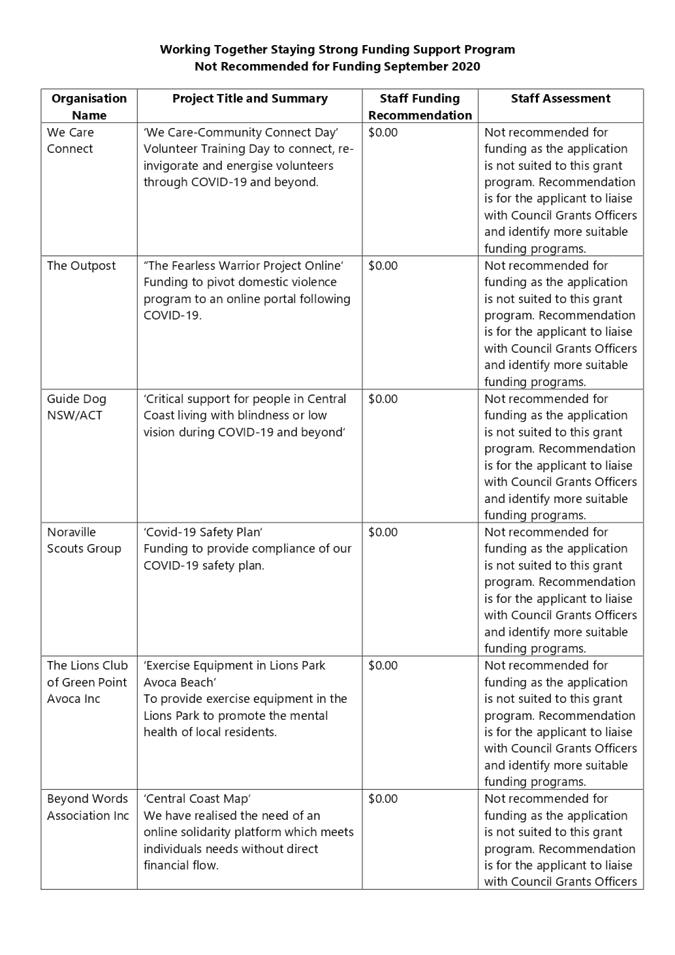
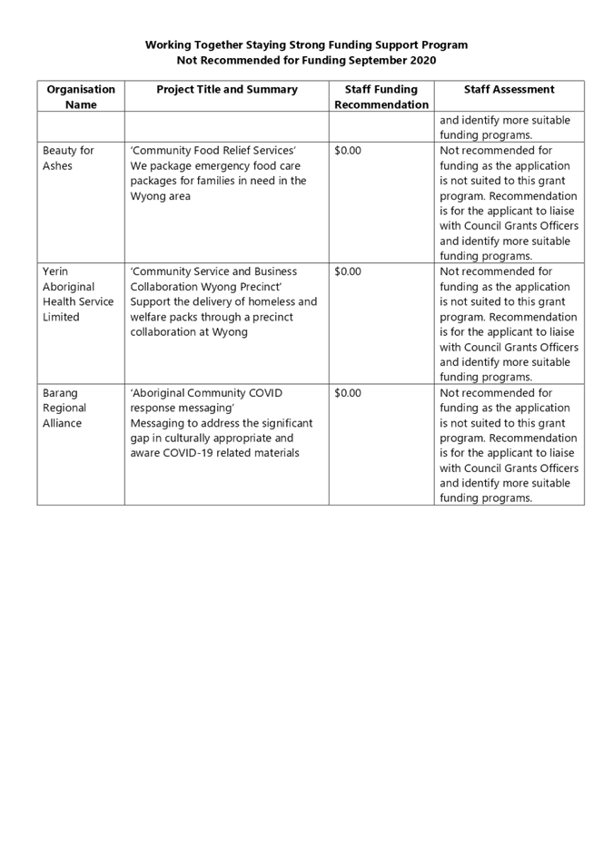
2.1 Working
Together Staying Strong COVID Grants - September 2020
Attachment
1: Working
Together Staying Strong Funding Recommended............. 17
Attachment
2: Working
Together Staying Strong Funding Not Recommended... 18
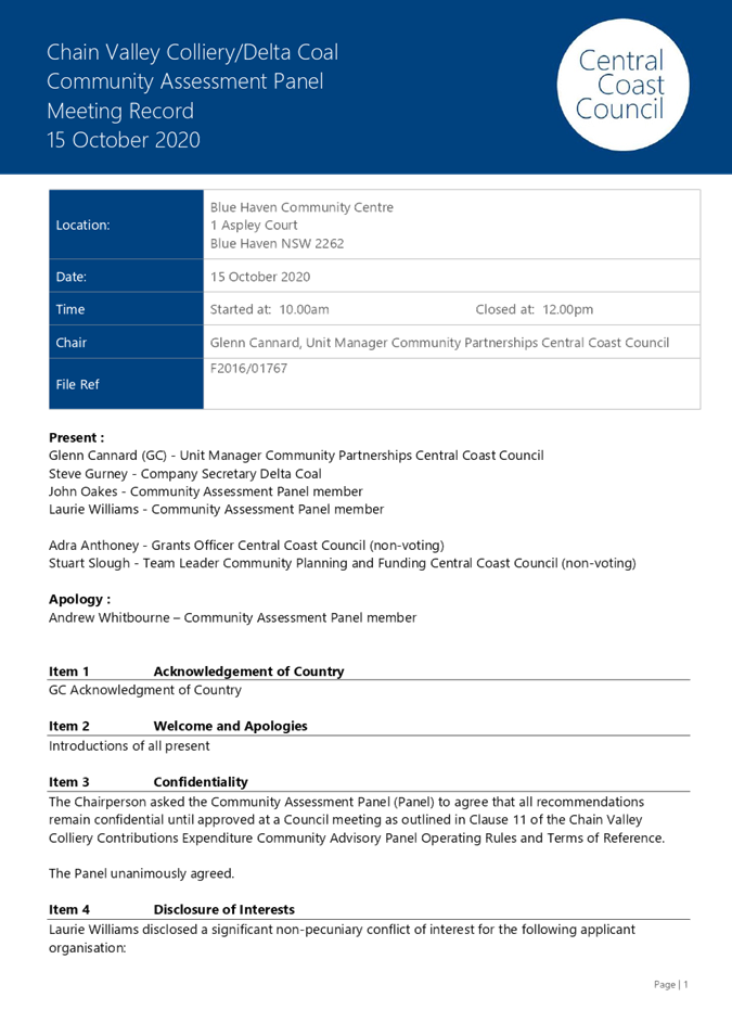
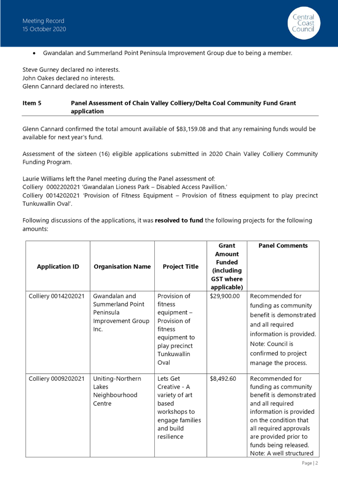
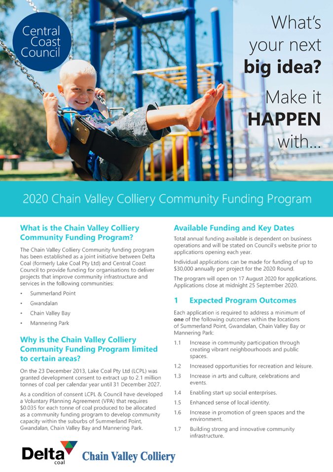
2.2 Chain
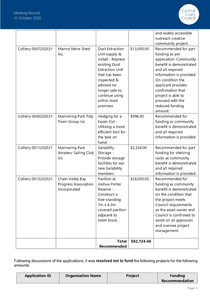
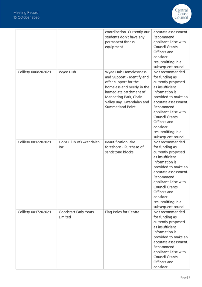
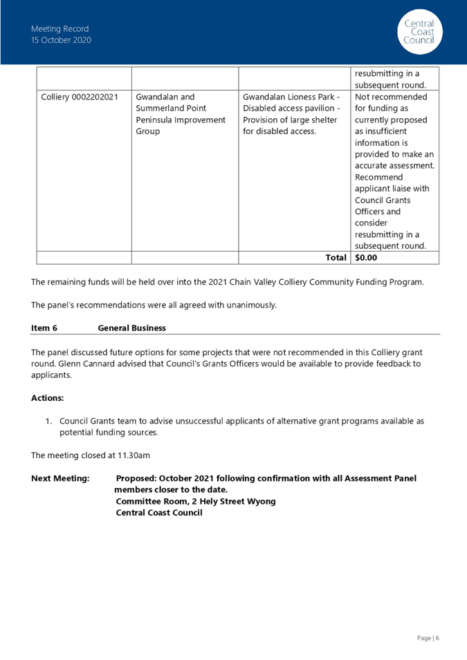
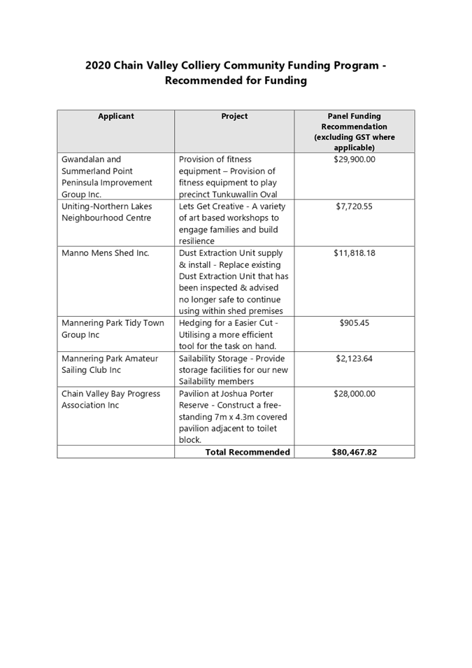
Valley Colliery/Delta Coal Community Funding Program - 2020
Attachment
2: Chain
Valley Colliery Community Assessment Panel Meeting Minutes 21
Attachment
3: 2020
Chain Valley Colliery Community Fund Recommended for Funding......................................................................................................................... 27
Attachment
4: Chain
Valley Colliery Fund Guidelines........................................................... 28
Corporate Affairs Reports
3.1 Business
Recovery Plan
Attachment
1: Business
Recovery Plan Tasks Update - 21012021................................. 31
Attachment
2: Property
and Asset Sales Governance Framework................................. 37
Attachment
3: Property
and Asset Sales Independent Advisory Group Terms of Reference..................................................................................................................... 43
Attachment
4: Property
and Asset Sales Project Control Group Terms of Reference 50
Attachment
5: Property
and Asset Sales Project Team Terms of Reference............. 57
Attachment
6: Michael
Filo CV......................................................................................................... 64
Attachment
7: Steve
Rowe CV.......................................................................................................... 65
3.2 Amendments
to Policy for Investment Management - November 2020
Attachment
1: Amended
Policy for Investment Management - November 2020. 67
3.4 Investment
Report for December 2020
Attachment
1: Summary
of Investments as at 31 December 2020............................... 86
Attachment
2: Summary
of Restrictions as at 31 December 2020................................. 87
Attachment
3: Investment
Report for December 2020 - Graph 1, 2 and 3............... 88
Attachment
4: Treasury
Direct Portfolio Report December 2020................................... 91
Attachment
5: Treasury
Direct Trading Limit Report December 2020......................... 96
Environment And Planning Reports
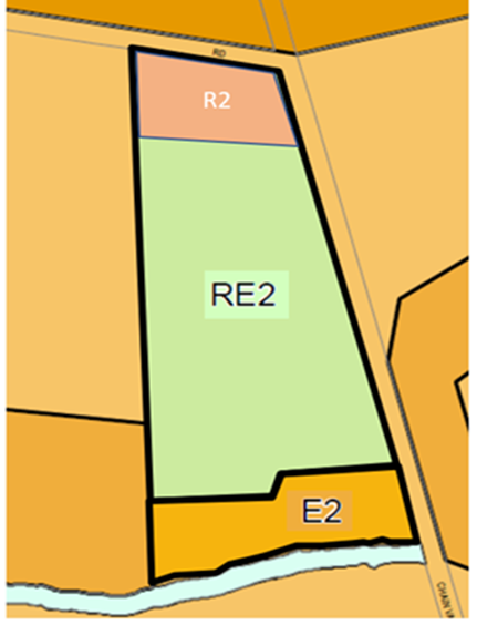
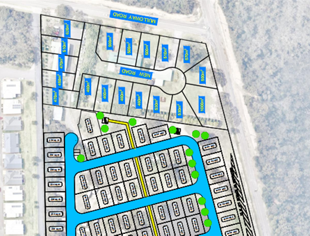
4.2 Request
for Amendment - Planning Proposal RZ/3/2019 - 45 Mulloway Road Chain Valley Bay
Attachment
1: Planning
Proposal Application - RZ/3/2019 - 45 Mulloway Road Chain Valley Bay - Report............................................................................................... 103
Attachment
2: Proposed
Subdivision Layout and Preliminary Assessment............ 114
4.3 Outcomes
of consultation the draft Smoke-free Outdoor Public Places Policy
Attachment
1: Submissions
- Smoke free outdoor public places policy.................. 116
Attachment
2: Draft
Smoke-Free Outdoor Places Policy highlighted changes.... 117
4.4 Cost
of Emergency Works at Wamberal Beach and The Entrance North Beach
Attachment
1: Letter
from DPIE Emergency Coastal Works Grant - Wamberal... 123
Attachment
2: Letter
from DPIE Emergency Coastal Works Grant - The Entrance North 124
4.5 Request
to Prepare a Planning Proposal for Jilliby Stage 2 Rural-Residential Area
Attachment
1: RZ_2_2020_Planning
Proposal Assessment............................................. 125
Attachment
2: RZ_2_2020_Strategic
Assessment................................................................. 145
4.6 Policy
for Development Application Functions
Attachment
1: Policy
on Assessment of Development Applications.......................... 168
4.7 Revocation
of Council Policies
Attachment
1: Section
149 Certificate Natural and Other Hazards Encoding - Revocation of Council
Policies....................................................................... 175
Attachment
2: Setback
Policy Creeks Rivers Lagoons - Revocation of Council Policies 178
Attachment
3: Summary
of Comments from Advisory Committee - Revocation of Council Policies...................................................................................................... 185
Infrastructure Reports
5.1 Central
Coast Stadium Final Strategy Report
Attachment
1: Central
Coast Stadium Strategy - Consultation Report..................... 189
Attachment
2: Central
Coast Stadium Strategy Final......................................................... 197
|
1.2
|
Confirmation of Minutes
of Previous Meeting
|
|
Attachment 1
|
Minutes
- Ordinary Meeting - 14 December 2020
|
 Central
Coast Council
Central
Coast Council
Ordinary Council
Meeting
Held in the Council
Chamber
2 Hely Street, Wyong
14 December 2020
MINUTES
Present
Dick Persson
AM
In
Attendance
Rik Hart Acting
Chief Executive Officer
Malcom Ryan Chief
Operating Officer
Boris
Bolgoff Director
Roads, Transport, Drainage and Waste
Julie
Vaughan Director
Connected Communities
Scott Cox Director
Environment and Planning
Jamie Loader Director
Water and Sewer
Natalia
Cowley Chief
Financial Officer
Krystie
Bryant Executive
Manager People and Culture
Notes
The
Administrator, Dick Persson AM, declared the meeting open at 6.37pm and advised
in accordance with the Code of Meeting Practice that the meeting is being
recorded.
The
Administrator, Dick Persson AM acknowledged the traditional custodians of the
land on which the meeting was being held, and paid respect to Elders past,
present and emerging.
The
Administrator, Dick Persson AM adjourned the meeting at 6.39pm and advised the
meeting would resume following the conduct of the Open and Public Forums.
The Open
Forum commenced at 6.40pm with the speakers addressing the Council on each of
the subjects below;
· Mr Stephen Sizer – Current
financial situation
· Mr Norman Harris – Community
consultation and DA assessments
· Ms Gaye Murrills – DA97/2020
– 604 Ourimbah Creek Road, Palm Grove
· Mr Jonathon Canavan – Old
Sydney Town Site
· Ms Liz Gabriel – Development
concept of World Village
The Public
Forum commenced at 7.05pm with the speakers addressing the Council on each of
the items below;
Item
4.1 – Draft Central Coast Local Environmental Plan and Draft Central
Coast Development Control Plan - Supplementary Report
· Mr Brian Barry
· Ms Sandra Kay
· Mr Mark Ellis
· Mr Kevin Haskell
· Mr Phil King
· Ms Dianna Arundell
· Mr Ron Stead
· Mr Jonathon Canavan
· Mr John Edwards
Item
4.5 – RZ/2/2015 Planning Proposal – Parraweena Road, Gwandalan
· Mr Jeremy Quek
The Public
Forum closed with the Ordinary Meeting resuming at 7.50pm.
Procedural
Motion
Time
commenced: 7.50pm
Moved: Mr
Persson AM
Resolved
1277/20 That
Council consider item 4.1 – Draft Central Coast Local Environmental Plan
and Draft Central Coast Development Control Plan - Supplementary Report first
with the remaining items in order.
1.1 Disclosures
of Interest
|
|
Item
4.1 – Draft Central Coast Local Environmental Plan and Draft Central
Coast Development Control Plan - Supplementary Report
Malcolm
Ryan, Chief Operating Officer declared a less than significant non pecuniary
interest in the matter as he owns property within the draft Central Coast
Local Environmental Plan. He chose to stay in the meeting and participate in
discussion on this matter as it does not prejudice or influence his decision
on the matter as there is no material effect on his interests.
Scott
Cox, Director Environment and Planning declared a less than significant non
pecuniary interest in the matter as he owns property within the draft Central
Coast Local Environmental Plan. He chose to stay in the meeting and
participate in discussion on this matter as it does not prejudice or influence
his decision on the matter as there is no change to his land zoning or
density.
|
|
Time
commenced: 7.54pm
|
|
Moved: Mr
Persson AM
Resolved
1278/20 That
Council receive the report on Disclosure of Interest and note advice of
disclosures.
|
1.2 Confirmation
of Minutes of Previous Meeting
|
|
Time
commenced: 7.54pm
|
|
Moved: Mr
Persson AM
1279/20 That Council confirm the minutes of
the Ordinary Meeting of Council held on the 30 November 2020 and the
Extraordinary Meeting of Council held 2 December 2020.
|
1.3 Notice
of Intention to Deal with Matters in Confidential Session
|
|
Time
commenced: 7.54pm
|
|
Moved: Mr
Persson AM
Resolved
1280/20 That Council
receive the report and note that no matters have been tabled to deal with in
a closed session.
|
1.4 Administrator's
Minute - Recruitment of ongoing Chief Executive Officer
|
|
Time
commenced: 7.54pm
|
|
Moved: Mr
Persson AM
Resolved
1281/20 That Council give
consideration to the Guidelines for the Appointment and Oversight of General
Managers issued under section 23A of the Local Government Act 1993 in
determining the selection panel to undertake the recruitment of a Chief
Executive Officer.
1282/20 That the selection panel
provide a report to Council following the recruitment process that makes a
recommendation as to appointment for determination by the Council.
|
1.5 Administrator's
Minute - Special Rate Variation application by Council
|
|
Time
commenced: 7.55pm
|
|
Moved: Mr Persson AM
Resolved
1283/20 That, in addition
to the resolution of 26 November 2020, Council endorse the undertaking of
community consultation on a potential application to
the Independent Pricing and Regulatory Tribunal for a one-off Special
Variation of 13% in 2021/22 to remain permanently, which plus the 2% rate peg
increase in 2021/22 represents a total rate increase of 15% for 2021/22.
1284/20 That a further
report be provided to Council regarding community consultation undertaken for
Council to determine any final application to be made to the Independent
Pricing and Regulatory Tribunal for a one off Special Variation in 2021/22.
|
2.1 Business
Recovery Plan
|
|
Time
commenced: 7.58pm
|
|
Moved: Mr
Persson AM
Resolved
1285/20 That Council note the
report “Business Recovery Plan – Status Report”.
|
2.2 Investment
Report for November 2020
|
|
Time
commenced: 8.00pm
|
|
Moved: Mr
Persson AM
Resolved
1286/20 That Council receive the
Investment Report for November 2020.
|
2.3 Policy
for Investment Management
|
|
Time
commenced: 8.03pm
|
|
Moved: Mr
Persson AM
Resolved
1287/20 That
Council note that a review of the Policy for Investment Management has been
undertaken and changes to the policy has been presented to the Audit, Risk
and Improvement Committee (ARIC).
1288/20 That
Council adopt the Policy for Investment Management.
|
3.1 Meeting
Record of the Social Inclusion Advisory Committee meeting held 14 October
2020
|
|
Time
commenced: 8.04pm
|
|
Moved: Mr
Persson AM
Resolved
1289/20 That Council note the Meeting
Record of the Social Inclusion Advisory Committee meeting held 14 October
2020 that is Attachment 1 to this report.
1290/20 That Council appoint
Michael Schell as a voting community representative of the Social Inclusion
Advisory Committee in light of Bert Cottee’s resignation, and that the
Terms of Reference (Attachment 2) be adopted accordingly.
|
3.2 Meeting
Record of the Town Centre Advisory Group Meeting held on 15 September 2020
|
|
Time
commenced: 8.04pm
|
|
Moved: Mr
Persson AM
Resolved
1291/20 That
Council note the Meeting
Record of the Town Centre Advisory Group Meeting held on 15 September 2020.
|
3.3 Consideration
of Submissions and Adoption of the Graffiti Management Strategy
|
|
Time
commenced: 8.04pm
|
|
Moved: Mr
Persson AM
Resolved
1292/20 That Council note that
the Draft Graffiti Management Strategy was publicly exhibited from 17 August
2020 to 13 September 2020.
1293/20 That Council consider
the submissions received (Attachment 2) during the exhibition period.
1294/20 That Council note and
endorse the amendments recommended in this report.
1295/20 That Council adopt the
Central Coast Graffiti Management Strategy (Attachment 1) and make it
available on Council’s website.
|
4.1 Draft
Central Coast Local Environmental Plan and Draft Central Coast Development
Control Plan - Supplementary Report
|
|
Malcolm
Ryan, Chief Operating Officer declared a less than significant non pecuniary
interest in the matter as he owns property within the draft Central Coast
Local Environmental Plan. He chose to stay in the meeting and participate in
discussion on this matter as it does not prejudice or influence his decision
on the matter as there is no material effect on his interests.
Scott
Cox, Director Environment and Planning declared a less than significant non
pecuniary interest in the matter as he owns property within the draft Central
Coast Local Environmental Plan. He chose to stay in the meeting and
participate in discussion on this matter as it does not prejudice or
influence his decision on the matter as there is no change to his land zoning
or density.
|
|
Time
commenced: 7.53pm
|
|
Moved: Mr
Persson AM
Resolved
1296/20 That Council adopt the
draft Central Coast Local Environment Plan (CCLEP) and Central Coast
Development Control Plan (CCDCP) as amended in response to issues raised
during the public exhibition in line with the changes as shown in Attachment
5.
1297/20 That Council request
The Department of Planning, Industry & Environment (DPIE), under Section
3.36 of the Environmental Planning and Assessment Act 1979 (EP&A Act), to
defer the inclusion of lands currently identified as Deferred
Matters under Gosford Local Environmental Plan 2014 (GLEP 2014) from
CCLEP.
1298/20 That an Environmental
Lands Review and Planning Proposal to review the Deferred Matters under
Gosford Local Environmental Plan 2014 (GLEP 2014) be commenced and that this
project be given a high priority on the Strategic Planning Unit’s work
program.
1299/20 That Council resolve
that the Chief Executive Officer (CEO) or Acting CEO may make other minor
alterations to the planning proposal, draft CCLEP and draft CCDCP as deemed
necessary.
1300/20 That Council advise all
those that made a submission of the decision.
1301/20 That Council resolve to
engage an independent planning consultant to conduct a review of the current
zoning of the Lots 2 to 7 DP249281 and Lot 11 DP 598580 475 to 535 Pacific
Highway Crangan Bay and the submissions made by the owners of this
property.
1302/20 That Council requests
the Chief Executive Officer to negotiate the funding for this review and its
terms of reference with the current property owners.
1303/20 That Council resolve to
have this reported to Council in February 2021.
|
4.2 Coastal
Zone Management Plan and Emergency Action Sub Plan
|
|
Time
commenced: 8.06pm
|
|
Moved: Mr
Persson AM
Resolved
1304/20 That
Council note the report on the Coastal Zone Management Plans and Emergency
Action Sub Plan for Wamberal - Terrigal Beach.
|
4.3 Activities
of the Development Assessment & Environment and Certification Units -
July to September 2020 - Quarter 1
|
|
Time
commenced: 8.11pm
|
|
Moved: Mr
Persson AM
Resolved
1305/20 That
Council notes the report on Activities of the Development Assessment &
Environment and Certification Units - July to September 2020 - Quarter 1.
|
4.4 Council
Representatives to Regional Planning Panel
|
|
Time
commenced: 8.12pm
|
|
Moved: Mr
Persson AM
Resolved
1306/20 That Council appoint the
following representatives as Central Coast Council nominees to the Hunter
Central Coast Regional Planning Panel Council:
Greg Flynn (Panel Nominee - from ‘expert’ Local Planning Panel list)
Anthony Tuxworth (Panel Nominee
from ‘community’ Local Planning Panel list)
Stephen Leathley (Alternate Nominee
from ‘expert’ Local Planning Panel list)
Lynette Hunt (Alternate Nominee
from ‘community’ Local Planning Panel list )
1307/20 That this representation
on the Hunter Central Coast Regional Planning Panel be for the period of
Council suspension under the provision of the Local Government Act 1993.
|
4.5 RZ/2/2015
Planning Proposal - Parraweena Road, Gwandalan
|
|
Time
commenced: 8.13pm
|
|
Moved: Mr
Persson AM
Resolved
1308/20 That Council endorse the
Planning Proposal as exhibited to rezone part Lot 1 DP 1043151 and Lot 20 DP 1089946 Parraweena Road,
Gwandalan to R2 Low Density Residential, R1 General Residential and B2 Local
Centre under Wyong Local Environmental Plan 2013 or the Central Coast Local
Environmental Plan (whichever is in effect) and forward to DPIE to make the
plan.
1309/20 That Council note the
removal of Council’s plan making delegation for this proposal.
1310/20 That all those who made
a submission be notified of the decision.
1311/20 That Council adopt the
site-specific Development Control Plan Chapter – Gwandalan Centre as Chapter 6.31 within
Wyong Development Control Plan 2013, and as Chapter 5.56 within the Central
Coast Development Control Plan (when it comes into effect), which shall come
into effect upon notification of the plan.
1312/20 That Council commence
the reclassification of part Lot
1 DP 1043151.
|
5.1 Minutes
of the Audit, Risk and Improvement Committee held on 17 June 2020
|
|
Time
commenced: 8.14pm
|
|
Moved: Mr
Persson AM
Resolved
1313/20 That
Council note the Minutes
of the Audit, Risk and Improvement Committee held on 17 June 2020 as attached.
|
6.1 Meeting
Record of the Heritage Advisory Committee meeting held 7 October 2020
|
|
Time
commenced: 8.14pm
|
|
Moved: Mr
Persson AM
Resolved
1314/20 That
Council note the report on Meeting Record of the Heritage Advisory Committee
meeting held 7 October 2020.
|
The Meeting closed
at 8.14 pm.
|
1.2
|
Confirmation of Minutes
of Previous Meeting
|
|
Attachment 2
|
Minutes
- Extraordinary Meeting - 18 December 2020
|
 Central
Coast Council
Central
Coast Council
Extraordinary
Council Meeting
Held remotely -
online
18
December 2020
MINUTES
Present
Dick Persson
AM
In
Attendance
Rik Hart Acting
Chief Executive Officer
Natalia
Cowley Director
– Corporate Affairs
Shane
Sullivan Unit
Manager Governance and Business Services
Notes
The
Administrator, Dick Persson AM, declared the meeting open at 3.06pm.
The
Administrator, Dick Persson AM acknowledged the traditional custodians of the
land on which the meeting was being held, and paid respect to Elders past,
present and emerging.
The
Administrator, Dick Persson AM advised
in accordance with the Code of Meeting Practice that the meeting is being recorded.
1.1 Disclosures
of Interest
|
|
Time
commenced: 3.09pm
|
|
Moved: Mr
Persson AM
Resolved
1315/20 That
Council receive the report on Disclosure of Interest and the fact that no
disclosure was made be noted.
|
1.2 Notice
of Intention to Deal with Matters in Confidential Session
|
|
Time
commenced: 3.10pm
|
|
Moved: Mr
Persson AM
Resolved
1316/20 That Council resolve that
the following matters be dealt with in closed session, pursuant to s. 10A(2)
of the Local Government Act 1993 for the following reasons:
Item
2.1 – General Fund Loan
Reason
for considering in closed session:
2(d) commercial
information of a confidential nature that would, if disclosed:
(i) prejudice
the commercial position of the person who supplied it.
That
Council resolve, pursuant to section 11(3) of the Local Government
Act 1993, that this report remain confidential in accordance with
section 10A(2)(d)(i)
of the Local Government Act as is contains commercial information of a
confidential nature that would, if disclosed prejudice the commercial
position of the person who supplied it and because consideration of the
matter in open Council would on balance be contrary to the public interest.
|
Confidential Session
Time
commenced: 3.10pm
Moved: Mr
Persson AM
Resolved
1317/20 That the meeting move into
Confidential Session.
|
At this
stage of the meeting being 3.11pm the meeting moved into Confidential Session
with the members of the press and public excluded from the closed session and
access to the correspondence and reports relating to the items considered
during the course of the closed session being withheld. This action is taken
in accordance with Section 10A of the Local Government Act, 1993.
|
Open
Session
|
The
meeting resumed in open session at 3.17pm and the Acting Chief Executive
Officer reported on proceedings of the Confidential Session of the
Extraordinary Meeting as follows:
|
|
|
|
Time
commenced: 3.12pm
|
|
Moved: Mr
Persson AM
Resolved
1318/20 That
Council accept
the offer of principal and interest loan, as dated on 18 December 2020, for
an amount of $100,000,000 on a fixed 3 year term, amortizing over 15 years,
from the financial institution.
1319/20 That
Council authorise the Administrator and Acting Chief Executive Officer to
execute all documents relating to the Facility Agreement between the Central
Coast Council and the financial institution.
1320/20 That
Council authorise the Common Seal to be affixed to the executed Facility
Agreement between the Central Coast Council and the financial institution.
1321/20 That
Council resolve, pursuant to section 11(3) of the Local Government Act 1993,
that this report remain confidential in accordance with section 10A(2)(d)(i)
of the Local Government Act as is contains commercial information of a
confidential nature that would, if disclosed prejudice the commercial
position of the person who supplied it and because consideration of the
matter in open Council would on balance be contrary to the public interest.
Consideration of the matter in open Council would, on balance, be contrary to
the public interest as publication of all tendered amounts would discourage
potential tenderers from submitting commercial information in future and
would affect Council’s ability to obtain value for money services for
the Central Coast community.
|
The
Meeting closed at 3.20pm.
|
2.1
|
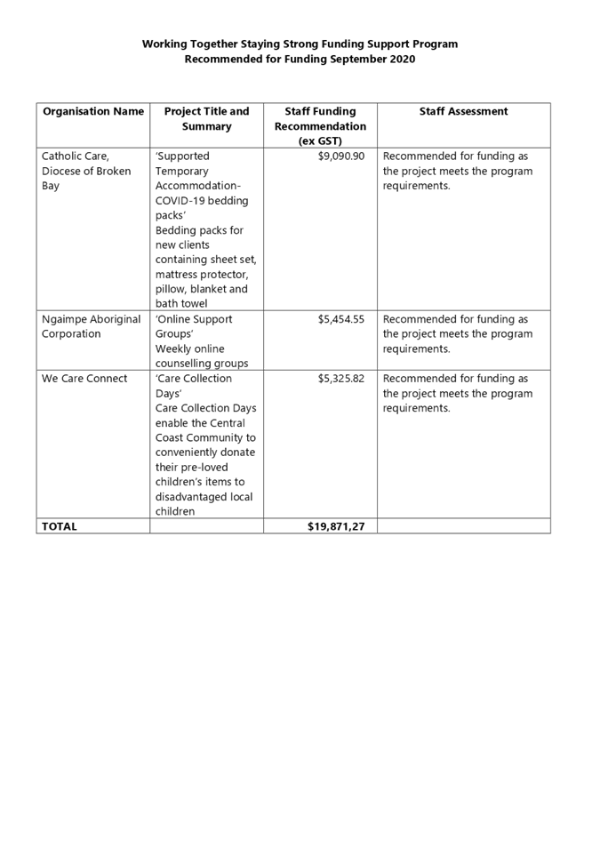
Working Together Staying Strong
COVID Grants - September 2020
|
|
Attachment 1
|
Working
Together Staying Strong Funding Recommended
|
|
2.1
|
Working Together Staying Strong
COVID Grants - September 2020
|
|
Attachment 2
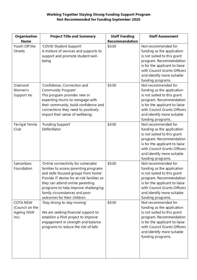
|
Working
Together Staying Strong Funding Not Recommended
|
|
2.2
|
Chain Valley Colliery/Delta Coal
Community Funding Program - 2020
|
|
Attachment 2
|
Chain
Valley Colliery Community Assessment Panel Meeting Minutes
|

|
2.2
|
Chain Valley Colliery/Delta Coal
Community Funding Program - 2020
|
|
Attachment 3
|
2020
Chain Valley Colliery Community Fund Recommended for Funding
|
|
2.2
|
Chain Valley Colliery/Delta Coal
Community Funding Program - 2020
|
|
Attachment 4
|
Chain
Valley Colliery Fund Guidelines
|
|
3.1
|
Business Recovery Plan
|
|
Attachment 1
|
Business
Recovery Plan Tasks Update - 21012021
|
|
3.1
|
Business Recovery Plan
|
|
Attachment 2
|
Property
and Asset Sales Governance Framework
|


Property and Asset Sales Governance Framework
Version:
0.1
Contents
Contents. 2
Purpose. 3
Objective. 3
Governance
Structure. 3
Property
and Asset Sales – Project Control Group.. 4
Property
and Asset Sales – Independent Advisory Group.. 5
Property
and Asset Sales – Project Team... 5
Appendix A: Project Control
Group Terms of Reference. 6
Appendix B: Independent
Advisory Group Terms of Reference. 6
Appendix C: Project Team Terms
of Reference. 6
Purpose
A governance framework provides a mechanism
for Council to practice good governance to ensure that Council meets its legal
compliance obligations, acts ethically and decisions are made in the interest
of its stakeholders and the community as a whole. Good governance ensures that
the Council is able to manage its many complex responsibilities effectively in
the best interests of the Community.
Disposal of assets
for local government are governed by strict considerations of probity,
transparency and accountability in the expenditure of public funds for public
purposes.
The purpose of the
Property Assets Sales Governance Framework (Framework) is to facilitate and
provide a structure that governs the sale of property assets of Central Coast
Council (Council) to include:
a. Effective
planning;
b. Allocation
of roles and responsibilities;
c. Accountable
and transparent decision-making;
d. Appropriate
engagement with risk; and
e. Compliance
with relevant legislation and policies
Objective
The objective is to
create framework which outlines each parties roles and responsibilities and the
regular process of reporting and decision making to manage the outcomes of each
project.
Governance Structure
Council have responsibility to their
community for the prudent management of public assets and finances under their
care, control and management. Local Government responsibilities generally go
beyond those of a private sector partner or project proponent due to the
management of the public “good” and “interest.” In
particular, land owned and controlled by a Council is a public asset to be
held, administered and used for the benefit of the public/local community and
to assist the Council in providing the services and facilities it is charged to
provide for the community.
All projects have unique circumstances and
challenges. Each project presents different challenges and requires different
management and governance structures.
Property and/or Asset Sales will be
undertaken in accordance with the following governance structure:
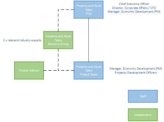
Property and Asset Sales – Project Control
Group
Council has formed a Project Control Group
(PCG) that will provide direction to the Project Manager and Project Team to
ensure there is ongoing confidence that the procurement/transaction processes
are conducted in a timely manner and within budget and agreed quality
expectations.
The key objectives of the PCG are as
follows:
· To operate independently from the
Project Team to ensure segregation of roles and to achieve objectives as
outlined;
· Ensure that the appropriate risk
management, internal compliance and control, code of conduct and regulatory
compliance policies are adhered to including the applicable regulatory
requirements for the planning proposal;
· Consider candidates for appointment
as advisers and to approve any such appointments (including fees), approve
engagement terms and monitor the performance of such parties;
· Undertake or coordinate internal and
external due diligence;
· Minimise ongoing financial risks and
liabilities for Council; and
Refer to Appendix A for the Terms of
Reference for the PCG
Property and Asset Sales – Independent
Advisory Group
The Council has formed an Independent
Advisory Group (IAG) to provide independent advice on matters relating to property and buildings held
by Council including but not limited to property divestment, investment, acquisition, returns
on investment, rationalisation of non-performing assets, the assessment of lease and licence
agreements, and assessment and delivery of capital works, as a property owner
and not as a statutory authority).
The IAP will utilise the methodologies and reporting
frameworks established by Council to supplement and independently assure Council, as required.
Refer to Appendix B for the Terms of
Reference for the IAG
Property and Asset Sales – Project Team
Council has formed a Project Team which will
oversee and manage the sales process of property assets undertaken by Council.
The Project Team has the following responsibilities:
· Oversee the day-to-day management of
the Project;
· Undertake the functions of the
evaluation panel in assessing the offers/proposals associated with transaction
of property and/or assets;
· Provide a report to the PCG with the
results of each evaluation process and subsequent recommendation (following IAG
endorsement); and
· Escalate any issues to the PCG
Refer to Appendix C for the Terms of
Reference for the Project Team
Appendix A: Project Control Group Terms of
Reference
Appendix B: Independent Advisory Group Terms of
Reference
|
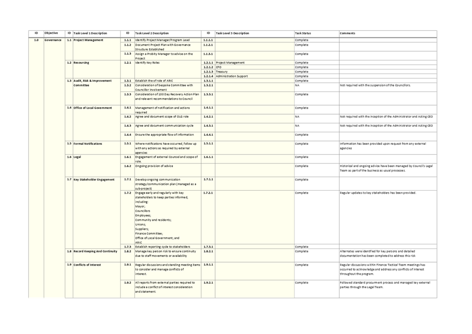
3.1
|
Business Recovery Plan
|
|
Attachment 3
|
Property
and Asset Sales Independent Advisory Group Terms of Reference
|

Property
and Asset Sales
Independent
Advisory Group - Terms of Reference
Version:
0.1
Contents
Contents. 2
1. Membership.. 3
1.1. Composition.. 3
1.2 Appointment 3
2. Terms
of Reference. 3
2.1 Purpose. 3
2.2 Roles
and Responsibilities. 4
Independent Advisory Group.. 4
Convener/Chair 4
Secretariat 4
Proxies to Meetings. 4
2.3 Meetings. 4
Schedule of meetings. 4
Meetings of the IAG: 5
Quorum... 5
In attendance. 5
Decisions. 5
2.4 Housekeeping.. 5
Agenda Items. 5
Code of Conduct 5
Confidentiality. 5
Termination of Membership.. 5
Minutes & Meeting
Papers. 6
Schedule
1 – Conflicts of Interest 7
Schedule
2 – Conflict of Interest Declaration. 7
1. Membership
1.1. Composition
The
membership of the IAG will be made up of a composition of members with the
following areas of expertise, as set out in Table 1 below:
Table
1 – IAG Membership
|
Individual
|
Position
|
|
Michael Filo
|
Member,
Property and/or Economic Development (Chair)
|
|
Steve Rowe
|
Member,
Property and/or Economic Development
|
1.2 Appointment
The IAG Members will
be appointed by Council following a review of relevant qualification/experience
criteria, as established by the PCG.
The IAG Members may
be appointed for an initial period not exceeding 12 months after which time
they will be eligible for extension or re-appointment, provided that at the IAG
Members provide details of their qualifications and experience of so that those
details can be considered by Council to ensure the qualifications and
experience of each IAG Member remain relevant to Council's requirements. The
IAG Members acknowledge that at any time they are being considered for re-
appointment or extension Council may also be running an expression of interest
process and the IAG Member must participate in an approved selection process.
Council may
terminate the appointment of an external IAG Member at any time at
Council’s discretion.
The Chair of the IAG
will be one of the IAG Members.
2. Terms of
Reference
2.1 Purpose
The purpose of the
Independent Advisory Group (IAG) is to advise Council on matters relating to property and assets held by
Council including but not limited to divestment, investment, acquisition, returns
on investment, rationalisation of non-performing assets, the assessment of lease and licence
agreements, and assessment and delivery of capital works.
The IAG will utilise the
methodologies and reporting frameworks established by Council to supplement and
independently
assure Council, as required.
2.2 Roles
and Responsibilities
Independent Advisory Group
The role of the IAG
is to provide advice, independent assurance in relation to risk identification
and mitigation, and to support the Property and Asset Sales Project Control
Group (PCG) in its decision making in respect of matters that are within the objectives
of the IAG, including but not limited to the following:
· Assure that Council
has followed prudent commercial risk management practices in relation to
matters within the objectives of the Property and Asset Sales Project;
· Assure that adequate
legal compliance practices and procedures are followed in connection with
matters that are within the objectives of the Property and Asset Sales Project;
· Consider reports and
recommendations provided by the Project Team and make assessments and
recommendations as to the validity of any proposal based on relevant criteria
being met and achieving the best commercial outcome for Council;
· Understand the
strategic implications and outcomes of the initiatives being overseen;
· Be committed to and
be actively involved in pursuing the most advantageous outcome for Council with
respect to property and assets;
· The responsibilities
of the IAG may be revised or expanded in consultation with, or as requested by,
either the Project Team or PCG.
Convener/Chair
The Chair shall
convene the Panel meetings.
If the designated
Chair is not available, then an appointed representative shall act as Acting
Chair. The Acting Chair will be responsible for convening and conducting that
meeting.
Secretariat
The Project Manager
will provide secretariat services to the IAG and provide Agendas and Minutes.
Proxies to Meetings
Members of the IAG
shall not nominate a proxy to attend a meeting if the member is unable to
attend.
2.3 Meetings
Schedule of meetings
Meetings
of the IAG will occur as required to meet the needs of the Property and Asset
Sales project.
Meetings of the IAG:
May be by way of the
following:
a) in person;
b) via teleconference;
c) combination of in person and teleconference
dependent on availability of IAG members;
d) by circular.
Quorum
A quorum
of the IAG requires both members.
In attendance
The IAG
may invite any person or persons to all or part of its meetings to assist the
IAG in its work, including in relation to specialised project issues such
as technical/design, financial, legal and economic feasibility matters.
Decisions
Decisions
of the IAG are to be unanimous. Where a unanimous decision is unable to be made
by the IAG, a dissenting view / report may be prepared for consideration by the
PCG.
2.4 Housekeeping
Agenda Items
An agenda for all
IAG meetings shall be agreed and circulated as soon as practical before the
meeting.
Code of Conduct
Members must abide
by the Code of Conduct and relevant policies adopted by Council. Members must
declare and manage any conflicts of interest (as per Schedules 1 and 2 below)
in a manner consistent with the Code of Conduct adopted by Council. For
completeness, declarations of interest will be an agenda item at each IAG
Meeting.
Confidentiality
IAG Members must
keep all discussions during meetings confidential. No Member can make public
comments regarding the activities of the IAG.
Termination of Membership
IAG membership can
be brought to an end in the following ways:
a) The expiry of the period for which
the relevant Member was appointed;
b) The resignation of a Member by
written notice to the Chair (who must without delay inform the remaining
members of the resignation). If the Chair resigns, written notice must be
provided to Council’s Chief Executive Officer;
c) A Member may be removed by the IAG if
they have:
(i) been
absent from three (3) consecutive meetings without having given reasons acceptable
to the PCG; or
(ii) intent
for the which the original engagement commenced is no longer considered
relevant.
Note:
Council reserve absolute discretion in determination of the above.
Minutes & Meeting
Papers
Each IAG meeting
will be formally recorded by the way of minutes.
Full copies of the
Minutes, including attachments, shall be provided to all IAG members no later
than 2 working days following each meeting. The Minutes of each IAG meeting
will be monitored and maintained by the Property and Asset Sales Project
Manager as a complete record as required under provisions of the NSW State
Records Act 1998.
Schedule 1 –
Conflicts of Interest
To be inserted
Schedule 2 – Conflict of Interest
Declaration
To be inserted
|
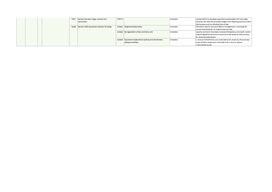
3.1
|
Business Recovery Plan
|
|
Attachment 4
|
Property
and Asset Sales Project Control Group Terms of Reference
|

Property
and Asset Sales
Project
Control Group - Terms of Reference
Version:
0.1
Contents
Contents. 2
1. Membership.. 3
2. Terms
of Reference. 3
2.1 Purpose. 3
2.2 Roles
and Responsibilities. 3
Project Control Group.. 3
Role of individual PCG Members. 4
Convener/Chair 4
Secretariat 4
Proxies to Meetings. 4
2.3 Meetings. 4
Schedule of meetings. 4
Additional ad hoc
meetings. 4
Meetings of the PCG.. 4
Quorum... 5
In attendance. 5
Decisions. 5
Considerations. 5
2.4 Housekeeping.. 5
Agenda Items. 5
Code of Conduct 5
Confidentiality. 5
Minutes & Meeting
Papers. 5
Schedule
1 – Non Disclosure Agreement 7
Schedule
2 – Conflict of Interest Declaration. 7
1. Membership
The current
membership of the PCG will be as set out in Table 1:
Table
1 – PCG Membership
|
Individual
|
Position
|
|
Rik
Hart
|
Chief Executive Officer (Chair)
|
|
Natalia
Cowley
|
Director, Corporate Affairs/ Chief
Financial Officer (CFO)
|
|
Jamie Barclay
|
Manager, Economic Development
(Project Manager)
|
2. Terms of Reference
2.1 Purpose
The purpose of the
Central Coast Council (Council) PGC is to provide direction to the Property and
Asset Sales Project Team to ensure there is ongoing confidence that the
procurement processes are conducted in accordance with the Property Asset Sales
Governance Framework (Framework), in a timely manner, within budget and agreed
quality expectations.
2.2 Roles
and Responsibilities
Project Control Group
The roles
and responsibilities of the PCG will include the following:
· operate independently from the
Project Team to ensure segregation of roles and to achieve objectives as
outlined
· ensure that the appropriate risk
management, internal compliance and control, code of conduct and regulatory
compliance policies (e.g. probity plan) are adhered to including the applicable
regulatory requirements for the planning proposal
· consider candidates for appointment
as advisers and to approve any such appointments (including fees), approve
engagement terms and monitor the performance of such parties
· undertake or coordinate internal and
external due diligence
· minimise risk, ongoing financial
risks and liabilities for Council
Role of individual PCG Members
The role
of the individual member of the PCG includes:
· Understanding the
strategic implications and outcomes of the sale of property and/or assets in
relation to Council’s approved plans and policy framework;
· Appreciate the
significance of the Project for some or all major stakeholders;
· Provide guidance as
appropriate; and
· Participate in all PCG
meetings and provide considered feedback / input into the decision-making
process.
Convener/Chair
The PCG Chair shall convene the PCG
meetings. If the designated Chair is not available, then an Acting Chair will
be assigned the responsibility for convening and conducting that meeting. The
Acting Chair is responsible for informing the Chair as to the salient
points/decisions raised or agreed to at that meeting.
Secretariat
The Project Manager will provide secretariat
services to the PCG and provide Agendas and Minutes.
Proxies to Meetings
Members of the PCG shall nominate a proxy to
attend a meeting if the member is unable to attend. The Chair will be informed
of the substitution as soon as practically possible prior to the scheduled
nominated meeting.
The nominated proxy shall have voting rights
at the attended meeting. The nominated proxy shall provide relevant
comments/feedback, of the PCG member they are representing, to the attended
meeting.
2.3 Meetings
Schedule of meetings
Meetings
of the PCG will occur monthly.
Additional ad hoc meetings
May be called by the
Chair (following a reasonable request from a Member or other party).
Meetings of the PCG
may be by way of the following:
a) in person;
b) via teleconference;
c) combination of in person and
teleconference dependent on availability of IAG members;
d) by circular.
Quorum
A quorum
of the PCG will constitute two representatives. Any decisions made in a PCG
where not all members of the PCG are present should be circulated to all PCG
members.
In attendance
The PCG
may invite any person or persons to all or part of its meetings to assist the
PCG in its work, including in relation to specialised project issues such
as technical, financial, legal and economic feasibility matters.
Decisions
Decisions
of the PCG are to be unanimous. Where a unanimous decision is unable to be made
by the PCG, a dissenting view / report may be prepared for consideration by
Council.
Considerations
PCG will
consider recommendations from the Property and Assets Sales Project Team
following endorsement from the Independent Property and Assets Sales Advisory
Group, confirming that relevant criteria have been met.
2.4 Housekeeping
Agenda Items
An agenda for all PCG meetings shall be
agreed and circulated as soon as practical before the meeting.
Code of Conduct
Members must abide by the Code of Conduct
and relevant policies adopted by Council. Members must declare and manage any
conflicts of interest (as per Schedules 1 and 2 below) in a manner consistent
with the Code of Conduct adopted by Council. For completeness, declarations of
interest will be an agenda item at each IAG Meeting.
Confidentiality
Members must keep all discussions during
meetings confidential. No Member can make public comments regarding the
activities of the PCG.
Minutes & Meeting
Papers
Each IAG meeting will be formally recorded
by the way of minutes.
Full copies
of the Minutes, including attachments, shall be provided to all PCG members no
later than 2 working days following each meeting. The Minutes of each PCG
meeting will be monitored and
maintained by the Property and Asset Sales Project Manager as a complete record
as required under provisions of the NSW State Records Act 1998.
Schedule 1 – Non Disclosure Agreement
Schedule 2 – Conflict of Interest
Declaration
|
3.1
|
Business Recovery Plan
|
|
Attachment 5
|
Property
and Asset Sales Project Team Terms of Reference
|

Property
and Asset Sales
Project
Team - Terms of Reference
Version:
0.1
Contents
Contents. 2
1. Membership.. 3
2. Terms
of Reference. 3
2.1 Purpose. 3
2.2 Roles
and Responsibilities. 3
Project Team... 3
Role of individual Project
Team Members. 4
Convener/Chair 4
Secretariat 4
Project Manager 4
Proxies to Meetings. 4
Probity Advisor 4
2.3 Meetings. 5
Schedule of meetings. 5
Meetings of the Project
Team... 5
Quorum... 5
In attendance. 5
Decisions. 5
2.4 Housekeeping.. 5
Agenda Items. 5
Code of Conduct 6
Confidentiality. 6
Minutes & Meeting
Papers. 6
Schedule
1 – Non Disclosure Agreement 7
Schedule
2 – Conflict of Interest Declaration. 7
1. Membership
The
current membership of the PCG will be as set out in Table 1:
Table
1 – Project Team Membership
|
Individual
|
Position
|
|
Jamie
Barclay
(Project Manager)
|
Unit Manager, Economic Development
and Property (Chair)
|
|
Ben
Brown
|
Property Development Manager
|
|
Joe
O’Connor
|
Property Development Manager
|
|
Rochelle Kirk (TBC)
|
Independent Probity Advisor
Principal, O’Connor Marsden
& Associates
|
2. Terms of Reference
2.1 Purpose
The purpose of the
Central Coast Council (Council) Property and Asset Sales Project Team is to
ensure property and/or assets sales are undertaken in a manner which maximises
value, both financially and strategically for Council. The Project Team
will engage with the IAG (Independent Advisory Group) to seek Counsel and
Strategic advice with respect to proposed property and/or asset disposals and
will undertake the role of the Evaluation Panel for submitted proposals,
providing recommendations and relevant support material to the IAG (Independent
Advisory Group) from review and endorsement prior to seeking ultimate review
and approval from the PCG (Project Control Group).
2.2 Roles
and Responsibilities
Project Team
The roles
and responsibilities of the Project Team will include the following:
· Regular engagement with the IAG to
discuss strategy and most appropriate marketing approach to maximise outcomes
for Council;
· Undertake each evaluation as per the
approved evaluation plan and Council’s Procurement Framework;
· Seek advice and support services
during the proposal evaluation process from specialist technical advisors as
required;
· Seek advice / direction from the IAG
and / or PCG as required; and
· Submit recommendations to the PCG via
the IAG for approval
Role of individual Project Team Members
The role
of the individual member of the Project Team members includes:
· Understanding the
strategic implications and outcomes of the sale of property and/or assets in
relation to Council’s approved plans and policy framework;
· Appreciate the
significance of the Project for some or all major stakeholders;
· Ensure compliance to the
Property and Asset Sales governance framework
· Seek guidance as
appropriate; and
· Participate in all Project
Team meetings and provide considered feedback / input into the decision-making
process.
Convener/Chair
The Project Team
Chair shall convene the Project Team meetings. If the designated Chair is not
available, then an Acting Chair will be assigned will be responsible for
convening and conducting that meeting. The Acting Chair is responsible for
informing the Chair as to the salient points/decisions raised or agreed to at
that meeting.
Secretariat
The Chair will provide secretariat services
to the Project Team and provide Agendas and Minutes.
Project Manager
The position Unit Manager, Economic Development
and Property will undertake the functions of ‘Project Manager’ for
the Property and Asset Sales. The Project Manager holds overall
responsibility for ensuring regular communication occurs with both the IAC and
PCG to ensure maximum benefit is delivered for Council.
Proxies to Meetings
Members of the PCG shall not nominate a
proxy to attend a meeting if the member is unable to attend.
Probity Advisor
Council is committed to maintaining probity
in all dealings to meet its responsibilities of public accountability and to
achieving value for money outcomes for customers, the community, stakeholders
and Government.
The Probity Advisor has been appointed to
review and provide guidance on all aspects of the procurement processes and
ensure compliance with Local Council Regulations Councils procurement
framework.
The Probity Advisor is O’Connor
Marsden & Associates (OCM):
Rochelle Kirk
0428 603 666
rkirk@ocm.net.au
2.3 Meetings
Schedule of meetings
Meetings of the Project Team will occur
as per the approved Evaluation Plan or as otherwise required.
Meetings of the Project
Team
may be by way of the following:
a) in person;
b) via teleconference;
c) combination of in person and teleconference
dependent on availability of IAG members;
d) by circular.
Quorum
A quorum
of the Project Team will constitute all representatives.
In attendance
The
Project Team may invite any person or persons to all or part of its meetings to
assist the Project Team in its work, including in relation to specialised project
issues such as technical/design, financial, legal and economic feasibility matters.
Decisions
Decisions
of the Project Team are to be unanimous. Where a unanimous decision is unable
to be made by the Project Team, a dissenting view / report may be prepared and
submitted for the PCG for ultimate determination.
2.4 Housekeeping
Agenda Items
An agenda for all Project Team meetings shall be
agreed and circulated as soon as practical before the meeting if applicable.
Code of Conduct
Members must abide by the Code of Conduct
and relevant policies adopted by Council. Members must declare and manage any
conflicts of interest (as per Schedules 1 and 2 below) in a manner consistent
with the Code of Conduct adopted by Council. For completeness, declarations of
interest will be an agenda item at each Project Meeting.
Confidentiality
Members must keep all discussions during
meetings confidential. No Member can make public comments regarding the
activities of the Project Team.
Minutes & Meeting
Papers
Each IAG meeting will be formally recorded
by the way of minutes.
Full copies of the Minutes, including
attachments, shall be provided to all Project Team members no later than 2 working days
following each meeting. The Minutes of each Project Team meeting will be monitored and
maintained by the Chair as a complete record as required under provisions of
the NSW State Records Act 1998.
Schedule 1 – Non Disclosure Agreement
|
3.1
|
Business Recovery Plan
|
|
Attachment 6
|
Michael
Filo CV
|

|
3.1
|
Business Recovery Plan
|
|
Attachment 7
|
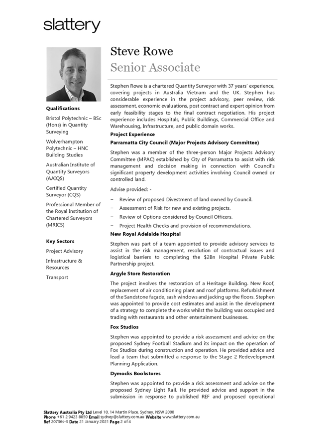
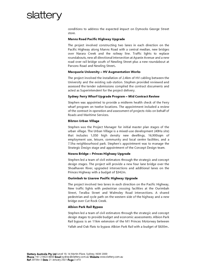
Steve
Rowe CV
|
|
3.2
|
Amendments
to Policy for Investment Management - November 2020
|
|
Attachment 1
|
Amended
Policy for Investment Management - November 2020
|
Policy for Investment Management
November
2020
Policy
No: CCC 024
|
Policy owner:
Approved by:
Date of approval:
Policy category:
Content Manager No:
Review date:
|
Financial
Services, Finance
Chief
Executive Officer
Day/Month/Year
Statutory
D14315776
December
2021
|
Contents
Contents. 2
Purpose. 4
Policy summary. 4
Background.. 4
General 5
Policy Statements. 5
Investment Guidelines. 6
Investments. 6
Accounting and Reporting.. 7
Independent Financial Advisor 7
Investment Guidelines. 8
Risk Management 8
Credit Risk. 9
Concentration Risk
(Counterparty/Institution Credit Framework) 10
Product, Interest Rate and
Income Risk / Term to Maturity Framework. 10
Regulatory, Fraud and
Safekeeping/Clear Title Risk. 10
Benchmarking and Monitoring.. 11
Implementation and Authority
to Amend Strategy. 11
Breaches of criteria. 12
Grandfathering of Investments. 12
Breach as a result of
regulatory change. 12
Breach as a result of a change
in the total investment portfolio.. 12
Professional Advice. 13
Definitions. 13
Appendix
1: Investment Strategy. 15
Scope. 15
General 15
Global and Domestic Investment
Environments. 15
Legislative Environment 16
Composition of Council’s
investment portfolio. 16
Investment Strategy. 16
Objectives. 17
Risk Profile. 17
Liquidity / Maturity. 17
Return / Income. 17
Unrealised Investment Gains. 18
Environmentally and Socially
Responsible Investments. 19
History
of revisions. 20
Purpose
1. The
Investment Policy sets out the requirements for the management of
Council’s cash and investment portfolio.
2. Central
Coast Council (CCC) require that all investment activities be exercised with
the care, diligence and skill of a prudent person, and not for speculative
purpose.
Policy
summary
3. All investments are
to comply with:
a) Local Government Act
1993;
b) Local Government
– Ministerial Order dated 12 January 2011;
c) Sections 14A (2),
14C (1) and (2) of the Trustee Amendment (Discretionary Investments) Act 1997;
d) Local Government
(General) Regulation 2005;
e) Division of Local
Government Circular 11-01;
f) Local Government
Code of Accounting Practice and Financial Reporting;
g) Australian
Accounting Standards
4. The Office of Local Government
releases guidance to Councils on investment management from time to time.
Council will review this policy in light of such advice.
Background
5. The policy sets the
framework to:
a) Safeguard
Council’s cash and investment portfolio
b) Achieve appropriate
earnings
c) Manage
Council’s cash resources to ensure sufficient liquidity to meet
Council’s business objectives over the long, medium and short term.
6. The
policy reinforces Council’s ongoing commitment to maintain a conservative
risk and return portfolio, an important component of its ongoing prudent
financial management practises.
7. The
Investment Strategy supports the policy by defining investment objectives and
actions for the next 12 months.
8. Central
Coast Council’s financial policies are developed to ensure that the
Council satisfies legislative requirements and follows ‘best
practice’ in its business operations, with due consideration for the
effective and efficient management of the resources utilised within that
business.
General
Policy
Statements
9. This
policy does not confer any delegated authority upon any person.
10. Council
will not instruct the CEO in any manner that requires the CEO to breach his or
her statutory responsibilities in respect of investments.
11. Subject
to any functions, duties or powers conferred directly on a Council or CEO by
the Act, the Council will delegate to the CEO, the power to make decisions
relating to the effective and efficient management of investments in accordance
with this policy.
12. The
CEO or their delegate may, in exceptional or emergency circumstances, approve
an action outside the requirements of this policy provided that any such
variation to this policy is reported to Council in the next monthly investment
report.
13. Other
investment acquisitions. The Council alone may approve the acquisition of
land or holding of any shares or interests in a body corporate, partnership,
joint venture or other association of persons; or settle, or be, or appoint a
trustee of, a Trust.
14. The
Council will not delegate to any person the authority to raise capital or to
specifically borrow money by any means, including options, swaps or any other
non-balance sheet items.
15. Council
will only allow investment for the purpose of achieving the effective and
efficient on-going management of the Council organisation in accordance with
the Act, Operational Plan, Long Term Financial Strategy and any other policy
made from time to time.
16. Investments
will be managed with the care, diligence and skill that a prudent person would
exercise, and officers shall not engage in activities that would conflict with
the proper execution and management of Council’s investment portfolio.
17. Management
of the risks associated with delegation of authority shall be achieved by way
of detailed regular reporting on the exercise of all functions, duties and
powers delegated throughout the organisation and by the Council.
18. Subject
to functions, duties or powers conferred upon the CEO by the Act, all delegated
authorities must be exercised in accordance with relevant CCC policies and
procedures set by the Council or CEO from time to time.
19. Variations,
reviews or additions to this policy shall be approved by resolution of the
Council.
20. The
Policy for Investment Management will be reviewed annually or as required in
the event of legislative changes and/or guidelines as per point 4.
21. This
policy is not dependent on the terms of any other policy or procedures except
the Act or direct, lawful instruction under the terms of the Act.
Investment
Guidelines
22. The
CEO or his/her delegate, in consultation with council staff, will approve
investment guidelines, within this policy, as part of the annual review, which
will set the general direction for the purchase and sale of investment assets
for the coming period and prescribe performance targets by asset category.
23. The
performance of the portfolio will be assessed against a benchmark set annually
in the Investment Guidelines.
24. The
CEO, in consultation with Council staff shall issue guidelines reviewed at
least annually, for the management of the following risk classes:
Credit
Risk Management Must Include
a) Maximum
portfolio weighting by total assets in an asset grouping
b) Maximum
amount to be held with an individual institution within an asset grouping
Term
to Maturity Framework
a) Asset
groupings will be defined with reference to credit rating.
b) The
amount of investment risk attached to a particular security is in part related
to its term to maturity. Guidelines for the management of term to maturity risk
shall at a minimum prescribe the maximum exposure by term to maturity
groupings, as an example, percentage of portfolio maturing in three to four
years.
Investments
25. All
investment securities must be denominated in Australian Dollars.
26. New
investments shall be limited to (by statute):
a) Any
public funds or securities issued by or guaranteed by the Commonwealth, any
State or a Territory of the Commonwealth;
b) Any
debentures or securities issued by other Local Government Councils;
c) Interest
bearing deposits with, or any debentures or bonds issued by, an authorised
deposit-taking institution (ADI), as defined in the Banking Act 1959, but
excluding subordinated debt obligations;
d) A
deposit with NSW Treasury Corporation or investments in their managed funds;
e) Any
bill of exchange which has a maturity date of not more than 200 days and if
purchased for value confers on the holder in due course a right of recourse
against a bank which has been designated as an ADI by the Australia Prudential
Regulation Authority (APRA).
27. This
investment policy prohibits any investment carried out for speculative purposes
including, but not limited to:
a) Derivative
based instruments;
b) Principal
only investments or securities that provide potentially nil or negative cash
flow;
c) Stand-alone
securities issued that have underlying futures, options, forwards contracts and
swaps of any kind;
d) The
use of leveraging (borrowing to invest) of an investment
e) Extensive
trading activity
Accounting
and Reporting
28. Council
will comply with appropriate accounting standards in valuing its investments
and quantifying its investment returns.
29. Investment
income must be recorded according to accounting standards. Published reports
may show a breakdown of its duly calculated investment returns into capital
gains and losses and interest.
30. A
report will be provided to Council on a monthly basis when Ordinary Meetings
occur. The report will detail the investment portfolio in terms of performance,
percentage exposure of total portfolio and maturity dates.
31. From
time to time financial assets may be acquired at a discount or premium to their
face value. Discount or premium is to be taken into account in line with relevant
Australian Accounting Standards.
32. For
audit purposes, certificates must be obtained from the banks/fund
managers/custodian confirming the amounts of investment held on Council’s
behalf at 30 June each year.
Independent
Financial Advisor
33. From time to time,
Council may utilise the services of a suitably qualified and experienced
investment advisor for the purposes of achieving the aims of this policy.
34. An appointment of an
Independent Financial Advisor (IFA) can be decided by the CEO or their
delegate. The IFA must be licensed by the Australian Securities and Investment
Commission. An appointed Independent Advisor will have no conflict of interest
in respect to their investments recommended. The term of any appointed
Independent Financial Advisor will not exceed 3 years without review.
Investment
Guidelines
35. Council
is a prudent investor. It is intended to maximise investment returns while
maintaining the security of investments through the prudent management of risk.
Risk Management
36. Detailed
decisions on the purchase and sale of investment assets will be mindful of the
following risk categories.
|
Risk
|
Mitigants
|
|
Risk of Capital
Loss
|
Diligent product
research, diversification and an intention to hold assets to maturity.
|
|
Liquidity risk
|
Cash flow
forecasting, allocation of investment funds to time horizons, maintenance of
a “liquidity reserve” through conservative assumptions in cash
flow forecasting.
|
|
Market timing risk
(“not getting a good price on the day”)
|
Stagger investment
dates, maintain spread of maturity dates.
|
|
Credit Risk
|
Credit Risk
guidelines imposing required credit rating targets for the portfolio.
|
|
Concentration risk
(“all eggs in one basket”)
|
Concentration Risk
guidelines imposing maximum exposure for Individual institutions.
|
|
Product risk
|
Undertake rigorous
product research.
|
|
Interest Rate
(duration) risk
|
Market Investments
acquired at par value will not be exposed to interest rate fluctuations if
they are redeemed at maturity.
|
|
Income risk
|
Conservative
approach to investment income budgeting.
|
|
Reinvestment/Rollover
risk
|
The risk that
income will not meet expectations or budgeted requirements because interest
rates are lower than expected in future.
|
|
Regulatory risk
|
Regulation embedded
in Investment Policy. Portfolio actively managed to comply with Policy.
|
|
Fraud risk
|
Documented
investment procedures, separation of responsibilities for investment decision
making and transaction settlement, only one account for payment of redemption
proceeds, use of licensed custodians or third-party registries where
applicable.
|
|
Safe keeping /
Clear title risk
|
Documented
investment procedures.
|
Credit Risk
37. Before entering into
any investment transaction with a new institution there will be a diligent
review of the creditworthiness of that institution. The Chief Executive Officer
or his/her delegate must form its own opinion of the risk attached to an
institution and not merely rely on published credit ratings.
38. Central Coast
Council will not invest in subordinate debt, as per the current NSW
Minister’s Order.
39. Standard &
Poor’s (or equivalent Moodys or Fitch) ratings attributed to each
individual institution will be used to determine maximum holdings. In the event
of disagreement between two rating agencies as to the rating band (“split
ratings”) Council shall use the lower of the ratings. Where more than two
ratings exist (e.g. 3 credit ratings S&P, Moody’s & Fitch),
Council shall discard the lowest rating and then use the lower of the higher
two ratings when assessing new purchases .
The maximum available limits in each rating
category are as follows:
Table 1 – Maximum Portfolio Weighting
Per Rating Category
|
Long Term Credit Ratings
|
Maximum Portfolio Weighting
|
|
AAA Category
|
100%
|
|
AA Category or
Major Bank^
|
100%
|
|
A Category
|
70%
|
|
BBB Category
|
60%
|
|
Unrated
|
0%
|
* For the
purpose of this Policy, “Major Banks” are currently defined as the
ADI deposits or senior guaranteed principal and interest ADI securities issued
by the major Australian banking groups:
• Australia
and New Zealand Banking Group Limited
• Commonwealth
Bank of Australia
• National
Australia Bank Limited
• Westpac
Banking Corporation
Including ADI subsidiaries whether or not explicitly guaranteed,
and brands (such as St George).
Council may ratify an alternative definition from time to time.
Concentration Risk (Counterparty/Institution
Credit Framework)
40. Exposure to
individual counterparties/financial institutions will be restricted by their
rating as per the APRA standard above so that single entity exposure is
limited, as detailed in the table below:
Table 2 – Counter Party Risk
|
Individual Institutions Limits
|
|
Long
Term Credit Ratings
|
Maximum
Exposure
|
|
AAA Category*
|
100%
|
|
AA Category*
|
30%
|
|
A Category
|
20%
|
|
BBB Category
|
10%
|
|
|
|
|
Unrated Category
|
0%
|
*The limit may be exceeded
temporarily to the extent that the excess represents funds held on deposit
awaiting reinvestment.
Product, Interest Rate and Income Risk /
Term to Maturity Framework
41. The investment
portfolio is to be invested with a conservative approach to income budgeting
within the following term to maturity constraints, subject to rigorous product
research:
Table 3 – Term to Maturity
|
Description
|
Maximum Exposure
|
|
Portfolio allocation:
|
|
Portfolio % <
1Year
|
100%
|
|
Portfolio % > 1
Year < 3 Years
|
70%
|
|
Portfolio % >3
Years < 5 Years
|
40%
|
|
Portfolio % > 5
Years
|
5%
|
|
Maturity of
financial institution securities:
|
|
ADI issues rated A
or above
|
5
years
|
|
ADI issues rated
BBB to A
|
3
years
|
|
ADI issues BBB-
and non-rated (Term Deposits only)
|
1
years
|
Regulatory, Fraud and Safekeeping/Clear
Title Risk
42. The regulatory
framework for investments is embedded within the investment policy and the
Portfolio will be actively managed to comply with policy.
43. Risk of Fraud and
safe keeping is mitigated by documented investment procedures, separation of
responsibilities for investment decision making and transaction settlement,
with only one account for payment of redemption proceeds, including the use of
licensed custodians or third-party registries where applicable.
Benchmarking and Monitoring
44. Each investment in
the portfolio is to be evaluated and monitored against a performance benchmark
appropriate to the risk and time horizon of the investment concerned.
45. The objective is to
ensure that all investments under consideration can deliver a level of return
commensurate with their risk profile and that they are competitive with an
appropriate peer group of alternative investment options.
46. The eligibility of
an investment is determined by the NSW Local Government Minister’s Order
dated 12 January 2011.
47. Under these
Investment Guidelines, no assets other than those listed in the table below
will be eligible.
Table 4 – Target Returns and Suitable
Products
|
Investment
Category
|
Investment
Horizon
|
Bench
Mark
|
Permitted
|
|
Working capital
funds
|
0-3
months
|
Official cash rate
|
11am, overnight
call and cash accounts, short dated Bank Bills, TCorpIM Cash Fund
|
|
Short term funds
|
3-12
months
|
AusBond Bank Bill
Index^^
|
TCorpIM Cash Fund,
Term Deposits, Bank Bills
|
|
Short-Medium term
funds
|
1-3
years
|
AusBond Bank Bill
Index
|
Term Deposits,
Senior ADI Fixed and Floating Rate Notes, short dated Bonds, TCorpIM
Strategic Cash Fund
|
|
Medium term funds
|
3-5
years
|
AusBond Bank Bill
Index
|
Term Deposits,
Senior ADI Fixed and Floating Rate Notes and Bonds
|
|
Long term funds
|
5
years
|
AusBond
Bank Bill Index
TCorp’s
Internal Benchmark (Funds)
|
Term deposits,
Senior ADI Fixed and Floating Rate Notes and Bonds, TcorpIM Growth Funds
|
Implementation and Authority to Amend
Strategy
48. The Investment
Guidelines noted earlier in this policy set out the intended approach to
investments in the market conditions that are expected to prevail over the
medium to long term investment horizon.
However, there may be periods, sometimes
sustained, where “normal” market conditions do not apply, for
example, periods where short term interest rates are higher than long term
interest rates, or investments of similar credit quality offer different yields
due to liquidity differences.
49. The CEO or his/her
delegate may approve a variation to this policy if the investment is to the
Council’s advantage or due to revised legislation subject to this
variation being reported to Council in the next available monthly investment
report.
Breaches of criteria
50. Procedures for
dealing with unavoidable breaches of any particular thresholds are contained in
the next section on grandfathering of investments.
Grandfathering of Investments
51. This policy imposes
limits and thresholds in relation to the acquisition and holding of
investments. However, situations may occur where inadvertent breaches of these
limitations or thresholds arise, other than from the acquisition of
investments. For example:
a) Amendments to
regulatory directives or legislation
b) Changes in the total
value or amount of Council’s investment portfolio which consequently
changes any of the threshold limits so that they no longer meet the portfolio
liquidity parameters.
Breach as a result of regulatory change
52. When limitations or
thresholds are breached due to the amendments to regulatory directives or
legislation, the investment portfolio must be managed in accordance with the
respective amendments. Where the amendments enable retention and grandfathering
of existing investments, Council may continue to actively manage those
investments within the portfolio in accordance with all other regulations and
policies applicable to such investments. This includes a strategy of holdings
or divesting such investments in accordance with regular investment
considerations.
Breach as a result of a change in the total
investment portfolio
53. Where limitations or
thresholds are breached due to a change in the overall size of the total investment
portfolio, the following process will apply :
a) An immediate freeze
is imposed on the acquisition of new investments in the relevant category until
the portfolio can be effectively managed back to accord with the requirements
of this policy.
b) The relevant
category of investments must be managed back in accord with the policy limits
within a period that takes into account any adversity created by market
liquidity, current valuations it these investments and the risk of default.
Professional Advice
54. Council may seek
professional, external investment advice from time to time to provide
assistance in Investment Strategy formulation, portfolio implementation and
monitoring in accordance with the Policy for Investment Management.
Definitions
55. In
this policy:
a) Active Secondary
Market – a market where investors purchase securities or assets
from other investors, rather than from issuing companies themselves on an
arm’s length (independent) basis.
b) Cash –
cash comprises both cheque accounts and daily call accounts with Authorised
Deposit taking institutions (ADIs). Cash assets typically have a maturity term
at the time of placement of being immediately available or available within 24
hours. Cash assets are closely linked with investments but do not constitute
investments. Cash is used to meet immediate operational cash needs.
c) Council
– means Central Coast Council
d) Delegated
Authority - means any function, duty or power vested in the Council by the
Act, that the Council may, within the terms of the Act, delegate to a Council
member, Committee of the Council, Chief Executive Officer, employee or person
or class of persons approved for the purpose.
e) Investment
– comprises term deposits and bonds with an active secondary market
placed with government (including NSW T-Corp) and Authorised Deposit Taking
institutions (ADI’s). Investment assets have maturities at the time of
placement of 30 days or more.
f) Policy
– means policy created and approved by the Council, as well as any
policy of either the former Gosford City Council or the former Wyong Shire
Council that applies to Council by the operation of the Proclamation.
g) Proclamation
- means the Local Government (Council Amalgamations) Proclamation 2016.
h) The
Act - means the Local Government Act 1993.
i) The
Bank Bill Swap Reference Rate (BBSW) – is the midpoint of the
nationally observed best bid and offer for AFMA Prime Bank eligible securities.
j) Year
- means from July 1 to June 30 (financial year).
k) Grandfathered
Investments – are part of total investments and comprise investments
where additional investment activity is prohibited by regulation and other
investments over which additional investment activity is temporarily prohibited
due to unintentional breaches of investments thresholds and limitations that
arise due to changes in the level of unrelated investments within the portfolio
(the prohibition only remains as long as the breaches remain in place).
Appendix 1: Investment Strategy
The
annual Investment Strategy sets out Council’s investment goals and
targets for the coming year. The aim of the strategy is to guide the management
of Council’s investment portfolio over the short to medium term to:
a) achieve
a balanced and diversified portfolio, in terms of allowable investment
products, credit ratings and maturation terms that will outperform the
benchmark indices
b) ensure
liquidity when required for Council’s operational and capital expenditure
needs.
Scope
1. The
Investment Strategy applies to all managers and employees who actively manage
the investment of surplus funds or have responsibility for employees who
actively manage the investment of surplus funds.
2. This
strategy should be read in conjunction with the Investment Policy.
General
3. Council’s
investment strategy is determined after taking into consideration a review of
the following issues:
a) global
and domestic economic investment environments
b) investment
policy and legislative constraints
c) current
composition of Council’s investment portfolio
d) long,
medium- and short-term financial plans.
Global and Domestic
Investment Environments
4. Financial
and investment environments, both globally and domestically, continue to
improve at different rates across various regions. The global financial
recovery process has been aided by a more standardised international regulatory
process with more stringent capital adequacy requirements for financial
institutions.
5. In
Australia, a history of prudent regulation of the financial institutions by the
Australian Prudential Regulation Authority (APRA) has meant that Australian
based regulated financial institutions have already operated for an extended
period under stringent capital adequacy and liquidity requirements.
Council’s investments all fall under APRA regulation with the result that
the portfolio is conservative and secure.
6. Interest
rates have remained low and in Australia the slow rate of expansion of the
domestic economy is expected to temper the pace at which local interest rates
rises will occur.
Legislative Environment
7. Council’s
investment opportunities are constrained by a combination of legislation,
regulation and any directions and guidelines issued by the Minister or the
Office of Local Government.
8. There
has been no change to the investment legislative environment for a number of
years and the most recent Ministerial Investment Order released in January 2011
continues to limit Council’s investment options to:
a) term
deposits with Approved Deposit-taking Institutions (ADIs)
b) other
ADI senior ranked securities
c) investments
with NSW Treasury Corporation (T-Corp)
d) funds
or securities issued or guaranteed by the Commonwealth or any State or
Territory.
Composition of
Council’s investment portfolio
9. The
conservative nature of Council’s Investment Strategy is clearly reflected
in the structure of the portfolio, where 100% of the portfolio is invested with
APRA-regulated ADIs.
10. Council’s
current portfolio is as follows:
|
Investment
|
Split
|
|
Big
Four banks
|
71.29%
|
|
Australian
mid-tier banks
|
22.82%
|
|
Foreign
controlled Australian based ADIs
|
5.89%
|
|
Total APRA-regulated ADIs
|
100%
|
* The
allocation of assets within the portfolio is with very secure institutions. In
the past year, Council has diversified the portfolio with further selected
investment into the Australian mid-tier banks as they continue to reflect
strength and stability.
Investment Strategy
11. Council’s investment portfolio will continue to be
prudently managed in accordance with:
a) Council’s Investment Policy and
related legislative and regulatory requirements
b) documented risk management procedures
to preserve capital
c) Council’s operational and
capital funding requirements.
Objectives
12. Council’s investment strategy for the period is to
maintain the highly secure profile of the portfolio, provide liquidity and
deliver competitive investment returns commensurate with the portfolio
structure.
Risk Profile
13. The risk profile for the Council’s investment
portfolio is based on the principles of being prudent, conservative and risk
averse. This is achieved by managing the diversity and creditworthiness of
investments in accordance with the Investment Policy and other relevant
requirements.
Liquidity / Maturity
14. The majority of the Council’s cash and investments
portfolio is held as internally restricted and externally restricted cash
reserves to satisfy the Councils legislative responsibilities.
15. There are presently increased demands for funding of
capital projects with the result that within the maturity profile of the
investment portfolio there is a responsive shift of funds from the longer term
to the short and medium terms.
16. To ensure Council has available funds to meet both these
commitments and its short-term operational and capital cash commitments, the
following liquidity targets are set in accordance with the Investment Policy.
|
Investment
period
|
Cumulative Minimum % of total portfolio
|
Maximum % of total portfolio
|
|
1 month
|
10%
or $50M
|
100%
|
|
2 to 12 months
|
40%
|
80%
|
|
1
to 3 Years
|
55%
|
40%
|
|
3
to 5 Years
|
90%
|
35%
|
|
>
5 Years
|
100%
|
10%
|
* Councils liquidity will
be monitored on an ongoing basis to ensure the Councils cash requirements are
met and that liquidity parameters remain within allowable limits set out in the
Investment Policy.
Return / Income
17. Council uses the
following benchmarks to measure investment performance, in relation to both
current month and 12-month rolling returns, against its return/income
objectives:
a) Bloomberg AusBond
Bank Bill Index
b) 30 day Bank Bill
Rate.
18. Council aims to
achieve returns equal to or above these benchmark rates for the period.
However, this achievement remains secondary to the critical strategies of maintaining
a prudent and conservative risk profile and in meeting Council’s
liquidity needs.
19. Councils current
cash balances are applied in meeting immediate operational and capital
commitments as well as future year’s capital commitments.
20. Additionally,
2020/21 will present continued challenges to Council in delivering higher
investment income returns, including the following:
a) Interest rates
continue to remain at low levels and expectations are that in the medium-term
over the next 3 years they could remain at these levels.
b) The increasing level
of capital expenditure is resulting in the maturity profile of the investment
portfolio reducing in the long-term and being reinvested in the short to medium
term where interest yields are lower.
c) A small number of
long-term investments that are locked in the higher rates offered in previous
years continue to mature and decline in quantity at a steady pace. As these
funds can now only be reinvested at the current low yields, overall earnings
will continue to fall.
Unrealised Investment Gains
21. The strategy in
managing significant unrealised investment gains is to compare the following
amounts:
a) If an investment
with a significant unrealised investment gain was to be sold to realise the
gain, its earning potential becomes the sum of (a) the unrealised gain now
realised and (b) the estimated future interest earnings of the proceeds of sale
up to the maturity date of the original investment sold. A key consideration is
that since the unrealisd gain was the result of a decline in interest rates,
the interest yields on the reinvesting of the proceeds of sale will be less
than the yields of the original investment up to the time of maturity of the
original investment.
b) If the investment
with a significant unrealised gain was to be held to maturity it would mature
at its face value with the result that the unrealised investment gain will
reverse steadily to its maturity date. On the other hand, the investment will
continue to earn interest income to maturity at yields that are higher than
those currently available in the market.
22. Consequently,
investments with significant unrealised gains will be retained in the portfolio
unless A exceeds B where:
a) A = the sum of
unrealised investment gain plus future interest earnings to maturity date at
the lower interest yield
b) B = the total amount
of the future interest to maturity at the current higher interest yield
23. In accordance with
accounting standards, the unrealised investment gain and any subsequent
increase or decrease in the amount is required to be recognised in
Council’s financial results. Consequently, if unrealised gains reverse as
losses in the future, it means that these losses are more than offset by the
interest income earned on those investments because of their respective higher
interest rates.
Environmentally and
Socially Responsible Investments
24. Council’s
ability to acquire environmentally and socially responsible investments within
the current investment and policy environment remains limited, as:
a) the structure of
many of these investments remains prohibited under the current Ministerial
Investment Order; and
b) the global financial
crisis caused significant declines in the valuation of the financial assets
that comprise many of these investments.
25. Council will,
however, continue to explore opportunities for supporting environmentally and
socially responsible investments within these constraints. The investment
climate is changing over time and Council notes that many large scale renewable
projects are expected to evolve, which may offer sustainable investment
opportunities in the future. Council will continue to encourage and give
preference to these investments where they comply with the Ministerial
Investment Order and satisfy Council’s policy and investment objectives.
History of revisions
|
Amendment
history
|
Details
|
|
Original
approval authority details
|
Craig Norman -
Chief Financial Officer
|
|
16 August 2019
|
|
The Investment
Policy sets out the requirements for the management of Council’s cash
and investment portfolio.
Central Coast
Council (CCC) require that all investment activities be exercised with the
care, diligence and skill of a prudent person, and not for speculative
purpose.
|
|
CM document number
D13648027
|
|
Version
0.2
|
XX/XX/20XX
<insert Council Meeting date and ‘minute number’ of resolution
adopting the policy <remove if not needed>
|
|
CM document number
|
|
Annual review of
Investment Policy.
Revision of bank
rating criteria from S&P to APRA standard approach
Inclusion of
Grandfathering provision and breaches of criteria
Updating of
maximum investment limits
|
|
3.4
|
Investment Report for December 2020
|
|
Attachment 1
|
Summary
of Investments as at 31 December 2020
|
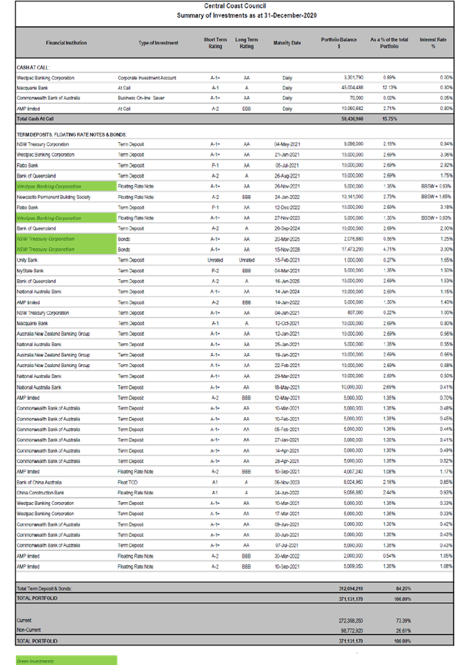
|
3.4
|
Investment Report for December 2020
|
|
Attachment 2
|
Summary
of Restrictions as at 31 December 2020
|
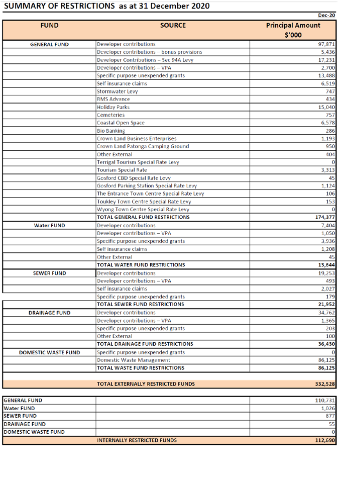
|
3.4
|
Investment Report for December 2020
|
|
Attachment 3
|
Investment
Report for December 2020 - Graph 1, 2 and 3
|
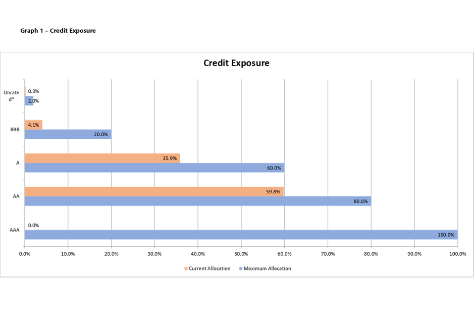
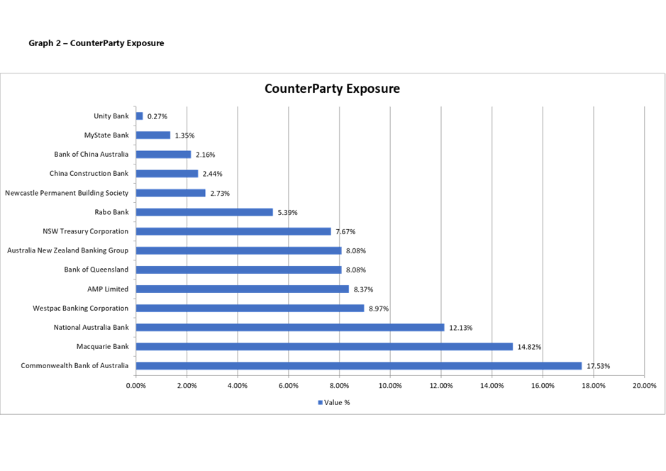
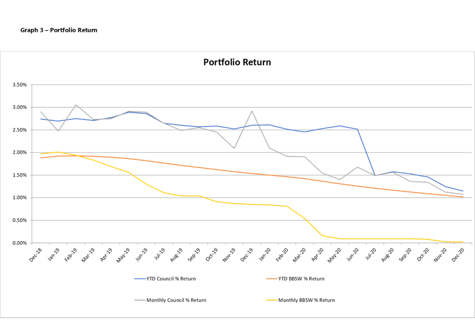
|
3.4
|
Investment Report for December 2020
|
|
Attachment 4
|
Treasury
Direct Portfolio Report December 2020
|
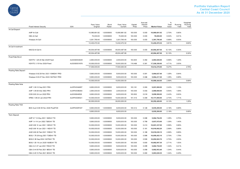
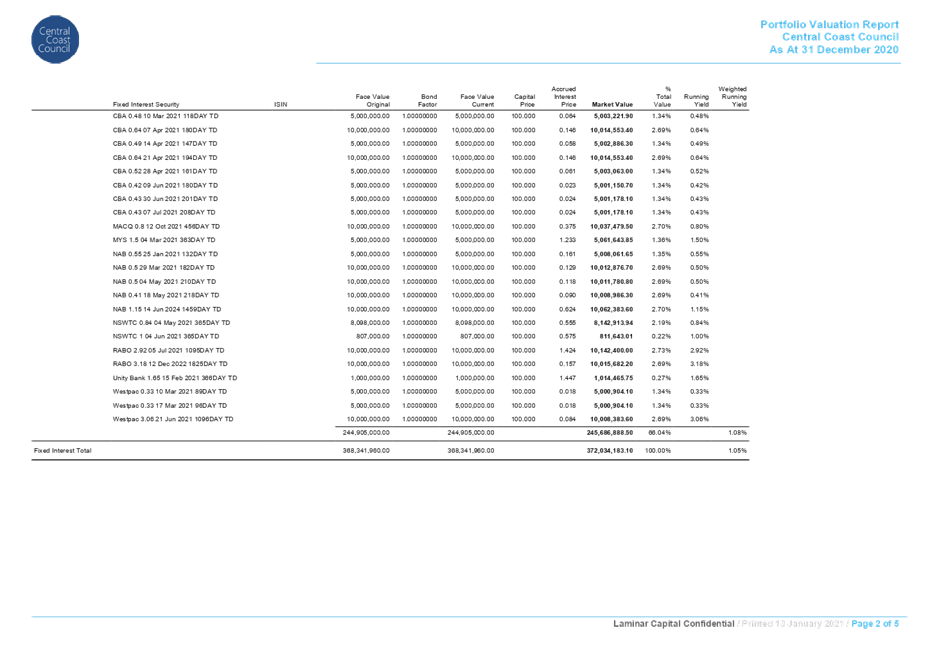
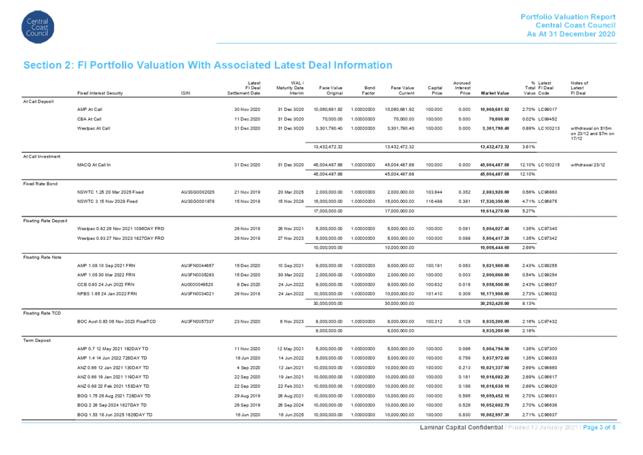
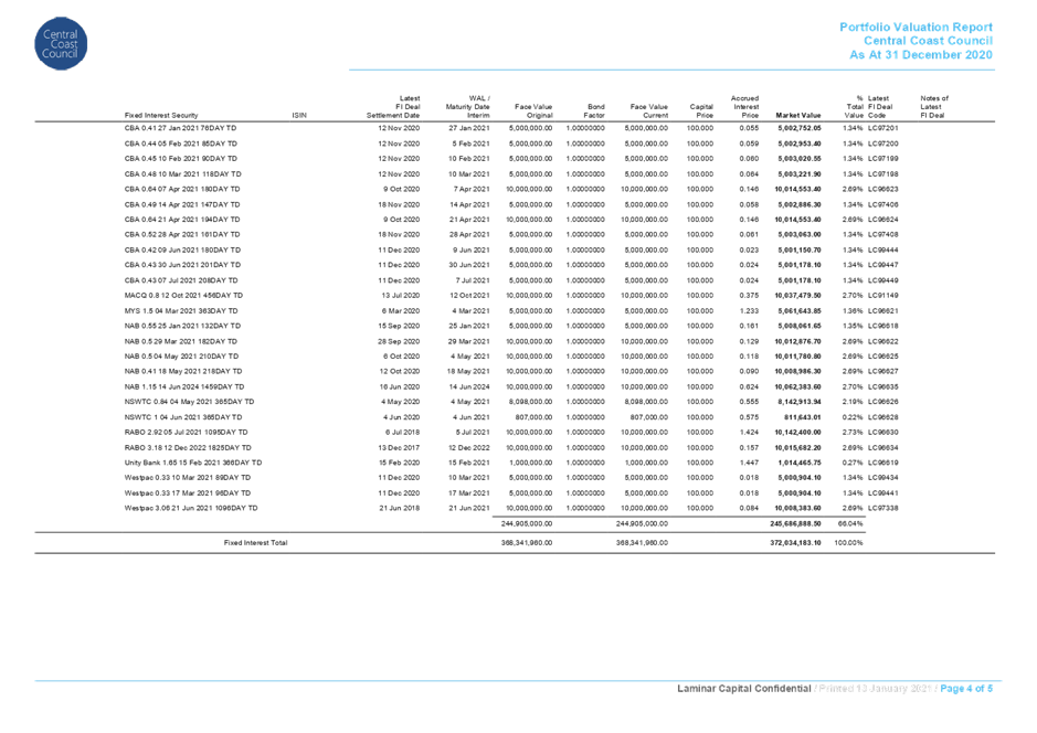
|
3.4
|
Investment Report for December 2020
|
|
Attachment 5
|
Treasury
Direct Trading Limit Report December 2020
|
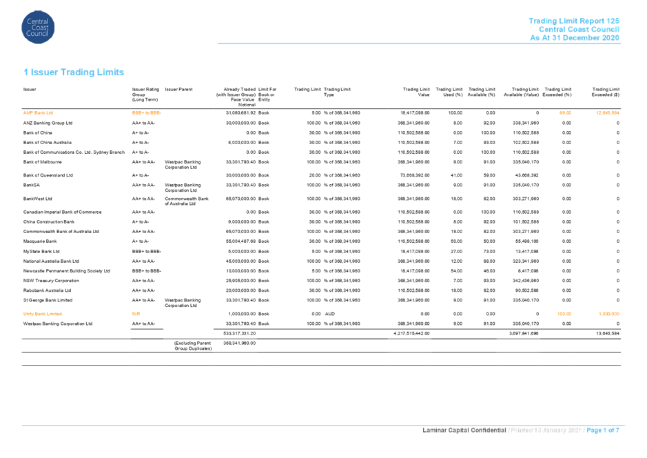
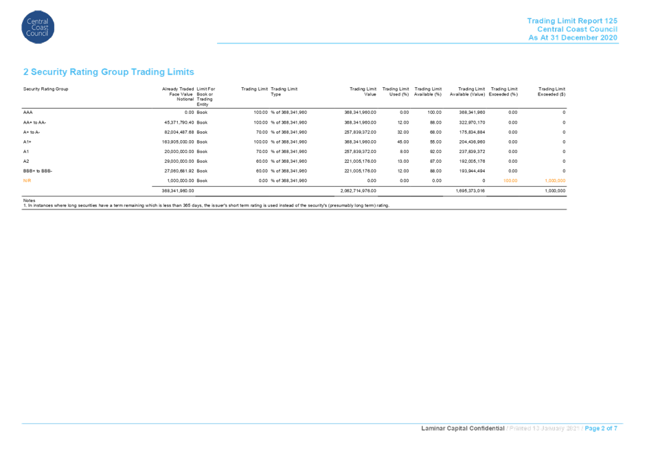
|
4.2
|
Request for Amendment - Planning
Proposal RZ/3/2019 - 45 Mulloway Road Chain Valley Bay
|
|
Attachment 1
|
Planning
Proposal Application - RZ/3/2019 - 45 Mulloway Road Chain Valley Bay - Report
|

|
Item No: 2.1
|
|
|
Title: Planning Proposal
Application - RZ/3/2019 - 45 Mulloway Road Chain Valley Bay
|
|
|
Department: Environment
and Planning
|
|
|
23
March 2020 Ordinary
Council Meeting
|
|
Trim Reference: RZ/3/2019
- D13749206
Author: Rodney
Mergan, Senior Strategic Planner
Manager: Karen
Tucker, Acting Unit Manager, Strategic Planning
Executive: Scott
Cox, Director Environment and Planning
|
Report
Purpose
The
purpose of this report is for Council to consider a request to prepare a
Planning Proposal to amend Wyong Local Environmental Plan 2013 (WLEP)
or draft Central Coast Council Local Environmental Plan (CCLEP) (if
in effect) for 45 Mulloway Road, Chain Valley Bay.
This
report recommends that Council prepare a Planning Proposal and request a
Gateway Determination from the Department of Planning, Industry and
Environment (DPIE).
|
Recommendation
1 That
Council, pursuant to Section 3.33 of the Environmental Planning and Assessment
Act, 1979, prepare a Planning Proposal applying to Lot 5 DP 1228880 (45
Mulloway Road, Chain Valley Bay) to rezone the subject sites from E3
Environmental Management to RE2 Private Recreation and E2 Environmental
Conservation by amending the Wyong Local Environmental Plan 2013 (or Central
Coast Local Environmental Plan), whichever is in effect at the time.
2 That
Council, pursuant to Section 3.34 of the Environmental Planning and Assessment
Act, 1979, forward the Planning Proposal to the Minister requesting a Gateway
Determination.
3 That
Council request delegation for Council to finalise and make the draft Local
Environmental Plan, pursuant to Section 3.36 of the Environmental Planning and
Assessment Act 1979.
4 That
Council undertakes public authority and community consultation in accordance
with the Gateway Determination requirements.
5 That
Council authorise staff to negotiate, prepare and exhibit a Planning Agreement
with respect to any aspect of the proposal to support the development of the
subject land.
6 That
Council authorise staff to prepare and exhibit site specific development
controls with respect to any aspect of the proposal to support the development
of the subject land.
1
7 That
Council consider a further report on the results of public authority and
community consultation.
The Site
The
subject land (figure 1) is known as 45 Mulloway Road Chain Valley Bay, Lot 5 DP
1228880.
The
site has an area of 10.61 Hectares (Ha) and can be divided into three distinct
areas:
- a
dwelling and ancillary development to the north of the site,
- a
generally cleared area predominately used for rural purposes through the
majority or middle of the site, and
- a
heavily vegetated area along the southern boundary of the site.
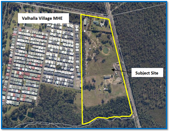
Figure
1- Aerial Photo - Subject site and surrounding land
Surrounding
land uses include:
· a Manufactured Home Estate
(MHE) to the west,
· State Recreation Area to
the north,
· vacant vegetated land to
the east and south currently subject to a planning proposal for residential
development. Land to the south is separated from the subject site by Karignan
Creek.
The
Proposal
The
proposal seeks to amend the Wyong Local Environmental Plan 2013 (WLEP
2013) or future Central Coast Local Environmental Plan (CCLEP) as follows:
· Rezone the subject sites
from E3 Environmental Management to part RE2 Private Recreation and part E2 Environmental
Conservation.
The proposal
does not propose to alter the existing minimum lot size applicable to the
subject site, being 40 ha.
The intended
outcome is to enable the construction of a MHE on the site. The proposal looks
to accommodate approximately 190 home sites, communal open space, communal hall
and recreation facilities.
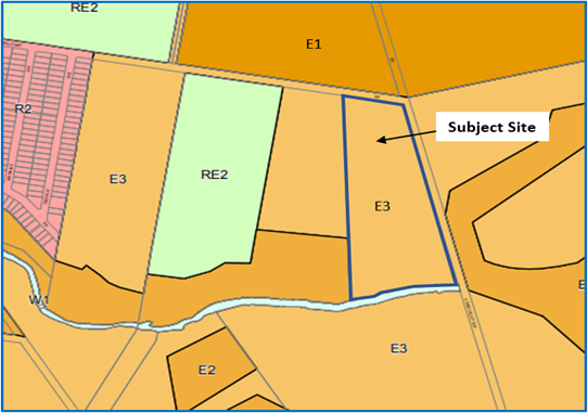
Figure 2 – Current Zoning Map
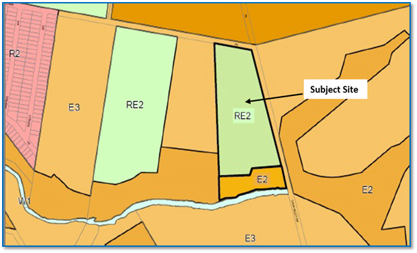
Figure 3 – Proposed Zoning
Assessment
The
rezoning of the subject land to RE2 Private Recreation and E2 Environmental Conservation
has strategic merit on the basis that:
· The proposed amendment is
consistent with actions in the Central Coast Regional Plan (CCRP) 2036,
aligning specifically with Goal 3- Well-connected communities and attractive
lifestyles and Goal 4- A variety of housing choice to suit needs and
lifestyles.
· The proposal is consistent
with the requirements of the Department Planning, Industry and Environment
(DPIE’s) North Wyong Shire Structure Plan (NWSSP), see Figure 4.
This plan identifies the site is
required for future residential purposes. The current timing had identified the
staging of the development within the long-range timeframe (land will not be
zoned before 15 years), this timing can be revised due to new information
relating to underlying mining constraints which are no longer an impediment to
surface land release. This means that the release of the land can be
accelerated, subject to appropriate funding arrangements being put in place to
manage infrastructure and servicing issues associated with increasing the
population in the locality.
2
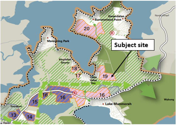
Figure
4 – Extract – North Wyong Shire Structure Plan
· The proposal is consistent
with the draft Greater Lake Munmorah Structure plan, see Figure 5, which was publicly exhibited between
1 April 2019 to 26 May 2019.
The area to be rezoned is identified
within the Draft Greater Lake Munmorah Structure Plan located within Precinct 7
Chain Valley Bay,
The draft Greater Lake Munmorah
Structure Plan facilitates the delivery of 2,885 additional lots, the subject
proposal will provide an additional 190 home sites.
The site is partially nominated as a green corridor and
habitat network by the NWSSP. That portion of the site proposed to be zoned E2
Environmental Conservation aligns with the high level mapped boundary of the
green corridor.
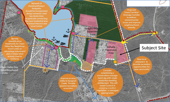
Figure 5 – Draft Greater Lake Munmorah Structure Plan, Precinct 7 –
Chain Valley Bay
· The applicant has provided
relevant supporting studies. These studies have been reviewed through the
internal consultation process and are considered appropriate for submission
with a request for a Gateway Determination. Once a suitable degree of certainty
is provided by a Gateway Determination being issued, appropriate draft planning
agreements to address issues such as roadworks and servicing can be completed
prior to public consultation.
Internal
Consultation
Internal consultation has been undertaken regarding the
proposed Planning Proposal and is summarised below.
Environmental
Strategies
Clearing of vegetation would be
required to facilitate the proposed development of the site for a MHE. While
vegetation removal would generally occur as part of a development application
process that would follow the completion of the planning proposal, Council must
be satisfied that the proposal can reasonably meet the requirements of State
Environmental Planning Policy (SEPP) (Vegetation in Non-Rural Areas)
2017 and the Biodiversity Conservation Act 2016.
A review of information submitted in
support of the proposal has confirmed that the proposal seeks to impact on
approximately 0.32 ha of Swamp Sclerophyll Forest and 0.92 ha of Narrabeen
Doyalson Coastal Woodland and potentially impact on the vegetated southern end
of the site. The proposal triggers entry into the Biodiversity Offset Scheme
(BOS) via impacting areas highlighted on the BV map and exceeding the area
clearing threshold.
Water
Planning and Development
The site
is connected to mains water supply.
The site is
connected to a nearby sewer main and pumping station. Upgrade works in this
area are identified in the Development Servicing Plan with the timing of this
upgrade to be confirmed. Any additional contributions for upgrade works can be
negotiated through an agreement between Council and the applicant.
Environmental
Health - Land Contamination
The proponent has addressed the
requirements under SEPP No. 55 - Remediation of Land by providing a
Preliminary Contamination Assessment.
The findings of this contamination
assessment recommend a detailed contamination assessment be undertaken with
remedial actions, where necessary. It has been determined that if all
“Areas of Concern” identified in the report are addressed prior to
the release of any subdivision certificate the land can be remediated to a
suitable condition for the proposed MHE.
Social
Planning
There is concern relating to residents
being unable to access the services they need due to the large population
increase in an area that is already underserviced and while there is need for
more affordable housing on the Central Coast, it must be well planned and well
located to avoid negatively impacting on residents.
Contributions
The site is
subject to the Northern Districts Section 7.11 Contribution plan. Contributions
will be payable for manufactured home sites for Open Space, Community Facilities
and Administration.
Any road upgrades
required as a result of this development would be subject to agreement between
the applicant, Council or Transport for NSW depending on the works required.
Development Engineering (Traffic)
It
has been acknowledged that the intersection of Pacific Highway and Chain Valley
Road is already at capacity and requires a significant upgrade. The Roads and
Maritime Services (RMS) will not support the creation of additional lots
requiring access to this intersection until the intersection has been upgraded.
There are several planning proposals concurrently being considered in this area
and all parties are to contribute to the completion of the required works
though agreement with Transport
for NSW.
In
addition, there will be local road and associated upgrades required to
facilitate the proposed MHE, the cost of which will be borne by the applicant
through conditions of consent.
Council
Site Inspection
A
site inspection was undertaken on 2 March 2020. The site inspection was
attended by Council staff and the following Councillors:
· Mayor – Councillor
Lisa Matthews
· Deputy Mayor - Councillor
Jane Smith
· Councillor Chris Holstein
The following matters were raised and discussed during the site
inspection:
1. The
southern area of the site is identified as a Regional Wildlife Corridor. What
width is this corridor and could it be widened on this site?
The subject site includes a small part of a regional wildlife
corridor which includes vegetated land north of the creek. The regional
corridor identified in the CCRP is also located on land owned by the Darkinjung
LALC to the south of the site. The final width of the regional wildlife
corridor is not yet agreed upon in this location and is a relevant
consideration in developing a Structure Plan for the DLALC Lake Munmorah
residential rezoning (further to the south). Regional wildlife corridors are
generally wider than local corridors and are normally several hundred metres in
width.
It was confirmed that an increase in corridor (E2 zone) width on
the site could be discussed with the applicant (with a splayed design response
to better align with the position of E2 zones on adjoining land).
2. Can
Council lobby for an improvement in public transportation servicing in the area
given the impact that this and other proposals in the area may have?
The State Government are aware of emerging issues in the area and
this proposal is one of several developments which will be contributing to
required intersection upgrades at the intersection of Chain Valley Bay Rd and
the Pacific Highway.
The proposal will be referred to Transport for NSW for
comment/consideration and will address the need for a coordinated approach to
public transport in the area.
3. Are
there plans for improve recreation facilities and other services for this area?
Facilitated for in the
draft GLMSP and a revision of the relevant S7.11 Contribution Plan is also
underway.
4. Will
the existing residential accommodation and ancillary structures be staying?
The entire site is proposed to be zoned RE2
and eventually all existing development will be replaced.
External
Consultation
Government
agency and public consultation requirements will be detailed in the Gateway
Determination and undertaken accordingly.
It
is anticipated due to the existing development, the proposal and the location
that several external agencies including the following will need to be
consulted:
- Department
of Transport (formerly Transport NSW and Roads and Maritime Services)
- Department
of Planning, Industry and Environment
- Department
of Family and Community and Justice (former Rural Fire Service NSW)
- Subsidence
Advisory NSW
- Darkinjung
Local Aboriginal Land Council
- Guringai
Tribal Link
It
expected that the Planning Proposal will be publicly exhibited for a period of
28 days.
Statutory
compliance and strategic justification
The Planning
Proposal has been assessed having regard for relevant State Environmental
Planning Policies (SEPPs), Ministerial Section 9.1 Directions and relevant
guidelines set out within the regional and local plans, including the Central
Coast Regional Plan (Attachment 2). The proposal is considered to be generally
consistent with the applicable directions and SEPPs.
Financial
Impact
The direct
cost to Council is the preparation of the Planning Proposal and Council’s
fee has been paid for this service. Council’s Fees and Charges allow for
an hourly rate for staff time beyond the scheduled fee to be charged where
required.
Social
Impacts
It has been
identified that the area is currently quite poorly serviced and is not equipped
to accommodate the increase in population envisaged by the development of this
type.
It is noted
that the draft Lake Munmorah Structure Plan envisages the development of this
site and surrounding sites and provides for improved servicing of the area.
Environmental
Impacts
Some clearing of vegetation would be
required to facilitate the proposed development of the site for a MHE. As the
area of the site over which development is proposed is not densely vegetated,
it is considered that required offsetting or redesign can be undertaken and
further addressed following Gateway Determination.
The site is partially nominated as a green
corridor and habitat network by the NWSSP. That portion of the site proposed to
be zoned E2 Environmental Conservation aligns with the high level mapped
boundary of the green corridor.
Link to
Community Strategic Plan
Theme 3:
Green
|
Goal F: Cherished and protected natural beauty
|
|
G-F2: Promote greening and the wellbeing of
communities through the protection of local bushland, urban trees, and expansion
of the Coastal Open Space System (COSS).
|
Theme 4:
Responsible
|
Goal I: Balanced and sustainable development
|
|
R-I3: Ensure land use planning and development is
sustainable and environmentally sound and considers the importance of local habitat,
green corridors, energy efficiency and stormwater management.
|
Risk
Management
There
have been no risks identified to the natural and built environment associated
with the proposed amendment to WLEP 2013 or the CCLEP.
Conclusion
The
request to rezone the subject land is considered to have strategic merit,
subject to being supported by appropriate studies and infrastructure funding
arrangements being in place to manage impacts associated with the additional
population arising from future development.
It is
recommended that a Planning Proposal be prepared and forwarded to the Minister
for Planning for a Gateway Determination.
Attachments
|
1
|
Proposal
Summary
|
|
D13807919
|
|
2
|
Strategic
Assessment RZ32019
|
|
|
|
4.3
|
Outcomes of consultation the draft
Smoke-free Outdoor Public Places Policy
|
|
Attachment 1
|
Submissions
- Smoke free outdoor public places policy
|
Submissions received
– draft Smoke-free Outdoor Public Places Policy
|
Number
of submissions
|
Issues
raised in submissions:
|
|
Six
|
1. All respondents
were individuals, who provided feedback that indicated that they were
supportive of smoke-free areas being extended.
2. Two responses
indicated that they believed the smoke-free distances from entrances to
buildings, playgrounds, bus stops and other facilities identified in the Smoke-free
Environment Act 2000 should be extended to 10 metres.
3. One submission was
supportive of sportsgrounds and other recreation areas being smoke-free at
all times.
4. One submission
would like to see all dining areas to be smoke-free.
5. One submission
indicated support for natural areas, parks, sportsgrounds, areas of cultural
significance, and general community use land being smoke-free, however it was
suggested that
· natural areas
should include beaches, lagoons and waterways,
· sportsgrounds
should include a smoke-free area within 10 metres of clubhouses, canteens
etc.
|
Advice in
relation to issues raised in submissions
1. The policy extends
smoke-free areas to Council managed open space areas to complement the Smoke-free
Environment Act 2000.
2. The policy does not
intend to extend the smoke-free distances identified in the Smoke-free
Environment Act 2000.
3. The draft policy that
was exhibited includes as point 7 “The prohibition of smoking in these
areas applies at all times, not just the specific times identified by some of
the SFE Act (such as areas set aside for spectators to watching sporting events
only when an organised sporting event is on).
4. Commercial outdoor
dining areas are covered by the Smoke-free Environment Act 2000.
Other public outdoor dining areas may include picnic tables provided by Council
in open space areas. Council’s open spaces areas are designated
smoke-free areas at all times under this policy.
5. Section 6 of the draft policy has
been amended to include beaches, lagoons and waterways. The policy
applies to community land categorised as sportsground, which includes canteens,
clubhouses and other buildings within the sportsground reserve.
|
4.3
|
Outcomes of consultation the draft
Smoke-free Outdoor Public Places Policy
|
|
Attachment 2
|
Draft
Smoke-Free Outdoor Places Policy highlighted changes
|
|
4.4
|
Cost of Emergency Works at Wamberal
Beach and The Entrance North Beach
|
|
Attachment 1
|
Letter
from DPIE Emergency Coastal Works Grant - Wamberal
|


|
4.4
|
Cost of Emergency Works at Wamberal
Beach and The Entrance North Beach
|
|
Attachment 2
|
Letter
from DPIE Emergency Coastal Works Grant - The Entrance North
|


|
4.5
|
Request to Prepare a Planning
Proposal for Jilliby Stage 2 Rural-Residential Area
|
|
Attachment 1
|
RZ_2_2020_Planning
Proposal Assessment
|
Planning Proposal Assessment
Proposal Summary
|
Applicant
|
Alf
Lester – LFA Pacific P/L
|
|
Owner
|
• Lot
2 DP 246727, 40 Sandra Street - Atchison
• Lot
3 DP 246727, 50 Sandra Street - Lin
• Lot
4 DP 246727, 60 Sandra Street - Tohamy
• Lot
11 DP 613648, 70 Sandra Street - Mushu
• Lot
10 DP 613648, 80 Sandra Street - Ethell
• Lot
11 DP 258965, 11 Cottesloe Road - MacDonald
|
|
Application Number
|
RZ/2/2020
|
|
Description of Land
subject of planning proposal
|
Legal and Property
Description:
• Lot
2 DP 246727, 40 Sandra Street
• Lot
3 DP 246727, 50 Sandra Street
• Lot
4 DP 246727, 60 Sandra Street
• Lot
11 DP 613648, 70 Sandra Street
• Lot
10 DP 613648, 80 Sandra Street
• Lot
11 DP 258965, 11 Cottesloe Road
|
|
Site Area
|
• Lot
2 DP 246727- 10.7 Ha
• Lot
3 DP 246727 - 10.5 Ha
• Lot
4 DP 246727 - 10.8 Ha
• Lot
11 DP 613648 - 10.8 Ha
• Lot
10 DP 613648 - 27.46 Ha
• Lot
11 DP 258965 - 15.3 Ha
Total Area Proposed E3:
21.6 Ha
Total Area Proposed E4:
63.96 Ha
Total Planning Proposal
Area: 85.56 Ha
|
|
Existing Use
|
• Lot
2 DP 246727 – Dwelling and Sheds
• Lot
3 DP 246727 – Dwelling and Sheds
• Lot
4 DP 246727 - Dwelling and Sheds
• Lot
11 DP 613648 - Dwelling, Sheds and Dams
• Lot
10 DP 613648 – Dwelling, Sheds, Stables and Dam
• Lot
11 DP 258965 – Dwelling, Sheds
and Dams
|
Proposed Amendments
–Wyong Local Environmental Plan 2013
|
|
Provisions
|
Existing
Provision
|
Proposed
Amendment
|
Outcome
(Supported/Not Supported)
|
|
Zoning
|
All Lots:
RU2 – Rural
Landscape
|
• Lot
2 DP 246727 – E4 Environmental Living
• Lot
3 DP 246727 – E4 Environmental Living
• Lot
4 DP 246727 - E3 Environmental Management
• Lot
11 DP 613648 - E3 Environmental Management
• Lot
10 DP 613648 – E4 Environmental Living
• Lot
11 DP 258965 – E4 Environmental Living
|
Outcomes Supported
|
|
Minimum Lot Size
|
20 Ha
|
E4 – 2 Ha
E3 – 20 Ha
|
Outcomes Supported
|
Proposal Report
Executive
Summary
This
Planning Proposal seeks to rezone the majority of the land from RU2 Rural
Landscape to E4 Environmental Living, to enable rural residential development
to occur (similar to that on lands developed to the south, often referred to as
Jilliby Stage 1), in accordance with the standard 2 Ha minimum area applying
within the E4 zone. Some floodprone land will also be rezoned E3
Environmental Management in the central portion of the site. It is expected
that the rezoning will yield approximately 19 rural-residential lots.
This
rezoning proposal originally formed part of a much larger Planning Proposal
which was withdrawn by the applicant. The original historic proposal was
significantly larger and included land with significant biodiversity, odour and
noise constraints (from the operation of Buttonderry Waste Facility) which have
since been removed from the current proposal.
The
subject land is underlain by coal, which will be extracted by the operators of
the Wallarah 2 Mine. The proponents have reached agreement with the mine
owners (and provided a copy to Council) for appropriate compensation
arrangements should surface development be impacted by the mine workings.
The
Site
The site is located approximately 8 kilometres north
west of the Wyong Town centre and is accessed from Sandra Street, off Hue Hue
Road, in the existing rural-residential area of Jilliby. The site is
located close to the Sparks Road interchange with the M1 Motorway. The
land also has road frontage to Cottesloe Road in the north.
The land subject to the rezoning request (see Figure 1)
comprises six (6) lots and has a total area of 85.56 Hectares (Ha).
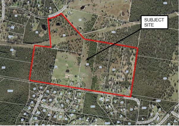
Figure
1: The Subject Site Aerial – Planning Proposal Area bounded in Red
The
land varies from cleared grazing land, through lightly timbered pastureland, to
timbered upslopes to the west. This vegetation connects to an identified
regional vegetation corridor along the adjacent ridgeline, which connects the
vegetation north of Cottesloe Road to Mount Alison in the south
across the Porters Creek floodplain. Central to the site is a low-lying
floodway, and in the north a Transmission Line Easement traverses east-west
across the site. The lands are each occupied by dwellings, farm buildings
and dams.
Surrounding
land uses include:
· East – Buttonderry
Waste Management Facility;
· West – Heavily
timbered and steep rural landholdings;
· North - Rural
landholdings; and
· South - Jilliby
Rural-Residential Estate.
The
land is currently zoned RU2 Rural Landscape (see Figure 2) under the Wyong
Local Environmental Plan 2013 (WLEP 2013), with a minimum area for subdivision
of 20 Ha per lot created. The draft Central Coast Local Environmental
Plan (dCCLEP) proposes to retain the current zoning of the land.
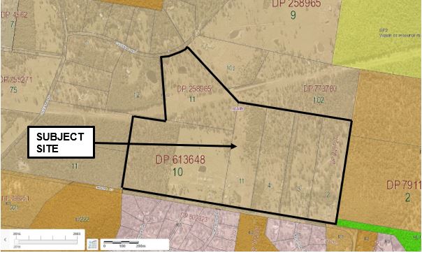
Figure
2: Site Aerial showing Existing Zones
Background
There
is a history of rezoning proposals which have incorporated the subject
lands. The rezoning of a broader Jilliby Stage 2 Land Release (RZ/2/2012
- see Figure 3) was proposed as part of the former Wyong Council’s
Shire-wide draft Local Environmental Plan 2012 (dLEP 2012). RZ/2/2012 had
been lodged on 22 March 2012, and supported by Council for consideration by the
Gateway on 27 March 2013. In issuing certification (17 September, 2013
for the public exhibition of the Shire-wide Plan, the then Department of
Planning and Infrastructure (DoPI), now Department of Planning Industry and
Environment (DPIE), excluded the proposed land release and recommended that it
proceed as an independent Planning Proposal. DLEP 2012 was gazetted as
the Wyong Local Environmental Plan 2013 (WLEP 2013) on 23 December, 2013.
The DPIE Assessment had identified serious
potential for environmental impacts from increased development on the larger
area of land (335 Ha). The key constraints within the Jilliby 2 study
area relate to underground coal mining, vegetation clearing, noise and
odour. A revised, reduced scale, proposal was endorsed by Council on 26
October 2016 and submitted for Gateway Determination on 14 November 2016.
DPIE advised the former WSC that it would need to
commence a Strategic Assessment to justify any future rural residential
planning proposals. DPIE advised that this strategic assessment would
need to consider the relevant factors outlined below:
· Consider the water
catchment;
· Consider the waste
management facility conflicts;
· Consider the potential impacts
of coal mining;
· Confirm any road upgrading
requirements;
· Confirm the land is
suitable for rural residential land uses; and
· Complete a rural land
analysis to facilitate rural residential land uses west of the M1 Motorway.
Council is
currently undertaking the required Rural Lands Studies and will produce a draft
Rural Lands Strategy, due for presentation to Council in June 2021, which will
inform the development of the Central Coast Comprehensive Local Environmental
Plan.
On 13 March
2018, Council was also requested by DPIE to amend its planning proposal to
include the outcome of negotiations between the proponent and the Wallarah 2
Coal Mine. The current proposal (RZ/2/2020, lodged 5 February 2020)
arises following the identification of all issues with the earlier proposal for
the significantly larger rural-residential release (see Figure 3). The applicant formally
withdrew RZ/2/2012 on 4 November 2020.
The
potential impacts of the land release related to fauna and vegetation removal,
the Central Coast Water Catchment, mine subsidence potential from the Wallarah
2 underground coal mine, as well as likely noise and odour impacts to future
residents arising from the future expanded operations of the adjacent
Buttonderry Waste Management Facility (BWMF). In this regard, odour from
the approved BWMF operations was modelled and odour contours developed.
This had implications for Jilliby Stage 2 within the areas affected by the 5
Odour Unit (OU) contour, and contributed to the reduction in the land included
within the new planning proposal.
However,
it can be noted that the potential impact from noise exceeds the impact of
odour upon the study area. Land within the 45dB(A) noise contour to the
BWMF was considered unsuitable for the type of dwelling density proposed by the
original planning proposal, now superseded and withdrawn. The planning
proposal study area has been reduced to facilitate the increased residential
density predominantly outside of the 45dB (A) noise contour, which is plotted
on the Development Concept (see Figure 4). This will minimise potential land
use conflict with the BWMF, which is projected to expand operations into the
western portion of that land into the future. The proposal has been redesigned
to enable additional dwellings to be located outside noise affected areas (see
Figure 4: Development Concept) and to be constructed incorporating
appropriate noise attenuation and mine subsidence treatments.
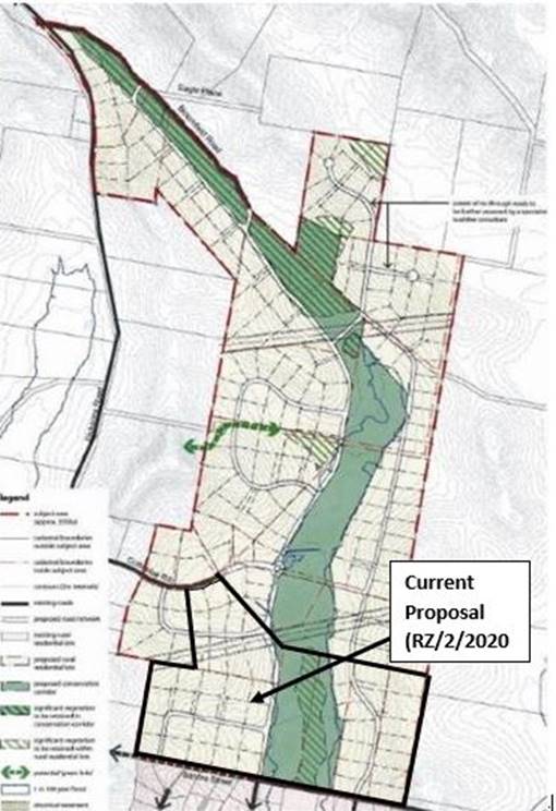
Figure
3: Current Proposal (RZ/2/2020), overlain over the Original Concept
(RZ/2/2012)
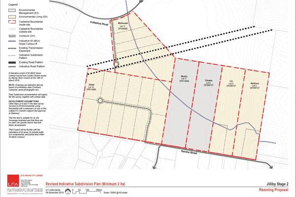
Figure 4: RZ/2/2020
Development Concept, showing the ability for dwellings to be located outside
the 45dB(A) design Noise Contour
The
Proposal
The proposal
is to rezone the majority of the land to E4 Environmental Living to enable
rural residential development to occur in accordance with the standard 2 Ha
minimum area applying within the E4 zone. All new dwellings are to be
located outside the noise and odour impact contours emanating from the adjacent
Buttonderry Waste Management Facility site. The residue land, comprising
the flood corridor traversing the site from North to South over Nos. 60 and 70
(Lots 4 and 11) Sandra Street, are to be rezoned E3 Environmental Management,
reflecting their status as Flood Prone Land. This zoning will allow the
continuance of rural, environmental and tourism uses currently permissible on
the land.
Figure 5
provides an indicative draft Zoning plan and Figure 6 provides the current
Concept Subdivision Layout (dated 9 December 2019) for direct comparison.
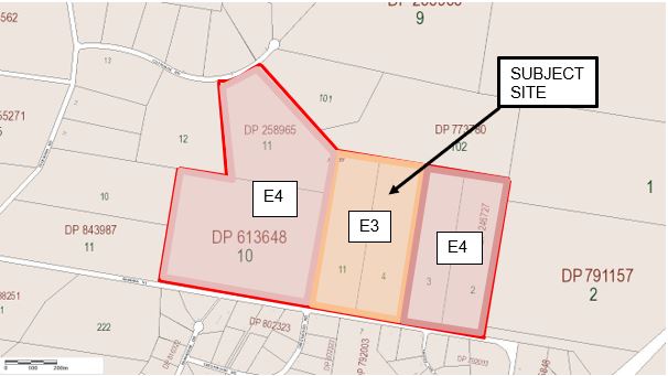
Figure
5: Indicative draft Zoning plan

Figure
6: Concept Subdivision Layout
Assessment
The
request to prepare a Planning Proposal (RZ/2/2020) is supported by the earlier
planning report addressing the larger proposal (RZ/2/2012), which details
preliminary investigations covering the revised area in regard to matters such
as Aboriginal heritage, archaeology, ecological, economics, bushfire, traffic,
water cycle management, onsite effluent and visual impact.
The
planning proposal has been assessed against the Central Coast Council Interim
Local Strategic Planning Statement (ILSPS), the Central Coast Regional Plan
2036 and State strategies, policies and directions, and is considered to be
either consistent, or considered capable of being consistent, subject to
appropriate resolution and management of matters raised below. The detailed
assessment is provided in Attachment 2 – Strategic Assessment.
Investigation
to this point has identified the proposal has strategic merit on the basis that
it will address the following Directions of the Central Coast Regional Plan
2036:
· Secure the productivity
and capacity of resource lands – will not impede access to underlying
coal reserves (Direction 10);
· Protect and manage
environmental values (Direction 12);
· Sustain water quality and
security (Direction13);
· Protect the coast and
manage natural hazards and climate change - Future development of the site will
be required to include relevant measures to ensure the security of land
improvements, such as Asset Protection Zones (Direction 14);
· Create a well-planned,
compact settlement pattern (Direction15);
· Align land use and
infrastructure planning (Direction 17);
· Accelerate housing supply
and improve housing choice (Direction19);
· Provide housing choice to
meet community needs (Direction 21); and
· Manage rural lifestyles
(Direction 23).
Further
Studies Likely to be Required by Gateway:
The
planning proposal has been informed by a series of preliminary specialist
Studies
and investigations which addressed the original 2012 Concept Masterplan.
The updated Concept Masterplan (9 December 2019) affects a subset of this land,
and therefore the reports contain relevant information, which may be required
to be updated to address current legislation and practice. However, this
information is considered to be sufficient for Council to endorse referral to
the Gateway for a Determination. Subject to the terms of the Gateway
Determination, it is likely that further detailed work on the following issues
will be required to progress the planning proposal post Gateway Determination:
· Ecology;
· Flooding and Stormwater
Management;
· Bushfire Risk Management;
· Preliminary Contamination
investigation;
· Mine Operations and
Subsidence;
· Geotechnical
understanding/response;
· Soil
suitability/capability;
· Traffic and Transport;
· Indigenous archaeological
cultural heritage impacts;
· Service infrastructure
provision;
· Social Impact and Open
Space and Recreational demands; and
· Physical infrastructure
and natural systems Funding/Management.
Current
Status
The
proponent has reduced the extent of land for proposed rezoning, and has
negotiated a “Heads of Agreement” document with Wallarah 2 in order
to prepare for specific financial arrangements between the Jilliby 2 landowners
and the Wallarah 2 mine owners to ensure there is no financial liability to the
mine if subsidence does occur.
The proposal
has been designed to enable additional dwellings to be located outside noise
affected areas (see Figure 4: Development Concept) and to be constructed
incorporating appropriate noise attenuation and mine subsidence treatments.
On 17
November 2020, the Administrator and staff undertook a site inspection.
Internal
Consultation
The rezoning request
and supporting reports have been reviewed by staff and responses are summarised
below. Some matters requiring more detailed investigation as a part of the
progression of the proposal are discussed below.
Urban Planning and
Development (Contributions)
The area is included
in the Local Government Area (LGA) Wide Section 7.11 Plan. Hence
Rural-Residential Subdivision will require the payment of development
contributions. If any works are proposed that are not included in the
Plan, then a Voluntary Planning Agreement (VPA) will be required.
It is noted
that under the Wyong District Contributions Plan, an upgrade of the
intersection of Sandra Street and Hue Hue Road is proposed. The
additional lots created may create a need for further intersection works.
The works identified in the Plan require a Type C Intersection.
Water
Planning and Development
There are no
objections/requirements from Wyong Water. The site is outside the
drinking water catchment and will not be serviced by water or sewer
reticulation.
Environmental
Strategies
Council’s
preference would be that Biodiversity Certification is conferred across the
site. This is because the significance of the land is identified by purple
colouring on the NSW Biodiversity Values Map (see Figure 7), in particular the
western half of Lot 10 Sandra Street. This
process identifies areas that can be developed after they are certified and
measures to offset the impacts of development. Where land is certified,
development may proceed without the usual requirement for site by site
assessment.
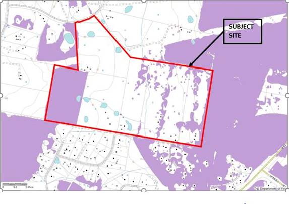
Figure
7: Purple Areas within the site identified on the Biodiversity Values Map
This area is also
identified as containing key habitats for Threatened Species:
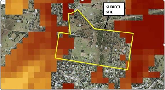
Figure
8: Key Habitats for Threatened Species within the Site
Alternatively, the applicant should delineate building
location envelopes on each of the lots in accordance with the framework of
‘Avoid, Minimise, Offset’ established under the Biodiversity
Conservation Act 2016. This approach may mean that individual DAs do not need
to obtain biodiversity offsets if these areas are disturbed. At the moment
single dwellings and their bushfire Asset Protection Zones (APZs) are requiring
the clearing of about 0.5 ha which would then trigger the need for a
Biodiversity Assessment Report (BDAR).
The planning
proposal could proceed for Council/Gateway endorsement based on the information
already provided (with the likelihood that further work would be required post
Gateway Determination, which would include the provision of a Biodiversity
Certification Assessment Report (BCAR), or a Biodiversity Development
Assessment Report (BDAR), prior to the commencement of community consultation).
A BDAR
provides guidance on how a proponent can avoid and minimise potential
biodiversity impacts and identifies the number and class of biodiversity
credits that need to be offset to achieve a standard of 'no net loss' of
biodiversity.
The current
ecological inventory style report is acceptable for Gateway Determination, on
the condition that either a BDAR is prepared
and the proponent completes the required offsetting (this may be proposed by
the proponent through a Planning Agreement), or an application for
Bio-certification is made to the NSW Minister for the Environment.
It is noted that the
proposed E4 zone boundaries may need to be revised in the western part of the
Planning Proposal area, if further ecological investigations and advice from
BCD confirms that modification of the planning proposal is warranted.
It can be noted that
Council is considering the introduction of a future conservation incentive
clause into the CCLEP, which is an action to be completed in Council’s
Biodiversity Strategy. Depending on how this clause operates, it might be able
to be used as a mechanism for the 2 Ha lot size to be reduced, if the policy
provisions of this policy are met, and once it is in place.
Engineering
Traffic Generation,
Design and Transport:
· Traffic generated by the scale of
this proposal will not have a significant impact on the surrounding road
network. At development application stage the proponent will be required
to address the type of intersection treatments required where the new
subdivision interfaces with existing roads.
· The steep grade and geometrical
constraints of Sandra St may present issues for access for construction traffic,
and for ‘Safer by Design’ principles.
§ Upgrade works maybe required or alternative suitable
access (Dickson Rd & Cottesloe Rd) locations agreed/provided, to provide
adequate construction access.
The geometry of the southern road through Lot 10 Sandra
Street shows a 90-degree bend (out of character curve). This will need to
be managed through appropriate traffic management measures, which can be
determined at DA stage.
· Also, see discussion below
identifying potential fire trail link between the cul-de-sacs.
Mine
Subsidence:
· Mine subsidence issues will impact
infrastructure.
· An additional freeboard allowance for
mine subsidence will be required to be added to the flood level.
Slope
stability:
· There are steep slopes (over 12%) in
some areas - slope stability could be an issue and will require more detailed
analysis at DA stage.
Flooding
& Water Quality
· The natural low point (watercourse)
as evident by the dams on the southern lot and based on the proposed road
location will intercept & convey significant stormwater run-off that will
need to be safely managed.
§ Stormwater could create some issues due to capacity
(system size & cost), erosion & safety issues due to grade &
velocities
§ Downstream increases (individual sub catchments &
whole catchment) in flooding may occur as a result of the proposal due to
increased impervious surfaces.
§ Due to potential issues it is suggested that analysis be
undertaken and ensure that downstream properties that already flood are not
further impacted.
§ There are water courses that will be affected by the
development that may require a Controlled Activity Notice from DPI Water under
the Water Management Act.
§ The level of service of the existing Sandra St culverts
should be confirmed to provide minimum 1% flood free access.
§ Effluent disposal - there could be water quality issues
(detrimental impacts on the floodplain) due to the collective impacts of this
proposal.
Natural
Assets
Bushfire
Prone Lands Assessment
The
lands within the subject site are generally Vegetation Category 1 and partly
Buffer Area, with small areas of Vegetation Category 2. A substantial
area (approx. 50%) of the land within Lot 10, DP 613648 is not identified as
Bushfire Prone Land (BFPL). See Figure 9 below.
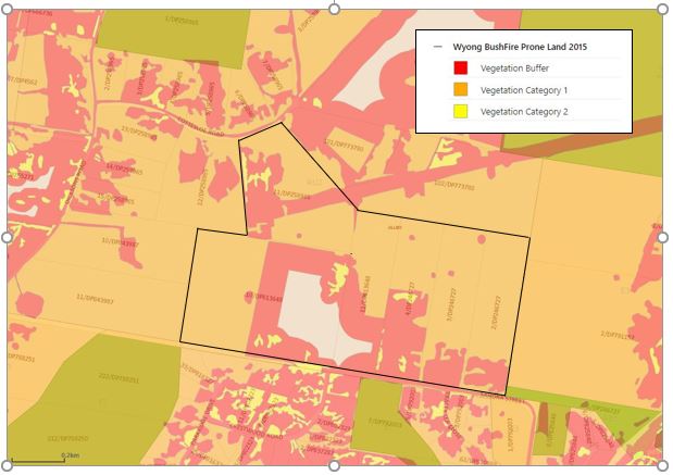
Figure 9:
Wyong Bushfire Prone Lands Map 2015
Wildlife
Corridors and Bushfire Access Fire Trails
Further work
is required to determine if the western parts of the proposed Planning Proposal
should be zoned (E2 or E3) in consideration of the potential biodiversity
impacts of rural-residential development in this location. This corridor
would fulfil the function of connecting Mt Alison E2 Environmental Conservation
lands with the 35ha bushland lot on the northern side of Cottesloe Road.
A Bush Fire
Access Trail (indicated in yellow Figures 10 and 11) could be located on the
edge of this bushland with a locked gate at each end, to manage the fire threat
effectively.
This
would reduce the potential subdivision yield, however would meet the dual needs
of biodiversity conservation and human protection during bushfire events.
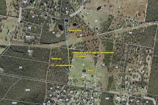
Figure
10: Potential Fire Trail Linkage shown Yellow
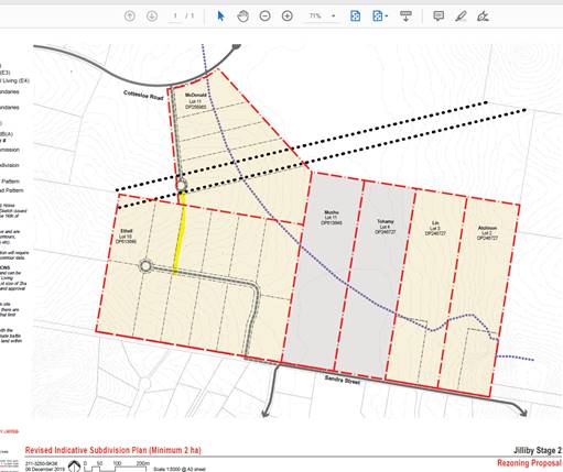
Figure
11: Potential
Fire Trail Linkage shown Yellow
Floodplain
Management
The land
identified as flood prone is primarily contained within land to be zoned E3
Environmental Management.
In reviewing
the terrain it is clear that the valley floor is very flat at around 0.4% grade
downstream. This is also shown along the profile of Sandra Street (see Figure
12).
|

|

|
|
Terrain
over the Site
|
Profile
along Sandra Street
|
Figure
12: Terrain Mapping
Flooding on
this site is as described in the 2009 Porters Creek Flood Study undertaken by
Cardno on behalf of Council. This study identifies a range of flood events
including the Probable Maximum Flood (PMF). This is the method used to define
flood prone land, with generally the 1% flood results used for setting floor
levels (see Figure 13 and14).
|
|
The extent
of flood prone land is that defined by the PMF extent.
|
|
PMF Flood
depth & Levels
|
|
Figure 13: Probable Maximum
Flood Extent, Depth and Levels
|
|
It is
unlikely that the proposal as put forward has any concerns related to
flooding of the site. The proponents need to account for local flow paths in
developing access and building sites etc.

|
Figure
14: 1%AEP Flood Extent and Depth
On the basis
that the extent of flood prone land is almost fully contained within land
proposed to be zoned “E3 Environmental
Management” there are no specific requirements other than the usual
requirements under the Wyong LEP 2013, Wyong DCP 2013 and the NSW State Government’s
Floodplain Development Manual.
External
Consultation
Government
agency and public consultation requirements will be detailed in the Gateway
Determination and conducted accordingly. It is anticipated that due to the
existing development surrounding, and the location, that a number of government
agencies may be required to be consulted, such as the following:
· Department of Family and
Community and Justice (former NSW Rural Fire Service), regarding bushfire
matters;
· Transport for NSW,
regarding transportation and road networking matters;
· Department of Planning,
Industry and Environment on regional planning matters;
· NSW Biodiversity
Conservation Division (BCD) on vegetation and biodiversity matters;
· Department of Primary
Industries on rural industries; and
· Darkinjung Local
Aboriginal Land Council and Guringai Tribal Link (also known as Wannangini),
regarding Aboriginal heritage values.
Statutory
compliance and strategic justification
The planning
proposal has been assessed having regard for relevant State Environmental
Planning Policies (SEPPs), Ministerial Section 9.1 Directions and relevant
guidelines set out within the regional and local plans, including the CCRP (see
Attachment 2 – Strategic Assessment). The proposal is generally
consistent with the applicable Ministerial Directions and SEPPs.
Social
Impacts
The
proposal will expand the available housing choice in terms of providing for
additional
Rural-residential
living within the northern part of the Central Coast. The site is located
outside of the water catchment and relatively close to transport connections
and centres. The WLEP 2013 only provides for limited areas of rural residential
land, and this land is considered a reasonable expansion of the land use.
Environmental
Considerations
Addressed
earlier in the report by relevant sections of Council on vegetation clearing, ecological
impact, and bushfire hazard reduction planning.
Central
Coast Local Strategic Planning Statement
Council’s
Interim Local Strategic Planning Statement (LSPS) came into effect on 21 August
2020 after adoption by Council on 29 June 2020. The LSPS aims to identify
important agricultural and resource lands and minimise rural-residential sprawl,
while supporting rural tourism.
It sets a
clear vision for the future and a proactive framework for delivering a growing
and sustainable Region with a strong network of Centres and thriving and
connected communities.
Further
investigations of the ecology of the site and potential threatened species
impacts will be likely to be required by the Gateway Determination. This
site was identified by DPIE as being able to be progressed for
rural-residential development independently of the earlier Rural Lands Study,
Northern Areas. Notwithstanding, the Planning Proposal documentation will
address these important issues.
The following priorities outlined in the LSPS are applicable to
this Planning Proposal.
|
Central
Coast Interim Local Strategic Planning Statement
(LSPS)
|
|
|
Planning Priority
|
Action
|
Assessment/Comment
|
|
22
|
Create sustainable and
Resilient Communities
|
Protect and minimise land
use impacts on the region’s drinking water catchments by ensuring water
quality objectives are included in Council’s planning controls.
(CCRP Direction 13)
|
The subject site is
generally not located within the Drinking Water Catchment. A small area
of Lot 10 only drains to the Catchment.
Water quality
controls can be applied at development stage.
|
|
24
|
Map, protect, and cherish
natural areas and ecosystems
|
Prepare and implement the
Central Coast Biodiversity Strategy, including land use planning principles
to protect and manage natural areas and ecosystems of high biodiversity
value.
(CCRP
Direction 12)
|
Further
investigations of the ecology of the site and potential threatened species
impacts will be likely to be required by the Gateway Determination.
|
|
25
|
Manage heat wave risks
through strategic planting and maintenance of vegetation
|
Finalise and implement
the Greener Places Strategy to mitigate the impacts of climate change on the
regions water resources, coastal ecosystems, infrastructure, health,
agriculture and biodiversity.
(CCRP
Direction 14)
|
Further
investigations of vegetation on site and potential threatened species impacts
will be likely to be required by the Gateway Determination.
|
|
26
|
Identify important
agricultural and resource lands
|
Prepare a Rural Lands
Study and Strategy having regard to the region’s biophysical,
infrastructure, and socio-economic factors.
(CCRP
Direction 11)
Work with the State
Government to identify and map the most productive and highly suitable land
for agricultural industries and natural resource extraction in the Central
Coast region.
(CCRP
Direction 11)
|
The Rural Lands
Study is currently in development. This site was identified by DPIE as being able to be progressed
independently of the earlier Rural Lands Study, Northern Areas.
This is one of the
major aims of the CC Rural Lands Study. Council is awaiting the final
DPI Ag mapping for Important Agricultural Lands from DPIE.
|
|
27
|
Minimise rural residential
sprawl and support rural tourism
|
Investigate the
suitability for urban development, having regard to agricultural production
and environmental protection priorities, and the ability to provide critical
infrastructure.
(CCRP
Direction 23)
|
This site was
identified by DPIE as being able to be progressed independently of the
earlier Rural Lands Study, Northern Areas. Notwithstanding, the
Planning Proposal documentation will address these important issues.
|
|
28
|
Preserve environmental,
scenic, heritage and cultural landscapes
|
Determine areas within
the rural landscape which require preservation because of environmental,
scenic, heritage and cultural values, as part of the Rural Lands Study and
Strategy.
(CCRP
Direction 8)
|
The Planning Proposal
documentation will address these important issues.
|
|
4.5
|
Request to Prepare a Planning
Proposal for Jilliby Stage 2 Rural-Residential Area
|
|
Attachment 2
|
RZ_2_2020_Strategic
Assessment
|
Central Coast Council
Strategic Planning
Framework Assessment
Various Lots, Sandra
Street and Cottesloe Road, Jilliby
PP/2/2020;
November 2020
(a)
Relationship to strategic planning framework
Where a regional or sub-regional plan is in place:
1. Is
the planning proposal consistent with the objectives and actions of the
applicable regional, sub-regional or district plan (including any exhibited
draft plans or strategies)?
Central Coast Regional Plan 2036
The Central Coast Regional
Strategy 2036 (CCRP) applies to the Central Coast local government area
(LGA).
The CCRP
is to provide the basis of planning by the local government and sets out a
number of actions. The table below demonstrates that the Planning
Proposal is generally consistent with relevant actions identified in the CCRP:
|
Central Coast Regional Plan
|
|
Direction
|
Applicable
|
Assessment/Comment
|
|
1.
|
Grow
Gosford City Centre as the region's capital
|
No
|
Not
located within the region’s capital.
|
|
2.
|
Focus
economic development in the Southern and Northern Growth Corridors
|
No
|
The
proposal is not located within the Southern or Northern Growth
Corridors.
It
represents a small rural/residential subdivision in an area which has been
identified for this purpose.
It
is not inconsistent with this Direction.
|
|
3.
|
Support
priority economic sectors
|
No
|
The
proposal is not inconsistent with this Direction.
|
|
4.
|
Strengthen
inter- regional and intra- regional connections for business
|
No
|
The
proposal is not inconsistent with this Direction.
|
|
5.
|
Support
new and expanded industrial activity
|
No
|
The
proposal is not inconsistent with this Direction.
|
|
6.
|
Strengthen
the economic self- determination of Aboriginal communities
|
No
|
Not
Applicable.
The
proposal is not on land owned by the DLALC.
|
|
7.
|
Increase
job containment in the region
|
No
|
The
proposal is not inconsistent with this Direction.
|
|
8.
|
Recognise
the cultural landscape of the Central Coast
|
No
|
The
proposal is not inconsistent with this Direction.
|
|
9.
|
Protect
and enhance productive agricultural land
|
No
|
The
subject site is not located on prime agricultural lands mapped under Sydney
Regional Environmental Plan (SREP) No. 8, nor identified as Biophysical
Strategic Agricultural Land (BSAL). It potentially may be included in
the current DPI-Ag IAL Mapping exercise, however, this has not yet been
finalised and is not available. The proposal is not
inconsistent with this Direction.
|
|
10.
|
Secure
the productivity and capacity of resource lands
|
Yes
|
The
proposal is consistent with this Direction.
The
subject land is underlain by Coal, which will be extracted by the operators
of the Wallarah 2 Mine. The proponents have reached agreement with the
mine owners (and provided a copy to Council) for appropriate compensation
arrangements should surface development be impacted by the mine
workings. The land is not mapped the ‘preferred location of
extractive industry’.
SEPP
State Environmental Planning Policy (Mining, Petroleum Production and
Extractive Industries) 2007 permits mining and extractive industries with
consent wherever an LEP permits agriculture or industry. The RU2 Rural
Landscape zoning applies to the land currently and permits “extensive
agriculture” without consent. The proposed E3 zone over 2 of the
lots (the floodway) will continue to permit “extensive
agriculture”, with consent. Farm buildings and other
“rural” type activities are also permissible within the E4 zone.
|
|
11.
|
Sustain
and balance productive landscapes west of the M1
|
No
|
The
proposal is not inconsistent with this Direction.
The
site is not located on resource lands per SREP Nos. 8 and 9 mapping.
|
|
12.
|
Protect
and manage environmental values
|
Yes
|
The
land has historically been used for agricultural purposes and also has been
cleared substantially.
The
area has high biodiversity values, ecological connectivity and Aboriginal
cultural heritage values. The surveys relied upon at this stage were conducted
prior to 2012 and will need to be updated in accordance with current
requirements. Additional cultural surveys will also need to be completed, in
the company of indigenous representatives.
The
proposal is recommended to Council for support with further environmental
investigations recommended to be carried out, as follows:
- appropriate
level of survey (including targeted species surveys) in accordance with
requirements of the Biodiversity Conservation Act, 2016 and/or Office
Environment & Heritage (OEH/DPIE) guidelines to demonstrate the avoidance
and minimisation of impacts.
|
|
13.
|
Sustain
water quality and security
|
Yes
|
The
proposal is consistent with this Direction.
The
subject site is generally not located within the Drinking Water Catchment.
A small area of Lot 10 only drains to the Catchment.
|
|
14.
|
Protect
the coast and manage natural hazards and climate change
|
Yes
|
The
proposal is consistent with this Direction.
The
proposal is not affected by coastal hazards.
The
site comprises Category 1, Category 2 Bushfire Prone Vegetation and
includes Buffer areas. Future development of the site will be required
to include relevant measures to ensure the security of land improvements,
such Asset Protection Zones (APZs).
|
|
15.
|
Create
a well-planned, compact settlement pattern
|
Yes
|
The
subject proposal is consistent with this Direction.
The
proposal will deliver Rural-Residential lots.
|
|
16.
|
Grow
investment opportunities in the region’s centres
|
No
|
The
subject proposal is not within a centre.
|
|
17.
|
Align
land use and infrastructure planning
|
Yes
|
The
subject proposal is consistent with this Direction.
Drainage
and traffic infrastructure may require upgrades with the development.
|
|
18.
|
Create
places that are inclusive, well-designed and offer attractive lifestyles
|
Yes
|
The
subject proposal is consistent with this Direction.
The
proposal will deliver Rural-Residential lots.
|
|
19.
|
Accelerate
housing supply and improve housing choice
|
Yes
|
The
proposal will deliver Rural-Residential lots, increasing the supply and
choice of available housing styles.
|
|
20.
|
Grow
housing choice in and around local centres
|
No
|
The
proposal does not relate to housing supply in or near a centre.
|
|
21.
|
Provide
housing choice to meet community needs
|
Yes
|
The
proposal will deliver Rural-Residential lots, increasing the supply and
choice of available housing styles.
|
|
22.
|
Deliver
housing in new release areas that are best suited to building new communities
|
Yes
|
The
proposal will deliver Rural-Residential lots, increasing the supply and
choice of available housing styles. The site is not within a new
release area, however, is relatively close to the future Warnervale Town Centre
Release Areas.
|
|
23.
|
Manage
rural lifestyles
|
Yes
|
The
proposal will deliver Rural-Residential lifestyle lots, increasing the supply
and choice of available rural housing styles and lifestyle opportunities.
|
|
|
|
|
|
Table 1: Central
Coast Regional Plan Assessment
2. Is
the planning proposal consistent with the local Council’s Community
Strategic Plan, or other local strategic plan?
Central
Coast Community Strategic Plan – One: Central Coast
The
Central Coast Community Strategic Plan outlines a set of guiding
principles, aspirations and values for the community. These reflect on social,
economic, environmental and governance aspects for now and the future.
The following strategies outlined in the
Community Strategic Plan are applicable to this Planning Proposal:
|
Theme - Belonging
|
|
Focus Area – Creativity, connection and local identity
|
|
Objectives
|
Assessment
|
|
B1
Support reconciliation through the
celebration of Aboriginal and Torres Strait Islander cultures
|
The Aboriginal Heritage Information
Management System (AHIMS) GIS mapping indicates no Aboriginal sites or places
on the subject land.
Further Aboriginal heritage investigation
and consultation with local Aboriginal groups will be required, should a
Gateway be granted, to ascertain if the proposal is consistent with this
Objective.
|
|
Theme - Green
|
|
Focus Area – Cherished and Protected Natural Beauty
|
|
Objectives
|
Assessment
|
|
F1
Protect our rich environmental heritage by
conserving beaches, waterways, bushland, wildlife corridors and inland areas
and the diversity of local native species
|
The land has historically been used for
agricultural purposes and also has been cleared substantially. Some
vegetation (Spotted Gum Ironbark Forest) will be removed or modified, of
which much is already in a disturbed or modified state.
The revised study area is affected on the
western edge by an identified regional vegetation corridor that connects
Mount Alison to the vegetation north of Cottesloe Rod along a ridgeline.
The proposal is recommended to Council for
support with further environmental investigations recommended to be carried
out, as follows:
· appropriate
level of survey (including targeted species surveys) in accordance with
requirements of the Biodiversity Conservation Act, 2016 and/or Office
Environment & Heritage (OEH) guidelines to demonstrate the avoidance and
minimisation of impacts.
|
|
Theme - Responsible
|
|
Focus Area – Balanced
and Sustainable Development
|
|
Objectives
|
Assessment
|
|
I1
Preserve local character and protect our
drinking water catchments, heritage and rural areas by concentrating
development along transport corridors and town centres east of the M1
|
Consistent.
The proposal will logically complete the
Jilliby Rural-Residential area. The higher, steeper, vegetated and low
lying flood prone land will retain existing RU2, E2 and E3 zonings.
|
|
I2
Ensure all new developments are well
planned with good access to public transport, green space and community
facilities and support active transport
|
Consistent.
See above I1.
|
|
I3
Ensure land use planning and development
is sustainable and environmentally sound and considers the importance of
local habitat, green corridors, energy efficiency and stormwater management
|
See above F1.
Further environmental investigation will
be required, should a Gateway be granted, to ascertain if the proposal is
consistent with this Action.
|
Table
2 – Community Strategic Plan Assessment
Local Strategic
Planning Statement
Council’s Interim Local Strategic Planning Statement (LSPS)
came into effect on 21 August 2020 after adoption by Council on 29 June
2020. The LSPS aims to identify important agricultural and resource lands
and minimise rural-residential sprawl, while supporting rural tourism.
Further investigations of the ecology of the site and potential
threatened species impacts will be likely to be required by the Gateway
Determination. This site was identified by DPIE as being able to be
progressed for rural-residential development independently of the earlier Rural
Lands Study, Northern Areas. Notwithstanding, the Planning Proposal
documentation will address these important issues.
The following priorities outlined in the LSPS are applicable to
this Planning Proposal.
|
Environment
|
|
22
|
Planning Priority
|
Action
|
Assessment
|
|
Create Sustainable and Resilient Communities
|
Protect and minimise land use impacts on the region’s
drinking water catchments by ensuring water quality objectives are included
in Council’s planning controls.
(CCRP Direction 13)
|
The subject site is generally not located within the Drinking
Water Catchment. A small area of Lot 10 only drains to the Catchment.
Water quality controls can be applied at development stage.
|
|
24
|
Map, protect, and cherish natural areas and ecosystems
|
Prepare and implement the Central Coast Biodiversity Strategy,
including land use planning principles to protect and manage natural areas
and ecosystems of high biodiversity value.
(CCRP Direction 12)
|
Further investigations of the ecology of the site and potential
threatened species impacts will be likely to be required by the Gateway
Determination.
|
|
26
|
Manage heat wave risks through strategic planting and
maintenance of vegetation
|
Finalise and implement the Greener Places Strategy to mitigate
the impacts of climate change on the regions water resources, coastal
ecosystems, infrastructure, health, agriculture and biodiversity.
(CCRP Direction 14)
|
Further investigations of vegetation on site and potential
threatened species impacts will be likely to be required by the Gateway
Determination.
|
|
Agriculture and Rural Land
|
|
27
|
Planning Priority
|
Action
|
Assessment
|
|
Identify and Protect important agricultural and resource lands
for local sustainability
|
Prepare a Rural Lands Study and Strategy having regard to the region’s
biophysical, infrastructure, and socio-economic factors.
(CCRP Direction 11)
Work with the State Government to identify and map the most
productive and highly suitable land for agricultural industries and natural
resource extraction in the Central Coast region.
(CCRP Direction 11)
|
The Rural Lands Study is currently in development. This
site was identified by DPIE as being able to be progressed independently of
the earlier Rural Lands Study, Northern Areas.
This is one of the major aims of the CC Rural Lands Study.
Council is awaiting the final DPI Ag mapping for Important Agricultural Lands
from DPIE.
|
|
28
|
Minimise rural residential sprawl and support rural tourism
|
Investigate the suitability for urban development, having regard
to agricultural production and environmental protection priorities, and the
ability to provide critical infrastructure.
(CCRP Direction 23)
|
This site was identified by DPIE as being able to be progressed
independently of the earlier Rural Lands Study, Northern Areas.
Notwithstanding, the Planning Proposal documentation will address these
important issues.
|
|
29
|
Preserve environmental, scenic, heritage and cultural landscapes
|
Determine areas within the rural landscape which require
preservation because of environmental, scenic, heritage and cultural values,
as part of the Rural Lands Study and Strategy.
(CCRP Direction 8)
|
The Planning Proposal documentation will address these important
issues.
|
Table
3 – Local Strategic Planning Statement Assessment
3. Is
the planning proposal consistent with applicable state environmental planning
policies?
The proposal has been considered against the relevant State
Environmental Planning Policies (SEPP) as detailed below.
|
State Environmental Planning Policies
|
|
SEPP
|
CONSISTENCY
|
|
SEPP 55 – Remediation of Land
|
|
Aims to promote the remediation of
contaminated land for the purpose of reducing the risk of harm to human
health or any other aspect of the environment.
(a) by
specifying when consent is required, and when it is not required, for a
remediation
work, and
(b) by
specifying certain considerations that are relevant in rezoning land and in
determining development applications in general and
(c) development
applications for consent to carry out a remediation work in particular, and
(d) by
requiring that a remediation work meet certain standards and notification
requirements.
|
Applicable
& Consistent.
The
Applicant’s planning report states that a search of the Environmental
Protection Authority’s Contaminated Land Records reveals no
entries, notices, actions or management proposals issued under the
Contaminated lands Act for the subject land.
At
the DA stage, should the planning proposal proceed and be finalised, a
Preliminary Site Contamination Assessment per SEPP 55 will be required to
support any proposed development.
|
|
SEPP (Coastal Management) 2018
|
|
The
aim of this Policy is to promote an integrated and coordinated approach to
land use planning in the coastal zone in a manner consistent with objects of
the Coastal Management Act 2016, including the Management objectives
for each coastal management area, by:
(a)
managing development in the coastal zone and protecting the environmental
assets of the coast, and
(b)
establishing a framework for land use planning to guide and decision-making
in the coastal zone, and mapping the 4 coastal management areas that comprise
the NSW coastal zone for the purpose of the definitions in the Coastal
Management Act 2016.
|
Not
Applicable.
The
subject land is not within the areas affected by this SEPP.
|
|
SEPP (Mining, Petroleum & Extractive Industries) 2007
|
|
Aims:
(a) to
provide for the proper management and development of mineral, petroleum and
extractive material resources for the purpose of promoting the social and
economic welfare of the State, and
(b) to
facilitate the orderly and economic use and development of land containing
mineral, petroleum and extractive material resources, and
(b1) to promote the development of significant mineral
resources, and
(c) to
establish appropriate planning controls to encourage ecologically sustainable
development through the environmental assessment, and sustainable management,
of development of mineral, petroleum and extractive material resources, and
(d) to
establish a gateway assessment process for certain mining and petroleum (oil
and gas) development:
(i) to
recognise the importance of agricultural resources, and
(ii) to ensure protection of strategic
agricultural land and
water resources, and
(iii) to
ensure a balanced use of land by potentially competing industries, and
(iv) to
provide for the sustainable growth for mining,
petroleum and agricultural industries.
|
Applicable
& Consistent.
SEPP
State Environmental Planning Policy (Mining, Petroleum Production and
Extractive Industries) 2007 permits mining and extractive industries with
consent wherever an LEP permits agriculture or industry.
The
current RU2 Rural Landscape zone permits extensive agriculture without
consent and other rural uses with consent.
The
E4 zone proposed over the majority of the land permits horticulture, bee
keeping and some other rural activities with consent, and the E3 zone
to apply to part of the land permits extensive agriculture, horticulture,
farm buildings, etc., with consent.
|
|
SEPP (Vegetation in Non-Rural Areas) 2017
|
|
The aims of this Policy are as follows:
(a) to
establish the process for assessing and identifying sites as urban
renewal precincts,
(b) to
facilitate the orderly and economic development and redevelopment of sites in
and around urban renewal precincts,
(c) to
facilitate delivery of the objectives of any applicable government State,
regional or metropolitan strategies connected with the renewal of urban areas
that are accessible by public transport.
|
Applicable
& Consistent.
Currently
not applicable as this SEPP does not apply to land zoned RU2, but it will
apply when the lands are rezoned to E3 and E4, meaning clearing Permits and
land clearing activities will generally be brought under Council’s
control.
|
|
SEPP (Aboriginal Land) 2019
|
|
Aims:
(a) to provide for development delivery plans for areas of land owned by Local
Aboriginal Land Councils to be considered when development applications are
considered, and
(b) to declare
specified development carried out on land owned
by Local Aboriginal Land Councils to be regionally significant development.
|
Not
applicable.
The
land is not identified in the mapping supporting this SEPP.
|
|
SEPP (Primary Production
and Rural Development) 2019
|
|
Aims
(a) to
facilitate the orderly economic use and
development of lands
for primary production,
(b) to
reduce land use conflict and sterilisation
of rural land by balancing primary production, residential development and
the protection of native vegetation, biodiversity and water resources,
(c) to
identify State significant agricultural land for the purpose of ensuring the ongoing viability of agriculture on that land,
having regard to social, economic and environmental considerations,
(d) to
simplify the regulatory process for smaller-scale low risk artificial
waterbodies, and routine maintenance of artificial water supply or drainage, in irrigation areas
and districts, and
for routine and emergency work in irrigation areas and districts,
(e) to
encourage sustainable agriculture,
including sustainable aquaculture,
(f) to require consideration of the effects of all
proposed development in the State on oyster aquaculture,
(g) to
identify aquaculture that is to be treated as designated development using a
well-defined and concise development assessment regime based on environment
risks associated with site and operational
factors.
|
Not
applicable.
The
subject land is not mapped as prime agricultural land.
|
|
SEPP Infrastructure
|
|
The aim of this Policy is to facilitate the effective delivery
of infrastructure across the State.
|
Not
Applicable unless in relation to development carried out by on behalf of
Council or a NSW Agency
|
|
Deemed State Environmental Planning Policies – Assessment
|
|
Deemed SEPP
|
Consistency
|
|
Sydney Region Environmental Plan No. 8 Central Coast Plateau
Areas
|
Comment
|
|
The relevant aims of the
deemed SEPP are:
- to
provide a basis for evaluating competing land uses
- to
direct development for non-agricultural purposes to land of lesser
agricultural capability and
• to
encourage the preparation of draft LEPs based on merits
|
Not Applicable.
|
|
SREP No. 9 Extractive Industry (No2 – 1995)
|
|
2 Aims,
objectives
(a) to facilitate the
development of extractive resources in proximity to the population of the
Sydney Metropolitan Area by identifying land which contains extractive
material of regional significance.
|
Applicable and consistent.
SEPP State Environmental Planning Policy (Mining, Petroleum
Production and Extractive Industries) 2007 permits mining and extractive
industries with consent wherever an LEP permits agriculture or industry.
The current RU2 Rural Landscape zone permits extensive
agriculture without consent and other rural uses with consent.
The E4 zone proposed over the majority of the land permits
horticulture, bee keeping and some other rural activities with consent, and
the E3 zone to apply to part of the land permits extensive agriculture,
horticulture, farm buildings, etc., with consent.
|
|
(b) to permit, with the consent of the council,
development for the purpose of extractive industries on land described in
Schedule 1 or 2, and
|
Consistent.
The subject land is not identified within Schedule 1 or 2 (nor
on the map).
|
|
(c) to ensure consideration is given to the impact of
encroaching development on the ability of extractive industries to realise
their full potential.
|
Consistent.
The subject land is not located near affected lands.
|
|
3 Future
development controls for extraction from Schedule 1 or 2 land
(a) council should not
prepare a draft local environmental plan to prohibit development for the
purpose of an extractive industry on land described in Schedule 1 or 2.
|
The subject land is not identified within Schedule 1 or 2 (nor
on the map).
|
|
State Regional Environmental Plan No 20 – Hawkesbury
– Nepean River (No2 – 1997)
|
|
Aims Objectives and Special Provisions of SREP 20
3 Aim of this plan
The aim of this plan is to protect the environment of the
Hawkesbury-Nepean River system by ensuring that the impacts of future land
uses are considered in a regional context.
|
Not applicable
The land is not mapped under the SREP
|
|
|
|
Table 4 – State Environmental Planning Policy
Assessment
4. Is
the planning proposal consistent with applicable Ministerial Directions (s.9.1
Directions)?
The proposal has been considered against the
relevant Ministerial Directions as summarised below. The full assessment of
these Directions is contained within the Attachments of this proposal.
|
Ministerial Section 9.1 Directions
|
|
Direction
|
Comment
|
|
Employment & Resources
|
|
1.1
Business & Industrial Zones
|
|
Aims to encourage employment growth in suitable
locations, protect employment land in business and industrial zones and to
support the viability of identified centres.
Applies when a planning proposal affects land within
an existing or proposed business or industrial zone.
|
Not
Applicable.
|
|
1.2
Rural Zones
|
|
Aims
to protect the agricultural production value of rural land.
Applies
when a planning proposal affects land within an existing or proposed rural
zone.
|
Applicable.
The
direction states that a Planning Proposal must not rezone land from a rural
zone to a residential, business, industrial, village or tourist zone.
A
planning proposal may be inconsistent with the terms of this direction if;
- the
council can satisfy the Department of Planning Industry & Environment
(DoPIE) that the provisions of the planning proposal that are inconsistent
are justified by a study (prepared in support of the planning proposal) which
considers the objectives of this direction, or
- the
proposal is of minor significance
No
state government recognised study to justify this rezoning exists. The
rural zone will not be retained, as Environmental zones are proposed.
Therefore the proposal does not contain provisions that will increase the
permissible density of land within a rural zone.
The
subject land is not mapped as being ‘prime agricultural land’,
nor Biophysical Strategic Agricultural Land
The
land is zoned RU2 – Rural Landscape, but not RU1 – Primary
Production.
The
proposal is not considered to be alienating agricultural production.
The
inconsistency of the proposal with this Direction is of minor significance.
|
|
1.3
Mining, Petroleum Production and Extractive Industries
|
|
Aims
to ensure that the future extraction of State or regionally significant
reserves of coal, other minerals, petroleum and extractive materials are not
compromised by inappropriate development.
Applies
when a planning proposal would have the effect of prohibiting the mining of
coal or other minerals, production of petroleum, or winning or obtaining of
extractive materials, or restricting the potential of development resources
of coal, other mineral, petroleum or extractive materials which are of State
or regional significance by permitting a land use that is likely to be
incompatible with such development.
|
Applicable
and consistent.
SEPP
State Environmental Planning Policy (Mining, Petroleum Production and
Extractive Industries) 2007 permits mining and extractive industries with
consent wherever an LEP permits agriculture or industry.
The
subject land is underlain by Coal, which will be extracted by the operators
of the Wallarah 2 Mine. The proponents have reached agreement with the
mine owners (and provided a copy to Council) for appropriate compensation
arrangements should surface development be impacted by the mine
workings. The land is not mapped the ‘preferred location of
extractive industry’.
SEPP
State Environmental Planning Policy (Mining, Petroleum Production and
Extractive Industries) 2007 permits mining and extractive industries with
consent wherever an LEP permits agriculture or industry. The RU2 Rural
Landscape zoning applies to the land currently and permits “extensive
agriculture” without consent. The proposed E3 zone over 2 of the
lots (the floodway) will continue to permit “extensive
agriculture”, with consent. Farm buildings and other “rural”
type activities are also permissible within the E4 zone.
The
proposal is consistent with this Direction.No. 9
|
|
1.4
Oyster Aquaculture
|
|
Aims
to ensure that Priority Oyster Aquaculture Areas and oyster aquaculture
outside such an area are adequately considered, and to protect Priority Oyster
Aquaculture Areas and oyster aquaculture outside such an area from land uses
that may result in adverse impacts on water quality and consequently, on the
health of oysters and oyster consumers. Applies when a planning
proposal could result in adverse impacts on a Priority Oyster Aquaculture
Areas or current oyster aquaculture lease in the national parks estate or
results in incompatible use of land between oyster aquaculture in a Priority
Oyster Aquaculture Area or current oyster aquaculture lease in the national
parks estate and other land uses.
|
Not
Applicable.
There
are no ‘Priority Oyster Aquaculture Areas’ (POAA) near the site.
The
proposal is consistent with this direction.
|
|
1.5
Rural Lands
|
|
Objectives
are to;
- protect
the agricultural production value of rural land;
- facilitate
the orderly and economic development of rural lands for rural and related
purposes;
- assist
in the proper management, development and protection of rural lands to
promote the social, economic and environmental welfare of the State;
- minimise
the potential for land fragmentation and land use conflict in rural areas,
particularly between residential and other rural land uses;
- encourage
sustainable land use practices and ensure the ongoing viability of
agriculture on rural land;
- support
the delivery of the actions outlined in the New South Wales Right to Farm
Policy.
|
Applicable
and consistent.
The
subject land is not covered by Sydney Regional Plan No: 8 (deemed SEPP).
The
subject land is not mapped as being ‘prime agricultural land’.
The
land is zoned RU2 – Rural Landscape, but not RU1 – Primary
Production.
The
proposal will not be inconsistent with the objectives.
|
|
Environment & Heritage
|
|
2.1
Environmental Protection Zones
|
|
Aims
to protect and conserve environmentally sensitive areas.
Applies
when the relevant planning authority prepares a planning proposal.
|
Applicable
and Consistent. Further investigation post gateway will be required.
The
proposal is recommended to Council for support with further environmental
investigations recommended to be carried out, as follows:
• appropriate
level of survey (including targeted species surveys) in accordance with
requirements of the Biodiversity Conservation Act, 2016 and/or Office
Environment & Heritage (OEH) guidelines to demonstrate the avoidance and
minimisation of impacts.
|
|
2.2
Coastal Management
|
|
Aims
to protect and manage coastal areas of NSW. Applies when a planning proposal
applies to land in the Coastal Zone as defined under the Coastal Management
Act 2016.
|
Not
Applicable.
The
Coastal Zone is defined under the Coastal Management Act as those lands
identified as coastal wetlands and littoral rainforests areas, coastal
vulnerability environmental and coastal use areas which are mapped under SEPP
Coastal Management. No ‘coastal zone’ areas are located in the
vicinity of the subject site.
|
|
2.3
Heritage Conservation
|
|
Aims
to conserve items, areas, objects and places of environmental heritage
significance and indigenous heritage significance.
Applies
when the relevant planning authority
prepares
a planning proposal.
|
Applicable.
Further
investigation post gateway will be required regarding this matter.
The
AHIMS database has not identified Aboriginal Cultural Heritage items within
1,000m of the subject land.
Wyong
LEP 2013 does not identify any European Heritage items within the proposal
area.
A
comprehensive Aboriginal Archaeological and Cultural Heritage survey will be
required to be undertaken in accordance with the NSW Office of Environment
and Heritage investigation, assessment and reporting guidelines, inclusive of
relevant consultation with indigenous groups. Should the proposal progress to
receipt of a Gateway Determination, an investigation into Aboriginal heritage
values will be required to be prepared.
|
|
2.4
Recreational Vehicle Areas
|
|
Aims
to protect sensitive land or land with significant conservation values from
adverse impacts from recreation vehicles.
Applies
when the relevant planning authority prepares a planning proposal.
|
Applicable
and consistent.
The
proposal does not seek to provide recreational vehicle areas.
|
|
2.5
Application of E2 and E3 Zones and Environmental Overlays in Far North Coast
LEPs
|
|
Aims
to ensure that a balanced and consistent approach is taken when applying environmental
protection zones and overlays to land on the NSW Far North Coast.
|
Not
Applicable
This
Direction does not apply to the Central Coast Local Government Area (or
former Wyong or Gosford LGAs).
|
|
Housing, Infrastructure and Urban Development
|
|
3.1
Residential Zones
|
|
Aims
to encourage a variety and choice of housing types to provide for existing
and future housing needs, to make efficient use of existing infrastructure
and services and ensure that new housing has appropriate access to
infrastructure and services and to minimise the impact of residential
development on the environment and resource lands.
Applies
when a planning proposal affects land within an existing or proposed
residential zone, and any other zone in which significant residential
development is permitted or proposed to be permitted.
|
Not
Applicable.
Proposal
is not within or proposing residential zonings.
|
|
3.2
Caravan Parks and Manufactured Home Estates
|
|
Aims
to provide for a variety of housing types and provide opportunities for
caravan parks and manufactured home estates.
Applies
when the relevant planning authority prepares a planning proposal.
|
Not
Applicable.
Caravan
Parks are not permissible under the current RU2 zoning, or the proposed E3 or
E4 zones.
|
|
3.3
Home Occupations
|
|
Aims
to encourage the carrying out of low impact small business in dwelling
houses.
Applies
when the relevant planning authority prepares a planning proposal.
|
Applicable
and consistent.
The
proposed E3 and E4 zones permit Home Occupations without consent.
|
|
3.4
Integrating Land Use & Transport
|
|
Aims
to ensure that urban structures, building forms, land use locations,
development designs, subdivision and street layouts to achieve: improving
access to housing, jobs and services by walking, cycling and public
transport; increasing choice of available transport and reducing dependence
on cars; reducing travel demand;
supporting efficient and viable public transport services; and provide for efficient movement of
freight.
Applies
when a planning proposal creates alters or moves a zone or provision relating
to urban land, including land zoned for residential, business, industrial,
village or tourist purposes.
|
Not
Applicable.
|
|
3.5
Development Near Regulated Airports and Defence Airfields
|
|
Aims
to ensure the effective and safe operation of regulated airports and defence
airfields; to ensure that their operation is not compromised by development
that constitutes an obstruction, hazard or potential hazard to aircraft
flying in the vicinity; and to ensure development, if situated on noise
sensitive land, incorporates appropriate mitigation measures so that the
development is not adversely affected by aircraft noise.
Applies
when a planning proposal creates, alters or removes a zone or provision
relating to land near a regulated airport which includes a defence airfield.
|
Not
Applicable.
The
subject land is not located within the ANEF Contour 20 of the Warnervale
Airport and any development on the land would be unlikely to exceed the
Obstacle Limitation Surface Level.
The
land is not near a defence airfield.
|
|
3.6
Shooting Ranges
|
|
Aims
to maintain appropriate levels of public safety and amenity when rezoning
land adjacent to an existing shooting range, to reduce land use conflict
arising between existing shooting ranges and rezoning of adjacent land, and
to identify issues that must be addressed when giving consideration to
rezoning land adjacent to an existing shooting range.
Applies
when a relevant planning authority prepares a planning proposal that will
affect, create, alter or remove a zone or a provision relating to land
adjacent to and/ or adjoining an existing shooting range.
|
Not
Applicable
The
land does not lie adjacent or near to a shooting range.
|
|
3.7
Reduction in non- hosted short term rental accommodation period
|
|
Applies
when a Council prepares a planning proposal to identify or reduce the number
of days that non- hosted short term rental accommodation may be carried out
in parts of its local government area. Applies to Byron Bay Shire Council
|
Not
Applicable
This
Direction does not apply to the Central Coast Local Government Area (or
former Wyong or Gosford LGAs).
|
|
Hazard & Risk
|
|
4.1
Acid Sulfate Soils
|
|
Aims
to avoid significant adverse environmental impacts from the use of land that
has a probability of containing acid sulfate soils.
Applies
when a planning proposal applies to land having a probability of containing
acid sulfate soils on the Acid Sulfate Soils
Planning Maps.
|
Applicable
and consistent.
The
subject land is not identified as having potential acid sulfate soils. The
soils in the locality however have been identified as highly erosional.
Intensification
of land uses on such soils can result in increased sedimentation of
watercourses affecting aquatic habitat. Resultant impacts can include
reduction in dissolved oxygen, promoting algal growth, diminished plant
growth reducing the ability of nitrogen and phosphorus absorption.
A
soil suitability and capability assessment will be required to examine
on-site waste water treatment options should the proposal be supported by the
gateway. The proposed zoning, E4 with a 2Ha minimum area, will likely create
lots of appropriate size. This report will influence future
requirements for establishing minimum lot sizes as part of this planning
proposal.
|
|
4.2
Mine Subsidence & Unstable Land
|
|
Aims
to prevent damage to life, property and the environmental on land identified
as unstable or potentially subject to mine subsidence.
Applies
when a planning proposal permits development on land which is within a mine
subsidence district, or identified as unstable in a study, strategy or
assessment undertaken by or on behalf of the relevant planning authority or
other public authority and provided to the relevant planning authority.
|
Applicable.
The
subject land is located within an area which will be undermined by the
Wallarah 2 underground coal mine.
Longwall
panels 1N – 6N are located below the revised planning proposal study
area. The height of coal extraction in this locality is between 4.0 and
4.5m. Subsidence impacts in the area range between 0 –
1.5m. The maximum tilt predicted for the subject land is 5.0mm/m for
longwall panels 1N – 4N and 10mm/m for longwall panels 5N – 10N. The
proponents have reached agreement with the mine owners (and provided a copy
of their signed Draft Heads of Agreement to Council), for appropriate
compensation arrangements should surface development be impacted by the mine
workings.
Further
consultation with DPIE will occur to discuss potential impacts of this
project on the Jilliby Stage 2 planning proposal in addition to advice from
the Subsidence Advisory NSW at consultation stage, in accordance with s3.34.
|
|
4.3
Flood Prone Land
|
|
Aims
to ensure: development on flood prone land is consistent with NSW Government’s
Flood Prone Land Policy and principles of the Floodplain Development Manual
2005; and provisions of an LEP on flood prone land are commensurate with
flood hazard and include consideration of the potential flood
impacts
|
Applicable
and consistent.
The
subject land incorporates an unnamed water feature which is affected by the
1% Annual Exceedence Probability (AEP) flood event.
The
water feature impacts Lot 4 DP2467272 No.60 Sandra Street and Lot 11 DP
613648 No.70 Sandra Street. These lots are proposed to be rezoned to E3
Environmental Management and retain the 40 Ha minimum lot size.
The
proponent may be required to undertake a flood study to determine the full
level of flood affectation on the site, in addition to developing appropriate
flood risk management plans should the proposal be supported by the gateway.
All
development is to comply with Council’s LEP and also DCP requirements
particularly with regards to Water Cycle Management, so as not to increase
run-off from the site from pre-development conditions.
The
proposal is consistent with this Direction.
|
|
5.4
Commercial and Retail Development along the Pacific Highway, North Coast
|
|
Aims
to manage commercial and retail development along the Pacific Highway, North
Coast.
Applies
to all councils between and inclusive of Port Stephens and Tweed Shire
Councils.
|
Not
Applicable.
This
Direction does not apply to the Central Coast Local Government Area (or
former Wyong or Gosford LGAs).
|
|
5.9
North West Rail Link Corridor Strategy
|
|
Aims
to promote transit-oriented development and manage growth around the eight
train stations of the North West Rail Link (NWRL) and ensure development
within the NWRL corridor is consistent with the proposals set out in the NWRL
Corridor Strategy and precinct Structure Plans.
This
Direction applies to Hornsby Shire Council, The Hills Shire Council and
Blacktown City Council.
|
Not
Applicable
This
Direction does not apply to the Central Coast Local Government Area (or
former Wyong or Gosford LGAs).
|
|
5.10
Implementation of Regional Plans
|
|
Aims
to give legal effect to the vision, land use strategy, goals, directions and
actions contained in Regional Plans.
Applies
when the relevant planning authority prepares a planning proposal.
|
Applicable
and consistent.
See
section above on compliance with the Central Coast Regional Plan 2036.The
proposal is consistent with most relevant actions. Further studies to
ascertain compliance with remaining relevant actions will be required post
Gateway.
|
|
5.11
Development of Aboriginal Land Council Land
|
|
Aims
to provide for the consideration of development
delivery plans prepared under the State Environmental Planning Policy
(Aboriginal Land) 2019.
Applies
when the relevant planning authority prepares a planning proposal for land
shown on the Land Application Map of the SEPP (Aboriginal Lands) 2019.
|
Not
applicable
The
land is not owned by an Aboriginal land council and it is not affected by the
SEPP (Aboriginal Land).
|
|
Local Plan Making
|
|
6.1
Approval and Referral Requirements
|
|
Aims
to ensure that LEP provisions encourage the efficient and appropriate
assessment of development.
Applies
when the relevant planning authority prepares a planning proposal.
|
Applicable
and consistent.
The
planning proposal will not increase the need for referrals for development
applications.
|
|
6.2
Reserving Land for Public Purposes
|
|
Aims
to facilitate the provision of public services and facilities by reserving
land for public purposes, and facilitate the removal of reservations of land
for public purposes where land is no longer required for acquisition.
Applies
when the relevant planning authority prepares a planning proposal.
|
Not
Applicable
Subject
proposal is not reserving land for public purposes.
|
|
6.3
Site Specific Provisions
|
|
Aims
to discourage unnecessarily restrictive site-specific planning controls.
Applies
when the relevant planning authority prepares a planning proposal to allow
particular development to be carried out.
|
Not
Applicable,
No
specific land use or particular development is proposed.
|
|
Metropolitan Planning
|
|
7.1
Implementation of A Plan for Growing Sydney
|
|
Aims
to give legal effect to the planning principles, directions and priorities
for sub regions, strategic centres and transport gateways contained in A Plan
for Growing Sydney
|
Not
Applicable.
This
Direction does not apply to the Central Coast Local Government Area (or
former Wyong or Gosford LGAs).
|
|
7.2
Implementation of Greater Macarthur Land Release Investigations
|
|
Aims
to ensure development within the Greater Macarthur Land Release Investigation
Area is consistent with the Greater Macarthur Land Release Preliminary
Strategy and Action Plan.
|
Not
Applicable.
This
Direction does not apply to the Central Coast Local Government Area (or
former Wyong or Gosford LGAs).
|
|
7.3
Parramatta Road Corridor Urban Transformation Strategy
|
|
Aims
to facilitate development within the Parramatta Road Corridor that is
consistent with the Parramatta Road Corridor Urban Transformation Strategy
(November 2016) and the Parramatta Road Corridor
Implementation
Tool Kit. To provide a diversity of jobs and housing to meet the needs of a
broad cross-section of the community and guide the incremental transformation
of the Parramatta Road Corridor in line with the delivery of necessary
infrastructure.
This
Direction applies to City of Parramatta Council, Cumberland Council,
Strathfield Council, Burwood Council, Canada Bay Council and Inner West
Council.
|
Not
Applicable.
This
Direction does not apply to the Central Coast Local Government Area (or
former Wyong or Gosford) LGAs
|
|
7.4
Implementation of North West Priority Growth Area Land Use and Infrastructure
Implementation Plan
|
|
Aims
to ensure development within the North West Priority Growth Area is
consistent with the North West Priority Growth Area Land Use and Infrastructure
Strategy (the Strategy)
This
direction applies to Blacktown City Council, The Hills Shire Council and
Hawkesbury City Council.
|
Not
Applicable.
This
Direction does not apply to the Central Coast Local Government Area (or
former Wyong or Gosford LGAs).
|
|
7.5
Implementation of Greater Parramatta Priority Growth Area Interim Land Use
and Infrastructure Implementation Plan
|
|
The
objective of this direction is to ensure development within the Greater
Parramatta Priority Growth Area
is consistent with the Greater Parramatta
Priority Growth Area Interim Land Use and Infrastructure Implementation Plan
dated July 2017 (the interim Plan).
|
Not
Applicable.
This
Direction does not apply to the Central Coast Local Government Area (or former
Wyong or Gosford LGAs).
|
|
7.6
Implementation of Wilton Priority Growth Area Interim Land Use and
Infrastructure Implementation Plan
|
|
The
objective of this direction is to ensure development within the Wilton
Priority Growth Area is consistent with the Wilton Interim Land Use and
Infrastructure Implementation Plan and Background Analysis. This direction
applies to Wollondilly Shire Council
|
Not
Applicable.
This
Direction does not apply to the Central Coast Local Government Area (or
former Wyong or Gosford LGAs).
|
|
7.7
Implementation of Glenfield to Macarthur Urban Renewal Corridor
|
|
The
objective of this direction is to ensure development within the precincts
between Glenfield and Macarthur is consistent with the plans for these
precincts. This direction applies to Campbelltown City Council
|
Not
Applicable.
This
Direction does not apply to the Central Coast Local Government Area (or
former Wyong or Gosford LGAs)
|
|
7.8
Implementation of Western Sydney Aerotropolis Interim Land Use and
Infrastructure Implementation Plan
|
|
The
objective of this direction is to ensure development
within the Western Sydney Aerotropolis is consistent with the Stage 1 Western
Sydney Aerotropolis Land Use and Infrastructure Implementation Plan dated
August 2018 (the Stage 1 Land Use and Implementation Plan). This direction
applies to Liverpool, Penrith, Blue Mountains, Blacktown Campbelltown City
and Fairfield City Councils, Camden and Wollondilly Shire Council.
|
Not
Applicable.
This
Direction does not apply to the Central Coast Local Government Area (or
former Wyong or Gosford LGAs)
|
|
7.9
Implementation of Bayside West Precincts 2036 Plan
|
|
The
aim is to ensure development within the Bayside West Precincts (Arncliffe,
Banksia and Cooks Cove) is consistent with the Bayside West Precincts 2036
Plan (the Plan). This direction applies to land within the Bayside local
government area.
|
Not
Applicable.
This
Direction does not apply to the Central Coast Local Government Area (or
former Wyong or Gosford LGAs)
|
|
7.10
Implementation of Planning Principles for the Cooks Cove Precinct
|
|
The
objective of this direction is to ensure development within the Cooks Cove
Precinct is consistent with the Cooks Cove Planning Principles.
This
direction applies to land within the Cooks Cove
Precinct
in the Bayside local government area, as shown on Map Sheet LAP_001 Cooks
Cove Precinct Section 9.1 Direction
|
Not
Applicable.
This
Direction does not apply to the Central Coast Local Government Area (or
former Wyong or Gosford LGAs)
|
Table 5: Section
9.1Ministerial Direction Compliance
|
4.6
|
Policy for Development Application
Functions
|
|
Attachment 1
|
Policy
on Assessment of Development Applications
|


|
4.7
|
Revocation of Council Policies
|
|
Attachment 1
|
Section
149 Certificate Natural and Other Hazards Encoding - Revocation of Council
Policies
|
|
4.7
|
Revocation of Council Policies
|
|
Attachment 2
|
Setback
Policy Creeks Rivers Lagoons - Revocation of Council Policies
|
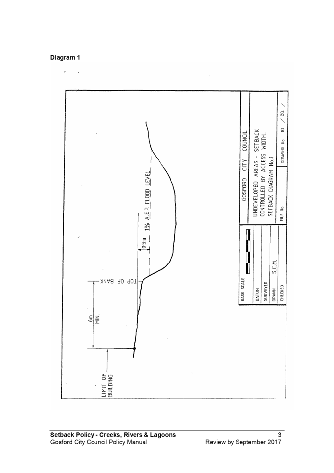
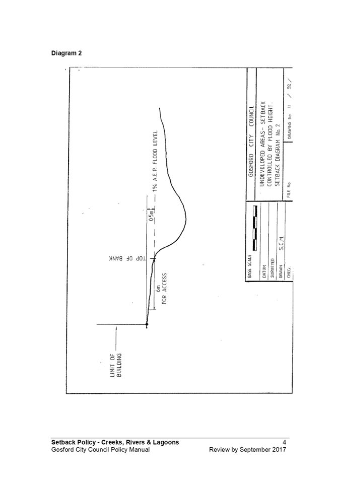
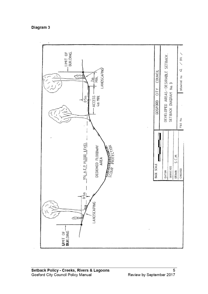
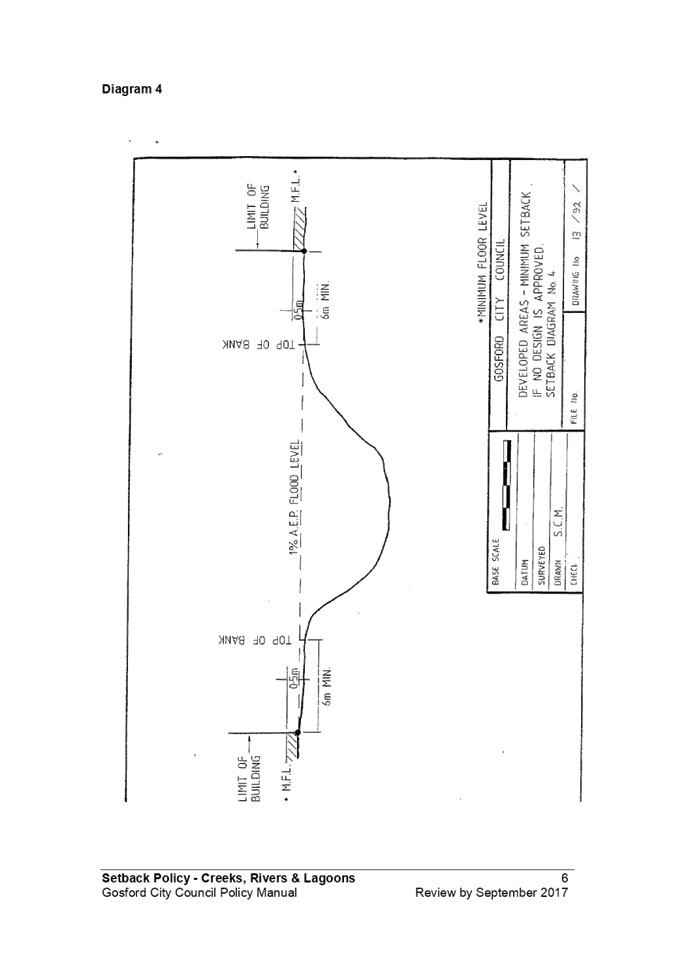
|
4.7
|
Revocation of Council Policies
|
|
Attachment 3
|
Summary
of Comments from Advisory Committee - Revocation of Council Policies
|
Summary of Comments of Catchment
& Coast Committee in respect of
· Section 149 Certificate - Natural and
Other Hazards Encoding Policy
· Setbacks Policy for Creeks, Rivers
& Lagoons
Background
At the
Ordinary Meeting of Council on 24 August 2020 it was resolved that.
883/20 That
Council refer the following policies to relevant Advisory Committee
for
their consideration:
· Section 149 Certificate - Natural and
Other Hazards Encoding Policy
· Setbacks Policy for Creeks, Rivers
& Lagoons
Minutes of
the August 2020 meeting of the Catchment & Coast Committee note as follows:
‘It was noted several policies were referred to
Council for revocation at the 24 August 2020 Council Meeting as part of the
Policy Project. Councillor Jane Smith requested the following two policies come
to the Catchment and Coast Committees for consideration:
a. Section 149 Certificate - Natural and Other
Hazards Encoding Policy
b. Setbacks Policy for Creeks, Rivers &
Lagoons
c.
Action: Advisory
Group Support Officer to circulate meeting papers about policies being
considered for revocation to Advisory Group members for review, and add item to
agenda for next meeting.’
Following
the August 2020 meeting of the Catchment & Coast Committee it is noted
that:
· The matter does not appear to have
been specifically discussed at the November meeting of the Advisory Committee,
although the Minutes of the previous meeting, which included comments about the
Policy revocations were noted; and
· Written comments were received from
committee members.
In order toe
ensure that all comments of the Advisory Committee were captured, and not
wanting to delay the matter to the next Advisory Committee meeting (not likely
under March 2021) on December 21, each of the committee members were contacted
by email, with detailed background to each of the policies and proposals for
revocation. Each committee member was requested to make any further comments,
in writing, prior to 11 January 2020, such that those matters could be
considered.
Summary
of Matters Raised by Committee Members
Natural
and Other Hazards Encoding Policy
The central
policy intent of this Gosford Council policy was to attach permanently to a
site a flag for the current and future (including prospective) owners of a
property that there is an ongoing hazard(s) risk.
This is an
important public policy approach to ensure that there is transparency ensuring
that people enter into ownership with their eyes wide open that a hazard
exists, and therefore can consider the implications for them (eg risk to
property and safety; building design demands, insurance premiums etc). (It may
also serve to protect Council from legal claims after a catastrophic event that
it had failed to provide access to information in its possession to forewarn owners.)
I consider
it essential that into the future Central Coast Council planning policies and
instruments give sound effect to that policy principle about hazard
information. There probably is a case for revocation of the Gosford policy
instrument at some point, as part of switching from old Councils policies to
contemporary Central Coast Council policies - but as set out below now is
probably not the time to do it in this particular case.
The advice
provided by Council staff arguing for revocation of this policy is opaque and
deficient:
· it nitpicks on details of drafting in
the policy - a red herring regarding the basic proposition for revocation
· it claims that much of the intent
will be picked up in Environmental Planning Instruments and Development Control
Plans (final para of relevant section of business paper).
o but it fails to describe how that is
done and whether it gives fully equivalent transparency to owners
o it is dfficult to fathom that
Central Coast Council DCP provisions do this - (1) currently operating under
old Councils DCPs; where Wyong Council seemingly had no such equivalent
policy as there is no proposal for revocation; (2) I doubt that the draft
Consolidated DCP addresses this provision - Council advice makes no such claim;
and, (3) the Comprehensive DCP be is only an aspiration at this stage.
Consequently,
I recommend that:
-
Councillors request Council staff for more concrete advice on how the policy
intent on information about hazards to properties is planned to be picked up in
new Council planning instruments
- Council
revoke the Gosford Council policy only when it is satisfied that the current
day planning instruments give proper effect to the public policy intent.
(There was a
lot of political debate approximately 5 years ago at local and State level
regarding the Section 149 Certificates addressing coastal inundation. But that
was driven by sectoral interests, and did not address meaningfully the public
policy necessity of transparent information. That episode is not relevant
to the broader revocation proposal before Council today. But it will
necessarily arise again when Council advances with framing its upcoming Coastal
Zone Management Program.)
Council
Officer Comment
Planning
Certificates are no longer called Section 149 Certificates. Council issues Planning
Certificates in accordance with the requirements of Section 10.7 of Environmental
Planning & Assessment Act 1979 (EP & A Act). The content
requirements of the Planning Certificate set out in Schedule 4 of the Environmental
Planning & Assessment Regulation 2000 (E&P Regulations).
This
policy is no longer required because it adds additional complexity, duplication
and uses terminology not consistent with the EP & A Act. There is also a
planning circular that details how coastal
hazards are noted on Planning Certificates.
Examples
of inconsistencies and difficulties with the current Policy:
· The Policy states that
Council will ‘encode a Section 149 Certificate …. when Council
is able to identify a hazard, which is likely to restrict development of the
property’. This is inconsistent with Schedule 4 of the Regulations
which states that the Planning Certificate will list every Environmental
Planning Instrument, draft Instrument, development control plan, draft plans
that apply to a parcel of land whether or not they restrict development on the
land.
· The policy refers to
‘expert reports’ and ‘specialist advice’ and
‘presentation of evidence that the hazards exist’. These terms are
not used in the Act or Regulations in relation to Planning Certificates.
There is nothing that determines what an ‘expert report’ is, nor
who is to judge whether such a report is an ‘expert report’.
What if two ‘expert reports’ are inconsistent with each other?
External
legal advice was sought following Councillor questions regarding the
recommended revocation of this policy. The legal advice recommends that the
policy be revoked. It notes that there is a risk in keeping the policy as it is
currently worded, and that there is no benefit in retaining the policy.
The
independent legal advice also notes that there has been a number of material
changes to the Environmental Planning & Assessment Act 1979 since
the Policy was adopted in 1995. Environmental Planning Instruments (EPIs) and
Development Control Plans (DCPs) are also more prescriptive now than they were
in the 1995. Much of the information that the Policy previously sought to cover
is now contained in EPIs and DCPs and are prescribed in other parts of the
Schedule 4 to the EP&A Regulation.
Setback
Policy - Creeks, Rivers & Lagoons Policy
The tenor of
the Council staff advice seems to be that the Water Management Act provisions
adequately cover the situation. It would be helpful to understanding the
situation if it relied less on a legalistic tone and included a practical
explanation that explained whether the WMA provisions are better,
equivalent or weaker than the Gosford Council policy - that would inform a more
considered assessment on revocation.
It would
also be helpful to be provided with information on where in Central Coast
planning instruments the WMA provisions will be laid out as part of a complete,
integrated Central Coast planning framework
I imagine
there is a reasonable case to be mounted that the WMA provisions are
satisfactory and revocation of the old Gosford policy can proceed.
Council
Officer Comment
The Policy relates to setback requirements for creeks, rivers,
lagoons and other water bodies. Since 1992 there has been significant
legislative amendments, such as the introduction of the Water Management Act
2000 (WM Act) and the Natural Resources Access Regulator Act 2017,
which created the Natural Resources Access Regulator (NRAR).
This
policy is no longer required because controlled activities are carried out in,
on or under waterfront land in accordance with the WM Act. The NRAR administers
the WM Act and their Guidelines over-ride this policy.
This
policy is inconsistent with guidance issued by the NRAR. For example:
· the policy defines
‘minor creeks’, as a creek with a catchment of less than 7.5
hectares. However, the ‘Guideline for Controlled Activities on
Waterfront Land’ prepared by NRAR, uses the Strahler system of
watercourse classification – i.e. 1st, 2nd, 3rd order watercourses.
· The policy allows for
building setbacks of 4 metres from ‘minor creeks’ and 6 metres for
‘major creeks’. However, new rules for riparian corridors near
creeks came into effect in July 2012. The NRAR advice provides a more complex
riparian management zone providing for 10 metres minimum setback for 1st order
creeks, increasing to 30 metres for 3rd order creeks.
|
5.1
|
Central Coast Stadium Final
Strategy Report
|
|
Attachment 1
|
Central
Coast Stadium Strategy - Consultation Report
|
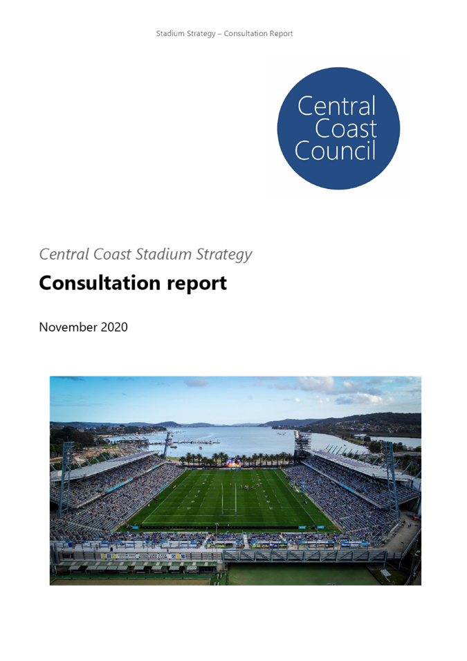

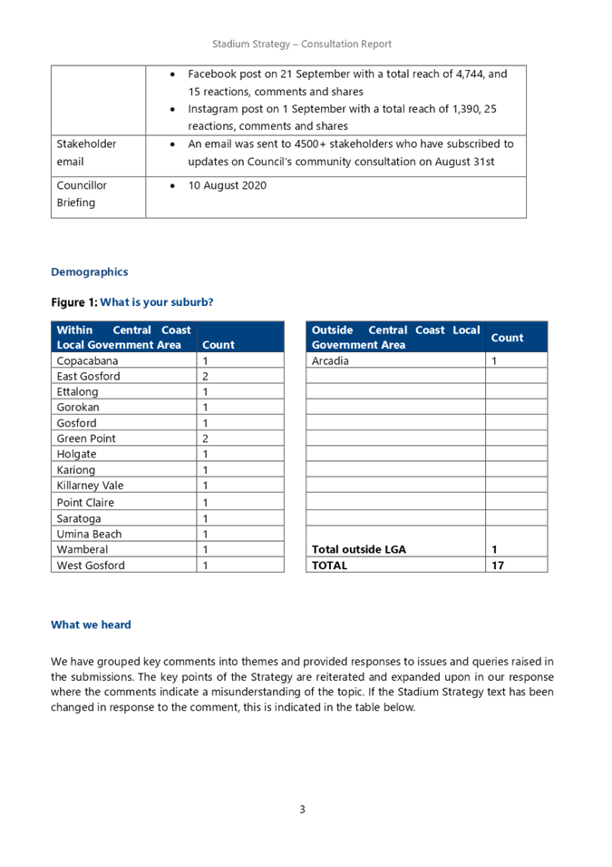
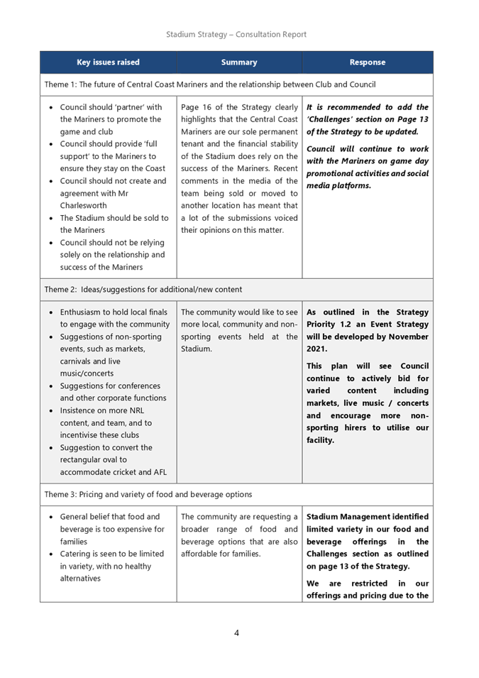
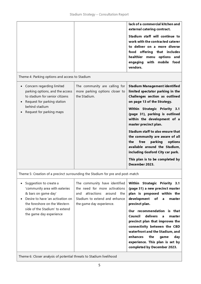
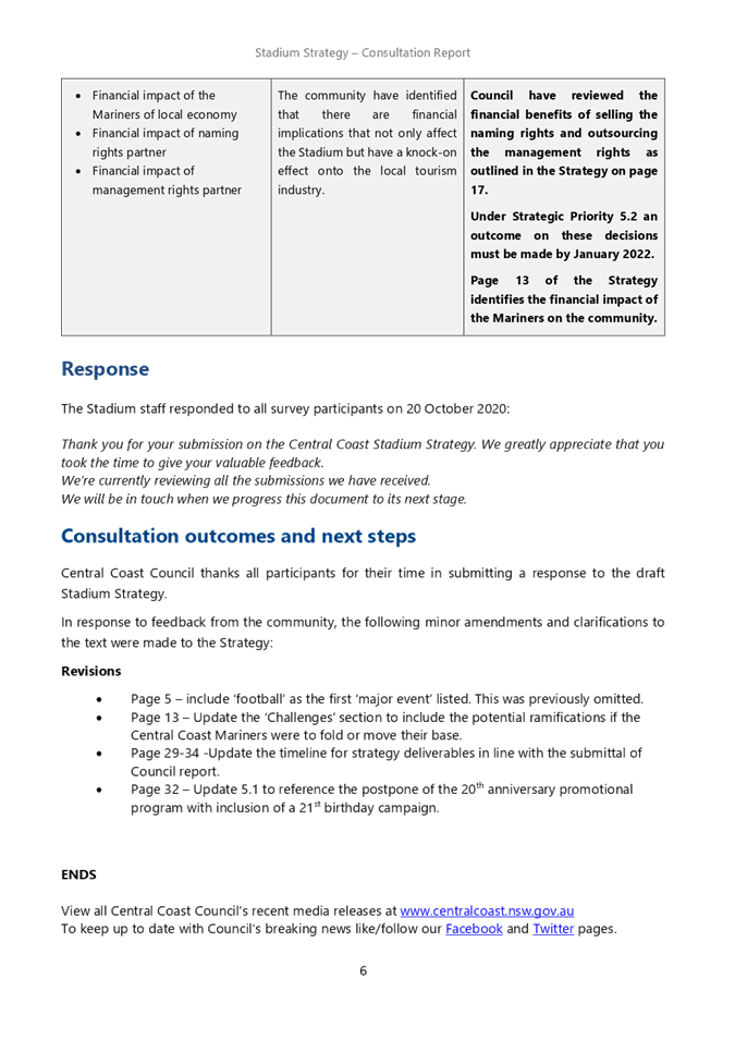
|
5.1
|
Central Coast Stadium Final
Strategy Report
|
|
Attachment 2
|
Central
Coast Stadium Strategy Final
|