Central Coast Council
Business Paper
Ordinary Council Meeting
22 March 2022
Central Coast Council
Business Paper
Ordinary Council Meeting
22 March 2022
The Ordinary Council Meeting
of Central Coast Council
will be held in the Council Chamber,
2 Hely Street, Wyong
on Tuesday 22 March 2022 at 6.30pm,
for the transaction of the business listed below:
1 Procedural Items
1.1 Disclosure of Interest................................................................................................................................ 4
1.2 Confirmation of Minutes of Previous Meeting................................................................................. 6
1.3 Notice of Intention to Deal with Matters in Confidential Session.............................................. 7
2 Reports
2.1 Presentation of 2020-2021 Financial Reports and related Auditor's Reports for Central Coast Council and Central Coast Council Water Supply Authority..................................................... 10
2.2 Investment Report for February 2022............................................................................................... 27
2.3 Monthly Finance Report - February 2022........................................................................................ 32
2.4 Council's Asset Sales Program - Update Report........................................................................... 37
2.5 Senior Staff Roles..................................................................................................................................... 41
2.6 Request to amend SEPP Gosford City Centre to reclassify 73-75 Mann St Gosford........ 45
2.7 Adoption of the Ourimbah Area Strategy and Centre Masterplan......................................... 52
2.8 Request to Prepare a Section 3.22 EP&A Act Submission for Precinct 2A and 2B North Wyong Shire Structure Plan................................................................................................................................. 64
2.9 Planning Proposal RZ/108/2020 for 121 - 129 Newling Street, Lisarow............................... 73
2.10 Planning Proposal RZ/38/2013 for land at Glenworth Valley and Calga............................... 83
2.11 Outcomes following Community Consultation for the Central Coast Stadium - Rezoning and Reclassification (Pre-Assessment by ED&P).................................................................................... 96
2.12 Surf Life Saving Central Coast and Surf Club Financial Partnership Support 2021/2022 102
2.13 Outcomes of Public Exhibition - Draft Responsible Dog Ownership Policy....................... 107
2.14 Remove historic Care, Control and Management responsibilities of Transport for NSW land at Lot 9 DP 863305, Pacific Highway, Mooney Mooney....................................................................... 112
2.15 Australian Local Government Association (ALGA) National General Assembly 2022 - Attendance and Voting............................................................................................................................................... 116
2.16 Tree Vandalism Statistics Report - January to December 2021............................................. 118
3 Confidential
3.1 Refinancing of Borrowings
David Farmer
Chief Executive Officer
|
Item No: 1.1 |
|
|
Title: Disclosure of Interest |
|
|
Department: Corporate Affairs |
|
|
22 March 2022 Ordinary Council Meeting |
|
Reference: F2022/00021 - D15044358
That Council and staff now disclose any conflicts of interest in matters under consideration by Council at this meeting.
Chapter 14 of the Local Government Act 1993 (“LG Act”) regulates the way in which the councillors and relevant staff of Council conduct themselves to ensure that there is no conflict between their private interests and their public functions.
Section 451 of the LG Act states:
“(1) A councillor or a member of a council committee who has a pecuniary interest in any matter with which the council is concerned and who is present at a meeting of the council or committee at which the matter is being considered must disclose the nature of the interest to the meeting as soon as practicable.
(2) The councillor or member must not be present at, or in sight of, the meeting of the council or committee:
(a) at any time during which the matter is being considered or discussed by the council or committee, or
(b) at any time during which the council or committee is voting on any question in relation to the matter.
(3) For the removal of doubt, a councillor or a member of a council committee is not prevented by this section from being present at and taking part in a meeting at which a matter is being considered, or from voting on the matter, merely because the councillor or member has an interest in the matter of a kind referred to in section 448.
(4) Subsections (1) and (2) do not apply to a councillor who has a pecuniary interest in a matter that is being considered at a meeting, if:
(a) the matter is a proposal relating to:
(i) the making of a principal environmental planning instrument applying to the whole or a significant part of the council’s area, or
(ii) the amendment, alteration or repeal of an environmental planning instrument where the amendment, alteration or repeal applies to the whole or a significant part of the council’s area, and
(a1) the pecuniary interest arises only because of an interest of the councillor in the councillor’s principal place of residence or an interest of another person (whose interests are relevant under section 443) in that person’s principal place of residence, and
(b) the councillor made a special disclosure under this section in relation to the interest before the commencement of the meeting.
(5) The special disclosure of the pecuniary interest must, as soon as practicable after the disclosure is made, be laid on the table at a meeting of the council and must:
(a) be in the form prescribed by the regulations, and
(b) contain the information required by the regulations.”
Further, the Code of Conduct adopted by Council applies to all councillors and staff. The Code relevantly provides that if a councillor or staff have a non-pecuniary conflict of interest, the nature of the conflict must be disclosed as well as providing for a number of ways in which a non-pecuniary conflicts of interests might be managed.
|
Item No: 1.2 |
|
|
Title: Confirmation of Minutes of Previous Meeting |
|
|
Department: Corporate Affairs |
|
|
22 March 2022 Ordinary Council Meeting |
|
Reference: F2022/00021 - D15044373
That Council confirm the minutes of the Ordinary Meeting of Council held on 22 February 2022.
Summary
Confirmation of minutes of the Ordinary Meeting of Council held on 22 February 2022.
|
1⇨ |
MINUTES - Ordinary Meeting 22 February 2022 |
Provided Under Separate Cover |
D15048107 |
|
Item No: 1.3 |
|
|
Title: Notice of Intention to Deal with Matters in Confidential Session |
|
|
Department: Corporate Affairs |
|
|
22 March 2022 Ordinary Council Meeting |
|
Reference: F2022/00021 - D15044387
|
That Council resolve that the following matters be dealt with in closed session, pursuant to s. 10A(2) of the Local Government Act 1993 for the following reasons:
Item 3.1 – Refinancing of Borrowings
Reason for considering in closed session:
2(d) commercial information of a confidential nature that would, if disclosed:
(i) prejudice the commercial position of the person who supplied it
That Council resolve, pursuant to section 11(3) of the Local Government Act 1993, that this report remain confidential in accordance with section 10A(2)(d)(i) of the Local Government Act as is contains commercial information of a confidential nature that would, if disclosed prejudice the commercial position of the person who supplied it and because consideration of the matter in open Council would on balance be contrary to the public interest. Consideration of the matter in open Council would, on balance, be contrary to the public interest as publication of all tendered amounts would discourage potential tenderers from submitting commercial information in future and would affect Council’s ability to obtain value for money services for the Central Coast community. |
Summary
It is necessary for the Council to adopt a resolution to formalise its intention to deal with certain matters in a closed and confidential Session. The report is incorporated in the "Confidential" business paper which has been circulated.
The Local Government Act 1993 requires the Chief Executive Officer to identify those matters
listed on the business paper which may be categorised as confidential in terms of section 10A
of the Local Government Act 1993. It is then a matter for Council to determine whether those
matters will indeed be categorised as confidential.
Context
2(a) personnel matters concerning particular individuals (other than Councillors),
2(b) the personal hardship of any resident or ratepayer,
2(c) information that would, if disclosed, confer a commercial advantage on a person with whom the Council is conducting (or proposes to conduct) business,
2(d) commercial information of a confidential nature that would, if disclosed:
(i) prejudice the commercial position of the person who supplied it, or
(ii) confer a commercial advantage on a competitor of the Council, or
(iii) reveal a trade secret,
2(e) information that would, if disclosed, prejudice the maintenance of law,
2(f) matters affecting the security of the Council, Councillors, Council staff or Council property,
2(g) advice concerning litigation, or advice that would otherwise be privileged from production in legal proceedings on the ground of legal professional privilege,
2(h) information concerning the nature and location of a place or an item of Aboriginal significance on community land,
2(i) alleged contraventions of any code of conduct requirements applicable under section 440.
It is noted that with regard to those matters relating to all but 2(a), 2(b) and 2(d)(iii) it is necessary to also give consideration to whether closing the meeting to the public is, on balance, in the public interest.
Further, the Act provides that Council may also close to the public so much of its meeting as comprises a motion to close another part of the meeting to the public (section 10A(3)).
As provided in the Office of Local Government Meetings Practice Note August 2009, it is a matter for the Council to decide whether a matter is to be discussed during the closed part of a meeting. The Council would be guided by whether the item is in a confidential business paper, however the Council can disagree with this assessment and discuss the matter in an open part of the meeting.
Attachments
|
Item No: 2.1 |
|
|
Title: Presentation of 2020-2021 Financial Reports and related Auditor's Reports for Central Coast Council and Central Coast Council Water Supply Authority |
|
|
Department: Corporate Affairs |
|
|
22 March 2022 Ordinary Council Meeting |
|
Reference: F2021/01155 - D14832345
Author: Mellissa McKee, Financial Controller
Manager: Peter Correy, Unit Manager Finance
Executive: Natalia Cowley, Director Corporate Affairs and Chief Financial Officer
1 That Council note that the 2020-2021 Central Coast Council audited financial reports including the auditor’s reports have been presented to this meeting of the Council, in accordance with s. 419(1) of the Local Government Act 1993 (“LG Act”).
2 That Council adopt the audited 2020-2021 financial reports for Central Coast Council as presented in accordance with ss. 413(2)(c) and 377(1)(k) of the LG Act, and cl. 215(1)(a) of the Local Government (General) Regulation 2005.
3 That Council include the audited 2020-2021 Central Coast Council Consolidated Financial Reports in Council’s 2020-2021 Annual Report in accordance with s.428(4)(a) of the LG Act.
4 That Council publish on Council’s website the 2020-2021 Central Coast Council Consolidated Financial Reports as an addendum to the 2020-2021 Annual Report and a copy be provided to the Minister of Local Government in accordance with s. 428 (5) of the LG Act.
5 That Council adopt the audited 2020-2021 financial reports for Central Coast Council Water Supply Authority as presented in accordance with s.45 of the Water Management Act, Australian Accounting Standards and other pronouncements of the Australian Accounting Standards Board.
|
Report purpose
This report presents the final 2020-2021 Consolidated Financial Reports for Central Coast Council and Central Coast Council Water Supply Authority, including external audit reports. The Financial Reports cover the period from 1 July 2020 to 30 June 2021.
This report details the amendments made to the Financial Reports that have been made subsequent to the Draft Financial Statements being presented to Council on 12 October 2021.
Executive Summary
This report, including external audit reports, presents the 2020-2021 Financial Reports for Central Coast Council and Central Coast Council Water Supply Authority.
The net assets for Central Coast Council as at 30 June 2021 total $7.4 billion.
The net assets for Central Coast Council Water Supply Authority as at 30 June 2021 total $3.8 billion. |
Background
The draft financial reports for Central Coast Council and Central Coast Council Water Supply Authority were presented to Council at its meeting held on 12 October 2021 and Council resolved as follows:
254/21 Resolved
1 That Council note that the draft Consolidated Financial Reports for Central Coast Council for the period from 1 July 2020 to 30 June 2021 are presented to Council. The Consolidated Financial Report includes the General Purpose financial report, Special Purpose financial report and Special Schedules, which are Attachments 1, 2 and 3 to the business paper.
2 That Council also note that the draft Consolidated Financial Reports have been prepared in accordance with the requirements of the Local Government Act 1993 (“LG Act”), the Local Government (General) Regulation 2005 (“LG Reg”) and the relevant accounting and reporting requirements of the Office of Local Government prescribed Code of Accounting Practice and Financial Reporting 2020/21 and Australian Accounting Standards.
3 That Council note that the draft Financial Reports for Central Coast Council Water Supply Authority for the period from 1 July 2020 to 30 June 2021 is presented to Council, which is Attachment 4 to the business paper.
4 That Council note that the draft Financial Reports for Central Coast Council Water Supply Authority as presented are in accordance with s.45 of the Government Sector Audit Act 1983, the Public Finance and Audit Regulation 2015, Australian Accounting Standards and other pronouncements of the Australian Accounting Standards Board.
5 That Council authorise, the Administrator, given the suspension of the Mayor, to execute all documents related to the draft 2020-2021 Consolidated Financial Reports in accordance with s413(2)(c) of the LG Act, and cl. 215(1)(b)(i) of the LG Reg.
6 That Council authorise, the Chief Executive Officer to execute all documents related to the draft 2020-2021 Consolidated Financial Reports in accordance with s413(2)(c) of the LG Act, and cl. 215(1)(b)(iv) of the LG Reg.
7 That Council authorise, the Responsible Accounting Officer of the Council, to execute all documents related to the draft 2020-2021 Consolidated Financial Reports with s413(2)(c) of the LG Act, and cl. 215(1)(b)(iii) of the LG Reg.
8 That Council authorise, for the purposes of s.45 of the Government Sector Audit Act 1983, its Administrator, Chief Executive Officer and Responsible Accounting Officer to execute all documents related to the draft 2020-2021 Financial Reports for Central Coast Council Water Supply Authority.
9 That Council resolve, for the purposes of s. 413(1) of the LG Act, to refer the draft Consolidated Financial Reports for Central Coast Council and the draft Financial Reports for Central Coast Council Water Supply Authority for the period from 1 July 2020 to 30 June 2021 to the Audit Office of New South Wales, for external audit.
10 That Council delegate to the Chief Executive Officer to set the date for the meeting to present the audited 2020-2021 financial reports, together with the auditor's reports, to the public in accordance with s418(1)(a), (b) of the LG Act.
Current Status
Central Coast Council
The 2020-2021 Central Coast Council Consolidated Financial Reports include the General Purpose financial statements, Special Purpose financial statements and Special Schedules, which include all of Council’s business activities. The 2020-2021 Central Coast Council Consolidated Financial Reports are provided as Attachment 1 to this business paper.
The Central Coast Council Financial Reports have been prepared in accordance with the requirements of the Local Government Act 1993 (“LG Act”), the Local Government (General) Regulation 2005 (“LG Reg”), and the relevant accounting and reporting requirements of the Office of Local Government prescribed Code of Accounting Practice and Financial Reporting 20/21 and Australian Accounting Standards.
In accordance with s. 413(1) of the LG Act, Council must prepare financial reports for each year, and must refer them for audit as soon as practicable after the end of that year.
The Audit, Risk and Improvement Committee met on 9 March 2022 to review the final 2020-2021 Central Coast Council Financial Reports. The Committee recommended that Council adopt the 2020-2021 Central Coast Council Consolidated Financial Reports (that include the General Purpose financial statements, Special Purpose financial statements and Special Schedules).
It is proposed that Council consider and accept the recommendations of the Audit, Risk and Improvement Committee to formally adopt the 2020-2021 Central Coast Council Financial Reports.
Pursuant to resolution 254/21 of 12 October 2021, the draft 2020-2021 Financial Reports of Central Coast Council and Central Coast Council Water Supply Authority were referred to Council’s external auditor, The Audit Office of New South Wales.
Council received audit reports from The Audit Office of New South Wales. Those audit reports form part of Attachment 1 and Attachment 2 to this business paper. Pursuant to s. 419(1) of the LG Act, those reports are presented to this meeting of Council.
Central Coast Council Water Supply Authority
The 2020-2021 Central Coast Council Water Supply Authority Financial Reports have been prepared in accordance with the Water Management Act and Australian Accounting Standards. Council is required to prepare financial reports for Central Coast Council Water Supply Authority each year. The 2020-2021 Central Coast Council Water Supply Authority Financial Reports are provided as Attachment 2 to this business paper.
The Audit, Risk and Improvement Committee met on 9 March 2022 to review the final 2020-2021 Central Coast Council Water Supply Authority Financial Reports. The Committee recommended that Council adopt the 2020-2021 Central Coast Council Water Supply Authority Financial Reports.
It is proposed that Council consider and accept the recommendations of the Audit, Risk and Improvement Committee to formally adopt the 2020-2021 Central Coast Council Water Supply Authority Financial Reports.
Council received audit reports from The Audit Office of New South Wales. Those audit reports form part of Attachment 2 to this business paper.
Amendments to the 2020-2021 Financial Reports
Subsequent to the presentation of draft 2020-2021 Financial Reports to Council on 12 October 2021 a number of amendments have been made within the Reports. The tabled amendments impact a number of Notes to the Financial Reports in the General Purpose Financial Statements, Water Supply Authority Financial Statements and Special Purpose Financial Statements. There have also been a number of minor typographical and rounding changes to improve clarity of the Notes. The key changes that have been made include the following items that have been reflected in the final Financial Reports:
· Water and Sewer Infrastructure, Property, Plant and Equipment revaluation results.
· Impacts of the International Financial Reporting Interpretations Committee (IFRIC) 'Software as a Service’ (SaaS) agenda decision.
· Amendment to the fair value of operational land.
· Recognition of newly found assets.
Council has received the formal audit opinions and the Financial Statements have been updated to include those opinions. The audit opinion issued for Central Coast Council includes a qualification. At 30 June 2021, Council recognised $5.5B of roads, bridges, footpaths, bulk earthworks, stormwater drainage, water supply network and sewerage network assets in note C1-8 of the Financial Statements. Council was unable to provide sufficient evidence to the Audit Office, to support the carrying value of these assets on the Statement of Financial Position as at 30 June 2021.
The audit opinion issued for Central Coast Council Water Supply Authority includes a qualification. At 30 June 2021, the Authority recognised $3.6B of stormwater drainage assets, water supply network assets and sewerage network assets in note C1-5 of the Financial Statements. The Authority was unable to provide sufficient evidence to the Audit Office, to support the carrying value of these assets on the Statement of Financial Position as at 30 June 2021.
Qualification
The qualified opinions noted by the Audit Office have no impact on Council’s cash flows, liquidity or ability to repay debts. The qualification relates to the fact that fixed asset information is held in two types of asset registers - one register stores the financial data (fixed asset register) and the other stores the condition data (technical register).
Council’s external consultants comprehensively revalued roads, bridges, footpaths, bulk earthworks, stormwater drainage, water supply network and sewerage network asset classes using the technical asset register.
Due to the fact that the two registers are not integrated, the Audit Office could not conclude on whether the information in the technical register reconciled to the financial fixed assets register. This had no impact on the Financial Performance of Council in 2020-2021.
A working group has been initiated to align the two asset registers by 30 June 2022.
Amendments 2020-2021 Financial Statements
This analysis provides an overview of the changes made to the key statements since presentation to Council on 12 October 2021. Key statements and notes detailed in this analysis include:
· Income statement
· Statement of financial position
· Statement of performance measures (Note G6 to the financial statements)
Council’s primary financial statements are in the format required by accounting standards and must conform to the provisions of the Local Government Code of Accounting Practice and Financial Reporting (Guidelines) issued by the Office of Local Government (OLG).
Consolidated Financial Statements
Following is a comparison of the financial performance for Central Coast Council as presented in the Draft 2020-2021 Financial Statements on 12 October 2021 compared to the final Financial Statements for 2020-2021 attached to this report.
Operating Result
The operating deficit before capital grants and contributions presented in the draft 2020-2021 Financial Reports was ($61.1M) and the operating result including capital grants and contributions of $83.7M was a surplus of $22.6M.
The operating deficit before capital grants and contributions presented in the final 2020-2021 Financial Reports is ($70.7M) and the operating result including capital grants and contributions of $83.7M was a surplus of $13.0M – a deterioration of ($9.6M).
The table below compares the draft 2021-2021 results with the final 2020-201 results.
|
|
Draft 2020-21 |
Final 2020-21 |
Movement
$’000 |
|
Income from operations |
539,670 |
541,944 |
2,274 |
|
Expenditure from operations |
600,797 |
612,635 |
(11,838) |
|
Operating result for continuing operations (excluding capital grants and contributions) |
(61,127) |
(70,691) |
(9,564) |
|
Income from capital grants and contributions |
83,702 |
83,702 |
- |
|
Net operating result (including capital grants and contributions) |
22,575 |
13,011 |
(9,564) |
Income from Operations
The following table reports income by category and is followed by explanations of the significant movements between draft and final results.
|
Income from Operations |
Draft 2020-21 |
Final 2020-21 |
Movement
$’000 |
|
Rates and Annual Charges |
331,384 |
331,727 |
343 |
|
User Charges and Fees |
139,103 |
141,034 |
1,931 |
|
Interest and Investment Revenue |
5,893 |
5,893 |
- |
|
Other Revenues |
12,667 |
12,667 |
- |
|
Grants and Contributions - Operating |
42,408 |
42,408 |
- |
|
Grants and Contributions - Capital |
83,702 |
83,702 |
- |
|
Rental Income |
8,215 |
8,215 |
- |
|
Total Income |
623,372 |
625,646 |
2,274 |
Rates and annual charges
The minor $0.3M increase relates to water supply, drainage and sewerage annual charges that were remapped from internal expense subsequent to the draft Financial Reports being presented. Nil impact overall on Income Statement.
User charges and fees
The $1.9M increase relates to water supply, sewerage and trade waste user charges that were remapped from internal expense subsequent to the draft Financial Reports being presented. Nil impact overall on Income Statement.
Expenditure from Operations
The following table reports expenditure by category and is followed by explanations of the significant movements between draft and final results.
|
Expenditure from Operations |
Draft 2020-21 |
Final 2020-21 |
Movement
$’000 |
|
Employee benefits and on-costs |
222,616 |
222,616 |
- |
|
Borrowing costs |
16,708 |
16,708 |
- |
|
Materials and services |
162,057 |
167,875 |
(5,818) |
|
Depreciation and amortisation |
156,305 |
162,303 |
(5,998) |
|
Other expenses |
36,059 |
36,081 |
(22) |
|
Net losses from the disposal of assets |
7,052 |
7,052 |
- |
|
Total Expenditure |
600,797 |
612,635 |
(11,838) |
Materials and Services
The ($5.8M) increase in Materials and Services is made up of two adjustments.
· ($2.3M) relates to the remapping of internal annual charges and user charges described above. Nil impact overall on Income Statement.
· ($3.6M) relates to the change in accounting treatment of the 'Software as a Service' (SaaS) International Financial Reporting Interpretations Committee (IFRIC) agenda decision, that meant that costs that had been previously capitalised were now recognised as operating costs on the Income Statement. Council revisited its capitalised configuration and customisation costs which resulted in the $3.6M write-off of intangible assets WIP capitalised in FY21.
Depreciation
The ($6.0M) increase in depreciation expense relates to:
· ($0.2M) increase in depreciation costs in water supply network and sewerage network assets as a result of IPPE revaluation.
· ($7.9M) revaluation decrement recognised for sewerage network assets as a result of IPPE revaluation. Council did not have sufficient balance in the asset revaluation reserve for sewerage network assets as the value of all assets and liabilities from the former Councils was transferred to Central Coast Council on 13 May 2016 and recognised as a gain on local government amalgamation via the Income Statement.
· Partially offset by a $2.1M reduction in IT intangible asset amortisation expense as a result of the 'Software as a Service' (SaaS) IFRIC agenda decision described above.
Other Expenses
The minor ($22k) increase relates to an increase in impairment of receivables that was recorded subsequent to the draft Financial Reports being presented.
Statement of Financial Position
The Statement of Financial Position details the value of what Council owns (“assets”) and what Council owes (“liabilities”).
Within these headings, “Current” means an amount that is due to be realised within the next 12 months whilst “Non-current” indicates an asset or liability that is longer term in nature.
The following table shows the changes in category on the Statement of Financial Position followed by explanations of the significant movements between draft and final results.
|
Statement of Financial Position |
Draft 30 June 2021 |
Final 30 June 2021 |
Movement
|
|
Assets |
|||
|
Current Assets |
337,443 |
342,370 |
4,927 |
|
Non-Current Assets |
7,565,350 |
7,625,575 |
60,225 |
|
Total Assets |
7,902,793 |
7,967,495 |
65,152 |
|
Liabilities |
|
|
|
|
Current Liabilities |
187,154 |
187,154 |
- |
|
Non-Current Liabilities |
397,462 |
397,462 |
- |
|
Total Liabilities |
584,616 |
584,616 |
- |
|
Net Assets |
|
|
|
|
Accumulated Surplus |
6,975,467 |
6,956,447 |
(19,020) |
|
Revaluation Reserve |
342,710 |
426,882 |
84,172 |
|
Net Equity |
7,318,177 |
7,383,329 |
65,152 |
Current assets
The $4.9M increase in Current assets is made up of two adjustments.
· ($1.6M) decrease in the value of land assets recognised as assets ‘held for sale’
· Offset by the recognition of $6.5M building assets recognised as assets ‘held for sale’ as part of Council’s financial recovery plan.
Non-current assets
The $60.2M increase in Non-current assets is made up of two adjustments.
· $93.1M increase in the value of Infrastructure, Property, Plant and Equipment as a result of revaluation activities and recognition of newly found assets:
o $84.2M to materially reflect the increase in fair value of operational land.
o $11.6M newly found assets. A number of water and sewer assets were identified during this year's comprehensive revaluations, which were not recorded in the Council's financial statements. Retrospective correction was made at 1 July 2019 in accordance with AASB 108 'Accounting Policies, Changes in Accounting Estimates and Errors', which increased the prior year comparatives for water supply network assets and sewerage network assets.
o $10.3M adjustment in WIP due to the realignment of IT intangible assets noted below.
o $8.9M net increase in the value of water supply and sewerage network assets.
o ($21.9M) decrease in the value of buildings.
· ($32.9M) reduction in the value of IT intangible assets due to the change in accounting treatment of the 'Software as a Service' (SaaS) International Financial Reporting Interpretations Committee (IFRIC) agenda decision, that meant that SaaS costs could no longer be capitalised. This was treated retrospectively as a change in accounting policy. A third Statement of Financial Position was included in the financial statements, and a number of comparative figures and disclosures were restated.
Statement of Performance Measurement (Note G6)
Note G6 - Statement of Performance Measures, includes various indicators mandated by the Office of Local Government (OLG). The indicators provide a ‘snap-shot’ of financial performance and comparability between Councils. The “benchmark” figures for the indicators reported represent the OLG’s benchmarks.
The table below shows the minor movements in the performance measures as a result of the amendments to the Financial Statements described above.
|
Local Government Industry Indicators
|
Draft 2021 |
Final 2021 |
OLG Benchmark |
2021 Result |
|
|
Operating Performance Ratio |
(10.10%) |
(10.37%) |
> 0.00% |
|
|
|
Own Source Operating Revenue Ratio |
79.75% |
79.83% |
> 60.00% |
|
|
|
Unrestricted Current Ratio |
2.18x |
2.27x |
> 1.50 |
|
|
|
Debt Service Cover Ratio |
1.49x |
1.44x |
> 2.00x |
x |
|
|
Rates, Annual Charges, Interest Outstanding Percentage |
5.41% |
5.69% |
< 5.00% |
|
|
|
Cash Expense Cover Ratio |
5.08 months |
5.03 months |
> 3 months |
|
Operating Performance Ratio - measures how well Council contained operating expenditure within operating revenue. Council has breached this benchmark in line with the reported $70.7M operating loss before capital grants and contributions.
Own Source Operating Revenue Ratio - measures Council’s fiscal flexibility and the degree of reliance on external funding sources such as operating grants and contributions. Council’s performance is satisfactory as it is above the benchmark.
Unrestricted Current Ratio – measures the adequacy of working capital and Council’s ability to satisfy obligations in the short term for the unrestricted activities of Council. Council has corrected the prior year breach of this benchmark through additional $150M external borrowings to substantially cover the reported overspend of unrestricted funds.
Debt Service Cover Ratio - measures the availability of operating cash to service debt including interest, principal and lease payments. Council has breached this ratio as the operating result before capital excluding interest and depreciation does not adequately cover loan principal repayments and borrowing costs.
Rate and Annual Charges Outstanding Ratio - assesses the impact of uncollected rates and annual charges on Council’s liquidity and the adequacy of debt recovery efforts. Council has breached this ratio however Council’s debt recovery efforts have shown significant improvement highlighted by the reduction in the ratio deficit from FY 2020. The primary driver for this breach continues to be the impact of COVID 19 on Council’s residents.
The impact of COVID 19 has necessitated Council staff to pro-actively work with our ratepayers on financially affordable payment plans in accordance with the Policy for Debt Recovery and Hardship to move towards achieving industry benchmark for this measure.
Cash Expense Cover Ratio - this liquidity ratio indicates the number of months a Council can continue paying for its immediate expenses without additional cash inflow. Council’s performance is above the benchmark.
Water Supply Authority (WSA) Financial Statements
Following is a comparison of the financial performance for Central Coast Council Water Supply Authority as presented in the Draft 2020-2021 Financial Statements on 12 October 2021 compared to the final Financial Statements for 2020-2021 attached to this report.
Operating Result
The operating deficit before capital grants and contributions presented in the draft 2020-2021 Financial Reports was ($33.4M) and the operating result including capital grants and contributions of $24.6M was a deficit of ($8.8M).
The operating deficit before capital grants and contributions presented in the final 2020-2021 Financial Reports is ($41.5M) and the operating result including capital grants and contributions of $83.7M was a deficit of ($16.8M) – a deterioration of $8.1M.
The table below compares the draft 2021-2021 results with the final 2020-201 results.
|
|
Draft 2020-21 |
Final 2020-21 |
Movement
|
|
Income from operations |
161,666 |
161,863 |
197 |
|
Expenditure from operations |
195,050 |
203,338 |
(8,288) |
|
Net operating result (excluding capital grants and contributions) |
(33,384) |
(41,475) |
(8,091) |
|
Income from capital grants and contributions |
24,630 |
24,630 |
- |
|
Net operating result (including capital grants and contributions) |
(8,754) |
(16,845) |
(8,091) |
Income from Operations
The following table reports income by category and is followed by explanations of the significant movements between draft and final results.
|
Draft 2020-21 |
Final 2020-21 |
Movement
|
|
|
Annual Charges |
81,825 |
81,804 |
(21) |
|
User Charges and Fees |
76,942 |
77,161 |
219 |
|
Interest and Investment Revenue |
2,125 |
2,125 |
- |
|
Other Revenues |
66 |
65 |
(1) |
|
Grants and Contributions - Operating |
708 |
708 |
- |
|
Grants and Contributions - Capital |
24,630 |
24630 |
- |
|
Total Income |
186,296 |
186,493 |
197 |
Annual charges and User charges and fees
The $0.2M increase relates to water supply and sewerage annual and user charges that were remapped from internal expense subsequent to the draft Financial Reports being presented. Nil impact overall on Income Statement.
Expenditure from Operations
The following table reports expenditure by category and is followed by explanations of the significant movements between draft and final results.
|
Expenditure from Operations |
Draft 2020-21 |
Final 2020-21 |
Movement
|
|
Employee benefits and on-costs |
36,218 |
36,218 |
- |
|
Borrowing costs |
14,439 |
14,439 |
- |
|
Materials and services |
69,668 |
69,866 |
(198) |
|
Depreciation and amortisation |
72,309 |
80,399 |
(8,090) |
|
Other expenses |
3 |
3 |
- |
|
Net losses from the disposal of assets |
2,413 |
2,413 |
- |
|
Total Expenditure |
195,050 |
203,338 |
(8,288)
|
Materials and Services
The ($0.2M) increase relates to the remapping of internal user charges described above. Nil impact overall on Income Statement.
Depreciation
The ($8.1M) increase in depreciation expense relates to:
· $0.2M adjustment in depreciation costs in water supply network and sewerage network assets.
· $7.9M revaluation decrement recognised for sewerage network assets as a result of IPPE revaluation. Council did not have sufficient balance in the asset revaluation reserve for sewerage network assets as the value of all assets and liabilities from the former Councils was transferred to Central Coast Council on 13 May 2016 and recognised as a gain on local government amalgamation via the Income Statement.
Statement of Financial Position
The following table shows the changes in category on the Statement of Financial Position followed by explanations of the significant movements between draft and final results.
|
Statement of Financial Position |
Draft 30 June 2021 |
Final 30 June 2021 |
Movement |
|
Assets |
|||
|
Current Assets |
93,386 |
93,386 |
- |
|
Non-Current Assets |
3,826,059 |
3,865,149 |
39,090 |
|
Total Assets |
3,919,445 |
3,958,535 |
|
|
Liabilities |
|
|
|
|
Current Liabilities |
77,244 |
82,860 |
(5,616) |
|
Non-Current Liabilities |
180,584 |
180,584 |
- |
|
Total Liabilities |
257,828 |
263,444 |
|
|
Net Assets |
|
|
|
|
Retained Earnings |
3,454,092 |
3,457,606 |
3,514 |
|
Revaluation Reserve |
207,525 |
237,485 |
29,960 |
|
Net Equity |
3,661,617 |
3,695,091 |
33,474 |
Non-current assets
The $39.1M increase in Non-current assets is an increase in the value of Infrastructure, Property, Plant and Equipment and is made up of the following adjustments:
· $13.7M to materially reflect the increase in fair value of operational land.
· $11.6M newly found assets. A number of water and sewer assets were identified during this year's comprehensive revaluations, which were not recorded in the Council's financial statements. Retrospective correction was made at 1 July 2019 in accordance with AASB 108 'Accounting Policies, Changes in Accounting Estimates and Errors', which increased the prior year comparatives for water supply network assets and sewerage network assets.
· $8.9M net increase in the value of water supply and sewerage network assets as result of revaluations.
· $4.9M including correction of WIP from General Fund to Drainage Fund.
Current Liabilities
The $5.6M movement in Current liabilities is an increase in internal loans to Drainage Fund from General Fund.
Annual Report
It is recommended that upon the adoption of the 2020-2021 Central Coast Council Financial Reports, that they be included in Council’s 2020-2021 Annual Report, Council’s website be appropriately updated and a copy be provided to the Minister for Local Government.
Consultation
All areas of Council contribute to the information contained within the Financial Reports.
Financial Considerations
At its meeting held 19 October 2020, Council resolved the following:
1108/20 That any motions put before Council for the remainder of this term of Council that have financial implications require the Chief Executive Officer to provide a report on how those additional costs will be met.
The following statement is provided in response to this resolution of Council.
These Financial Reports set out the financial position of Central Coast Council and Central Coast Council Water Supply Authority as at 30 June 2021 and the financial performance and cash flows for the reporting period 1 July 2020 to 30 June 2021. Comparatives for the statutory reporting period 1 July 2019 to 30 June 2020 are included in accordance with requirements set down by the NSW Office of Local Government in line with accounting standards.
Council’s net operating result for the financial year ended 30 June 2021 is a deficit of $70.7M excluding Grants and Contributions for capital purposes. After adjusting for Capital Grants and Contributions, the net operating surplus was $13.0M.
Central Coast Council Water Supply Authority’s net operating result for the financial year ended 30 June 2021 is a deficit of $41.5M excluding Grants and Contributions for capital purposes. After adjusting for Capital Grants and Contributions, the net operating deficit was $16.8M.
The net assets for Central Coast Council as at 30 June 2021 total $7.4 billion.
The net assets for Central Coast Council Water Supply Authority as at 30 June 2021 total $3.7 billion.
Link to Community Strategic Plan
Theme 4: Responsible
|
Goal G: Good governance and great partnerships |
|
R-G2: Communicate openly and honestly with the community to build a relationship based on transparency, understanding, trust and respect. |
Risk Management
Council has worked with the Audit Office of New South Wales to meet our legislative reporting requirements.
The Financial Reports are audited by the Audit Office of New South Wales who, amongst other things, form an opinion on the Financial Statements whether:
· The Council’s accounting records have been kept in accordance with the requirements of the Local Government Act 1993, Chapter 13, Part 3 Division 2; and
The Financial Statements:
· Have been prepared, in all material respects, in accordance with the requirements of this Division
· Are consistent with the Council’s accounting records
· Present fairly, in all material respects, the financial position of the Council as at 30 June 2021, and of its financial performance and its cash flows for the year then ended in accordance with Australian Accounting Standards
· All information relevant to the conduct of the audit has been obtained
· No material deficiencies in the accounting records or financial statements have come to light during the audit.
Options
It is a legislative requirement for Councils to adopt annual Financial Reports.
Critical Dates or Timeframes
In accordance with s.48 (2) of the LG Act, Council must present its 2020-2021 Consolidated Financial Reports to the community and it is a legislative requirement for Councils to adopt annual Financial Reports.
|
1⇨ |
2020-2021 Central Coast Council Consolidated Financial Reports |
Provided Under Separate Cover |
D15068011 |
|
2⇨ |
2020-2021 Central Coast Council Water Supply Authority Financial Reports |
Provided Under Separate Cover |
D15061609 |
|
Item No: 2.2 |
|
|
Title: Investment Report for February 2022 |
|
|
Department: Corporate Affairs |
|
|
22 March 2022 Ordinary Council Meeting |
|
Reference: F2004/06604 - D15046933
Author: Devini Susindran, Team Leader
Manager: Mellissa McKee, Financial Controller
Executive: Natalia Cowley, Director Corporate Affairs and Chief Financial Officer
1 That Council note the Investment Report for February 2022.
2 That Council note that internally restricted funds are unrestricted funds that have been internally allocated to a certain purpose.
3 That Council allocate the required unrestricted funds available in the General Fund to meet its February 2022 unrestricted funds deficit of $45.49M in Water and Drainage funds as set out in this report.
|
Report purpose
To present monthly Investment Reports in accordance with cl. 212 of the Local Government (General) Regulation 2005 which states as follows:
1 The Responsible Accounting Officer of a Council
a must provide the council with a written report (setting out details of all money that the council has invested under section 625 of the Act) to be presented— i. if only one ordinary meeting of the council is held in a month, at that meeting, or ii. if more than one such meeting is held in a month, at whichever of those meetings the council by resolution determines, and b must include in the report a certificate as to whether the investment has been made in accordance with the Act, the regulations and the council's investment policies.
2 The report must be made up to the last day of the month immediately preceding the meeting.
Executive Summary
This report details Council’s investments as at 28 February 2022. |
Background
Council’s investments are made in accordance with the Local Government Act 1993, Local Government (General) Regulation 2005, the amended Investment Policy adopted at the Ordinary Council Meeting on 3 February 2021, Ministerial Investment Order issued February 2011 and Division of Local Government (as it was then known) Investment Policy Guidelines published in May 2010.
Current Status
Council’s current cash and investment portfolio totals $625.49M as at 28 February 2022.
Council’s Cash and Investment Portfolio by Source of Funds
|
Source of Funds |
Value ($’000) |
|
Investment Portfolio |
597,257 |
|
Transactional accounts Per Bank Statement and cash in hand |
28,234 |
|
Total |
625,491 |
Council’s Portfolio is held in separate funds by purpose and is summarised as follows:
|
Fund |
General Fund ($’000) |
Water Fund ($’000) |
Sewer Fund ($’000) |
Drainage Fund ($’000) |
Waste Fund ($’000) |
|
External Restricted Funds |
186,923 |
7,411 |
22,117 |
37,090 |
94,166 |
|
Internal Restricted Funds |
89,914 |
1,026 |
877 |
55 |
- |
|
Total Restricted Funds |
276,837 |
8,437 |
22,994 |
37,145 |
94,166 |
|
Unrestricted Funds |
100,034 |
(9,932) |
118,400 |
(35,555) |
12,965 |
|
Total funds by Fund |
376,871
|
(1,495) |
141,394 |
1,590 |
107,131 |
During February, Council’s total cash and investments increased by $44.87M from $580.62M to $625.49M. The increase during February was due to quarterly rates instalment payments received at the end of February, receipt of quarterly Financial Assistance Grant of $3.5M and property settlement proceeds of $15.2M received as part of Council’s business recovery plan.
Detailed restrictions have been provided in Attachment 2. Council is managing the previously reported negative unrestricted funds balance, as part of Council’s Business Recovery Plan.
The negative unrestricted balance is currently $45.49M, made up of unrestricted fund deficits in the Water and Drainage Funds, as per the table above.
Portfolio management
Council’s Investment Portfolio is managed through term deposits and floating rate note maturities and placements.
Total net return on the portfolio for Council in February, comprising entirely of interest earned, was $415k. The total value of the Council’s investment portfolio at 28 February 2022 is outlined in Table 1 below.
Table 1 – Portfolio movement Investment only
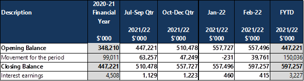
The market value of Council’s investment portfolio at 28 February is $597.26M.
Council’s investments are evaluated and monitored against a benchmark appropriate to the risk (APRA Standards BBB long term or above) and time horizon of the investment concerned.
A summary of the term deposit and floating rate notes maturities are listed in Table 2 below.
Table 2 - Investment Maturities
The investment portfolio is concentrated in AA above (22.50%), A (27.18%), and BBB (50.32%).
Council monitors and manages the portfolio taking into consideration credit ratings of financial institutions, interest rates offered for the maturity dates required and counterparty exposure. All of Council’s investments were within policy guidelines at 28 February 2022.
The current spread of investments and counterparty exposure for February 2022 are shown in Graphs 1 and 2 respectively in Attachment 3.
Environmental, Social and Green (ESG) Investments
Council continues to look for ‘ESG’ investment opportunities subject to prevailing investment guidelines. A list of current ESG investments held is contained on the investment listing, highlight in green. In the month of February Council increased its green investments by $10M.
Council currently holds 5.47% or $32.682M in ESG investments as at 28 February 2022.
Portfolio Return
Interest rates on investments in the month, ranged from 0.10% to 3.18%, all of which exceeded the monthly Bank Bill Swap Rate (BBSW) benchmark of 0.01%.
The weighted running yield for February of 0.86% for Central Coast Council is favourable compared to the rolling three-year benchmark bank bill swap (BBSW) Index of 0.42% as shown in Graph 3 - Portfolio Returns in Attachment 3.
Market values reflected in the Portfolio valuation report in Attachment 5 have been used to record the unrecognised gains in tradeable fixed rate bonds and floating rate notes. Interest accrued has been recorded separately and is not reflected in portfolio valuations.
Financial Considerations
At its meeting held 19 October 2020, Council resolved the following:
1108/20 That any motions put before Council for the remainder of this term of Council that have financial implications require the Chief Executive Officer to provide a report on how those additional costs will be met.
The following statement is provided in response to this resolution of Council.
Council’s investment portfolio includes rolling maturity dates to ensure that Council has sufficient liquidity to meet its ongoing obligations.
Link to Community Strategic Plan
Theme 4: Responsible
|
Goal G: Good governance and great partnerships |
|
R-G4: Serve the community by providing great customer experience, value for money and quality services. |
|
1⇨ |
Summary of Investments as at 28 February 2022 |
Provided Under Separate Cover |
D15076687 |
|
2⇨ |
Summary of Restrictions as at 28 February 2022 |
Provided Under Separate Cover |
D15076688 |
|
3⇨ |
Investment Report for February 2022 - Graphs 1, 2 and 3 |
Provided Under Separate Cover |
D15076699 |
|
4⇨ |
Trading Limits Report as at 28 February 2022 |
Provided Under Separate Cover |
D15076704 |
|
5⇨ |
Portfolio Valuation Investment Report Pack as at 28 February 2022 |
Provided Under Separate Cover |
D15076706 |
|
Item No: 2.3 |
|
|
Title: Monthly Finance Report - February 2022 |
|
|
Department: Corporate Affairs |
|
|
22 March 2022 Ordinary Council Meeting |
|
Reference: F2020/03205 - D15046767
Author: Peter Correy, Unit Manager Finance
Executive: Natalia Cowley, Director Corporate Affairs and Chief Financial Officer
1 That Council note the report Monthly Financial Reports – February 2022.
2 That Council adopt the amendments to the 2021-2022, 2022-23, 2023-24 and 2024-25 Capital Works Program detailed in Attachment 9.
|
Report purpose
To present to Council the monthly financial reports for February 2022.
Executive Summary
This report presents the February 2022 monthly financial reports for Central Coast Council. The reports cover the period 1 July 2021 to 28 February 2022. |
Background
The monthly financial reports have been prepared in accordance with the requirements of the Local Government Act 1993 (“LG Act”), the Local Government (General) Regulation 2005 (“LG Reg”), and the relevant accounting and reporting requirements of the Office of Local Government prescribed Code of Accounting Practice and Financial Reporting and Australian Accounting Standards.
Report
The reports disclose the year-to-date financial results in Operating Statement format, they reflect the organisational structure and are presented by Department and Unit. The reports include a traffic light indicator of current status – on track (green light), off track (red light) continue to monitor status (orange light). Relevant supporting comments are included, as well as a graphical representation of the financial results.
The Local Government Code of Accounting Practice and Financial Reporting (Guidelines) require Council to recognise rates income at the beginning of the financial year when levied. However, for internal reporting purposes Council recognises rates revenue on a continual basis throughout the financial year thereby aligning revenue with Council’s expenditure for the delivery of services to the community.
Consultation
In the preparation and finalisation of the monthly reports for January 2022, all business areas of Council contributed to the information contained within the financial reports.
Financial Considerations
At its meeting held 19 October 2020, Council resolved the following:
1108/20 That any motions put before Council for the remainder of this term of Council that have financial implications require the Chief Executive Officer to provide a report on how those additional costs will be met.
The following statement is provided in response to this resolution of Council.
These financial reports show how actual revenue and expenditure is tracking against the year-to-date Q2 adjusted forecast of Council for the reporting period 1 July 2021 to 28 February 2022.
In February, Council is reporting a surplus of $13.9M (favourable to budget by $4.3M) for its net operating result, excluding capital income and profit on sale of land.
Year to date, Council is reporting a surplus of $43.3M (favourable to budget by $20.8M) for its net operating result, excluding capital income and profit on sale of land.
In February Council’s net operating result including capital income and profit on sale of land is $40.9M (favourable to budget by $32.6M).
Year to date, Council’s net operating result including capital income and profit on sale of land is $95.4M (favourable to budget by $45.6M).
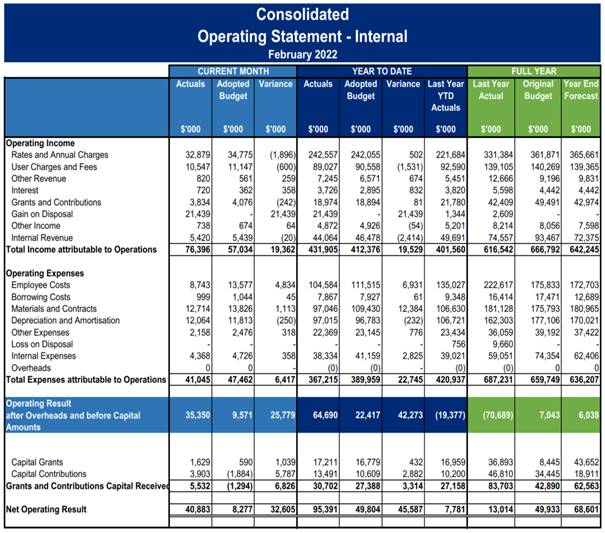
Year to date capital expenditure was $54.3M against budget of $72.7M. There are currently 361 projects in various stages of completion.
Proposed amendments to the 2021-2022 capital works program resulting in a reduction of $1.2M have been requested and are detailed in Attachment 9. Several of the amendment are due to delays experienced in 2021-2022, resulting in project delivery extending into future years. Attachment 9 also includes details of increases to the capital works program in 2022-2023, 2023-2024 and 2024-2025.
Council held $625.5M in cash and investments and had external borrowings of $331.7M at 28 February. The recovery in Council’s General Fund continues to improve with an unrestricted cash balance of $100.0M compared to ($50.0M) 12 months prior.
Link to Community Strategic Plan
Theme 4: Responsible
|
Goal G: Good governance and great partnerships |
|
R-G2: Communicate openly and honestly with the community to build a relationship based on transparency, understanding, trust and respect. |
|
1⇨ |
Monthly Finance Report February 2022 |
Provided Under Separate Cover |
D15081306 |
|
2⇨ |
Consolidated and By Fund February 2022 Monthly Financial Report |
Provided Under Separate Cover |
D15080143 |
|
3⇨ |
Office of the Chief Executive Officer February 2022 Monthly Financial Report |
Provided Under Separate Cover |
D15080129 |
|
4⇨ |
Community and Recreation Services February 2022 Monthly Financial Report |
Provided Under Separate Cover |
D15080130 |
|
5⇨ |
Infrastructure Services February 2022 Monthly Financial Report |
Provided Under Separate Cover |
D15080132 |
|
6⇨ |
Water and Sewer February 2022 Monthly Financial Report |
Provided Under Separate Cover |
D15080133 |
|
7⇨ |
Environment and Planning February 2022 Monthly Financial Report |
Provided Under Separate Cover |
D15080134 |
|
8⇨ |
Corporate Affairs February 2022 Monthly Financial Report |
Provided Under Separate Cover |
D15080136 |
|
9⇨ |
Amendments to the Capital Works Program |
Provided Under Separate Cover |
D15080359 |
|
Item No: 2.4 |
|
|
Title: Council's Asset Sales Program - Update Report |
|
|
Department: Corporate Affairs |
|
|
22 March 2022 Ordinary Council Meeting |
|
Reference: F2020/03104 - D14955785
Author: Joe O'Connor, Commercial Property Manager
Manager: Jamie Barclay, Unit Manager Development and Property
Executive: Natalia Cowley, Director Corporate Affairs and Chief Financial Officer
That Council note that the following land has been sold and will be removed from Council’s land register:
a) Warnervale Town Centre:
2 Woongarrah Rd, Woongarrah (1/DP1275060)
formally known as
236 - 260 Hakone Road Woongarrah (Lot 1 DP 376264)
236 - 260 Hakone Road Woongarrah (Lot 54 DP 7527)
236 - 260 Hakone Road Woongarrah (Lot 55 DP 7527)
236 - 260 Hakone Road Woongarrah (Lot 1 DP 371647)
236 - 260 Hakone Road Woongarrah (Lot 1 DP 375712)
99 Sparks Road Woongarrah (Lot 52 DP 561032)
103 Sparks Road Woongarrah (Lot 51 DP 561032)
107 Sparks Road Woongarrah (Lot 41 DP 1200210)
b) 15-23 Hely St Wyong (PT 1 Sec1 DP 3136)
15-23 Hely St Wyong (PT 2 Sec1 DP 3136)
15-23 Hely St Wyong (PT 3 Sec1 DP 3136)
15-23 Hely St Wyong (PT 4 Sec1 DP 3136)
15-23 Hely St Wyong (PT 5 Sec1 DP 3136)
|
Report purpose
To provide a further update on Council’s Asset Sales program and to remove land that has been sold from Council’s land register.
Executive Summary
Council is continuing the path to financial recovery and sustainability with further actions implemented from the adopted Business Recovery Plan. Part of the significant steps being undertaken, include the sale of Council assets which are underperforming or surplus to Council’s current and future needs. This process is crucial to deliver a much-needed boost to Council’s financial position and provide confidence to our lenders that Council operations can continue sustainably, and loans serviced.
Given the importance for transparency with the community, an update report is provided here which confirms recent land sales. |
Warnervale Town Centre
Council resolved to sell the land, known as the Warnervale Town Centre site (refer to Figure 1 below) at its meeting of 25 November 2015. An expression of interest was called, and a contract was entered into with the successful proponent on 1 August 2017. The agreed sale price at the time was $16,000,000 being $2million higher than the valuation received (refer to Attachment 1). The sale of the site was subject to Council completing remediation works and subdivision works of the former land fill site. These works were completed in late 2021 and the land was registered on 17 January 2022, which consolidation the lots, and the land is now known as Lot 1 in DP1275060. It should be noted that Lot 2 will be retained by Council and developed into the future Hilltop Park. This land was sold via private treaty and settlement occurred on 21 February 2022.
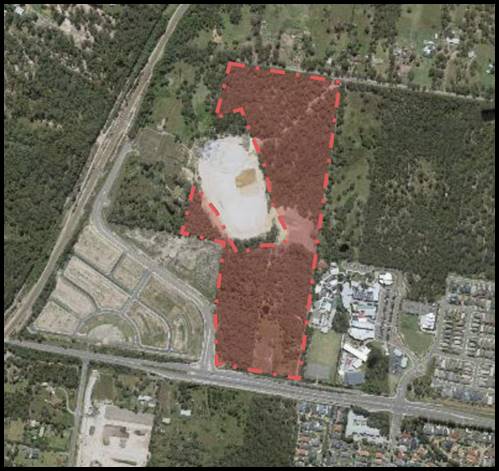
Figure 1 – Warnervale Town Centre site dashed red - 1/DP1275060.
15-23 Hely St Wyong
At its meeting of 30 November 2020, Council resolved to sell 15 – 23 Hely Street Wyong (known as the Oasis and currently leased to the Salvation Army) on the open market for not less than the market valuation. Following from this resolution, Council received an unsolicited proposal from the Salvation Army to purchase the land and continue the community programs currently undertaken at the Oasis. This site was included in the community consultation which provided an opportunity for feedback on the sale of Tranche 3 properties. A further report was put to Council on 27 July 2021 at which time Council resolved to directly sell 15 – 23 Hely Street Wyong to the Salvation Army for not less than the market valuation (refer to Attachment 2). The Salvation Army has agreed to the price indicated within the valuation and completion of the contract occurred on 9 March 2022.
|
Property Address |
Lot/DP |
Settlement Date |
Valuation Price |
Sale Price |
|
Properties previously reported as sold (refer to previous Council report update 14/12/2021) |
$24,632,088 |
$34,738,775 |
||
|
2 Woongarrah Rd, Woongarrah |
1/DP1275060 |
21/02/2022 |
$14,000,000 |
$16,000,000 |
|
15-23 Hely St Wyong |
PT 1 – 5 Sec1 DP 3136 |
9/03/2022 |
$4,000,000 |
$4,000,000 |
|
TOTAL VALUE |
As of 22/03/22 |
$42,632,088 |
$54,738,775 |
|
Financial Considerations
At its meeting held 19 October 2020, Council resolved the following:
1108/20 That any motions put before Council for the remainder of this term of Council that have financial implications require the Chief Executive Officer to provide a report on how those additional costs will be met.
The following statement is provided in response to this resolution of Council.
The total sale of these properties achieved a sale value of $20,000,000 (excluding GST) and has contributed to Council’s financial recovery.
Link to Community Strategic Plan
Theme 4: Responsible
|
Goal G: Good governance and great partnerships |
|
R-G2: Communicate openly and honestly with the community to build a relationship based on transparency, understanding, trust and respect. |
Risk Management
Risk mitigation has been achieved during the sales process through ensuring adequate due diligence. This process included:
· Reviewing these sites against Council resolutions and historical records
· Ensuring Council retains ownership of land that is needed for its current and future service delivery
· Ensuring that any sale would not contravene legislative requirements
· Consultation with internal stakeholders affected by the disposal of these assets.
Council staff have engaged with independent property development experts Michael Filo and Steve Rowe to execute the functions of the Independent Advisory Group. The Advisory Group’s function is to provide an independent panel to review asset sales program prior to going to Council, review and advise on conditional sales for commercial and industrial sales and to review opportunities and advise Council on potential highest and best use analysis to ensure Council is receiving value for the sale.
|
1⇨ |
Valuation Warnervale Town Centre |
Provided Under Separate Cover |
D15054541 |
|
2⇨ |
Valuation 15-23 Hely Street Wyong |
Provided Under Separate Cover |
D15064082 |
|
Item No: 2.5 |
|
|
Title: Senior Staff Roles |
|
|
Department: Corporate Affairs |
|
|
22 March 2022 Ordinary Council Meeting |
|
Reference: F2020/02595 - D15068487
Author: Krystie Bryant, Unit Manager People and Culture
Executive: Natalia Cowley, Director Corporate Affairs and Chief Financial Officer
1 That Council note the report on senior staff roles.
2 That Council determine the described four Unit Manager positions as set out in this report as Senior Staff positions for the purpose of section 332 of the Local Government Act 1993.
|
Report purpose
To determine that current vacant Unit Manager roles are designated as ‘Senior Staff’ positions in accordance with s. 332 of the Local Government Act 1993.
Executive Summary
A number of Unit Manager roles are currently vacant and scheduled to be filled. In reviewing these roles and giving consideration to size and scope of the roles, it is appropriate that those four positions are designated as ‘Senior Staff’ positions for the purposes of s.332 of the Local Government Act 1993. The positions are as outlined below:
1 Unit Manager, Governance, Risk and Legal 2 Unit Manager, Facilities and Asset Management 3 Unit Manager, Environmental Compliance Systems 4 Group Financial Controller
(Organisational Chart - Attachment 1) |
Background
Unit Manager roles within the structure of Central Coast Council are currently not identified as senior staff positions.
It should be noted that there is currently industry conversation regarding the use of senior staff contracts. It is unclear as to where this conversation may lead however should legislative change occur, these contracts will transition to the appropriate arrangements in line with that change.
Current Status
There are four positions currently vacant and scheduled to be filled.
Report
In reviewing the current vacant Unit Manager roles and giving consideration to size and scope of the roles, it is more appropriate that these four positions are designated as “Senior Staff” positions for the purposes of s. 332 of the Local Government Act 1993.
In reviewing the descriptors outlined in the Local Government (State) Award 2020 which act as a guide in determining Senior Staff positions, it is considered that the positions appropriately align to these descriptors which are outlined below. The positions also meet the required remuneration threshold.
Authority and accountability: Accountable for the direction and control of the employer or a department or the like. Influence and commit the employer or a department or the like to long-term strategic directions. Lead policy development and implementation.
Judgement and problem solving: Positions solve problems through analytic reasoning and integration of wide-ranging and complex information, and have a high level of independence in determining direction and approach to issues.
Specialist knowledge and skills: The position requires the application of a range of specialist knowledge and skills, including relevant legislation and policies and other areas of precedent. Ability to provide authoritative advice to the employer.
Management skills: Application of corporate management skills in a diverse organisation to establish goals and objectives. Manage and control staff, budgets and work programs or major projects of the employer or a department or the like utilising leadership, evaluation and monitoring skills to facilitate achievement of objectives. Ability to generate innovative approaches to more effectively deploy resources, meet changing circumstances and improve service to the employer's clients.
Interpersonal skills: Positions use persuasive skills with external parties on major items of critical importance to the employer. They motivate managers and staff at all levels by leading and influencing others to achieve complex objectives. They influence the development of the employer.
Qualifications and experience: Positions will have a relevant degree or equivalent and management experience, combined with accredited management qualifications.
The roles also meet the remuneration threshold.
Consultation
As the positions are currently vacant, no consultation is required however the relevant Unions have been informed.
Financial Considerations
At its meeting held 19 October 2020, Council resolved the following:
1108/20 That any motions put before Council for the remainder of this term of Council that have financial implications require the Chief Executive Officer to provide a report on how those additional costs will be met.
The following statement is provided in response to this resolution of Council.
This change does not financially impact Council, as the role is within budget, and does not impact overall staff numbers.
Link to Community Strategic Plan
Theme 4: Responsible
|
Goal G: Good governance and great partnerships |
|
R-G4: Serve the community by providing great customer experience, value for money and quality services. |
Risk Management
The establishment of senior staff contracts aids in providing greater alignment between the most appropriate legislation to support the employment conditions associated with these types of roles. It also allows a mechanism to refresh the organisational leadership in line with naturally occurring end dates to ensure that the best outcome for the organisation is always prioritised.
As identified above, there is a risk that legislative change regarding senior staff contracts may occur. This risk is easily mitigated by transitioning incumbents to the appropriate legislation should that change occur, as part of an industry approach.
Options
1 Council could resolve that vacant Unit Manager roles be added to Council’s Senior Staff Structure as set out in this report. This is the recommended option.
2 Council could decline to include the vacant Unit Manager roles in the Senior Staff Structure. Not recommended.
|
1⇨ |
Organisation Chart 2022 |
Provided Under Separate Cover |
D15082891 |
|
Item No: 2.6 |
|
|
Title: Request to amend SEPP Gosford City Centre to reclassify 73-75 Mann St Gosford |
|
|
Department: Environment and Planning |
|
|
22 March 2022 Ordinary Council Meeting |
|
Reference: CPA/3903 - D14959244
Author: Lucy Larkins, Senior Strategic Planner
Scott Duncan, Section Manager Land Use and Policy
Manager: Shannon Turkington, Unit Manager Strategic Planning
Executive: David Milliken, Director Environment and Planning (Acting)
1 That Council prepare a Planning Proposal to amend SEPP Gosford City Centre to enable the reclassification of Lot B DP 321076 and Lot 2 DP 543135 (73-75 Mann Street, Gosford) from community land to operational land.
2 That Council submit the Planning Proposal to the Minister for Planning in accordance with Section 3.35(2) of the Environmental Planning and Assessment Act 1979, requesting a Gateway Determination, pursuant to Section 3.34 of the Environmental Planning and Assessment Act 1979.
3 That Council undertake public authority and community consultation in accordance with the Gateway Determination requirements.
4 That Council conduct a public hearing consistent with the requirements of Section 29 of the Local Government Act 1993.
|
Report purpose
The purpose of this report is to recommend the reclassification of Lot B DP 321076 and Lot 2 DP 543135 (73-75 Mann Street Gosford) from community land to operational land under Section 30 of the Local Government Act 1993.
Executive Summary
The subject land was originally acquired in 2019 for the purpose of the then proposed Gosford Cultural Precinct (consisting of a Regional Library and Regional Performing Arts Centre).
Upon acquisition by Council in 2019, the parcels of land were classified as community land.
On 25 September 2019, Council resolved to withdraw from any further work on the Gosford Cultural Precinct and proceed with a stand-alone Regional Library.
In 2020 as part of a review of assets, Council determined the properties were surplus to its needs and is seeking to reclassify the land to “operational land” in order to facilitate its sale. It will not be possible to sell the site while it is classified as community land.
By disposing of land that is surplus to its needs Council will make it available to be repurposed or redeveloped by others with uses that contribute to the revitalisation of the Gosford City Centre.
Reclassification of community land must follow the procedure described by the Department of Planning and Environment’s LEP Practice Note 16-001: Classification and reclassification of public land through a local environmental plan.
The reclassification of land process requires the preparation of a Planning Proposal, community consultation as well holding a public hearing, using an independent facilitator. The purpose of a public hearing is to give interested people an opportunity to have their say on the proposed reclassification before a decision is made.
The Planning Proposal is then finalised for Council endorsement following consideration of any public submissions and issues raised during the public hearing.
The subject sites have been earmarked for inclusion in the TAFE NSW campus redevelopment and therefore the reclassification supports this. |
Background
Lot B DP 321076 and Lot 2 DP 543135 (73-75 Mann Street Gosford) are owned by Central Coast Council. The land was originally acquired in 2019 by private treaty for the purpose of building a Gosford Cultural Precinct. The parcel was acquired by agreement under the framework of the Land Acquisition (Just Terms Compensation) Act.
On 25 September 2019, Council resolved to withdraw from any further work on the Gosford Cultural Precinct and proceed with a stand-alone Regional Library. The Regional Library will now be developed on the site of the Parkside Building in Gosford at 123A Donnison Street (Lot 100 DP 711850).
Council is reviewing plans for the Regional Performing Arts Centre (RPACC). The site for the RPACC will not be developed on any of the land previously identified for the Cultural Precinct and other locations are now being considered.
On the 30 November 2020 Council resolved the following:
1258/20 That Council resolve to reclassify the following land from community to operational land and sell for not less than market value as determined by an independent valuer;
a) 73 Mann Street Gosford (Lot B in DP 321076)
b) 75 Mann Street Gosford (Lot 2 in DP 543135)
As per the Local Government Act 1993 (LG Act) all public land must be classified. There are two classifications for public land – community land or operational land. Community land is land made available for use by the general public / community uses, while operational land is land required for Council’s operational functions, such as a Council depot or for commercial land holdings.
Following its acquisition by Council, the subject land was classified as community land. Council has determined that this land is surplus and that it should be made available to be repurposed or redeveloped by others with uses that contribute to the revitalisation of the Gosford City Centre. As per Clause 45(1) of the LG Act, Council has no power to dispose of community land. Even if Council choses to lease the land, Clause 45 of the LG Act significantly restricts the range of uses for which a lease over community land might be granted, and the time period of such a lease. If the site remains as community land, most of the uses for which the buildings might be leased are not permissible under the provisions of Clause 45 of the LG Act. It is therefore recommended that Council reclassify the land to operational land.
The reclassification process for Council land is specified in Part 6 Section 2 of the LG Act, and the Department of Planning, Industry and Environment’s LEP Practice Note 16-001 - Classification and reclassification of public land through a local environmental plan.
The land is proposed to be reclassified by amending the State Environmental Planning Policy (Gosford City Centre) 2018 (Gosford SEPP). The wording and effect of the relevant part of the of the Gosford SEPP (Clause 5.2 and Schedule 4) is the same as Clause 5.2 and Schedule 4 of the Gosford Local Environmental Plan LEP 2014, and the proposed reclassification will follow the same process as any other land reclassification. The Department of Planning and Environment has advised that even though an amendment to a State Environmental Planning Policy is required, Council should proceed as it would for an amendment to a Local Environmental Plan via a Planning Proposal.
The Planning Proposal is currently at the stage in the Local Environmental Plan Amendment Process shown in Diagram 1.
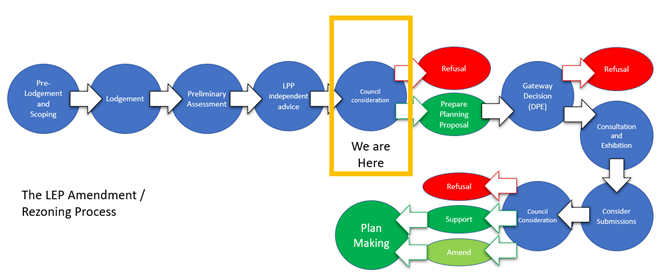
Diagram 1 – LEP Amendment/Rezoning Process
Current Status
The site is located within the commercial core of Gosford City Centre (Figure 1). Located at the front of the site are vacant single storey commercial buildings with ground floor access to Mann Street, with car parking located to the rear. Henry Parry Drive, to the rear, is elevated and separated from the site by a steep embankment.
The land is not currently used for a community purpose and has been previously used for commercial purposes.
![]()
![]()
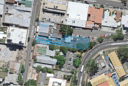
Figure 1 – Aerial photograph of the subject site
Consultation
Planning proposals to reclassify public land are to be publicly exhibited for at least 28 days.
Council must also hold a public hearing when reclassifying public land from community to operational land.
After the public exhibition period has ended for the Planning Proposal, at least 21 days public notice is to be given before the public hearing. There are specific requirements for an independent person to chair the hearing and prepare a public hearing report, and that Council make the report publicly available.
Council will consider the outcomes of the public exhibition process for the Planning Proposal and the public hearing in finalising the land reclassification.
Financial Considerations
At its meeting held 19 October 2020, Council resolved the following:
1108/20 That any motions put before Council for the remainder of this term of Council that have financial implications require the Chief Executive Officer to provide a report on how those additional costs will be met.
The following statement is provided in response to this resolution of Council.
Adoption of the staff recommendation has no budget implications for Council. Strategic Planning will undertake the work and engage a consultant to assist with the assessment. As the Asset Sales is being undertaken by the Economic and Property Development Unit, this work has been budgeted for and arranged through existing allocations within Economic Development and Property’s budget.
In addition, the reclassification of the site to operational land will enable the potential sale of this site. Funds from the eventual sale of the land will enable Council to continue to deliver a range of social/community services and infrastructure to the community.
Link to Community Strategic Plan
Theme 5: Liveable
|
Goal C: A growing and competitive region |
|
S-C2: Revitalise Gosford City Centre, Gosford Waterfront and town centres as key destinations and attractors for business, local residents, visitors and tourists. |
Risk Management
Council is complying with the provisions of the LG Act and with the Department of Planning, Industry and Environment’s LEP Practice Note 16-001 - Classification and reclassification of public land through a local environmental plan.
Options
1 Proceed with the reclassification. This approach enables greater flexibility in the use of the land including its potential sale, consistent with Council’s resolution of 30 November 2020. This is the recommended option.
2 Do not proceed with the proposed reclassification of the site. There is a Council resolution to reclassify and sell the site. If the reclassification does not proceed, Council’s resolution of 30 November 2020 cannot be implemented, and the land will remain as community land, with inherent limitations in its future use, leasing, and an inability to dispose of the property. Not recommended.
Critical Dates or Timeframes
Council will adhere to the Department of Planning, Industry and Environment are strict Gateway Determination timeframes, requiring the finalisation of Planning Proposals within 6 to 12 months of issuing a gateway Determination.
Attachments
|
1⇨ |
Proposal Summary cover sheet for Council report |
Provided Under Separate Cover |
D15019474 |
|
2⇨ |
Strategic Assessment |
Provided Under Separate Cover |
D15021477 |
|
3⇨ |
Minutes of LPP Meeting 24022022 |
Provided Under Separate Cover |
D15070068 |
|
Item No: 2.7 |
|
|
Title: Adoption of the Ourimbah Area Strategy and Centre Masterplan |
|
|
Department: Environment and Planning |
|
|
22 March 2022 Ordinary Council Meeting |
|
Reference: CPA/249857-002 - D15015159
Author: Melati Lye, Senior Strategic Planner
Jared Phillips, Section Manager Centres Planning and Urban Design
Manager: Shannon Turkington, Unit Manager Strategic Planning
Executive: David Milliken, Director Environment and Planning (Acting)
1 That Council note the extensive community consultation that has been undertaken over the course of the development of the Draft Ourimbah Area Strategy and Centre Masterplan and the numerous iterations, and subsequent final version presented in this report, that have been as a result of the community’s input.
2 That Council note the amendments to Draft Ourimbah Area Strategy and Centre Masterplan, as outlined in this report.
3 That Council adopt the Ourimbah Area Strategy and Centre Masterplan, as per Attachment 1.
4 That Council authorise, subject to Resolution 3, the Chief Executive Officer to make final editorial amendments to the Ourimbah Area Strategy and Centre Masterplan.
|
Report purpose
To outline the feedback received from the community, note the amendments and adopt the Ourimbah Area Strategy and Centre Masterplan presented in Attachment 1.
Executive Summary
The Ourimbah Area Strategy and Centre Masterplan (the Plan) presents a vision for Ourimbah that assists with managing the expected long-term growth and change in the area, strengthens its broader economic future, provides housing choice, and enhances the local area’s identity as a place that is safe, attractive, busy and well connected. It consists of:
1 an Area Strategy, which includes an area-wide framework emerging from a series of thematic strategies (Section 3), along with high-level plans for individual precincts (Section 4), and
2 a Centre Masterplan (Section 5), providing more detailed directions for land use, development, and public domain considerations focused within Ourimbah’s Centre.
3 Implementation Mechanisms for the planning and delivery of infrastructure improvements that support the envisaged growth and change in Ourimbah
The Plan aligns with the key direction and actions of the draft Central Coast Regional Plan 2041, Community Strategic Plan, Local Strategic Planning Statement, Ourimbah Creek Floodplain Risk Management Plan and other relevant studies.
The issues and opportunities that were raised by the community are outlined in this report, with Attachment 2 responding to the most recent feedback. The input from the community has helped shape the Plan, with each of the versions and amendments that have resulted outlined in this report.
Development of the Ourimbah Area Strategy and Centre Masterplan – Version 1
The draft Ourimbah Land Use Strategy and Town Centre Masterplan was prepared using the following three population growth scenarios to consider the additional dwellings that may need to be accommodated over the next 20 years:
· Scenario 1 (Low Growth Model) – Business as Usual considered the likely housing requirements of the currently projected population growth rate of 0.5% per annum (around 500 people). · Scenario 2 (Medium Growth Model) – Keeping Pace considered additional housing requirements if Ourimbah grew at 1.5% per annum. This was in line with projections for the whole of Wyong Shire (around 1,600 people). · Scenario 3 (High Growth Model) – Peak Growth considered additional housing requirements if Ourimbah grew at the rate of 2.4% per annum (around 2,900 people).
Scenario 3 having a greater proportion of apartments and multi-storey development was the preferred approach in Version 1.
Version 1 was then publicly exhibited for 44 days from 18 April 2016 to 31 May 2016.
In response to the public submissions received during the 2016 exhibition, Version 1 was revised substantially, with Scenario 1 the community’s preference for Ourimbah.
Development of the Ourimbah Area Strategy and Centre Masterplan – Version 2
A second version was then prepared which included a significant reduction in the number of investigation areas as well as the anticipated dwelling and population capacity. As the format and contents of the document was substantially revised it was recommended that Council re-exhibit the document.
The draft Ourimbah Land Use Strategy and Town Centre Masterplan (Version 2) was publicly exhibited in 2019 for 57 days from 31 January 2019 to 28 March 2019. During the 2019 public exhibition period there were 1,500 visits to the Council website and more than 20,300 social media users. A total of 140 formal submissions were received including 11 submissions from State Government agencies.
Version 2 was amended in response to the issues raised during the public exhibition. The amended Version 2 was reported to Council for adoption on 28 October 2019 with details of the exhibition and submissions included. Council resolved to defer adoption to allow for the alignment with other Council strategic planning initiatives, such as the Local Strategic Planning Statement and the Ourimbah Creek Floodplain Risk Management Plan. Full details of this report can be viewed here (Item 4.4): https://cdn.centralcoast.nsw.gov.au/sites/default/files/Council/Meetings_and_minutes/businesspaper-om28october2019.pdf
Development of the Ourimbah Area Strategy and Centre Masterplan – Version 3
The third version was then prepared which included changes as a result of submissions received during public exhibition of Version 2, as well as alignment to the Urban Spatial Plan, the Local Strategic Planning Statement and the Ourimbah Creek Floodplain Risk Management Plan. It was reported to Council for adoption on 14 December 2021. Council resolved (302/21) to defer this item and provide a further report in early 2022 that considers the draft Central Coast Regional Plan 2041 and responds to comments made during the public forum.
Development of the Ourimbah Area Strategy and Centre Masterplan – Version 4
A fourth version of the Plan has been prepared and is contained in Attachment 1. This version builds off the previous versions, responding to feedback received during public exhibition of Versions 1 and 2, and also responding to the feedback received during the Public Forum of the 14 December 2021 Council meeting.
The Plan also aligns with key directions of the draft Central Coast Regional Plan 2041, such as the “15-minute neighbourhoods” to achieve mixed use communities which support walking, cycling and public transport.
Attachment 2 responds to comments made at the Public Forum on 14 December 2021 and related submission dated 5 February 2020. |
Background
On 28 October 2019, the Ourimbah Land Use Strategy and Town Centre Masterplan was reported to Council for adoption.
Council resolved the following:
1027/19 That Council defer the consideration of this item to allow Council to review the plan and its alignment to the Urban Spatial Plan, the Local Strategic Planning Statement and the Ourimbah Creek Floodplain Risk Management Plan.
On 27 April 2020, in response to a Notice of Motion, Council resolved the following:
344/20 That Council thanks the Ourimbah Region Residents Association (ORRA) for its work in representing the interests of its community in relation to the Ourimbah Master and Draft Urban Spatial Plan.
345/20 That Council also thank the many petitioners who supported the petition prepared by the Member for The Entrance, David Mehan MP, asking for Ourimbah’s heritage to be preserved.
346/20 That Council will incorporate the suggestions made by ORRA and the petitioners in any plan for Ourimbah, including:
a) That Ourimbah be classified as a ‘Village”.
b) That building heights be limited to two storeys except on the Pacific Highway between Station Street and Walmsley Road where it will remain single storey to preserve the heritage streetscape at this location.
c) That planning controls be used to preserve the character of the heritage streetscape between the Railway Station and Post Office site on Station Street along the Highway to Walmsley Road.
d) That the rural character and streetscape for Dog Trap Road, Ourimbah Creek Road and Baileys Road be preserved by planning controls.
On 14 December 2021, the Ourimbah Area Strategy and Centre Masterplan was reported to Council for adoption.
Council resolved the following:
302/21 That Council defer the Ourimbah Area Strategy and Centre Masterplan and provide a further report in early 2022 that considers the draft Central Coast Regional Plan and responds to comments made during tonight’s public forum.
This report responds to the above Council resolutions and recommends the adoption of the Ourimbah Area Strategy and Centre Masterplan.
Current Status
The Ourimbah Area Strategy and Centre Masterplan (the Plan), as presented in Attachment 1, responds to the above resolutions.
It has been developed through several iterations and aligns with the Urban Spatial Plan, the Local Strategic Planning Statement (LSPS), the Ourimbah Creek Floodplain Risk Management Plan, and aligns with key directions from the Draft Central Coast Regional Plan 2041. The Plan also responds to Council resolution 346/20 of 27 April 2020 and the feedback received during the Public Forum of 14 December 2021.
A summary of amendments to the draft Plan is as follows:
· The Executive Summary was expanded to act as a standalone reference document;
· The Strategic Planning Context was updated to include current plans such as the Central Coast Community Strategic Plan 2018, LSPS 2020, Ourimbah Creek Floodplain Risk Management Plan 2019;
· The document was revised to reflect the Local Strategic Planning Statement and Council resolution 346/20 dated 27 April 2020;
- Ourimbah is termed a ‘Local’ Centre, consistent with the classification in the Central Coast LSPS. This is also consistent with the classification in the Central Coast Regional Plan 2036. Additionally, Ourimbah is also identified as a ‘Centre’ in the Draft Central Coast Regional Plan 2041.
- The Building Height section (including maps) in the Centre Masterplan was deleted from the draft plan.
- Note: The two storey building height controls related to land uses under the Wyong Development Control Plan 2013 will continue to apply to the Ourimbah Centre.
· The Implementation Plan was updated in line with current work programs;
· In response to comments at the Public Forum on 14 December 2021;
- Precinct 1: Desired Future Outcomes (page 60), the words “to reach greater heights” has been deleted from the following sentence - “Built form reflects the area’s context and role as a local service centre. New buildings are moderately-scaled, with opportunities for landmark buildings in prominent sites.”
- Precinct 1: Implementing Change (page 61), a note was added – “Any proposed changes to planning rules will be exhibited for public comment, prior to being implemented. This will allow opportunities for local communities to provide further feedback on the specific changes.” This note also added to Section 5.1.
- Precinct 1: Fig 4.2.5 Strategies, the link to Natasha Close was labelled “a pedestrian link.” Also, the same was reflected throughout the document.
- Section 5.2 – under Built Form (page 110) delete words “Provide incentives to”
- Outcome 4 Public Domain – Fig 5.2.9 Artists Impression of intersection of Jaques Street and Glen Road (view southwards). The artists impression refers to public domain outcomes only and indicative future development has been removed.
· Minor formatting and reference updates.
Report
Ourimbah is strategically located close to existing infrastructure, including the M1 Motorway, the main Northern railway line, the regional campus of the University of Newcastle (UON), TAFE NSW (Hunter Institute), the Central Coast Community College and district playing fields at Sohier Park.
The Plan presents a vision for Ourimbah which assists with managing the expected long-term growth and change in the area, strengthens the broader economic future, provides housing choice, and enhances the local area’s identity as a place that is safe, attractive, busy and well connected.
It consists of:
1 an Area Strategy, which includes an area-wide framework emerging from a series of thematic strategies (Section 3), along with high-level plans for individual precincts (Section 4), and
2 a Centre Masterplan (Section 5), providing more detailed directions for land use, development, and public domain considerations focused within Ourimbah’s Centre.
The Plan responds to the constraints and opportunities of the area and was formulated to solve a set of existing problems, to build resilience and to improve amenity and connectivity. The strategies all relate to movement and place. Biodiversity corridors represent improvements to the connections of natural systems. Movement strategies include new and improved pedestrian and vehicular connections. Place strategies relate to prominent natural and urban sites. Also, a set of areas, which may be capable of growth and change are included, but are subject to detailed investigation. The Plan also includes mechanisms for the planning and delivery of infrastructure improvements that support the envisaged growth and change in Ourimbah.
The Plan aligns with the Urban Spatial Plan, the Local Strategic Planning Statement and the Ourimbah Creek Floodplain Risk Management Plan.
Urban Spatial Plan (USP) and Local Strategic Planning Statement (LSPS)
The USP (Part 1 of the LSPS) referred to Ourimbah as a “Potential” Town Centre due to its close proximity to the M1 Motorway, Main Northern Railway Station, University of Newcastle (Ourimbah Campus), TAFE, Community College and District playing fields at Sohier Park. There were a large number of public submissions from members of the Ourimbah Region Residents Association objecting to this reference.
As a response to these submissions, Ourimbah was changed to a “Local Centre”, in the LSPS. The LSPS intentions for local planning in Ourimbah are focused on “having a mixture of the old and the new, retaining the historical, semi-rural character of Ourimbah while providing housing, employment, educational and recreational opportunities.”
Ourimbah Creek Floodplain Risk Management Plan (FRMP)
The FRMP sets out the agreed approach to managing flood risk in the Ourimbah Creek catchment. It concluded that the current land use zones for the Ourimbah Creek catchment comply with the current NSW standards. Any future investigations resulting in land use changes recommended in the draft Plan will require flood risk planning measures to identify any impacts and additional management actions.
Relevant actions have been added in the Plan for Precincts where flood improvements were identified in the FRMP (Precincts 4, 6 and 10)
Council resolution 346/20 of 27 April 2020
346/20 That Council will incorporate the suggestions made by ORRA and the petitioners in any plan for Ourimbah, including:
a That Ourimbah be classified as a ‘Village”.
b That building heights be limited to two storeys except on the Pacific Highway between Station Street and Walmsley Road where it will remain single storey to preserve the heritage streetscape at this location.
c That planning controls be used to preserve the character of the heritage streetscape between the Railway Station and Post Office site on Station Street along the Highway to Walmsley Road.
d That the rural character and streetscape for Dog Trap Road, Ourimbah Creek Road and Baileys Road be preserved by planning controls.
a In the Plan, Ourimbah is now termed a ‘Local’ Centre, consistent with the classification in the Central Coast LSPS. This is also consistent with the classification in the Central Coast Regional Plan 2036 and the Central Coast Regional Plan 2041.
b The current two storey building height controls related to land uses under the Wyong Development Control Plan 2013 will continue to apply to the Ourimbah Centre. As such, the Building Height section including maps in the Centre Masterplan has been deleted from the document. However, the reduction in the current building heights from two storey to single storey on Pacific Highway between Station Street and Walmsley Road represents a significant reduction in the development potential of some 27 properties and the affected landowners will need to be advised of this. This will be addressed at a later stage through LEP / DCP amendments and related public exhibition process.
c Wyong Shire Heritage Strategy (adopted in 2014) identifies heritage items as well as priorities for managing heritage in the Ourimbah area. These heritage items are listed in Council’s Local Environmental Plan and are afforded statutory protection. Updating the Heritage Strategy for the Central Coast will be important in addressing any gaps in the planning evidence base relevant to Ourimbah, including protection of the heritage streetscape. Refer Section 6.2 Strategic Initiatives Item L.2.
d The
rural character of Dog Trap Road and Ourimbah Creek Road (west of the M1
Motorway) will remain unchanged as T1 Rugged Terrain and T2 Bushland
Residential under the Ourimbah Area Strategy. Note: a small portion of
Ourimbah Creek Road between the Motorway and Pacific Highway (Precinct 5) has
been largely cleared of vegetation to accommodate the Ausgrid Depot and has an
urban character.
Baileys Road is located within Precinct 11 which has a distinctive and
attractive suburban residential character of low-rise dwellings on a range of
lot sizes. Baileys Road is located near the south-west boundary of
Precinct 11 and runs parallel to the Main Northern Railway and Pacific
Highway. The
Precinct’s existing character is expected to be mainly unchanged.
Draft Central Coast Regional Plan 2041
The Ourimbah Area Strategy and Centre Masterplan was also assessed for alignment with the Draft CCRP 2041(dCCRP), which was on public exhibition till the 4 March 2022.
The dCCRP sets the long-term strategic planning vision for the region to 2041. The key focus of the dCCRP is “creating a sustainable ‘15-minute region’ of vibrant, connected healthy neighbourhoods where people’s everyday needs are close to home and can be met within a short walk and bike ride or a car trip in rural areas.”
Objective 1 – Leverage connectivity for jobs and prosperity
Ourimbah has been identified as a major highway interchange location that can leverage improved connectivity between the Central Coast and Greater Sydney. Ourimbah is also identified as a ‘Centre’ in the Narara District.
Objective 3 - Create a 15-minute region made up of mixed, multi-modal, inclusive and vibrant local communities
This supports the choice to live and work locally, with the things we need located nearby and easy to access without a personal vehicle.
The Plan also directly progresses or will assist in delivering relevant objectives of the dCCRP by:
· Managing land supply near the Motorway interchange to enable the area to support economic development and employment generating uses in the long term (in line with Objective 1).
· Providing the physical links to enhance social and industrial connections and reinforcing walking and cycling connections to and between the Centre, Station, Bill Sohier Park and University Campus (in line with Objective 3).
· Directing opportunities for more housing and new typologies to suitable locations within and close to the Centre, allowing it to sustain an adequate level of services and jobs for the surrounding community and in keeping with the Ourimbah’s unique character (in line with Objective 4),
· Providing appropriately located infill development opportunities to reduce impacts on biodiverse lands and values and achieve a balanced and sustainable outcome (in line with Objective 5)
· Integrating wildlife corridor considerations into public domain and open space planning and design initiatives (in line with Objective 5), and
· Providing a framework to align land use and infrastructure planning to maximise the use and capacity of existing infrastructure, and the efficiency of new infrastructure (in line with Objective 7).
Consultation
The Plan was informed by extensive consultation with the community. This included online forums and an open-invitation public meeting, with around 80 people in attendance. A Stakeholder Liaison Group was established, comprising of 22 members representing State Government agencies, locally based institutions, business and residents. This group met three times during the strategy formulation process to identify the main issues of interest and consider how the strategy could address them.
The specific issues and opportunities raised by the community have helped shape the more detailed recommendations presented in the Plan. This will support the long-term vision and change for the area.
The Ourimbah Land Use Strategy and Town Centre Masterplan (Version 1) was publicly exhibited during April and May 2016. In response to the public submissions received during the 2016 exhibition, Version 1 was revised substantially and the Ourimbah Land Use Strategy and Town Centre Masterplan (Version 2) was publicly exhibited between January and March 2019.
There were 1,500 visits to the Council website and more than 20,300 social media users, during the public exhibition period. A total of 140 formal submissions were received including 11 submissions from State Government agencies.
This document was amended in response to the issues raised during the public exhibition of Version 2 and reported to Council for adoption on 28 October 2019. Council resolved to defer consideration of the Plan to allow for the alignment with other Council strategic planning initiatives, such as the Local Strategic Planning Statement and the Ourimbah Creek Floodplain Risk Management Plan.
Version 3 was then prepared and reported to Council for adoption on 14 December 2021. During the Public Forum of this meeting, further feedback was received from the community. Council resolved to defer adoption of the Ourimbah Area Strategy and Centre Masterplan and provide a further report in early 2022 that considers the draft Central Coast Regional Plan 2041 and respond to comments made during the Public Forum. Attachment 2 provides a summary of the feedback received during the Public Forum (and the related submission referred to) and amendments that have been made to the Plan as a result.
Attachment 1 is the fourth version of the Ourimbah Area Strategy and Centre Masterplan and includes amendments made as a result of the 14 December 2021 Council resolution.
All community, stakeholder and agency feedback has helped to inform the Ourimbah Area Strategy and Centre Masterplan, presented in Attachment 1.
Financial Considerations
At its meeting held 19 October 2020, Council resolved the following:
1108/20 That any motions put before Council for the remainder of this term of Council that have financial implications require the Chief Executive Officer to provide a report on how those additional costs will be met.
The following statement is provided in response to this resolution of Council.
Actions are predominantly those that Council has already committed to implementing or alternatively are open-ended and the cost of implementation can be included in future Operational Plans.
Council may employ a range of mechanisms to fund and deliver infrastructure, such as levying contributions (including works-in-kind) from new developments through Local Contributions Plans or by securing grants or funding through National and State Government schemes.
Council may also consider proponent-led planning proposals within the investigation areas, identified in the draft Plan. These proposals will be required to address relevant strategic objectives and precinct level considerations. The cost of providing essential infrastructure associated with these proposals (including utilities and community infrastructure) will be met by the proponent. Planning proposals that are not within identified investigation areas will generally not be supported, unless identified in an updated strategy.
Link to Community Strategic Plan
Theme 4: Responsible
|
Goal I: Balanced and sustainable development |
|
R-I2: Ensure all new developments are well planned with good access to public transport, green space and community facilities and support active transport. |
Risk Management
The implementation of the draft Plan will consider and mitigate any corporate risks through ensuring:
· Appropriate consultation is undertaken with relevant public authorities, major stakeholders and the community; and
· All legislative procedures have been followed.
Options
1 Adopt the Ourimbah Area Strategy and Centre Masterplan as presented in Attachment 1. It is considered that the Ourimbah Area Strategy and Centre Masterplan is a balanced plan that not only responds to the planning issues and opportunities of the area, but also represents the community’s thoughts and aspirations for Ourimbah. It has been prepared through extensive community consultation and has gone through several iterations, with community feedback helping to shape each iteration.
This is the Recommended option.
2 Resolve not to adopt the Ourimbah Area Strategy and Centre Masterplan. Failure to adopt the Ourimbah Area Strategy and Centre Masterplan will mean that the area will be developed with minimal strategic vision. The Plan provides a long-term vision for the area. It responds to the constraints and opportunities of the area and was formulated to solve a set of existing problems, to build resilience and to improve amenity and connectivity. Extensive community consultation has been undertaken, with the Ourimbah Area Strategy and Centre Masterplan presented in Attachment 1 a representation of the community’s thoughts and aspirations for Ourimbah. This is not the recommended option. Not adopting the plan also carries a risk that there is no strategy for Ourimbah and the State may form its own opinion on the form of development appropriate for the centre.
Critical Dates or Timeframes
If the Ourimbah Area Strategy and Centre Masterplan is adopted by Council, the implementation of the Plan will occur over a short (0-5 years), medium (5-10 years) and long term (10 + years) timeframe. Projects will be prioritised based on need, safety, and resourcing.
|
1⇨ |
Ourimbah Area Strategy and Centre Masterplan |
Provided Under Separate Cover |
D15071383 |
|
2⇨ |
Response to Community Comments - Ourimbah Area Strategy and Centre Masterplan |
Provided Under Separate Cover |
D15045715 |
|
Item No: 2.8 |
|
|
Title: Request to Prepare a Section 3.22 EP&A Act Submission for Precinct 2A and 2B North Wyong Shire Structure Plan |
|
|
Department: Environment and Planning |
|
|
22 March 2022 Ordinary Council Meeting |
|
Reference: RZ/2/2013 - D14979291
Author: Charlotte Ryan, Strategic Planner
Scott Duncan, Section Manager Land Use and Policy
Manager: Shannon Turkington, Unit Manager Strategic Planning
Executive: David Milliken, Director Environment and Planning (Acting)
That Council proceed with the making of an amendment to the Wyong Local Environmental Plan 2013 (or the Central Coast Local Environmental Plan, whichever is in effect) for Precinct 2A and 2B in the North Wyong Shire Structure Plan in accordance with Section 3.22 and 3.36(2) of the Environmental Planning and Assessment Act 1979.
|
Report purpose
To recommend that Council proceed with the making of an amendment to the Local Environmental Plan for Precinct 2A and 2B in the North Wyong Shire Structure Plan in accordance with sections 3.22 and 3.36(2) of the Environmental Planning and Assessment Act 1979 (EP&A Act).
Executive Summary
In response to issues raised by submissions received through public exhibition of a Planning Proposal, Council resolved on 28 September 2020 to amend the Wyong Local Environmental Plan 2013 (WLEP 2013) to widen the central wildlife corridor at Wadalba from 30 metres to a minimum of 40 metres. The amendment is to provide greater guidance for future development of Precinct 2A and 2B as described in the North Wyong Shire Structure Plan, with the width of the central wildlife corridor not accurately scaled when the WLEP 2013 mapping was finalised.
Given the minor nature of the amendment, this report recommends that Council proceed with the making of an amendment to the WLEP 2013 (or the Central Coast Local Environmental Plan, whichever is in effect) in accordance with sections 3.22 and 3.36(2) of the EP&A Act. |
Background
At its Ordinary Meeting of the 28 September 2020, Council considered the outcomes of the public exhibition of a Planning Proposal and site-specific Development Control Plan Chapter for Precincts 2A and 2B of the North Wyong Shire Structure Plan.
The objective of this Planning Proposal was to enable low density residential development of approximately 1200 residential lots, except flood prone and other lands required for conservation, recreation and infrastructure purposes. This was achieved through an amendment to WLEP 2013 by rezoning the subject lands from RU6 Transition and E2 Environmental Conservation to R2 Low Density Residential, E2 Environmental Conservation, E3 Environmental Management and RE1 Public Recreation.
The rezoning proposal included significant areas of proposed E2 Environmental Conservation Land (now referred to as C2 – Environmental Conservation), which connect to existing planned wildlife corridors at Wadalba and include the Squirrel Glider dispersal corridors that transect the site.
The Planning Proposal, draft Development Control Plan (DCP) Chapter and relevant supporting information and studies were publicly exhibited between 18 October and 25 November 2018. The planning proposal as exhibited displayed an east-west connecting wildlife corridor to enable species movement at 30 metres in width. This corridor facilitates species movement between conserved vegetation in the north-west of the site and the existing wildlife corridor on the eastern boundary of the site.
During the exhibition period, several concerns were raised regarding the adequacy of the proposed 30 metre wide wildlife corridor. Post-exhibition the proponents were requested to undertake further studies to determine the viability and functionality of this movement corridor and respond to issues raised by the NSW Biodiversity Conservation Division (BCD).
Following investigations, it was determined that 30 metres was insufficient to facilitate optimal Glider dispersal and that the corridor should be widened to 40 metres.
It was also recommended that additional provisions be included in the Site Specific DCP chapter to address revegetation of the corridor, movement aids for Squirrel Gliders and other protection measures.
To address the above, Council resolved:
907/20 That Council amend Planning Proposal (PP_2013_WYONG _013_02; RZ/2/2013) as exhibited in response to issues raised by submissions and to provide greater guidance for future development of the land, as follows:
a Relocation of RE1 Public Recreations zoning adjoining the wildlife and riparian corridors to more suitable, less topographically constrained locations;
b Widening the central wildlife corridor from 30m to a minimum of 40m; and
c Realignment of the R2 Low Density Residential zone and RE1 Public Recreation Zone to promote a more orderly and feasible development outcomes.
908/20 That Council supports the Planning Proposal (PP_2013_WYONG _013_02; RZ/2/2013) as exhibited and outlined above, to land within Precincts 2A and 2B from RU6 Transition and E2 Environmental Conservation to R2 Low Density Residential, RE1 Public Recreation, E2 Environmental Conservation and E3 Environmental Management under Wyong Local Environmental Plan 2013 or the Central Coast Local Environmental Plan (whichever is in effect);
909/20 That Council request the Secretary of the Department of Planning, Industry and Environment to concur that the inconsistency of the Planning Proposal with the s9.1 Ministerial Direction 4.3 Flood Prone Land be considered of minor significance for the reasons outlined in this report;
910/20 That Council request, upon the receipt of concurrence requested by resolution 3, and the adoption of the updated Warnervale District S.7.11 Development Contribution Plan, the Chief Executive Officer to exercise the delegation issued by the Department of Planning, Industry and Environment for Planning Proposal (PP_2013_WYONG _013_02; RZ/2/2013) to proceed with the steps for drafting and making of Amendment No. 34 to Wyong Local Environmental Plan 2013 or an amendment to the Central Coast Local Environmental Plan (whichever is in effect);
911/20 That Council request that the Chief Executive Officer investigate further a voluntary scheme to increase the width of the wildlife corridor through Landholder agreements that may include options of voluntary acquisition and provide a report back to Council.
912/20 That Council amend the draft site-specific Development Control Plan Chapter - Wadalba South Urban Release Area (as exhibited) in response to issues raised by submissions and to provide greater guidance for future development of the land, as follows:
a Addition of objectives and controls regarding flooding, stormwater and biodiversity;
b Including additional and expanded requirements for Council to consider at the DA stage which include staging and servicing requirements;
c Minor alterations to wording, terminologies and references to make the DCP clearer and to better reflect objectives.
913/20 That Council adopt the site-specific Development Control Plan Chapter - Wadalba South Urban Release Area (as amended at Attachment 2) as Chapter 6.28 within Wyong Development Control Plan 2013, and as Chapter 5.52 within the Central Coast Development Control Plan (when it comes into effect), which shall come into effect upon notification of the plan.
914/20 That Council publish a public notice of its decision regarding the adoption of the Development Control Plan within 28 days;
915/20 That Council provide the Planning Secretary with a copy of the Development Control Plan within 28 days;
916/20 That Council advise all those who made a submission of the decision.
Report
As illustrated in Figure 1, this report seeks to rectify the width of the wildlife corridor. The request to increase the width of the wildlife corridor from 30 metres to a minimum of 40 metres is considered to have strategic merit, as it will ensure the environmental value and functionality of the wildlife corridor is preserved, protected, and enhanced. The additional width to the corridor will facilitate optimal species movement, particularly for the Squirrel Glider.
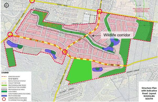
Figure 1 – Original concept plan and location of wildlife corridor
As per Figure 2, the wildlife corridor traverses a number of properties, with a total of 12 lots affected by the proposed widening. The properties affected include:
· Lot 10 DP12304
· Lot 44 DP1207188
· Lot 228 DP1213339
· Lot 130 DP1236451
· Lot 24 DP 1264605
· Lot 212 DP810087
· Lot 15 DP 12304
· Lot 12 DP12304
· Lot 13 DP12304
· Lot 1 DP119542
· Lot A DP33532
· Lot B DP33532
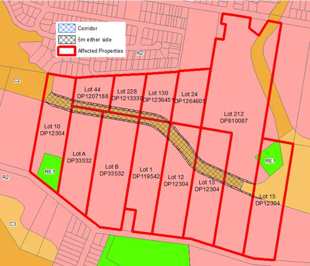
Figure 2 – Properties affected by the proposed widening
Given the minor nature of the amendment, this report recommends that Council proceed with the making of an amendment to the WLEP 2013 (or the Central Coast Local Environmental Plan, whichever is in effect) in accordance with sections 3.22 and 3.36(2) of the EP&A Act.
· Land Zoning Map – LZN_007B and LZN_014
· Lot Size Map - LSZ_007B and LSZ_014
In accordance with Section 3.22 of the EP&A Act, an amendment of an environmental planning instruments can be made without following the usual plan-making procedures (such as public exhibition) if it is to correct an obvious error.
Given the nature of the proposed amendment is to correct the width of the central wildlife corridor which was not accurately scaled when the WLEP 2013 mapping was finalised, it is considered the proposal meets this requirement and that a s3.22 application be prepared and forwarded to the Department of Planning and Environment (DPE).
Once DPE has assessed the proposal, they will arrange the preparation of a draft LEP and forward the amending LEP and s3.22 application to the Minister for determination. If the Minister determines the amending LEP is in accordance with section 3.36(2) and section 3.22 of the EP&A Act, public notification will occur through the NSW Legislation website.
The process for making a section 3.22 amendment is outlined below in Figure 3.
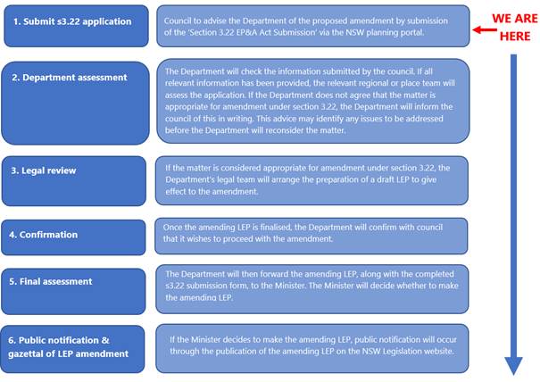
Figure 3 – s3.22 process
Attachment 1 provides a summary of proposal to amend the WLEP 2013. Attachment 2 is the completed s.322 application, which will be forwarded to DPE if Council resolves to proceed.
Consultation
Council staff have had preliminary discussions with DPE who have confirmed a s3.22 application is the appropriate planning pathway to amend the wildlife corridor and associated LEP maps.
In accordance with s3.22 of the EP&A Act public exhibition would not be required. Notwithstanding this, all landowners affected by the amendment will be notified in writing to ensure they are aware of the LEP amendment.
During the public exhibition of the original planning proposal in 2018, no submissions or objections were received from landowners regarding the width of the wildlife corridor which was exhibited as 30m. Increasing the width of the corridor is a requirement of the Biodiversity Conservation Division (formerly known as the Office of Environment and Heritage). The DCP was updated to identify a corridor width of 40m however, when the LEP mapping was finalised, the width of the central wildlife corridor not accurately scaled.
The site specific DCP applicable to the site (WDCP 2013 – Chapter 6.17 Warnervale East / Wadalba North West Urban Release Area) identifies a corridor width of 40m. The LEP amendment request seeks to rectify an administrative error and ensure consistency with both the adopted DCP and council resolution.
Financial Considerations
At its meeting held 19 October 2020, Council resolved the following:
1108/20 That any motions put before Council for the remainder of this term of Council that have financial implications require the Chief Executive Officer to provide a report on how those additional costs will be met.
The following statement is provided in response to this resolution of Council.
Adoption of the staff recommendation has neutral budget implications for Council. This will be undertaken within existing resourcing.
Link to Community Strategic Plan
Theme 3: Green
|
Goal F: Cherished and protected natural beauty |
|
G-F1: Protect our rich environmental heritage by conserving beaches, waterways, bushland, wildlife corridors and inland areas, and the diversity of local native species. |
|
Goal I: Balanced and sustainable development |
|
R-I3: Ensure land use planning and development is sustainable and environmentally sound and considers the importance of local habitat, green corridors, energy efficiency and stormwater management. |
Risk Management
There have been no risks identified at this stage to the natural and built environment associated with the proposed amendment to WLEP 2013, about seeking a Gateway Determination.
Options
1 Resolve to proceed with the proposed amendment. The recommendation is in response to a Council resolution. Council staff have had discussion with DPE and a s3.22 application has been determined as the appropriate planning pathway to amend the wildlife corridor and associated LEP maps. This is the recommended option.
2 Resolve not to proceed with the proposed amendment. Given the nature and merit of the proposed amendment, the recommendation is the most appropriate and efficient course of action. Resolving not to proceed would mean the Council resolution is not completed. Not recommended.
|
1⇨ |
Planning Proposal Summary |
Provided Under Separate Cover |
D15029063 |
|
2⇨ |
Section 3.22 submission form |
Provided Under Separate Cover |
D15029068 |
|
Item No: 2.9 |
|
|
Title: Planning Proposal RZ/108/2020 for 121 - 129 Newling Street, Lisarow |
|
|
Department: Environment and Planning |
|
|
22 March 2022 Ordinary Council Meeting |
|
Reference: F2020/00039 - D15022876
Author: Bruce Ronan, Strategic Planner
Scott Duncan, Section Manager Land Use and Policy
Manager: Shannon Turkington, Unit Manager Strategic Planning
Executive: David Milliken, Director Environment and Planning (Acting)
1 That Council endorse the Planning Proposal for Lot 122 DP 1218619 and Lot 4 DP 660988 (121 and 129 Newling Street), Lisarow, as exhibited.
2 That Council request the Chief Executive Officer to exercise delegation issued by the Department of Planning and Environment for RZ/108/2020 and proceed with the steps for drafting and making of the amendment to Gosford Local Environmental Plan 2014 or Central Coast Local Environmental Plan, whichever is in effect at the time.
|
Report purpose
To consider the Planning Proposal for Lot 122 DP 1218619 and Lot 4 DP 660988 (121 and 129 Newling Street), Lisarow, following public exhibition, and seek endorsement for the Planning Proposal through an amendment to the Gosford Local Environmental Plan 2014 or Central Coast Local Environmental Plan, whichever is in effect at the time.
Executive Summary
Council previously resolved to prepare a Planning Proposal to rezone Lot 4 DP 660988 and part of Lot 122 DP 1218619 (121 and 129 Newling Street, Lisarow) from B2 Local Centre to R1 General Residential to enable residential development. Other relevant Local Environmental Plan mapping layers were required to be amended to reflect the proposed R1 General Residential zone.
This report provides an overview of the outcome of State agency and community feedback received following public exhibition.
Based on the community and State government agency consultation and Council staff review it is recommended that Council endorse the Planning Proposal through an amendment to the Gosford Local Environmental Plan 2014 or the Central Coast Local Environmental Plan, whichever is in effect at the time. |
Background
On 27 April 2021, Council resolved the following:
137/21 Resolved
1 That Council prepare a Planning Proposal to amend the Gosford Local Environmental Plan 2014 (GLEP 2014), or draft Central Coast Council Local Environmental Plan (if in effect), by rezoning proposed lot 2 under the consolidation and re-subdivision of Lot 122 DP 1218619 and Lot 4 DP 660988 (DA 58001/2020 of 21/7/20) from B2 Local Centre to R1 General Residential.
2 That Council forward the Planning Proposal to the Minister requesting a Gateway Determination.
3 That Council request delegation for Council to finalise and make the draft Local Environmental Plan.
4 That if required Council authorise the Chief Executive Officer (or delegate) to enter into a Planning Agreement (PA), and to negotiate and execute all documentation in relation to the finalisation of the PA.
5 That if required Council prepare and exhibit an amendment to the relevant Section 7.11 Development Contributions Plan and Development Control Plan to support the development of the land subject to this planning proposal.
6 That Council undertake public authority and community consultation in accordance with the Gateway Determination requirements, including the concurrent exhibition of any draft Voluntary Planning Agreement, draft Development Control Plan amendment and / or draft Section 7.11 Development Contributions Plan amendment (if required).
With respect to Resolution 2, a Gateway Determination Alteration was issued by the Department of Planning and Environment (DPE) on 4 August 2021. This report responds to the above resolutions and provides details of the outcome of the Planning Proposal following public exhibition.
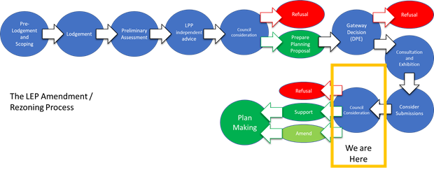
Diagram 1 – Local Environmental Plan Amendment Process
Report
The Site - The subject site is within the Lisarow local centre which is bounded by Pacific Highway, Parsons Road and Newling Street. The site is accessed from Newling Street which provides access to the adjoining residential area. The land is primarily cleared of vegetation and slopes downhill to the north away from Newling Street. The site has an area of 11,710m2.
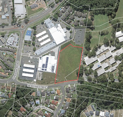
Figure 1 – Aerial Photograph
The site is currently zoned B2 Local Centre under the GLEP 2014 and draft CCLEP (Figure 2).
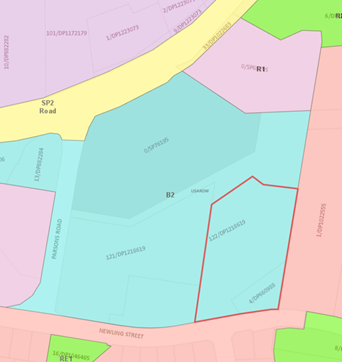
Figure 2 – Existing zoning under GLEP 2014
The Proposal - The Planning Proposal seeks to rezone the site from B2 Local Centre to R1 General Residential under either the GLEP 2014 or CCLEP, whichever is in effect at the time (Figure 3).
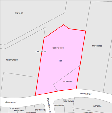
Figure 3 – Proposed zoning under GLEP 2014 or CCLEP
The rezoning of the site to R1 General Residential would require the relevant local environmental plan mapping layers (i.e. lot size, height, floor space ratio) to be amended to those consistent with the R1 zoned land in the locality (Table 1).
Table 1 – Proposed Mapping Layer Amendments
|
Provisions |
Existing Provision |
Proposed Amendment GLEP 2014 |
Proposed Amendment CCLEP |
|
Zoning |
B2 Local Centre |
R1 General Residential |
R1 General Residential |
|
Minimum Lot Size |
N/A |
550m2 |
550m2 |
|
Height of Building |
11.5m |
11.0m |
11.0m |
|
Floor Space Ratio |
1:1 |
0.85:1 (bounded by a blue line) This blue line refers to clause 4.4(2A) which specifies that notwithstanding the mapped FSR; an FSR of 0.6:1 applies if: - the building is used for the purpose of a residential flat building or multi dwelling housing, and - includes on-site car parking that is not located in the basement, and - the site area is 1,000m2 or more. |
0.5:1 (mapped in Area 2) Area 2 refers to clause 4.4A(6) which specifies: ~ that a FSR of 0.85:1 applies if: - the building is used for the purpose of residential flat building or multi-dwelling housing, and - all on-site car parking is located in the basement, and - the site area is 1,000m2 or more. ~ that a FSR of 0.6:1 applies for any purpose other than a dwelling house. (i.e. includes residential flat building or multi-dwelling housing with on ground parking). |
Concurrent Exhibition of Other Planning Controls
With respect to Resolution 6 and the concurrent exhibition of any draft Development Control Plan (DCP), draft Contributions Plan (CP) or draft Planning Agreement, Council staff considered these matters and determined this was not required due to the following:
· The existing DCP (Chapter 5.14 of Gosford DCP 2013) specifically applying to Lisarow/Niagara Park relates to the surrounding low density residential area that is now fully developed. It does not relate to the area zoned B2 Local Centre nor R1 General Residential adjoining the B2 zone. Consequently, the subject site is not required to be included in Chapter 5.14 of the DCP. Any infrastructure augmentation or roadworks for the individual development site are able to be assessed as part of a future Development Application and thus not required to be included in a site specific DCP or Planning Agreement.
· The existing CPs (CP 8A Drainage, CP 8B Roadworks and Traffic Management, 8C Community and Recreation Facilities) do not relate to the B2 Local Centre zone or the adjoining R1 General Residential zoned land. The area covered by these CPs is fully developed and all the CP works have been funded and completed. Consequently, Council, on 23 November 2021 resolved to repeal these three CPs, together with others.
Assessment
The rezoning of the subject land to R1 General Residential under the GLEP 2014 or CCLEP, is considered to have strategic merit on the following basis:
· The site is unsuitable for commercial and retail uses as it lacks main road exposure and fronts a residential street;
· The subject site is located at the rear of the existing retail development and is elevated above such development meaning that there is limited opportunity for any future commercial development on the land to be integrated with the adjoining retail uses; and
· The proposal will expand the available housing choice in Lisarow by providing the opportunity for either low or medium density housing (or a combination thereof), in an area with all necessary infrastructure and services available i.e. being located adjacent to a shopping centre, high school and within walking distance of bus stops, the railway station, primary school and sporting fields.
Statutory Compliance and Strategic Justification
The planning proposal has been assessed having regard for all State Environmental Planning Policies, Ministerial Directions and the relevant guidelines set out within the Central Coast Regional Plan 2036 (CCRP). The proposal is considered to be consistent with the CRRP and is suitable for forwarding to DPE for finalisation.
Delegation
Council has been issued with the delegations of the Minister to make amending Local Environmental Plans. The Gateway Determination dated 4 August 2021 provides Council the appropriate delegations under section 3.36(2) of the Environmental Planning and Assessment Act 1979 to make this amending Local Environmental Plan. Council’s delegate for this function is the Chief Executive Officer, David Farmer.
Consultation
Internal Consultation
Internal consultation has been undertaken as summarised below:
· Environmental Planning – the subject land is cleared of vegetation so there are no ecological constraints that need to be addressed by the Planning Proposal.
· Environment and Health – A Stage 2 Detailed Site Contamination Assessment was prepared generally in accordance with the NSW EPAs Contaminated Site Guidelines. Samples were analysed for all potential contaminants of concern and appropriate National Environment Protection (Assessment of Site Contamination) Measure (NEPM) health and ecological investigation levels in soils were selected (Residential A). All samples were below the adopted criteria, therefore, the site is considered suitable for the proposed residential land use. Further detailed analysis will occur at the development application stage.
· Floodplain Management – The site is not impacted by flooding and therefore can be supported in its current form. At the development application stage, the applicant should identify local flow paths to determine if any locally derived flows may impact the site that will need to be accounted for in any subsequent design for the site.
· Transport Planning – It is noted that Busways operates within the area and provides a regular service to Gosford from a bus stop located along Parsons Road, at Lisarow Plaza. Lisarow Train Station is also located just 800 metres north-east of the subject lands. The proposal would reduce traffic impacts, as the Roads and Maritime Service’s Guide to Traffic Generating Developments Guidelines indicates residential property has relatively lower traffic generation rates for both the AM and PM peaks and all-day trip generation rates, when compared to the rates for shops. There are no transport concerns with the proposed rezoning as the transport network has the capacity to cater for the proposed rezoning.
· Water and Sewer – There are no significant constraints with respect to water and sewerage. The following items will be assessed as part of any subsequent Water Management Act Section 305 Applications:
o Developer charges will apply in accordance with the 2019 Southern Region Water Supply and Sewerage Development Servicing Plan
o New water and sewer mains would be required to service any new properties. The subsequent developer would undertake the design and construction of those assets in accordance with the prevailing water and sewer design codes of practice.
Government Agency Consultation
The Gateway Determination required that the NSW Rural Fire Service (RFS) be consulted, with their assessment as follows:
· Future development application referrals for the further subdivision of the subject site for residential purposes must demonstrate compliance with the following:
o The provision of asset protection zones (APZs) in accordance with Table 5.3a and Table A1.12.2 of PBP 2019;
o The provision of access in accordance with Table 5.3b of PBP 201; and
o The provision of services and utilities in accordance with Table 5.3c of PBP 2019.
Community Consultation
The Planning Proposal was publicly exhibited from 19 November 2021 to 17 December 2021 and was undertaken in accordance with the Gateway Determination.
No submissions were received during the public exhibition.
Outcome of Consultation
Based on the community and State government agency feedback, the Planning Proposal has satisfied relevant statutory requirements relating consultation.
Financial Considerations
At its meeting held 19 October 2020, Council resolved the following:
1108/20 That any motions put before Council for the remainder of this term of Council that have financial implications require the Chief Executive Officer to provide a report on how those additional costs will be met.
The following statement was provided in response to this resolution of Council in the Council report of 27 April 2021.
The recommendations have no financial implications for Council. The direct cost to Council is the preparation of the Planning Proposal, which will be charged as per Council’s Fees and Charges, on a cost recovery basis.
Link to Community Strategic Plan
Theme 2: Smart
|
S-C3: Facilitate economic development to increase local employment opportunities and provide a range of jobs for all residents. |
Theme 3: Green
|
Goal F: Cherished and protected natural beauty |
|
G-F1: Protect our rich environmental heritage by conserving beaches, waterways, bushland, wildlife corridors and inland areas, and the diversity of local native species. |
Theme 4: Responsible
|
Goal I: Balanced and sustainable development |
|
R-I1: Preserve local character and protect our heritage and rural areas including concentration of development along transport corridors and around town centres and east of the M1. |
|
Goal I: Balanced and sustainable development |
|
R-I2: Ensure all new developments are well planned with good access to public transport, green space and community facilities and support active transport. |
|
Goal I: Balanced and sustainable development |
|
R-I3: Ensure land use planning and development is sustainable and environmentally sound and considers the importance of local habitat, green corridors, energy efficiency and stormwater management. |
|
Goal I: Balanced and sustainable development |
|
R-I4: Provide a range of housing options to meet the diverse and changing needs of the community and there is adequate affordable housing. |
Risk Management
There have been no risks identified to the natural and built environment associated with the proposed amendment to GLEP 2014 (or the CCLEP).
Options
1 Endorse the Planning Proposal. The Planning Proposal is considered to have strategic merit, it has received a Gateway Determination and there are no public objections.
This is the recommended option.
2 Refuse the finalisation of the Planning Proposal. The Planning Proposal has been assessed on its merit and is deemed to be a suitable proposal. In Council staff opinion there is no reason why it should be refused. Not recommended.
Nil.
|
Item No: 2.10 |
|
|
Title: Planning Proposal RZ/38/2013 for land at Glenworth Valley and Calga |
|
|
Department: Environment and Planning |
|
|
22 March 2022 Ordinary Council Meeting |
|
Reference: F2020/00039 - D15024570
Author: Bruce Ronan, Strategic Planner
Scott Duncan, Section Manager Land Use and Policy
Manager: Shannon Turkington, Unit Manager Strategic Planning
Executive: David Milliken, Director Environment and Planning (Acting)
1 That Council endorse the Planning Proposal for land at Glenworth Valley and Calga, subject to the amendments outlined in this report.
2 That Council request the Chief Executive Officer to exercise delegation issued by the Department of Planning and Environment for RZ/38/2013 and proceed with the steps for drafting and making of the amendment to Gosford Local Environmental Plan 2014 or Central Coast Local Environmental Plan, whichever is in effect at the time.
3 That all those who made submissions during public exhibition be notified of Council’s decision.
|
Report purpose
To consider the Planning Proposal on land at Glenworth Valley and Calga following public exhibition, and seek endorsement for the Planning Proposal through an amendment to the Gosford Local Environmental Plan 2014 or Central Coast Local Environmental Plan, whichever is in effect at the time
Executive Summary
The Planning Proposal seeks to enable various additional permitted uses on certain land operating as Glenworth Valley Outdoor Adventures. The additional permitted uses will facilitate long term certainty as to the continued and future operations of Glenworth Valley Outdoor Adventures and permit a range of recreational and tourist related activities, whilst protecting the environmental quality of the site.
The existing zones applying to the subject land (i.e. C2 Environmental Conservation and RU2 Rural Landscape) are not being changed as part of the Planning Proposal.
The Planning Proposal underwent State agency consultation and was publicly exhibited from 22 November 2021 to 20 December 2021. Details of the feedback received and the outcome of consultation are contained in this report.
Based on community and State government agency consultation, and Council staff assessment it is recommended that Council endorse the Planning Proposal, subject to amendments outlined in this report, and that an amendment to the Gosford Local Environmental Plan 2014 or the future Central Coast Local Environmental Plan, whichever is in effect at the time, is made. |
Background
The Planning Proposal seeks to provide certainty for the continuation of existing uses on the subject site and to provide opportunities for additional recreation and tourist related developments in the future by adding specific additional permitted uses which can be conducted on the property.
The original Planning Proposal was supported by the former Gosford City Council on 17 December 2013 and 10 June 2014.
The Planning Proposal was subject to a Gateway Determination issued on 17 July 2014 by the Department of Planning and Environment and a subsequent Gateway extension which lapsed on 24 October 2018.
On 24 April 2018 an amended Planning Proposal was lodged.
Council considered the amended Planning Proposal on 11 November 2019 and resolved:
1085/19 That Council defer consideration of this item for a site inspection to be
conducted and a briefing at the monthly planning workshop to be provided.
Council considered the amended Planning Proposal on 27 April 2020 and resolved:
295/20 That the Council support an amended Planning Proposal applying to:
- Lots 19, 20, 21, 23, 24, 25, 30, 31, 32, 33, 37, 50, 53, 64, 65, 68, 81, 82, 85, 86, 87, 89, 91, 108, 145 DP 755221,
- Lots 22, 23, 32, 73, 75, 76 DP 755253,
- Lots 1, 3 DP 617088,
- Lot 881 DP 563889,
- Lot 1 DP 1222754,
- Lot 7 DP 1230083,
- Lot 245 DP 48817,
- Lot 7012 DP 1059767,
- Lot 7029 DP 93603,
- Lot 7035 DP 1051932,
- Lot 7036 DP 1059768,
- Lot 7303 DP 1154929, Glenworth Valley, and
- Lot A DP 365595,
- Lot C DP 382358,
- Lot 2 DP 1139242,
- Lot 882 DP 563889,
- part of Lot 102 DP 1139060,
- Lot 7039 DP 1059766,
- Lot 7303 DP 1161109, Calga
to amend the Gosford Local Environmental Plan 2014 (or draft Central Coast Local Environmental Plan), whichever is in effect at the time, to permit the following additional permitted uses (if they are not included in the Central Coast Local Environmental Plan):
a on land zoned E2 Environmental Conservation, development for the purpose of eco-tourist facilities and recreation facilities (outdoor);
b on land zoned RU2 Rural Landscape, development for the purposes of eco-tourist facilities, camping grounds and tourist and visitor accommodation;
c on the existing cleared areas of the land zoned E2 Environmental Conservation, comprising Lots 19, 20, 21, 23, 25, 30, 32, 33, 37, 50, 53, 64, 68, 85, 86, 87, 89, 91, 108 and 145 DP 755221, Lots 22 and 32 DP 755253, Lot 3 DP 617088, Lot 245 DP 48817, Lot 7039 DP 1059766 and Lot 7303 DP 1154929, development for the purpose of extensive agriculture.
d on land comprising that part of Lot 89 DP 755221 which currently accommodates the multi-purpose building and its curtilage,
(i) development for the purpose of function centre, entertainment facility and food and drink premises, and
(ii) the total floor area for the function centre, entertainment facility and food and drink premises is to be a maximum of 1500m2 with any additions being attached to, or directly adjacent to, the existing building.
e on the existing cleared areas of the land zoned E2 Environmental Conservation comprising part of Lots 19, 37 and 89 DP 755221 and Lots 22 and 32 DP 755253, development for the purpose of function centre and camping ground.
f on the existing cleared areas of the land zoned E2 Environmental Conservation comprising part of Lots 108 and 145 DP 755221, development for the purpose of tourist and visitor accommodation.
296/20 That Council submit a revised Planning Proposal to the Minister for Planning in accordance with Section 3.35(2) of the Environmental Planning and Assessment Act 1979, requesting an amended Gateway Determination pursuant to Section 3.34 of the Environmental Planning and Assessment Act 1979.
297/20 That Council request delegation for Council to finalise and make the draft Local Environmental Plan, pursuant to Section 3.36 of the Environmental Planning and Assessment Act 1979.
298/20 That Council undertake community and public authority consultation, in accordance with the Gateway Determination requirements.
299/20 That the Council consider a further report on results of the agency and community consultation.
In regards to Resolution 296/20, the Department of Planning and Environment (DPE) issued a Gateway Determination on 6 August 2020, which lapsed on 6 February 2022. As the Planning Proposal has been on public exhibition prior to 6 February 2022, DPE have agreed that finalisation of the Planning Proposal can occur after this date.
This report responds to the above resolutions and provides details of the outcome of the Planning Proposal following public exhibition. The Planning Proposal is currently at the stage in the Local Environmental Plan Amendment Process shown in Diagram 1.
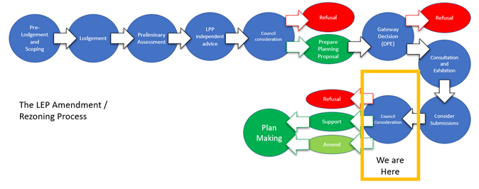 Diagram 1 – Local
Environmental Plan Amendment/Rezoning Process
Diagram 1 – Local
Environmental Plan Amendment/Rezoning Process
Report
The Site - The subject site comprises 49 lots with a total area of 1173.6 Ha.
The land represents a significant holding of environmentally important land being relatively isolated, with limited access from Cooks Road, and characterised by a cleared valley floor with vegetated hillsides and ridgelines (Figure 1).
The land comprises of a number of discrete pockets of Endangered Ecological Communities (EEC) and regionally significant vegetation throughout the site. It is located between developed agricultural and resource lands situated along Peats Ridge Road to the east and Popran National Park to the west. Popran Creek, and a number of other small watercourses which run into it, flow through the site, which then drains to the Hawkesbury River.
The land is also an established tourist destination. Its close proximity to Sydney makes it a desirable destination for a wide tourism market, including international visitors. The broad range of nature-based activities offered at the site also make it appealing for a variety of users and maximises opportunities that the site presents. Some uses are temporary (e.g. camping, outdoor recreation), whilst other uses are of a more permanent nature with some fixed structures (e.g. multi-purpose building). Different parts of the site are used for various activities (e.g. abseiling, horse riding, quad bike riding). The cleared valley floor is used for the grazing of horses and livestock.
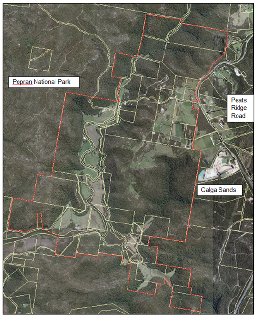
Figure 1 – Locality Map
The subject site comprises approximately 1070.2 Ha of land zoned C2 Environmental Conservation (prior to 1 December 2021 - E2 Environmental Conservation) and 103.4 Ha of land zoned RU2 Rural Landscape under Gosford Local Environmental Plan 2014 (GLEP 2014) (Figure 2).
The zone boundaries are not proposed to be changed under the Central Coast Local Environmental Plan (CCLEP).
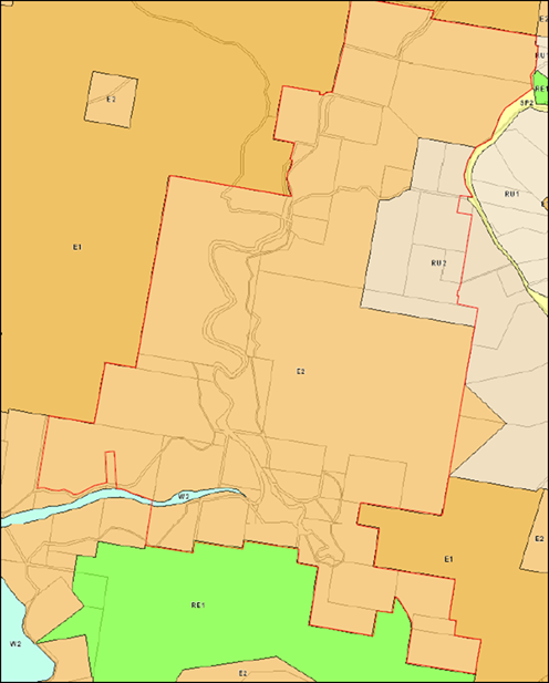
Figure 2 – Existing Zoning under GLEP 2014
The Proposal- The objective of this Planning Proposal is to enable additional permitted uses on the subject land. In summary this entails:
· On land zoned RU2 Rural Landscape, the additional permitted uses of eco-tourist facilities, camping grounds, tourist and visitor accommodation;
· On land zoned C2 Environmental Conservation, the additional permitted uses of eco-tourist facilities and recreation facilities (outdoor).
· On existing cleared areas of land zoned C2 Environmental Conservation, comprising part of Lots 19, 20, 21, 23, 25, 30, 32, 33, 37, 50, 53, 64, 68, 85, 86, 87, 89, 91, 108 and 145 DP 755221, part of Lots 22 and 32 DP 755253 part of Lot 3 DP 617088, part of Lot 245 DP 48817 and part of Lot 7303 DP 1154929, development for the purpose of extensive agriculture.
· On existing cleared areas of land zoned C2 Environmental Conservation, comprising part of Lots 19, 37 and 89 DP 755221 and part of Lots 22 and 32 DP 755253, development for the purposes of camping grounds and function centres.
· On existing cleared areas of Lot 108 DP 755221 and Lot 145 DP 755221, development for the purposes of tourist and visitor accommodation.
· On land comprising part of Lot 89 DP 755221 which currently accommodates the multi-purpose building:
o Development for the purposes of function centre, entertainment facility and food and drink premises, and
o The total floor area for the function centre, entertainment facility and food and drink premises, is to be a maximum of 1500m2 with any additions being attached to, or directly adjacent to the existing building.
To implement these changes an amendment to Schedule 1 Additional Permitted Uses in the GLEP 2014 or CCLEP, whichever is in effect at the time, will be required. The proposed wording of the new clause in Schedule 1 will be (subject to DPE approval):
XX Use of certain land at Calga and Glenworth Valley
(1) This clause applies to 49 lots at Calga and Glenworth Valley identified as “Popran Creek” on the Additional Permitted Uses Map.
(2) The following development is permitted with development consent:
(i) In Area A - eco-tourist facility and recreation facility (outdoor);
(ii) In Area B - eco-tourist facility, camping ground, tourist and visitor accommodation;
(iii) In Area C - eco-tourist facility, recreation facility (outdoor), extensive agriculture;
(iv) In Area D - eco-tourist facility, recreation facility (outdoor), extensive agriculture, camping ground, function centre;
(v) In Area E - eco-tourist facility, recreation facility (outdoor), extensive agriculture, tourist and visitor accommodation;
(vi) In Area F - eco-tourist facility, recreation facility (outdoor), extensive agriculture, camping ground, function centre, entertainment facility, food and drink premises.
(3) In Area F the total floor space to be used for a function centre, entertainment facility and a food and drink premises is to not exceed 1500m2 and any additions being attached to, or directly adjacent to the existing building.
The accompanying Additional Permitted Uses (APU) Map pictorially indicating the subject Areas is shown in Attachment 1.
Note: - should the CCLEP be in effect when this Planning Proposal is finalised the following changes would be required:
· As “eco-tourist facilities” is a land use proposed to be permitted generally in the C2 Environmental Conservation zone, it would not be required to be included as an additional permitted use in Areas A, C, D, E and F.
· As “camping grounds” is a land use proposed to be permitted generally in the RU2 Rural Landscape zone, it would not be required to be included as an additional permitted use in Area B.
Assessment
The Planning Proposal for additional permitted uses on the site has strategic merit on the basis that:
· It will facilitate long term certainty as to the continued and future operations of Glenworth Valley Outdoor Adventures to permit a range of recreational and tourist related activities, whilst protecting the environmental quality of the site.
· The retention of existing zones with the proposed additional permitted uses will allow for the on-going development and enhancement of a significant tourist facility and ensure it remains intrinsically linked to the protection and management of the environment and allowing development at an appropriate scale.
· It will allow a regionally significant nature-based tourist development to add complementary nature-based tourist facilities, including accommodation that will build on existing capital investment, and allow additional outdoor recreational opportunities as they emerge.
· The proposed additional permitted uses are mainly located within the cleared areas of the site which will protect the environmental value of the land whilst enabling economic development of tourist related uses.
Statutory Compliance and Strategic Justification
The Planning Proposal has been assessed having regard for all State Environmental Planning Policies, Ministerial Directions and the relevant guidelines set out within the Central Coast Regional Plan 2036 (CCRP). The proposal is considered to be consistent with the actions related to environmental land and tourism outlined in the CRRP and the Interim Local Strategic Planning Statement (LSPS) and is therefore suitable for forwarding to the DPE for finalisation.
Delegation
Council has been issued with the delegations of the Minister to make amending Local Environmental Plans (LEPs). The Gateway Determination issued on 6 August 2020 provides Council the appropriate delegations under Section 3.36(2) of the Environmental Planning and Assessment Act, 1979 to make this amendment to the LEP. Council’s delegate for this function is the Chief Executive Officer, David Farmer.
Consultation
The Planning Proposal was publicly exhibited from 22 November 2021 to 20 December 2021 and was undertaken in accordance with the DPE’s A Guide to Preparing Local Environmental Plans and the Gateway Determination.
Community Consultation
Two submissions were received during the exhibition period. The matters raised in the submissions are summarised and responded to in Attachment 2.
The main concerns raised are that the Planning Proposal will allow the removal of native vegetation which will negatively alter the scenic quality of the area, reduce habitat, increase traffic on local and internal roads and put pressure on adjoining conservation lands.
Agency Consultation
The
Gateway Determination specified which agencies were to be consulted in the
Planning Proposal process. The agencies were consulted prior to public
exhibition and again during the exhibition period. The issues are summarised in
Attachment 3.
As a result of Agency consultation during the exhibition period, the following amendments have been made to the Planning Proposal:
- The Additional Permitted Uses Map has been amended to remove the biodiversity offset for the adjoining Calga Quarry. This biodiversity offset is a triangular area of 41 Ha in an isolated location in the south-eastern corner of the subject land (Lot 108 DP 755221 and part of Lot 23 DP 755221).
- The proposed clause in Schedule 1 Additional Permitted Uses has been amended to ensure emergency responses to flooding and bushfire will be addressed with any future development proposal.
Internal Consultation
Internal consultation has been undertaken, as summarised below.
· Environmental Planning – most of the proposed Additional Permitted Uses are to be located within the existing cleared areas of the site so that habitat, threatened species, populations and ecological communities will not be adversely affected. Any development applications for uses within an existing vegetated area can be assessed at that time and environmental management conditions linked to the specific activity to ensure environmental values are not adversely affected.
· Waste Management – on balance it is considered that any likely increases in usage of the facilities as result of the planning proposal can be accommodated by the existing system, provided that management system are put in place. In the event that there is a more substantial increase in the daily hydraulic loadings than anticipated it has been demonstrated that the system can be modified to accommodate it. Accordingly, there are no objections to the Planning Proposal from the Environmental Health (OSSM) team.
· Flooding and Drainage – the impacts of overland flooding from upstream tributaries in the locality may impact on future structures. The assessment of such impacts would be subject to development applications and any flooding issues could be dealt with at that stage.
· Environment and Health – from a contamination perspective the Planning Proposal is suitable based on the Health Investigation Levels (HIL) C assessment criteria.
· Transport Planning – the road network has the capacity to support the various recreational and festival events being held with access to Cooks Road and its intersection with Peats Ridge Road. These roads in this remote location could be upgraded with improved parking and upgraded pedestrian access to support larger scale events or more frequent activities if desired, when future development applications are lodged. If any one-off traffic generating events occur on site, Council’s Traffic Officer and a Police Officer liaise with the applicant and oversee the implementation and monitoring of temporary Traffic Management Plans (TMPs) to address such issues as queuing along Peats Ridge Road. No objection is raised to the independent use of the existing multi-purpose building or other activities provided any development proposals are assessed in accordance with the RMS Guidelines for Traffic Generating Development.
Outcomes of Consultation
Based on the community and State government agency feedback, the Planning Proposal has satisfied relevant statutory requirements relating to consultation.
Link to Community Strategic Plan
Theme 2: Smart
|
Goal C: A growing and competitive region |
|
S-C4: Promote and grow tourism that celebrates the natural and cultural assets of the Central Coast in a way that is accessible, sustainable and eco-friendly. |
Theme 3: Green
|
Goal F: Cherished and protected natural beauty |
|
G-F1: Protect our rich environmental heritage by conserving beaches, waterways, bushland, wildlife corridors and inland areas, and the diversity of local native species. |
Theme 5: Liveable
|
Goal L: Healthy lifestyle for a growing community |
|
L-L1: Promote healthy living and ensure sport, leisure, recreation and aquatic facilities and open spaces are well maintained and activated. |
Financial Considerations
At its meeting held 19 October 2020, Council resolved the following:
1108/20 That any motions put before Council for the remainder of this term of Council that have financial implications require the Chief Executive Officer to provide a report on how those additional costs will be met.
The recommendations have no financial implications for Council. The direct cost to Council is the preparation of the Planning Proposal, which will be charged as per Council’s Fees and Charges, on a cost recovery basis.
Risk Management
Any matters that have identified through assessment have been addressed. There are no risks identified to the natural and built environment if this Planning Proposal is endorsed by Council.
Options
1 Endorse the Planning Proposal. The Planning Proposal has strategic merit and any matters raised during public exhibition or through agency consultation have been addressed. This is the recommended option.
2 Refuse the finalisation of the Planning Proposal. The Planning Proposal has been assessed on its merit and is deemed to be a suitable proposal. In Council staff opinion there is no reason why it should be refused. Not recommended.
|
1⇨ |
APU Map for Glenworth Valley and Calga |
Provided Under Separate Cover |
D15039652 |
|
2⇨ |
Community Consultation |
Provided Under Separate Cover |
D15080157 |
|
3⇨ |
Agency Consultation |
Provided Under Separate Cover |
D15080162 |
|
Item No: 2.11 |
|
|
Title: Outcomes following Community Consultation for the Central Coast Stadium - Rezoning and Reclassification (Pre-Assessment by ED&P) |
|
|
Department: Corporate Affairs |
|
|
22 March 2022 Ordinary Council Meeting |
|
Reference: CPA/3261 - D14839810
Author: Ben Brown, Property Development Manager
Mellissa McKee, Financial Controller
Manager: Jamie Barclay, Unit Manager Development and Property
Executive: Natalia Cowley, Director Corporate Affairs and Chief Financial Officer
1 That Council consider the submissions and feedback received during the consultation period.
2 That Council commence the rezoning and reclassification process for Lot 2, DP1011876 which will allow greater Masterplan outcomes.
3 That Council modify the Plan of Management for Lot 1 DP 1011876 to reflect the uses triggered by any Masterplan proposal.
|
Report purpose
Report to Council on the submissions and outcomes following the public exhibition of the Central Coast Stadium- Rezoning and Reclassification proposal and seek resolution to proceed with both the Rezoning and Reclassification of Lot 2 DP 1011876.
Executive Summary
This report is in response to Council Resolution 133/21 which resolved that Central Coast Stadium- Rezoning and Reclassification proposal dated 27 April 2021 be placed on public exhibition with a further report provided to Council on the submissions and feedback received.
This report notifies Council that the submissions received through the public exhibition period have been reviewed and recommends that Council adopt the Central Coast Stadium- Rezoning and Reclassification proposal for Lot 2 DP 1011876 only.
|
Background
On 27 April 2021, Council put forth a recommendation to seek resolution to rezone the Central Coast Stadium (Lot 1 & Lot 2 DP 1011876) to an appropriate B3, B4 or B6 zone or a mixed zoning thereof as defined in the GCC SEPP 2018 and reclassify the land to an operational classification which will enable greater opportunities as defined in the Stadium Implementation Plan.
A key component in achieving the goals of the Stadium Implementation Plan, is to develop a precinct masterplan. To develop the scope for the masterplan, Council was seeking to have the Stadium land holdings appropriately rezoned and subsequently reclassified.
Rezoning and reclassification of the Stadium site will allow complementary uses at the Stadium site and allow greater flexibility in any adopted Masterplan strategy and design.
Current Status
The Central Coast Stadium- Rezoning and Reclassification Council Report was considered by Council at the Ordinary Meeting of 27 April 2021, where Council resolved the following:
133/21 That this matter be deferred to allow for the conduct of community consultation for a period of not less than 21 days, with a further report to be provided to Council to consider submissions made during the exhibition period.
In compliance with this resolution, between 30 April and 21 May 2021, Council sought community feedback on a potential rezoning and reclassification of the Central Coast Stadium.
Furthermore, and specifically in relation to Lot 1:
(a) On 28 September 1998, the State entered into a ‘Deed of Agreement’ with Gosford City Council;
(b) The Deed provided, amongst other things, for the vesting by the State of the Crown reserve component of Grahame Park being Lot 9 DP 868080 (now Lot 1) to Council for the purposes of constructing Central Coast Stadium.
(c) The Deed requires Council to pay compensation to the State if Council modifies the Stadium community classification within a 99-year period after the Deed’s execution.
(d) Council queried the State, and specifically asked, ‘if Council would be able to reclassify the land from “community” to “operational” without triggering the compensation clause’. The State subsequently advised that Council would be required to purchase the land from the State as per the compensation clause set out in the deed.
As the Masterplan envisages the Stadium proper to be utilised in its current format and ancillary uses (such as carpark and community facilities) be developed on the western side of the Stadium, the envisaged Masterplan proposal would be compliant with the current zoning and classification, albeit with a requirement to modify the Plan of Management only. As such, Council will no longer be pursuing Rezoning or Reclassification of Lot 1.
Consultation
The purpose of the consultation engagement was to:
· Inform the community of Council’s continued commitment to implementing the actions identified in its strategic documents;
· Seek feedback on the proposed rezoning and reclassification of Central Coast Stadium;
· Understand community sentiment about the proposal, allow ideas to be submitted on the future of the Stadium and broader sentiment about the long-term commitment to the Central Coast Stadium;
· Work with stakeholders and the community to identify issues which may affect the proposal.
Consultation had been designed in accordance with Central Coast Council’s Engagement Framework. This framework was available to view at the designated Your Voice Our Coast website.
The consultation methods employed for the consultation engagement included:
|
Information package |
All residents and stakeholders could view the information package presented on Your Voice Our Coast which provided all the information relating to Central Coast Stadium and the rezoning and reclassification proposal. |
|
Written feedback |
All residents and stakeholders could provide written feedback via email, the online submission form on yourvoiceourcoast.com, or via post. |
On 21 May 2021 and separate from the key findings from the community’s submissions, Council was presented with a petition signed by 948 people. The subject matter and action requested on the petition included:
“Gosford City Bowling Club (Lot 2 DP 1011876), currently used by the members of Gosford City Bowling Club and All Ability Bowls and numerous others, should remain under its current zoning of community sportsground (RE1) and not be reclassified as operational.”
For the purposes of clarity, Council leases the premises contained on Lot 2 DP 1011876 to the Central Coast Leagues Club and the Gosford Bowling Club is provided access to this site by the Leagues Club. Rezoning and reclassifying Lot 2, DP1011876 provides greater flexibility for future integrated planning for the Central Coast Stadium and Gosford Waterfront and does not presuppose any future outcome for the Gosford Gosford Leagues Club and its occupant the Gosford Bowling Club.
In summary, the key findings from the community’s submissions included:
· Consideration of user groups whom may be affected;
· Stadium management rights could be provided to another party;
· Support for the rezoning and reclassification process to stimulate the Stadium;
· Request for more music concerts being held at the Stadium.
Specifically, when ‘support v unsupported’ is compared for the proposed Stadium Rezoning and Reclassification, a ratio of 62:38 is determined in favor of the proposal.
Financial Considerations
At its meeting held on 19 October 2020, Council resolved the following:
1036/20 That any motions put before Council for the remainder of this term of Council that have financial implications require the Chief Executive Officer to provide a report on how those additional costs will be met.
The following statement is provided in response to this resolution of Council.
There will be fees associated with GCC SEPP 2018 modification related with a Planning Proposal which is estimated to be $50,000.
Council has sufficient funding available in the 2021-22 adopted operational budget in the Economic Development and Property Management Consultants budget 10.52200.821005.000.00000 to cover the $50,000 to complete the Rezoning and Reclassification of Lot 2 DP1011876.
Link to Community Strategic Plan
Theme 2: Smart
|
Goal C: A growing and competitive region |
|
S-C3: Facilitate economic development to increase local employment opportunities and provide a range of jobs for all residents. |
Risk Management
The community consultation and submissions received in the public exhibition period have been considered. Council staff propose to continue with the Rezoning and Reclassification of Lot 2.
Council staff will ensure any issues pertaining to the ability to rezone and reclassify the Stadium land holdings will be mitigated prior to Council undertaking either the rezoning or reclassification process.
Options
1 Proceed with the Rezone and Reclassification of Lot 2 at the Central Coast Stadium. This is the recommended option.
2 Discontinue with Rezoning and Reclassifying of Lot 2 at the Central Coast Stadium. This is not the recommended option due to the extensive community consultation already undertaken.
Critical Dates or Timeframes
June 2022- Deadline to finalise the Stadium Masterplan.
Planning Proposal Indicative Timeframe
|
STAGE |
DESCRIPTION |
BENCHMARK TIMELINE (days) |
STATUS |
|
Stage 1 |
Pre-Lodgment |
30 |
P |
|
Stage 2 |
Planning Proposal |
40 |
|
|
Stage 3 |
Gateway Determination |
45 |
|
|
Stage 4 |
Post Gateway |
160 |
|
|
Stage 5 |
Public Exhibition and Assessment |
95 |
|
|
Stage 6 |
Finalisation |
80 |
|
Local Environmental Plan Amendment Process
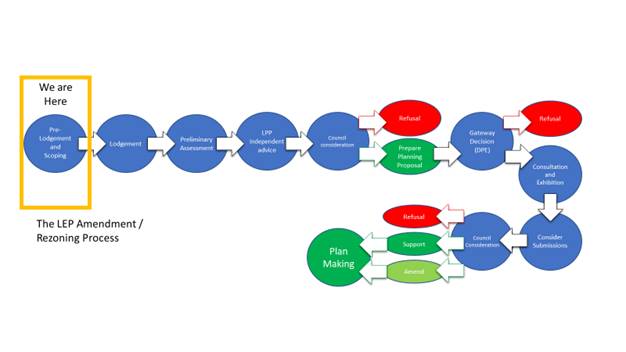
|
1⇨ |
Central Coast Stadium- Consultation Report |
Provided Under Separate Cover |
D14839864 |
|
2⇨ |
Stadium.Legend.a.04.03.22 |
Provided Under Separate Cover |
D15068243 |
|
Item No: 2.12 |
|
|
Title: Surf Life Saving Central Coast and Surf Club Financial Partnership Support 2021/2022 |
|
|
Department: Community and Recreation Services |
|
|
22 March 2022 Ordinary Council Meeting |
|
Reference: F2022/00021 - D15037581
Author: Phil Cantillon, Unit Manager Leisure Beach Safety and Community Facilities
Executive: Brian Bell, Director Community and Recreation Services (Acting)
1 That Council adopt the recommendations as outlined in this report to provide 2021/2022 financial partnership support to Surf Life Saving Central Coast (SLSCC) and the Central Coast’s 15 Surf Clubs.
2 That Council approve the distribution of $213,500 through the following:
a $38,000 to SLSCC to coordinate beach safety activities and educational messaging across the Central Coast.
b $78,000 to SLSCC to administer the purchase of the following equipment on behalf of the Central Coast’s 15 Surf Clubs. This includes:
i. Inflatable Rescue Boat (IRB) motor over a multi-year replacement scheduled cycle;
ii. IRB hull over a multi-year replacement scheduled cycle;
iii. service radios annually for all Surf Clubs;
iv. service oxygen equipment annually for all Surf Clubs; and
v. purchase of one rescue board for each Surf Club.
c $6,500 direct to each of Central Coast’s 15 Surf Clubs to support beach safety operations.
|
Report purpose
To consider the recommendations to provide 2021/2022 financial partnership support to Surf Life Saving Central Coast (SLSCC) and the Central Coast’s 15 Surf Clubs.
Executive Summary
Council provides a lifeguard service across 15 patrolled beach locations Monday to Friday from late September to April annually. The service provides a safe beach and aquatic environment for the residents and visitors of the region. SLSCC through the individual Surf Clubs, provides lifesaver patrols on the weekends and public holidays, covering the same span of hours and beach locations as our Council service. This creates a seven day a week seamless service for the community.
In 2020/21 Council resolved to provide financial partnership support of $213,500 to SLSCC and the region’s 15 Surf Clubs. Council previously provided financial support with a three-year agreement in place from 2017 to 2020. Separate financial partnership support agreements were also in place in the former Gosford City Council and Wyong Shire Council, that jointly accumulated to the combined value proposed.
This support will allow SLSCC and the Surf Clubs to continue to deliver vital beach safety patrols and educational programs on the weekend to Central Coast’s residents and visitors, keeping them safe and informed of the importance to “Swim Between the Flags”.
The Central Coast’s 15 Surf Clubs are as follows:
- The Lakes Surf Life Saving Club - Soldiers Beach Surf Life Saving Club - North Entrance Surf Life Saving Club - The Entrance Surf Life Saving Club - Toowoon Bay Surf Life Saving Club - Shelly Beach Surf Life Saving Club - Wamberal Surf Life Saving Club - Terrigal Surf Life Saving Club - North Avoca Surf Life Saving Club - Avoca Beach Surf Life Saving Club - Copacabana Surf Life Saving Club - MacMasters Beach Surf Life Saving Club - Killcare Surf Life Saving Club - Ocean Beach Surf Life Saving Club - Umina Beach Surf Life Saving Club
It is recommended that Council provides $213,500 in direct financial support for the 2021/2022 financial year, which is similar to previous annual financial support provided. |
Background
This re-current financial partnership support has historically been presented to SLSCC and Surf Clubs through an annual cheque presentation event held at the start of the patrol season in October, with SLSCC representatives and Surf Club Presidents in attendance. However, due to COVID-19 restrictions, current service reductions and organisational financial challenges, this was delayed.
The 2021/2022 financial partnership support will be structured in the same manner as the 20/21 agreement, following close consultation with Surf Life Saving Central Coast. The approach and ongoing partnership will ensure that the Central Coast is a leader in beach safety and an equipment replacement cycle is fully implemented.
Due to the uncertainty of future Council budgets and the impending Special Rate Variation process, Council is unable to commit to a longer-term agreement beyond the 2021/2022 period at this stage.
Current Status
The 2021/2022 financial partnership support consists of:
1 $38,000 to SLSCC to coordinate beach safety activities and educational messaging across the Central Coast.
2 $78,000 to SLSCC to administer the purchase of the following equipment on behalf of the Central Coast’s 15 Surf Clubs. This includes:
a Inflatable Rescue Boat (IRB) motor over a multi-year replacement scheduled cycle;
b IRB hull over a multi-year replacement scheduled cycle;
c service radios annually for all Surf Clubs;
d service oxygen equipment annually for all Surf Clubs; and
e purchase of one rescue board for each Surf Club.
3 $6,500 direct to each of Central Coast’s 15 Surf Clubs to support beach safety operations. A total of $97,500 provided.
Council also provides shared fleet and equipment, with beach vehicles and jet ski’s utilised by Surf Clubs on weekends and public holidays. This in-kind support is approximately $50,000 per year based on usage at the weekends and public holidays. Additionally, Council provides 95% subsidised rental fees for Council owned Surf Clubs. For 21/22 Council has an annual recurrent surf club maintenance budget of $107,000 for reactive repairs of the buildings, whilst $66,000 is aligned in 21/22 for capital upgrades. Future capital funds are aligned based on the condition of surf clubs, lifecycle of assets and resource priorities in line with Council’s asset management plans.
In 2020/21, Surf Life Saving Central Coast had a total of 8,338 active members across the fifteen Surf Clubs, who delivered over 94,742 patrolling hours, with 42,436 preventative actions and 530 rescues completed. SLSCC support operations team also responded to 106 emergency call outs and incidents. A high number of community education programs were delivered by SLSCC in 54 schools across the Coast reaching approximately 15,500 students, to promote the importance of beach safe swimming and mitigating risks. These educational programs are aligned to Council’s own beach safety messaging, that is delivered throughout the year.
A Social and Economic Value Study of Surf Life Saving in Australia was completed by Deloitte’s in August 2020, which reported that the total net benefit of Surf Life Saving Australia to the Australian community is $97 billion across 15 years, and that every dollar invested provides a return of $20.20 for the Australian community. This Cost Benefit Analysis identifies four specific benefits including - coastal safety and lifesaving, education and training, social benefit of volunteering and increased physical activity. The cost of Council to provide an extended lifeguard service at the weekends and public holidays at the current fifteen beach locations would be approximately $860,000. This includes weekend and public holiday employee penalty rates and loading, and fleet cost.
Consultation
Leisure, Beach Safety and Community Facilities Unit Manager has worked closely with the Chief Executive Officer for Surf Life Saving Central Coast to ensure the ongoing support provides the most benefit for the community and maximises resources between the two organisations.
Financial Considerations
At its meeting held 19 October 2020, Council resolved the following:
1108/20 That any motions put before Council for the remainder of this term of Council that have financial implications require the Chief Executive Officer to provide a report on how those additional costs will be met.
The following statement is provided in response to this resolution of Council.
The financial partnership support of $213,500 is currently budgeted in the 2021/2022 Leisure, Beach Safety and Community Facilities - Other Expenses, operational budget. No additional budget needed.
Link to Community Strategic Plan
Theme 1: Belonging
|
Goal L: Healthy lifestyle for a growing community |
|
B-A4: Enhance community safety within neighbourhoods, public spaces and places. |
Risk Management
There is a reputational and safety risk to the community, if the financial partnership support ceases or is significantly reduced, due to insufficient funds aligned to replace rescue equipment, complete educational programs and support beach safety patrols. This presents a risk of future drownings on the beaches. Regular consultation and discussion have occurred with Surf Life Saving Central Coast to maintain ongoing education programs and patrol delivery to the same levels of the previous three-year agreement.
The cost to Council replacing this service on weekends and public holidays internally is significant, costing over four times the financial support provided.
Options
1 To provide the recommended 2021/2022 financial partnership support to Surf Life Saving Central Coast and the 15 Surf Clubs of $213,500.
This is the recommended option.
2 Council could decide to provide less financial support to Surf Life Saving Central Coast and the 15 Surf Clubs. This presents a significant risk of rescue equipment not being satisfactory, educational programs being reduced and patrols not occurring. Not recommended.
Nil.
|
Item No: 2.13 |
|
|
Title: Outcomes of Public Exhibition - Draft Responsible Dog Ownership Policy |
|
|
Department: Environment and Planning |
|
|
22 March 2022 Ordinary Council Meeting |
|
Reference: F2021/01237 - D14901984
Author: Luke Sulkowski, Unit Manager Environmental Compliance and Systems (Acting)
Executive: David Milliken, Director Environment and Planning (Acting)
1 That Council note the draft Responsible Dog Ownership policy was placed on public exhibition from Wednesday, 11 August to Wednesday, 8 September 2021.
2 That Council note the updates to the draft Policy as a result of public exhibition as outlined in this report.
3 That Council adopt the Responsible Dog Ownership Policy as amended per Attachment 2.
|
Report purpose
To consider the outcomes of the public exhibition of the draft Responsible Dog Ownership Policy and seek Council resolution to adopt the Policy.
Executive Summary
The purpose of the Policy is to outline expectations in relation to responsible dog ownership on the Central Coast, as well as guide, promote and manage responsible pet ownership in line with the Companion Animals Act 1998 (NSW) and Companion Animals Regulation 2018.
The Central Coast Local Government Area (LGA) has one of the highest populations of companion animals in NSW, and with that, a number of issues relating to animal management, community safety and animal welfare. This Policy aims to define the expectations, requirements and responsibilities of dog owners to their dogs and the broader Central Coast community.
The draft Responsible Dog Ownership Policy was on public exhibition for 29 days from Wednesday, 11 August to Wednesday, 8 September 2021. During that time, 124 submissions were received from community members.
In response to the submissions, a number of minor changes have been made to the draft Policy to address; vets updating the NSW pet registry when an animal is desexed, control of dogs while walking, approaching dogs with permission from the owner, clearer definition around what is considered a children’s play area, socialisation, the taking of dogs into shared off-leash dog areas and a section covering the complaints handling process.
The report recommends that the Responsible Dog Ownership Policy be adopted by Council. |
Background
At its meeting held 10 August 2021, Council resolved the following:
214/21 1 That Council endorse the draft Responsible Dog Ownership Policy for the purpose of community consultation.
2 That Council place the draft Responsible Dog Ownership Policy on public exhibition for a period of 28 days.
3 That Council request the Chief Executive Officer provide a further report back to Council on the outcomes of the public exhibition.
Report
Central Coast Council recognises the significant social and health benefits of dog ownership. These benefits, however, need to be balanced with compliance and animal management in accordance with the Companion Animal Act 1998.
This Policy has been developed in recognition of the high rates of dog ownership within the Central Coast LGA and will be used to raise awareness of community expectations and requirements of owning a dog.
The Policy aims to promote responsible dog ownership through education, compliance and mutual understanding of the roles and responsibilities of all members of the community in relation to dogs.
Consultation
The draft Responsible Dog Ownership Policy was placed on public exhibition for 29 days from Wednesday, 11 August to Wednesday, 8 September 2021. The draft Policy was exhibited online through Council’s Your Voice Our Coast website to ensure the community were aware of the opportunity to provide feedback. Attachment 3 provides a copy of the public exhibition release.
A total of 124 submissions were received, which are summarised as follows:
· Request for greater enforcement activity and presence across the Central Coast LGA;
· Request for information outlining Council’s enforcement and education programs;
· Concerns regarding irresponsible pet ownership and general complaints about lack of compliance with the legislation;
· Request for additional relevant signage across the Central Coast LGA;
· Request for additional designated off-leash dog parks, particularly with fencing;
· Section covering the complaints handling and investigation process regarding barking dogs;
· Concern regarding lack of rules for cat ownership;
· Request to prohibit dogs from enclosed non-tidal lagoons and lakes for environmental reasons; and
· Request to limit the number of dogs per residence.
The draft Policy has been revised as per the recommendation section in the report to include additional minor changes based on community consultation.
As part of developing the policy internal consultation was also undertaken with relevant stakeholders.
Council staff are currently developing a Dogs in Open Space Strategy that will inform decision making and encourage safe and sustainable dog participation in Central Coast Council's Open Space areas. It will consider current and future needs across the Central Coast LGA and address gaps in the provision for dog off leash areas, as well as improve the quality and function of existing dog off leash areas.
The Draft Dogs in Open Space Strategy will be presented to Council in 2022 and placed on public exhibition for community consultation.
Council staff are currently conducting a signage audit across the Central Coast LGA to ensure signage is clear and supports enforcement in areas where dogs should be on a lead or prohibited. Council will also schedule pop up stalls at these locations to educate the community and seek further feedback.
Revisions to the Draft Policy
After review of the submissions received following the consultation period, the following changes have been made to the policy:
a Additional sentence added to ‘Care and Welfare’ under 5.2 to include ”When your dog is desexed, your vet should update the NSW Pet Registry with details of the desexing and provide you with a certificate”.
b Additional sentence added to ‘Microchipping and Registration’ under 6.3 to include “Registration is free for rescue dogs”.
c Additional sentence added to ‘Out and About’ under 7.4 to include “Dogs should be walked on a short lead to enable the handler to have good control of the dog. Long or retractable leads often do not provide effective control over the dog”.
d Additional point added to ‘Out and About’ under 7.5 to include “Dogs should not be approached by other people without permission from the owner first”.
e Wording amended for “Out and About” under 7.6 a. to “Children’s play areas (meaning any public place, or part of a public place, that is within 10 meters of any playing apparatus provided in that public place or part for the use of children)”.
f Wording amended for “Out and About” under 7.8 to “It is the responsibility of dog owners to ensure that their dog is well trained and socialised and can safely interact with other dogs without becoming fearful or aggressive if they are going to be taking them out in the community”.
g Additional sentence for “Out and About” under 7.8 to include “For older dogs that have not been socialised from a young age, or are not trained, owners should consider engaging the services of a suitably qualified dog trainer”.
h Additional point added to ‘Out and About’ under 7.9 to include “Dog owners who do not have effective control of their dog must not use shared designated off-leash areas, even if they are fenced. Effective control means that the dog has good recall and is responsive to basic commands which support safe play and interaction with other dogs and people”.
i Additional point added to ‘Out and About’ under 7.11 to include “Dogs who are reactive or lack social skills should not be taken into an off-leash dog area.”
j Additional section added under 16 to include information on Council’s ‘Complaints Handling Process’ relating to responsible pet ownership
Financial Considerations
At its meeting held 19 October 2020, Council resolved the following:
1108/20 That any motions put before Council for the remainder of this term of Council that have financial implications require the Chief Executive Officer to provide a report on how those additional costs will be met.
The following statement is provided in response to this resolution of Council.
The signage audit and pop-up stalls will be undertaken by current Council staff and are therefore already budgeted as part of Council's general operating expenses. There is no further financial impact arising from the recommendation. As signage is identified as requiring replacement, funding will be appropriately considered at that time and determined whether critical signage upgrades and replacement can occur within existing budgets, whether the works need to be programmed into future budgets or whether they can occur in lieu of other activities. Again however, there is no financial impact arising from the recommendation.
Link to Community Strategic Plan
Theme 4: Responsible
|
Goal G: Good governance and great partnerships |
|
R-G2: Communicate openly and honestly with the community to build a relationship based on transparency, understanding, trust and respect. |
Risk Management
Ineffective management of dogs within the Central Coast LGA can negatively impact the community and pose a safety risk. This Policy aims to reduce these risks and impacts.
This Policy will also inform the community of the rights and responsibilities of all dog owners and it will also assist Council with compliance and animal management in accordance with the Companion Animal Act 1998, NSW.
|
1⇨ |
Review of Submissions Received Relating to the Draft Responsible Dog Ownership Policy Following Public Exhibition |
Provided Under Separate Cover |
D15075240 |
|
2⇨ |
Amended Responsible Dog Ownership Policy Incorporating Recommended Changes from Public Exhibition Submissions |
Provided Under Separate Cover |
D15075243 |
|
3⇨ |
Exhibition of Policy Through Your Voice Our Coast |
Provided Under Separate Cover |
D15075251 |
|
Item No: 2.14 |
|
|
Title: Remove historic Care, Control and Management responsibilities of Transport for NSW land at Lot 9 DP 863305, Pacific Highway, Mooney Mooney |
|
|
Department: Environment and Planning |
|
|
22 March 2022 Ordinary Council Meeting |
|
Reference: RZ/58/2014 - D15004573
Author: Larry Melican, Section Manager Natural Assets and Biodiversity
Manager: James Lawson, Unit Manager Environmental Management
Executive: David Milliken, Director Environment and Planning (Acting)
1 That Council endorse the removal of its Care Control and Management responsibilities for land owned by Transport for NSW at Lot 9 DP 863305, Pacific Hwy, Mooney Mooney.
2 That Council authorise the Chief Executive Officer to write to the Governor of NSW requesting that the proclamation of 31 July 1953 as it applies to granting care control and management responsibilities for Lot 9 DP 863305 at Mooney Mooney to the former Gosford Shire Council be revoked.
|
Report purpose
To seek endorsement from Council to remove Council’s care, control and management responsibilities for Lot 9 DP 863305, Pacific Hwy, Mooney Mooney, which is owned by Transport for NSW.
To authorise the Chief Executive Officer to write to the Governor of NSW requesting that the proclamation of 31 July 1953 as it applies to the granting of Care, Control and Management responsibilities for Lot 9 DP 863305 at Mooney Mooney to the former Gosford Shire Council be revoked.
Executive Summary
Council has historic Care, Control and Management responsibilities for the public reserve at Lot 9 DP 863305, Pacific Highway, Mooney Mooney (see Attachment 1) which is owned by Transport for NSW. A proclamation by the Governor of NSW on 31 July 1953 declared the land a public reserve and gave the former Gosford Shire Council Care Control and Management responsibilities.
A 30.48-metre-wide transmission line managed by Ausgrid runs though the land. A historic grave on the site is managed by Transport for NSW. There are no facilities on the land that provide for community use, and Council does not actively manage the public reserve.
It is requested that Council authorise the Chief Executive Officer to write the Governor of NSW to seek the revocation of Council’s Care, Control and Management responsibilities for Lot 9 DP 863305, Pacific Highway, Mooney Mooney. |
Background
The proclamation to declare Lot 9 DP 863305, at Mooney Mooney (see Attachment 1), a public reserve and place its Care, Control and Management in the Council of the Shire of Gosford was made by the Governor of NSW in the NSW Government Gazette no. 137 on 31 July 1953. Proclamations of this type by the Governor are rare as Care, Control and Management is usually granted by the relevant minister.
The 3.763-hectare land parcel includes a 30.48-metre-wide transmission line easement which is managed by Ausgrid. A historic grave which is managed by Transport for NSW is also located on site. The remainder of the land supports a mix of native vegetation, disturbed regrowth vegetation and exotic grassland. The is no active management of the public reserve undertaken by Council.
Current Status
Council has historic Care, Control and Management responsibilities for the public reserve at Lot 9 DP 863305, Pacific Highway, Mooney Mooney which is owned by Transport for NSW.
Report
Council has Care, Control and Management responsibilities for the public reserve at Lot 9 DP 863305, Pacific Highway, Mooney Mooney which is owned by Transport for NSW. A proclamation by the Governor of NSW on 31 July 1953 declared the land a public reserve and gave the former Gosford Shire Council Care, Control and Management responsibilities for the site.
A 30.48-metre-wide transmission line easement managed by Ausgrid runs north-south across the public reserve. The northern pylon of the span of the transmission line across the Hawkesbury River is located in an easement within Lot 9. A historic grave is located on the land, with management undertaken by Transport for NSW.
No recreational facilities have been provided in the reserve for the community and Council does not undertake active management of the remainder of the site including the remnant native vegetation.
Revocation of Council’s Care, Control and Management responsibilities would result in those responsibilities being transferred to Transport for NSW as owner of the land. Any potential costs or liability associated with the land would then become the responsibility of Transport for NSW.
As Care, Control and Management responsibilities were given to the former Council of the Shire of Gosford by proclamation by the Governor of NSW in the Government Gazette of 31 July 1953, the request to revoke these responsibilities should be directed to the current Governor of NSW.
Consultation
Consultation has been undertaken with Transport for NSW, who have provided their written support for removing Council’s Care Control and Management responsibilities with advice from Kylie Clarke, Senior Manager Planning and Property Co-ordination, Transport for NSW, indicating that the land is to remain a public reserve.
Financial Considerations
At its meeting held 19 October 2020, Council resolved the following:
1108/20 That any motions put before Council for the remainder of this term of Council that have financial implications require the Chief Executive Officer to provide a report on how those additional costs will be met.
The following statement is provided in response to this resolution of Council.
The recommendations do not have a financial cost to Council.
Link to Community Strategic Plan
Theme 4: Responsible
|
Goal I: Balanced and sustainable development |
|
R-I3: Ensure land use planning and development is sustainable and environmentally sound and considers the importance of local habitat, green corridors, energy efficiency and stormwater management. |
Risk Management
Removing Council’s Care, Control and Management responsibilities for Lot 9 DP 863305. would eliminate the need for Council to expend resources to manage issues such as rock fall and slope instability that may affected adjacent roads and/or the Derubbin Reserve Carpark.
Options
1 Council endorse the removal of its Care, Control and Management responsibilities for land owned by Transport for NSW at Lot 9 DP 863305, Pacific Hwy, Mooney Mooney; And Council authorise the Chief Executive Officer to write to the Governor of NSW requesting that the proclamation of 31 July 1953 as it applies to granting Care, Control and Management responsibilities for Lot 9 DP 863305 at Mooney Mooney to the former Gosford Shire Council be revoked. This is the recommended option
2 Council retains Care, Control and management responsibilities for the public reserve at Lot 9 DP 863305. Not recommended.
|
1⇨ |
22 March 2022 Ordinary Council Report - Location Plan |
Provided Under Separate Cover |
D15081037 |
|
Item No: 2.15 |
|
|
Title: Australian Local Government Association (ALGA) National General Assembly 2022 - Attendance and Voting |
|
|
Department: Corporate Affairs |
|
|
22 March 2022 Ordinary Council Meeting |
|
Reference: F2021/00035 - D15072494
Author: Edward Hock, Unit Manager Governance, Risk and Legal
Executive: Natalia Cowley, Director Corporate Affairs and Chief Financial Officer
|
Report purpose
To note the Administrator will attend the Australian Local Government Association (ALGA) National General Assembly 2022, commencing 19 June 2022, as Council’s voting delegate.
Additionally, that Council will not be submitting any motions for consideration at the Annual Conference.
Executive Summary
The Australian Local Government Association (ALGA) National General Assembly will be held 19 – 22 June 2022 at the National Convention Centre in Canberra, ACT.
The Administrator will attend the National General Assembly as Council’s representative but will not be submitting any motions.
Details about the National General Assembly are available on the ALGA website. |
Background
The National General Assembly is convened annually by the Australian Local Government Association (ALGA) to allow Local Government representatives the opportunity to engage directly with the Federal Government.
It provides a unique opportunity to develop national policy, and to influence the future direction of our councils and communities.
The theme for the 2022 National General Assembly is Partners in Progress.
Attendance and Motions
Council is invited to send representatives to the 2022 National General Assembly and submit any motions for debate, as detailed in the Call for Motions Discussion Paper.
Acceptance of motions closes on 25 March 2022.
The Administrator will attend as Council’s delegate and Council will not be submitting any motions for consideration.
Financial Considerations
At its meeting held 19 October 2020, Council resolved the following:
1108/20 That any motions put before Council for the remainder of this term of Council that have financial implications require the Chief Executive Officer to provide a report on how those additional costs will be met.
The following statement is provided in response to this resolution of Council.
Funding for conferences and seminars is included in the budget adopted as part of the Operational Plan for the 2021-22 financial year.
The provisions relating to the Administrator’s attendance of conferences, such as the National General Assembly, are contained in clauses 52 to 55 of the Councillor Expenses and Facilities Policy.
Link to Community Strategic Plan
Theme 4: Responsible
|
Goal G: Good governance and great partnerships |
|
R-G1: Build strong relationships and ensure our partners and community share the responsibilities and benefits of putting plans into practice. |
Nil.
|
Item No: 2.16 |
|
|
Title: Tree Vandalism Statistics Report - January to December 2021 |
|
|
Department: Environment and Planning |
|
|
22 March 2022 Ordinary Council Meeting |
|
Reference: F2020/02982 - D14795506
Author: Luke Sulkowski, Unit Manager Environmental Compliance and Systems (Acting)
Executive: David Milliken, Director Environment and Planning (Acting)
1 That Council note the report on Tree Vandalism Statistics.
2 That tree vandalism statistics be reported through Council’s Annual Report rather than twice-annual information reports to Council.
3 That this annual tree vandalism report will continue to report on incidents where a Penalty Infringement Notice or prosecution relating to tree vandalism occurred.
|
Report purpose
Executive Summary
At its meeting of 23 February 2021, Council adopted the “Tree and Vegetation Vandalism Management Policy”. The report provided information to Council following community consultation on the draft policy which was placed on public exhibition between Monday 14 September 2020 and Thursday 29 October 2020.
This report provides supplementary information in accordance with Council’s resolution of 27 April 2021 on the number of unauthorised tree works annually.
Council receives nearly 10,000 requests regarding trees per annum. A total of 500 requests in 2021 were for unauthorised tree removal, vandalism, damage or poisoning. Over the past 4 years an average of 452 requests have been received per annum. |
Background
At its meeting of 27 April 2021, in consideration of a report titled “Tree Vandalism Statistics Report” Council resolved the following:
141/21 Resolved
1 That Council receive the report on Tree Vandalism Statistics
2 That the Chief Executive Officer provide a report on tree vandalism statistics twice a year and to also include properties where a Penalty Infringement Notice or prosecution where tree vandalism has occurred.
This report specifically addresses part 2 of resolution 141/21. Staffing changes following the organisations restructure to address Council’s financial deficit have delayed the completion of the initial 6 monthly report. As a result, this report will comment upon Council’s tree vandalism statistics for the entirety of 2021.
Current Status
Council’s service request management system (CX) recorded a total of 500 requests during the 2021 year for ‘Illegal Tree Works’ which generally relate to alleged tree vandalism instances. When compared with previous years a total of 592 requests were recorded for 2020, 384 requests in 2019 and 335 requests in 2018 year (refer to Table 1 below).
Table 1 - total service requests relating to ‘Illegal Tree Works’ received by Central Coast Council from 2018 to 2021.
|
Year |
Service Requests Received |
|
2018 |
335 |
|
2019 |
384 |
|
2020 |
592 |
|
2021 |
500 |
|
TOTAL |
1,811 |
Of the total illegal tree works requests received, approximately 20% (101 for 2021) are for tree vandalism on public land. The remaining 80% are related to alleged illegal tree works on private land. The outcomes of these requests are summarised in Table 2. Those items recorded in the ‘Other’ column of the Table typically referred to situations such as Ausgrid undertaking exempt clearance works are asset protection.
Table 2 – investigations regarding ‘Illegal Tree Works’ by Council in 2021, including prosecutions and action taken.
|
|
Successful Prosecution / PIN |
Formal Caution |
Insufficient Evidence to Proceed |
Prior Approval or Exemption |
Other |
Total |
|
Public Tree Vandalism Reports |
5 |
7 |
77 |
0 |
12 |
101 |
|
Private Tree Vandalism Reports |
6 |
56 |
118 |
219 |
0 |
399 |
|
Total |
11 |
63 |
195 |
219 |
12 |
500 |
As a result of the investigations undertaken by Council, it was found that 2% of reports received were successfully prosecuted. The main reasons for this success rate in prosecution is because most reports are not supported by sufficient evidence to take formal regulatory action.
A
total of six (6) penalty infringement notices under the Environment Planning
and Assessment (EP&A) Act 1979 for development without consent
(totalling $18,000) were issued on private land in 2021. Furthermore, five (5)
penalty infringement notices under the Local Government Act 1993 for
remove/damage tree in public place (totalling $1,100) were issued on public
land in 2021. An additional sixty-three (63) formal cautions have been issued
for technical/minor breaches. A large proportion of investigations find that
property owners have exemption under the NSW Rural Fire Service 10/50
Vegetation Clearing Code of Practice or allege danger from falling branches
during storms.
Report
Tree compliance complaints are treated seriously, as are other regulatory complaints and public safety issues, however staff must prioritise complaints, typically proportionate to the risk that the issue presents to the community. Many of these complaints do not present significant risk to our community and therefore don’t always attract a high priority. Current service levels are commensurate with available resourcing and budget capacity, but do not necessarily yield a high percentage of regulatory success.
Staff also recommend that the delivery of the report, including its frequency, be amended for its inclusion in Council’s Annual Report instead of at two (2) Council meeting per year. An annual report will still provide relevant information for Council in relation to tree vandalism statistics, however will be a more efficient and effective method of presenting the information.
Consultation
In drafting this report, data was gathered from Council’s service request management system (CX) and discussions held with Council’s Tree Risk Management and Development Control Teams.
Financial Considerations
At its meeting held 19 October 2020, Council resolved the following:
1108/20 That any motions put before Council for the remainder of this term of Council that have financial implications require the Chief Executive Officer to provide a report on how those additional costs will be met.
The following statement is provided in response to this resolution of Council.
There are no financial impacts as a result of this report, tree management operations are funded through Councils annual budget.
Link to Community Strategic Plan
Theme 3: Green
|
Goal F: Cherished and protected natural beauty |
|
G-F1: Protect our rich environmental heritage by conserving beaches, waterways, bushland, wildlife corridors and inland areas, and the diversity of local native species. |
Risk Management
Recommendations of this report have no impact on risk. Development Control officers will continue to pursue matters brought to Council’s attention alleging unauthorised tree vandalism.