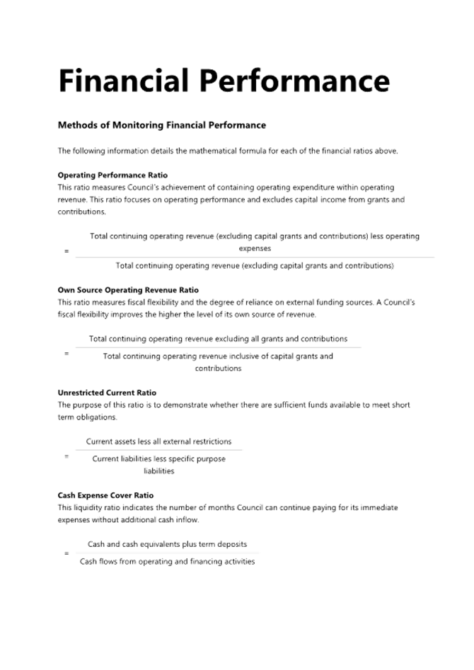
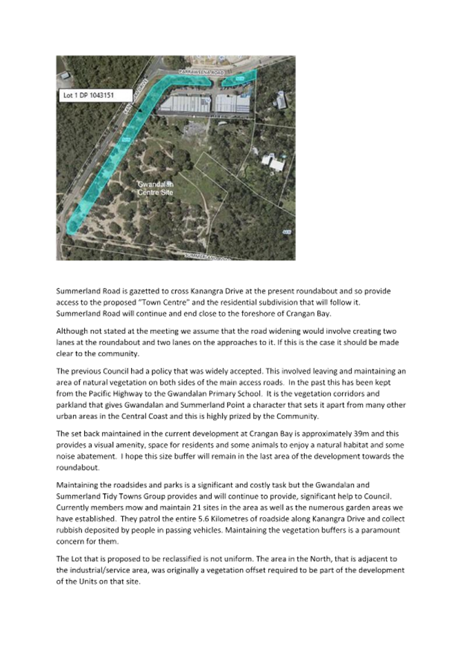
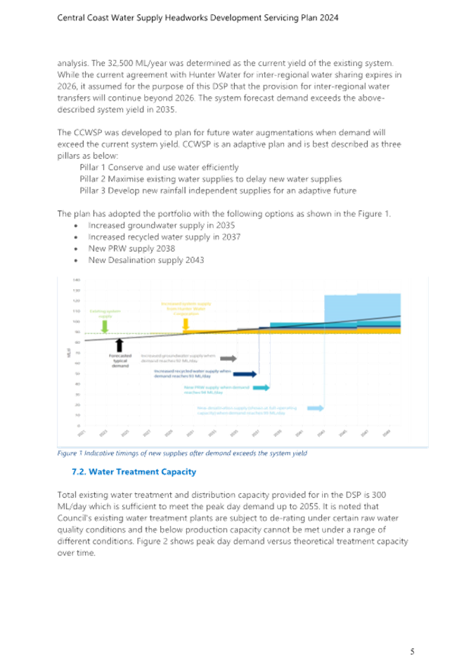
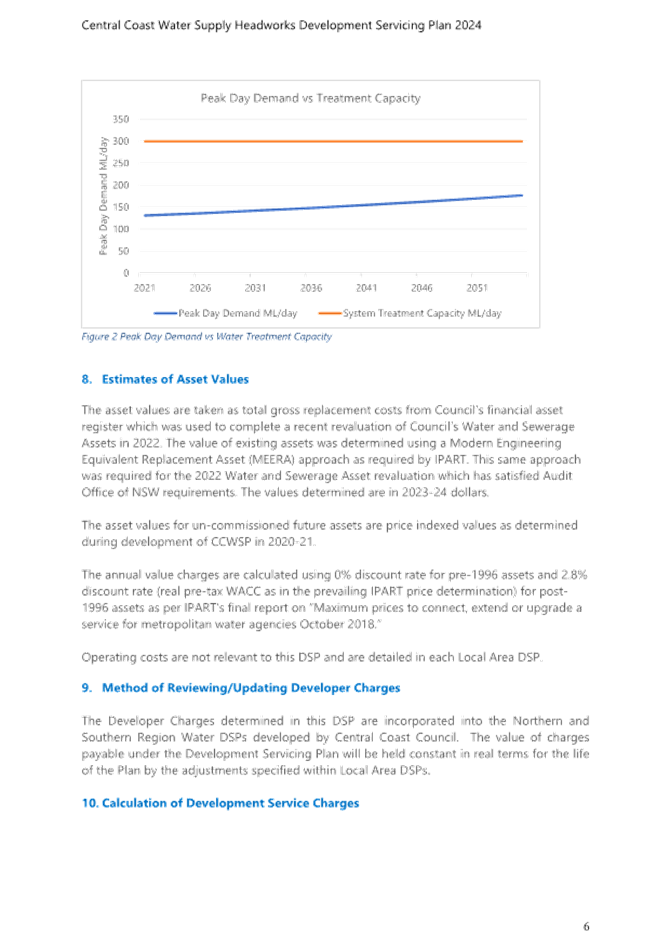
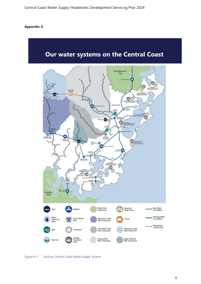
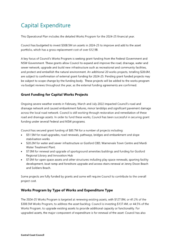
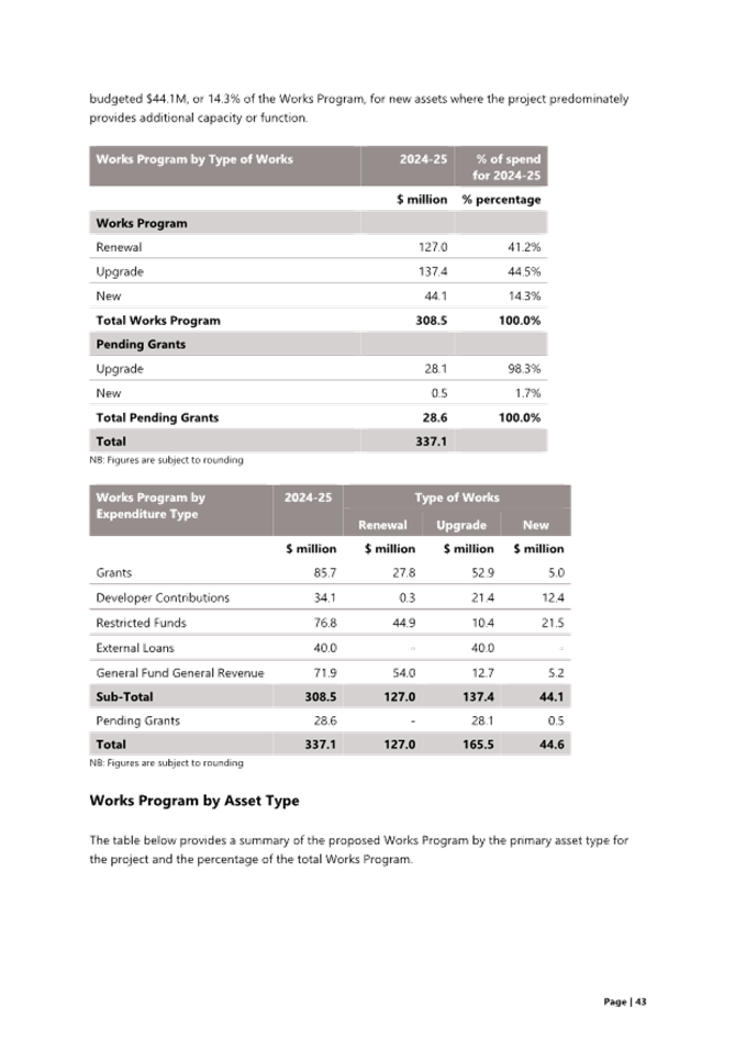
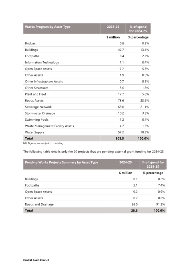
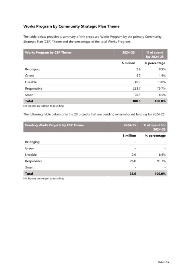
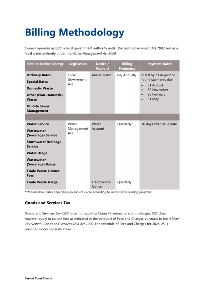
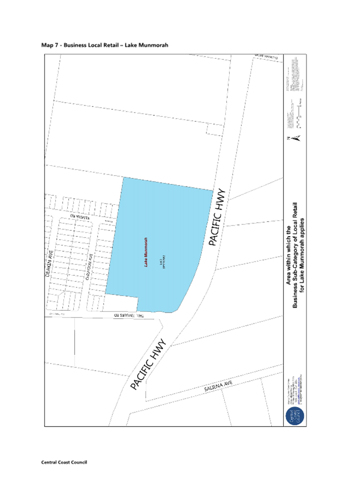
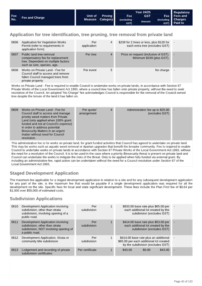
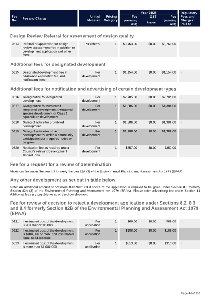
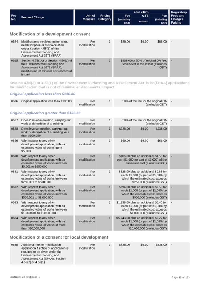
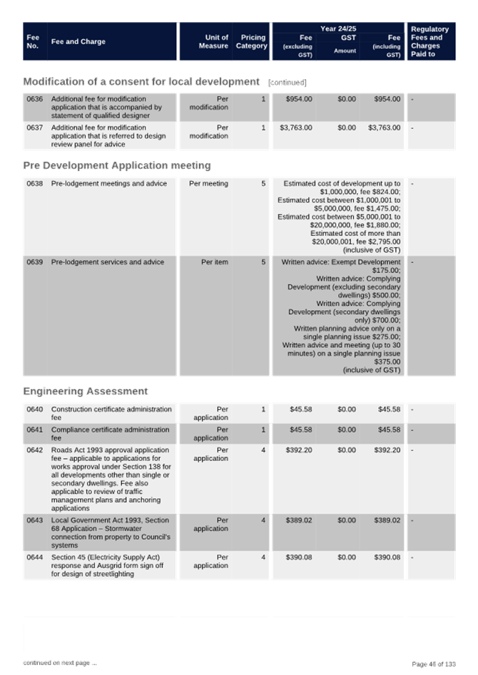
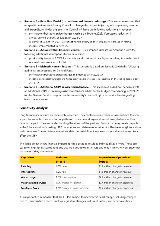
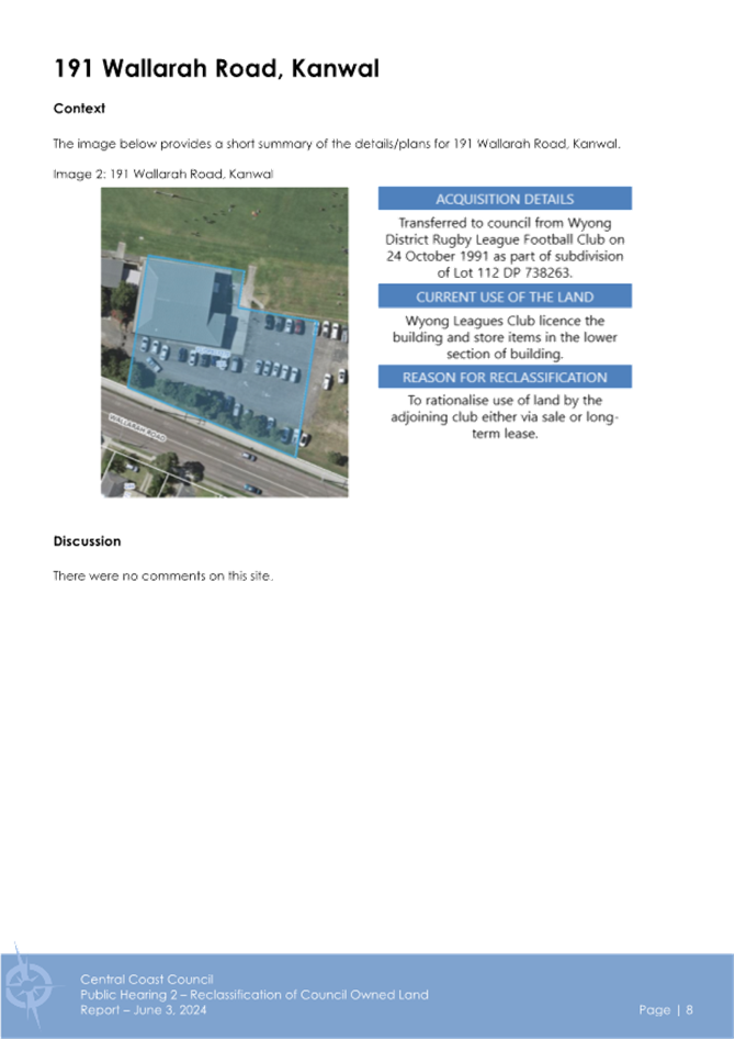
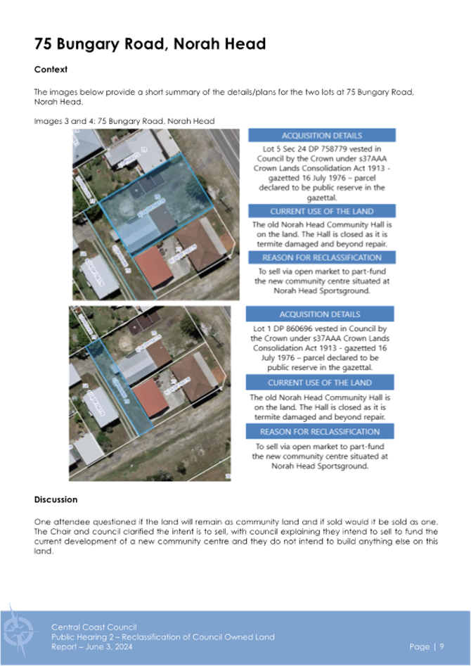
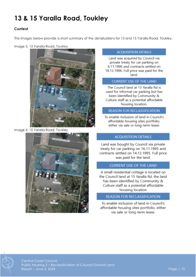
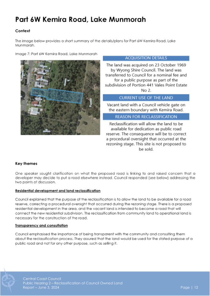
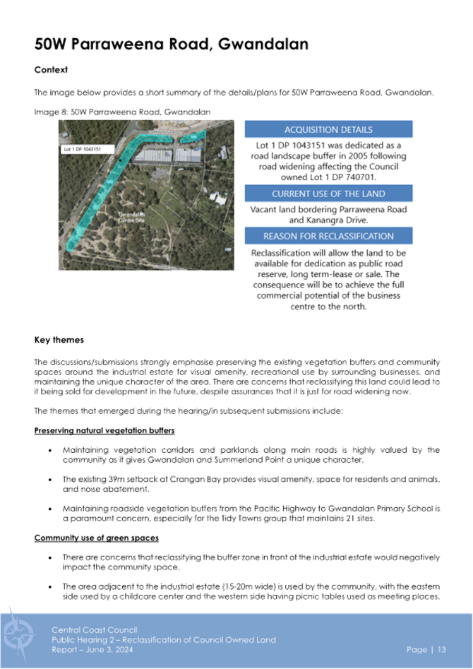
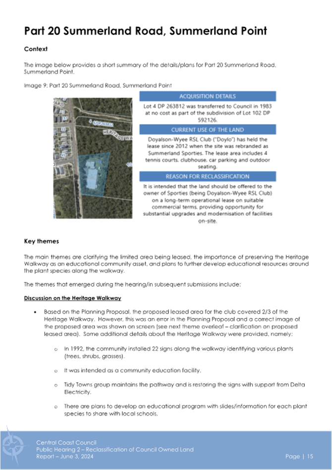
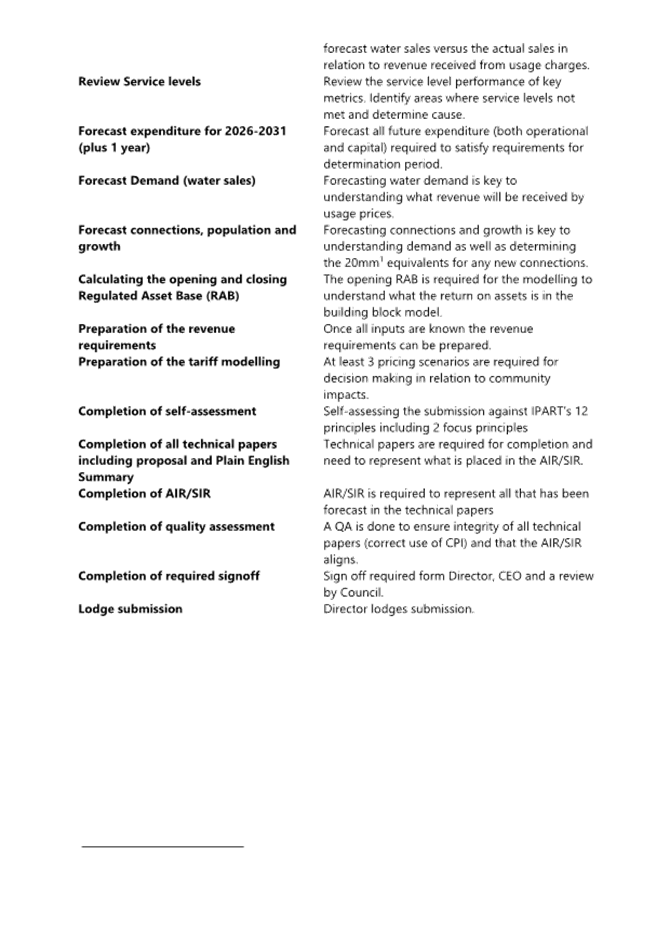
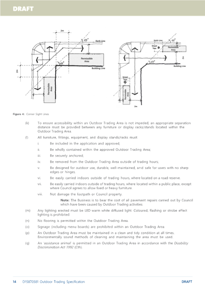
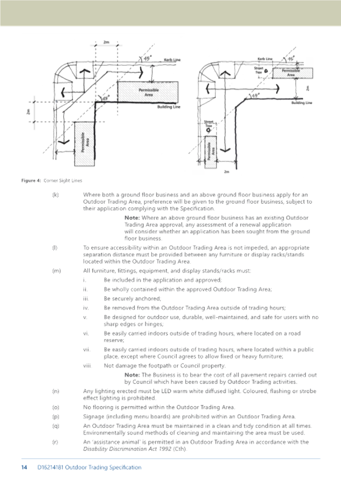
|
1.2 |
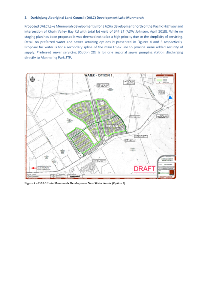
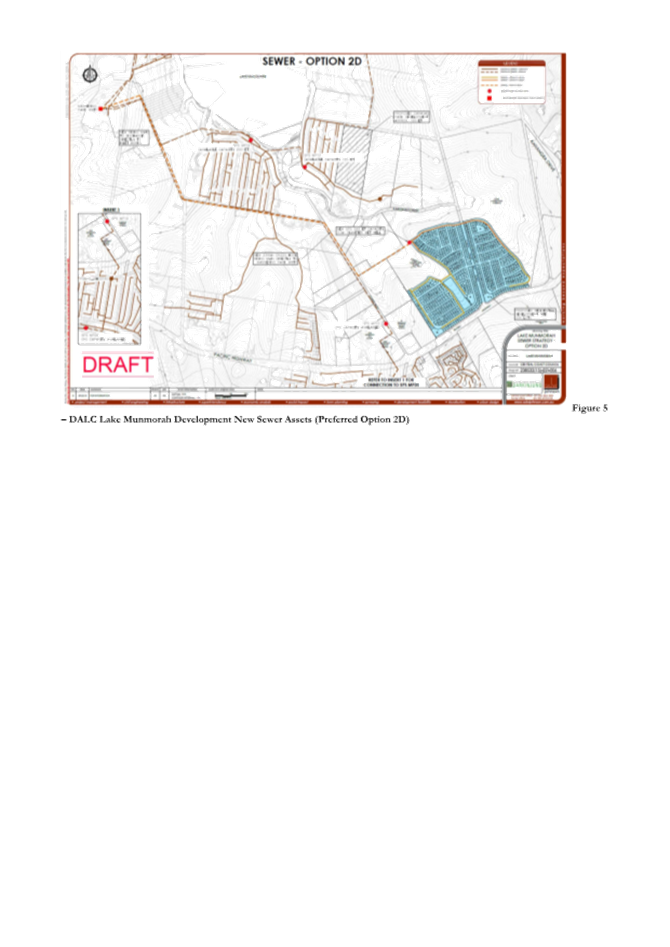
Confirmation of Minutes of Previous Meeting |
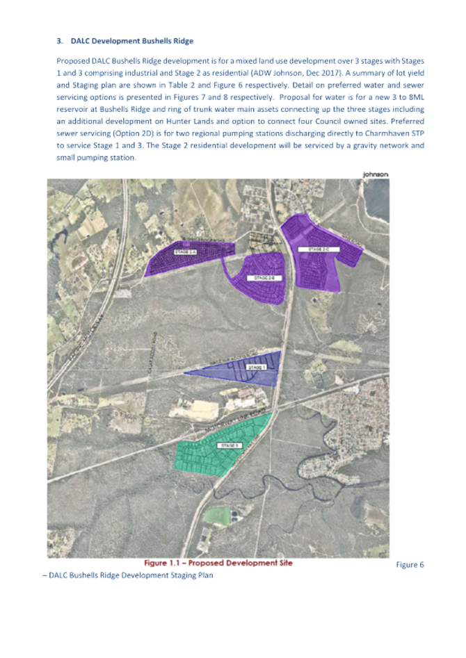
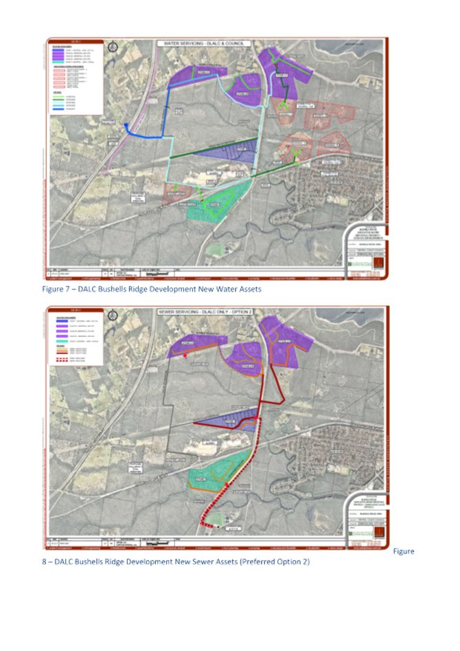
|
Attachment 1 |
MINUTES - Council Meeting - 28 May 2024 |

Central Coast Council
Ordinary Council Meeting
ATTACHMENTS PROVIDED UNDER SEPARATE COVER
Tuesday 25 June 2024
Ordinary Council Meeting 25 June 2024
Central Coast Council
ATTACHMENTS PROVIDED UNDER SEPARATE COVER to the
Ordinary Council Meeting
To be held in the Central Coast Council Chambers,
2 Hely Street, Wyong
on Tuesday 25 June 2024
Commencing at 6:30 PM
INDEX
Procedural Items
1.2 Confirmation of Minutes of Previous Meeting
Attachment 1: MINUTES - Council Meeting - 28 May 2024................................................ 4
Reports
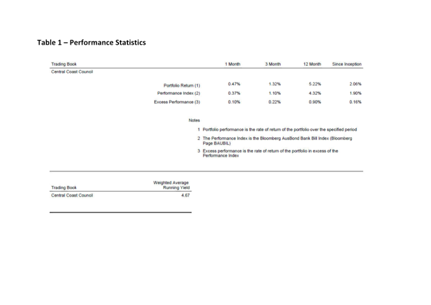
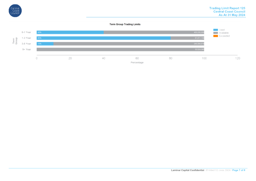
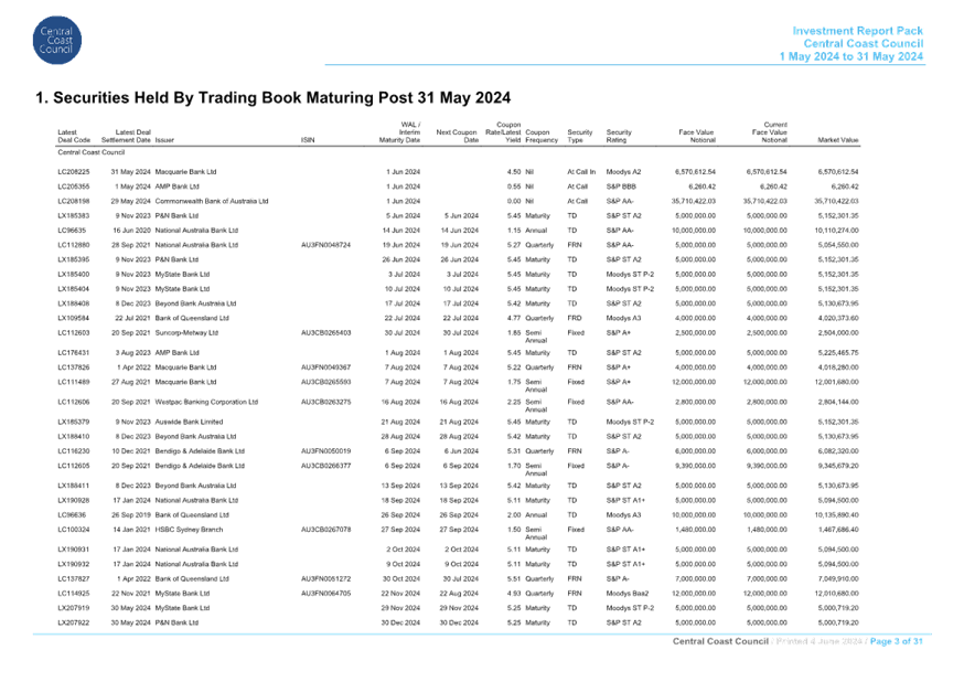
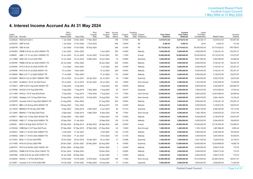
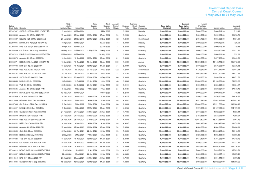
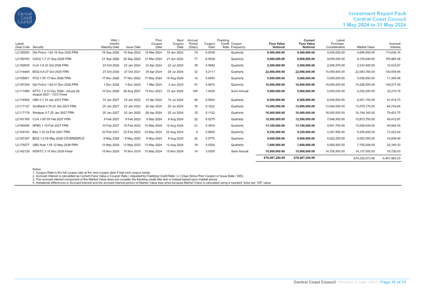
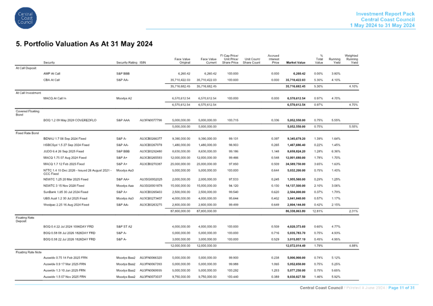
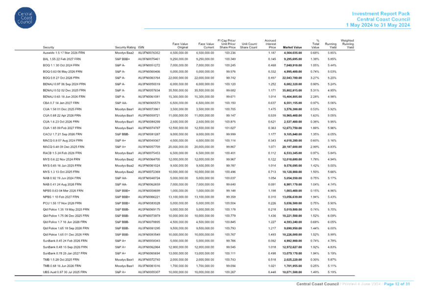
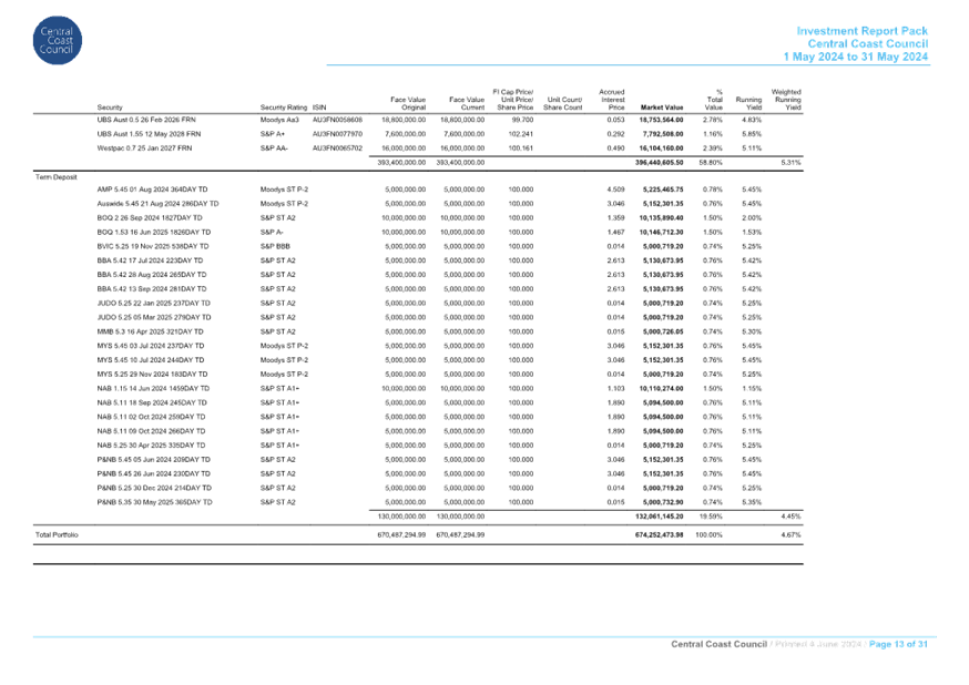
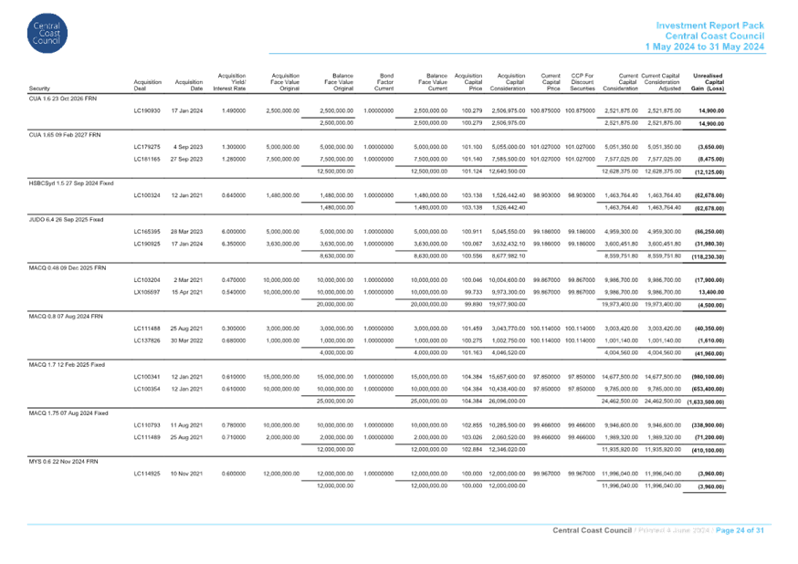
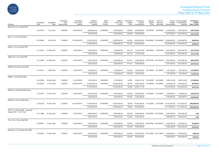
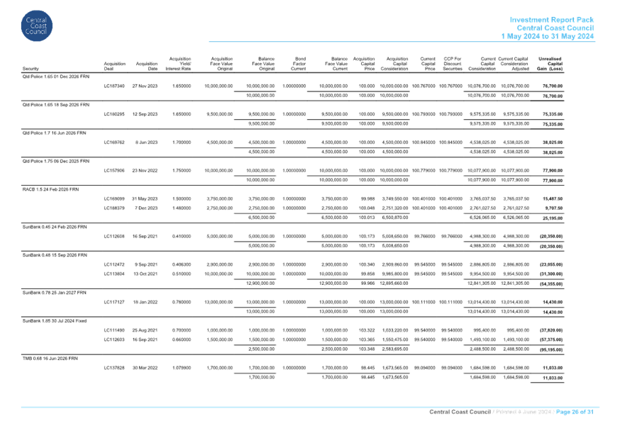
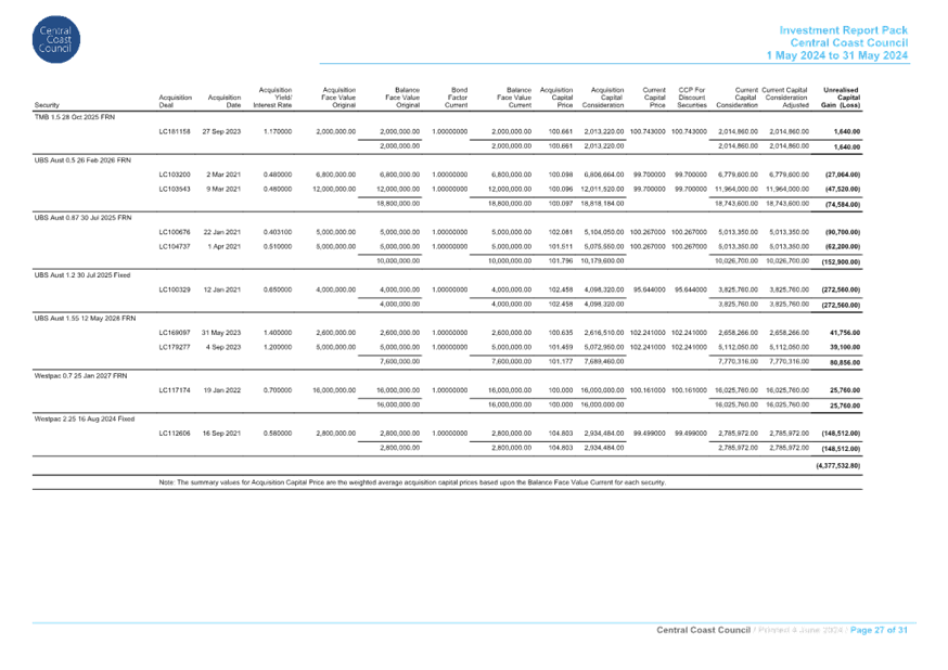
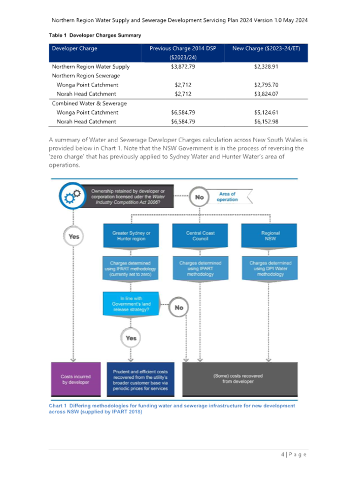
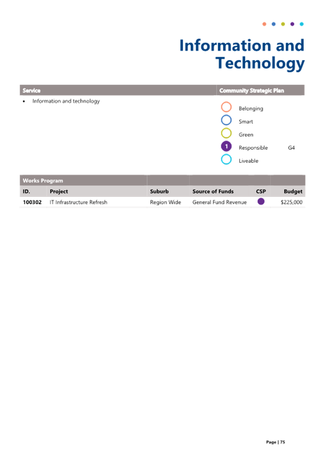
2.2 Monthly Investment Report May 2024
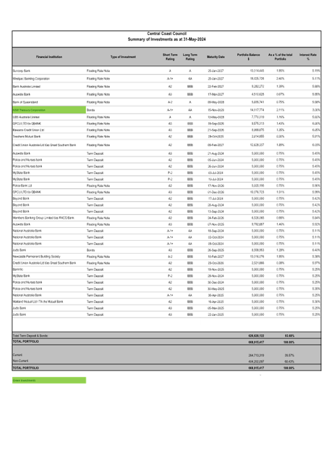
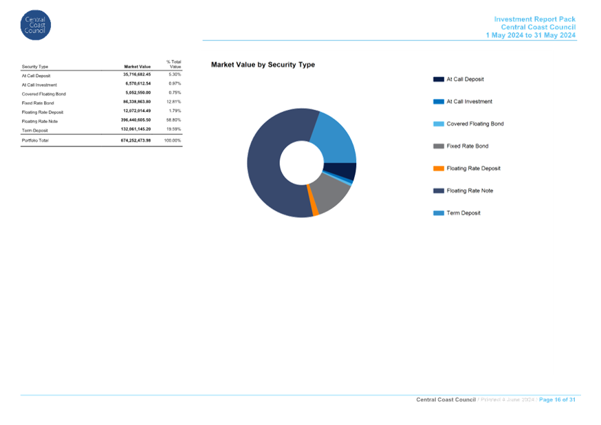
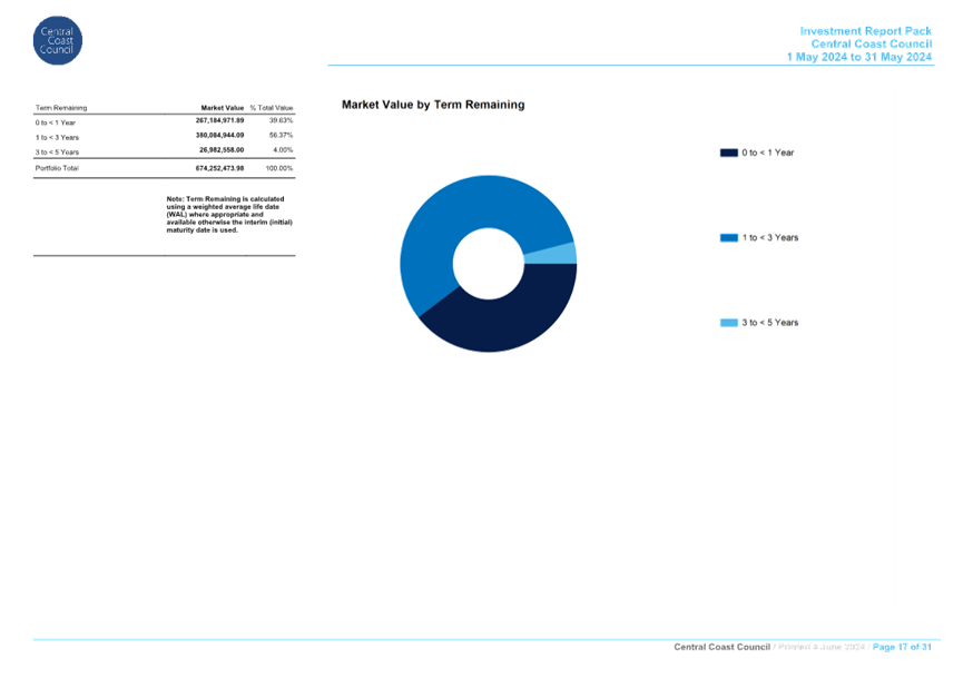
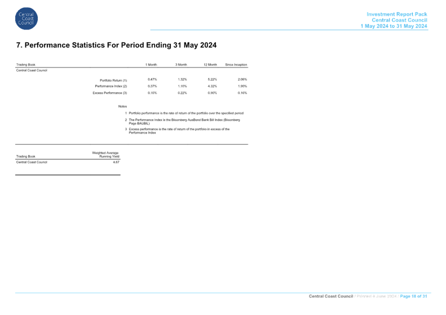
Attachment 1: Summary of Investment as at 31 May 2024.............................................. 15
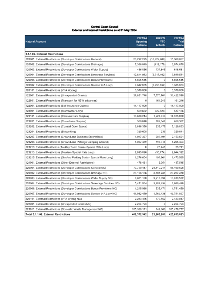
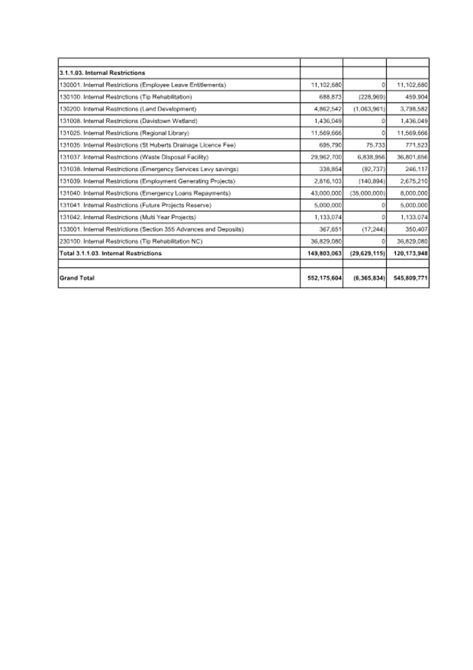
Attachment 2: Restrictions as at 31 May 2024......................................................................... 17
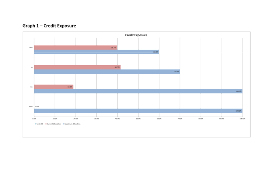
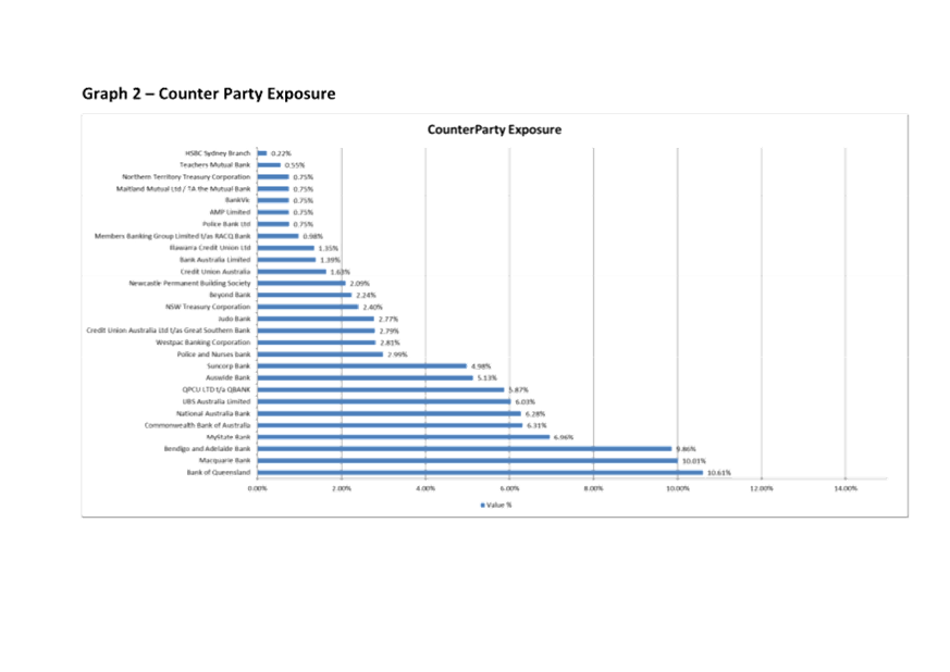
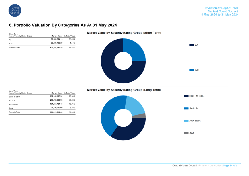
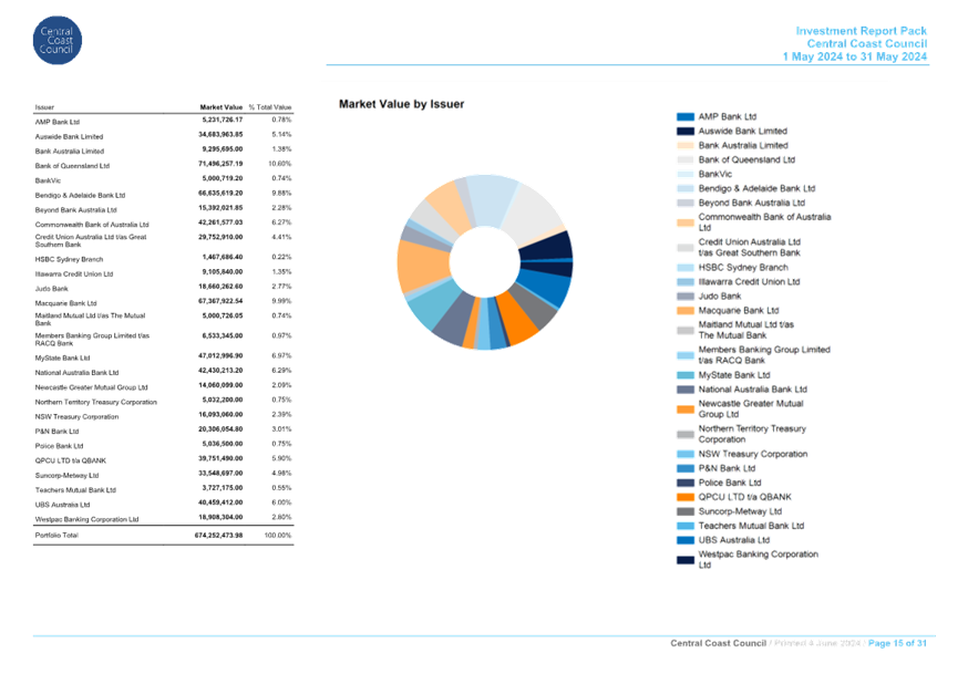
Attachment 3: Investment Report Graphs and Table for May 2024............................. 19
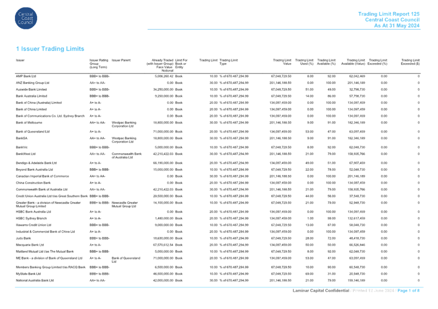
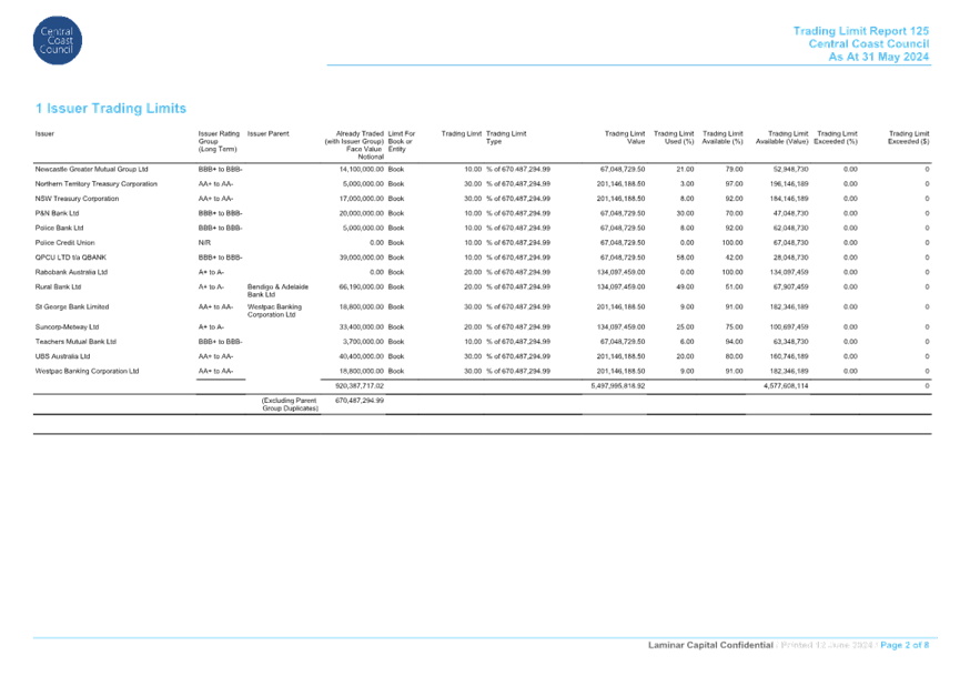
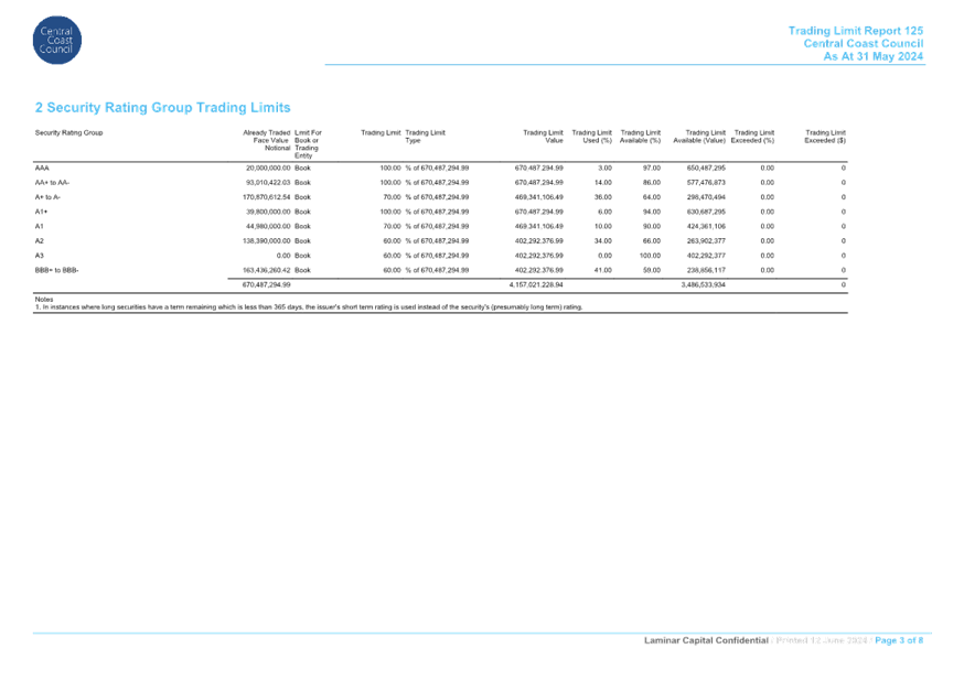
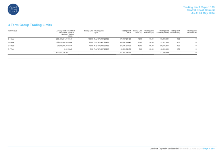
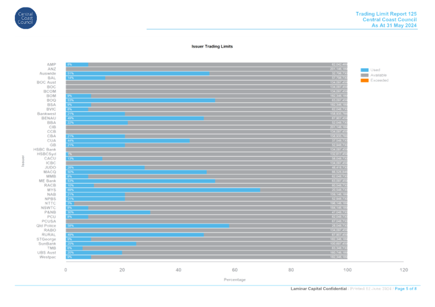
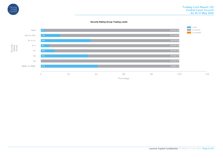
Attachment 4: Trading Limits Reports as at 31 May 2024................................................. 22
Attachment 5: Portfolio Valuation Report as at 31 May 2024.......................................... 30
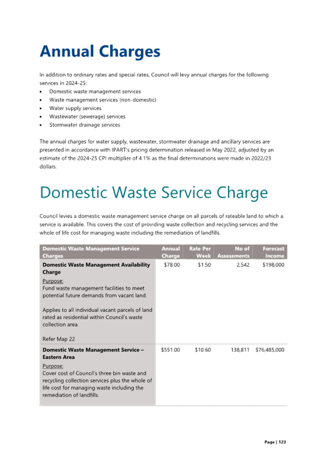
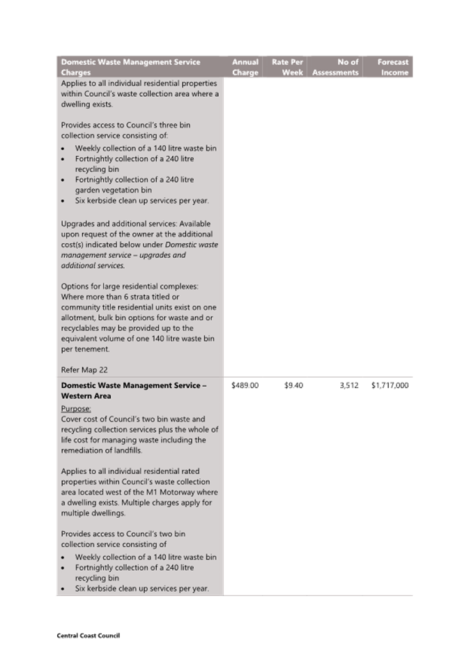
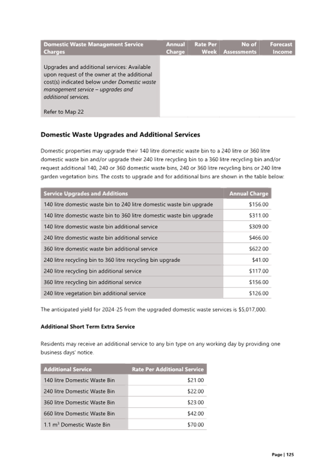
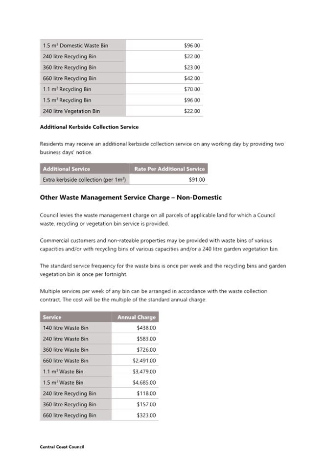
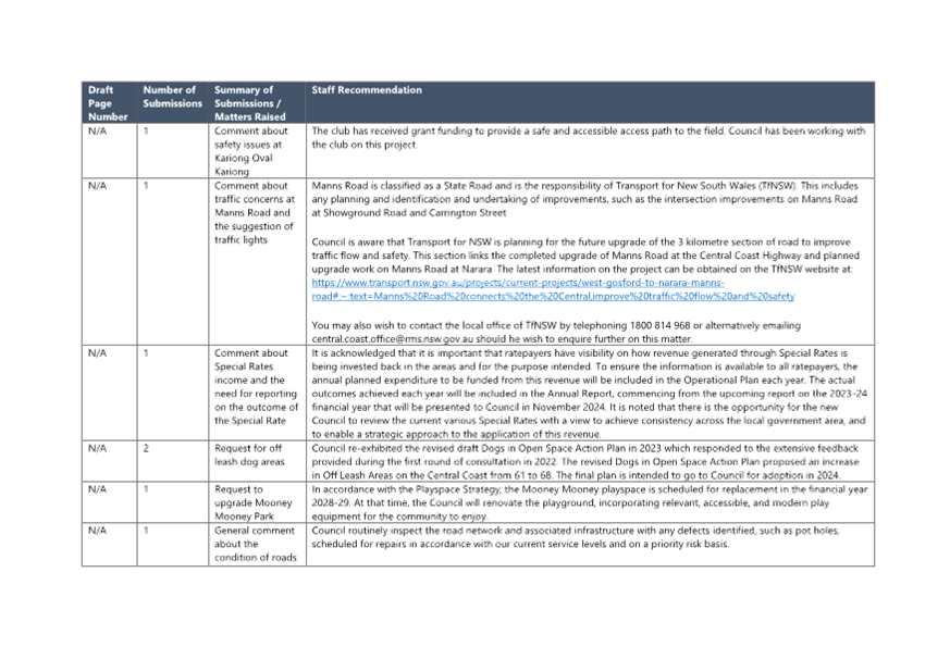
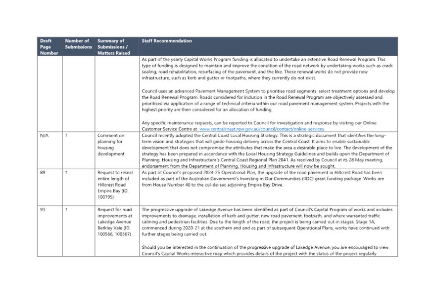
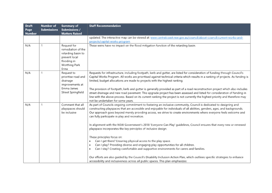
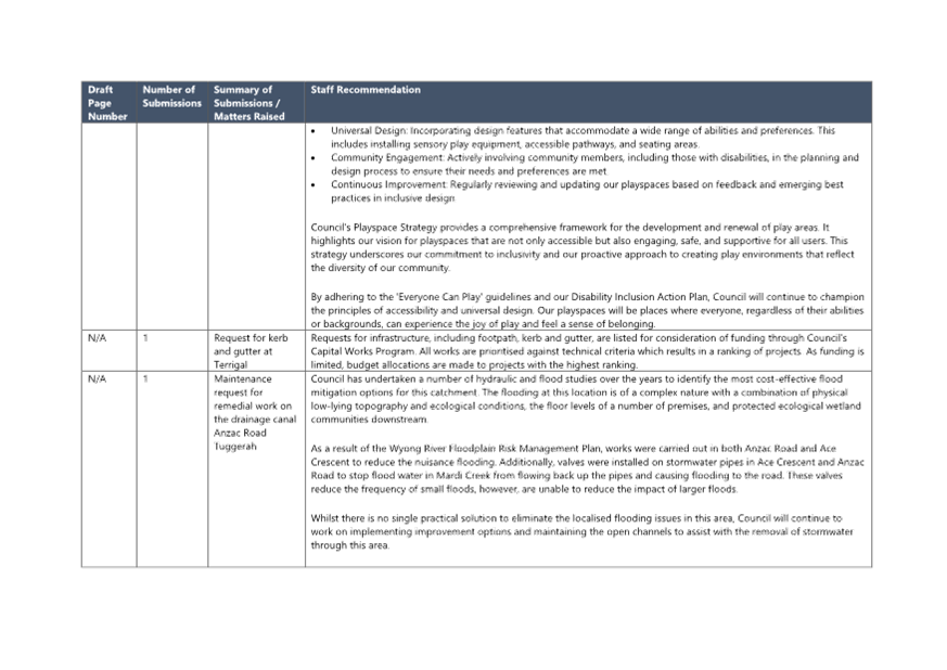
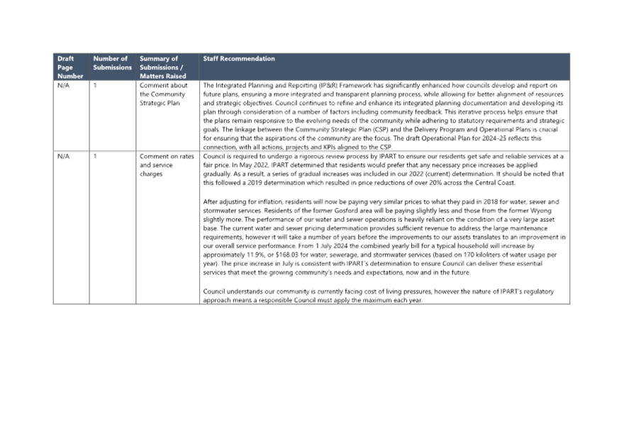
2.3 Operational Plan 2024-25, Rates and Annual Charges - Submissions and Adoption
Attachment 1: Final Operational Plan 2024-25........................................................................ 61
Attachment 2: Final Fees and Charges 2024-25................................................................... 235
Attachment 3: Summary of Submissions 2024-25.............................................................. 371
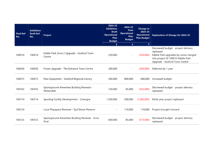
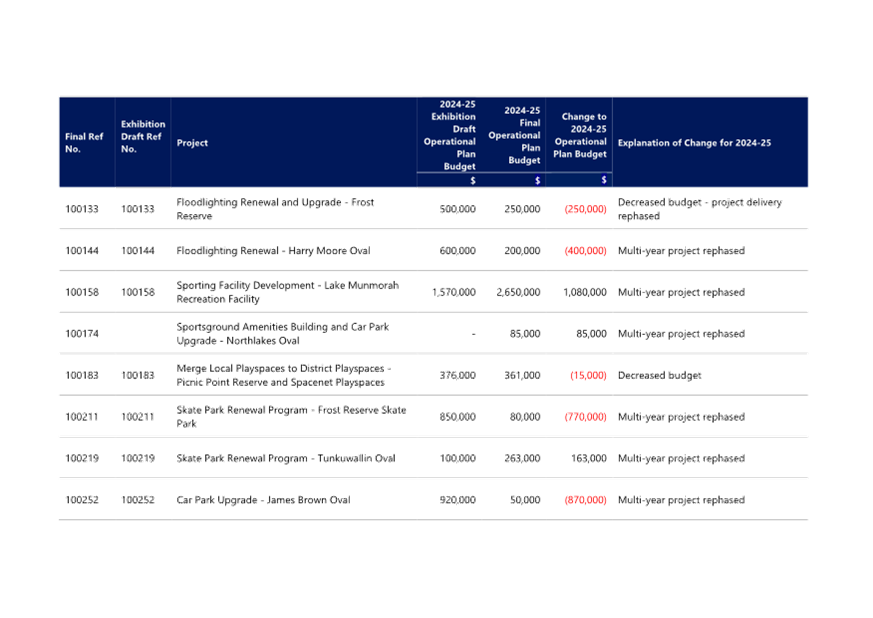
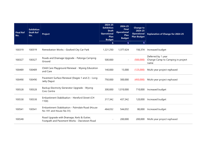
Attachment 4: Amendments to Operational Actions and Indicators 2024-25...... 406
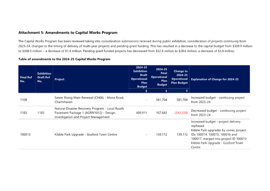
Attachment 5: Amendments to Capital Works Program 2024-25............................... 407
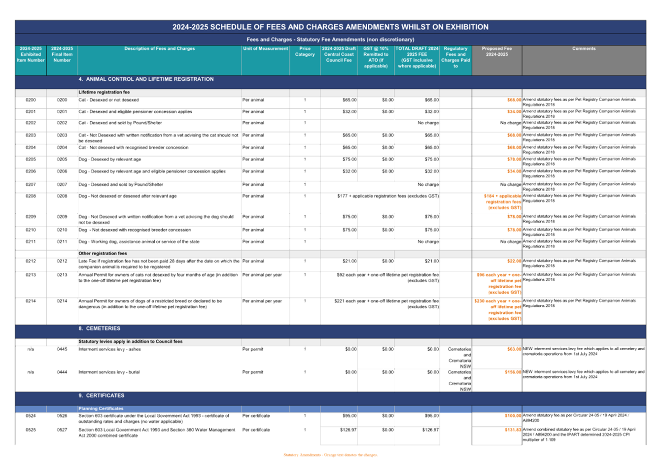
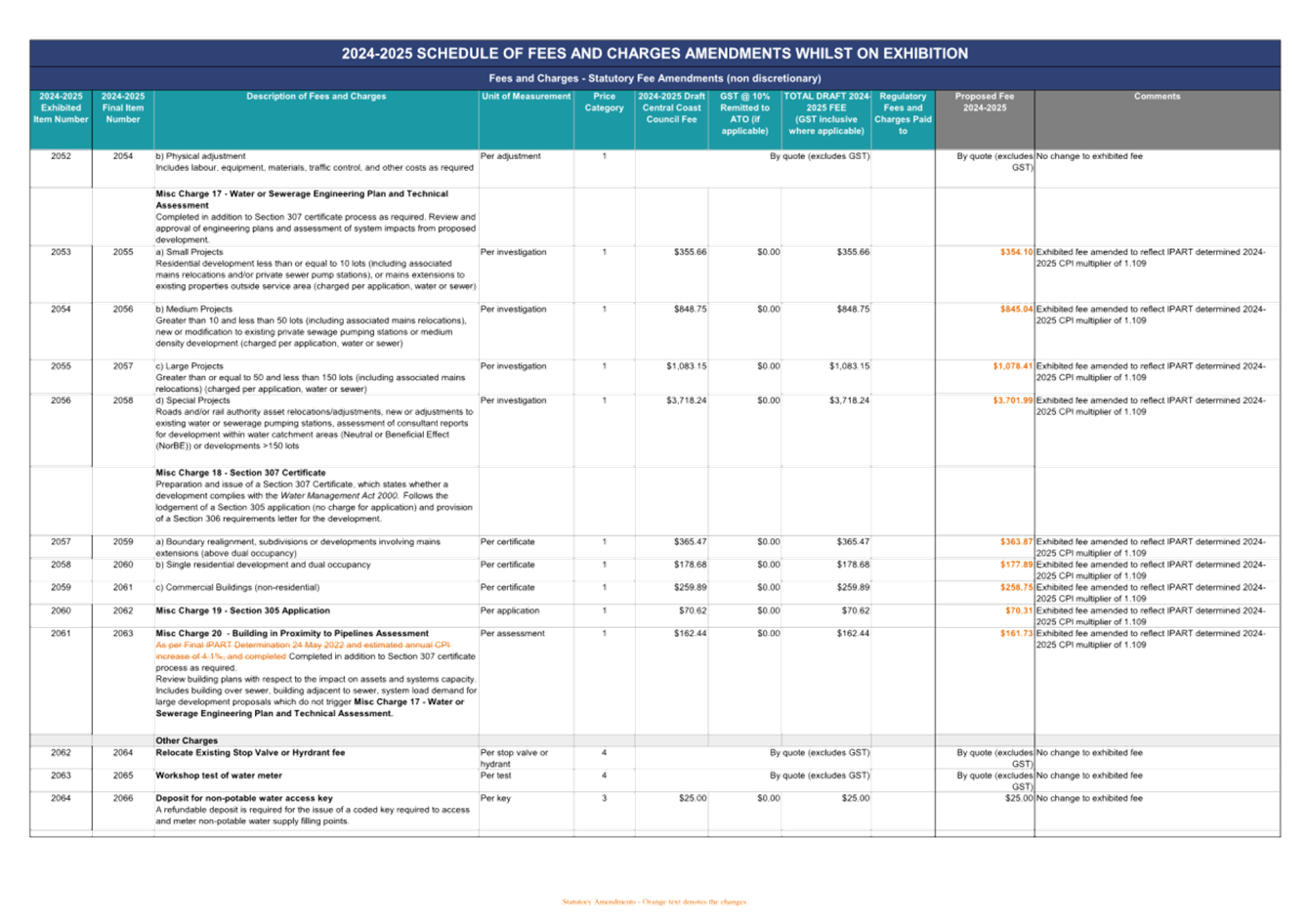
Attachment 6: Statutory Amendments to Fees and Charges 2024-25..................... 419
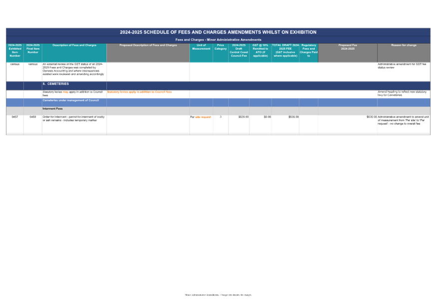
Attachment 7: Administrative Amendments to Fees and Charges 2024-25.......... 426
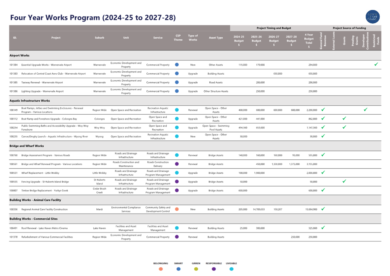
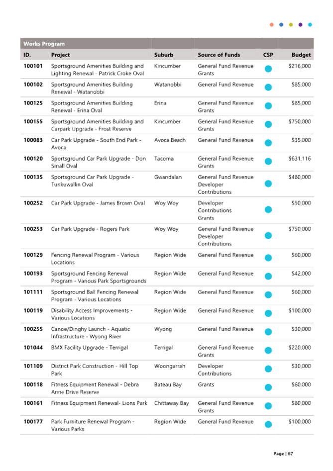
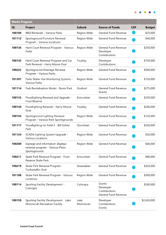
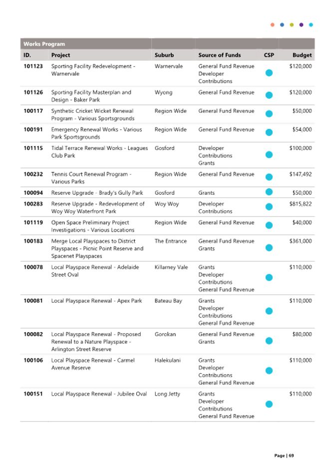
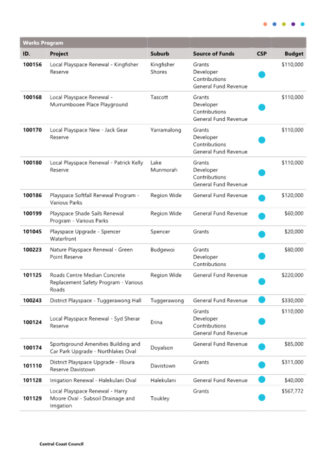
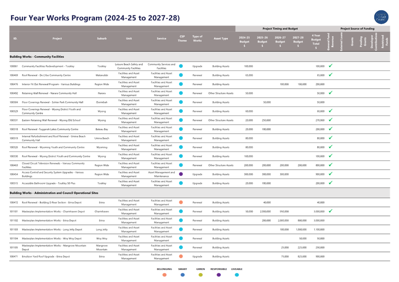
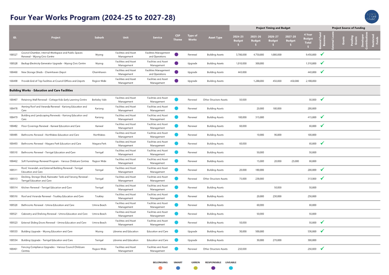
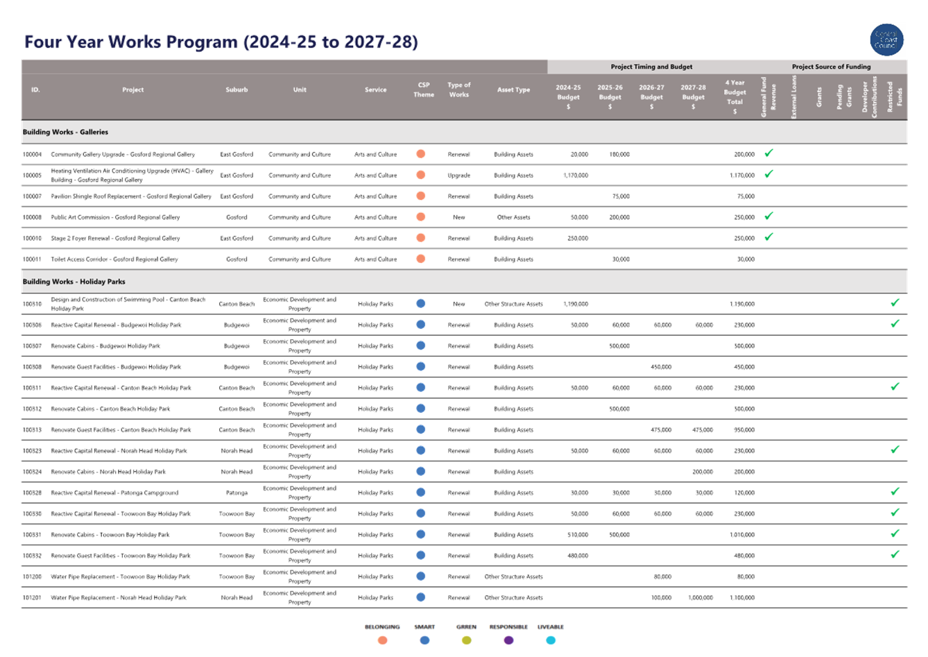
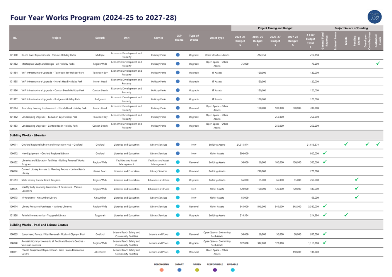
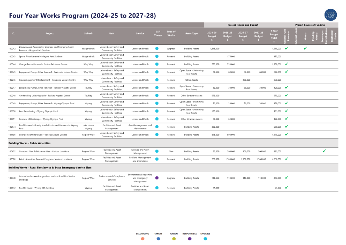
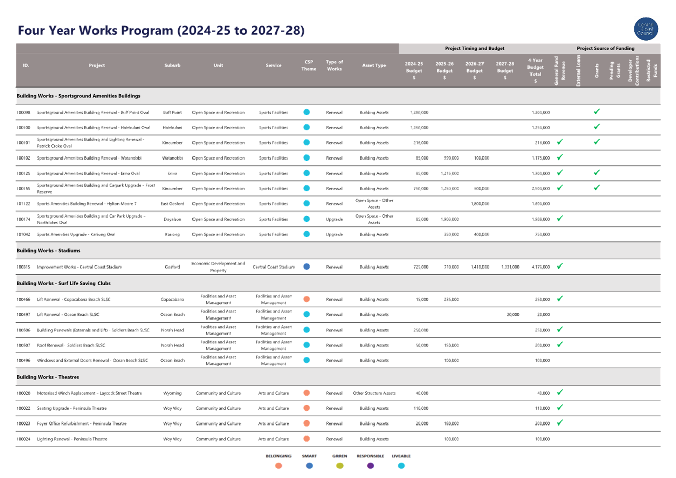
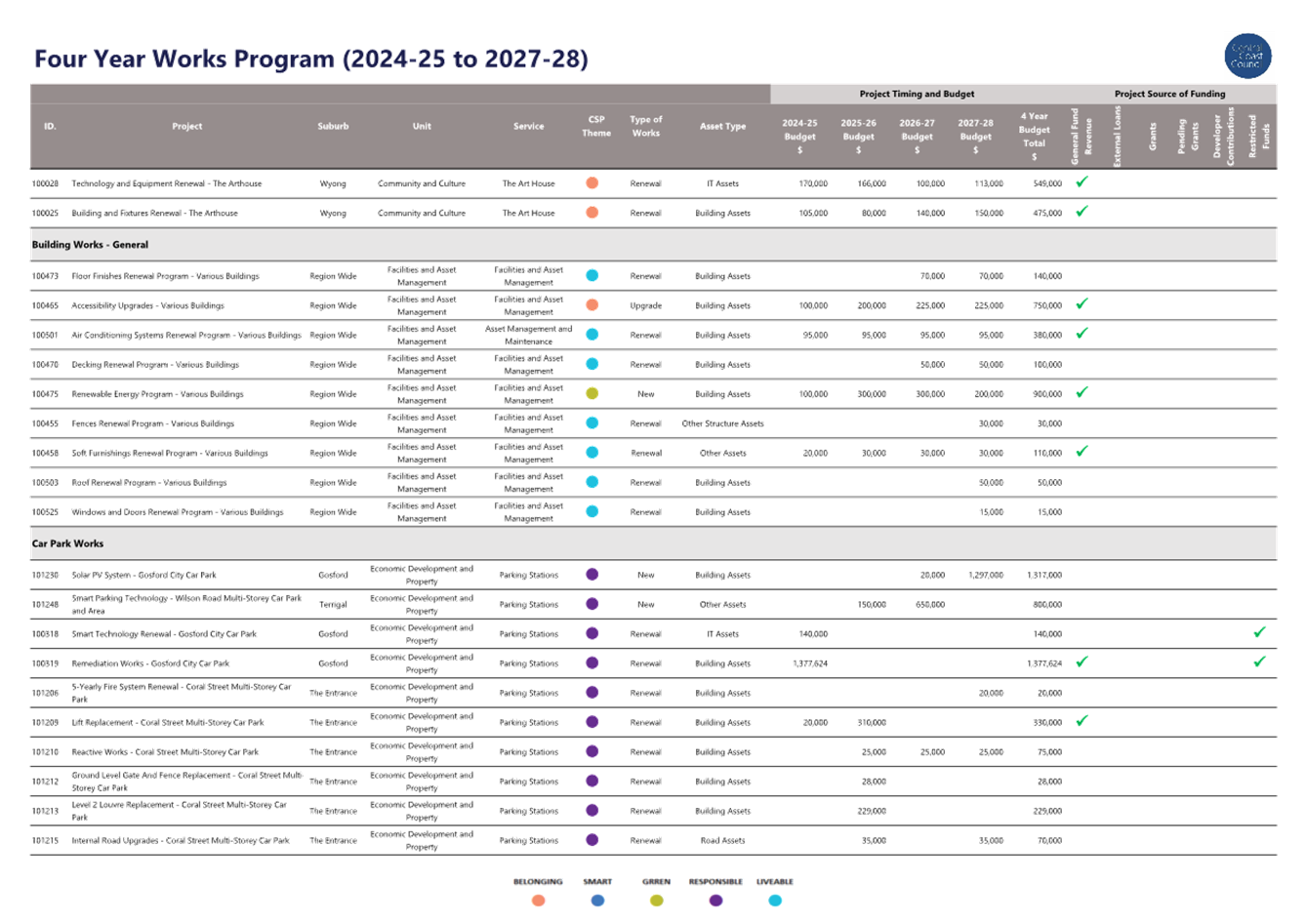
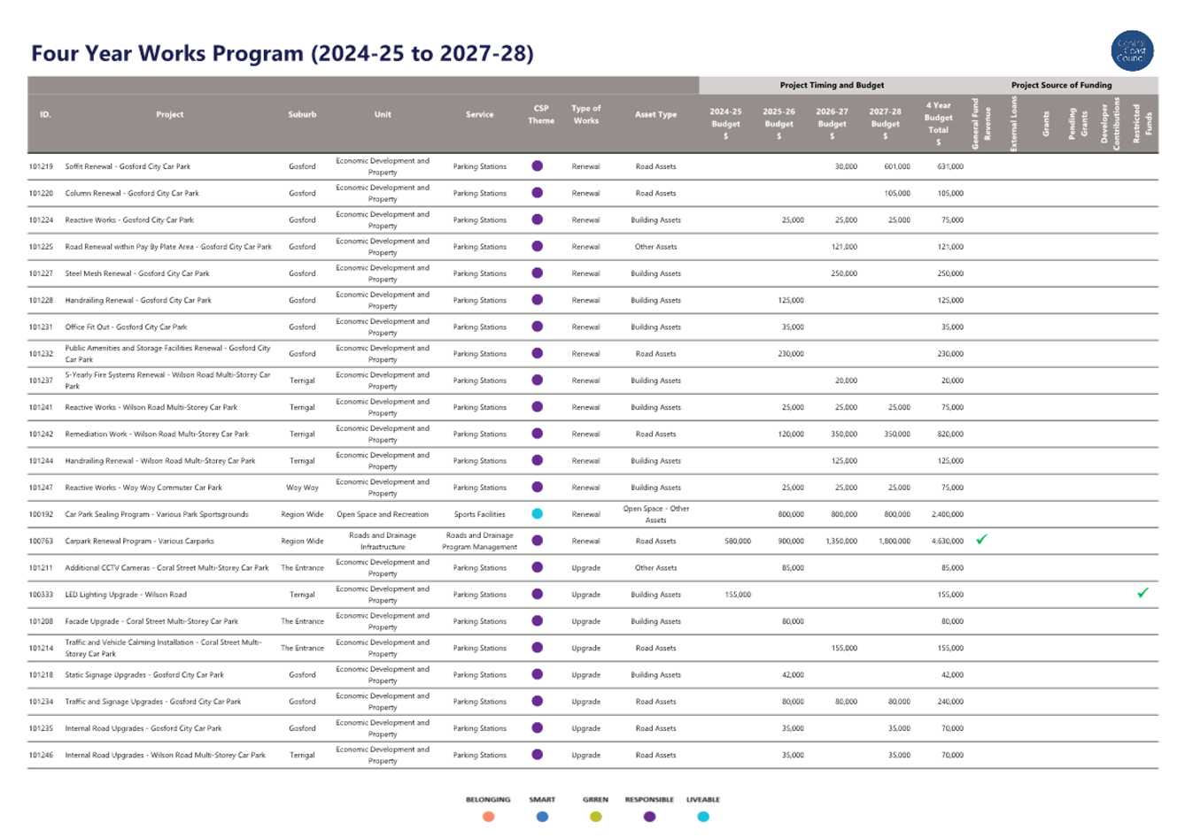
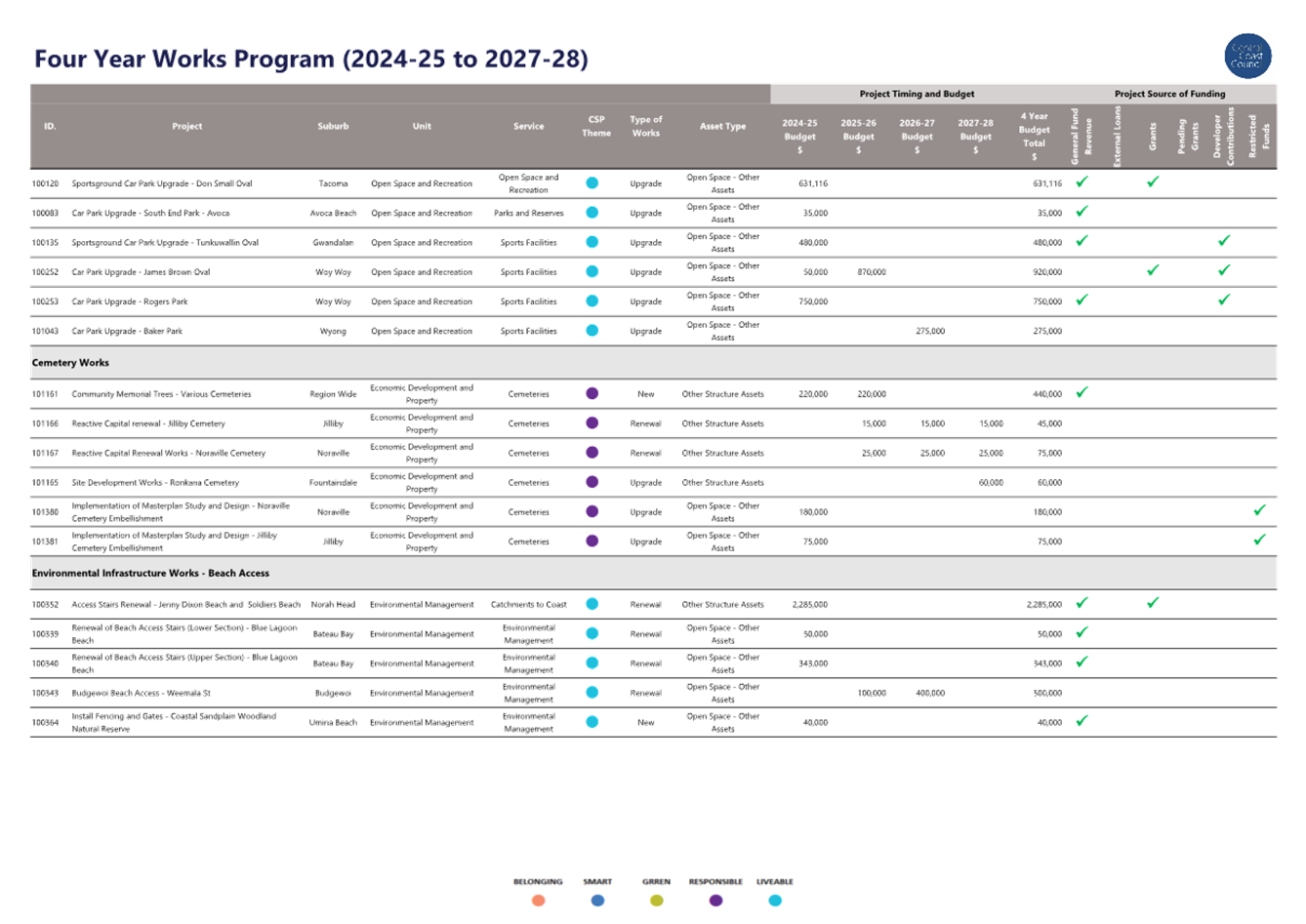
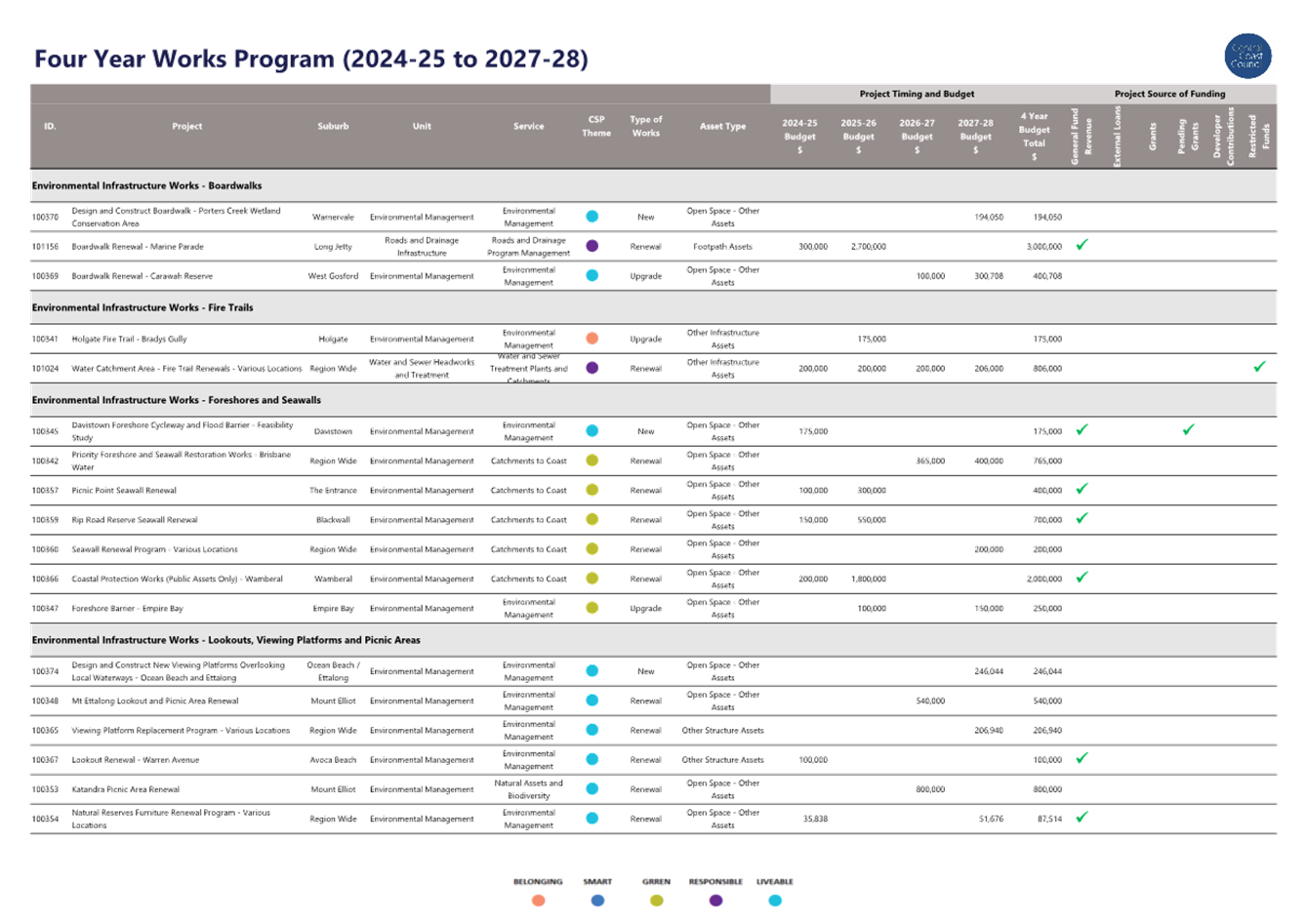
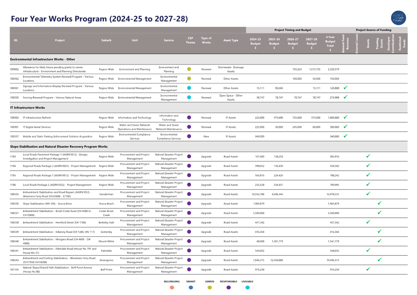
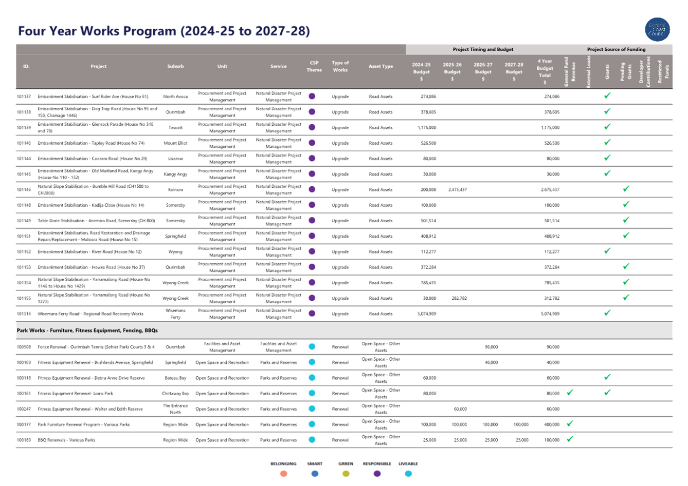
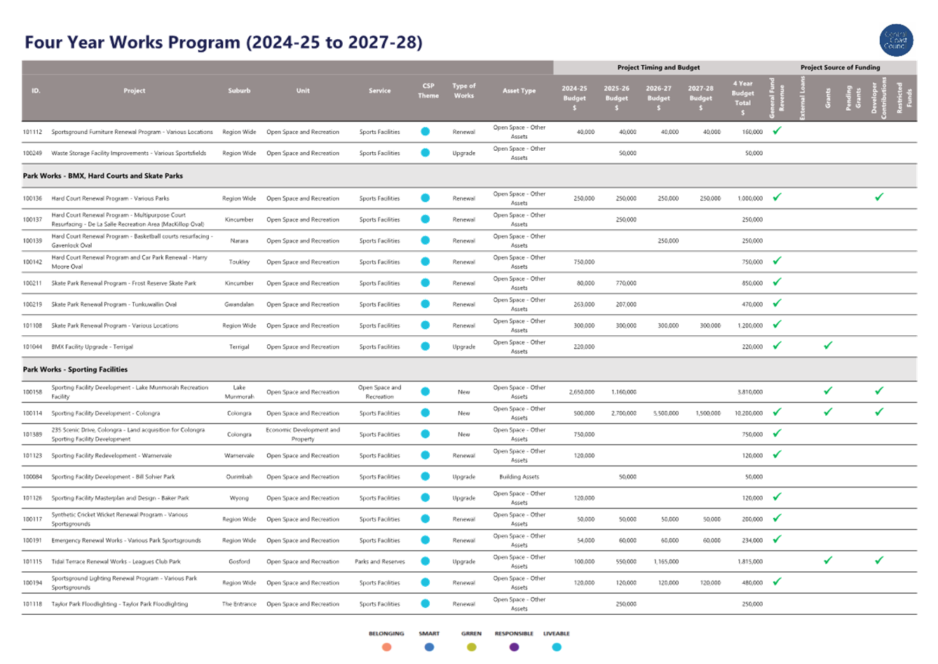
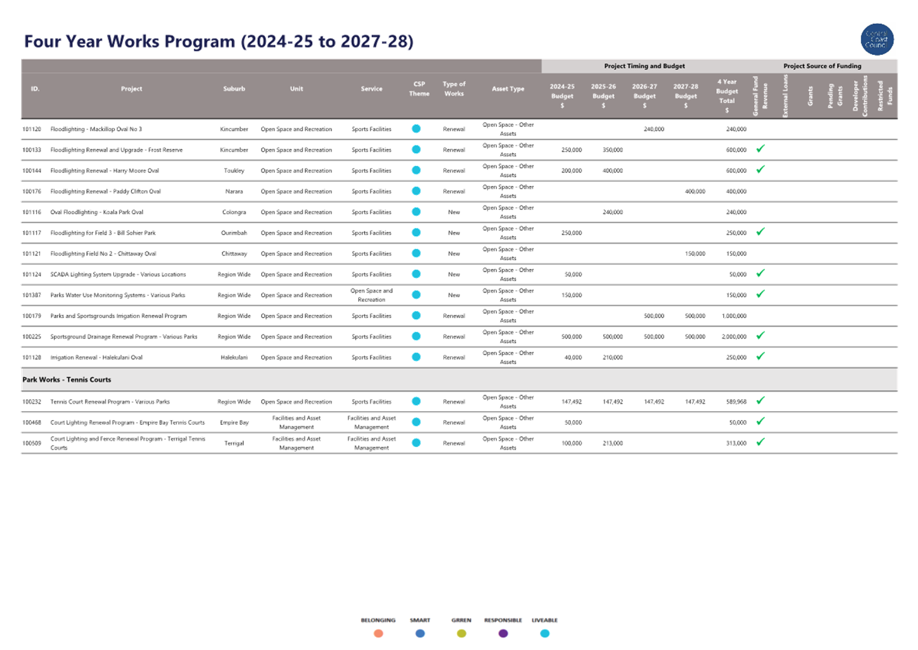
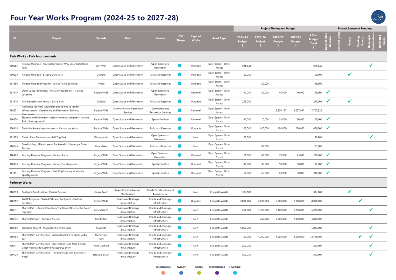
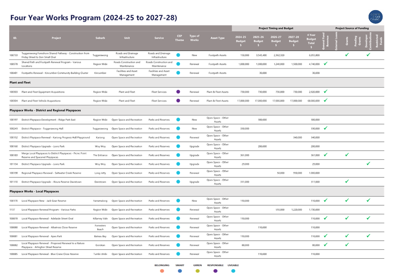
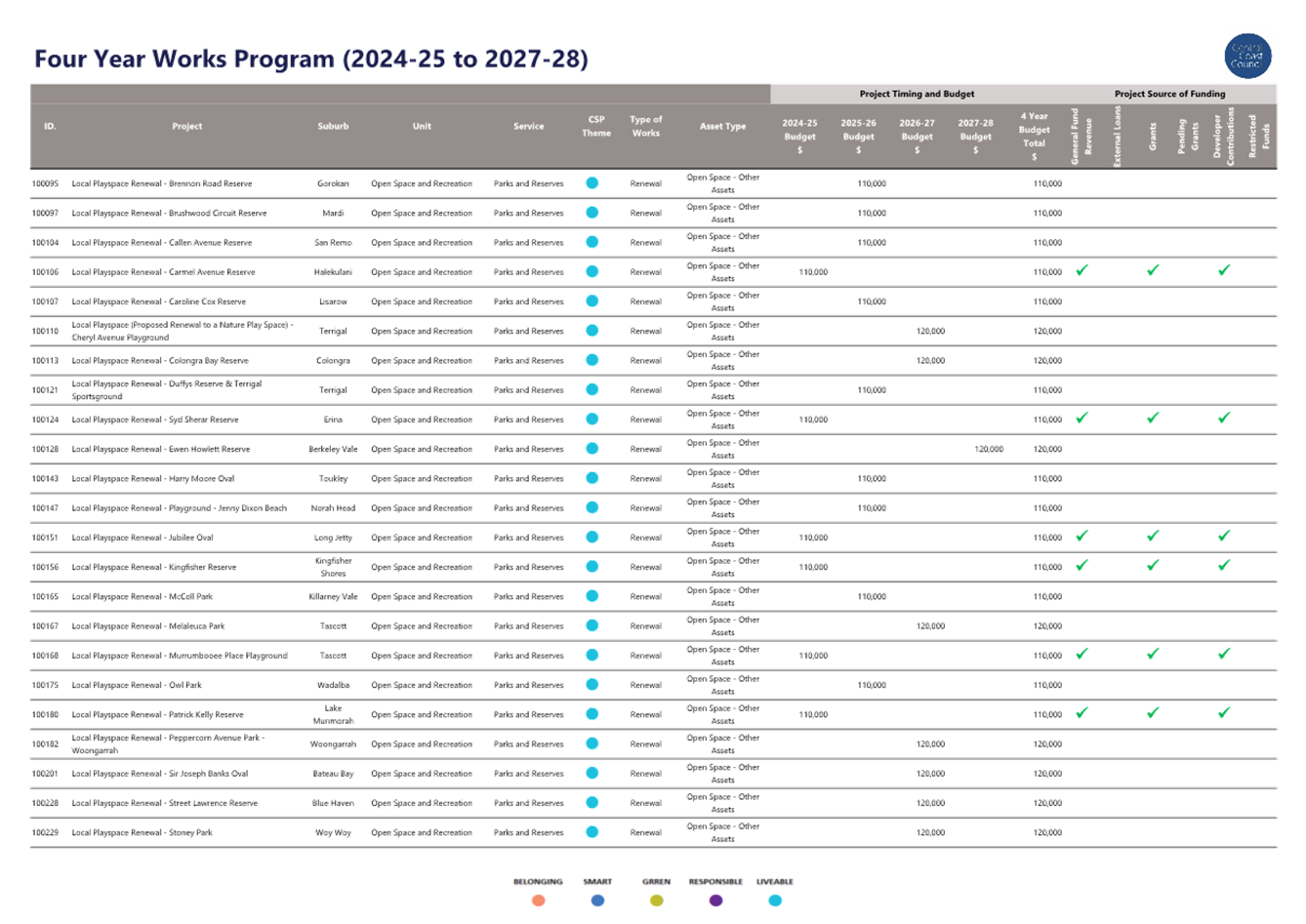
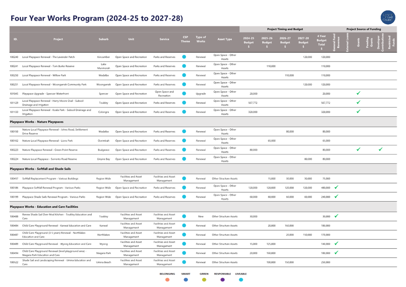
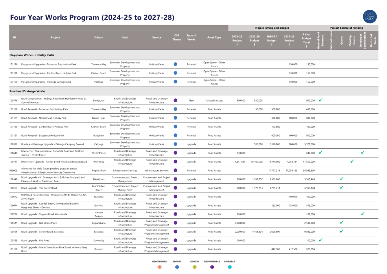
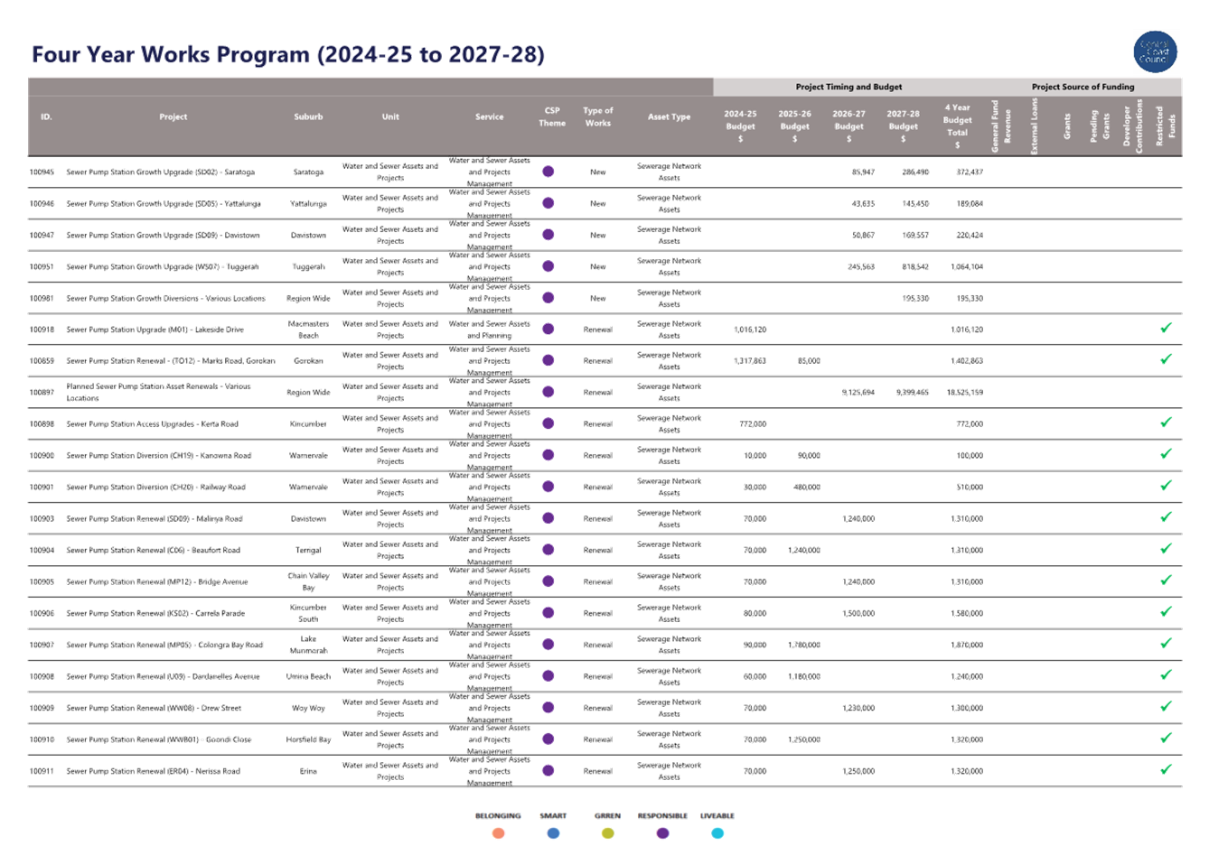
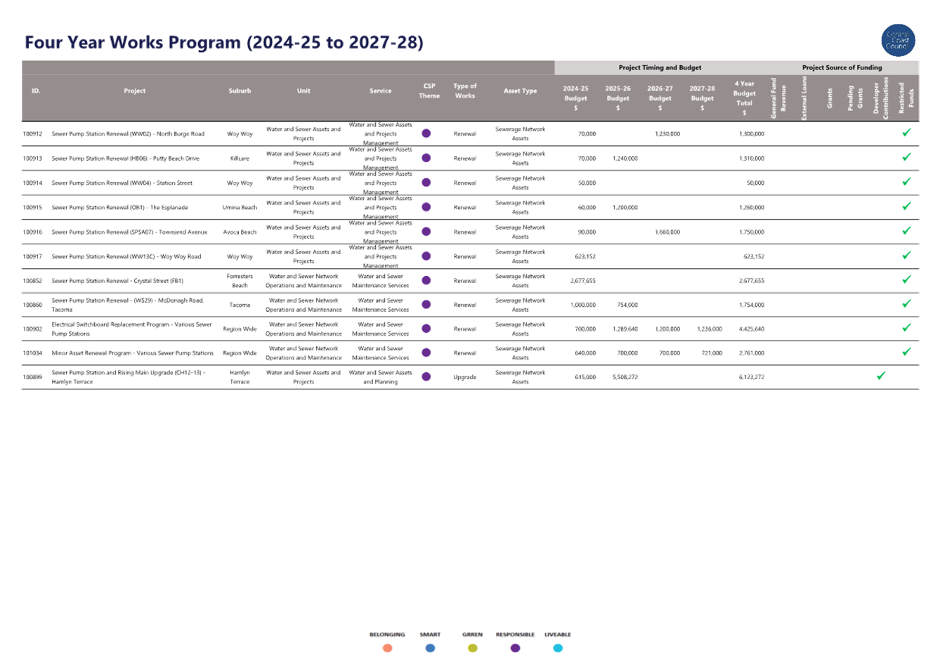
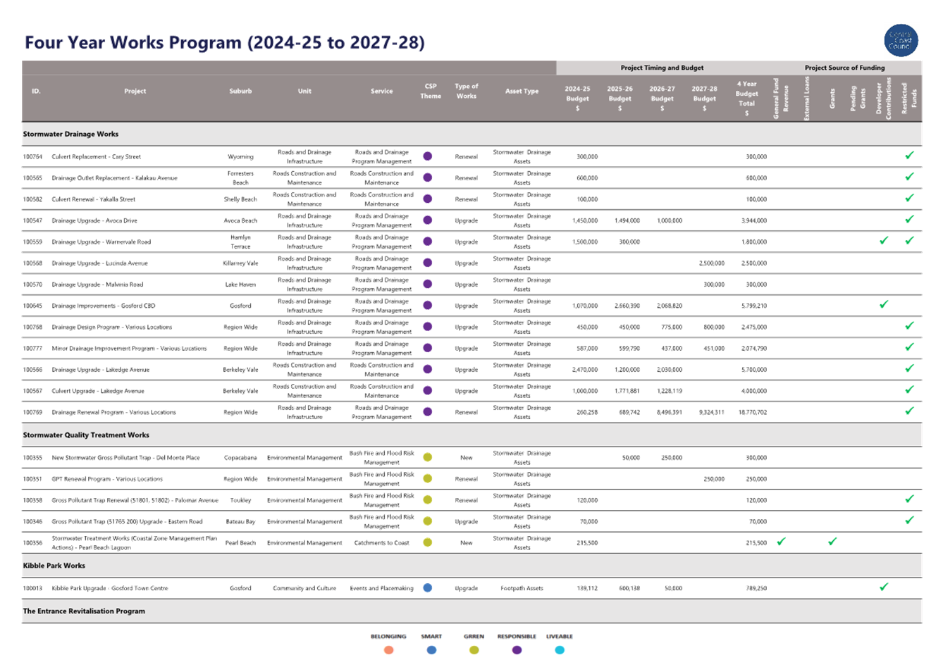
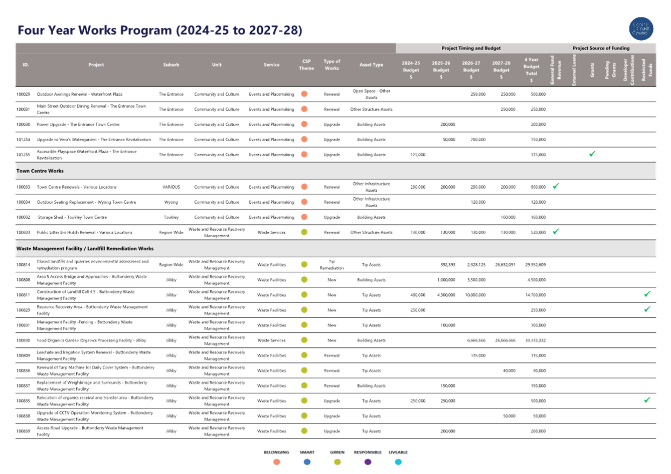
Attachment 8: Four Year Works Program 2024-25 to 2027-28.................................... 427
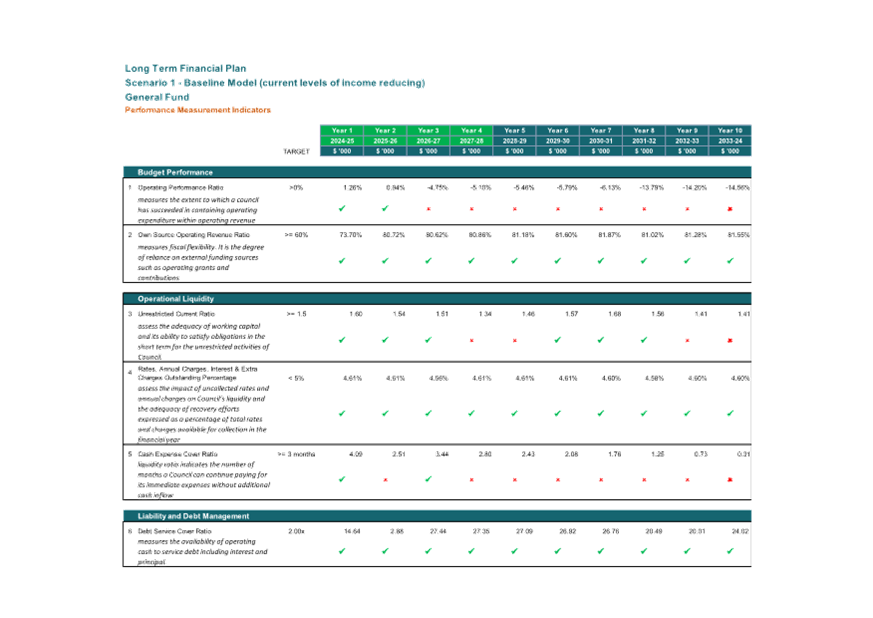
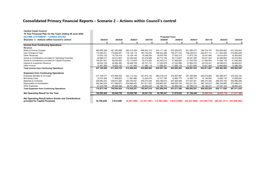
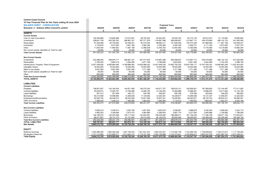
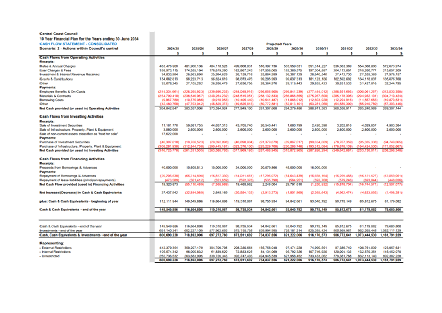
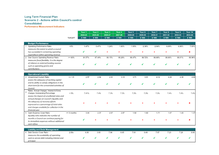
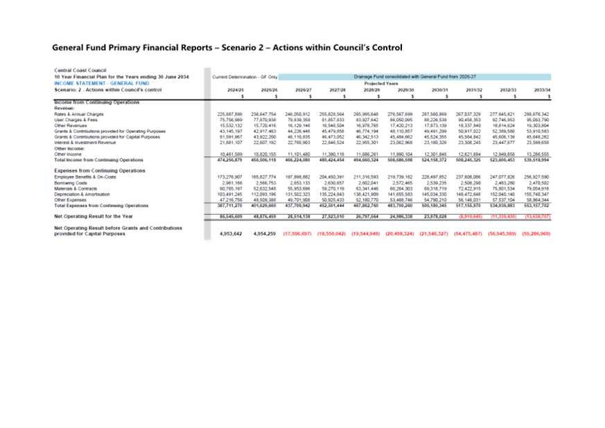
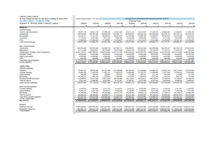
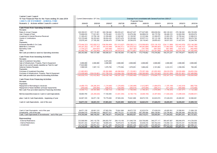
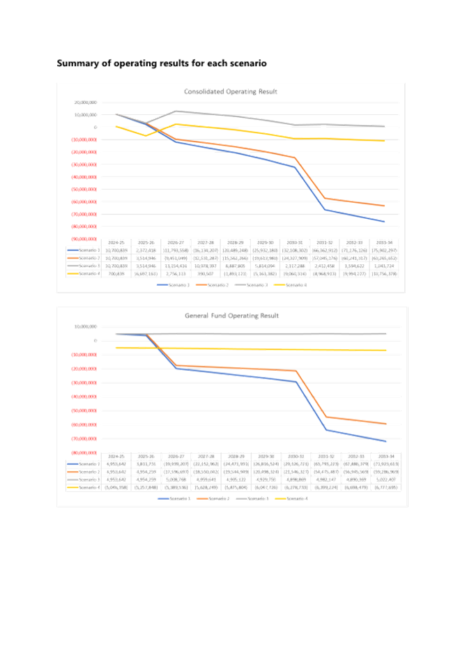
Attachment 9: Long Term Financial Plan (2024-25 to 2033-34)................................... 460
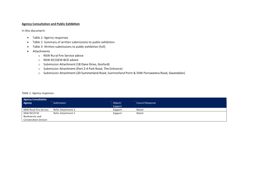
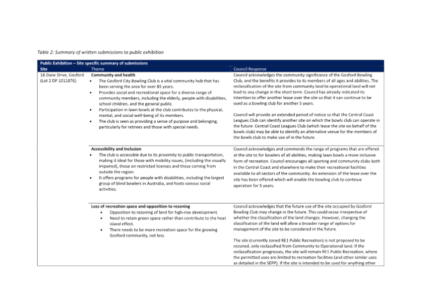
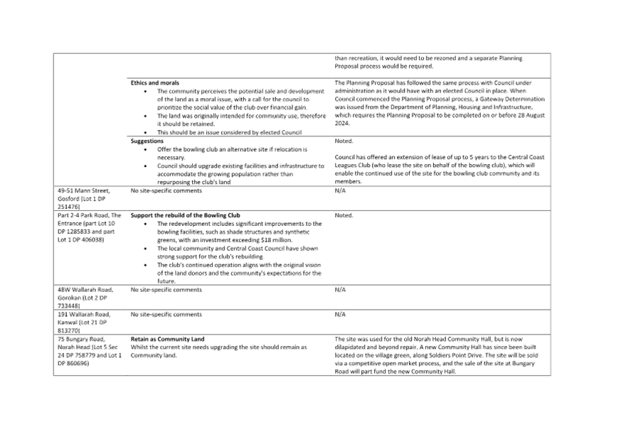
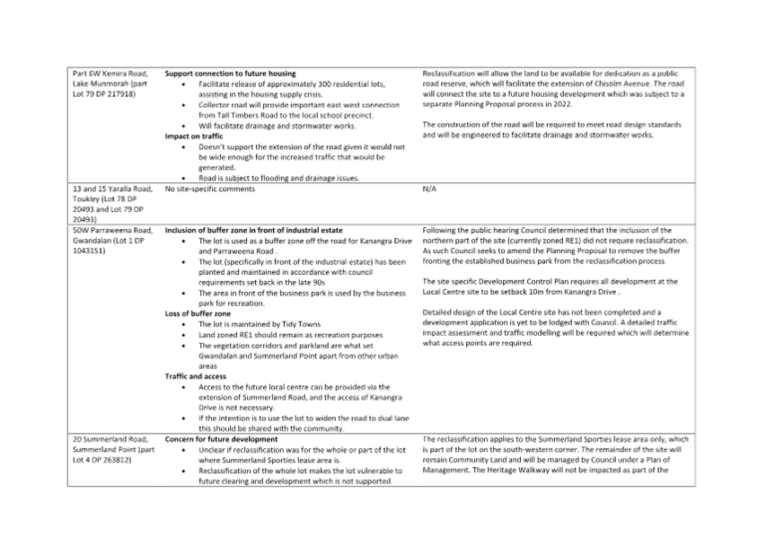
2.4 Planning Proposal for Reclassification of Council land (multiple sites) - Outcomes of Public Exhibition
Attachment 1: Submissions and Responses - Public Exhibition and Agency Consultation............................................................................................................ 515
Attachment 2: Public Hearing Report 1 (Erina, 8th of May 2024)................................ 549
Attachment 3: Public Hearing Report 2 (Wyong, 9th of May 2024)........................... 573
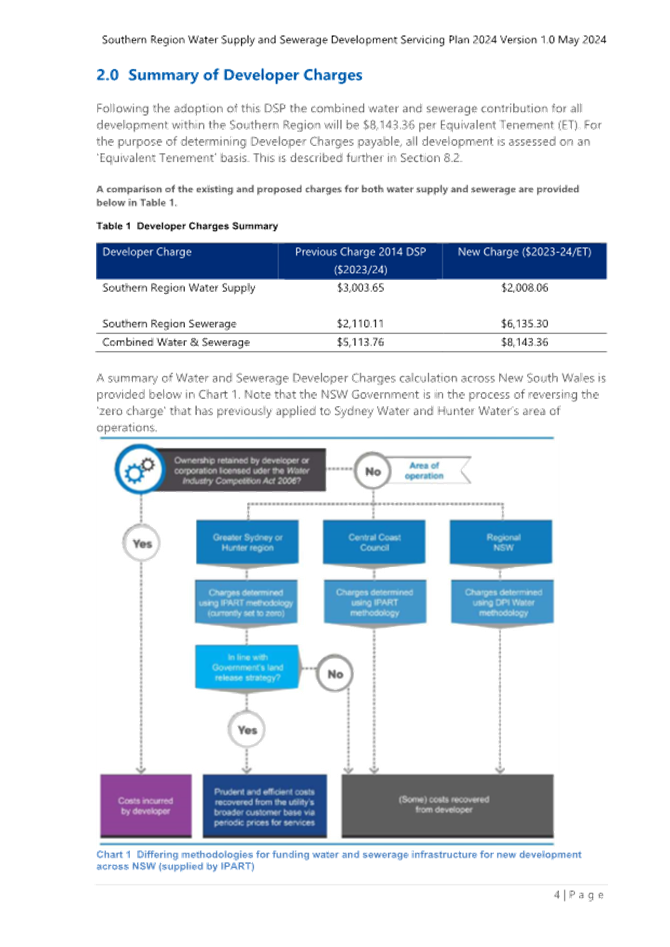
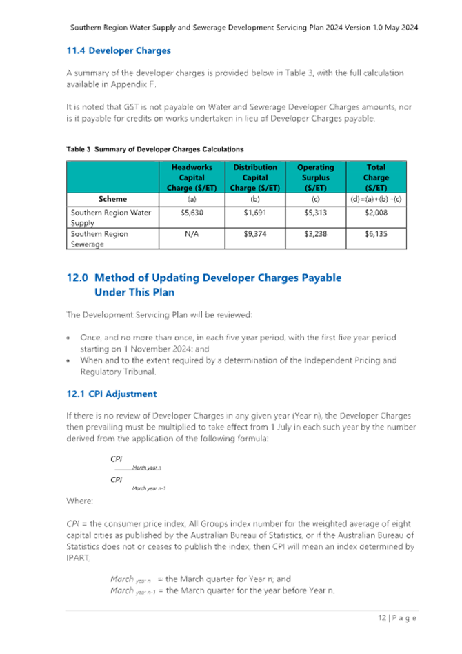
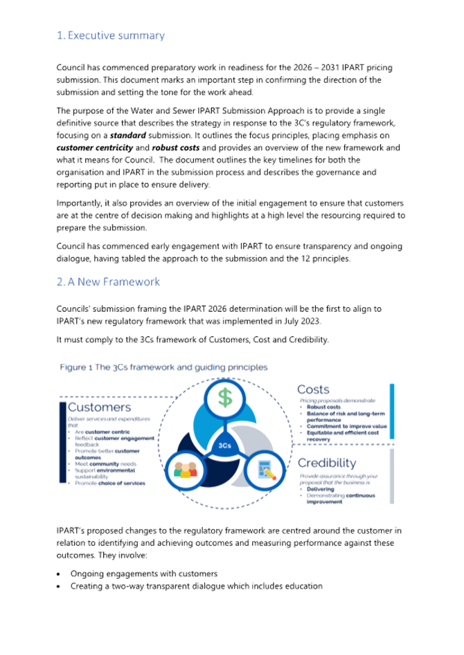
2.6 Water and Sewer 2026-2031 IPART Pricing Submission Approach
Attachment 1: Water and Sewer 2026 - 2031 IPART Submission Approach......... 598
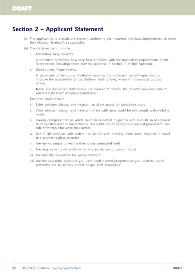
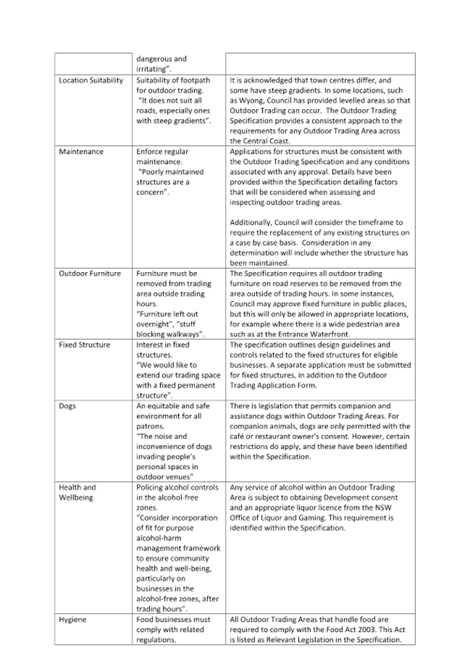
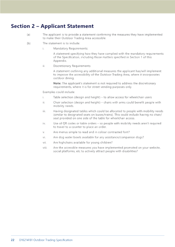
2.9 Outdoor Trading Specification - Outcomes of Public Exhibition
Attachment 1: Outdoor Trading Specification - Simplified edits................................. 614
Attachment 2: Closing the Loop Statement............................................................................ 638
Attachment 3: Outdoor Trading Specification - Final Version...................................... 641
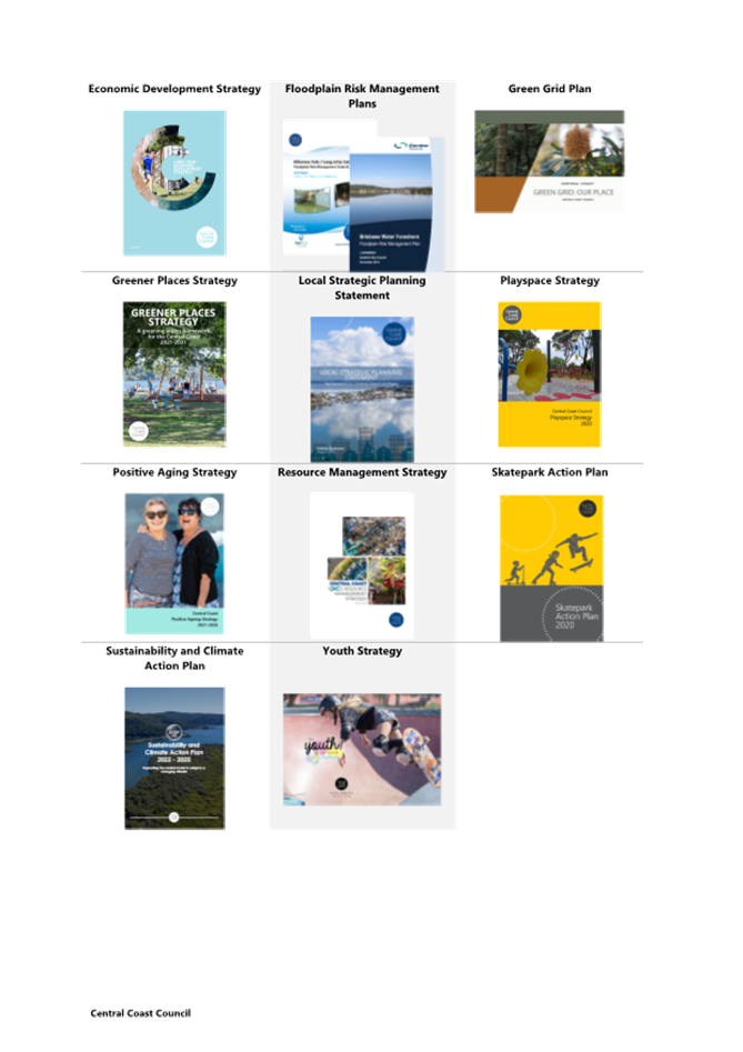
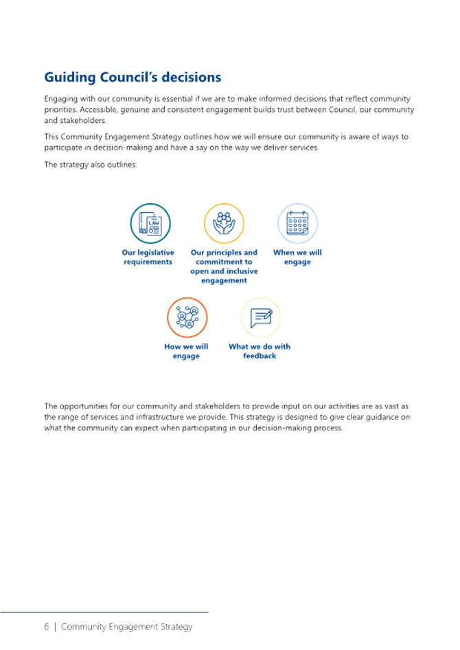
2.10 Draft Central Coast Council Engagement Strategy - For Public Exhibition
Attachment 1: Draft 2024-2028 Community Engagement Strategy – For Consultation V1_12 June 2024.................................................................................................... 665
2.11 Planning Proposal to rezone 2 Woongarrah Road, Woongarrah
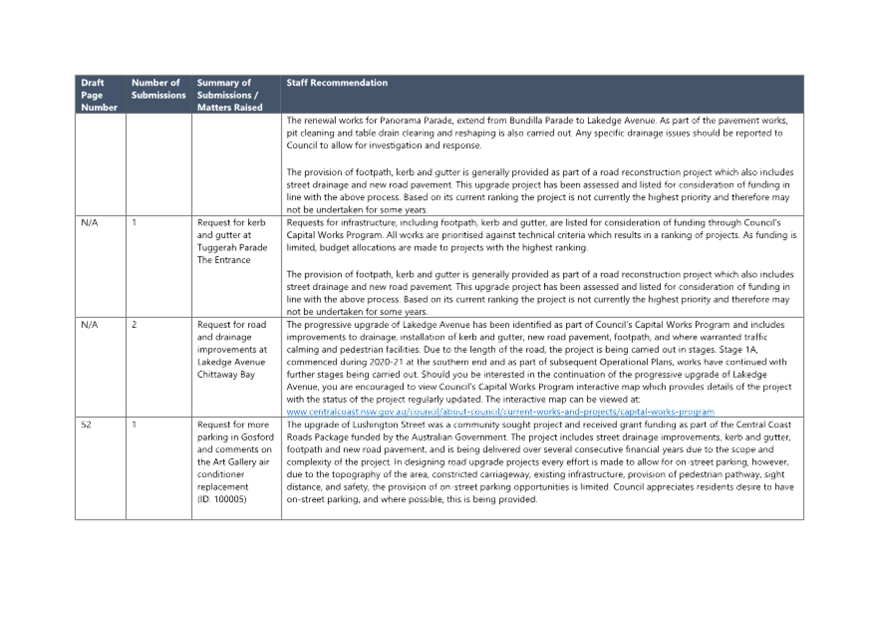
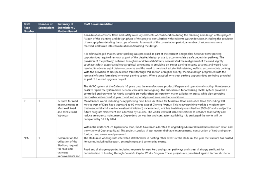
Attachment 1: Planning Proposal 2 Woongarrah Road, Woongarrah - May 2024 version........................................................................................................................ 701
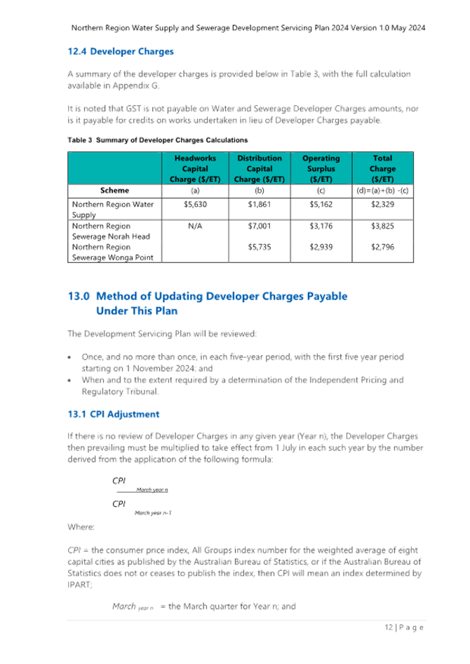
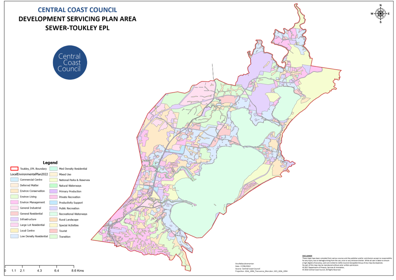
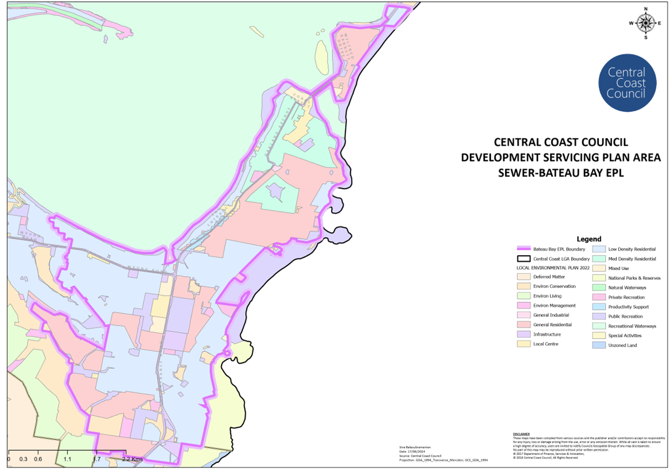
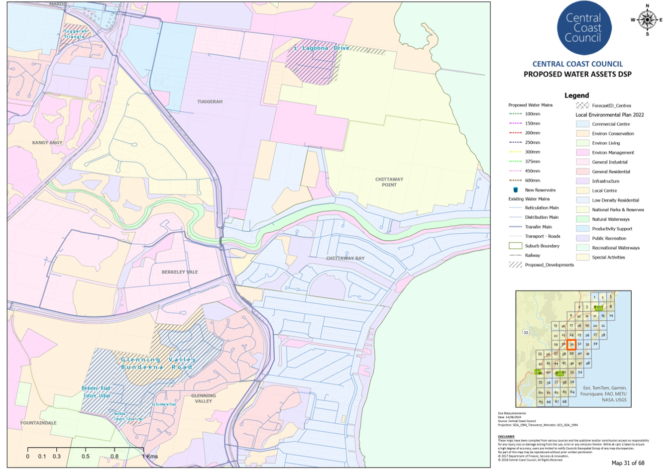
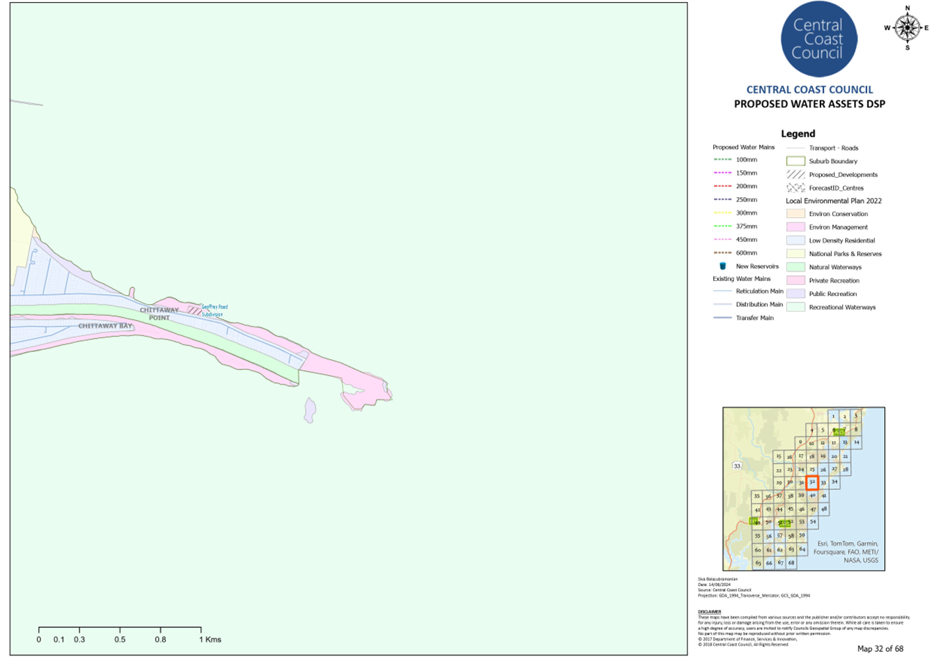
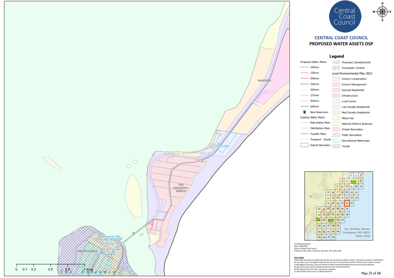
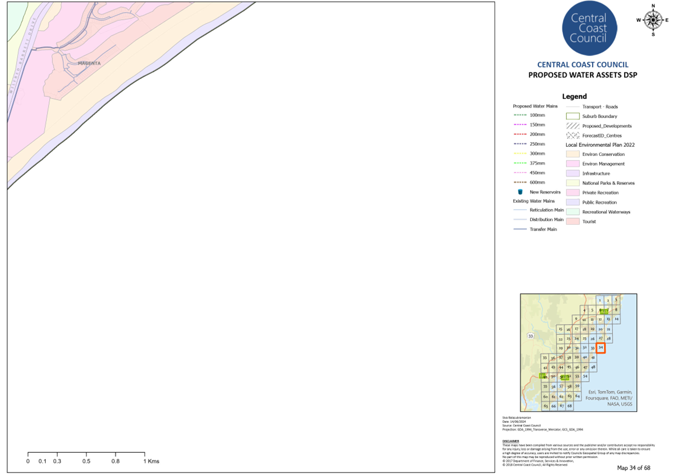
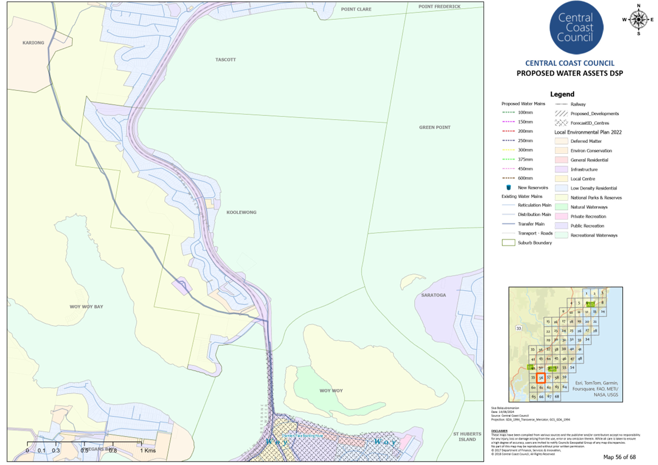
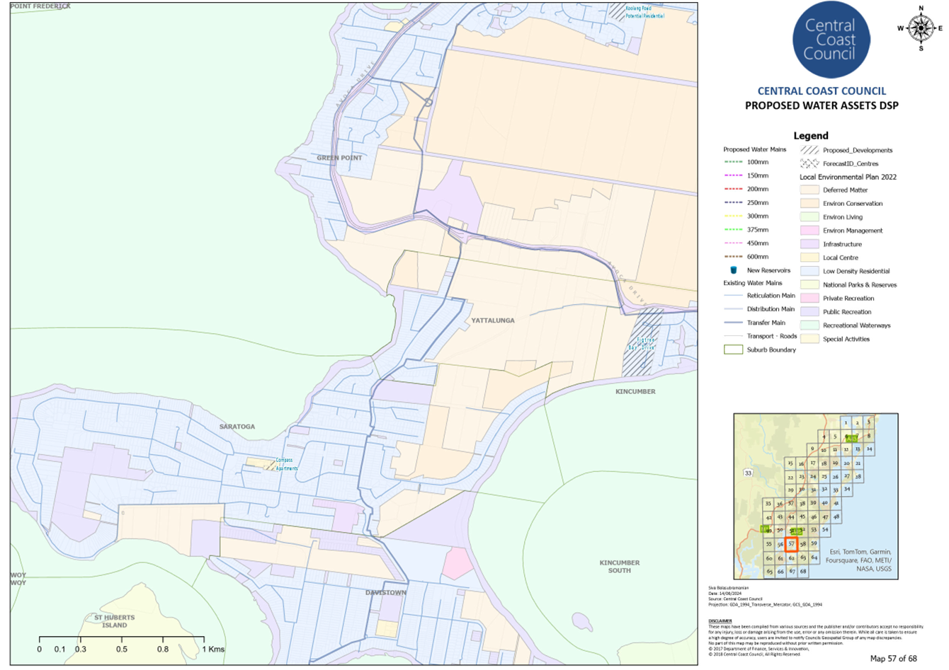
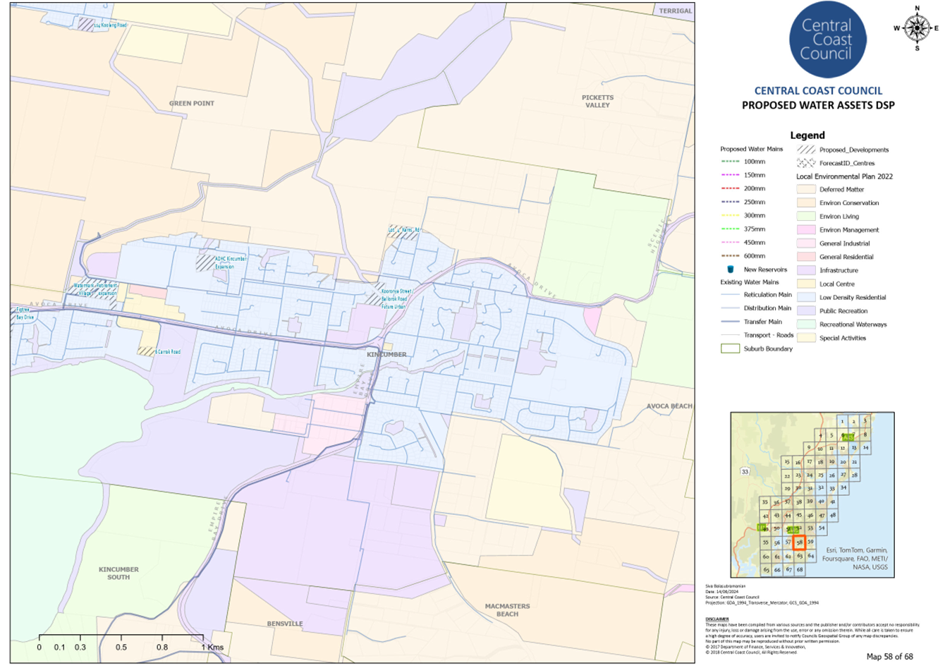
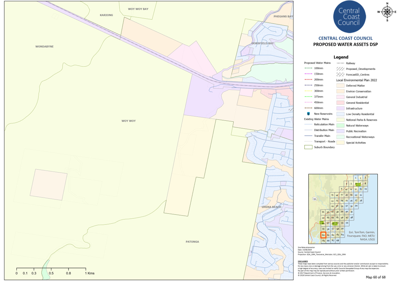
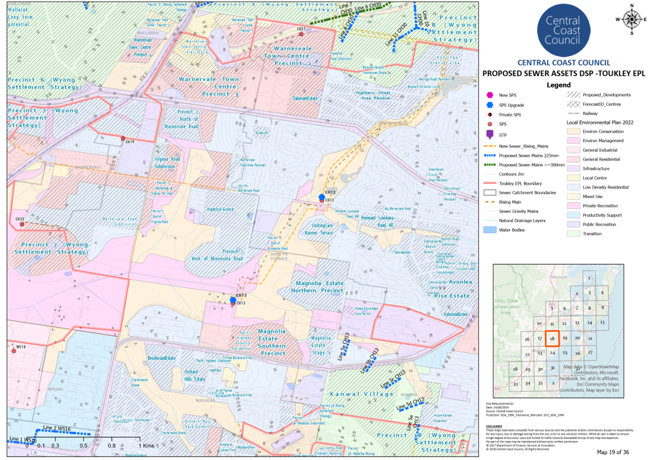
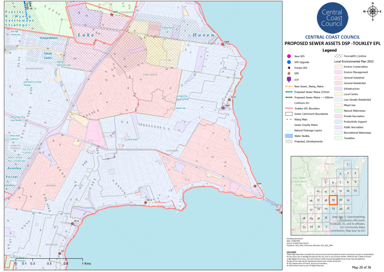
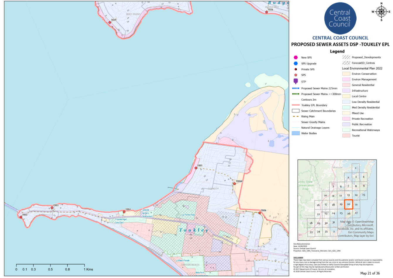
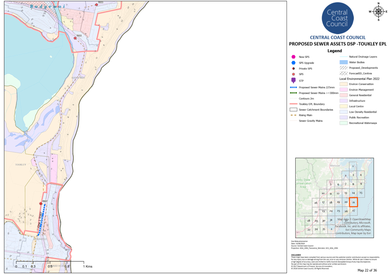
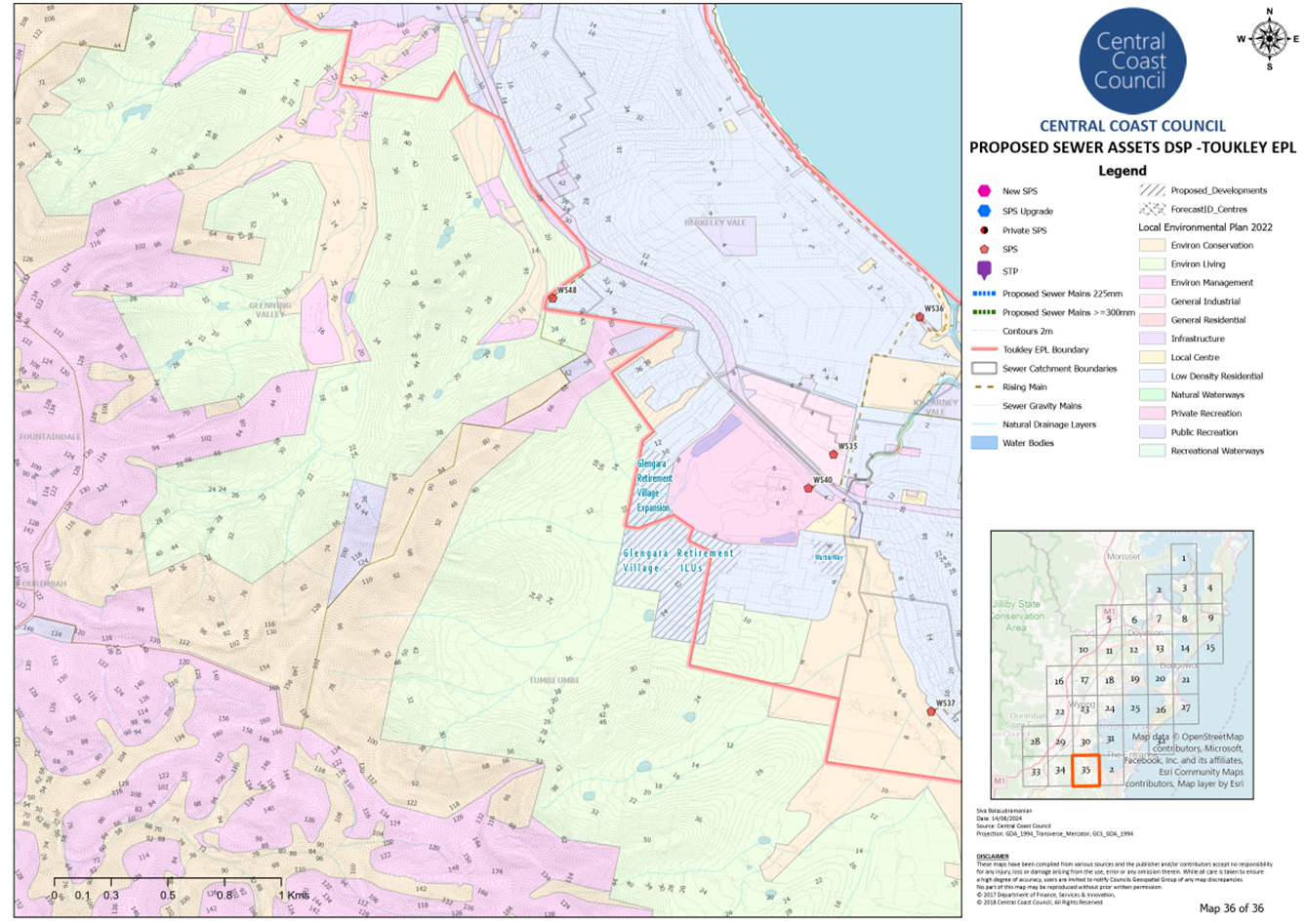
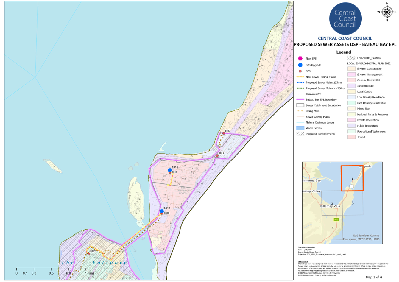
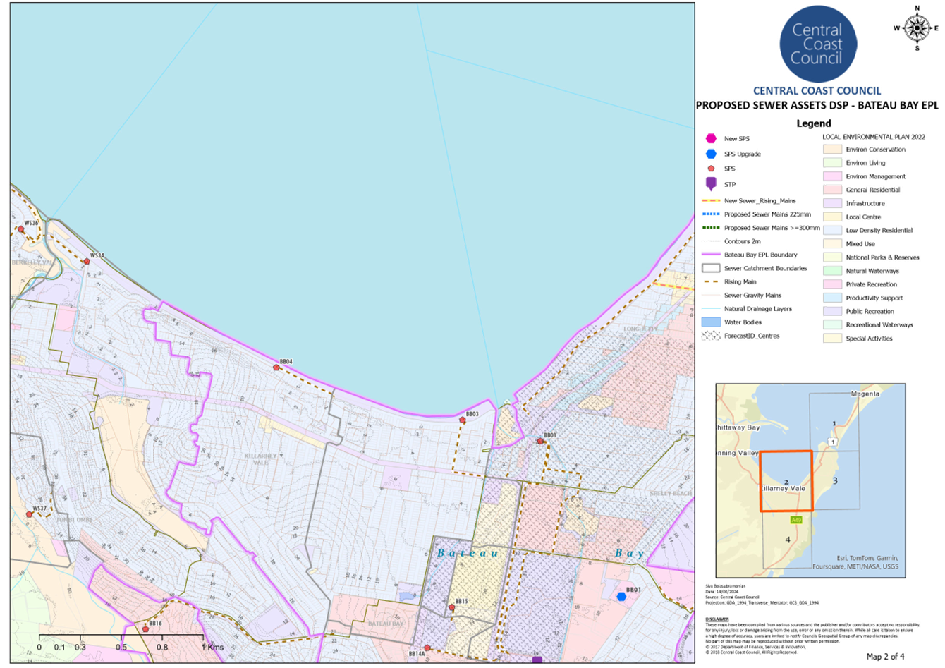
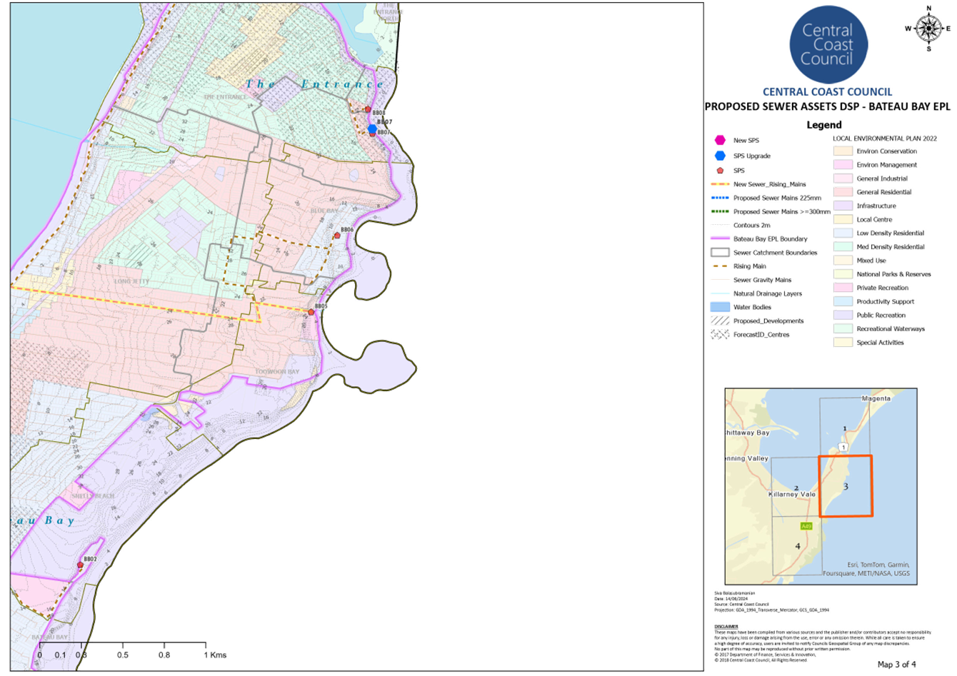
2.12 Draft Water and Sewer Developer Servicing Plans - For Public Exhibition
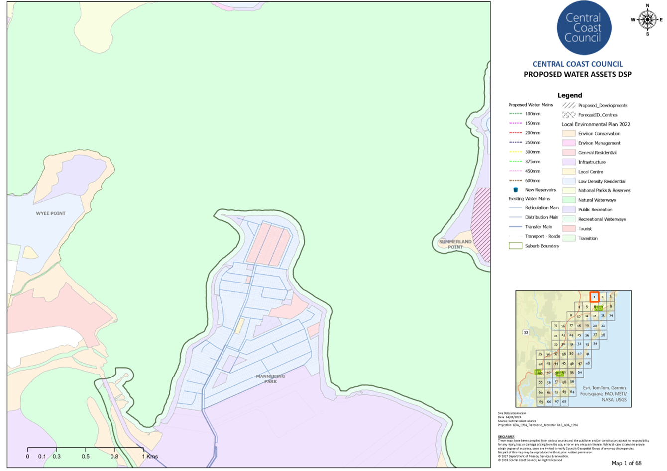
Attachment 1: Draft Northern Water Supply and Sewerage Development Servicing Plan 2024................................................................................................................... 755
Attachment 2: Draft Southern Water Supply and Sewerage Development Servicing Plan 2024................................................................................................................... 923
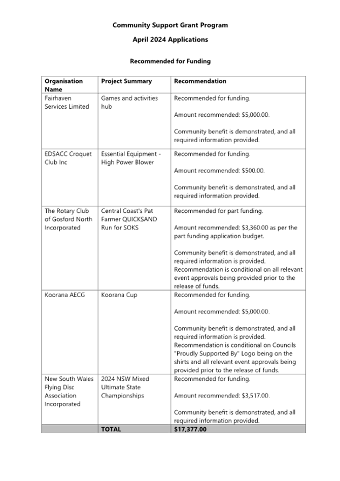
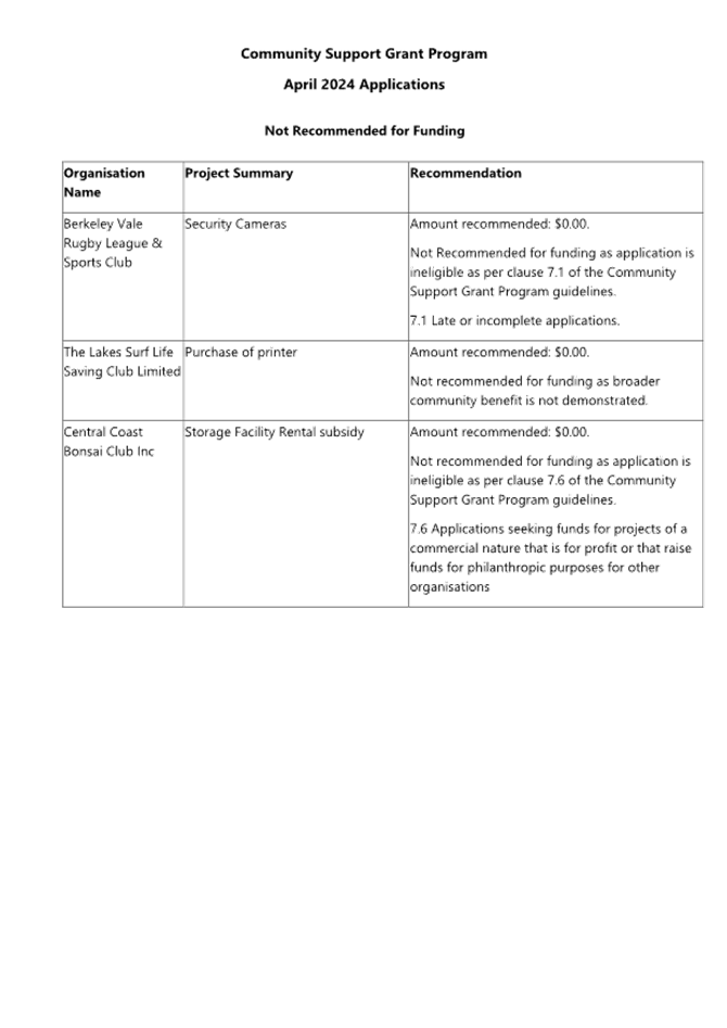
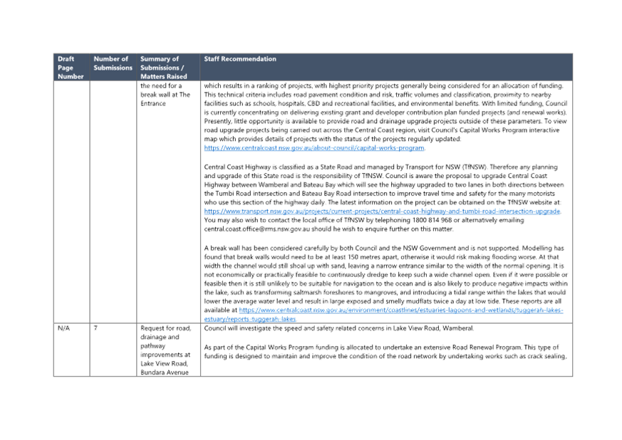
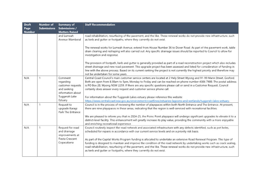
2.15 Community Support Grant Program - April 2024
Attachment 1: Community Support Grant Program - April 2024 Recommended and Not Recommended........................................................................................... 1066
|
1.2 |
Confirmation of Minutes of Previous Meeting |
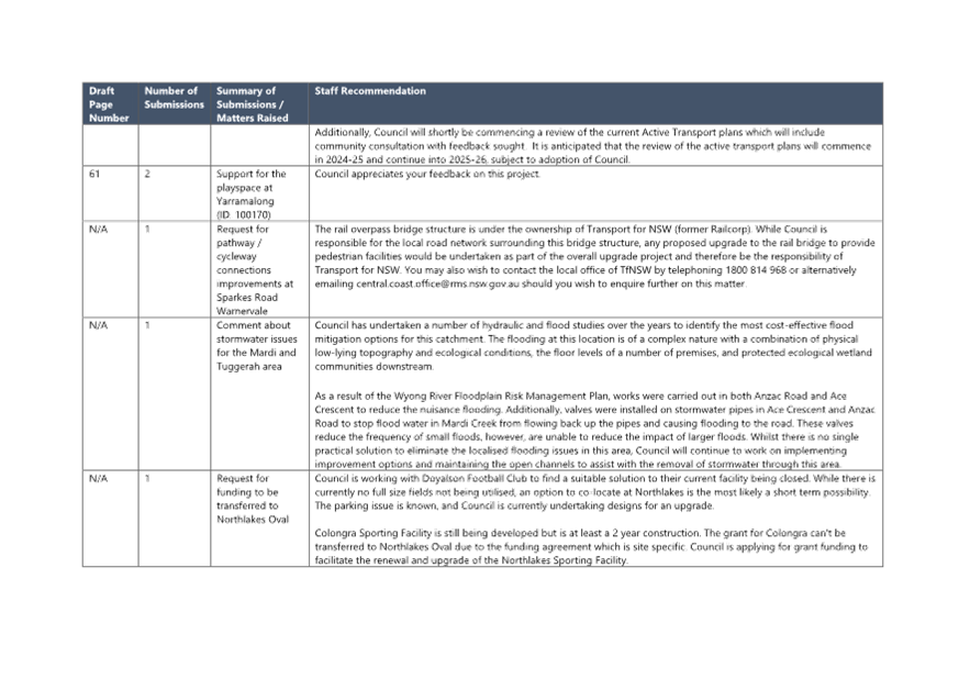
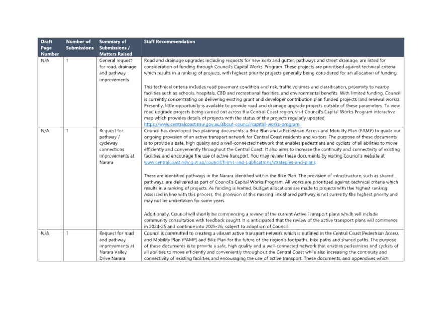
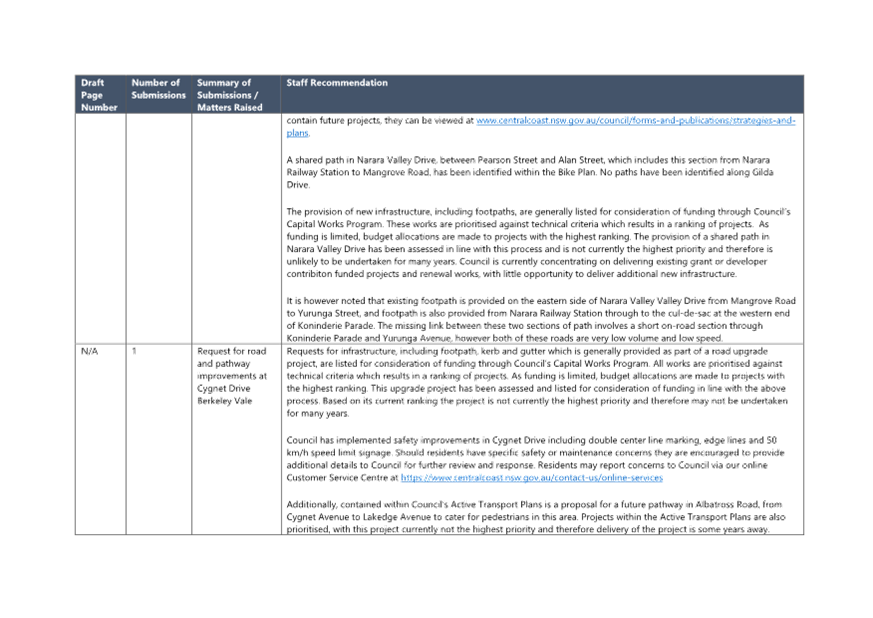
|
Attachment 1 |
MINUTES - Council Meeting - 28 May 2024 |
|
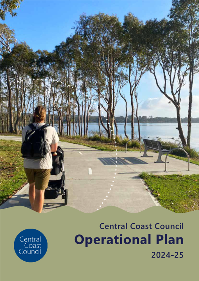
Operational Plan 2024-25, Rates and Annual Charges - Submissions and Adoption |
|
|
Attachment 1 |
Final Operational Plan 2024-25 |


|
Operational Plan 2024-25, Rates and Annual Charges - Submissions and Adoption |
|
|
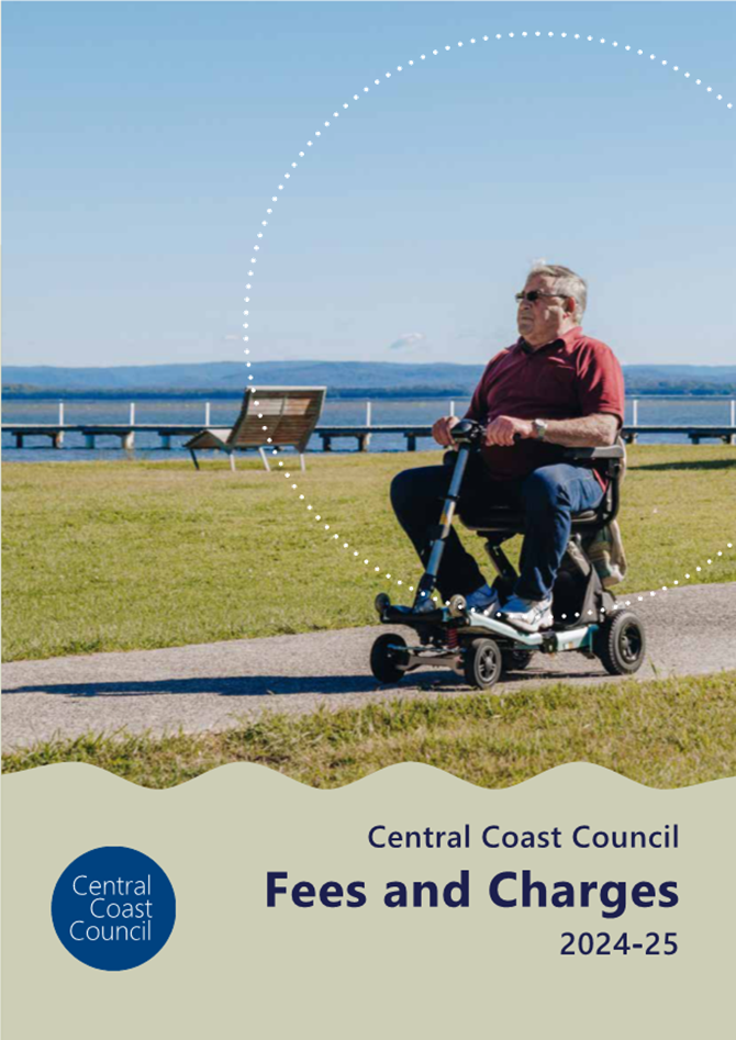
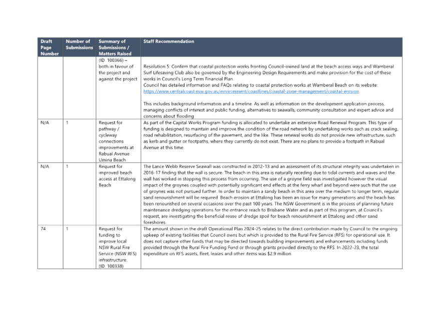
Attachment 2 |
Final Fees and Charges 2024-25 |


|
Operational Plan 2024-25, Rates and Annual Charges - Submissions and Adoption |
|
|
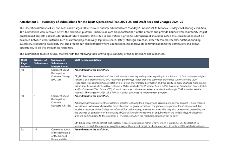
Attachment 3 |
Summary of Submissions 2024-25 |


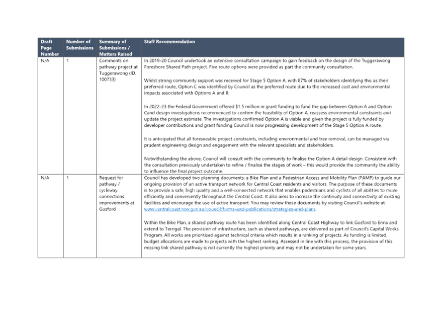
|
Operational Plan 2024-25, Rates and Annual Charges - Submissions and Adoption |
|
|
Attachment 4 |
Amendments to Operational Actions and Indicators 2024-25 |
|
2.3 |
Operational Plan 2024-25, Rates and Annual Charges - Submissions and Adoption |
|
Attachment 5 |
Amendments to Capital Works Program 2024-25 |
|
Operational Plan 2024-25, Rates and Annual Charges - Submissions and Adoption |
|
|
Attachment 6 |
Statutory Amendments to Fees and Charges 2024-25 |
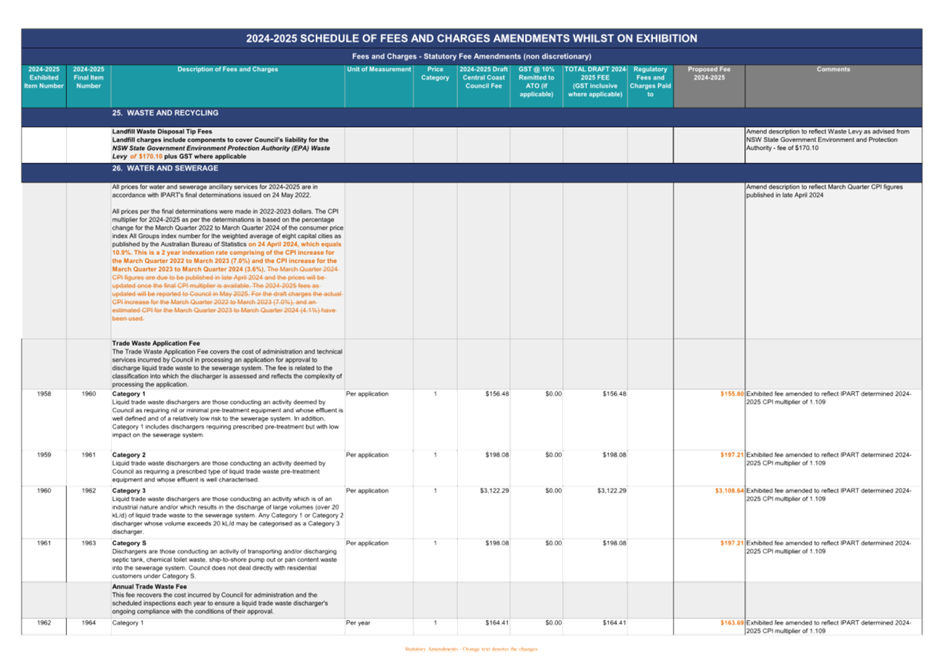
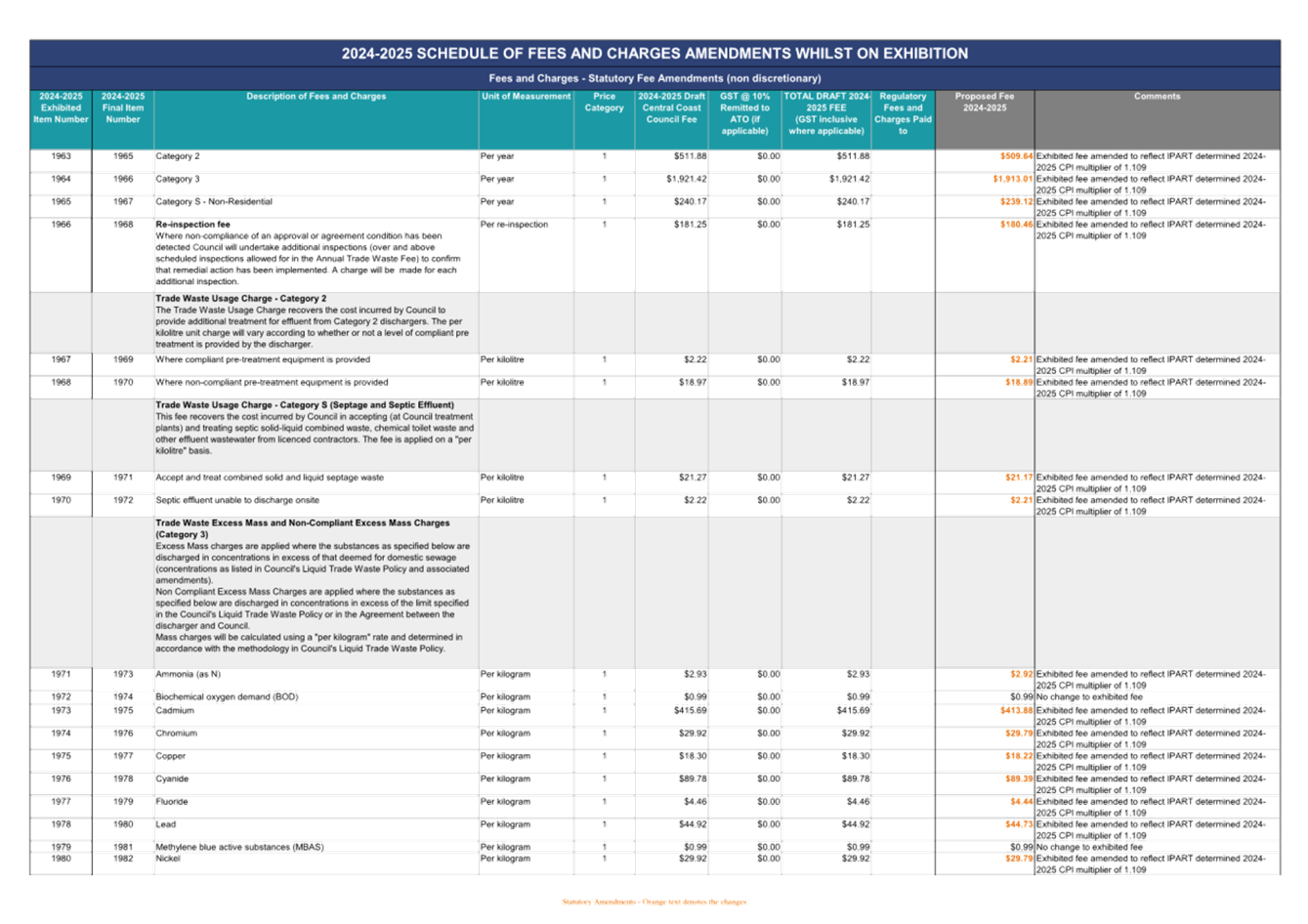

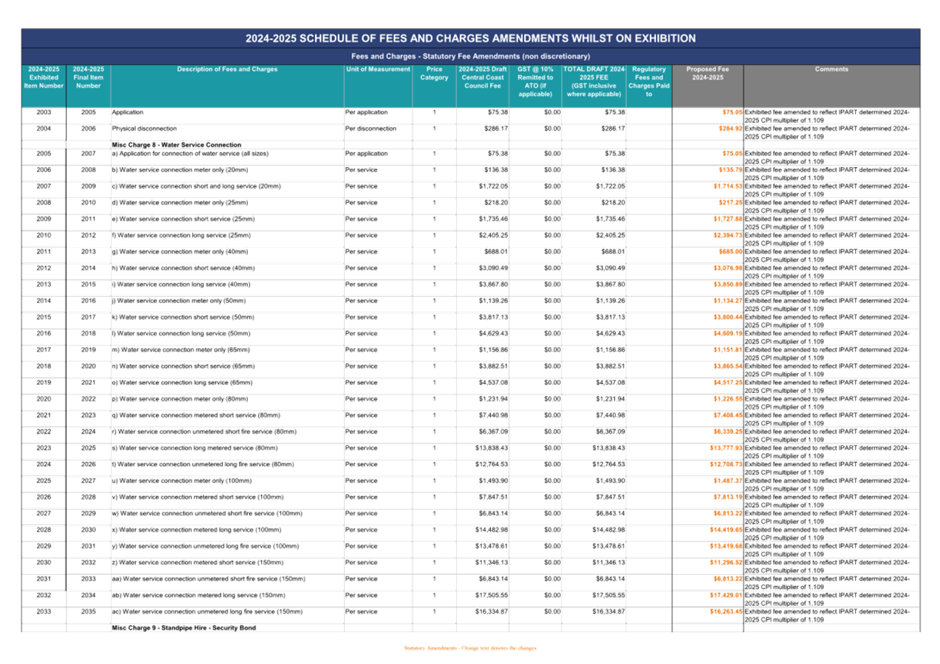
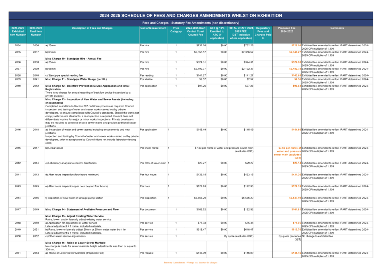
|
Operational Plan 2024-25, Rates and Annual Charges - Submissions and Adoption |
|
|
Attachment 7 |
Administrative Amendments to Fees and Charges 2024-25 |
|
2.3 |
Operational Plan 2024-25, Rates and Annual Charges - Submissions and Adoption |
|
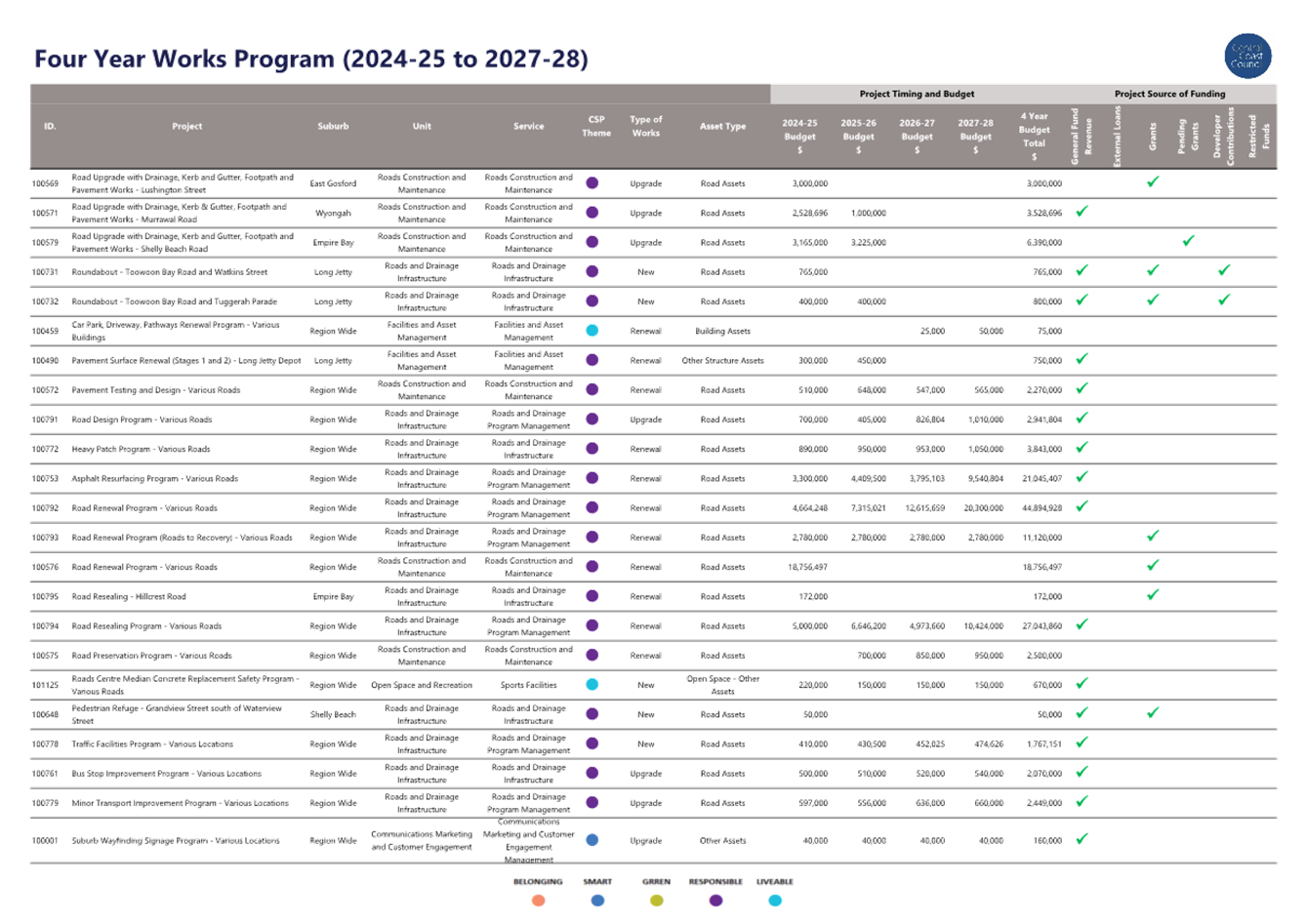
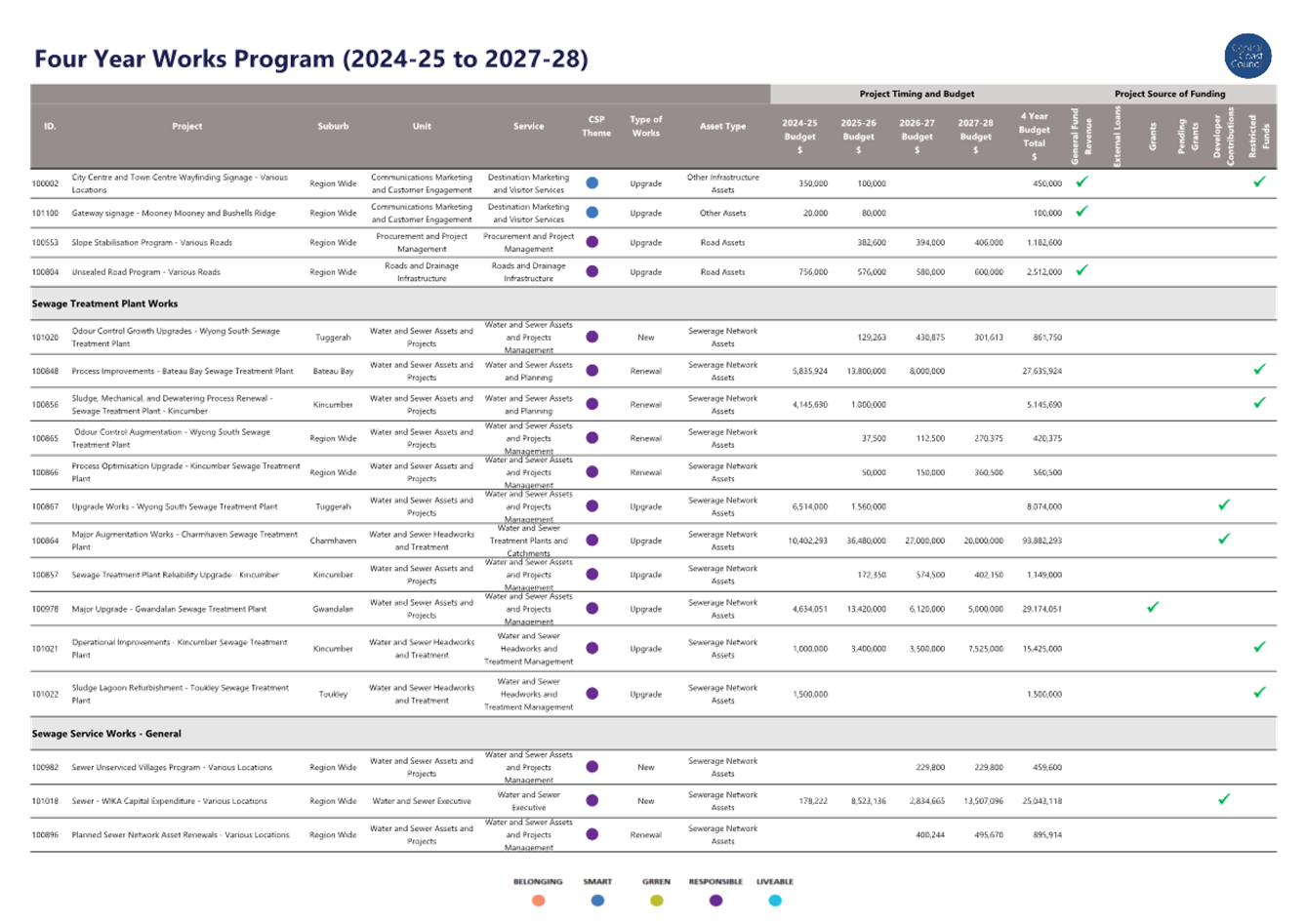
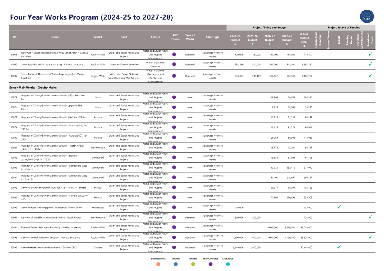
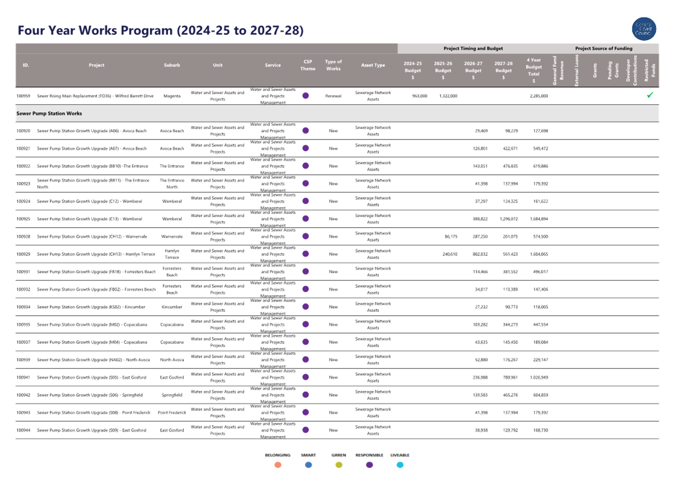
Attachment 8 |
Four Year Works Program 2024-25 to 2027-28 |

|
Operational Plan 2024-25, Rates and Annual Charges - Submissions and Adoption |
|
|
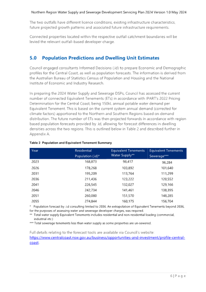
Attachment 9 |
Long Term Financial Plan (2024-25 to 2033-34) |


|
Planning Proposal for Reclassification of Council land (multiple sites) - Outcomes of Public Exhibition |
|
|
Attachment 1 |
Submissions and Responses - Public Exhibition and Agency Consultation |
|
Planning Proposal for Reclassification of Council land (multiple sites) - Outcomes of Public Exhibition |
|
|
Attachment 2 |
Public Hearing Report 1 (Erina, 8th of May 2024) |


|
Planning Proposal for Reclassification of Council land (multiple sites) - Outcomes of Public Exhibition |
|
|
Attachment 3 |
Public Hearing Report 2 (Wyong, 9th of May 2024) |


|
Water and Sewer 2026-2031 IPART Pricing Submission Approach |
|
|
Attachment 1 |
Water and Sewer 2026 - 2031 IPART Submission Approach |

|
Outdoor Trading Specification - Outcomes of Public Exhibition |
|
|
Attachment 1 |
Outdoor Trading Specification - Simplified edits |
|
Outdoor Trading Specification - Outcomes of Public Exhibition |
|
|
Attachment 2 |
Closing the Loop Statement |

|
Outdoor Trading Specification - Outcomes of Public Exhibition |
|
|
Attachment 3 |
Outdoor Trading Specification - Final Version |

|
Draft Central Coast Council Engagement Strategy - For Public Exhibition |
|
|
Attachment 1 |
Draft 2024-2028 Community Engagement Strategy – For Consultation V1_12 June 2024 |


|
Planning Proposal to rezone 2 Woongarrah Road, Woongarrah |
|
|
Attachment 1 |
Planning Proposal 2 Woongarrah Road, Woongarrah - May 2024 version |
Central Coast Council
Planning Proposal
Lot 1 DP 1275060 – 2 Woongarrah Road
Woongarrah
File No: RZ/1/2023; PP-2023-581
May 24

Planning Proposal
Lot 1 DP 1275060 – 2 Woongarrah Road
Woongarrah
File No: RZ/1/2023; PP-2023-581
Date: May 24
Version 1
Central Coast Council
Wyong Office: 2 Hely St / PO Box 20 Wyong NSW 2259 l P 1300 463 954
Gosford Office: 49 Mann St / PO Box 21 Gosford NSW 2250 l P 1300 463 954
E ask@centralcoast.nsw.gov.au l
W www.centralcoast.nsw.gov.au l
ABN 73 149 644 003
Opening Hours 8.30am - 5.00pm
Lot 1 DP 1275060 – 2 Woongarrah Road
File No: RZ/1/2023; PP-2023-581
Background & Locality Context
Part 1 Objectives or Intended Outcomes
Part 2 Explanation of Provisions
Part 3 Justification
Section A – Need for the Planning Proposal
Section B – Relationship to strategic planning framework
Section C – Environmental, Social and Economic Impact
Section D – State and Commonwealth Interests
Part 4 Mapping
Part 5 Community Consultation
Part 6 Project Timeline
Appendix 1 - Mapping
Appendix 2 – Council Report
Appendix 3 – Supporting Documentation
Locality Context
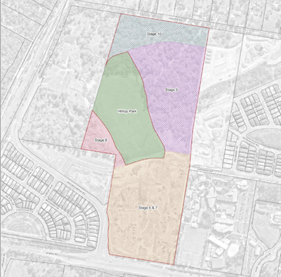
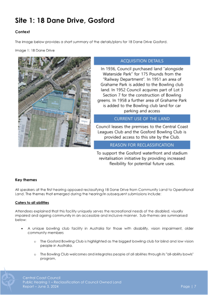
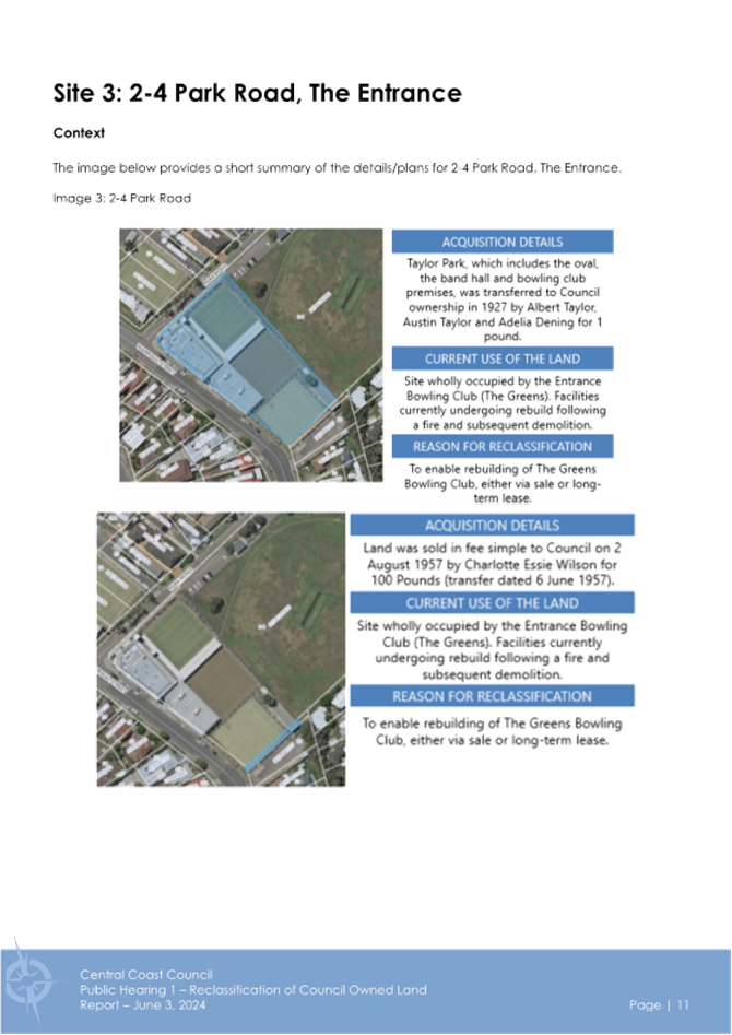
The Planning Proposal (PP) nominates the northern portion of 2 Woongarrah Road, Woongarrah, (Figure 1) as the site that this the subject of the rezoning, and known as Stage 10 within the overall masterplan of the site (see Figure 2).
The real property description is:
· Lot 1 DP 1275060
![]()
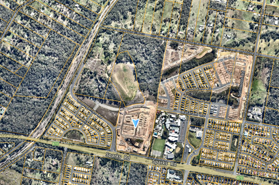
Figure 1: Subject site, (Source: SIX Maps, 2023)
The irregular shaped allotment is consistent with the original staged masterplan (see Figure 2) and adjoins Hilltop Park. Hilltop Park will feature as the key public open space area for the centre and is under Council management. Earlier stages in the masterplan development are either in the approval pathway or under construction as seen in Figure 1 and will primarily support single lot low density development.
Figure 2: Site Aerial (Source: Beveridge Williams, 2023)
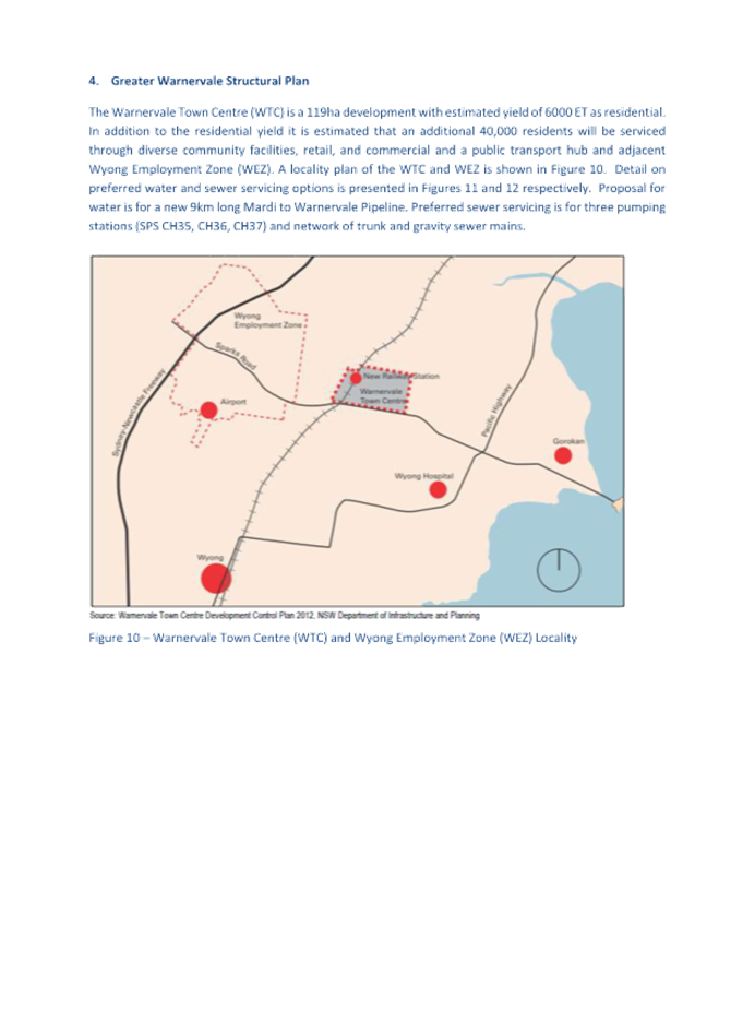
The subject land is located within the Warnervale Town Centre as identified by the Central Coast Regional Plan 2041 and the Draft Greater Warnervale Structure Plan (see Figure 3).
![]()
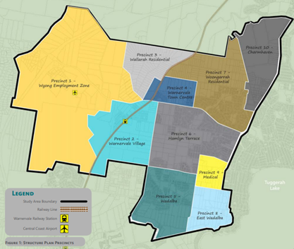
Figure 3: Extract of Precinct Mapping for draft Greater Warnervale Structure Plan (Source: CCC, 2022)
Access to the site will occur from both Sparks Road from the south, via stages 6 – 7, and Hakone Road to the northern portion, when construction of this road takes place. Construction of Hakone Road will be required to facilitate access to lands fronting this road reserve, and as part of the development application pathway.
Surrounding land use includes:
· North: RU6 Transition zoned rural residential properties, with some C2 Environmental Conservation zoning interspersed and associated with vegetation corridors. This land falls outside the Warnervale Town Centre area identified in the CCRP 2041;
· East: R1 General residential land with some remnant MU1 Mixed Use zoned land. A part of this site has commenced construction for a residential subdivision comprising low density housing (see Figure 1);
· South: R1 General Residential zoned land included within the subject site and earlier stages of the redevelopment of the land. Hilltop Park located adjacent to the southern boundary of the subject site is a Council reserve to be constructed as a local park to support this precinct. There is also a vegetation corridor that dissects the subject land and is zoned C2 Environmental Conservation; and
· West: Zoned E1 Local Centre and currently vacant. The southern portion of this lot has been the subject of a recent SEARs request for commercial/retail development and Woolworths is the proponent. Further west is the Northern railway line and opposite this land is a site owned by the Department Planning & Environment that is also vacant land. This land forms the extremity of the Warnervale Town Centre.
Background
The subject land is in a central position in the land identified as the Warnervale Town Centre. The southern extremities of the site have been the subject of development consents granted as follows;
· DA/919/2018 (Stages 6 & 7) – approval was issued on 20 December 2021 for ’91 residential lots, one residential super lot and three residue lots which includes a lot be dedicated to Council for the purposes of a reserve (public open space).
· DA3910/2022 (Stage 9) - Development application is under assessment for a torrens title subdivision consisting of 86 residential lots, one lot for acquisition by Council for drainage and environmental purposes and one residue lot for the subject planning proposal and residential development under a separate development application. The application also seeks approval for associated land clearing, earthworks, construction of roads and augmentation of services.
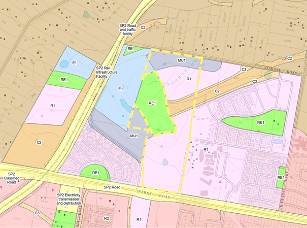
The subject land is currently zoned MU1 Mixed Use, E1 Local Centre, R1 General residential and C2 Environmental Conservation as shown in Figure 4 below. Land that is the subject of this Planning Proposal is zoned MU1 Mixed Use and E1 Local Centre.
Figure 4: Subject site existing zoning under Central Coast Local Environmental Plan 2022 (CCLEP) (Source: NSW Planning ePortal)
Part 1 Objectives or Intended Outcomes
The Planning Proposal seeks to rezone the E1 Local Centre and MU1 Mixed Use zones to R1 General Residential under the Central Coast Local Environmental Plan 2022 (CCLEP).
The objective of this proposal is to:
a) Provide additional diverse housing in an established residential area in support of the changed direction of the Warnervale Town Centre that promotes connectivity with the surrounding employment lands and public open space areas;
b) Creating employment opportunities during construction and beyond with future residential development and mixed land uses.
The intended outcomes of the proposal are:
(a) to enable development of 2 Woongarrah Road, Woongarrah for residential land uses with a particular focus on medium density residential purposes that supports a diverse housing mix and is consistent with the emerging residential development in the local centre; and
(b) to enable development of land adjacent to the local park that facilitates active transport throughout the precinct and good connection to the public open spaces;
(c) to facilitate residential development of land in an established growth area in an orderly manner, and
(d) to permit non-residential uses consistent with the zone objectives, and in support of the local centre delivery of ‘every day’ services to the community.
Part 2 Explanation of Provisions
The objectives/intended outcomes are to be achieved by rezoning lands identified as MU1 Mixed Use and E1 Local Centre under the CCLEP 2022 for R1 General Residential, to enable residential development. This will require amendments to the mapping associated with this land as explained in Table 1.
The following table identifies the proposed amendments to CCLEP mapping and clauses as required:
Table 1: Explanation of Map and Instrument Amendments
|
Existing Provision |
Proposed Amendment |
|
Zoning Map
|
· Replace MU1 Mixed Use and E1 Local Centre zoned land with R1 General Residential land as shown.
|
Additionally, the Proposal includes the amendment of Chapter 4.1 of Central Coast Development Control Plan 2022 to update the changed direction for the Warnervale Town Centre that no longer includes a new railway station. Additional changes are proposed to update mapping and associated strategic directions that have subsequently changed and in alignment with the objectives of the draft Greater Warnervale Structure Plan.
Section A – Need for the Planning Proposal
1. Is the Planning Proposal a result of any Strategic Study or report?
The Planning Proposal is not the result of a strategic study or report but in response to changing direction in the Warnervale Town Centre (WTC). The WTC was previously designed with a focus on the location of the new North Warnervale train station and commercial/retail and residential densities surrounding this central location commensurate for a town centre. The NSW State Government has determined the North Warnervale train station is no longer required and therefore the WTC no longer requires the centre hierarchy as previously identified in the Masterplan.
The Central Coast Regional Plan 2041 identifies the need for an amended vision for this centre following the changed direction with the railway infrastructure. The subject proposal has been amended concurrently with the finalisation of the Greater Warnervale Structure Plan (GWSP) that is to be considered by Council in July 2024. The GWSP identifies a need for two local centres to replace the previous town centre envisaged for lands in proximity and including this site. The two local centres to support this regionally significant growth area will be located both in the land area adjacent to the existing Warnervale railway station and on the employment lands zoned to the north of Sparks Road, in the precinct formerly identified as the WTC.
With the amended vision for the WTC a reduced commercial land area has been proposed and replaced with greater housing diversity in the immediate catchment of these employment lands and surrounding the Hilltop Park open space precinct. This will enable direct connection to the local centre for the surrounding residential lands, good movement networks throughout the centre and activation of the public open space areas. Of importance to the success to the amended vision for the local centre is the integration of diverse housing opportunities to the lands with immediate interface to these non-residential lands, including the subject site.
The subject Planning Proposal does have strategic merit and is an appropriate strategic response to the changed vision for the WTC for the following reasons:
· The proposal aligns with the 15 minute neighbourhood objective defined in the CCRP 2041 to support mixed, multi modal inclusive and vibrant communities. The subject rezoning will promote this intention at the local, general suburban scale and is commensurate with the demand for services and infrastructure required at this scale.
· The proposal is supported by a retail centre analysis that confirms the amended local centre scale will meet the demand for this locality and will service the emerging residential developments in the centre. While the proposal does result in a reduced area of employment lands in this local centre precinct, the permissible land uses in this location as a result of the proposed R1 General Residential zone do not prohibit services reflecting the local/day to day scale of the centre (i.e. neighbourhood shops and the like).
· The Proposal seeks to rezone land within a portion of the WTC and aligns with the strategic objectives and actions outlined in the Central Coast Council Interim Local Strategic Planning Statement (LSPS). The LSPS provides overall goals for Central Coast’s growth centres that aligns development with infrastructure capacity, encourages growth in existing centres; and renews centres as places for people. The proposal is consistent with these objectives and strengthens the WTC’s function as an emerging Strategic Centre to service a growing population.
· Central Coast Development Control Plan 2022 identifies the site as a local centre and the proposal is consistent with the objectives of this document. Noting that the CCDCP Chapter 4.1 still identifies the former proposal for the new North Warnervale train station. The DCP identifies the subject lands for higher density residential lands than those proposed, however these high densities are no longer appropriate where not supported by complementary infrastructure. The Planning Proposal will include an amendment to Chapter 4.1 Warnervale Town Centre CCCDCP 2022 to reflect the changed direction of the WTC.
· The land is appropriate for this use and continues the release of land in this location for housing, particularly for those lands to the south of the proposal that form part of the subject land holding. The subject land area represents a small portion of land within the WTC and on the northern extremity of the WTC boundary, thus providing good transition to the rural lands opposite the site, or low density residential development in the longer term vision for these lands.
2. Is the planning proposal the best means of achieving the objectives or intended outcomes, or is there a better way?
A
Planning Proposal process is the only means of achieving the
objectives/intended outcomes of changing the zone under the CCLEP 2022. The land cannot be developed
for residential purposes without a change to the applicable zoning. The only
means for achieving residential housing on these lands is through other mixed
use developments comprising commercial tenancies and residential housing. This
is inconsistent with the hierarchy of the local centre now that the railway
station is not proceeding therefore is it necessary for the planning proposal
to achieve these outcomes.
Section B – Relationship to strategic planning framework
3. Is the planning proposal consistent with the objectives and actions of the applicable regional, sub-regional or district plan or strategy (including any exhibited draft plans or strategies)?
Central Coast Regional Plan (2041)
The Central Coast Regional Plan 2041 (CCRP) applies to the Central Coast local government area (LGA).
The CCRP is to provide the basis of planning by the local government and sets out a number of objectives. The table below demonstrates that the Planning Proposal is generally consistent with relevant objectives identified in the CCRP.
Table 2: Central Coast Regional Plan 2041
|
Applicable |
Assessment/Comment |
|
|
1. A prosperous Central Coast with more jobs close to home. |
Yes |
The Proposal is located within a local centre, and proposes to remove commercial/retail mixed use zoned land are surplus to the needs of the local centre now that the strategic vision for the centre has changed. The realignment of the local centre promotes commercial/retail developments on the employment lands, centralised with the public open space areas, creating a local centre ‘place’ for this precinct. This is an appropriate local centre scale and the proposed R1 zone will enable a transition between these employment zones and the low density residential developments to the east of precinct. The proposal enables housing delivery in a well located position, in a regional growth precinct. The land use permissibility within the R1 General Residential zone does not prohibit further day to day commercial/retail entities from being established in this land, and likely given the nature of the land uses permitted, to be more in scale with the local centre, and combined with complementary housing (i.e. shop top housing). |
|
2. Support the right of Aboriginal residents to economic self-determination. |
N/A |
The proposal will not impact on the economic self determination of Aboriginal residents. |
|
3. Create 15-minute neighbourhoods to support mixed, multi-modal, inclusive and vibrant communities. |
Yes |
The rezoning facilitates an extension of an existing residential land release in the local centre and supports the performance outcomes of the 15min neighbourhood as demonstrated following;
· Urban settlement patterns maximise the use of existing infrastructure and reduce travel demand, especially by car. The proposal reinforces the identity of the local centre as the focal point for community connection and services and will operate as a transitional space between residential lands and the commercial/retail and public open space areas. The vision for the subject site is to act as the interfacing lots and provide a mixed land use with medium and high density residential development as its priority. These lands will rely on the movement to the local centre and Hilltop Park to provide essential facilities and day to day services and these will be accessible via non-car based transport.
· Neighbourhoods maximise mobility independence and active and public transport opportunities. The proposed residential lands have an immediate interface with Hilltop Park and the adjoining employment lands which fosters good connection to this local centre. Hilltop Park will act as a central movement network throughout the centre and provide pedestrian connection to the immediate services on the employment lands, and the corresponding public transport networks in this locality.
Medium and higher density development is permitted in the R1 General Residential zoned land, and the proposal does not include restriction on height or FSR beyond those already in force for the site. The zoning categorisation will however promote greater density in this location, maximising the mobility and independence of future residents by enabling a diverse housing supply in a well located local centre.
· Neighbourhoods provide local access to education, jobs, services, open space and community activities The neighbourhoods created by this proposal will have local access to employment lands, community services, Hilltop Park for open space and social infrastructure in Warnervale including local schools. The GWSP indicates community facilities to be provided in these locations to support future communities as part of the regional growth precinct.
· Neighbourhoods encourage healthy lifestyles with opportunities to experience and engage in the cultural, entertainment, sport and recreation, and educational activities. The proposed residential lands will benefit from close proximity to the Hilltop Park open space area, and sporting facilities and cultural spaces within the Warnervale growth area. Schools are located in the local centre and more broadly across Greater Warnervale.
· Neighbourhoods establish or reinforce local identity. The identity of the subject site is established by its proximity to the local centre, and with an immediate interface with Hilltop Park. This portion of the subject site will act as a transition space between the local centre space, Hilltop Park and the remaining residential lands.
· Public spaces are designed to invite community interactions and economic, social and cultural activity. They enable a sense of social inclusion, wellbeing, comfort and belonging. The subject land is an irregular shaped parcel of land located with immediate interface with Hilltop Park. This location offers good connection to these public spaces and opportunities for the development of movement networks between the residential lands and public open space. The amended DCP will promote this connection and the further development of public domain areas fostering identity for community.
· Places are designed to be greener to support the regeneration of and connection to the natural environment The R1 General residential zone promotes a variety of land uses and will enable greening of sites to complement the land use and provide connection to the adjoining public open space areas, and further east to the conservation zoned lands. By promoting higher density in this location, this ensures that the feasibility of good private and communal open spaces can be developed as good design practices allow. |
|
4. An interconnected Central Coast without car-dependent communities |
Yes |
The residential lands will benefit from convenient access to Sparks Road, Warnervale train station and local centre public services, including bus transit. The road hierarchy within the existing DCP is to be amended to foster a walkable local centre and movement networks through Hilltop Park for this community. |
|
5. Plan for ‘nimble neighbourhoods’, diverse housing and sequenced development |
Yes |
The proposal benefits from existing infrastructure supporting surrounding residential lands. The land is a greenfield development and is well suited for diverse housing in response to the circumstances of the topography, road layout, proximity to the commercial lands and open space areas. By adopting the R1 General Residential zone, and maintaining the height and FSR controls as established, this will foster greater densities in this well located centre. While the portion of the subject land can sustain greater densities, at 50 dwellings per Ha though the proposal is likely to result in a dwelling density less than this rate and adopt a transitional role between the employment lands and adjoining low density residential development. The R1 General Residential zone underpins objectives that meet the criteria for nimble neighbourhoods, and enable a diverse range of land uses. |
|
6. Conserve heritage, landscapes, environmentally sensitive areas, waterways and drinking water catchments |
N/A |
The subject portion of the land doesn’t support any environmentally sensitive areas. However, by promoting higher capacity outcomes for these lands, this assists with preserving adjoining sites that do support land with these environmental attributes. |
|
7. Reach net zero and increase resilience and sustainable infrastructure |
Yes |
The planning proposal seeks an amendment to the zone to allow for further residential lands in the local centre. The future subdivision can achieve the 15-minute neighbourhood and will foster housing diversity, particularly with the inclusion of small lot housing. Further controls will be developed in the amendments to the CCDCP 2022 Chapter 4.1 to assist with housing mix. |
|
8. Plan for businesses and services at the heart of healthy, prosperous and innovative communities |
Yes |
The Planning Proposal does not negatively impact the local centre despite removing commercial zoned lands as the permissible land uses will still allow for some local scale developments that complement these uses (i.s. shop top housing, neighbourhood shop). Given the scale of the proposed local centre, and changed priorities surrounding the Warnervale train station, the reduction of commercial lands by this proposal is appropriate. |
|
9. Sustain and balance productive rural landscapes |
N/A |
The subject land is not zoned for rural purposes and the proposed residential use will not conflict with established rural production areas. |
|
Part 3 – District planning and growth areas |
|
|
|
Central Lakes District |
Yes |
The proposed is located within the Central Lakes district (see Figure 5) and identified in the draft Greater Warnervale Structure Plan where a priority is identified for medium and high density dwellings and ‘every day’ non-residential land uses. Priority is identified for Planning Proposals in the Central Lakes district that satisfy the following;
· not categorised as flood planning area · with a slope of less than 18 degrees · that does not exceed the clearing threshold for any area of native vegetation · greater than 500m from any known mineral resource · identified in future infrastructure delivery plans for the provision of water, sewer, transport and electricity.
The subject planning proposal achieves these criteria.
The subject site is located in the Warnervale ‘regionally significant growth area’ that identifies 9 Principles for urban design in the WTC. These principles are addressed hereunder, acknowledging the need for a “rethink” of the new town centre now that the new rail station is no longer proposed. |
Warnervale regionally significant growth area
The site is located within the Warnervale regionally significant growth area, the Warnervale Town Centre precinct. The CCRP 2041 provides the following,
The proposal for a new Warnervale town centre goes back to 1977. While residential development has occurred since then, the commercial development associated with a new rail station is no longer proposed. A rethink of a new town centre is needed so it can service the wider Warnervale area as it grows.
The proposal doesn’t align with the mapping of the town centre as previously proposed (as it includes the current zoned land use) but can achieve the urban design principles identified in the CCRP.
![]()
![]()
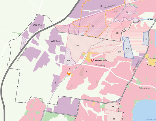
Figure 5 Extract from Central Lakes District Greater Warnervale precinct with location of site shown (Source CCRP 2041)
Table 3: Central Coast Regional Plan 2041 - Warnervale town centre urban design principles
|
Principle |
Applicable |
Assessment/Comment |
|
Principle 1 - Embrace the natural features of the site and embellish the public domain and open space network with additional greenery.
|
Yes |
The site has previously been identified as developable land and is bio certified land to be cleared for development purposes. Areas of higher environmental value in the southern precincts of the site have previously been retained. However, any future residential lands will be required to provide adequate public domain areas and connect to the identified network of open space via Hilltop Park. |
|
Principle 2 - Prioritise walking and cycling by considering site grade, desire lines and through site links to create a connected community that exemplifies the 15-minute neighbourhood.
|
Yes |
The proposed residential zoned land can be designed to complement the approved road hierarchy of the southern precincts and earlier stages of the development. This can include pedestrian and cycle networks giving connection and movement throughout the Warnervale centre. |
|
Principle 3 - Create an accessible, active and vibrant town centre that appeals to residents, visitors and investors by promoting fine grain built form and prioritising the pedestrian experience.
|
Yes |
As identified above, the future residential subdivision can be designed to promote active transport movements to connect with pedestrian networks through Hilltop Park and the street network through the local centre. The DCP Chapter for this locality will be amended to ensure these design principles are incorporated into future subdivision design. |
|
Principle 4 - Promote active and public transport options to decrease the dependence on private vehicles within and around the community for a safer and more activated precinct.
|
Yes |
The change to the zoning will promote medium and higher density residential outcomes in the locality and reducing car dependency by reducing car accommodation supply. This will be supplemented by good connection through the local centre and integration into the existing road hierarchy and movement networks established as active transport pathways. |
|
Principle 5 - Orient activity towards the street to help create safe and vibrant public areas. Provide a visual exchange between commercial, social and residential uses and the street.
|
Yes |
The future residential subdivision can be designed to promote positive public domain areas, particularly those adjacent to the new Hilltop local park. The residential zoning will provide clear objectives for a diverse housing supply along with best practice in design of increased density housing and with clear interaction with the public domain and open space areas. |
|
Principle 6 - Provide more mid rise living adjacent the town centre and open spaces for vibrancy and convenience, while also focusing development along key pedestrian routes.
|
Yes |
Housing diversity, including greater variety in medium density supply is promoted in the objectives of the zone. The changed direction of the local centre is mapped in the draft GWSP to identify a vision for greater densities surrounding the Hilltop Park and with interface with the adjoining employment lands. The DCP chapter will be updated to reflect this outcome and contains controls to reflect this principle. |
|
Principle 7 - Supply a mix of housing typologies including affordable housing for a diverse and well-rounded community.
|
Yes |
Housing diversity, including greater variety in medium density supply is promoted in the objectives of the zone. The applicable development standards for this site are unchanged to ensure maximum yield from the land. All forms of affordable housing are permissible within the residential zone. With increased diversity and proximity to services this location is well suited to affordable housing development. |
|
Principle 8 - Establish a robust structure plan which can adapt to market demand and investor interest through typology mix or density. |
Yes |
The Proposal responds to the draft Greater Warnervale Structure Plan that has been amended to reflect the local centre status for this location. The local centre will still provide everyday services and the location of Hilltop Park will facilitate the 15 minute neighbourhood connections to this centre. While the subject site is a small portion of land within the centre, it does provide important interface with the adjoining employment lands and Hilltop Park and so affords the opportunity for higher density and diversity to maximise the connection to these facilities. |
|
Principle 9 - Provide a staged approach to development that aims to reach the site’s maximum yield potential.
|
Yes |
The Proposal represents Stage 10 of the subject site land release and represents the final portion of the land to be utilised. While the majority of lands in the subject site have resulted in low density outcomes, with the modified zoning for this land with a clear direction for housing diversity and increased densities to interface with the employment lands and Hilltop Park, with changes to the GWSP and DCP to reflect these intentions clearly, it is anticipated that the resulting developments will more clearly align with this principle. |
4. Is the planning proposal consistent with local Council’s local strategy or other local strategic plan?
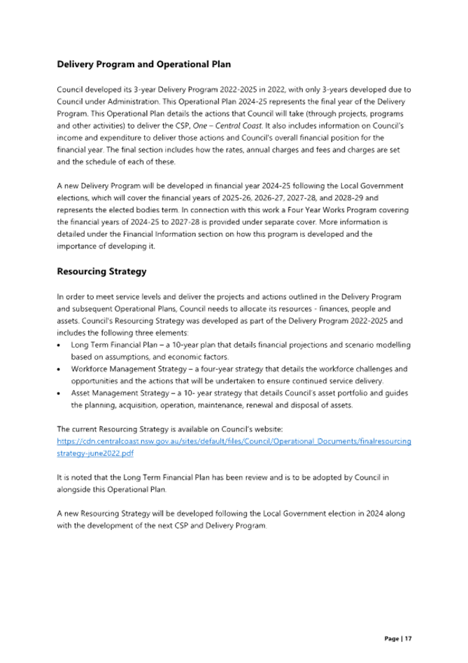
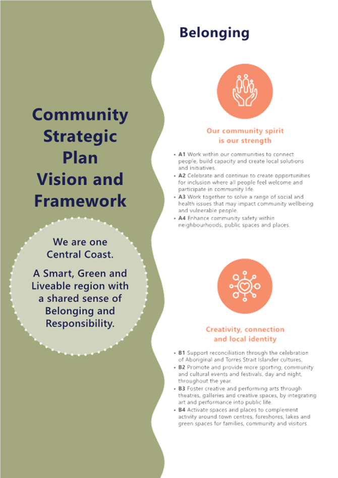
Community Strategic Plan
The proposal is consistent with the five themes of the Community Strategic Plan 2018 - 2028. An assessment of the proposal against the Community Strategic Plan is located in Table 4 below.
Table 4: Community Strategic Plan assessment
|
Objective/Requirement |
Comment |
|
|
SMART |
|
|
|
A GROWING AND COMPETITIVE REGION |
|
|
|
C1 |
Target economic development in growth areas and major centres and provide incentives to attract businesses to the Central Coast |
The residential zoning still allows for the supply of ‘everyday’ services and more readily aligns with the local centre scale of this precinct. |
|
C2 |
Revitalise Gosford City Centre, Gosford Waterfront and town centres as key destinations and attractors for businesses, local residents, visitors and tourists |
N/A |
|
C3 |
Facilitate economic development to increase local employment opportunities and provide a range of jobs for all residents |
Despite a reduction in commercial lands in this centre, the available lands are considered sufficient to service the local centre scale. |
|
C4 |
Promote and grow tourism that celebrates the natural and cultural assets of the Central Coast in a way that is accessible, sustainable and eco-friendly |
N/A |
|
CHERISHED AND PROTECTED NATURAL BEAUTY |
|
|
|
F1 |
Protect our rich environmental heritage by conserving beaches, waterways, bushland, wildlife corridors and inland areas and the diversity of local native species |
All vegetation on site has been bio certified for removal to enable development. |
|
F2 |
Promote greening and ensure the wellbeing of communities through the protection of local bushland, urban trees, tree canopies and expansion of the Coastal Open Space System (COSS) |
N/A |
|
F3 |
Improve enforcement for all types of environmental non-compliance including littering and illegal dumping and encourage excellence in industry practices to protect and enhance environmental health |
N/A |
|
F4 |
Address climate change and its impacts through collaborative strategic planning and responsible land management and consider targets and actions |
N/A |
|
RESPONSIBLE |
|
|
|
DELIVERING ESSENTIAL INFRASTRUCTURE |
|
|
|
H1 |
Solve road and drainage problem areas and partner with the State Government to improve road conditions across the region |
N/A |
|
H2 |
Improve pedestrian movement safety, speed and vehicle congestion around schools, town centres, neighbourhoods, and community facilities |
The local movement networks for the subject land are largely established by the existing development to the south of the Proposal lands. Notwithstanding, the future subdivision can be designed to accommodate active movement networks adjacent to Hilltop park and in connection to the commercial lands and road networks. |
|
H3 |
Create parking options and solutions that address the needs of residents, visitors and businesses whilst keeping in mind near future technologies including fully autonomous vehicles |
With higher densities mapped for these lands, a reduced reliance on car movements and greater accessibility to everyday services, this location will promote more active transport movements and less car dependency. |
|
H4 |
Plan for adequate and sustainable infrastructure to meet future demand for transport, energy, telecommunications and a secure supply of drinking water |
N/A |
|
BALANCED AND SUSTAINABLE DEVELOPMENT |
|
|
|
I1 |
Preserve local character and protect our drinking water catchments, heritage and rural areas by concentrating development along transport corridors and town centres east of the M1 |
N/A |
|
I2 |
Ensure all new developments are well planned with good access to public transport, green space and community facilities and support active transport |
The subject land is adjacent to the Sparks Road major arterial road connecting these precincts to the M1. The site is located with close proximity to the Warnervale rail station and is located within an established residential area. The subject land benefits from immediate access to the proposed Hilltop park and connecting passive transport movement networks. |
|
I3 |
Ensure land use planning and development is sustainable and environmentally sound and considers the importance of local habitat, green corridors, energy efficiency and stormwater management |
The Proposal benefits from proximity to established green corridors in the southern precincts of the subject lands. |
|
I4 |
Provide a range of housing options to meet the diverse and changing needs of the community including adequate affordable housing |
Proposed rezoning of the land for residential purposes with clear objectives for diversity and increased densities along with mapping identified in the GWSP to indicate this outcome will see delivery of variety in the housing mix and foster affordable housing options. |
|
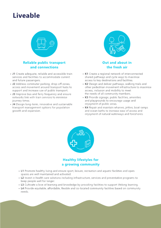
OUT AND ABOUT IN THE FRESH AIR |
|
|
|
K1 |
Create a regional network of interconnected shared pathways and cycle ways to maximise access to key destinations and facilities |
This can be facilitated as per of the future residential development of the site as connection through Hilltop Park and adjoining employment lands are developed. |
|
K2 |
Design and deliver pathways, walking trails and other pedestrian movement infrastructure to maximise access, inclusion and mobility to meet the needs of all community members |
Proposed rezoning of land for residential purposes will enable the connection throughout the WTC for passive movement networks. |
|
K3 |
Provide signage, public facilities, amenities and playgrounds to encourage usage and enjoyment of public areas |
N/A |
|
K4 |
Repair and maintain wharves, jetties, boat ramps and ocean baths to increase ease of access to and enjoyment of natural waterways and foreshores |
N/A |
Local Strategic Planning Statement - Interim
The interim Central Coast Local Strategic Planning Statement (LSPS) sets a clear vision for the future and a proactive framework for delivering a growing and sustainable Region with a strong network of Centres and thriving and connected communities. The LSPS is Council’s guide to how the Central Coast will respond to future population growth challenges in a manner that benefits our existing residents.
The following strategies and priorities outlined in the LSPS are applicable to this Planning Proposal and the proposal is consistent with these, or in the few cases where inconsistent, it is considered to be minor and justifiable.
Table 5: Local Strategic Planning Statement assessment
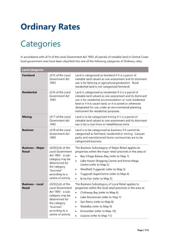
|
Strategies
|
Outcome |
Assessment/Comment |
|
1 Revitalise our centres
|
Seeks to bring activity and life into our existing centres. |
The subject land is located within the identified Warnervale local centre and will therefore support the identity of this centre. |
|
2 Renew urban form
|
Will improve the living environment for new and existing communities. |
The subject land is located within a local centre and by rezoning this land, will allow for greater diversity in the residential supply in this location. |
|
3 Define the urban edge |
Will define where urban development should stop and environmental protection starts. |
The planning proposal seeks to provide residential zoned land within an established residential local centre and is therefore consistent with this strategy.
|
|
4 Create a sustainable region |
A prepared and resilient region Council is actively adapting to climate change through infrastructure, construction, rehabilitation and land use planning. Council will provide a framework for an ongoing and holistic approach to emergency management across Council. Council will help to build the capacity of the community to prepare, respond and recover from the extreme weather events, and adapt to a changing climate. |
The planning proposal seeks to enable residential development in an established and serviced local centre.
|
|
One Direction for Growth |
Emerging Strategic Centre - Warnervale |
|
|
|
An Emerging Strategic Centre is identified as a future growth centre serving a growing subregional residential population. It aims to provide for a shopping mall, a public transport interchange, central civic spaces, library and community facilities. Our potential Strategic Centres will need to offer high-amenity settings for residential development and maintain their distinctive characters.
Warnervale
To create a vibrant, pleasant safe town centre with housing, jobs, services, community facilities and entertainment for residents and visitors. o To achieve a high standard of public domain and architectural design quality. o Integrate community facilities with the town centre. o Encourage the use of walking, cycling and buses. o Provide comfortable access grades throughout the town centre to ensure equity in accessibility. o Provide a built form in a treed setting and reflect the topography and environmental and visual features. o To facilitate urban development that achieves highest environmental sustainability objectives. o Protect and enhance riparian corridors, nature conservation areas, significant trees and local vegetation. |
The planning proposal seeks to enable residential development in an identified local centre that will provide for everyday/local services. The site represents a small but integral parcel of land that interfaces with both Hilltop Park and the employment lands. This land will form the transitional parcel of land between the employment lands and the public open space areas of the local centre and the adjoining residential land parcels. Though identified for greater density, the residential lands to the east of Hilltop Park have primarily been development for low density housing. With the amendments to the GWSP, and the rezoning of this land to facilitate a more transitional space for higher density outcomes than the single dwelling. This will be achieved through the zoning objectives, the development standards that retain height to enable mid rise outcomes, the changed direction of the local centre, the mapping within the GWSP, and updated DCP controls to reflect this outcome. The changes to the zoning reflect the changed scale of the local centre, while also facilitating transition to residential lands to the east that are currently under development, and future investigation areas to the north of the site. The residential rezoning of this land will embed the best practice objectives of the zone in the desired outcomes for this land, promote the urban design outcomes intended in the DCP for this location, and facilitate housing diversity that is needed for this location. The residential zoning doesn’t not amend the existing riparian corridors or high value environmental attributes of the southern portions of the subject site that were established in earlier stages of the development of this precinct.
|
|
Housing |
||
|
Provide well designed housing with high standards of sustainability features |
1. Provide well designed housing within our strategic centres; 2. Meet diverse housing needs of the community; and 3. Plan for future urban release areas. |
The planning proposal seeks to enable residential development in an established, serviced local centre that will enable housing diversity through varying lot arrangements, size and layout. The local centre scale of this precinct is reflected in the final Structure Plan for this precinct to be considered by Council. This Structure Plan amends the interim version of this local centre that was aligned with the future railway station vision for the centre and now focuses the local centre around the existing employment lands and Hilltop Park. The subject lands act as a transition place between these local centre functions and the surrounding residential lands.
|
|
Meet diverse housing needs of the community |
|
The R1 General Residential zone provides objectives and development standards that will direct diverse housing solutions. |
|
Plan for future urban release areas |
Diversity and choice of housing types and sizes to accommodate the growing community. Housing areas that are well connected to local jobs and social infrastructure will become desirable and competitive, pushing up housing densities to accommodate the market. Take up will be focused in the Centres with existing zoning capacity, helping them to become more vibrant and better serving to the surrounding communities. Our housing provision will have occurred in an equitable manner that ensures all communities remain connected to transport, services and employment. |
The R1 General Residential zone provides objectives and development standards that will direct diverse housing solutions. |
|
Economy |
||
|
Facilitate emerging Logistics, Warehousing, Manufacturing and Innovative Enterprises.
Build the Knowledge Economy and support the Health and Wellness Industries.
Grow Regionally Competitive Tourism Destinations across the entire Central Coast. |
|
Not directly relevant to the proposed rezoning for residential development, however the removal of the mixed use zone will not detract from the establishment of the local centre. |
|
Environment |
||
|
03 Define the urban edge |
Create Sustainable and Resilient communities |
Not directly relevant to the proposed rezoning for residential development as the land has previously been bio certified to enable clearing for development. The proposed supportive infrastructure (local roads) may generate further impacts, however these are on lands identified for road reserve and are discussed further by Council’s Senior Ecologist in Section C. |
|
Agriculture & Rural Lands |
|
|
|
01 Protect agricultural lands as an economic resource and for local sustainability 02 Minimise rural residential sprawl and support rural tourism |
|
The subject lands are not rural or productive agricultural lands. However by maximising capacity in existing residential lands identified for growth, this reinforces the protection of productive lands in the future. |
Draft Greater Warnervale Structure Plan
The draft Greater Warnervale Structure Plan (GWSP) identifies the long-term vision and principles that will guide land use planning in the area. The draft GWSP will be considered by Council in July 2024 for final adoption. It is intended to enable Greater Warnervale to grow in a sustainable way, by allowing for future growth to occur in a manner that does not compromise the attributes that make the area a desirable place to live.
The draft GWSP establishes a framework to guide the future growth of the study area from approximately 20,162 people to approximately 57,000 people over a 20-year period.
The proposed Warnervale Town Centre was designed to provide key services to the local population including commercial, civic and community services. This was developed alongside plans by Transport for NSW (TfNSW) to include a Northern Warnervale railway station to support the town centre. TfNSW has withdrawn plans for the future railway station and it has been recognised that this will significantly shift the priorities for the centre. Council has modified the approach to commercial and civic services delivery for Warnervale to enable two local centres to provide these functions across Warnervale rather than in a single centre. A second local centre will be provided in the Warnervale Village precinct that includes the existing railway station.
The subject site falls with the now local centre of Warnervale and the final GWSP has been amended to reflect this changed role and hierarchy of centres. Figure 6 identifies that the subject site falls within Precinct 4 – Warnervale Centre of the Structure Plan and the portion of land applicable to this Planning Proposal is identified for residential development.
![]()
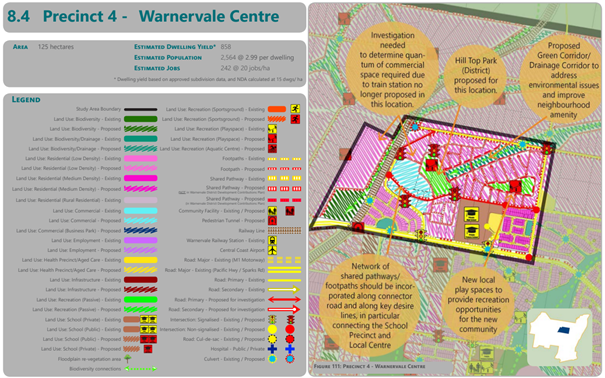
Figure 6 Extract from Draft Greater Warnervale Structure Plan (Source GWSP, 2022)
The Structure Plan recognises that the removal of the proposed railway station prompts a change to the high density residential and commercial development opportunities to the west of the subject land. Though as was originally intended by the draft GWSP, the final structure plan does identify a need for transitional residential and mixed uses for lands with a frontage to the park and immediate interface with the existing employment zoned lands. These can be achieved by the proposal under the R1 General Residential zone and offers a better opportunity to promote housing diversity and mix through the objectives of the zone. Similarly, heights have been retained as originally mapped in the LEP to ensure that those lands with an immediate interface with the employment lands and park will deliver high and medium density housing.
The draft GWSP recognises that future development of the local centre needs to be considered in response to the now local centre context and future proposals will fall outside of the masterplan included in Chapter 4.1 of the Central Coast Development Control Plan 2022 Chapter 4.1. The Planning Proposal does however require some modification to this Chapter and this will be undertaken in consultation with landowners in this precinct following the issue of the Gateway Determination.
The proposed rezoning is consistent with the draft Greater Warnervale Structure Plan, specifically with Precinct 4 Warnervale Centre.
Central Coast Development Control Plan Chapter 4.1 Warnervale Town Centre
At adoption, the DCP provided detailed provisions to expand upon the relevant provisions of the then in force Wyong Local Environmental Plan 1991 for development of the Warnervale Town Centre (WTC) Site. The WTC is located 5 km north of Wyong in the Central Coast Local Government Area. It straddles the northern regional rail corridor and is approximately 1km east of the Wyong Employment Zone. It is bound by Hiawatha, Hakone and Sparks Roads and east of Bruce Crescent.
The subject land is located within the Residential Northern Precinct (see Figure 7).
![]()
Figure 7 Extract from Chapter 4.1 CCDCP 2022 (Source CCC, 2022)
The key objectives of this Chapter of the DCP are:
• To create a vibrant, pleasant safe town centre with housing, jobs, services, community facilities and entertainment for residents and visitors.
• To achieve a high standard public domain and architectural design quality.
• Integrate community facilities with the town centre.
• Encourage the use of walking, cycling and buses.
• Provide comfortable access grades throughout the town centre to ensure equity in accessibility.
• Provide a built form in a treed setting and reflect the topography and environmental and visual features.
• To facilitate urban development that achieves highest environmental sustainability objectives.
• To provide a variety of housing types to cater for different household types and demographics, and improve affordability.
• Provide housing with a high standard of residential amenity.
• Promote recreation opportunities.
• Protect and enhance riparian corridors, nature conservation areas, significant trees and local vegetation.
As part of the assessment of the subject Proposal, Council recommends amending Chapter 4.1 of CCDCP 2022 to include the following;
· The change in direction from the State government regarding the railway station means that the town centre as master planned in the DCP no longer reflects the future strategic vision for the centre.
· Road and movement networks have been established by the DCP and emerging approved residential development. While the DCP road hierarchy and layout can generally be upheld by this Proposal it is noted that amendments to the overall road layouts have been made throughout the development of the centre as land release occurs. These have been warranted due to the topography and engineering circumstances of the land.
· The density and land use for precincts 6A and 7A do not reflect the scale of the local centre. Indicative discussions with the landowner for the employment lands to the west of the subject land indicate a commercial focus for large retail and small speciality shops in precincts 6b and the southern portions of 6a.
· Insert provisions for high and medium density development surrounding the Hilltop Park site and those with an interface with the employment lands.
5. Is the planning proposal consistent with applicable State Environmental Planning Policies?
The proposal has been considered against the relevant State Environmental Planning Policies (SEPP) as detailed below. The proposal is considered to be generally consistent/inconsistent with the applicable SEPPs.
Table 6: Assessment of Proposal against applicable SEPP’s
SEPP |
Applicable |
Consistent |
|
State Environmental Planning Policy (Biodiversity and Conservation) 2021. |
||
|
Chapter 2 – Vegetation in Non-Rural Areas |
Y |
Consistent with the provisions of this SEPP. The land is the benefit of bio certified lands and therefore does not require further consideration against the provisions of this Chapter. Notwithstanding the above, works within the road reserve (particularly Hakone Road) will be required in order to enable development of the land and therefore consideration of these potential works has been included. See comments from Council’s Ecologist in Section C. |
|
Chapter 3 – Koala habitat protection 2020 |
N |
|
|
Chapter 4 – Koala Habitat Protection 2021 |
Y |
Consistent with the provisions of this SEPP. The site is located within a local government area listed in Schedule 2 of this SEPP. The supporting FFA provides an assessment of koala habitat in accordance with Chapter 4 of this SEPP, while the land area exceeds 1ha the land does not have an approved koala plan of management and is not considered to support potential koala habitat, as defined. |
|
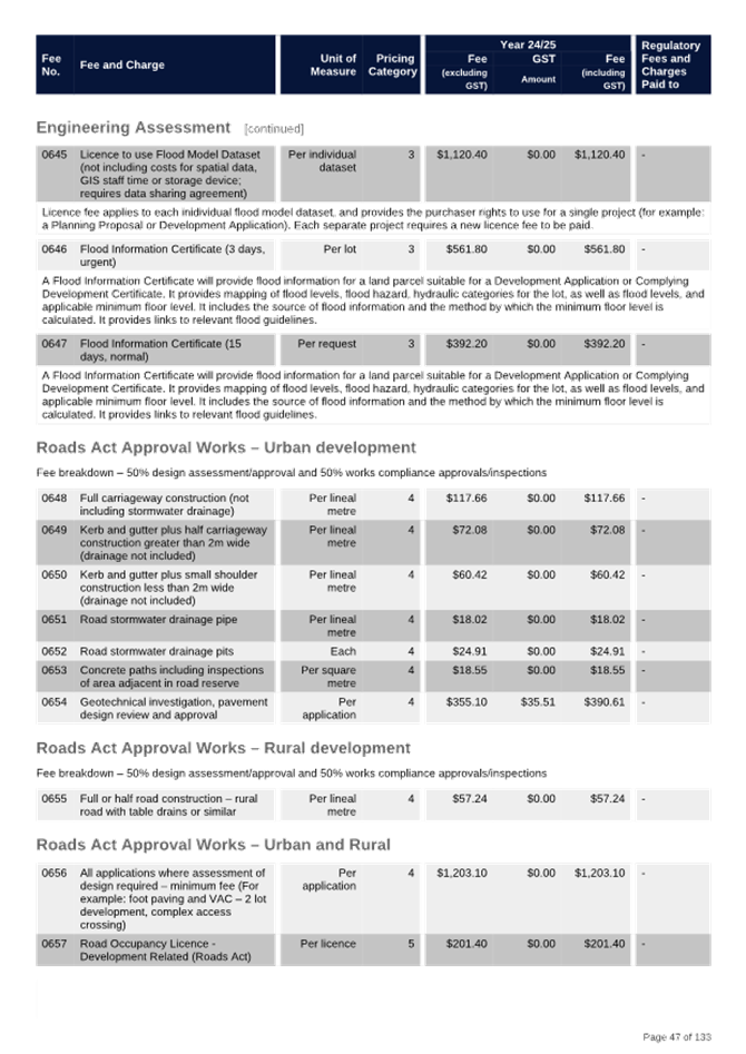
Chapter 5 – River Murray lands |
N |
|
|
Chapter 6 – Bushland in Urban Areas |
Y |
The subject land is located adjacent to RE1 zoned land known as Hilltop Park however this land is currently under construction and does not support any significant vegetation worthy of protection under the provisions of this Chapter (refer Figure 2). |
|
Chapter 7 – Canal Estate Development |
N |
|
|
Chapter 8 – Sydney drinking water catchment |
N |
|
|
Chapter 9 – Hawkesbury – Nepean River |
N |
|
|
Chapter 10 – Sydney Harbour Catchment |
N |
|
|
Chapter 11 – Georges Rivers Catchment |
N |
|
|
Chapter 12 – Willandra Lakes Region World Heritage Property |
N |
|
|
State Environmental Planning Policy (Housing) 2021 |
||
|
Chapter 2 – Affordable Housing |
N |
Not applicable to Planning Proposal however the future residential redevelopment of the land will enable development in accordance with the provisions of this Chapter. |
|
Chapter 3 – Diverse Housing |
N |
Not applicable to Planning Proposal however the future residential redevelopment of the land will enable development in accordance with the provisions of this Chapter. |
|
State Environmental Planning Policy (Industry and Employment) 2021. |
||
|
Chapter 3 – Advertising and Signage |
N |
|
|
State Environmental Planning Policy (Planning Systems) 2021 |
||
|
Chapter 2 – State and Regional Development |
N |
|
|
Chapter 3 – Aboriginal Land |
N |
|
|
State Environmental Planning Policy (Precincts—Regional) 2021 |
||
|
Chapter 5 – Gosford City Centre |
N |
|
|
State Environmental Planning Policy (Primary Production) 2021. |
||
|
Chapter 2 - Primary Production and Rural Development |
N |
|
|
Chapter 3 - Central Coast Plateau Areas |
N |
|
|
State Environmental Planning Policy (Resilience and Hazards) 2021. |
||
|
Chapter 2 - Coastal Management |
N |
Consistent with the provisions of this SEPP. |
|
Chapter 3 – Hazardous and Offensive Development |
N |
|
|
Chapter 4 - Remediation of Land |
Y |
Consistent with the provisions of this SEPP. The proposal is supported by a Site Audit undertaken by Ramboll on behalf of Council for the centre, along with additional audits conducted in 2024. This report concludes, Based on the information presented in the reviewed reports and observations made on site, and following the Decision-making process for assessing urban redevelopment sites in NSW EPA (2017) Guidelines for the NSW Site Auditor Scheme (3rd Edition), the Auditor concludes that the site is suitable for uses in accordance with the land zoning under Wyong Local Environment Plan 2013 including B2 Local Centre, B4 Mixed Use, E2 Environmental Conservation, E3 Environmental Management, R1 General Residential subject to compliance with the following EMP provided attached to the Site Audit Statement in Appendix B: • ‘Environmental Management Plan, Warnervale Town Centre, Management of Potential Contamination During Development’ dated 13 September 2021 by Ramboll Australia Pty Ltd. The EMP requires that the registered proprietor develop and implement a CEMP and UFP for future development works at the WTC that include bulk earthworks or major ground disturbance across the entire site and any future development works in the E2 Environmental Conservation and E3 Environmental Management zoned areas of the site. The EMP is enforceable via a public positive covenant on title under Section 88E of the Conveyancing Act 1919 and further by relevant future development consent conditions. Councils Environmental Health Officer has reviewed this report and provides additional comments in Section C. |
|
State Environmental Planning Policy (Resources and Energy) 2021. |
||
|
Chapter 2 – Mining, Petroleum Production and Extractive Industries |
N |
Consistent with the provisions of this SEPP. The site is not located in close proximity to any Mining, Petroleum Production and Extractive Industries, and is not mapped as being mineral or resource land or biophysical strategic agricultural land, or within any mapped critical industry cluster. |
|
Chapter 3 – Extractive Industries in Sydney Area |
Y |
Consistent with the provisions of this SEPP. |
|
State Environmental Planning Policy (Transport and Infrastructure) 2021 |
||
|
Chapter 2 – Infrastructure |
N |
|
|
Chapter 3 – Educational Establishments and Childcare Facilities |
N |
|
6. Is the planning proposal consistent with applicable Ministerial Directions (s.9.1 directions)?
The proposal has been considered against the relevant Ministerial Section 9.1 Directions as summarised below. The proposal is considered to be consistent with all relevant Ministerial Section 9.1 Directions.
Table 7: S9.1 Ministerial Direction Compliance
No. |
Direction |
Applicable |
Consistent |
|
Planning Systems |
|||
|
1.1 |
Implementation of Regional Plans |
Y |
Consistent - Consistency with the CCRP 2041 is outlined at the beginning of this document at Table 2. |
|
1.2 |
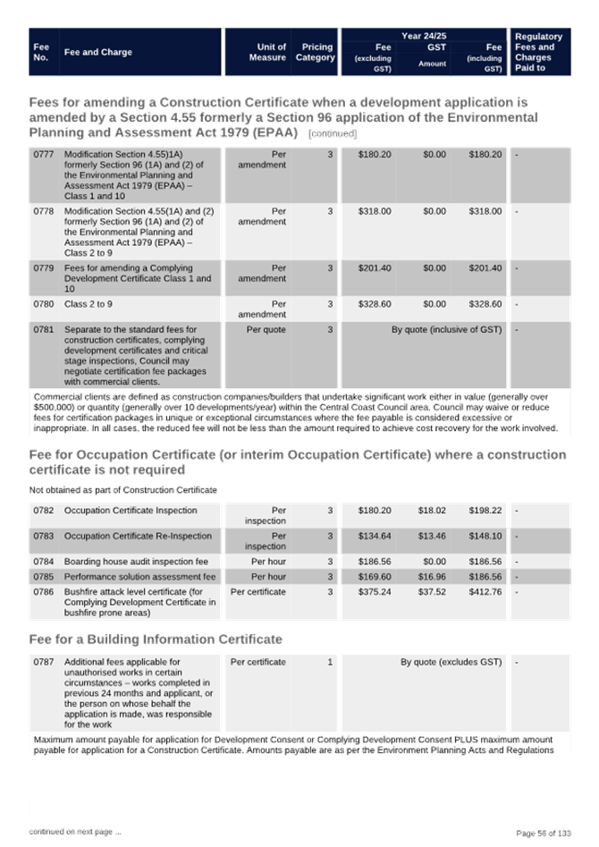
Development of Aboriginal Land Council Land |
N |
The subject land is not shown on the Land Application Map of State Environmental Planning Policy (Aboriginal Land) 2019. |
|
1.3 |
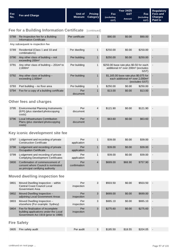
Approval and Referral Requirements |
Y |
Consistent - The proposal does not seek to include additional approval or referral requirements. |
|
1.4 |
Site Specific Provisions |
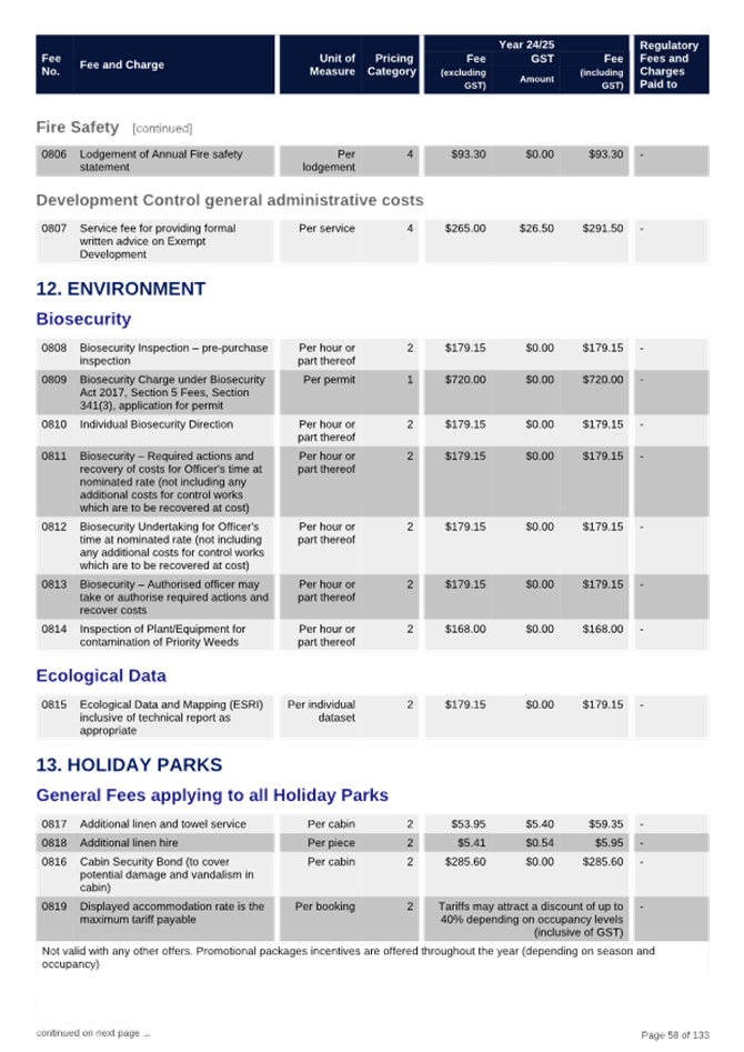
Y |
Consistent - The proposal does not seek to apply specific site-specific provisions through the LEP. |
|
Planning Systems – Place based |
|||
|
1.5 |
Parramatta Road Corridor Urban Transformation Strategy |
N |
This Direction does not apply to the Central Coast Local Government Area. |
|
1.6 |
Implementation of North West Priority Growth Area Land Use and Infrastructure Implementation Plan |
N |
This Direction does not apply to the Central Coast Local Government Area. |
|
1.7 |
Implementation of Greater Parramatta Priority Growth Area Interim Land Use and Infrastructure Implementation Plan |
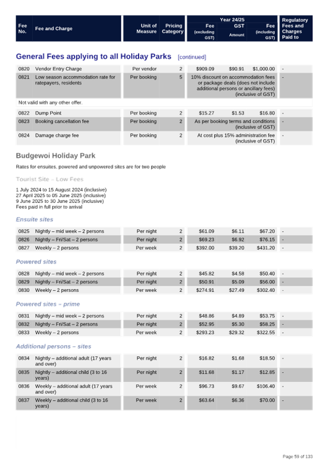
N |
This Direction does not apply to the Central Coast Local Government Area. |
|
1.8 |
Implementation of Wilton Priority Growth Area Interim Land Use and Infrastructure Implementation Plan |
N |
This Direction does not apply to the Central Coast Local Government Area. |
|
1.9 |
Implementation of Glenfield to Macarthur Urban Renewal Corridor |
N |
This Direction does not apply to the Central Coast Local Government Area. |
|
1.10 |
Implementation of Western Sydney Aerotropolis Interim Land Use and Infrastructure Implementation Plan |
N |
This Direction does not apply to the Central Coast Local Government Area. |
|
1.11 |
Implementation of Bayside West Precincts 2036 Plan |
N |
This Direction does not apply to the Central Coast Local Government Area. |
|
1.12 |
Implementation of Planning Principles for the Cooks Cove Precinct |
N |
This Direction does not apply to the Central Coast Local Government Area. |
|
1.13 |
Implementation of St Leonards and Crows Nest 2036 Plan |
N |
This Direction does not apply to the Central Coast Local Government Area. |
|
1.14 |
Implementation of Greater Macarthur 2040 |
N |
This Direction does not apply to the Central Coast Local Government Area. |
|
1.15 |
Implementation of the Pyrmont Peninsula Place Strategy |
N |
This Direction does not apply to the Central Coast Local Government Area. |
|
1.16 |
North West Rail Link Corridor Strategy |
N |
This Direction does not apply to the Central Coast Local Government Area. |
|
1.17 |
Implementation of Bayside West Place Strategy |
N |
This Direction does not apply to the Central Coast Local Government Area. |
|
1.18 |
Implementation of the Macquarie Park Innovation Precinct |
N |
This Direction does not apply to the Central Coast Local Government Area. |
|
1.19 |
Implementation of the Westmead Place Strategy |
N |
This Direction does not apply to the Central Coast Local Government Area. |
|
1.20 |
Implementation of Camellia-Rosehill Place Strategy |
N |
This Direction does not apply to the Central Coast Local Government Area. |
|
1.21 |
Implementation of South West Growth Area Structure Plan |
N |
This Direction does not apply to the Central Coast Local Government Area. |
|
1.22 |
Implementation of Cherrybrook Station Place Strategy |
N |
This Direction does not apply to the Central Coast Local Government Area. |
|
Design and Place |
|||
|
Biodiversity & Conservation |
|||
|
3.1 |
Conservation Zones |
Y |
Consistent: The subject site is bio certified and so doesn’t require further consideration for lands within the site boundaries. The road reserve in Hakone Road is outside the area of land benefitting from biocertification and so will require further consideration at the development application assessment pathway. The planning proposal has demonstrated that access to the subject land will initially be provided from within the existing subdivision. Notwithstanding, Councils Strategic Environmental Planner has reviewed the Flora & Fauna Assessment comments regarding this planning proposal, has conducted a site inspection, and supports the planning proposal in its current form. After review of the Flora and Fauna Assessment (FFA) by Evolve Ecology (19 May 2023) Councils Strategic Environmental Planner concludes the proposal does not trigger entry into the Biodiversity Offset Scheme. The FFA has identified that 588.97 m2 of native vegetation will require removal for the proposal. Likelihood of occurrence assessments identified potential foraging habitat may occur on the site for 19 threatened fauna species. Assessments of significance (5-part tests) were conducted for these species. The assessments concluded that the proposal was unlikely to have a significant impact on the majority of these species and the outcomes of the 5-part test are supported. |
|
3.2 |
Heritage Conservation |
Y |
Consistent: A Due Diligence Assessment was prepared by Ecological Australia and did not identify any Aboriginal sites within the subject site. Further Aboriginal Cultural Heritage Assessment may be required post Gateway Determination. |
|
3.3 |
Sydney Drinking Water Catchments |
N |
This Direction does not apply to the Central Coast Local Government Area. |
|
3.4 |
Application of E2 and E3 Zones and Environmental Overlays in Far North Coast LEPs |
N |
This Direction does not apply to the Central Coast Local Government Area. |
|
3.5 |
Recreational Vehicle Areas |
N |
This Direction does not apply to the Central Coast Local Government Area. |
|
3.6 |
Strategic Conservation Planning |
Y |
Consistent: The subject site is bio certified and so doesn’t require further consideration for lands within the site boundaries, however the road reserve requires assessment as it will support the future redevelopment of the land. Notwithstanding, Councils Strategic Environmental Planner has reviewed the Flora & Fauna Assessment comments regarding this planning proposal, has conducted a site inspection and supports the planning proposal in its current form. |
|
3.7 |
Public Bushland |
Y |
Consistent: The subject lands of the Proposal are not identified as public bushlands, however will adjoin Hilltop Park. Hilltop Park construction has commenced on the RE1 zoned land on the subject site and proposes clearing on the RE1 land. The proposed residential zoned land will rely on Hilltop Park as the public open space area for this residential area. |
|
3.8 |
Willandra Lakes Region |
N |
This Direction does not apply to the Central Coast Local Government Area. |
|
3.9 |
Sydney Harbour Foreshores and Waterways |
N |
This Direction does not apply to the Central Coast Local Government Area. |
|
3.10 |
Water Catchment Protection |
N |
This Direction does not apply to the subject land area. |
|
Resilience & Hazards |
|||
|
4.1 |
Flooding |
N |
The subject site is not located within flood prone land. |
|
4.2 |
Coastal Management |
N |
The subject site is not located within a coastal environment area. |
|
4.3 |
Planning for Bushfire Protection |
Y |
Consistent- The site is identified as Category 1 bushfire prone land and is supported by a Bushfire Assessment Report (BAR) (2022) prepared by BEMC, addressing the requirements of Planning for Bushfire Protection (RFS 2019). The proposal has been assessed for its compliance with the accepted solutions for bushfire protection measures, including the strategic considerations under Section 4.2 of Planning for Bushfire Protection. With the implementation of the combination of measures recommended in the assessment, the overall aims and objectives of Planning for Bushfire Protection (RFS 2019) can be achieved for the proposed development at development application stage. While the BAR indicates that the proposal relies on an APZ offsite, where this is not supported by NSW RFS an alternative staged scenario is proposed. Consultation with the RFS is required should a Gateway Determination be issued. |
|
4.4 |
Remediation of Contaminated Lands |
Y |
Consistent- As detailed in the assessment against SEPP (Resilience and Hazards) 2021 – Chapter 4 – Remediation of Land, the land has been the subject of an Audit Report, and further review undertaken of the Hilltop Park were undertaken in early 2024. Councils Environmental Health Officer has concluded the site can be suitable for the Proposal subject to the implementation of the recommendations. The recommendations are to be implemented at the DA stage. |
|
4.5 |
Acid Sulfate Soils |
N |
The subject site is not within Class 5 acid sulfate soils as it is more than 500m from Classes 1-4. |
|
4.6 |
Mine Subsidence & Unstable Land |
N |
The Planning Proposal site is not located within a Mine Subsidence District. |
|
Transport & Infrastructure |
|||
|
5.1 |
Integrating Land Use & Transport |
Y |
Consistent- The Proposal removes employment and mixed use zoned land and replaces it with residential land. This is in response to the changed direction with the WTC and TfNSW’s decision not to provide a train station in this centre. The Proposal is supported by a Traffic Impact Assessment report addressing the land use and transport strategy for this remaining Stage 10 of the overall development of the site. |
|
5.2 |
Reserving Land for Public Purposes |
N |
The subject site is not identified for acquisition for public purposes. |
|
5.3 |
Development Near Regulated Airports and Defence Airfields |
N |
The site is not located in the vicinity of a licensed aerodrome. |
|
5.4 |
Shooting Ranges |
N |
The proposal is not located in the vicinity of a shooting range. |
|
Housing |
|||
|
6.1 |
Residential Zones |
Y |
Consistent- The Proposal is for conversion of employment and mixed use zones to residential zoned land. The subject land is benefitted by established local infrastructure as part of the development of the local centre and will integrate into the emerging development pattern. The change to a residential zone will allow a greater focus on housing delivery and recognises the reduced need for employment and retail based land uses within this local scale centre. Notwithstanding this, the land use table permits these non-residential land uses within the zone where they serve the everyday needs of the community. By modifying the zone, the objectives of the R1 General Residential zone are adopted and these give clear direction for housing diversity, clear intention for enhanced delivery of medium density developments, and best practice tests for housing. As these lands represent the fringe of the local centre, it of a greater strategic merit to drive residential outcomes in this location than employment based land use activities in a local centre. There are no provisions in the Proposal to reduce the permissible residential density of the land. |
|
6.2 |
Caravan Parks and Manufactured Home Estates |
N |
Not applicable to Planning Proposal. |
|
Industry & Employment |
|||
|
7.1 |
Business & Industrial Zones |
Y |
Inconsistent – The Proposal intends the reduction of MU1 and E1 zoned land in this location and is therefore inconsistent with this direction. The R1 General Residential zone permits some employment based land uses, and these uses are more in line with the scale of the centre than currently allowed, and will still enable some delivery of these services in this location (i.e. neighbourhood shop, shop top housing etc). Notwithstanding this, the inconsistency can be supported as the proposed residential zoning is consistent with both the CCRP 2041 following the changed direction for the local centre and the draft Greater Warnervale Structure Plan that indicates this land for residential development. The Proposal gives consideration to the objectives of this direction in that it responds to the reduced scale of the local centre and does not encourage employment lands in an inappropriate location. Without the service function of the railway station, and with the development of commercial lands to the south west of the site, locating E1 and MU1 lands in the current position would be inappropriate to the connectivity of the commercial lands, the hierarchy of the centre, and the viability of those commercial lands proposed. The subject proposal is supported with a Retail Assessment that demonstrates that the demand for retail land uses in this location is not supported at the scale previously adopted. |
|
7.2 |
Reduction in non-hosted short-term rental accommodation period |
N |
Not applicable to Planning Proposal. Applies to Byron Shire Council. This Direction does not apply to the Central Coast LGA. |
|
7.3 |
Commercial and Retail Development along the Pacific Highway, North Coast |
N |
This Direction does not apply to the Central Coast Local Government Area. |
|
Resources & Energy |
|||
|
8.1 |
Mining, Petroleum Production and Extractive Industries |
N |
Consistent- The Planning Proposal does not propose to rezone land impacted by extractive industries. |
|
Primary Production |
|||
|
9.1 |
Rural Zones |
N |
Consistent- The Planning Proposal does not propose to rezone rural land. |
|
9.2 |
Rural Lands |
N |
Consistent- The Planning Proposal does not propose to rezone rural land. |
|
9.3 |
Oyster Aquaculture |
N |
The proposal does not affect land within a Priority Oyster Aquaculture Area. |
|
9.4 |
Farmland of State and Regional Significance on the NSW Far North Coast |
N |
This Direction does not apply to the Central Coast Local Government Area. |
Section C – Environmental, Social and Economic Impact
7. Is there any likelihood that critical habitat or threatened species, populations or ecological communities, or their habitats, will be adversely affected as a result of the proposal?
Council’s Environmental Strategies Section supports the planning proposal in its current form. While the subject lands are bio-certified, the full extent of the development footprint has been assessed and does not trigger entry into the Biodiversity Offset Scheme (BOS). The Proposal is supported by a Flora & Fauna Assessment that adequately addresses the potential impacts of the proposal.
8. Are there any other likely environmental effects as a result of the planning proposal and how are they proposed to be managed?
A Strategic Bushfire Assessment Report (BEMC 2022) has been submitted to support the proposal. The report shows that compliance with the provisions of Planning for Bushfire Protection (PBP) 2019 can be achieved when the land is developed for residential purposes. Consultation with NSW Rural Fire Service (RFS) will be required during or following a Gateway Determination.
Natural Resources
The site is not mapped as containing any significant resources.
Indigenous and Non-Indigenous Cultural Heritage Items
The site does not comprise heritage items and is not located near other heritage items or within an environmental heritage zone.
The AHIMS database did not identify any Aboriginal sites recorded near the subject site. A further Heritage Assessment can be required to be undertaken by the applicant post a Gateway Determination where required.
Contaminated Land
A Detailed Site Audit has been prepared to support this Proposal and includes subsequent reviews of the Audit conducted in 2024. Councils Environmental Health Officer reviewed these reports and concludes from a site contamination standpoint the site can be made suitable for the proposed residential use subject to further detailed assessment to be completed at the DA stage.
Acid Sulfate Soils
Under the CCLEP 2022 mapping the Proposal site is not mapped within an area subject to Acid Sulfate Soils.
Flooding and Drainage
The proposal is located outside of flood prone area and flood free access is provided to the site.
A Stormwater Management Plan would be prepared at the development application stage to address stormwater management and disposal from the site, in accordance with the requirements of Central Coast DCP 2022.
Social Issues
The proposal provides residential zoned land in combination with an established residential land release site. The land is a remnant stage in the land release and will be of a size and arrangement that can support housing in this local centre.
Economic Impacts
The local
economy will not be negatively impacted by the loss of the E1 and MU1 Zoned
land and the replacement of this land with residential zoned land is a more appropriate
outcome for this land given the changes in direction for the WTC.
Section D – State and Commonwealth Interests
9. Is there adequate public infrastructure for the planning proposal?
A Traffic Assessment has been prepared to support the proposal which has been reviewed by Councils Traffic Engineering Team, who have no objection to the planning proposal. A referral to Transport for NSW for any development requesting access from the Sparks Road would be required, however this is not the circumstances of this Proposal.
Services (Water, Sewer, Gas and Electricity)
Local services are available to the site and comments from Council’s Water and Sewer team are provided hereunder,
The proposed rezoning will rely on the water main extension from previous stage (Stage 9) development.
For sewer servicing, Council adopted a sewer servicing strategy and will require the lead developer to design and construct a Council sewer pump station and associated sewer rising main located at the north-west corner of property 262 Hakone Rd Woongarrah. It will be the applicant/proponent’s responsibility to obtain property owner’s consent to access and carry out relevant works at private property.
Alternatively, Council can consider the required proposed Council pump station to be located at the north-west corner of the subject property site. A statement government funding is currently available for the design and construction of this particular pump station. Subject to landowner’s consent, W&S Asset Delivery team can commence the project. Please note that the project will need to be completed within a certain timeframe in order to satisfy the funding requirement. Otherwise, the proponent/applicant will be responsible of the design and construct of a Council sewer pump station.
10. What are the views of State and Commonwealth public authorities consulted in accordance with the gateway determination?
Consultation with the following agencies is proposed, based on the identified triggers and site constraints:
Table 8: Agency Consultation
|
Agency |
|
Department of Planning and Environment – Biodiversity and Conservation Division |
|
NSW Rural Fire Service |
Pre Gateway consultation has occurred with the following agencies. Their comments are summarised below:-
Department of Planning & Environment (DPE)
A Pre-gateway Determination review was provided in August 2023 by the then Department of Planning & Environment in response to the lodged proposal. These comments are addressed in Table 4.
Table 9: Response to DPE Pre-Gateway Feedback
|
Comment
|
Assessment/Comment |
|
• The planning proposal will need to be amended and assess against the Central Coast Regional Plan 2041, please remove references to the repealed 2036 version. • The planning proposal will need to be an assessment against relevant strategies of the Central Coast Regional Plan 2041. Please see ‘how to use Part 2 Objectives’ on page 21 of the plan.
|
The Planning Proposal has been updated to reflect the CCRP 2041 principles and priorities.
Refer to Tables 2 and 3 for assessment of the applicable strategies. |
|
• The Department is prepared to assist Council and undertake consultation with Greater Cities Commission to help inform Councils Warnervale structure plan (which the Department is yet to endorse to allow this planning proposal to proceed). • The Commission will ultimately determine the centres hierarchy in the Central Coast City Plan, including confirming whether Warnervale will remain as an emerging strategic centre. This will effect it’s role/function and the types of uses/facilities envisioned for the centre (i.e. how much commercial land there is and what it permits). • Furthermore, the Commission is preparing job targets for the Central Coast. Understanding what the target is for Warnervale and whether this relies on existing zoned land will be important to understand as it may provide further justification for retaining existing commercial zoned land in Warnervale. |
The GWSP is tabled to be finalised at the July 2024 Council Meeting. This follows liaison with the then DPE team to finalise the strategies for the Warnervale local centres. |
|
Central Coast Regional Plan 2041 |
|
|
Strategy 3.2 Planning proposals that propose a residential, local centre or commercial centre zone will not prohibit the following land uses within urban core, general urban, inner suburban and general suburban contexts: b) business premises c) restaurants or cafes d) take-away food and drink premises e) neighbourhood shops and supermarkets f) educational establishments g) early education and care facilities h) health services facilities i) markets j) community facilities k) recreation areas |
To ensure consistency across the CCLEP standard instrument the land uses in the R1 General Residential zone prohibit business premises, restaurants or cafes, take-away food and drink premises, supermarkets, health services facilities, markets, and recreation areas. Though it is worth noting that some of these uses are permitted by other SEPPs and temporary use arrangements. The R1 zone in this location will permit shop top housing to enable non-residential land uses to be ancillary to the local centre, however Council has intentionally pushed all supermarkets and food and drink premises into the employment zones. This has been historically consistent across the LGA to protect the integrity of the centre hierarchy established across the LGA, to preserve market activity in established centres, and to minimise the impact of large scale developments like a supermarket on residential lands. Similarly, this protects viable residential lands for development for housing and residential purposes. The list of land uses identified in the R1 General Residential zone allows for smaller non-residential uses that might assist with the demand for ‘every day’ services that the 15min local centre cannot provide in the immediate centre, without compromising the integrity of the employment lands. |
|
Strategy 3.3 Planning proposals will incorporate: · a small neighbourhood centre if the proposed residential yield exceeds 1,500 dwellings or · a large neighbourhood centre if the proposed residential yield exceeds 4,000 dwellings. The neighbourhood centre will: · support a floor area informed by a local retail demand analysis have enough developable area to accommodate the uses over one level with at grade parking to reduce costs · be located to maximise its convenience for the vast majority of residents of which it serves · be located in a high profile location (i.e. main arterial road or precinct with strong pedestrian traffic) · be supported by a walkable catchment and pedestrian friendly environment. |
The proposal relies on the established local centre and the services and facilities to be provided in this location. The proposed residential lands will benefit from convenient location to the centre and in time, with the development of the local road and pedestrian movement network, provide a walkable catchment and pedestrian friendly environment. This is further enhanced by the location adjacent to Hilltop Park. |
|
Strategy 5.3 Planning proposals will not prohibit the following housing typologies within residential zones that apply to urban core, general urban, inner suburban and general suburban contexts: a) attached dwellings b) boarding houses c) dual occupancies d) group homes e) multi dwelling housing f) secondary dwellings g) semi-detached dwellings. |
These land uses are not prohibited in the R1 General Residential zone in the CCLEP. |
|
Strategy 6.4 Planning proposals must ensure the biodiversity network is protected within an appropriate conservation zone unless an alternate zone is justified following application of the avoid, minimise, offset hierarchy.
|
Lands have been set aside under the previous masterplan that contained biodiversity values. Biodiversity attributes contained within the road reserve have been assessed as part of this application and will be further addressed through the DA approval pathway. |
|
Strategy 6.5 Planning proposals should promote enterprises, housing and other uses that complement the biodiversity, scenic and water quality outcomes of biodiversity corridors. Particularly, where they can help safeguard and care for natural areas on privately owned land.
|
The subject proposal for R1 General Residential zoned land promotes housing diversity in this location. |
|
District Planning Priorities The planning proposal will also need to reflect the Central Lakes District Priorities Planning Priority 1 (Accelerate housing and employment growth in identified precincts) and Priority 3 (Retrofit suburban areas to enhance quality of life).
The site is identified as a ‘Residential Investigation Area’ in this district and is located on the Warnervale Significant Growth Area Map.
|
The subject site represents unconstrained land suitable for residential land uses with immediate proximity to public open space areas and the proposed local centre. |
|
Warnervale Regionally Significant Growth Area The planning proposal will need to demonstrate consistency with the Place strategy outcome ‘3. Town Centre Precinct’ as the subject site is identified in the Town Centre Precinct of Warnervale.
The planning proposal is also missing a detailed assessment against urban design principles listed in the ‘Warnervale regionally significant growth area’.
|
Table 3 provides this assessment. |
|
Other strategies and policies The planning proposal should also: - The subject site is also identified in Greenfield Housing Code Area and will need to demonstrate consistency with SEPP Exempt and Complying Development Codes. - Demonstrate consistency with local strategic documents: 1. Central Coast LSPS 2. Draft Greater Warnervale Structure Plan
The Departments comments reflect a conflicting assessment of the vision for the future centre in Warnervale.
|
The subject site falls outside the Greenfield Housing Code Area (see figure 8). Council does not intend to amend this mapping. However, where the development of the land is not permitted under the SEPP (E&CDC) until the subdivision is completed and essential infrastructure is provided. This ensures the protection of the land for high density development.
The Draft LSPS and GWSP have been addressed in earlier discussion. |
Figure 8 Extract from SEPP Exempt & Complying Development Code Mapping (Source Planning Portal, 2024)
Council undertook further discussions with the Department for the subject Proposal and in combination with the finalisation of the draft Greater Warnervale Structure Plan. The amended Proposal as lodged in April 2024 reflects the updated vision for the Greater Warnervale Structure Plan including the following priorities for the Warnervale Local Centre,
Further consultation will be required to determine whether the proposal demonstrates site-specific merit.
· Department of Planning and Environment – Biodiversity Conservation and Science Group regarding:
o Ministerial Direction 3.1 Conservation Zones
o Ministerial Direction 4.1 Flooding
o Chapter 4 – Koala Habitat Protection 2021 of the SEPP (Biodiversity and Conservation) 2021
· NSW Rural Fire Service regarding Ministerial Direction 4.3 Planning for Bushfire Protection
The Planning Proposal has been written in accordance with the advice provided by DPHI, including the specific updates discussed in the advice above. Refer to Table 8 above regarding the agencies proposed for consultation, based off the DPHI review.
Local Planning Panel
The Local Planning Panel (LPP) considered the matter on 6 June 2024. The LPP comments were:
In performing its role in relation to this matter, limited to the provision of advice only, the Panel notes and has no objection to the Planning Proposal proceeding subject to the following:
These comments have been addressed within this Planning Proposal.
Council’s
Strategic Assessment was updated prior to the Council Meeting to reflect the
advice provided by the LPP.
Part 4 Mapping
Table 10: Existing and Proposed Provisions
|
Map |
Map Title |
|
A. |
Locality Plan |
|
B. |
Aerial Photograph |
|
Proposed Provisions |
|
|
A. |
Zoning Map |
The Planning Proposal will be made available for community/agency consultation as specified in the Gateway Determination and will be undertaken in accordance with any determinations made by the Gateway.
![]() The planning Proposal will be required to be publicly exhibited
for 28 days.
The planning Proposal will be required to be publicly exhibited
for 28 days.
It is anticipated that the proposal will be made available on Council’s website
Additionally, notification of the exhibition of the proposal will be provided to adjoining landholders prior to commencement of the exhibition period.
Table 11: Key Project Timeframes
|
Action |
Period |
Start Date |
End Date |
|
Anticipated commencement date (date of Gateway Determination) |
1 month |
July 2024 |
October 2024 |
|
Timeframe for government agency consultation (pre and post exhibition as required by Gateway determination) |
2 months |
October 2024 |
December 2024 |
|
Commencement and completion dates for public exhibition |
28 days |
February 2025 |
March 2025 |
|
Timeframe for consideration of submissions |
1 month |
March 2025 |
April 2025 |
|
Timeframe for consideration of a proposal (by Council) |
2 months |
May 2025 |
July 2025 |
|
Date of submission to the Department to finalise LEP |
1 month |
July 2025 |
August 2025 |
|
Anticipated date RPA will make the plan (if delegated) |
14 days |
August 2025 |
September 2025 |
|
Anticipated date RPA will forward to the Department for notification |
7 days |
October 2025 |
October 2025 |
Map A - Locality Plan
Map B - Aerial Photograph
![]()

Draft LEP Mapping
Proposed Land Zoning Map
![]()
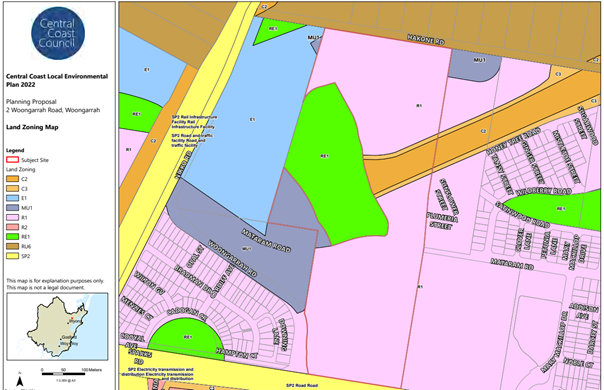
Appendix 3 – Supporting Documentation
Table 12: Supporting Documentation to the Planning Proposal
|
Attachment |
Document |
|
A. |
Flora and Fauna Report (Evolve Ecology 2023) |
|
B. |
Traffic Impact Assessment (Aus Wide Consulting 2022) |
|
C. |
Geotechnical Investigation Report (Douglas Partners 2022) |
|
D. |
Bushfire Assessment Report (Bushfire Environmental Management Consultancy 2022) |
|
E. |
Retail Need Assessment (IQ 2022) |
|
F. |
Aboriginal Heritage Due Diligence Report (Ecological Australia 2023) |
|
G. |
Site Audit Report (Ramboll 2021), Site Audit Statement NSW EPA (2021), Subsurface Landfill Gas Summary Report (Coffey, 2024) |
|
H. |
Crime Prevention Through Environmental Design Report (Beveridge Williams 2022) |
|
I. |
Planning Proposal (Beveridge Williams 2023)
|
|
Draft Water and Sewer Developer Servicing Plans - For Public Exhibition |
|
|
Attachment 2 |
Draft Southern Water Supply and Sewerage Development Servicing Plan 2024 |