 |
Central Coast
Local Planning Panel Meeting
Business Paper
22 August 2024
 |
|
Central Coast
Local Planning Panel Meeting
Business Paper
22 August 2024
|
The Local Planning Panel Meeting
of Central Coast
will be held remotely - online,
Thursday 22 August 2024 at 2.00 pm,
for the transaction of the business listed below:
1 Planning Reports
1.1 DA/1892/2021 - 15-35 Warnervale Rd & 95-10 Virginia Rd, 107-171 Virginia Rd Warnervale - Proposed Residential Subdivision (216) Lots.................................................................................... 3
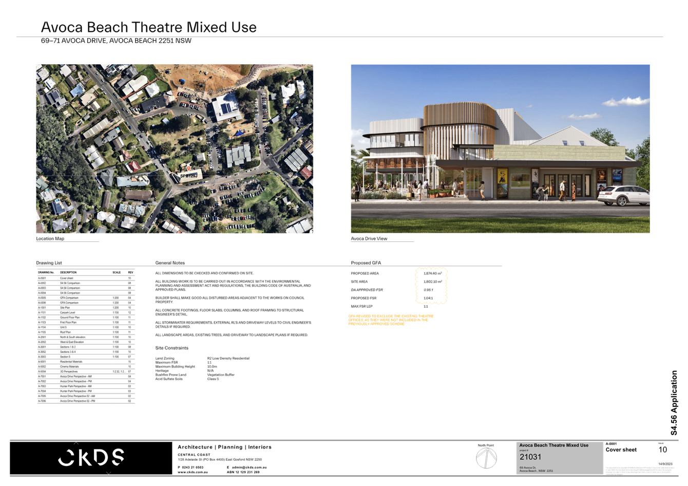
1.2 DA/42661/2012/E - 69-71 Avoca Drive, Avoca Beach - Alterations & Additions to existing Theatre....................................................................................................................................................................... 91
2 Planning Reports- Outside of Public Meeting
2.1 DA/2048/2023 - 22 Clairvoux Road Wamberal - Alterations and Additions (Existing Dwelling)..................................................................................................................................................................... 477
2.2 Supplementary Report - DA/1849/2005/B - 2-6 Fairport Avenue & 46-48 Ocean Parade, The Entrance - Residential Flat Building and Demolition of Existing Structures (Amended Application)..................................................................................................................................................................... 559
Jason Perica
Chairperson
|
Item No: 1.1 |
|
|
Title: DA/1892/2021 - 15-35 Warnervale Rd & 95-10 Virginia Rd, 107-171 Virginia Rd Warnervale - Proposed Residential Subdivision (216) Lots |
|
|
Department: Environment and Planning |
|
|
22 August 2024 Local Planning Panel Meeting |
|
Reference: DA/1892/2021 - D16158076
Author: Salli Pendergast, Principal Development Planner.Employment and Urban Release
Manager: Emily Goodworth, Section Manager Employment and Urban Release
Unit Manager: Andrew Roach, Unit Manager. Development Assessment
A development application has been received for a residential subdivision including 216 lots and associated works including earthworks, servicing, and roads infrastructure in stages, at 15-35 Warnervale Road & 95-105 Virginia Road, Warnervale. The application has been assessed having regard to the matters for consideration detailed in Section 4.15 of the Environmental Planning and Assessment Act 1979 and other statutory requirements.
The application includes works (being two stormwater quality basins being constructed) on Council owned land which necessitates the application to be forwarded to the Local Planning Panel (LPP) for determination under Schedule 2 of the Ministers Directions (dated 6 March 2024). Although the proposal has resulted in no submissions being received from notification of the DA, the development taking place on Council owned land has a capital value above $1 million.
The application is recommended for approval.
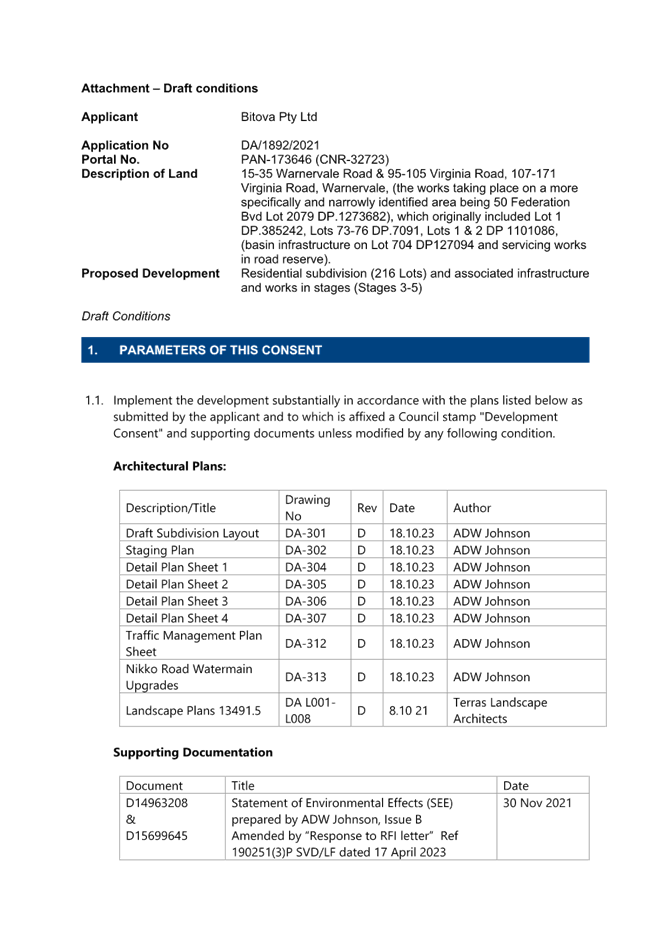
Applicant Bitova Pty Ltd
Owner Bitova Pty Ltd & Rathdrum Properties P/L
Central Coast Council
Application No DA/1892/2021
Portal No. PAN-173646 (CNR-32723)
Portal No. PAN-173646
Description of Land 15-35 Warnervale Road & 95-105 Virginia Road, 107-171 Virginia Road, Warnervale, (the works taking place on a more specifically and narrowly identified area being 50 Federation Bvd Lot 2079 DP.1273682), which originally included Lot 1 DP.385242, Lots 73-76 DP.7091, Lots 1 & 2 DP 1101086, (basin infrastructure on Lot 704 DP127094 and servicing works in road reserve).
Proposed Development Residential subdivision (216 Lots) and associated infrastructure and works in stages (Stages 3-5)
Site Area 35.57ha (Lot 2079 DP.1273682) 17.9Ha (residue lot 2193 including 9ha of C2 & C3)
Zoning R1 General Residential; R2 Low Density Residential; C3 (formerly E2) Environmental Management; C2 (formerly E3) Environmental Conservation; RE1 Public Recreation under Wyong LEP 2013
Existing Use Former vacant grazing land now subdivision under construction
Value of Works $19,120,000
1 The Panel grant consent to DA/1892/2021 at 15-35 Warnervale Road & 95-105 Virginia Road, 107-171 Virginia Road, Warnervale for a residential subdivision including 216 lots and associated works including earthworks, servicing and roads infrastructure in stages, subject to the conditions provided in the Attachment.
Key Issues
· The application seeks consent for residential subdivision including 216 lots and associated works including earthworks servicing and roads infrastructure in 5 stages.
· The proposal is the next stage in part of the progressive and ongoing subdivision and development of the site for residential purposes by AV Jennings Properties Limited.
· The progressive residential subdivision of the site has been the subject of a rezoning of a broader site known as Precinct 7A and the site is identified for residential development under the adopted North Wyong Structure Plan and is within an emerging growth area centre under the Central Coast Regional Plan 2041.
· The site is the subject of a Deed of Agreement which was established between Wyong Shire Council and the landowner (at the time) to change the zoning of various portions of the landowner’s land within the Precinct 7A study area, and to provide for certain land (referred to as the ‘Transfer Land’) to be transferred to Council for regional stormwater and conservation purposes. The transfer of most (but not all) of this land has only more recently occurred. The proposed water quality basins are to be located on recently transferred lands.
· The application is for integrated development requiring approval under for Section 100B of the Rural Fires Act 1997 for Bush Fire Safety Authority (BFSA) (related to a Special Fire Protection Purpose).
· The application is for integrated development requiring approval under S90 of the National Parks and Wildlife Act 1974 for an Aboriginal Heritage Impact Permit (AHIP) to harm Aboriginal objects.
Precis:
|
Proposed Development |
|
|
Permissibility and Zoning |
R1 General Residential; R2 Low Density Residential; C3 Environmental Management; C2 Environmental Conservation; RE1 Public Recreation under Wyong LEP 2013 |
|
Relevant Legislation |
Environmental Planning and Assessment Act 1979 Environmental Planning and Assessment Regulations 2000 State Environmental Planning Policy (Transport and Infrastructure) 2021 State Environmental Planning Policy (Planning Systems) 2021 State Environmental Planning Policy (Koala Habitat Protection) 2021 State Environmental Planning Policy (Resilience and Hazards) 2021 Wyong Local Environmental Plan 2013 |
|
Current Use |
Recently re-zoned land for residential development |
|
Integrated Development |
Section 100B of the Rural Fires Act 1997 (Special Fire Protection Purpose) for Bush Fire Safety Authority (BFSA). Section 90 of the National Parks and Wildlife Act 1974 for an Aboriginal Heritage Impact Permit (AHIP) to harm Aboriginal objects. |
|
Submissions |
No submissions |
Variations to Policies
|
4.1c – Lot size |
|
|
|
|
|
Standard |
Min 15m lot width at building line |
|
DCP |
Part 4 Subdivision |
|
Departure basis |
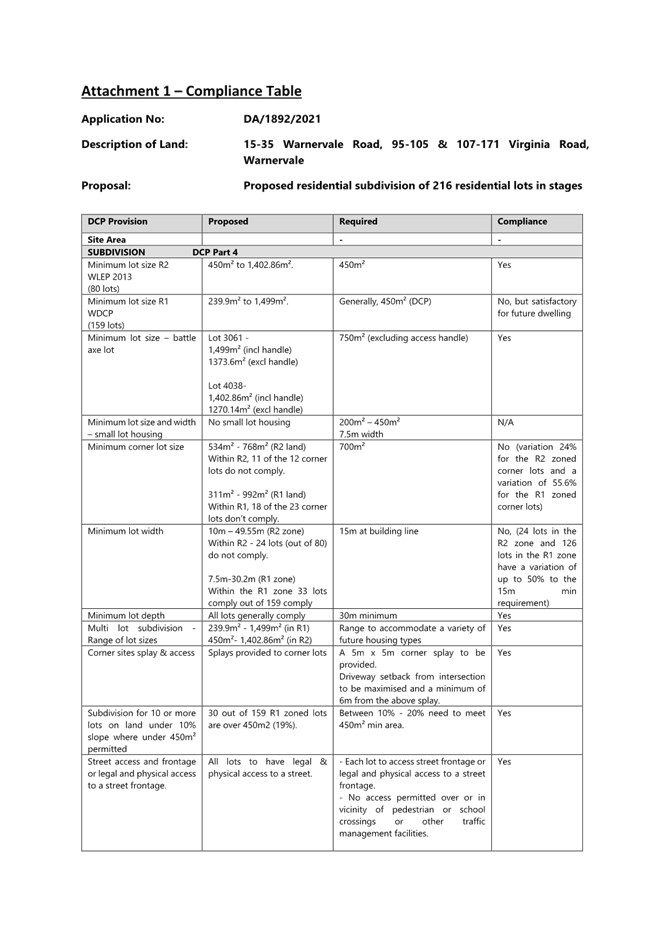
Lot width 10m – 49.55m (R2 zone) 24 lots out of 80 lots have a variation of up to 33% to the 15m min width requirement. Lot width 7.5m-30.2m (R1 zone) 126 lots out of 159 lots have a variation of up to 50% to the min 15m width requirement. |
|
Clause |
4.1.2 Corner Lots |
|
Standard |
Min area 700m² |
|
DCP |
Part 4 Subdivision |
|
Departure basis |
534m² - 768m² (R2 land) 11 of the 12 corner lots don’t comply with the minimum 700m2, with the greatest variation to the minimum corner lot size being 166m2 (24% variation). 311m²-992m² (R1 land) 18 of 23 corner lots don’t comply with the minimum 700m2 with the greatest variation to the minimum corner lot size being 389m2 (55.6% variation). |
|
Clause |
3.3c- Cut, Fill Earthworks |
|
Standard |
Boundary retaining walls max height 900mm and not extend for more than 2 lots |
|
DCP |
Part 4 Subdivision |
|
Departure basis |
Retaining walls between 0.5-2.5m but majority under 1m in height |
|
Clause |
4.1b Lot Size - other residential zones |
|
Standard |
Minimum lot size within other residential zones is generally 450m² |
|
DCP |
Part 4 Subdivision |
|
Departure basis |
R1 lots sized between 239.9m² to 1,499m² Up to a 47% variation to the lot size in R1 zone |
|
Clause |
3.4o – Street layout and Design |
|
Standard |
Residential street blocks no more than 80 metres deep & 160 metres long |
|
DCP |
Part 4 Subdivision |
|
Departure basis |
2 residential street blocks 205m & 265m length but under 80m depth. Non-traditional configuration (up to 66% variation) |
|
2.4 - Road layout and hierarchy |
|
|
Standard |
Road layout reflective of concept layout |
|
DCP |
Chapter 6.5 – Warnervale South |
|
Departure basis |
Non-numerical- minor change to road alignment and layout shown in DCP with deletion of laneways and road width details for collector roads (Warnervale Road) |
The proposed variations are discussed in further detail in the body of the report.
INTRODUCTION
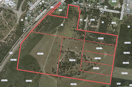
The Site
The site is located on the southern side of Warnervale Road, approximately 150m east of Warnervale railway station. The subdivision is proposed over residue Lots 2206-2208 approved under DA/129/2019 in Lot 1 DP385242, Lots 1-2 DP1101086 and Lots 73-76 DP7091 at 15-35 Warnervale Road and 95 – 171 Virginia Road, Warnervale. Access to the proposed lots will be provided from local roads approved under both DA/561/2017 and DA/129/2019. The earlier approved residential subdivision is currently under construction on the site.
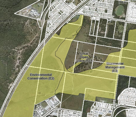
The site is identified as bushfire prone land, is partly flood affected, and a watercourse extends to the west of the new lots. Located to the west and south-west of the site is an identified coastal wetland and the site contains coastal wetlands buffer areas. The site is also identified as Acid Sulphate Soils Class 3 & 5. The area for the proposed is predominantly cleared of any significant vegetation other than scattered trees.
The site is located within Precinct 7A and the Warnervale South Urban Release Area. The site is contained by floodplain lands to the east, south and west, and construction (of earlier approved residential subdivisions) to the north. Additionally, the site includes recently acquired Council owned land zoned C3 under an earlier deed of agreement and Land Transfer Agreement. The works also involve a small part of Virginia Road and servicing works along Warnervale Road and Nikko Road.
Above: Aerial view of site and original lots
Above: Aerial view of Lot 2079 DP.1273682 containing the new subdivision lots
The site is within close proximity to primary and high schools, a railway station, Warnervale Airport, and the M1 Motorway is just over 3 km to the west. The railway line between Sydney and Newcastle extends along the western boundary of the site and the current Warnervale Station is located in the vicinity of the north-western corner of the site. A coastal wetland is located to the west and south-west of the site and a floodplain is located to the south, west and east. The site is located within the Warnervale South Urban Release Area.
The Proposed Development
The application seeks approval for a residential subdivision of the site into 216 residential lots in 5 stages and associated infrastructure and other works on the site. The proposal is the next stage in part of the progressive and ongoing subdivision and development of the site for residential purposes by AV Jennings Properties Limited.
The proposed works involves the creation of 216 residential lots and one future park lot.
Consent is also sought for bulk earthworks, benching and retaining, roads, connection to services, landscaping, sediment basins, and vegetation removal. The subdivision will be carried out in five stages (Stages 3A, 3B, 4A, 4B and 5) and will follow on following on from the five lots approved in Stage 1 under DA/561/2017; the 158 lots approved in Stages 2A and 2B approved under DA/129/2019; and the 37 lots also proposed in Stages 2C and 2D concurrently lodged under DA/1347/2021.
The works under the application include:
· Stage 3A - 23 lots (R1 zone)
· Stage 3B - 57 lots (R1 zone)
· Stage 4A - 67 lots (R2 zone) and part residue lot
· Stage 4B - 37 lots (R2 zone) and open space lot and part residue lot
· Stage 5 - 32 lots (R1 zone)
· Construction of associated road infrastructure and servicing for each stage.
· Construction of 1.5m wide footpaths along all roads.
· Construction of 2.5m shared paths along the bus route, perimeter road, park edge
road park and those connecting roads.
· Bulk earthworks including stockpiles and retaining walls, benching and/or retaining.
· Provision of underground water, sewer, stormwater, electrical and communication
servicing throughout.
· Removal of vegetation and provision of street tree planting.
· Proposed stormwater and water quality basins (within the C3 zone).
· Creation of various residue lots and part of the future park lot.
· Creation of any necessary easements.
· Intersection treatment for Warnervale Road.
· Water main connection along Warnervale Road and Nikko Road.
· Construction of a small section of existing unmade Virginia Road (C2 zone) to tie in with the road works approved to Virginia Road under the earlier stage.
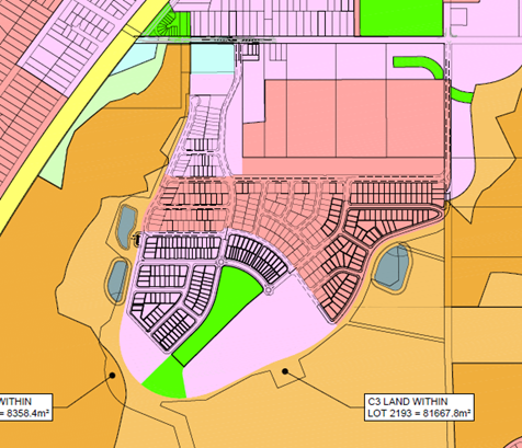
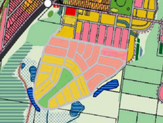
The proposed new 159 lots within the R1 zone, range in size between 239.9m² to 1,499m². The proposed new 80 lots within the R2 zone range in size from 450m² to 1,402.86m². The lots are generally regularly shaped and where they are irregular in shape, such lots have been suitably increased in size to accommodate a future dwelling. Under the subdivision there are two battle axe lots proposed, with one lot in the R1 zone (Lot 3061 with an area of 1499m²) and the other in the R2 zone (Lot 4038 with an area of 1402.86m²). All other lots have a variable street frontage of between 7.5m – 49.55m.
The subdivision also includes the creation of an RE1 zoned lot comprising (most, but not all) the future public park (2.26ha in area, which at completion will result in an area of approximately 2.939 hectares for the park). The subdivision also includes a residue C3 zoned lot and two proposed new wetland basins on Council land which will function as water quality basins for the upstream catchment.
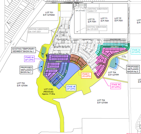
Above: Proposed subdivision layout
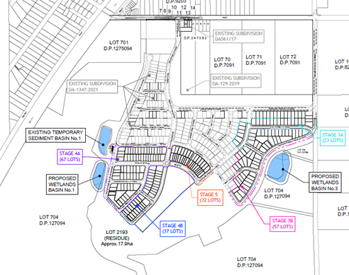
Above: Subdivision staging layout
History
The subject development was originally lodged as part of DA/561/2017 and DA/1002/2017 and proposed 216 lots in total (108 lots each). However, due to potential impacts on the squirrel glider, the applicant was advised that a Species Impact Statement was required. In September 2018 the applicant chose to amend DA/561/2017 proposing only six residential lots adjacent to Warnervale Road, in an area that would not impact the squirrel glider. DA/1002/2017 was withdrawn.
Recently DA/561/2017 has been further amended, and the number of approved lots was reduced from six to five. The development approved under this DA represents Stage 1.
· Development Consent No. DA/561/2017 was granted on 18 January 2019 for Subdivision Comprising 6 Residential Lots & 1 Residue Lot, Associated Roads & Earthworks at Lot 1 DP 385242, Lot 2 DP 247082, Lot 3 DP 247082, Lot 1 DP 385242 & Lots 1 to 3 DP 247082, 15-41 Warnervale Road Warnervale.
Above: Approved plan
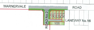
· Development Consent No. DA/129/2019 was granted on 3 July 2020 for Subdivision (158 Residential Lots, 1 Commercial Lot, 14 Residue Lots & Wildlife Corridor) at 1 - 13 & 15-35 Warnervale Road & 95 – 105 & 107-171 Virginia Road, Warnervale. This consent included residue lots (2206-2208) that are to be further subdivided under the current DA.
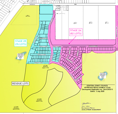
Above: Stamped approved subdivision layout plan for DA/129/2019
· Rezoning of the site under RZ/6/2016 Wyong LEP 12013 (Map Amendment No.1) was gazetted 17 September 2021 and included amendment to the ‘Land Zoning Map’ and ‘Lot Size Map’ that apply to the site with the following changes.
- Rezoning portions of the RE1 Public Recreation zoned land (referred to as the “RE1 land”) to residential (primarily R1);
- Rezoning portions of the RU6 Transition zoned land (referred to as the “Rose Farm”) to residential (R2);
- Allowing sub 450m2 lots; small scale multi-dwelling and residential flat buildings around the park and in the north by including additional R1 zoned land in these areas;
- Extending the current residential zone boundary which was determined based on high level flood modelling undertaken over 15 years ago which was refined through the findings of more site-specific flood modelling.
Above: Masterplan overlaid on previous zoning map.
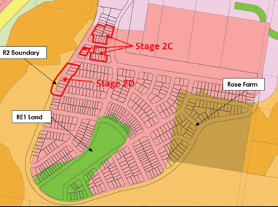
· Development Consent No. DA/1347/2021 was determined on 30 June 2021 for Residential subdivision (34 lots) in two stages (Stage 2C & 2D) and associated works at 15-35 Warnervale Road, and 107-171 Virginia Road Warnervale.
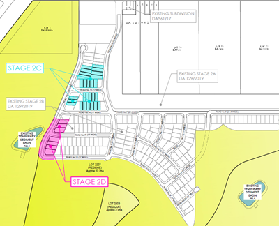
Above: Approved plan for DA/1347/2021
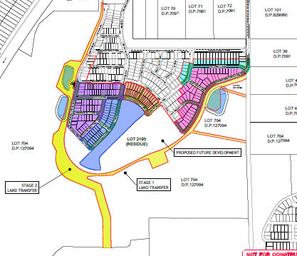
The current application represents the next stages (Stages 3 – 5) to the subdivision applications approved and under construction known as DA/561/2017 and DA/129/2019 (Stages 1 and 2). The lots involved in the subject DA have been approved under DA/129/2019 as residue lots.
Deed of Agreement/Land Transfer Agreement
In 2007 a Deed of Agreement was established between Wyong Shire Council and the landowner. This agreement established a process to amend Wyong Local Environmental Plan 1991 to change the zoning of various portions of the landowner’s land within the Precinct 7A study area, and to provide for certain land (referred to as the ‘Transfer Land’) to be transferred to Council for regional stormwater and conservation purposes.
Under the Deed, the transfer of the Transfer Land was supposed to occur once the rezoning had been finalized, however this was not carried out within the specified time frames. As such, a more recent Land Transfer Agreement was entered into and executed on 11 August 2022 to secure the transfer lands.
The Stage 1 transfer land has occurred, and the Stage 2 Transfer land is yet to be transferred.
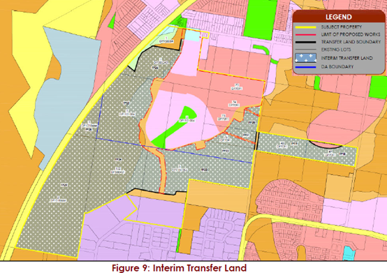
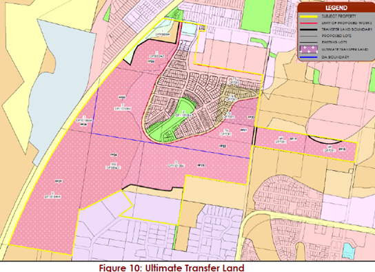
Above: Stage 2 transfer lands to occur
Land under the interim (Stage 1) and ultimate transfer lands (Stage 2) contains proposed basins as part of the public stormwater drainage system for the development of the site. The current proposal seeks to create these basins to cater for future water quality purposes. This is to ensure that stormwater discharged from the future residential development on the site (and any upstream development) will not adversely impact on the ecological integrity of the existing downstream wetland.
ASSESSMENT
Having regard for the matters for consideration detailed in Section 4.15 of the Environmental Planning and Assessment Act 1979 and other statutory requirements, Council’s policies and Section 10.7 Certificate details, the assessment has identified the following key issues, which are elaborated upon for Council’s information. Any tables relating to plans or policies are provided as an attachment.
Provisions of Relevant Instruments/Plans/Policies:
State Environmental Planning Policy (Resilience and Hazards) 2021
· Coastal Management
The provisions of State Environmental Planning Policy (Resilience and Hazards) 2021 (‘SEPP RH’) Chapter 2 (Coastal Management) have been considered in the assessment of the development application. The site is not located within the ‘coastal use area’ or within the ‘coastal environment area’ under the SEPP.
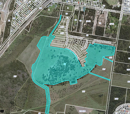
The broader site contains a mapped Coastal wetland and the ‘wetland buffer areas’ extend onto the specific site area (as shown below). However, there are no works proposed within the coastal wetland are and as such Section 2.7 (Development on certain land within coastal wetlands and littoral rainforest area) does not apply, and the proposed development is not designated development having regard for the provisions of s.2.7(2).
The proposal has been revised such that no development works or subdivision lots are occurring within the coastal wetlands buffer area and as such Section 2.8 (Development on land in proximity to coastal wetlands or littoral rainforest) does not apply. The Panel, as the consent authority, can be satisfied the provisions of Chapter 2 have been adequately considered.
![]()
Above: Site and coastal wetlands mapping and buffer
· Remediation of Land
The provisions of State Environmental Planning Policy (Resilience and Hazards) 2021 (‘SEPP RH’) Chapter 4 (Remediation of Land) have been considered in the assessment of the development application. Chapter 4 of the SEPP applies to the site and requires that contamination and remediation be considered in determining a development application.
Section 4.6 of SEPP RH requires that Council must not consent to the carrying out of any development on land unless it has considered whether the land is contaminated, and if contaminated, whether it is satisfied that the land is suitable in its contaminated state (or will be suitable, after remediation) for the purpose for which the development is proposed to be carried out.
The applicant has satisfied the requirements under Section 4.6 of the SEPP and the Managing Land Contamination guidelines, by following the set criteria for undertaking a “Preliminary Site Investigation” (PSI). The PSI accompanying this proposal was originally undertaken to support the rezoning of the land for the Precinct 7A Warnervale project, which is now identified in Councils DCP for Warnervale South.
The site is not identified under DCP Chapter 6.5 (Appendix B- Potential Site Contamination – Areas of concern). Potential contamination was assessed under the rezoning of the site and earlier application (DA/129/2019) for creation of the residue lots now to be subdivided and including associated bulk earthworks. The PSI identified that the lots associated with this proposal were not identified as containing any “Areas of Environmental Concern” (AEC) nor historic land use activities that would trigger a detailed contamination assessment. Accordingly, the Panel can be satisfied the provisions of Section 4.6 have been considered and the land is suitable for the proposed residential subdivision.
State Environmental Planning Policy (Transport and Infrastructure) 2021
Section 2.97 – Development involving access via a level crossings.
Section 2.97 applies to development that involves a likely significant increase in the total number of vehicles or the number of trucks using a level crossing because of the development. There is an existing level crossing located approximately 130 metres west from the site along Warnervale Road and a propose 216 new residential lots on the site. There is, however, alternative construction access available along Warnervale Road to the east of the site which would avoid the use of the level crossing.
Under subsection (2), before determining a development application for development to which this section applies, the consent authority must give written notice of the application to the rail authority (which is Sydney Trains) for the rail corridor and take into consideration any response. In this instance, the DA has been referred to Sydney trains (under CNR 32723) for their concurrence. Sydney Trains (Transport for NSW) granted their concurrence to DA/1892/2021 subject to the imposition of three operational conditions. The Panel can be satisfied the provisions of s.2.97 have been met and concurrence has been obtained from Sydney Trains as per the requirements of s.2.97(3).
Section 2.100 – Impact of rail noise or vibration on non-rail development
Section 2.100(1) applies to development for ‘residential accommodation’ proposed on land in or adjacent to a rail corridor, and that the consent authority considers is likely to be adversely affected by rail noise or vibration. The broader original site adjoins the rail corridor; however, the works are more specifically located on a recently registered lot known as 50 Federation Boulevard (Lot 2079 DP.1273682).
Sub sections (2) & (3) state:
(2) Before determining a development application for development to which this section applies, the consent authority must take into consideration any guidelines that are issued by the Planning Secretary for the purposes of this section and published in the Gazette.
(3) If the development is for the purposes of residential accommodation, the consent authority must not grant consent to the development unless it is satisfied that appropriate measures will be taken to ensure that the following LAeq levels are not exceeded—
(a) in any bedroom in the residential accommodation—35 dB(A) at any time between 10.00 pm and 7.00 am,
(b) anywhere else in the residential accommodation (other than a garage, kitchen, bathroom or hallway)—40 dB(A) at any time.
The land (comprising the originally nominated site) is located adjacent to the rail corridor and consideration of potential noise and vibration has been considered. However, there is considerable distance between the new residential lots and the railway line of at least 350m, and these new lots are created on an existing residue lot that no longer has an adjoining boundary or interface with the rail corridor. Under the section, the consent authority must take into consideration any guidelines and must not grant consent unless it is satisfied that appropriate measures will be taken to ensure that certain decibel levels are not exceeded.
In accordance with subsection (2), the document titled ‘Development near rail corridors and busy roads – interim guidelines’ has been taken into consideration. A Noise and Vibration Impact Assessment report was prepared for the original rezoning of the site for residential purposes. Council’s relevant officer reviewed sampling data, methodology and findings of this acoustic assessment.
The predicted noise contour maps illustrate that this development proposal will not be adversely impacted by road and/or rail. The construction material used to build individual dwellings will also contribute to attenuating any excessive acoustic impacts.
· Section 2.122 – Traffic-generating development
The proposed development is identified as a ‘traffic generating development’ under Section 2.122 and Schedule 3 (column 1 & 2) of the SEPP as follows:
|
Subdivision of land |
200 or more allotments where the subdivision includes the opening of a public road (where the site has access to a road) |
In accordance with this section, the application was referred to Transport for NSW for comment and the comments received have been taken into consideration along with:
(ii) the accessibility of the site concerned, including—
(A) the efficiency of movement of people and freight to and from the site and the extent of multi-purpose trips, and
(B) the potential to minimise the need for travel by car and to maximise movement of freight in containers or bulk freight by rail, and
(iii) any potential traffic safety, road congestion or parking implications of the development.
TfNSW has reviewed the information provided and raises no objection or requirements for the proposed development. The development fronts Warnervale Road which is a local road and Council is the roads authority for this road and all other public roads in the area, in accordance with Section 7 of the Roads Act 1993.
A traffic report was prepared which identified the traffic generation and impacts of the proposal. Sidra modelling was carried out for the two closest intersections for the AM and PM peak periods which indicated that the intersections assessed currently operate at a satisfactory level of service of LOS A or better, with minimal delays and queueing in both the AM and PM peak periods. This indicates that these intersections have considerable spare capacity in each of the AM and PM peak periods. The report concluded that the traffic generation from the proposed development can be accommodated within the existing external road network. In order to fully comply with design and safety standards, intersection treatments have been presented to ensure safe access and egress from the development site.
The Panel can be satisfied TfNSW has been consulted and their comments considered in accordance with the provisions of s.2.122(4)(b)(i), and the accessibility of the site has been considered in accordance with s.2.122(4)(b)(ii).
Section 2.120 is not relevant to the proposal as although the development sensitive to road noise or vibration, the site does not have a frontage to a classified road. Traffic generation from the development of the site has been considered in the supporting traffic studies and traffic modelling for the planning of Precinct 7A. Therefore, Council has considered the cumulative effects of this and other proposed developments in the greater Warnervale area.
• Section 2.126 – Sewerage Systems and Section 2.161 – Water Supply Systems
The proposal includes works for water and sewer servicing and under the SEPP ‘sewage reticulation systems’ and ‘water reticulation systems’ are both permissible development with consent on any land under the following:
Section 2.126 (7) of the SEPP which states:
(7) In any other circumstances, development for the purpose of sewage reticulation systems may be carried out with consent on any land.
The proposed servicing of the site for sewer has been included in the application.
Section 2.161(1) of the SEPP states:
(1) Development for the purpose of water reticulation systems may be carried out by any person with consent on any land.
The proposed servicing of the site for water supply has been included in the application.
Section 2.138 – Stormwater Management Systems
The proposal includes stormwater works including the construction of water quality basins within land zoned now C3 Environmental Management. Section 2.138 of the SEPP states:
Development for the purpose of a stormwater management system may be carried out by any person with consent on any land.
The definition of stormwater management systems under the SEP is as follows:
stormwater management system means—
(a) works for the collection, detention, harvesting, distribution or discharge of stormwater (such as channels, aqueducts, pipes, drainage works, embankments, detention basins and pumping stations), and
(b) stormwater quality control systems (such as waste entrapment facilities, artificial wetlands, sediment ponds and riparian management), and
(c) stormwater reuse schemes.
The development has been designed in line with Council’s strategy for the Porters Creek wetland which involves a regional approach to stormwater treatment (quantity and quality) and which relies on the transfer of land under the Land Transfer Agreement.
State Environmental Planning Policy (Planning Systems) 2021
Under Schedule 6 of SEPP (Planning Systems) 2021, the trigger for regionally significant development includes the residential subdivision of land into more than 100 lots if the land is wholly or partly in a sensitive coastal location (i.e. being within 100m of land to which (former) SEPP 14 – Coastal Wetlands applies). The amended plans do not include the subdivision of any land within a sensitive coastal location. Additionally, the development works on Council land are not more than $5 million in capital investment value.
State Environmental Planning Policy (Koala Habitat Protection) 2021
SEPP (Koala Habitat Protection) 2021 applies to Central Coast LGA (under schedule 1) and the site contains koala use trees species listed in Schedule 2. A Koala Habitat Assessment Report has been included within the Biodiversity Development Assessment Report (BDAR) which identifies that the Study Area is greater than 1 ha and does not have an approved Koala Plan of Management. Potential Koala habitat within the site is fragmented and contains habitat constraints such as roads and local developments.
While offering some potentially suitable habitat, the site is within an unfavourable habitat matrix for Koalas with its proximity to highways and urban areas. The proposed development cannot avoid potential Koala habitat within the subject site, however, vegetation within the subject site is not functionally significant given its existing fragmentation and isolation from other areas of habitat. Notwithstanding, a corridor to the north of the site is being retained for connectivity from east to the west.
Pre-clearing and clearing protocols will be implemented as part of the development, to manage any potential impacts to fauna during works. Security fencing will be installed around active work areas during construction to prevent ingress of larger fauna. Compensation in the form of an ecosystem credit liability under the Biodiversity Offsets Scheme is proposed. The development is considered to have taken adequate steps to mitigate, avoid and compensate the impacts to Koala and Koala habitat.
The Panel can be satisfied that an assessment of whether the development is likely to have any impact on koalas and koala habitat has been carried out in accordance with s.11(2), and that the proposed development will have no impact on koalas or koala habitat (s.11(3)).
Central Coast Local Environmental Plan 2022
Central Coast Local Environmental Plan 2022 (CCLEP) was published 24 June 2022 and commenced on 1 August 2022 and has been considered in the assessment of the application. However, in accordance with the savings provisions, this application has been lodged (8 Dec 2021) prior to the commencement of the new Plan and as such the provisions of Wyong Local Environmental Plan 2013 (WLEP) continue to apply.
There is no change to the zoning of the site or significant change to other relevant statutory matters as they apply to the proposal under the CCLEP, that require specific discussion in relation to the proposal.
Wyong Local Environmental Plan 2013
Zoning and permissibility
The subject site at the time of lodgement of the DA (8 Dec 2021) was zoned R1 General Residential; R2 Low Density Residential; B1 Neighborhood Centre (now referred to as E1 Local Centre); RU6 Transition; RE1 Public Recreation; E3 (now referred to as C3) Environmental Management and E2 (now referred to as C2) Environmental Conservation under Wyong Local Environmental Plan 2013 (WLEP 2013).
The changes to the zone references to E1, C2 and C3 were a result of an amending order that did not change the zone substance but only the zone references (under Standard Instrument (Local Environmental Plans) Amendment (Land Use Zones) Order 2022). These zones will be referred to in the report as changed under the Amending order.
The specific parts of the site that are the subject of the residential subdivision lot creation (and associated roads and servicing infrastructure) are zoned R2 and R1. The land zoned C2 and C3 contains the temporary sediment basin, roads and servicing infrastructure being constructed on the site. The future public park is zoned RE1 and although no works are proposed in this area under this application, part of the lot comprising the future park is being created consistent with the RE1 zoning boundaries for the northern portion of the site.
The works for the creation of the residential lots take place within land zoned R2 Low Density Residential and R1 General Residential wherein subdivision for residential purposes, associated earthworks, retaining walls, services and roads are all permissible development with consent as part of the residential subdivision works.
Within the C3 zoned part, no subdivision lots are being created, however, two separate water quality basins are proposed to be constructed on the Council owned land (land subject to the Land Transfer Agreement). These works are permissible within the C3 zone as ‘environmental protection works’.
Apart from the construction of roads within the residentially zoned land, there are road works and essential services proposed within the Virginia Road (unmade road) road reserve zoned C2. Within the C2 zone ‘roads’ are permissible under WLEP 2013.
There is an existing temporary sediment basin (approved under an earlier consent) and sewer pump station plant located within the C3 zone and within this zone, ‘stormwater management systems’, ‘sewage reticulation systems’ and ‘water reticulation systems’ are permissible development pursuant to State Environmental Planning Policy (Transport and Infrastructure) 2021 (refer to that section in the report for relevant definitions).
The following definition under Section 6.2 of the Environmental Planning and Assessment Act 1979 is relevant to the proposal and reads:
Subdivision of land means the division of land into two or more parts that, after the division, would be obviously adapted for separate occupation, use or disposition.
Subdivision is permissible development in the relevant zones.
The following definitions under WLEP are relevant to the proposal and read:
road means a public road or a private road within the meaning of the Roads Act 1993, and includes a classified road.
earthworks means excavation or filling.
urban release area means the area of land identified as “Urban Release Area” on the Urban Release Area Map.
water reticulation system means a building or place used for the transport of water, including pipes, tunnels, canals, pumping stations, related electricity infrastructure and dosing facilities.
Note— Water reticulation systems are a type of water supply system—see the definition of that term in this Dictionary.
sewage reticulation system means a building or place used for the collection and transfer of sewage to a sewage treatment plant or water recycling facility for treatment, or transfer of the treated waste for use or disposal, including associated—
(a) pipelines and tunnels, and
(b) pumping stations, and
(c) dosing facilities, and
(d) odour control works, and
(e) sewage overflow structures, and
(f) vent stacks.
Note—
Sewage reticulation systems are a type of sewerage system—see the definition of that term in this Dictionary.
environmental protection works means works associated with the rehabilitation of land towards its natural state or any work to protect land from environmental degradation, and includes bush regeneration works, wetland protection works, erosion protection works, dune restoration works and the like, but does not include coastal protection works.
Above: WLEP 2013 zoning of the site and stages
In accordance with Clause 2.3 of WLEP, the proposal is consistent with the R1 and R2 zone objectives which read as follows:
R2 Low Density Residential zone objectives
· To provide for the housing needs of the community within a low-density residential environment.
· To enable other land uses that provides facilities or services to meet the day to day needs of residents.
· To maintain and enhance the residential amenity and character of the surrounding area.
· To provide a residential character commensurate with a low-density residential environment.
R1 General Density Residential zone objectives
• To provide for the housing needs of the community.
• To provide for a variety of housing types and densities.
• To enable other land uses that provides facilities or services to meet the day to day needs of residents.
• To promote “walkable” neighbourhoods.
• To ensure that development is compatible with the scale and character of the local area and complements the existing streetscape.
The proposal is compatible with the objectives of the above zones as the proposed residential subdivision provides a variety of lot sizes suitable for a variety of housing types for the community. The proposal will facilitate the creation of a walkable neighbourhood, will provide a suitable residential streetscape of a scale and character compatible with the respective R1 or R2 areas and the local area.
In accordance with Clause 2.3 of WLEP, the proposal is consistent with the C2 and C3 zone objectives which read as follows:
C2 Environmental Conservation zone objectives:
• To protect, manage and restore areas of high ecological, scientific, cultural, or aesthetic values.
• To prevent development that could destroy, damage, or otherwise have an adverse effect on those values.
• To protect endangered ecological communities, coastal wetlands, and littoral rainforests.
• To enable development of public works and environmental facilities if such development would not have a detrimental impact on ecological, scientific, cultural, or aesthetic values.
C3 Environmental Management zone objectives:
• To protect, manage and restore areas with special ecological, scientific, cultural, or aesthetic values.
• To provide for a limited range of development that does not have an adverse effect on those values.
The proposal is compatible with the objectives of the C2 and C3 zones as the works within these areas are confined to infrastructure and services and tree removal and impacts to vegetation within these zones is kept to a minimum to retain the natural, ecological, and aesthetic values of these areas.
In accordance with Clause 2.3 of WLEP, the proposal is consistent with the RE1 zone objectives which read as follows:
• To enable land to be used for public open space or recreational purposes.
• To provide a range of recreational settings and activities and compatible land uses.
• To protect and enhance the natural environment for recreational purposes.
• To provide linked open space for ecosystem continuity, public access, local community recreation and waterway protection.
• To provide space for integrated stormwater treatment devices for flow and water quality management.
• To enable ancillary development that complements land zoned for recreational purposes.
There are no works proposed under the DA for the area zoned RE1 but the lot (in part) for the future public park is to be created under this stage of the development and is generally consistent the RE1 zone boundaries.
Clause 2.6 Subdivision
The proposed subdivision of land within each zone is permissible with consent under Clause 2.6 of WLEP 2013.
Clause 4.1 Minimum subdivision lot size
Clause 4.1 of WLEP 2013 restricts the subdivision of land within certain zones to a minimum lot size as shown on the Lot Size Map. The minimum allotment size for the R2 zoned site under this clause is 450m². All proposed residential allotments that are located within the R2 meet the minimum site area of 450m². Under WLEP, there is no mapped minimum allotment size applying to the R1 zoned land or the RE1 zoned land.
In relation to the C2 and C3 zoned land, the minimum lot size which applies is 40 hectares. These C2 and C3 areas are the subject of the earlier deed of agreement and more recent Land Transfer Agreement 2022, and the final parcel created under the agreement will result in a lot size which exceeds with the minimum 40ha site area required under this clause for any new lot zoned C2 and C3.
Clause 5.1 - Relevant acquisition authority
Clause 5.1 identifies the relevant authority to acquire land reserved for certain public purposes. The broader site contains land which is to be acquired by Council for environmental conservation, stormwater management and local open space. The specific area where the new lots are being created is not within any area required for acquisition. However, the majority of the C2 and C3 zoned land is generally identified as being acquired by Council for environmental conservation and stormwater purposes. This land is subject to a Land Transfer Agreement between Council and the landowner which sets out the terms of its transfer.
Above: LEP Land Reservation Acquisition Map
Clause 5.10 Heritage conservation
Clause 5.10(4) requires the consent authority to consider the effects of a proposed development on the heritage significance of an item or area.
The site is not located within a heritage conservation area and does not contain any items of State Heritage. However, located in the vicinity of the site is Heritage Item No. I108 - Warnies Railway Café and General Store. The effect of the proposal on the significance of the heritage item has been considered in accordance with subclause (4) and it is concluded that the proposal will not result in any adverse effects or impacts to this heritage item.
Subclause (2)(f) requires consent be obtained for subdividing land- on which an Aboriginal object is located. The site is not an archaeological site or an Aboriginal place of heritage significance under subclause (7) or (8).
An Aboriginal Cultural Heritage Assessment Report (ACHAR) has been carried out over the site, which identified that Aboriginal objects/sites will be impacted by the development (consisting of isolated finds and artefact scatters). The ACHAR concludes that an Aboriginal Heritage Impact Permit (AHIP) will be required prior to construction commencing. An Aboriginal Cultural Heritage Management Plan (ACHMP) has been prepared which identifies how the site will be managed in terms of its impacts.
The application was referred to Heritage NSW as integrated development and to the Local Aboriginal Land Council’s (LALC’s) for comment as further discussed below.
Having regard for the above, the Panel can be satisfied that heritage has been adequately considered in accordance with the requirements of clause 5.10 of WLEP 2013.
Clause 5.21- Flood Planning
The broader site is partially flood affected mainly in the area west of the development site within the E2 zone area. The proposed lot and perimeter roads are outside of the 1% AEP flood extents. The land for these stages has been filled to ensure lots are above the flood planning level (1%AEP + 0.5m) to be flood free.
The development is deemed satisfactory with regard to the following considerations under Clause 5.21:
· the impact of the development on projected changes to flood behaviour as a result of climate change,
· the intended design and scale of buildings resulting from the development,
· whether the development incorporates measures to minimise the risk to life and ensure the safe evacuation of people in the event of a flood,
· the potential to modify, relocate or remove buildings resulting from development if the surrounding area is impacted by flooding or coastal erosion.
The two entry roads into the development will be above the flood planning level (1%
AEP + 500mm) providing a flood free access in the event of a flood. All allotments will be built above the FPL. Small portions of the site would be impacted by low hazard flood under a Probable Maximum Flood (PMF) scenario.
The development has been designed to ensure no risk to life will occur in the event of a flood, and that safe, flood free safe evacuation routes are provided if required. The rezoning preceding this DA investigated the flood impacts of the future development at length to arrive at an agreed footprint which was supported by DPIE, the Biodiversity Conservation Division and Council. The proposal will have minimal impact on the floodplain and will not present any unmanageable risk to life. Accordingly, the Panel can be satisfied the provisions of clause 5.21 have been adequately met.
Clause 6.1 Arrangements for designated State public infrastructure
Clause 6.1 requires that the consent authority must not grant development consent for the subdivision of land in an urban release area unless the Director-General has certified in writing to the consent authority that satisfactory arrangements have been made to contribute to the provision of designated State public infrastructure in relation to the land to be subdivided. The site is mapped under WLEP 2013 as Warnervale South Urban Release Area.
The NSW Department of Planning and Environment has issued a Secretary’s Certificate (SVPA2017/8485 dated 17.12.21) confirming that satisfactory arrangements have been made to contribute to the provision of designated state public infrastructure. The Department considers that satisfactory arrangements are in place to contribute to the provision of designated state public infrastructure, as there is an executed planning agreement over the land. As such, the Panel can be satisfied the provisions of clause 6.1 have been met.
Clause 6.2 Public utility infrastructure
Clause 6.2 states that consent must not be granted for development on land in an urban release area unless the Council is satisfied that any public utility infrastructure that is essential for the proposed development is available or that adequate arrangement have been made to make the infrastructure available when it is required. Plans have been assessed in relation to the future servicing of the new lots to be created and the proposal is considered satisfactory subject to fulfillment of recommended conditions.
The proposed development relies on the extension of all services under the earlier consents granted on the site, including water supply, electricity, telecommunications, and sewerage in accordance with the adopted servicing strategies. The Panel can be satisfied that adequate arrangements can be made to service the development and will be conditioned accordingly.
Clause 7.1 - Acid Sulfate Soils
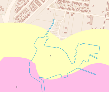
Clause 7.1 requires consideration to be given to certain development on land being subject to actual or potential acid sulphate soils. The site is identified on the Acid Sulphate Soils (ASS) Planning Map as both Class 3 and 5, however the area for the development works is identified as Class 5 with no works occurring within the Class 3 area which is a residue lot. Within Class 5 land, works within 500m of adjacent Class 1, 2, 3 or 4 land that is below 5 metres Australian Height Datum and by which the watertable is likely to be lowered below 1 metre Australian Height Datum on adjacent Class 1, 2, 3 or 4 land, requires the submission of an acid sulfate soils management plan.
A
preliminary Acid Sulphate Soils Assessment (prepared by Douglas Partners) was
provided as part of the Precinct 7A rezoning which concluded:
In summary, it is considered that acid sulphate soils are not generally present within site and
thus the soil could be excavated without the need to operate under an acid sulphate soil
management plan. Notwithstanding this, if soils different to those described in our test bore logs are encountered during excavation, then these soils should be segregated, and advice sought from DP.
The report did recommend as a precaution during construction in areas where excavation depths are expected to exceed approximately 2 m or where excavation is proposed within or immediately adjacent to watercourses (intermittent or permanent) that further assessment is recommended.
In accordance with Clause 7.1(4)(a) a preliminary assessment of the proposed works prepared in accordance with the Acid Sulfate Soils Manual indicates that an acid sulfate soils management plan is not required for the work. Accordingly, the Panel can be satisfied consent can be granted having regard for the findings of the preliminary ASS assessment.
Above: Acid Sulphate Soils Map
Clause 7.7 - Aircraft Operations
The proposal is consistent with Clause 7.7 - Airspace Operations. The site is identified on the Obstacle Limitation Surface map with a limitation or operation surface level across the site which range from 52.6m AHD to 107m AHD. However, finished site contours range from 8m AHD to 20m AHD which is well below the permitted range and future residential development will not penetrate the Obstacle Limitations Surface. The proposal is a suitable height so as not to affect airspace operations or penetrate the limitation or operation surface.
Clause 7.8 - Development in areas subject to aircraft noise
The subject site is not located within an ANEF contour of 20 or greater. Accordingly, this clause does not apply.
Clause 7.9 Essential Services
Clause 7.9 states that development consent must not be granted to a development application unless the consent authority is satisfied that the services that are essential for the development are available or that adequate arrangements have been made to make them available.
· Water and Sewer
The proposed development will be required to extend the Council water and sewer main from the previous stages. The proposed development will be required to upgrade the existing 100mm AC water main to the west of Warnervale Road and Nikko Road with 200mm PVC pipe. This will improve the water supply into the area. The proposed development will be required to adjust the sewer rising main to the high point and connect back into the new gravity sewer network. The “temporary’ section of rising main shall be made redundant. Water and sewer contributions will be applicable to the development.
The applicant will need to apply under section 305 of the Water Management Act 2000 for a section 306 letter of requirements regarding water and sewer specific connection requirements for the development. The 306 Notice of Requirements outlines the relevant contributions, required civil works and relevant connection requirements.
Water and Sewer Developer contributions will be required based on the number of new lots and will be outlined in the section 306 letter of requirements. Water and sewer credits may be available for construction of water or sewer mains required under the capital works program in association with the development.
· Other services
Arrangements can be made for the servicing of the new lots for electricity, the provision of vehicular access, waste management and collection and satisfactory storm water management subject to recommended conditions.
In accordance with Clause 7.9, the Panel can be satisfied the services essential for the development are available or that adequate arrangements can be made to make them available.
Central Coast Development Control Plan 2022 (CCDCP 2022)
The Central Coast Development Control Plan 2022 (CCDCP 2022) commenced on 1 August 2022. In accordance with the savings provisions under clause 1.1.4 of Chapter 1.1, this application has been lodged prior to the commencement of the new Plan and as such the provisions of the WDCP 2013 continue to apply.
Wyong Development Control Plan 2013 (DCP)
DCP Chapter 6.5 Warnervale South
DCP Chapter 6.5 applies to the site which is to be developed for the purposes of future residential subdivision.
· Open Space
Clause 2.3 requires open space to be provided as per Figure 3 in Chapter 6.5 as shown below.
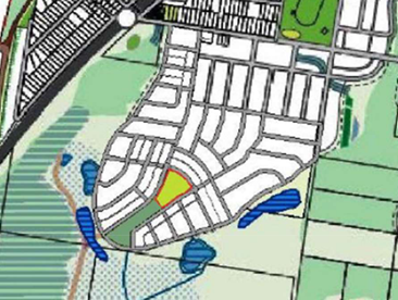
The DCP requires that residents of new subdivisions have access to (at a minimum) a formalised small neighbourhood park within 400m of their homes (Clause 2.3c). The broader proposed development includes a provision of a formalised public park and adjoining parkland. Delivery of the park will be undertaken at a later stage once council embellishment requirements are confirmed. All lots will be within 400m of either the current Nikko Road Park or the future neighbourhood park to be developed on the site. There is also floodplain, wetlands and restoration areas surrounding the residential lots.
· Road Layout and Hierarchy
Clause 2.4 and Figure 4 of the Chapter ‘Indicative Road Layout and Hierarchy’, shows the subject site with a perimeter road, local roads, park edge roads and bus route roads. The current proposal does not include all the future roads, however the roads that are included under this stage are generally consistent with the indicative road design and hierarchy included under the DCP.
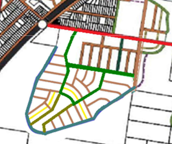
Above: Road layout as depicted in Chapter 6.5.
The proposed road widths generally comply with the DCP requirements (and are included in the table of compliance) except for the requirement for a collector road width for Warnervale Road. The proposal includes a new intersection to Warnervale Road with Federation Boulevarde and this intersection will be subject to a road safety audit and detailed design. A pavement width of 12m has been agreed upon for Warnervale Road and specific conditions have been recommended in this regard.
Additionally, there is a very minor variation related to the non-inclusion of laneways in the design that are shown on the indicative layout. The current layout also includes temporary roads until the next stages of the development occur to create the perimeter road. The indicative road layout for the internal roads is not practicably able to be achieved in its entirety on the site at this stage (as it is reliant upon future stages), but upon completion of the remaining stages, will generally achieve compliance.
The objectives for the road layout and hierarchy requirements under Clause 2.4 are as follows:
· To establish a hierarchy of streets which maximises convenience, amenity and safety for vehicles, pedestrians and cyclists.
· To provide a legible, connected and permeable grid of local streets that are sympathetic to the topography terminating with view to open space.
· To protect conservation areas through the appropriate location of roads, paths and developable area.
Despite the incomplete road layout included at this stage, the proposed subdivision including the minor variation, is considered consistent with the above objectives that apply to the road layout and hierarchy requirements under Clause 2.4.
· Pedestrian and cycleway routes
Because of the road layout proposed to date, parts of the shared pathway routes under Clause 2.5 of the DCP (shown below) will also need to be completed under subsequent future stages to achieve full compliance. In the interim, cycleways and shared paths have been provided throughout the development in accordance with the DCP requirements for the road layouts included under this stage. All park edge streets have the cycleway/footpath located on the park side of the road.
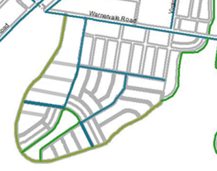
Above: Shared pathway routes as depicted in Chapter 6.5.
· Public Transport
Clause 2.6 requires that bus stops are to be provided along approved bus routes, no greater than 400 metres apart. Federation Boulevard; Road 3 adjoining the future park; and Songlark Avenue have been designed as a “bus route road”. The road design for the bus route includes compliant road widths of 21.5m (with 11.5m pavement, and compliant verge widths including a cycleway) The proposed bus route servicing the road network is consistent with the DCP requirements.
· Residential Subdivision
Clause 2.7b refers to density targets for residential subdivision (population targets). The clause has a dwelling density target 18 dwellings per hectare for R1 zoned land and a density target of 15 dwellings per hectare for land zoned R2 Low Density Residential. The proposal complies as it offers a mix of lot sizes and achieves a density of 15 dwellings per hectare for the R2 zoned land and density of 18 dwellings per hectare for the R1 zoned land.
· Noise Assessment and Mitigation
Clause 2.9 provides objectives relating to the minimisation of noise impacts on residential and other noise sensitive land uses. The site is 350m from the railway corridor and 550m south of Warnervale Road. In this regard, the site for development of residential lots does not directly adjoin Warnervale Road, Sparks Road, the Link Road, or the Railway.
A Noise and Vibration Assessment was prepared for the original rezoning of Precinct 7A but was deemed not necessary for the current stage of the development given the physical distance to the railway corridor and Warnervale Road potential noise sources. The development does not require any acoustic buffers or treatments as the site is not located adjacent to Sparks Road or the rail line.
· Water Cycle Management Requirements
Clause 2.10 aims to minimize the impacts of development on the Porters Creek Wetland and provide water quality and quantity control measures. Stormwater Management Plans accompanied the subdivision application and are generally consistent with the Integrated Water Cycle Management Strategy for Warnervale South. The centralized storage referred to in the DCP are not in place. A combination of rainwater tanks, GPTs and basins are proposed to protect this system from receiving waters.
Concerns were raised regarding the potential for degradation of the ecological values of the ecosystem downstream including the Porters Creek wetland. The floodplain and the nearby Porters Creek Wetland are key components of the local and regional water management system. If the development is not required to adequately control the quantity and quality of
stormwater leaving the site prior to operation of a future water quality solution (funded by contributions), degradation of downstream ecosystems is likely to occur in the interim because of the development.
The proposal was amended to include constructed wetlands in two locations on Council land for water quality purposes to achieve the objectives Clause 2.10 which include:
· To minimise the impacts of development on the Porters Creek Wetland and hydrologically sensitive ecosystems
· To provide water quality and quantity control measures that are cost effective and affordable, with consideration given to ongoing maintenance costs
· To be compatible with the broader Porters Creek IWCM scheme
· To safeguard the environment by improving the quality of stormwater run-off to achieve best practice standards
· To facilitate the inclusion of WSUD elements into development as an at source treatment of stormwater where possible whilst balancing with end of line water quality treatment devices in order to meet the required targets and satisfy the Regional Stormwater Harvesting Scheme
· To preserve the nature of overland flow into the adjacent habitat and Flood Plain
· To control the impacts of urban development on channel bed and bank erosion by controlling the magnitude and duration of sediment-transporting flows
· To limit changes in flow rate, flow duration and overland flow path areas within the floodplain as a result of development
· To limit erosion of watercourses, slopes and banks due to runoff from impervious areas within the development
· To maintain and improve water quality in receiving waters and groundwater systems
· To reduce flood risk in urban areas and downstream water bodies by adopting requirements for minor and major system flow in accordance with Australian Rainfall & Runoff
· To protect and restore aquatic and riparian ecosystems and habitats
· To protect the scenic, landscape and recreational values of streams and water bodies
The applicant has provided an amended Stormwater Management Report and MUSIC-link modelling report to support the application. Performance treatment targets of 85% (TSS), 65% (TP) and 45% (TN) specified in WDCP 2022 – Chapter 6.5 Warnervale South, have been satisfied through the water quality modelling. Satisfactory water quality and quantity measures will be adopted under the development during construction and for the ongoing residential occupation of the land.
· Floodplain Management
Clause 2.11 aims to ensure orderly development of the area regarding flood mitigation measures. The proposed subdivision design is considered consistent with the DCP and Council’s guidelines for flood prone land. The proposal has included design measure to address the potentially flood prone areas of the site. Filling within the floodplain for a small amount of land has been accepted through the Precinct 7A rezoning and associated flood modelling completed for this. The development has been designed with a perimeter road which separates the development from the floodplain and Porters Creek wetland. A Flood Impact Assessment has been provided in accordance with Chapter 3.3.
· Potential Site Contamination
Clause 2.12 requires that all development applications consider the potential for any existing site contamination impacting on future land uses. The Preliminary Contaminated Lands Assessment provided as part of the rezoning process for the Warnervale South area has identified sites where historic land uses have increased the potential for site contamination to be present and are likely to require management prior to changes in land use. The subject site is not indicated as an “Area of Concern” in Appendix B and further assessment of contamination is not required.
· Indigenous Heritage
Clause 2.13 requires a review of AHIMS to identify any known aboriginal sites that may be impacted by the development proposal. The DCP also requires that no development be undertaken or approved in the vicinity of identified sites before a Cultural Heritage Management Plan has been prepared by a suitably qualified person.
The proposal will require an Aboriginal Heritage Impact Permit (AHIP) under Section 90 of the National Parks and Wildlife Act 1974 due to the disturbance of known sites. The application was accompanied by an Aboriginal Cultural Heritage Management Plan; however, Heritage NSW have advised under their GTA’s that this plan will need revision as part of the AHIP assessment process.
· Ecological Issues
Clause 2.14 requires that all development satisfy any requirements that are identified in any ecological management plan or offset strategy applicable to the precinct. A BDAR was submitted for the proposal, and this is discussed further below.
DCP Part 4 – Subdivision
A table of compliance with the specific DCP requirements has been attached to the report. The proposal is considered generally consistent with the objectives and requirements of Part 4 of WDCP as outlined below, including the variations being sought as specifically discussed.
Clause 3 – General Design Principles
The proposed subdivision has been designed in accordance with the General Design Principles under Clause 3 of DCP Part 4 as follows.
· Satisfactory stormwater management arrangements are included as part of the proposal consistent with Clause 3.1.1 and potential flooding impacts have been suitably addressed.
· All services are proposed in accordance with the requirements of Clause 3.2. All services will be conditioned to be provided underground.
· The proposed subdivision is generally consistent with the street layout and design requirements identified under Clause 3.4. The street network provides interconnection and legibility. There are only 2 battle axe allotments proposed and no cul-de-sacs are proposed, and a new intersection is proposed to Warnervale Road.
· All lots will have legal and physical access to a street frontage. A range of lot sizes has been proposed consistent with the DCP.
· Footpaths and cycleways are provided throughout the development in accordance with Clause 3.5.
· Street trees are to be provided at a rate of one semi-advanced tree per 15m of frontage as shown on the landscape plans (consistent with Clauses 3.6a and b).
· Open Space is included as part of the development consistent with the applicable Contributions plan. The proposal includes part of the proposed Open Space along the ridgeline servicing the development. Each dwelling will be within 400m walking distance of public open space. No lots directly abut any public open space. The design includes the provision of cycleways around the perimeter of the open space area.
· Under Clause 3.8 there are aboriginal sites identified under the rezoning documentation and separate approval will be required under the NPW Act to disturb these scatter finds. This is discussed elsewhere in the report.
· Vegetation Management, Threatened Species and Urban interface Areas (UIA) under Clause 3.9 have been considered in the development design. A BDAR has been provided for the development and land surrounding the site is the subject of the Land Transfer Agreement, which transfers it into Council ownership. There are no proposed residential lots that directly contain or adjoin bushland or significant vegetation to be retained such that individual UIAs are applicable. However, the development has been designed with a perimeter road which separates the development from the floodplain and Porters Creek wetland. This road will accommodate APZs, a cycleway and native street trees in accordance with the UIA requirements.
· Community safety and security has been considered in the design, with preservation of sightlines and street design to limit speed, adequate lighting and lot frontage and footpath design to maximise safety and surveillance.
However, the proposal does include the following variations which are being sought to the controls under Clause 3 of Part 4 WDCP:
Residential Design Block length
The proposal includes two residential street blocks 205m and 265m in length which exceeds the requirement under Clause 3.4. Both blocks comply with the maximum depth with both being under 80m. The variation to length results in a 66% variation to the DCP control. In this regard, it is noted that more specific controls apply to the development under DCP Chapter 6.5. Despite the variation, the proposal remains consistent with the objectives outlined under Clause 3.4 as follows:
· To provide a legible hierarchy of streets according to the specific purpose and function of the streets
· To ensure street connectivity and legibility for pedestrians, cyclists and drivers
· To provide and promote an attractive and safe streetscape
· To control street design speed by geometry, traffic calming treatments, length, width and streetscape treatments
· To provide safe and effective access opportunities for pedestrians, cyclists and drivers
· To provide appropriate access for larger and special purpose vehicles including garbage trucks, emergency service vehicles, delivery vehicles and buses where appropriate
· To minimise through design the negative impact of high traffic volumes and vehicle speed throughout the subdivision
· To accommodate sufficient on street parking
· To avoid cul-de-sacs where possible, and
· To encourage the use of a grid pattern layout where possible
Notwithstanding the numerical non-compliance, the design of the development, including the variation being sought, is considered consistent with the objectives for the control and therefore satisfactory with regard to site topography, street legibility and hierarchy, subdivision street pattern, safety and access.
Retaining walls and earthworks
The subdivision includes earthworks and retaining walls to provide suitable development lots for future slab construction dwelling houses. The development includes individual lot benching. All retaining is proposed to be constructed of either sandstone logs or concrete and steel.
Clause 3.3a states:
Boundary retaining walls for cut or fill shall not exceed 900mm in height for residential zones and shall not extend for more than 2 lots.
The site is sloping and the inclusion of retaining walls throughout the development on most lots is necessary because of the type of future house construction and compliance with the DCP road layout and hierarchy. Bulk earthworks across the site will ensure that all lots have a slope of 10% or less. The retaining walls extend along the shared boundaries of most lots and whilst the majority of wall heights range around 1m or less, the proposed walls range from 0.5m to 2.5m.
The retaining walls are considered suitable for the site to facilitate the future residential development given the topography. All retaining walls within view of the street are to be designed and constructed using a high-quality decorative masonry product as required under subclause h.
The DCP objectives for the control under Clause 3.3 are as follows:
· To minimise earthworks in order to preserve, where practicable, the existing topography, drainage and catchment areas, trees, and amenity of the site
· To use construction methods which minimise site disturbance
· To protect the stability and amenity of adjoining lots
· To minimise cutting and filling on sites while recognising the need in some cases for the creation of large level areas
· To minimise cut and fill in order to encourage harmonious construction techniques for potential future development
· To ensure cut and fill requirements do not compromise development of a high standard
Despite the noncompliance, the proposed retaining walls are considered consistent with the objectives and satisfactory within the site context and with the likely future neighbourhood character.
Clause 4 – Residential Subdivision
Clause 4 of Part 4 of the WDCP provides requirements in relation to residential subdivision as follows:
· Lot size
The proposal includes lots ranging from 450m² to 1402m² within the R2 zone and lots ranging from 239.9m² to 1499m² within the R1 zone. There are also 2 battle axe lots as follows:
Lot 3061 - 1,499m² (incl handle) & 1373.6m² (excl handle)
Lot 4038- 1,402.86m² (incl handle) & 1270.14m² (excl handle)
In accordance with Clause 4.1a, all lots within the R2 zone comply with the minimum lot size of 450m² required under the DCP. The battle axe lots comply with the required minimum lot size of 750m² (excluding access handle) under Clause 4.1.4b.
However, a variation is sought to 136 lots (84%) within the R1 zone which are below 450m² in area. In this regard, Clause 4.1b states:
b The appropriate minimum lot size within other residential zones is generally considered to be 450m², however, will range according to the site characteristics, such as location, slope, drainage, vegetation, required setbacks, and the form of development proposed.
The proposal therefore seeks variation of up to 46.6% to the R1 DCP minimum lot size. It is noted that the DCP states that the minimum lot size if only ‘generally’ considered to be 450m² but dependent on site circumstances. In this regard, each undersized lot within the R1 zone is regularly shaped with a direct street frontage and with site attributes which suit a smaller sized lot layout. In this instance, the proposed lots within the R1 zone are appropriately sized given their location and the characteristics of the area for a more compact density of urban development.
· Lot width
The proposal seeks also variation to the minimum lot width under Clause 4.1c which reads:
c The minimum width of a lot is 15 metres, measured at the building line.
In relation to the R2 zone 24 (out of 80) lots within do not comply with the required minimum width of 15 metres measured at the building line. The lot widths are proposed between 10m-49.55m for the R2 zoned lots (up to a 33% variation to the DCP).
In relation to the R1 zone 33 out of 159 lots comply with required minimum width of 15 metres measured at the building line. The lot widths are proposed between 7.5m-30.2m within the R1 zone (up to a 50% variation to the DCP).
The variation to minimum lot widths is considered reasonable in this instance.
· Corner lots minimum area
The proposal seeks variation to Clause 4.1.2a which reads:
a Corner lots should have a minimum area of 700m2 for the purpose of providing adequate area for addressing dual streetscape impacts, privacy issues, setback implications and intersection sight lines. The larger area will also provide opportunities for subdividable corner lot Dual Occupancies.
There are 12 proposed corner lots within the R2 zoned land under the proposed subdivision each with an area of between 534m² to 768m² and 11 of the 12 corner lots do not comply with the minimum area of 700m². This is a variation of up to 24% for the R2 zoned corner lots.
Within the R1 zoned land 18 of 23 corner lots do not comply with the minimum area of 700m². The sizes of the corner lots within the R1 zoned land vary between 311m² -992m². This is a variation of up to 55.6% for the R1 zoned corner lots. Indicative house designs have been provided to demonstrate the suitability of these lots for residential development.
All the lots provide the required 5m x 5m corner splay and a driveway can be appropriately located on each site. There are no significant implications for sight distances. The under sized corner lots are regularly sized and are not located on a busy road but on a local road. The reduced corner size of the lot will not prejudice its future potential development for a dwelling which would achieve compliance with Council’s DCP controls particularly in relation to addressing potential streetscape impacts. The undersized corner lots are suitably shaped and positioned to permit satisfactory future development for residential purposes.
Lot size Objectives
Despite the variations proposed to the DCP, the proposal is considered to achieve the objectives under Clause 4 that apply to residential subdivision and the proposal is considered consistent with the objectives under Clause 4.1.
The objectives for all of the varied lot size controls under Clause 4.1 (Lot size) are:
Lots are to have sufficient area and take into account opportunities:
· To enable water and energy efficient design of buildings and services
· To encourage waste minimisation, collection and disposal
· To assist conservation of habitat for native fauna and flora
· To retain of significant natural features
· To ensure privacy and security of residents
· To preserve local character
Overall, each of the lots are suitably configured to accommodate a range and diversity of future housing types. The proposed lots despite their non- compliant width and area are suitably sized and configured to allow for energy efficient design, satisfactory waste storage and collection arrangements, privacy and amenity, security for future occupants and preservation of local character and streetscape. A future a dwelling that can achieve adequate amenity is able to be provided on each of the proposed lots created on the site.
Although variations are proposed to the DCP, the proposed lots are considered to be adequately configured to allow for future development in a manner that is consistent with the objectives under Clause 4.1. The variations are considered reasonable and recommended for support.
· Street Orientation and Lot Design for Solar Access
Clause 4.2 requires the lots to be designed to maximize their potential to receive solar access. Lots are to be of a shape and orientation which facilitates the design and construction of development to be energy efficient, attractive, and functional. The subdivision has been designed so that all streets are oriented to maximize solar access to the future dwellings and private open space.
· Urban Design
Clause 4.3 requires quality subdivision designs to ensure allotments promote attractive amenity and visual privacy. The subdivision design is required to be consistent with any established streetscape and the desired future character of the area. The proposed subdivision reflects a low-density residential lot layout, and the mix of lot sizes will promote a variety of low density housing outcomes as anticipated by the zoning.
The proposal has been assessed against the requirements of the DCP and the variations proposed are reasonable in the context of the site and proposal. Overall, the DCP variations proposed to the above design standards outlined under Wyong DCP Part 4 are considered satisfactory and reasonable in the site context and are supported. The development remains consistent with the objectives for the controls being varied. As outlined above a table of compliance is included with this report as an attachment.
DCP Chapter 3.1 Site Waste Management
Under Clause 2.1 of this Chapter, a Waste Management Plan (WMP) that complies with the requirements of Council’s Waste Control Guidelines needs to be prepared prior to issue of a Construction Certificate. In accordance with DCP Chapter 3.1, a condition is recommended for submission of a Waste Management Plan for the development outlining the waste disposal, re-use, and recycling (on and off site) for the construction and operational stages of the development.
Chapter 3.3 – Floodplain Management
As part of the development, it is proposed to fill some land that lies within the 1% Annual Exceedance Probability (AEP) flood extent. The land identified to be filled is consistent with that of the precinct 7A study. In accordance with the DCP, a flood impact assessment that included TUFLOW modelling to determine the impact of filling within the 1% AEP flood extent was provided. The proposed perimeter road is to ensure all lots and roads are flood free in all events up to and including the 1% AEP. Virginia Road to the east of the development site is to be raised above the 1% AEP level and sealed, with new culverts to convey the overland flow path.
The proposed development causes minor flood level increases, as a result of floodplain filling. These impacts are considered acceptable given impacts are in keeping with the Precinct 7A study outcomes, and the impacts are contained within conservation areas and offset by immediately adjacent decreases. There are negligible (less than 10mm) impacts in the wider floodplain showing that proposed filling of the development site is acceptable.
Chapter 3.10 - Wetlands Management
The proposal has been designed to include a clear delineation to the wetland areas including the construction of a perimeter road and cycleway (consistent with Clause 2.1b). No clearing is proposed in the wetlands, and downstream impacts are addressed through the provision of proposed water quality basins. The basins aim to ensure that the future development does not directly or indirectly impact adversely on the ecological values and integrity of the downstream Porters Creek Wetland. The purpose of the basins is to improve the quality of stormwater run-off from the development (in accordance with Clause 2.1.1 & 2.1.2).
d) Any planning agreement
No VPA relates to this DA other than that which has been entered into with the Minister for the satisfactory arrangements. There is a Deed of Agreement and new Land Transfer Agreement that was entered into, separate and distinct from this application.
e) Relevant Regulations
Environmental Planning and Assessment Regulations 2000 (Regs)
The Environmental Planning and Assessment Regulations 2000 (Regs) applies to the application which was lodged on 8 Dec 2021 and therefore pre-dates the introduction of the Regulation 2021. The application has been assessed in accordance with the relevant clauses under these Regulation. The submission of the latest amended plans for the proposal were accepted in accordance with Clause 55 of EPA Regulation 2000.
There are no other matters requiring specific discussion in relation to the Regulation which was in place at the time.
Environmental Planning and Assessment Regulations 2021
The 2021 EP&A Regulation commenced on 1 March 2022. Transitional arrangements apply for certain provisions including this application. The 2000 Regulation continues to apply to a Development Application made but not finally determined before 1 March 2022. Notwithstanding this, the following section has been considered under the Regulation 2021 in relation to the DA.
• Council related Development Applications
Section 66A requires that Council related development applications must not be determined by the consent authority unless:
a) The council has adopted a conflict-of-interest policy, and
b) The council considers the policy in determining the application.
Central Coast Council’s Council Related Development Applications Conflict of Interest Protocol, Revision 1, was adopted by Council in 2023 in response to Section 66A of the Regulations.
The Protocol aims to manage potential conflicts of interest and increase transparency at all stages of the development process for council-related development. This application is considered under the Protocol as the site is Council owned land.
In accordance with the Protocol:
Appropriate and correct owners’ consent was obtained from Council in relation to the proposed development.
The application was notified for a period of 28 days with nil submissions received and given the minor works Council has no adopted management strategy for the application (under Section 30B of the Regs).
Likely Impacts of the Development:
Built Environment, Context and Setting
The subdivision layout includes regularly shaped lots that are generally in a north-south orientation. The orientation can afford the future dwelling development opportunity to establish a building footprint with useable open space and reasonable solar access, and a suitable streetscape presentation.
Roads, Access & Traffic
Construction of proposed stages 3-5 triggers an upgrade of the Federation Boulevard/ Warnervale Road intersection to a Chanellised Right Turn (CHR) treatment for eastbound traffic due to the increase in vehicle movements, and the proximity to the level crossing for Warnervale train station.
A detailed intersection design has been provided by the applicant. The design will be conditioned to be in accordance with Austroad design requirements. A road safety audit shall be undertaken of the intersection to identify any safety improvements.
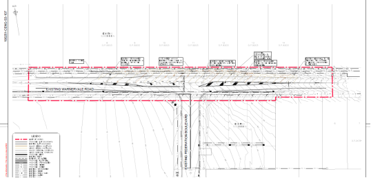
Above: Intersection design of Federation Boulevard and Warnervale Road
A vehicle swept path plan has been provided for the two proposed roundabout intersections of proposed Road 03 with Federation Boulevard, and Songlark Avenue for a 12.5m bus/heavy rigid vehicle. The wheel paths of the bus appear to conflict with the splitter islands on the approach/departure of the roundabouts. The proposed roundabouts shall be designed in accordance with Council’s Civil Works design specification and current Austroads guidelines. Suitable alternative treatments such as raised thresholds may be required at the proposed four way intersections to accommodate the geometry required for buses (HRV) to negotiate.
Civil works (Road Reserve)
The development will necessitate the construction and provision of bulk earthworks and site regrading to provide the necessary civil infrastructure including full road construction formation including pavement, footpaving/cycleways, longitudinal stormwater drainage works (incl. pit and pipe network) including two constructed stormwater wetlands, water and sewer servicing and associated retaining walls to provide benching of the sites.
The Federation Boulevard and Warnervale Road intersection will require upgrade works in accordance with the current Austroads Guidelines. The ultimate Warnervale Road profile shall provide for the following widths.
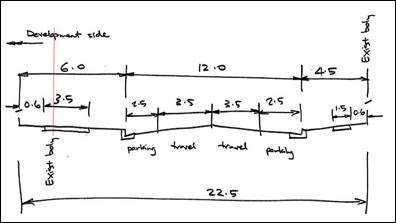
Warnervale Road shall provide a carriageway width of 12.0m kerb to kerb to accommodate bus route. The civil works to be delivered shall be in accordance with Council’s Civil Works Design Guidelines and Construction Specification 2022.
Flooding (Lake, Riverine & Overland)
The proposed lot and perimeter roads are outside of the 1% AEP flood extents. The land for Stage 3 & 4 has been filled to ensure lot are above the flood planning level (1%AEP + 0.5m) to be flood free.
Stormwater Runoff Management (Quantity & Quality)
The applicant is proposing the construction of two permanent constructed stormwater wetlands for the end of line treatment of stormwater runoff from Stages 3A and 3B (eastern wetland) and Stage 4A, 4B & 5 (western wetland). The western wetland discharges into a designated (SEPP14 now SEPP R&H) coastal wetland downstream (Porters Creek).
The applicant has provided an amended Stormwater Management Report and MUSIC-link modelling report to support the application. Performance treatment targets of 85% (TSS), 65% (TP) and 45% (TN) specified in CCDCP 2022 – Chapter 5.25 Warnervale South, Clause 5.25.2.10 have been satisfied through the water quality modelling.
Detailed design of the constructed wetland basin will be required to be undertaken in accordance with industry best guidelines. Suitable areas are to be provided for the ongoing future maintenance of the Gross Pollutant Traps (GPT’s – CDS units) and desilting of the inlet sedimentation basins.
The drainage pits discharging to the gross pollutant traps shall be splitter pit, which will enable the frequent/first flush flows to enter the GPT and wetland for treatment. High flows from larger events shall be directed to the high flow bypass channel.
Bulk Earthworks/excavation (Retaining/Benching)
The development involves significant bulk earthworks for the proposed regrade activities that are expected to occur to reach design levels. Filling is predominately associated with low-lying areas around the perimeter of the site in the east, south and west of the development, while cutting is generally associated with the central elevated portion of the site.
The applicant is proposing significant regrading/benching of the land to enable level building pad for dwelling construction. The majority of retaining walls are between 0.5 to 1.0m in height. However, there are a limited number of 1.5m -2.5m high retaining walls.
The extent of benching of the land is considered appropriate considering the advantage of being able to control the construction of retaining structures and services during the subdivision stage (rather than at a later stage). The large proportion of retaining walls are at or below 1.5m. All retaining walls and garden landscaping walls more than 1m in height are to be engineer designed.
The construction of the gravity sewer is expected to require a maximum depth of excavation in the order of 4.0m. The alignment is expected to intersect the north-south oriented ridgeline in the central portion of the site.
Neighbouring Properties
Standard dilapidation reports will be required to be prepared for the protection of Council civil assets in the road reserve.
Construction Issues
A traffic management plan (TMP) will be required to be prepared by a suitably qualified traffic engineering consultant, particularly for road intersection works within Warnervale Road.
Subdivision, Easements, 88B Requirements
Subdivision plans shall provide easements for rights of carriageway, easements for inter-allotment stormwater drainage where the lots don’t fall to the public street drainage system.
Traffic Impacts
A Traffic assessment report was prepared for the development which identified that the resulting subdivision would generate additional traffic in the order of approximately 3.1 vehicle movements per minute, on average, in the AM and PM peaks. This will not have a significant impact on the surrounding road network.
The potential cumulative impacts from the intensification of development in the Warnervale and Wadalba areas on various intersections in the vicinity of the subdivision has been considered in the Precinct 7A Traffic and Transport study (2012). The performance of existing and future network capacity within the Precinct 7A study area has been assessed.
Future years modelling was undertaken for 2021 and 2031 using land use data sourced from Council and included the cumulative growth from following planned developments including:
· Precinct 7A;
· Wyong Employment Zone (WEZ);
· Bruce Crescent;
· Warnervale Town Centre (WTC);
· The Lakes Anglican Grammar School;
· Precinct 14, and
· Wadalba Precinct
In this regard, the cumulative effects of this and other proposed developments in the greater Warnervale area has been considered. Traffic generation for the site that is subject to this development application was included in the study and the applicant will be required to pay a development contribution towards intersection upgrades in accordance with the adopted section 7.11 contributions plan.
Aboriginal heritage impacts
The proposal will involve ground disturbance in the form of bulk earthworks for the creation of infrastructure and levelled residential lots and will require an AHIP under Section 90 of the National Parks and Wildlife Act 1974 due to the disturbance of known sites. The AHIP must be obtained prior to commencement of any works for the development. If harm to an Aboriginal object or place cannot be avoided, an Aboriginal cultural heritage assessment report needs to be prepared in accordance with the Aboriginal cultural heritage guidelines.
In 2017, an Aboriginal Cultural Heritage Assessment Report (ACHAR), was undertaken as part of the rezoning of the site, which identified two Aboriginal archaeological sites within the study area:
· Warnervale Residential Isolated Find 1 (AHIMS #45-3-4055; WR IF1) of low heritage significance.
· Warnervale Residential Artefact Scatter 1 (AHIMS # 45-3-4054; WR AS1) of moderate heritage significance. The artefact scatter is a low-density surface and subsurface scatter that comprises the 15 previously identified Aboriginal archaeological sites within the study area, on the crest and slopes of the southern ridgeline.
The ACHAR prepared as part of the rezoning application was also lodged with the DA. Heritage NSW provided initial advice recommending that Council request the applicant to either revise the existing ACHAAR or prepare a new ACHAR, and if Aboriginal objects will be harmed, recommended that the DA be referred as Integrated Development to Heritage NSW as an Aboriginal Heritage Impact Permit (AHIP) would be required under NPW Act prior to any works commencing.
Heritage NSW confirmed that a revised ACHAR was required, which addressed several gaps in the previously submitted report. The applicant was also required to prepare the report in line with the ‘Guide to Investigating, Assessing and Reporting on Aboriginal Cultural Heritage in NSW’ and Heritage NSW requirements.
The applicant revised the ACHAR and the application was subsequently lodged and advertised as integrated development with Heritage NSW. General Terms of Approval have been provided by Heritage NSW for the development. The ACHAR identified 16 aboriginal sites where stone artifacts have been observed on ground surface exposures. The ACHAR identifies that impacts to objects is not anticipated in stages 3A and 3B, nor in the construction of the water detention basins. Construction of stages 4A, 4B and 5 will result in impacts and an AHIP will be required.
The application was also accompanied by an Aboriginal Cultural Heritage Management Plan, however, this plan (as well as the ACHAR) will need revision and updating as part of the AHIP assessment process. The application was also referred to Darkinjung Local Aboriginal Land Council and Gur-ring-gai and Awabakal Local Aboriginal Land Council for comment, with no response received.
Bushfire Risk
The subject site is identified as bushfire prone land and residential subdivisions are classified as integrated development under Section 4.46 of the EP &A Act 1979 requiring issue of a Bush Fire Safety Authority (BFSA) under Section 100B of the Rural Fires Act 1997 for a Special Fire Protection Purpose.
The site is currently exposed to a medium bushfire hazard consistent with a forest (dry sclerophyll forest) to the east and a forest (coastal swamp) to the west of the development site and is separated by an existing grass floodplain. There is also low threat vegetation within the site intended to be retained as public open space. Vegetation Category 1 bushfire prone land exists to the east and a narrow strip to the north-east of the development site within the approved residential zone. The remainder of the development site is mapped as a bushfire Buffer.
The development application was accompanied by a Bushfire Assessment Report identifying how the development will comply with Planning for Bushfire Protection 2019. In accordance with s.4.46(1) of EP & A Act, the application and report were referred to the NSW Rural Fire Service and General Terms of Approval and a BFSA under Section 100B of the Rural Fires Act 1997 have been granted by the NSW RFS for the development.
The bushfire report identifies that the proposal provides for a minimum APZ to achieve BAL 29 construction on each lot. The bushfire report was amended to clarify that no proposed APZ encroaches into any wetland areas and wetland buffer areas. The assessment report concludes the proposed subdivision does not increase the bushfire hazard the development is exposed to, as the application seeks to subdivide land previously identified for residential development in an urban release area.
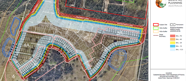
Above: Proposed APZ’s from Bushfire Assessment Report
Section 4.47, subsections (1), (2) and (3) of the EP&A Act 1979 state as follows:
4.47 Development that is integrated development
(1) This section applies to the determination of a development application for development that is integrated development.
(2) Before granting development consent to an application for consent to carry out the development, the consent authority must, in accordance with the regulations, obtain from each relevant approval body the general terms of any approval proposed to be granted by the approval body in relation to the development. Nothing in this section requires the consent authority to obtain the general terms of any such approval if the consent authority determines to refuse to grant development consent.
(3) A consent granted by the consent authority must be consistent with the general terms of any approval proposed to be granted by the approval body in relation to the development and of which the consent authority is informed. For the purposes of this Part, the consent authority is taken to have power under this Act to impose any condition that the approval body could impose as a condition of its approval.
Having regard for the above, the consent authority can be satisfied that General Terms of Approval have been obtained from the NSW Rural Fire Service (s.4.47(2)), and that the draft conditions of consent are consistent with the General Terms of Approval that have been granted.
As a result, the proposed development is considered satisfactory in terms of impacts on the built environment.
Natural Environment
Flora and Fauna
A Biodiversity Development Assessment Report (BDAR) accompanied the proposal to address the ecological impacts of the proposed development. The proposal seeks to remove approximately 13.75ha of remnant vegetation of various conditions (predominantly low condition). Large areas of the site are classified as derived native grassland.
In accordance with the BC Act, the application has taken measures to avoid and minimise the impact on biodiversity values. However, avoidance of biodiversity impacts is primarily provided by the provision and management of a biodiversity corridor (Lot 2192/DP.1273022) required under previous stages of development (DA/129/2019). Trees will also be retained within the proposed park. Surrounding land (Lot 704/DP.1275094) has also been previously dedicated to Council for floodplain rehabilitation works under a Deed of agreement.
The BDAR has assessed the below footprint (red outline):
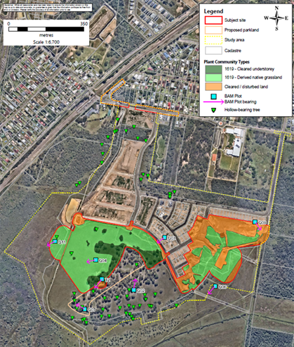
As detailed in the BDAR, to offset the residual impacts of the development, the following Biodiversity Credits will be required to be retired, as conditioned:
· 45 Ecosystem Credits for PCT 1619 Smooth-barked Apple - Red Bloodwood - Brown Stringybark - Hairpin Banksia heathy open forest of Coastal Lowlands (all including hollow bearing trees)
· 60 Species Credits for the Squirrel Glider
· 62 Species Credits for the Southern Myotis
A Critically Endangered orchid species Thelymitra adorata (Wyong Sun Orchid) has been detected within proposed residue Lot 2193. There are no works required in that area as part of the current application. Surveys within the development footprint for the current application (stages stage 3, 4 and 5) were conducted at appropriate times and did not detect the species.
Two threatened flora species have been recorded within the Study Area. There is a historical record within the Study Area for two individual records of Rutidosis heterogama (Heath Wrinklewort). Subsequent surveys of the Subject Site in 2015, 2016 and 2018, could not relocate the specimens. It is assumed that they are no longer present as a result of cattle grazing and trampling of habitat.
No serious and irreversible impacts (SAIIs) are likely to occur as a result of the proposal.
Some large and hollow bearing trees near the edge of the park have been nominated for retention and protection. The existing dam within proposed park to be filled. Bushfire Assessment was revised to ensure that no APZ (temporary or otherwise) extends within the SEPP Wetland boundary or extends outside the footprint of the BDAR.
The proposed subdivision is outside, but close to the Coastal Wetlands “buffer” boundary mapped under SEPP (Resilience and Hazards) 2021 and associated with Porters Creek wetland. The property is within a Wetland Management Area mapped in DCP Chapter 3.10.
Increase in pollutants and quantity of water being released into the wetland is a potential concern in relation to the degradation of the ecological values of ecosystems downstream, including the Porters Creek SEPP Coastal Wetland. The wetland also qualifies as Endangered Ecological Communities listed under the Biodiversity Conservation Act and provides a range of threatened species habitats. To address this concern, the applicant proposes two constructed wetland basins for stormwater quality and quantity control to ensure no impacts to downstream Porters Creek wetland. The constructed wetland basins are proposed to be placed in cleared areas. The revised BDAR (April 2023) includes the footprint of these basins.
Overall
All other relevant issues regarding the likely impacts of the development have been discussed throughout this report. In general, it is considered that the property is suitable for the proposed residential subdivision subject to conditions.
Economic and Social Impacts
The proposed subdivision will provide employment opportunities during the construction of the development and will provide much needed housing on the Central Coast.
Suitability of the Site for the Development
The site is in a suitable context for the nature, scale and type of development proposed. The site is located within a recently rezoned urban release area and the proposal is consistent with the broader and longer-term strategic planning for the area. The site is well serviced and accessible to public transport and facilities, and the proposed development provides land for future low-density housing in the area which will broaden the availability and choice of housing for the community.
There are no significant site constraints or hazards that would render the location of the development as unsuitable. There are no other constraints that would render the site unsuitable for development.
Submissions
Any submission from the public
The original plans for the application were notified in accordance with DCP 2013 – Chapter 1.2 Notification of Development Proposals with no submissions being received. Following the submission of amended plans which reduced the proposed lots from 239 to 216 residential lots, the application was renotified in accordance with DCP 2013 – Chapter 1.2 Notification of Development Proposals and no submissions were received.
Any submission from public authorities
NSW Rural Fire Service
The application was referred to the NSW Rural Fire Service as integrated development requiring issue of a Bush Fire Safety Authority (BFSA) under Section 100B of the Rural Fires Act 1997 for a Special Fire Protection Purpose. The development application was accompanied by a Bushfire Assessment Report, which was referred to the Rural Fire Service. A BFSA and General Terms of Approval have been issued for the development (dated 4 Feb 2024) and will be referenced under the recommended conditions.
Department of Planning and Environment
The application was referred to the Department of Planning and Environment in respect of Clause 6.1 of WLEP. A Secretary’s Certificate for Satisfactory Arrangements for designated State public infrastructure (SVPA 2017/8485 dated 17.12.21) has been issued by the delegate of the Department of Planning and Environment, to certify that satisfactory arrangements have been made to contribute to the provision of designated State public infrastructure in relation to the proposed development.
Heritage NSW
The application was referred to Heritage NSW under the integrated development provisions as the development will impact on known Aboriginal sites which would require an Aboriginal Heritage Impact Permit (AHIP) pursuant to Section 90 of the National Parks and Wildlife Act 1974. Heritage NSW have provided their General Terms of Approval (DOC24/468183).
Transport for NSW
The application was referred to Transport for NSW for comment under the provisions of Section 2.122 (Traffic Generating Development) of SEPP (Transport and Infrastructure) 2021. This provision includes the subdivision of land (Column 1) involving 200 or more allotments where the subdivision includes the opening of a public road and where the site has access to a road (generally) (Column 2). Transport for NSW reviewed the information provided and raised no objection to or requirements for the proposed development.
Transport for NSW - Sydney Trains
The application was referred to Sydney Trains (Transport for NSW) for concurrence under the provisions of Section 2.97 (Development involving access via level crossing) of SEPP (Transport and Infrastructure) 2021. Sydney Trains granted concurrence to the development subject to the imposition of operational conditions that will need to be complied with. The concurrence and conditions are included under the recommended conditions.
Internal Consultation
|
Senior Ecologist |
Supported, subject to conditions. |
||
|
Contributions Officer |
Supported, subject to conditions. |
||
|
Traffic and Transport Engineer |
Supported subject to conditions. |
||
|
Water and Sewer-Water Assessments Team |
|
Supported, without conditions. |
|
|
Senior Development Engineer |
|
Supported, without conditions. |
|
|
Tree Assessment Officer |
|
Supported, without conditions |
|
|
Senior Environmental Protection Officer |
|
Supported, without conditions |
|
Ecologically Sustainable Principles:
The proposal has been assessed having regard to ecologically sustainable development principles and is consistent with the principles.
The proposed development is considered to incorporate satisfactory stormwater, drainage and erosion control and the retention of vegetation where possible and is unlikely to have any significant adverse impacts on the environment and will not decrease environmental quality for future generations. The proposal does not result in the disturbance of any endangered flora or fauna habitats and is unlikely to significantly affect fluvial environments.
Climate Change
The potential impacts of climate change on the proposed development have been considered by Council as part of the assessment of the application.
This assessment has included consideration of such matters as potential rise in sea level, potential for more intense and/or frequent extreme weather conditions including storm events, bushfires, drought, flood, and coastal erosion; as well as how the proposed development may cope, combat, withstand these potential impacts. The proposed development will incorporate appropriate Asset Protection Zones and flooding has been considered as part of the assessment of the application. Future development of the lots will be subject to BASIX requirements.
Planning Agreements
The proposed development is not subject to a Planning Agreement or Draft Planning Agreement that has been entered into with Council. However, the applicant has entered into a Planning Agreement with the Department of Planning and Environment in respect of Clause 6.1 of WLEP. A Secretary’s Certificate for Satisfactory Arrangements for designated State public infrastructure (SVPA 2017/8485 dated 17.12.21) has been issued.
Other Matters for Consideration
Contributions Plans (Section 7.11 and 7.12)
The application falls under the Warnervale District Section 7.11 Plan 2021 and the recommended conditions have been included in accordance with the proposed stages.
Water and Sewer Contributions
Water and sewer developer contributions will be applicable for the creation of each new lot under the provisions of the Water Management Act 2000, and a Section 305 application will need to be submitted in order to obtain a Section 307 Certificate of compliance. The resulting Section 306 letter of requirements will contain Water Authority conditions.
Panel Planning Directions
The application includes works (being two water quality basins being constructed) on Council owned land which necessitates the application to be forwarded to the Local Planning Panel (LPP) for determination under Schedule 2 of the Ministers Directions (dated 6 March 2024). Although the proposal has resulted in no submissions being received from notification of the DA, the development taking place on Council owned land has capital value above $1 million and so does not qualify for an exclusion.
Conflict of Interest Policy
The subject site for the proposed development is on Council owned Land and this matter is discussed earlier in the report under the section on the current EPA Regulation that is in place.
Central Coast Regional Plan 2041 and North Wyong Structure Plan (2012)
The site is identified under the North Wyong Structure Plan (2012) for residential development in the short term (Precinct 7) at a dwelling density of 15 dwellings per hectare. The site is identified as a residential area within an ‘emerging growth area centre’ and is within a ‘regionally significant growth area’. The proposal is consistent with the planning under each strategic plan.
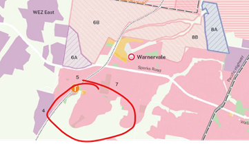
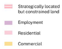
Above: Extract from CC Regional Plan 2041 with site shown circled in red.
The Public Interest:
There are no matters associated with the proposal that are contrary to the local or community interest.
CONCLUSION
The application seeks approval for a residential subdivision including 216 lots and associated works including earthworks servicing and roads infrastructure in stages at 15-35 Warnervale Road and 95-105 Virginia Road, Warnervale
The proposed variations to WDCP are considered reasonable and acceptable in the circumstances. There were no submissions received from the notification of the proposal and the site is in a suitable context for the nature, scale and type of development proposed.
Following a thorough assessment of the relevant planning policies and controls, it is considered the application is appropriate and can be supported for the following reasons:
1. The proposal is satisfactory having regard for the relevant environmental planning instruments, plans and policies.
2. The proposed development satisfies the provisions and pre-conditions of the grant of consent of State Environmental Planning Policy (Resilience and Hazards) 2021, SEPP (Transport and Infrastructure) 2021 and SEPP (Koala Habitat Protection) 2021.
3. The proposal has been considered against the permitted uses and objectives of the R2 Low Density Residential and R1 General Residential under Wyong Local Environmental Plan 2013. The proposal is permissible with development consent in the R2 and R1 zone and is considered satisfactory in terms of the objectives of the zone.
5. The proposal satisfies the provisions of Section 4.14 of the Environmental Planning and Assessment Act 1979.
6. The proposal is considered satisfactory in relation to the requirements of Wyong Development Control Plan 2013, Chapter 6.5 (Warnervale South), Part 4 (Subdivision), Chapter 3.3 (Floodplain Management) Chapter 3.10 (Wetlands Management) and Chapter 3.1 (Site Waste Management) and the variations proposed are satisfactory with respect to the control objectives.
7. There are no significant issues or impacts identified with the proposal under s. 4.15 of Environmental Planning and Assessment Act 1979 and no submissions have been received.
8. The proposed development is considered suitable within the context of the site and surrounding development and is in the public interest.
The development application has been considered in accordance with the requirements of the Environmental Planning and Assessment Act 1979 and the Regulations, as outlined in this report.
The proposal is recommended for approval subject to conditions.
|
1⇩ |
Attachment 1 - DCP Compliance |
|
D16341259 |
|
2⇩ |
Draft conditions DA/1892/2021- 15-35 Warnervale Rd, 95-105 Virgina Rd, 216 lot residential subdivision |
|
D16162037 |
|
1.1 |
DA/1892/2021 - 15-35 Warnervale Rd & 95-10 Virginia Rd, 107-171 Virginia Rd Warnervale - Proposed Residential Subdivision (216) Lots |
|
Attachment 1 |
Attachment 1 - DCP Compliance |
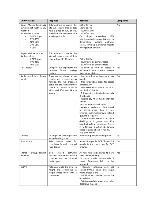
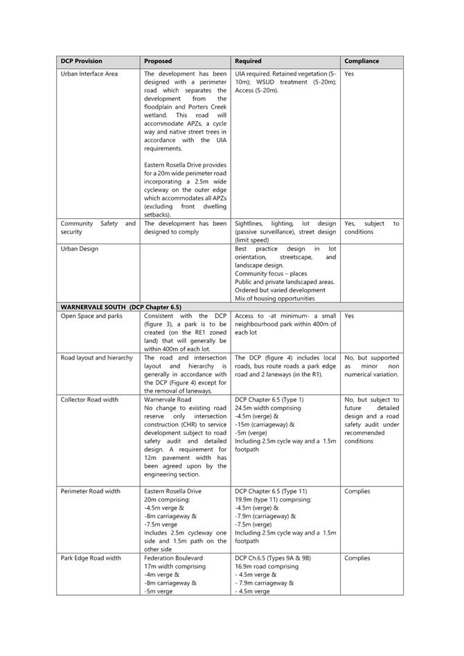
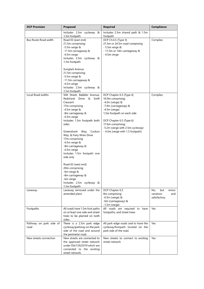
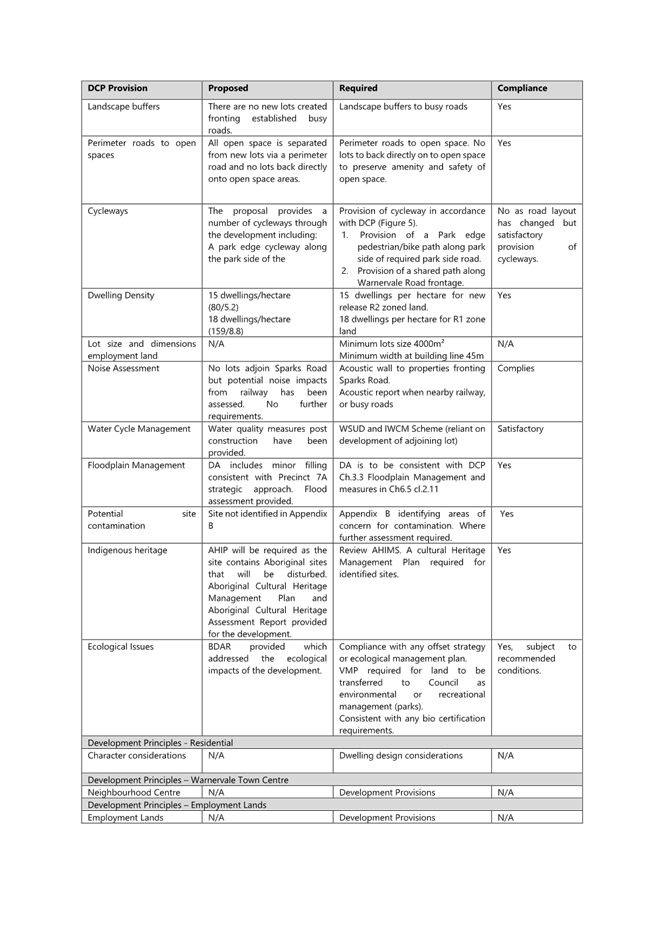
|
DA/1892/2021 - 15-35 Warnervale Rd & 95-10 Virginia Rd, 107-171 Virginia Rd Warnervale - Proposed Residential Subdivision (216) Lots |
|
|
Attachment 2 |
Draft conditions DA/1892/2021- 15-35 Warnervale Rd, 95-105 Virgina Rd, 216 lot residential subdivision |
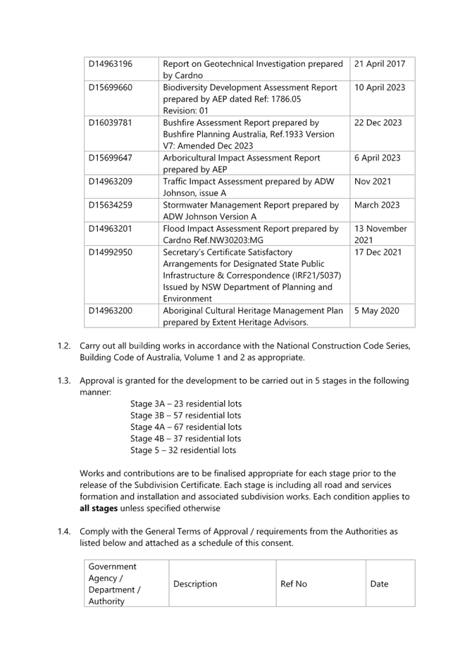
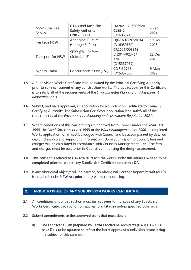

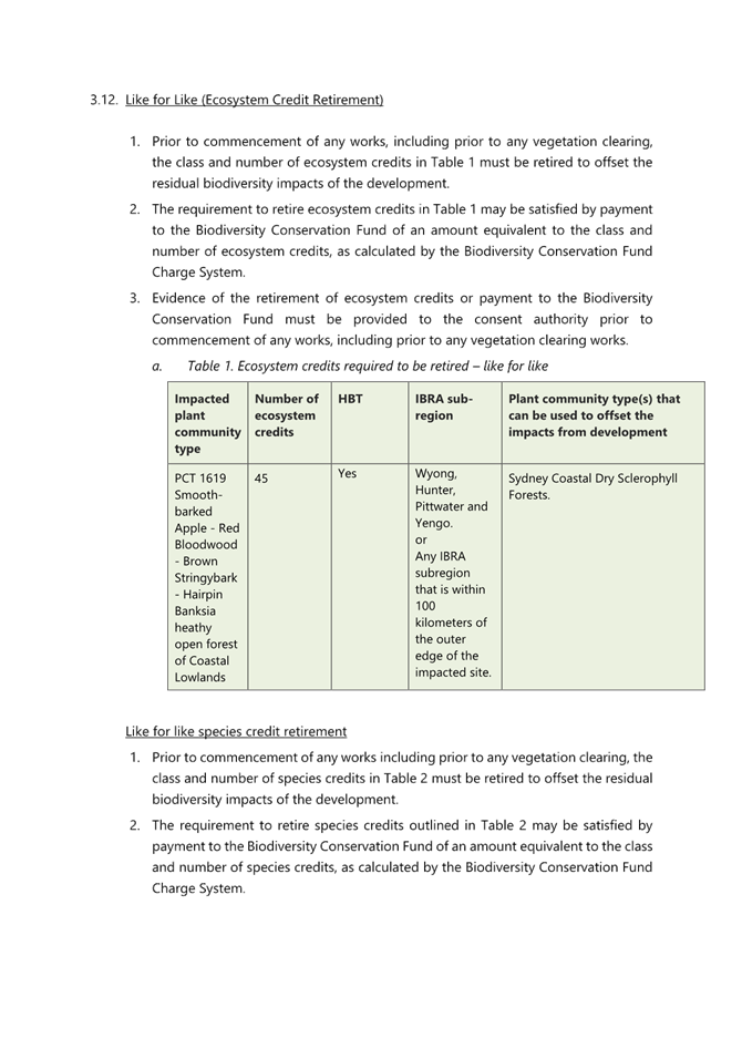
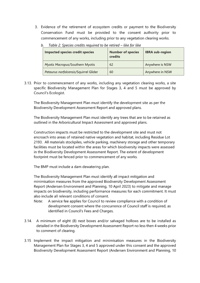
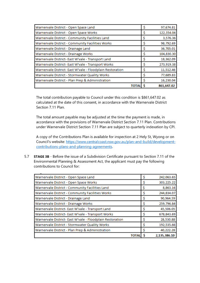
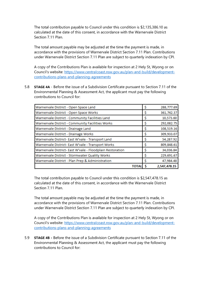
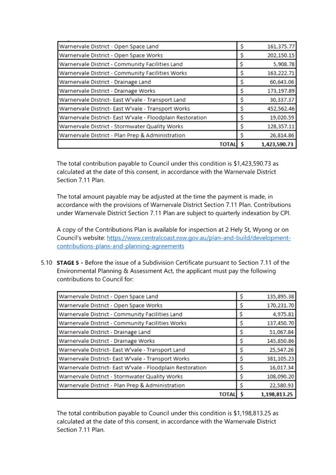
|
Item No: 1.2 |
|
|
Title: DA/42661/2012/E - 69-71 Avoca Drive, Avoca Beach - Alterations & Additions to existing Theatre |
|
|
Department: Environment and Planning |
|
|
22 August 2024 Local Planning Panel Meeting |
|
Reference: DA/42661/2012/E - D16282236
Author: Robert Eyre, Principal Development Planner. Residential Assessments
Section Manager: Ailsa Prendergast, Section Manager. Residential Assessments
Manager: Andrew Roach, Unit Manager. Development Assessment
|
Recommendation
2 The consent be modified by: a. The amendment of conditions 1.1A, 1.1, 2.2, 2.7, 2.13. b. The addition of conditions 1.5, 2.22, 2.9, 5.23, 5.24. c. The deletion of condition 6.14.
3 That Council advise those who made written submissions of the Panel’s decision. 4 That Council advise relevant external authorities of the Panel’s decision
|
|
|
This matter was previously considered by the Local Planning Panel on 16 May 2024. The matter was deferred at that meeting (see report included as Attachment 19, and further explanation below).
Subject Land
The subject land comprises Lot 140 DP 9359 and Lot 651 DP 16791, No’s. 69 and 71 Avoca Drive, Avoca Beach, having an area of 1,802.10m2. No.69 (Lot 651) Avoca Drive, Avoca Beach is occupied by a commercial premises known as the Avoca Beach Theatre. An existing part one and two storey theatre building is located on. The building contains the theatre itself, as well as the box office, toilets, projection room, storage rooms and first floor office. An awning extends out over the footpath at the entry to the theatre off Avoca Drive. No.71 Avoca Drive, Avoca Beach (Lot 140) is occupied by three outbuildings (metal, weatherboard and fibro respectively) and a single storey weatherboard garage.
Previous Consent/s
Consent was originally granted to DA/42661/2012 on 18 April 2017 by the NSW Land & Environment Court (LEC), comprising:
· Demolition of the existing cottage, shed, outbuildings and shade sails on Lot 140 and removal of the disused speaker box and ramp from the rear of the existing theatre on Lot 651, as well as the staircase and ancillary storage rooms on the northern side of the theatre;
· Preparation of the site, including removal of existing trees and the undertaking of earthworks and excavation for the basement; and
· Construction of a part two, part three storey building to the north and east of the existing theatre to provide one mixed use commercial and residential building containing four cinemas and associated foyers and facilities; terrace; cafe/gallery and five apartments.
Since that time there have been a number of modification applications, which are elaborated upon in the original report considered by the Panel (16 May 2024, refer Attachment 19). The development has physically commenced.
Proposed Development
The applicant is seeking to further modify the consent for Development Application DA/42661/2012 under section 4.56(1) of the Environmental Planning & Assessment Act 1979, by amendment of approved plans. The amendments are broadly set out as follows:
· Amendments to the basement through addition of plant room, alterations to waste storage, relocation of disabled parking spaces and amendment to access ramp;
· Amended layout to ground, first and second floor including amended entries, layout and seating adjustments to cinemas, residential circulation spaces amended, altered layout to units including balcony layout;
· Amendment to roof which includes rood height and shape, and additional of solar panels to assist in BASIX requirements; and
· Total reduction of cinema seating from 616 to 462, a reduction of 154 seats.
Further details on the proposed modifications are provided in the assessment report at Attachment 19.
Previous Consideration By Local Planning Panel
The Panel considered the matter at its meeting on 16 May 2024 (report included as Attachment 19).
The minutes of that meeting set out that the item was deferred from consideration, as follows:
‘The registered speakers for Item 3.1 – DA/42661/2012/E were briefed by the Chair, that this matter would need to be rescheduled to another panel meeting due to procedural issues and will be re-scheduled – see Item 3.1.
The Chair explained that the main reasons for deferring consideration of this matter to a future public meeting included:
· Lack of certainty that reasonable notice had been given by Council to submitters of the public meeting as required by the Local Planning Panels Direction – Operational Procedures and that the notification requirements of Central Coast Local Planning Panel Operational Guideline had been met, which requires all people who have made written submissions to be notified of the Panel meeting the week prior to the meeting.
· The business papers inadvertently did not include a copy of the current set of proposed plans which the Panel was advised had not been notified. A set of plans were provided to the Panel on the day of the Panel meeting, however there was no opportunity for the Panel to review such late material ahead of the meeting; and
· Uncertainty whether the current plans were available to the public on Council’s website notwithstanding they were not attached to the business paper and had not previously been notified.
Accordingly, to ensure procedural fairness and compliance with the relevant direction and guidelines are achieved, the Panel postponed hearing from speakers and considering this matter until all such matters had been satisfactorily met.’
The minutes of the meeting also include the following as formal reasons for the deferral of the matter at the meeting:
‘The Local Planning Panel deferred consideration of this matter to a future public meeting in order for Council to address the following matters detailed below:
· A full set of the final proposed plans and the original court approved plans with the business papers.
· Provide the Panel with copies of all supporting documentation related to and referenced in the assessment report and draft conditions. This should include a copy of the original conditions issued by the Land and Environment Court and reasons given by the Court for granting consent pursuant to S. 4.56(1A).
· Provide a detailed assessment of the application against the original approval as required by Section 4.56 of the Environmental Planning and Assessment Act 1979. This should include but not be limited to key matters of building height, FSR, car parking, view loss, urban design and architectural quality.
· The Panel noted that Council’s Architect had significant concerns with the proposed modified design and that the matter has not been before a design review panel. In the absence of a design review panel and noting the matters not supported by Council’s architect compared to the originally approved scheme, the Panel suggests Council consider obtaining an independent design review of the proposed modified scheme against the originally approved development as part of its detailed assessment against the provisions of Section 4.56 of the Act.
· Confirm that the updated view impact assessment is based on an assessment of view impacts form all previously identified view impacted residences against the current set of proposed plans. Further, given the proposed increase in height provide confirmation that no additional properties would be significantly impacted by the proposed modification, beyond those previously considered acceptable by the Court approval.
· Provide more detailed assessment in relation to Section 7.18(3) and (5) of CCLEP 2022.
· Correct all reporting errors throughout the report in relation to proposed FSR and Height numerical figures and percentages and associated commentary regarding compliance and non-compliance.
· Clarify whether a VPA applies to the site given inconsistencies in reporting between the consultant documentation, Council’s assessment report and the briefing.
· Confirmation whether the proposed modification plans require re-notification having due regard to the public interest in the matter and whether people who lodged a submission (either for or against) are also renotified in accordance with Council’s notification policy.
· Once an updated business paper that addresses all of the above matters is prepared, a copy if to be issued to the planning panel at least a week prior to the public meeting date in accordance with the Operational Guidelines.
· Council is to ensure that all people who lodged a submission receive notice of the date and time of the public meeting at least the week prior to the meeting as per Council’s Local Planning Panel Operational Guidelines.
· Confirm that the proposed plans and all documentation submitted following the initial notification of the modification application have been uploaded to Council’s website and are available for public viewing.
Once the above matters have been addressed , a public Local Planning Panel determination meeting will be held.’
Each of the matters set out in the deferral are dealt with separately in the following pages of this report
CONSIDERATION OF MATTERS FOR DEFERRAL
A comment is made below, and on the following pages, in respect to each of the reasons for deferral at the Panel meeting of 16 May 2024:
A full set of the final proposed plans and the original court approved plans with the business papers.
Comment:
The originally approved (Land & Environment Court) plans are included as Attachment 1 and LEC conditions are included as Attachment 2.
The current/proposed plans are included as Attachment 5.
Provide the Panel with copies of all supporting documentation related to and referenced in the assessment report and draft conditions. This should include a copy of the original conditions issued by the Land and Environment Court and reasons given by the Court for granting consent pursuant to S. 4.56(1A).
Comment:
Refer to various attachments:
· Attachment 2 - original conditions issued by Land and Environment Court.
· Attachment 3 - current consent as modified.
· Attachment 7 - proposed conditions.
· Attachment 8 to 13 (inclusive) - supporting documentation, including View Impact Assessment, Apartment Design Guide Report, Design Verification Statement, Landscape Plan.
In relation to the Land and Environment Court determination, the Court did not give reasons for the imposition of conditions, as such, other than that referred to in Condition 6.14 which relates to restriction of hours during the peak summertime school holidays to avoid conflict with peak beach use.
The applicant has requested condition 6.14 be deleted as the reduction in the seating capacity decreases the parking demand generated by the proposal on the basis that the condition is no longer considered necessary. This issue is addressed below in more detail.
The Court judgement itself (Norman McDonald & Anor v Central Coast Council [2017] NSWLEC 1207) provides various reasons for the determination decision. In the findings within the judgement, Commissioner O’Neill C stated:
66. Much of the objector evidence and the written submissions can be distinguished as objections to the amending LEP 456, which on its making inserted cl 49DN into the GPSO. The exhibition of the (then proposed) VPA, from 19 July 2006 until 16 August 2006 attracted 518 submissions against the VPA (and 2 in support) and Council, confronted with that opposition, resolved to execute the VPA (exhibit E, volume 3, f 435) and did so. The insertion of cl 49DN into the GPSO is merely a historical matter from the perspective of this appeal and I am bound to give weight to the fact that the application is to use the site for the specific permitted purpose for which it is zoned (BGP Properties v Lake Macquarie (2004) 138 LGERA 237 [117]). The relatively recent making of LEP 2014, including extensive community consultation, contains the enabling clause at 2.5 demonstrating that Council has recently looked again at the potential development of this site and confirmed that the permitted use is appropriate, subject to the considerations in Schedule 1(5) of LEP 2014 (BGP Properties v Lake Macquarie (2004) 138 LGERA 237 [119]). Importantly though, the zoning does not create a presumption that the use will necessarily be achieved, as the acceptability of the proposal depends on whether the design results in acceptable environmental impacts with reference to the matters for consideration under s 79C of the EPA Act.
67. I am satisfied that the proposal is consistent with the development envisaged by cl 49DN of the GPSO, as the proposal complies with the provisions of cl 49DN of the GPSO, including the maximum floor space ratio (FSR) of 1:1 and height of 10m, except as provided by sub-clause (5). The two merits contentions raised by the Council in this appeal, that the development application should be refused because the proposed development will have an adverse impact on the heritage character and qualities of the Avoca Beach Theatre and that inadequate car parking is provided for the proposed development, have not been made out, for the reasons given in the judgment.
68. I am satisfied that the design of the proposal, by Artichoke Design Studios, provides a high standard of urban design and architectural quality, including the interface between the existing building and Hunter Park and it complements the heritage qualities of the existing Avoca Beach Theatre building; that it is consistent with the development envisaged by the amending LEP 456 and LEP 2014; and it satisfies the relevant aims and guidelines of SEPP 71. This new layer of development will harmonise with the special character and qualities of the Avoca Beach Theatre and its setting. For these reasons, the proposal can be granted consent.’
The complete judgement is included in Attachment 16 for the information of the Panel.
Provide a detailed assessment of the application against the original approval as required by Section 4.56 of the Environmental Planning and Assessment Act 1979. This should include but not be limited to key matters of building height, FSR, car parking, view loss, urban design and architectural quality.
Comment:
A comparison table is included below which compares the proposed modification to the originally determined application (by the LEC) and the various other amendments approve over time.
It is considered the proposal is substantially the same development for which the consent was originally granted and as modified, and therefore satisfies the requirements of 4.56(1)(a).
|
Item |
Original DA |
Part A |
Part B |
Part D |
Proposed Part E |
Difference Original to Part E |
|
GFA |
1801.96m2 |
1588.68m2 |
1712.63m2 |
No change |
1874.40m2 |
+72.44m2 or 4% |
|
FSR |
1:1 |
0.88:1 |
0.95:1 |
No change |
1.04:1 |
+0.04:1 or 4% |
|
Building Height |
RL14.2m |
No Change |
RL 14.9m |
No Change |
RL 15.145m |
+0.945m |
|
Car Parking Spaces |
14 |
14 |
14 |
14 |
14 |
Nil |
|
Cinema Seating |
4 cinemas-613 |
4 cinemas-614 |
4 cinemas-616 |
No change |
4 cinemas-462 |
-151
|
|
Residential Units |
5 |
5 |
5 |
No change |
5 |
Nil |
The increase in height from the original approval does not result in any significant view loss from surrounding properties. Refer View Assessment in Attachments and 8 and 15.
The proposal achieves a high standard of urban design and architectural quality, including in relation to the interface between the development and the adjoining public park, The reduction in cinema seating and number of residential bedrooms reduces the likely traffic impact generated by the proposal on the community use of the beach and park area. The proposal adds to the community activities in this location and economic and recreational facilities.
The proposed plans provided in Attachment 5 show the outline of the originally approved building for comparison purposes which has been used in the assessment of the current application.
The Panel noted that Council’s Architect had significant concerns with the proposed modified design and that the matter has not been before a design review panel. In the absence of a design review panel and noting the matters not supported by Council’s architect compared to the originally approved scheme, the Panel suggests Council consider obtaining an independent design review of the proposed modified scheme against the originally approved development as part of its detailed assessment against the provisions of Section 4.56 of the Act.
Comment:
An independent design review of the proposed modifications was undertaken by an external urban design/architect consultant in response to the LPP comments. The independent review, in summary, concludes:
“The proposed modifications will not cause any adverse environmental effects beyond those that have already been considered and approved under the original consent. As previously mentioned, building setbacks and landscaping remain consistent with that approved.
The proposed amendments to the approved FSR and building height does not significantly alter the visual relationship of the approved development to that of the existing character of the area and views enjoyed by surrounding developments.
Given the above brief review and consideration of the detailed submission, it is considered that sufficient planning grounds exist to support the proposed modification application”.
The Written independent design review is included in Attachment 18.
Confirm that the updated view impact assessment is based on an assessment of view impacts form all previously identified view impacted residences against the current set of proposed plans. Further, given the proposed increase in height provide confirmation that no additional properties would be significantly impacted by the proposed modification, beyond those previously considered acceptable by the Court approval.
Comment:
The view impact assessment is based on all previous and current submissions which raised view loss as an issue. The view impact assessment is based on the amended plans referred to in Attachment 5. Refer view impact assessment and statement. (Attachments 8 and 15).
Provide more detailed assessment in relation to Section 7.18(3) and (5) of CCLEP 2022.
Comment:
Clause 7.18 of the Central Coast Local Environmental Plan 2022 states:
(1) This clause applies to Lot 140, DP 9359 and Lot 651, DP 16791, Avoca Drive, Avoca Beach, identified as “Avoca Beach Theatre” on the Key Sites Map.
(2) Development for the following purposes is permitted with development consent on land to which this clause applies—
(a) entertainment facilities,
(b) residential flat buildings,
(c) restaurants or cafes.
(3) Development consent must not be granted to development referred to in subclause (2) unless the design of the development has been reviewed by a design review panel.
(4) In deciding whether to grant development consent, the consent authority must consider the following—
(a) whether the development retains the existing theatre building,
(b) whether the design of the development complements the heritage character of the existing theatre building,
(c) whether the design of development achieves a high standard of urban design and architectural quality, including in relation to the interface between the development and the adjoining public park,
(d) whether the design of the development is appropriate for the location of the land on the coast,
(e) whether adequate car parking is provided,
(f) whether the development provides measures to conserve water usage and increase water efficiency,
(g) if applicable, the outcome of the review by the design review panel.
(5) Subclause (3) does not apply to development if the Planning Secretary provides a written statement to the consent authority stating that the Planning Secretary considers the development is of a minor nature.
(6) A building on land to which this clause applies resulting from development for the purposes of entertainment facilities may exceed the maximum height shown on the Height of Buildings Map if the consent authority is satisfied the part of the building that exceeds the maximum height is an integral part of the design of the building.
(7) In this clause—
design review panel means a panel of 2 or more persons established by the consent authority for the purposes of this clause.
There is currently no design review panel constituted for the Central Coast local government area, other than for proposals within the Gosford City Centre.
In the absence of a formal design review panel, Council has a list of approved design/architecture experts that it calls on to provide independent review and comment on the architectural and design merit of proposals and compliance with such measures as the NSW Apartment Design Guide.
For this application, Council assessment staff sought external urban design/architectural assessment which is provided for the information of the Panel.
The proposed development meets the requirements of Clause 7.18 of the Central Coast LEP and the Panel can be satisfied that the provisions of 7.18(4) have been complied with.
Correct all reporting errors throughout the report in relation to proposed FSR and Height numerical figures and percentages and associated commentary regarding compliance and non-compliance.
Comment:
The following tables shows the variations with development standards for building height and floor space ration from the Central Coast LEP 2022.
Development Standard |
Required |
Approved |
Proposed |
Compliance with Controls |
Variation % |
Compliance with Objectives |
|
cl. 4.3 (Height of Buildings) |
10m |
11.5m |
11.745m |
No |
17.45% |
Yes |
|
cl. 4.4 (Floor Space Ratio |
1.:1 |
0.95:1 |
1.04:1 |
No |
4% |
Yes |
Clarify whether a VPA applies to the site given inconsistencies in reporting between the consultant documentation, Council’s assessment report and the briefing.
Comment:
A Voluntary Planning Agreement (VPA) applies to the site and is referred to in the conditions of consent granted by the Land and Environment Court.
This condition is not proposed to be modified and is retained in the proposed conditions. (Refer condition 2.20 in the recommended conditions at Attachment 7).
The VPA was entered into as an agreement to amend the planning instrument which existed at the time (Gosford Planning Scheme Ordinance) to facilitate and permit the redevelopment of the site as now proposed.
The VPA requires the payment of $500,000.00 prior to the issue of a Construction Certificate and is to be used by Council for public works in the area, including car parking and upgrading nearby Hunter Park.
Confirmation whether the proposed modification plans require re-notification having due regard to the public interest in the matter and whether people who lodged a submission (either for or against) are also renotified in accordance with Council’s notification policy.
Comment:
The current application (Part E) was lodged on 11 October 2022. The application was initially notified from 21 October 2022 to 11 November 2022 with 332 public submissions received.
(273 submissions were in support of the proposed development and 59 submissions objected to the proposed development).
The amendments within those plans placed on public exhibition proposed:
· A further height increase of 0.845m to the current approved plans (Part D, which as a current approved height of RL 14.9m); and
· A proposed FSR of 1.09:1 (which was greater than the initial 1:1 floor space ratio initially approved by the Land & Environment Court in April 2017, and higher than the current approval, Part D, which has a Floor Space Ratio of 0.95:1).
During the assessment of the application, Council raised concerns with both the proposed additional height and floor space.
Subsequently, the applicant submitted revised plans, dated 14 September 2023, which:
· Reduced the height (the current plans propose a maximum height of RL 15.145m which is an increase of 0.245 metres over the existing approved height of RL 14.9m) and
· Reduced the floor space ration to 1.04:1.
Chapter 1.2 of CCDCP 2022 sets out notification procedures. Section 1.2.2.10 specifically deals with situations where proposals have been notified, and then amended plans received during the assessment process. Section 1.2.2.10 states:
‘ ….. if in the opinion of Council or staff with the appropriate delegated authority the amendments are minor, or will result in no additional impacts, the amendments will not require readvertisement or re-notification.’
The amended plans were not required to be re-advertised/notified under the provisions of 1.2.2.10 of CCDCP 2022 as the changes/amendments were reductions/improvements to the application. These changes are minor and create no additional impacts on the surrounding properties. Further, the amendments made were in response to a number of issues raised in the public submissions and during the preliminary assessment of the application.
All those who made a submission to the application were notified of the initial public Local Planning Panel meeting on 16 May 2024.
Once an updated business paper that addresses all of the above matters is prepared, a copy if to be issued to the planning panel at least a week prior to the public meeting date in accordance with the Operational Guidelines.
Comment:
All information will be sent to panel members at least a week before the public meeting, as is required for Local Planning Panel meetings.
Council is to ensure that all people who lodged a submission receive notice of the date and time of the public meeting at least the week prior to the meeting as per Council’s Local Planning Panel Operational Guidelines.
Comment:
All those who made a submission to the application were notified of the initial public Local Planning Panel meeting on 16 May 2024.
All people who lodged a submission will again be notified in reasonable time of the public meeting as per the Local Planning Panel Operational Guidelines and standard practice.
Confirm that the proposed plans and all documentation submitted following the initial notification of the modification application have been uploaded to Council’s website and are available for public viewing.
Comment:
All documents have been uploaded to Council’s website and are available for public viewing.
Once the above matters have been addressed, a public Local Planning Panel determination meeting will be held.
Comment:
A public Local Planning Panel meeting will be arranged in sufficient time.
Additional Comment in Relation to Condition 6.14 –
The applicant requests, as part of the modification application, to delete condition 6.14 from the consent.
Condition 6.14 of the consent is as follows:
The applicant contends that this condition was intended as a means by which ticket sales could be restricted to limit the parking impacts during the summer school holidays. With the currently approved 616 seat (total) capacity, the 25% restriction of sales would result in 462 seats being available.
This number is only four (4) seats less than the proposed 466 total seats under the current proposal.
Given the greatly reduced number of seats – and the fact that the current maximum is only 4 less than the proposed total, the applicant contends that this condition is superfluous and should be removed.
Comment:
The 25% reduction in seating and decrease in size of residential apartments has reduced the demand for car parking.
It is considered that the reduction in seating has satisfactorily addressed the previous concerns with parking conflict during peak summer school holiday periods.
In addition, additional street parking and public car parking is to be constructed by Council using funds from the previously mentioned VPA. It is also noted that the peak usage of the theatre is more likely to be of an evening or night time, which does not coincide with the peak use of the beach and associated areas which is more likely to be during the daytime.
Council’s Development Engineer has no objection to the deletion of condition 6.14, on the basis of parking impacts.
In the event that the current modification application is approved, it is not considered that this condition is no longer necessary and Council assessment staff recommend its deletion as part of this determination.
Conclusion
Based on the considerations provided in the initial assessment report presented to the Panel at its meeting on 16 May 2024, and the further material provided within this supplementary report, it is concluded the proposed modifications are not without merit and will not hinder the attainment of objectives under s.1.3 of the EP & A Act. It is considered there are sufficient grounds to justify a further variation of the development standard to that originally approved and subsequently amended.
The proposed development is considered to be substantially the same development and the proposed modifications are not considered to have significant additional impacts on surrounding properties or the environment.
The Development Application has been assessed against the heads of consideration of s.4.15 and s.4.56 of the EP & A Act and all other relevant instruments and polices. The proposed modifications are considered reasonable and therefore it is recommended that Council grant approval to Development Application No. 42661/2012/E, including:
o Amendment of conditions 1.1A, 1.1, 2.2, 2.7, 2.13.
o The addition of conditions 1.5, 2.22, 2.9, 5.23, 5.24.
o The deletion of condition 6.14.
|
1⇩ |
LEC Approved Plans DA42661 L651 DP16791 & L140 DP9359 H69-71 Avoca Dr Avoca Beach Part 1 |
|
ECMD23246807 |
|
2⇩ |
Annexure A - Conditions of Consent155633.16 O_Neill (C) L&E Court NSWLEC 1090 DA 42661 H69 Avoca Drive Avoca Beach |
|
ECMD23192378 |
|
3⇩ |
Approved Plans DA42661 L140 DP9359 H71 Avoca Drive AVOCA BEACH Part 3 |
|
ECMD24899443 |
|
4⇩ |
PUBLIC DA Assessment Section 4.55 Consent - 69 Avoca Dr, AVOCA BEACH NSW 2251 - DA 42661 2012 D - Johnson Projects |
|
D15351409 |
|
5⇩ |
Architectural Plans (S4.56 Ver 8) - 69 Avoca Dr, AVOCA BEACH NSW 2251 - PAN-268705 - DA/42661/2012/E |
|
D16105303 |
|
6⇩ |
PUBLIC - Redacted Notification Plans - Avoca Beach Theatre - 69 & 71 Avoca Dr Avoca Beach - DA/42661/2012/E |
|
D16326712 |
|
7⇩ |
Draft conditions/reasons - Avoca Beach Theatre 69 & 71 Avoca Drive, AVOCA BEACH - DA/42661/2012/E - Central Coast Council |
|
D16143009 |
|
8⇩ |
UPDATED View Impact Analysis[1]_PAN-268705 - 69 Avoca Drive AVOCA BEACH - Avoca Theatre - 69 & 71 Avoca Drive AVOCA BEACH - DA/42661/2012/E |
|
D15643909 |
|
9⇩ |
PUBLIC Apartment Design Guide Report - 69 Avoca Dr, AVOCA BEACH NSW 2251 - PAN-268705 - DA/42661/2012/E |
|
D15367102 |
|
10⇩ |
PUBLIC Architectural Design Statement - 69 Avoca Dr, AVOCA BEACH NSW 2251 - PAN-268705 - DA/42661/2012/E |
|
D15367082 |
|
11⇩ |
PUBLIC Design Verification Statement - 69 Avoca Dr, AVOCA BEACH NSW 2251 - PAN-268705 - DA/42661/2012/E |
|
D15367081 |
|
12⇩ |
PUBLIC Landscape Plan - 69 Avoca Dr, AVOCA BEACH NSW 2251 - PAN-268705 - DA/42661/2012/E |
|
D15367079 |
|
13⇩ |
Statement of Environmental Effects - DA/42661/2012/E - 69 Avoca Dr, Avoca Beach |
|
D16122723 |
|
14⇩ |
Covering Letter - Deed of agreement - Avoca Beach Theatre - 69 Avoca Drive, AVOCA BEACH - DA/42661/2012/E |
|
D16245193 |
|
15⇩ |
Visual Impact Analysis - 69 Avoca Dr, AVOCA BEACH NSW 2251 - PAN-268705 - DA/42661/2012/E |
|
D16210627 |
|
16⇩ |
Land & Environment Court - NSWLEC - 2017- Ruling - Avoca Beach theatre Re Development Fee Accepted. - 69 Avoca Drive, AVOCA BEACH - DA/42661/2012/E |
|
D16233718 |
|
17⇩ |
Assessment Report DA42661 L140 DP9359 H71 Avoca Drive AVOCA BEACH Part 3 |
|
ECMD24899306 |
|
18⇩ |
Cover Letter - DA/42661/2012/E - 69 Avoca Drive, AVOCA BEACH NSW |
|
D16251449 |
|
19⇩ |
DA/42661/2012/E - 69 Avoca Drive, Avoca Beach - Alterations & Additions to existing Theatre |
|
D15558924 |
|
1.2 |
DA/42661/2012/E - 69-71 Avoca Drive, Avoca Beach - Alterations & Additions to existing Theatre |
|
Attachment 1 |
LEC Approved Plans DA42661 L651 DP16791 & L140 DP9359 H69-71 Avoca Dr Avoca Beach Part 1 |
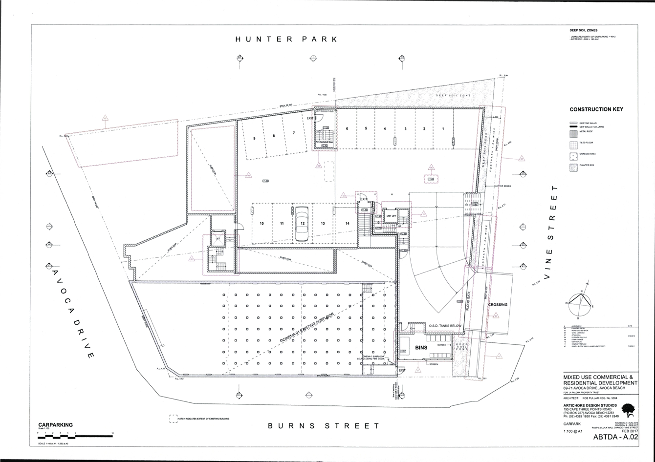
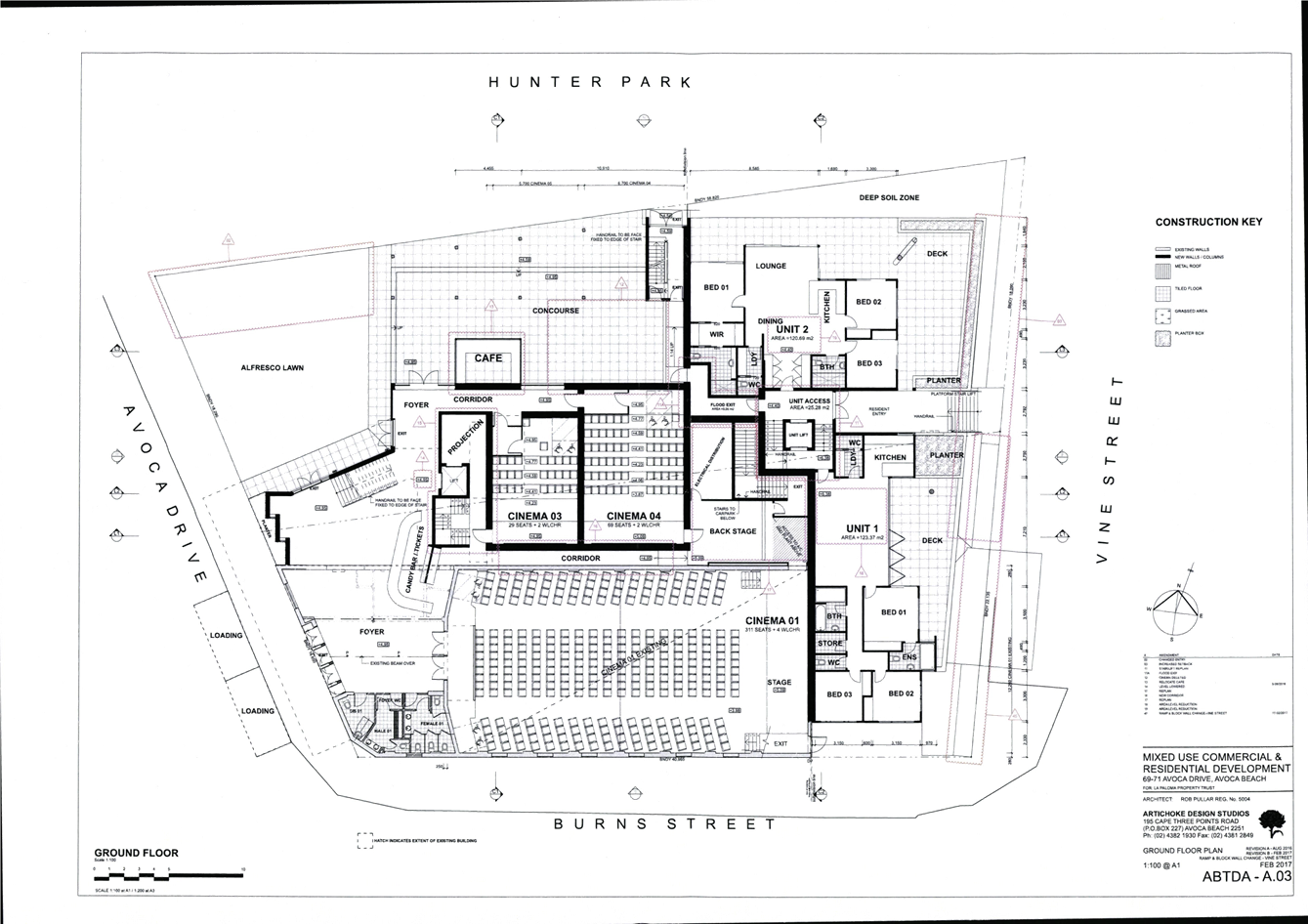
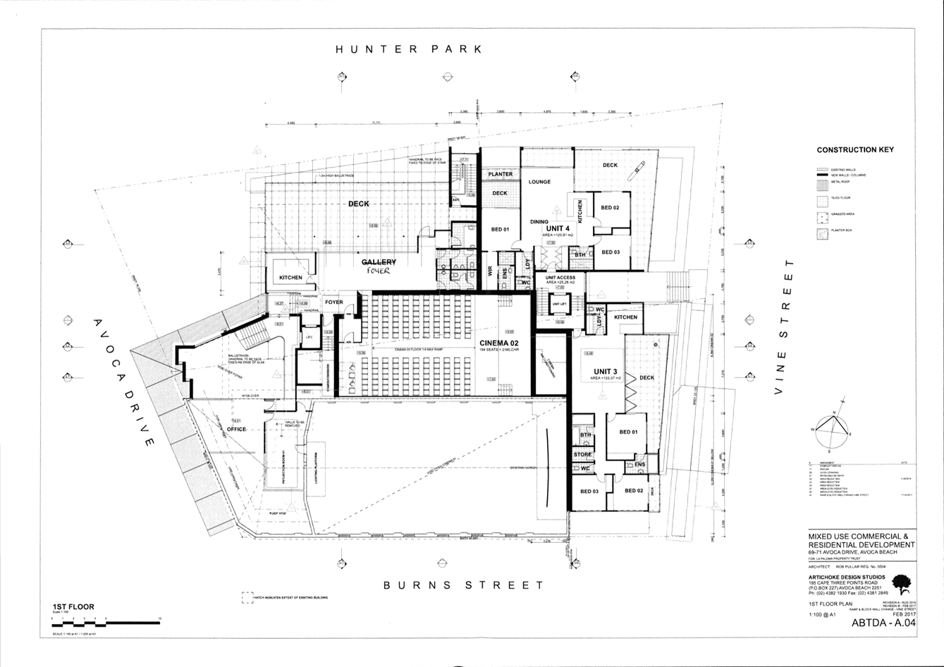
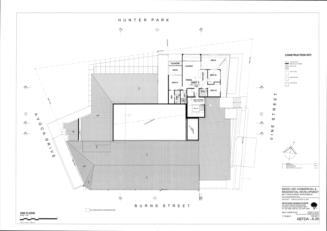
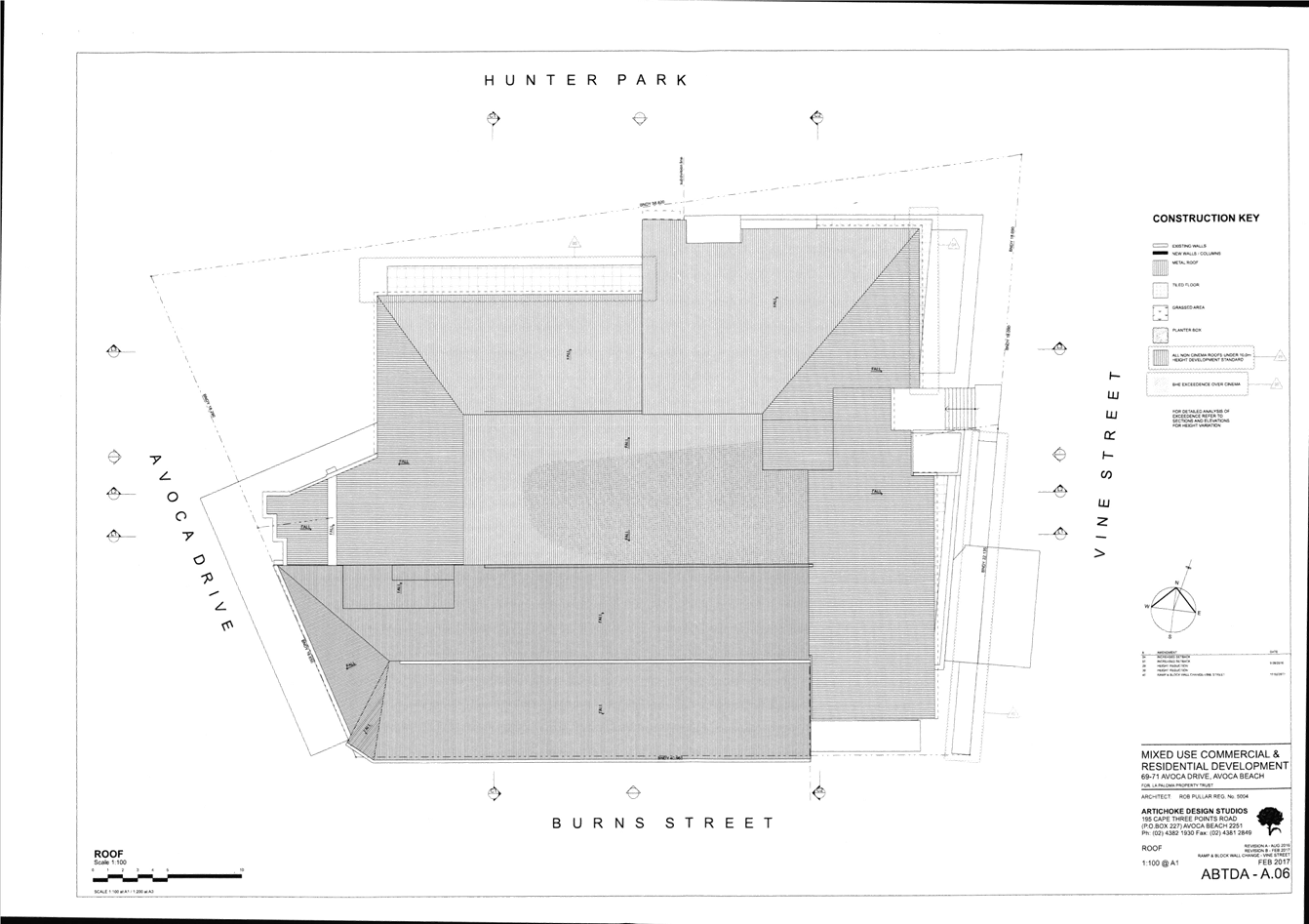
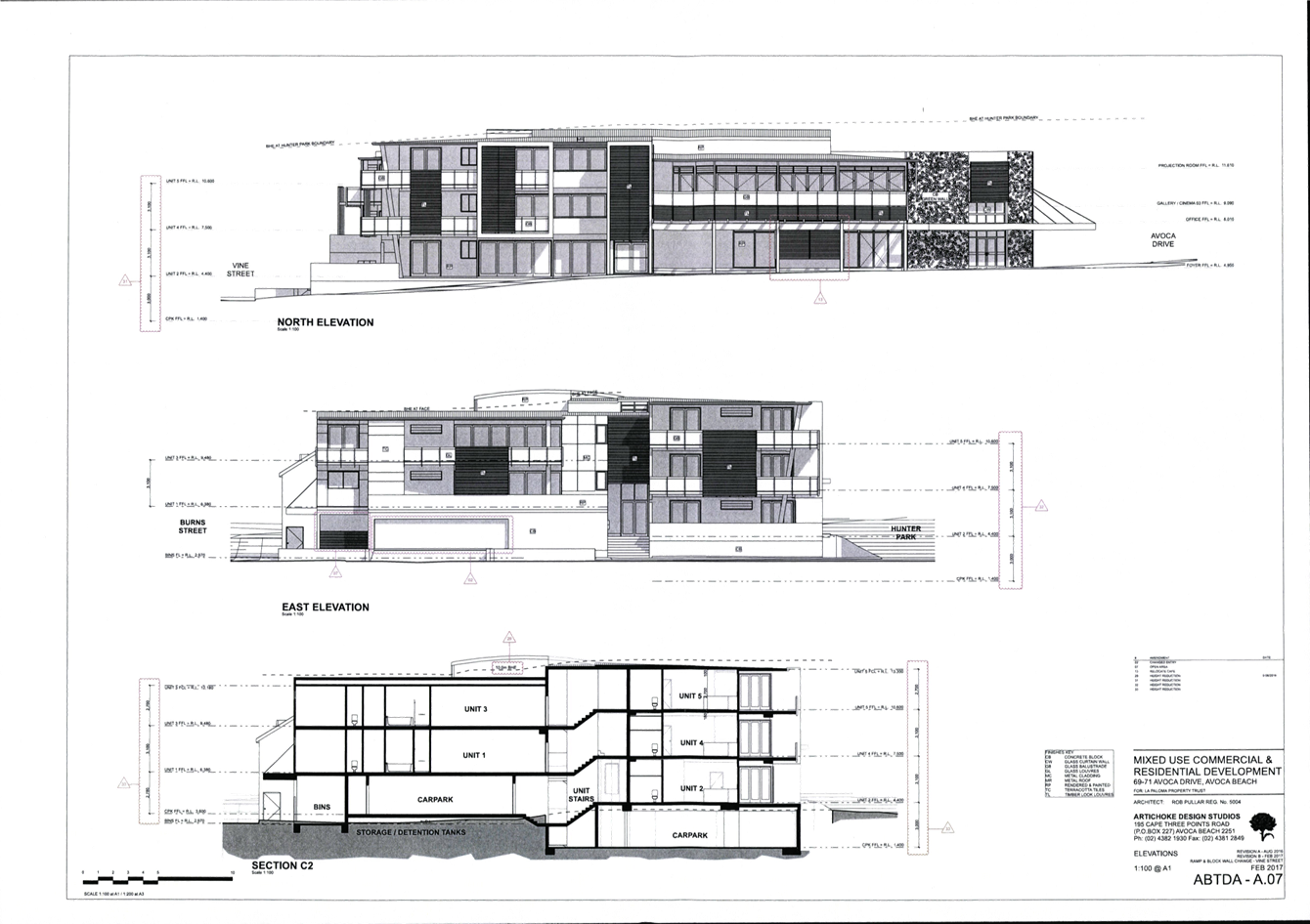
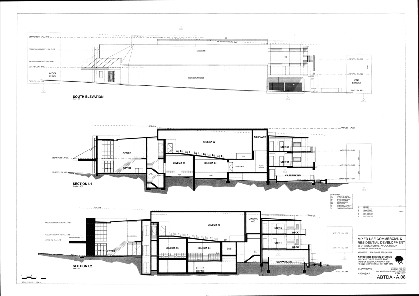
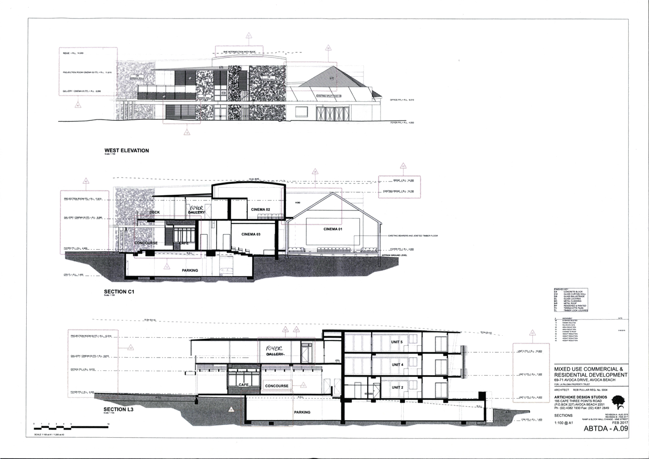
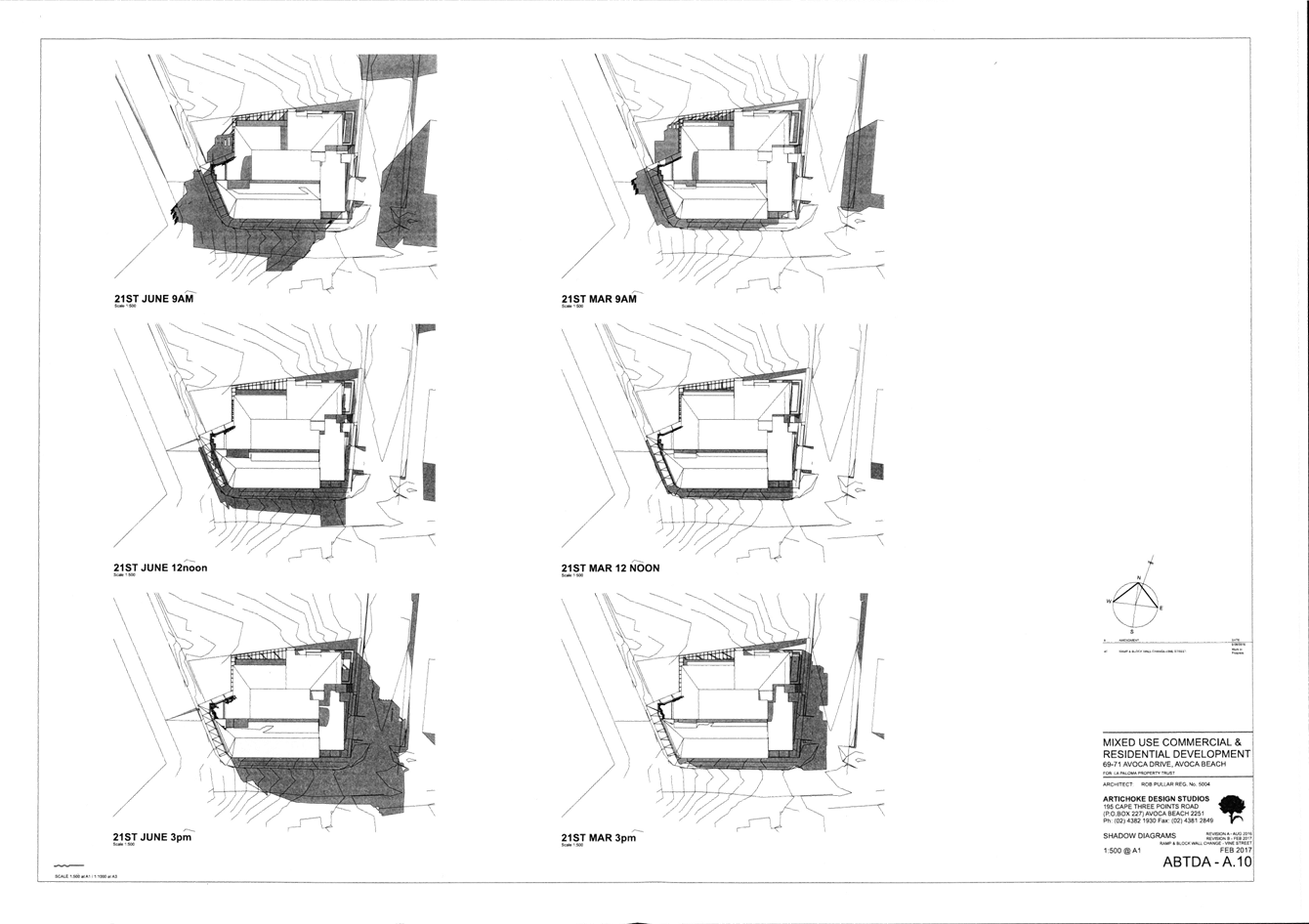
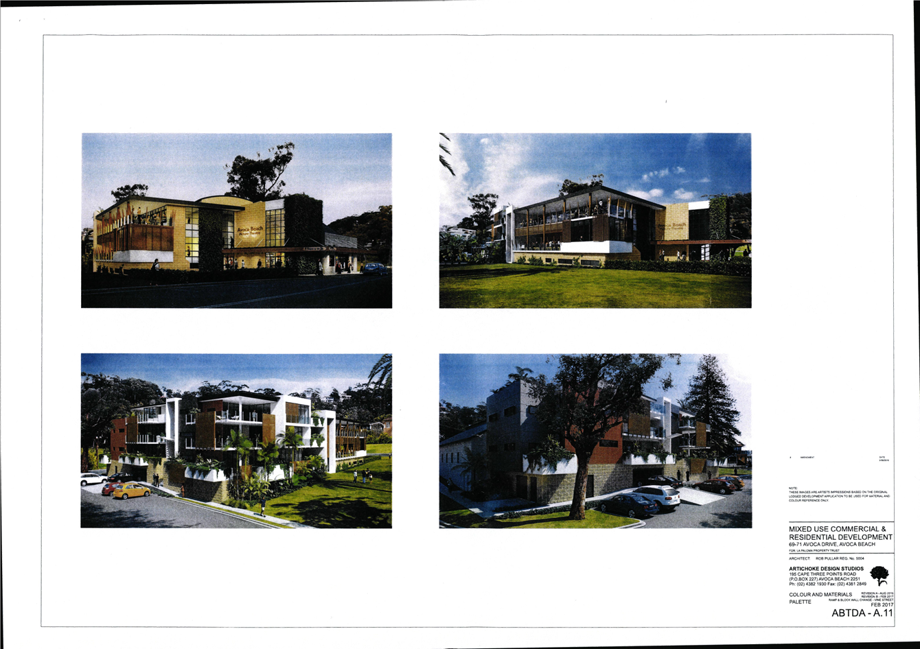
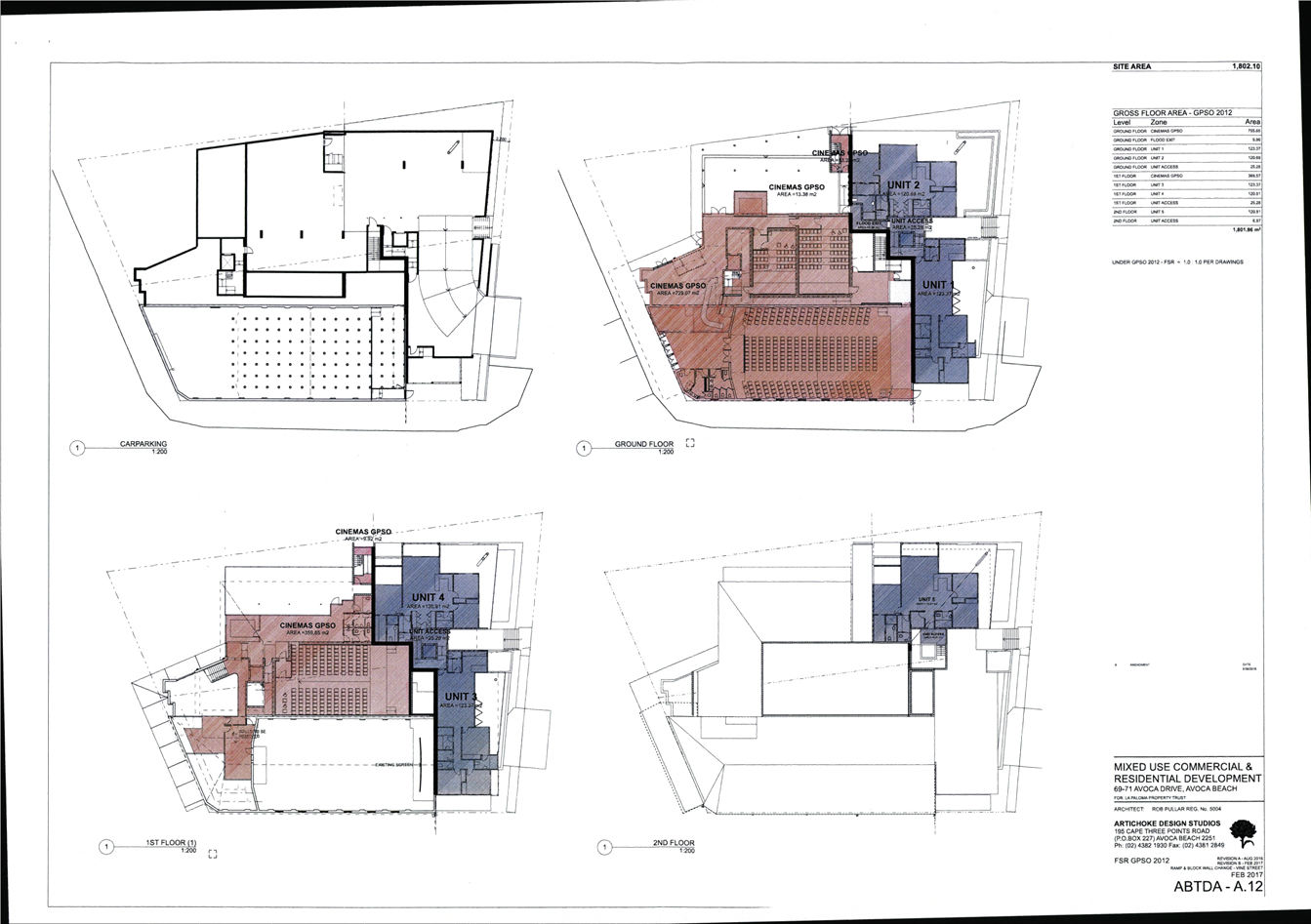
|
DA/42661/2012/E - 69-71 Avoca Drive, Avoca Beach - Alterations & Additions to existing Theatre |
|
|
Attachment 2 |
Annexure A - Conditions of Consent155633.16 O_Neill (C) L&E Court NSWLEC 1090 DA 42661 H69 Avoca Drive Avoca Beach |


|
DA/42661/2012/E - 69-71 Avoca Drive, Avoca Beach - Alterations & Additions to existing Theatre |
|
|
Attachment 3 |
Approved Plans DA42661 L140 DP9359 H71 Avoca Drive AVOCA BEACH Part 3 |
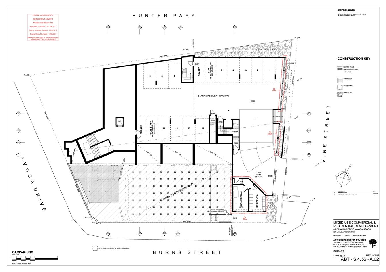
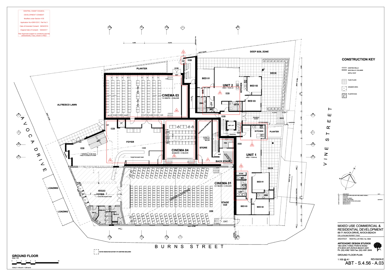
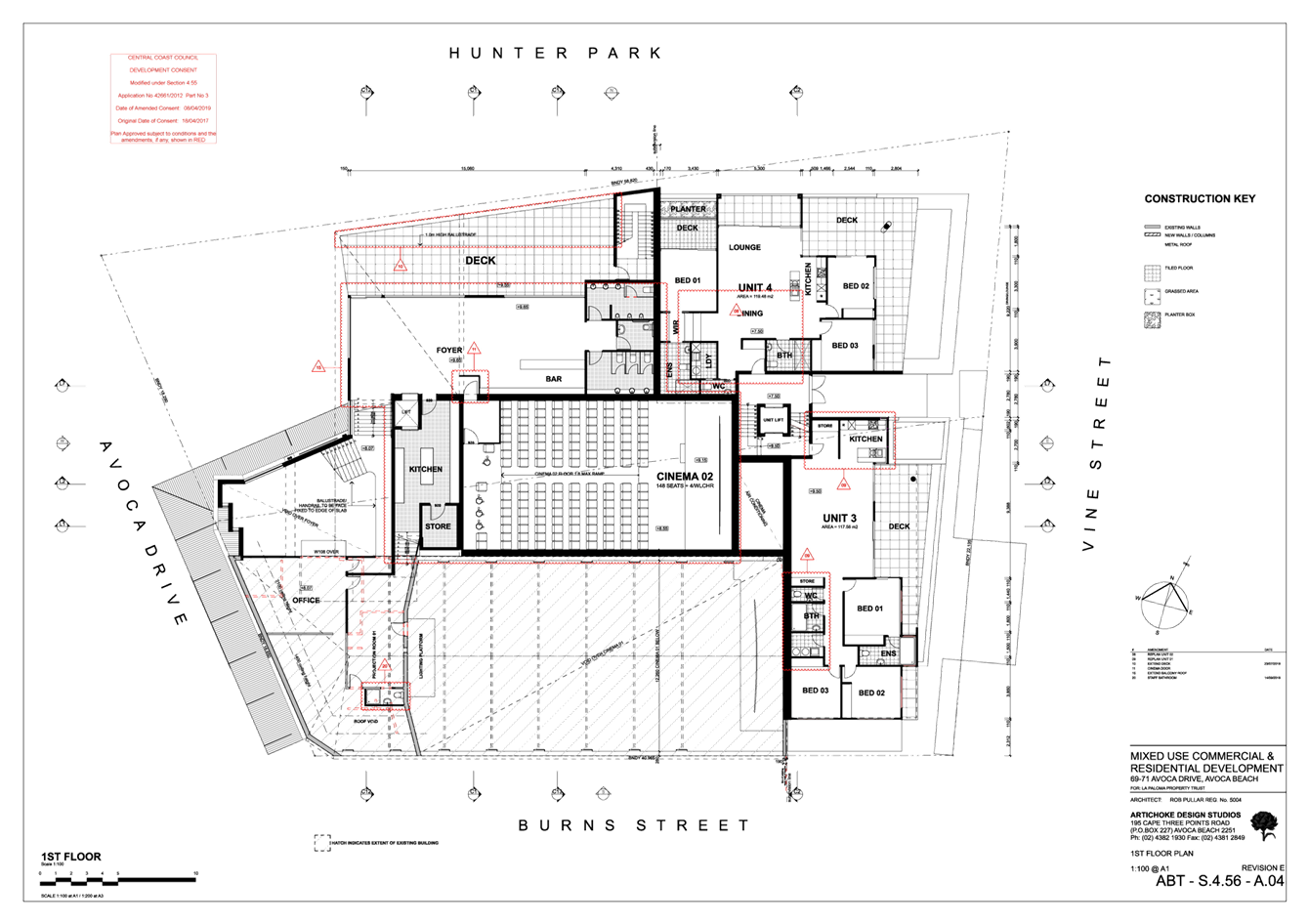
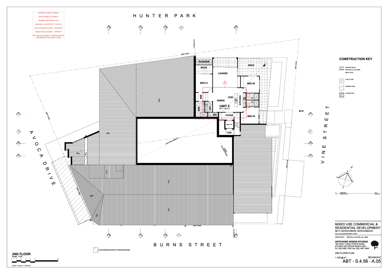
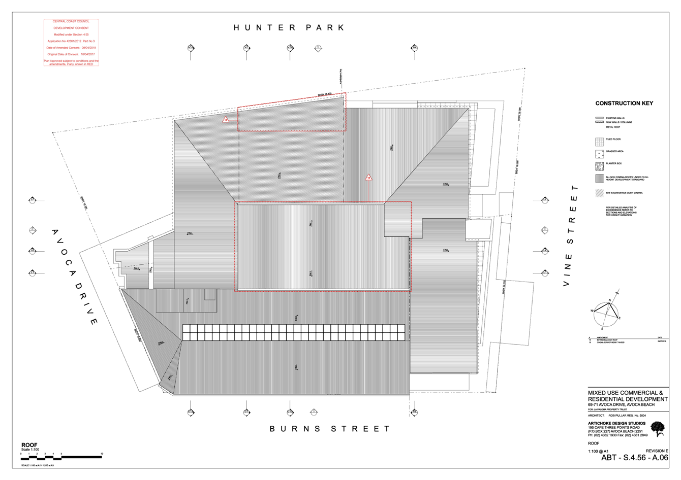
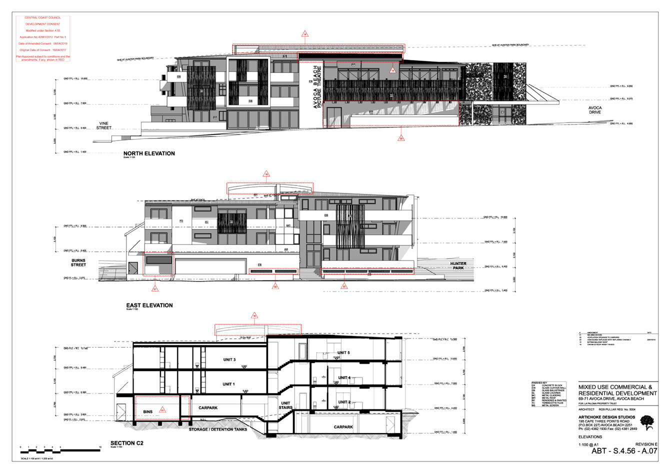
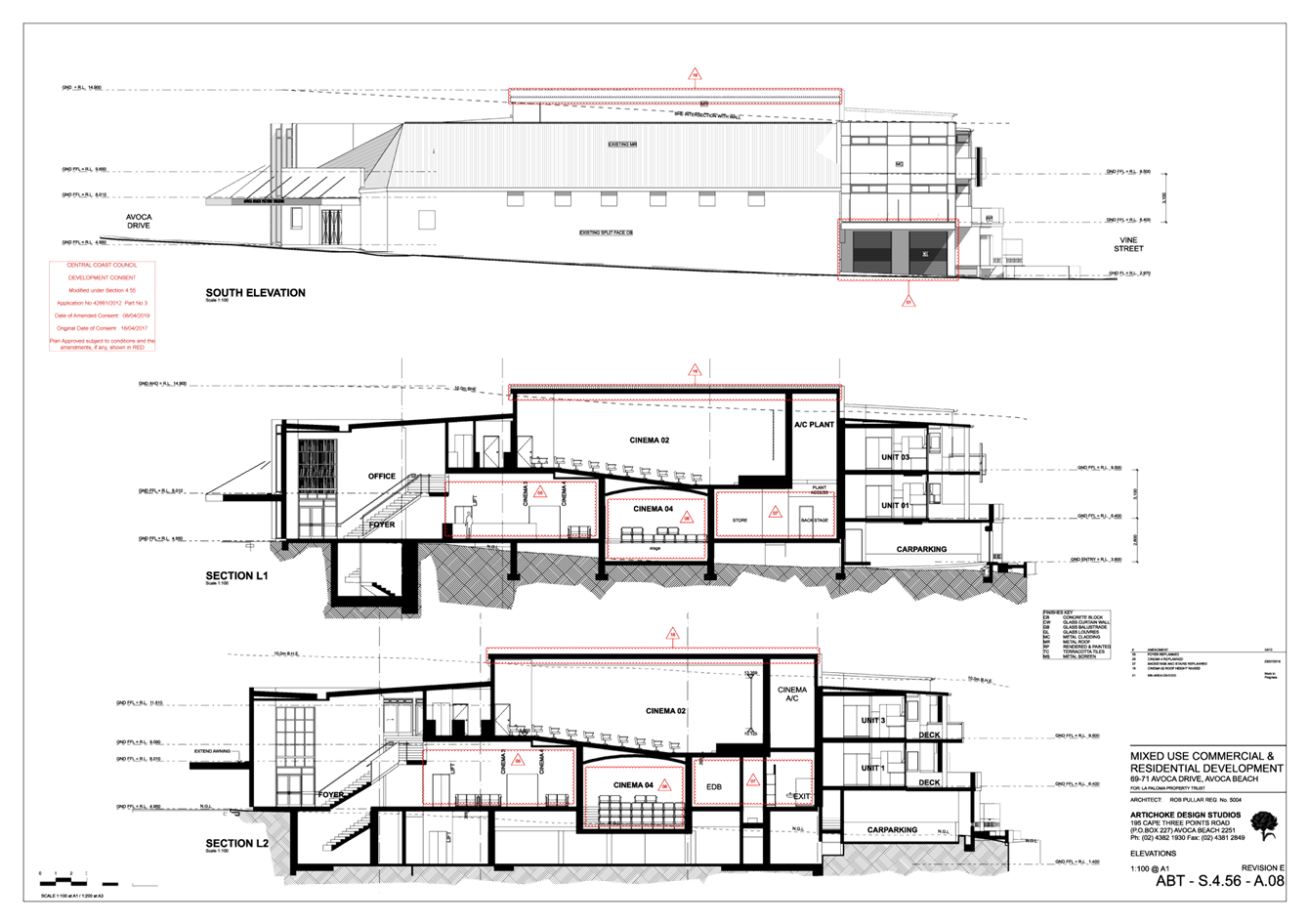
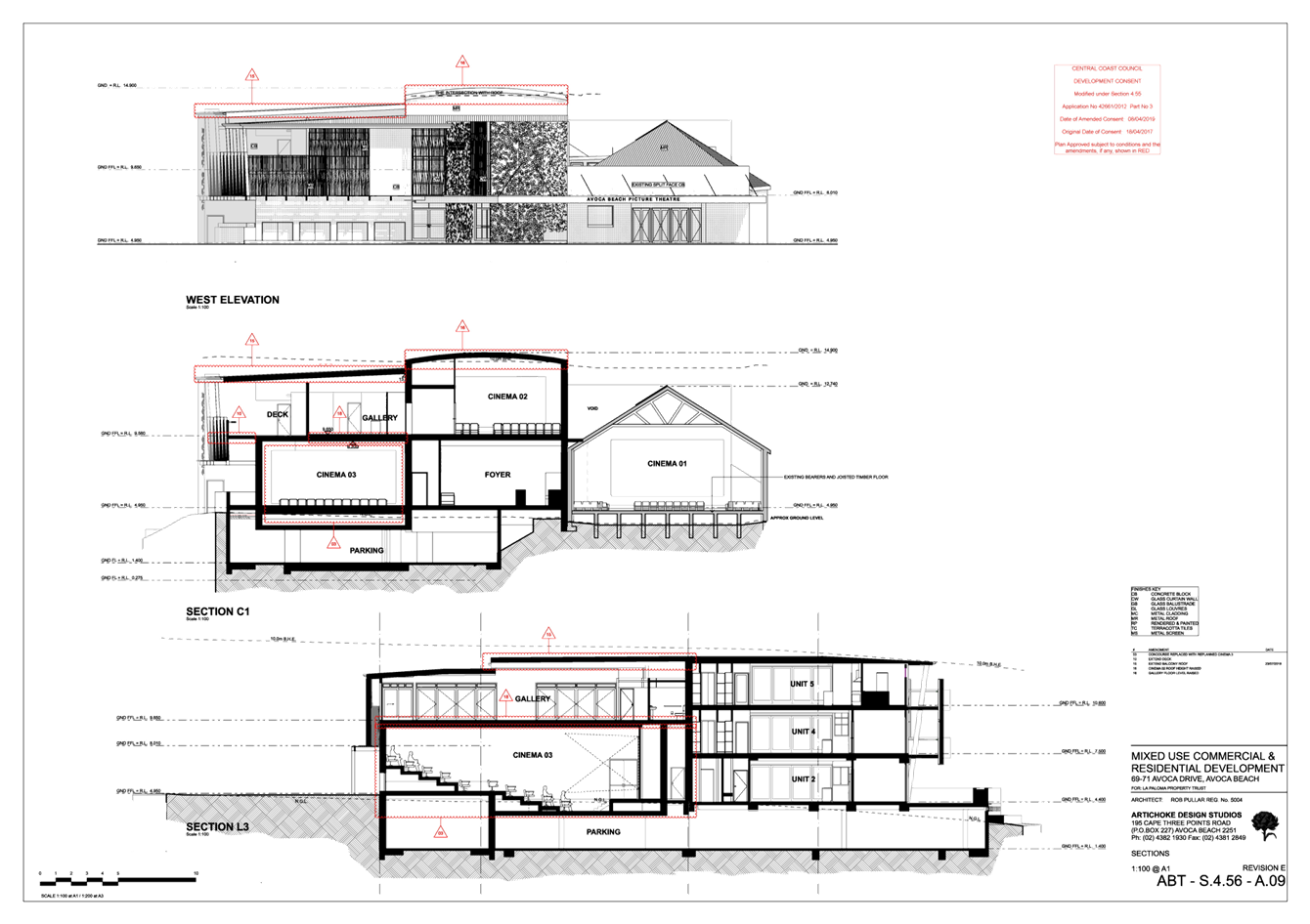
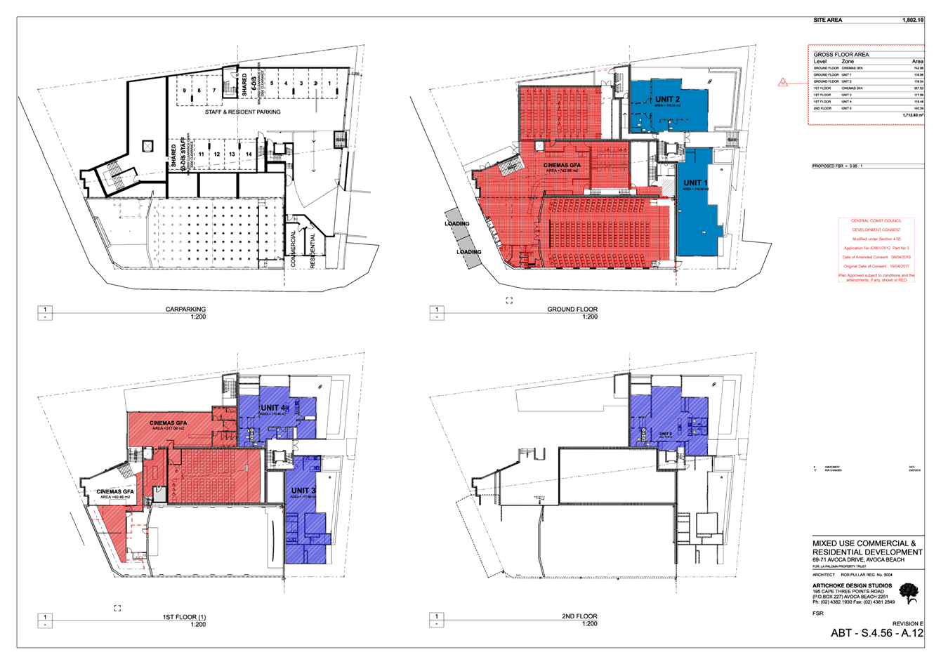
|
DA/42661/2012/E - 69-71 Avoca Drive, Avoca Beach - Alterations & Additions to existing Theatre |
|
|
Attachment 4 |
PUBLIC DA Assessment Section 4.55 Consent - 69 Avoca Dr, AVOCA BEACH NSW 2251 - DA 42661 2012 D - Johnson Projects |


|
DA/42661/2012/E - 69-71 Avoca Drive, Avoca Beach - Alterations & Additions to existing Theatre |
|
|
Attachment 5 |
Architectural Plans (S4.56 Ver 8) - 69 Avoca Dr, AVOCA BEACH NSW 2251 - PAN-268705 - DA/42661/2012/E |
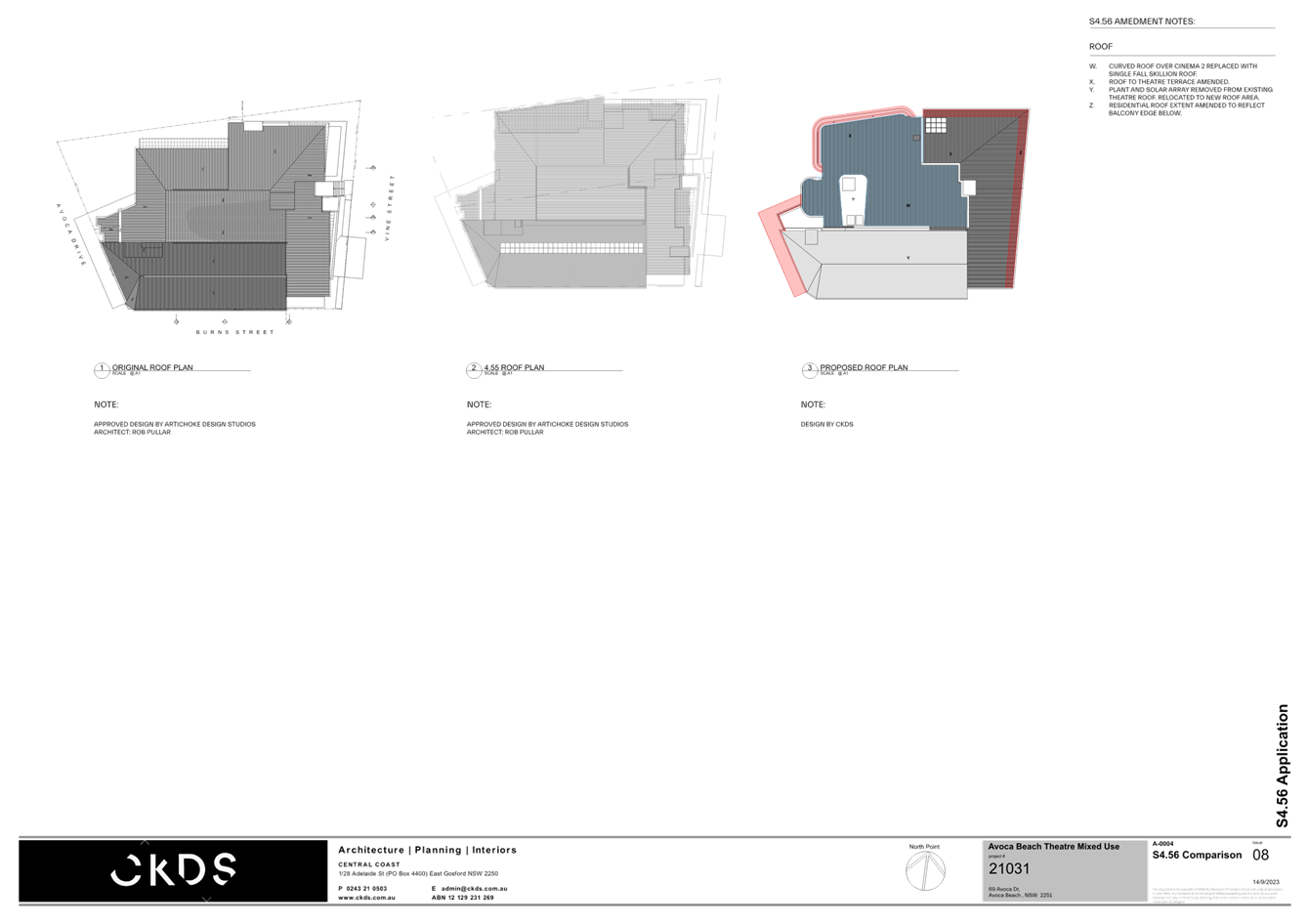
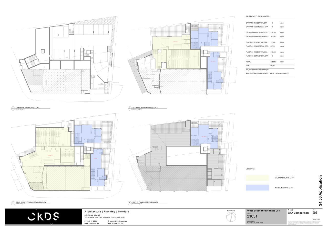
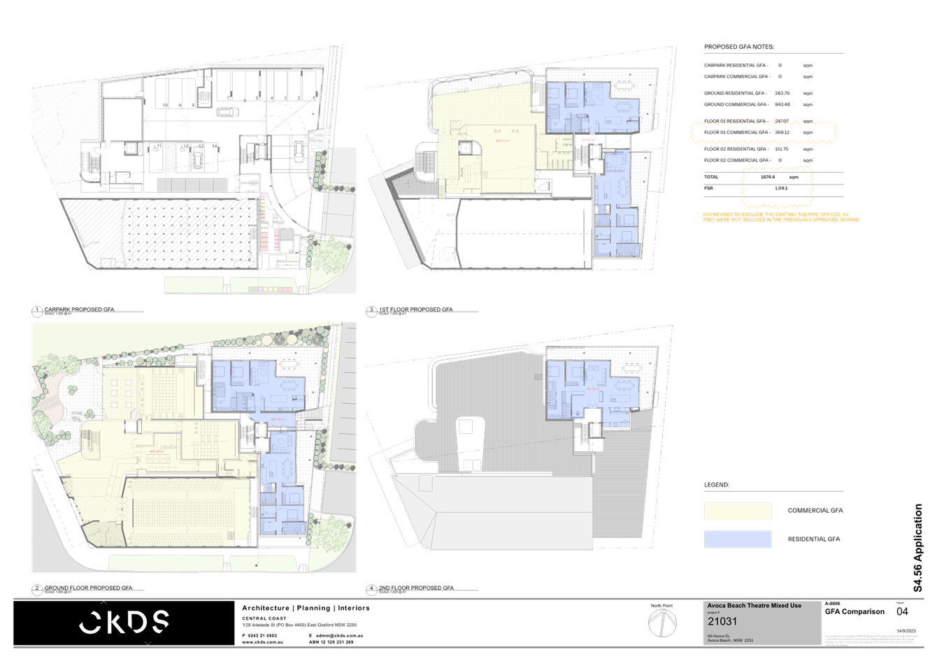
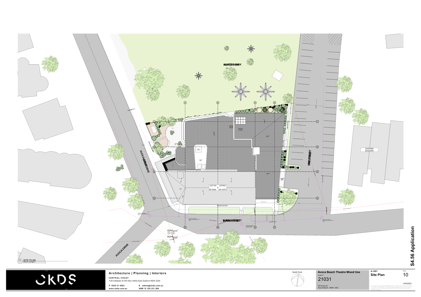
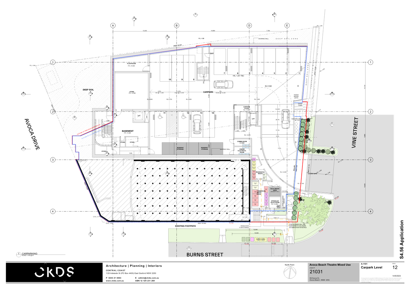
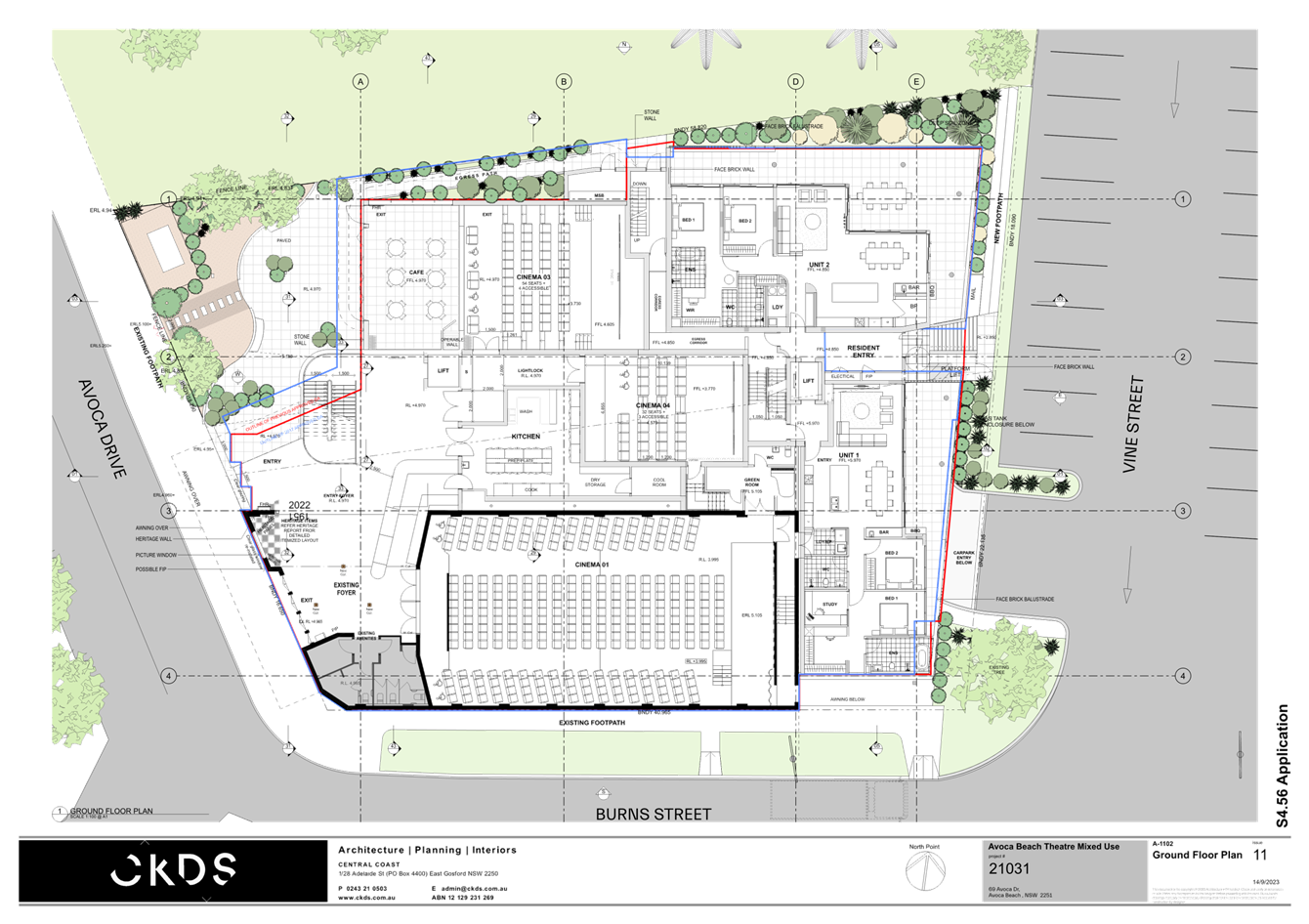
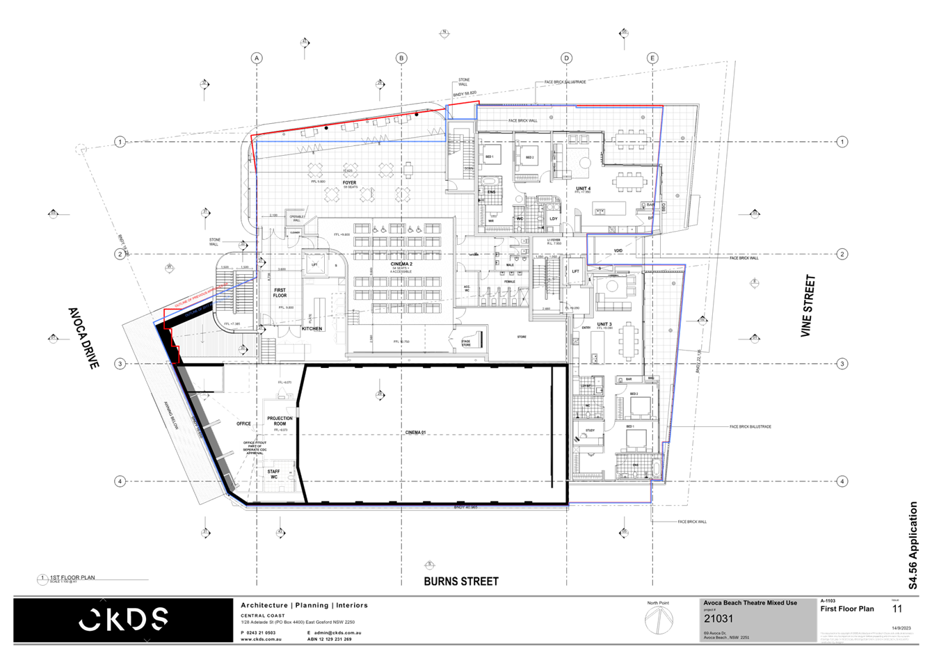
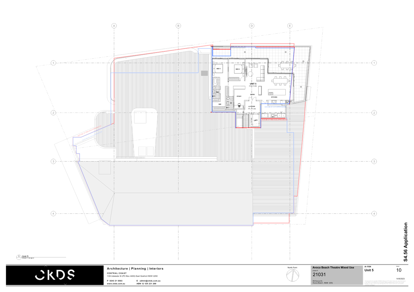
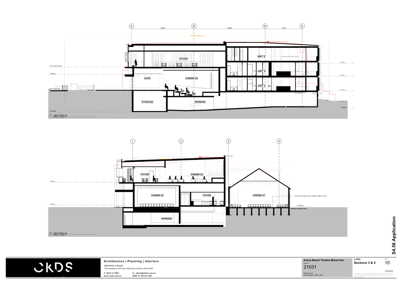
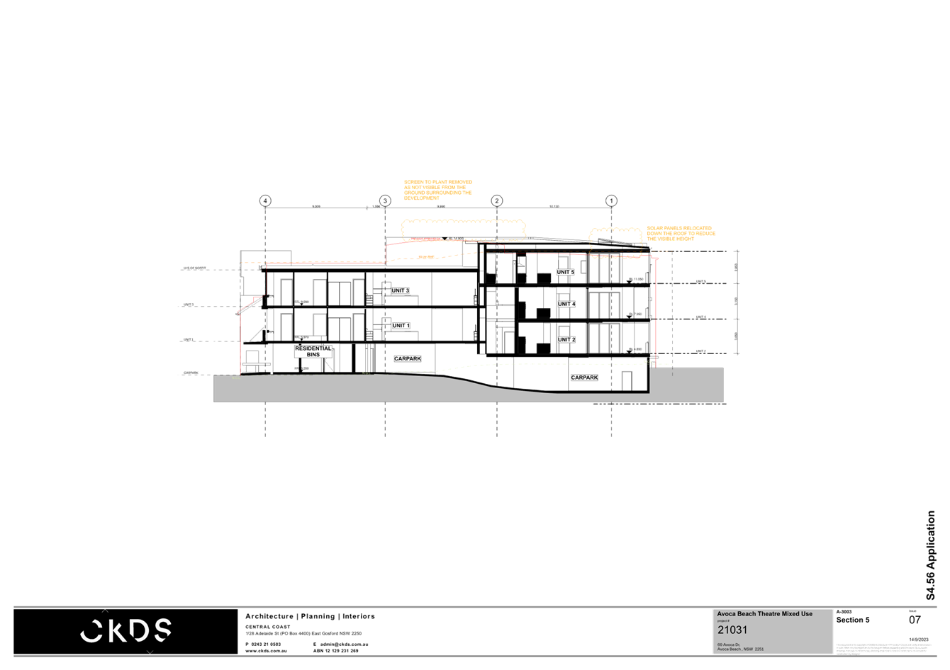
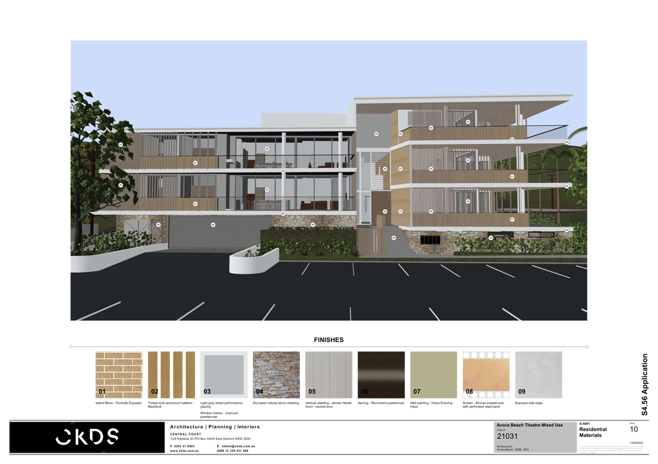
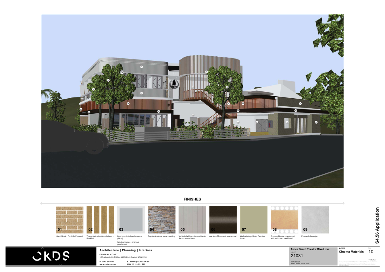
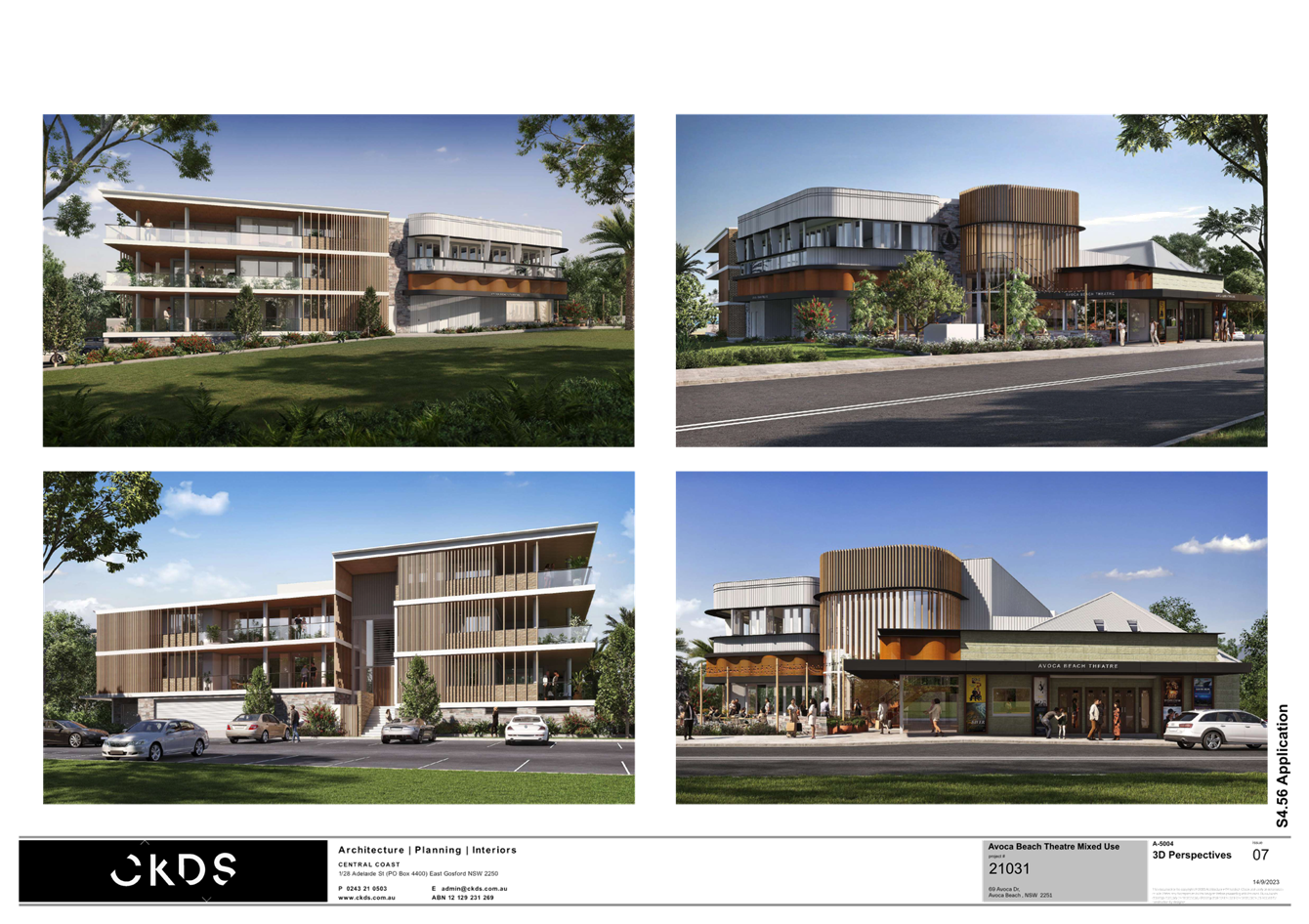
|
DA/42661/2012/E - 69-71 Avoca Drive, Avoca Beach - Alterations & Additions to existing Theatre |
|
|
Attachment 6 |
PUBLIC - Redacted Notification Plans - Avoca Beach Theatre - 69 & 71 Avoca Dr Avoca Beach - DA/42661/2012/E |


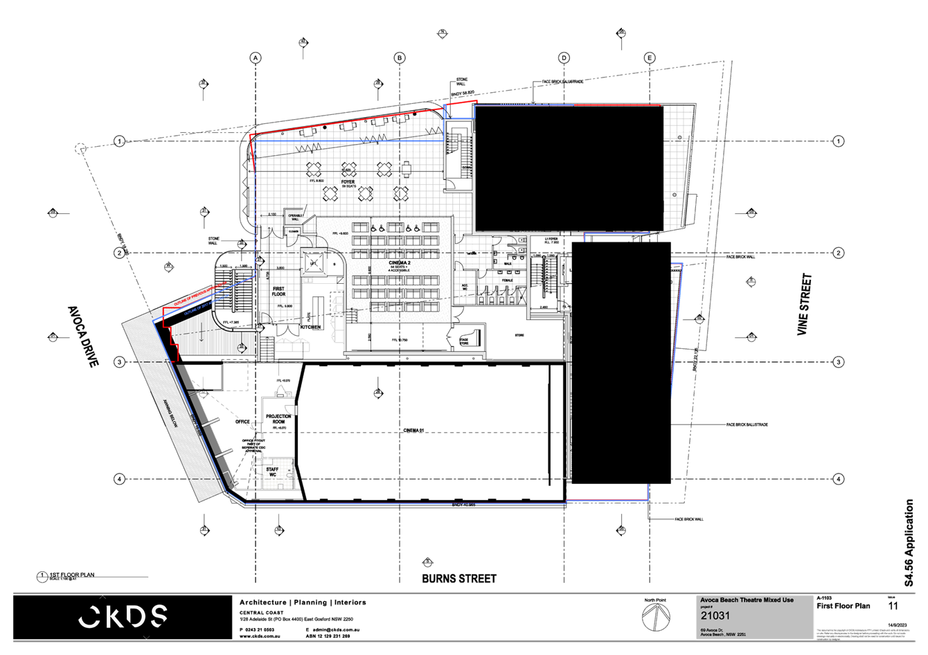
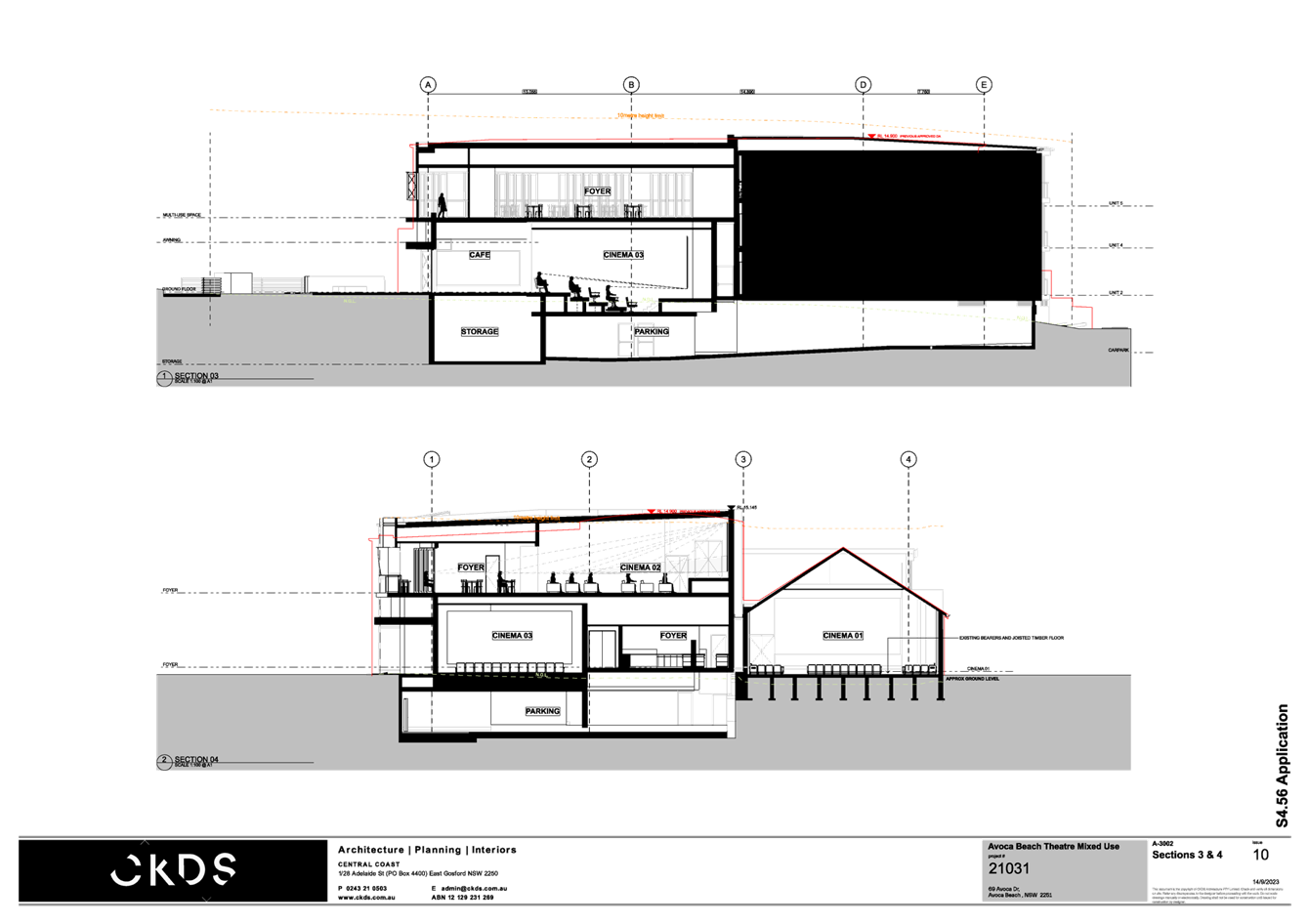
|
DA/42661/2012/E - 69-71 Avoca Drive, Avoca Beach - Alterations & Additions to existing Theatre |
|
|
Attachment 7 |
Draft conditions/reasons - Avoca Beach Theatre 69 & 71 Avoca Drive, AVOCA BEACH - DA/42661/2012/E - Central Coast Council |


|
DA/42661/2012/E - 69-71 Avoca Drive, Avoca Beach - Alterations & Additions to existing Theatre |
|
|
Attachment 8 |
UPDATED View Impact Analysis[1]_PAN-268705 - 69 Avoca Drive AVOCA BEACH - Avoca Theatre - 69 & 71 Avoca Drive AVOCA BEACH - DA/42661/2012/E |
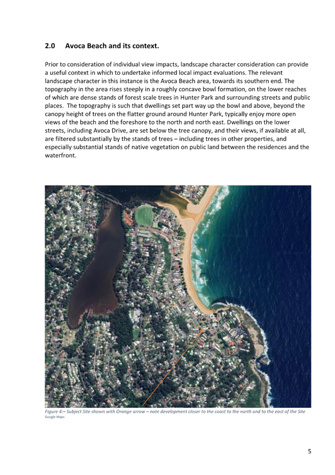
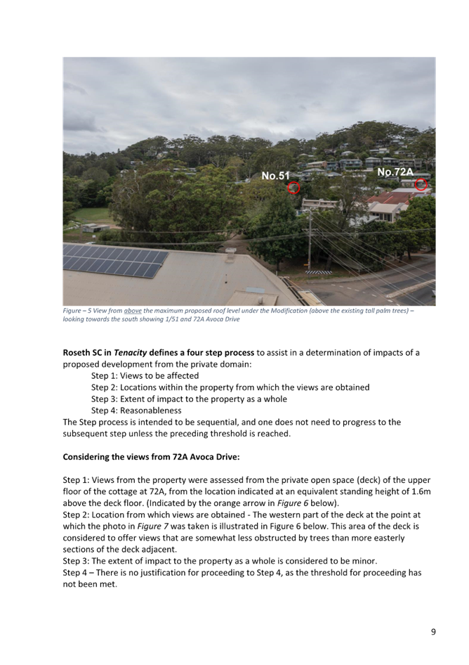
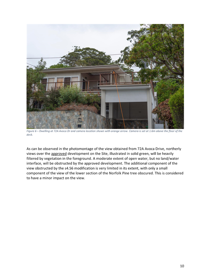
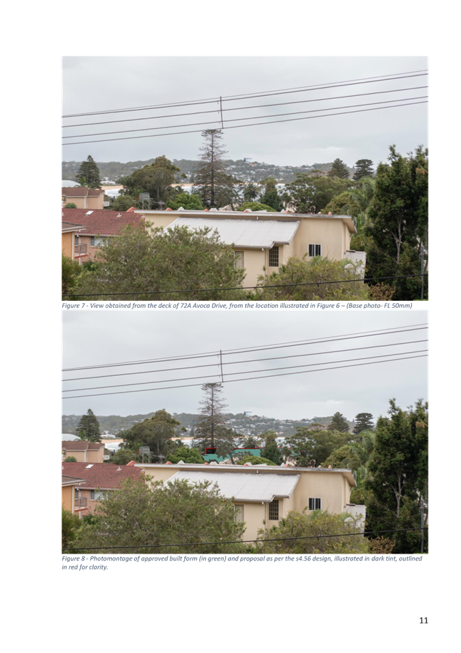
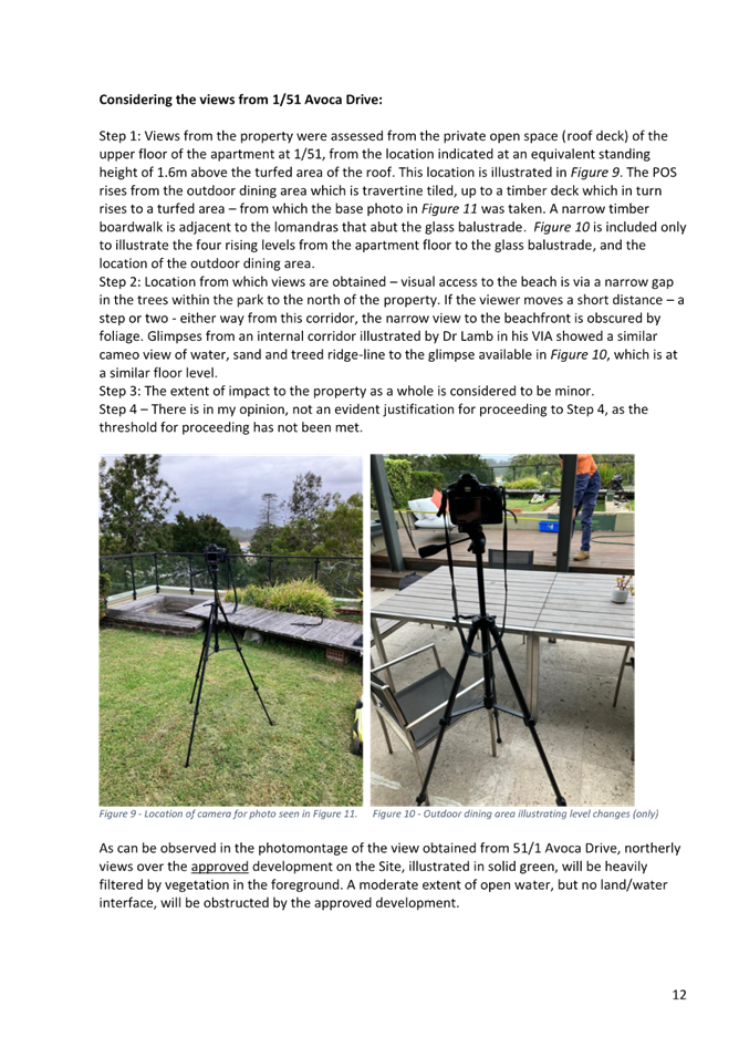

|
DA/42661/2012/E - 69-71 Avoca Drive, Avoca Beach - Alterations & Additions to existing Theatre |
|
|
Attachment 9 |
PUBLIC Apartment Design Guide Report - 69 Avoca Dr, AVOCA BEACH NSW 2251 - PAN-268705 - DA/42661/2012/E |
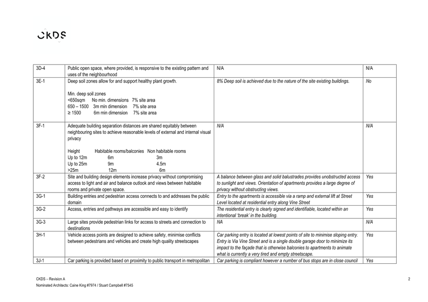

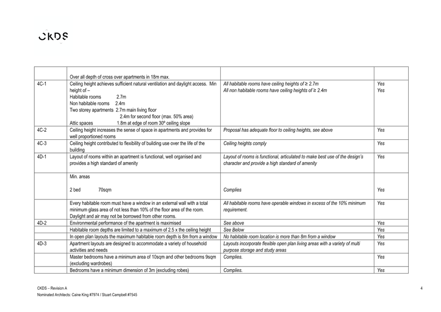
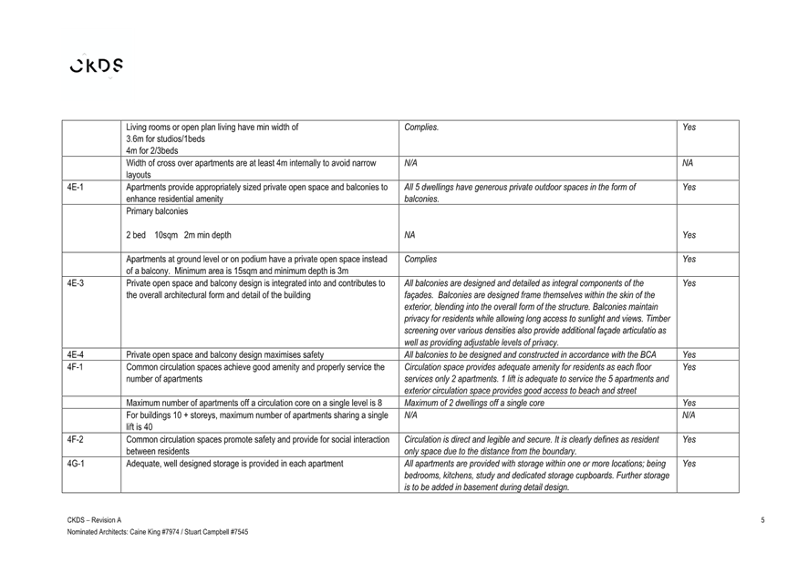
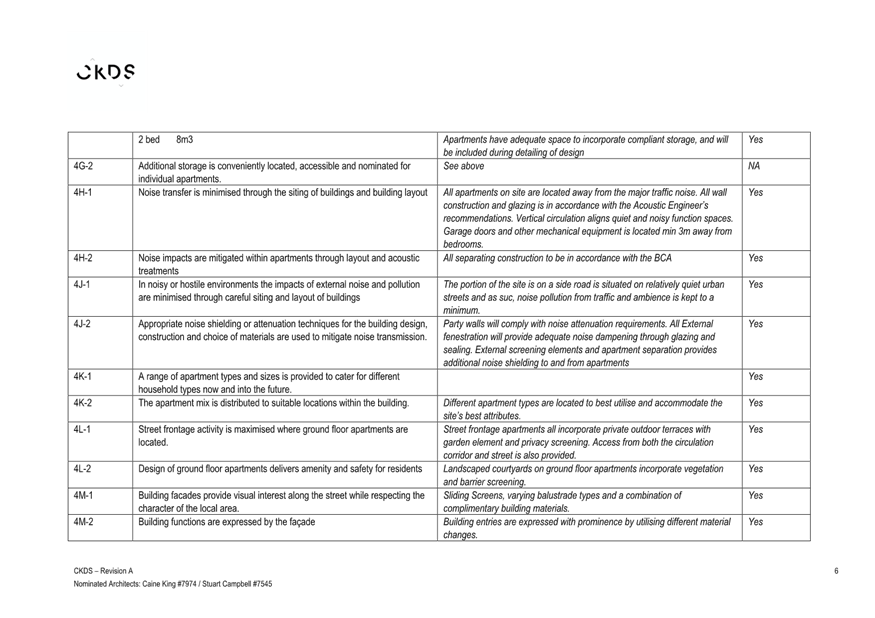
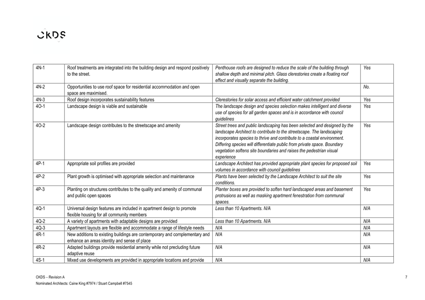
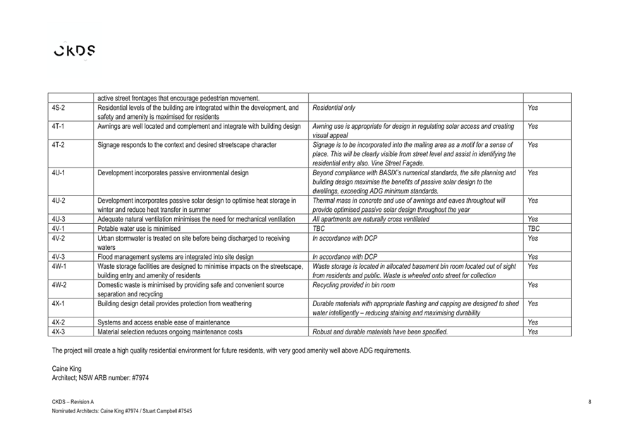
|
DA/42661/2012/E - 69-71 Avoca Drive, Avoca Beach - Alterations & Additions to existing Theatre |
|
|
Attachment 10 |
PUBLIC Architectural Design Statement - 69 Avoca Dr, AVOCA BEACH NSW 2251 - PAN-268705 - DA/42661/2012/E |
|
DA/42661/2012/E - 69-71 Avoca Drive, Avoca Beach - Alterations & Additions to existing Theatre |
|
|
Attachment 11 |
PUBLIC Design Verification Statement - 69 Avoca Dr, AVOCA BEACH NSW 2251 - PAN-268705 - DA/42661/2012/E |


|
DA/42661/2012/E - 69-71 Avoca Drive, Avoca Beach - Alterations & Additions to existing Theatre |
|
|
Attachment 12 |
PUBLIC Landscape Plan - 69 Avoca Dr, AVOCA BEACH NSW 2251 - PAN-268705 - DA/42661/2012/E |
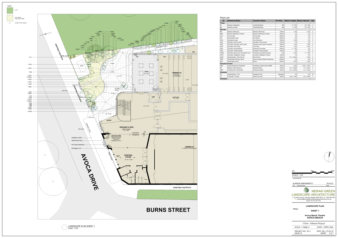
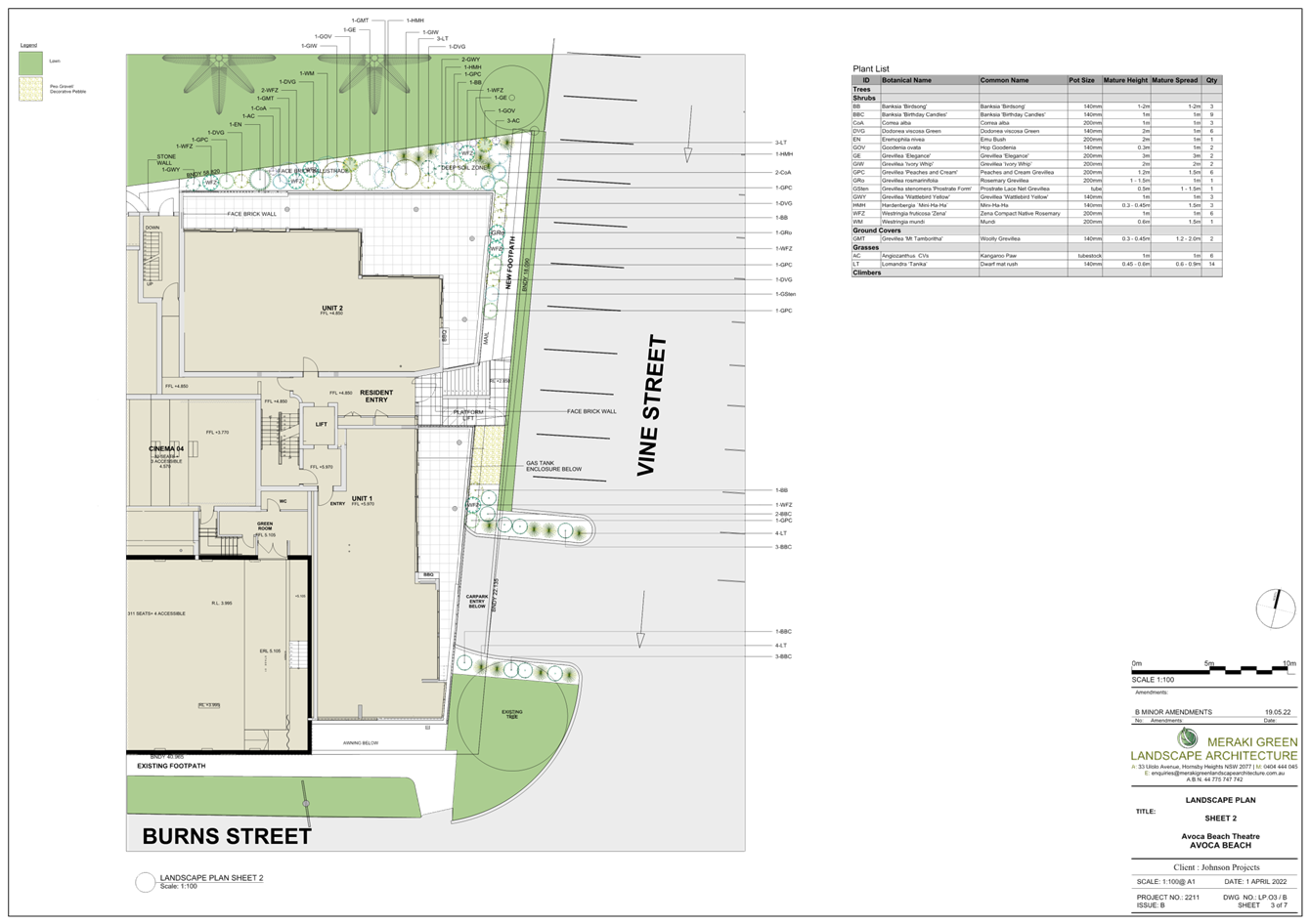
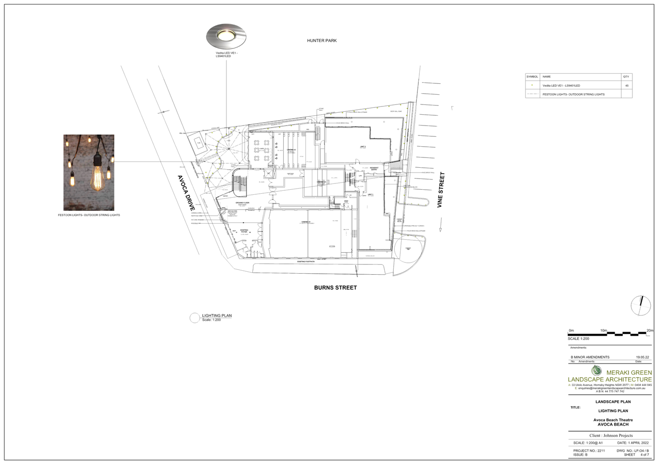
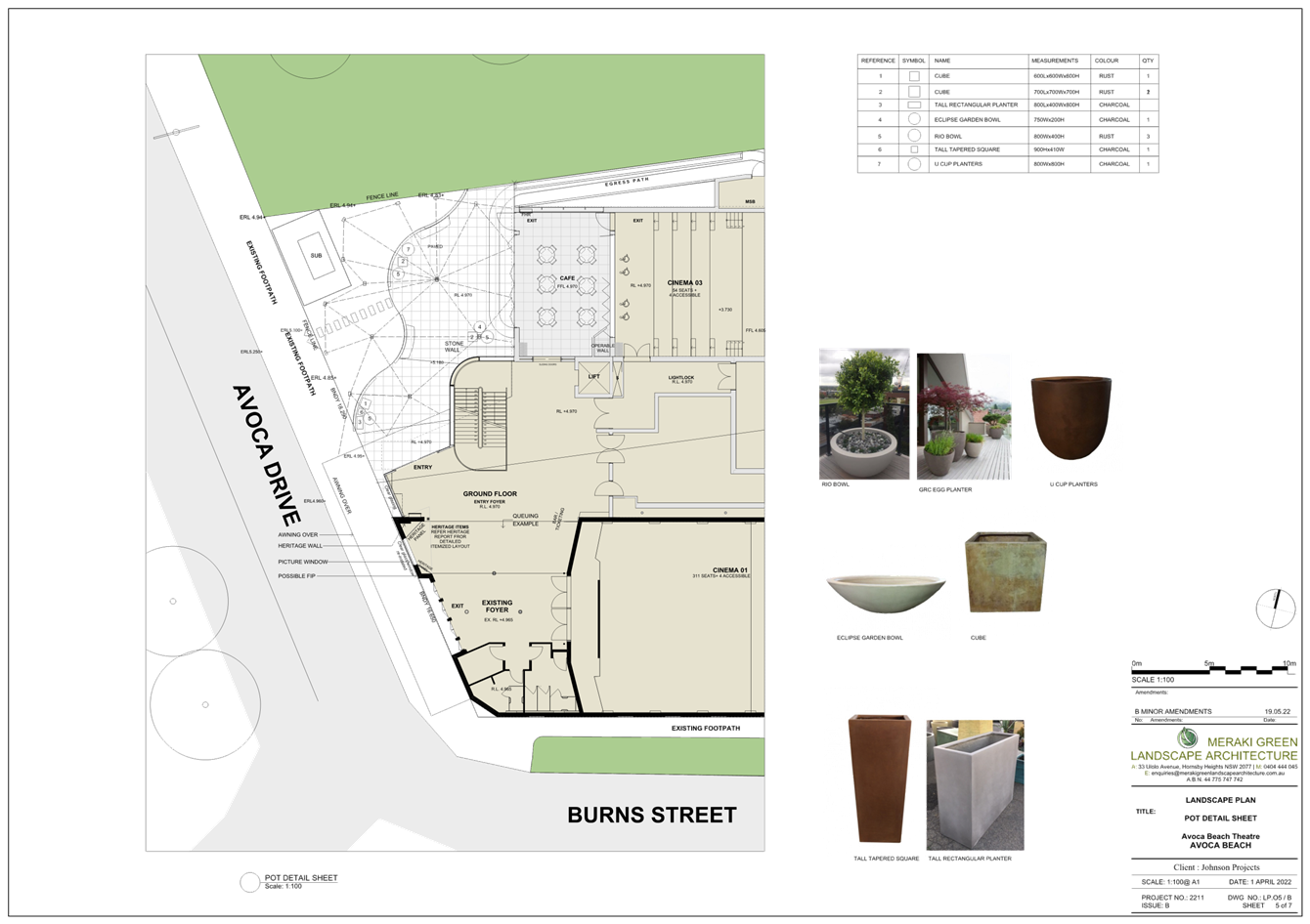
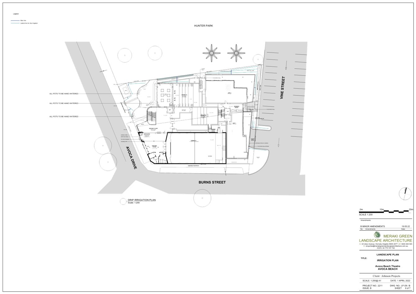
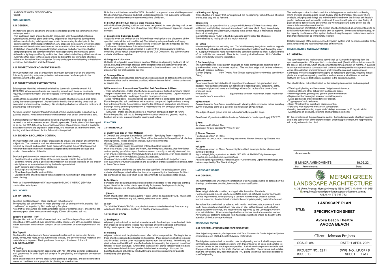
|
DA/42661/2012/E - 69-71 Avoca Drive, Avoca Beach - Alterations & Additions to existing Theatre |
|
|
Attachment 13 |
Statement of Environmental Effects - DA/42661/2012/E - 69 Avoca Dr, Avoca Beach |
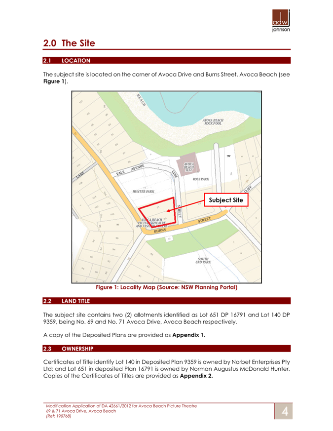
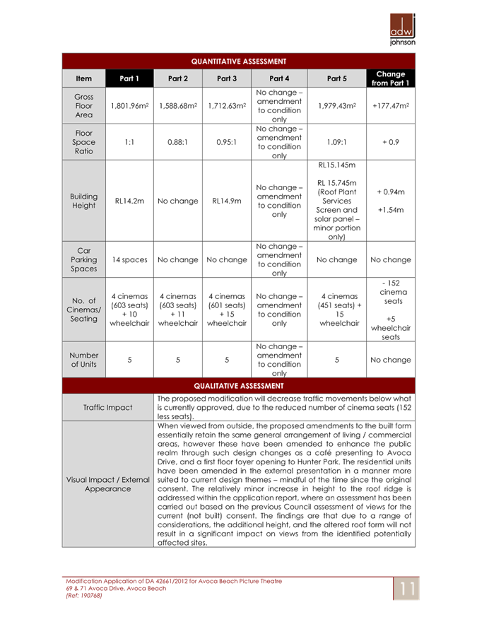
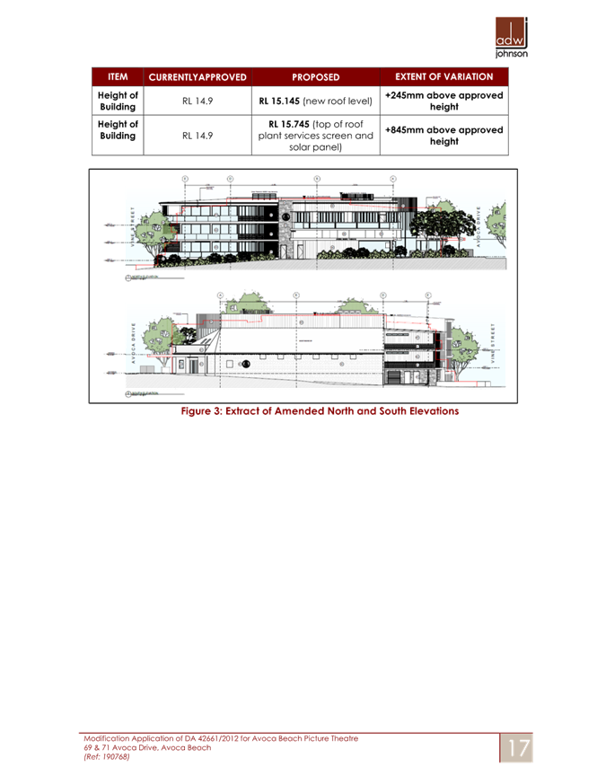
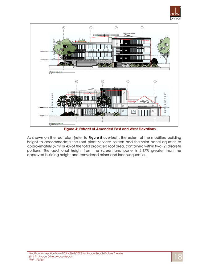
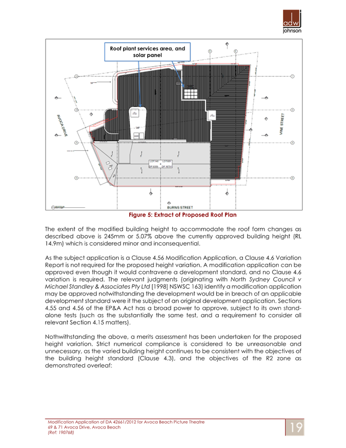
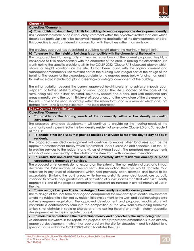
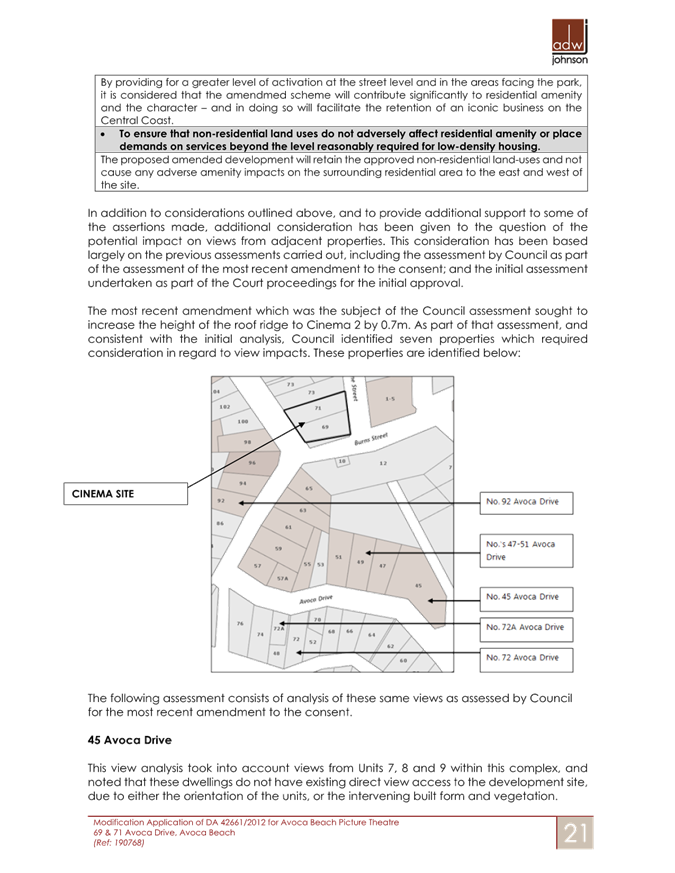
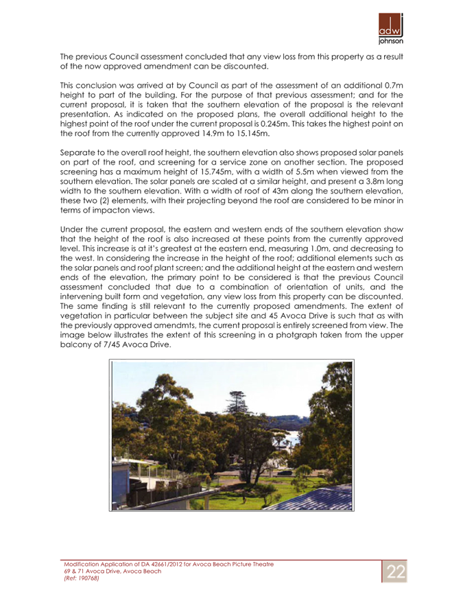
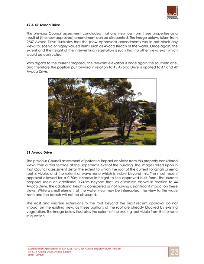
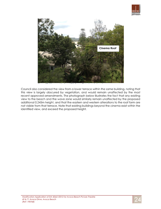
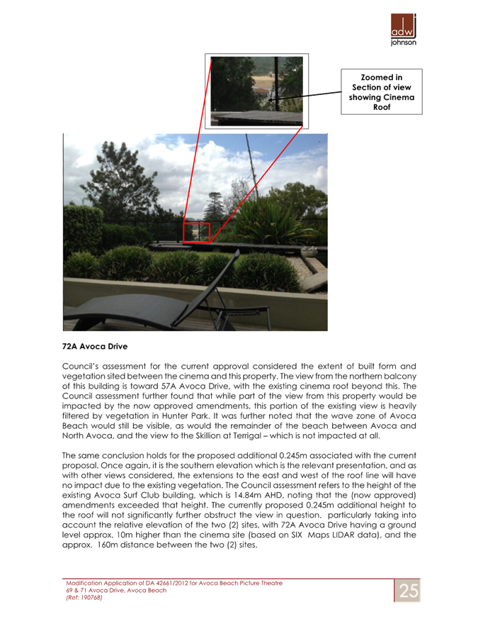
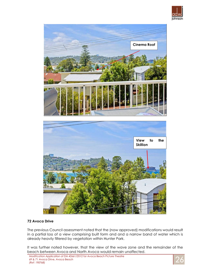
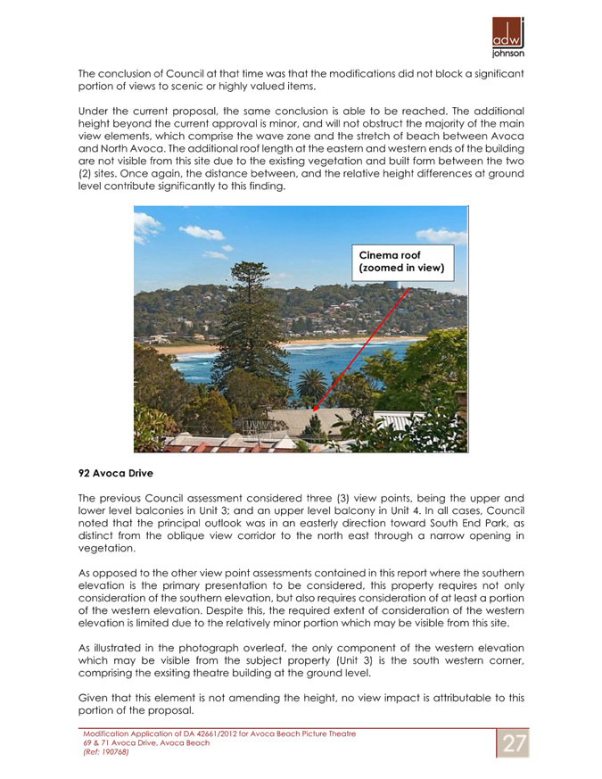
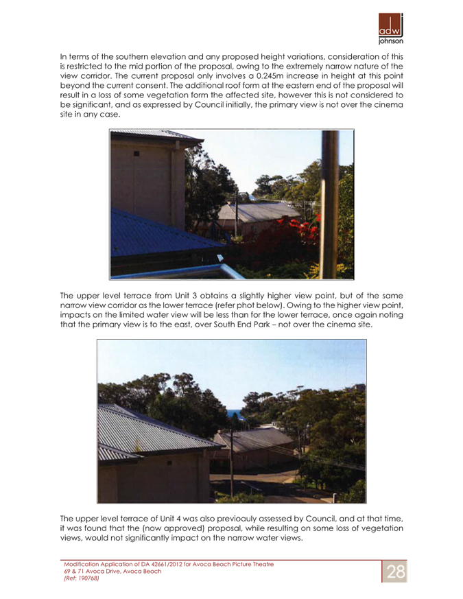
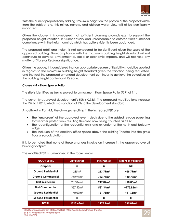
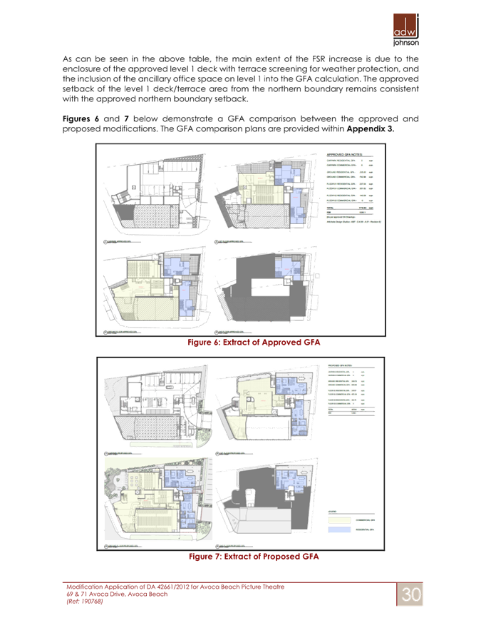
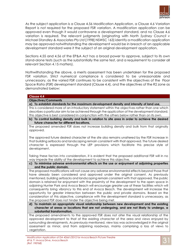


|
DA/42661/2012/E - 69-71 Avoca Drive, Avoca Beach - Alterations & Additions to existing Theatre |
|
|
Attachment 14 |
Covering Letter - Deed of agreement - Avoca Beach Theatre - 69 Avoca Drive, AVOCA BEACH - DA/42661/2012/E |
|
1.2 |
DA/42661/2012/E - 69-71 Avoca Drive, Avoca Beach - Alterations & Additions to existing Theatre |
|
Attachment 15 |
Visual Impact Analysis - 69 Avoca Dr, AVOCA BEACH NSW 2251 - PAN-268705 - DA/42661/2012/E |
|
1.2 |
DA/42661/2012/E - 69-71 Avoca Drive, Avoca Beach - Alterations & Additions to existing Theatre |
|
Attachment 16 |
Land & Environment Court - NSWLEC - 2017- Ruling - Avoca Beach theatre Re Development Fee Accepted. - 69 Avoca Drive, AVOCA BEACH - DA/42661/2012/E |

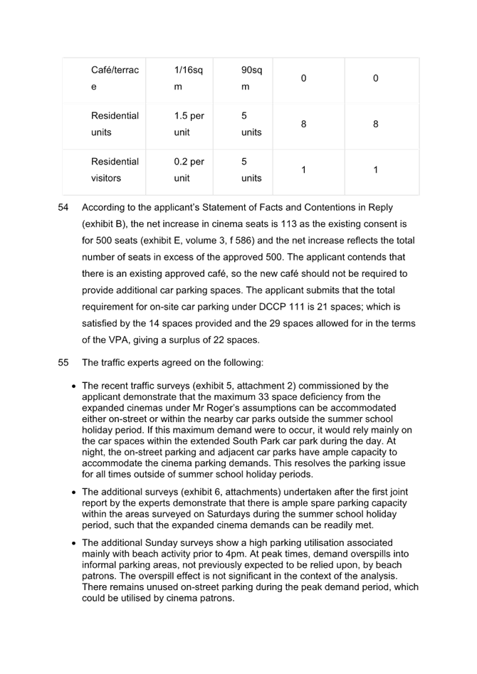

|
DA/42661/2012/E - 69-71 Avoca Drive, Avoca Beach - Alterations & Additions to existing Theatre |
|
|
Attachment 17 |
Assessment Report DA42661 L140 DP9359 H71 Avoca Drive AVOCA BEACH Part 3 |
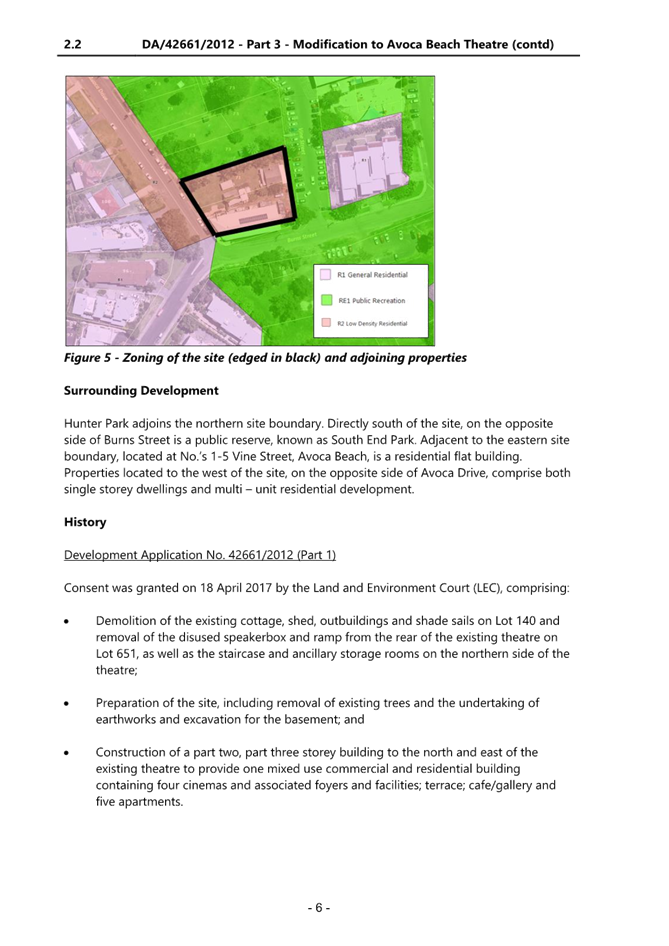
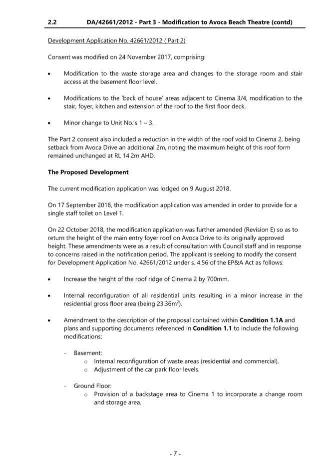
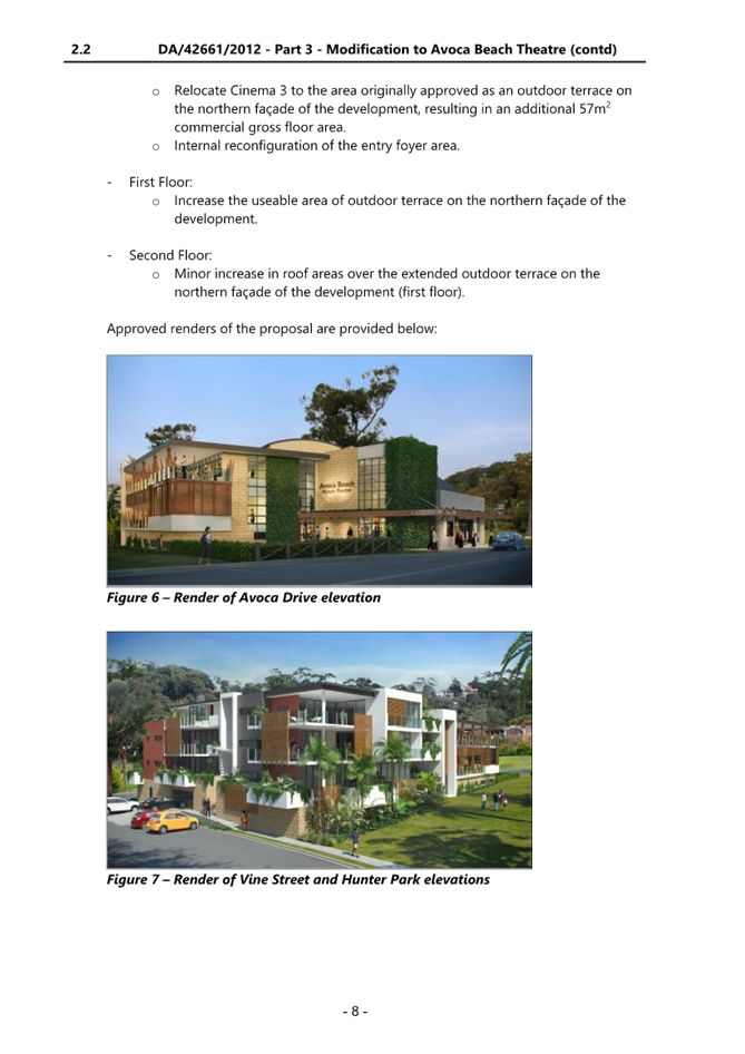
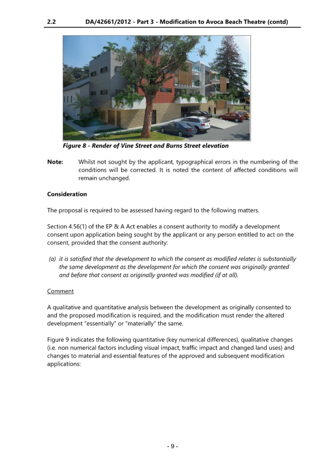
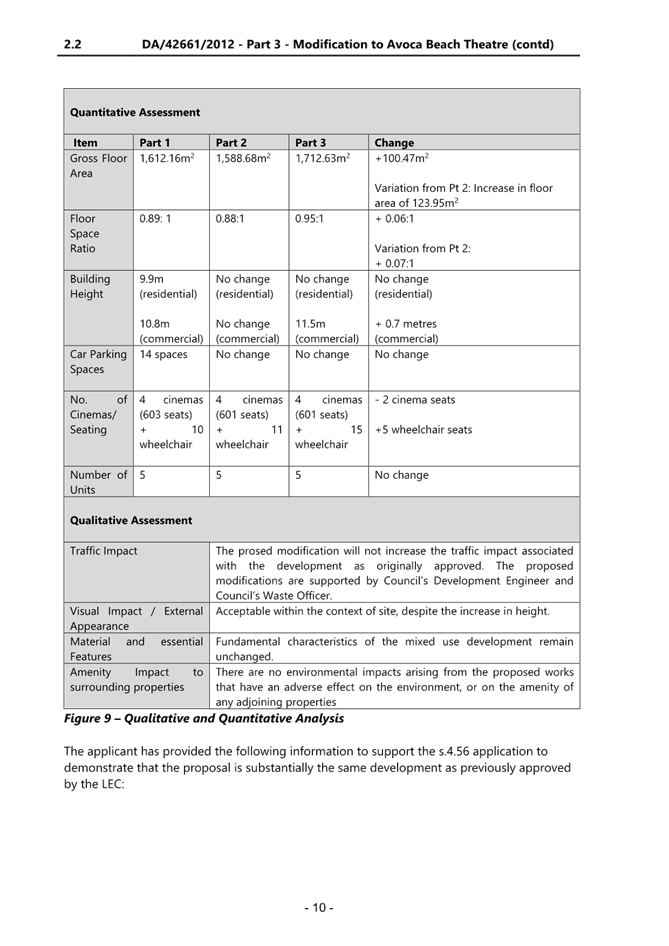
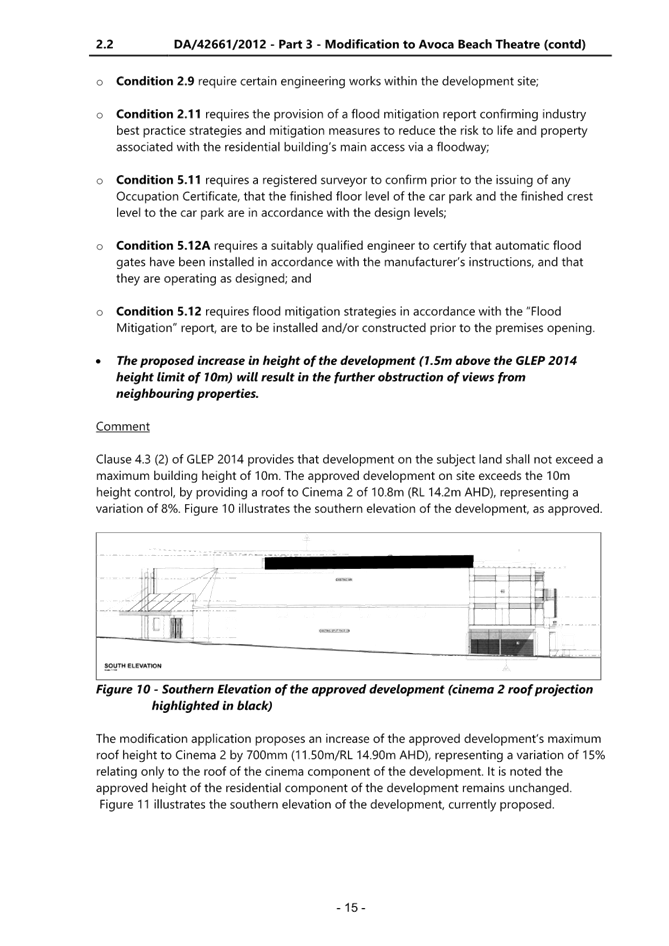
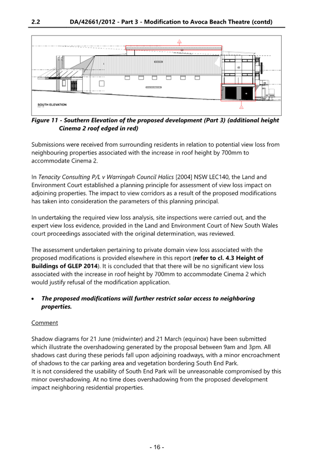
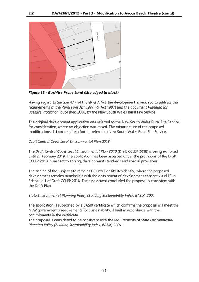
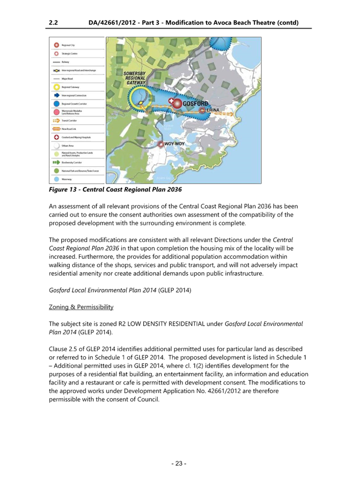
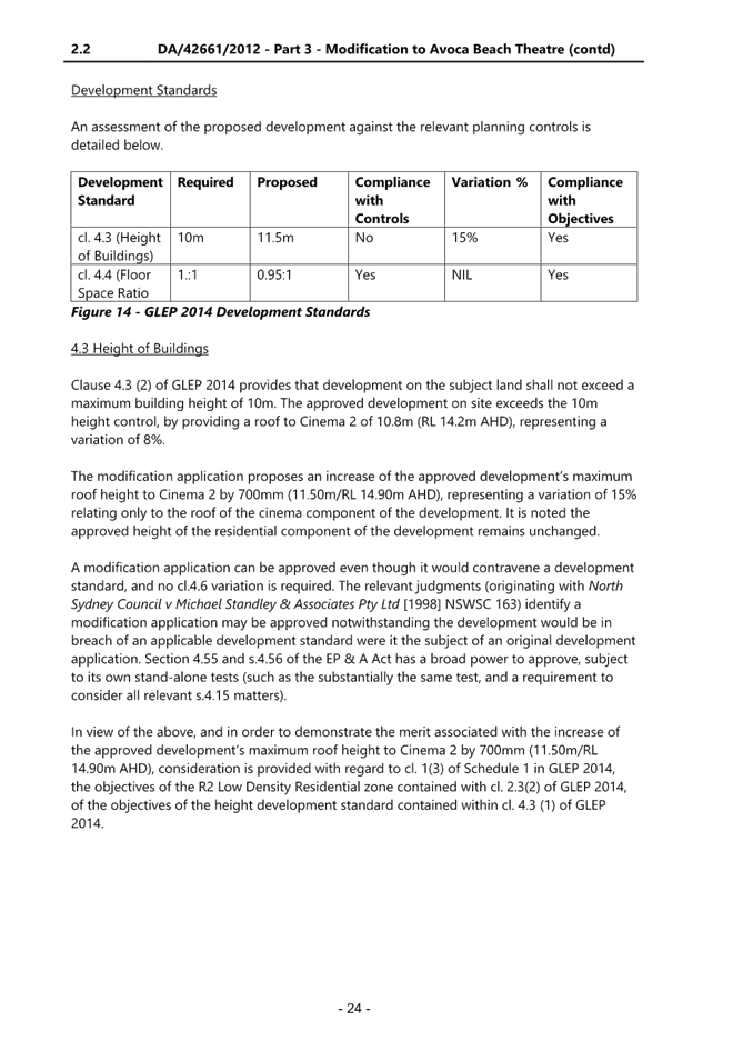
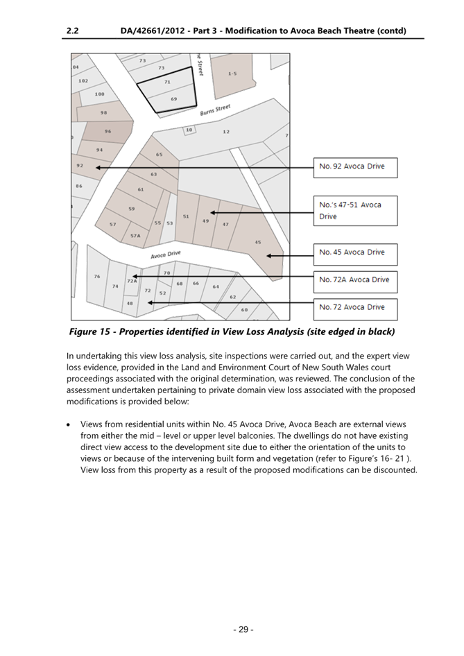
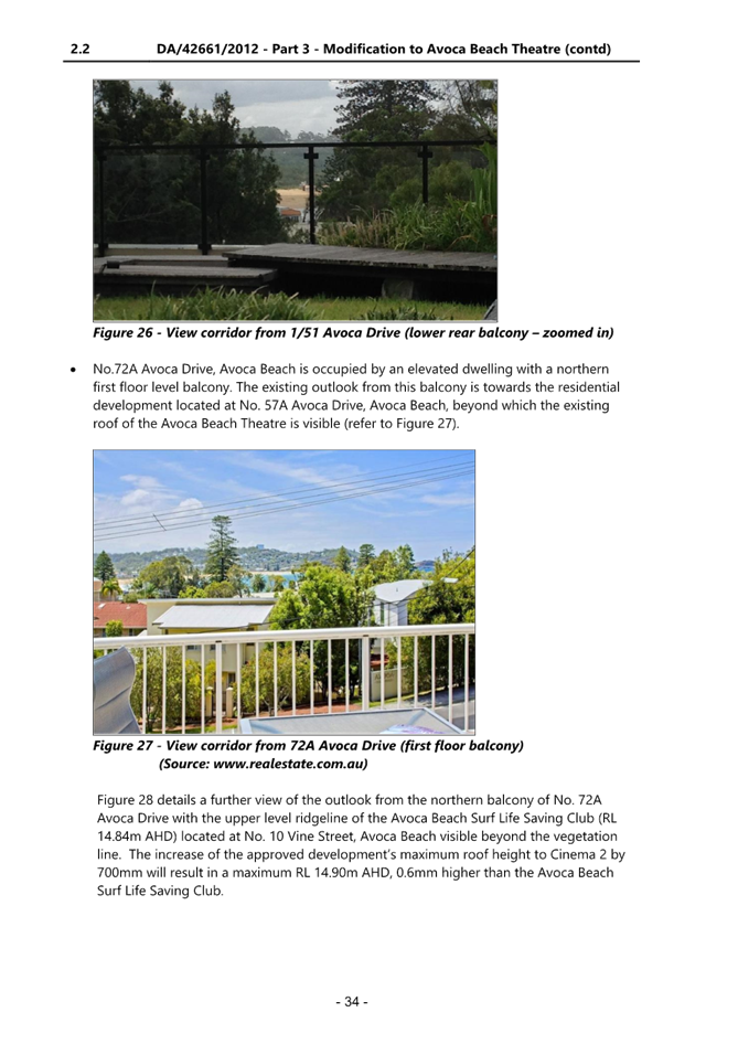
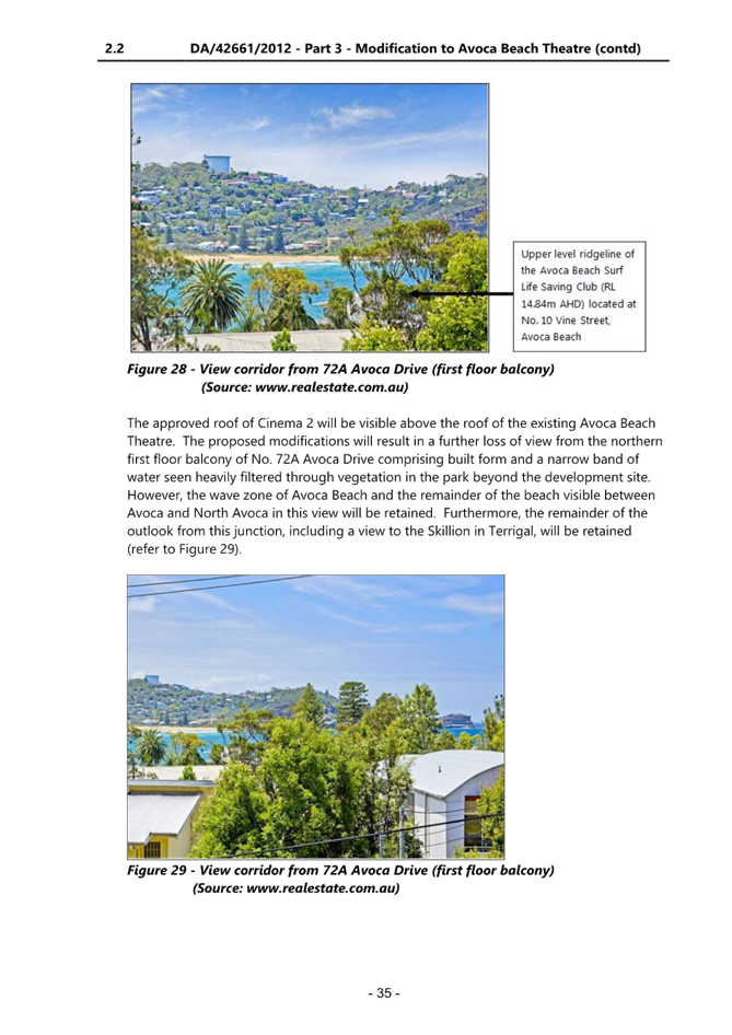
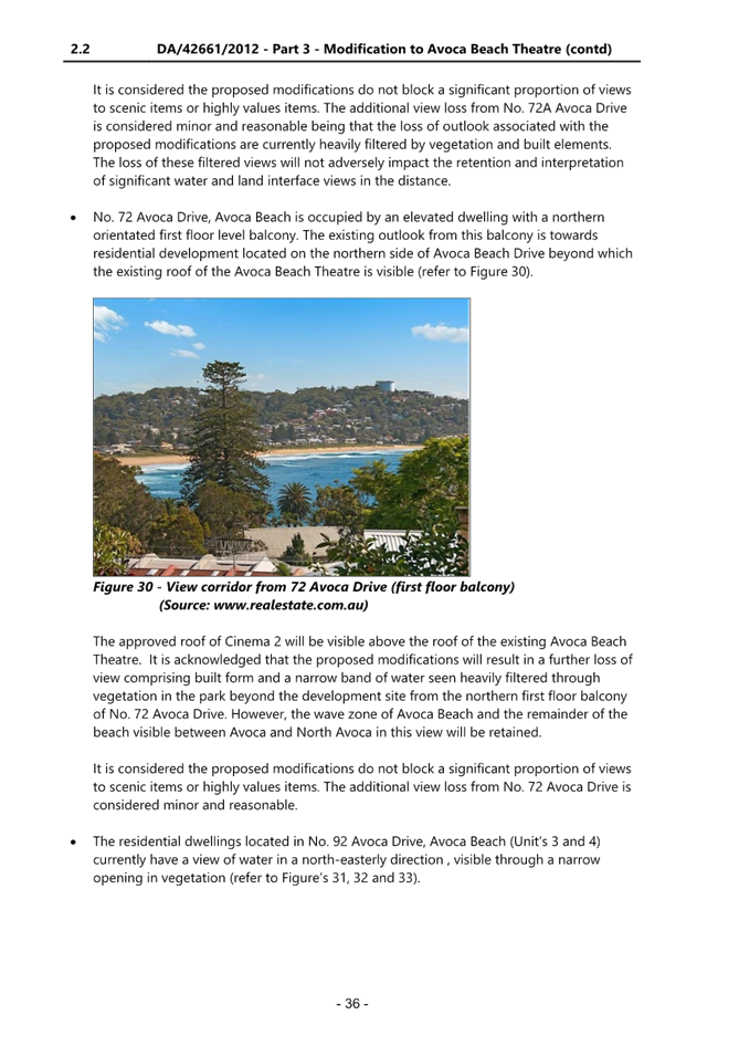
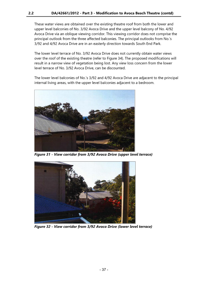
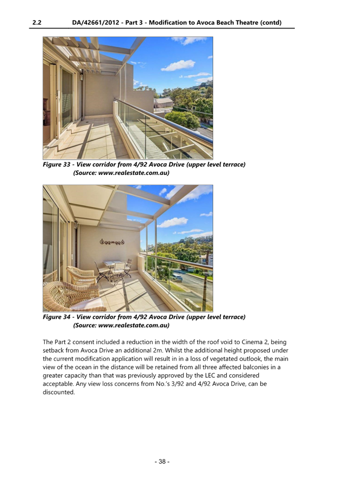
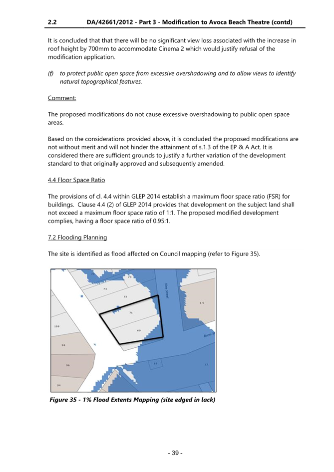
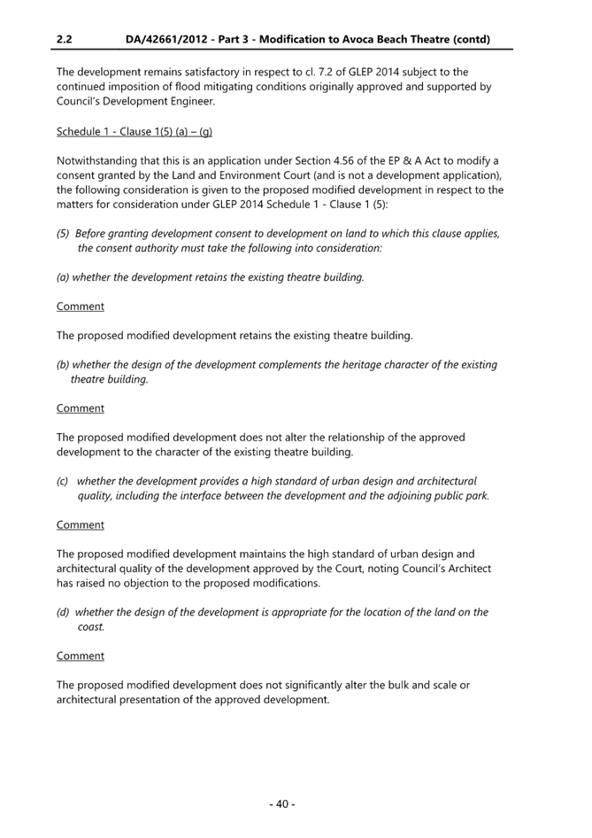
|
DA/42661/2012/E - 69-71 Avoca Drive, Avoca Beach - Alterations & Additions to existing Theatre |
|
|
Attachment 18 |
Cover Letter - DA/42661/2012/E - 69 Avoca Drive, AVOCA BEACH NSW |
|
DA/42661/2012/E - 69-71 Avoca Drive, Avoca Beach - Alterations & Additions to existing Theatre |
|
|
Attachment 19 |
DA/42661/2012/E - 69 Avoca Drive, Avoca Beach - Alterations & Additions to existing Theatre |
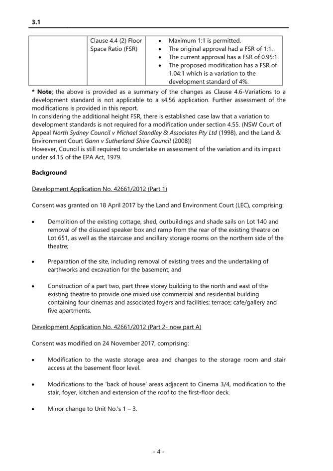
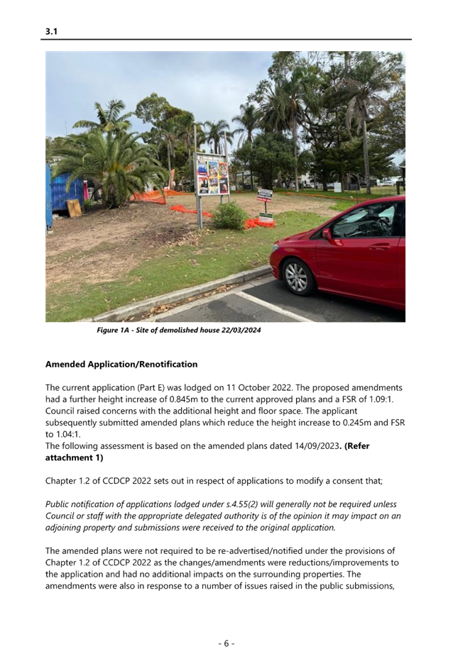
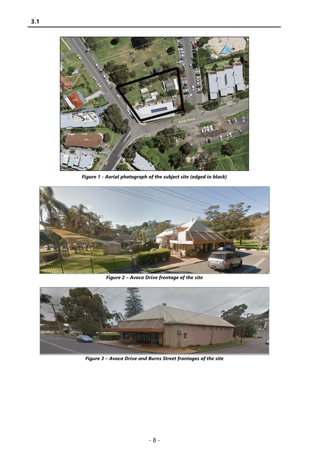
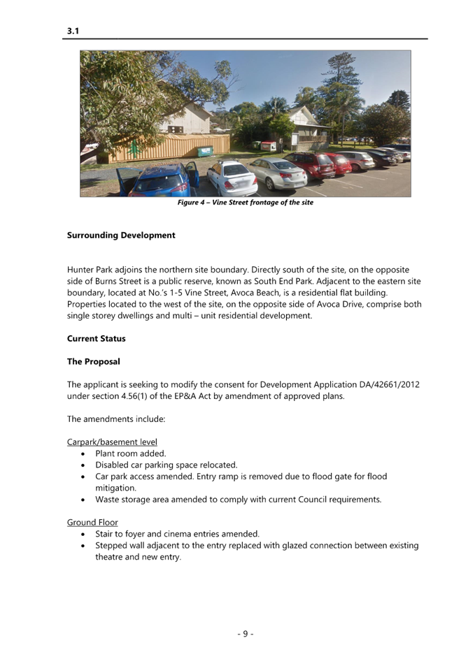
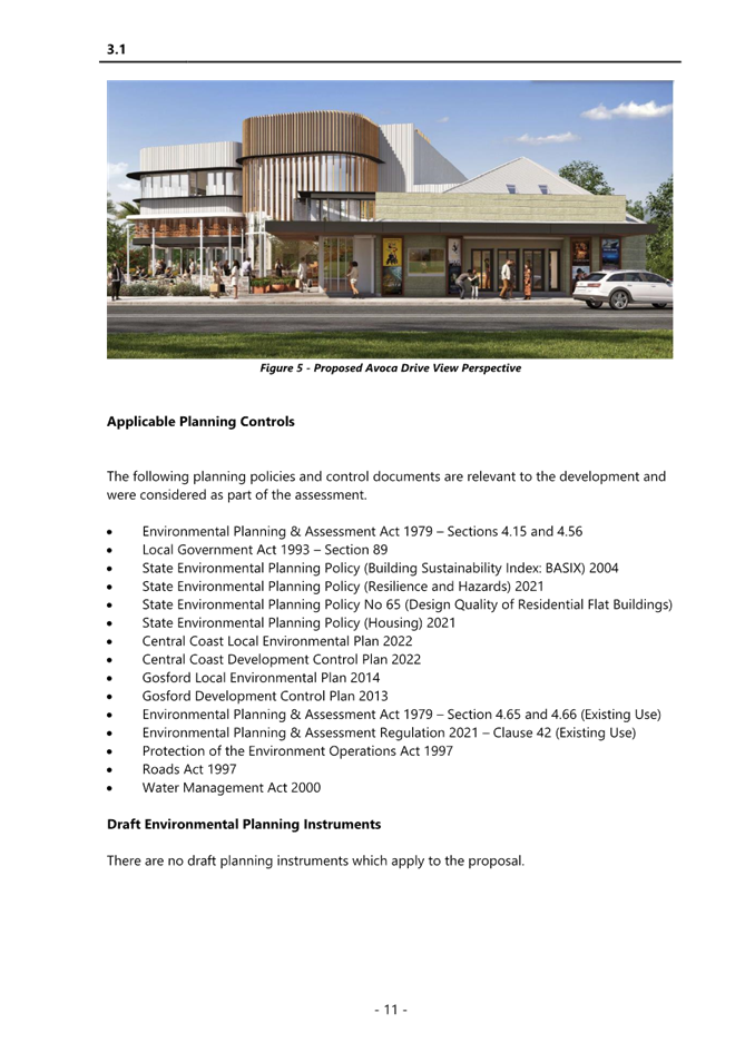
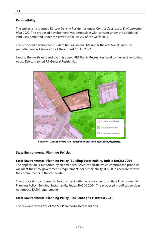

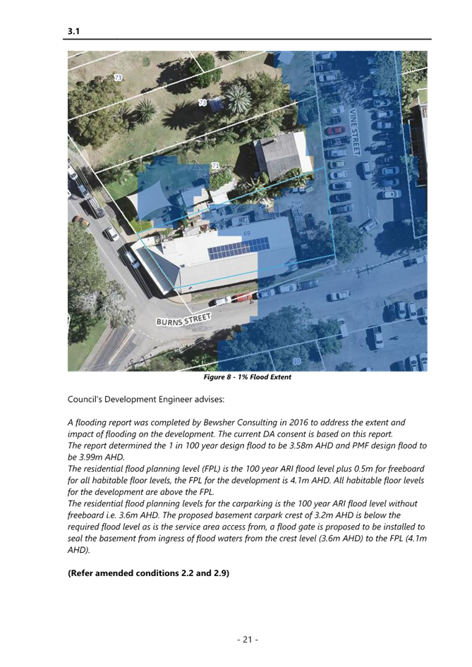
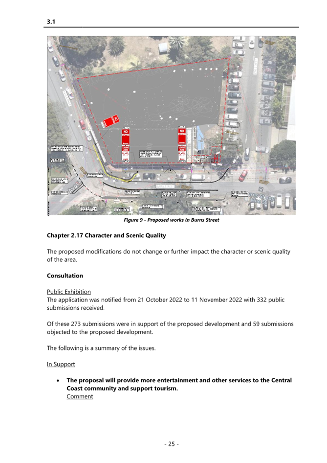
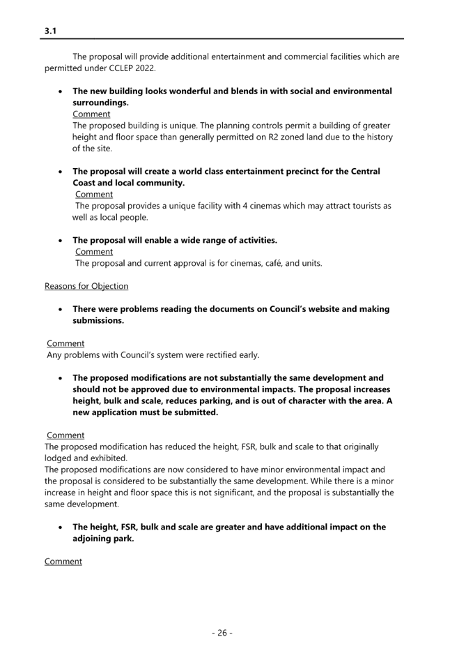
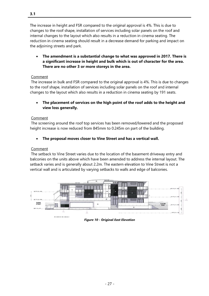
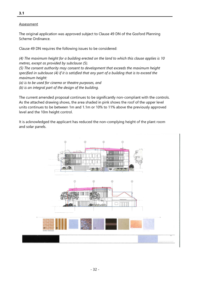
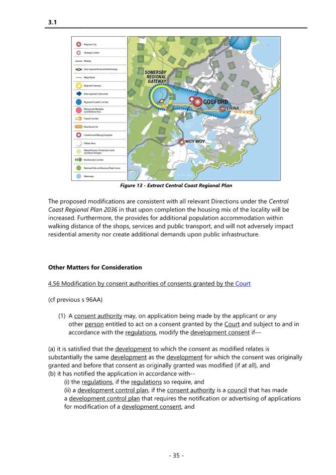

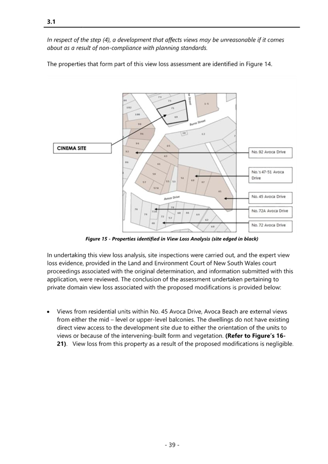
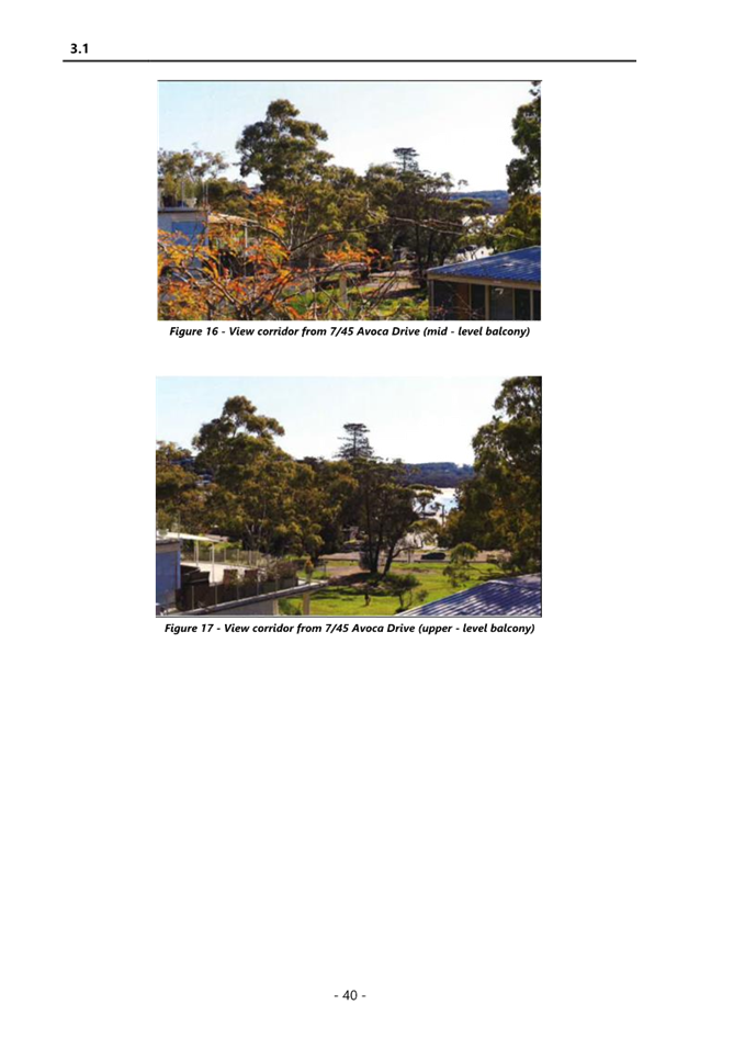
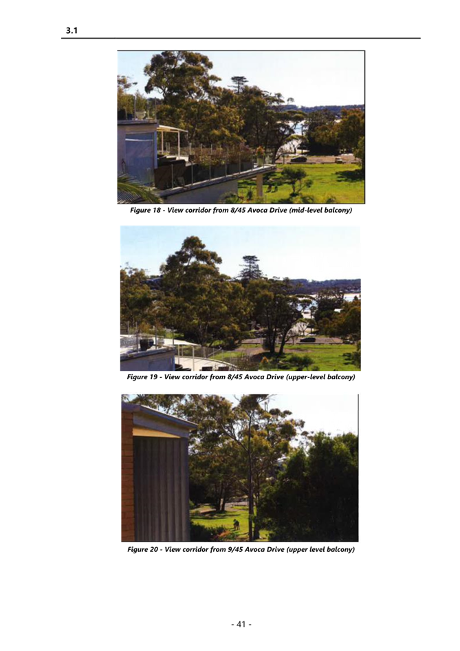
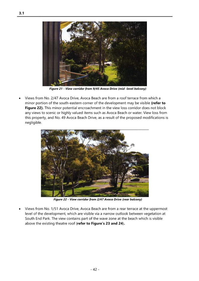
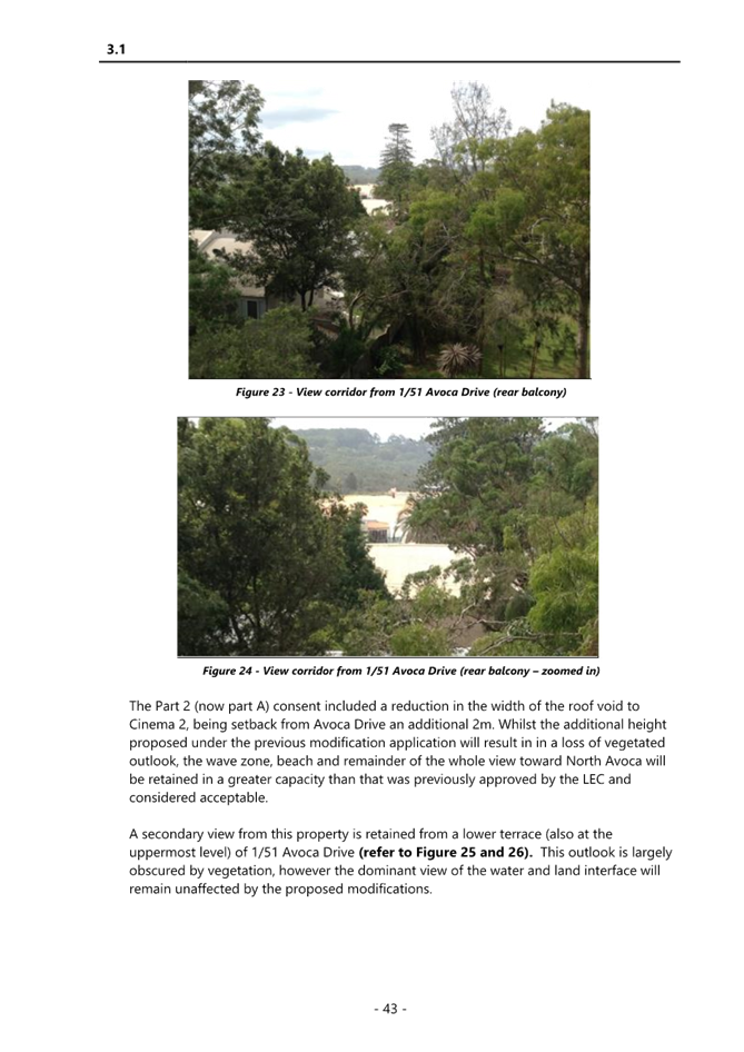
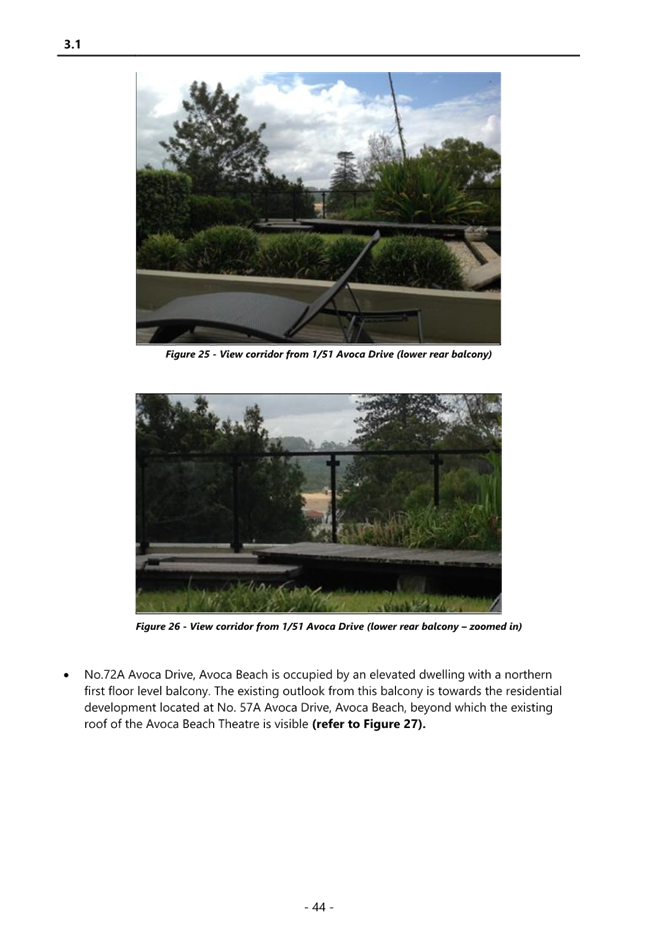
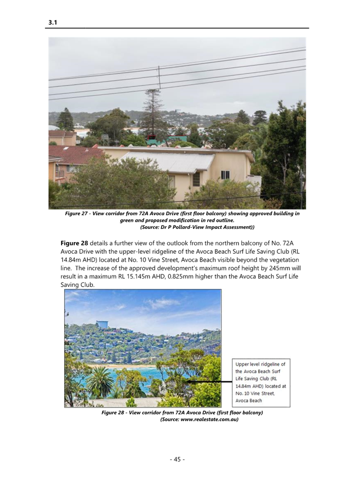
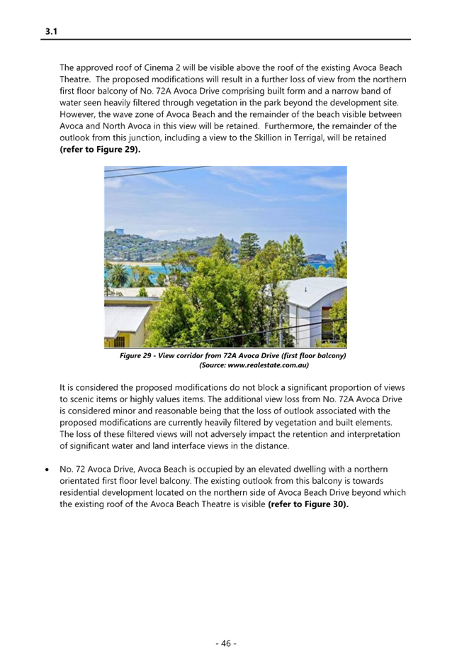
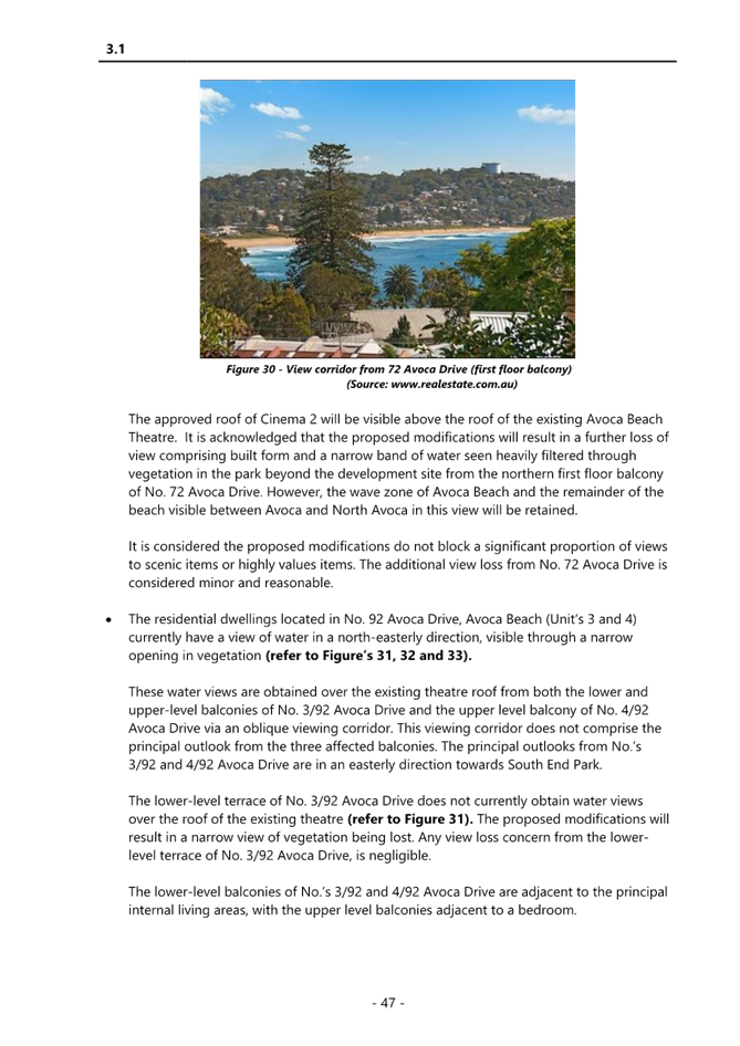
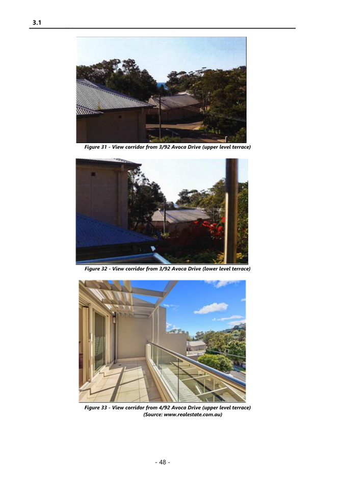
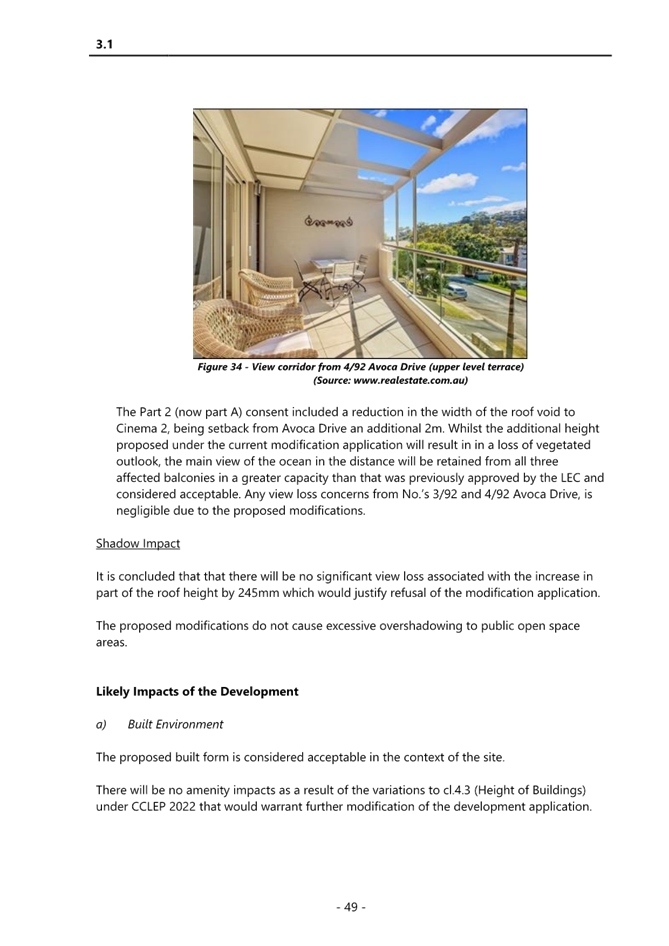
|
Item No: 2.1 |
|
|
Title: DA/2048/2023 - 22 Clairvoux Road Wamberal - Alterations and Additions (Existing Dwelling) |
|
|
Department: Environment and Planning |
|
|
22 August 2024 Local Planning Panel Meeting |
|
Reference: DA/2048/2023 - D16255377
Author: Amy Magurren, Senior Development Planner. Residential Assessments
Section Manager: Ailsa Prendergast, Section Manager. Residential Assessments
Unit Manager: Andrew Roach, Unit Manager. Development Assessment
|
Summary
An application has been received for alterations and additions to an existing dwelling located at 22 Clairvoux Road Wamberal. The application has been examined having regard to the matters for consideration detailed in section 4.15 of the Environmental Planning and Assessment Act and other statutory requirements with the issues requiring attention and consideration being addressed in the report.
The development application is required to be reported to the Local Planning Panel due to the development exceeding the “Height of Buildings” development standard specified and calculated under Clause 4.3 of the Central Coast Local Environmental Plan 2022 (CCLEP 2022) by more than 10%. The current height standard for the site is 8.5m and the development proposes a maximum height of 9.58m for the central roof form facing Clarivoux Road (a variation of 1.08m or 12.7% variation).
One (1) submission was received in relation to the application.
The application is recommended for approval.
Applicant Slater Architects Owner Mr Steve Fort & Mrs Kerrie Fort Application No DA/2048/2023 Description of Land Lot C in DP 103618 Proposed Development Alterations and Additions Site Area 929.5m2 Zoning R2 Low Density Residential Existing Use Residential Dwelling Employment Generation No Estimated Value $212,391.00
|
Recommendation
1 The Central Coast Local Planning Panel accept that the Applicants Clause 4.6 written request demonstrates that compliance with the Height of Buildings development standard is unreasonable in the circumstances of the case because of the minimal environmental impact that would arise from the noncompliance with the Height of Buildings standard.
Compliance with the Height of Buildings development standard would be unreasonable in the circumstances of this application because the existing exceedance to the Height of Buildings standard already granted for the existing dwelling has been maintained and the proposed additions do not increase the overall height of the building, nor do they have an unreasonable impact to the surrounding development.
Further, the panel consider that the proposed development will be in the public interest because it is consistent with the objectives of the development standard and the objectives for development within the R2 Low Density Residential zone in which the development is proposed to be carried out.
2 That the Local Planning Panel grant consent to DA/2048/2023- 22 Clairvoux Road Wamberal for alterations and additions to an existing dwelling subject to the conditions detailed in the schedule attached to the report and having regard to the matters for consideration detailed in Section 4.15 of the Environmental Planning and Assessment Act 1979.3
3 The Local Planning Panel assume the concurrence of the Secretary of the Department of Planning to permit the non-compliance with the development standard under clause 4.6 of the Central Coast Local Environmental Plan 2022, in accordance with the provisions of clause 55 of the Environmental Planning and Assessment Regulation 2021.
4 That Council advise those who made written submissions of the Panel’s decision.
Precis:
|
Proposed Development |
Alterations and additions to an existing residential dwelling (primarily removal and replacement of an existing section of roof form and internal alterations).
|
|
Permissibility and Zoning |
The subject site is zoned R2 Low Density Residential under the provisions of the Central Coast Local Environmental Plan 2022 (Central Coast LEP 2022).
The existing development is defined as a “dwelling house” which is defined under Central Coast LEP 2022 as:
dwelling house means a building containing only one dwelling.
The proposed development is best defined as alterations and additions to an existing residential dwelling and is permissible with consent in the current zone.
|
|
Current Use |
Residential Dwelling
|
|
Integrated Development |
No
|
|
Submissions |
The development application was notified (in accordance with the provisions of Central Coast LEP 2022 from the 10th November 2023 to 24th November 2023.
There was one (1) submission received. |
Variations to Policies
Proposed variations to Central Coast Local Environmental Plan 2022
|
Clause |
4.3 – Height of Buildings
|
|
Standard |
Height limit of 8.5m
|
|
Departure basis |
The proposal seeks a variation to the development standard in accordance with the following:
· 9.58m building height for the central roof form (1.08m or 12.7% variation)
It is noted that the proposed development will maintain the existing ridge level of the roof however proposes a change from a hip to gable presentation. The proposed development does not seek to increase the overall building height, rather replace an existing portion of the roof of the building that will be greater than the current building height control at the front of the development. |
The Site
The site is legally described as Lot C in DP 103618 and is commonly known as 22 Clairvoux Road, Wamberal. The overall site has a total site area of 932.5m2 by survey with a frontage of 17.905m to Clairvoux Road.
The site is located on the eastern side of Clairvoux Road, at the intersection of the Clairvaux Road and Ocean View Road Wamberal. The topography of the site rises from the kerb of the road at RL15.68 to RL23.58 at the rear of the site, approximately 11.7% slope across the site and is not mapped as being impacted by Bushfire Prone Land.
The site contains an existing residential dwelling. The area is surrounded by residential lots also zoned R2 Low Density Residential, that generally contain a mix of one and two storey residential dwellings dominated by newer (and renovated) dwellings, with some remaining older style dwellings.
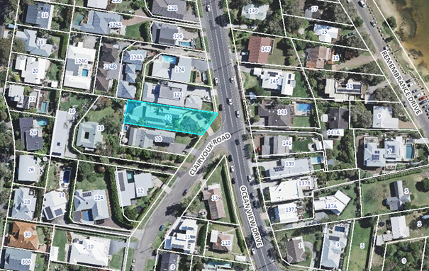
Figure 1: Site Locality Plan
Figure
2: The proposed development site from Clairvoux Road
Surrounding Development
The site is bordered to the north by a two-storey residential dwelling located at 122 Ocean View Drive approved under DA/49622/2016.
Figure 3: Existing dwelling located at 122 Ocean View Drive, Wamberal
The site is bordered to the south by a two-storey residential dwelling located at 20 Clairvoux Road constructed prior to 2000, with minor alterations and additions to the roof and terrace occurring in circa 2009 and 2010.
Figure
4: Existing dwelling located at 20 Clairvoux Road, Wamberal
The Proposed Development
The proposed development seeks consent for internal alterations and additions to the existing dwelling house and changes to the existing garage, specifically:
Level 1
• internal alterations;
• open up existing study to become a porch, with new stair entry;
• extend Bedroom 3 by 2m to the east; and
• other minor changes as shown on the architectural plans.
Level 2
• internal alterations;
• change alignment/ windows on northern side, adjacent to dining area;
• extend Master Bedroom by 2m to the east;
• new highlight ensuite window on the southern side;
• minor changes to rear terrace area, including new access doors;
• provide privacy screening to the outer sides of existing terrace areas;
• changes to the window to the living area, and roof form above; and
• replace existing balustrading with frameless glass, new timber batters and underside roof lining.
External
• remove existing garage roof and provide new flat roof and roof garden;
• changes to garage door; and
• changes to paths and retaining walls as shown on the architectural plans.
The existing dwelling house provides 3 separate and staggered building elements facing Clairvoux Road, each with a separate roof element. The northern and southern elements provide open gable roof presentations the front, and the middle element has a hip roof presentation. The change to the middle element above the living area proposes a similar open gable presentation to the elements on either side, which brings consistency to the dwelling’s presentation to Clairvoux Road, and the ridgeline of the roof will continue the same level as the existing roof to the west. Based on existing ground levels identified by survey, the new gable roof will have a maximum building height of 9.58m.
Figure 5: Architectural perspective of new roof form
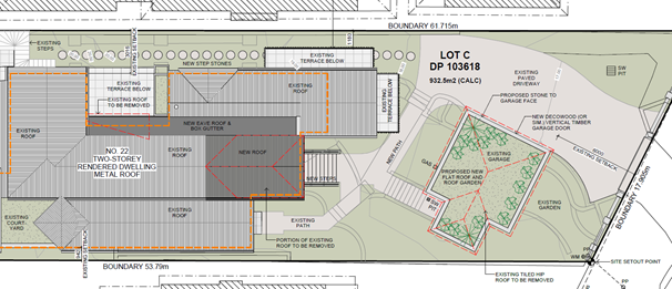
Figure 6: Site plan
History
The application as originally lodged proposed a privacy screen to the outer sides of the existing terrace area on the northern side of the dwelling. During the notification period a submission was received from a neighboring dwelling which indicated their views of the beach and ocean would be significantly impacted as a result of the construction of the privacy screen.
A site inspection was carried out on Wednesday 19th June 2024 to determine the impact to the views of the neighboring property. Assessment of the view considered the proposed development in the context of the Land and Environmental Court Planning Principles for view sharing.
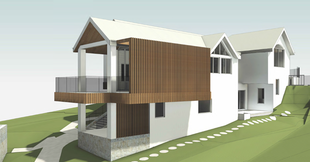
Figure 7: Proposed screen as originally proposed.
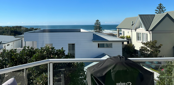
Figure 8: View from neighboring dwelling
The neighbouring site has views of the beach and ocean which have been eroded by the construction of the dwelling at 122 Ocean View. However, they have remaining forward views of the beach and ocean through the gap between 22 Clarivoux Road and 122 Ocean View. The screen would be visible from both a standing and sitting position in the living and dining room of the dwelling and would almost completely remove the views of the sand and surf break.
The adjoining wall of 122 Ocean View has been designed without windows and is not impacted by overlooking or privacy from 22 Clairvoux Road, as such there is no need for the screen to increase the privacy to the dwelling. Additionally, the proposed screen results in a variation of 500mm to the side setback envelope for the northern elevation.
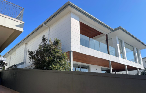
Figure 9: Adjoining wall of dwelling house to the north
Figure 10: Extent of variation to side setback
Assessment
of the impact of the privacy screen concluded that the proposed privacy screen
has a significant impact to the views of the neighbouring dwelling and will
likely remove the existing views of the beach and water. Given the impact to
views arises from a non-compliance in the side setback, the privacy screen was
not supported. On the 24th June 2024, the applicant provided amended
plans removing the privacy screen component from the development application.
ASSESSMENT:
Having regard for the matters for consideration detailed in Section 4.15 of the Environmental Planning and Assessment Act 1979 and other statutory requirements, Council’s policies and Section 10.7 Certificate details, the assessment has identified the following key issues, which are elaborated upon for Council’s information. Any tables relating to plans or policies are provided as an attachment.
State Environmental Planning Policy (Building Sustainability Index) BASIX 2004
A compliant BASIX certificate achieving the NSW Government’s Energy Efficiency targets has been provided in support of the application. The proposal is consistent with the requirements of State Environmental Planning Policy (Building Sustainability Index: BASIX) 2004.
The Panel can be satisfied that the proposed development satisfies the relevant provisions of SEPP (BASIX) 2004, subject to recommended conditions.
State Environmental Planning Policy (Resilience and Hazards) 2021
The relevant provisions of the SEPP are addressed as follows:
Chapter 2 Coastal Management
The aims of Chapter 2 are to be considered when determining an application within the Coastal Management Areas. The Coastal Management Areas are areas defined on maps issued by the NSW Department of Planning and Environment and the subject property falls within the ‘Coastal Environment Area’ and ‘Coastal Use Area’ identified on these maps.
In considering the impact of any development application, the consent authority must have regard to matters within clause 2.10 of the SEPP (for the coastal environment area) and clause 2.11 (for the coastal use area).
The relevant matters have been considered in the assessment of this application. The proposed development is not likely to cause undue impact on the biophysical, hydrological or ecological environment. The values of the natural coastal processes are not likely to be impacted, marine vegetation and fauna habitats will not be disturbed by the proposal and the proposal does not impact on known aboriginal cultural heritage, the surf zone, or existing public spaces. The proposed development will not result in adverse impact on rock shelves, overshadowing, loss of views from public places nor visual amenity.
The Panel can be satisfied that the relevant matters of clause 2.10 for development within the coastal environment and use area and clause 2.11 for development within the coastal use area have been considered in the assessment of this application. The application is considered consistent with the stated aims and objectives.
Chapter 4 Remediation of Land
Clause 4.6 of Chapter 4 requires that a consent authority must not consent to the carrying out of any development on land unless it has considered whether the land is contaminated. The current use of the site is residential purposes, and there are no known previous uses that would lead to the site being contaminated or unsuitable for the proposed use.
The Panel can be satisfied that the proposed development is acceptable with regard to Chapter 4 of the SEPP.
Central Coast Local Environmental Plan 2022 (CCLEP 2022)
The subject site is zoned R2 - Low Density Residential under the provisions of CCELP 2022. The proposed development is best defined as alterations and additions to a ‘dwelling house’, which is defined under CCLEP 2022 as:
‘Dwelling House’ means – a building containing only one dwelling.
The development is permissible in the zone, with development consent.
Central Coast Local Environmental Plan 2022 – Zone Objectives
The land is zoned R2 Low Density Residential under the provisions of the CCLEP 2022.
The objectives for the R2 zone are:
• To provide for the housing needs of the community within a low-density residential environment.
• To enable other land uses that provide facilities or services to meet the day to day needs of residents.
• To encourage best practice in the design of low-density residential development.
• To ensure that non-residential land uses do not adversely affect residential amenity or place demands on services.
• To maintain and enhance the residential amenity and character of the surrounding area.
Following a detailed assessment of the proposed development and with the Applicant’s written request to vary a development standard within CCLEP 2022, it is considered that the proposal is consistent with the stated objectives of the zone, providing housing consistent with the character of the area and does not have adverse impacts on the locality.
Central Coast Local Environmental Plan 2022 – Principal Development Standards
The proposal has been assessed in accordance with the relevant development standards of CCLEP 2022.
|
Development Standard |
Required |
Proposed |
Compliance with Controls |
Variation % |
Compliance with Objectives |
|
Clause 4.3 Height of Buildings |
8.5m |
9.6m |
No |
12.9% |
Yes |
|
Clause 4.4 Floor Space Ratio |
Not mapped |
N/A |
|
|
|
Central Coast Local Environmental Plan 2022 - Clause 4.3 - Height of buildings
Central Coast Local Environmental Plan 2022 Clause 4.6 - Exceptions to development standards for Height
The applicant seeks a variation to clause 4.3(2) of CCLEP 2022 in relation to the proposed maximum height of the dwelling. In this regard, the proposal seeks a maximum overall height of 9.58m in lieu of the 8.5m mapped maximum height limit applicable to the allotment. This represents a variation of 12.7%.
![]()
Figure 6: Variation to Building Height development standard (Red)
Clause 4.6 of CCLEP 2022 provides the ability to grant consent to a development application where the variation to a development standard can be adequately justified and where the
objectives of clause 4.6 are satisfied, being:
(a) to provide an appropriate degree of flexibility in applying certain development standards to particular development,
(b) to achieve better outcomes for and from development by allowing flexibility in particular circumstances.
Applicant’s Written Clause 4.6 Request
The Applicant has provided a detailed request to vary the mapped height development standard by the proposed 12.7%. In requesting the variation, the applicant has provided the following matters in support of the proposal (the Applicant’s full clause 4.6 request is included in Attachment 3).
The basis of the applicants’ arguments, as set out in the clause 4.6 request, are:
· The variation is minor in nature, and relates to a small area of roof which is changing from a hip to gable presentation, and will be consistent with other existing roof elements facing Clairvoux Road;
· The site is sloping, with a fall of 6.8m (11.7%) from the rear to front boundaries, and has cross fall as well. The proposed roof change will continue the same ridge level as the existing roof over the centre of the dwelling, and the variation arises as a result of the fall of the land towards the front;
· The area of variation will be open in appearance facing Clairvoux Road, with a glazed gable exterior, and will not unreasonably add to building bulk or result in adverse visual impacts;
· The variation will improve, and bring consistency to the dwelling’s presentation to Clairvoux Road, and will provide an architecturally complementary roof form to the existing roof presentations on either side;
· The area of variation is well setback from Clairvoux Road, with a minimum setback of 21m, which reduces visual impacts, and will be located behind the average setback of the dwellings on either side;
· The variation is unlikely to result in any privacy, overshadowing or view impacts; and
· The proposal is otherwise consistent with the objectives of the R2 Low Density Residential zone and the objectives of the height standard.
Pre - conditions to be satisfied.
Clause 4.6 (4) of CCLEP 2022 establishes preconditions that must be satisfied before a consent authority can exercise the power to grant development consent for development that contravenes a development standard. Clause 4.6(2) provides this permissive power to grant development consent for a development that contravenes the development standard is subject to conditions.
The two preconditions are:
1. Tests to be satisfied pursuant to clause 4.6(4)(a) – this includes matters under clause 4.6(3)(a) and (b) in relation to whether the proposal is unreasonable and unnecessary in the circumstances of the case and whether there are sufficient environmental planning grounds to justify contravening the development standard and whether the proposal is in the public interest (clause 4.6(a)(ii)); and
2. Tests to be satisfied pursuant to clause 4.6(4)(b) – concurrence of the Planning Secretary.
Clause 4.6(3)
Clause 4.6 (3) of CCLEP 2022 requires consideration of the following:
‘Development consent must not be granted for development that contravenes a development standard unless the consent authority has considered a written request from the applicant that seeks to justify the contravention of the development standard by demonstrating –
(a) that compliance with the development standard is unreasonable or unnecessary in the circumstances of the case, and
(b) that there are sufficient environmental planning grounds to justify contravening the development standard.’
In reviewing whether the proposed variation is unreasonable or unnecessary, and whether there are sufficient environmental planning grounds to justify contravening the variation, consideration of the objectives for maximum building height controls are relevant. CCLEP 2022 sets out two objectives pertaining to the building height development standard. The objectives are contained within clause 4.3 (1) (a) and (b). These objectives are replicated below and commentary in respect to compliance or otherwise with each of the objectives in relation to the proposed development:
a) to establish a maximum height of buildings to enable appropriate development density.
Comment: The proposed height of the building, whilst exceeding the numerical height limit, is consistent with numerous other dwellings within the vicinity on this steep bayside locality. The proposed dwelling design meets the relevant zone objectives and does not cause any unreasonable level of view loss impacts to the adjoining and surrounding properties. The proposed dwelling design and height will not create any overshadowing to public open spaces and not impact on viewing natural topographical features from surrounding open spaces within the Wamberal locality.
b) to ensure that the height of buildings is compatible with the character of the locality.
Comment: The new dwelling alterations incorporate an open gable roof form and typical windows and will result in a contemporary design. The use of quality materials will encourage a desired urban form in the locality. The proposed dwelling will not result in any appreciable additional overshadowing of the adjoining property in the winter months. The extent of shadowing, considering the orientation of the dwellings within an east-west axis is reasonable as demonstrated on the shadow diagrams.
The height exceedance relates to the continuation of the existing roof form through to the construction of the new section of roof, over the sloping site. The additional roof form is an appropriate transition from the existing to the new and does not in itself unreasonably increase the land use intensity. It is consistent to the height of other buildings on the hillside within this locality and is imperceivable from the street.
Clause 4.6(4)
Clause 4.6 (4) of CCLEP 2022requires consideration of the following:
‘Development consent must not be granted for development that contravenes a development standard unless—
(a) the consent authority is satisfied that—
(i) the applicant’s written request has adequately addressed the matters required to be demonstrated by subclause (3), and
(ii) the proposed development will be in the public interest because it is consistent with the objectives of the particular standard and the objectives for development within the zone in which the development is proposed to be carried out, and
(b) the concurrence of the Planning Secretary has been obtained.’
Consideration of Applicant’s Submission
The Applicant’s submission in accordance with clause 4.6 is attached, and adequately addresses the provisions of clause 4.6(3), as set out above.
Zone Objectives
In reviewing the proposed variation, consideration of the R2 Low Density Residential Zone objectives is also considered necessary.
The R2 Low Density Residential Zone objectives are as follows:
• To provide for the housing needs of the community within a low-density residential environment.
• To enable other land uses that provide facilities or services to meet the day to day needs of residents.
• To encourage best practice in the design of low-density residential development.
• To ensure that non-residential land uses do not adversely affect residential amenity or place demands on services.
• To maintain and enhance the residential amenity and character of the surrounding area.
In considering these zone objectives, the following points are considered relevant:
• Dwelling Houses are permissible within the zone and satisfies the zone objective in terms of the provision of low-density residential development.
• The proposed dwelling design is considered in keeping with the existing and desired future character of the area.
• The design of the dwelling incorporates suitable architectural design elements and incorporates sustainable design features.
The proposal meets the relevant zone objectives and does not cause view loss or overshadowing impacts to the adjoining properties. The proposal is consistent with the objectives of the development standard, as noted above, and approval of the development is therefore in the public interest.
Having regard to the site factors, minimal impact on the character of the area and that of the residents, the applicants request to vary the building height development standard is considered reasonable and therefore supported.
Central Coast Local Environmental Plan 2022 - Clause 5.21 Flood Planning
The site is not subject to flood planning controls.
Central Coast Local Environmental Plan 2022 - Clause 7.1 Acid sulfate soils
This land has been identified as being affected by the Acid Sulfate Soils Map and the matters contained in clause 7.1 of CCLEP 2022 have been considered. The site contains Class 5 Acid Sulfate Soils. In this instance, the proposal works are not considered to impact on Acid Sulfate Soils.
Central Coast Local Environmental Plan 2022 - 7.6 Essential Services
Development consent must not be granted to development unless the consent authority is
satisfied that all of the following services that are essential for the development are available or that adequate arrangements have been made to make them available when required—
(a) the supply of water,
(b) the supply of electricity,
(c) the disposal and management of sewage,
(d) stormwater drainage or on-site conservation,
(e) suitable vehicular access,
(f) the collection and management of waste.
The application makes adequate arrangements for the essential services required for the development. Council is satisfied that all of the above services are available to the land to service the development.
Central Coast Development Control Plan 2022
The relevant controls of CCDCP 2022 are considered below:
Chapter 2.1 – Dwelling Houses, Secondary Dwellings and Ancillary Development
|
Required |
Proposed |
Compliance with Controls |
Compliance with Objectives |
|
|
2.1.2.1 b Building Height |
8.5m. |
9.58 |
No Variation of 12.7% |
Yes |
|
2.1.2.1 c Building Height |
Building Height shall generally not exceed two storeys. |
Two (2) Storeys |
Yes |
Yes |
|
2.1.2.2 a (ii) Site Coverage |
Maximum of 50% site coverage for allotments greater than 450m2 but less than 900m2 |
Remains unchanged |
Yes |
Yes |
|
2.1.2.3 Floor Space Ratio (FSR) |
FSR not mapped |
N/A |
- |
Yes |
|
2.1.3.1 a (i) Front Setbacks |
Average distance of the 2 neighbouring properties |
Remains unchanged and consistent with the neighbouring dwellings
|
Yes |
Yes |
|
2.1.3.1 b (i) Rear Setbacks |
3m |
Remains unchanged |
Yes |
Yes |
|
2.1.3.1 c (ii) Side Setbacks |
For any part of the building with a height of up to 4.5m—0.9m, and For any part of the building with a height of more than 4.5m—0.9m plus one-quarter of the height of the building above 4.5m |
Remains unchanged
|
Yes |
Yes |
|
2.1.3.3.2 a Garage Door Articulation |
6m if the lot has a width measured at the building line of 12m or less |
Remains unchanged |
Yes |
Yes |
|
2.1.4.1 Views |
Facilitate reasonable view sharing whilst not restricting reasonable development of the site |
The proposed development would have no adverse impacts on the primary views of neighbouring properties. |
Yes |
Yes |
|
2.1.4.2 Visual Privacy |
Orientation of windows and terrace areas to not directly overlook private open space areas of adjoining allotments |
No adverse amenity or privacy impacts. |
Yes |
Yes |
|
2.1.4.3 Private Open Space
|
24sqm for allotments with a width greater than 10m wide at the building line |
>24sqm of POS is provided with greater dimensions than 3m. The POS is directly accessible from and adjacent to both the living room and alfresco area. |
Yes |
Yes |
|
2.1.4.4 Sunlight Access |
50% of POS for all dwellings should receive at least 3 hours unobstructed sunlight access between 9am and 3pm |
>50% of POS will receive at least 3 hours unobstructed sunlight access between 9am and 3pm |
Yes |
Yes |
|
|
50% of POS on adjoining land should receive at least 3 hours unobstructed sunlight access between 9am and 3pm |
>50% of POS on adjoining land will receive at least 3 hours unobstructed sunlight access between 9am and 3pm |
Yes |
Yes |
|
2.1.5 Car Parking and Access |
Provide minimum off street parking facilities – 2 space for dwelling with 4 or more bedrooms.
Ensure safe vehicular access to public road Driveway access does not detract from aesthetic qualities of the site |
2 spaces are provided within the garage.
|
Yes |
Yes |
|
2.1.6.1 Earthworks |
Cut/fill maximum 1m within 1m of boundaries, or 3m if more than 3m from boundary |
No cut greater than 1m in depth is proposed.
|
Yes |
Yes |
|
2.1.6.2 (a) Retaining walls and structural support |
Retaining walls >600mm and within 1m of boundary or more than 1m above or below existing ground level in any other location – must be designed by a professional engineer |
None proposed. |
Yes |
Yes |
|
2.1.6.3 Drainage |
All stormwater drainage collecting must be conveyed by a gravity fed or charged system to a public drainage system, or an inter-allotment drainage system, or an on-site disposal system |
The alterations will connect to the existing stormwater system. |
Yes |
Yes |
|
2.1.7.4 (a) (i) Fencing |
Maximum height of 1.8m for side and rear fencing |
Remains unchanged |
Yes |
Yes |
Chapter 3.1.2.1 Building Height
The Applicant seeks a variation to the proposed maximum height of the dwelling. In this regard, the proposal seeks a maximum overall height of 9.58m. The variation proposed is 12.7%.
An assessment of the building height has been carried out under the CCLEP 2022. The proposed development will be consistent to the height of other buildings on the hillside. The proposal meets the relevant zone objectives and does not cause view loss impacts or an unreasonable level of overshadowing to the adjoining properties.
It is considered the Applicant’s request to vary the development standard would be consistent to the height and scale of other dwellings within the immediate area. In addition, the development would not impose any unreasonable level of detrimental impact on the amenity of residents in nearby dwellings. It has been concluded the steepness of the site contributes to the difficulty in complying with the height controls and comparisons to the height and scale of other dwellings along the hillside provide justification to vary them.
Chapter 2.14 Site Waste Management
A Waste Management Plan has been submitted with the proposal.
The proposal has demonstrated compliance with this chapter of the CCDCP 2022 and associated Waste Control Guidelines. Appropriate conditions are included in the development consent.
Chapter 2.17 Character and Scenic Quality
The site is located within the character area: Wamberal 6: Open Woodland Hillsides of CCDCP 2022. The character statement provides for the desired character as follows:
“These should remain low-density residential areas where the existing scenic quality and amenity of prominent hillsides are enhanced substantially by further “greening” of gardens and street verges in order to screen new development and to complement the open bushland canopy that surrounds most dwellings.
Maintain the semi-natural character of hillsides by retaining existing natural slopes throughout gardens and along street verges, and by conserving bushland trees that are visually-prominent features. Complement the established canopy by planting trees and shrubs that are predominantly indigenous throughout all garden areas and along street verges. Do not plant identified noxious or environmental weeds in any garden that is close to a bushland reserve. Facing all boundaries, emphasise a leafy garden character by avoiding tall retaining walls, elevated structures such as terraces or pools, and steep driveways that would visibly compromise the leafy hillside character.
In areas that are defined as bushfire prone, hazard must not be increased by inappropriate new plantings or structures. Minimise the extent of cleared asset protection zones by fire-resistant siting, design and construction for all new structures plus effective management of gardens. The ideal compromise between desired scenic quality and hazard-reduction would limit clearing to thinning of the canopy to establish breaks between existing trees. Screen or shield all verandahs, windows, roofs and suspended floors to prevent the entry of sparks and flying embers.
Avoid disturbing natural slopes and trees by appropriate siting of structures plus low-impact construction such as suspended floors and decks, rather than extensive cut-and-fill. On the steeper sites, locate parking next to the street in structures that are designed to blend with their desired bushy setting. Avoid the appearance of a continuous wall of development along any street or hillside by locating buildings behind front and rear setbacks similar to their surrounding properties, and providing at least one wide side setback or stepping the shape of front and rear facades.
Minimise the scale and bulk of buildings by stepping floor-levels to follow natural slopes and by using irregular floorplans to create well-articulated forms. For example, divide floorspace into linked pavilions that are separated by courtyards and capped by individual roofs. Front or rear facades that are taller than neighbouring dwellings should be screened by balconies, verandahs, stepped forms or extra setbacks. Roofs should be gently-pitched to minimise the height of ridges, and flanked by wide eaves to disguise the scale of exterior walls.
Minimise the scale of prominent facades by using extensive windows and verandahs plus a variety of materials and finishes rather than expanses of plain masonry. All dwellings should display a traditional “street address” with verandahs or decks, and living rooms or front doors that are visible from the roadway. Avoid wide garages that would visually-dominate any front façade or block views from a dwelling to the street. Locate and screen all balconies or decks to maintain the existing levels of privacy and amenity that are enjoyed by neighbouring dwellings.”
Comment: The proposed dwelling design incorporates these desired character features. The proposed dwelling design is consistent with the desired character of the precinct.
The Likely Impacts of the Development
Built Environment
Given the position of the proposed dwelling on the allotment and comparison of bulk and scale with other dwellings, the proposal is suitable with regard to the context and setting of the subject site and is considered to be in keeping with the character of the area.
A thorough assessment of the proposed development’s impact on the built environment has been undertaken in terms of the CCLEP 2022 and CCDCP 2022 compliance. It is considered on balance that the potential impacts are considered reasonable.
Natural Environment
The proposal does not involve any site excavation. Accordingly, the proposal is considered satisfactory in relation to impacts on the natural environment.
Context and Setting
The proposal is located within the R2 Low Density Residential land under CCLEP 2022 and the North Coastal Land Unit under Chapter 2.17 of CCDCP 2022. The proposal provides an updated housing option within a residential zone and is consistent with the objectives of the R2 land use and the North Coastal Land Unit. In addition, the proposal is considered to be consistent with the desired character for future development within the Wamberal 6: Open Woodland Hillsides of CCDCP 2022.
Economic and Social Impacts
The proposal will provide minor economic benefit through the provision of temporary employment during demolition and construction. The application does not require any tree removal to facilitate the development and the private open space remaining within the subject site will retain adequate private open space and landscaping.
The Suitability of the Site for the Development
Section 4.15(c) of the Environmental Planning and Assessment Act 1979 requires the consent authority to consider the suitability of the development site, being the subject site, for the development as proposed. The proposal slightly modifies the built form to the central portion of the front of the existing dwelling, with minimal impacts to the surrounding built and natural environment able to be mitigated via project design and the application of appropriate conditions of consent. It is considered that the site, given its R2 land zoning under CCLEP 2022 is suitable for the proposal as currently submitted.
Submissions
The development application was notified in accordance with CCDCP 2022 from 10th November 2023 to 24th November 2023.
One (1) submission was received.
A summary of the submissions is detailed below.
1. Impacts to view loss
“The DA applies for a variation to the Central Coast Development Control Plan 2022, in that it seeks a variation to the side setback which will impact our property in denying us a view to the beach. It also seeks a variation to the height restrictions which may impact others and will set a precedence for others to apply for similar variations.
We are neighbours to the property applying for this DA, situated directly besides, but behind them. Our view to the beach is only possible directly beside the corner of the house applying for a screen around their balcony.
The proposed DA will ruin what little is left of our view of the beach taking at a minimum 80-90% of it away.”
Comment: The originally proposed screen has been removed from the application due to its impacts to views to the surrounding properties and is discussed above under application history.
Internal Referrals
There were no internal referrals required for this application.
Contributions
The proposed development is not a development type that is subject to Section 7.11 or Section 7.12 development contributions. Therefore, no contributions are applicable.
The proposed development is not subject to water and sewer contributions.
Planning Agreements
The proposal is not subject to a Planning Agreement or Draft Planning Agreement.
Political Donations
During assessment of the application no political donations were declared by the Applicant. Applicant’s consultant, owner, objectors and / or residents.
Ecologically Sustainable Principles:
The proposal has been assessed having regard to ecologically sustainable development principles and is consistent with the principles.
The proposed development is considered to incorporate satisfactory stormwater, drainage and erosion control and the retention of vegetation and is unlikely to have any significant adverse impacts on the environment and will not decrease environmental quality for future generations. The proposal does not result in the disturbance of any endangered flora or fauna habitats and is unlikely to significantly affect fluvial environments.
Climate Change
The potential impacts of climate change on the proposal have been considered as part of the assessment of the application.
The assessment has included consideration of such matters as potential rise in sea level; potential for more intense and / or frequent extreme weather conditions including storm events, bushfires, drought, flood, and coastal erosion; as well as how the proposed development may cope, combat and withstand any resultant impacts. The proposed development is considered satisfactory in relation to climate change.
The Public Interest
The proposed development is seen to be in the public interest by providing assurance that the subject land can be developed in proportion to its site characteristics.
Conclusion:
The development application has been assessed in accordance with Section 4.15 of the Environmental Planning and Assessment Act 1979, and all relevant instruments and polices. The proposed development is considered suitable for the site despite the listed variation for the following reasons,
1. Assessment of the application has concluded the proposed development is permitted with the current R2 – Low Density Residential zone under the provisions of the Central Coast Local Environmental Plan 2022 and meets the objectives for the zone.
2. Assessment of the application has concluded the proposed development meets the objectives related to the building height development standard contained in Central Coast Local Environmental Plan 2022.
3. Assessment of the application has concluded the requirements of clause 4.6 (3) and (4) of Central Coast Local Environmental Plan 2022 have been satisfied and that variation to the maximum building height provisions of the Central Coast Local Environmental Plan 2022 is warranted.
4. With regard to the variation to development standards, the assessment of the application has concluded that:
a. The Applicant’s written request for a variation to development standards (height) adequately addresses the matters required to be addressed under clause 4.6(3) of the Central Coast Local Environmental Plan 2022; and
b. The development is in the public interest because it is consistent with the objectives for development in the zone; and
c. The concurrence of the Secretary can be assumed.
The proposal is therefore recommended for approval pursuant to Section 4.16 of the Environmental Planning and Assessment Act 1979.
|
1⇩ |
Draft conditions/reasons - 22 Clairvoux Road, WAMBERAL NSW 2260 - DA/2048/2023 - Draft conditions/reasons - Central Coast Council |
|
D16341455 |
|
REVISED - Architectural Plans - PAN-367189 - 22 Clairvoux Rd, WAMBERAL - DA/2048/2023 |
Provided Under Separate Cover |
D16268236 |
|
|
3⇩ |
PUBLIC Redacted Statement Environmental Effects - PAN-367189 - 22 Clairvoux Rd, WAMBERAL - DA/2048/2023 |
|
D15931801 |
|
4⇩ |
PUBLIC - Variation Request Clause 4.6 - PAN-367189 - 22 Clairvoux Rd, WAMBERAL - DA/2048/2023 |
|
D15906534 |
|
5⇩ |
PUBLIC - BASIX Certificate - PAN-367189 - 22 Clairvoux Rd, WAMBERAL - DA/2048/2023 |
|
D15906515 |
|
6⇩ |
PUBLIC - Survey - PAN-367189 - 22 Clairvoux Rd, WAMBERAL - DA/2048/2023 |
|
D15906529 |
|
7⇩ |
PUBLIC - Waste Management Plan - PAN-367189 - 22 Clairvoux Rd, WAMBERAL - DA/2048/2023 |
|
D15906538 |
|
2.1 |
DA/2048/2023 - 22 Clairvoux Road Wamberal - Alterations and Additions (Existing Dwelling) |
|
Attachment 1 |
Draft conditions/reasons - 22 Clairvoux Road, WAMBERAL NSW 2260 - DA/2048/2023 - Draft conditions/reasons - Central Coast Council |
|
DA/2048/2023 - 22 Clairvoux Road Wamberal - Alterations and Additions (Existing Dwelling) |
|
|
Attachment 3 |
PUBLIC Redacted Statement Environmental Effects - PAN-367189 - 22 Clairvoux Rd, WAMBERAL - DA/2048/2023 |
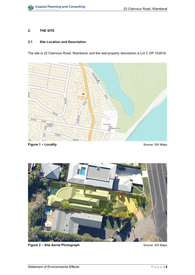
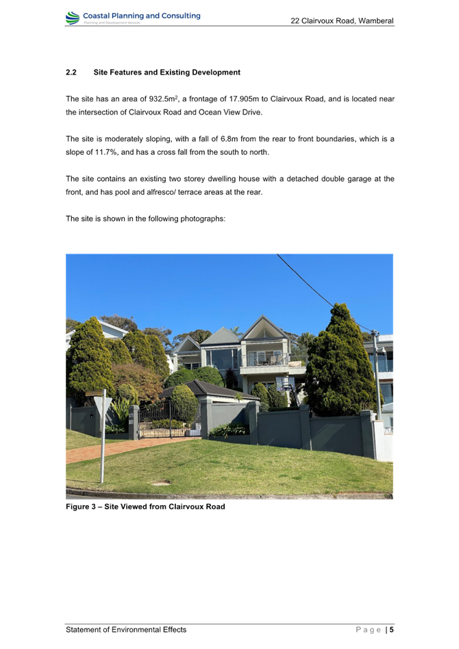

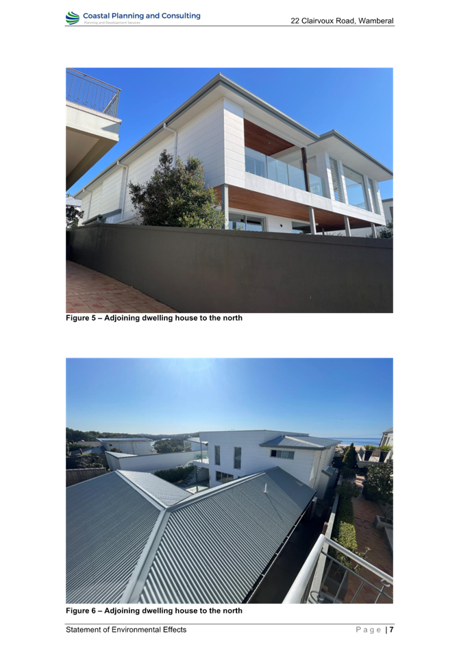
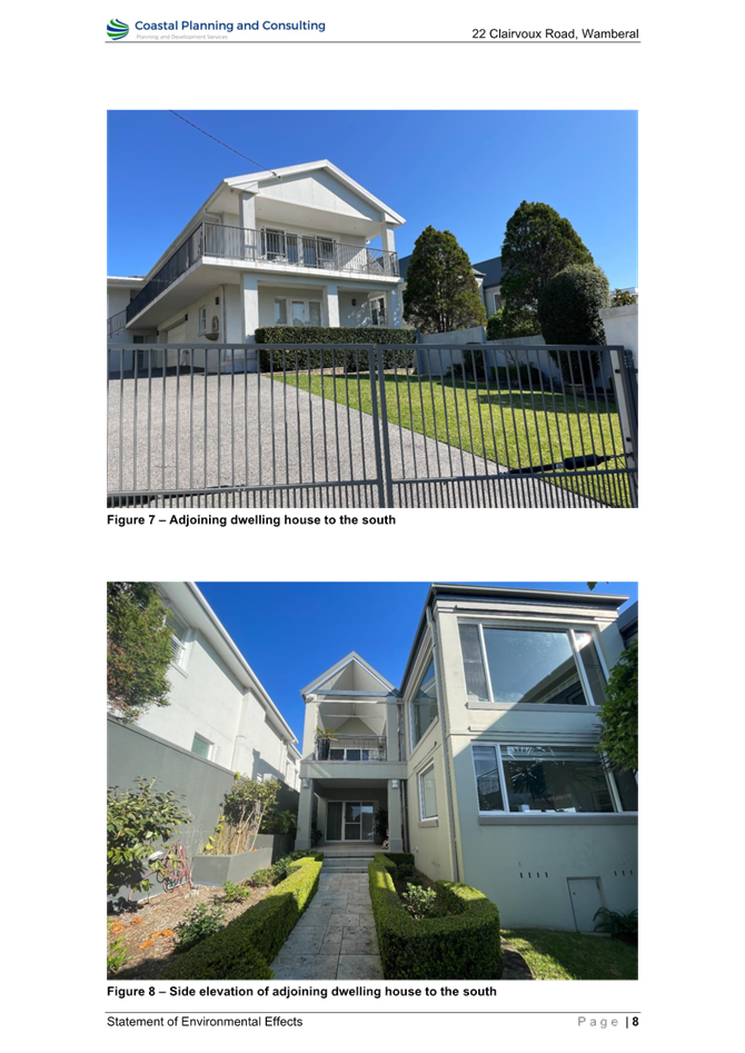
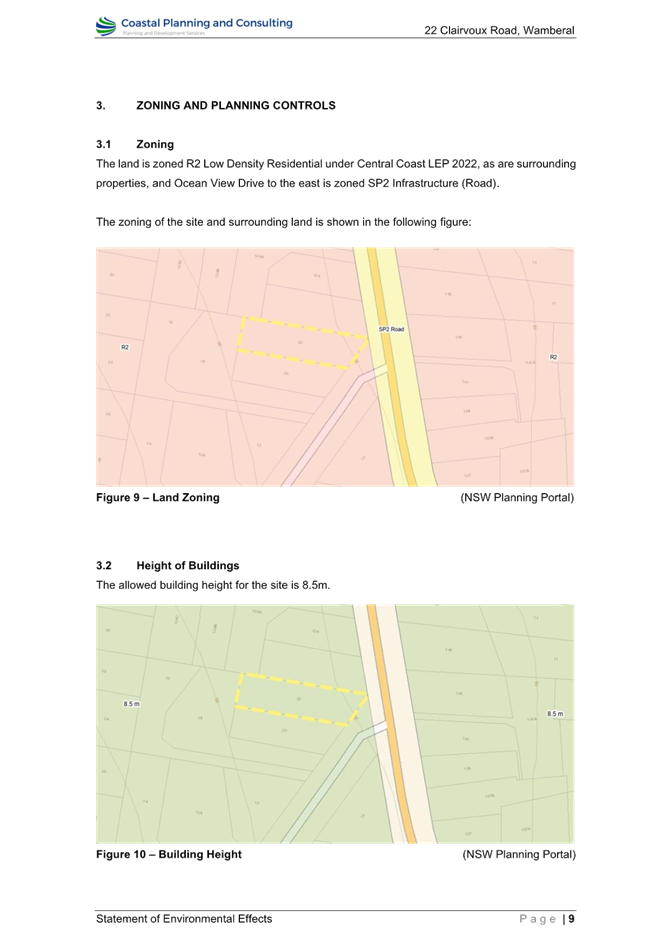
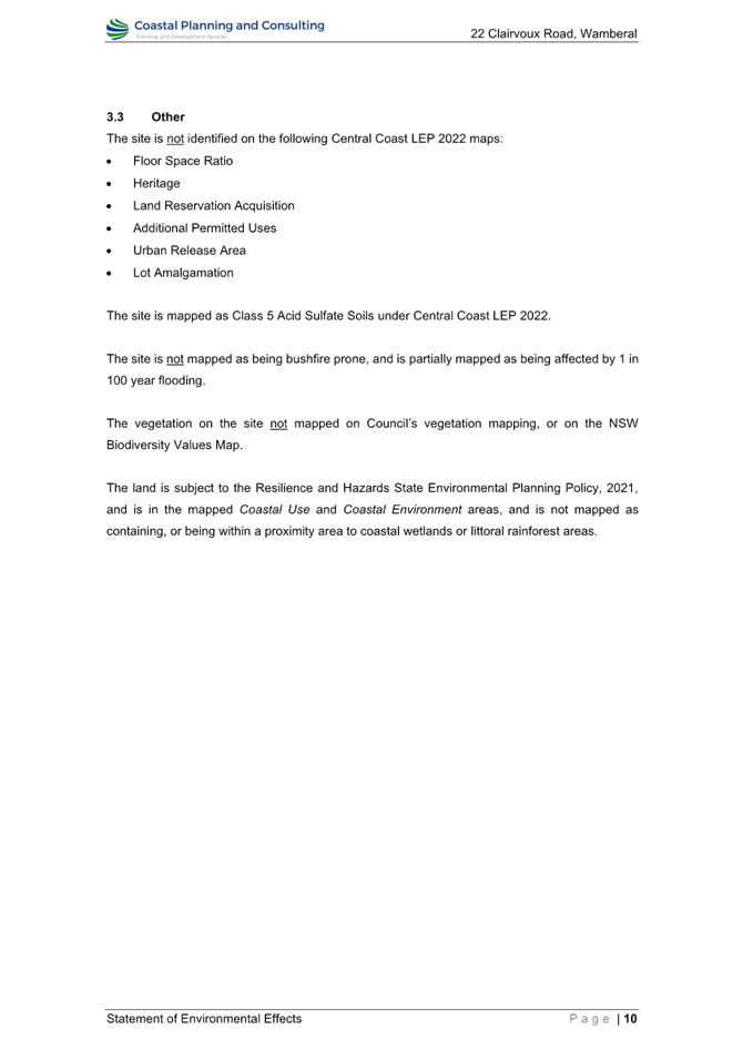
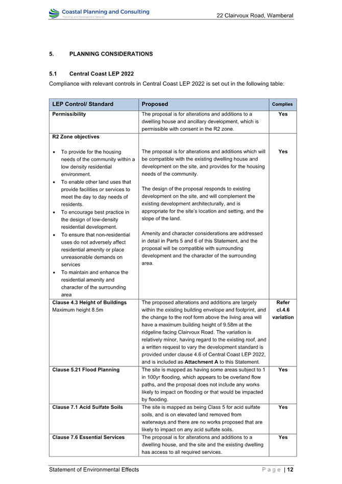
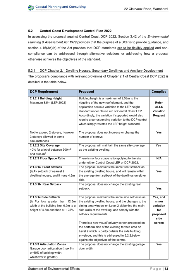
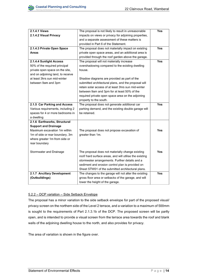
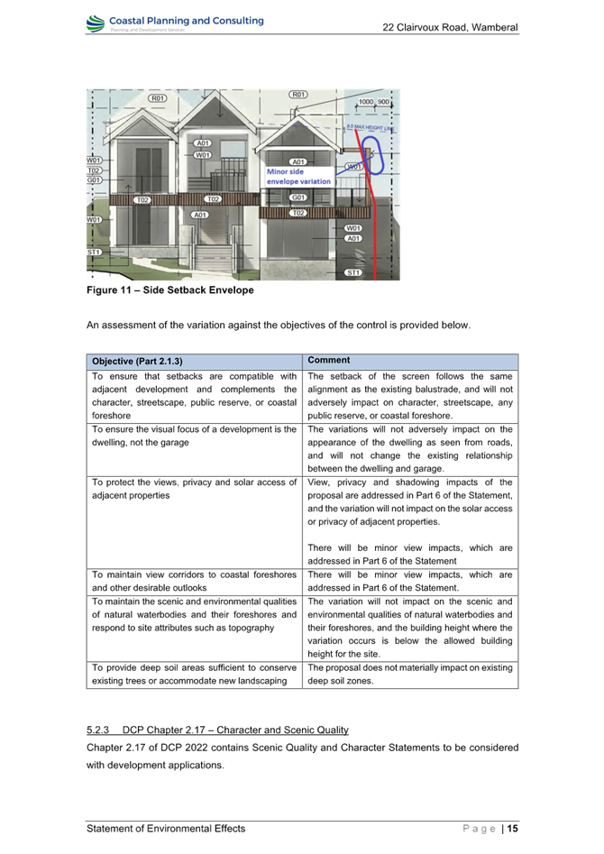
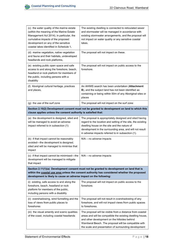
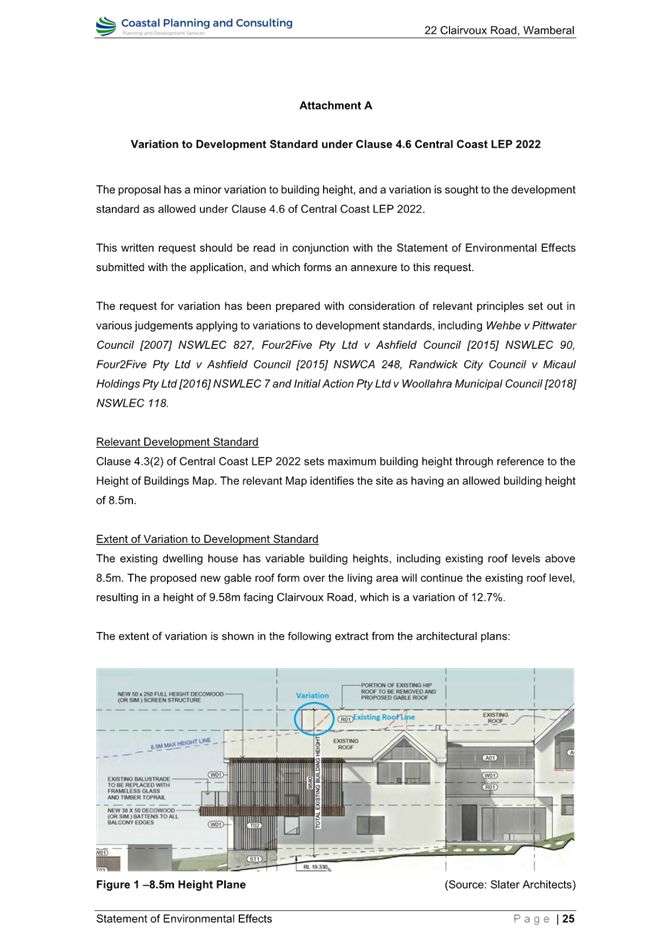
|
DA/2048/2023 - 22 Clairvoux Road Wamberal - Alterations and Additions (Existing Dwelling) |
|
|
Attachment 4 |
PUBLIC - Variation Request Clause 4.6 - PAN-367189 - 22 Clairvoux Rd, WAMBERAL - DA/2048/2023 |
|
DA/2048/2023 - 22 Clairvoux Road Wamberal - Alterations and Additions (Existing Dwelling) |
|
|
Attachment 5 |
PUBLIC - BASIX Certificate - PAN-367189 - 22 Clairvoux Rd, WAMBERAL - DA/2048/2023 |
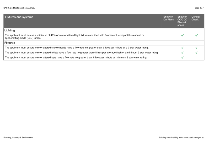

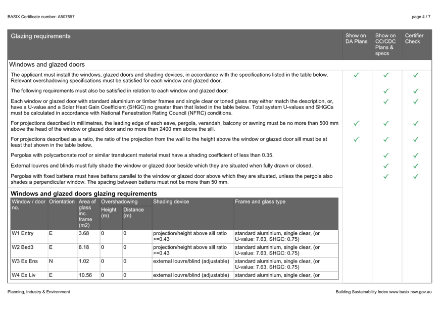
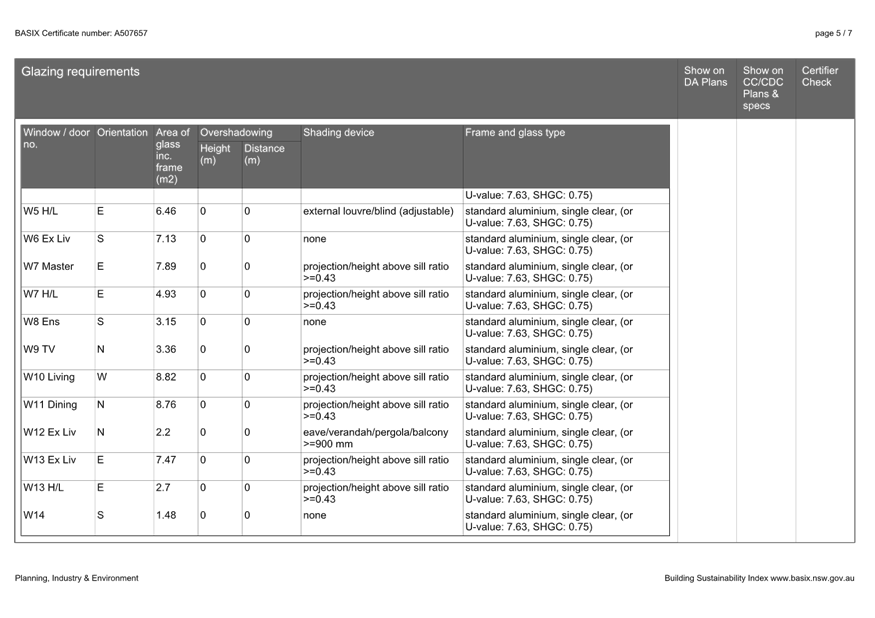
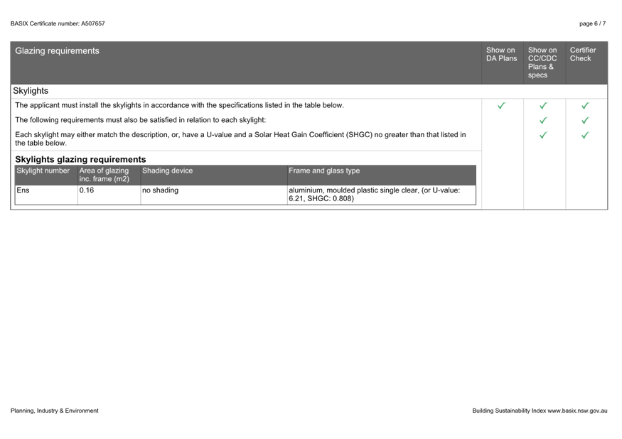
|
DA/2048/2023 - 22 Clairvoux Road Wamberal - Alterations and Additions (Existing Dwelling) |
|
|
Attachment 6 |
PUBLIC - Survey - PAN-367189 - 22 Clairvoux Rd, WAMBERAL - DA/2048/2023 |
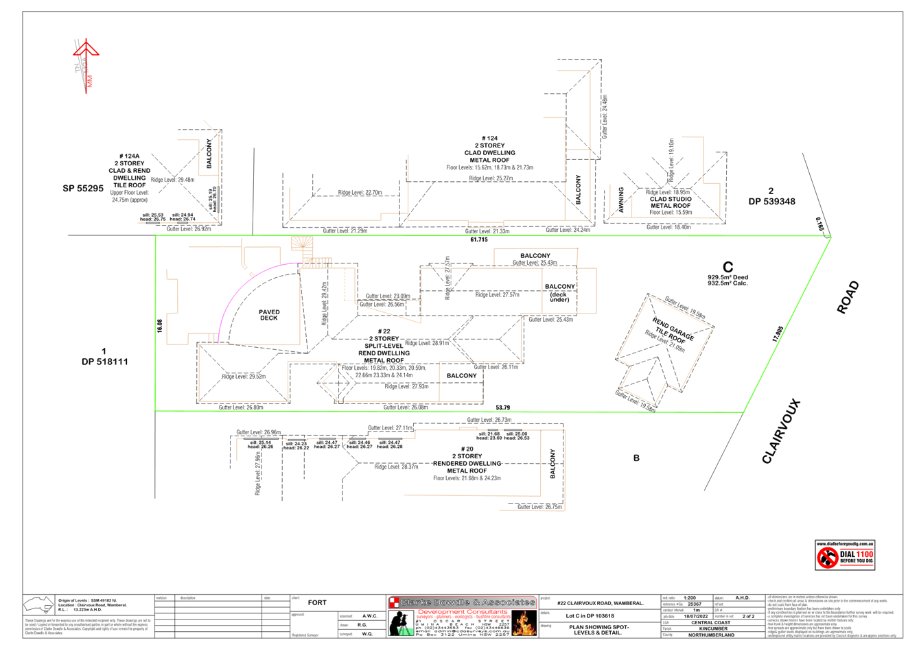
|
DA/2048/2023 - 22 Clairvoux Road Wamberal - Alterations and Additions (Existing Dwelling) |
|
|
Attachment 7 |
PUBLIC - Waste Management Plan - PAN-367189 - 22 Clairvoux Rd, WAMBERAL - DA/2048/2023 |
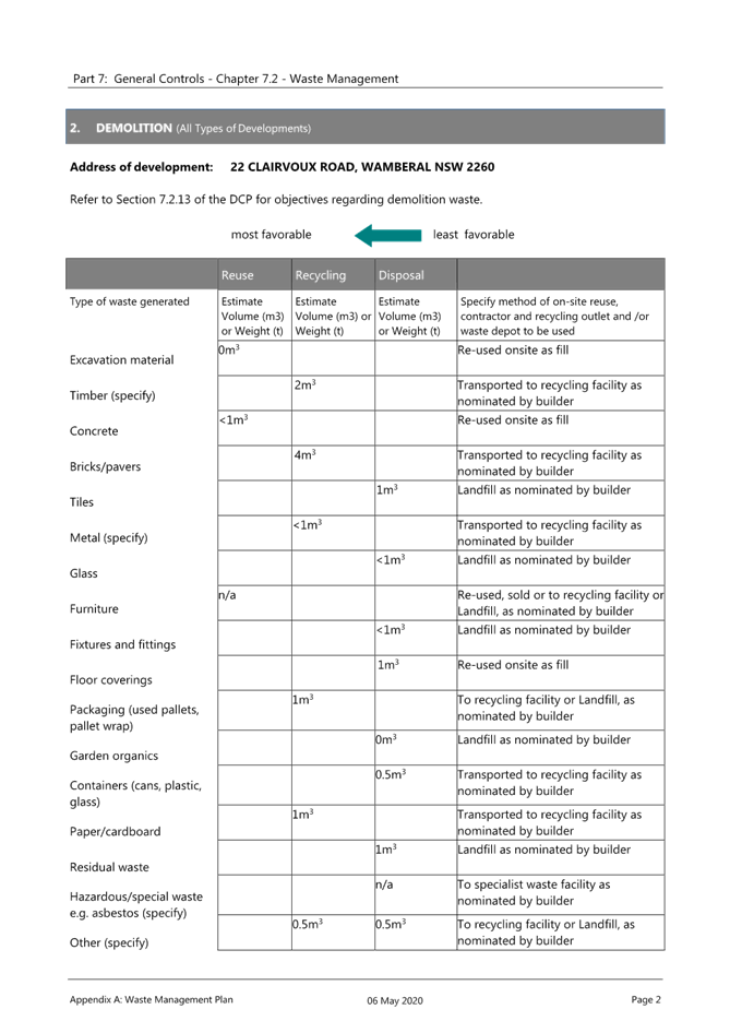
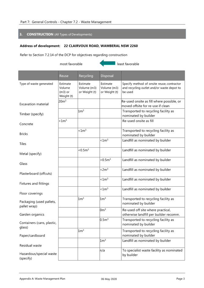
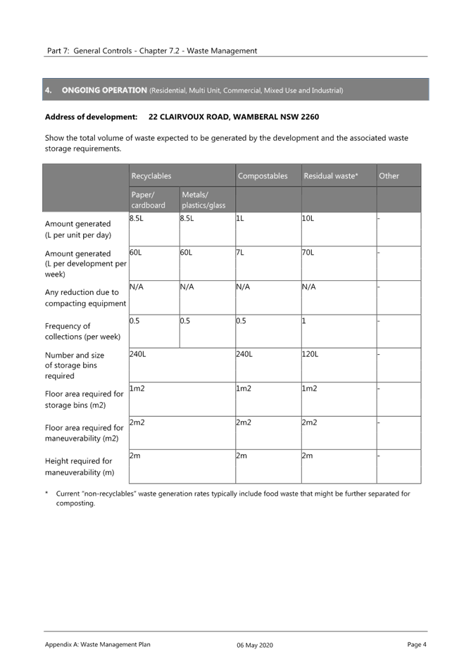
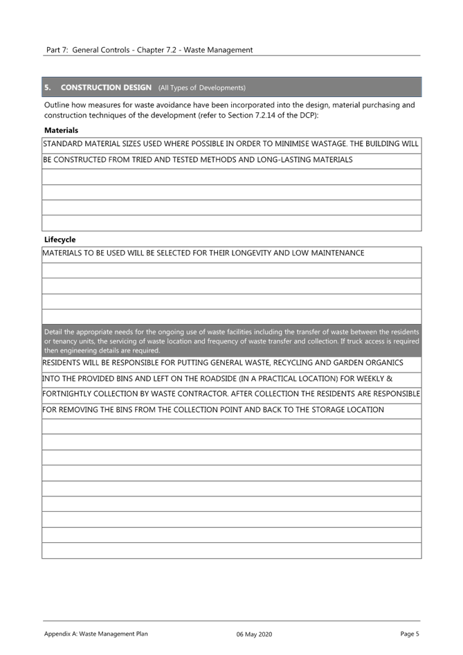
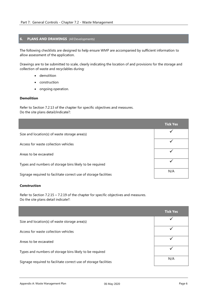
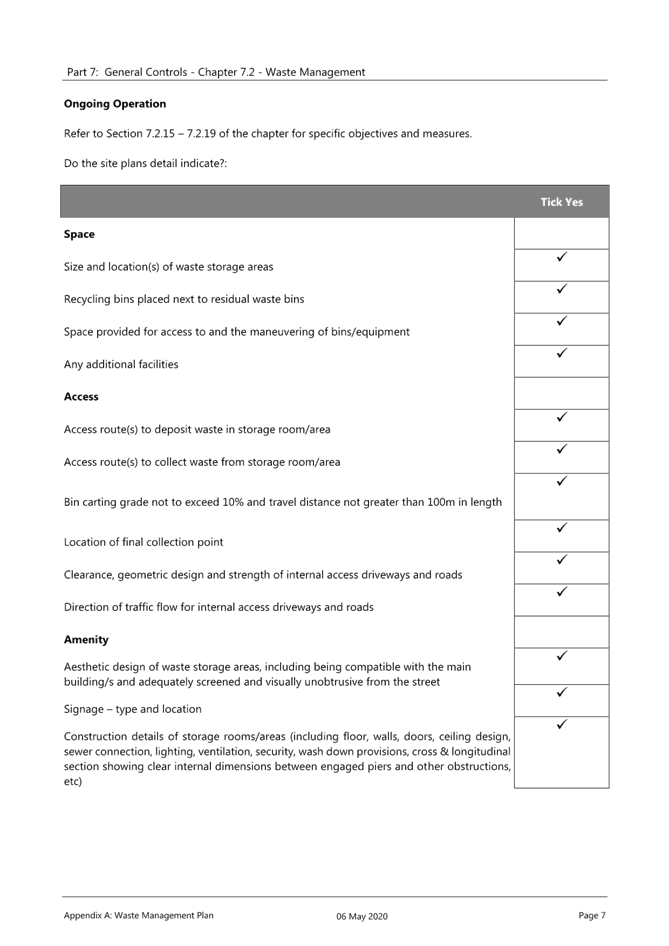
|
Item No: 2.2 |
|
|
Title: Supplementary Report - DA/1849/2005/B - 2-6 Fairport Avenue & 46-48 Ocean Parade, The Entrance - Residential Flat Building and Demolition of Existing Structures (Amended Application) |
|
|
Department: Environment and Planning |
|
|
22 August 2024 Local Planning Panel Meeting |
|
Reference: DA/1849/2005/B - D16288819
Author: Rebecca Samways, Development Planner. Employment and Urban Release
Manager: Emily Goodworth, Section Manager Employment and Urban Release
Executive: Andrew Roach, Unit Manager. Development Assessment
Recommendation
1 That the additional information be considered in the Panel’s determination of the application.
2 In the event that the Local Planning Panel are of the view that sufficient evidence has been provided that Development Consent DA/1849/2005 has physically commenced, the Panel approve the modifications to Development Application 1849/2005/B at Lot 200 DP 1140826, Lot B DP 364571 & Lot C DP 364571, 2-6 Fairport Ave & 56-48 Ocean Parade, THE ENTRANCE in accordance with the recommendation included in the initial report on the matter (23 September 2021) subject to the amendments detailed in the schedule attached to that report and having regard for the matters for consideration detailed in Section 4.15 and Section 4.55(2) of the Environmental Planning and Assessment Act 1979.
3 That Council advise those who made written submissions of the Panel’s decision.
Summary
A section 4.55(2) application has been received to modify a consent for a residential flat building (comprising 45 units) and demolition of existing structures. The application has been examined having regard to the matters for consideration detailed in Section 4.15 and Section 4.55 of the Environmental Planning and Assessment Act 1979 and other statutory requirements.
The Local Planning Panel considered the matter at its meeting of 23 September 2021 (report included as Attachment 1). The matter was deferred at the meeting pending the submission of supplementary information regarding:
a. Physical commencement
b. Suitability of the proposed species and height, in consideration of potential view loss within the north eastern corner of the lot
A Supplementary Report was provided to the Panel on 18 July 2022 (report included as Attachment 2) addressing the matters raised in the meeting minutes from the 23 September 2021 meeting. Upon review of the supplementary report and the submission of further legal correspondence prepared by Mills Oakley on behalf of the applicant, the Chair of the LPP requested further round of legal advice be obtained in relation to the legal advice received from Mills Oakley, specifically in relation to physical commencement.
This Supplementary report provides further information regarding the correspondence prepared by Mills Oakley which has been received since the preparation of the first Supplementary Report and includes comments from a Landscape Architect who worked for council recently.
Applicant Planning Lab
Owner Fincorp Pty Ltd
Application No DA/1849/2005/B
Description of Land Lot 200 DP 1140826, Lot B DP 364571 & Lot C DP 364571
2-6 Fairport Avenue & 46 – 48 Ocean Parade, The Entrance
Approved Development Residential Flat Building comprising 45 units and Demolition of Existing Structures
Proposed modification Increase in the number of units from 45 to 56, removal of level 3 basement carpark and reduction of carparking spaces from 84 to 72, internal reconfiguration of apartments, change of rooftop private open space to communal open space, increase in building height and external design changes
Site Area 3258m2
Zoning R3 Medium Density Residential
Existing Use Multi dwelling housing/vacant lot
Employment Generation Nil
Estimated Value $20,731,286
Precis
|
Proposed Development |
Modification of consent for a residential flat building and demolition of existing structures |
|
Permissibility and Zoning |
The site is zoned R3 Medium Density Residential under Wyong Local Environmental Plan 2013 (WLEP). A residential flat building is permissible in the zone. |
|
Relevant Legislation |
· Environmental Planning & Assessment Act 1979 (EP&A Act) · Environmental Planning & Assessment Regulation 2000 (EP&A Regulation) · State Environmental Planning Policy No. 65 (SEPP 65) · Apartment Design Guide (ADG) · State Environmental Planning Policy (Coastal Management) 2018 · State Environmental Planning Policy (Building Sustainability Index: BASIX) 2004 (BASIX) · State Environmental Planning Policy No.55 – Remediation of Land (SEPP 55) · Wyong Local Environmental Plan 1991 · Wyong Local Environmental Plan 2013 · Draft Central Coast Local Environmental Plan 2018 · Wyong Development Control Plan 2005 · Wyong Development Control Plan 2013 |
|
Current Use |
Multi dwelling housing/vacant lot |
|
Integrated Development |
No |
|
Submissions |
· 25 submissions original LPP report · 11 submissions latest notification period for supplementary report |
Background
The Panel considered a Planning Report on the matter at its meeting on 23 September 2021 and resolved as follows:
|
Panel Decision |
1 That the Local Planning Panel defer this matter for electronic determination, pending provision of detailed evidence from the applicant within the next 28 days demonstrating the consent has physical commencement and therefore not lapsed.
2 Matters to be addressed as part of the above include, but are not limited to: · Copy of the deposited plan of the plan of consolidation required. · Evidence from surveyor as to any physical work they undertook on site required. · Evidence that the demolition took place prior to the lapse of consent, including copies of receipts and dated aerial photos showing demolition before consent lapsed required.
3 That Council’s Landscape Officer review the proposed landscaping within the north eastern corner of the lot to confirm the suitability of the proposed species and height, in consideration of potential view loss issue raised by adjoining resident.
4 Upon receipt of the additional material requested, that Council make this information available on their website and notify those who previously made submissions. |
|
Reasons |
1 The applicant has not adequately demonstrated that the consent has physical commencement. In this regard the Panel does not rely on the letter provided by Council dated 29 September 2009.
2 To minimise any adverse impacts on the amenity of adjoining residents. |
In response to the outcome of the Panel meeting of 23 September 2021, additional information was received from the applicant. A Supplementary Report was prepared for the Panel to address the matters raised in the Panel’s decision on 23 September 2021.
On 29 June 2022, the Chair of Central Coast Local Planning Panel (LPP) requested a briefing meeting between the Panel members and Council staff prior to arranging a date for determination. Council arranged a briefing meeting scheduled for 21 July 2022 and circulated the Supplementary Report on 18 July 2022 to the Panel. However, on 20 July 2022 the meeting was cancelled and was to be rescheduled for a later date as not all Panel members were available.
On 21 July 2022 the Chair requested a meeting with the Director of Environment and Planning to discuss the Supplementary Report.
Since the Supplementary Report was prepared and sent to the Panel on 18 July 2022, Council has received further legal correspondence prepared by Mills Oakley on 20 October 2022 and 11 April 2023 (Attachments 3 and 4).
Having regard for the complexity of the matter regarding physical commencement, the LPP Chair requested Council obtain further legal advice to respond to the more recent Mills Oakley advice, to assist the Panel in making an informed decision on the matter of physical commencement.
Additional information for the Panel’s consideration is attached in (Confidential Attachment 5).
Physical Commencement
The legal advice prepared by Mills Oakley on behalf of the applicant asserts that physical commencement has occurred. As a result of the additional legal advice received from Mills Oakley dated 20 October 2022 and 11 April 2023, post the preparation of the Supplementary report, Council has sought further assistance on behalf of the Chair of the LPP.
The only evidence provided in respect of physical commencement are the documents referred to in the Supplementary Report dated 31 December 2022. The tax invoices supplied do not detail the date or nature of the works undertaken. No further evidence has been provided since December 2022 to substantiate the assertions of physical commencement.
It is a matter for the LPP to decide whether they are satisfied if physical commencement has occurred. The options for determination of the modification are:
· refuse on the basis that physical commencement has not occurred, or
· approve the modification based on the facts provided by Mills Oakley and satisfaction physical commencement has occurred; or
· defer the decision for further information to be obtained by the Applicant.
Notwithstanding the question of physical commencement, Council must still complete a merit assessment of the proposed modification if it is determined that physical commencement has been achieved. An assessment of the proposed modification was undertaken in the report considered by the Panel on 23 September 2021 and the supplementary report sent to the Panel on 18 July 2022. Those assessment reports remain relevant for the merit assessment.
Other Matters
Landscaping
Since the previous supplementary report, Council has obtained comments from a landscape architect that was working with Council. The following comments are made in relation to the landscaping.
The Panel raised concerns with the suitability of the proposed species and height in the north eastern corner of the site with regard to potential view loss. The landscape plans provided at the LPP meeting on 23 September 2021 detailed the provision of an Illawarra Flame Tree in the north eastern corner of the site which grows up to 16m in height. The original landscaping also included Coastal Banksia and Blueberry Ash which both grow up to 10m in height in the north eastern corner.
The applicant submitted amended landscape plans, dated 18 October 2021 which reduced the maximum height of the landscaping to 6m in the north eastern corner of the site. The amended landscape plans included Coastal Tea Tree (maximum 6m), NSW Christmas Bush (maximum 3-5m) and Silver Banksia (maximum 2-4m). It is estimated that maximum tree height and widths in planting to the north eastern precinct, predominantly Coastal Tea Tree, are unlikely to be reached due to the confined soil depths in the planter box structure (over basement), and therefore unlikely to have a major impact on associated view loss.
The plant selections are all hardy species suitable for use in planter boxes and coastal conditions with rooftop planting to be irrigated. The proposed Roof Plan planting consist of predominantly native shrubs, low growing groundcovers and texture grasses that are drought tolerant species suitable for use in coastal conditions and high wind environments. The Landscape Response states that an automatic irrigation system is proposed which will ensure a greater success in plant growth and establishment.
As per the previous assessment report and supplementary report which discussed the landscaping on the roof and the landscaping in the north eastern corner of the site, the landscaping is considered satisfactory.
Contributions
Condition 2 which levied the payment of contributions was recommended to be updated in the original report to the Local Planning Panel on 23 September 2021. Since the application was reported to the Local Planning Panel, contribution rates have been indexed. Accordingly, condition 2 has been updated in the modified conditions of consent in (Attachment 6).
Merit assessment
As per the original report for the modification application (considered by the Panel 23 September 2021), the proposed modifications are considered to result in a proposal that is substantially the same development for which consent was originally granted. Having regard for the statutory approach to the consideration of what constitutes substantially the same development, a quantitative and qualitative analysis of the proposed development has identified there will be no radical changes to the original approved built form and the impacts assessed in the granting of the original consent will remain relatively the same under the proposed modified built form.
Having regard for the provisions of Sections 4.55(2) and 4.15 of the Environmental Planning & Assessment Act 1979, as set out in the original report, and the additional landscaping information, the proposed modification to the original approved development is considered reasonable and warranted in this instance.
Conclusion
This supplementary report and the previous supplementary report, along with the report considered by the Panel on 23 September 2021, has been prepared and assessed against the matters for consideration of Sections 4.15 and 4.55 of the Environmental Planning & Assessment Act 1979 and all relevant instruments, plans and policies.
The applicant has provided further legal advice post consideration of the Supplementary Report sent to the Panel on 18 July 2022 and Council has sought its own further analysis in relation physical commencement at the request of the Chair. It is a matter for the LPP to decide whether they are satisfied physical commencement has occurred. The LPP should have regard to all information included in the attachments to this Report, a number of which are confidential documents and not addressed in detail in this public document.
The proposed landscaping is considered suitable. A merit assessment of the application was undertaken under the original report that went before the Panel on 23 September 2021 which found that the proposed modification was substantially the same development to that which was originally granted consent. Subject to the imposition of appropriate amended and new conditions, the proposed modifications are considered reasonable. It is a matter for the LPP to be satisfied that the proposed modification to the approved development is considered reasonable and warranted having regard for the merits of the proposal.
Attachments
|
1⇩ |
Original Assessment Report - 23 Septemeber 2021 LPP Meeting |
|
D14810016 |
|
2⇩ |
First Supplementary Report distributed to LPP on 18 July 2022 |
|
D15327792 |
|
Mills Oakley legal advice dated 20 October 2022 - |
Provided Under Separate Cover |
D15723655 |
|
|
Mills Oakley Legal Advice dated 11 April 2023 - |
Provided Under Separate Cover |
D15723658 |
|
|
Confidential Attachment dated 27 March 2023 - |
Provided Under Separate Cover |
D15723660 |
|
|
6⇩ |
Updated Modified Conditions of Consent |
|
D15037217 |
|
2.2 |
Supplementary Report - DA/1849/2005/B - 2-6 Fairport Avenue & 46-48 Ocean Parade, The Entrance - Residential Flat Building and Demolition of Existing Structures (Amended Application) |
|
Attachment 1 |
Original Assessment Report - 23 Septemeber 2021 LPP Meeting |
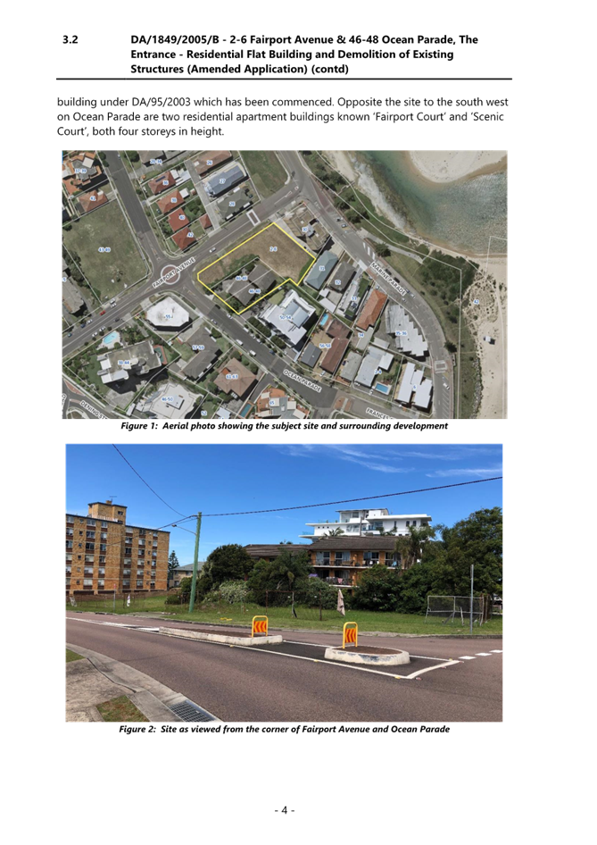
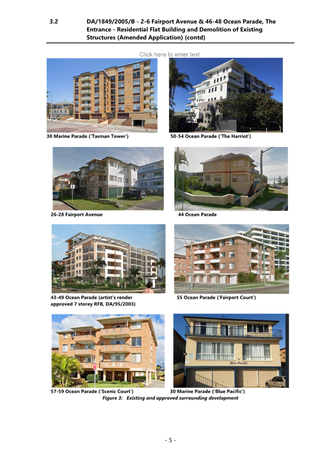
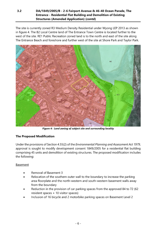
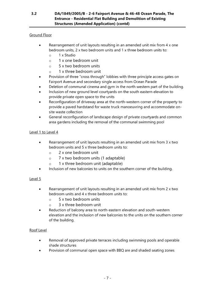
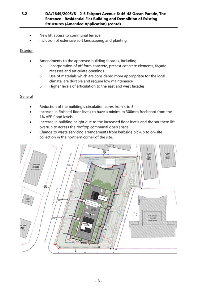
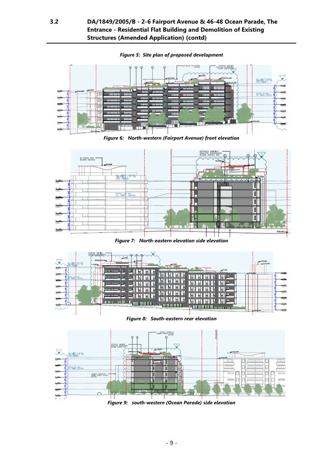
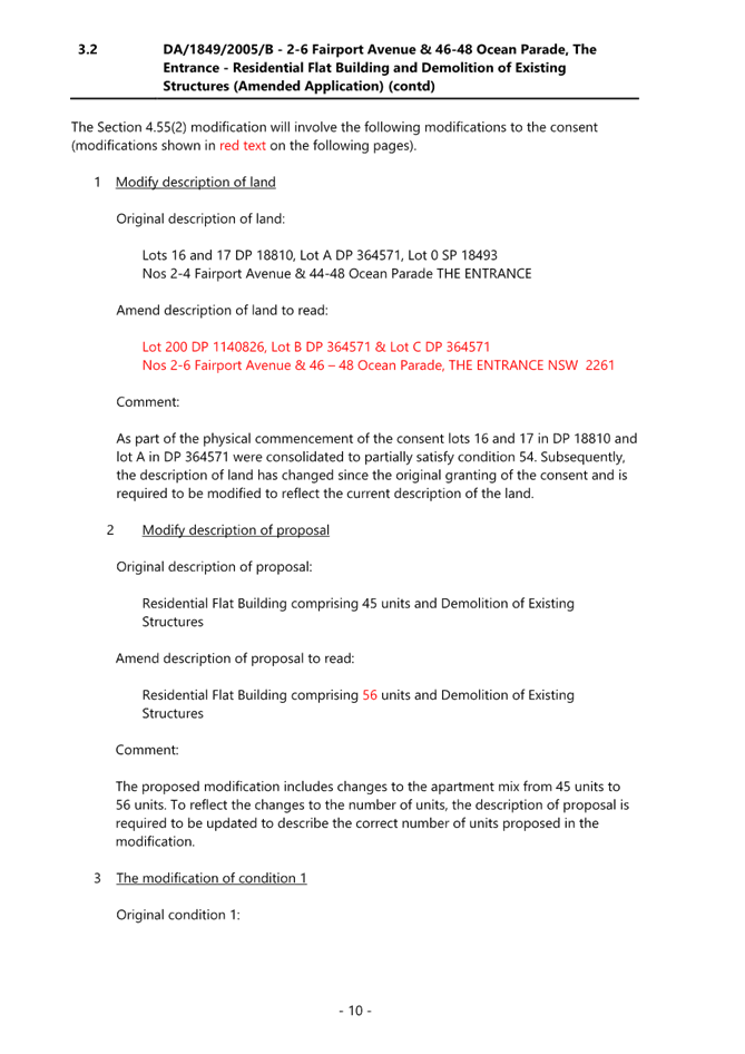
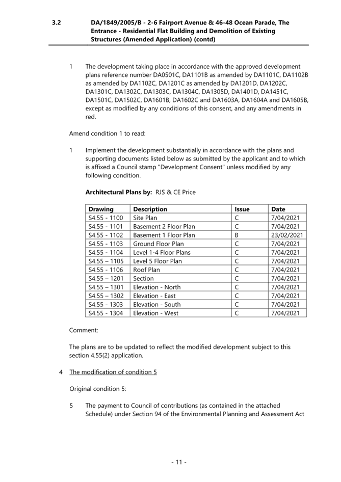
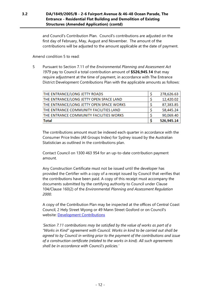
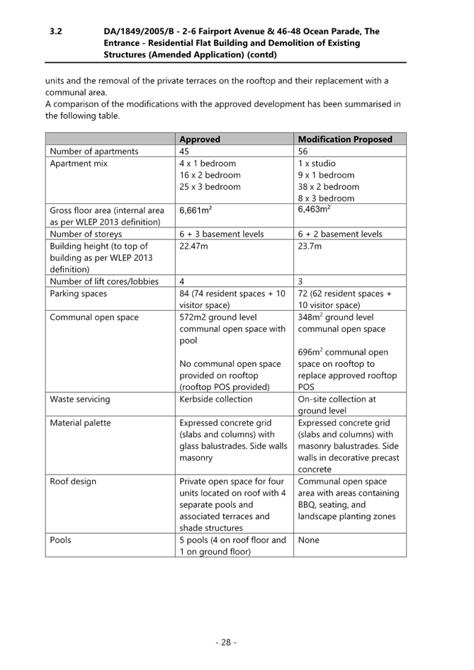
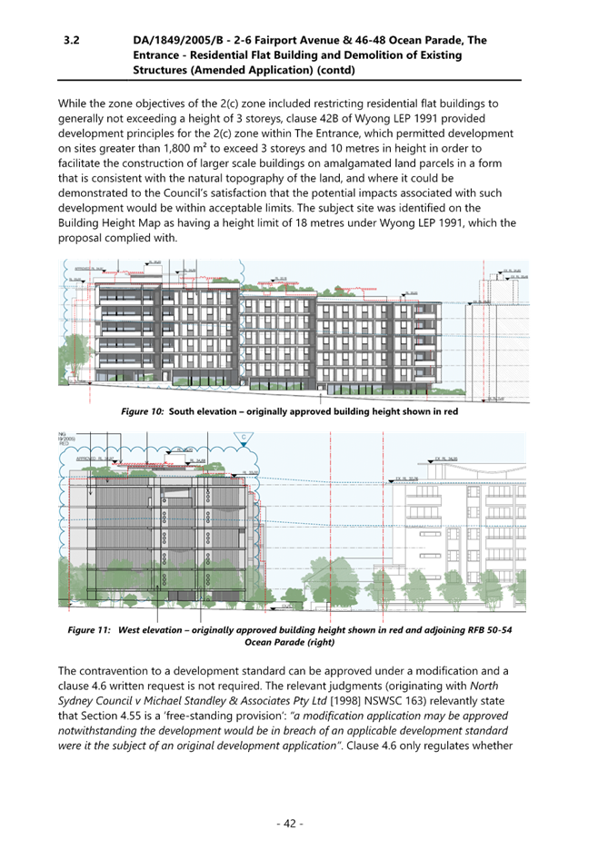
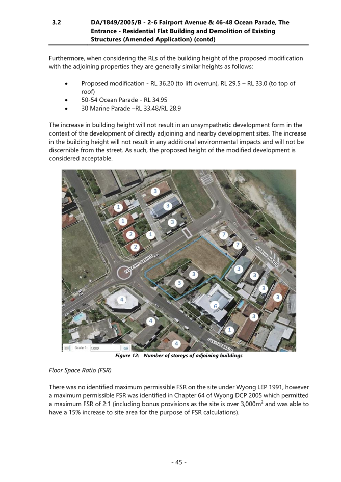
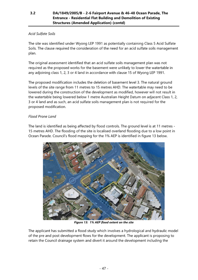
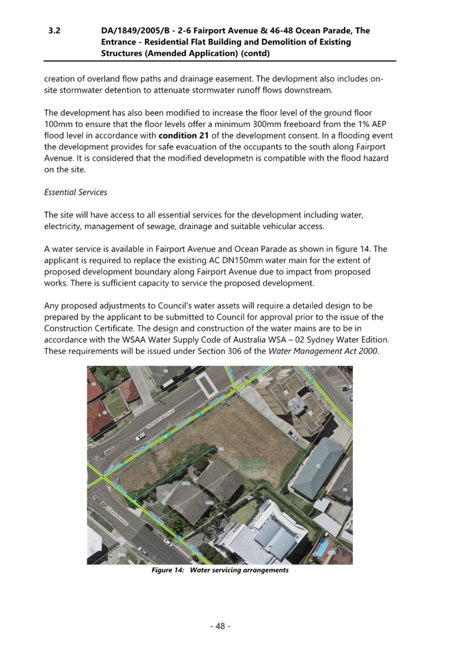
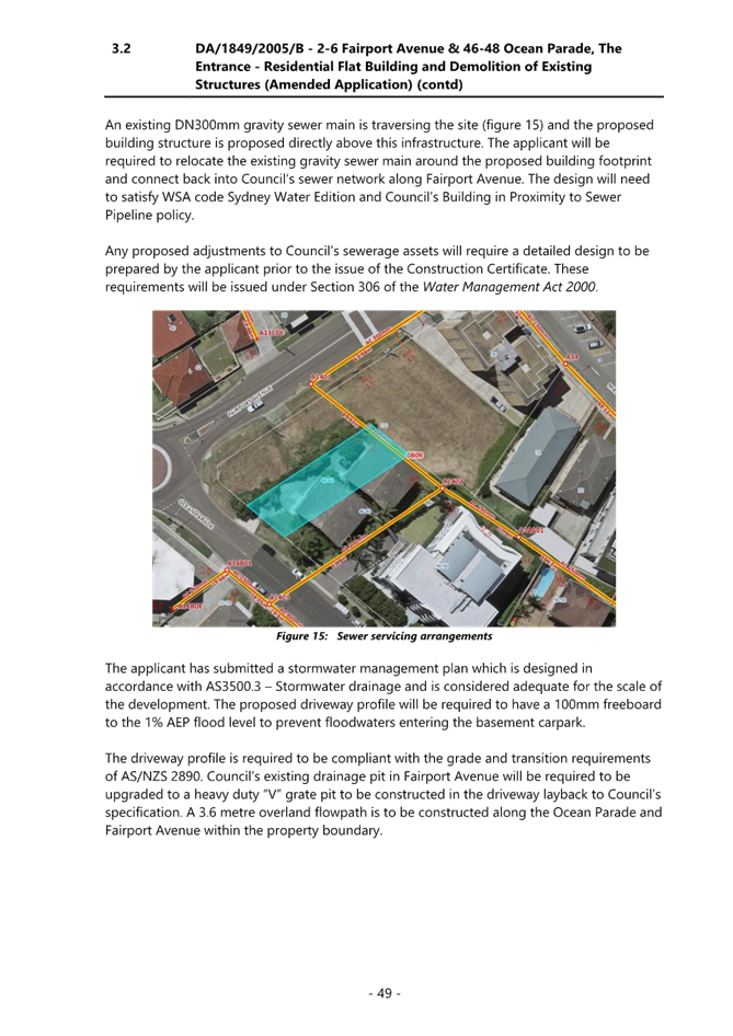
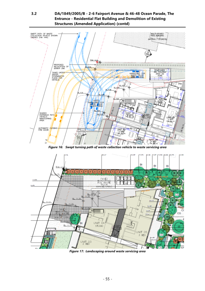
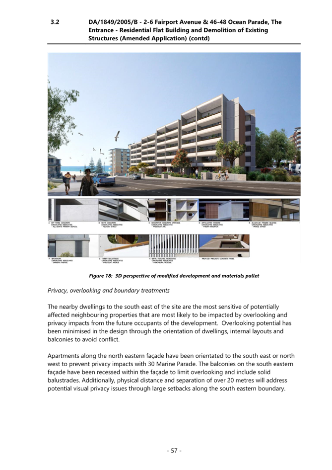
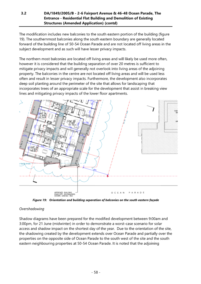
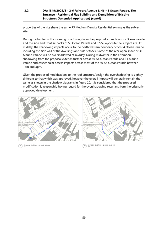
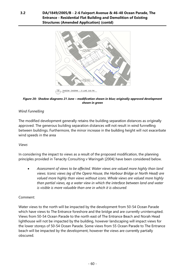

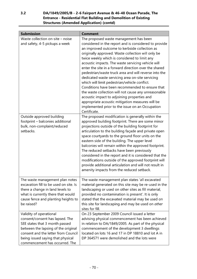
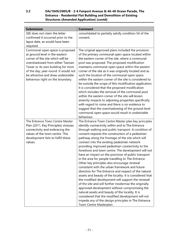
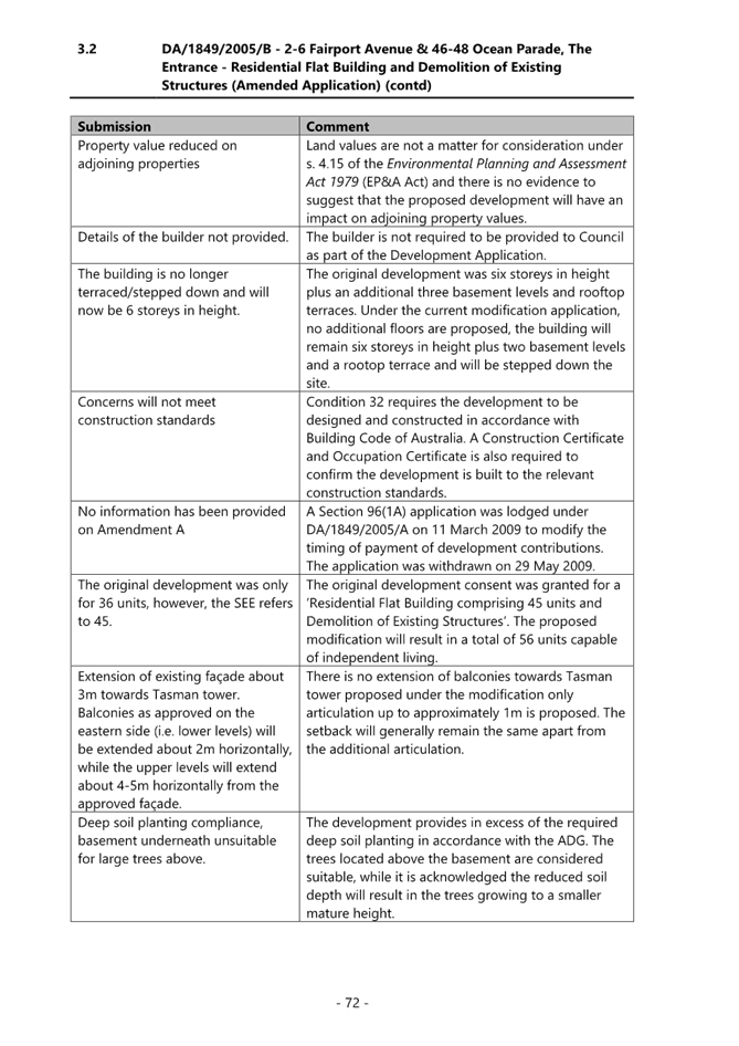
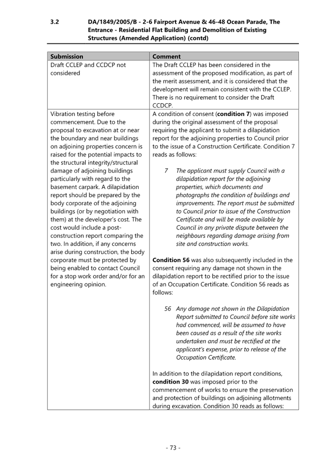
|
Supplementary Report - DA/1849/2005/B - 2-6 Fairport Avenue & 46-48 Ocean Parade, The Entrance - Residential Flat Building and Demolition of Existing Structures (Amended Application) |
|
|
Attachment 2 |
First Supplementary Report distributed to LPP on 18 July 2022 |