|
Item No: 3.1
|
|
|
Title: DA/60468/2020 - Caravan
Park (31 long term sites and 37 short term sites) - 255, 255A, 255B Avoca
Drive & 19 Picketts Valley Road, Kincumber
|

|
|
Department: Environment
and Planning
|
|
|
25
November 2021
Local Planning Panel Meeting
|
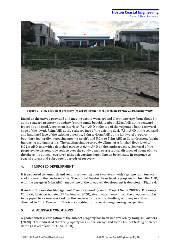
|
Reference: 011.2020.00060468.001
- D14832322
Author: Robert
Eyre, Principal Development Planner South
Manager: Ailsa
Prendergast, Section Manager, Development Assessment South
Approver: Andrew
Roach, Unit Manager, Development Assessment
|
Summary
An
application has been received for a caravan park containing 31 long term
sites and 37 short term sites on Lot A DP449600, Lots 2, 3 and 9 DP976799,
255, 255A, 255B Avoca Drive, 19 Picketts Valley Road, Kincumber. The
application has been examined having regard to the matters for consideration
detailed in section 4.15 of the Environmental Planning and Assessment Act and
other statutory requirements with the issues requiring attention and
consideration being addressed in the report.
The
application is referred to the Local Planning Panel due to the number of
public submissions received being in excess of 15 submissions. 161
submissions have been received. The application is recommended for refusal
for the following reasons:
1 The proposed development
is not consistent with the objectives of the E4 Environmental Living
zone
2 The proposed development
would result in additional stormwater run-off and potential impacts on
riparian zones.
3 The proposed development
would result in significant cut and fill, earthworks and removal of
vegetation on the site which would impact the ecological values, visual and
scenic quality of the area.
4 The site is not suitable
for the proposed development due to its landscape, scenic and ecological
qualities which should be preserved.
5 Insufficient information
has been provided on road works within the site, ecology impacts, waste
impacts, soil and water management, and tree retention.
6 The proposal is an
overdevelopment of the site, inconsistent with the current and future desired
character of the locality and approval is not in the public interest.
7 Pursuant to Draft
Central Coast LEP (2018) the proposed development is prohibited within E4
Environmental Living zone.
8 The proposed development
does not have adequate regard to achieving compliance with the Local
Government (Manufactured Home Estates, Caravan Parks, Camping Grounds and
Moveable Dwellings) Regulation 2005
Applicant ADW
Johnson
Owner Avoca
Land Pty Ltd
Application
No DA/60468/2020
Description
of Land Lot A DP449600, Lots 2,
3 and 9 DP976799, 255, 255A, 255B Avoca Drive, 19 Picketts Valley Road,
Kincumber
Proposed
Development Caravan
Park
Site
Area 24.12ha
Zoning E4
Environmental Living
Existing
Use Dwelling houses, stables
and ancillary buildings
Employment
Generation No
Estimated
Value $9,273,541.00
|
Recommendation
1 That the Local Planning Panel refuse the application DA
60268/2020 for a caravan park on Lot A DP449600, Lots 2, 3 and 9
DP976799,
255,
255A, 255B Avoca Drive, and 19 Picketts Valley Drive, Kincumber, subject to the
reasons for refusal detailed in the schedule attached to the report and having
regard to the matters for consideration detailed in Section 4.15 of the
Environmental Planning and Assessment Act 1979.
2 That
Council advise those who made written submissions of the Panel’s
decision.
3 That
Council advise relevant external authorities of the Panel’s decision.
Key
Issues
· Permissibility and
characterisation of use as a caravan park.
· Inconsistency with the
objectives of the E4 Environmental Living zone.
· Inconsistency with the
draft Central Coast Local Environmental Plan 2018.
· Environmental/ecological
Impacts.
· Inadequate/insufficient
information on ecological impacts, waste impacts, soil and water management,
and tree retention.
· Integrated Development.
· Overdevelopment and
inconsistency with current and future character of the locality.
· Social impacts and public
submissions (and matters raised therein).
Precis:
|
Proposed Development
|
Caravan Park
|
|
Permissibility and Zoning
|
E4 Environmental Living under Gosford Local
Environmental Plan 2014. Permissible with consent
|
|
Relevant Legislation
|
· Environmental Planning
& Assessment Act 1979 –
· Section 4.15
· Local Government Act
1993 – Section 68 and 89
· Fisheries Management Act
1994
· Heritage Act 1977
· Protection of the
Environment Operations Act 1997
· Roads Act 1997
· Rural Fires Act 1997
· Water Management Act
2000
· State Environmental
Planning Policy (Coastal Management) 2018
· Gosford Local
Environmental Plan 2014
· Gosford Development
Control Plan 2013
· State Environmental
Planning Policy (Infrastructure) 2007
· State Environmental
Planning Policy (State and Regional Development) 2011
· State Environmental
Planning Policy No 21-Caravan Parks
· State Environmental
Planning Policy No 36- Manufactured Home Estates.
· State Environmental Planning Policy No55- Remediation
of Land
· State Environmental Planning policy (Koala Habitat)
2020
· Draft Central Coast
Local Environmental Plan 2018 (CCLEP)
· Local
Government (Manufactured Home Estates, Caravan Parks, Camping Grounds and
Moveable Dwellings) Regulation 2005.
|
|
Current
Use
|
Dwelling
houses, stables, agriculture and ancillary buildings.
|
|
Integrated
Development
|
· Natural Resources
Access Regulator (NRAR)
· NSW Primary Industries (NSW Fisheries)
· NSW Rural Fire Service (NSW RFS)
|
|
Submissions
|
One
hundred and sixty-one (161)
|
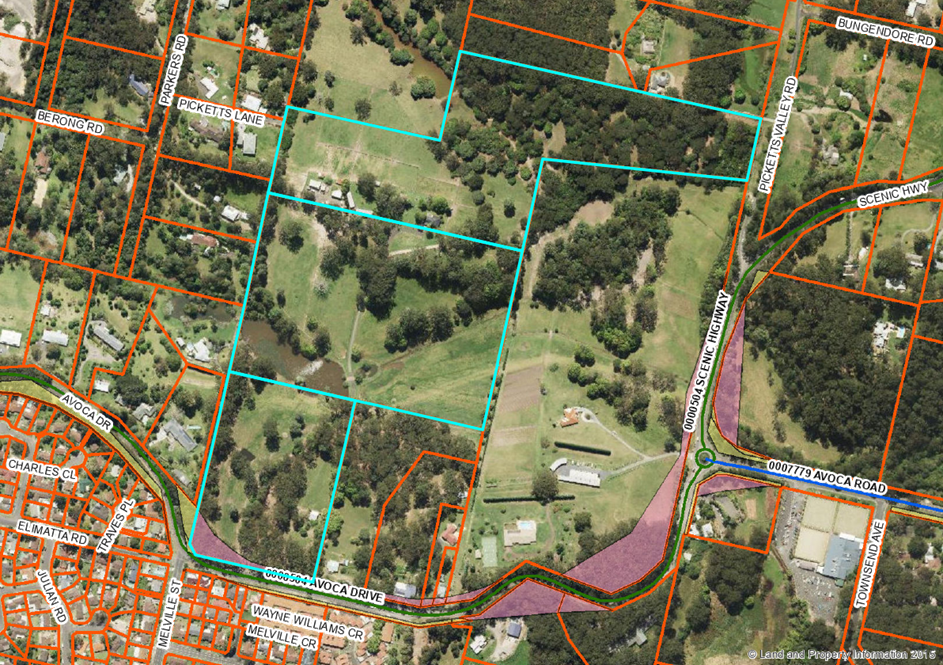
The Site and Surrounds
The
site is an irregular shape and consists of four (4) existing allotments, 255,
255A & 255B Avoca Drive Kincumber, and 19 Picketts Valley Road Picketts
Valley, legally identified as:
· Lot A DP449600
· Lots 2, 3 and 9 DP976799
The
site is located on the northern side of Avoca Drive between Picketts Valley
Road and
Melville
Street, Kincumber, having a 154m frontage to Avoca Drive, and an 82m
frontage
to Picketts Valley Road.
The
land is undulating with varying slopes to 20% and is dissected by two
watercourses
which
traverse the property in a generally east-west direction. There is also
existing
dam/water
storage on site. The levels vary from about RL 40m at the southern side
boundary
with
Avoca Drive, falling away to the north to about RL 6m at the first watercourse.
The elevation rises again to about RL 40m near the centre of the site then
falls away (to about RL 6m) at the second watercourse, rising again to (about
RL 30m) at the northern side/ rear of the site.
Past
use of the land has been generally agricultural with dwelling houses. The site
contains 3
existing
dwelling houses, sheds, stables, and an access driveway from Avoca Drive. One
dwelling house and the dam are located at the southern end of the site, with
the remaining dwelling houses, sheds, and stables located approximately in the
centre of the site between the two watercourses.
The
rear of the site and frontage to Picketts Valley Road is heavily vegetated,
with the
remainder
of the site having scattered stands of vegetation.
The
site is identified as "bushfire prone
land". A Bushfire Assessment Report prepared by
Peterson Bushfire (Reference 17033 dated 22 April 2020 was submitted with the
application
recommending the proposal comply with varying BAL levels with the highest
being
BAL-12.5 for buildings and long term sites.
The
site is located about 2.5km east of the Kincumber shopping centre and about
3.8km west
of
Avoca Beach.
Adjoining
development to the north, east and west comprises small rural holdings,
associated
dwelling
houses and agricultural uses. Land to the south and south-west (opposite side
of
Avoca
Drive) includes residential areas of Kincumber incorporating senior living
developments.
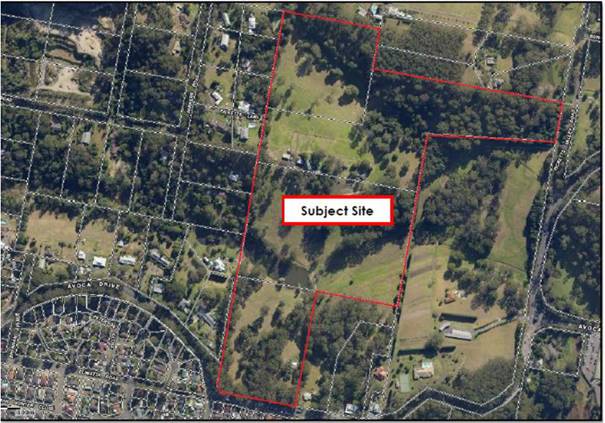
Figure 1- Locality Plan
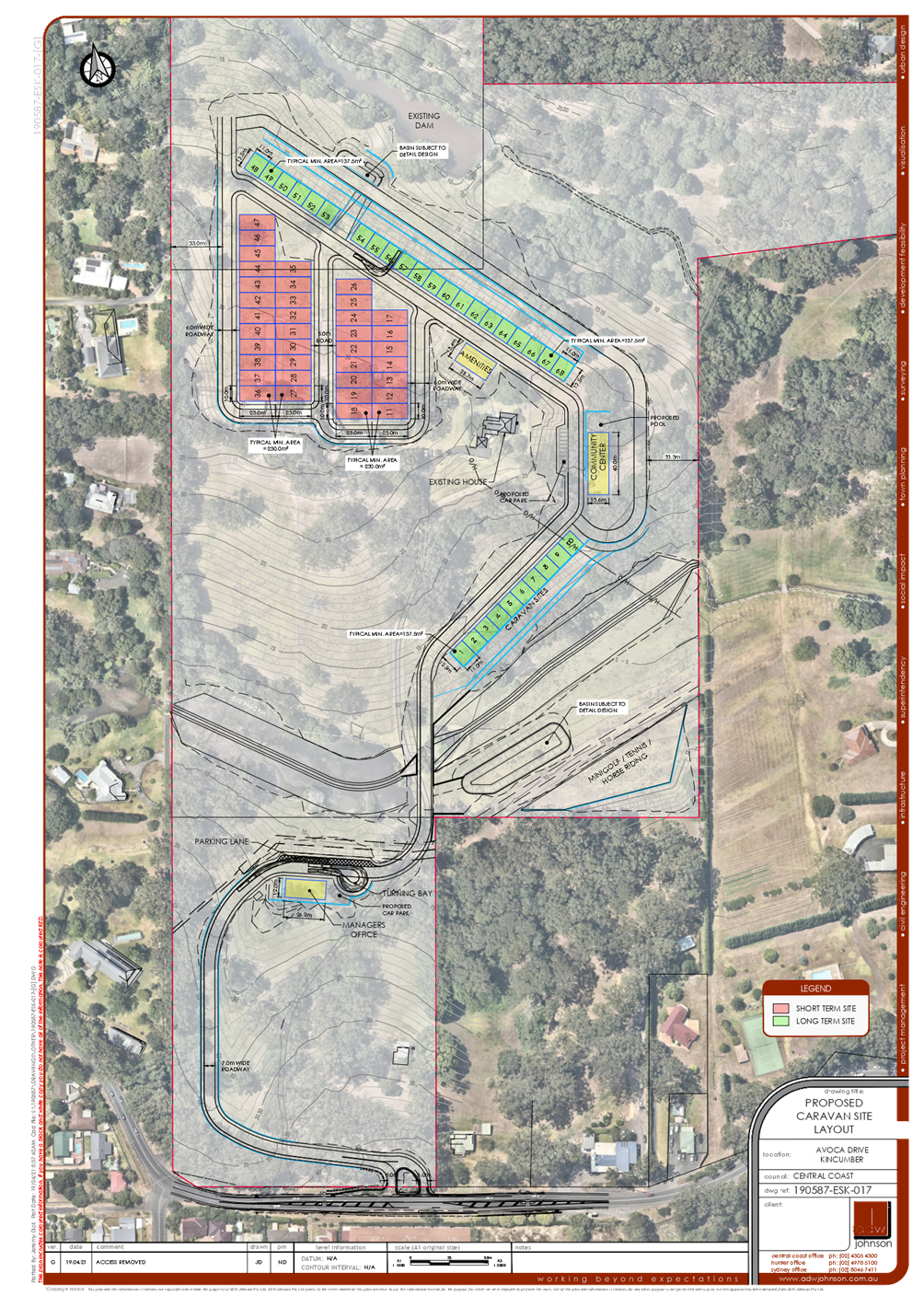
The
Proposed Development
It
is proposed to construct a caravan park consisting of 68 caravan sites
including 31 long term sites and 37 short term sites.
The
proposal will involve:
· Earthworks and
construction of internal roads, landscaping and driveway access off Avoca
Drive.
· Demolition of 2 existing
dwelling houses, stables and ancillary structures.
· Construction of stormwater
infrastructure including 2 basins.
· Dewatering and reshaping
dam on southern watercourse.
· Realignment of existing
southern watercourse crossing and upgrade to culverts.
· Construction of a
recreational area for mini golf, tennis and horse riding, community centre,
amenities building and managers office.
· Provision of water, sewer,
and electrical and other services.
· Installation of a sewer pump
station and electrical kiosk.
· Removal of 210 or more
trees.
· 70,000m3 of cut
and 5,5003 of imported fill.
· Setback to western
boundary of 30m and southern boundary with Avoca Drive of 400m.
· Retaining walls up to
4.4m.
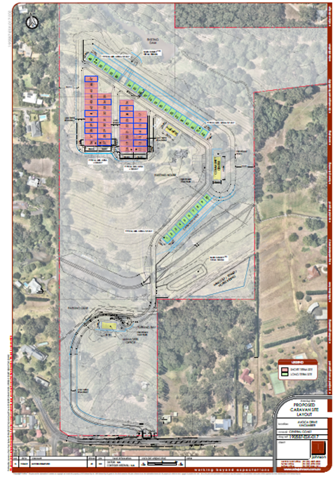
Figure 2- Site Plan
The application states that the
development is proposed to be used as a high- quality tourist park where short
term stays will be limited to 180 days in any 12month period. A full- time
manager will reside on site.
The application was amended by the
deletion of the emergency access road across the northern creek to Picketts
Valley Road. An amended bushfire report was submitted by Peterson Bushfire
dated 22 April 2020. This report states that a BAL 12.5 is required for
buildings and that the secondary access to Picketts Valley Road is highly
unlikely to be used during bushfire as it passes through the bushfire hazard
area. Bushfire access is to be via the access to Avoca Drive away from the
bushfire source.
The conditions of approval by the RFS
require an 8m wide perimeter road and 5.5m wide internal roads.
As can be seen by figures 2 and 3
(proposed and previous applications) the internal road layout has not
essentially changed. The current application is a reduction in the number of
sites while maintaining the internal layout.
Background
DA16548/1992
A 6 lot community title subdivision
was approved on 9 November 1993; this consent has lapsed.
Two Pre-DA meetings 2018 & 2019
On
10 May 2018 a pre-DA meeting was held with Council for a senior living
development on the site. The meeting identified that a retirement
village/senior living development was a prohibited use under the Gosford Local Environmental
Plan 2014 and State Environmental Planning
Policy (Senior Living).
A
further pre-DA meeting was held on 5 September 2019 for a caravan park on the
site
consisting
of about 210 sites in the form of manufactured homes with community facilities
and
associated infrastructure. The applicant was advised at that time that:
‘The
proposed caravan park is a prohibited use under the draft Central Coast Local
Environmental Plan 2018. It is
likely that Council will not support the proposal due to the draft plan being
imminent, the density proposed, impact on scenic values of the site, and
inconsistency with the objectives of the E4 zone. A caravan park should not be
a quasi-retirement village, particularly due to the site constraints of this
site. The proposal will also have to comply with the definition of
’caravan park’.
Development
Application Ref DA/57698/2019 – Residential Land Lease Community
Development
application DA/57698/2019 was considered by the Local Planning Panel at its
meeting of 6 August 2020. This application was for a Staged ‘Residential
Land Lease Community’ (Caravan Park) comprising 202 long term sites, 2
short term ‘caravan’ sites, community facilities, roads and
infrastructure, landscaping, and demolition of existing structures.
DA/57698/2019 was refused development consent by the Local Planning Panel.
The
reasons for refusal at that meeting are summarised below:
· The proposed development
is not consistent with the objectives of the E4 Environmental Living zone
· The proposed development
would result in additional stormwater run-off and increased downstream
flooding.
· The proposed development
would result in significant cut and fill, earthworks and removal of vegetation
on the site which would impact the ecological values, visual and scenic quality
of the area.
· The site is not suitable
for the proposed development due to its landscape, scenic and ecological
qualities which should be preserved.
· Insufficient information
has been provided on potential contamination, road works within the site,
ecology impacts, waste impacts, soil and water management, emergency and
construction access, bush fire hazard, and tree retention.
· The proposal is an
overdevelopment of the site, inconsistent with the current and future desired
character of the locality and approval is not in the public interest.
· Pursuant to Draft Central
Coast LEP (2018) the proposed development is prohibited within E4 Environmental
Living zone.
Section
8.2 Review of Determination
A
Section 8.2 application to review the LPP refusal was submitted in respect of
Development Application Ref. DA/57698/2019.
The s8.2 application included amended engineering and landscape
plans. The amended proposal maintains the overall design approach and general
configuration of the originally considered development with the following
amendments made as part of the review of determination:
· A reduction in sites from
202 sites to 165 sites
· Minor relocation of
internal Road 1 in south west corner
· Minor alterations to
internal Road 6
· Reduction of tree removal
from 491 to 327 trees
· Retention of existing
farmhouse and incorporation into future community facilities
· Removal of Welcome Centre
at the southern end of the site near the entrance
· Demolition of existing
structures on the site
· Retention of existing
farmhouse
· De-watering and filling in
of the existing farm dam
· De-watering and reshaping
of dam on southern watercourse to revert to a watercourse
· Bulk earthworks.
Preliminary plans submitted indicate cut up to 6.2m and fill up to 5.5m. The
applicant has estimated the total cut volume of 92,970m3, fill of 98,692m3, and
a shortfall of 5,722m3 to be imported into the site
· Construction of three water
quality basins
· 2 short term
‘caravan’ sites (15m x 6m)
· Construction of community
facilities including a club house (including caretakers’ residence),
indoor swimming pool, tennis court, bowling green, putting green, village
green, community garden and yoga deck
· Construction of
intersection of access driveway with Avoca drive and internal driveways
· Realignment of southern
existing watercourse crossing and upgrade of road and culvert
· Services, including the
provision of sewer
· Landscaping
The
165 long-term dwelling sites are proposed to contain
future manufactured homes. The application showed an indicative mix of 1 and 2
storey, 3-bedroom homes.
The
applicant also advised the application for the operation of the caravan park
and moveable dwellings will be lodged separately under Section 68 of the Local
Government Act 1993.
The
s8.2 application was considered by the Local Planning Panel at its meeting on
22 July 2021 and refused the application for the following reasons:
a) The proposed development
is not properly characterised as a ‘caravan park’ as the two
short-term dwelling sites must be proposed for a proper use to satisfy the
requirements of the definition for a caravan park. The two short-term dwelling
sites have been nominated for parking for visitors of residents.
b) The proposed development
is not consistent with the objectives of the E4 Environmental Living zone under
the provisions of the Gosford Local Environmental Plan 2014.
c) The proposed
development would
result in significant cut and fill, earthworks and removal of vegetation on the
site which would impact the ecological values, visual and scenic quality of the
area.
d) The site is not suitable
for the proposed development due to its landscape, scenic and ecological
qualities which should be preserved.
e) Insufficient information
has been provided in relation to stormwater run-off and downstream flooding
impacts, ecology, waste, soil and water management, emergency and construction
access and tree retention.
f) The proposal is an
overdevelopment of the site, inconsistent with the current and future desired
character of the locality and approval is not in the public interest.
g) The proposed development
does not have adequate regard to achieving compliance with the Local
Government (Manufactured Home Estates, Caravan Parks, Camping Grounds and
Moveable Dwellings) Regulation 2005
Figure 3- Original
application layout (LHS) and Section 8.2 layout (RHS)
ASSESSMENT:
Having
regard for the matters for consideration detailed in Section 4.15 of the
Environmental Planning and Assessment Act 1979 and other statutory
requirements, Council’s policies and Section 10.7 Certificate details,
the assessment has identified the following key issues, which are elaborated
upon for Council’s information.
Draft
Environmental Planning Instruments.
The
Draft Central Coast Local Environmental Plan (Draft CCLEP) is a matter
for consideration under Section 4.15 of the Environmental Planning &
Assessment Act 1979. The gazettal of the Draft CCLEP is considered to be
certain and imminent, initially expected to be competed by December 2021, the
Department of Planning Industry & Environment have advised that the
gazettal is likely to be delayed slightly (to be completed in the first few
months of 2022).
Under the provisions of the Draft
CCLEP, the land is
proposed to retain the E4 Environmental Living zoning, however
‘caravan parks’ are not permissible in the E4 zone under the
provisions of the Draft CCLEP.
The
Planning Proposal exhibited in support of the draft LEP included a section
titled “CCLEP Part 2 – Permitted or Prohibited Development”,
which compared the provisions of Wyong LEP 2013 and Gosford LEP 2014 and
contained the following relevant information:
In some circumstances, Principle 5 –
Permissibility Retention has not been able to be applied. This is because, in
some instances, the application of zones between the two former LGAs has been
different. For example, the E4 Environmental Living zone in the former Wyong
LGA was generally applied for the purposes of larger lot residential
development in environmentally sensitive locations. While in the former Gosford
LGA, the E4 Environmental Living zone was applied to enable tourist development
in environmentally sensitive locations. Therefore, some land uses have been
found to not always align, and may be inappropriate for application over the
entire Central Coast LGA
The
Draft CCLEP includes a savings provisions that provide for an application
lodged before the making of the draft Plan, that the application must be
determined as if the draft Plan had not been made.
The
Draft CCLEP is a matter for consideration under s4.15(1) of the Environmental
Planning and Assessment Act 1979. How much weight should be given to a
draft LEP depends on whether the draft Plan is imminent, and the public
interest in approving a development which is proposed to be prohibited. In this
regard the following points should be considered:
· The weight to be given to
each head of consideration in s4.15(1) of the EPA Act is a matter for the
consent authority.
· The case law is to the
effect that the weight to be given to a draft instrument will be greater, the
more ‘certain and imminent’ it’s making (Terrace
Tower Holdings v Sutherland Shire Council [2003] NSWCA 289 (Terrace
Towers)).
· A draft instrument is
generally considered to be ‘imminent and certain’ where it has been
approved by the planning authority and sent to the Minister to be made.
· By contrast, a draft
instrument which has not been the subject of public consultation will generally
be given less weight than one that has been the subject of public consultation.
The
Draft CCLEP has been publicly exhibited and adopted by Council on 14 December 2020, however, has not yet been sent to
the Minister to be made. The Draft CCLEP is considered both reasonably imminent
and certain and should be afforded significant weight. Advice from the
Department of Planning Industry & Environment is that the gazettal of the
Draft CCLEP whilst initially anticipated by December 2021, is now likely to be
in the first few months of 2022.
The
following site-specific circumstances are considered in terms of the public
interest being served in approving the development:
· The objectives of the E4
zone under the Draft CCLEP are:
o To provide for low-impact
residential development in areas with special ecological, scientific or
aesthetic values.
o To ensure that residential
development does not have an adverse effect on those values.
o to allow additional land
uses that will not have an adverse impact on those values.
· As discussed throughout
this report the proposed development is not consistent with these objectives as
the proposal cannot be considered to be ‘low impact’ and results in
adverse impacts on the ecological and aesthetic values of the site.
· There is no historic or
future expectation for this nature of development on the site. The site is
located within the Kincumber Character Area 13: Scenic Buffer under the GDCP
2013. The desired character for this area includes “very-low density
residential developments” and requires the retention of natural
slopes, prevention of further fragmentation of tree canopy, low impact
construction methods and avoidance of retaining walls. The proposed development
is in direct conflict with desired character future for the area.
In
Terrace Tower holdings Pty Limited v Sutherland Shire Council [2003]
NSWCA 289, the Court
held
that:
‘…The purpose of a
draft instrument is entitled to be given significant weight in deciding whether
to reject an application brought under a pre-existing planning instrument that
would undermine the draft instrument’s purpose in a substantial
way.’
The
draft CCLEP will prohibit caravan parks on E4 zoned land. The applicant was
aware of this during the exhibition of the draft plan and prior to the lodgement
of the previous development application, Section 8.2 Review and current
application. No public submissions were received objecting to the proposed E4
zoning of the land and or that caravan parks should be retained as a
permissible use with consent in the zone during the exhibition of the Draft
CCLEP.
It
is not in the public interest to approve a development which is inconsistent
with both the current and draft zone objectives. This would prejudice the
making of the draft Plan and future planning objectives for the area. It is
considered the draft plan must be given significant weight and remains a
recommended reason for refusal insofar as it is inconsistent with the zone
objectives is therefore does not result in the public interest being served.
As
discussed above, the land is proposed to retain the E4 Environmental Living
zoning, however ‘caravan parks’ are not permissible in the E4 zone
under the provisions of the Draft CCLEP.
The objectives of the E4 zone under
the Draft CCLEP are similar to the current objectives, being:
o To provide for low-impact
residential development in areas with special ecological, scientific or
aesthetic values.
o To ensure that residential
development does not have an adverse effect on those values.
o to allow additional land
uses that will not have an adverse impact on those values.
As discussed throughout this report
the proposed development is not consistent with these objectives as the
proposal cannot be considered to be ‘low impact’ and results in
adverse impacts on the ecological and aesthetic values of the site. Even if
caravan parks remained a permissible use, the proposal remains inconsistent
with the draft zone objectives and could not be supported.
State
Environmental Planning Policy (Infrastructure) 2007.
The
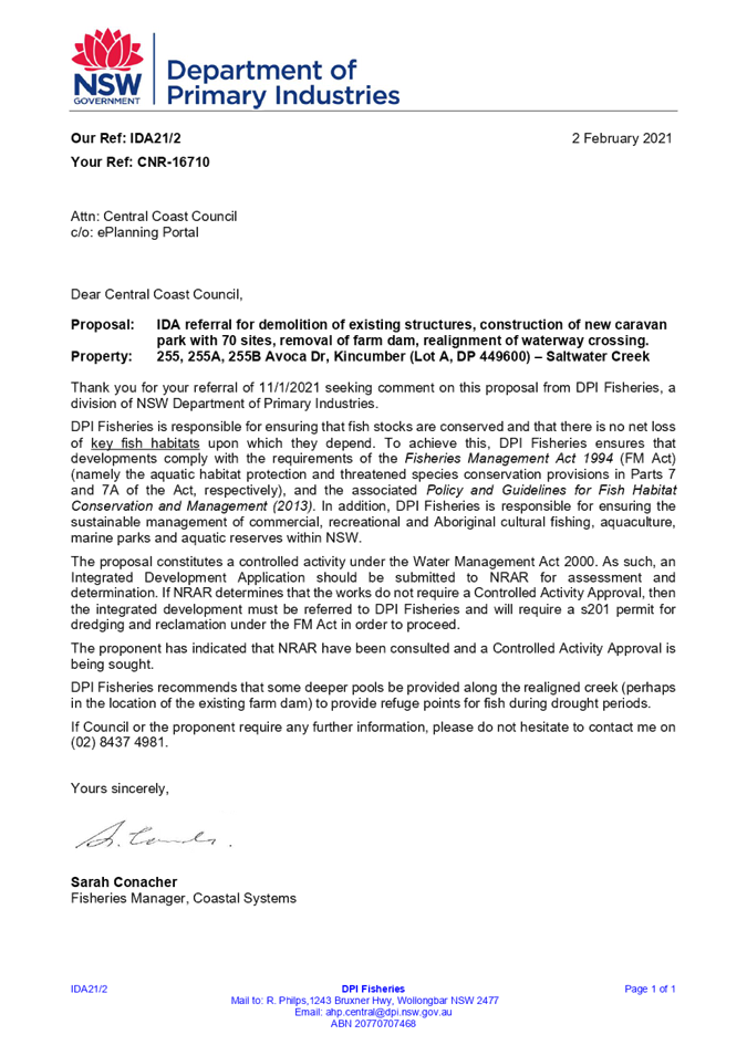
application was referred to Transport for NSW (TfNSW formerly RMS) under
clauses 101 and 104 as the site has access to and frontage to a regional road
and is classified as traffic generating development. TfNSW have advised the
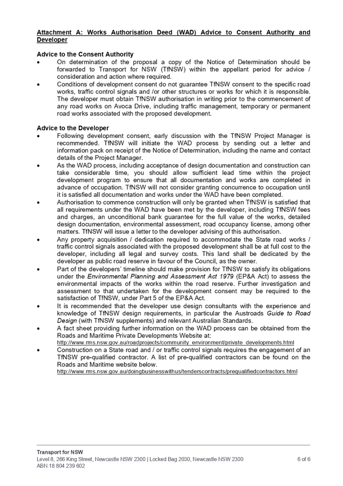
site is subject to road widening and conditions of consent if approved. (Refer attachment 5)
State Environmental Planning Policy No
21-Caravan Parks
The proposal has been assessed having
regard for the provisions of State Environmental Planning Policy 21 -
Caravan Parks which state:
(1) The
aim of this Policy is to encourage—
(a) the
orderly and economic use and development of land used or intended to be used as
a caravan park catering exclusively or predominantly for short-term residents
(such as tourists) or for long-term residents, or catering for both, and
(b) the
proper management and development of land so used, for the purpose of promoting
the social and economic welfare of the community, and
(c) the
provision of community facilities for land so used, and
(d) the
protection of the environment of, and in the vicinity of, land so used.
(2)
The strategies by which that aim is to be achieved are—
(a) Repealed
(b) by
requiring that development consent be obtained from the local Council for
development for the purposes of caravan parks, and
(c) by
providing that development consent may be granted that will authorise the use
of sites for short-term stays (whether or not by tourists) or for long-term
residential purposes, or for both, and
(d) by
requiring that development consent be obtained from the local Council for the
subdivision of land for lease purposes under section 289K of the Local
Government Act 1919.
The proposed development is not
considered to result in the orderly and economic use of the land as the
development is of a nature and scale that is not appropriate for the character
of the area and will result in unacceptable environmental impacts.
Clause 8 requires consideration of
the number of sites suitable for long and short-term sites and requires any development consent to include a
condition specifying the maximum number of sites (if any) within that land that
may be used for long-term residence.
The
definition of long-term and short-term sites, from the Local Government
(Manufactured Home Estates, Caravan Parks, Camping Grounds and Moveable
Dwellings) Regulation 2005 are:
long-term site means a dwelling site that is
specified in the approval for a caravan park as being a long-term site.
short-term site means a dwelling site on which a
moveable dwelling that is ordinarily used for holiday purposes may be installed
and that is specified in the approval for a caravan park as being a short-term
site.
Development consent is being sought
for 31 long -term sites and 37 short-term sites. The 31 long-term dwelling
sites are not considered suitable for long-term residences as discussed
elsewhere in this report.
Clause
10 of this SEPP includes the matters to be considered by the consent authority
including:
(a) whether,
because of its location or character, the land concerned is particularly
suitable for use as a caravan park for tourists or for long-term residence,
(b) whether
there is adequate provision for tourist accommodation in the locality of that
land, and whether existing or potential tourist accommodation will be displaced
by the use of sites for long-term residence,
(c) whether
there is adequate low-cost housing, or land available for low-cost housing, in
that locality,
(d) whether
necessary community facilities and services are available within the caravan
park to which the development application relates or in the locality (or both),
and whether those facilities and services are reasonably accessible to the
occupants of the caravan park,
(e) any
relevant guidelines issued by the Director, and
(f) the
provisions of the Local Government (Caravan Parks and Camping Grounds) Transitional
Regulation 1993.
The topography of the site is steep
with two watercourses traversing the site and covered in a large number of
trees. The site is not considered suitable for the type of development that is
proposed as evident by the significant site regrading required, extent of cut
and fill required and resultant impacts on trees, ecology, soil and water and
visual qualities.
The proposal will neither provide,
nor displace any tourist or low-cost accommodation. The proposal is described
in the Statement of Environmental Effects as a high- quality tourist park
providing a different style of tourist accommodation where short term stay is
permitted for up to half the year (180 days) while also stating that the
caravan park will contribute to the loss of affordable housing. These appear to
be conflicting statements.
The proposed development includes
on-site facilities and is located approximately 3km from shopping and services
at Kincumber.
An assessment against the Local
Government (Manufactured Home Estates, Caravan Parks, Camping Grounds and
Movable Dwellings) Regulation 2005 is included further below.
It is considered that the site is not
suitable for the long-term and shot-term sites proposed. The proposal will have
unacceptable environmental impacts and is not of a scale or nature that is
consistent with the existing or desired future character of the surrounding
locality. The application is considered to be inconsistent with the stated aims
and objectives of State Environmental Planning Policy
21 - Caravan Parks.
State Environmental
Planning Policy No 55-Remediation of Land
Clause 7 of SEPP 55 requires the
consent authority to consider whether the land is contaminated when determining
a development application. The
proposed development involves significant disturbance through site regrading
and the provision of infrastructure on the site.
The
applicant has provided the following information in relation to contamination:
· Preliminary Stage 1 Contamination
Assessment
· Detailed Stage 2
Contamination Assessment
· Contamination Assessment
Report
· Stage 3 Remediation Action
Plan
· Construction Contamination
Management Plan
· Dam Dewatering Management
Plan
The
submission of the above information is considered to satisfy the provisions of
clause 7(1)(c) as it is considered that the land will be suitable for the
purposes of a caravan park upon remediation of the land prior to its use.
Gosford Local Environmental Plan 2014 (GLEP 2014) - Zoning and Permissibility
The
subject site is zoned E4
Environmental Living under
Gosford Local
Environmental Plan 2014.
A caravan park is permissible in the zone with development consent.
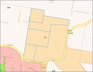
Figure 4 – Zoning
Map extract
Caravan park means land (including a
camping ground) on which caravans (or caravans and other moveable dwellings)
are, or are to be, installed or placed.
A caravan park is a permissible use in the E4 zone. The proposed
development involves the provision of 31 long-term and 37 short-term dwelling
sites and an associated community building and facilities.
The
definition of ‘caravan park’ requires that caravans are to
be installed or placed on the land; ‘other moveable dwellings’
may be placed or installed on the land in conjunction with caravans but are not
required in order for the development to meet the definition of a ‘caravan
park’.
The definition of “moveable
dwellings” includes manufactured homes under the GELP2014:
“moveable
dwelling means:
(a) any tent,
or any caravan or other van or other portable device (whether on wheels or
not), used for human habitation, or
(b) a
manufactured home, or …”
The parentheses “(or caravans
and other moveable dwelling)” contained in the definition of
“caravan park” states that manufactured homes in conjunction with
caravan sites qualifies, and forms part of the definition for, a caravan park.
The
definition of ‘caravan park’ does not specify a minimum
number or proportion of caravan sites beyond requiring that there must be
‘caravans’ (i.e more than one). The application proposes 37
short-term sites for caravans.
Advice received by Council for a
caravan park at 1 Bowtells Drive, Avoca Beach (DA 51538/2017) recently confirmed
that there is no minimum number or proportion of caravan sites and that there
is no authority from the Land and Environment Court which requires that a
certain proportion or percentage of sites within a caravan park (as that term
is defined by the standard template) are required to contain caravans.
However,
the inclusion
of 37 short-term dwelling sites for caravans, in conjunction with 31 long-term
dwelling sites must be proposed for a proper purpose to satisfy the
requirements of the definition for a caravan park, having particular regard for
the decision made in TMT
Devco Pty Limited v Cessnock City Council [2016] NSWLEC 1161 (‘TMT Devco’).
In
TMT Devco Pty Limited v Cessnock City Council [2016] NSWLEC 1161
(‘TMT Devco’), the Court determined that development for
manufactured homes with associated “caravan parking and RV
storage” did not qualify as a “caravan park” as it was
considered ancillary to the use of the site as a manufactured home
estate.
In addition to this, the sites are not provided with
servicing as required by the Local Government (Manufactured Home Estates, Caravan Parks,
Camping Grounds and Moveable Dwellings) Regulation 2005, such as appropriately
located shower, toilet and laundry facilities.
Caravan Park Use and Approval to Operate a
Caravan Park
Despite
the discussion regarding permissibility and definition of a caravan park above,
it is important to note that this application is for the use of the site for a
caravan park, as well as the required infrastructure works and construction of
the community building and facilities. A separate approval from Council under
s.68 of the Local Government Act 1993 (LG Act) is required to operate a
caravan park and is subject to the provisions of Subdivisions 1-8 of Division 3
of the Local Government (Manufactured Homes Estates, Caravan Parks, Camping
Grounds and Moveable Dwellings) Regulation 2005.
An
applicant can make a development application, in which they apply for both
development consent under the EP&A Act and approval under the LG Act to
operate a caravan park, or they can make two separate applications. This
application relates to the use and infrastructure works and building work only
and does not included the Section 68 application for the operation of
the caravan park.
The
Regulation makes provision for a number of criteria that a caravan park must
comply with, including the minimum size of sites, distance from amenities and
number of amenities.
These
include a minimum 65m2 for short term sites and 80m2 for
long term sites. The proposal states that short term sites are a minimum 230m2
and long- term sites a minimum 137.5m2.
The
distance from a short- term site to the amenities block is not to exceed 100m,
and from a long -term site is not to exceed 75m.
Short-
term sites 36-47 exceed the maximum distance, and a number of long-term sites
also exceed the maximum 75m. The applicant states that the long-term sites will
be for self- contained movable dwellings, however this is not part of the
application and the proposal relies on either future development or approval
and conditions of consent to ensure compliance with the Regulation.
Gosford Local Environmental Plan 2014
(GLEP 2014) - Objectives
of the zone
The objectives of the E4 Environmental Living zone are:
· To provide for
low-impact residential development in areas with special ecological, scientific
or aesthetic values.
· To ensure that
residential development does not have an adverse effect on those values.
· To promote
ecologically, socially and economically sustainable development and the need
for, and value of, biodiversity in Gosford.
· To provide
land for low-impact tourist-related development that is of a scale that is
compatible with the special ecological, scientific or aesthetic values of the
area.
· To ensure that
development is compatible with the desired future character of the zone.
The
proposed development does not comply with the objectives of the zone for the
following
reasons:
· The proposal
is not a low-impact residential or tourist related development and is of an
urban nature.
· The proposal
is not low impact given it proposes:
o significant
cut and fill with up to 70,000m3 of cut and 5,500m3 of
imported fill;
o significant
land disturbance of 80,200m2, which is about 33% of the site; and
o significant
tree removal, with 210 trees proposed to be removed and a further 88 trees in
close proximity or ‘threatened’ by proposed works.
· The proposal
impacts the ecological and biodiversity values of the site and locality.
· The proposal
is not compatible with the desired future character of the zone and area due to
the urban nature of the development and impacts on the environment.
Gosford Local Environmental Plan 2014
(GLEP 2014) - Clause
4.3 Height of Buildings
The maximum height of buildings is
8.5m and the proposed height is 7.6m.
Gosford Local Environmental Plan 2014
(GLEP 2014) - Clause
5.10 Heritage Conservation.
The existing house which is
identified as a proposed heritage item is proposed to be retained.
An aboriginal heritage due diligence
assessment submitted with the application identified a potential archaeological
deposit adjacent to the southern bank of the northern dam. This is located
within the riparian setbacks where no work is proposed. Further investigation
may be required or procedures put in place if approval were to be granted.
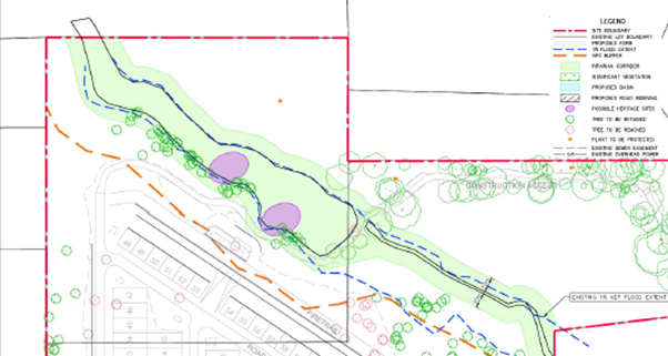
Figure 5-Location of
Potential Aboriginal Sites
Gosford Local Environmental Plan 2014
(GLEP 2014) - Clause
7.1 - Acid Sulfate Soils
The
site contains Class 5 acid sulfate soils and the site is not located within
500m of class 1-4
land. In this
instance, the proposed works are not considered to impact on Acid Sulfate
Soils.
Gosford Local Environmental Plan 2014
(GLEP 2014) - Clause
7.2 - Flood Planning
The
land has been classified as being under a “flood planning level”
and subject to the
imposition
of a minimum floor level.
Two
watercourses flow through the site and into Avoca Lagoon, being Saltwater Creek
and an unnamed watercourse. The applicant has submitted a Flood Impact Assessment.
Council’s Flooding Engineer advises:
· The information provided
indicates that there will be a net increase in flood storage of approximately
7000m3 within the Base Case 1% AEP event.
· The Flood Impact
Assessment indicates that there will be no significant inundation to any
individual lots during the 1% AEP event.
· The Flood Impact
Assessment indicates that there will be no increase in flood levels upstream or
downstream of the site during the 1% AEP event
· The Flood Impact
Assessment indicates that there will be no overtopping of the proposed creek
crossing during the 1% AEP event. However there will be some flow overtopping
the crossing during the PMF event
· There is no net flood
impact as well and no increase in flood storage as a result of the development.
This forms the basis of the consultant’s opinion that multiple similar
developments would not be expected to increase flood levels.
Conclusions:
1 The information and
opinions provided by the consultant are deemed to be reliable and accurate.
2 The detailed drainage
design is required to adhere to recommendation about lowering the area near to
the proposed culverts in the minor tributary (Page 3). If this cannot be
achieved, remodelling will be required.
3 Warning signs are
recommended on the proposed creek crossing to manage the risk to motorists
during extreme storm events.
Gosford
Local Environmental Plan 2014 (GLEP 2014) – Clause 7.3 Floodplain risk
management
The
objectives of this clause are:
· In relation to development
with particular evacuation or emergency response issues, to enable evacuation
of land subject to flooding in events exceeding the flood planning level,
· To protect the operational
capacity of emergency response facilities and critical infrastructure during
extreme flood events.
Clause
7.3(3) states that development consent must not be granted for caravan parks
unless the consent authority is satisfied that the development will not, in
flood events exceeding the flood planning level, affect the safe occupation of,
and evacuation from, the land.
Safe
evacuation and occupation may not be possible during a PMF event and such risk
may be avoided by a different development of the site.
Gosford
Development Control Plan 2013 (GDCP 2013)
Chapter 2.1 Character
The
site is identified as being located within Unit 13-Scenic Buffer of the Kincumber Precinct. The desired character for this area,
as set out in the DCP is (with emphasis added):
‘These should remain
rural-residential buffers where the scenically-distinctive semirural and
natural qualities of prominent backdrops to Gosford City’s major roads
and tourist routes are preserved by appropriate very-low density residential
developments associated with low-impact rural activities, and by small-scale
businesses or community and educational facilities that have a modest impact.
Retain natural slopes and
prevent further fragmentation of the tree canopy in order to maintain habitat
values and informal scenic characters of hillside or valley properties, plus
meandering roads with unformed verges. Along creeks, ridges, slopes or road
frontages, conserve all mature bushland remnants that provide
scenically-prominent backdrops visible from any road or nearby property. Limit
intrusion of structures upon their landscape setting by concentrating new
buildings and pavements in existing clearings. Use low-impact
construction such as suspended floors and decks rather than extensive
cut-and-fill, particularly on elevated slopes or near bushland.
In areas that are defined as
bushfire prone, hazard must not be increased by inappropriate new plantings or
structures. Minimise the extent of cleared asset protection zones by
fire-resistant siting, design and construction for all new structures plus
effective management of gardens. The ideal compromise between desired scenic
quality and hazard-reduction would limit clearing to the understorey plus
thinning of the canopy to establish breaks between existing trees.
Maintain the informal character
of existing semi-rural hillsides by avoiding tall retaining walls, extensive
terraces or broad driveways that would be visible from any road or nearby
property, and provide boundary fences that are see-through such as traditional
post-and-rail designs. Surround all buildings with extensive garden setbacks,
planted with new trees and shrubs that are predominantly indigenous to
complement the established canopy. Noxious or environmental weeds must not be
planted, and existing infestations should be controlled.
The
proposed development remains inconsistent with the desired character for this
area due to the extent of clearing, earthworks, and urban nature of
development. The proposed development does not maintain a rural-residential
buffer and is essentially an urban residential development situated within a
semi-rural/urban buffer location.
Chapter
2.2- Scenic Quality
The
site is located within Kincumber
land unit of the East
Brisbane Water
Geographic Unit. The development
objectives are:
1 Maintain broad
patterns of land use within area to ensure protection of landscape diversity
and in particular Environmental/Conservation and Scenic Protection zoned areas.
2 Retain current
subdivision standards in Environmental/Conservation and Scenic Protection zoned
areas to ensure continuing dominance of landscape features over built
environment.
3 Opportunities for
increases in densities and scale are available in urban areas, not subject to
visibility constraints or other physical constraints. Visually constrained land
includes land viewed from main roads, waterfront areas and land on higher
slopes.
4 Uses of a retail and
commercial nature and associated signage permitted in scenic protection zoned
areas to be, where achievable, of a style and scale which reflects the rural
nature of the area in which it is located.
5 Restrict zoning
density of development to current levels on higher visible slopes in urban
areas, particularly in steep land zoned areas.
6 Continue to attempt
to secure lands identified for inclusion in the Coastal Open Space System as
part of the visual landscape.
7 Proposals for
residential and retail/commercial rezonings be preferred where the result will
be the consolidation of existing residential and retail/commercial areas rather
than the extension of these areas as ribbon development or as incremental
extensions into adjoining areas.
8 Recognise importance
of privately owned Environmental/Conservation zoned land in providing a complimentary
land system to and a buffer area for COSS lands.
The
proposed development is by nature and character an urban residential
development, with about one-third of the site being disturbed by cut and fill
and with 68 tightly packed dwelling/caravan sites proposed. This pattern of
land use is commensurate with a more typical urban residential development and
similar to the residential and seniors housing development located to the
south, which is on residential zoned land. This pattern of land use is not
appropriate on environmental conservation land and does not ensure protection of landscape
diversity or ensure the continuing dominance of landscape features over built
environment.
The
built forms and works will be visible from adjoining properties and from public
spaces (including Avoca Drive) and will impact the scenic quality of this area
due to the extent of clearing, earthworks, and the nature of development.
Chapter 3.10-Environmental Controls
for Development in Zone E4.
The
objectives of this clause are:
· to provide further detail to guide
assessment relating to tourist-related development to that provided in
Council’s planning instrument.
· to encourage tourist-related
development which is sympathetic with the ecological characteristics of the
land on which it is located and in the catchment of the land.
· to encourage tourist-related
development where the layout of the development ensures that the natural/rural
characteristics are the dominant feature of the land.
· to encourage tourist-related
development where the design of buildings blends with the natural/rural
setting.
The
specific requirements of this section of the GDCP 2013 are to:
· Restrict the
amount of development on land on slopes greater than 20% - Where this is not
possible, due to the extensive areas of the land having slopes over 20%,
development can occur on the steeper land as long as building methods are
adopted which rely on minimal disturbance to the land surface such as pole or
similar type construction.
· Maximise
retention of existing native vegetation - All development including all
building works, access, bushfire asset protection zones should be confined to
existing cleared areas
· Restrict the
amount of cut and fill - The extent of cut and fill for buildings is to be
limited to a maximum of 1m and in other cases is to be minimised.
· Ensure
provision of utility services protects ecological and landscape values of land
and catchment.
· Encourage a
design of tourist development which is compatible with the natural/rural
character of Environmental land in the City.
The
site has some areas with slopes in excess of 20% which results in extensive cut
and fill across the site for the provision of roads and benching of sites.
Building methods, such as pole foundations, have not been proposed to minimise
impacts.
While
the reduction in tree removal from the originally proposed 491 to 327 to 210
trees is noted, it remains a significant number, and the works are not confined
to the existing cleared areas on site. It is considered that the type of
development proposed, including the number of dwelling sites, is not conducive
to the retention of existing native vegetation and for minimising the extent of
cut and fill on the site where site disturbance equates to approximately
80,200m2, which is over one third of the site (33%).
While
utility services can be provided to the site with underground connections, this
will form part of the overall excessive disturbance of the site.
The
proposal is not a tourist development and is not compatible with the
natural/rural character of environmental land and is inconsistent with this
section of GDCP 2013.
Chapter 6.1- Acid Sulfate Soils.
The
site is identified as containing acid sulfate soils Class 5 and is not located
within 500m of sites containing acid sulfate soils Classes 1-4. An acid sulfate
soil management plan therefore is not required.
Chapter 6.3-Erosion and Sedimentation
Control
The
proposed development results in extensive cut/fill and earthworks to create
roads and
building
sites. The slope of the land along with the extent of earthworks proposed, in
proximity to the watercourses, have the potential for erosion to impact on the
watercourses and downstream properties. The submitted Soil and Water Management
Plans are not satisfactory as discussed elsewhere in this report.
Chapter 6.6-Tree and Vegetation
Management.
210
trees are proposed to be removed and a further 88 or more likely to be removed
(total 298). While
proposed tree plantings are noted, there remains a significant removal of trees on E4
zoned land which is a result of the intensification of development proposed on
the land that is not in harmony with the objectives of the zone. Development of
E4 land is required to consist of low-impact development that does not affect
the ecological and aesthetic values of the land and will result in sustainable
development of the site. The caravan park in its current form does not achieve
these objectives.
Council’s
Tree Assessment Officer and Ecologist have also raised concerns in relation to
the extent of tree removal on site and inadequate information submitted to
address properly these issues.
Chapter 6.7 Water Cycle Management.
A
water cycle management plan was submitted with the application. Detention
basins are proposed to limit post-development flows to pre-development flows
for the 1% AEP.
Chapter 7.1 - Car Parking
The
dwelling sites can accommodate a manufactured home that can provide the
required number of car parking spaces for each dwelling along with visitor
parking spaces.
Chapter 7.2 - Waste Management
An
amended waste management plan was submitted with the application.
Council’s Waste Assessment Officer advises the plan is not satisfactory
as it fails to adequately address waste generated during construction and
operational waste collection and servicing.
Internal Consultation
|
Traffic
Engineer
|
|
Not
supported-additional information required. See comments below.
|
|
|
Development
Engineer
|
|
Not
supported-additional information required. See comments below.
|
|
|
Flooding
Engineer
|
|
Supported
subject to conditions.
|
|
|
Tree
Assessment Officer
|
|
Not
supported. See comments below.
|
|
|
Ecology
|
|
Not
supported-additional information required. See comments below.
|
|
|
Waste
Services
|
|
Not
supported-additional information required. See comments below.
|
|
|
Water
and Sewer
|
|
Supported
subject to conditions.
|
|
|
Environmental
Health
|
|
Not
supported-additional information required. See comments below.
|
|
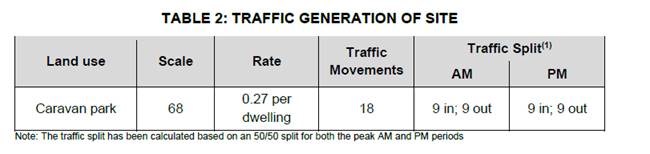
Traffic Engineer
The
proposed development has the following characteristics:
A 68-site
caravan park with additional ancillary facilities including:
· 31 long-term sites;
· 37 short-term sites;
· A recreation area for Minigolf /
Tennis / Horse Riding;
· A managers office;
· Club room and facilities, and;
· Laundry, toilets, and shower
facilities.
Due to
safety issues and crash patterns on Avoca Drive TfNSW has identified an upgrade
to Avoca Drive in the vicinity of Melville Street.
Access
The road
network and the available routes from the wider area have been assessed and the
following traffic assignment has been assumed for all traffic to and from the site:
Traffic
exiting the site:
· 100% to the east towards the
intersection of Avoca Drive and the Scenic Highway, then:
· 50% towards Terrigal along the Scenic
Highway;
· 50% towards Kincumber by making a
U-Turn at the roundabout.
Traffic approaching the site:
· 50% from the east along Avoca Drive;
· 50% from the west along Avoca Drive.
Traffic
Impact
The RMS
Guide to Traffic Generating Developments refers to ITE Trip Generation manual
for comparable rates from the USA. The given rate for a campground / recreation
vehicle park is 0.27 trips per site.
Worst
movements of the driveway intersection during the weekday AM, weekday PM and
weekend peak hourly periods are expected to perform with a SIDRA Level of
Service of “A”. This Level of Service “A” represents
good performance.
As outlined
above 50% of exit traffic is assumed to be destined to Kincumber and do a
U-turn at the roundabout. There appears a deficiency as
no SIDRA analysis of the increase in U-turns at Avoca Drive / Scenic Highway
roundabout has been undertaken.
To reduce
the disruption to Avoca Drive traffic - It is proposed to ban right turns out
of the site.
A
channelised left and channelised right treatments CHL/CLR are to be constructed
to facilitate safe vehicle entry and exit. This is consistent with earlier
TfNSW requirements.
Sight
Distance
AS2890.1:2004
provides the requirements for sight distances for access driveways in Figure
3.2. For a 60km/h road, the desirable “5-second gap” distance is
83m. Approximately 153m of sight is available to the west and 184m of sight to
the east, significantly exceeding this requirement.
Carparking
· Two-way access roads with
a minimum width of 6m are to be provided and;
· Access road of at least 7m
width providing entrance and exit from Avoca Drive
The proposed
development takes the form of a Caravan Park and therefore the parking
requirements are provided in Clauses 96 to 98 of the Local Government
(Manufactured Home Estates, Caravan Parks, Camping Grounds and Moveable
Dwellings) Regulation 2005
Each of the
proposed caravan sites will be provided with one parking space within each
individual site to meet the requirements stated above.
Clause 97
specifies the requirement for residential car parking. The 68 sites for caravan
use, comprises 31 long-term and 37 short-term sites require the provision of
six (6) visitor spaces. A minimum of six (6) spaces will be provided.
At least one
space for people with disabilities is to be provided.
Recommendation
Councils
Traffic Engineering staff have reviewed the Traffic and Parking Impact
Assessment by McLaren Traffic Engineering (MTE) dated 11 December2020 and I
have one deficiency to report as listed below:
· There appears a deficiency
as no SIDRA analysis of the increase in U-turns at Avoca Drive / Scenic Highway
roundabout has been undertaken
Development Engineer
1 The secondary RFS access
requires a creek crossing approximately 15m from Picketts Valley Road. The
culvert and associated fill have not been accounted for in the flood modelling.
There is insufficient information to ascertain if this will increase flood
levels upstream of the creek crossing.
2 The secondary RFS access
passes by an existing dam. It is unclear whether and parts of this access are
located below the 1% AEP flood.
3 Additional information
from a geotechnical engineer certifying the use the TrueGrid permeable paving
system will be adequate for the expected traffic loadings.
Tree Assessment Officer
The
proposal is to establish a tourist park along the lines of the recently
rejected DA57698.
A
very brief Tree Assessment Report has accompanied the documentation but does
not sufficiently address such a proposal. Although a much lesser development,
it still has most of the undesirable impacts on existing trees as the previous
proposal as follows:
1 Impacts
to mapped Regionally Significant trees adjacent to southern boundary (Avoca
Drive) could be reduced. Instead of running mostly through the mapped area,
greater reductions on trees could be achieved by slightly redesigning the entry
access and then setback the east-west running portion beyond 40m of the
southern boundary.
2 The
primary lead road near the western boundary will require civil works for the
battering of the road and catchment drains along road and western boundary.
Impacts of those works on existing trees intended to be retained have not been
addressed in the Arborist Report. If this road was not to run towards the
western boundary but link into a modified version of the existing central access
track, it would mostly impact on smaller natives or undesirable exotic species
(Camphor laurel) located either side of the existing access.
3 Impacts
on existing trees along the water course on the eastern side of the access
could be reduced. Greater retention of trees by redesigning to utilise the
mostly cleared area upslope would also contribute to screening from adjoining
properties. Although some trees are numbered on plans, they are not tagged in
this area which makes it difficult to orientate yourself.
4 The
secondary access track to Pickets Valley Drive essentially follow the alignment
of an existing track. The Tree Assessment Report - Access Track (Dec 20)
proposes removal of just five (5) trees, however a site inspection with
Council’s Engineer found that the track will likely need to be wider and
the required cut and fill. This is likely to have a greater unquantified impact
on native trees. It is difficult to orientate yourself without tagged
trees corresponding with a plan, therefore the applicant must tag trees for any
amended reports/future plans.
5 The
Bushfire Report has not proposed that the entire site be maintained as an IPA.
We’ll need to receive the response from RFS as the previous unsuccessful
proposal was that the entire property must be managed as an IPA. That requires
a tree canopy less than 15%, canopies separated by 2 to 5m and large gaps in
vegetation that would further fragmentate the existing tree canopy, resulting
in even greater tree removal than presented by the applicant.
The
proposal does not go far enough to conserve mature trees that provide
scenically prominent backdrops visible from roads and nearby properties and
does not prevent further fragmentation of the tree canopy. The concept
hasn’t adequately minimised impacts on mature native trees, nor
concentrated enough to utilise existing clearings.
At
this stage further information is not requested as the concept is not supported
by Council’s Tree Assessment Officer. Any development for this site is
expected to better utilise existing cleared areas and demonstrate minimimal
impacts on native trees by greater retention, protection and adding to existing
valuable groves of native trees.
If
this concept was to proceed a more detailed Arboricultural Impact Assessment
would be required. Their Arborist would need to collecting data on all trees
within and near the development footprint, not just those intended for
retention. Such information would assist in identifying valuable, undesirable
and poor tree specimens so that the constraints of the site can be better
understood and designed for.
RFS
states “the entire property must be managed as an inner protection
area (IPA), with the exception of the native vegetation located in the northern
part of the site, the riparian corridor proposed to be retained and existing
stand of managed trees along Avoca Drive”.
Although
this relaxes APZ requirements on valued groups of trees, there will be unquantified
impact of other trees outside those areas and impacts of the design that are
still not supported as listed in Preliminary Comments from Tree Assessment
Officer 17/3/21.
It
is reiterated that the brief Tree Assessment Report provided by the applicant
does not sufficiently address this proposal. If this development was to
proceed, tree removal for establishing required IPA’s will also needs to
be detailed within an acceptable Arboricultural Impact Assessment.
Ecology
The
objectives of the relevant policies, zoning objectives and potential
environmental impacts associated with the proposal have been considered. A
review of all relevant information provided has identified additional
information and amendments to supplied information that will be required prior
to any further assessment of the proposal is undertaken.
An
assessment of the Biodiversity Development Assessment Report submitted by the
applicant has identified a number of matters that are required to be addressed
and updated by the applicant’s Ecological Consultant prior to a further
assessment of the proposal being undertaken.
A
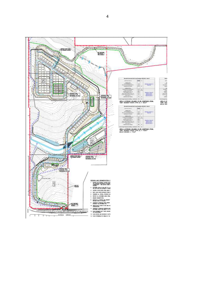
determination by NSW RFS has indicated that the area of the subject site, south
of the northern water course is required to be maintained entirely as an Inner
Protection Area bushfire Asset Protection Zone and that only specific areas
including the riparian corridor of the southern creek and the trees lining
Avoca Drive are to be maintained as an Outer Protection Area.. This is to be
adequately reflected within all relevant documentation submitted as it will
allow for an accurate assessment of the direct ecological impacts of the
proposal as well as the scope for any ecological rehabilitation present within
the site to be considered.
It
is noted that NSW DPI Fisheries has recommended that a series of deeper pools
be provided along the proposed re-aligned watercourse in order to provide
refuge points of fish during periods of drought. This ties in with the request
of Council’s Ecologist to provide a mosaic of permanent and ephemeral
pools along side the proposed watercourse in order to provide suitable habitat
for the Green and Golden Bell Frog (GGBF) and could be incorporated into any
such habitat design.
With
regard to the design of habitat for the GGBF, it is recommended that species
specific expert advice be sought and that draft pond design be implemented in
any updated watercourse engineering plans. Design details and considerations
used for replacement GGBF habitat at Sydney Olympic Park will be provided to
the applicant in order to guide the design of the replacement habitat.
It
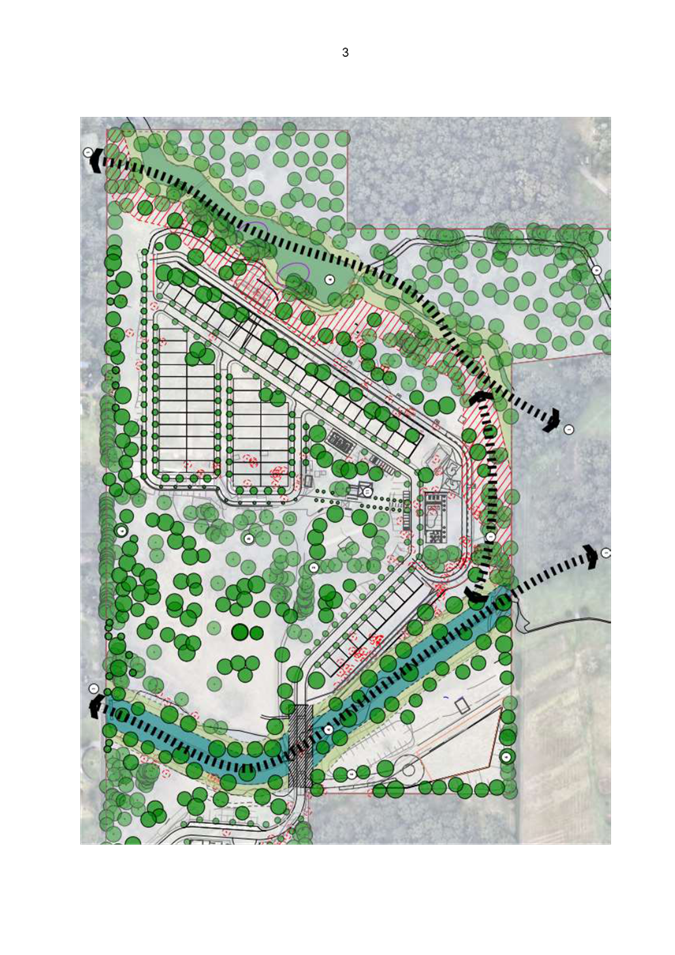
is noted that NSW NRAR has identified a significant encroachment into the
required 20m Vegetated Riparian Zone of the southern bank of the northern
watercourse as a result of the proposed bushfire Asset Protection Zone. It is
expected that the applicant will amend their plans accordingly do address this
matter. The updated plans will have to be assessed with respect to all other
relevant ecological matters when submitted.
At
the current point in time, a significant review of the consistency of the
relevant environmental and bushfire assessment documents is required in order
to reflect a unified and consistent plan for the proposed works in order for a
sound decision making review process to be undertaken. Further assessment and
consideration of the proposal will be undertaken when all relevant
documentation is adequately updated and consistently reflects the proposal.
An
amendment to the proposed site layout, submitted to Council on 26/04/2021 has
deleted the previously proposed northern access road. This will remove the
requirement for any additional Rhodamnia rubescens surveys and potential impact
assessments and is generally observed as a positive ecological outcome within
the bounds of the proposal.
Additional Information Required:
BDAR
Review:
Updated Proposed Site Plan
- Update the proposed site
plan including the deletion of the northern access road (ADW Johnson –
‘Proposed Caravan Site Layout, 19/04/2021). Adjust the BAM-C accordingly.
Green
and Golden Bell Frog – Habitat Removal/ Replacement
- Provide additional
explanation/ justification as to why the removal/ modification of Dam 1 (the
large centre dam/ watercourse) is required. As per the BDAR (Ecoplanning, 11
Dec 2020), the dammed watercourse meets the definition of a ‘Local
Wetland’ as per the BAM, and that “Dewatering of the dam and
modification to drainage lines will remove and affect habitat that is ideal
breeding habitat for GGBF.” (Green and Golden Bell Frog). As indicated by
the BDAR, this feature represents special ecological value within the site and
therefore, its retention or adequate, compensatory replacement should be
demonstrated :
o The BDAR states that
“Provision of compensatory or additional GGBF habitat and other GGBF
relevant conservation measures as part of the development planning would be
ideal. GGBF habitat components and their strategic positioning are outlined in
the GGBF Best Practice Habitat Guide (DECC 2008) and these have the potential
to be provided as part of the proposal design.”
Replacement GGBF
habitat (in the form of a mosaic of permanent and ephemeral pools and shallow
wetlands) is recommended to be demonstrated along the proposed newly channelled
watercourse through the centre of the subject property. Replacement habitat
features should be designed in accordance with industry best practice and
specialist knowledge of GGBF replacement habitat. Replacement habitat design is
recommended to be undertaken in consultation with relevant species specific
experts.
As a general
approach to the inclusion of GGBF habitat, the following should be considered:
§ Make each pond/ wetland as large as the confines of the
site will allow and include a variety of depths with a minimum of 600mm for the
deepest sections.
§ The mosaic of ponds along side the constructed watercourse
should be designed to have differing hydroperiods/ drying cycles and can
include habitat features such as swales, lined and non-lines ponds to provide
for a range of habitat features.
§ Ensure that pond/ wetland design allows for the
isolation and treatment of ponds for pest and disease management. Ie: draining
and drying for Gambusia.
§ Generally, replacement/ supplementary ponds should aim
for the following:
· retention of water for a minimum of 8
weeks, a pond where breeding is likely/has been recorded should be full for the
whole active frog season
· be unshaded between 10am and 4pm
· macrophytes covering 40% - 70% of the
waterbody when the pond is full
· perimeter macrophytes being at least
1.5 metres wide where pond design permits.
· contain shelter habitat such as rock
piles/ emergent coarse woody debris
- Any proposed species
polygon assigned to the GGBF is to be consistent with the ‘NSW Guide
to Surveying Threatened Frogs’ (September 2020). Specifically the
guidance for creating a species polygon states that “The species
polygon boundary should align with aquatic habitats linked directly to the
record and a buffer, incorporating the PCTs with which the species is
associated, of 200 metres radius from the top of bank. The polygon should include
minimum 50 metre wide corridors of native and non-native vegetated areas
linking the available waterbodies, where relevant.”
o It should be noted that
both native and non-native vegetation is to be included within the corridors
between available waterbodies and that the GGBF is associated with PCT 99997
‘Highly disturbed areas - road verges, table drains, road embankments,
ploughed paddocks etc.’. The non-native, disturbed/ cleared lands
surrounding the existing waterbodies should be considered for inclusion when
applying the latest guidelines.
Bushfire
Tree Removal Requirements:
- It is recommended that the
applicant’s Bushfire Consultant, in conjunction with the
applicant’s consultant Ecologist, provide a tree retention/ removal plan
for the existing canopy trees to be retained and managed within the proposed
IPA APZ area (excluding the heavily vegetated area of the property, north of
the northern watercourse). The plan should detail which trees are proposed to
be retained and which will need to be removed in order to comply with IPA APZ
requirements.
Preference should be
given to the retention of large, mature native trees that contain multiple tree
hollows and therefore have high ecological significance with the removal of
non-native and smaller/ less ecologically significant native trees prioritised
where required.
Dam
Dewatering Report:
- Update the Dam Dewatering
report to be consistent with the proposed works. The Dam Dewatering Report
states that “Dam 1 and Dam 3 will require dewatering, as displayed in
the Dam Dewatering Plan (ADW Johnson 2020)”. Engineering plans
provided indicate Dam 3 is to remain (figure 2). The remaining details of the
report, and any corresponding reports, should then be updated accordingly.
- Update the Dam Dewatering
Report to include specific measures to ensure the protection of the Green and
Golden Bell Frog (GGBF) during site preparation and dam de-watering works,
should any individuals be identified.
o Include a procedure for the removal
of fringing and emergent vegetation. This should include, but not be limited to
a staged vegetation removal process over a series of days to ensure no
individuals are directly impacted as a result of the proposed works. The method
identified should be similar to or reflect the intention of the below:
§ Mark the boundaries of the works
footprint with star pickets, witches’ hats or similar.
§ Aquatic vegetation
· Lower water levels or pump
out pond (where feasible); wait two days
· Hand-cut emergent
macrophytes as low as possible (do not use brushcutters or similar).
Minimise trampling during the works. Continually watch for and relocate
any sheltering frogs or other animals (ecologist in attendance). Remove
cut material from the works footprint.
· Either remove cut
material on the same day it is cut, or leave it on site to decompose in a
location approved by the appointed Ecologist
§ Terrestrial vegetation
· Day 1: Slash vegetation to
300mm
· Day 2: Slash vegetation to
150-200mm.
· Day 3: Hand search by
ecologists for any remaining frogs; slash vegetation to <50mm; commence
works
·
An
Ecologist is to undertake pre- clearance fauna surveys no longer than 24 hours
prior to the commencement of works. This is to include survey of all adjacent
and emergent vegetation around both dams proposed for removal to ensure no threatened
fauna species sensitive to disturbance are actively nesting or breeding. If
sensitive threatened species are detected, such as Green and Golden Bell Frog (Litoria
aurea), consultation with Council is to be undertaken and works must not
commence until appropriate mitigation measures have been agreed and written
clearance from Council’s Ecologist has been given.
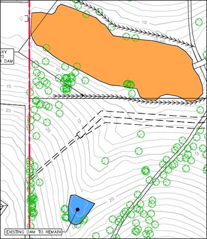
Figure
6 - Concept engineering plans indicating that 'Dam 3' is to remain (ADW
Johnson, 11/12/20)
Waste
Where
the consent authority was in a position to support the proposal, the submission
of a revised signed and dated Waste Management Plan would be required in accordance
with Chapter 7.2 – Waste Management of Gosford DCP 2013 and Central Coast
Local Environment Plan 2014 (GLEP2014)- A guide for Applicants on Supporting
Document Requirements for all site preparation, demolition, construction and
on-going management of waste.
Review
of the submitted document dated (10 December 2020) notes Demolition details are
overly brief and do not indicate all materials likely to be generated by the
structures identified for demolition.
All
Demolition materials capable of reuse/ recycling are to identified with an
estimated quantity for disposal to an appropriate licensed facility.
Residual
waste is to refer to only those materials that are unable or not feasible to
separate for disposal to landfill.
Ongoing
Operation details require revision to refer to all mixed and recyclables waste
to be serviced by a private commercial waste contractor.
Environmental Health.
Air Quality
Dust
is expected during construction works. Standard condition will be applied.
Acid
Sulfate Soil (ASS)
The
land is mapped as Class 5, no known occurrence ASS, therefore an ASS Management
Plan is NOT required.
Asbestos
Containing Material (ACM)/ Contamination/ SEPP 55
The
site currently contains three dwellings, several ancillary structures and
outbuildings including horse stables.
The
preliminary and detailed contamination assessment identify lead and asbestos
contamination in surface soils around the vicinity of the residential dwelling,
microbial contamination associated with the septic tank and buried asbestos
pipework.
The
Remediation Action Plan (‘RAP’) has been prepared generally
in accordance with the NSW EPAs Guidelines. The demolition plan indicates that
one dwelling is to be retained with all other buildings to be demolished. The
Hazardous Substances Audit, which forms part of the RAP indicates that
asbestos, synthetic mineral fibre and lead paint is present in several
structures.
The
RAP identifies the preferred methods of remediation, which include offsite
disposal of lead and asbestos impacted soils, asbestos pipes and asbestos from
the buildings to a licensed waste facility. Excavation and exposure to UV
radiation of the microbial contamination is the preferred option, with offsite
disposal to a licensed waste facility as a contingency plan. An asbestos
removal plan, environmental management plan and unexpected finds protocol forms
part of the RAP. A construction environmental management plan for the
remediation and validation works has also been provided.
Conditions
will be applied.
Stage
4 Validation that all site contamination has been removed and the site is
suitable for the proposed land uses is required to be provided to Council
following demolition and remediation works, which can be addressed by deferred
commencement conditions.
Noise
The
acoustic report is outdated and is modelled on the previous refused DA for the
Residential Land Lease Community. An updated acoustic report is required.
Soils
and Construction/ Water
Works
will require approximately 131,165m2 of soil disturbance, therefore
a Soil and Water Management Plan (‘SWMP’) must be approved
prior to consent as per Clause 6.3 of the Gosford DCP.
The
site contains two watercourses, tributaries of Saltwater Creek and Avoca
Lagoon. Avoca Lagoon is a regionally significant water body, with high
recreational, ecological and aesthetic values.
Works
involve dewatering and filling a small farm dam, reshaping the southern dam
into a flowing watercourse with riparian vegetation and keeping the northern
watercourse in its current state (with additional riparian planting). Three
permanent detention/biofiltration basins (to be used as sediment basins during
construction works) are proposed upstream of the existing watercourses to allow
for treatment prior to dewatering. A further three sediment basins will be
constructed to capture and treated sediment laden water during construction
works.
Works
are required on ‘waterfront land’, therefore a soil loss class 6
applies automatically and works are identified as a high erosion hazard,
therefore timing constraints applies to when excavation and construction works
can be undertaken. It is expected that works will be conducted over 12 months
therefore special erosion controls are required between November and May, such
as spraying hydro mulch prior to rainfall. Instream diversions are proposed to
divert clean water around the works areas.
Submitted
SWMPs are not satisfactory for the following reasons:
· Construction drawings and
notes for wet sediment basins have not been provided,
· Water quality parameters
set for dewatering sediment basins and dewatering existing dams have not been
provided,
· Hay bales are NOT supported
in watercourses due to the risk of weeds spreading downstream. Also,
construction notes and detail for hay bales have not been provided,
· Special sediment and
erosion control measures have not been listed and identified,
· Sediment basins have been
sized on 50% settling zone capacity however as Soil Loss is identified as Class
6, therefore they must be sized on 2-month soil loss,
· Mulch mounds are NOT
depicted on Area 1 and Area 4 catchments and are used to make up storage zones
for sediment basins, however no technical construction details or notes are
provided, nor is this method endorsed by ‘Blue book’.
The Dewatering Management sets out the requirements of
dewatering two of three dams on site. It is expected that the Ecology team will
provide comment on impacts to fauna and flora. Water quality parameters are to
be met prior to any dewatering, as per the detail set out in the SWMP (to be
provided); with water will be irrigated onto grassed areas.
Excavation works involve 92,970m3 of cut and
98,692m3 of fill, with 5,722m3 of fill to be imported to
the site.
Additional
information required:
· Provide an updated
acoustic report that is modelled on the current application for a caravan park.
The acoustic
report must be prepared by a suitably qualified acoustic consultant that meets
the technical eligibility criteria for membership with the Association of
Australasian Acoustical Consultants. The report must be prepared in accordance
with the NSW EPAs Noise Policy for Industry (2017).
· The Soil and Water
Management Plan is NOT supported in its current form. The following comments
are provided for amendment:
o Provide construction drawings and
notes for wet sediment basins (see SD 6-4 ‘Blue Book’),
o Provide water quality parameters to
be set for dewatering sediment basins and dewatering existing dams (no visible
oil and grease, <50 NTU Turbidity, etc.),
o Hay bales are NOT supported in
watercourses due to the risk of weeds spreading downstream and should be
replaced with rock check dams. Include construction details and notes and
depict on plans (see SD 5-4 from ‘Blue Book’)). If hay bales are to
be used in areas other than watercourses provide construction notes and detail
(see SD 6-7 ‘Blue Book’),
o Special sediment and erosion control
measures (due to Soil Loss Class 6) are to be identified and listed,
o Sediment basins must be sized on
2-month soil loss, (due to Soil Loss Class 6 (see Section 6.3.4 (i) (ii)
‘Blue Book’)),
o Mulch mounds are NOT depicted on Area
1 and Area 4 and are NOT supported to be used to make up storage zones for
sediment basins, unless further detail such as published technical
specifications and construction detail and notes are provided and are endorsed
by an independent expert in Erosion and Sediment Control (i.e.CPESC).
Submissions from Public Authorities/External Consultation
The following submissions have been received from agency
consultation:
|
NSW
Rural Fire Service
|
|
Supported
subject to conditions. Refer attachment 3.
|
|
|
TfNSW
|
|
Supported
subject to conditions. Refer attachment 5.
|
|
|
NRAR
|
|
Additional
information required. Refer attachment 4.
|
|
|
Department
of Primary Industries-Fisheries
|
|
Deeper
pools should be provided. Subject to approval by NRAR. Refer attachment 6.
|
|
Ecologically
Sustainable Principles:
The
proposal has been assessed having regard to ecologically sustainable
development principles and is considered to be inconsistent with the
principles.
The
proposed development is not considered to incorporate satisfactory stormwater,
drainage and erosion control and the retention of vegetation where possible and
is likely to have significant adverse impacts on the environment and will
decrease environmental quality for future generations. The proposal does or is
likely to result in the disturbance of endangered flora or fauna habitats and
is likely to significantly affect fluvial environments.
Climate Change
The
potential impacts on climate change of the proposed development have been
considered
by Council as part of its assessment of the application.
The
assessment has included consideration of such matters as potential sea level
rise;
potential
for more intense and/or frequent weather conditions including storm events,
bushfires,
drought, flood and coastal erosion; as well as how the proposed development may
cope,
combat, withstand these potential impacts.
The
proposed development is not considered to be compatible with the likely
increases
in
flooding and risk of bushfires particularly having regard to the likely age of
occupants, tourist use and intensity of development.
Any Submission made in
Accordance with this Act or Regulations
The
application was notified from 15 January 2021 to 22 February 2021. One hundred
and sixty- one (161) public submissions were received in relation to the
application. Those issues associated with the key issues have been addressed in
the above report. The remaining issues pertaining to various concerns were
addressed in the assessment of the application pursuant to the heads of
consideration contained within Section 4.15 of the Environmental Planning
and Assessment Act 1979.
A
summary of the public submissions, with appropriate comments, is detailed
below.
1
The
proposal will have a negative impact on the road system by increased traffic,
noise and decrease in road safety.
Comment: The road system
can cater for the additional traffic generated by the proposal. Works will be
required on Avoca Drive to Council and TfNSW requirements.
2
The
proposal will result in the destruction of a large number of trees. This will
impact wildlife, result in erosion and pollution increase in watercourse, and
increase flooding and climate change. Replacing mature trees with saplings does
not compensate for habitat loss.
Comment: The proposal
results in a significant removal of existing trees and habitat value. The
replacement planting cannot fully compensate for this. It would be more
appropriate to site development so as to have negligible tree removal and
earthworks to preserve the existing landscape and scenic value and ecology
impacts.
3
The
proposal is not consistent with the proposed E4 zone and future planning for
the area.
Comment: The proposal is
not consistent with the objectives of the E4 zone for low density development
and preservation of scenic values.
4
The
proposal will impact the visual and scenic quality of the area.
Comment: The significant
tree removal and earthworks will impact the visual and scenic quality of the
site and the area.
5
The
extensive earthworks and tree removal will impact downstream waterways
including Avoca Lagoon.
Comment. Appropriate
sedimentation and erosion controls could be installed. There is always a risk
during storm events that downstream waterways may be impacted during
construction and future operation.
6
Overdevelopment
of the site. And gross inappropriate development. Not low density.
Comment: The density concentrated in part of the site and works
required throughout the site is not considered to be low density.
7
Impact
on adjoining property values.
Comment: There is no
evidence to support this claim. Inappropriate development may have social and
economic impacts on the community as well as adjoining properties.
8
The
cluster of the proposed sites in one corner of the site indicates the
developer’s future plans to extend the development in the future. The
proposed caravan sites should have been scattered throughout the site to reduce
the environmental impact.
Comment: The density
concentrated in part of the site and works required throughout the site is not
considered to be low density and has significant impacts on the environment. It
is not a matter for consideration what future development applications may be
lodged for development on the site.
9
The
$9.2 million cost does not justify 68 caravan sites.
Comment: The viability of
the development is a matter for the developer. The high cost of the development
indicates the works required to develop the site are extensive and a more
sensitive development is warranted and should be considered.
10
Existing
facilities in the area are inadequate, such as shops, medical services and
public transport.
Comment: The additional
population generated is minor compared to the total population of the area.
There are additional services and facilities throughout the Central Coast
albeit a greater distance away from the site.
11
Existing
tourist accommodation is adequate for the area.
Comment: Tourist
accommodation aids the local economy.
12
The
proposal is not in the public interest as it is against the wishes of the community.
Comment: The proposal is
not in the public interest due to the significant environmental impacts of the
proposal.
13
The
proposal does not comply with the objectives of the E4 zone and SEPPs for
caravan parks or mobile home estates.
Comment: The proposal is
not consistent with the objectives of the existing and proposed E4 Zone.
14
The
proposal is not for tourist development as there are 31 or about half long-
term sites.
Comment: Both long term
and short term caravan sites are permitted. There is no restriction on the
number or percentage permitted for long term sites. Long term sites typically
are associated with low cost or affordable housing.
15
Bushfire
risk and inadequate egress in times of bushfire.
Comment: The RFS have
issued conditions of approval if consent is granted for the proposal.
16
The
land should be purchased by the State Government to preserve the
landscape/scenic quality.
Comment: There is no
proposal to bring the land into public ownership.
17
The
proposal is a manufactured home estate in the guise of a caravan park.
Comment: This is not
subject to this application but may occur in the future.
18
The
many applications add to public confusion.
Comment: The site has had
two previous applications which were both refused. It is understandable why
there is public confusion.
19
Impact
on flora and fauna.
Comment. Council’s
ecologist does not support the proposal based on the information submitted.
20
Heritage
impact on existing house.
Comment: The existing
house identified as a proposed heritage item is proposed to be retained.
21
Documentation
submitted is vague, misleading, inconclusive and not sufficient to justify
approval.
Comment: This is a reason
for refusal. Council cannot approve the application based on the information
submitted and approval from all integrated authorities.
22
No
security fence is proposed. This could have trespass access and impacts on
neighbours.
Comment: This could be
required as a condition of consent if deemed necessary.
23
Project
is going from bad to worse.
Comment: The applicant has
gradually been reducing the density and number of proposed sites. The proposal
still has significant environmental impacts due to the extent of internal works
proposed.
24
The
proposal has already been refused twice.
Comment: The previous
application and Section 8.2 review were both refused by the Local Planning
Panel. The current application is a new application.
25
Significant
weight must be given to objectives of the E4 zone and draft LEP which prohibits
the development.
Comment: The proposal does
not comply with the objectives of the E4 zone and is prohibited under the Draft
LEP. Significant weight must be given to the draft LEP as approval would undermine
the planning instrument which is imminent.
26
The
proximity to adjoining houses and the impact of waste collection.
Comment: The development
is setback an adequate distance from the side boundary of the site. Noise
mitigation measures could be constructed if required.
27
The
proposed access from Picketts Valley Road is subject to flooding and will
impact trees and ecology of the site.
Comment: The application
has deleted the proposed access road form Picketts Valley Road. All access is
from Avoca Drive.
28
The
proposal is not reflective of a caravan park or affordable housing and does not
have social and economic benefits to the community.
Comment: The proposal is
not for low- cost housing or affordable housing.
29
The
proposal is prohibited on the subject land under the provisions of SEPP
36-Manufactured Home Estates as land identified as environmental protection is
excluded from the SEPP. Clause 2.1 of the GLEP 20114 includes the E4
Environmental Living zone under the environmental protection classification.
Comment: The current
application does not include a proposal for a manufactured home estate.
Other
Matters for Consideration:
Contributions
The development would be
subject to Section 7.12 contributions (1%) and water and sewer contributions if
approval were to be granted.
Central Coast Regional Plan 2036
The
plan identifies the need for an increase in population and housing by the year
2036,
including
the need for aged housing. The Central Coast has a higher proportion of aged
people
over 55 than the state average. There is also a need for affordable housing
such as
that
provided in caravan parks or other residential accommodation. The proposed
development would provide some additional housing in the local government area
however, this site is not considered appropriate for the type of development
proposed.
The
Public Interest
For the reasons identified in the assessment and
contained within Council’s reasons for refusal, the proposal is not
considered to be in the public interest.
Conclusion:
This application has been assessed
against the heads
of consideration of Section 4.15 of the Environmental Planning
& Assessment Act 1979
and all relevant
instruments and policies. The potential constraints of the site have been assessed
and it is considered that the site is unsuitable for the proposed development.
The proposed development is expected
to have adverse social, economic, ecological, amenity impacts. It is considered that the proposed development will not complement the locality and
not meet the desired
future character of the area.
Accordingly, the application is recommended for refusal pursuant to Section 4.16 of the Environmental Planning
and Assessment Act.
Recommendation
That
the Local Planning Panel refuse the application [DA 60268/2020 for a
caravan park on Lot
A DP449600, Lots 2, 3 and 9 DP976799, 255, 255A, 255B Avoca Drive, and 19 Picketts Valley
Drive, Kincumber, subject to the reasons for refusal detailed below and having
regard to the matters for consideration detailed in Section 4.15 of the Environmental
Planning and Assessment Act 1979:
1 The proposed development
is not consistent with the objectives of the E4 Environmental Living zone
2 The proposed development
would result in additional stormwater run-off and potential impacts on riparian
zones.
3 The proposed development
would result in significant cut and fill, earthworks and removal of vegetation
on the site which would impact the ecological values, visual and scenic quality
of the area.
4 The site is not suitable
for the proposed development due to its landscape, scenic and ecological
qualities which should be preserved.
5 Insufficient information
has been provided on road works within the site, ecology impacts, waste
impacts, soil and water management, and tree retention.
6 The proposal is an
overdevelopment of the site, inconsistent with the current and future desired
character of the locality and approval is not in the public interest.
7 Pursuant to Draft Central
Coast LEP (2018) the proposed development is prohibited within E4 Environmental
Living zone.
8 The proposed development
does not have adequate regard to achieving compliance with the Local
Government (Manufactured Home Estates, Caravan Parks, Camping Grounds and
Moveable Dwellings) Regulation 2005
Reasons for the Decision
The reasons for the decision as
recommended under the assessment of this application are as follows:
1
The
proposal is not satisfactory having regard for the relevant environmental
planning instruments, plans and policies.
2
The
proposal has been considered against the provisions of State Environmental
Planning Policy No 21 (Caravan Parks), Gosford Local Environmental Plan 2014
and Gosford Development Control Plan 2013 and has been found not to be
satisfactory.
3
There
are significant issues or impacts identified with the proposal under s.4.15 of
the Environmental Planning and Assessment Act 1979.
4 Inadequate and
insufficient information to satisfactorily address the impacts of the proposal
and compliance with statutory requirements and regulations.
Attachments
|
1⇩
|
Amended
Site Plan
|
|
D14602396
|
|
2⇨
|
Statement
of Environmental Effects
|
Provided
Under Separate Cover
|
D14402017
|
|
3⇩
|
NSW
RFS GTAs
|
|
D14550226
|
|
4⇩
|
NRAR
Letter
|
|
D14751406
|
|
5⇩
|
TfNSW
Letter
|
|
D14512751
|
|
6⇩
|
NSW
Fisheries Letter
|
|
D14532515
|
|
Item No: 3.2
|
|
|
Title: DA/60416/2020
- 36 Coral Crescent Pearl Beach - Dwelling House (New), Pool and Demolition
of Existing Dwelling
|

|
|
Department: Environment
and Planning
|
|
|
25
November 2021 Local
Planning Panel Meeting
|
|
Reference: 011.2020.00060416.001
- D14922663
Author: Susana
Machuca, Senior Development Planner
Manager: Ailsa
Prendergast, Section Manager, Development Assessment South
Approver: Andrew
Roach, Unit Manager, Development Assessment
|
Summary
An
application has been received for a new dwelling house, pool and demolition
of existing dwelling.
The
development application has been referred to the Local Planning Panel (LPP)
as a result of the number of submissions objecting to the proposal. A total
of 45 submissions were received by Council during notification.
The
application is recommended for approval, subject to conditions.
Applicant Professional
Construction Services Pty Ltd
Owner Trish
Affleck
Application No DA60416/2020
Description of
Land Lot 273 DP 14817
Proposed Development Dwelling House (New), Pool and
Demolition of Existing Dwelling
Site Area 674.7sqm
Zoning R2
Low-density Residential
Existing Use Dwelling House
Employment
Generation No
Estimated Value $1,360,019.00
|
Recommendation
1
That
the Local Planning Panel grant consent to DA60416/2020 for Dwelling House
(New), Pool and demolition of existing dwelling on LOT 273 DP 14817, 36 Coral
Crescent PEARL BEACH subject to the conditions detailed in the schedule
attached to the report and having regard to the matters for consideration
detailed in Section 4.15 of the Environmental Planning and Assessment Act 1979.
2 That
Council advise those who made written submissions of the Panel’s
decision.
Key
Issues
· Non-compliance with Chapter 5.10 of the Pearl Beach Residential
Development of
Gosford
Development Control Plan 2013 –
floor space ratio, building setbacks and
building
lines.
· Matters Raised in public submissions,
including amenity impacts,
building
encroachment beyond the coastal building line, triple car garage etc.
Precis:
|
Proposed Development
|
Dwelling House (new), pool and demolition of existing dwelling.
|
|
Permissibility and Zoning
|
The
subject site is zoned R2 Low-density Residential under Gosford
Local Environmental Plan 2014 (GLEP 2014).
The
proposed development is defined in the GLEP 2014 as ‘dwelling
house’ and is permissible in the zone with the consent of Council.
dwelling
house means a
building containing only one dwelling.
|
|
Relevant Legislation
|
The
following planning policies and control documents are relevant to the
development and were considered as part of the assessment:
· Environmental Planning &
Assessment Act 1979 – Section 4.15 (EP&A Act)
· Protection of the Environment
Operations Act 1997 (POEO
Act)
· State Environmental
Planning Policy (Building Sustainability Index: BASIX) 2004
· State Environmental Planning Policy
No. 55 – Remediation of Land (SEPP
55)
· State Environmental Planning Policy
(SEPP) No 71 – Coastal Protection
· State Environmental Planning Policy
(Coastal Management) 2018 (Coastal
Management SEPP)
· Gosford Local Environmental Plan
2014 (GLEP 2014)
· Gosford Development Control Plan
2013 (GLEP 2013)
|
|
Current
Use
|
Single
storey Dwelling House
|
|
Integrated
Development
|
No
|
|
Submissions
|
45
Submissions
|
Variations
to Policies – Gosford Development Control Plan 2013
|
Clause
|
Clause 5.10.7 Site Development subclause b) iii) - the
development will have a floor space ratio (FSR) of 0.448:1 which is greater
than the allowable FSR of 0.4:1.
|
|
Standard
|
0.4:1
|
|
LEP/DCP
|
Gosford Development Control Plan 2013
|
|
Departure
basis
|
37.35sqm or 5.53%
|
|
Clause
|
Clause
5.10.9 Building Setbacks and Building Lines
|
|
Standard
|
subclause
b) i) – the building does not provide a minimum setback of 6m from the
street and rear boundary.
|
|
LEP/DCP
|
Gosford
Development Control Plan 2013
|
|
Departure
basis
|
Front
Setback – a variation of 1.40m or 20% (for 6.93m or 45.47%) of site
width.
|
|
Clause
|
Clause 5.10.9 Building Setbacks and Building Lines
|
|
Standard
|
Subclause
b) iv) – a dwelling house with a building height of more than 3.8m and
any carport, garage, balcony, deck, patio, pergola, terrace or verandah that
is attached to the dwelling house must have a setback from a side boundary of
at least the sum of:
a. the amount of the setback
specified for the relevant sized lot in
subclause
5.10.9b(iii) and
b. an amount that is equal to
one-quarter of the additional building height above 3.8m.
|
|
LEP/DCP
|
Gosford
Development Control Plan 2013
|
|
Departure
basis
|
Encroachment
of north and south facing upper-level external wall as shown on the
architectural plans. A variation of approximately 0.93m or 56.33% (for 9.17m or
20.72%) to the northern boundary and 0.93m or 56.33% (for 9.17m or 20.72%) of
the total 44.27m site length the southern boundary respectively.
|
The Site
The site is
legally identified as Lot:273 DP:650 No 36 Coral Crescent Pearl Beach, has a
site area of 674.7sqm
and is located on the eastern side of Coral Crescent, between Silex Place and
Beryl Boulevard, refer figure 1.
The site is
a beach front property, has a rectangular shape and generally flat, with
minimal sharp slopes to the front boundary at Coral Crescent and rear boundary
to Pearl Beach. The site runs on approximately east to west axis and grades
abruptly from a central plateau to the front west boundary of 15.24m - Coral
Crescent (RL 7.0- 6.0AHD) and rear east boundary of 15.24m– Pearl Beach
(RL 7.0-6.0AHD). Both north and south longitudinal boundaries are 44.27m in
length. The site currently contains an existing older single storey dwelling
and detached double garage built to the north front boundary. There are two
trees within the front southern setback together with a street tree and
adjoining landscaping. There is dune vegetation to the rear of the site
adjoining the beach.
The subject
site has panoramic ocean and beach views of Peral Beach and Box Head / Bouddi
National Park as well views to the south-east of Green Point Headland and Lion
Island.

The site is
not identified as being flood affected. The site is not identified as being
"bushfire prone land" on Council's bushfire maps.
Surrounding
Development
The site is
located within a low-density residential area with beach front view and access,
characterized by a mixture of one and two storey dwelling houses.
Adjoining development comprises a 2-storey dwelling house, to the south No. 34
Coral Crescent and to the north No. 38 Coral Crescent, refer to figure 2.
Surrounding
development to the north, west and south consists of a combination of
predominantly detached single storey detached original older dwellings and two
storey newer developments. In the immediate vicinity there is a mix of dwelling
types, sizes and architectural designs with smaller and older dwelling houses
giving way to larger new and/or renovated residential homes, refer
figures 3-6.


The
Proposed Development
The proposed
development involves the demolition of the existing single storey dwelling and
the construction of a 2-storey (5 bedroom) dwelling and pool.
The proposal
comprises:
· New Dwelling:
o Lower
street access (half level) double garage (40sqm+ 15sqm services) with lift
shaft and service area (Waste Bin and Rainwater tanks), main entry with timber
and metal pergola, landscaping and side access stairs (to south boundary);
o Ground
floor level (156 sqm)– Main Entry to a terraced timber deck, 12.5m x 3.0m
pool with surrounding terrace pathway. Main entry into main stair shaft, open
plan living /dining and kitchen area with large open timber deck area to the
beach, small study nook, powder room toilet area, laundry, hallway to side
access stair and lift shaft, cabinet and storage areas including access to
large terrace area with timber and metal pergola over garage, bathroom and two
double bedrooms.
o First
floor (151.78sqm) – Main stair shaft accessibility to main bedroom
private wing with large en-suite and private balcony (to the beach), rumpus
/entertaining area with bar and balcony facing the beach, store areas and
hallway to side access stair, lift shaft and more store area, main bathroom and
two double bedrooms.
o Roof
design caters for future solar panels, open roof area to balcony in
rumpus/entertainment area and skylights to the master bedroom, access area and
hallway. Refer to
figures 12-16.
History /
Background:
The proposed
development was amended twice during the assessment process on 26 April 2021
and 31 August 2021 in response to issues raised through initial assessment by
Council Officers and matters raised in submissions including but not limited
to:
· Engineering vehicle access
longitudinal section design were not submitted, this work must be carried out
and completed in line with W&S design requirements.
· Water & Sewer assessment required
proper engineering detailed design of the proposals ability to comply with the
aims and requirements of Council’s Building in Proximity to Water and
Sewer Pipelines Policy, the extent of cut within the road verge, treatment of
proposed excavation with retaining walls whereby these may not be permitted
over water supply mains and proper adjustment of horizontal and vertical water
main and impacts these could have to the services. In order to complete this
more detailed engineering design, the applicant had to conduct a pot holing
process on the road reserve.
· Vehicle Access Crossing design was
amended from a triple garage (one single and one double garage) with two road
reserve vehicle accesses to one double garage access given that only 1 x
crossing is permitted at maximum 5.0m wide.
· Development beyond allowable coastal
building line, height, bulk and scale dominance of building, and dual occupancy
matters were raised in submissions.
o After
amended plans were lodged by applicant on 26 April, adjoining properties owners
of Nos 34 and 38 and 40 Coral Crescent commissioned Turnbull Planning
International to represent them and requested to view full lodged amended
architectural plans and reports.
o On
24 May 2021 the assessing planning officer facilitated a review of this
documentation at Council offices, the owner of 34 Coral Crescent attended and
reviewed amended plans.
o On
25 May 2021 Turnbull planning after various requests to view electronic copies
of amended architectural pans (which were denied under intellectual property
rights by the Architect) applied for a GIPA authorization to view a full set of
the architectural drawings.
o On
20 August 2021, in order to assist the process (amid Covid conditions) the
planning officer spoke to all parties and arranged a virtual Team meeting whereby
the architectural drawings could be viewed on the computer shadowing exactly
the same conditions as if the attendance were at Council Offices. All parties
attended the Teams meeting to view of plans only and no recording of the
information was allowed.
o On
31 August 2021 amended architectural plans were lodged in-line where possible
with discussion and concerns pointed out by adjoining neighbours mainly
pertaining to privacy and views matters.
The amended
plans were not notified given the changes to the architectural plans reduced
the impacts, were minor in nature and overall, the development variations of
the proposal remained substantially the same development.
ASSESSMENT:
Having
regard for the matters for consideration detailed in Section 4.15 of the Environmental
Planning and Assessment Act 1979 and other statutory requirements,
Council’s policies and Section 10.7 Certificate details, the assessment
has identified the following key issues, which are elaborated upon for
Council’s information. Any tables relating to plans or policies are
provided as an attachment.
Draft
Central Coast Local Environmental Plan
The
following draft Environmental Instruments apply to this application:
· Draft Central Coast Local Environment
Plan (CCLEP) 2018.
Under the
draft CCLEP 2018 the subject site is proposed to be under R2 Low-density
Residential zoning whereby dwelling houses remain as a permitted use within the
land zoning.
Given the
site characteristics and surrounding residential homes in the immediate
locality, existing planning controls, and conditions contained in the
recommendation, it is considered that the granting of consent to the proposal
will not be detrimental to the Draft CCLEP.
The
assessment concluded the proposal is consistent with the draft CCLEP 2018.
State Environmental Planning Policy No. 55
– Remediation of Land
State Environmental Planning Policy No 55
Remediation of Land (SEPP
55) applies to all
development
and requires consideration and management of site contamination issues as
part
of the development assessment process. The current use of the site is for
domestic
residential
purposes, and there are no known previous uses that would lead to the site
being
contaminated
or unsuitable for the proposed use.
State Environmental Planning Policy (Building
Sustainability Index: BASIX) 2004
The
application is supported by a BASIX certificate which confirms the proposal
will meet the
NSW
government's requirements for sustainability, if built in accordance with the
commitments
in the certificate.
The
proposal is considered to be consistent with the requirements of State
Environmental
Planning
Policy (Building Sustainability Index: BASIX) 2004.
State Environmental Planning Policy (Coastal
Management) 2018
The
provisions of State
Environmental Planning Policy (Coastal Management) 2018 (Coastal
Management
SEPP) require Council consider the aims and objectives of the SEPP when
determining
an application within the Coastal Management Area. The Coastal Management
Area
is an area defined on maps issued by the NSW Department of Planning &
Environment
and
the subject property falls within the mapped coastal management areas.
The
subject property is within the Coastal Environment area and Coastal Use area.
The
relevant
matters have been considered in the assessment of this application. The
application
is considered
consistent with the stated aims and objectives.
Gosford Local Environmental Plan
2014 - Permissibility
The
subject site is zoned R2 Low-density Residential under Gosford Local Environmental
Plan
2014 (GLEP
2014).
The
proposed development is defined as dwelling
house which is
permissible in the zone
with
consent of Council.
dwelling house means a building containing only one
dwelling.
Gosford Local Environmental Plan 2014 - 2.3
Zone Objectives and Land Use Table
Subclause
2.3(2) of the GLEP 2014 requires the consent authority to have regard to the
objectives
for development in a zone when determining a development application.
The
objectives of the R2 Low-density Residential zone are:
· To provide for the housing
needs of the community within a low-density residential environment.
· To enable other land uses that
provides facilities or services to meet the day-to-day needs of residents.
· To ensure that development is
compatible with the desired future character of the zone.
· To encourage best practice in
the design of low-density residential development.
· To promote ecologically, socially
and economically sustainable development and the need for, and value of,
biodiversity in Gosford.
· To ensure that non-residential
land uses do not adversely affect residential amenity or place demands on
services beyond the level reasonably required for low-density housing.
The proposal
will not impact on the consistency of the approved development with the
objectives of the R2 Low-density Residential zone. The proposal will
continue to provide for a low-density residential environment whilst providing
for the housing needs of the community and will not impact on the character of
the area or the character of the approved development.
In
this instance, it is considered that the proposal is consistent with the stated
objectives of
the
zone and consistent with the principles of Ecologically Sustainable Development
as
specified
within the Local Government Act 1993.
Development Standards
An
assessment of the proposed development against the relevant planning controls
is
detailed
below.
|
Development
Standard
|
Required
|
Proposed
|
Complies with Controls
|
Compliance with Objectives
|
|
Clause
4.3(2) – Height of Building (HOB)
|
8.5m
|
8.3m
|
Yes
|
Yes
|
|
Clause
4.4(2) – Floor Space Ratio (FSR)
|
0.5:1
|
0.457:1
|
Yes
|
Yes
|
The proposal
is consistent with the relevant development standards of the GLEP 2014.
Gosford
Local Environmental Plan 2014 - 5.5 Development within the Coastal Zone
The
provisions of Clause 5.5 of Gosford Local Environmental Plan 2014 (GLEP
2014) require Council to consider matters in relation to the Coastal Zone. The
Coastal Zone is an area defined on maps issued by the NSW Department of
Planning & Environment and the subject property fall within the zone. The
relevant matters have been considered in the assessment of this application and
are considered consistent with the stated aims and objectives.
The
proposal was referred to the Coastal Management section of Council. No
objections were raised in relation to the proposal on the foredune of Pearl
Beach subject to conditions.
Gosford
Local Environmental Plan 2014 - 7.1 Acid Sulfate Soils
This
land has been identified as being affected by the Acid Sulfate Soils Map and
the matters
contained
in clause 7.1 of Gosford Local Environmental Plan 2014 have been
considered. The
site
contains Class 4 Acid Sulfate Soils. In this instance, the proposed works are
not considered to impact on Acid Sulfate Soils. Notwithstanding this, consent
conditions are recommended for action to be taken if Acid Sulfate Soils are
encountered during construction. Refer to Condition 4.12.
Gosford
Development Control Plan 2013
It
is noted that Gosford Development Control Plan 2013 (GCDP 2013) provides
objectives, design criteria and design guidance on how development proposals
can achieve good design and planning practice.
An assessment of the proposed development against the relevant
chapters of GDCP 2013 is
provided in a Compliance Table below. Despite
resulting in some variations with the requirements of
Chapter 5.10 Pearl Beach Residential Development of GDCP 2013, it is concluded
the development is appropriate in the locale.
Additional
detail is provided on the following relevant chapters of the GDCP 2013:
Chapter 2.1 Scenic Character
The proposal
is subject to the provisions of Gosford Development Control Plan (GDCP) 2013
Chapter 2.1 – Character and clause 2.1.3 provides for the following
objectives:
1. Protect
and enhance environmental character that distinguishes Gosford City’s
identity, and
2. Enhance
the City’s identity by development that displays improved standards of
scenic, urban and civic design quality.
The
site is located within the character area: Pearl Beach 1: Ocean Beachfront of Gosford
Development
Control Plan 2013
(GDCP 2013) Chapter 2.1 Character.
The existing
character (summarised) is:
· A predominantly low-density
residential foreshore almost totally cleared of original vegetation, situated
on gentle slopes at the crest of an exposed foredune facing an ocean
beachfront, forming a prominent backdrop to the Hawkesbury rivermouth and to the
surrounding suburb.
· Facing an ocean beach, the original
regular pattern of medium-frontage lots has survived, but the effective area of
these medium-sized allotments has been reduced substantially by foredune
erosion. Most original seaside bungalows have been replaced by large new houses
and a scattering of dual occupancies.
· Buildings are oriented towards
waterfront views, predominantly large new brick and timber houses, generally of
two storeys with wide frontages and a variety of terraces and balconies
designed to capture panoramic ocean views. New buildings have narrow side
setbacks and have adopted a consistent foreshore setback, creating the appearance
of a continuous wall of buildings along the foreshore.
· Set behind the planted foredune,
waterfront gardens are generally small open areas of turf flanked by hedges of
low shrubs planted along the side boundaries, occasionally supporting tall
Norfolk Island pines. Along the street frontage, a variety of building setbacks
and stepping floorplans provide leafy garden areas, planted predominantly with
native trees and shrubs, maintaining the informal atmosphere that was
established by the original coastal bungalows and their gardens. Generally,
garages and carports are integrated discretely within building facades, and
some gardens are surrounded by courtyard walls or low front fences.
The desired
character statement for this locality (summarised) recommends that:
· These should remain low-density
residential foreshores where future development does not dominate the informal
scenic quality of prominent backdrops to Gosford City’s ocean beaches,
and new dwellings are surrounded by leafy gardens that
provide protection from storm surges and shoreline erosion.
· Avoid the appearance of a continuous
wall of foreshore development by setting all building works back from exposed
fore-dunes, and by surrounding buildings with leafy gardens. Incorporate
waterfront and street setbacks that are similar to the surrounding properties
and provide at least one wide side setback or step the shape of front and rear
facades.
· Minimise the scale and bulk of new
buildings or additions to existing dwellings. Use irregular floorplans to
create well-articulated forms, such as linked pavilions that are separated by
courtyards and capped by individual roofs. All roofs should be gently-pitched
to minimise the height of ridges, flanked by wide eaves and verandahs to
disguise the scale of exterior walls. Facing the beach, disguise the impact of
upper storeys by a combination of extra setbacks from the ground floor plus
shady balconies and verandahs.
· Reflect elements of traditional
coastal architecture and minimise the scale of prominent facades by using
extensive windows and lightly-framed verandahs plus a variety of materials and
finishes rather than expanses of plain masonry. All dwellings should display a
“street address” with verandahs or decks, and living rooms or front
doors that are visible from the roadway. Avoid wide garages that would
visually-dominate any front façade or block views between the dwelling
and the street. Locate and screen all balconies or decks to maintain existing
levels of privacy and amenity that are enjoyed by neighbouring dwellings.
The proposed
development does not change the use and complies with the development controls.
The proposal is consistent with the desired future character and densities of
the area and is considered to comply with the objectives of Chapter 2.1
Character which are to protect and enhance environmental character of the
development site and surrounding area for the following reasons:
· The proposal is for a new dwelling
house which is consistent with the current use and will remain low-density
residential and will maintain dune vegetation that provides protection from
storm surges and shoreline erosion.
· The overall building L-shape floor
plan and site positioning (staggered from adjoining neighbouring building lines
both at the front and rear facades) design is consistent in height, bulk and
scale with adjoining properties and with other recent development in the
immediate surrounding locality.
· The architectural design of the
dwelling reflects extended setbacks, simple roof design and building
articulation reflective of traditional coastal architecture with extensive
windows (where appropriate) and lightly framed varandahs and terraces.
· The 2-storey L-shaped building floor
plan incorporates the desired future design element by maintaining wide side
setbacks fronting Corel Crescent and north neighbouring property to avoid a
continuous wall appearance. This dwelling design (including the pool position)
provides a traditional pavilion like style building with linking terraces and
pergolas that provide the use of various building elements and materials that
permit a light-weight appearance with a variety of transparencies and
articulation features. Refer
figures 12 and 14.
· The proposal provides the desired “street
address” with layered walls heights, verandahs, decks and landscaping
visible from Coral Crescent characteristic of surrounding development.
As such, it
is considered the proposal will not adversely impact on the character of the
streetscape or the character of the surrounding area.
Chapter 2.2 Scenic Quality
The
proposal is located within the Broken Bay geographic unit and the Pearl Beach
landscape
unit, which
is of state significance and described as follows:
· The Pearl Beach Landscape Unit
is an isolated beach-side residential and recreational settlement contained
within a natural heavily vegetated backdrop and surrounded by National Park
landscapes of steep wooded hills on the foreshore of Broken Bay. Urban form is
largely of traditional beachcomber, bungalows and more recent residential
development, mostly of similar scale, with an almost tropical setting. The area
is distinctively different from nearby Patonga, more closely settled, smaller
in extent and heavily vegetated.
· For the Pearl Beach Landscape
Unit area, the need to conserve the consistency of small-scale residential
development, informal street alignments and paths, low speed traffic
environment, vernacular form and compact scale of village.
· Detracting elements in the
landscape are overscale and bulky modern beach side buildings.
The
principle aim of the Scenic Quality Development Control Plan is to provide
guidelines for
the
interpretation and management of the scenic quality of the area and provides
for the
following
objectives:
i to
provide a detailed assessment of Gosford's landscape character which highlights
the diversity between and within landscape units;
ii to
detail the components of that landscape character;
iii to
provide a comparative ranking of the landscapes; and
iv to develop
appropriate guidelines for the management of the landscape character.
Overall, the
proposal is considered to have appropriate context and compatibility within the
surrounding neighbourhood character and immediate streetscape of the area and
is considered to appropriately respond to desired characteristics, topography
and natural features of the site.
The proposal
will not impact on the scenic value or quality of the area, overpower the
natural elements of the beach and surrounding natural backdrop.
The
proposal will present a building, landscaping and foredune protection to Coral
Crescent and the beach frontage respectively consistent with adjoining
neighbouring properties. As such, the proposal is consistent with the stated objectives of GDCP
2013 Chapter 2.2 - Scenic
Quality.
Chapter 5.10 - Pearl Beach Residential Development
The
proposal has been assessed in accordance with the relevant provisions of GDCP
2013
Chapter 5.10
Pearl Beach Residential Development at detailed in the table below:
Table
2 – GDCP 2013 Chapter 5.10 Pearl Beach Residential Development
|
Development
Control
|
Required
|
Proposed
|
Compliance
|
|
5.10.5
Protection of Natural Vegetation and Fauna
|
An
Erosion and Sediment Control Plan is required.
The
wildlife habitat of the Koala is protected.
|
· The proposal is
accompanied by an Erosion & Sediment Control Plan prepared by Acor
Consultants.
· Landscape Plan to
incorporate native plantings.
· Existing Beach
Foredune to remain untouched, no loss of existing vegetation.
· No impact on Koala
habitat.
|
Yes
|
|
5.10.6
Tree Cover
|
Retain,
or replace existing tree cover to ensure the predominant landscape quality of
the locality is maintained.
|
The
proposal nominates the removal of (1) tree from the road reserve and (2)
small ornamental within the front yard.
· Replacement Street
tree and Standard tree protection conditions are provided. Refer
Conditions 1.1, 3.12, 4.12, 5.16, 6.4 & 6.5.
|
Yes
|
|
5.10.7
Site Development
|
· Site coverage max
40% total site area
· Minimum open space
50% total site area
· Maximum FSR 0.4:1
· Maximum 10% site
area to be hard surfaces
· Maximum site
coverage 300sqm on any site
|
· Site coverage
– 220.96sqm or 32.74%
· Open Space –
ground level approximately 518.08sqm plus upper deck 30.4sqm = 156sqm or
81.30%
· Maximum FSR -
0.457:1
o The development
proposes a maximum FSR of 0.457:1 and complies with the development standard
of 0.5:1 in the GLEP 2014 however exceeds the FSR of the DCP for the Pearl
Beach area by 37.35sqm or 5.53%.
· Proposal provides
balance between hard surfaces and soft landscaping to maintain beach frontage
character.
· Site Coverage
– 156.62sqm
|
Yes
Yes
No
Variation
supported, refer to comments below
Yes
Yes
|
|
Minimise
Site Disturbance
|
· The extent of site
disturbance is limited to excavation for the proposed garage area and
structures at the front of site.
· No change to
natural ground level – no cut and fill required for remainder of site.
· Retention of
existing beach front lawn and foredune vegetation.
· New driveway access
width is less than the existing driveway.
|
Yes
|
|
Erosion
Control
|
· To be implemented
in accordance with the Erosion & Sediment Control Plan prepared by Acor
Consultants.
|
Yes
|
|
5.10.8
Streetscape
|
The
size and shape of development, the extent of cut and fill, the type and
colour of building materials, the design of roofs (in terms of materials,
colour, pitch, etc) and the amount and type of landscaping:
· are to be
compatible with the character and scale of surrounding residential
development.
· do not intrude or
otherwise impact upon the natural landscape, particularly on the beachfront,
hillsides, headlands and on ridgetop locations and adjoining public reserves.
· Textured face brick
is to be avoided.
|
The
proposal is generally consistent with the character and scenic quality of the
area.
The
proposal has total height in line with the adjoining neighbouring dwellings
although has minor intrusion into the Pearl Beach building envelope however
will not have adverse amenity impacts on adjoining development and is not
discernible to the streetscape character.
The
built form steps back by 7.00m to the north boundary and 18.00m to the west
boundary to allow for good residential amenity features (sun capture, good
private open space including pool, terraces and landscape and visual privacy
etc.).
The
proposal retains the existing beach front lawn and foredune vegetation.
New
street and site trees as well as retaining of site trees which are prominent
features of the local streetscape will be planted conserved respectively on
the property and in front of the property in the road reserve.
|
Yes
|
|
5.10.9
Building Setbacks and Building Lines
|
Front
setback 6m
|
Proposed
front setbacks – 4.60m and 18.00m
· Ground level of
existing dwelling garage footprint is similarly retained.
· Width of dwelling
including stairs at street frontage is 6.93m.
· L-shape floor plan
is variable and consistent with existing adjoining neighbouring properties building
lines.
· Front
entry, landscaping, terrace, pergola and balcony building elements provide a
layered effect to front elevation and streetscape.
|
No
Variation
supported, refer to comments below
|
|
Rear
- foreshore setback 10.00m
|
Rear
setback – 20.00mm and 20.80m
|
Yes
|
|
Side
setback for building height up to 3.8m – 1m, if the lot has an area of
at least 450sqm – 900sqm.
|
Side
setbacks - 1.20m and 7.10m
|
Yes
|
|
Side
setback for building height over 3.8m – 1m plus ¼ of building
height over 3.8m – 2.13m
|
· Northern boundary
first floor setback – 18.00m (for 10.40m) and 1.20m (for 9.17m)
· Minor encroachment
into building envelope – refer Figure 6
· Southern boundary
first floor setback – 1.80m (for 9.0m) and 1.20m (for 5.30m)
|
No
Variation supported
|
|
5.10.10
Building Styles
|
Building
form should be compatible with the scale and character of development in
Pearl Beach
Buildings
should be articulated by breaking up the building mass to reduce their
apparent size.
Sympathetic
development
|
· The proposal is generally consistent
with the scale and desired character of the area.
· Provides building
articulation incorporating terraces, decks with pergolas to enhance the
articulation of the built form.
· Terraces and
balconies enable passive surveillance of public spaces from upper floor deck
at site street and beach frontages.
· Development does
not interrupt the streetscape of Coral Crescent – provides consistency
in HOB and building setbacks to adjoining neighbouring properties, No. 34 and
38 Coral Crescent.
· Proposal respects
privacy to adjoining development providing extended setbacks (18.00m to the
northern boundary), 2.0m high privacy screening to deck areas and Green
screen to both north and south elevations.
· L-shaped building
mass aligns with the adjoining 2-storey neighbouring dwelling building lines
and articulates stepped side elevations that facilitate to retain view
corridors and sunlight to neighbouring properties.
|
Yes
|
|
5.10.11
External Materials, Colours & Finishes
|
· External materials
and finishes complement the natural environment and streetscape character
· Avoid undue glare
|
Materials
schedule provided and provides a unified modern concept, low reflectivity and
designed to blend into surrounding locality in that:
· External materials
and finishes complement the natural environment and coastal architecture
style homes.
· Use of pergolas,
terraces and balconies provides an articulation and combination of solid mass
and transparencies proper of pavilion style
· Avoids expanses of
reflective/brightly coloured materials
· Landscaping and
paved areas concentrated in entry and pool area
· Driveway and
carparking areas shall not dominate streetscape, layered landscaping
proposed.
|
Yes
|
|
5.10.12
Privacy
|
|
· 2.0m high privacy
screening on upper floor comprising vertical metal louvres prevents
overlooking and provides privacy from first floor deck to adjoining
residences at the rear side boundaries. Additionally, a green screen wall has
been incorporated to south external stairs for additional neighbouring
property privacy.
· Where there is no
privacy screening – highlight windows prevent overlooking from first
floor level.
· Large setback to
northern boundary of 7.10m including existing and proposed landscaping
provides privacy.
|
Yes
|
|
5.10.13
Views
|
Development
to maintain, within reason, the views and outlook of existing buildings.
|
· The siting of the
2-storey L-shaped building footprint provides articulation and transparencies
to both minimise windows to the northern and southern longitudinal elevations
and where high-level windows are applicable. Additionally, vertical privacy
louvres have been incorporated to ensure that visual corridors are maintained
as desirable outlook.
|
Yes
|
|
5.10.14
Solar Access
|
Development
should not unreasonably reduce solar access to living and recreational areas
on adjacent properties.
|
• Shadow diagrams
have been submitted with the application which shows the development
maintains a reasonable level of sunlight for the residents and neighbouring
properties between 12.00 noon and 3.00pm during the winter solstice, 22 June
• Site design and building
orientation of living and recreational areas achieves the objectives of the
controls.
• The proposed
development will not have any excessive adverse overshadowing effects on
adjoining residential development.
• Solar access to
living areas is maintained by the provision of east and west facing windows
allowing solar access in the mornings and afternoons.
|
Yes
|
|
5.10.15
Noise
|
· Noise level,
measured at any point of the boundary of a site, shall not exceed 5dBA above
background noise level.
· Use may be made of
screen barriers or noise mitigation techniques, to Council’s approval
|
· The dwelling has
been designed to retain and minimise noise by concentrating the private open
spaces to two core areas, north -west pool area and beachfront. There are
limited and/or high windows to both longitudinal elevations facing adjoining
neighbouring properties.
· The Applicant has
considered the concerns raised in submissions by reducing the size of the
deck, increasing the setback to the rear boundary and providing privacy
screens that allow vertical movement and transparency as well as to provide
privacy.
· Floor plans
indicate that services and pump equipment have been located away from
neighbouring properties notwithstanding this, appropriate conditions of
consent have been included on draft conditions of consent. Refer
Condition 5.3 & 6.10
|
Yes
|
|
5.10.16
Construction Controls
|
Minimise
disturbance to neighbours and the environment during construction.
|
· Construction hours
- conditioned
· Appropriate method
for removal of any asbestos if encountered – conditioned
· Tree protection
measures – conditioned
|
Yes
|
|
5.10.17
Landscaping & Stormwater
|
· Maintain and
enhance landscape quality of the village
· Decrease stormwater
run-off by the inclusion of soft landscaped areas.
· Ensure the natural
environment is not threatened by development.
· Avoid curb and
guttering
|
· Landscape concept
plan provided, including the planting of local native species where
appropriate.
· Existing trees
onsite are retained and tree protection measure conditioned
· Stormwater
Management Plan provided –designed by hydraulic engineer
|
Yes
|
|
5.10.19
Car Parking
|
· Dwellings less than
125m2 - 1 car parking space
· Dwellings greater
than 125m2 - 2 car parking spaces
|
The
proposal provides 2 garage parking spaces and is consistent with these
provisions in clause 3.1.5 Car Parking and Access and clause 7.1.3.2 Schedule
of requirements in the provision of 2 car space for a dwelling that has 4 or
more bedrooms.
|
Yes
|
The
proposal is considered satisfactory notwithstanding minor areas of
non-compliance with
the
following:
Clause 5.10.7 - Site Development
Clause
5.10.7 (b) (iii) requires the floor space ratio (FSR) of the development on the
land not
exceed
0.4:1 which equates to an allowable gross floor area of 269.88sqm. The
development
proposes
a floor area of 307.23sqm which is an FSR of 0.457:1, it complies with the
development standard of 0.5:1 in the GLEP 2014 however exceeds the FSR control
for the
Pearl
Beach area by 37.35sqm or 5.53%. As such non-compliance is considered on a
merit-based assessment.
The
purpose of the clause is to control the density of the development on the site
in combination with other controls for site coverage and open space areas.
Comment:
Overall, the development has an exceedance of the floor area of 37.35sqm (or
5.53%) resulting in a floor space ratio (FSR) of 0.457:1 which is greater than
the allowable FSR of 0.4:1. It is noted that the objectives for site
development stated below are achieved notwithstanding the minor non-compliance:
i. The
natural character of the locality is maintained by reserving a significant portion
of the site for landscaping. Prominence is given to the natural environment
over the built environment.
ii. Minimise
intrusion of buildings into the landscape by distributing landscaped areas in
such a way as to screen and break up the bulk of the buildings. Take account of
appearance from the street, from surrounding properties, public places and
surrounding National Park.
iii. Sufficient
unsurfaced area shall be retained for site absorption of rainwater to minimise
the effect of run-off on neighbouring properties, on the creek systems and
ultimately on the frontal dune and the beach itself.
The
development FSR non-compliance is minor, and the use remains the same which
will not provide additional densification. In terms of the building design of the
dwelling, the L-shaped floor plan and use of terraces and pergolas permits that
this additional floor area and mass does not perceptibly impact the overall
bulk, scale, and articulation. It is not visible from the street nor is not
detrimental to the streetscape or surrounding neighbourhood character. The
proposal retains the existing beach front lawn and foredune vegetation as well
as incorporating new trees and landscaping which maintains a good balance
between hard surfaces and soft landscaping to both the streetscape and beach
frontage characters respectively.
Council
is satisfied that the proposal is consistent with the zone objectives and as
such that the proposal is in the public interest. The contravention of the FSR
control does not raise any matter of significance for State or Regional
environmental planning given the nature of the development proposal. Strict
compliance with the prescriptive FSR control is unreasonable and unnecessary in
the context of the proposal in the circumstances of this case. The proposed
development meets the underlying intent of the control and is a compatible form
of development that does not result in unreasonable environmental amenity
impacts and the proposal is worthy of support.
Clause 5.10.9 - Building Setbacks
and Building Lines
The
proposed development does not comply with the following:
Clause
5.10.9 Building Setbacks and Building Lines
· subclause b) i) – the building
does not provide a minimum setback of 6m from the street and rear boundary.
· Subclause b) iv) – a dwelling
house with a building height of more than 3.8m and any carport, garage,
balcony, deck, patio, pergola, terrace or verandah that is attached to the
dwelling house must have a setback from a side boundary of at least the sum of:
a. the amount of the
setback specified for the relevant sized lot in subclause 5.10.9b(iii) and
b. an amount that is equal
to one-quarter of the additional building height above 3.8m.
Front
Setback Comment: The
proposals L-Shaped building footprint has front setback to Corel Crescent of
4.60m and 18.00m. The building alignment of the proposal located towards the
southern boundary is 4.60m (for 6.93m or 45.47% of front boundary)
resulting in a variation of 1.40m or 20% on both ground and first floor levels and
is consistent with the setback of the dwelling at 34 Coral Crescent. The
building alignment of the proposal to the northern boundary is 18.00m from the
street frontage on both ground and first floor levels and is consistent with
the setback of the dwelling at 38 Coral Crescent, refer figure 12.
As such it is noted that:
· The adoption of this floor plan
footprint is consistent with both adjoining properties, allows a good
transition and alignment between neighbouring properties and their existing
building lines.
· There is good site planning design of
entry into the residence, private open space (pool and terrace areas including
first floor balconies and pergolas) and landscaping that allow a good natural
break-up, articulation and transparencies of the building which retains the
sense of openness and space between built elements. Adding to the amenity of
locality.
· The car garage is integrated into the
building footprint and used as terrace area with landscaping consistent with
the size, bulk and scale of dwellings in the area and streetscape character.
· There are no adverse impacts on views,
privacy and solar access to adjacent properties.
Side Setback Comment: Residential development requires a setback of 1m for a
building height of up to 3.80m. For any part of the building over 3.8m, 1m plus
an amount that is equal to one-quarter of the additional building height above
3.8m; in this instance is 2.13m. The proposal has a 1.20m setback to the
northern side boundary a variation of 0.93m or 56.33% (for 9.17m or 20.72% of
the total 44.27m site length) and a 1.80m to the southern side boundary, a
variation of 0.33m or 15.49% (for 9.0m or 20.72% of the total 44.27m site
length) respectively.
It is noted
that the guidelines in Chapter 5.10 of the GDCP 2013 are more restrictive that
the controls for dwellings under Chapter 3.1 Dwelling Houses, Secondary
Dwellings and Ancillary Development of GDCP 2013. Chapter 3.1, clause 3.1.3.1c
provides setback guidelines for lot greater than 12.5 wide at the building line
and states:
· for any part of the building with a
height of up to 4.5m—0.9m, and
· for any part of the building with a
height of more than 4.5m—0.9m plus one quarter of the height of the
building above 4.5m.
Notwithstanding
the non-compliance, the built form provides extended setbacks for an important
portion of the site at the front, side and to the rear beach front.
Additionally, the proposal steps back on the south façade to articulate
building elements such as an external stair which has been provided with a
green wall for additional privacy to neighbouring property.
The
purpose of setbacks is to provide reasonable amenity for both existing and
proposed
dwellings.
The non-compliance in this instance is considered to not have any unreasonable
amenity impact on adjoining and proposed development. The side setbacks of the
proposal do not have adverse impact on views, privacy and solar access of any
adjacent properties.
The
proposal is considered to have comparable setbacks to adjoining and nearby
properties and found to be an appropriate response to site area constraints and
is considered reasonable development of the site. The proposal complies with
the objectives and is supported.
Chapter 6.2 Coastal Frontage
The
development application is accompanied by a Coastal Engineering report prepared
by Horton Coastal Engineering, dated 17 November 2021 in support of the
proposal. The Coastal Frontage chapter provides guidance for the development
that has frontage to a coastal beach in order to minimize risk from coastal
hazard.
All
structures constructed within a designated Coastal Hazzard Area shall:
i. be
compatible with the coastal hazards identified;
ii. be founded
landward of the coastal building line;
iii. not give rise
to any increased coastal hazard;
iv. be
designed to not be damaged by the designated hazard;
v. give
consideration to the effects of larger events than the designated hazard;
vi. be
constructed in a manner which overcomes any problem from the coastal hazards of
run-up and inundation; and
vii. be set back as
far landward as practicable.
The
plans and report were reviewed and assessed by Council’s Coastal
Management Section. No objections were raised in relation to the conclusions
and recommendations of this documentation subject to conditions.
Chapter 6.3 Erosion and Sediment
Control
Erosion
and sediment control plan provided. Conditions applied.
6.4 Geotechnical Requirements for
Development Applications
The
property is mapped as being in a medium hazard landslip risk. The proposal is
supported by a Geotechnical report prepared by Douglas Partners, dated November
2021 in support of the proposal. These matters have been considered by the
Coastal Management section of Council and are supportive of the application
subject to conditions.
Chapter 6.6 Preservation of Trees or
Vegetation
The
controls require the protection of trees on privately owned land that
contribute positively
to
the amenity, scenic landscape characteristics and ecological values of the
Central Coast
Local
Government Area.
The
application is accompanied by a concept landscape plan which intends to remove
one (1) tree from the road reserve and two (2) from within the front property
line. The application was assessed by Council’s Tree Protection Officer
who commented as follows:
“The
street tree is a small Eucalypt located under power wires that has termite
activity. The two (2) smaller trees within the property are ornamental
plantings between 3 to 4m high.
Plans
propose planting a Jacaranda on the road reserve, however that species of tree
will become too large for planting under power wires. It is recommended that
the proposed street tree species be changed to a smaller native species such as
Callistemon viminalis or Blueberry Ash. Therefore, a replacement street tree of
a local species is recommended.
It was
further noted that excavation will be very close to small native planting
within the front yard of the southern adjoining property (not shown on plan).
Those small trees consist of Callistemon (4m) and Banksia (2m). Although very
close, as the trees are young it could be possible for them to remain viable
with the works providing all care is taken during construction, therefore a
standard replacement street tree condition and tree protection condition
respectively have been provided”.
As such, the
application has been reviewed by Council’s Tree Protection Officer who
has determined the proposal is supported subject to conditions of consent.
Chapter 6.7 Water Cycle Management
The
application is accompanied by Water Cycle Management concept drainage design
prepared by Accor Engineering in support of the application. These matters have
been considered consistent with Chapter 6.7 – Water Cycle Management of
the GDCP 2013 and conditions of consent included in the development consent.
Chapter 7.2 Waste Management
The
application is accompanied by a Waste Management Plan has been prepared by
Michael Leavy, dated 7 October 2020. Appropriate conditions will be imposed on
Schedule 1 of the Draft Notice of Determination requiring the development to
comply with Council’s Technical Specification Waste minimisation and
Management regarding demolition and construction waste. Refer to Condition 1.1, 3.6,
4.12, 4.19, 6.7 & 6.8.
Other
Matters for Consideration
Development Contribution Plan
The
land is subject to Central Coast Council Regional Section 7.12 Development
Contributions
Plan 2019. Development that is not subject to a section 7.11 contribution
under
any other contributions plan adopted by the Council under the Environmental
Planning & Assessment Act 1979 may be subject to levy of section 7.12
contributions unless is development that is exempt under Clause 1.5 of this
Plan.
The
proposal is for the construction of a new a dwelling house and is exempt under
Clause 1.5. Therefore, no contributions are
applicable.
Planning Agreements
The
proposed development is not subject to a planning agreement / draft planning
agreement.
Referrals
|
Internal
Referral Body
|
Comments
|
|
Coastal
Engineering
|
Supported,
subject to conditions, refer Condition 2.3.
|
|
Council
Tree Protection Officer
|
Supported,
subject to conditions refer Conditions 4.10, 4.11,.4.12 & 5.16.
|
|
Water and
Sewer
|
Supported,
subject to conditions, refer Condition 1.1, 2.8 & 5.6.
|
|
Vehicle
Access Crossing (VAC) Officer
|
Supported,
subject to conditions, refer Condition 2.4, 5.4 & 6.6.
|
Public Submissions
The
development has been notified in accordance with the provisions of Gosford
Development
Control Plan 2013. A total of 49 public submissions were received in relation
to the application.
The
application was amended during the assessment following site inspection of the
adjoining
neighbours properties to the subject site. The amendments were not formally
notified
to all objectors. The amendments were notified to and comments received from
the
immediate
neighbours subject of the site inspection.
Those
issues associated with key issues have been addressed in the above report. The
remaining
issues pertaining to various concerns were addressed in the assessment of the
application
pursuant to the heads of consideration contained within section 4.15 of the
Environmental Planning and Assessment Act 1979.
A summary of
the submissions objecting to the proposal is detailed below.
1. …It
is as though the designers of this proposal were unaware of the specific
provisions in the DCP for Pearl Beach as there are so many aspects of
non-compliance.
…This Proposed building is not
compliant with the guidelines of the Pearl Beach LEP.
…It does not comply with the
various planning regulations.
…The
height and scale of the development is pushing all the boundaries/ exceeding
the local codes…
Comment:
Noted. The development application has been considered under the provisions of
Chapter 5.10 of Gosford Development Control Plan 2013 (GDCP 2013 which
contains site specific controls for residential development in Pearl Beach that
are applied to new buildings
and alterations and
additions to existing buildings when development consent is sought.
A
comprehensive assessment of Chapter 5.10 of the GDCP 2013 was carried out and
detailed within in this report. The proposal results in non-compliances for
floor space ratio and building setbacks development controls. Notwithstanding
the stated non-compliances, the proposal is consistent with the objectives of
the R2 zone and desired character of the area, in line with size, bulk and
scale of adjoining properties and surrounding development and is not considered
to have adverse impact on the natural or built environment or the privacy and
amenity of surrounding and adjoining properties.
The
variations have been considered on its merits. Development standards contained
within DCP’s are automatically given flexibility by virtue of the
legislative framework under which they operate and in this instance the
proposal is supported subject to conditions.
2. …There
is considerable encroachment on the beachside of the property where the
building is beyond the coastal building line.
…The houses from number 20 to
the original building on number 42 were all aligned to the coastal building
line…They need to amend their proposal and fit their design to the
coastal building.
…It
flagrantly breaches the coastal building alignment to which all other
developments have adhered…Bring it back in line with all the other houses
on the eastern side of Coral Crescent…
…The
development does not comply with the coastal building alignment.
…This
building is in front of the coastal building line, by approx. 5 metres which I
thought was against the coastal development plan and - would result in loss of
views, loss of sunshine, loss of amenity, and loss of privacy to both neighbours
and beach goers…
Comment:
The proposal was modified during the assessment of the subject application as
result of the objections by immediate neighbours to address encroachment on the
beachside which in turn raised further privacy and amenity concerns. The
amended architectural plans demonstrate that the proposals building footprint
has been reduced to be now located behind the Coastal Building Line and no
closer to the beach than the adjoining dwelling at 34 Coral Crescent. The
ground floor (beach façade) building line is now approximately 1300mm
behind the first floor of 34 Coral Crescent and the first-floor building line
(beach façade excluding balconies) is now 90mm - 850mm behind the first
floor of 34 Coral Crescent. It is noted that the reduction of both the ground
and first floor footprints are now located behind the existing dwellings
building line, equating to an extended rear foreshore setback of 20.00m as
opposed to the required 10.00m DCP 2013 development control. Furthermore, the
existing foreshore lawn and vegetation respectively are to remain untouched.
3. ….We
are concerned that the proposed new development at 36 Coral Crescent Pearl
Beach may be intended as a dual occupancy on the dune front which is not zoned
for this purpose.
…The development is a dual
occupancy and not a single residence.
…The separated garages of the
new development appear to support a dual occupancy…
Comment:
The development application has been lodged as a single dwelling house. It is
noted that Dual occupancy development is not a permitted use in the R2 zone
under GLEP 2014. Under the draft consolidated Central Coast Local
Environmental Plan dual occupancy development will be permitted in the R2
zone however subject to lodgement and merit assessment. Notwithstanding this,
the following conditions of consent are recommended and included as part of
Schedule 1 Draft Conditions of Consent:
· Do not let, adapt or use the dwelling
/ building for separate occupation in two or more parts.
· Do not provide cooking facilities to
the first-floor upper level of the dwelling house.
4. …Triple
car garage is not in keeping with the streetscape despite 1 older development
in the street where only 2 garage doors are actually garages.
…Triple car garage is not in
keeping with the streetscape despite 1 older development in the street where only
2 garage doors are actually garages.
Comment:
As previously mentioned, the proposal was modified during the assessment of the
subject application as result of Council VAC Officers non-supportive comments
to two driveways on the road reserve and objections by neighbours to address
the triple garage. As such, the amended architectural plans now demonstrate
that only one single driveway on the road reserve with one double car garage
has been incorporated to the dwellings floor plan and final architectural
drawing set.
5. …Currently
there is a bus stop located in front of one of the proposed garages.
Comment:
It is noted that the bus stop is on a local road and constitutes a bus sign
attached to electricity pole, there is no formal shelter. It is a Busway Woy
Woy to Pearl Beach No 54 (Loop) Service and they have reported that the bus
stop location is mapped by them to be in-front of No 34 Coral Crescent.
Additionally, after consultation with Council’s Traffic Committee Officer
it was advised that bus stop relocation is possible and can be moved within the
general immediate vicinity. The applicant has agreed to review this matter in
due course and if so required will coordinate and follow proper due process to
relocate the bus stop within the vicinity.
6. …The
bulk of the building dominates the neighbouring houses, and is not in keeping
with other houses along Coral Crescent.
…The size and
scale of the development is not in keeping with the area.
…Removal of native tree and bus
stop needs significant consideration as to the benefits to be gained.
…Massive overdevelopment of the
site, bulk, scale is excessive, intrusive, out of keeping with row of adjoining
houses
Comment:
The proposal complies with the allowable building height stipulated in GLEP
2014
of
8.5m (the proposal has a maximum roof height of 8.3m) and the maximum floor
space ratio (FSR) for the site stipulated in Gosford Local Environmental
Plan 2014 (GLEP 2014) which is 0.5:1. The subject site has a total area of 674.7sqm and gross floor area of 307.23sqm
which results in FSR of 0.457:1 and complies with the development standard.
The
development control plan Chapter 5.10 Pearl Beach Residential Development of
GDCP 2013 provides further guidance for development within the Pearl Beach area
which requires consideration to the bulk of buildings to address visual amenity
of the street, reserves, neighbours, the balance between vegetation cover and
built form. The DCP further reduces the FSR on a site to 0.4:1 (cl 5.10.7b).
As
previously outlined, the proposal does not comply with the provision having
variation of 37.35sqm or 5.53%. However, the FSR does not stand alone in the assessment
of overdevelopment and is to be considered in combination with controls in the
DCP for site coverage, open space and vegetation cover to control the density
of development on the site. Whilst the proposal has minor non-compliance with
the FSR it complies with the other density provisions.
As
such, the proposal is consistent with the objectives of the R2 zone and desired
character of the area, in line with size, bulk and scale of adjoining
properties and surrounding development and is not considered to have adverse
impact on the natural or built environment or the privacy and amenity of surrounding
and adjoining properties.
Likely Impacts of the Development
Section
4.15 (1)(b) of the EP&A Act requires consideration of the likely impacts of
the
development
including environmental impacts on both the natural and built environments,
and
social and economic impacts in the locality.
a) Built Environment
The
subject site is zoned R2 Low Density Residential under GLEP 2014 and adjoins
residential
developments
comprising single and 2-storey dwellings. A thorough assessment of the
impacts
of the proposed development on the built environment has been undertaken in
terms
of GLEP 2014 and GDCP 2013 compliance. There will be minimal amenity impacts as
a
result
of the non-compliant floor space ratio, building setbacks and building lines in
Chapter
5.10
Pearl Beach Residential Development. The proposed built form is considered
acceptable
in the
context of the site. Despite these non-compliances the proposal will not
detract from the size, scale and bulk present in the immediate vicinity and
neighbourhood.
b) Natural Environment
The
proposed development is not considered to have any adverse impacts on scenic
quality of Pearl Beach or the streetscape of Coral Crescent. The submitted
engineering reports and concept plans provide an overall design concept that
specifically have assessed the development is in line with the sensitive
coastal area. The
proposal is satisfactory in relation to impacts on the natural environment as
identified throughout this report. There will be no significant impact upon the
natural environment as a result of the proposal.
c) Economic Impacts
The
proposed development will contribute to the supply of an upgraded housing need
and contribute to the amenity of the immediate the locality and is satisfactory
from an economic perspective.
d) Social Impacts
No social
impacts will arise from the approval of this residential development.
Suitability of the Site for the Development
The
site is zoned is zoned R2 Low Density Residential under GLEP 2014. The proposed
development
is permitted in the zone with development consent. The proposal complies
with
the provisions of GLEP 2014 and despite minor non-compliances is generally in
keeping
with
the provisions of Chapter 5.10 Pearl Beach Residential Development of GDCP 2013
and
raises
no adverse impacts or consequences in regard to the principles of Ecologically
Sustainable
Development.
There
are no environmental hazards which would prevent development of the site,
existing utilities are available to the site and is located near public
transport facilities as well as public recreation / community facilities.
The
site is not subject to flooding or bushfire constraints. As such the site is
considered
suitable
for this type of development subject to conditions.
Ecologically Sustainable Principles
The
proposal has been assessed having regard to ecologically sustainable
development principles and is considered to be consistent with the principles.
The
proposed development is considered to incorporate satisfactory stormwater,
drainage and erosion control and the replacement of vegetation where possible
and is unlikely to have any significant adverse impacts on the environment and
will not decrease environmental quality for future generations. The proposal
does not result in the disturbance of any endangered flora or fauna habitats
and is unlikely to significantly affect fluvial environments.
Climate Change
The potential impacts of climate change on the proposed
development have been considered by Council as part of the assessment of the
application.
This
assessment has included consideration of such matters as potential rise in sea
level; potential for more intense and/or frequent extreme weather conditions
including storm events, bushfires, drought, flood and coastal erosion; as well
as how the proposed development may cope, combat, withstand these potential
impacts. The proposed development is considered satisfactory in relation to
climate change.
The Public Interest
The
approval of the application is considered to be in the public interest. The
proposal will It
will
not have any adverse impact on the natural environment and will not unreasonably
impact the amenity of neighbouring properties.
Political Donations
During
assessment of the application there were no political donations were declared
by the
applicant,
applicant’s consultant, owner, objectors and/or residents.
Conclusion
This
application has been assessed under the heads of consideration of section 4.15
of the
Environmental
Planning and Assessment Act 1979
and all relevant instruments and policies.
Subject
to the imposition of appropriate conditions, the proposed development is not
expected
to have any adverse social or economic impact.
Accordingly,
the application is recommended for approval
pursuant to section
4.16 of the
Environmental Planning and Assessment Act 1979.
Reasons for the Decision
The
reasons for the decision as recommended under the assessment of this
application are as
follows:
1. The proposal is satisfactory having
regard for the relevant environmental planning instruments, plans and policies.
2. There are
no significant issues or impacts identified with the proposal under s.4.15 of
the Environmental Planning and Assessment Act 1979.
Attachments
|
1⇩
|
Draft
Conditions of Consent 36 Coral Crescent Pearl Beach DA60416 2020 Part 1
|
|
D14934664
|
|
2⇩
|
Amended Redacted
Architectural Plans 36 Coral Crescent PEARL BEACH DA60416 2020 Part 1
Amended Unredacted Architectural Plans 36 Coral Crescent PEARL BEACH DA60416
2020 Part 1
|
Provided to
Panel Only
|
D14832097
D14934570
|
|
3⇩
|
Concept
Coastal Engineering Design 36 Coral Crescent PEARL BEACH DA60416 2020 Part 1
|
|
D14397708
|
|
4⇩
|
Amended
WCMP Concept Design 36 Coral Crescent PEARL BEACH DA60416 2020 Part 1
|
|
D14734074
|
|
5⇩
|
Amended
Vertical Clearance and WSA Concept Plan 36 Coral Crescent, Pearl Beach DA60416/2020
Part 1
|
|
D14934639
|
|
6⇨
|
Geotechnical
Report 36 Coral Crescent PEARL BEACH DA60416 2020 Part 1
|
Provided
Under Separate Cover
|
D14397709
|
|
7⇨
|
Statement
of Environmental Effects 36 Coral Crescent PEARL BEACH DA60416 2020 Part 1
|
Provided
Under Separate Cover
|
D14452305
|
|
8⇩
|
PUBLIC
BASIX Certificate 36 Coral Crescent, Pearl Beach DA60416 2020 Part 1
|
|
D14397704
|
|
Item No: 4.1
|
|
|
Title: DA/60725/2021 - 8 Ghersi
Avenue, Wamberal - 1 into 2 Lot Subdivision
|
|
|
Department: Environment
and Planning
|
|
|
25
November 2021
Local Planning Panel Meeting
|
|
Reference: 011.2021.00060725.001
- D14936218
Author: Susana
Machuca, Senior Development Planner
Manager: Ailsa
Prendergast, Section Manager, Development Assessment South
Approver: Andrew
Roach, Unit Manager, Development Assessment
|
Summary
An application has been received for 1 into 2 Lot Subdivision
for Lot 33 DP20817, 8 Ghersi Avenue, Wamberal.
The development application has been referred to the Local
Planning Panel as there is
proposed variation to the minimum lot size development standard
of Gosford Local Environmental Plan 2014. The variation is greater
than 10% (14%, or 77.5 sq metre variation proposed). Two submissions have
been received.
The
application is recommended for approval, subject to conditions.
Applicant Tim
Shelley
Owner B Lawrence
Application
No DA60725/2021
Description
of Land LOT:33 DP:20817, 8 Ghersi Avenue
WAMBERAL
Proposed
Development 1
into 2 Lot Subdivision
Site
Area 1081sqm
Zoning R2 Low-density
Residential
Existing
Use Single-storey Dwelling
House
Employment
Generation No
Estimated
Value Nil
|
Recommendation
1 That the Local Planning Panel assume
the concurrence of the Secretary of the Department of Planning to permit the
non-compliance with the development standard under Clause 4.6 of the Gosford
Local Environmental Plan 2014, in accordance with the provisions of Clause 64
of the Environmental Planning and Assessment Regulation 2000.
2 That the Local Planning Panel grant
consent to DA60725/2021 – 8 Ghersi Avenue Wamberal for two lot
subdivision subject to the conditions detailed in the schedule attached to the
report and having regard to the matters for consideration detailed in Section
4.15 of the Environmental Planning and Assessment Act 1979.
3 That
Council advise those who made written submissions of the Panel’s
decision.
Key
Issues
· Variation to minimum
subdivision lot size development standard in Gosford Local
Environmental Plan 2014 and Chapter 3.5 of Gosford Development Control Plan for
subdivision of residential land.
Precis:
|
Proposed Development
|
Two Lot Subdivision
|
|
Permissibility and Zoning
|
The subject site is zoned R2 Low-density Residential under Gosford
Local Environmental Plan 2014 (GLEP 2014).
The proposed development is for subdivision of land permissible
with consent of Council.
|
|
Relevant Legislation
|
The following planning policies and control documents are
relevant to the development and were considered as part of the assessment:
· Environmental
Planning & Assessment Act 1979 – Section 4.15 (EP&A Act)
· Local
Government Act 1993 – Section 89
· State
Environmental Planning Policy (Coastal Management) 2018 (Coastal Management
SEPP)
· Gosford
Local Environmental Plan 2014 (GLEP 2014)
· Gosford
Development Control Plan 2013 (GLEP 2013)
·
|
|
Current
Use
|
Single
storey Dwelling House
|
|
Integrated
Development
|
No
|
|
Submissions
|
Two
(2)
|
Variations to Policies
|
Clause
|
Clause 4.1(3) Minimum
Subdivision Lot Size
|
|
Standard
|
The
size of any lot resulting from a subdivision of land to which this clause
applies is not to be less than the minimum size shown on the Lot Size
Map in relation to that land.
|
|
LEP/DCP
|
Gosford Local
Environmental Plan 2014
|
|
Departure basis
|
Proposed Lot 331
– 14.0% (77.50sqm)
|
|
Clause
|
Clause 3.5.3.2a
Allotment Size
|
|
Standard
|
The
minimum allotment area (specified in Gosford LEP 2014) and width at the
building lines are:
Zone
R1 – Low-density Residential
· 550sqm minimum area
· 15m minimum width at building line
|
|
LEP/DCP
|
Gosford Development
Control Plan 2013
|
|
Departure basis
|
Proposed Lot 331
– 0.56% (0.85m), Proposed
Minimum lot width is
15.00m a maximum variation of 0.56%
|
The Site
The site is legally identified as Lot:33 DP:20817 No 8 Ghersi Avenue,
Wamberal, has a site area of 1081sqm and is
located on the eastern side of Ghersi Avenue, between The Entrance
Road and Old Gosford Road, refer Figure 1.
The
site is irregular in shape, has a total frontage of 17.65m to Ghersi Avenue and
presently contains an existing single-storey residential dwelling with a
concrete driveway access to a backyard basement garage. The subject site runs
on an east to west axis, has overall contours of the land distributed from the
north-western corner of the site (RL26.00) to the south-eastern corner
(RL19.00) resulting in an approximately 7.0m rise over a longitudinal section
of 49.54m equating to a 14.13% slope.
The
site is not identified as being flood affected. The site is not identified as being "bushfire prone land"
on Council's bushfire maps.
Surrounding
Development
Surrounding
development to the east, south and west is predominantly original older
detached single dwellings to the east, south and west characterized by a
mixture of material combinations of timber and brick, brick and tile, timber
and metal roof one and two-storey dwellings. Many of these have been renovated.
To the north there is a range and newer modern multi-dwelling town houses and
mixed-use flat residential units, one storey shops and commercial premises, one
and two-storey shop top housing developments and Wamberal Shopping Centre on
the opposite side of Ghersi Avenue. Land zoned B1 Neighbourhood Centre is
immediately to the north.


The
Proposed Development
An application has been received for the proposed subdivision of
LOT:33 DP:20817, 8 Ghersi Avenue, Wamberal into 2 allotments pursuant to the
statutory provisions of Clause 4.1 (3) of Gosford Local Environmental Plan
2014 (GLEP). Proposed allotments being lots 331 and 332, with areas
of 472.5m2 and 610.5m2 respectively. As part of the proposed subdivision, the
existing dwelling-house on the site will be retained on proposed lot 331.

The
summary Table 1 below, provides an overview of the proposed lot/site areas as
shown in Figure 3.
|
Lot
|
Lot size
|
Access
Provisions
|
Variation
to Policies
|
Improvements
|
Zone
|
|
Lot
331
|
472.5sqm
|
Ghersi Avenue
|
14% to lot size
|
Existing dwelling
house
|
R2 Low-density
Residential
|
|
Lot
332
|
610.5sqm
|
Ghersi Avenue
|
N/A
|
Existing driveway
|
R2 Low-density
Residential
|

Proposed Lot 331 is irregular in shape and proposes a site area of
472.5sqm. This allotment proposes a frontage of approximately 14.15m to Ghersi
Avenue and is presently occupied by an existing dwelling. Vehicular access
provisions to this allotment to and from Ghersi Avenue is proposed via a new
concrete driveway approximately 3.5m wide.
Proposed Lot
332 is battle axe in shape and proposes a site area of 610.5sqm. This allotment
proposes a splay frontage of approximately 3.5m to Ghersi Avenue and is presently
vacant, other than the existing concrete vehicular driveway and pad. Vehicular
access provisions to this allotment to and from Ghersi Avenue is proposed via
an existing concrete driveway approximately 3.5m wide.
The proposal will necessitate the removal of approximately three
(3) existing trees. Council’s Tree Preservation Officer has advised that
two of the trees in question are located in the vicinity of proposed stormwater
pipes and pits which in the past have had encroachments on existing sewer
installations. The third rear neighbouring tree (not shown on plan) is in a
deteriorating condition and is currently being applied for removal due to its
poor condition. Due to the proposed easements for drain water easements and
limited available area for replacement tree planting a tree replacement
condition is not recommended on this occasion.
The
proposal provides for allotments of suitable size, shape and configuration, as
well as providing for allotments of suitable utility and amenity. The proposal
will have a satisfactory relationship to the adjoining developments, given the
allotment sizes that are proposed and the degree of spatial separation between
the proposed allotments and adjoining developments.
The
general scope of civil construction works that are proposed in conjunction with
the subdivision, are summarised as follows:
Works
within the Road Reserve
a. Up
to half width road construction including kerb and guttering, subsurface
pavement drainage, concrete footpath, verge formation, street stormwater
drainage and a minimum 2m wide new road pavement with end transitions across
the full frontage of the site in Ghersi Avenue.
b. Construction
of concrete footpath 1.5m wide for the full street frontage of the development
in Ghersi Avenue.
c. Construction
of the road verge/footway formation with a minimum width of 2m graded at +2%
from the top of existing kerb to the property boundary, across the full
frontage of the site in Ghersi Avenue. Construction to include transitions to
existing formation either side of the site.
d. Construction
of a residential vehicle access crossing that has a width of 4m at the road
gutter crossing and 3m at the property boundary including construction of a
gutter crossing and road pavement adjacent to the gutter crossing.
e. Construction
of street storm water drainage including tail out drainage. This drainage is to
consist of a pavement widening and bitumen berm from the end of the proposed
kerb and gutter to direct stormwater into the table drain.
f. Construction
of any works required to transition new works into existing infrastructure and
the surrounding land formation.
g. Construction of
retaining walls, including details of surface and subsurface drainage required
for the retaining wall. Retaining wall design must not conflict with existing
or proposed services or utilities. Retaining walls designs must be certified by
a registered practising Civil or Structural engineer as being in accordance
with Australian Standards.
h. Construction of a
storm water drainage connection from the development site to Council’s
storm water drainage system within the road reserve, including the construction
of a new 1.8m extended kerb inlet pit in Lucinda Avenue
i. Road pavement
designs. An Investigation and Design report prepared by a practising
Geotechnical Engineer must be provided. The pavement design thickness must be determined
in accordance with Council’s specifications and the following traffic
loadings:
Name of Street Traffic
Loading (ESAs)
Ghersi Avenue 2
x 106
j. The section 138
Roads Act Works Approval must be issued by Council and all conditions of that approval
must be addressed prior to occupying and commencing any works in the road
reserve.
Works
within the Private Property
a. Construction
of retaining walls, including details of surface and subsurface drainage
required for the retaining wall where indicated on development approval
documentation. Retaining wall design must not conflict with existing or
proposed services or utilities. Retaining wall designs must be certified by a
registered practising Civil or Structural engineer as being in accordance with
Australian Standards.
b. Construction
of a concrete accessway comprising a minimum 3m wide reinforced concrete
pavement with integral kerb on the low side, 3% reverse cross fall and drainage
within the proposed right of access or access handle for proposed lots 332.
c. Installation
of services conduits (including draw wire) for all available services which may
include electricity, telecommunications, gas and water within the right of
access or access handle in accordance with the relevant authority’s
specifications and requirements.
d. Construction
of inter-allotment stormwater drainage where stormwater from individual
allotments cannot be discharged directly into the proposed street drainage
system or existing street drainage system.
e. Construction
of on-site stormwater detention system/s. Designed to be in accordance with
Council's Chapter 6.7 - Water Cycle Management of the Gosford Development
Control Plan 2013. The system(s) must be designed to limit post development
peak flows from the development site to less than or equal to predevelopment
peak flows for all storm events up to and including the 1% Annual Exceedance
Probability (AEP) storm event. A runoff routing method must be used. An on-site
stormwater detention design report including an operation and maintenance plan
must accompany the design. The on-site stormwater detention facility is not
permitted within drainage easements, and / or secondary flow paths. A safety
fence may be required around the facility.
f. Construction
of nutrient and pollution control measures/facilities. Design to be in
accordance with Council's Chapter 6.7 - Water Cycle Management of the Gosford
Development Control Plan 2013. A nutrient and pollution control design report
including an operation and maintenance plan must accompany the design.
g. Construction
of storm water drainage connection all existing buildings, structures and
impervious areas to the proposed stormwater systems.
The
application was amended once during the assessment process (amended Subdivision
Plan, WCMP and Clause 4.6 Submission on 27 May and 2 June 2021 respectively) in
response to issues raised through initial assessment by Council Officers
including but not limited to engineering requirements. Final amended site plan,
WCMP and concept engineering design were submitted 27 May 2021 and updated
Clause 4.6 written submission on 2 June 2021.
ASSESSMENT:
Having
regard for the matters for consideration detailed in Section 4.15 of the Environmental
Planning and Assessment Act 1979 and other statutory requirements,
Council’s policies and Section 10.7 Certificate details, the assessment
has identified the following key issues, which are elaborated upon for
Council’s information. Any tables relating to plans or policies are
provided as an attachment.
Draft
Central Coast Local Environmental Plan
The Draft
Central Coast Local Environment Plan (CCLEP) 2018 applies to this
application:
Under the
draft CCLEP 2018 the subject site is proposed to be under R2 Low-density
Residential zoning whereby subdivisions remain as a permitted use within the
land zoning.
Given the
site characteristics and existing dwelling and surrounding residential homes in
the
immediate
locality, existing planning controls, and conditions contained in the recommendation,
it is considered that the granting of consent to the proposal will not be
detrimental to the Draft CCLEP.
The assessment concluded the proposal
is consistent with the draft CCLEP 2018.
State
Environmental Planning Policy (Coastal Management) 2018
The
provisions of State Environmental Planning Policy (Coastal Management) 2018
(Coastal Management SEPP) require Council consider the aims and objectives of
the SEPP when determining an application within the Coastal Management Area.
The Coastal Management Area is an area defined on maps issued by the NSW
Department of Planning & Environment and the subject property falls within
this zone.
The
subject property is within the Coastal Environment area.
The proposal is for subdivision of an approved development. No
works are proposed. The
relevant matters have been considered in the assessment of this application.
The application is considered consistent with the stated aims and objectives.

Gosford
Local Environmental Plan 2014 - Permissibility
The
subject site is zoned R2 Low-density Residential under Gosford Local
Environmental Plan 2014 (GLEP 2014). The proposed development is defined as
subdivision and is permissible in the zone with consent of Council and relates
to an approved use of the land.
Gosford
Local Environmental Plan 2014 - 2.3 Zone Objectives and Land Use
Table
Subclause
2.3(2) of the GLEP 2014 requires the consent authority to have regard to the
objectives for development in a zone when determining a development
application.
The
objectives of the R2 Low-density Residential zone are:
· To provide for the housing
needs of the community within a low-density residential environment.
· To enable other land uses
that provide facilities or services to meet the day to day needs of residents.
· To ensure that development
is compatible with the desired future character of the zone.
· To encourage best practice
in the design of low-density residential development
· To promote ecologically,
socially and economically sustainable development and the need for, and value
of, biodiversity in Gosford.
· To ensure that
non-residential land uses do not adversely affect residential amenity or place
demands on services beyond the level reasonably required for low-density
housing.
The
proposal will not impact on the consistency of the approved development with
the objectives of the R2 Low-density Residential zone. The proposal will
continue to provide for a low-density residential environment whilst providing
for the housing needs of the community and additional housing on the site
consistent with the zone objectives. The proposal will not impact on the
character of the area or the character of the approved development.
In
this instance, it is considered that the proposal is consistent with the stated
objectives of the zone, as well as also being consistent with the principles of
Ecologically Sustainable Development, as specified within the Local Government
Act 1993.
Gosford
Local Environmental Plan 2014 - 2.6 Subdivision – consent
requirements
Subdivision
of land is permitted with development consent. The proposed subdivision does
not contain a secondary dwelling and will ensure that future residential uses
are clear and independent of each other. The subdivision is not likely to
interfere with the future character and amenity of the neighbourhood.
Adequate
attention has been given to access to services. Separate occupation of the
proposed lots will not conflict with the provisions of the Environmental
Planning and Assessment Act, 1979 (EP&A Act), or any Environmental
Planning Instrument within the meaning of that act.
Development Standards
The proposed development is
permissible with Council's consent and permits a minimum allotment size of 550sqm and is subject to compliance
with a number of specific statutory provisions, including satisfactory
assessment of the application against the relevant "Heads of
Consideration" specified under Section 4.15 of the Environmental
Planning and Assessment Act 1979 and Section 89 of the Local government Act
1993.
Gosford
Local Environmental Plan 2014 - 4.1 Minimum Subdivision Lot Size
Clause 4.1(3) of GLEP 2014 provides
the size of any lot resulting from subdivision of land is not to be less than
the minimum size shown on the Lot Size Map. The minimum lot size for
subdivision on the relevant map is 550sqm.
An assessment of the proposed
development against the relevant development standards is detailed in summary
Table below as follows:
|
Proposed
Lot
|
Area Proposed
|
Area Required
|
Compliance
|
% Variation
|
|
Lot 331
|
472.50sqm
|
550sqm
|
No
|
14 %
|
|
Lot 332
|
610.50sqm
|
550sqm
|
Yes
|
Nil
|

The
summary table indicates that the proposal complies with the 550sqm minimum site
area prescribed by the statutory requirements of Clause 4.1(3) of GLEP 2014,
with the exception of proposed Lot 331. Notwithstanding this, it is noted that
proposal will not result in any additional impacts on the character of the
area, ecological, social or economic sustainability impacts, and will be
consistent with the approved use and development of the land.
The
Applicant submitted a request to vary the minimum subdivision lot size for the
proposal.
Gosford
Local Environmental Plan 2014 - 4.6 Exceptions to Development Standards
Clause
4.6 of GLEP 2014 provides the ability to grant consent to a development
application where the variation to a development standard can be adequately
justified and where the objectives of clause 4.6 are satisfied, being:
(a) to provide an
appropriate degree of flexibility in applying certain development standards to
particular development,
(b) to achieve
better outcomes for and from development by allowing flexibility in particular
circumstances.
In
accordance with clause 4.6(3) the Applicant has submitted a written request
seeking variation to the minimum subdivision lot size development standard in
clause 4.1(3) of GLEP
2014 prepared by Tim Shelly Planning, dated May 2021. A copy of the clause 4.6 variation
is included as Attachment 6.
Clause
4.1(3) of GLEP 2014 provides the size of any lot resulting from subdivision of
land is not to be less than the minimum size shown on the Lot Size Map.
The minimum lot size for subdivision on the relevant map is 550sqm.
The proposed
development seeks to vary the minimum subdivision lot size development standard
resulting in proposed Lot 331 containing the existing dwelling house an area of
472.50sqm, which results in a variation of 14% (-77.50sqm).
The
applicant’s written request refers to the first of the five tests
established in Wehbe
v
Pittwater Council [2007] NSW LEC 827 to demonstrate that
compliance with the numerical
standard
is unreasonable or unnecessary. The test seeks to demonstrate that the
objectives
of
the standard are achieved notwithstanding non-compliance with the numerical
standard.
The
Applicant’s written request (summarised) to vary the minimum subdivision
lot size development standard demonstrates the following:
· Granting approval to the undersized
allotment facilitates the creation of a new allotment within an established
residential area and the existing urban footprint, consistent with Goal 4 of
the Central Coast Regional Strategy (CCRS), which aims to provide “a
variety of housing choice to suit needs and lifestyles”.
· Underlying this goal, infill
development is to be targeted and encouraged in and around local centres and
other areas with sufficient infrastructure to support growth, such as the
Wamberal local centre immediately to the north of the site which contains
shops, restaurants and other retail and commercial services and which is
located on a major bus route along the Central Coast Highway.
· All necessary utility services are
already provided and able to be readily connected.
· The proposed subdivision will create
two residential allotments of a size and shape consistent with the character
and subdivision pattern of the surrounding area. In this regard, both lots are
low-density in nature, with the new vacant allotment able to accommodate a
variety of low-density housing types with appropriate side and rear setbacks,
surrounded by extensive areas of open space, which will minimise impact on
surrounding residences.
· The subdivision can be undertaken with
minimal physical impact on the land given the steeper part of the site is to be
contained within the allotment that contains the existing dwelling house, with
the vacant allotment being of a compliant size and of a lesser slope that is
conducive to the construction of a dwelling house with limited earthworks, cut
and fill or retaining required.
· The subdivision can be undertaken with
no ecological impact on given the site is located within a highly modified and
disturbed urbanised environment.
· The site is not subject to bushfire
nor flooding nor any landslip or stability issues such that subdivision of the
land as proposed does not pose a risk to any adjoining allotments or exacerbate
any existing constraints.
· Proposed lot 331 contains
the existing dwelling-house, meaning the built-form of this allotment is
already known. As such, the area of this lot is of no consequence as no
allowance has to be made for a future dwelling on this property as would be the
case with a vacant allotment.
As such, there are no implications or adverse impacts resulting from the minor
shortfall in area as this non-compliance.
· The area of proposed lot 331 is
sufficient to accommodate the existing single-storey cottage, inclusive of
suitable areas of private open space and provision for car parking. This is
demonstrated by the photographs provided in the SoEE submitted with the
application.
· The size and shape of proposed lot 331
is consistent with surrounding allotments and facilitates the construction of a
dwelling house on proposed lot 332 consistent with the existing and desired
future character of the locality.
Council’s
Assessment of the Applicant Clause 4.6
The
cl.4.6 (Exceptions to Development Standards) of GLEP 2014 variation request
submitted by the applicant also provides assessment of the proposal against the
relevant development standard, zone objectives and commentary on public
interest. Overall, the proposal provides for the creation of x2 lots, each of
which contain urban disturbed and cleared areas with existing services,
adequate curtilage for future improvements, access, services infrastructure and
landscaping. The subject site is not located in flood affected nor bushfire
prone mapped areas respectively, which renders it more suitable for in-fill
development.
It
is also noted that R2
Low-density Residential under the
draft Central Coast Local Environmental Plan which is currently due to come
into effect, provides for the size of any lot resulting from subdivision of
land is not to be less than the minimum size shown on the Lot Size Map. The
minimum lot size for subdivision on the relevant map is 450sqm.
In accordance
with clause 4.6(4), development consent must not grant consent for a
development that contravenes a development standard unless:
1 The
consent authority is satisfied that the Applicant’s written request has
adequately addressed the matters required to be demonstrated in clause 4.6(3).
Comment:
The clause 4.6 submitted by the Applicant has addressed how strict compliance
with the development standards is unreasonable or unnecessary having regard to
various relevant decisions in the NSW Land and Environment Court and New South
Wales Court of Appeal and how there are sufficient environmental planning
grounds to justify the contravention. Council is satisfied that the matters
required to be demonstrated in subclause 4.6(3)(a) have been adequately
addressed for the variation to minimum subdivision lot size development
standard.
2 The
consent authority is satisfied that the proposed development will be in the
public interest because it is consistent with the objectives of the particular
standard and the objectives for development within the zone in which the
development is proposed to be carried out.
Comment: In order to demonstrate if the
proposal has merit, consideration of the proposed minimum subdivision lot size
non-compliance regarding the objectives of the control contained within Clause
4.1 of GLEP 2014 is as follows:
a) to
reflect State, regional and local planning strategies relating to the provision
of
various sizes of land,
b) to
ensure that the subdivision of land is compatible with the desired future
character of the area,
c) to
promote the ecologically, socially and economically sustainable subdivision of
land,
d) to
ensure that the creation of parcels of land for development occurs in a manner
that protects the physical characteristics of the land, does not create potential
physical hazard or amenity issues for neighbours, can be satisfactorily
serviced and will, through its potential cumulative effects, not create
capacity problems for existing infrastructure.
The
proposal is consistent with objectives in GLEP 2014 as follows:
· Subdivision of the land in the manner
proposed will produce 2 urban residential housing sites that can be adequately
accessed and serviced.
· The proposed vacant lot 332 contains
adequate cleared curtilage to accommodate future dwelling, services infrastructure,
and landscaping.
· The proposed undersized lot 331 with
the existing dwelling house has sufficient land area to provide direct private
access off Ghersi Avenue, car parking and private open space.
· Subdivision of land in the manner
proposed will conserve the existing dwelling house which in turn will
contribute to maintaining the existing streetscape and neighbourhood character
untouched. And any future dwelling on proposed lot 332 given the natural land
contours (depressed by approximately 4m), the departure from development
standards in respect of site area does not cause impacts off-site in terms of
streetscape, nor diminution of residential character or landscape values.
As such:
· Variation in minimum site area in
relation to Lot 331 does not give rise to any negative aspects in terms of the
existing or likely/desired character of the locality or precedent.
· The proposal will not result in any
additional ecological, social or economic sustainability impacts beyond the
existing approval, and will be consistent with the approved use and development
of the land.
· The proposed lots will reflect an
already existing development, which will not change in appearance at the
streetscape level and will not impact on the physical characteristics of the
land, create any physical hazards or amenity issues for neighbours and will not
create additional demand for services, nor capacity problems for existing
infrastructure.
The
proposed development is consistent with the objectives for the R2 Low-density
Residential zone as follows:
i. The
proposed subdivision will provide for in-fill development that will contribute
to the housing needs of the Wamberal community within a low-density residential
environmental setting.
ii. The
proposal will facilitate on-going low-density residential land use that
provides housing opportunity that can be readily accessed and serviced to meet
the day to day needs of residents.
iii. The
proposed subdivision will provide no design change or appearance of the
streetscape and unlikely to affect the immediate neighbourhood character as
such, is found to be retaining the aesthetic values and compatible with the
future desired character of the area.
iv. The
proposal has the curtilage to accommodate best practice design without
impacting on the amenity of adjoining residences nor create additional demands
for services.
The
assessment of the proposal against the objectives of the development standard
and the R2 Low-density Residential zone confirms that the proposal complies
with these objectives despite the variation.
3 The
concurrence of the Secretary has been obtained.
Comment:
Planning Circular PS 18-003 issued 21 February 2018 states that the consent
authority may assume the concurrence of the Secretary of the NSW Department of
Planning and Environment when considering exceptions to development standards
under clause 4.6. The Central Coast Local Planning Panel is therefore empowered
to determine the application.
Council
is satisfied that the Applicant has demonstrated compliance with the objectives
of
the
development standard and the zone objectives such that the proposal is in the
public
interest.
The contravention of the minimum subdivision lot size control does not raise
any matter of significance for State or regional environmental planning given
the nature of the development proposal. Strict compliance with the prescriptive
measures of the control is unreasonable and unnecessary in the context of the
proposal in the circumstances of this case. The proposed development meets the
underlying intent of the control and is a compatible form of development that
does not result in unreasonable environmental amenity impacts.
This
assessment concludes that the clause 4.6 variation of GLEP 2014 provided having
regard
to
clause 4.1(3) of GLEP 2014 is well founded and worthy of support.
Gosford
Local Environmental Plan 2014 - 7.1 Acid sulfate soils
This
land has been identified as being affected by the Acid Sulfate Soils Map and
the matters contained in clause 7.1 of Gosford Local Environmental Plan 2014
have been considered. The site contains Class 5 Acid Sulfate Soils. The
proposal will not impact on Acid Sulphate Soils.
Gosford
Development Control Plan 2013
The
Gosford Development Control Plan 2013 (GDCP 2013) was considered during
assessment of this application.
Chapter
2 Scenic Quality and Character
The
proposal is subject to the provisions of Gosford Development Control Plan
(GDCP) 2013 Chapter 2.1 – Character and clause 2.1.3 provides for the
following objectives:
1 Protect and enhance
environmental character that distinguishes Gosford City’s identity, and
2 Enhance the City’s
identity by development that displays improved standards of scenic, urban and
civic design quality.
The
subject site is located within the Wamberal Character Precinct 6 – Open
Woodland Hillsides –. The desired character statement for this locality
(summarize) recommends that:

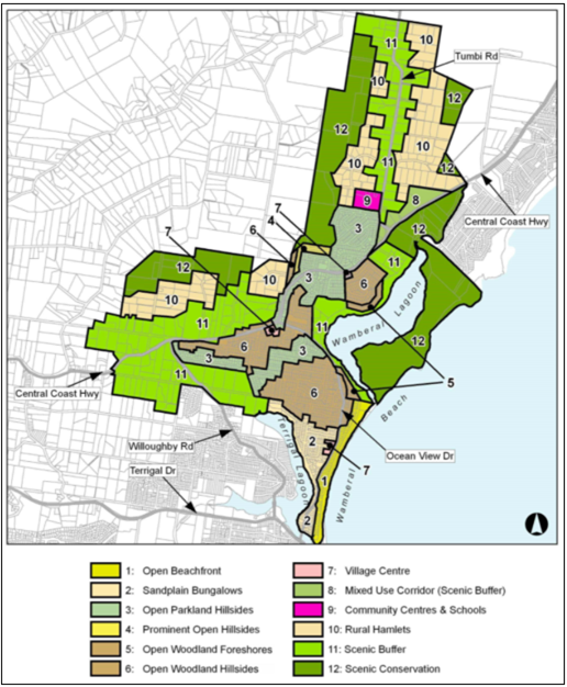
· These should remain low-density residential areas where the existing
scenic quality and amenity of prominent hillsides are enhanced substantially by
further “greening” of gardens and street verges in order to screen
new development and to complement the open bushland canopy that surrounds most
dwellings.
· Avoid disturbing natural slopes and trees by appropriate siting of
structures plus low-impact construction such as suspended floors and decks,
rather than extensive cut-and-fill. On the steeper sites, locate parking next
to the street in structures that are designed to blend with their desired bushy
setting. Avoid the appearance of a continuous wall of development along any
street or hillside by locating buildings behind front and rear setbacks similar
to their surrounding properties and providing at least one wide side setback or
stepping the shape of front and rear facades.
· Minimise the scale and bulk of buildings by stepping floor-levels to
follow natural slopes and by using irregular floorplans to create
well-articulated forms. For example, divide floorspace into linked pavilions
that are separated by courtyards and capped by individual roofs. Front or rear
facades that are taller than neighbouring dwellings should be screened by
balconies, verandahs, stepped forms or extra setbacks. Roofs should be
gently-pitched to minimise the height of ridges, and flanked by wide eaves to
disguise the scale of exterior walls.
· Minimise the scale of prominent facades by using extensive windows and
verandahs plus a variety of materials and finishes rather than expanses of
plain masonry. All dwellings should display a traditional “street
address” with verandahs or decks and living rooms or front doors that are
visible from the roadway. Avoid wide garages that would visually-dominate any
front façade or block views from a dwelling to the street. Locate and
screen all balconies or decks to maintain the existing levels of privacy and
amenity that are enjoyed by neighbouring dwellings.
The
proposal does not change the use, layout or external appearance of the existing
development and maintains the same approved building height bulk and scale.
Subdivision of the land will remain low-density residential development on the
site and will not impact on the character of the approved development or the
character of the surrounding area.
Chapter
3.5 Residential Subdivision
Chapter
3.5 of GDCP 2013 provides guidelines for residential subdivision. In this
instance the proposal is for subdivision to establish in-fill development for
residential use land in
the manner proposed will produce 2 urban residential housing sites that can be
adequately accessed and serviced.
The
proposed subdivision lot arrangement/orientation reflects it is consistent with
the provisions and objectives of the controls notwithstanding variation to the
minimum subdivision lot size of 550sqm (refer Table 2 for the extent of the
variations) and minimum lot width of 14.15m (minimum lot width is 15.00m a
maximum variation of 0.56% - merit based assessment) on land zoned R2
Low-density Residential required by Clause 3.5.3.2 Allotment Size.
The
proposal seeks variation to the minimum 550sqm lot size development control
which largely restates to clause 4.1 of GLEP 2014
minimum lot size requirement for the reasons outlined under clause 4.6 of GLEP
2014. The submitted clause 4.6 is considered well founded and is
supported as stated within this report.
The
assessment considers the proposal is consistent with the objectives of the
controls and the variation is supported for the following reasons:
· An acceptable level of
amenity for the existing and future residents is provided.
· The subdivision layout is
done in an efficient and orderly manner, consistent with existing development.
· All lots are
satisfactorily serviced by infrastructure:
o The proposal is consistent
with the existing development within the site.
o The proposed subdivision
would not be generating a significant amount of traffic nor changing traffic
movements.
o Both resulting allotments
contain vehicular access arrangements for the development to/from Ghersi Avenue
so as to not congest the existing the access provisions proposed with the
subdivision.
o However, a right of access
is to be created with the proposed subdivision.
o The proposed subdivision
will require half road construction, a 1.5m wide kerb-side footpath and a
minimum 2m wide footway formation across the frontage of the site. Proposed Lot
332 will require the construction of a vehicle crossing. Proposed Lot 331 has
an existing vehicle crossing.
o Stormwater from the site
will be conveyed via an inter-allotment drainage system constructed within an
inter-allotment drainage easement located within Lot 47 DP25382 and connecting
to the existing piped system within Lucinda Avenue.
o Appropriate easements are
created on the proposed plan of subdivision.
6.3
Erosion Sedimentation Control
Appropriate
siltation control to be conditioned. Refer
Conditions 1.1, 3.5,4.4 & 4.8.
6.7 Water
Cycle Management
The
provisions of Gosford Development Control Plan (DCP) 2013 Chapter 6.7
Water Cycle Management has been assessed by Council's Development Engineer and
found to be satisfactory, subject to the imposition of suitable conditions of
consent as contained in the recommendation. Refer Conditions 1.1, 2.2
& 2.4.
Other
Matters for Consideration
Development
Contribution Plan
The
proposed development is subject to the provisions of the Central Coast Regional
Section 7.12 Development Contributions Plan 2019. It is noted that development
contributions are only levied where the proposed works exceeds $100,000. In
this instance, the proposed development is under $100,000 therefore, no
contribution levies are applicable.
Water
and Sewer Requirements / Contributions
The
proposal is supported by the Water Authority (Council). The development
site is within the water and sewer service area.
The
proposal will require:
· Separate water meter and
sewer connection point is required under the stratum Torrens subdivision for
each lot.
· Separate water services
and sewer junctions will be required for Torrens Title Subdivision. Easement to
drain sewer benefiting proposed lot 331 will be required to ensure future
structure will not impact the sewer service for proposed lot 331.
Water
and sewer contribution, assessment and inspection fees shall apply to the
proposal to obtain a 307 Certificate of Compliance under the Water Management
Act 2000. Refer Condition 2.5 & 5.7.
Planning
Agreements
The
proposed development is not subject to a planning agreement / draft planning
agreement.
Referrals
|
Internal
Referral Body
|
Comments
|
|
Engineering
|
Supported,
subject to conditions, refer Conditions 1.1, 2.2 – 2.4, 3.6, 3.7,
5.2 -5.11.
|
|
Tree
Preservation Officer
|
Supported,
without conditions
|
|
Water
and Sewer
|
Supported,
subject to conditions, refer Condition 1.1, 2.2 & 2.4.
|
Public
Submissions
The
development application was notified between 5 February and 26 February 2021 in
accordance with the provisions of Gosford Development Control Plan
(GDCP) 2013. A total of two (2) submissions were received by Council –
both Objections.
Those
matters associated with key issues have been addressed in the report here
within.
The
remaining issues pertaining to various concerns were addressed in the
assessment of the application pursuant to the heads of consideration contained
within section 4.15 of the Environmental Planning and Assessment Act 1979.
A summary of the issues in the submissions in relation to the
proposal are detailed below.
· ...I have concerns to
my privacy as if a 2-storey dwelling was to go up it would be looking straight
on to the back of my home and entertaining area. if they were told to put up a
privacy screen then I fear I would lose my winter sun which would be
devastating…
Comment: Noted. Given that the
proposed lot 332 allotment size (610sqm) complies with the minimum subdivision
lot size control of the GLEP 2014, the orientation of the site, the natural
contours and existing vegetation, the proposed subdivision and likely future
construction of a dwelling is
not expected to result in inappropriate overlooking and overshadowing.
Notwithstanding this, any future dwelling proposal has the spatial area and
ability to achieve good site planning practice in order to not impact the
adjoining properties to the east.
· …Drainage -
neighbours on the lower side of this have had ongoing drainage issues because
of the Seabreeze development. Whilst reports might show otherwise, we have live
with it…
Comment: Noted. The proposal has
been assessed by Councils Development Engineer and requires as conditions of
consent civil works including but not limited to road and drainage works, storm
water detention systems, pathway and kerb upgrades etc, to ensure an integrated
water cycle management and water sensitive urban design in accordance with
Council's Chapter 6.7 - Water Cycle Management of the Gosford Development
Control Plan 2013. The proposal is supported subject to conditions.
· … Noise
- neighbours have had to endure an excess of noise due to the Seabreeze
apartments and multiple families moving into a small area which was once very
quiet, do we really need to cram any more buildings into this already congested
part of Wamberal?...
Comment: Noted. The proposal is
not for high density in-fill development and as previously mentioned, it is
considered that any future dwelling proposal has the spatial area and ability
to achieve good site planning practice to not impact the adjoining properties in
particular neighbouring properties to the east and south boundaries. As such,
the resulting increase of one (1) additional allotment of land is considered to
be a minor increase in density in planning terms. The proposal will be
maintaining the low-density residential character of the prescribed R2 land
zoning.
It
is noted that amended plans were submitted responding to issues raised during
Council Officers initial assessment. These amended plans (received by Council
on 27 May and 2 June 2021 respectively) included amendments (engineering
stormwater and covenants technical information) which did not alter the shape
and size of the survey plan. Given the minor nature of alterations and/or
technical information inclusion, the amended plans were not re-notified. In
accordance with Section 7.3.3.10(c) of the Gosford Development Plan
(GDCP) 2013, applications which have been amended do not require
re-notification where ‘…the amendments will result in no additional
impacts…’
Likely
Impacts of the Development
Section
4.15 (1)(b) of the EP&A Act requires consideration of the likely impacts of
the development including environmental impacts on both the natural and built
environments, and social and economic impacts in the locality.
The
proposed subdivision will reflect and maintain an existing residential
development and create additional residential in-fill development capacity
which has been assessed and considered to not impact on the physical
characteristics of the land, create any physical hazards or amenity issues for
neighbours and will not create additional demand for services, nor capacity
problems for existing infrastructure.
The
proposed development will contribute to the supply of housing needs in the
locality and is satisfactory from an economic perspective. No social impacts will
arise from the approval of the proposed subdivision.
Suitability
of the Site for the Development
The site is zoned is zoned R2
Low-density Residential under GLEP 2014. The proposal is generally in keeping with the provisions
of GLEP 2014 and GDCP 2013. The
proposal is for the subdivision into 2 allotments with an existing residential dwelling
which will be retained and will create one additional residential in-fill
development capacity beyond that already approved for the site consistent with
other residential lots that are typical of the area.
The
newly created vacant allotment 332 complies with the minimum subdivision lot
size and has the spatial area and capacity to ascertain direct access off
Ghershi Avenue and for required services infrastructure. The newly created
allotment 331 which contains the existing dwelling and undersized minimum
subdivision lot size will continue to be consistent with the existing and
desired future character
of the area by maintaining its residential streetscape character in size, bulk
and scale whilst also having the spatial capacity to ascertain direct access
off Ghershi Avenue, on-grade carparking, private open spaces and additional
landscaping.
As
such the site is considered suitable for this type of development subject to
conditions of consent.
The
Public Interest
The
approval of the application is considered to be in the public interest.
The proposal will not have any adverse impact on the natural or built
environment and will not unreasonably impact the amenity of neighbouring
properties and provide for the orderly and economic development of the land.
It is considered that the site is
suitable for the proposed development, subject to the imposition of appropriate
conditions of consent, as contained in the Recommendation. It is considered
that the proposal is generally consistent with the existing pattern of
subdivision in the immediate locality and will be consistent with the existing
and desired future character of the area.
The
site area of the existing allotment in its present form is considered to be an
under-utilised resource. The proposed in-fill development will provide for the
housing needs of the community and additional housing on the site consistent
with the zone objectives.
Political
Donations
During
assessment of the application there were no political donations were declared
by the applicant, applicant’s consultant, owner, objectors and/or
residents.
Conclusion
This
application has been assessed under the heads of consideration of section 4.15
of the Environmental Planning and Assessment Act 1979 and all relevant
instruments and policies. Subject to the imposition of appropriate conditions,
the proposed development is not expected to have any adverse social or economic
impact.
Accordingly,
the application is recommended for approval pursuant to section 4.16 of
the Environmental Planning and Assessment Act.
Reasons for the Decision
The
reasons for the decision as recommended under the assessment of this
application are as
follows:
1 The
proposal is satisfactory having regard for the relevant environmental planning
instruments, plans and policies.
2 There are no significant
issues or impacts identified with the proposal under s.4.15 of the Environmental
Planning and Assessment Act 1979.
Attachments
|
1⇩
|
Draft
Conditions of Consent 8 Ghersi Ave WWAMBERAL DA60725 Part 1
|
|
D14922160
|
|
2⇩
|
Updated
Subdivision Plan 8 Ghersi Avenue, WAMBERAL DA60725 Part 1
|
|
D14656775
|
|
3⇩
|
Concept
Engineering Design 8 Ghersi Ave WAMBERAL DA60725 Part 1
|
|
D14656777
|
|
4⇨
|
WCMP
Report 8 Ghersi Avenue, WAMBERAL DA60725 Part 1
|
Provided
Under Separate Cover
|
D14656776
|
|
5⇨
|
PUBLIC
Statement of Environmental Effects 8 Ghersi Avenue, WAMBERAL DA60725 Part 1
|
Provided
Under Separate Cover
|
D14444243
|
|
6⇩
|
Updated
Clause 4.6 Submission to Minimum Allotment Size 8 Ghersi Ave WAMBERAL Part 1
|
|
D14667387
|