 |
Central Coast
Supplementary Local Planning Panel
Business Paper
19 January 2022
 |
|
Central Coast
Supplementary Local Planning Panel
Business Paper
19 January 2022
|
The Supplementary Meeting Local Planning Panel
of Central Coast
will be held remotely - online,
Wednesday 19 January 2022 at 3.00 pm,
for the transaction of the business listed below:
1 Procedural Items
1.1 Disclosures of Interest......................................................................................................................... 3
2 Planning Reports- Outside of Public Meeting
2.1 Supplementary Report - DA/530/2019 - 2 & 11 Bryant Drive Tuggerah - Mixed Use Development comprising Specialised Retail Premises, Signage and Food and Drink Premises - (Agenda Item 4.1 Local Planning Panel meeting 24 June 2021)............ 4
Donna Rygatre
Chairperson
|
Item No: 1.1 |
|
|
Title: Disclosures of Interest |
|
|
Department: Governance |
|
|
19 January 2022 Supplementary Local Planning Panel |
|
Reference: F2020/02502 - D14205789
|
The NSW Local Planning Panel Code of Conduct states that all panel members must sign a declaration of interest in relation to each matter on the agenda before or at the beginning of each meeting.
|
That Panel Members now confirm that they have signed a declaration of interest in relation to each matter on the agenda for this meeting and will take any management measures identified.
|
Item No: 2.1 |
|
|
Title: Supplementary Report - DA/530/2019 - 2 & 11 Bryant Drive Tuggerah - Mixed Use Development comprising Specialised Retail Premises, Signage and Food and Drink Premises - (Agenda Item 4.1 Local Planning Panel meeting 24 June 2021) |
|
|
Department: Environment and Planning |
|
|
19 January 2022 Supplementary Local Planning Panel |
|
Reference: DA/530/2019 - D14985950
Author: Janice Buteux-Wheeler, Senior Development Planner
Manager: Emily Goodworth, Section Manager Development Assessment North
Executive: Andrew Roach, Unit Manager, Development Assessment
|
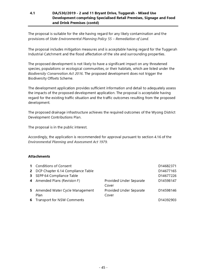
Summary
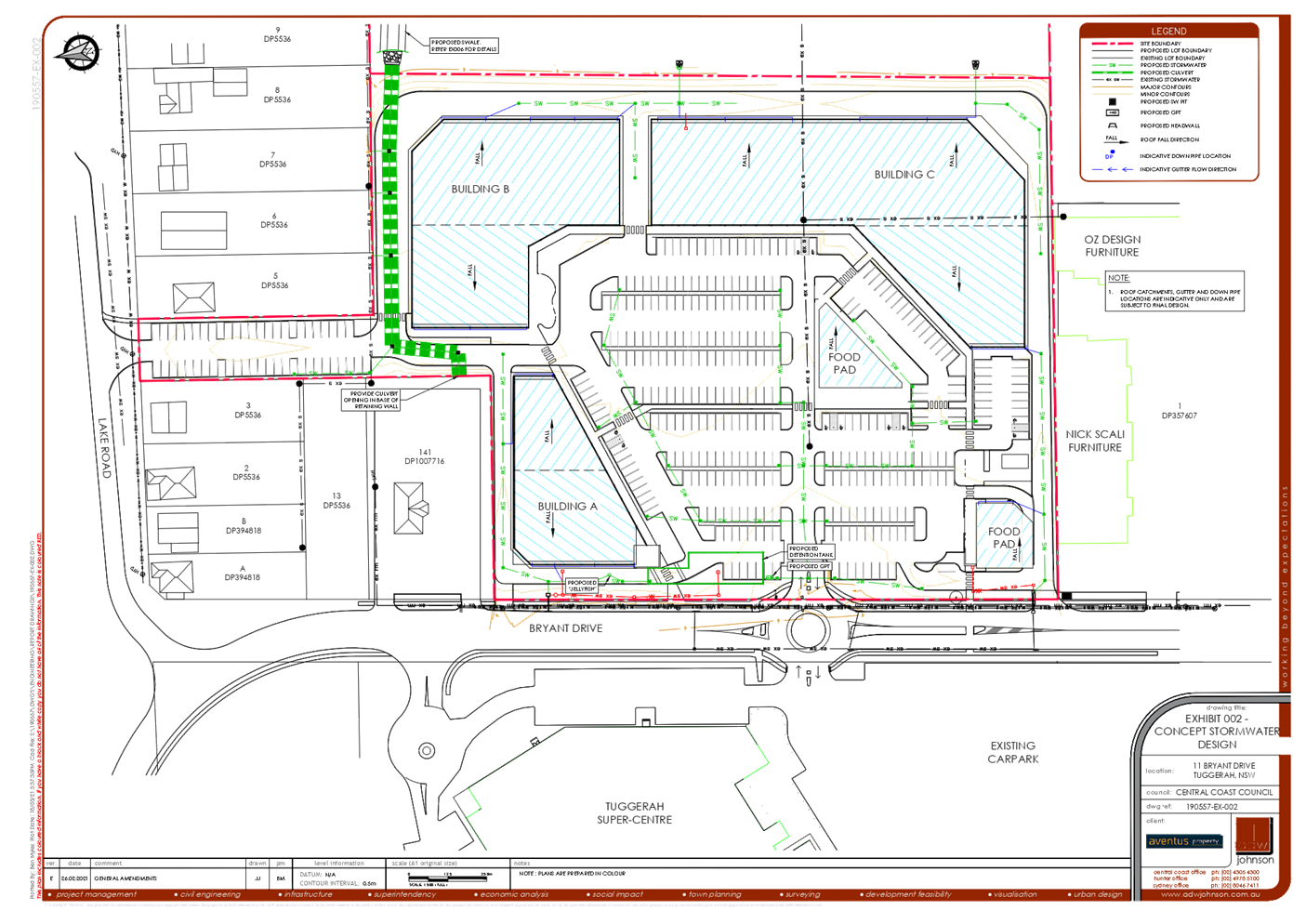
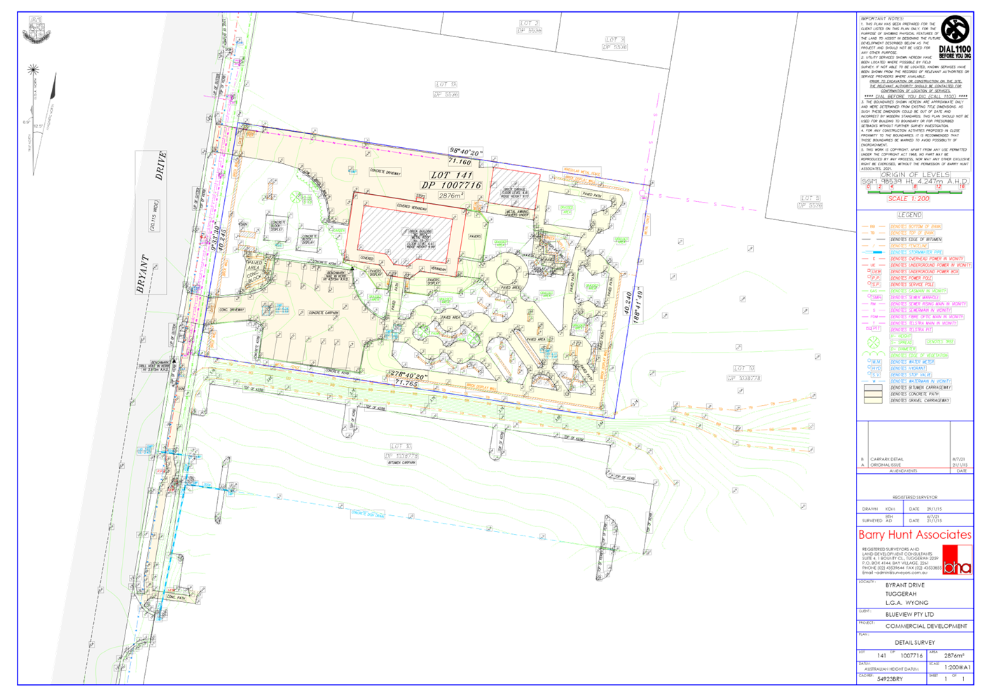
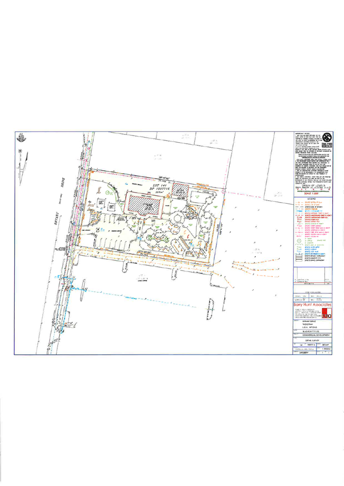
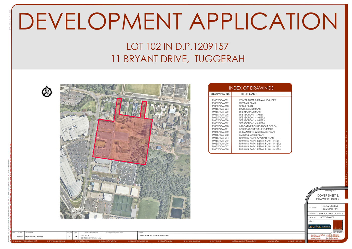
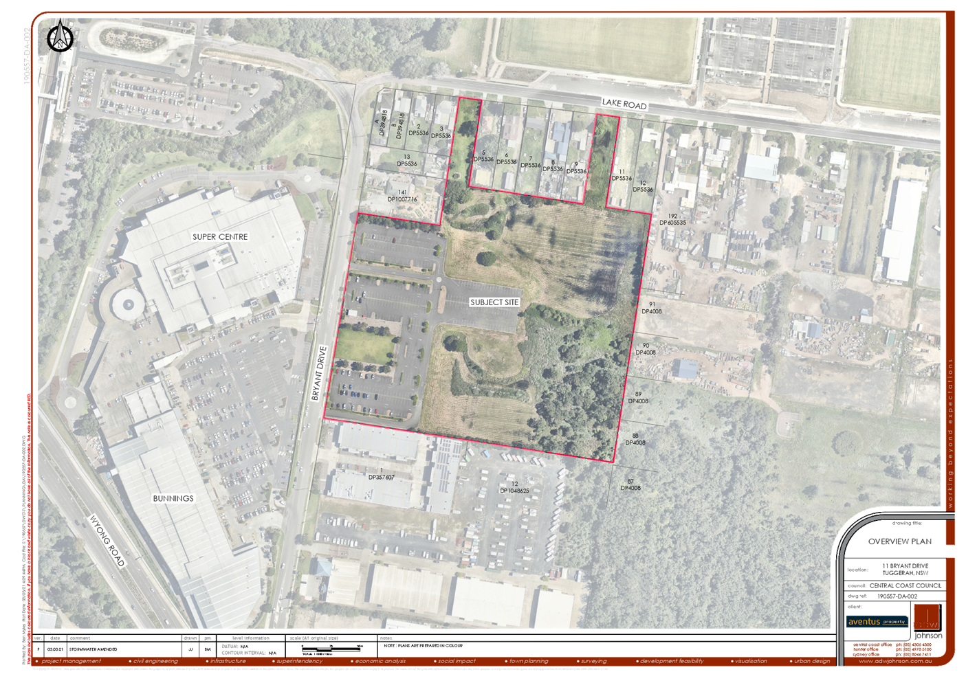
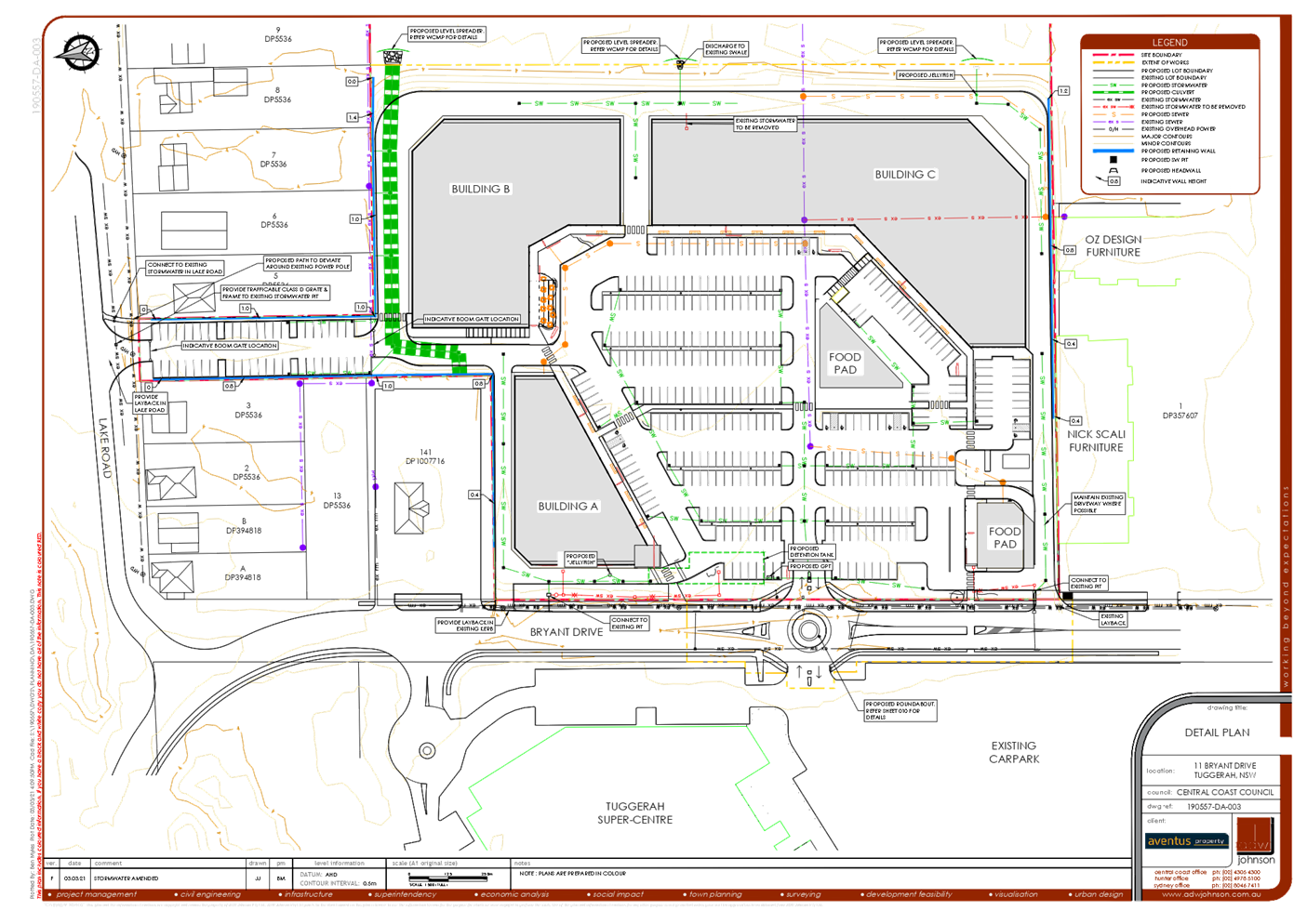
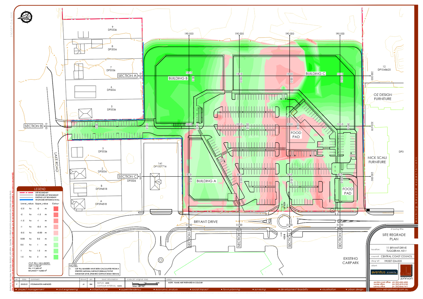
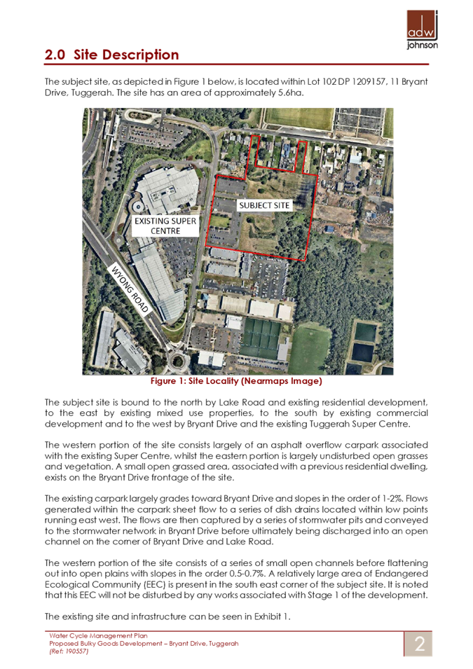
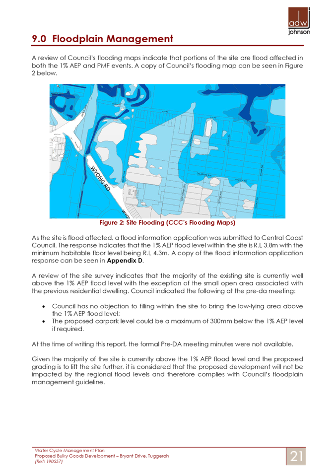
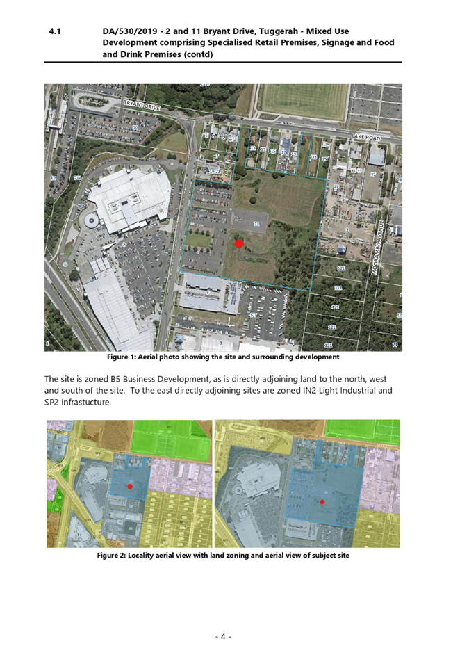
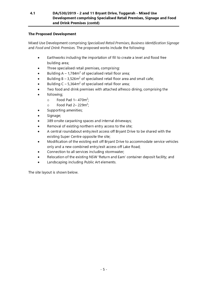
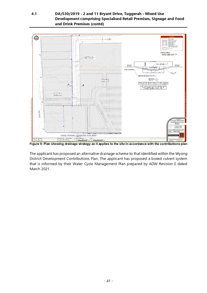
An application was received for a Mixed Use Development comprising Specialised Retail Premises, Signage and Food and Drink Premises at 2 & 11 Bryant Drive, Tuggerah.
The Local Planning Panel considered the matter at its meeting of 24 June 2021. The matter was deferred at the meeting pending the submission of supplementary information. The panel resolved the following:
1 That the Local Planning Panel defer a decision regarding DA/530/2019 – 2 & 11 Bryant Drive - Mixed Use Development comprising Specialised Retail Premises, Signage and Food and Drink Premises and request the Council to notify all adjoining owners who have not previously been notified and provide them the opportunity to make a submission on the proposal within 14 days of the notification.
2 The matter is to be reported back to the Panel for determination within 28 days of the closing date for submissions in accordance with 1 above.
3 This report should include information detailing the basis on which contributions are being levied, including the net developable area for contributions that have been paid and contributions that are proposed.
This supplementary report is submitted for the consideration of the Local Planning Panel having regard to the resolution of the 24 June 2021 meeting to be read in conjunction with the report of 24 June 2021 report, addressing all relevant matters to be considered within the provisions of the Environmental Planning and Assessment Act 1979.
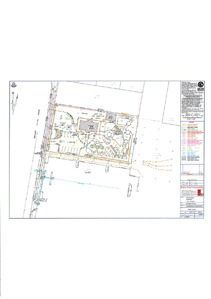
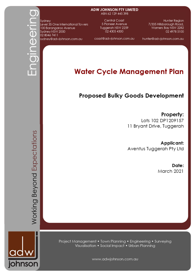
Applicant Aventus Tuggerah Pty Ltd c/- ADW Johnson Pty Ltd Owner Aventus Tuggerah Pty Ltd Application No DA/530/2109 Description of Land Lot 101 and Lot 102 DP 1209157 Proposed Development Mixed Use Development comprising Specialised Retail Premises, Signage and Food and Drink Premises Zoning B5 Business Development Existing Use Car parking, vacant Employment Generation Yes Estimated Value $29,777,000.00 |
1 That the additional information be considered in the Panel’s determination of the application.
2 That the Local Planning Panel grant consent to DA/530/2019 Mixed Use Development comprising Specialised Retail Premises, Signage and Food and Drink Premises on 2 & 11 Bryant Drive Tuggerah, subject to the conditions detailed in the schedule attached to the report and having regard to the matters for consideration detailed in Section 4.15 of the Environmental Planning and Assessment Act.
3 That Council advise those who made written submissions of the Panel’s decision.
4 That the Council advise relevant external authorities of the Panel’s decision
Key Issues
Flooding, drainage, traffic and noise impacts.
Precis:
|
Proposed Development |
Mixed Use Development comprising Specialised Retail Premises, Signage and Food and Drink Premises
|
|
Permissibility and Zoning |
|
|
Relevant Legislation |
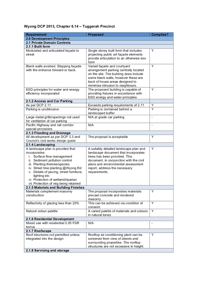
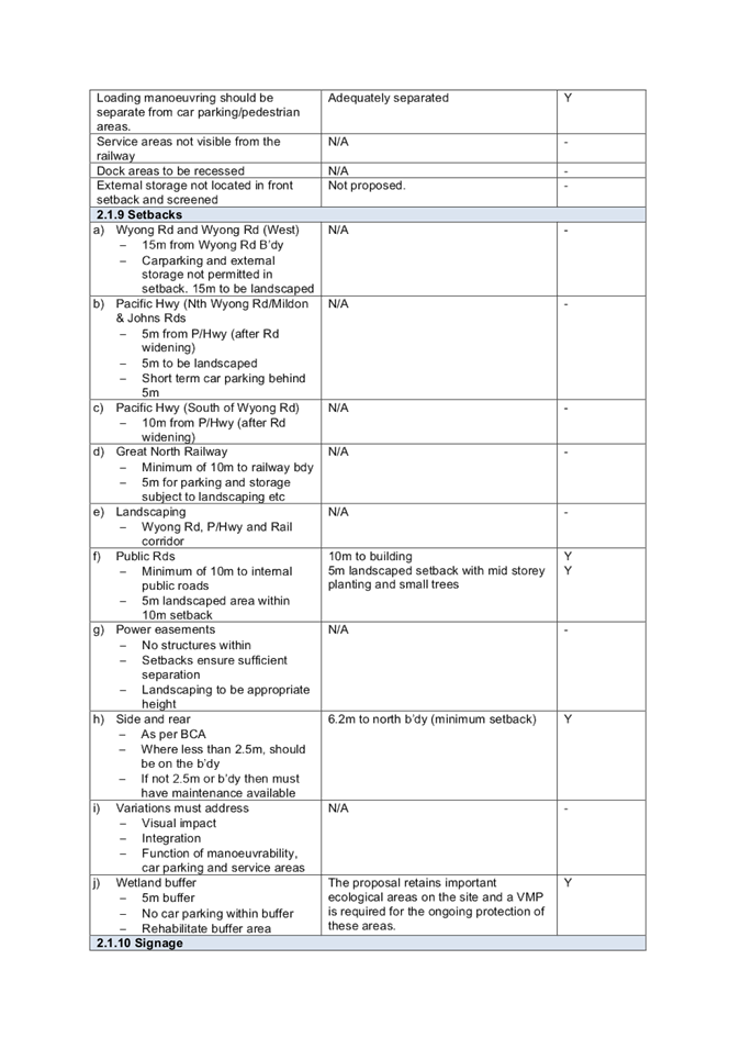
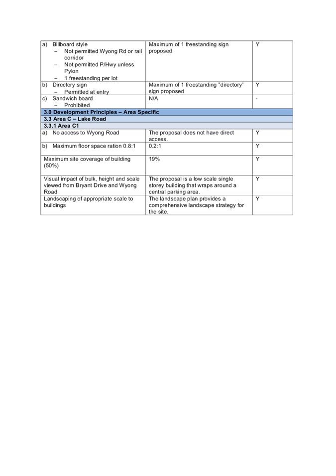
Environmental Planning and Assessment Act 1979 State Environmental Planning Policy No. 64 – Advertising and Signage State Environmental Planning Policy No.55 – Remediation of Land State Environmental Planning Policy (Koala Habitat Protection) 2019 Wyong Local Environmental Plan 2013 Draft Central Coast Local Environmental Plan 2018 Wyong Development Control Plan 2013
|
|
Current Use |
Car parking, vacant.
|
|
Integrated Development |
No
|
|
Submissions |
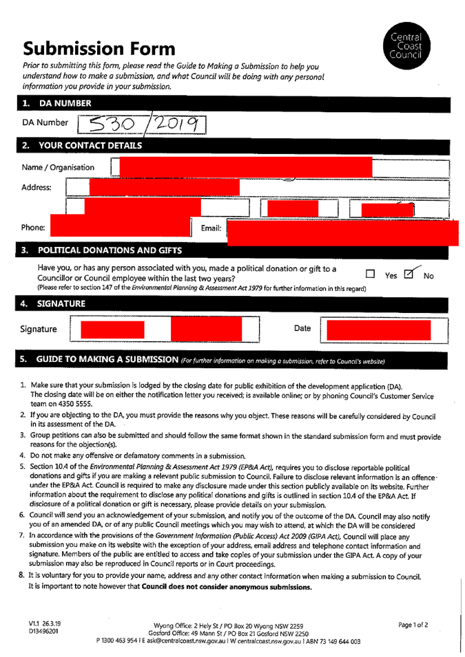
Three additional submissions as a result of further notification period.
|
|
List of all documents submitted with this report for the Panel’s consideration |
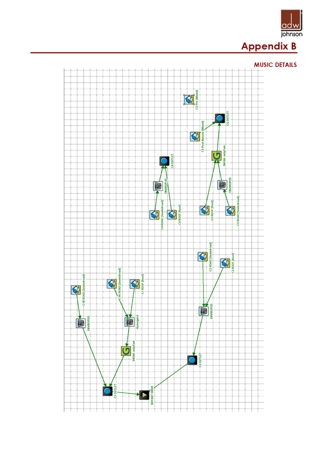
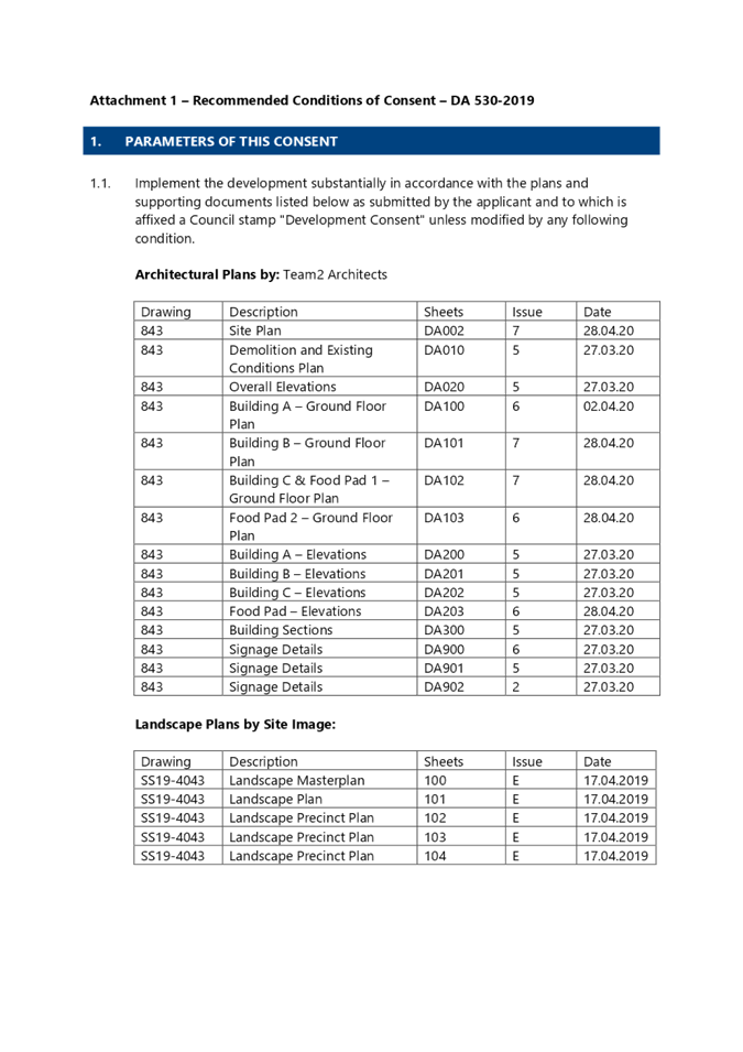
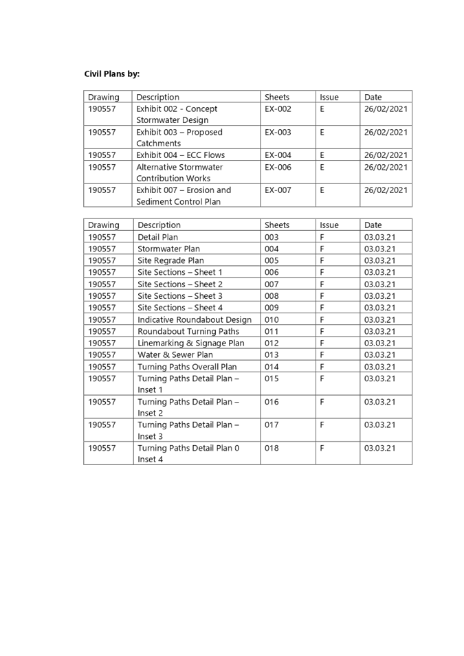
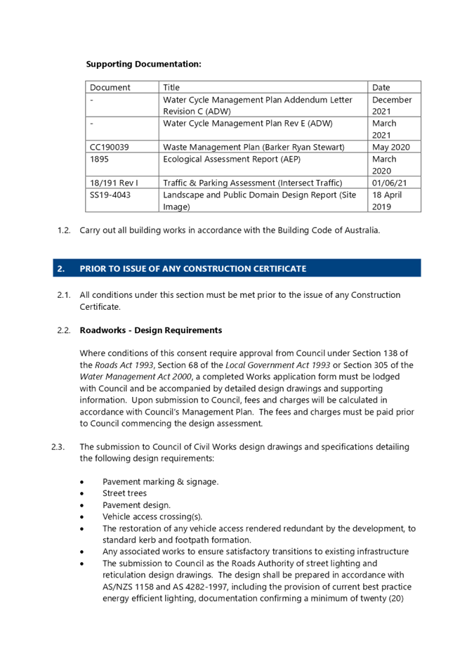
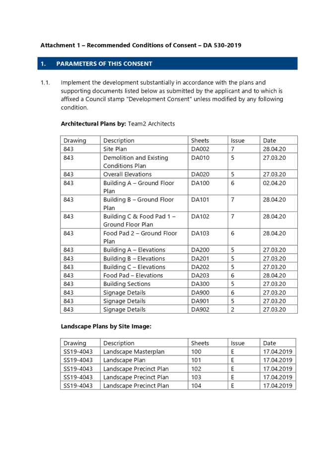
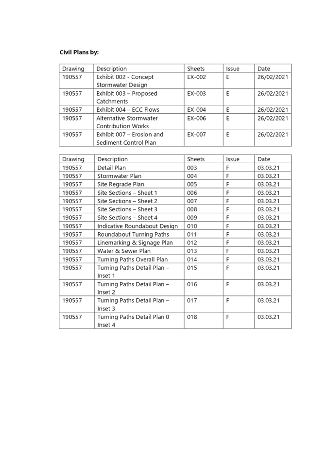
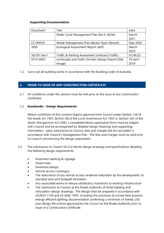
1. Water Cycle Management Plan – Addendum Letter Revision C December 2021 2. LPP Report and Attachments (24 June 2021) 3. LPP Minutes (24 June 2021) 4. Updated Draft Conditions of Consent |
|
Report prepared by |
Janice Wheeler – Senior Development Planner |
|
Report date |
17 December 2021 |
Background
The Panel considered a Planning Report on the matter at its meeting on 24 June 2021 and resolved as follows:
|
Decision |
That the Local Planning Panel defer a decision regarding DA/530/2019 – 2 & 11 Bryant Drive - Mixed Use Development comprising Specialised Retail Premises, Signage and Food and Drink Premises and:
1 Request the Council to notify all adjoining owners who have not previously been notified and provide them the opportunity to make a submission on the proposal within 14 days of the notification.
In oral submissions provided by members of the public during the determination meeting, attention was brought to the interpretation of the notification provisions of Chapter 1.2 of the Wyong Development Control Plan 2013 (WLEP 2013). The Panel considered that it was arguable that the proposed development may be a change of use triggering a requirement to notify all adjoining land owners.
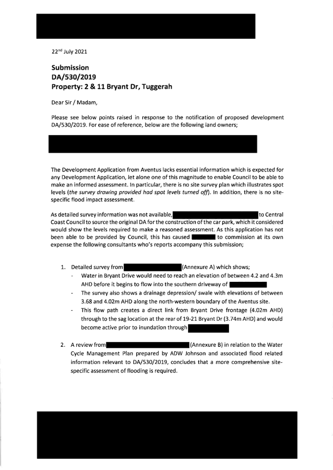
The application was notified to all adjoining property owners from 1 July 2021 to 22 July 2021. Submissions from three submitters were received.
2 The matter is to be reported back to the Panel for determination within 28 days of the closing date for submissions in accordance with 1 above.
Noted.
3 This report should include information detailing the basis on which contributions are being levied, including the net developable area for contributions that have been paid and contributions that are proposed.
The Panel sought clarification as to the methodology for the calculation of the contributions, having regard for historical approvals on the site.
|
|
Reasons |
1 The Panel considered that it was arguable that the proposed development may be a change of use triggering a requirement to notify all adjoining owners.
2 Clarification is required regarding contributions. |
Additional Information
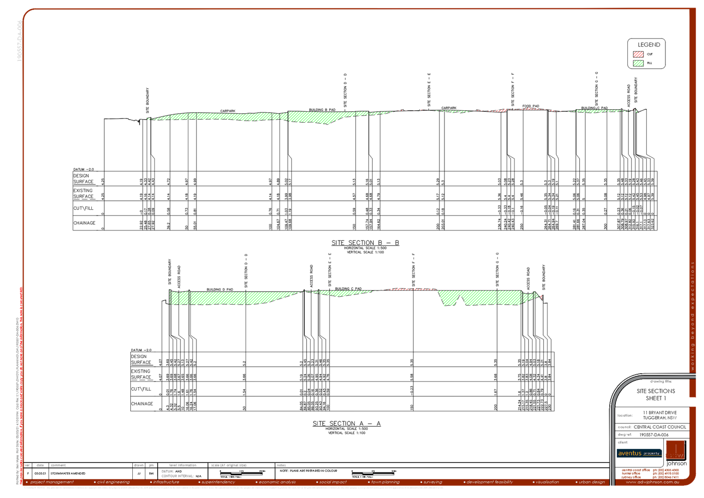
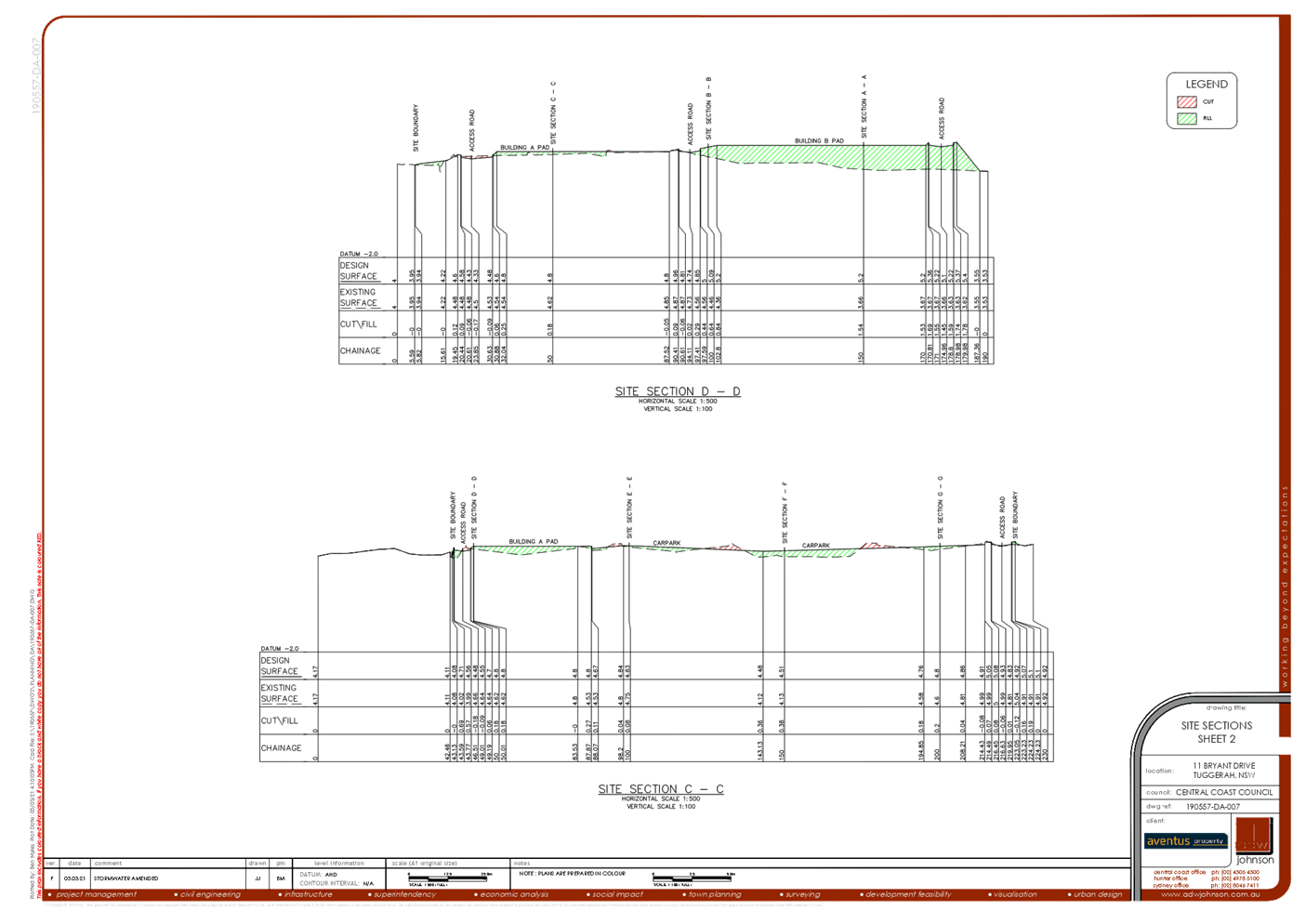
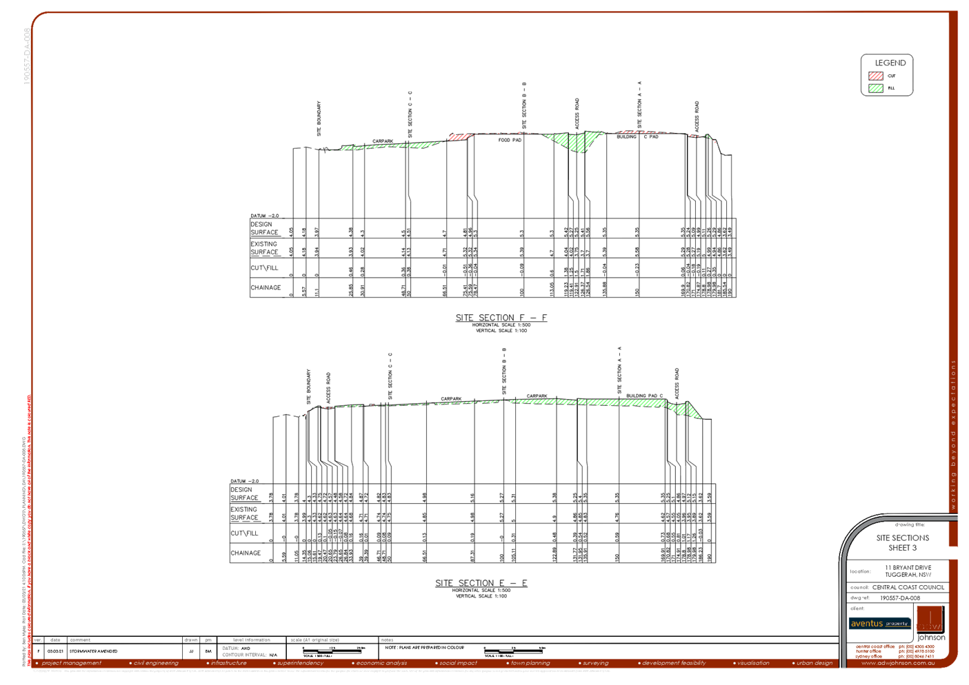
In response to the decision of the Panel at its meeting of 24 June 2021, council undertook notification of all adjoining properties, irrespective of the use of the land, in accordance with Chapter 1.2 of Wyong Development Control Plan 2013. The notification period commenced on 1 July 2021 and finished on 22 July 2021. During the submission period, submissions from three submitters were received.
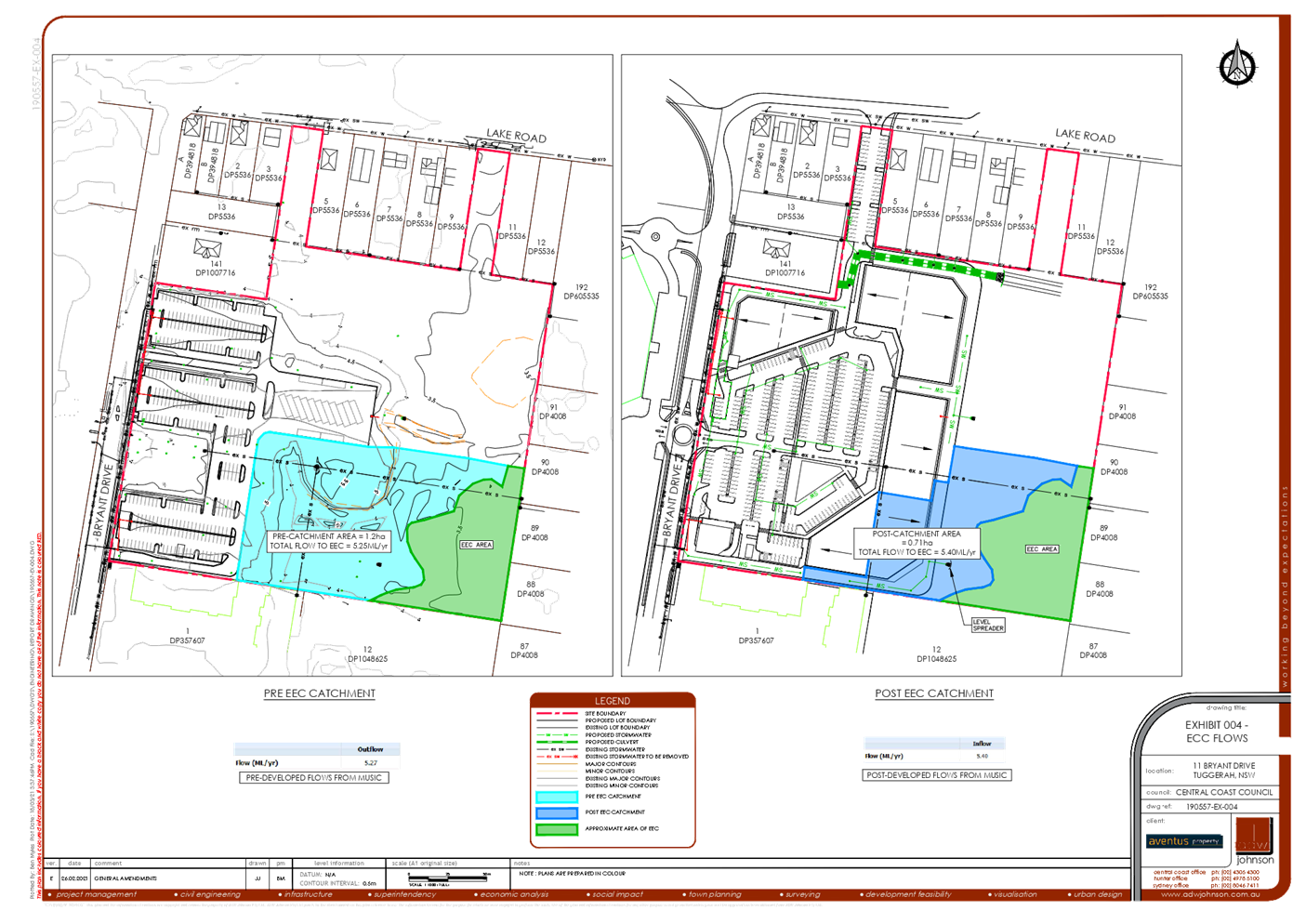
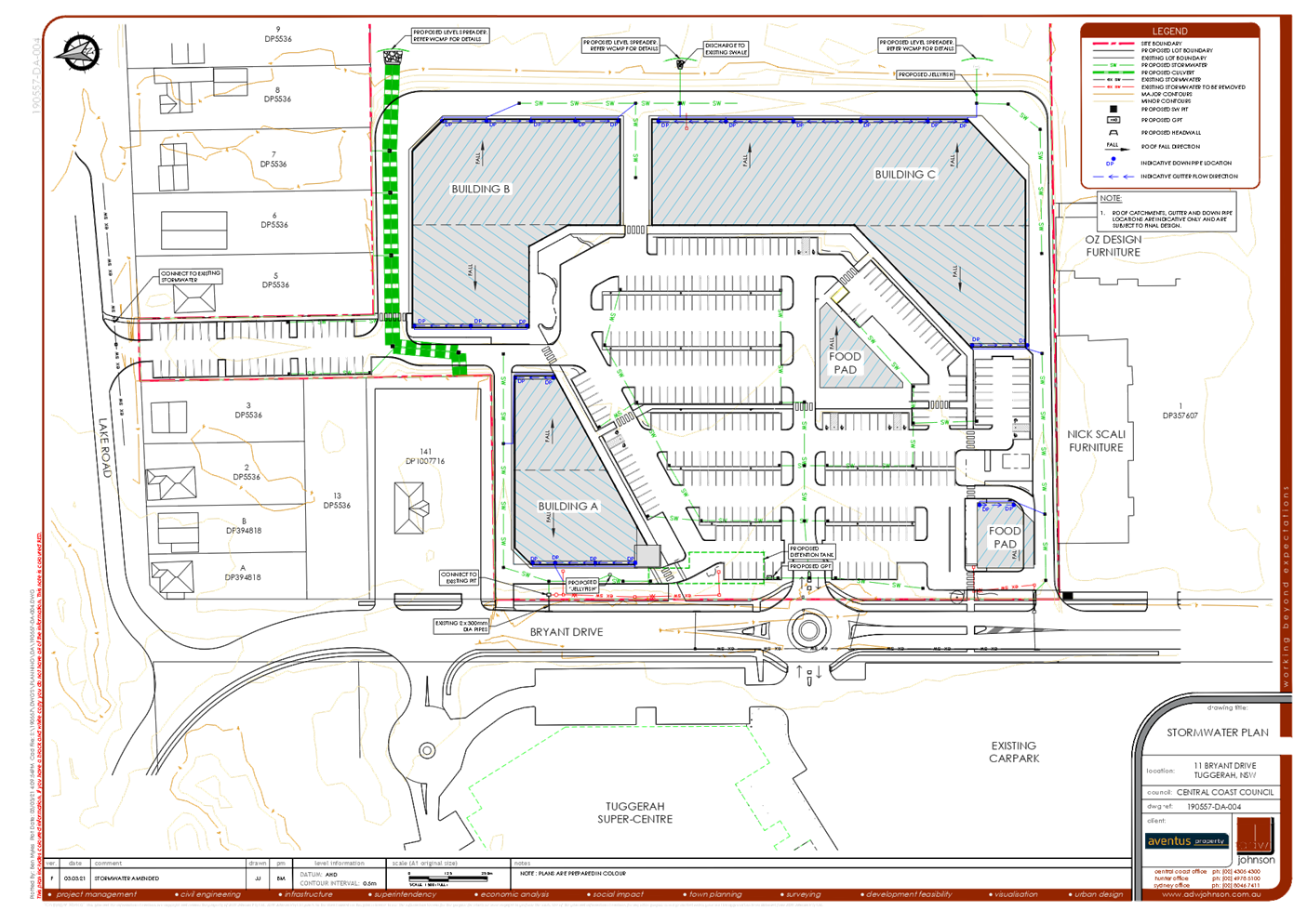
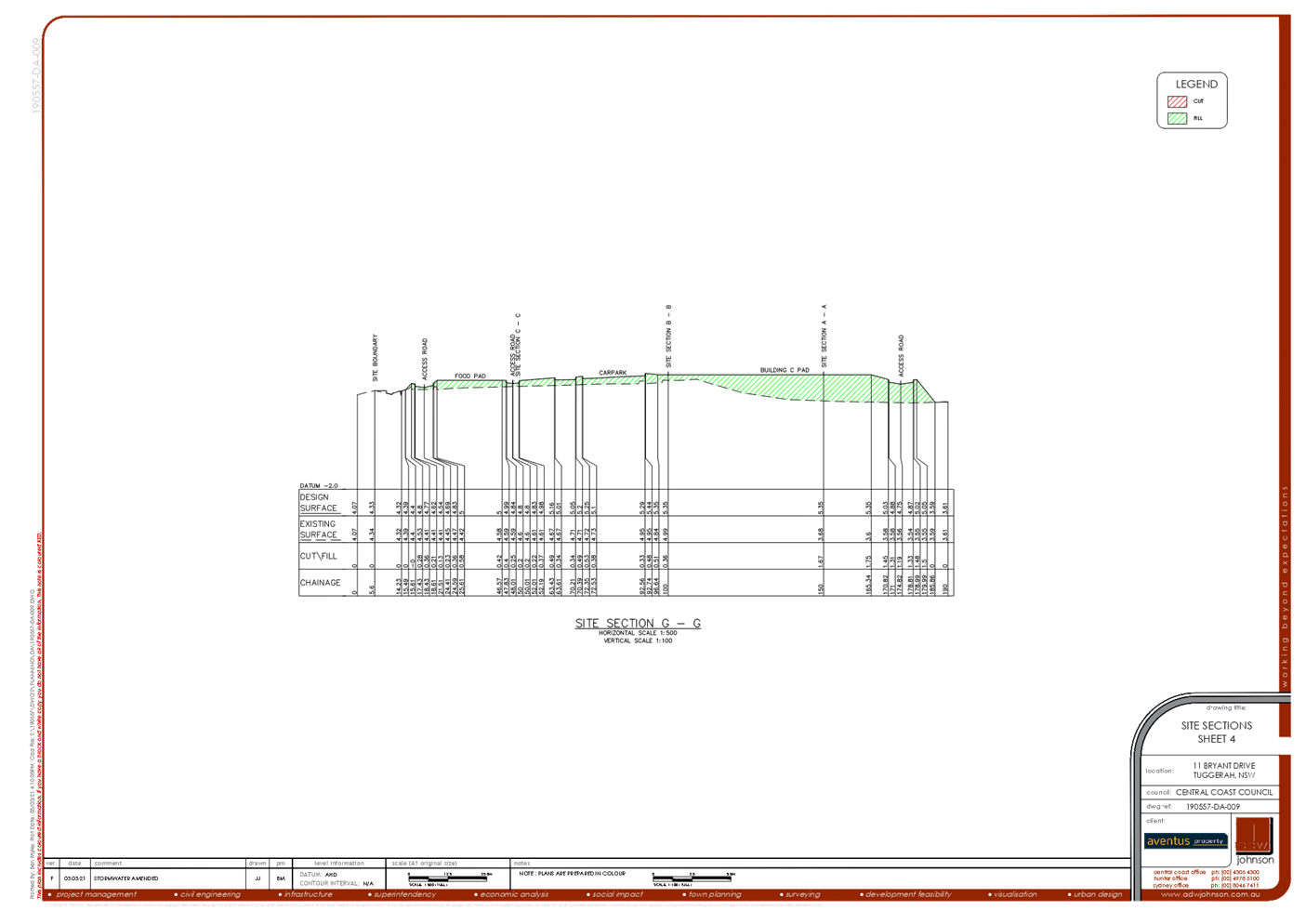
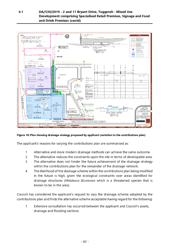
Following Council’s consideration of the submissions, Council requested that the applicant provide a response to submissions document in relation to matter’s raised regarding storm water, overland flow and localised flooding. This document is titled Water Cycle Management Plan Addendum Letter. The latest revision of this document is Revision C.
20 August 2021:
· Council attended an online meeting with the Applicant to request the applicant respond to submissions raised during the notification period.
31 August 2021:
· Received Applicant’s Water Cycle Management Plan – Addendum Letter Revision A.
20 September 2021:
· Council assessed the information, and the following summary of comments is provided:
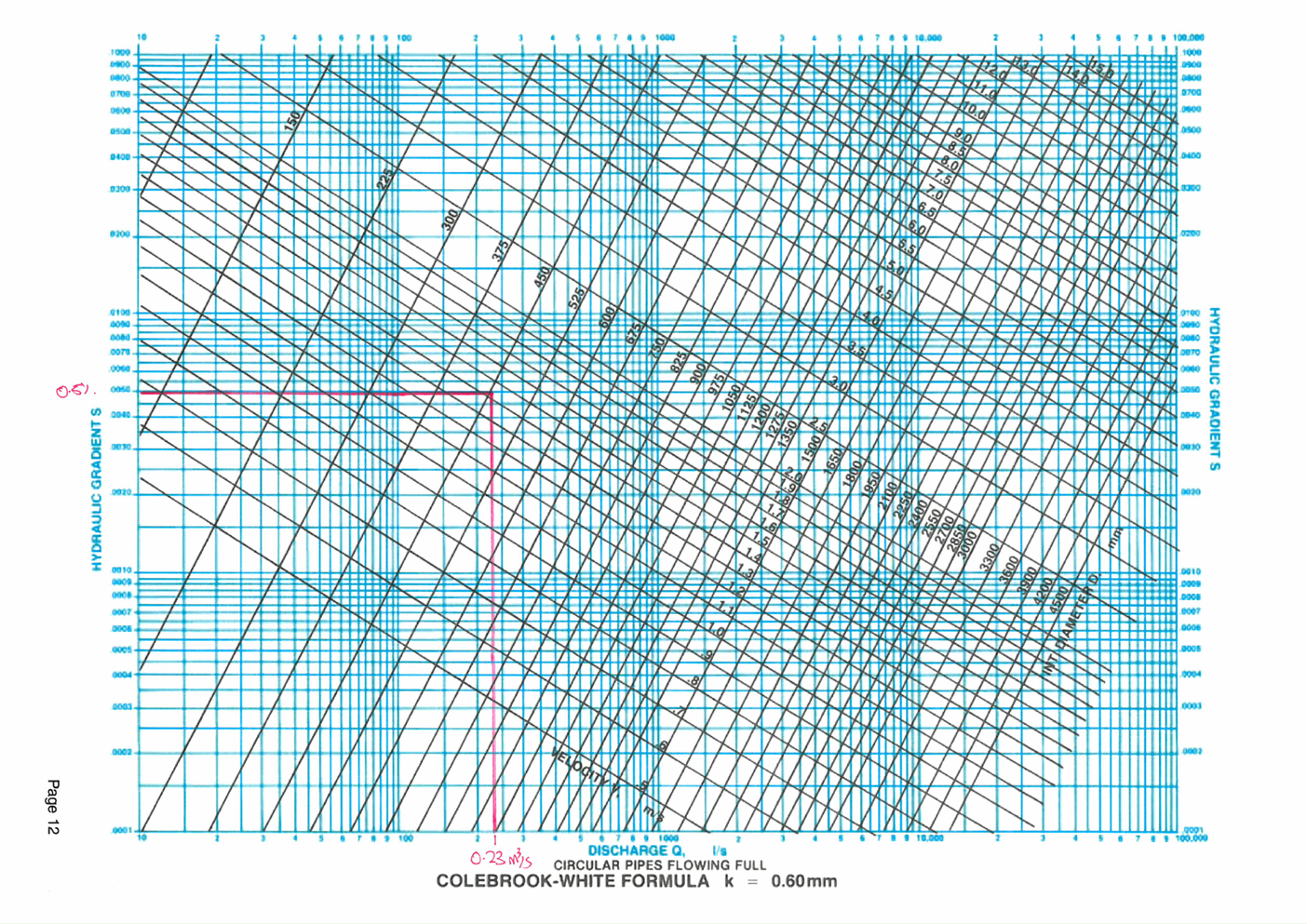
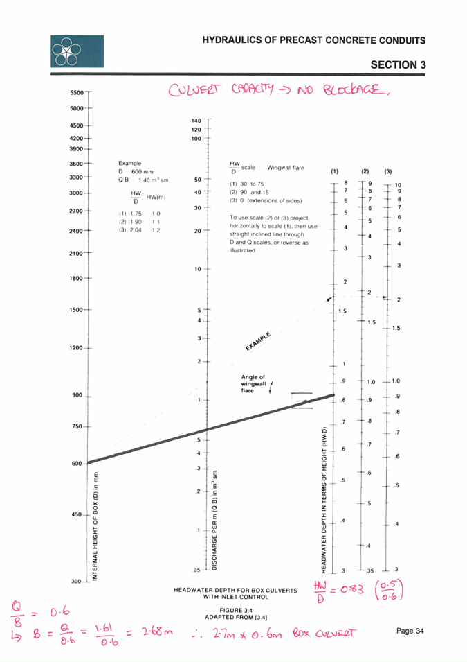
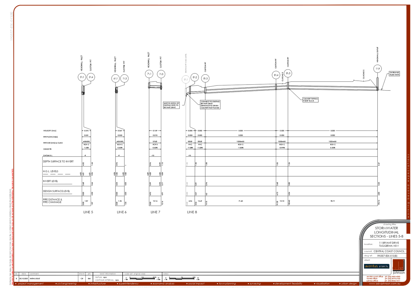
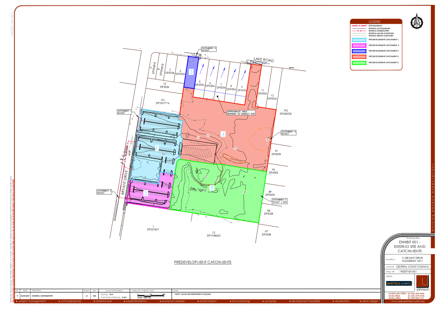
The proposed split system is a better option than the originally presented option because it allows for the minor system to drain the proposed development and intercept the overland flows from the adjoining lots that are impacted by the proposed filling. The larger culvert independently caters for the major flow when Bryant Drive becomes inundated.
The submission from ADW Johnson provides the outcome of the additional work that they have undertaken but for transparency some of the workings should be provided in to report to support the solution. This information is required and should be provided. The need for a full flood study was raised in submissions.
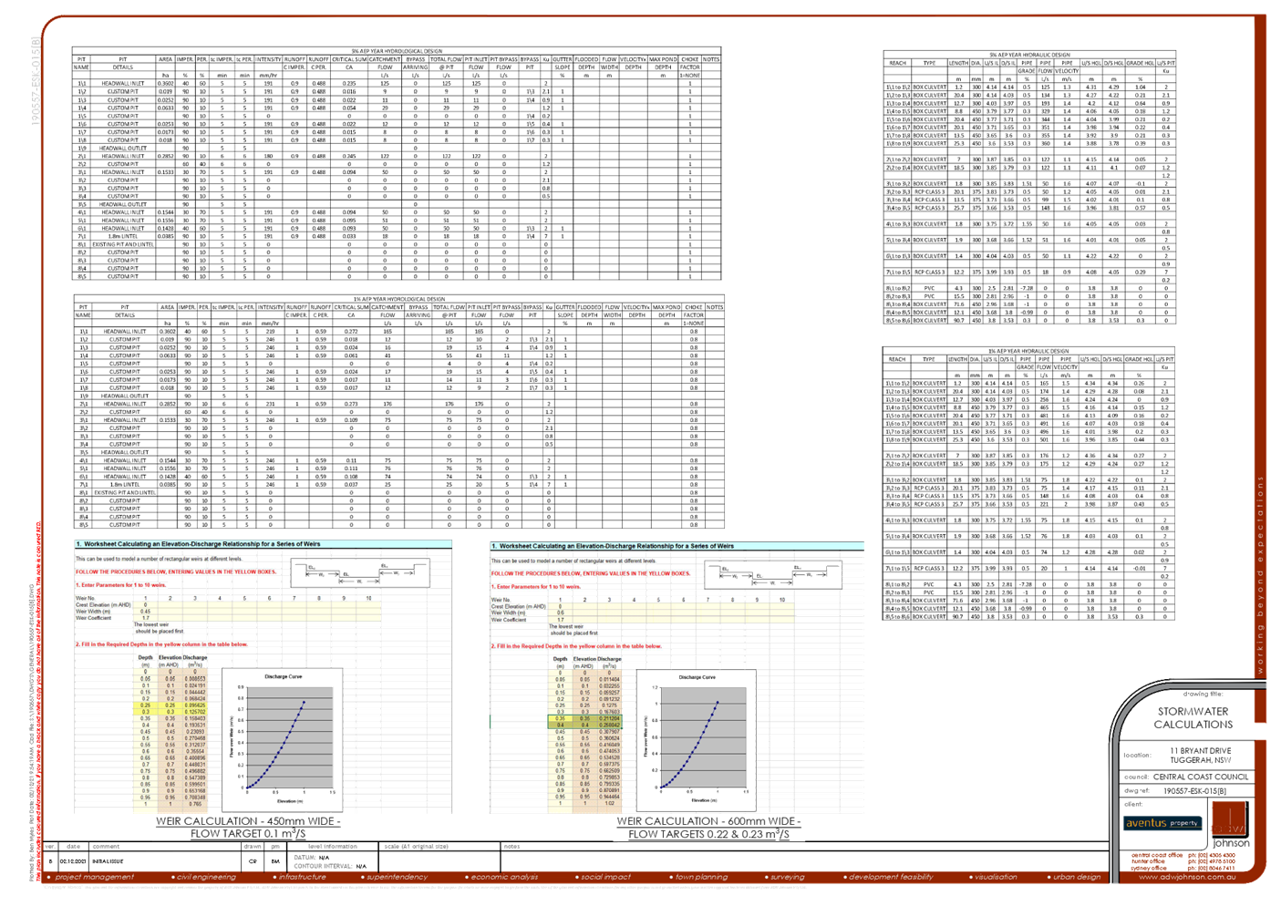
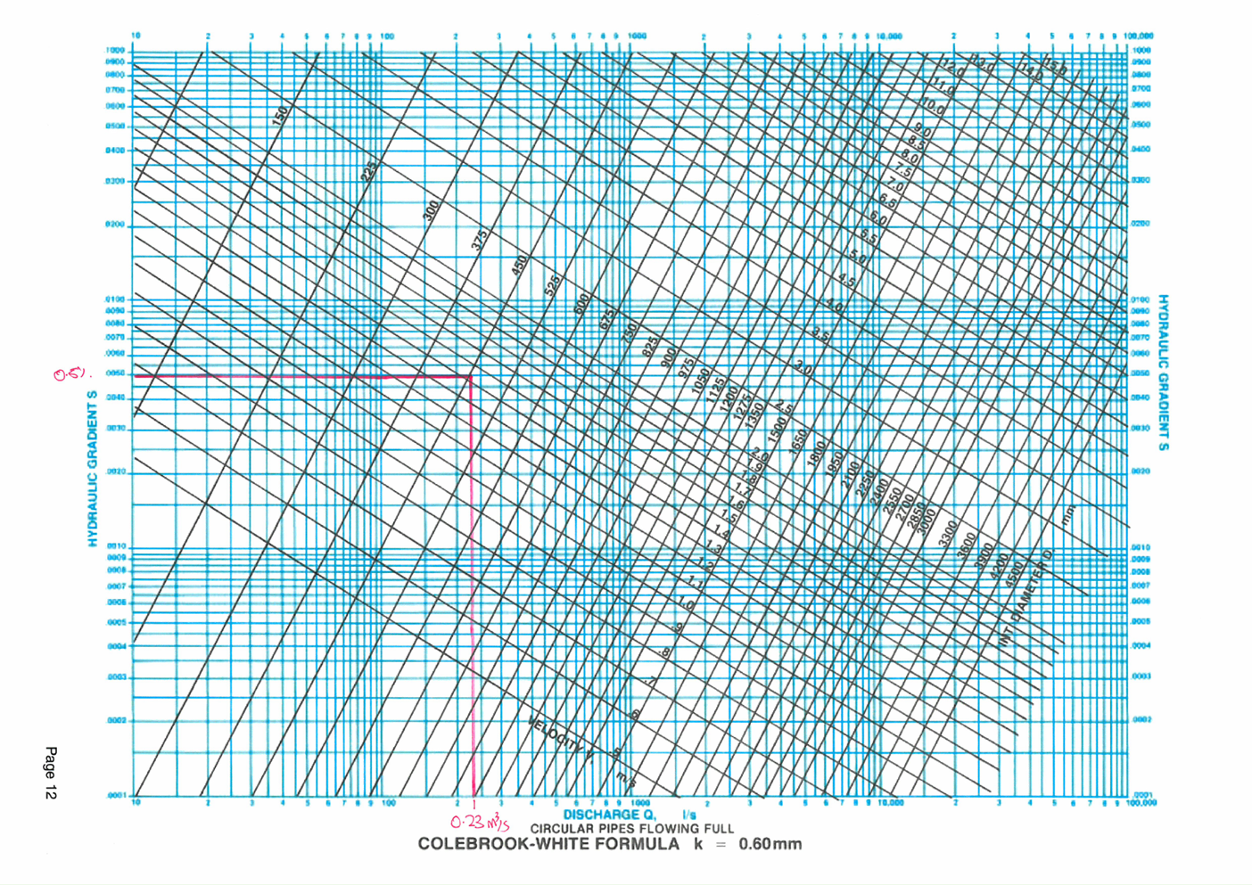
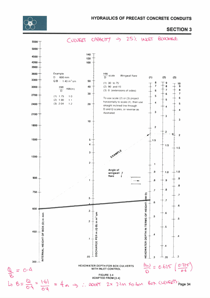
The flood relief culvert size, its capacity flowing full and with 25% blockage has been identified. A direct correlation between the existing bypass capacity and culvert capacity has been made which indicates an improvement in that sense, however that improvement is not quantified. Clarification of the improvement is required. This is dependant on the inlet capacity of Pit 8/3 and the piped flow from Pits 8/1 and 8/2 with their associated entry types and blockage factors.
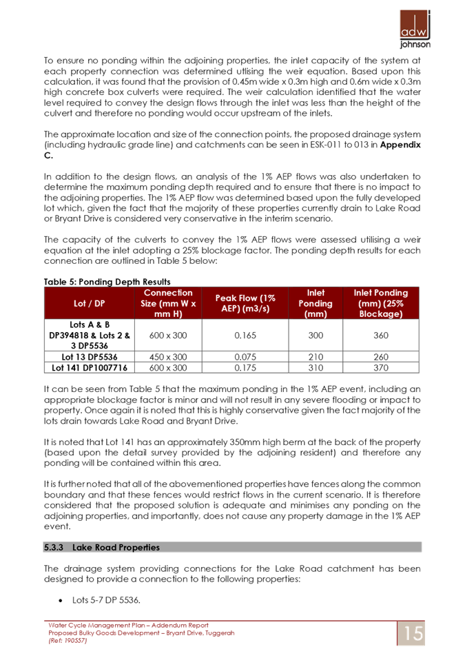
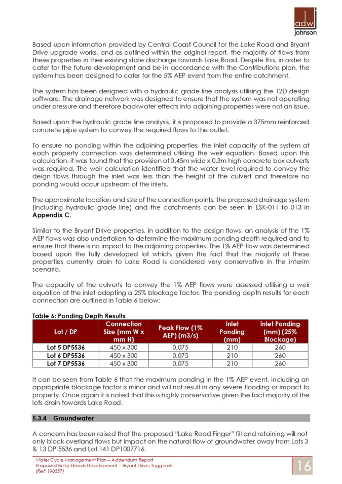
The independent lot drainage system should also be supported by the calculations to prove its efficiency. The type of grating system for the overland flow connection points must be considered from the perspective of children and pet safety. This in turn may impact inlet capacities and system efficiency. The system has generally been designed for the 5% rain event, however consideration should be given to the performance of the system in the 1% event to ensure that there are no severe adverse impacts (inundation of floor levels). The duration of inundation for the 1% draining through the system should be provided, particularly for the properties identified in the Bryant Drive catchment.
The information should be readily available as it was used to provide the outcome summary in the WCMP.
This information was provided to the applicant to respond.
15 October 2021:
· Received Applicant’s Water Cycle Management Plan – Addendum Letter Revision B.
24 November 2021:
· Council assessed the information and requested that the applicant address ground water issues identified in submissions.
30 November 2021:
· Copy of Water Cycle Management Plan – Addendum Letter Revision B provided to submitters.
2 December 2021:
· Received Applicant’s Water Cycle Management Plan – Addendum Letter Revision C, with clarification of geotechnical information and addressing ground water queries of Council.
7 December 2021:
· Council’s engineer and planner met with objectors to discuss water management concerns and provide information on the response to submissions document (Water Cycle Management Plan – Addendum Letter Revision C) that was provided by the applicant.
8 December 2021:
· Council requests survey plan with spot levels.
9 December 2021:
· Received Applicant’s survey plan.
10 December 2021:
· Copy of survey plan with spot levels provided to submitters.
RESPONSE TO PANEL DECISION
In response to the matters raised by the Panel in the deferral of decision of 24 June 2021 the following is provided:
1 Request the Council to notify all adjoining owners who have not previously been notified and provide them the opportunity to make a submission on the proposal within 14 days of the notification.
In response to the outcome of the Panel meeting of 24 June 2021, council undertook notification of all adjoining properties, irrespective of the use of the land. The notification period commenced on 1 July 2021 and finished on 22 July 2021. During the submission period, submissions from three submitters were received.
Following Council’s consideration of the submissions, Council requested that the applicant provide a response to submissions document in relation to matter’s raised regarding storm water, overland flow and localised flooding. This document is titled Water Cycle Management Plan Addendum Letter. The latest revision of this document is Revision C.
A summary of the issues raised in submissions and the responses of both the applicant and Council are provided in the table below.
|
Submission |
ADW Response (Applicant) |
Council Comment |
|
1 (D14759142) |
|
|
|
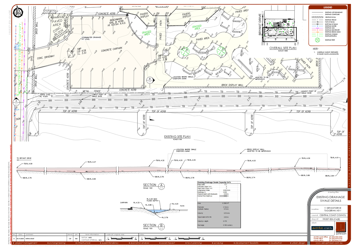
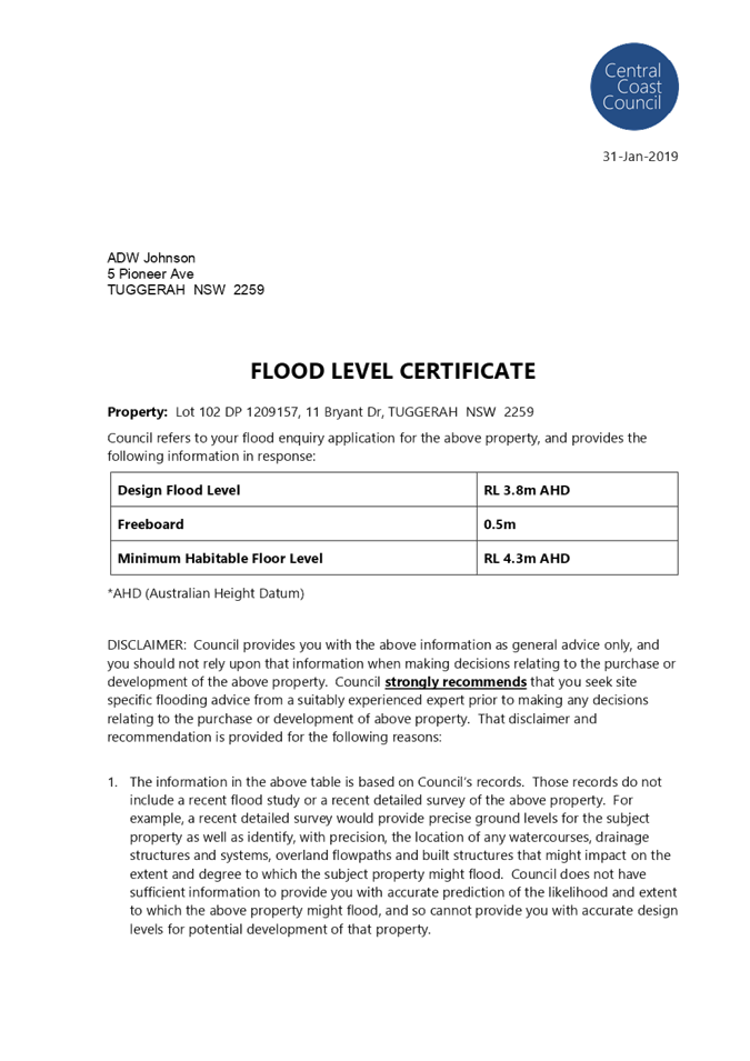
Detailed survey shows: Water would need to reach an elevation of between 4.2 and 4.3m AHD before it begins to flow into the southern driveway |
ADW Johnson agrees that any water ponding within Bryant Drive would need to reach between RL 4.2m and 4.3m prior to overtopping the driveway of the adjoining property. It is however, noted that the drainage system within the adjoining property connects to the stormwater system in Bryant Drive and has a lower finished surface level of between RL 4.04m and 4.11m. This results in water entering the adjoining property via pit surcharge, when water within Bryant Drive reaches RL 4.04m (approximately 20mm after it enters the existing swale).
|
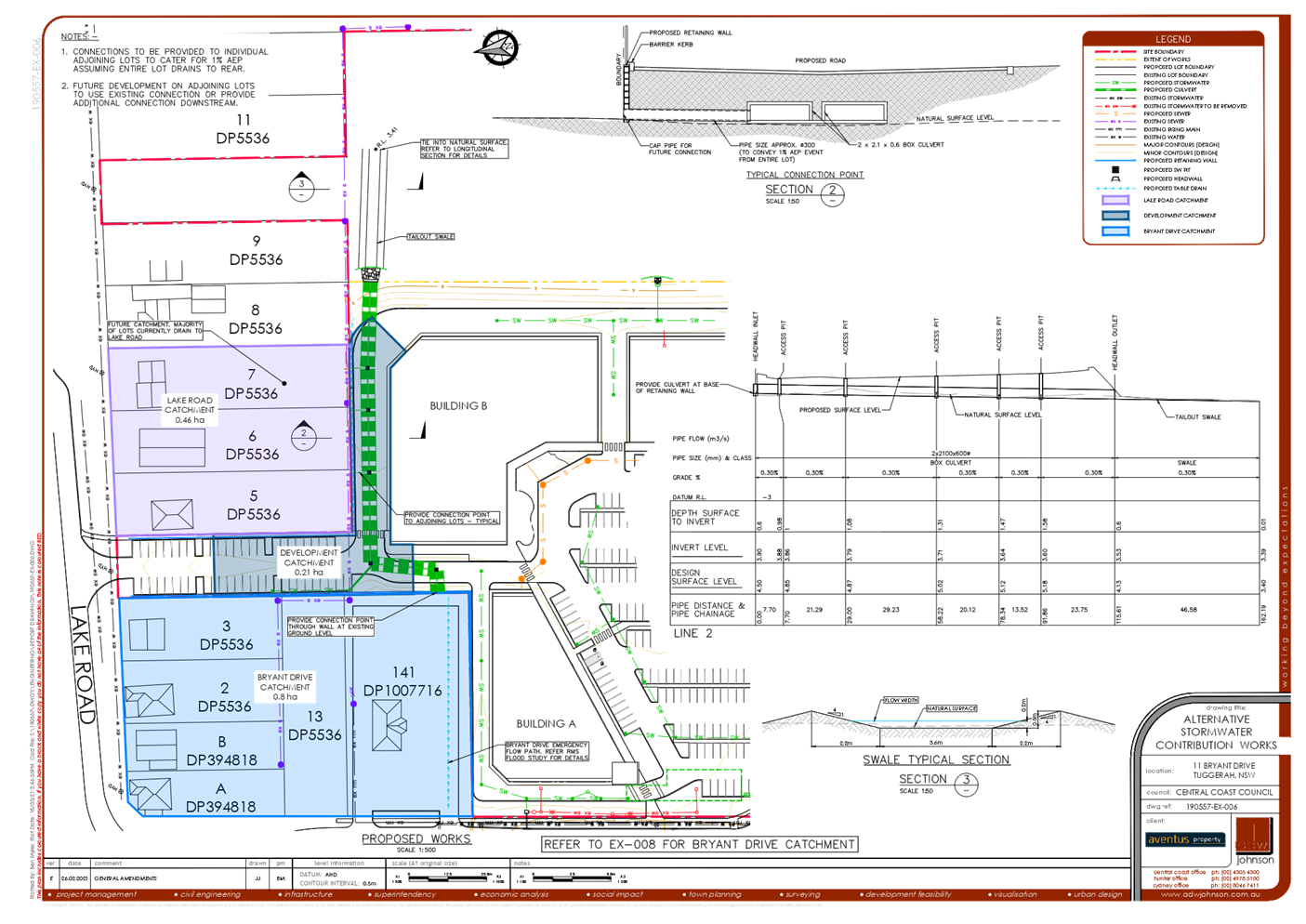
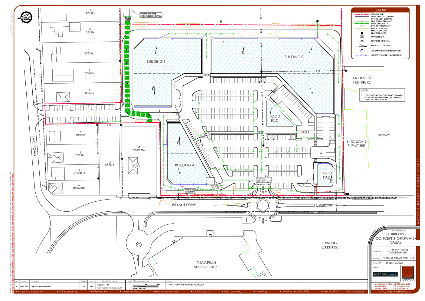
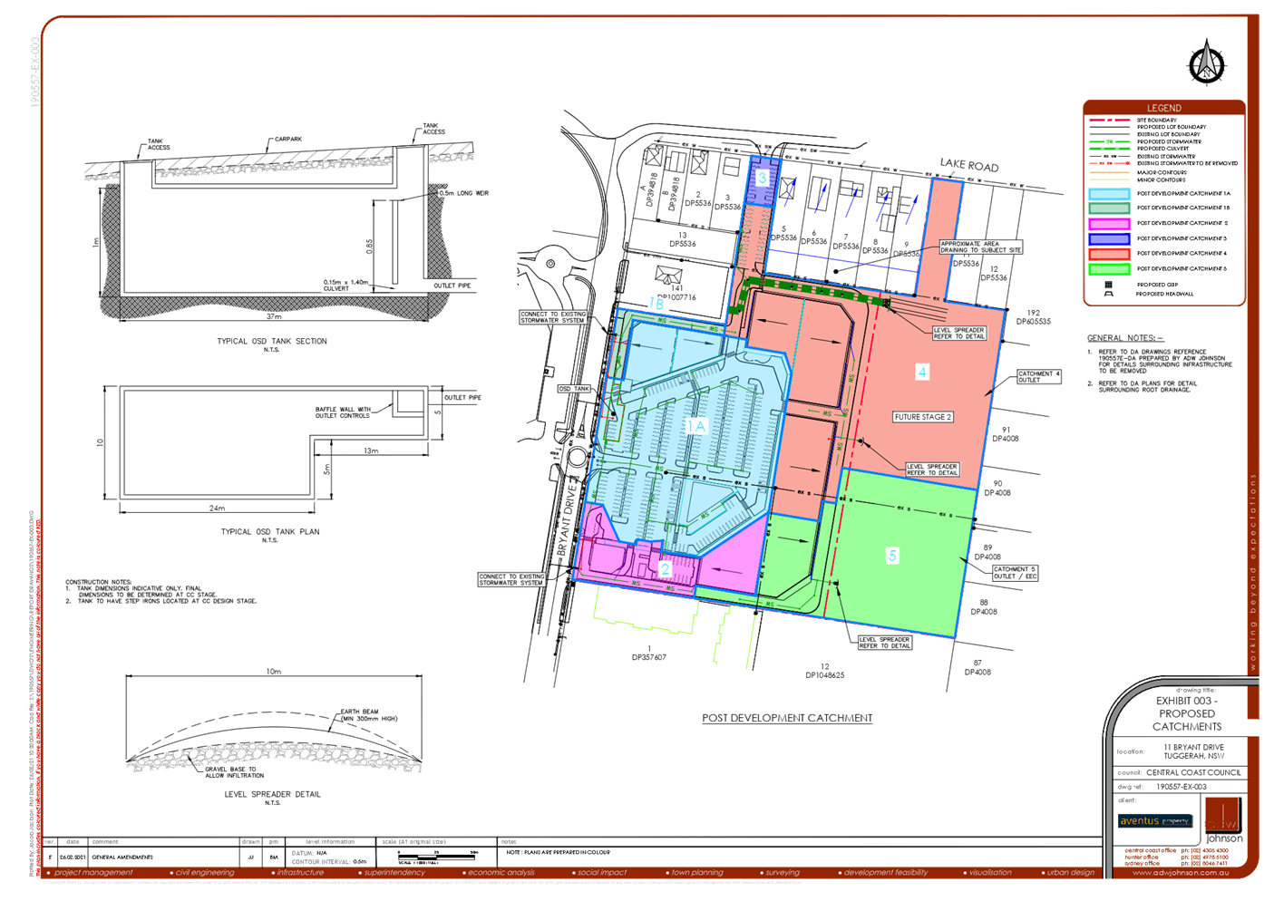
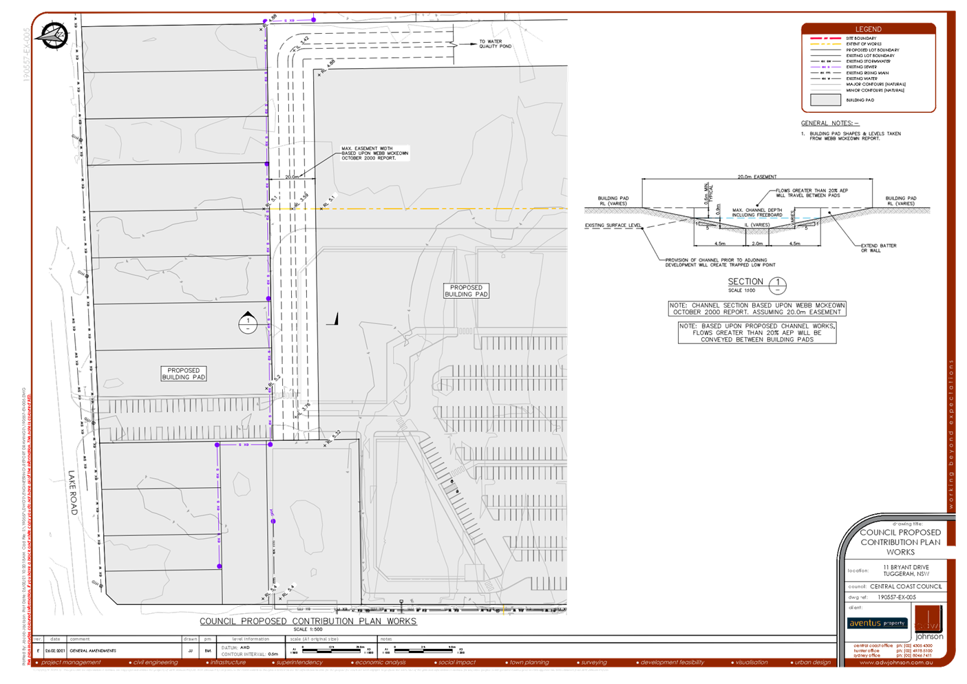
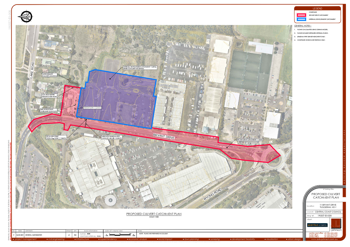
The revised drainage strategy now includes the extension of the flood relief culvert to the Bryant Drive road boundary with a low flow interconnection to the Bryant Drive Drainage system. This culvert begins to operate at RL 3.8m AHD and the main inlet pit begins operating at RL 4.0m AHD. The applicant has indicated that this maintains/reduces the impact of the 1% AEP flood level. |
|
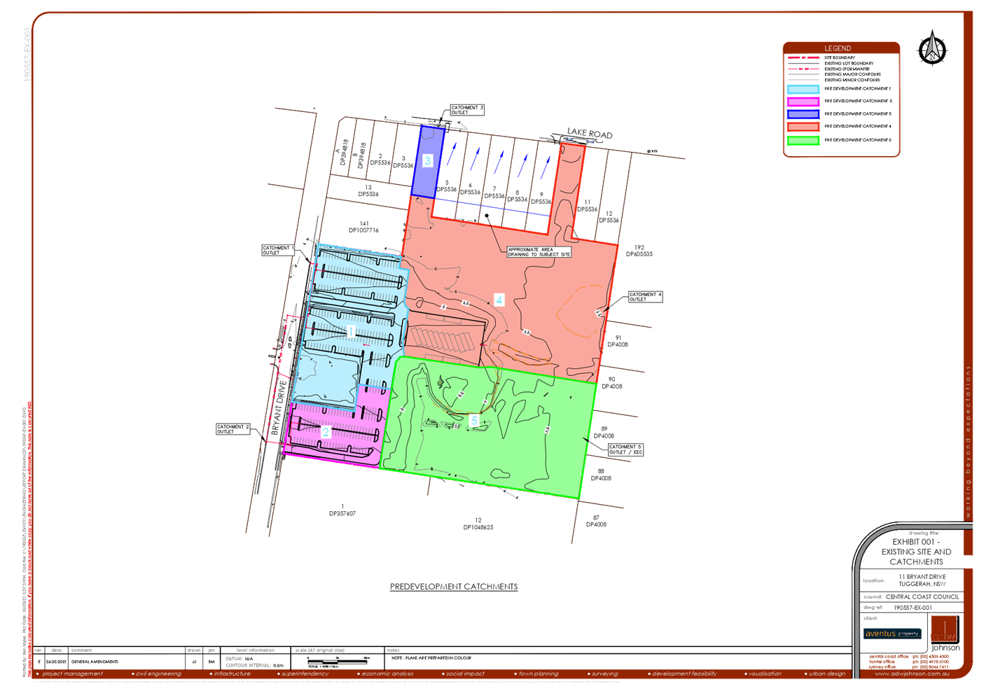
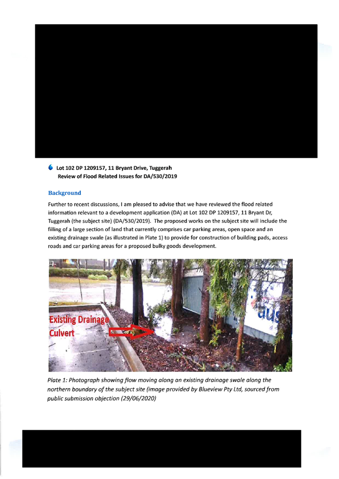
The Survey shows a drainage depression / swale with elevations of between 3.68 and 4.02m AHD along the north-western boundary of the Aventus Site |
Whilst the survey shows that there is a drainage depression / swale along the northern boundary of the Aventus site, it should be noted that the survey also shows that the swale does not explicitly grade to the East and currently grades in a “sawtooth” pattern with the lowest point being RL 3.68 (towards the Bryant Drive end) and the highest being RL 3.88m (towards the eastern end). This means that the depression / swale would not discharge water to the east until the depression has filled up to RL 3.88 (noting that the swale would not start filling up until the flood levels reach RL 4.02m).
Despite the above, ADW Johnson proposes to amend the proposed design to ensure that, at a minimum, the capacity of the existing swale is maintained.
|
The revised drainage strategy (Rev C) addresses this by the extension of the flood relief culvert to the Bryant Drive road boundary. The strategy includes a low flow interconnection to the Bryant Drive Drainage system that begins to operate at RL 3.8m AHD. The main inlet pit begins operating at RL 4.0m AHD. |
|
This flow path creates a direct link from Bryant Drive frontage (4.02m AHD) through to sag location at the rear of 19-21 Bryant Drive (3.74m AHD) and would become active prior to inundation through the adjoining property. |
ADW Johnson agree that this drainage link would convey flows prior to inundation of the adjoining property, however as mentioned above, this would not occur until the swale fills up past RL 3.88m. It is also noted that the swale would break its banks at approximately RL 4.2m and therefore has a minimal flow capacity and the drainage connection from the adjoining property to Bryant Drive results in water entering the site from RL 4.04m.
|
This is addressed in the comments above. The revised strategy has been designed to address the low point on Bryant Drive and convey water towards the rear of the development site consistent with the contributions plan.
|
|
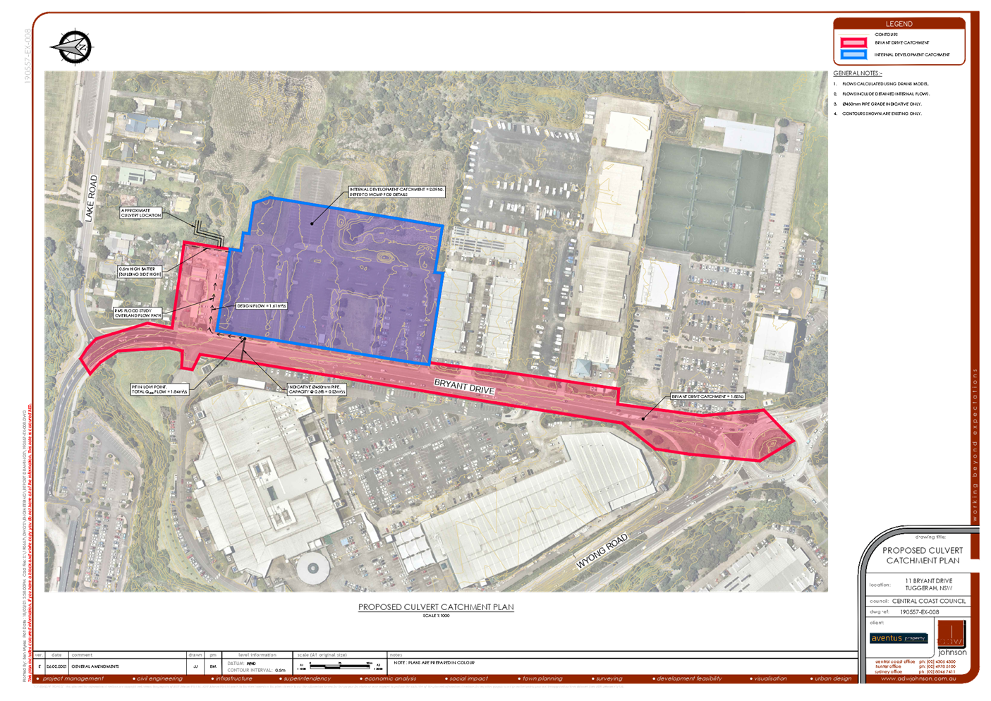
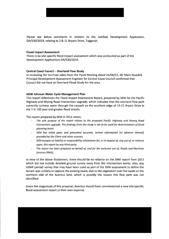
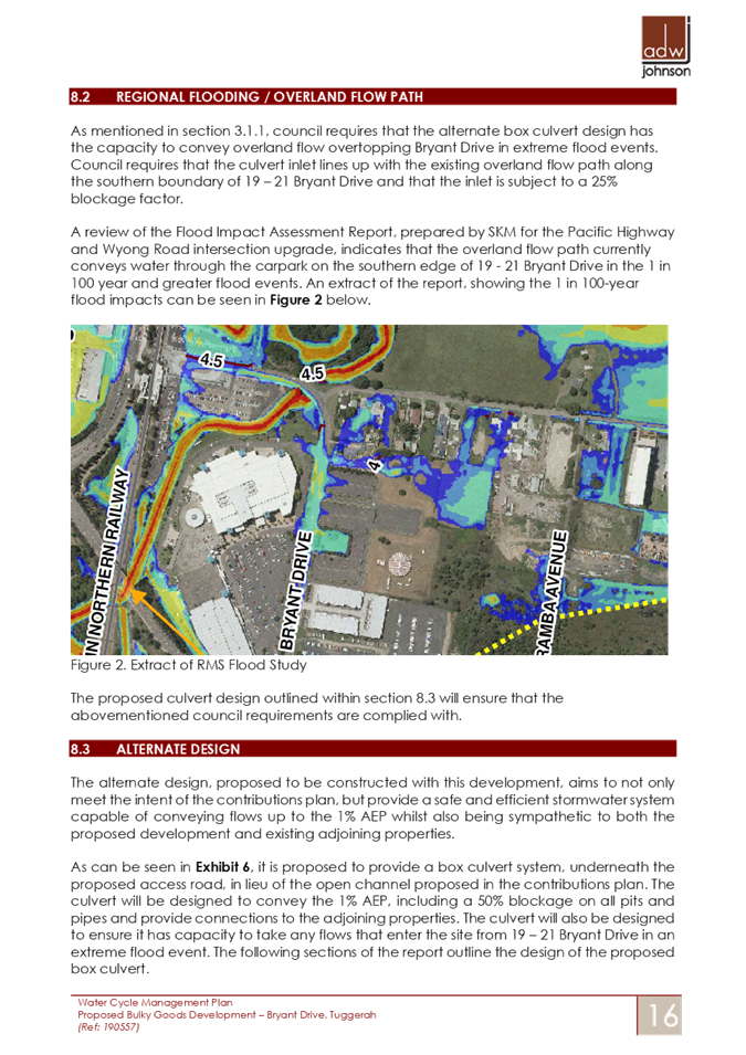
The ADW Johnson report references the Flood Impact Assessment Report, prepared by SKM for the Pacific Highway and Wyong Road Intersection Upgrade |
As mentioned in Section 2, the original concept engineering works were based upon a 1% AEP flood level of RL 3.8m. After the DA had been lodged with Council, ADW Johnson were provided the SKM report and were advised that this was to be adopted as the location of overland flow path. Accordingly, the concept engineering design made provision for a stormwater culvert at the back of the adjoining property to allow flows to continue to the east.
Whilst ADW Johnson were aware of the drainage swale along the northern boundary and that it was likely to convey overflows from Bryant Drive, given the 1% AEP flood level provided by Council (RL 3.8m) and the Bryant Drive verge level (4.02m), it was clear that the filling of this depression would not impact on the flow of flood waters in the 1% AEP event. The stormwater culvert was therefore provided to cater for flows from the adjoining site and for future connections in accordance with the district stormwater Contributions plan. We are proposing to introduce a flood relief culvert independent to the proposed stormwater system capable of discharging more runoff than the existing swale to improve the existing flooding in the adjoining property.
|
The revised Water Cycle Management Plan and Addendum Letter (Revision C) contain the necessary flood impact consideration having regard for the very localised catchment. This includes regard for the SKM Flood Impact Assessment Report for the Pacific Highway and Wyong Road Intersection Upgrade. Mitigation measures for the interim scenario include the extension of the flood relief culvert to the Bryant Drive road boundary with a low flow interconnection to the Bryant Drive Drainage system.
|
|
What the current application is proposing is to delete the existing drainage swale arrangement, fill the land and re-direct the overland flow from the Aventus land to Blueview’s land (adjoining land) |
This statement is incorrect as the application is not proposing to redirect flows to the adjoining property.
The proposed filling on the subject site is required to be undertaken in accordance with the district stormwater Contributions Plan as discussed within the Introduction at Part 1.0 of this document.
The amended design will ensure that the subject development will not adversely impact on any adjoining property.
|
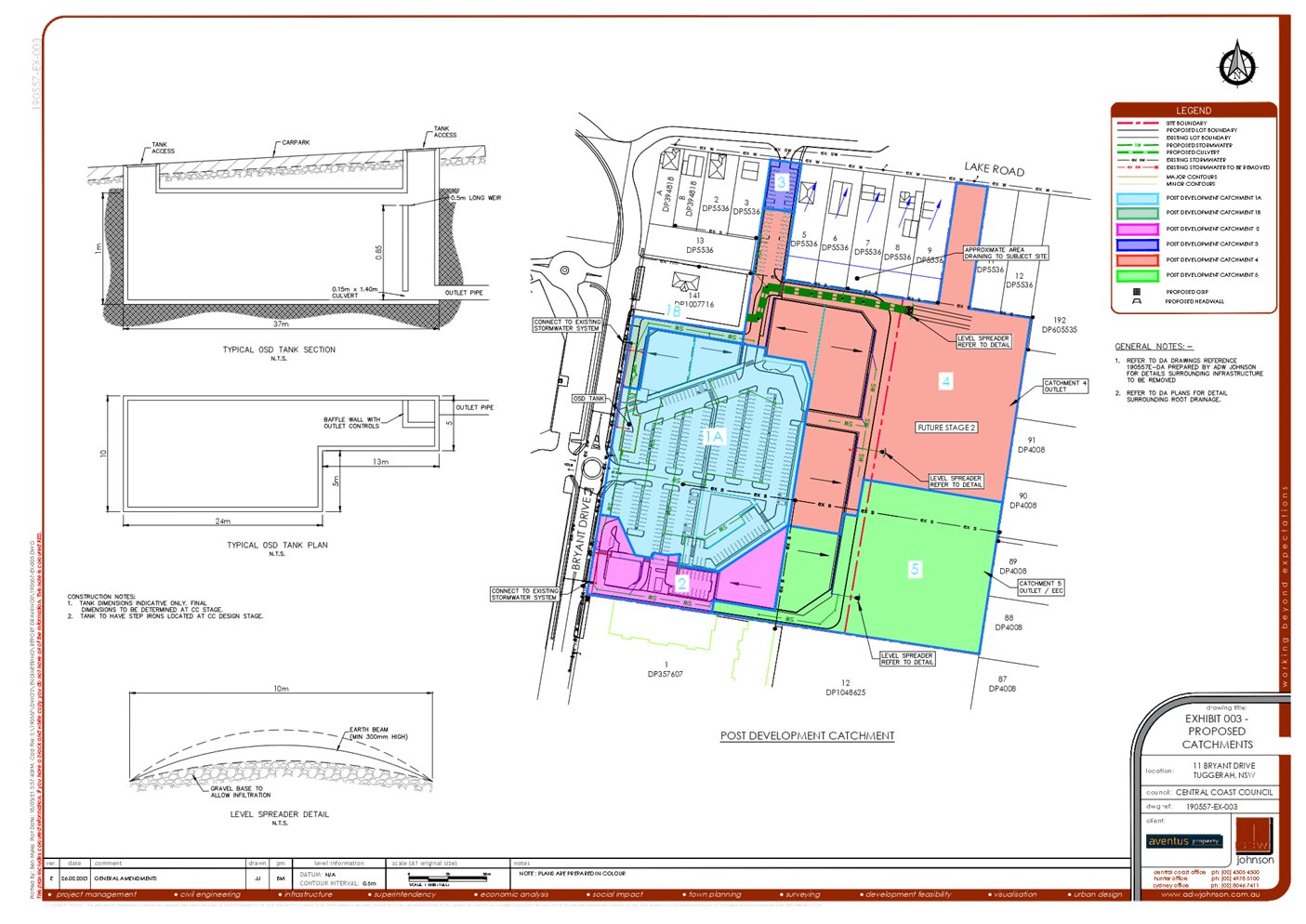
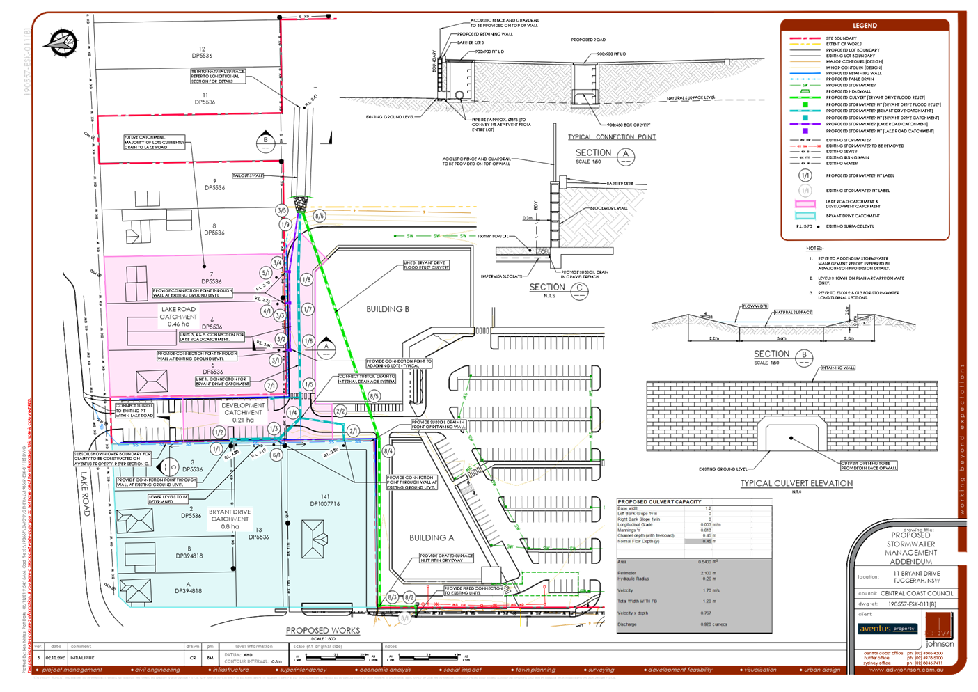
The contributions plan for the area includes a drainage strategy that relies upon filling the land to achieve drainage channels. The proposal includes filling the land as per the contributions plan, and direction of storm water to the east via a series of culverts. The proposal includes a drainage strategy that addresses the “interim scenario” where neighbouring land has not developed to include filling of land as required by the contributions plan. The revised drainage strategy includes the extension of the flood relief culvert to the Bryant Drive road boundary with a low flow interconnection to the Bryant Drive Drainage system.
|
|
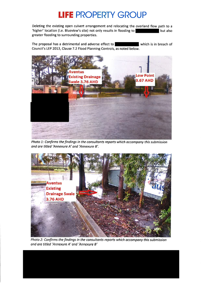
Deleting the existing open culvert arrangement and relocating the overland flow path to a ‘higher’ location (i.e. Blue views site) not only results in flooding to the adjoining property but also greater flooding to surrounding properties. |
Based upon the regional flood RL provided by Council (RL 3.8m) the filling of the drainage swale would not impact on flooding within Bryant Drive in events up to and including the 1% AEP event. Despite the above, ADW Johnson proposes to amend the proposed design to provide a flood relief culvert that improves the existing flooding of the adjoining property.
|
The revised drainage strategy now includes the extension of the flood relief culvert to the Bryant Drive road boundary with a low flow interconnection to the Bryant Drive Drainage system.
|
|
2 – (D14767780) |
|
|
|
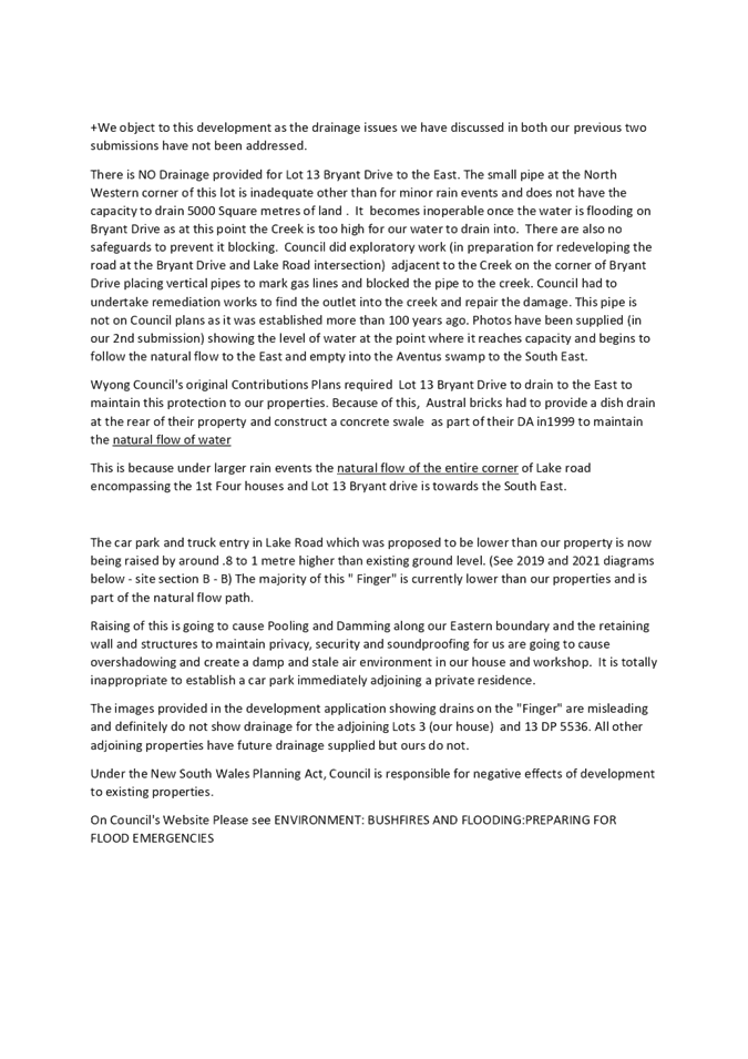
There is no drainage provided for Lot 13 Bryant Drive to the East. The small pipe at the north western corner of this lot is inadequate other than from minor rain events |
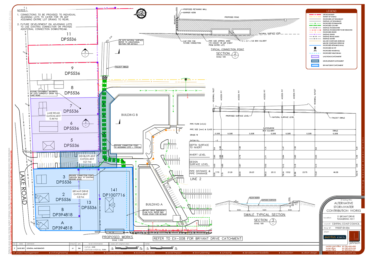
The Bryant Drive / Lake Road intersection design plans show an interelement drainage connection back to Bryant Drive, which is confirmed in the public submission. As such it is considered that Lot 13 has a connection to Bryant Drive and not to the east. Despite this, the original proposal allowed for a connection to this property, however it is understood that this connection was not made clear. Accordingly, the design drawings have been amended to provide a clear connection point to allow overland flows to continue to drain east and to allow for future development in accordance with the district stormwater Contributions plan. Refer to section 5.0 for details of the amended design.
|
The revised drainage strategy proposes 3 separate drainage systems providing a direct connection for all lots at ground level to collect surface water.
As a result of the condition of consent that requires the removal of the parking that from the Lake Road accessway, the surface water connection point will be within the site rather than directly to the boundary with the neighbour, however the neighbour will retain the right to drain into the sytem. |
|
Wyong Council’s original Contributions Plan require 13 Bryant Drive to drain to the east to maintain this protection to our properties |
The Contributions Plan is based upon a fully developed scenario in which Lot 13 (and all surrounding properties) have been filled to above the flood level. This filling would enable fall on Lot 13 to be developed to the east. The Contributions plan is irrelevant in determining the flow of water in the existing scenario, where not all properties have yet been filled and developed as per the Contributions Plan. The design prepared in response to submissions offers an appropriate interim arrangement whereby current flows are retained until such time as the adjoining sites are also filled.
|
The drainage scheme in the contributions plan relies upon the filling of land in order to achieve the overall drainage strategy, and does not identify drainage management in the “interim scenario”. A site specific drainage strategy for the interim is proposed by the applicant. This strategy does not frustrate the future development of adjoining properties in accordance with the strategic plans for the area. |
|
Pooling and damming along our eastern boundary, and block the natural flow of surface and ground water |
Subsoil drainage has been provided. |
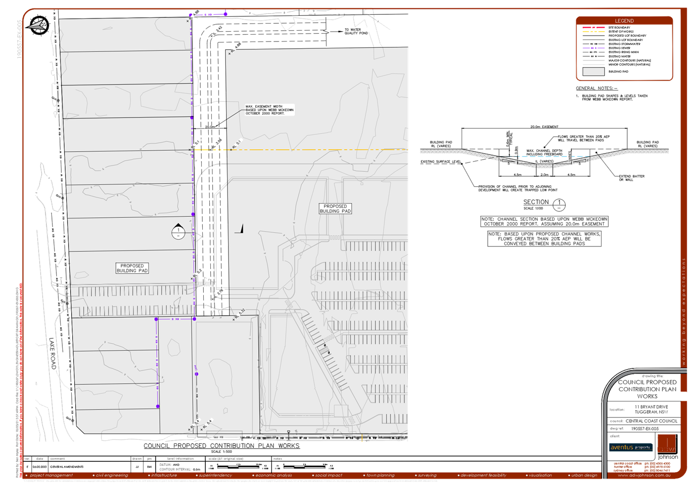
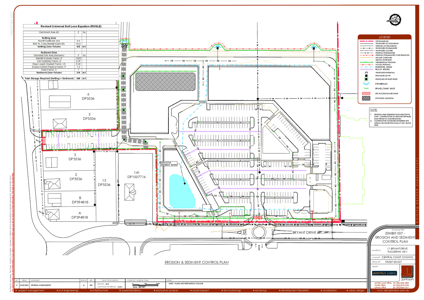
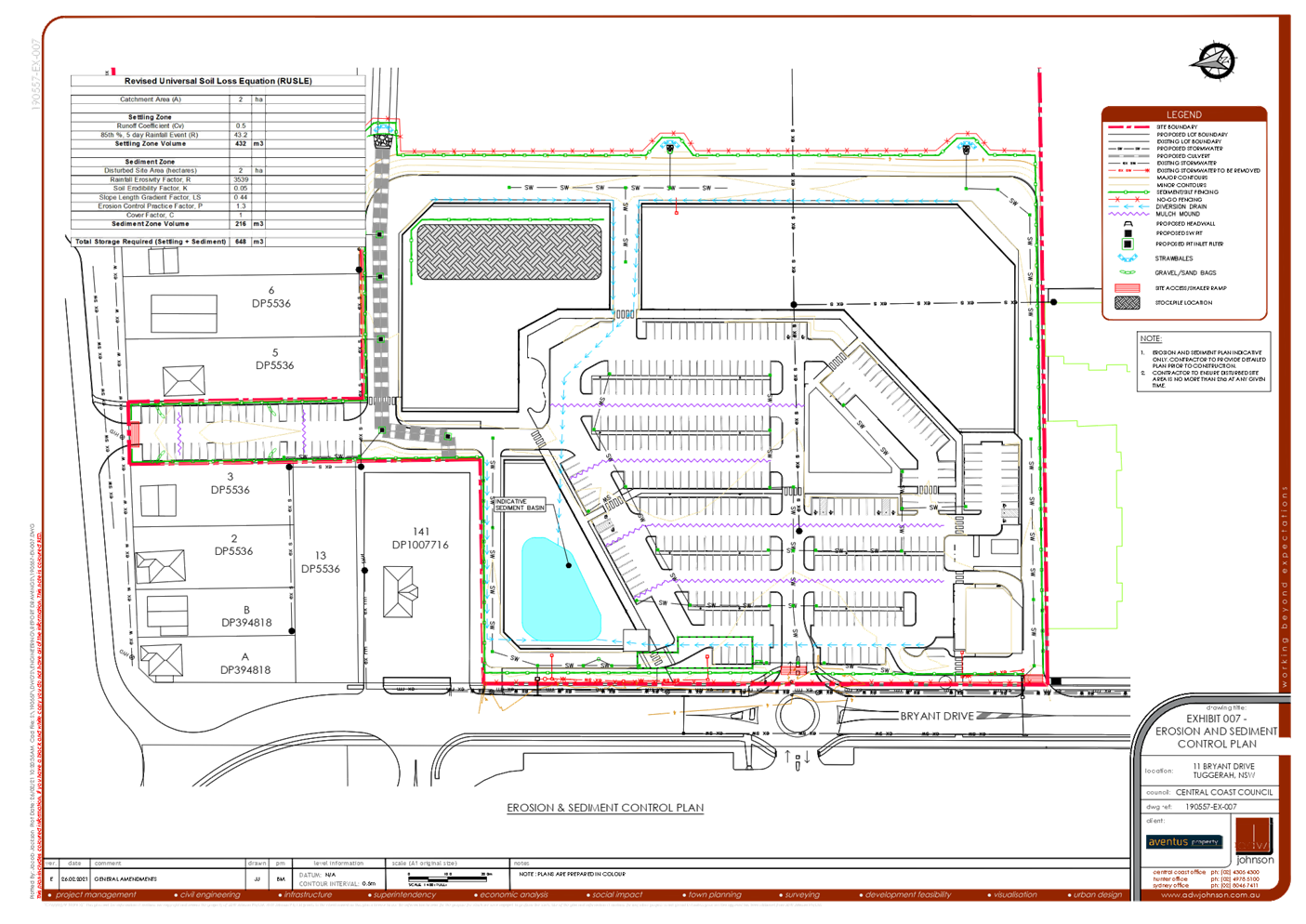
Council’s engineer and planner have further considered surface and subsurface drainage for properties on Lake Road as a result of the filling of part of the site fronting Lake Road to facilitate truck access. Having regard for the concerns raised in public submissions, as a result of Council’s meeting with submitters, and having regard for the information provided within the Water Cycle Management Plan Addendum Letter, additional conditions of consent have been imposed that remove surplus areas of car parking from the lot fronting Lake Road, increasing the setback of areas of fill to 4 metres from the side boundaries with Lake Road properties, and allowing additional opportunities to manage storm water impacts through water quality infiltration measures such as a bioretention filter and subsurface drainage pipework.
Surface water connections to the proposed drainage system will still be provided at this location. |
|
Shadow and dampness from the retaining wall and fencing that provides privacy, security and soundproofing |
Not addressed in additional supplementary information. |
Although half of the boundary retains very close to existing levels, there are impacts associated with the acoustic fence on top of fill towards the rear of the neighbour’s property. Having regard for the concerns of the neighbour, the car parking in this location is not approved for the interim scenario until such time as adjoining properties are developed.
The truck access will be permitted with a pedestrian pathway, and is to be acoustically attenuated with a fence, however the car parking is not approved. As a result of conditions of consent the fill, retaining structures and acoustic fence will be required to be located at a minimum distance of 4 metres from the common boundary with the neighbour Lot 3 and Lot 5 and Lot 13 DP5536 (Condition 2.20).
|
|
Inappropriate to establish a car park immediately adjoining a residence. |
Not addressed in additional supplementary information. |
The car parking is deleted via conditions of consent (Condition 2.20). The use of the part of the site fronting Lake Road in proximity to the dwellings on Lot 3, Lot 5 and Lot 13 DP5536 is limited to delivery access.
|
|
The images provided in the development application showing drains on the “finger”are misleading and definitely do not show drainage for the adjoining lots 3 (our house) and Lot 13 DP5536. All other adjoining properties have future drainage supplied but ours do not. |
We agree that the proposed drainage connections are not clearly shown on the current drawings, however, also confirm that these connections have always been part of the proposed scheme. The amended design outlined within section 5.0 clearly demonstrates connection points for all properties adjoining the Aventus site.
|
The updated Water Cycle Management Plan Addendum Letter (Revision C) indicates adequate surface drainage connection points are proposed for all adjoining properties. |
|
Safety concern for heavy vehicles and cars where there is no guard rail |
Not addressed in additional supplementary information. |
A guard rail will be required to be provided. This is referenced in AS 2890 and is a condition of consent (Condition 2.11).
|
|
How does the boom gate location work with trucks turning from Lake Road |
Not addressed in additional supplementary information. |
The boom gate is required to be located with sufficient queuing inside the property boundary to accommodate the length of the longest permitted vehicle (semi-trailer 19m). This is imposed as a condition of consent (Condition 2.11).
|
|
How is noise policed |
Not addressed in additional supplementary information. |
The conditions of consent 2.19, 3.14, 4.2, 5.4, 5.5, 6.3 address construction and operational noise impacts. Non-compliance with operational conditions of consent in relation to noise impacts can be investigated by Council’s compliance officers in response to a noise complaint.
|
|
3 – (D14751641) |
|
|
|
Traffic impacts and safety and efficiency of the Bryant Drive and Wyong Road intersection |
Not addressed in additional supplementary information. |
Refer to comments in relation to traffic contained within the assessment report of 24 June 2021 provided as attachment 2.
|
2 The matter is to be reported back to the Panel for determination within 28 days of the closing date for submissions in accordance with 1. above.
Noted. In order to provide the applicant an opportunity to adequately address the matters raised in submissions, this timeframe was extended.
3 This report should include information detailing the basis on which contributions are being levied, including the net developable area for contributions that have been paid and contributions that are proposed.
The Panel require clarification as to the methodology for the calculation of the contributions, having regard for historical approvals on the site.
Council’s contributions officer has provided further information in relation to the calculation of contributions for the information of the Panel:
The contributions have been re-calculated to take into account the latest indexing and to include credit for the roads and drainage contributions that were previously paid under Development Application 2438/2000.
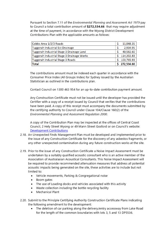
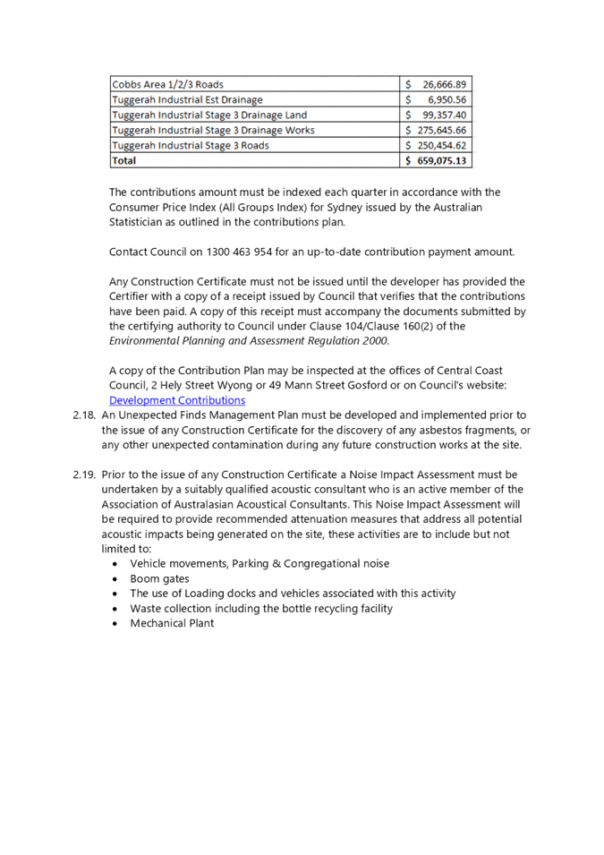
The application falls under Wyong District s7.11 Contributions Plan. The following contributions are applicable:
Tuggerah Industrial estate stage 3 drainage land & works
Tuggerah Industrial Estate drainage – segment D (0.92 ha only)
Roads – Wyong Rd/Bryant Dr/Pacific Hwy/ Cobbs Rd
Roads – Tuggerah Industrial Estate stage 3
The total site area is 3.55 hectares. The contributions have been calculated based on a total net developable area (NDA) of 1.45 hectares.
The NDA takes into account a credit for the roads and drainage contributions paid over that part of the site occupied by the existing carpark. The previous contributions relating to the existing carpark, were paid under DA/2438/2000, and were based on an NDA of 2.1 hectares.
Only part of the proposed development (0.92 ha) is within the drainage scheme for segment D, and that specific contribution has been calculated based on an NDA of 0.92 ha (instead of 1.45 ha).
The total s7.11 contributions are $272,534.66. The contributions are subject to quarterly indexation.
Conclusion
The application was re-notified to surrounding properties and three submissions were received. The applicant has submitted a Water Cycle Management Plan Addendum Letter (Revision C) in response to the submissions raised, and Council have met with submitters in relation to this document.
The additional storm water measures proposed by the applicant in this document have been further revised via conditions of consent to ensure an adequate storm water management outcome at the interface with adjoining properties. A detailed explanation of the calculation of s7.11 contributions has been provided and the recommended condition of consent has been revised having regard for indexing.
The original assessment report, which was considered by the Panel on 24 June 2021, and this supplementary report, have had regard for the matters for consideration of Section 4.15 of the Environmental Planning & Assessment Act 1979 and all relevant instruments, plans and policies. The potential constraints of the site have been assessed and it is considered that the site is suitable for the proposed development.
Subject to the imposition of appropriate conditions, it is recommended that the Local Planning Panel grant consent to DA/530/2019 for a Mixed Use Development comprising Specialised Retail Premises, Signage and Food and Drink Premises on 2 & 11 Bryant Drive, Tuggerah.
|
1⇩ |
Water Cycle Management Plan - Addendum Letter - Revision C |
|
D14969458 |
|
2⇩ |
LPP Report & All Attachments 24 June 2021 |
|
D14987653 |
|
3⇩ |
Minutes of LPP meeting 24 June 2021 with Item No 4.1 only |
|
D14987688 |
|
4⇩ |
Revised Recommended Conditions of Consent |
|
D14985743 |
|
2.1 |
Supplementary Report - DA/530/2019 - 2 & 11 Bryant Drive Tuggerah - Mixed Use Development comprising Specialised Retail Premises, Signage and Food and Drink Premises - (Agenda Item 4.1 Local Planning Panel meeting 24 June 2021) |
|
Attachment 1 |
Water Cycle Management Plan - Addendum Letter - Revision C |


|
Supplementary Report - DA/530/2019 - 2 & 11 Bryant Drive Tuggerah - Mixed Use Development comprising Specialised Retail Premises, Signage and Food and Drink Premises - (Agenda Item 4.1 Local Planning Panel meeting 24 June 2021) |
|
|
Attachment 2 |
LPP Report & All Attachments 24 June 2021 |


|
Supplementary Report - DA/530/2019 - 2 & 11 Bryant Drive Tuggerah - Mixed Use Development comprising Specialised Retail Premises, Signage and Food and Drink Premises - (Agenda Item 4.1 Local Planning Panel meeting 24 June 2021) |
|
|
Attachment 3 |
Minutes of LPP meeting 24 June 2021 with Item No 4.1 only |