 |
Central Coast
Local Planning Panel Meeting
Business Paper
24 March 2022
 |
|
Central Coast
Local Planning Panel Meeting
Business Paper
24 March 2022
|
The Local Planning Panel Meeting
of Central Coast
will be held remotely - online,
Thursday 24 March 2022 at 2.00 pm,
for the transaction of the business listed below:
1 Procedural Items
1.1 Disclosures of Interest.............................................................................................................................. 3
2 Confirmation of Minutes of Previous Meetings
2.1 Confirmation of Minutes of Previous Meeting................................................................................. 4
3 Planning Reports
3.1 DA/63281/2021 - 40 Webb Road Booker Bay - Dual Occupancy Attached and Demolition of Existing Dwelling........................................................................................................................................ 8
3.2 DA/1508/2021 - 11 Trelawney Street, Killarney Vale - Demolition of existing & new dwelling..................................................................................................................................................................... 109
4 Planning Reports- Outside of Public Meeting
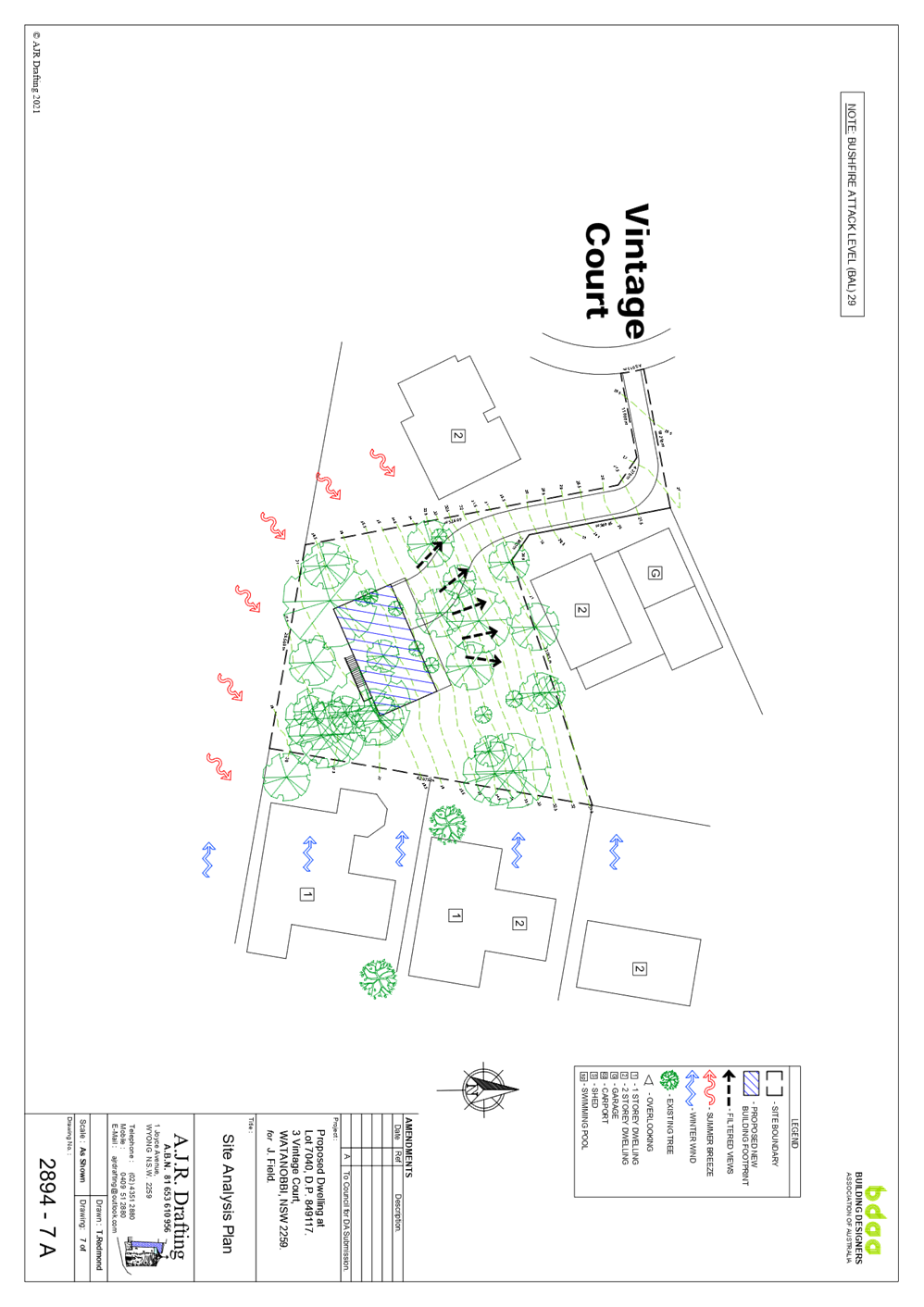
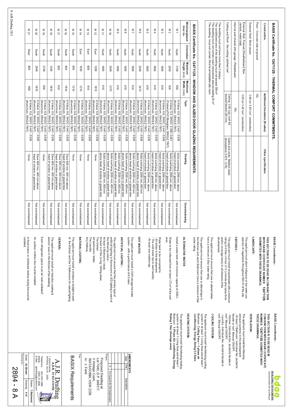
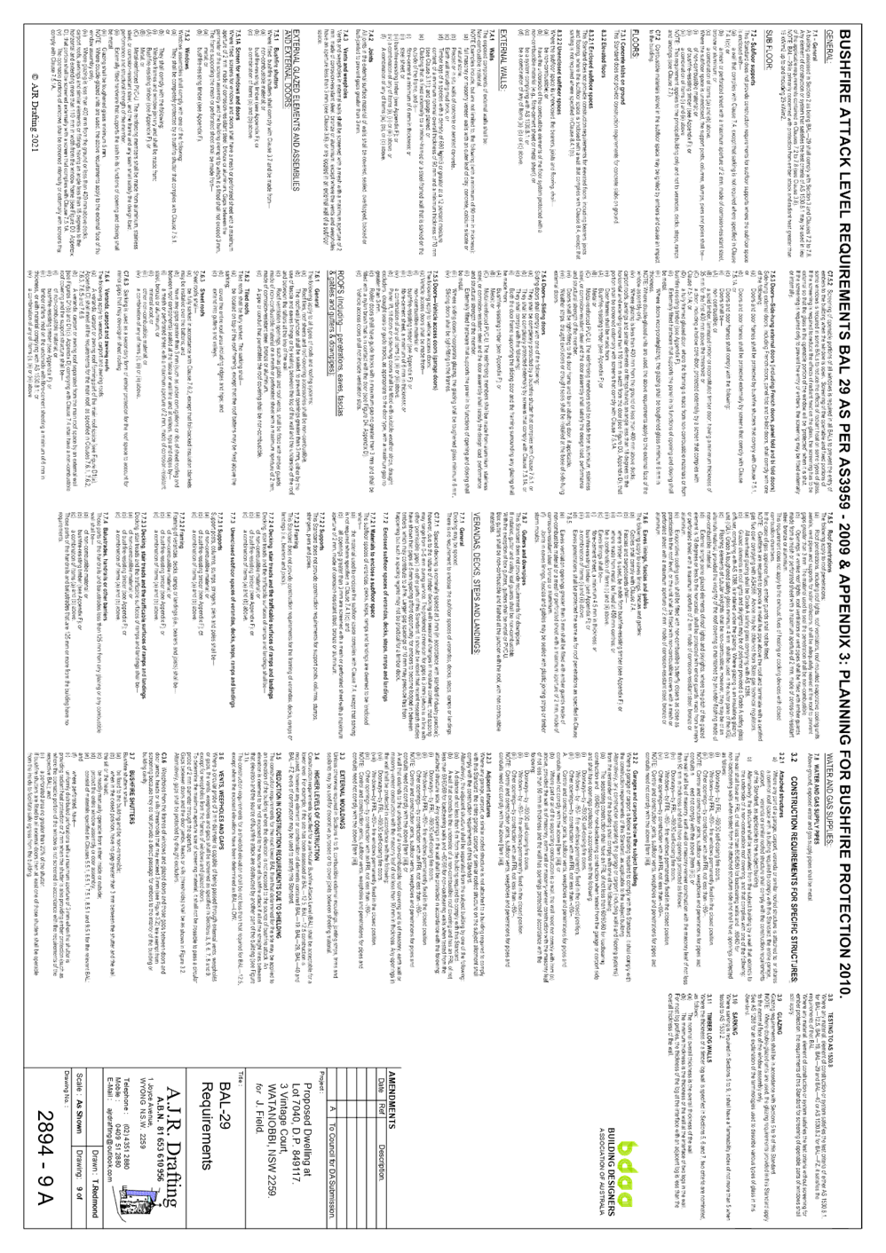
4.1 DA/1825/2021 - 3 Vintage Court, Watanobbi - Construction of New Dwelling Including Tree Removal.................................................................................................................................................... 164
Donna Rygate
Chairperson
|
Item No: 1.1 |
|
|
Title: Disclosures of Interest |
|
|
Department: Governance |
|
|
24 March 2021 Local Planning Panel Meeting |
|
Reference: F2020/02502 - D14205789
|
The NSW Local Planning Panel Code of Conduct states that all panel members must sign a declaration of interest in relation to each matter on the agenda before or at the beginning of each meeting.
|
That Panel Members now confirm that they have signed a declaration of interest in relation to each matter on the agenda for this meeting and will take any management measures identified.
|
Item No: 2.1 |
|
|
Title: Confirmation of Minutes of Previous Meeting |
|
|
Department: Corporate Affairs |
|
|
24 March 2022 Local Planning Panel Meeting |
|
Reference: F2020/02502 - D15082152
Author: Rachel Callachor, Meeting Support Officer
|
Summary
The
Minutes of the following Meetings of the Local Planning Panel, which have
been endorsed by the Chair of that meeting, are submitted for noting: · Local Planning Panel Meeting held on 24 February 2022 |
That the minutes of the previous Local Planning Panel Meeting held on 24 February 2022 which were endorsed by the Chair of that meeting, are submitted for noting.
|
1⇩ |
MINUTES - Local Planning Panel - 24 February 2022 |
|
D15057396 |
|
2.1 |
Confirmation of Minutes of Previous Meeting |
|
Attachment 1 |
MINUTES - Local Planning Panel - 24 February 2022 |
|
Item No: 3.1 |
|
|
Title: DA/63281/2021 - 40 Webb Road Booker Bay - Dual Occupancy Attached and Demolition of Existing Dwelling |
|
|
Department: Environment and Planning |
|
|
24 March 2022 Local Planning Panel Meeting |
|
Reference: DA/63281/2021 - D15062130
Author: Amy Magurren, Development Planner
Manager: Ailsa Prendergast, Section Manager, Development Assessment South
Approver: Andrew Roach, Unit Manager, Development Assessment
|
Summary
An application has been received for Dual Occupancy Attached and Demolition of Existing Dwelling. The application has been examined having regard to the matters for consideration detailed in section 4.15 of the Environmental Planning and Assessment Act and other statutory requirements with the issues requiring attention and consideration being addressed in this report.
The development application has been referred to the Local Planning Panel as a result of the number of submissions objecting to the proposal. A total of 15 submissions were received by Council during the notification period.
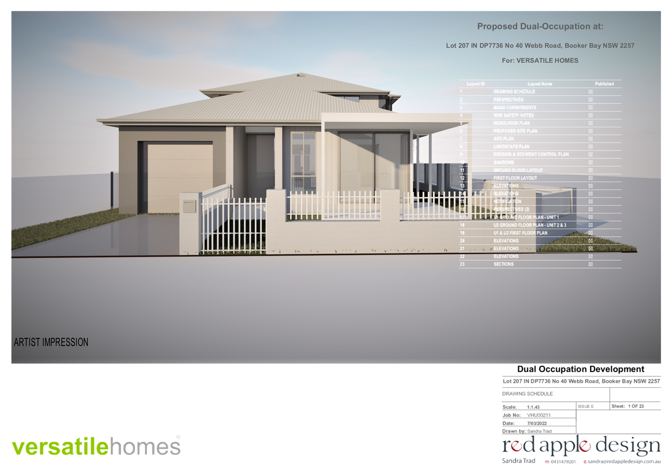
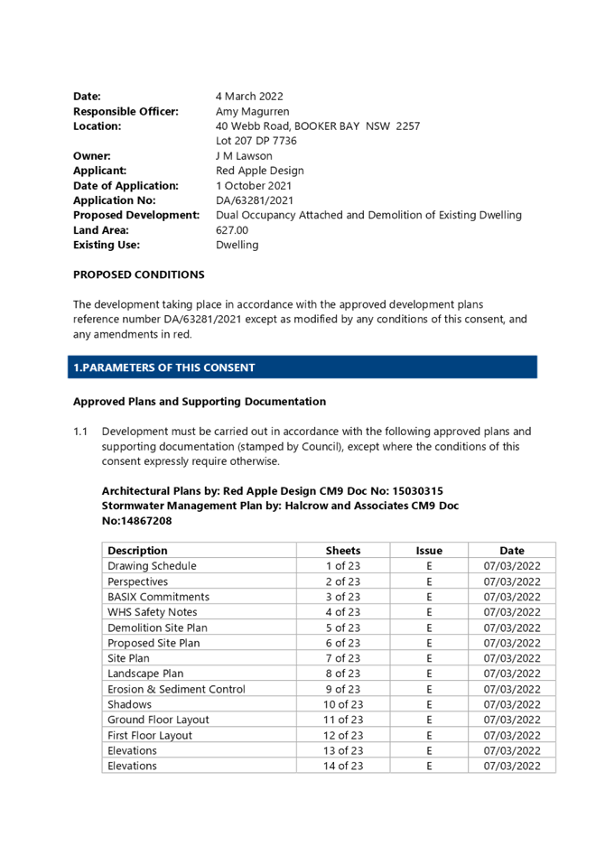
Applicant Red Apple Design Owner J M Lawson Application No DA/63281/2021 Description of Land Lot 207 in DP 7736, 40 Webb Road, BOOKER BAY Proposed Development Dual Occupancy Attached and Demolition of Existing Dwelling Site Area 627m2 Zoning R1 General Residential Existing Use Dwelling House Employment Generation No Estimated Value $495,529
|
1 That the Local Planning Panel grant consent to DA/63281/2021 – 40 Webb Road Booker Bay – Dual Occupancy Attached and Demolition of Existing Dwelling subject to the conditions detailed in the schedule attached to the report and having regard to the matters for consideration detailed in Section 4.15 of the Environmental Planning and Assessment Act 1979.
2 That Council advise those who made written submissions of the Panel’s decision.
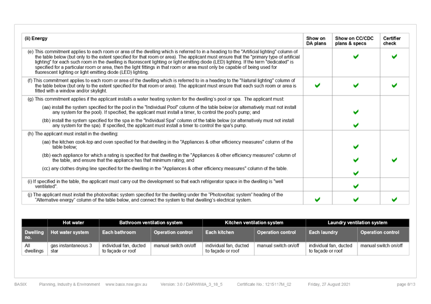
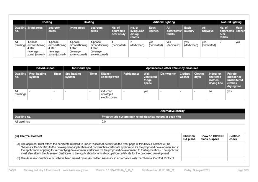
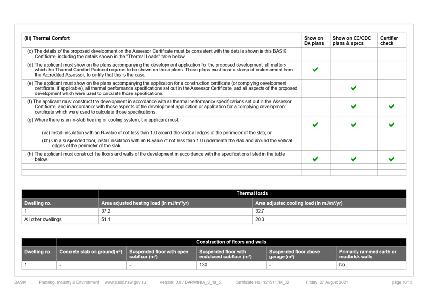
Key Issues
· Non-compliance with Chapter 3.2.3.6.2 of the Gosford Development Control Plan 2013 - Façade Articulation Controls.
· Matters raised in public submissions, including removal of trees and amenity.
Precis:
|
Proposed Development |
Dual Occupancy Attached and Demolition of Existing Dwelling |
|
Permissibility and Zoning |
The subject site is zoned R1 General Residential under Gosford Local Environmental Plan 2014 (GLEP 2014)
dual occupancy (attached) means 2 dwellings on one lot of land that are attached to each other, but does not include a secondary dwelling.
|
|
Relevant Legislation |
The following planning policies and control documents are relevant to the development and were considered as part of the assessment.
· Environmental Planning & Assessment Act 1979 - Section 4.15 · Local Government Act 1993 - Section 89 · State Environmental Planning Policy No 55 Remediation of Land (SEPP 55) · State Environmental Planning Policy (Coastal Management) 2018 · State Environmental Planning Policy (Building Sustainability Index: BASIX) 2004 · Gosford Local Environmental Plan 2014 · Gosford Development Control Plan 2013
|
|
Current Use |
Dwelling House
|
|
Integrated Development |
No |
|
Submissions |
15 Submissions
|
Variations to Policies
|
Clause |
3.2.3.6.2 Façade Articulation Controls
|
|
Standard |
The “unarticulated length” of any exterior wall should not exceed 8m.
|
|
LEP/DCP |
Gosford Development Control Plan 2013
|
|
Departure basis |
13m or 163% to the south elevation.
|
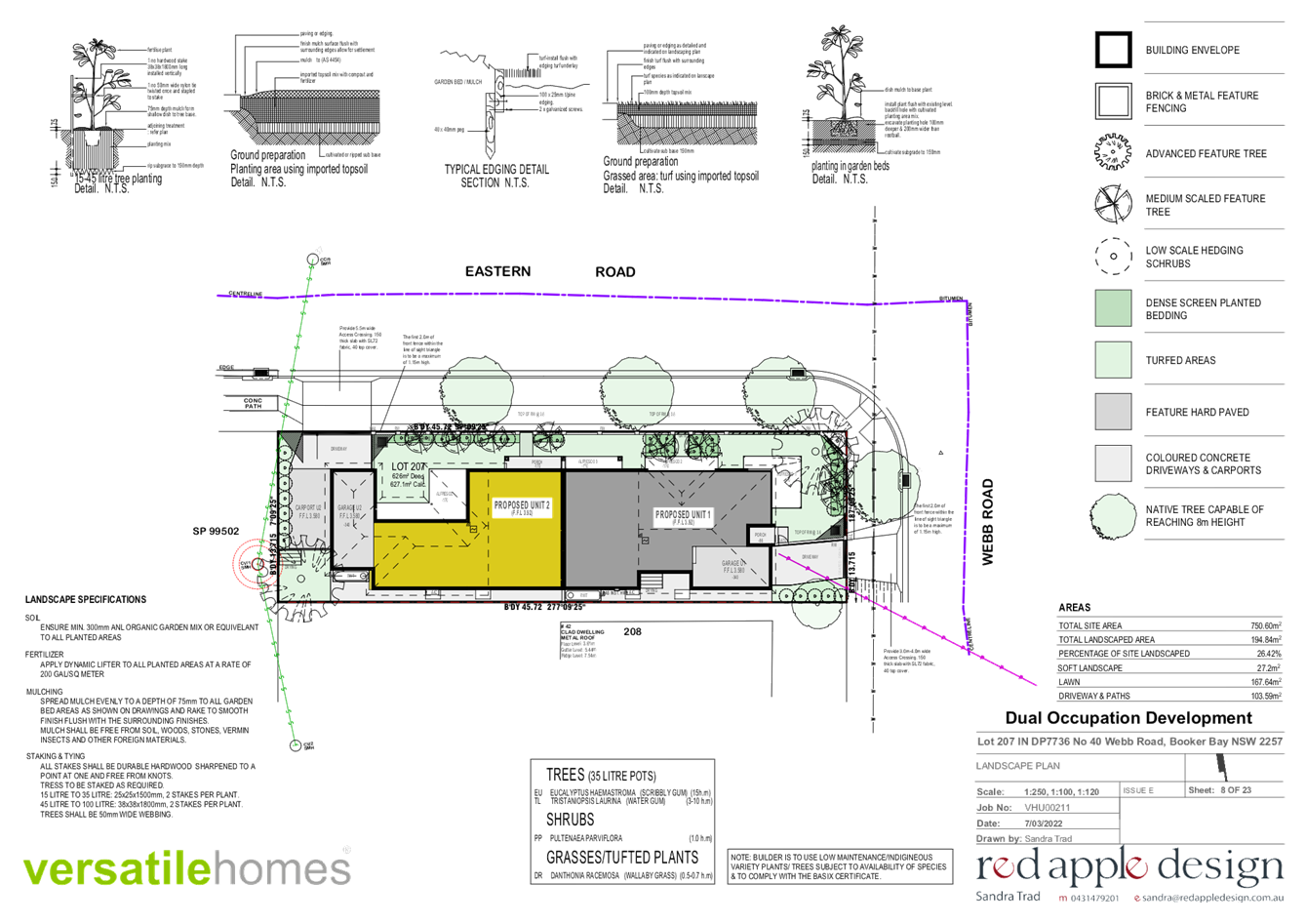
The Site
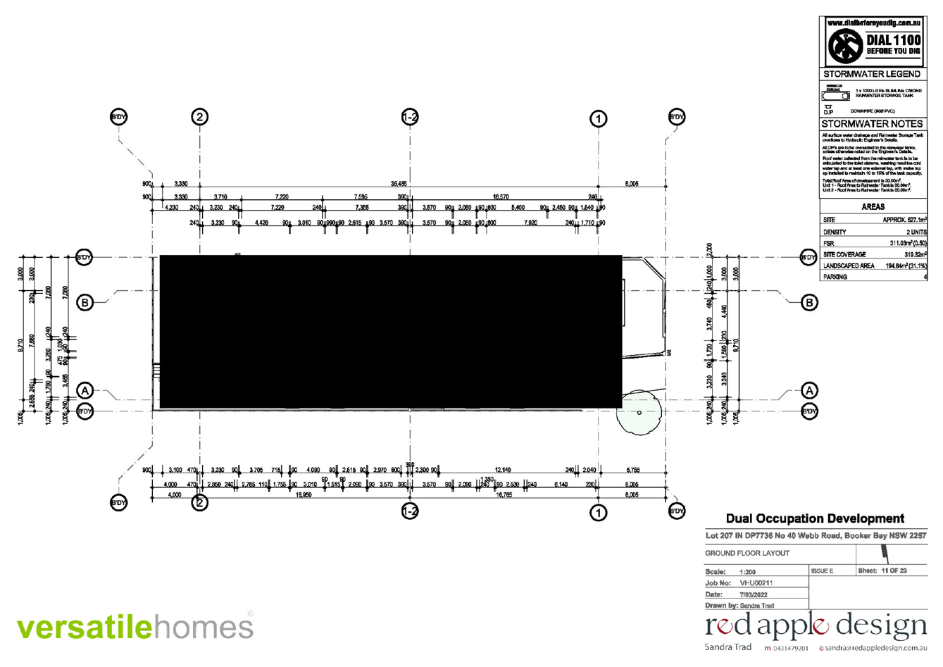
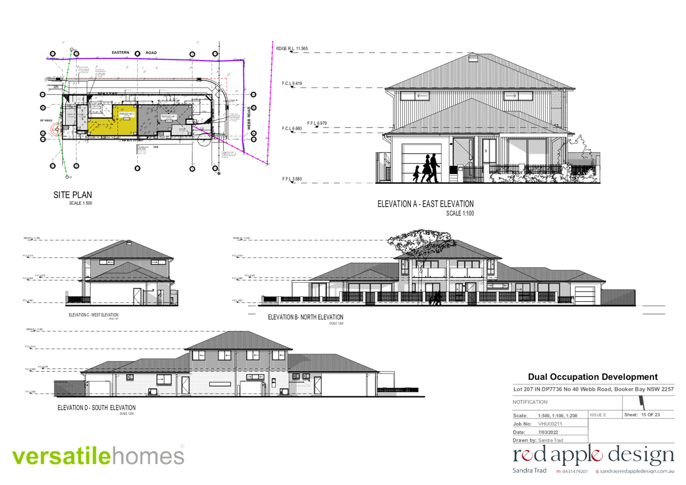
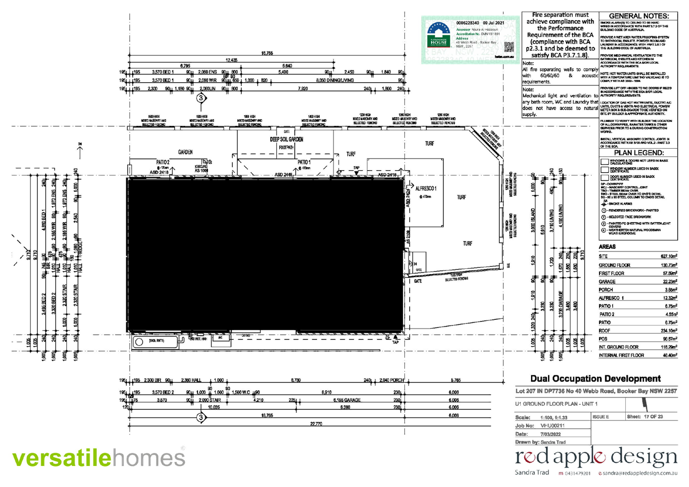
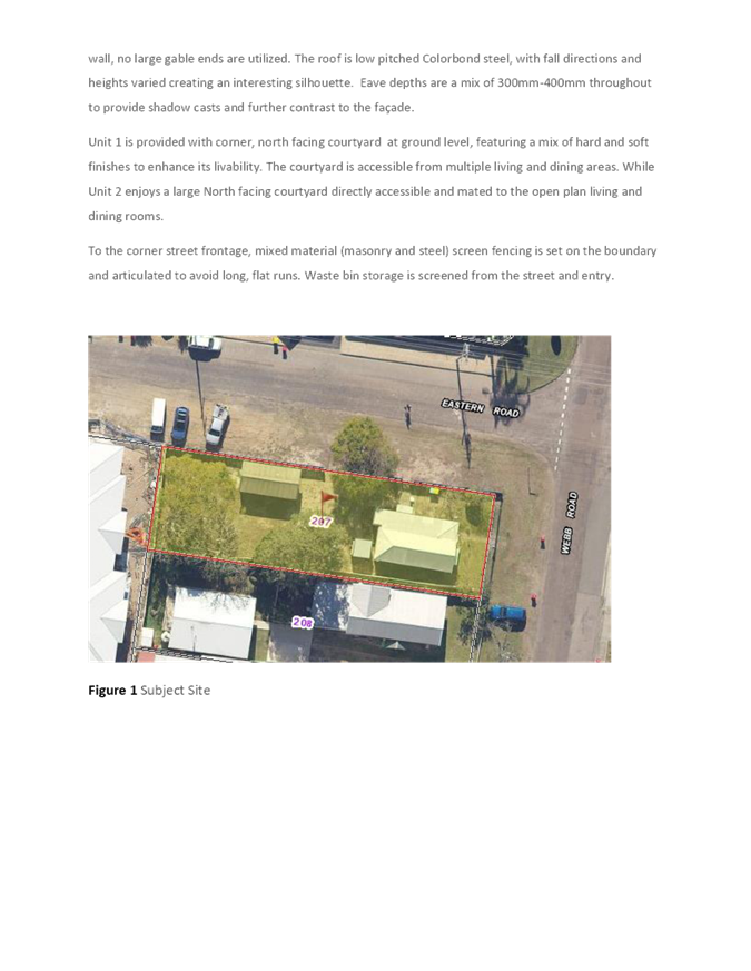
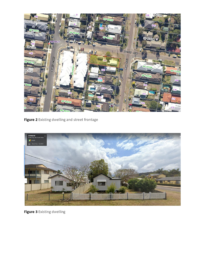
The site is described as Lot 207 DP 1136, 40 Webb Road Booker Bay having an area of 627m2, with frontage to both Webb Road (13.715m) and Eastern Road (45.72m) (Figure1).
The site is regular in shape and located on the south western side of the intersection between Webb Road and Eastern Road. The topography has a mild slope from to the north of 0.10m.
The site contains an existing single-storey clad, steel roofed dwelling and a freestanding garage/shed. Adjoining development comprises low density residential developments (Figure 2).
The site is not identified as being "bushfire prone land" on Council's bushfire maps. A mature Apple Gum is centrally located on the site close to the boundary of 42 Webb Road. Three (3) mature Jacaranda trees are also located within the site.
Council’s sewer main traverses the site in a south/north direction on the very western edge of the lot. The proposed development will not impact sewerage easements or existing line of pipes across the site.
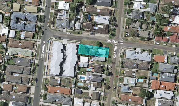
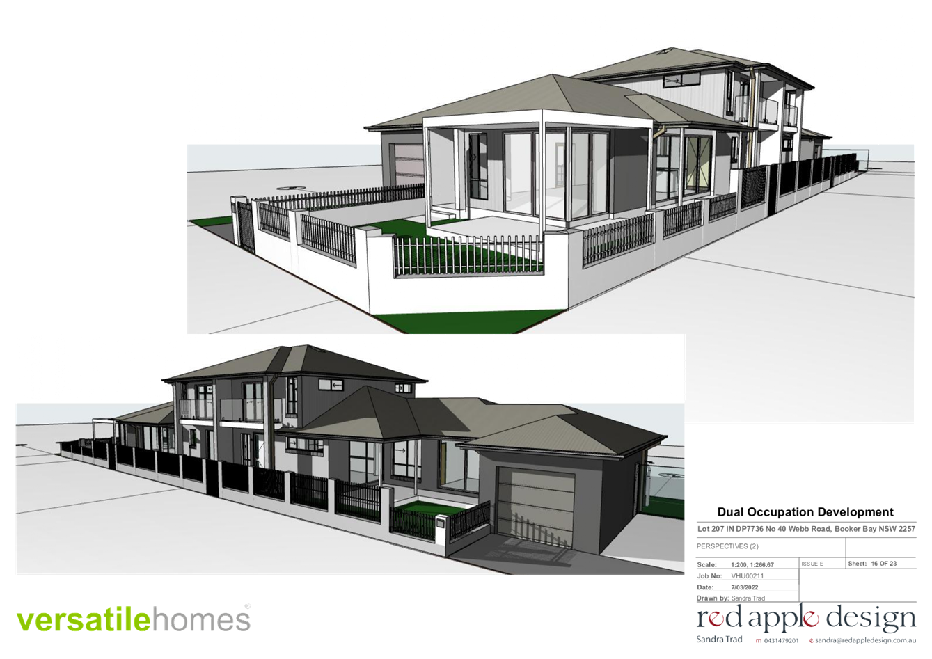
Figure 1 - The proposed development and surrounding site.
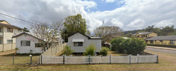
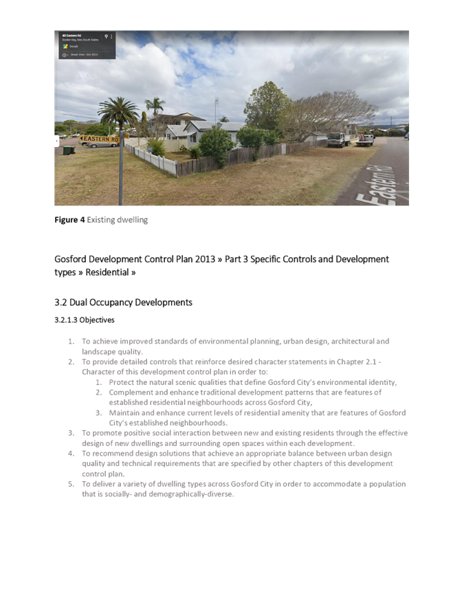
Figure 2 - Existing dwelling as viewed from Webb Road
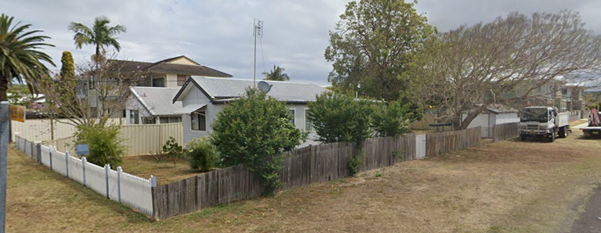
Figure 3 – Existing dwelling as viewed from the intersection of Webb and Eastern Road
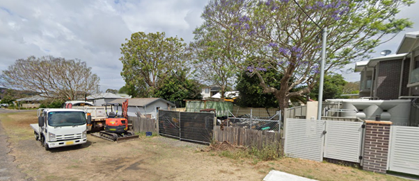
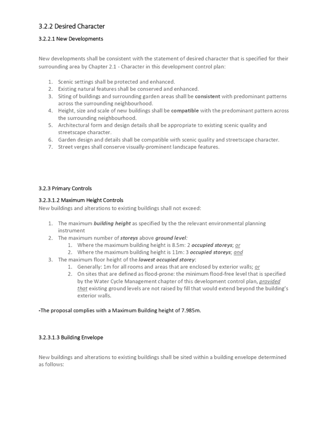
Figure 4 – Existing dwelling as viewed from Eastern Road
Surrounding Development
The site is located within a low-density residential area, characterised by a mixture of one and two storey dwellings, dual occupancies and multi dwelling housing. Adjoining the site to the south is a single storey dwelling being 42 Webb Road, dual occupancies are located to the north and east of the site being 36-38 Webb Road and 27 Webb Road. To the rear of the site is a multi dwelling housing development being 20 Murray Street.
Approximately 250m to the south west of the site is the “Galleria” Commercial precinct at Ettalong Beach. Both Bus and Ferry public transport is located to the south of the site on Booker Bay Road and Ferry Road.
The Proposed Development
The proposed development is for Dual Occupancy (attached) development and comprises the following:
· Demolition of the existing dwelling and all site improvements;
· Removal of all existing site trees including an Apple Gum and 3 Jacarandas;
· Construction of a two-storey dual occupancy development containing 2 units;
· Access to the site and associated road works; and
· Landscaping
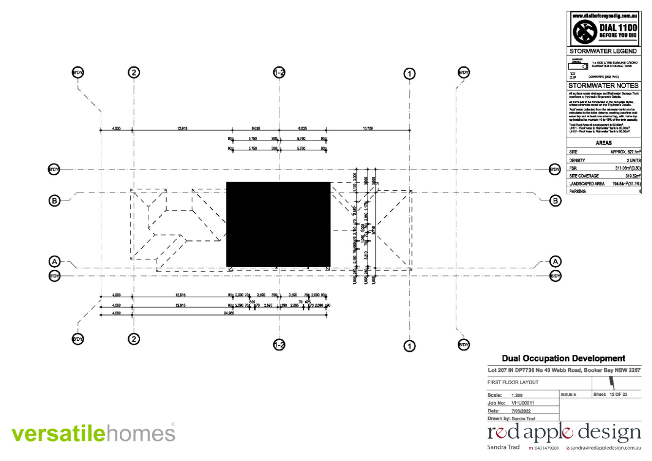
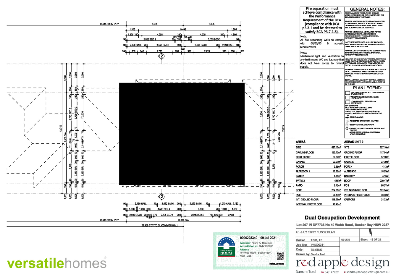
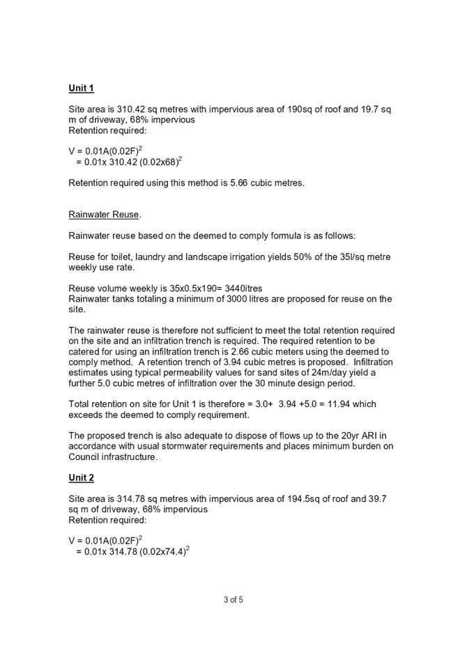
Unit 1 comprises:
· GFA of 210.65m2;
· Ground floor area of 130.73m2 and First floor area of 57.69m2;
· 4 Bedrooms, 3 Bathrooms;
· Single garage;
· Alfresco area of 12.32m2; and
· Private Open Space of 96.87m2.
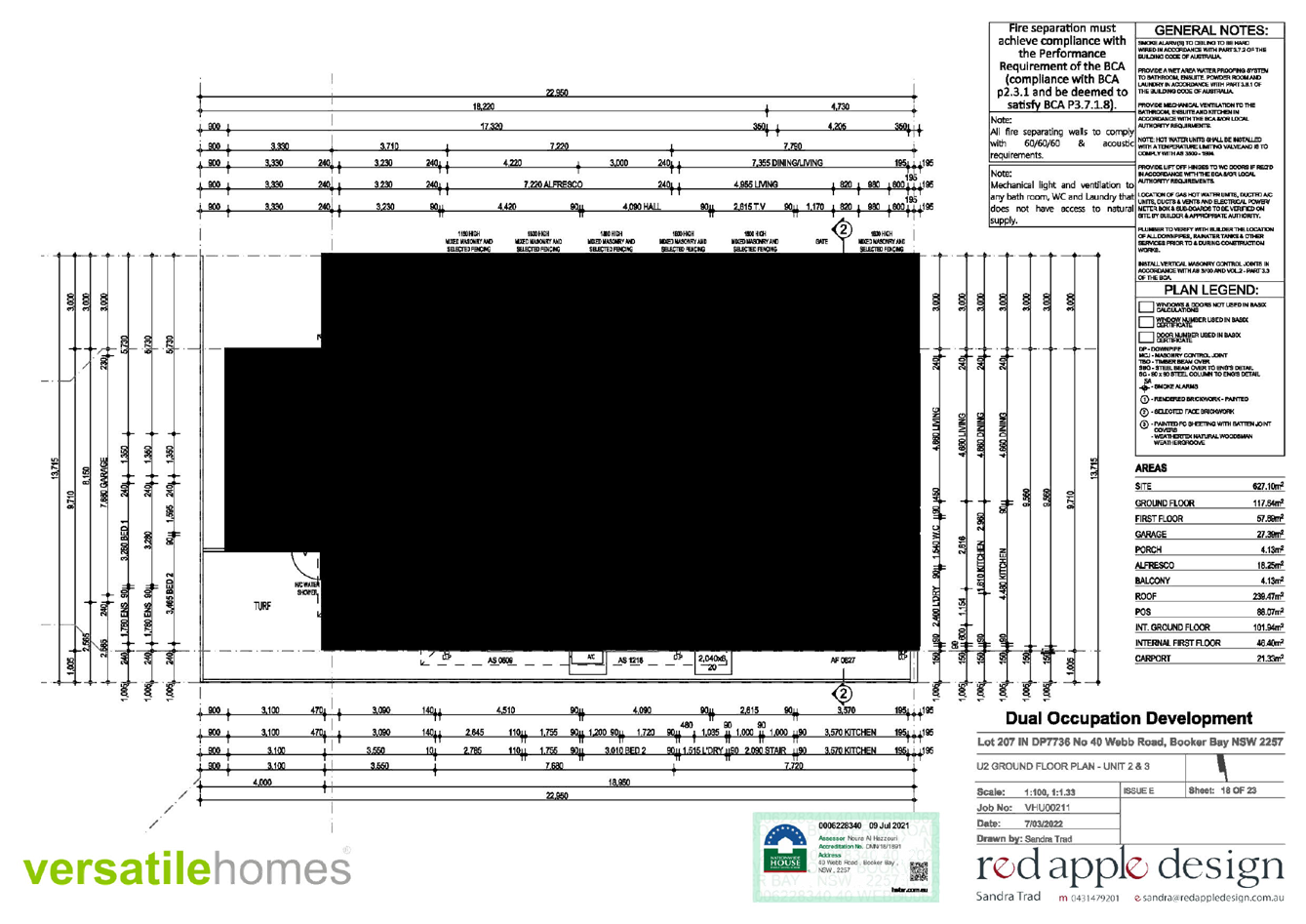
Unit 2 comprises:
· GFA of 202.72m2;
· Ground floor area of 117.64m2 and First floor area of 57.69m2
· 4 Bedrooms, 3 bathrooms;
· Single garage with carport;
· Alfresco area of 18.25m2; and
· Private Open Space of 88.07m2
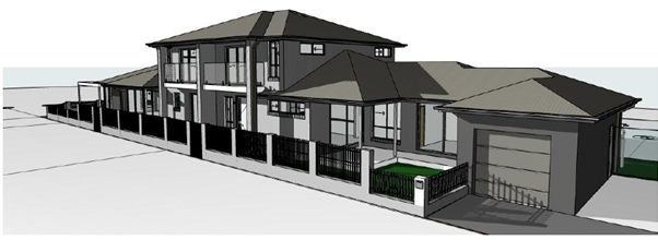
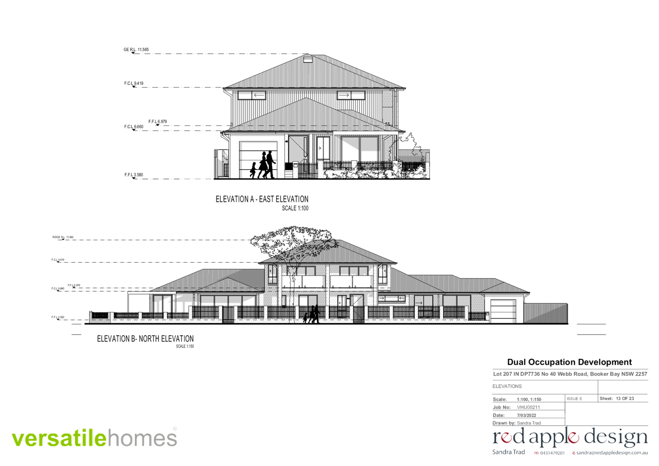
Figure 5 – Perspective – Eastern Road View
History/Background
Council records indicate there is no historic applications available for this location.
The proposed development remains substantially as lodged by the applicant. Minor discrepancies between the engineering plans and the architectural plans were amended in response to issues raised through the initial assessment by Council officers. Officers and matters raised in submissions including:
· Earthworks – discrepancies appear to exist between the Architectural Plans and engineering plans in relation to the proposed earthworks and retaining. Retaining walls are detailed in multiple locations on the engineering plans that are not shown in the Architectural Plans (i.e., along inside edged of driveways) and vice versa (i.e., retaining along edge of carport). Revised plans are required for consistency.
· Corner Splay – to accommodate the required road reserve verge and footpath construction requirements, a corner splay needs to be provided, as detailed within the submitted engineering plans. The Architectural Plans are to be revised to amend the proposed fencing and landscaping within this corner of the site match the splay detailed within the engineering plans.
· Access Sight Distance Clearances – in accordance with AS2890.1 Figure 3.3 appropriate clear sight triangles are to be provided for property accesses. AS2890.1 compliant sight distance lines are to be overlaid on the plans, demonstrating compliance with this standard can be achieved (note: where existing boundary fencing exceeds 1.15m in height (above the ground level from which the driver location is checked) the driveway offset may be required to be modified to achieve the required safety sight clearances.
· Garage Clear Space – in accordance with DCP Chapter 7 Parking, Section 7.1.4.2.c. a minimum clear internal dimension of 3.2m x 6.0m is required for the garages (note: a physical restriction, i.e., walls, are applicable to these spaces). Revised plans are required for compliance, noting any swinging doors protruding into these spaces will not be accepted and should be replaced with cavity sliders or outward swinging doors.
· Tree Removal and
Replacement
- A proposal to remove neighbours trees and shared boundary trees require
written agreement from the adjoining property owner. Opportunity also exists
for street tree planting on the road reserves of Eastern and Webb Road.
The is to applicant obtain and forward a copy to Council written agreement from
the adjoining property owner for removal of their trees as shown on plan.
Also amend Landscape Plan to show street tree planting along Eastern and Webb
Road with a native species capable of achieving a height of 8m (Eastern 3
trees, Webb 1 tree).
Amended plans were lodged by the Applicant on the 04/02/2022 to correct the discrepancies and make the changes as requested by Council Officers. Additionally, Owners consent was lodged by the Applicant on the 24/02/2022, granting permission from the owners of the neighboring property being 42 Webb Road for the removal of the boundary trees as requested by Councils Tree officer.
The amended plans were not notified given the minor changes to the survey levels contained on the architectural plans had no impact, were minor in nature and overall, the development variations of the proposal remained substantially the same development.
ASSESSMENT:
Having regard for the matters for consideration detailed in Section 4.15 of the Environmental Planning and Assessment Act 1979 and other statutory requirements, Council’s policies and Section 10.7 Certificate details, the assessment has identified the following key issues, which are elaborated upon for Council’s information. Any tables relating to plans or policies are provided as an attachment.
Draft Central Coast Local Environmental Plan
The application has been assessed under the provisions of the draft Central Coast Local Environment Plan 2018 (draft CCLEP) publicly exhibited from 15 October 2021 to 5 November 2021 with respect to zoning, development standards and special provisions.
Under the draft CCLEP the subject land retains its R1 General Residential zoning. Dual Occupancy (attached) remain permitted within the zone.
The assessment concluded the proposal is consistent with the Draft Central Coast Local Environment Plan.
State Environmental Planning Policy No. 55 – Remediation of Land
State Environmental Planning Policy No 55 Remediation of Land (SEPP 55) applies to all development and requires consideration and management of site contamination issues as part of the development assessment process. The current use of the site is for domestic residential purposes, and there are no known previous uses that would lead to the site being contaminated or unsuitable for the proposed use.
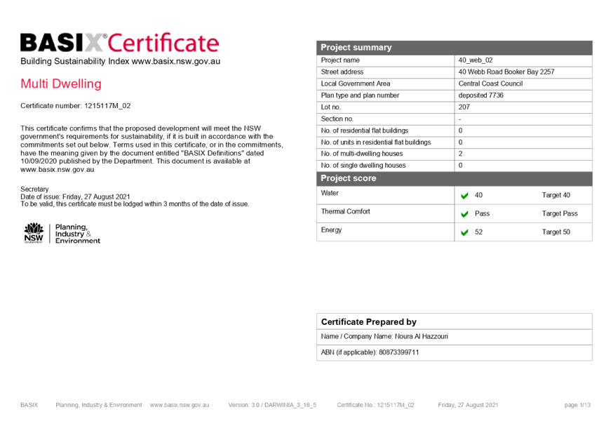
State Environmental Planning Policy (Building Sustainability Index: BASIX) 2004
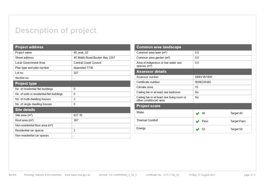
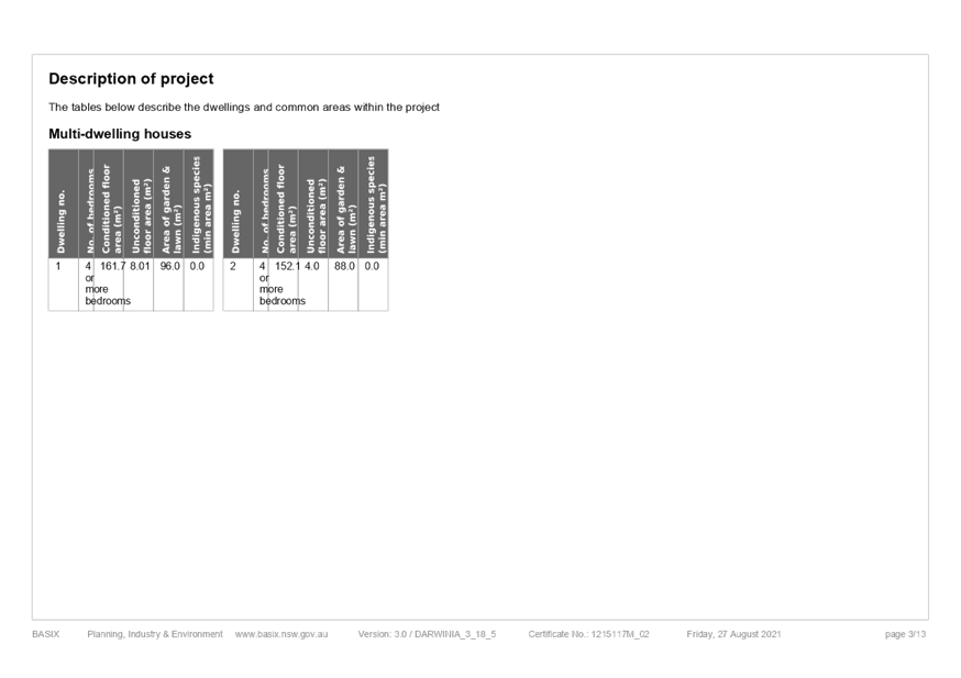
The application is supported by a BASIX certificate which confirms the proposal will meet the NSW government's requirements for sustainability, if built in accordance with the commitments in the certificate.
The proposal is considered to be consistent with the requirements of State Environmental Planning Policy (Building Sustainability Index: BASIX) 2004.
State Environmental Planning Policy (Coastal Management) 2018
The provisions of State Environmental Planning Policy (Coastal Management) 2018 (Coastal Management SEPP) require Council consider the aims and objectives of the SEPP when determining an application within the Coastal Management Area. The Coastal Management Area is an area defined on maps issued by the NSW Department of Planning & Environment and the subject property falls within the mapped coastal management area.
The subject property is within the Coastal Environment area. The relevant matters have been considered in the assessment of this application. The application is considered consistent with the stated aims and objectives.
Gosford Local Environmental Plan 2014 - Permissibility
The subject site is zoned R1 General Residential under Gosford Local Environmental Plan 2014 (GLEP 2014).
The proposed development is defined as Dual Occupancy (Attached) which is permissible in the zone with consent of Council.
dual occupancy (attached) means 2 dwellings on one lot of land that are attached to each other, but does not include a secondary dwelling.
Gosford Local Environmental Plan 2014 - 2.3 Zone Objectives and Land Use Table
Subclause 2.3(2) of the GLEP 2014 requires the consent authority to have regard to the objectives for development in a zone when determining a development application.
The objectives of the R1 General Residential zone are:
· To provide for the housing needs of the community.
· To provide for a variety of housing types and densities.
· To enable other land uses that provide facilities or services to meet the day to day needs of residents.
· To ensure that development is compatible with the desired future character of the zone.
· To promote best practice in the design of multi dwelling housing and other similar types of development.
· To ensure that non-residential uses do not adversely affect residential amenity or place demands on services beyond the level reasonably required for multi dwelling housing or other similar types of development.
In this instance, it is considered that the proposal is consistent with the stated objectives of the zone and consistent with the principles of Ecologically Sustainable Development as specified within the Local Government Act 1993.
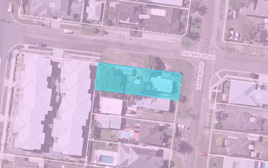
Figure 6 – Zoning Map – Subject Site (Blue Highlight)
Gosford Local Environmental Plan 2014 – Development Standards
An assessment of the proposed development against the relevant planning controls is detailed below.
Table
1 – GLEP 2014 Development Standards
|
Development Standard |
Required |
Proposed |
Compliance with Controls |
Compliance with Objectives |
|
4.1B – Minimum lot sizes for attached dwellings, dual occupancies, multi dwelling housing and residential flat buildings |
550m2 |
627.1m2 |
Yes |
Yes |
|
Clause 4.3 (2) Height |
8.5m |
7.985m |
Yes |
Yes |
|
Clause 4.4 (2) Floor Space Ratio (FSR) |
0.5:1 |
0.5:1 |
Yes |
Yes |
The proposal is consistent with the relevant development standards of the GLEP 2014.
Gosford Local Environmental Plan 2014 - 7.1 Acid sulfate soils
This land has been identified as being affected by the Acid Sulfate Soils Map and the matters contained in Clause 7.1 of Gosford Local Environmental Plan 2014 have been considered. The site contains Class 3 Acid Sulfate Soils. In this instance, the proposed works are not considered to impact on Acid Sulfate Soils.
Gosford Local Environmental Plan 2014 – 7.2 Flood Planning
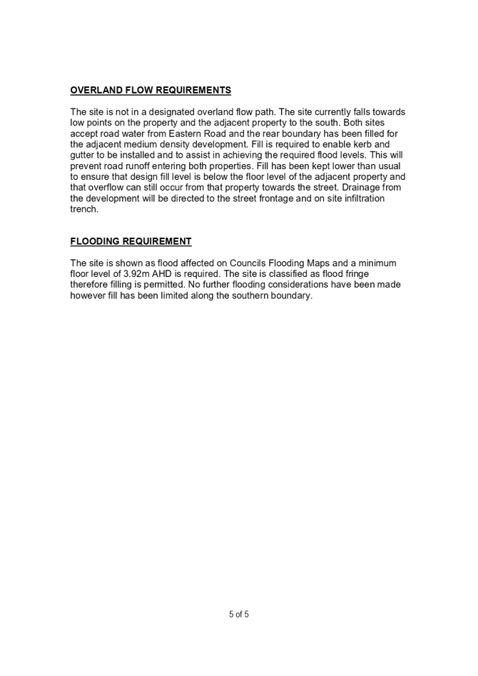
The site is located within the Woy Woy Peninsular Catchment and Council’s records indicate that the site is affected by flooding and/or minimum floor level requirements. The 1% AEP level impacting the site is RL 3.42m AHD, with a minimum habitable floor level of RL 3.92m AHD required for the development.
The flooding in this location is due to the underlying sand plain and freely rising groundwater levels during a storm event. The flooding on the site comprises ponding to 0.25mm in depth. Due to the type of flooding, and the negligible impact upon diversion of flood waters onto neighbouring properties, the proposed fill in this location is acceptable.
Gosford Development Control Plan 2013
Gosford Development Control Plan 2013 (GCDP 2013) provides objectives, design criteria and design guidance on how development proposals can achieve good design and planning
practice.
Additional detail is provided on the following relevant chapters of the GDCP 2013:
Chapter 2.1 Character
The site is located within the character area: Booker Bay 3: Sandplain Mixed Density area of Gosford Development Control Plan 2013 (GDCP 2013) Chapter 2.1 Character.
Existing character is generally medium sized allotments with medium frontages facing unkerbed streets with narrow pavements flanked by wide grassed verges. Dwellings vary from traditional bungalows that are modestly scaled single storey timber framed buildings, to new housing developments that are a mix of medium to large one or two storey single dwellings, dual occupancy or multi dwelling housings constructed of brick or timber, with balconies and verandahs surrounded by modest gardens. Garages are incorporated within each dwelling, or located as free standing structures to the side or rear. Gardens generally consist of a grass studded yard with plants or trees that are mostly native or indigenous to the area.
The character statement provides for the desired character. In this context, the proposal is
consistent with the desired future character and densities of the area and is considered to
comply with the objectives of Chapter 2.1 Character which are to protect and enhance
environmental character of the development site and the surrounding area whereby the
development displays improved standards of scenic, urban and civic design quality as follows:
· These areas should remain leafy mixed-density residential neighbourhoods that retain some of the original mid-Twentieth Century bungalows which remain distinctive elements of the Woy Woy Peninsula’s identity, and future developments achieve significantly improved standards of amenity and urban design quality by reflecting features of those traditional bungalows, as well as providing a variety of low-rise dwellings that include apartments, town houses and villas.
· Surround each development with leafy gardens to conserve existing visually-prominent trees, particularly along back fences and street frontages or verges, as well as to provide space for shady trees and shrubs planted as backdrops to new buildings. Maintain the informal qualities of existing wide grassy street verges and conserve existing shady street trees. Complement the surviving canopy by planting a combination of trees and shrubs that are mostly-indigenous along all property boundaries, and use hedges or fences that are low or see-through rather than tall and opaque in order to maintain the informal character of existing street frontages.
· Ensure that new developments complement the siting, form and scale of surviving traditional bungalows upon nearby properties, as well as maintaining reasonable levels of sunlight, privacy and amenity for neighbouring dwellings plus their private open spaces. Maintain street setbacks that are similar to surrounding properties, and minimise the extent of hard-paved surfaces. Avoid the appearance of long or continuous buildings facing any front or side boundary by stepping the shape of visible facades, by providing at least one wide landscaped setback that varies in width, and lining driveways with avenues of trees and shrubs.
· Reflect the modest scale of traditional mid-Twentieth Century bungalows, for example by dividing new developments into individual dwelling pavilions with a varied form or orientation, separated by landscaped courtyards and verandahs or parking structures. Any facades that are taller or longer than neighbouring buildings should be disguised by a combination of extra setbacks, stepped forms, and balconies or verandahs. Roofs should be gently-pitched to minimise the height of ridges, and flanked by wide eaves that disguise the scale and bulk of exterior walls. Parking is preferable in open carports or part-basements, rather than in wide garages that would accentuate building bulk or dominate visible facades.
· In order to complement the scale and design character of traditional bungalows, a “light-weight appearance” is preferable for all visible facades, incorporating walls of windows that are shaded by framed balconies or verandahs plus exterior sunscreens, painted finishes and some sheet or board cladding rather than extensive plain masonry. Where facades face a street, a laneway or a driveway, provide a traditional “street address” with visible verandahs, living rooms and front doors.
· Screen driveways, terraces, courtyards and balconies to protect the privacy and amenity of neighbouring dwellings."
Figure 7 below shows the existing streetscape of Eastern Road from the corner of Webb Road:
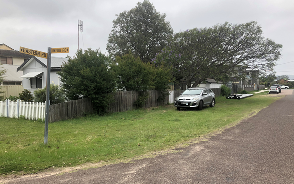
Figure 7 – Looking west – Existing streetscape of Eastern Road, Booker Bay
The proposal is a Dual Occupancy (attached) to create two dwellings within the one lot. Consideration has been given to the limitations and opportunities of developing the corner site in the design of the development to achieve the desired character as follows:
· Each unit gives the appearance of a traditional “street address” with architectural treatments by incorporating patios and entry ways from both Webb and Eastern Roads.
· The architectural design of the dwellings adopts a light weigh appearance in the façade with a variety of finishes and materials used in the construction.
· Bulk and scale of the two-storey section of the dwellings has been stepped back from the front and rear of the site to reduce the visual impact to neighboring dwellings and does not visually dominate the façade of the development.
· The front fence of the development is in keeping with the existing style of fence from the neighboring development at 20 Murray Road and will consist of a similar construction.
· New plantings within the streetscape will contribute to the replacement of vegetation from within the development site.
· Only minor fill and retaining walls are proposed.
Chapter 2.2 Scenic Quality
The proposal is located within the Peninsula geographic unit and the Woy Woy/Umina landscape unit, which is of local significance and described as follows:
The Woy Woy/Umina Landscape Unit is an extensively urbanised area of essentially flat land on sand sheets and sand dunes at the southern entrance to Brisbane Water. Strict road grid pattern with many older style dwellings, beach huts, beachcomber style shacks plus extensive more recent infill redevelopment. Pleasant beach and bay side outlook from locations at the fringes with some enclosure provided from surrounding vegetated escarpment.
The principle aim of the Scenic Quality Development Control Plan is to provide guidelines for
the interpretation and management of the scenic quality of the area and provides for the
following objectives:
i. i to provide a detailed assessment of Gosford's landscape character which highlights
the diversity between and within landscape units;
ii. ii to detail the components of that landscape character;
iii. iii to provide a comparative ranking of the landscapes; and
iv. iv to develop appropriate guidelines for the management of the landscape character.
Comment:
The proposal is considered to have appropriate context and compatibility within the
character and streetscape of the area and is considered to appropriately respond to
characteristics, topography and natural features of the site.
The proposal is located on an appropriately sited lot which is consistent with the scenic quality of the landscape unit and the surrounding extensively urbanised area. The proposal is consistent with the stated objectives of GDCP 2013 Chapter 2.2 – Scenic Quality.
Chapter 3.2 Dual Occupancy Developments
|
Development Standard |
Required |
Proposed |
Compliance with Controls |
Compliance with Objectives |
|
|
3.2.3.1.2 - Maximum Height Controls |
Number of storeys above ground maximum |
2 |
2 |
Yes |
Yes |
|
Floor height of lowest occupied storey maximum |
1m |
Less than 1m |
Yes |
Yes |
|
|
3.2.3.1.3 - Building Envelope |
Building envelope restrictions |
3.5m at 45 degrees |
Complies |
Yes |
Yes |
|
3.2.3.1.4 Development Controls |
Cut and fill restrictions |
1m |
None proposed |
Yes |
Yes |
|
Garage and basement cut and fill maximum |
3m |
None proposed |
Yes |
Yes |
|
|
Ceiling height of living, dining and family rooms in 2 or 3 three storey buildings minimum |
2.7m |
2.740m |
Yes |
Yes |
|
|
Ceiling height of other habitable rooms in 2 or 3 storey buildings minimum |
2.4m |
2.440m |
Yes |
Yes |
|
|
Ceiling height of bathrooms, laundries and storage areas for single, 2 or 3 storey buildings minimum |
2.2m |
2.4m |
Yes |
Yes |
|
|
3.2.3.2.2 - Setback Controls |
Front boundary setback minimum |
6m |
6m |
Yes |
Yes |
|
Secondary street or laneway setback minimum |
3m |
3m |
Yes |
Yes |
|
|
Side boundary setbacks minimum |
1m |
1m |
Yes |
Yes |
|
|
Rear boundary setback minimum |
3m |
4.2m |
Yes |
Yes |
|
|
Foreshore boundary setback minimum |
10m |
n/a |
|
|
|
|
Additional setback for 3 storey development minimum |
1.5m |
n/a |
|
|
|
|
Setback between detached dual occupancy development minimum |
4m |
n/a |
|
|
|
|
3.2.3.3.2 - Technical Requirements |
Car parking spaces minimum
|
Dwellings greater than 125m2 – 2 parking spaces.
|
2 spaces
|
Yes |
Yes |
|
Driveway gradient maximum |
|
|
Yes |
Yes |
|
|
Dimensions of driveways and parking spaces |
|
|
Yes |
Yes |
|
|
3.2.3.3.4 - Fully Enclosed Garages |
Fully enclosed garage width maximum |
6m |
3.2m - Webb Road & 3.2m - Eastern Road |
Yes |
Yes |
|
3.2.3.4.2 - Private Open Space |
Private open space provided minimum |
75m2 |
Unit 1 - 88m2 & Unit 2 - 96m2 |
Yes |
Yes |
|
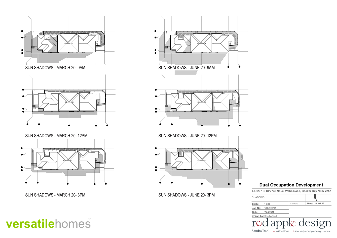
3.2.3.4.3 - Minimum Amount of Sunlight |
|
|
|
Yes |
Yes |
|
3.2.3.5 - Residential Address |
|
|
|
Yes |
Yes |
|
3.2.3.6.2 - Facade Articulation Controls |
Unarticulated external wall length maximum |
8m |
20m |
No – variation supported, refer to comments below. |
Yes |
|
3.2.3.6.3 - Roof Elements |
|
|
|
Yes |
Yes |
|
3.2.3.6.4 - Materials and Exterior Finishes |
|
|
|
Yes |
Yes |
|
3.2.3.6.5 - Visually Prominent Facades |
|
|
|
Yes |
Yes |
|
3.2.3.7 - Landscaped Areas |
|
|
|
Yes |
Yes |
|
3.2.3.8.2 - Design and Location of Stormwater Systems |
|
|
|
Yes |
Yes |
|
3.2.3.8.3 - Storage of Garbage Bins |
|
|
|
Yes |
Yes |
|
3.2.3.8.4 - Location and Design of Service Meters |
|
|
|
Yes |
Yes |
|
3.2.3.8.5 - Secure Private Storage Requirements |
Secure private storage minimum |
10m3 |
>10m3 |
Yes |
Yes |
The proposal is considered satisfactory notwithstanding minor non-compliance with the following:
· Clause 3.2.3.6.2 Façade Articulation Controls – The proposed development will have a non-compliance of 13m along the western façade which is greater than the allowable 8m.
The area of non-compliance including relevant development controls are detailed as follows:
Chapter 3.2.3.6.2 - Facade Articulation Controls
Clause 3.2.3.6.2 requires that all facades are articulated to disguise the scale and bulk of new buildings. The development incorporates articulation throughout the development with the exception of a section of the southern façade which extends for approximately 21m.
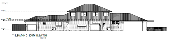
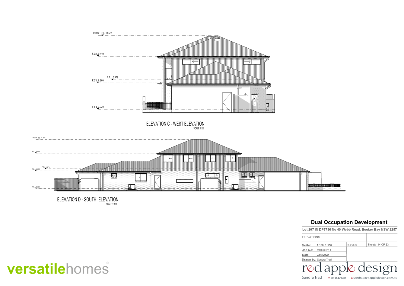
Figure 8 – Perspective – Southern Elevation
To reduce the impacts of the exterior wall, the southern façade incorporates elements of overall stepping and indentation of the building line. Combined with distinct contrasts in the building design and finish of exterior walls reduce the overall appearance of the non-compliance as demonstrated below in Figure 6.
The external materials and finishes complement the natural environment and coastal architecture style homes. The Use of porches, terraces and balconies throughout the development provides an overall articulation of the solid mass of the development and is considered acceptable given the overall context of the development. The proposed materials will provide a unified modern concept, low reflectivity and designed to blend into surrounding developments and are consistent with the coastal architectural style homes of the area.
Council is satisfied that the proposal is consistent with the zone objectives and as such that
the proposal is in the public interest. The contravention of the articulation does not raise any matter of significance for Regional environmental planning given the nature of the development proposal. Strict compliance with the prescriptive articulation is unreasonable and unnecessary in the context of the proposal in the circumstances of the case. The proposed development meets the underlying intent of the control and is a compatible form of development that does not result in unreasonable environmental amenity impacts and the proposal is worthy of support.
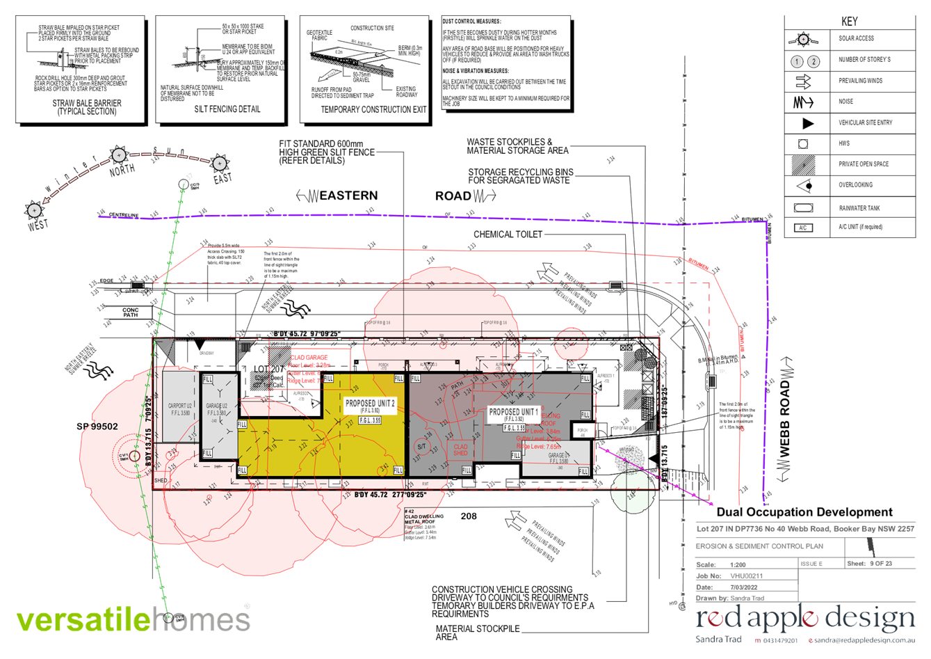
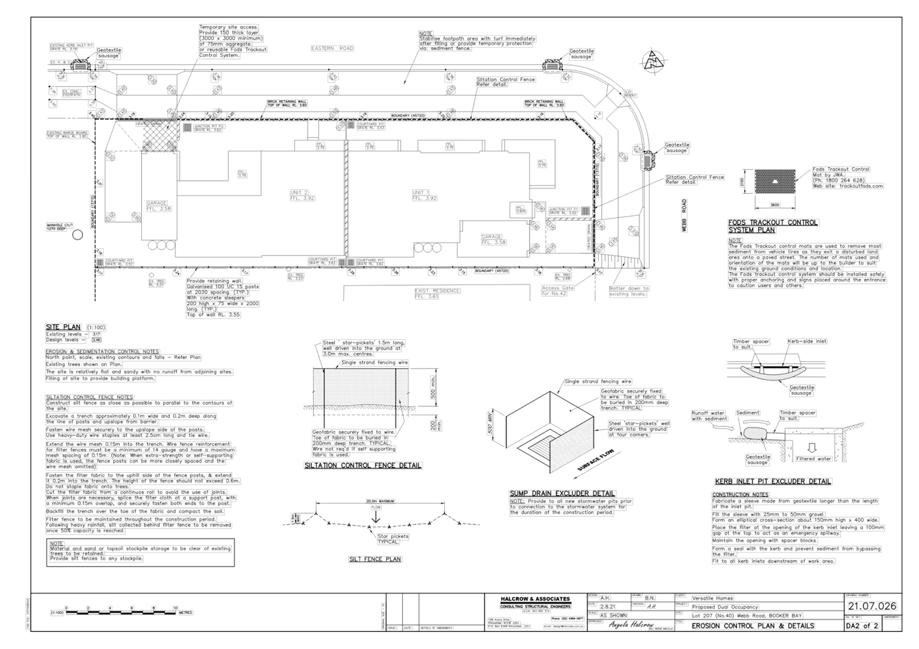
Chapter 6.3 Erosion and Sediment Control
Erosion and sediment control plan provided. Conditions applied.
Chapter 6.4 Geotechnical Requirements for Development
The property is not mapped as being in a landslip hazard risk. There are no proposed earth works or excavation in the development that would pose a landslip risk. It has been considered due to the existing area where there is no evidence of landslip and the site being relatively flat, there would be no additional geotechnical information required to support the development at the DA stage.
Chapter 6.6 Preservation of Trees or Vegetation
The controls require the protection of trees on privately owned land that contribute positively to the amenity, scenic landscape characteristics and ecological values of the Central Coast Local Government Area.
The proposal seeks consent for the removal of all existing site trees including three mature (3) Jacaranda’s and one mature Angophora Floribunda known as an Apple Gum. The proposal also includes significant landscaping and planting throughout the private open spaces within the proposed development. Two (2) Scribbly Gums (Eucalypyuts Haemastroma) and nine (9) Water Gums (Tristaniopsis Laurina) are proposed to be planted around the perimeter of the site with shrubs and grasses to be planted in the private open space. Two feature trees are proposed to be planted in the north eastern corner and south western corners of the development. Low scale hedging shrubs are proposed to the planted along the western boundary of the site.
The application was referred to Council’s Tree officer for comments who raised concerns over the location of the trees for removal and required that permission from the owner be sought to remove the boundary trees due to their impact on the neighbouring property. The applicant was requested to provide owners consent for the removal of the boundary trees which was provided to council on the 24 February 2022. In addition to this, Councils Tree Officer also identified that the Apple gum has has had a past event in its upper crown (damaged or lopped), has a cavity and large termite nest, any reasonable development of the property would require its removal.
The central location of the trees sited for removal would prevent any reasonable development of the property. Whilst the removal of all trees is required for the development, it is considered that the proposed landscaping and street trees will improve the overall amenity of the site.
Councils Tree officer has supported the removal of all trees and has also conditioned three (3) street trees to be provided within Eastern Road and one (1) tree within the Webb Road set back as depicted on the Landscape plan in Figure 10 below.
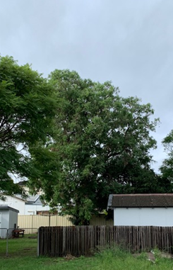
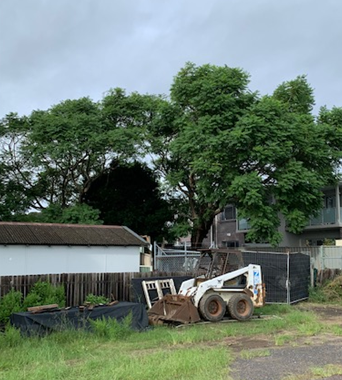
Figure 9 & 10 – Angophora Floribunda (Left) & Two Jacarandas (Right)
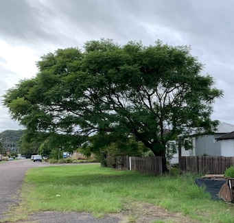
Figure 11 – Large Jacaranda on Eastern Road Boundary
Figure 12: Landscape Plan
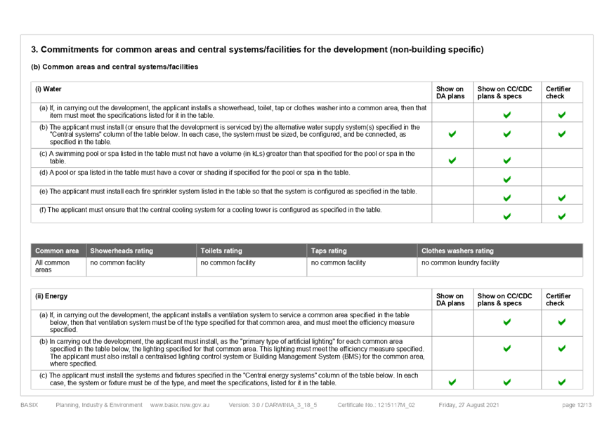
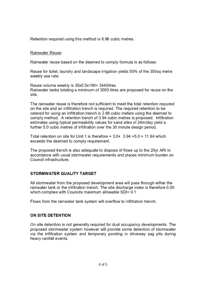
6.7 Water Cycle Management
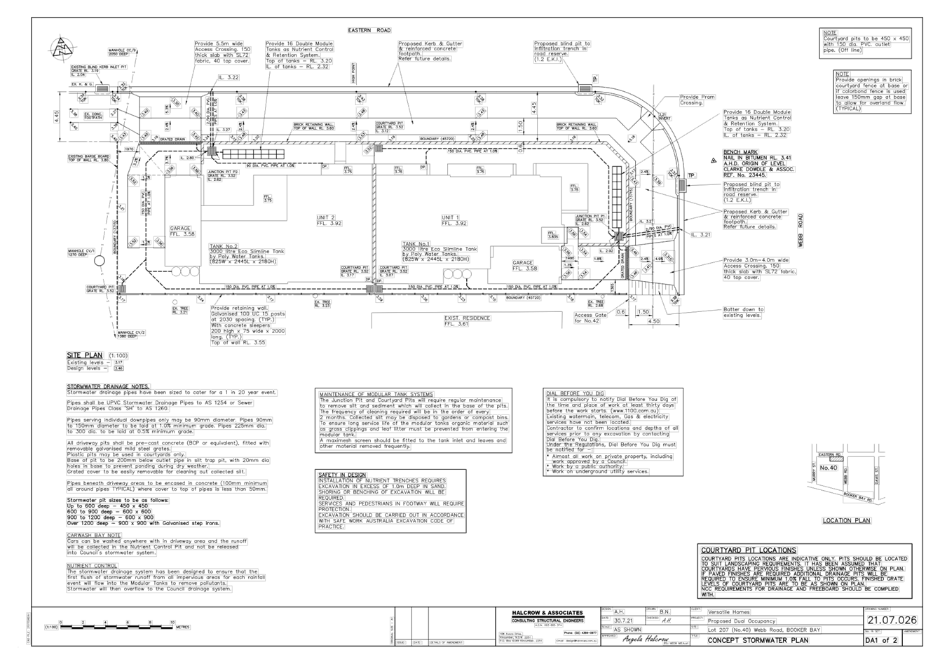
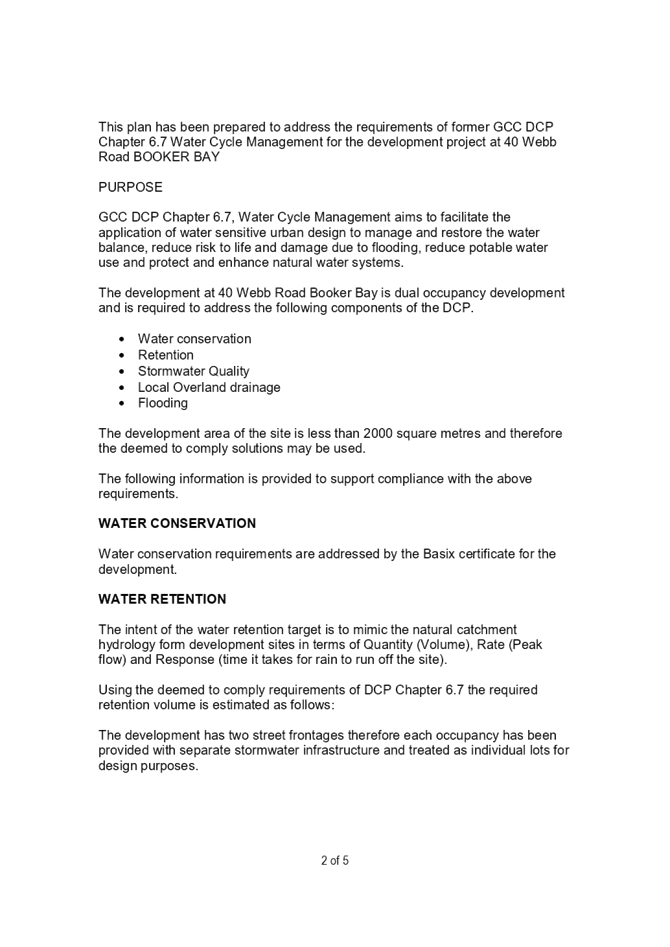
The site is flat, with no clear direction of fall. The Applicant has submitted a Water Cycle Management Plan, by HALCROW AND ASSOCIATES, designed in accordance with DCP Chapter 6.7 Water Cycle Management.
The submitted Concept Stormwater Plan, by HALCROW AND ASSOCIATES, details stormwater collected within each new allotment being directed via an on-site nutrient control and retention system (one on each Lot), with overflow to the new street drainage system (to be constructed as part of the development, including kerb and gutter and 2 x kerb inlet infiltration trench pits). The Applicant has proposed a rainwater tank system, with a 2kL RWT behind the garage of each dwelling, as part of their BASIX water commitments.
Councils Engineer has supported the Water Cycle Management plan and provided conditions accordingly.
7.1 Car Parking
The controls require 2 spaces be provided for Dual Occupancy developments greater than 125m2. One space is required to be covered (ie carport or garage) set back a minimum of 6m from the frontage of the site.
Additionally Chapter 3.2.3.3.3 development controls for Dual Occupancies provides:
C. if two parking spaces are provided for a dwelling:
i. One space may be located within a fully-enclosed garage or carport;
ii. The second space may be located in an open area, or as a stacked space upon the dwellings driveway.
The proposal provides 1 enclosed garage space per unit.
Unit 1 can accommodate a second space in a stacked parking arrangement within the 6m setback. Unit 2 includes an open carport on the western elevation to provide the second space, as well as being able to incorporate a stacked space if required.
The proposed development will require the construction of kerb and gutter to the streetscape along Eastern and Webb Roads. This will formalise the streetscape and provide opportunity for on street parking within the quiet residential street.
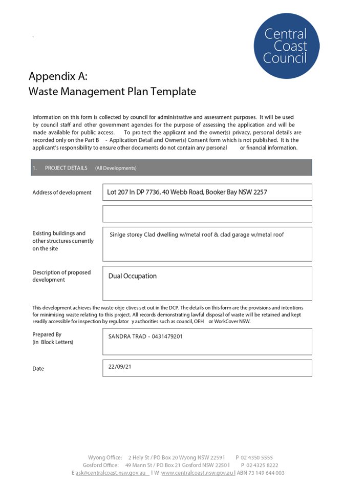
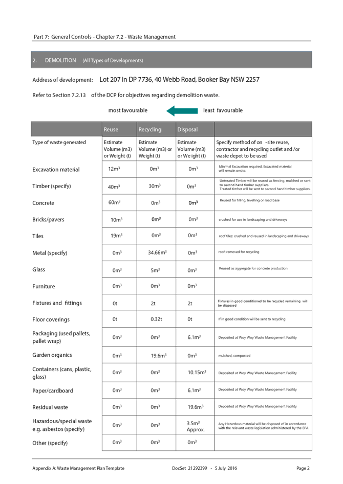
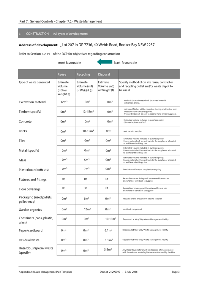
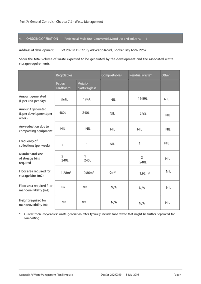
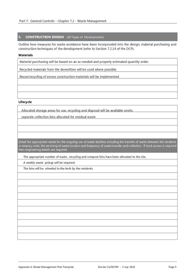
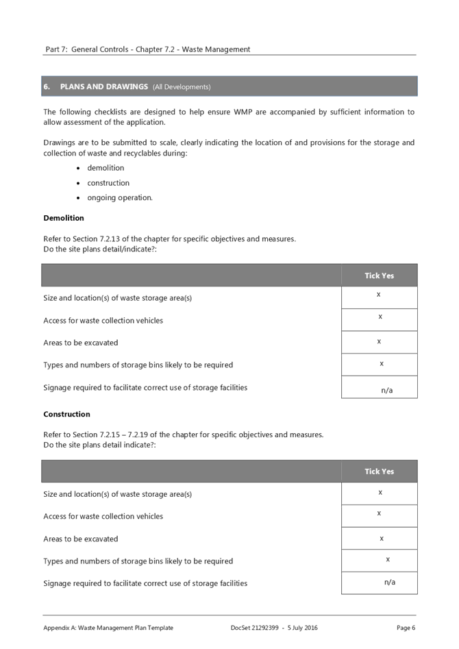
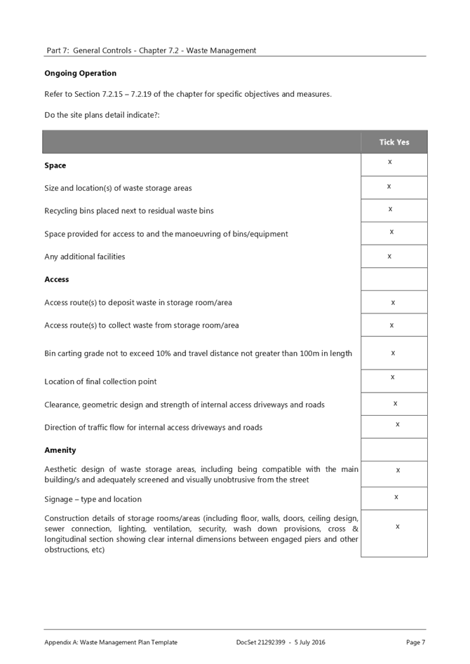
7.2 Waste Management
Waste Management Plan submitted. A condition has been included in the development consent.
Other Matters for Consideration
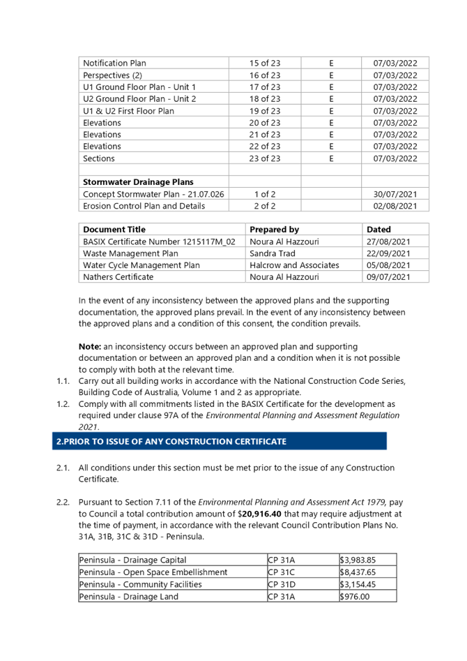
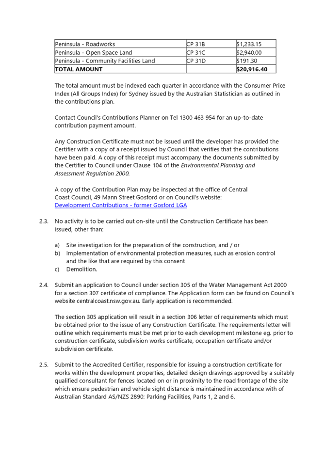
Development Contribution Plan
The subject site is located within Central Coast Regional Section 7.12 Development Contribution Plan 2019, where dual occupancy developments are subject to section 7.12 contributions. The applicable contribution amount was calculated and imposed as a standard condition of consent requiring the contribution to be paid prior to the issue of any Construction Certificate.
Consent condition 2.2 has been included as follows:
Pursuant
to Section 7.11 of the Environmental Planning and Assessment Act
1979, pay to Council a total contribution amount of $20,916.40 that
may require adjustment at the time of payment, in accordance with the relevant
Council Contribution Plans No. 31A, 31B, 31C & 31D - Peninsula.
|
Peninsula - Drainage Capital |
CP 31A |
$3,983.85 |
|
Peninsula - Open Space Embellishment |
CP 31C |
$8,437.65 |
|
Peninsula - Community Facilities |
CP 31D |
$3,154.45 |
|
Peninsula - Drainage Land |
CP 31A |
$976.00 |
|
Peninsula - Roadworks |
CP 31B |
$1,233.15 |
|
Peninsula - Open Space Land |
CP 31C |
$2,940.00 |
|
Peninsula - Community Facilities Land |
CP 31D |
$191.30 |
|
TOTAL AMOUNT |
$20,916.40 |
|
The total amount must be indexed each quarter in accordance with the Consumer
Price Index (All Groups Index) for Sydney issued by the Australian Statistician
as outlined in the contributions plan.
Contact Council’s Contributions Planner on Tel 1300 463 954 for
an up-to-date contribution payment amount.
Any Construction Certificate must not be issued until the developer has
provided the Certifier with a copy of a receipt issued by Council that verifies
that the contributions have been paid. A copy of this receipt must accompany the
documents submitted by the Certifier to Council under Clause 104 of
the Environmental Planning and Assessment Regulation 2000.
A copy of the Contribution Plan may be inspected at the office of Central
Coast Council, 49 Mann Street Gosford or on Council's website:
Development Contributions - former
Gosford LGA
Planning Agreements
The proposed development is not subject to a planning agreement / draft planning
agreement.
Referrals
|
Development Engineer |
Supported subject to conditions. |
|
|
Tree Assessment Officer |
Supported subject to conditions |
|
|
Water and Sewer |
Supported subject to conditions |
Public Submissions
The development has been notified in accordance with the provisions of Gosford
Development Control Plan 2013. A total of 15 public submissions were received in relation to the application.
Minor discrepancies with the application were amended during the assessment following requests by Councils officers. The amendments were not formally notified to all objectors due to the minor nature. The application remains substantially the same development as originally lodged.
All 15 submission raised concerns about the removal of the trees within the site in particular a mature Angophora Floribunda commonly known as an Apple Gum. Many of the submissions were duplicated however a summary of the submissions objecting to the proposal is detailed below:
1 Retention of trees is paramount to provide shelter for wide life and shade for people.
2 Has any consideration been given to requesting that the applicant adjust the design or to utilise sensitive construction methodology in order to retain at least the mature native Angophora?
3 The plans show mature trees in red, indicating their removal. There is no arborist report. I ask that these healthy mature shade trees which are all situated close to the boundary of this building block be retained.
4 The new Greener Places Strategy, released by Central Coast Council, stipulates that local native species should be retained.
5 There appears to be no consideration I could see in the application given to the retention of any trees in spite of the DCP clause Purpose of Setbacks 3.2.3.2.1
6 One of the trees is an Angophora Floribunda which is a threatened species in the endangered ecological community of the Urban Coastal Sandplain Woodland. This development with its trees removed will have a detrimental impact on the streetscape, reducing vibrancy and character.
Comment: Council’s ecologist was consulted to provide clarification in relation to the Angophora being a threatened species who provided the following advice:
“Angophora floribunda is not listed as a threatened species in NSW. It is included as a characteristic canopy tree species within the Umina Coastal Sandplain Woodland EEC. However, single remnant trees within built up urban areas which are now isolated from areas of bushland are not considered to comprise the Endangered Ecological Community.”
Clause 3.2.3.2.1 aims to conserve important elements of existing scenic quality, in particular any prominent trees that might be located near ridgelines or a site’s boundaries. As depicted in “Figure 5 - Required setbacks + deep soil” of the Gosford Development Control Plan 2013 to further explain this clause it is noted that prominent trees located within the rear are front set backs are considered to the subject of this clause.
The nature of this particular development being located on a site that has frontage to two streets gives the opportunity for the replacement of a further four (4) street trees to improve the streetscape and scenic quality surrounding the development. The proposal also includes significant landscaping with the site which will contribute to the softening of the visual impact of the development.
The removal of the tree is supported by Councils Ecologist and Tree Officer and an arborists report is not required in this instance. It is not considered that this tree has a significant impact of character or the scenic quality of the locality and retaining the tree would restrict reasonable development of the site.
 Figure 7 – Updated Landscape
Plan – Including street trees for Eastern and Webb Road
Figure 7 – Updated Landscape
Plan – Including street trees for Eastern and Webb Road
1 There is no environmental impact statement in the Statement of Environmental Effects as mandated in Schedule 1 1.2.4 of the Environmental Planning and Assessment Regulations 2000.
An Environment Impact Statement is not required for local development. Schedule 11.2.4 of the Environmental Planning and Assessment Regulations 2000 relates to a development application for State Significant Development or Designated Development.
Likely Impacts of the Development:
Section 4.15 (1)(b) of the EP&A Act requires consideration of the likely impacts of the
development including environmental impacts on both the natural and built environments,
and social and economic impacts in the locality.
a) Built Environment
The subject site is zone R1 General Residential under GLEP 2014 and adjoins residential developments comprising single and two storey dwellings. A throughout assessment of the impacts of the proposed development on the built environment has been undertaken in terms of GLEP 2014 and GDCP 2013 compliance. There will be minimal amenity impacts as a result of the non-compliance of the articulation of the southern elevation. The proposed built form is considered acceptable in the context of the site.
b) Natural Environment
The proposal is satisfactory in relation to impacts on the natural environment as identified
throughout this report. There will be no significant impact upon the natural environment as a
result of the proposal.
c) Economic Impacts
The proposed development will contribute to the supply of housing needs in the locality and
is satisfactory from an economic perspective.
d) Social Impacts
No social impacts will arise from the approval of this residential development
Suitability of the Site for the Development:
The site is zoned is zoned R1 General Residential under GLEP 2014. The proposed
development is permitted in the zone with development consent. The proposal complies
with the provisions of GLEP 2014 and is generally in keeping with the provisions of GDCP 2013 and raises no adverse impacts or consequences in regard to the principles of Ecologically Sustainable Development.
The site is not subject to bushfire constraints. As such the site is considered suitable for this type of development subject to conditions.
The Public Interest: (s79C(1)(e)):
The approval of the application is considered to be in the public interest. The proposal will It
will not have any adverse impact on the natural environment and will not unreasonably
impact the amenity of neighboring properties.
Political Donations
During assessment of the application there were no political donations were declared by the
applicant, applicant’s consultant, owner, objectors and/or residents.
Conclusion
This application has been assessed against the heads of consideration of Section 4.15 of the Environmental Planning & Assessment Act 1979 and all relevant instruments and policies. The potential constraints of the site have been assessed and it is considered that the site is suitable for the proposed development. Subject to the imposition of appropriate conditions, the proposed development is not expected to have an adverse social or economic impact. It is considered that the proposed development will complement the locality and meet the desired future character of the area.
Accordingly, the application is recommended for approval pursuant to Section 4.16 of the Environmental Planning and Assessment Act.
Reasons for the Decision
The reasons for the decision as recommended under the assessment of this application are as
follows:
1 The proposal is satisfactory having regard for the relevant environmental planning
a. instruments, plans and policies.
2 There are no significant issues or impacts identified with the proposal under s.4.15
a. of the Environmental Planning and Assessment Act 1979.
|
1⇩ |
Public Redacted Updated Architectural Plans - DA63281/2021 - 40 Webb Road Booker Bay |
|
D15071359 |
|
2⇨ |
Updated Architectural Plans - DA63281/2021 - 40 Webb Road Booker Bay |
Provided Under Separate Cover |
D15071352 |
|
3⇩ |
Draft Conditions of Consent - DA/63281/2021 - 40 Webb Road Booker Bay |
|
D15068621 |
|
4⇩ |
Statement of Environmental Effects - DA63281/2021 - 40 Webb Road Booker Bay |
|
D14867203 |
|
5⇩ |
BASIX Certificate - DA63281/2021 - 40 Webb Road Booker Bay |
|
D14867174 |
|
6⇩ |
Stormwater Drainage Plan - DA63281/2021 - 40 Webb Road Booker Bay |
|
D14867208 |
|
7⇩ |
Stormwater Drainage Report - DA63281/2021 - 40 Webb Road Booker Bay |
|
D14867210 |
|
8⇩ |
Waste Managment Plan - DA63281/2021 - 40 Webb Road Booker Bay |
|
D14867214 |
|
9⇨ |
Neighbours Owners Consent for Tree Removal - 42 Webb Road - DA/63281/2021 - 40 Webb Road Booker Bay |
Provided Under Separate Cover |
D15066322 |
|
10⇩ |
Nathers Certificate - DA/63281/2021 - 40 Webb Road Booker Bay Road |
|
D14867179 |
|
3.1 |
DA/63281/2021 - 40 Webb Road Booker Bay - Dual Occupancy Attached and Demolition of Existing Dwelling |
|
Attachment 1 |
Public Redacted Updated Architectural Plans - DA63281/2021 - 40 Webb Road Booker Bay |
|
DA/63281/2021 - 40 Webb Road Booker Bay - Dual Occupancy Attached and Demolition of Existing Dwelling |
|
|
Attachment 3 |
Draft Conditions of Consent - DA/63281/2021 - 40 Webb Road Booker Bay |


|
DA/63281/2021 - 40 Webb Road Booker Bay - Dual Occupancy Attached and Demolition of Existing Dwelling |
|
|
Attachment 4 |
Statement of Environmental Effects - DA63281/2021 - 40 Webb Road Booker Bay |

|
DA/63281/2021 - 40 Webb Road Booker Bay - Dual Occupancy Attached and Demolition of Existing Dwelling |
|
|
Attachment 5 |
BASIX Certificate - DA63281/2021 - 40 Webb Road Booker Bay |
|
DA/63281/2021 - 40 Webb Road Booker Bay - Dual Occupancy Attached and Demolition of Existing Dwelling |
|
|
Attachment 6 |
Stormwater Drainage Plan - DA63281/2021 - 40 Webb Road Booker Bay |
|
DA/63281/2021 - 40 Webb Road Booker Bay - Dual Occupancy Attached and Demolition of Existing Dwelling |
|
|
Attachment 7 |
Stormwater Drainage Report - DA63281/2021 - 40 Webb Road Booker Bay |
|
DA/63281/2021 - 40 Webb Road Booker Bay - Dual Occupancy Attached and Demolition of Existing Dwelling |
|
|
Attachment 8 |
Waste Managment Plan - DA63281/2021 - 40 Webb Road Booker Bay |
|
DA/63281/2021 - 40 Webb Road Booker Bay - Dual Occupancy Attached and Demolition of Existing Dwelling |
|
|
Attachment 10 |
Nathers Certificate - DA/63281/2021 - 40 Webb Road Booker Bay Road |
|
Item No: 3.2 |
|
|
Title: DA/1508/2021 - 11 Trelawney Street, Killarney Vale - Demolition of existing & new dwelling |
|
|
Department: Environment and Planning |
|
|
24 March 2022 Local Planning Panel Meeting |
|
Reference: DA/1508/2021 - D15072046
Author: Shane Smith, Building Surveyor, Building Assessment and Certification
Manager: Wayne Herd, Section Manager, Building Assessment and Certification
Executive: Andrew Roach, Unit Manager, Development Assessment
|
Summary
The development application is for demolition of the existing dwelling, removal of tree and construction of new dwelling on the subject property. The application has been examined having regard to the matters for consideration as detailed within Section 4.15 of the Environmental Planning and Assessment Act (EP&A Act) and other relevant statutory requirements, with the issues requiring attention being addressed within this report.
This development application is required to be reported to Local Planning Panel due to the number of unique submissions received. 152 submissions have been received.
The application is recommended for approval with conditions.
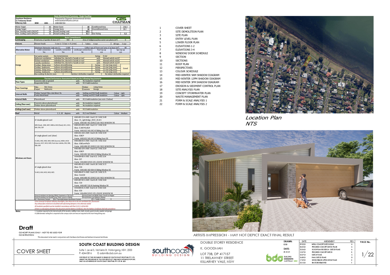
Applicant South Coast Building Design Owner Mrs K F Goodman Application No DA/1508/2021 Description of Land Lot 73B DP 417157 11 Trelawney Street, KILLARNEY VALE NSW 2261 Proposed Development Demolition of existing & new dwelling Site Area 701.90 Zoning R2 Estimated Value $907225 |
1 The Local Planning Panel grant development consent to DA/1508/2021 for the demolition of the existing dwelling, removal of Norfolk Island tree and construction of a new dwelling at No. 11 Trelawney Street, Killarney Vale subject to appropriate conditions as detailed in the schedule attached to the report and having regard to the matters for consideration detailed in Section 4.15 of the Environmental Planning and Assessment Act and other relevant issues.
2 Those who made a submission be notified of the outcome of the development application.
Key Issues
· The application proposes variations to the front building setback contained within Council’s Chapter 2.1 “Dwelling Houses, Secondary Dwellings and Ancillary Development”;
· The application proposes removal of a mature Norfolk Island Pine tree located within Council road reserve at the front of the property. The development application has been supported by an Arboricultural Impact Assessment report which justifies the tree removal noting that the removal of the tree is required to facilitate the demolition of existing housing and new dwelling construction;
· Matters raised in submissions - notification of the development proposal resulted in the receipt of one hundred and fifty two (152) submissions relating to the proposed development, with a significant number of submissions raising the specific issue of the removal of the Norfolk Island Pine, as well as other matters.
Precis:
|
Proposed Development |
Demolition of existing dwelling, removal of tree & the construction of a new two-storey dwelling.
|
|
Permissibility and Zoning |
The subject site is zoned R2 – Low Density Residential under the provisions of Wyong Local Environmental Plan 2013 (Wyong LEP 2013).
The proposed development is defined as a ‘dwelling house’ which is defined under the Wyong LEP 2013 as:
‘dwelling house’ means – a building containing only one dwelling.
The use is permissible with consent of the relevant authority within the zone.
|
|
Relevant Legislation |
The following planning policies and control documents are relevant to the development and were considered as part of the assessment. · SEPP Basix · Wyong Local Environmental Plan 2013 · Wyong Development Control Plan 2013, Chapter 2.1 Dwelling Houses & Ancillary Structures · Wyong Development Control Plan 2013, Chapter 3.3 Floodplain Management · Wyong Development Control Plan 2013, Chapter 3.6 Tree & Vegetation Management · State Environmental Planning Policy (Vegetation in Non-Rural Areas) 2017
|
|
Current Use |
Residential dwelling
|
|
Integrated Development
|
No
|
|
The application was advertised in accordance with Wyong Development Control Plan 2013 Chapter 1.2 - Notification of Development Proposals.
One hundred and fifty-two (152) submissions were received.
|
Variations to Plans and Policies
|
Clause |
Clause 3.1 Setbacks – Residential Lots |
|
Standard |
The minimum required front boundary setback for a dwelling is the average setback of the two adjoining properties |
|
WDCP |
DCP 2013- Chapter 2.1; Houses and Ancillary Structures |
|
Departure basis |
The application proposes the dwelling to have a front setback of 7.253m. The front setback under the provisions of Clause 3.1.a.i requires the average of the two adjoining properties which is 9.3m The proposed front setback of 7.253m is a variation of approximately 2.047m or 22%. |
|
Clause |
Clause 3.1 Setbacks – Residential Lots |
|
Standard |
The minimum required front boundary setback for a garage or carport structure and the like is a minimum of 1m behind the front boundary setback |
|
LEP/DCP |
DCP 2013- Chapter 2.1; Houses and Ancillary Structures |
|
Departure basis |
The application proposes the garage to have a front setback of 6.504m. The front setback under the provisions of Clause 3.1.a.iv requires a minimum of 1m behind the building line. The required front setback for the garage is 10.3m. This is a variation of approximately 3.796m or 37.06%.
|
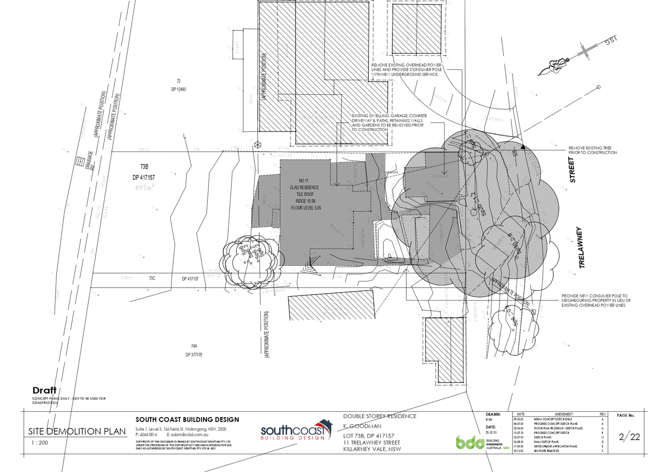
The Site
The site is located on the northern side of street. The site contains a two-storey dwelling with a detached garage and is surrounded by other similar low rise residential development. The site topography is sloping moderately from south to north where it drains to Tuggerah Lake Reserve.
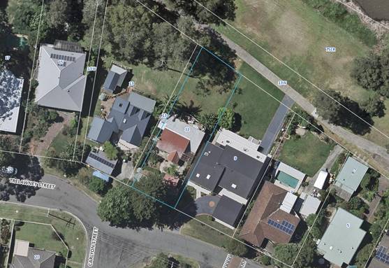
Figure 1 – Aerial view (site edged in blue)
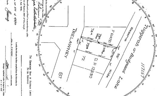
Figure 2 – Deposited plan extract
Surrounding Development
The subject site is surrounded on both sides by existing R2 – low density zoned residential allotments, generally containing a mixture of older style one and two-storey dwellings and associated outbuildings. There are a number of newer dwellings (mainly one- and two-storey) dispersed amongst the older dwellings on the moderately sloping hillsides.
Due to the moderate steepness of the land, garages and other parking structures associated with dwellings on land along the northern side of Trelawney Street are located in front of the building line towards Trelawney Street. This is a result of the moderately steep hillside topography of the area and the constraints imposed in providing safe gradient vehicular and pedestrian access directly from Trelawney Street.
Vegetation (Norfolk Island Pine)
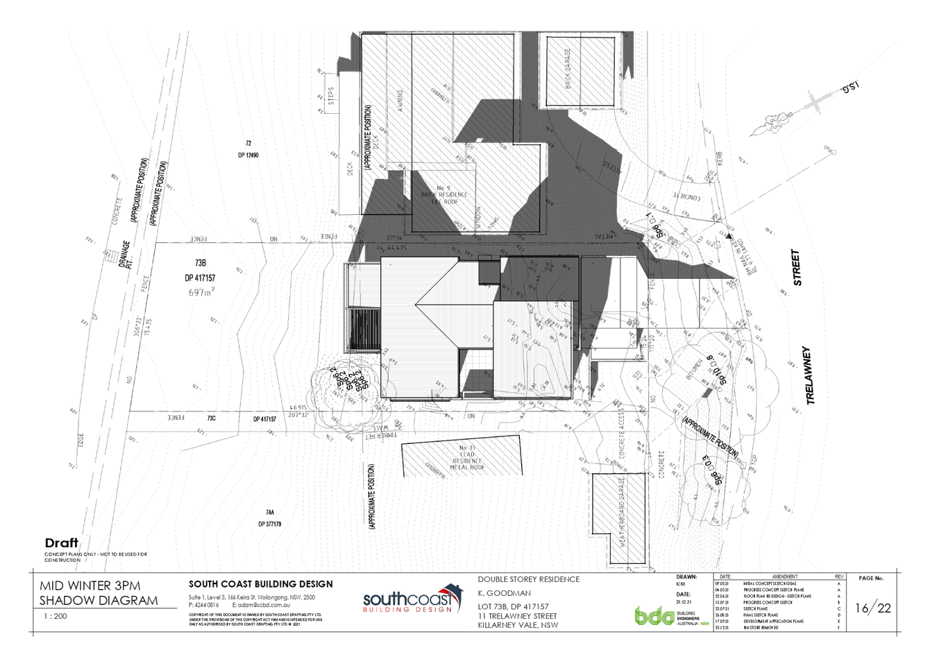
There is an existing Norfolk Island Pine tree located at the frontage of the site. This tree is located within the Council road reserve, adjacent to the property boundary, with root system that extends into the property. The application proposes removal of this tree and application is supported by an Arboricultural Impact Assessment. The tree removal will be discussed further within the report.
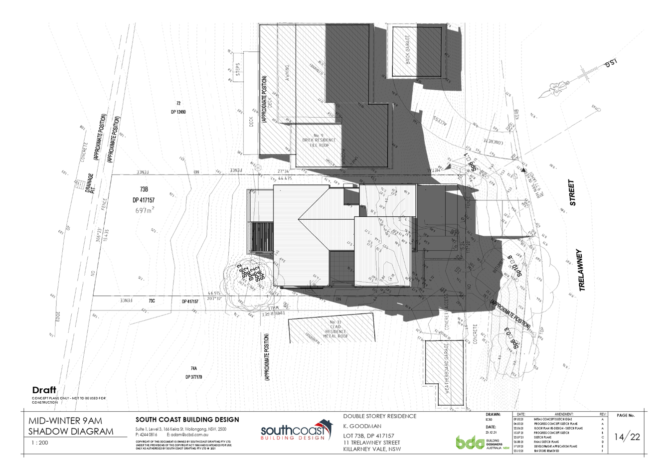
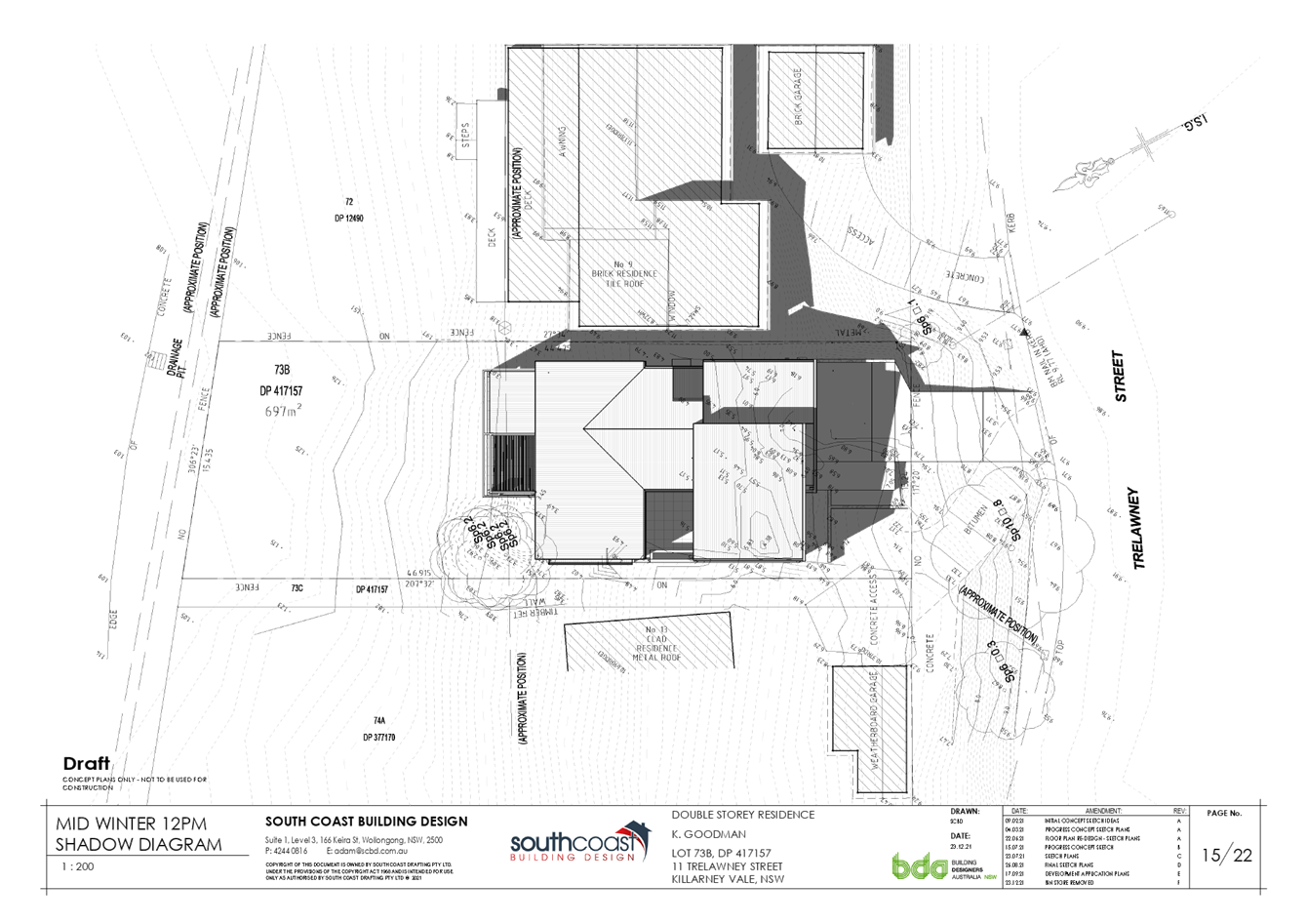
Flood Planning
The subject land is identified as being impacted by flooding. A Flood Impact Study was submitted with this application prepared by Northrop dated 30 March 2021. Flooding is dealt with later in the report.
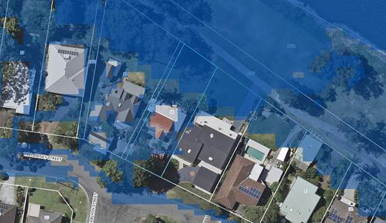
Figure 3 - Shows extent of flooding on the subject site
Acid Sulfate Soils
The subject land is identified as being impacted by Acid Sulfate Soils and Clause 7.1 of the Wyong Local Environmental Plan 2013 applies.
Where a development has potential to disturb, expose or drain acid sulfate soils there is potential to cause environmental damage. The class of land for the proposed works ( as identified on the Acid Sulfate Soils Map) are class 2 and 5, with potential impacts set out in the table below:
|
Class of land |
Works |
|
2 |
Works
below the natural ground surface. |
|
5 |
Works within 500 metres of adjacent Class 1, 2, 3 or 4 land that is below 5 metres Australian Height Datum and by which the water table is likely to be lowered below 1 metre Australian Height Datum on adjacent Class 1, 2, 3 or 4 land. |
The works proposed as part of the proposed development do not exceed the thresholds set out in Clause 7.1(6), and as such, development consent would not normally be required for such works and, therefore, an Acid Sulfate Soils Management Plan is note required.
Clause 7.1(6) states:
‘Despite subclause (2), development consent is not required under this clause to carry out any works if—
(a) the works involve the disturbance of less than 1 tonne of soil, and
(b) the works are not likely to lower the watertable.’
Figure 4 - Shows extent of Acid Sulfate Soils on the subject site
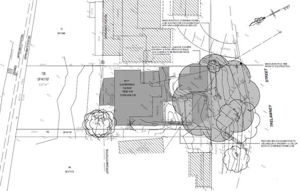
Figure 5 - Shows existing site conditions specifically the Norfolk Pine tree located approximately in the middle of the Council cross over.
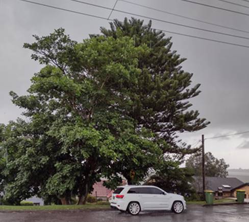
Figure 6 – Street view of 11 Trelawney Street showing Norfolk Island Pine
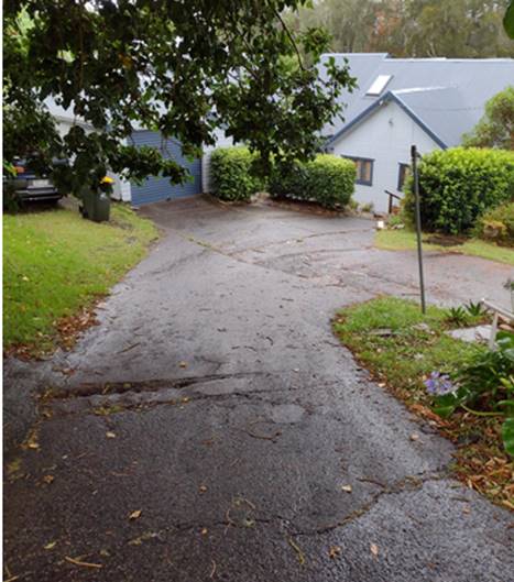
Figure 7 – Existing damaged driveway that services 11 and 13 Trelawney Street
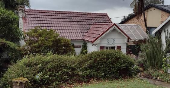
Figure 8 – Existing dwelling at 11 Trelawney Street viewed from the street frontage
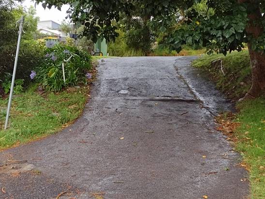
Figure 9 - Existing damaged driveway that services 11 and 13 Trelawney Street
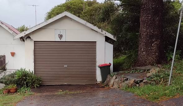
Figure 10 – Existing Garage at 11 Trelawney Street. Note location of Norfolk Island Pine to the right of frame.
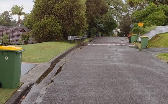
Figure 11 – Street view looking east from 11 Trelawney Street
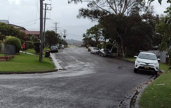
Figure 12 - Street view looking west from 11 Trelawney Street
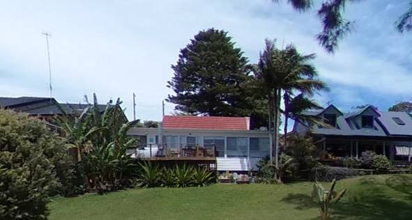
Figure 13 – Existing dwelling at 11 Trelawney Street viewed from the rear of lot. Note the Norfolf Island Pine viewed from this location.
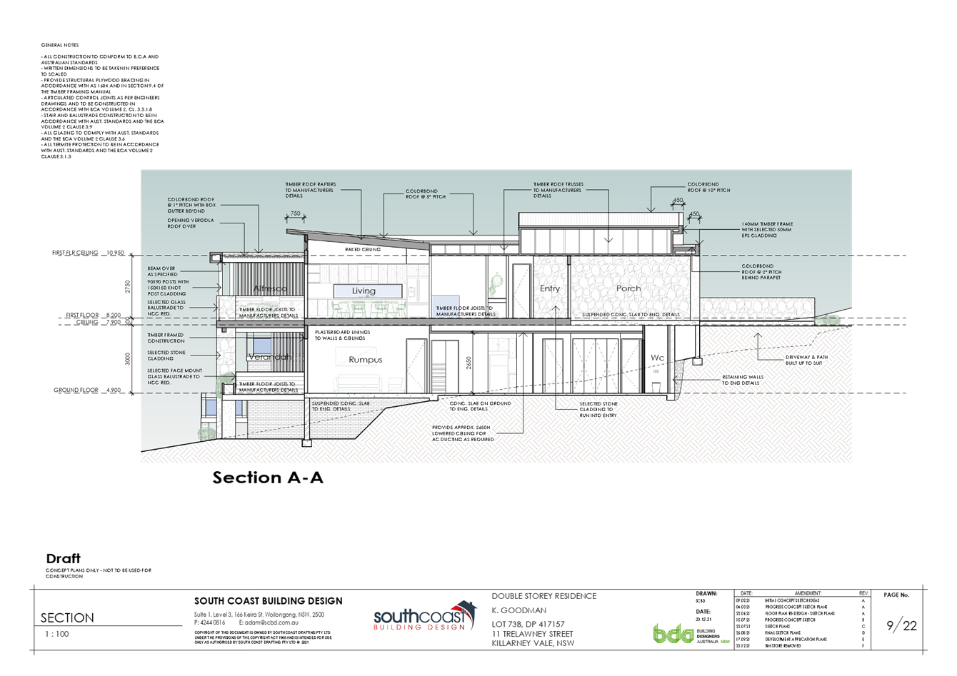
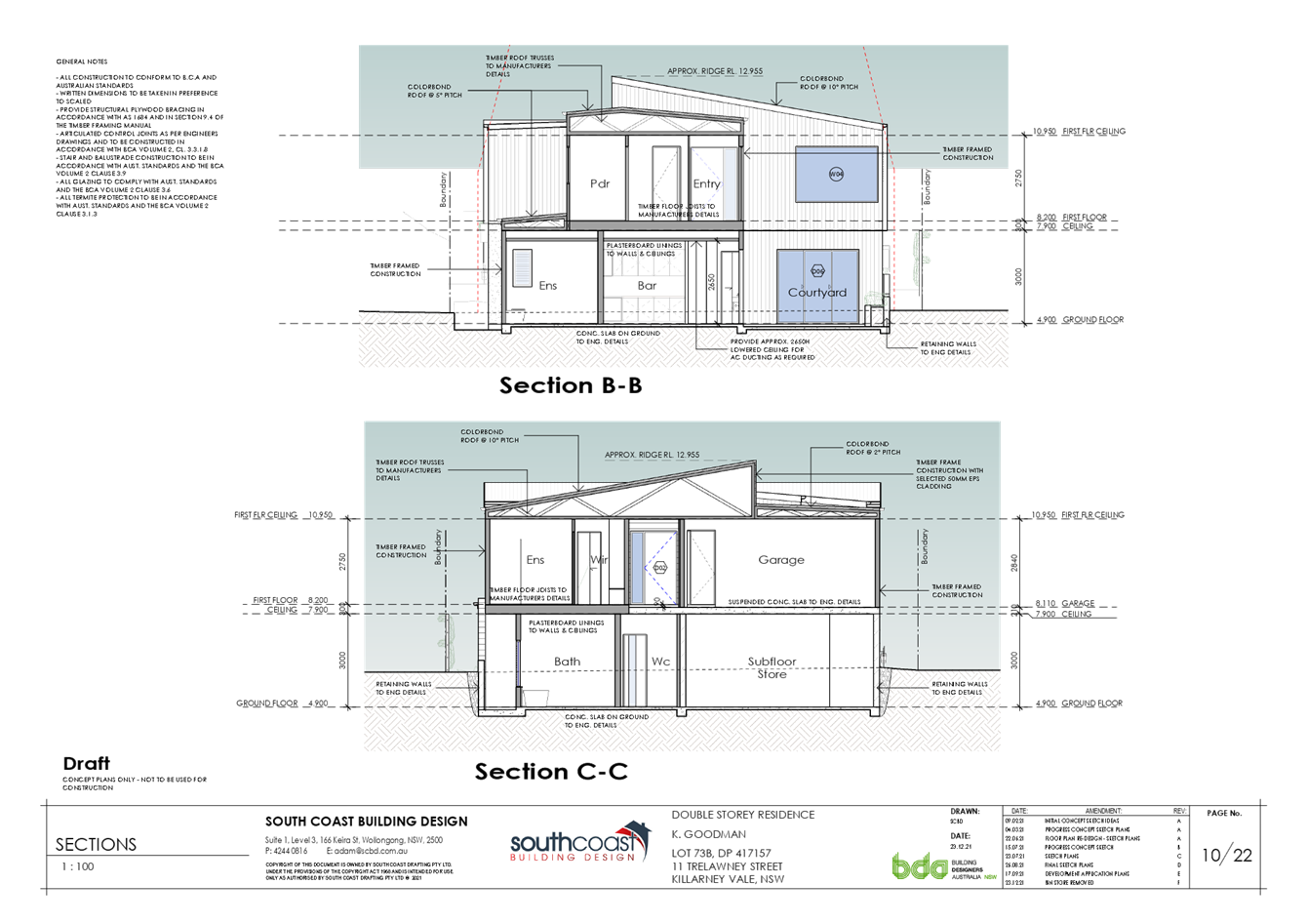
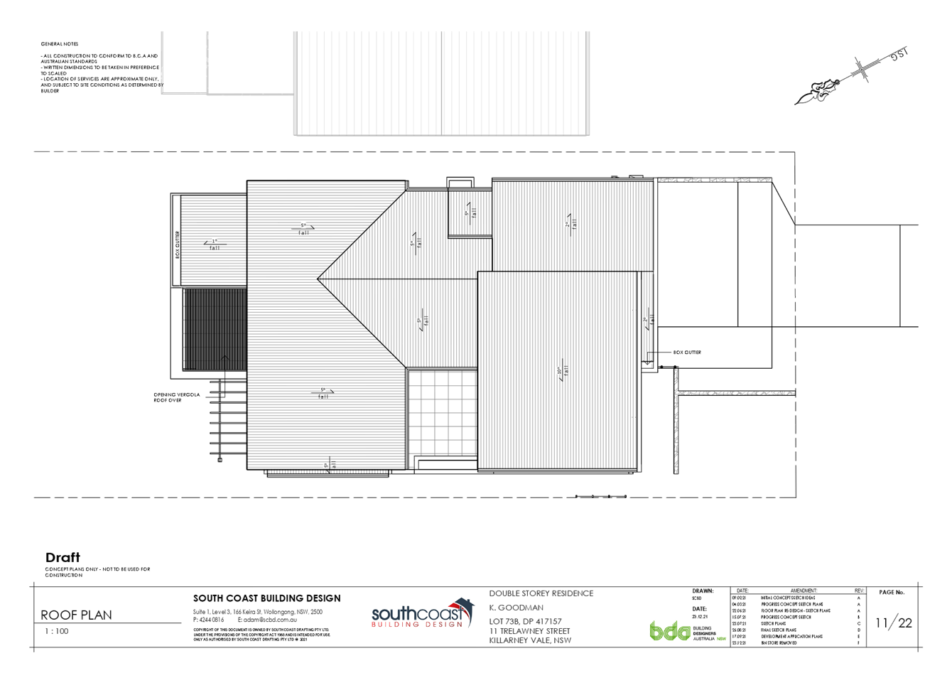
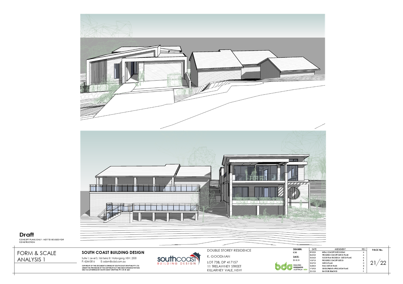
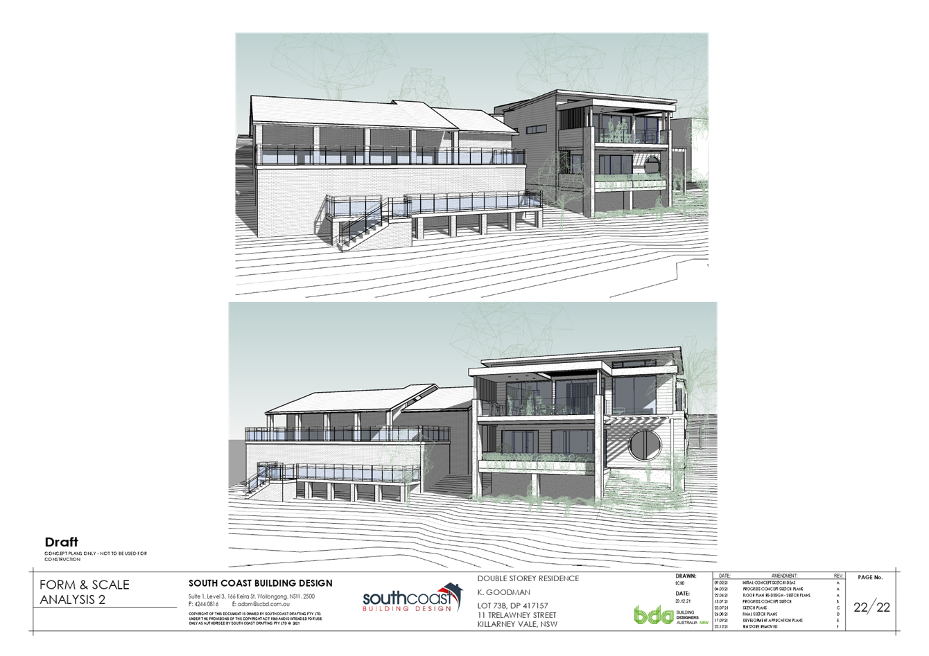
The Proposed Development
The proposed development consists of the demolition of the existing dwelling, removal of the Norfolk Island Pine tree and other site vegetation & the construction of a new two-storey dwelling.
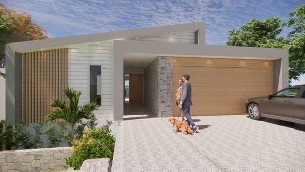
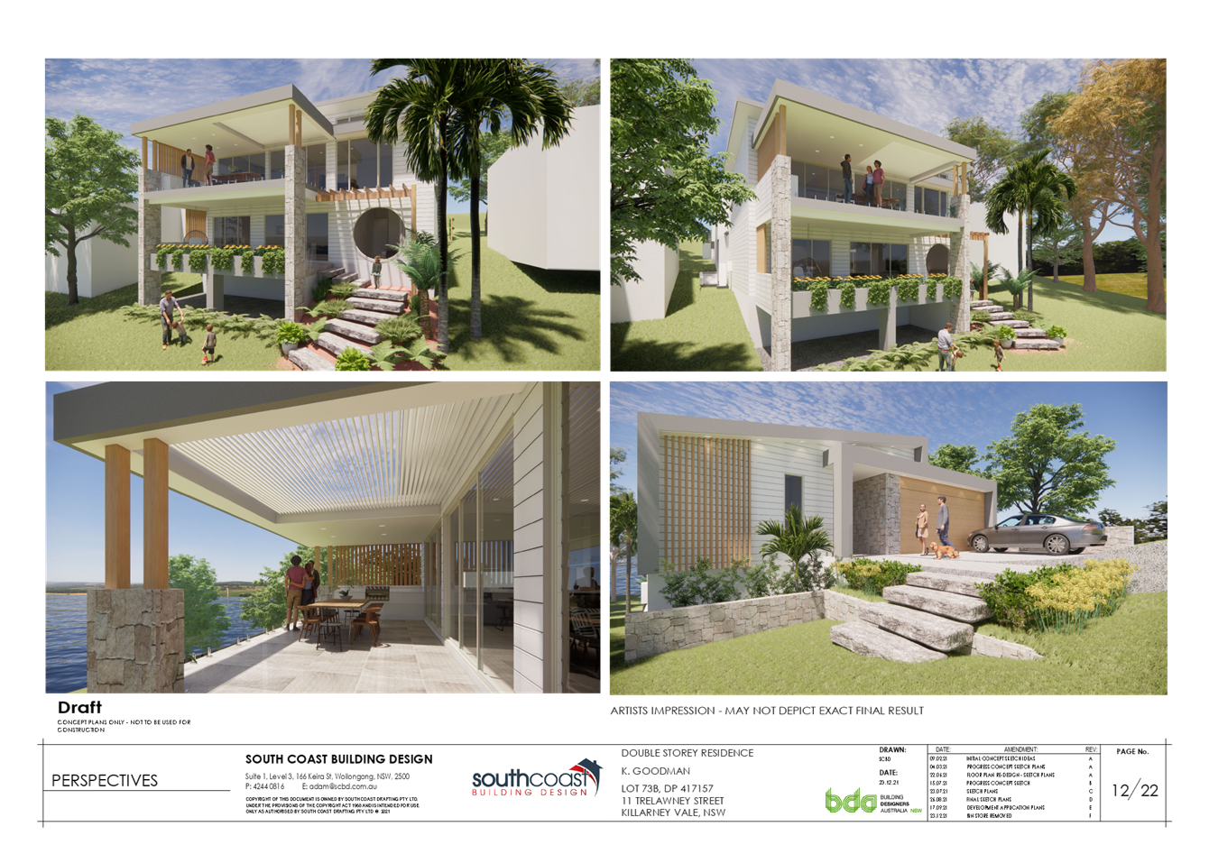
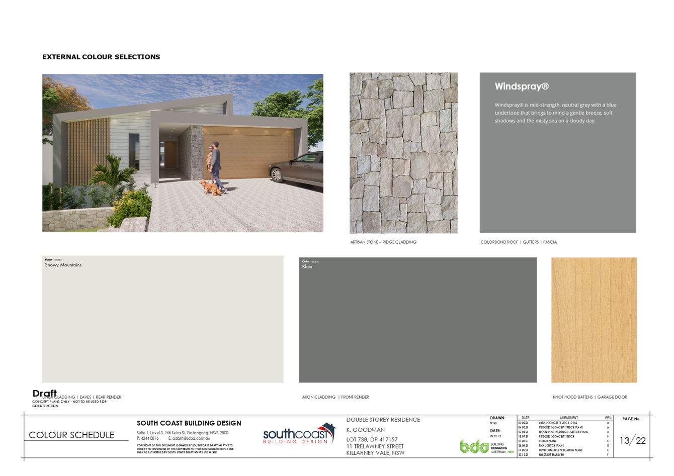
Figure 14 – 3D visualisation – front facade
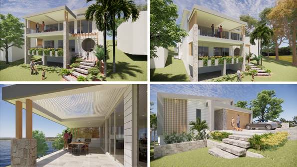
Figure 15 - 3D visualisation – rear, first floor deck and front facade
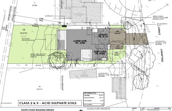
Figure 16 – Site plan
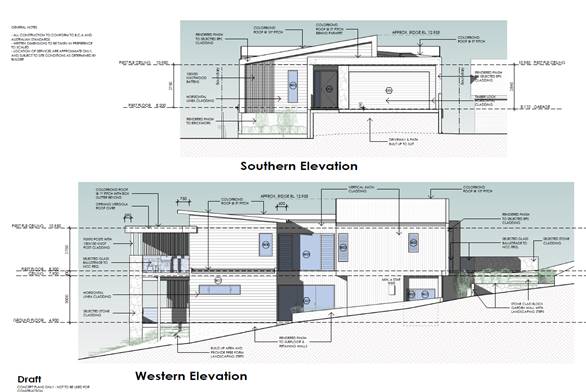
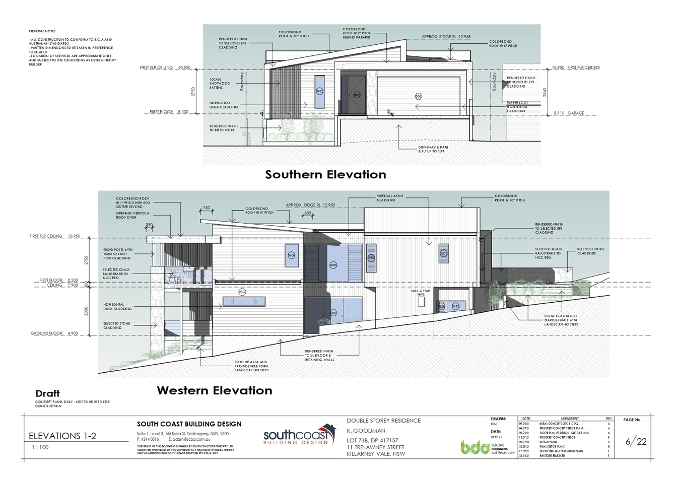
Figure 17 – Southern and western elevation
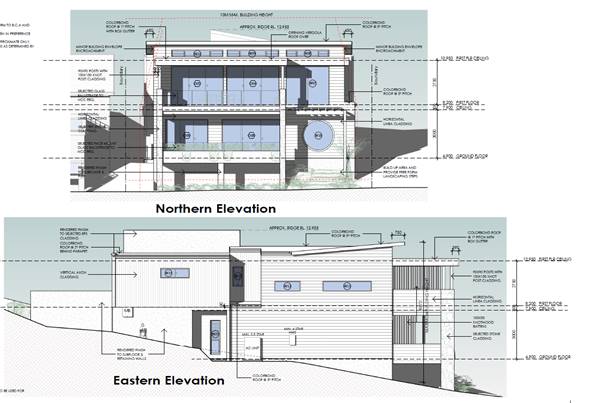
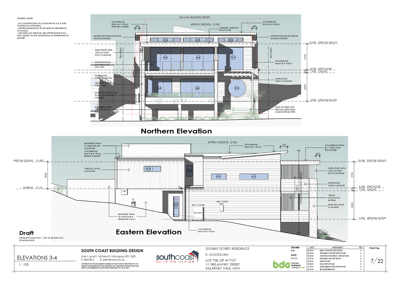
Figure 18 - Northern and eastern elevation
ASSESSMENT:
Having regard for the matters for consideration detailed in Section 4.15 of the Environmental Planning and Assessment Act 1979 and other statutory requirements, the assessment has identified the following key issues, which are elaborated upon for the Local Planning Panel.
State Environmental Planning Policy (Building Sustainability Index) BASIX 2004
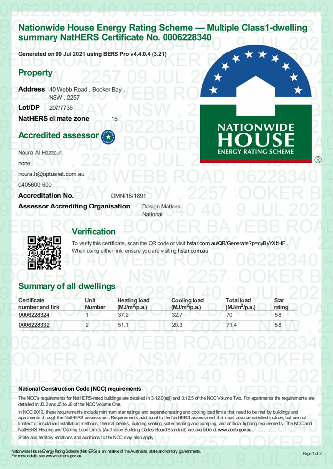
A compliant BASIX certificate achieving the State Governments Energy Efficiency targets has been provided in support of the application.
State Environmental Planning Policy (Vegetation in Non-Rural Areas) 2017
This policy applies to this site under clause 5(1)(b) as it is within an R2 Low Density zone.
Further, Clause 9 details that vegetation removal as declared by Wyong Development Control Plan 2013, Chapter 3.6 Tree & Vegetation Management requires consideration under this SEPP.
In considering the removal of the trees Council shall consider the aims of the policy. The aims of the Policy are set out below:
‘The aims of this Policy are—
(a) to protect the biodiversity values of trees and other vegetation in non-rural areas of the State, and
(b) to preserve the amenity of non-rural areas of the State through the preservation of trees and other vegetation.’
The proposed development proposal the removal of a mature Norfolk Island Pine tree which is situated on the road reserve, right near the front boundary of the subject land. The tree is situated centrally on the lot frontage.
The tree is also listed on Councils Significant Tree Register and a significant number of objections to the development have been in relation to the removal of this tree.
The matter of the tree removal, the supporting documentation submitted in support of the application and the consideration by specialist officers of the Council is dealt with specifically later in this report (under the section in relation to Wyong Development Control Plan, Chapter 3.6 - Tree & Vegetation Management).
Wyong Local Environmental Plan 2013 - Permissibility
The subject site is zoned R2 – Low Density Residential under the provisions of Wyong Local Environmental Plan 2013. The proposed development is best defined as a ‘dwelling house’ and is permissible with consent.
Wyong Local Environmental Plan 2013 - Objectives of Zone
The objectives of the R2 – Low Density Residential zone are:
· To provide for the housing needs of the community within a low-density residential environment.
· To enable other land uses that provides facilities or services to meet the day to day needs of residents.
· To maintain and enhance the residential amenity and character of the surrounding area.
· To provide a residential character commensurate with a low-density residential environment.
The proposed development provides for a style of housing use commensurate with the scale, character and desirable amenity of the existing streetscape and surrounding area.
Wyong Development Control Plan 2013
DCP Chapter 3.6 Tree & Vegetation Management
Chapter 3.6 requires development consent for the removal of tree/s and with consideration to the relevant requirements of the Environmental Planning and Assessment Act 1979 (EP&A Act). The consideration of matters set out in State Environmental Planning Policy (Vegetation in Non-Rural Areas) 2017 is also undertaken in this section of the report.
Significantly, the proposed development includes the removal of a mature Norfolk Island Pine tree which is situated on the road reserve, right near the front boundary of the subject land. The tree is situated centrally on the lot frontage.
Existing improvements on the site (namely the existing garage, and concrete hardstand/driveway) have been constructed within very close proximity of the tree (garage within 3 metres of the tree base).
Figures 19 and 20 (on the following page) are repeated from previously in the report to demonstrate the location of the tree in relation to the property frontage/front boundary and the existing structures/driveway. Figures 21 and 22 show further photographs of the tree and its location in relation to existing improvements.
Figure 19 – Existing improvements and location of Norfolk Island Pine tree
Figure 20 – Existing Garage at 11 Trelawney Street. Note location of Norfolk Island Pine to the right of frame.
Figures 21 and 22 –location of Norfolk Island Pine
Council Significant Tree Register
Council has a Significant Tree Register in which this tree is listed. Whilst the Significant Tree Register is not intended to provide any additional legal protections over the trees contained within it, it does contain a list of trees of specific value that have been nominated by the community. As such, these are matters for consideration of Development Applications and other applications which involve removal or potential damage of significantly listed trees.
The criteria for listing of trees on the Significant Tree Register are:
· Outstanding visual or aesthetic significance
· Botanic or scientific significance
· Significant ecological value
· Historical and commemorative significance
· Social significance
Council received a nomination to include the Norfolk Island Pine at the frontage of the subject site on the Significant Tree Register on 18 August 2021, from a member of the community. The application was supported by signatures from 32 nominees.
The reasons given for the nomination of the tree as significant include:
· It is a ‘beautiful, iconic landmark’ and ‘used by Tuggerah Lakes boaties and fisherman as a landmark’;
· ‘Similar to the Norfolk Pines at The Entrance and along seashores within this LGA, this tree is highly visible many kilometres out in Tuggerah Lake and also highly visible from within Killarney Vale, Long Jetty, The Entrance, Berkley Vale and Bateau Bay.’
· ‘This Norfolk Island Pine trees exceeds all the protection criteria’; and
· ‘It should be preserved and protected through Significant Tree Listing for our current and future generations, and for the ongoing survival of our local and migratory birds and mammals that calls it home’.
Arboricultural Impact Assessment
The applicant has provided Council with an Arboricultural Impact Assessment report to determine the potential impact upon the Norfolk Island pine tree as a result of the proposed development.
The Arboricultural Impact Assessment has concluded that the removal of the subject tree is required to enable the development to proceed. A key point in the Arboricultural Impact Assessment report is the view that demolition of the existing garage structure (and ancillary footings/concrete slab/driveway/hardstand) will most likely result in damage to the Structural Root Zone (SR)Z of the tree.
Specifically, Section 5.4 of the Aboricultural Impact Assessment notes that:
‘This tree has severely damaged the adjacent garage which is <3m to the trunk of the tree. The driveway is also badly damaged. There are major (1st order) roots visible, and the redevelopment of the site will cause serious damage to the Structural Root Zone (SRZ) of this tree. The root plate is 2m below road level.’
and
‘There is a sewer main within 4 metres of this tree. Hunter Water1 lists Araucaria species (Norfolk Island Pine) as a high damage rating.’
and
‘Demolition of the existing structure will probably cause damage to the SRZ, and it
will be exposed to the sun. These works could impact the stability and viability of this tree. The proposed driveway will impact the trunk and canopy of this tree. It will also impact its SRZ.
The redevelopment of this site will require the removal of this tree to facilitate the proposed plans. There are no options available to successfully retain this tree.’
On this basis, Council staff have not pursued amended design for the dwelling to cater for retention of the tree as it is the demolition work will result in damage to the tree SRZ and impact the viability of the tree (rather than the construction of the new/proposed dwelling).
Council Tree Risk Manage Officer Review of Arboricultural Impact Assessment
Councils Tree Risk Management Officer (private works) has undertaken a site inspection (18 December 2021) and reviewed documents relevant to the development application, including:
· The Statement of Environmental Effects
· Architectural plans
· Arboricultural Impact Assessment
Following a review of the relevant documentation, Council’s Tree Risk Management Officer notes:
‘I recommend that the removal of the subject tree is the only option to facilitate the current development proposal.
The tree roots have severely damaged the existing adjacent garage. The existing driveway is also badly damaged and will need to be replaced and the redevelopment of the site will cause severe damage to the SRZ of the subject tree.
There is a sewer main located within 4 meters of the tree, this species is known to cause extensive damage to pipes etc.
The demolition of the existing garage and driveway has the potential to impact the stability and viability of the tree. Any redevelopment of this site to facilitate the current proposal will cause excessive damage to the SRZ and there are no other options available to reduce the impacts this development will have on the subject tree.’
Further Review by Council Public Tree Risk Management Officer
As the tree is located on public land, Councils Public Tree Risk Management Officer has also been consulted. He concurs with the comments provided by Councils Tree Assessment officer.
Although alternative options to retain the tree have been investigated/considered, the demolition of the existing garage is likely to cause impact to the structural root zone of the tree.
Further Comments
The location of the Norfolk Island Pine Tree being situated approximately in middle of the site adjacent to the front boundary provides design constraints for any future development on the site. The tree is located within the road reserve and has a root system that spans the width of the lot and also extends onto the subject property.
The redevelopment of the subject lot will necessitate the removal/demolition of the existing garage which is located within the front portion of the lot within close proximity to the Norfolk Island Pine. Advice from Council officers supports the view set out in the Arboricultural Impact Assessment that the demolition of existing structures are likely to cause damage to the tree resulting in its demise.
It is also noted that redevelopment of the site with a compliant legal vehicle access is not possible without root damage being cause to the tree.
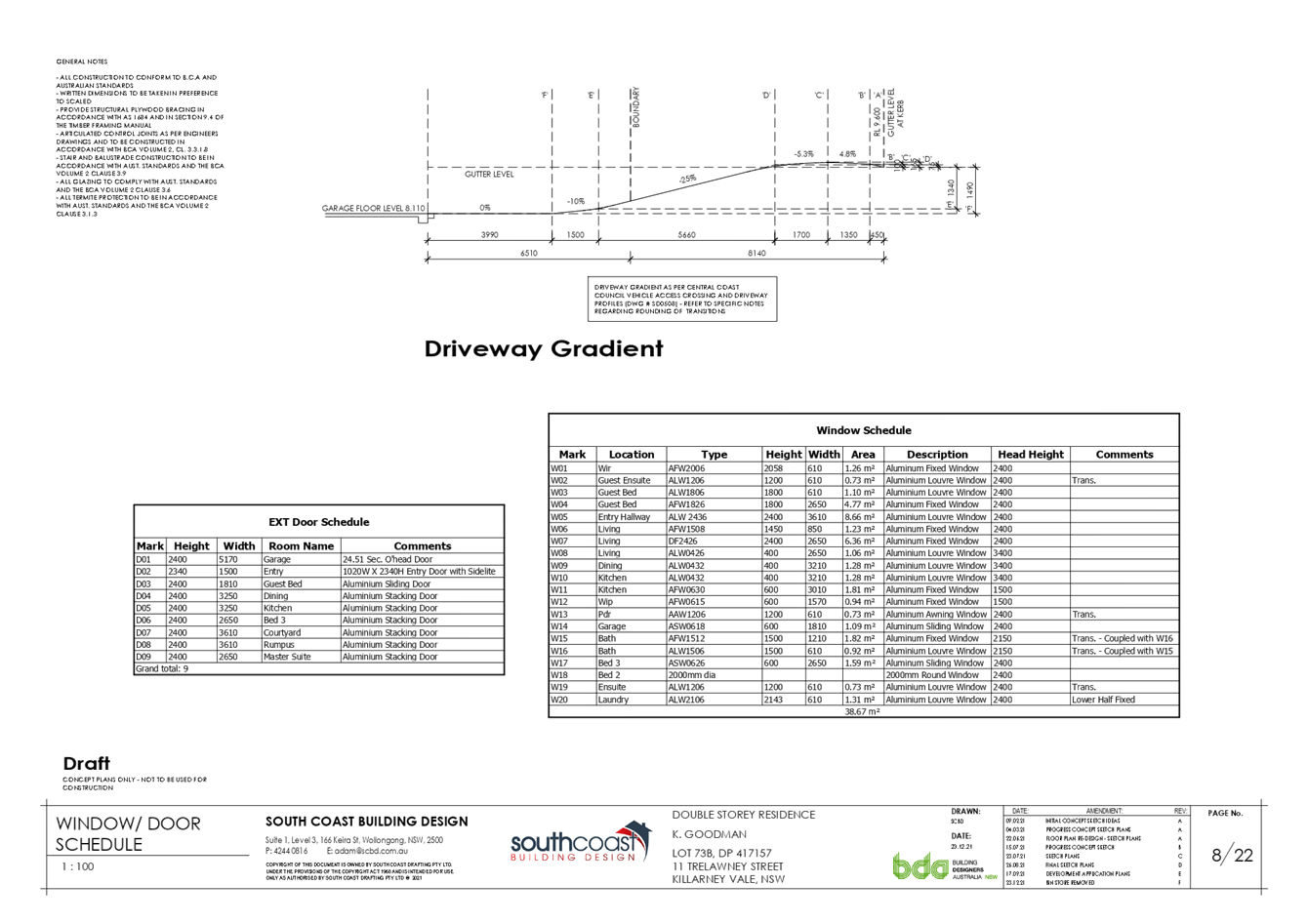
It is acknowledged that there would be loss of amenity with the tree removal. And the listing of the tree on the Significant Tree Register is noted, as well as the views expressed by a significant number of community members during the notification process (please see later in this report). However, a dwelling is permissible within the zone and legal access is required to comply with Councils DCP and to gain access to the site to maintain undercover off-street parking. It is also noted that off street parking is very limited within the direct area and the proposal generally complies with WDCP Chapter 2.1 dwelling houses, secondary dwellings and ancillary development apart form one minor variation to the front boundary setback which is addressed within this report.
Re-design of the proposed dwelling would not guarantee survival of the tree because damage to the Structural Root Zone is expected to occur as part of the demolition stage due to the location of the tree roots in relation to the existing site improvements including garage and driveway.
It is accepted that this type of species commonly grows very large and is not suited on a small residential lot near dwellings or ancillary structures. Poor planning is evident by the planting of this Norfolk Island Pine in this location as it is in the middle of the street frontage and it has left the applicant no other alternative other than to have it removed to gain safe, level and legal access to the land.
A condition will be included in any consent issued which requires replanting of two native tree species which over time will address the amenity impact.
The relevant matters of this SEPP have been considered in the assessment of this application and removal of the Norfolk Island Pine tree is supported.
The removal of the tree, and other vegetation on the site as part of the redevelopment of the land is unlikely to have a potential impact upon any threatened species, populations or ecological communities that may occur within the area. The factors taken into account when assessing whether the proposed development will have a significant ecological effect are based upon the 5-part Test of Significance detailed in the Environmental Planning and Assessment Act 1979 (EP&A Act) and the Biodiversity Conservation Act 2016 (BC Act).
DCP Chapter 2.1 - Housing & Ancillary Structures
The proposed development has been assessed against the relevant provisions of Chapter 2.1 – Housing and Ancillary Structures as follows:
|
Clause
|
Requirement |
Proposed |
Compliance |
|
2.1 - Building height |
10.0 metres for dwellings
Maximum 2 stories |
8.055m
Two stories
|
Yes
Yes |
|
2.2 - Site coverage |
Maximum 50% |
27.30% |
Yes |
|
3.1.a.i - Front setback (dwelling) |
Average setback of adjoining dwellings – 9.3m |
7.253m |
No |
|
3.1.a.iv - Front setback (garage) |
1.0 metre behind Average setback of adjoining dwellings – 10.3m |
6.504m |
No |
|
3.1 - Rear setback |
6.0m |
17.316m |
Yes |
|
3.1 - Side setback |
1.050 metres given building height |
1.050 metres minimum |
Yes |
|
3.3.2 - Garage door articulation |
Maximum 60% of building width – 7.614m |
5.17m |
Yes |
|
4.3 - Private open space areas |
Minimum 24m2
Minimum dimension 3m
Maximum gradient 1:50
|
Well In excess of 24m2
Well in excess of 3.0m
Level |
Yes
Yes
Yes |
|
4.4 Sunlight Access |
On June 21, 50% of the required principal private open space area for all dwellings receives at least 3 hours of unobstructed sunlight access between 9am and 3pm
On June 21, 50% of the required principal private open space on adjoining land receives at least 3 hours of unobstructed sunlight access between 9am and 3pm.
|
Well in excess of 50% |
Yes
Yes
|
|
5.0 Car parking and access |
2 spaces if 4 or more bedrooms
Parking to be located behind the primary road setback
Maximum driveway width 4m at the street crossover |
3
Garage forward of the primary road setback
4.5m |
Yes
No* see note
No* see note
|
|
6.1 - Earthworks |
Maximum 1.0 metre fill
No retaining wall for fill is to be less than 1m from boundary
Fill not associated with dwelling to be max 0.6 metres and setback 1.0 from boundary |
0.9m
1.13m
1.13m |
Yes
Yes
Yes |
|
6.2 - Retaining walls |
To be designed by a structural engineer |
Structural plans to be received conditioned prior to Issue of Construction Certificate |
Yes |
|
6.3 - Drainage |
To be disposed of to reserve |
To Tuggerah Lakes Reserve to the rear of the lot |
Yes |
* Note: The variations required by Clause 3.1 relating to the proposed primary road setback for the garage structure.
DCP Chapter 3.1 Setbacks – Residential Sized lots R1, R2, R3 or RU5
The proposed development includes compliant setbacks for the rear and side boundaries.
The application proposes a variation to the primary road setback – with a proposal front building setback for the dwelling to be 7.253m and the garage to have a front setback of 6.504m. The front setback under the provisions of Clause 3.1.a.i requires a front setback to the dwelling to be the average of the two adjoining properties. The front setback to the dwelling is required to be 9.3m and the development proposes 7.253m. This is a variation of approximately 2.047m or 22%.
The front setback for the garage under the provisions of Clause 3.1.a.iv requires a minimum of 1m behind the building line. The required front setback is 10.3m. This is a variation of approximately 3.8m or 37.06%.
In support of this variation, the applicant has provided justification for the proposed variation.
In considering the proposed setback variation, the objectives of Clause 3.1 need to be taken into consideration. Objectives of Clause 3.1 are as follows:
· To ensure that setbacks are compatible with adjacent development and complements the character, streetscape, public reserve, or coastal foreshore
· To ensure the visual focus of a development is the dwelling, not the garage
· To protect the views, privacy and solar access of adjacent properties
· To maintain view corridors to coastal foreshores and other desirable outlooks
· To maintain the scenic and environmental qualities of natural waterbodies and their foreshores and respond to site attributes such as topography
· To provide deep soil areas sufficient to conserve existing trees or accommodate new landscaping
· To provide appropriate articulation of facades and horizontal elements reduce the appearance of bulk and provides visual interest to the building and subsequent streetscape where they face a street frontage/s.
In considering the proposed setback variation in terms of the aims and objectives of Clause 3.1, the following points are considered relevant.
1 The proposed dwelling is sited, sized and compatible with many other dwellings within the direct area in Killarney Vale. It is noted that due to the slope of land it is common building design and practice to bring the garage forward of the dwelling to accommodate ease of access to a garage, to lower construction costs and to implement better design principals.
2 The design of the dwelling is set as a two-story building on a sloping site with a contemporary and thoughtful design which has maintained visual focus on the dwelling. The proposal will add interesting street appeal when viewed from the Trelawney Street.
3 The proposal will not reduce existing view corridors, privacy, and solar access of adjacent properties.
4 The setbacks, height and bulk of the dwelling are commensurate with the scale of the existing dwellings within the area. It is further noted that both adjacent properties have garages built in front of the dwellings which do not comply with Councils DCP.
5 Building garages forward of the building line in this locality is not setting a precedent and similar development approvals of garages/carports built forward of the building line have been supported within the direct locality
It is considered the applicants request to vary the development control requirements has been justified and under these circumstances the development is recommended for approval.
* Note: The minor width increase to the driveway crossover has been referred to Councils Development Engineers and has been supported in its current form. The driveway width complies with the Australian Standard
DCP Chapter 6.3 Erosion Sedimentation Control
Appropriate siltation control to be conditioned within the issued development consent.
DCP Chapter 6.4 Geotechnical Requirements for Development Applications
There are no requirements in relation to geotechnical requirements for this Development Application.
DCP Chapter 7.2 Waste Management
A Waste Management Plan has been submitted in support of the proposed development.
Flood Planning
The site as it is identified as impacted by flooding.
A flood impact study was submitted with this application prepared by Northrop dated 30 March 2021 which supports the proposal. Further consent must not be granted to land identified by this clause unless the consent authority is satisfied that the development:
· is compatible with the flood hazard of the land: and
· Is not likely to significantly adversely affect flood behavior resulting in worsened flood hazard to other development or properties, and
· Incorporates appropriate measures to manage risk to life from flood and
· Is not likely to significantly adversely affect the environment or cause avoidable erosion, siltation, destruction of riparian vegetation or a reduction in the stability of riverbanks or watercourses, and
· Is not likely to result in unsustainable social and economic costs to the community as a consequence of flooding.
The 1% AEP flood level in this location is RL 7.06m AHD and the minimum floor level required is RL 7.56m AHD (1% AEP flood plus 500mm).
The Flood Impact Report submitted in support of the application notes that:
‘The flood depth across the site is relatively shallow, ranging from 20-70mm typically
with the highest depth noted as 290mm.’
and
‘It is proposed that the building will consist of two stories with floor levels of 4.90m AHD and 8.20m AHD. The lower level is to be protected from the flood levels by providing a waterproof wall around the perimeter of the building to at least 500mm above the corresponding flood level at each location. This will ensure protection from the 1% flood depths across the site with 500mm freeboard as typically required.
All access locations to the lower floor level will be located such that they are suitably protected from the risk of flood inundation.
The upper floor level will be above the required minimum floor level as noted in the Flood Information Certificate.’
Council development engineering staff raise no objection to the proposal on the basis of flooding.
Public Submissions
The application was advertised in accordance with DCP 2013 Chapter 1.2 - Notification of Development Proposals with 152 submissions being received. The issues raised in the submissions have been addressed in the assessment of the application pursuant to the heads of consideration contained within Section 4.15 of the Environmental Planning and Assessment Act 1979.
The general issues raised in relation to the proposal are included below.
1. Tree removal
Comment
A significant number of submissions raised the issue of the removal of the Norfolk Island Pine, as well as request to retain the tree, for the site development to be redesigned and the like.
As previously reported Council received an Arboricultural Impact Assessment report as part of the application. The report was prepared by Russell Kingdom of Advanced Treescape Consulting dated the 28 September 2021 in relation to the proposed tree removal.
The Arboricultural Impact Assessment report has recommended that the removal of the tree is required to enable the development to proceed. The report has further identified that demolition of the existing garage will probably cause damage to the Structural Root Zone (SRZ). These works could impact the stability and viability of this tree.
On this basis Council staff have not pursued alternative designs for the proposed dwelling which could cater for the retention of the Norfolk Island pine tree as the demolition work will result in the SRZ of the tree being damaged. Councils Tree Risk Management Officer has reviewed the report and agrees with this conclusion.
It is generally accepted that this species of tree is aesthetically pleasing to most and it is noted that the majority of submissions relate to the tree removal. However it must be acknowledged that a tree of this species that can cause damage to structures and infrastructure. Due to the size of the tree, and its location, it is no longer appropriate in proximity to the residential property and in this instance, it restricts a complaint vehicle access to the site.
2. Potential for separate use
Comment
The application is for a single residential dwelling. A condition has been applied to the development consent to ensure the legal ongoing use is as a single residential dwelling. Any further use will require appropriate development consent if not subject to exempt/complying provisions contained within NSW legislation.
3. A central courtyard at ground floor level, enclosed on three sides, provides accessible recreational space capable of enclosure and utility as floor space.
Comment
The central courtyard at ground floor would require development consent prior to be enclosed. Any matters related to floor space ratio would be considered and assessed at that time.
4. Both the ground floor and first floor verandah space are capable of enclosure and therefore contribute to the effective floor space and mass of the building.
Comment
The ground floor and first floor verandah space would require development consent to be enclosed. Any matters related to floor space ratio would be considered and assessed at that time.
5. Building being elevated unnecessarily.
Comment
The building includes compliant height, bulk and scale design elements as previously discussed within this report. It is noted that the proposal is compatible with the existing and desired future character of the area. It is not fair or reasonable for the applicant to change the height and design of the proposal when it complies with Councils DCP and the design is assessed to have negligible impacts.
6. Better design would remove the non-compliance with building envelope requirements and reduce the dominance of the garage door and façade improving the streetscape to Trelawney Street.
Comment
The front set back variation is deemed minor and creates negligible impacts to adjacent properties and has been justified within this report previously. Further the design of the garage has incorporated articulation and fenestration with appealing design features which will improve and add value to the streetscape.
7. There are multiple areas of non-compliance with the Development Control Plan objectives including, for example, the author of the Statement of Environmental Effects suggestion that the non-compliance with the garage setback requirements results in “…a better streetscape and character outcome than the current situation…”. That is incorrect and takes no account of the unnecessary elevation of the garage component and its resultant prominence in streetscape terms highlighted by the sites location immediately opposite the “T” intersection of Carlyon Street.
Comment
The proposal has been assessed against the relevant development standards and development Control Plans applicable to the site. One variation to Councils DCP related to front building setback has been identified and discussed within the report. The variation is supported, and the proposed design is recommended for approval. The development is not considered to have a negligible impact on the streetscape.
8. Reviewing the proposal in the context of the information contained in Photograph No. 14, indicates the manner in which a horizontally aligned driveway and retaining works would conspire to disrupt the natural topography and streetscape appeal by the crude insertion of inappropriate civil works disrupting also vehicular access to the dwelling to the west and imposing a 3m high garbage receptable enclosure to the dwelling to the east.
Comment
The proposed dwelling is sited, sized and compatible with many other dwellings within Killarney Vale. It is noted that due to the slope of land it is common building design and building practice to have an elevated garage level and additionally position the garage forward of the dwelling to enable a compliant vehicle access. In this case the proposed design is accepted as the best option available. It is noted that both adjacent properties garages are built in front of the dwellings and they both do not comply with Councils DCP in relation to primary road setbacks.
Further it is noted that through negotiation with the applicant the proposed bin storage that encroached into the 900mm side setback was deleted.
9. Adoption of an almost horizontal alignment of a driveway disrupts not only the longitudinal streetscape but elevates the building unnecessarily such that it disrupts the view available from the public domain. The resultant impact on the streetscape is better avoided and may be avoided by better design; a design which adopts a lower but still compliant ground floor level and a more considered vehicular access arrangement.
Comment
This point has previously been addressed within the report.
10. The better design approach would have the added benefit of reducing the apparent bulk of the building and allowing greater solar access, particularly to the residence on the easternmost side which relies on a single west facing window for light and ventilation.
Comment
It has been demonstrated within this report that the proposal generally complies with Wyong Development Control Plan 2013 other than the minor variation to the front setback. The design is appropriate, sensitive to the environment, thoughtful and contemporary.
11. Procedural Objection - community participation and access to information
Comment
Community participation was clearly achieved with over 100 submissions being received via the NSW Planning Portal. It is noted that generally on review of DA’s all the documents as part of the application are not displayed on the NSW Planning Portal however when requested the information is made available. In this instance documents were made available as requested.
Further to the above the application was placed on public notification in accordance with the requirements of the Environmental Planning & Assessment Act 1979 and the provisions of the Wyong Development Control Plan 2013. The notification period was undertaken from 11 November 2021 until 2 December 2021. Some members of the community requested additional time to make submissions.
Late submissions were considered as part of the assessment process. All submissions have been considered carefully in this assessment.
Ecologically Sustainable Principles:
The proposal has been assessed having regard to ecologically sustainable development principles and is considered to be consistent with the principles.
The proposed development is considered to incorporate satisfactory stormwater, drainage and erosion control and is unlikely to have any significant adverse impacts on the environment and will not decrease environmental quality for future generations. The proposal does not result in the disturbance of any endangered flora or fauna habitats and is unlikely to significantly affect fluvial environments.
The Likely Impacts of The Development
Built Environment
Given the position of the proposed dwelling and garage on the allotment and comparison of bulk and scale with other dwellings, the proposal is considered to be suitable with regard to the context and setting of the subject site and is considered to be in keeping with the character of the area.
A thorough assessment of the proposed development’s impact on the built environment has been undertaken in terms of the WLEP 2013 and WDCP 2013 compliance. It is considered on balance that the potential impacts are considered reasonable.
Access and Transport
The proposed development will not create any adverse effect on access, transport and traffic measures within the local area. The site has compliant parking and hardstand for the residents without any impact to nearby residents.
Context and Setting
The proposed works are a permissible form of development, appropriate in the proposed location and are in keeping with the character of the local area.
The existing dwelling and ancillary development to be demolished is an older style residential cottage and it is noted that this area is undergoing redevelopment with older cottages being replaced with modern style dwellings.
As previously discussed, the proposal would result in the removal of a mature Norfolk Island Pine tree. It is noted that there is no practical alternative for the siting of a dwelling on this lot to retain the tree, and that the significant impact to the tree is likely from the demolition of existing structures. The subject Norfolk Island Pine tree proposed to be removed has a root system that spans approximately the full width of the lot and to gain legal access to the site. There is no other alternative to removing the tree as demonstrated within the Arborists report.
It is also proposed to require the planting of replacement trees which (in time) will assist in addressing any loss of amenity.
Natural Environment
The proposal involves some site excavation given the site’s sloping topography. Whilst there is some impact upon the natural environment specifically the proposed removal of a Norfolk Island Pine tree (previously considered)
Cumulative Impacts
The ecological assessment has concluded that the development would not have a significant ecological impact. This has been demonstrated by the five-part test of significance for the development. In particular, the trees are physically isolated on a residential site thereby not contributing to any existing wildlife corridor and will not result in fragmentation of the existing local habitat. The lack of ecological impact demonstrates the site does not adjoin any area of outstanding biodiversity.
This method of assessment effectively considers any cumulative impact of the development and in this case has demonstrated that that it would not have a cumulative impact in the area.
Killarney Vale is gradually undergoing redevelopment and there is some cumulative loss of amenity with the tree removal in the suburb. This is acknowledged and it is appropriate that as the site be redeveloped, replanting of trees will address any amenity impact caused by removal of the tree.
The Suitability of the Site for the Development
A review of Council’s records identifies the following constraints:
· Flood Plain Management – The allotment is impacted by flooding and accordingly, the application has been referred to development engineering staff for comment. Upon review, the proposal has been found to be acceptable subject to the imposition of appropriate conditions of consent.
· Acid Sulfate Soils - The proposed works is within class 2 and 5 land shown on the Acid Sulfate Soils Map and proposing works below its threshold, however in accordance with clause (6) (repeated below) the development is exempt from requiring an acid sulfate soils management plan, as:
(a) the works involve the disturbance of less than 1 tonne of soil, and
(b) the works are not likely to lower the water table.
There are no other constraints that would render the site unsuitable for development.
Climate Change
The potential impacts of climate change on the proposed development have been considered as part of the assessment of the application.
This assessment has included consideration of such matters as potential for more intense and/or frequent extreme weather conditions including storm events, bushfires, drought and flood as well as how the proposed development may cope / combat / withstand these potential impacts.
The development proposal is not considered to be impacted by potential climate change.
Conclusion
The proposed development complies with the objectives of subject zone and is compatible with the existing and desired future character of the area. The proposal complies with objectives and desirable outcomes of Chapter 2.1 Dwelling Houses & Ancillary Structures. The proposal raises no significant issues under Section 4.15 of the EP&A Act 1979 to warrant refusal, and as such the application is recommended for approval.
|
1⇩ |
Draft Conditions of Consent |
|
D14995762 |
|
2⇩ |
Redacted Architectral Plans |
|
D15071003 |
|
Item No: 4.1 |
|
|
Title: DA/1825/2021 - 3 Vintage Court, Watanobbi - Construction of New Dwelling Including Tree Removal |
|
|
Department: Environment and Planning |
|
|
24 March 2022 Local Planning Panel Meeting |
|
Reference: DA/1825/2021 - D15021687
Author: Gary Evans, Principal Health and Building Surveyor
Manager: Wayne Herd, Section Manager, Building Assessment and Certification
Executive: Andrew Roach, Unit Manager, Development Assessment
|
Summary
An application has been received for the construction of a new dwelling and tree removal. The application has been examined having regard to the matters for consideration detailed in section 4.15 of the Environmental Planning and Assessment Act 1979 and other statutory requirements with the issues requiring attention and consideration being addressed in the report.
The application is referred to the Panel as a result of conflict of interest, with the applicant being a member of staff within the Development Assessment Unit involved with the assessment of development applications. The proposed development is recommended for approval.
Applicant Mr J J Field Owner Mr J J Field Application No 1825/2021 Description of Land Lot 7040 DP 849117 3 Vintage Court Watanobbi 2259 Proposed Development Dwelling including tree removal Site Area 1,191 m2 Zoning R1 General Residential Existing Use Dwelling house Employment Generation N/A Estimated Value $410,000
|
That the Local Planning Panel grant consent to DA/1825/2021 – Lot 7040 DP 849117, 3 Vintage Court Watanobbi NSW – Dwelling and tree removal subject to the conditions detailed in the schedule attached to the report and having regard to the matters for consideration detailed in Section 4.15 of the Environmental Planning and Assessment Act 1979.
Key Issues
· The subject application complies with the relevant prescriptive development controls as contained within Council’s Chapter 2.1 “Dwelling Houses, Secondary Dwellings and Ancillary Development”;
· The application has been supported by an arborist and flora assessment which both support the tree removal required to facilitate dwelling construction;
· Notification of the development proposal to adjoining landowners resulted in the receipt of 1 minor submission relating to the potential use of the rear unformed road during the construction phase of the development.
Precis:
|
Proposed Development |
Dwelling including tree removal. |
|
Permissibility and Zoning |
The subject site is zoned R1 General Residential under the provisions of Wyong Local Environmental Plan 2013 (WLEP 2013).
The proposed development is defined as a ‘dwelling house’ which is defined under the Wyong LEP 2013 as;
‘dwelling house’ means – a building containing only one dwelling.
The use is permissible with consent of Council within the zone.
|
|
Relevant Legislation |
The following planning policies and control documents are relevant to the development and were considered as part of the assessment. · Environment Planning and Assessment Act 1979 - section 4.15 (EP&A Act) · State Environmental Planning Policy (Building Sustainability Index: BASIX) 2004 · Wyong Local Environmental Plan 2013 (WLEP 2013) · Draft Central Coast Local Environmental Plan 2018 (Draft CCLEP 2018) · Wyong Development Control Plan 2013 Chapter 2.1 Dwelling Houses, Secondary Dwellings and Ancillary Development (WDCP 2013) · Wyong Development Control Plan 2013 Chapter 3.6 Tree and Vegetation Management (WDCP 2013)
|
|
Current Use |
Dwelling house
|
|
Integrated Development |
No
|
|
Submissions |
The development application was notified in accordance with the provisions of the Wyong Development Control Plan 2013 Chapter 1.2 - Notification of Development Proposals from 9 December 2021 until 19 January 2022. One (1) submission was received during this period. |
Variations to Policies
Nil to report.
The Site
The site is known as No. 3 Vintage Court Watanobbi and is located on the southern side of the Vintage Court cul-de-sac head at Watanobbi. The site is irregularly shaped and has an overall area of 1,191m² which includes the battle-axe handle serving the allotment. The site, beyond the battle-axe handle, contains a significant available building platform with a rear boundary width of 26.560m and a minimum lot depth of 28.0m.
The site slopes moderately from the southern (rear) boundary to the site’s northern boundary. Vehicular access to the site is contained within the battle axe handle serving the allotment. This driveway access also serves the adjoining allotment to the immediate north of the site.
The site is currently vacant.
The site is zoned R1 General Residential under Wyong Local Environment Plan 2013 (WLEP 2013).
Figure 1 - Aerial view of the Watanobbi locality with the site highlighted in blue.
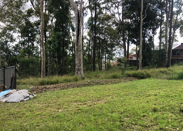
Site photograph 1: Taken from the rear unformed road reserve looking north across the site
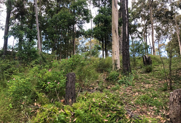
Site photograph 2: Looking in a southerly direction across the building envelope from the sites existing driveway access
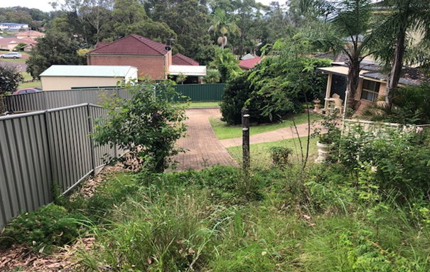
Site photograph 3: Detailing the existing driveway access serving the allotment looking north
Surrounding Development
The site is surrounded by other residential allotments generally retaining R1 General Residential and R2 Low Density Residential zonings under WLEP 2013. To the immediate rear of the site is an area of unformed road reserve and beyond that, an area of RE1 wooded recreation zoned land.
Existing dwellings in proximity to the site, are a generally limited to one and two storeys and are typically of brick veneer construction displaying traditional roof pitches.
The Proposed Development
The application submitted to Council seeks to construct a new two storey dwelling on a vacant allotment inclusive of the removal of a number of trees to facilitate the development.
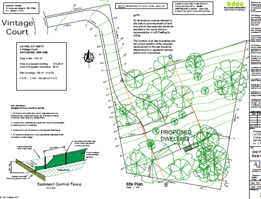
Figure 2: The proposed site plan
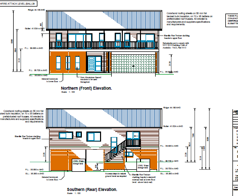
Figure 3: The proposed northern and southern elevations
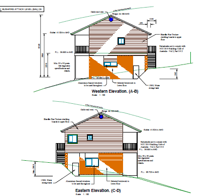
Figure 4: The proposed eastern and western elevations
ASSESSMENT:
Having regard for the matters for consideration detailed in Section 4.15 of the Environmental Planning and Assessment Act 1979 and other statutory requirements, the assessment has identified no issues that would prevent the approval. Relevant matters are dealt with below:
State Environmental Planning Policy (Building sustainability Index) BASIX 2004
A compliant BASIX certificate achieving the State Governments Energy Efficiency targets has been provided in support of the modification application.
Wyong Local Environmental Plan 2013 - Permissibility
The subject site is zoned R1 General Residential under Wyong Local Environmental Plan 2013.
The proposed development is defined as a Dwelling House which is permissible in the zone with consent.
‘dwelling house’ means a building containing only one dwelling.
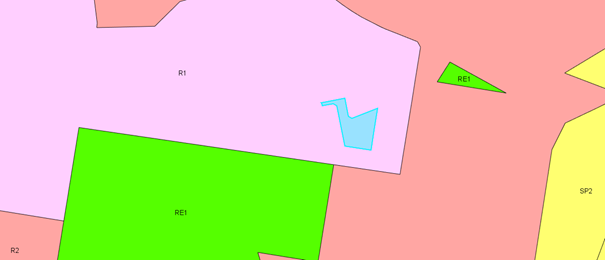
Figure 2: Zoning Map with the site highlighted in blue.
Wyong Local Environmental Plan 2013 - Objectives of zone
The subject site is zoned R1 General Residential under Wyong Local Environmental Plan 2013.
The objectives of the zone are:
· To provide for the housing needs of the community.
· To provide for a variety of housing types and densities.
· To enable other land uses that provides facilities or services to meet the day to day needs of residents.
· To promote “walkable” neighbourhoods.
· To ensure that development is compatible with the scale and character of the local area and complements the existing streetscape.
The proposed development is a permissible land use within this residential zone which is considered to be development that provides for a style of housing use commensurate with the scale and character of existing dwellings within the local area.
Draft Central Coast Local Environmental Plan 2018 (Draft CCLEP 2018)
A Draft Central Coast Local Environmental Plan 2018 (Draft CCLEP 2018) was exhibited until 27 February 2018. The gazettal of the Draft LEP is imminent. Under the provisinos of the Draft LEP, the subject site retains its R1 General Residential zoning, with dwelling houses remaining permissible with the consent of Council.
Wyong Development Control Plan 2013
A review of the application against the provisions of the Wyong Development Control Plan 2013 is included below:
Chapter 2.1 “Dwelling Houses, Secondary Dwellings and Ancillary Development”
The following table includes an assessment of the proposal against the provisinos of Chapter 2.1 of the Wyong Development Control Plan 2013.
|
Clause |
Requirement |
Proposed |
Compliance
|
|
2.1(c) - Building height |
10.0 m
Maximum 2 storeys unless steeply sloping
|
8.38m
2 storeys |
Yes
Yes |
|
3.1.2.2 – Site coverage |
Maximum 50% |
12.6% |
Yes
|
|
3.1(b) – Rear setback |
3.0 metre rear setback to parallel road or public reserve required |
5.0m |
Yes |
|
3.1(c) – Side setback |
Maximum 1.87m given height of building
|
6.660m minimum
|
Yes |
|
4.3 - Private open space areas |
Minimum 24m2
Minimum dimension 3m
Maximum gradient 1:50 |
In excess of 24m2
Well in excess of 3m
Level |
Yes
Yes
Yes |
|
5.0 – Car parking and access |
2 spaces if 4 or more bedrooms
|
2 car spaces
|
Yes |
|
6.0 - Earthworks |
3.0 metres where located more than 1.0 metre from the allotment boundary |
Maximum 1.3m located in excess of 1.0 metre from boundary |
Yes |
Chapter 3.6 Trees and Vegetation Management
As indicated, the development proposal includes the removal of a number of trees within the building envelope to facilitate the dwellings construction. In this regard, the dwelling proposal has been accompanied by an appropriate arborists report and additionally, a flora survey which have been reviewed internally and found to be satisfactory.
Accordingly, the removal of the nominated trees is considered appropriate subject to the implementation of conditions of consent regarding the retention and protection of the remaining trees to be retained.
Likely Impacts of the Development:
Built Environment
A thorough assessment of the proposed development's impact on the built environment has been undertaken in terms of WLEP 2013 and WDCP 2013 compliance and in terms of the submission received. It is considered on balance that the potential impacts are considered reasonable.
Access and Transport
The site is well served by the existing roadway and is also well served by public transport.
Context and Setting
The subject site lies within an established residential area. The design of the development proposal is considered consistent with adjoining development and the areas context and setting.
Natural Environment
As indicated, the proposal requires the removal of a number of trees to facilitate the development. Upon internal review, tree removal is considered appropriate in the location noting the sites R1 General Residential zoning. Accordingly, the proposal is considered satisfactory in relation to impacts on the natural environment.
Suitability of the Site for the Development:
There are no site constraints that would render the site unsuitable for the proposed development.
The proposal is consistent with the size and scale of development in proximity to the allotment. Accordingly, the proposal is considered to be in keeping with the character of the area.
Public Submissions
In accordance with Chapter 1.2 - Notification of Development Proposals of Wyong Development Control Plan 2013 (WDCP), the application was initially notified from 9 December 2021 to 19 January 2022.
A total of one submission was received in relation to the development proposal.
A summary of the issue raised within the individual submission include:
1 Concerns regarding access and the use of the rear unformed road reserve for construction access and material delivery.
Comment
A condition of consent will be applied requiring the fencing of the site and use of the existing driveway access located off Vintage Court for construction access and material deliveries.
Submissions from Public Authorities
The application was not required to be referred to any public authorities.
Internal Consultation
The application was referred to the following internal staff;
Tree Officer
· Supported subject to the imposition of conditions of consent.
Ecologist
· Supported subject to the imposition of conditions of consent.
Ecologically Sustainable Principles:
The proposal has been assessed having regard to ecologically sustainable development principles and is considered to be consistent with the principles.
The proposed development is considered to incorporate satisfactory stormwater, drainage and erosion control and is unlikely to have any significant adverse impacts on the environment and will not decrease environmental quality for future generations. The proposal does not result in the disturbance of any endangered flora or fauna habitats and is unlikely to significantly affect fluvial environments.
Climate Change
The potential impacts of climate change on the proposed development have been considered as part of the assessment of the application.
This assessment has included consideration of such matters as potential for more intense and/or frequent extreme weather conditions including storm events, bushfires, drought and flood as well as how the proposed development may cope / combat / withstand these potential impacts.
The development proposal is not considered to be impacted by potential climate change.
Other Matters for Consideration:
Nil matters.
Conclusion:
The development application has been assessed in accordance with Section 4.15 of the EP&A Act and all relevant instruments and polices. The proposed development is considered suitable for the site. The development proposal is therefore recommended for approval subject to the conditions attached to this report.
|
1⇩ |
Draft Consent Conditions |
|
D15022009 |
|
2⇩ |
REDACTED PLANS for LPP Report |
|
D15021735 |
|
4.1 |
DA/1825/2021 - 3 Vintage Court, Watanobbi - Construction of New Dwelling Including Tree Removal |
|
Attachment 1 |
Draft Consent Conditions |