 |
Central Coast
Local Planning Panel Meeting
Business Paper
26 May 2022
 |
|
Central Coast
Local Planning Panel Meeting
Business Paper
26 May 2022
|
The Local Planning Panel Meeting
of Central Coast
will be held remotely - online,
Thursday 26 May 2022 at 2.00 pm,
for the transaction of the business listed below:
1 Procedural Items
1.1 Disclosures
of Interest......................................................................................................................... 3
2 Confirmation of Minutes of Previous Meetings
2.1 Confirmation of Minutes of Previous Meeting........................................................................ 4
3 Planning Reports
3.1 DA 52083/2017(C) Section 8.2 Review - 5-7 Church St, Terrigal................................. 10
Kara Krason
Chairperson
|
Item No: 1.1 |
|
|
Title: Disclosures of Interest |
|
|
Department: Governance |
|
|
26 May 2022 Local Planning Panel Meeting |
|
Reference: F2020/02502 - D14205789
|
The NSW Local Planning Panel Code of Conduct states that all panel members must sign a declaration of interest in relation to each matter on the agenda before or at the beginning of each meeting.
|
That Panel Members now confirm that they have signed a declaration of interest in relation to each matter on the agenda for this meeting and will take any management measures identified.
|
Item No: 2.1 |
|
|
Title: Confirmation of Minutes of Previous Meeting |
|
|
Department: Corporate Affairs |
|
|
26 May 2022 Local Planning Panel Meeting |
|
Reference: F2020/02502 - D15168449
Author: Rachel Callachor, Meeting Support Officer
|
Summary
The
Minutes of the following Meetings of the Local Planning Panel, which have
been endorsed by the Chair of that meeting, are submitted for noting: · Local Planning Panel Meeting held on 21 April 2022 |
That the minutes of the previous Local Planning Panel Meeting held on 21 April 2022 which were endorsed by the Chair of that meeting, are submitted for noting.
|
1⇩ |
MINUTES - Local Planning Panel - 21 April 2022 |
|
D15133413 |
|
2.1 |
Confirmation of Minutes of Previous Meeting |
|
Attachment 1 |
MINUTES - Local Planning Panel - 21 April 2022 |
|
Item No: 3.1 |
|
|
Title: DA 52083/2017(C) Section 8.2 Review - 5-7 Church St, Terrigal |
|
|
Department: Environment and Planning |
|
|
26 May 2022 Local Planning Panel Meeting |
|
Reference: DA/52083/2017/C - D15109604
Author: Salli Pendergast, Principal Development Planner North
Manager: Emily Goodworth, Section Manager Development Assessment North
Approver: Andrew Roach, Unit Manager, Development Assessment
|
Summary
A Section 8.2 application has been received for a Review of Determination of an application for modification under S4.55(2) to the approved shop top housing development comprising two shops, 12 residential units and car parking at 5 & 7 Church Street, Terrigal. The application has been examined having regard to the matters for consideration detailed in section 4.15 of the Environmental Planning and Assessment Act 1979 and other statutory requirements with the issues requiring attention and consideration being addressed in the report.
Applicant George Daaboul c/- Slater Architects Owner Gmda P/L and AJ Baladi and N Baladi Application No DA/52083/2017/C (previously known as Part 4) (PAN-152416) Description of Land 5 & 7 Church Street, Terrigal, Lots 19 & 20 DP.7861 Proposed Development Shop top housing comprising business premises, 13 units and car parking Site Area 942m² Zoning B2 Local Centre – Gosford LEP 2014 Existing Use Approved development under construction Estimated Value $9,791,503 (excluding GST)
|
1 That the Local Planning Panel refuse the application DA/52083/2017/C at 5 & 7 Church Street, Terrigal - Section 8.2 application for a Review of Determination of Section 4.55(2) application for the modification of a commercial and shop top housing development subject to the reasons for refusal detailed in the schedule attached to the report and having regard to the matters for consideration detailed in Section 4.15 of the Environmental Planning and Assessment Act 1979.
2 That Council advise those who made written submissions of the Panel’s decision.
• Whether the proposal is substantially the same development
• Height and Floor Space Ratio
• Building bulk and scale
• View impacts
• Matters raised in Public Submissions.
Precis:
|
Proposed Development |
Review of a Determination for refusal of a S4.55(2) application to modify an approved commercial premises and shop top housing development. |
|
Permissibility and Zoning |
B2 Local Centre. Shop top housing permissible with consent. |
|
Relevant Legislation |
Environmental Planning and Assessment Act 1979 – Division 8.2 and Sections 4.15 and 4.55(2). Local Government Act 1993 - Section 89 State Environmental Planning Policy (Coastal Management) 2018 State Environmental Planning Policy (Building Sustainability Index: BASIX) 2004 State Environmental planning Policy (Gosford City Centre) 2018 Draft Central Coast Local Environmental Plan 2018 Gosford City Centre Development Control Plan 2018 State Environmental Planning Policy (Infrastructure) 2007 State Environmental Planning Policy No 65 (Design Quality of Residential Flat Buildings) Draft State Environmental Planning Policy (Environment) 2017 Draft State Environmental Planning Policy (Short Term Rental Accommodation) 2019 State Environmental Planning Policy (Exempt and Complying Development) 2008 Apartment Design Guidelines (ADG) Central Coast Climate Change Policy |
|
Current Use |
Construction physically commenced for development (Construction Certificate issued 8 January 2021). |
|
Integrated Development |
No |
|
Submissions |
42 submissions received (first notification) 31 submissions received (amended plans second notification) |
The Site
The site is known as No.’s 5-7 Church Street, Terrigal and is in the Terrigal Village Centre having a primary street frontage to Church Street and rear site frontage to Hudson Lane. There is a very slight grade from Church Street (RL 4.09m AHD) towards Hudson Lane (RL 2.72m AHD). The site is generally rectangular having a site area of 942m² with a 24.385m south-west frontage to Church Street, and a 24.385m rear frontage to Hudson lane. The north-western side boundary has a length of 38.605m and the south-eastern side boundary a length of 38.66m.
The site is located one street back from Terrigal Esplanade and approximately 130m walk to Terrigal Beach. The subject site previously contained a public car parking area for 33 cars. The site was sold by Council in 2015 and construction work has physically commenced under this consent. The site is located within a flood planning area and subject to the PMF. The site is also identified as Class 5 acid sulphate soils.
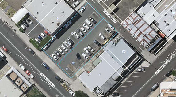
Above: Aerial view of site
Surrounding Development
Surrounding development mainly consists of commercial premises, shops and restaurants of varying heights. The Crown Plaza is located on the southern side of Kurrawyba Avenue. A two storey medical centre is located on the northern side of the site and a single storey bank on the southern side of the site. Terrigal Police Station (a two storey building) is located further to the north. A six storey development (DA49519/2016) has been approved on the corner of Kurrawyba Avenue and Church Street diagonally opposite the site.
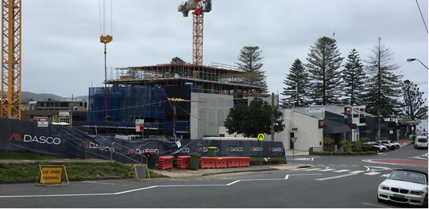
Above: View of site from south on Kurrawyba Ave
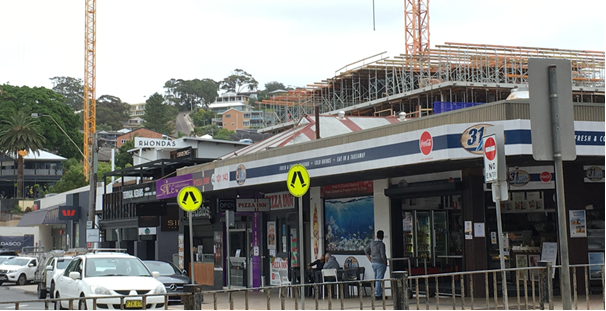
Above: View of development from Terrigal Esplanade from east
Above: View of site from Grosvenor Road
The Proposed Development
The application seeks a review of determination of the refusal of a modification application made under Section 4.55(2) of the Environmental Planning and Assessment Act 1979 (EP&A Act) for the approved shop top housing development comprising of two shops, 12 residential units and car parking. The modification application was refused by the Central Coast Local Planning Panel at their meeting of the 24 June 2021.
The reasons for refusal were as follows:
i. The proposed modification significantly increases the height and floor space of the approved development and exceeds the development standards of Clause 4.3 and 4.4 of the Gosford Local Environmental Plan 2014.
ii. The proposed modification does not comply with the objectives and development standards of the B2 zone State Environmental Planning Policy 65, Gosford Local Environmental Plan 2014, or Gosford Development Control Plan 2013.
iii. The proposed modification would have additional impacts on adjoining sites resulting in additional view loss and amenity impacts.
iv. Approval is not in the public interest.
The modification was for the addition of a fifth floor (Level 6) level on the approved building which would result in an increase in the number of units from 12 to 13 and consequently a revised roof design, with an additional storey and enlarged terraces to the units on Level 5.
The modification under review specifically seeks the following changes:
• Change in the description of development to “Shop Top Housing – Comprising of Two Business Premises, 13 Residential Units & Car Parking”
• Rectify the duplication of condition 3.1 within the development consent by deleting the first condition 3.1 referencing “Submit notice of intention to commence subdivision, roads and stormwater drainage works”.
• Change to the plan reference under Condition 1.1 to include a reference to the revised plans. The revised plans include the following changes to the original approved development:
- addition of a fifth floor (Level 6), 3x bedroom penthouse unit (195m²) which increases the number of residential units from 12 to 13 and increases the building height and FSR
- revisions to the roof plan
- enlargement of the size of the terraces on level 5 to all boundaries resulting in a reduction to the boundary setbacks on all sides of the building as follows:
- front (Church St) boundary setback to balcony- from 2.2m to 500mm
- north-western side setback to balcony from 3m to 2.4m
- south-eastern side setback to balcony from 3m to 2.4m
- rear (Hudson Lane) boundary setback to balcony from 2.2m to 1.1m
The plans submitted for the s4.55(2) review of determination were revised during the assessment of the review as follows:
• Amendments to the street and side boundary setbacks and a reduced floor plate for the penthouse unit. In this regard, the building setback to Church Street and side boundaries have been increased by 1m and 0.5m respectively, with a consequential reduction in the floor plate of the proposed penthouse unit.
• The lift overrun ridge has been reduced in area and height from RL 23.72 to RL 23.63 and is now located only over the lift (i.e., not over the fire stair or service risers); and
• The roof pitch has been reduced from 3 degrees to 1 degree, which has reduced the height of the main roof by 230mm.
• A view analysis (by Urbaine Architectural) has been provided by the applicant to assist in the assessment of the impacts of the proposed modifications to the development.
Above: Original approved front elevation plans
Above: Proposed modified development front elevation under the latest plans for the review
Above: Original approved north-west elevation plans
Above: Proposed modified development north-west elevation under the latest plans for the review
Further amended plans/additional documentation was submitted on 2 May 2022 however, this information has not been assessed as the review of determination had been completed and the assessment report finalized for the 26 May meeting agenda.
Applicant’s Submission on the Reasons for Refusal
The applicant has provided information to address each of the reasons for refusal as follows:
Refusal Reason 1 - “The proposed modification significantly increases the height and floor space of the approved development and exceeds the development standards of Clause 4.3 and 4.4 of the Gosford Local Environmental Plan 2014”.
The proposal involves the following:
· The planning controls are RL18.5m (max height) and 1.8:1 (max FSR)
· The approved development is RL 19.8m (max roof height) and RL 20.35m (lift overrun) and FSR 2:05:1.
· The latest plans for the proposed development propose RL 23m (to the building roof) and RL 23.63m (lift overrun) and FSR 2.24:1.
The applicant has included a legal opinion as part of the review of determination application which states the development is substantially the same development to that which was originally granted development consent.
The applicant’s SEE (pp25 & 25) states as follows:
In Mr. Tomasetti’s opinion:
There can be no doubt in my view that the proposed development is substantially the same development as that which was approved. To add an apartment to an approved building already containing 12 apartments without material alteration to the approved scheme below the new level, is in my view, a classic example of a modification;
The consultant architects provided an assessment which showed that the proposed modified building height would be compatible with the height of other multi-level buildings recently constructed or under construction in the locality. The proposed additional penthouse level at a maximum height of (RL 23.55 – lift overrun),is either lower than, or similar in height to other multi-level mixed use buildings approved by Council in recent years in the immediate locality at:
- No. 15 Kurrawyba Street (RL 26.75 – lift overrun/FSR 2.56:1);
- No. 6 Pine Tree Lane (RL 27.65m);
- No. 13 Ash Street (RL 23.18m).
All exceeded the RL18.5m maximum building height development standard for Terrigal Town Centre yet little reference is given to this important fact in the Council assessment report.
Council’s past decisions indicate that the building height development standard may have virtually been abandoned or destroyed by the Council’s own actions in granting consents departing from the standard and hence the merit consideration of this modification application should not give the proposed numerical exceedance of the development standard determining weight.
In my respectful view, to reject the development on Ground 1 that is, because the proposed modification significantly increases the height and floor space of the approved development and exceeds the development standards of Clause 4.3 and 4.4 of the Gosford Local Environmental Plan 2014 is no proper ground for refusal at all. The question to be asked and answered by the LPP is far more sophisticated.
A detailed analysis of the objectives of the height (and floor space) standards has to be undertaken and then the proper planning decision follows. To rely upon mere numerical non-compliance with the building height control is not giving effect to the logic in the SJD decision and is not consistent with other recent decisions of the Court like Big Property Group.
Height Objectives – Applicant’s Submission
The applicant has outlined why they deem the development to be consistent with the ‘height of buildings’ objectives under Clause 4.3 of GLEP as follows:
· Objective of GLEP Clause 4.3(1)(a) to establish maximum height limits for buildings,
Applicant: Objective (a): The maximum building height of the proposed modified development is either lower than, or similar in height to other multi-level buildings approved by Council in recent years in the immediate locality
· Objective of GLEP Clause 4.3(1)(b) to permit building heights that encourage high quality urban form
Applicant: Objective (b): The proposed modified development is demonstrated in the accompanying Architect’s Design Statement and the Architect’s SEPP 65 Design Verification Statement to be of high quality architectural/urban form
· Objective of GLEP Clause 4.3(1)(c) to ensure that buildings and public areas continue to receive satisfactory exposure to sky and sunlight,
Applicant: Objective (c): The accompanying comparative shadow diagrams, showing comparative shadows cast by the approved and proposed modified development show that neighbouring buildings and public areas continue to receive satisfactory exposure to sky and sunlight
· Objective of GLEP Clause 4.3(1)(d) to nominate heights that will provide an appropriate transition in built form and land use intensity
Applicant: Objective (d) The various sections provided in Diagram DA-CA02-Context Analysis’ prepared by Slater Architects (Revision 3 - 4th August 2021), show that the proposed modified development contributes to an appropriate transition in built form and land use intensity in the locality, particularly observed in Section 5 which shows a lowering of building height towards Terrigal Beach
· Objective of GLEP Clause 4.3(1)(e) to ensure that taller buildings are located appropriately in relation to view corridors and view impacts and in a manner that is complementary to the natural topography of the area
Applicant: Objective (e): As demonstrated in this Section 8.3 review request’s response to Refusal Reason 3, the proposed built form of the modified development is appropriately located in relation to view corridors and view impacts, in a manner which is complementary to the topographical characteristics of the locality
· Objectives of GLEP Clause 4.3(1)(f) to protect public open space from excessive overshadowing and to allow views to identify natural topographical features
Applicant: Objective (f): The proposed modified development does not overshadow any public open space and does not obstruct any views of natural topographical features from any public open space, or the public domain generally
FSR Objectives – Applicant’s Submission
• Objective of GLEP Clause 4.4(a) to establish standards for the maximum development density and intensity of land use,
Applicant: Objective (a) The floor space ratio of the proposed modified development is either lower than, or similar in floor space ratio to other multi-level buildings approved by Council in recent years in the immediate locality
• Objective of GLEP Clause 4.4 (b) to control building density and bulk in relation to site area in order to achieve the desired future character for different locations,
Applicant: Objective (b) The proposed modified development is demonstrated in this Section 8.3 review request’s response to Refusal Reason 2 to be consistent with the desired future character of Terrigal Town Centre
• Objective of GLEP Clause 4.4 (c) to minimise adverse environmental effects on the use or enjoyment of adjoining properties and the public domain,
Applicant: Objective (c): The proposed modified development has been demonstrated to minimise adverse environmental effects on the use or enjoyment of adjoining properties and the public domain (refer also to the response herein to refusal reasons 3 and 4)
• Objective of GLEP Clause 4.4 (d) to maintain an appropriate visual relationship between new development and the existing character of areas or locations that are not undergoing, and are not likely to undergo, a substantial transformation,
Applicant: Objective (d): As demonstrated in Diagram DA-CA02-Context Analysis’ prepared by Slater Architects (Revision 3 - 4th August 2021), a copy of which is provided in Figure 18, the proposed modified development maintains an appropriate visual relationship to the existing bult form/character of Terrigal Town Centre
• Objective of GLEP Clause 4.4 (e) to provide an appropriate correlation between the size of a site and the extent of any development on that site,
Applicant: Objective (e): As demonstrated in the accompanying Architectural Drawings (Figures 4 - 14); the Architect’s Design Statement (copy provided in Annexure C); and the Architect’s SEPP 65 Design Verification Statement (copy provided in Annexure D), the proposed modified development provides an appropriate correlation between the size of the site and the extent of the proposed modified development
• Objective of GLEP Clause 4.4 (f) to facilitate design excellence by ensuring the extent of floor space in building envelopes leaves generous space for the articulation and modulation of design,
Applicant: Objective(f) The built form of the proposed modified development provides for suitable articulation and modulation of design
• Objective of GLEP Clause 4.4 (g) to ensure that the floor space ratio of buildings on land in Zone R1 General Residential reflects Council’s desired building envelope,
Applicant: Objective (g): Not Applicable as the subject land is not zoned R1 General Residential.
• Objective of GLEP Clause 4.4 (h) to encourage lot amalgamation and new development forms in Zone R1 General Residential with car parking below ground level.
Applicant: Objective (h): Not Applicable as the subject land is not zoned R1 General Residential.
The applicant concludes:
The Central Coast Council/Central Coast Local Planning Panel has erred in its decision to reject DA 52083/2017/4 because the proposed modification significantly increases the height and floor space of the approved development and exceeds the development standards of Clause 4.3 and 4.4 of the Gosford Local Environmental Plan 2014. For the reasons given in the Opinion of Mr. Peter Tomasetti SC and provided in section 6.1 of this Section 8.3 review application, this “is no proper ground for refusal at all. The proposed modified development is demonstrated to be consistent with the objectives of both the maximum building height and floor space ratio development standards.
Refusal Reason 2 The proposed modification does not comply with the objectives and development standards of the B2 zone, State Environmental Planning Policy 65, Gosford Local Environmental Plan 2014, or Gosford Development Control Plan 2013
Objectives of the B2 zone
The objectives of the B2 zone are as follows:
· To provide a range of retail, business, entertainment and community uses that serve the needs of people who live in, work in and visit the local area.
· To encourage employment opportunities in accessible locations.
· To maximise public transport patronage and encourage walking and cycling.
· To provide for residential uses, but only as part of a mixed use development.
· To ensure that development is compatible with the desired future character of the zone.
· To promote ecologically, socially and economically sustainable development.
· To ensure that the town centres of Erina and Woy Woy are recognised as providing a higher level, and greater diversity, of services and facilities to serve a wide population catchment from numerous localities and as key public transport nodes, secondary to Gosford City Centre.
· To ensure that village centres such as Avoca, East Gosford, Ettalong Beach, Kincumber, Lisarow, Niagara Park, Terrigal, Umina Beach, West Gosford and Wyoming are recognised as providing a broad range of services and facilities to serve the population of the locality.
· To ensure that villages are recognised as providing local level services and facilities and are developed at a scale that reflects their population catchment and as a focus for public transport routes.
· To ensure that the different roles of villages are recognised with some villages being key tourist destinations with boutique activities in addition to serving the needs of local residents, while other villages are purpose-built centres to serve the needs of the local population.
· To encourage the residential population of villages and town centres to contribute to the vitality of those locations.
The applicant has argued that the modified proposal is consistent with the B2 objectives because:
· The proposed modified development retains ground floor business premises to serve the needs of the local community
· The proposed modified development retains the ground floor business premises, thereby providing employment opportunities within Terrigal Village Centre
· The proposed modified development is in close proximity to bus routes circulating within Terrigal Village Centre and is within walking distance of all local facilities, services and the coastal foreshore.
· The proposed modified development continues to provide shop-top residential accommodation (13 apartments) as part of a mixed-use development.
· The built form of the proposed modified development is substantially unchanged from that of the originally approved development and is consistent with the desired future character of the zone.
· The proposed modified development provides for the efficient and sustainable use of the subject land, located in an urban setting and which has no ecological values requiring protection.
· The proposed modified development provides ground level business premises to service the local community and will provide additional residential accommodation (13 units) within Terrigal Village Centre.
· The proposed modified development provides ground level business premises, which will provide local services to the community, accessible by public transport.
· The proposed modified development provides for a mix of uses appropriate to Terrigal Village Centre as a tourist destination.
· The proposed modified development provides 13 shop-top residential units and will result in an increased residential population contributing to the vitality of Terrigal Village Centre.
Development standards of B2 zone
The applicant has argued that the modified proposal should not have been refused for this reason as follows:
It is established in the response to Refusal Reason 1 (Section 6.1 above) that to reject the proposed modified development because the proposed modification significantly increases the height and floor space of the approved development and exceeds the development standards of Clause 4.3 and 4.4 of the Gosford Local Environmental Plan 2014 is no proper ground for refusal of the modification application.
SEPP 65 – Objectives and Standards
The accompanying Architect’s SEPP 65 Design Verification Statement (copy provided in Annexure D) demonstrates that the proposed additional penthouse level complies with the applicable aims/objectives and the Schedule 1 - Design Quality Principles of SEPP 65.
Clause 30 of SEPP 65 provides standards that cannot be used as grounds to refuse development consent or modification of development consent…The proposed modified development provides for car parking; internal apartment area; and ceiling height associated with the proposed penthouse level, which are equal to, or greater than the recommended minimum. It is noted that the Council assessment report has not provided any reference to any noncompliance with a development standard contained in SEPP 65, notwithstanding the reference to SEPP 65 given in Refusal Reason 2.
GLEP - Objectives and Development Standards
The applicant has argued that the modified proposal should not have been refused for this reason as the officer’s report did not directly address this aspect as follows:
It is noted that whilst Central Coast Council’s assessment report dated 24th June 2021 considers the consistency of the proposed modified development with the objectives of the B2 Local Centre zone contained within Gosford Local Environmental Plan 2014, it does not establish any inconsistency of the proposed modified development with the general aims contained in Clause 1.2 of Gosford Local Environmental Plan 2014.
The development standards of Gosford Local Environmental Plan 2014 contained in Clause 4.3 (2) (Maximum Height of Buildings) and Clause 4.4 (2) (Maximum Floor Space Ratio) applicable to the subject land are RL18.5m and 1.8:1 respectively. The response to the Council’s consideration that the proposed modified development significantly increases the height and floor space of the approved development and development standards of Clause 4.3 and 4.4 of the Gosford Local Environmental Plan 2014 is addressed in the response to Refusal Reason 1 (refer to sections 6.1.1 – 6.1.4 above).
Objectives of Gosford DCP 2013
The applicant has argued that the modified proposal should not have been refused for this reason as the officer’s report made limited references to support this opinion as follows:
In relation to the development guidelines contained in Gosford Development Control Plan 2013, the Council’s development assessment report makes the following limited references on pages 19 – 22 to support its opinion of the proposed modified development’s inconsistency with the guidelines of GDCP 2013 relating generally to the desired character of multi-level development within Terrigal Town Centre…
Applicant’s Response - Chapter 2.1 – Character
The applicant has argued that the modified proposal is consistent with the DCP Chapter 2.1 desired character statement as follows:
· The proposed
modified development provides for a mix of commercial (retail) and residential
accommodation providing for high levels of street activity, improved standards
of amenity and high-quality urban design appropriate to the coastal character
of Terrigal Village Centre.
· The proposed modified development enhances existing levels of ‘main street’ activity; maintains satisfactory levels of midday sun along footpaths; promotes high levels of on-street activity; provides a shelter awning for pedestrians in Church Street; and contributes to high levels of visible activity along Church Street and Hudson Lane by providing residential balconies to both the eastern and western building elevations.
· The proposed modified development does not dominate the foreshore setting or disrupt ‘main street’ development patterns. The height and form of the building maintains scenic views available from hillside residential properties. Along Church Street, the proposed development provides for retail premises with zero building setback. There are no existing adjoining residential properties impacted by the proposed modified development.
· The proposed modified development is compatible with the coastal character of Terrigal Village Centre. Articulation of the proposed modified development in terms of built form and use of materials avoids the appearance of a continuous wall of development.
· The bulk and scale of the proposed modified development (Level 6 – Penthouse) is disguised by the proposed street and side boundary setbacks. A flat roof has been adopted to minimise building height. The architectural treatment of the side and rear facades are appropriate, having regard to any future prospect of the eventual redevelopment of the adjoining sites in a similar manner to the proposed development.
· Off street parking is concealed within the proposed modified building and vehicle access is provided from Hudson Lane, thereby avoiding disrupting the desired pattern of continuous shopfronts to Church Street. Paving of the proposed foyer entry from Church Street will match the existing council footpath paving. The proposed materials schedule and colour scheme is coordinated and appropriate to the public domain. There is no requirement for additional street improvements.
Applicant’s Response - Chapter 2.2 – Scenic Quality
The applicant has argued that the modified proposal is consistent with the DCP Chapter2.2 – Scenic Quality as follows:
For the purposes of Chapter 2.2, the subject land is located within the “North Coastal Geographic Unit – Terrigal Landscape Unit” …
The proposed modified development is consistent with the applicable development objectives for this landscape unit as the subject land is not subject to visibility or other physical constraints and the proposed development will not detract from the scenic quality of the Terrigal Landscape Unit as it is located within the Terrigal Town Centre, where there are a number of multi-storey mixed-use buildings (either existing or under construction) of similar or greater building height.
As shown in the Building Context Analysis Diagrams provided in Figure 18, the proposed penthouse level will not be visually dominant within the Terrigal Town Centre; will not have any impact on beach amenity; and is located within an area that has high ‘absorption capacity’ for an increase in density and built form, as demonstrated by past Council approvals for multi-level buildings in the locality.
Applicant’s Response - Chapter 4.3 – Terrigal Town Centre
The applicant has argued that the modified proposal is consistent with the DCP Chapter 4.3 – Terrigal Town Centre as follows:
The amended architectural plans for the Level 6 Penthouse Unit submitted with this S.8.3 Review Application achieves compliance with the GDCP2013 requirement that this level not exceed 50% of the street frontage width (i.e. to Church Street). The amended Level 6 penthouse achieves a compliant floor width of 47.8% of the street frontage width.
The amended architectural plans for Level 6 (refer to the elevation and section drawings) suitably reduce the bulk and scale of the proposed modified building and provide for a pedestrian friendly scale, as the penthouse unit is not visually dominant to pedestrians in Church Street.
Refusal Reason 3 The proposed modification would have additional impacts on adjoining sites resulting in additional view loss and amenity impacts
View loss impacts
The applicant has argued that the modified proposal should not have been refused for this reason as:
…the Local Planning Panel gave determining weight to an objection to the proposed modified development lodged on behalf of the owners of No. 15 Kurrawyba Avenue, which is currently being developed for a six storey mixed-use building (‘Azure Apartments’) under Development Consent 49519/2016.
The owners of No. 15 Kurrawyba Avenue claimed that the proposed penthouse level on the subject land would result in a loss of ocean/beach views which would be otherwise available from Levels 4 and 5 of that development.
It is contended however
that the Council did not give reasonable consideration to the applicant’s
view loss assessment, which concluded that potential view loss from Levels 4
and 5 of 15 Kurrawyba Avenue, was minor and reasonable in the circumstances. It
is further noted that:
•
The photographic analysis provided in the ‘Azure
Apartments’ View Loss Assessment did not present a true panoramic
photograph of the total view that will be available from both Level 5
apartments of that development. The photographs are instead selectively cropped
• It is the case that any redevelopment of retail/commercial premises in the Terrigal Town Centre block bounded by Terrigal Esplanade; Kurrawyba Avenue; Church Street; and Campbell Crescent (particularly fronting Terrigal Esplanade) and complying with the RL 18.5m development standard would cause a greater loss of beach/water interface views from No. 15 Kurrawyba Avenue, than would the proposed modified development
• For the same reasons that the Land and Environment Court has established the planning principle that it is not reasonable to expect to wholly retain existing lateral views over a neighbouring property upon its redevelopment, it is also unreasonable for a development, which itself substantially exceeds the RL 18.5m maximum building height development standard and is located one entire town block landward of the beachfront, to expect to retain an existing unencumbered beach/water view over that town block, including the subject land at Nos. 5 and 7 Church Street;
• The primary unimpeded coastal view available to the future residents of Level 5 (Units 15 and 16) No. 15 Kurrawyba Avenue is in fact the open street corridor view obtained along Kurrawyba Avenue towards Terrigal Beach. This view is retained and is not impeded by the proposed modified development. All other views of Terrigal Beach are already blocked by the existing commercial/retail premises fronting Terrigal Esplanade. There is no significant reduction in the available view of the beach foreshore, ocean or its horizon obtained from Level 5, No. 15 Kurrawyba Avenue resulting from the proposed modified development; and
• In relation to coastline views available from Level 5, No. 15 Kurrawyba Avenue to the north, there is no significant reduction in the available views of the Wamberal Beach surf zone or the iconic view of Wyrrabalong Trig coastal headland, resulting from the proposed modified development. (p.42 SEE)
The applicant has argued that the latest plans under the S8.2 Review Application achieves compliance with the GDCP2013 requirement that Level 6 not exceed 50% of the street frontage width (i.e., to Church Street). The amended application achieves a Level 6 width of 47.8% of the street frontage width.
The amended architectural plans for the Level 6 penthouse unit (refer to the elevation and section drawings) reduce the bulk and scale of the proposed modified building by increasing the street and side boundary building setbacks and reducing the GFA of the proposed penthouse. Importantly, the proposed amendments to Level 6 provide for enhanced view sharing through the site. (SEE p43)
In this regard, it is noted that the modified building referred to immediately above includes:
- an increased Level 6 Church Street building setback by 1m, however the balcony structure setback to the street appears to be reduced from 2.2m to 2.1m (closer).
- and increased Level 6 side boundary building setback by 0.5m
The applicant has argued that their view analysis diagrams show that the proposed amended modified development (i.e., the addition of a penthouse unit level with increased street and side boundary building setbacks) will not result in the unreasonable loss of part of beach; coastal foreshore; or ocean horizon views available from Level 5 Units 15 and 16, No. 15 Kurrawyba Avenue, when the construction of that development is completed under Development Consent 49519/2016. (SEE p48)
Additionally, the applicant argues that the… View Analysis…shows that amended DA/52083/2017/4 results in a minor and reasonable loss of coastal scenic views from the approved, but not yet constructed, Level 5 (Units 15 and 16) located at No. 15 Kurrawyba Avenue. The amendments to the street and side boundary building setbacks and the reduced floor plate of the proposed penthouse on the subject land provides for wider coastal view sharing corridors through Level 6 of the proposed modified development, benefiting view sharing for upslope properties (SEE p.52)
Refusal Reason 4 - Approval is not in the public interest.
The applicant has argued that the modified proposal should not have been refused for this reason as:
This S 8.3 review application demonstrates in the response to Refusal Reasons 1 and 2…, that the proposed modified development is consistent with the relevant objectives of the applicable environmental planning framework, including Gosford Local Environmental Plan 2014 and Gosford Development Control Plan 2013.
It is evident that the proposed modified penthouse level does not cause any adverse amenity or loss of utility impacts on any adjoining commercial building. There are no adjoining residential buildings.
History
· Development Application No. DA/52083/2017 which was for the erection of a five storey building on the subject land for ‘Shop Top Housing – Comprising of Two Shops, 12 Residential Units & Car Parking’ was refused by Council at its meeting of 10 December 2018.
A Section 8.2 Review of Determination was lodged and Development Application No. DA/52083/2017 was approved by Council at its meeting on 28 October 2019. Development consent was granted for the erection of a five storey building on the subject land for ‘Shop Top Housing – Comprising of Two Shops, 12 Residential Units & Car Parking’. The proposal included 23 parking spaces over two levels which complied with the DCP controls.
Above: Approved plan section of the development
The approved development included the following variations:
Gosford Local Environmental Plan 2014
- Clause 4.3(2) (Height of Buildings)
Maximum proposed height 20.35m AHD (lift overrun) which equates to 1.85m (10%) non-compliance. The remainder of the building was a maximum height of 19.8m AHD which resulted in a variation to the height control of 1.3m (7%).
- Clause 4.4(2) (Floor Space Ratio)
Maximum gross floor area (GFA) of 1695.6m² (1.8:1) applies. Approved GFA of 1798m² (1.91:1) which is a variation of 102.4m² or 6%.
Gosford Development Control Plan 2013
- Clause 4.3.6 Height Form + Scale of Building
5 storey proposed but only 4 storeys permitted (1 storey or 25% variation); 3m exceedance of external wall height (23.55% variation); Pedestrian Envelope Encroachments; variation to maximum width of enclosed floor space at 5th level (13-26% variation)
- Clause 4.3.7 Setbacks Siting + Scale of Building
3m setback required to Hudson Lane but granted a zero setback (100% variation)
Apartment Design Guide (ADG)
- 3D-1 Communal Open Space – 100% variation to required 25% site area as communal open space
- 3E-1 Deep Soil Zone- No deep soil (100% variation)
- 3F-1 Visual Privacy – No separation as zero side and rear setbacks (100% variation)
- 4D 2 Room Depths – various variations to apartments
· An application for modification DA/52083/2017-Part 2 was lodged seeking to convert the originally approved first floor car parking level to residential units and relocate that parking level to a basement. This application was withdrawn on 6 February 2020.
· An application for modification DA/52083/2017-Part 3 was approved on 4 September 2020. This modification involved the following:
- Amend approved plans under condition 1.1.
- Amend conditions 1.4, 2.7, 2.8, 2.9, 2.11, 2.13, 3.1, 3.12, 5.7, 6.11 and 6.18 to reflect the amended plans and waste, water and sewer, landscape, and engineering conditions.
- Changing the use of the ground floor premises from ‘shop’ to ‘business premises’
- Revised internal layout on levels 1, 2, 3 and 4 to accommodate structural and service requirements.
- Amend car parking layout on levels 1 and 2 to increase car parking spaces from 23 to 36 spaces.
- Reduction of GFA of ground floor business premises from 315m² to 258m² and provision of 92m2 storage for business premises.
- Revision of ground floor entry foyer.
- Changes to floor levels to achieve 3.2m floor to floor for residential levels.
- Revised internal layout of units 2 and 6 on level 3.
- Revised internal layout to unit 7 on level 4 to reduce from 3 to 2 bedrooms and amended planter box depth and privacy screens to suit.
- Revised layout of unit 11 on level 5 and location of privacy screens.
- Revised building elevations to reflect internal changes.
- Minor increase in height of the lift overrun from RL 20.35m AHD to RL 20.43m AHD, an increase of 80mm.
· An application for modification to the approved development under DA/52083/2017-Part 4 (now known as DA/52083/2017/C) was refused by the Central Coast Local Planning Panel at their meeting of 24 June 2021. The modification sought to increase the approved height of the building by creating an additional storey and to increase the number of dwellings (from 12 to 13) and in doing so, create a new penthouse dwelling at the proposed new upper level of the building.
The modification application was referred to the Local Planning Panel due to 62 submissions being received in relation to the application.
The Panel’s decision was as follows:
That the Local Planning Panel refuse the application to modify DA52083/2017 Part 4 for commercial/shop top housing development on Lots 19 and 20 DP7861 No 5 and 7 Church Street, Terrigal, for the reasons below and having regard to the matters for consideration detailed in Sections 4.15 and 4.55(2) of the Environmental Planning and Assessment Act 1979.
i. The proposed modification significantly increases the height and floor space of the approved development and exceeds the development standards of Clause 4.3 and 4.4 of the Gosford Local Environmental Plan 2014.
ii. The proposed modification does not comply with the objectives and development standards of the B2 zone State Environmental Planning Policy 65, Gosford Local Environmental Plan 2014, or Gosford Development Control Plan 2013.
iii. The proposed modification would have additional impacts on adjoining sites resulting in additional view loss and amenity impacts.
iv. Approval is not in the public interest.
Assessment:
Having regard for the matters for consideration detailed in Section 4.15 and 4.55 of the Environmental Planning and Assessment Act 1979 and other statutory requirements, Council’s policies and Section 10.7 Certificate details, the assessment has identified the following key issues, which are elaborated upon for Council’s information. Any tables relating to plans or policies are provided as an attachment.
Section 8.2 - Determinations and decisions subject to review
The application has been lodged under Section 8.2(1)(b) of the EP&A Act 1979, seeking a review of determination of a modification application that was refused by the Central Coast Local Planning Panel at its meeting on 24 June 2021.
Section 8.3(3) reads:
In requesting a review, the applicant may amend the proposed development the subject of the original application for development consent or for modification of development consent. The consent authority may review the matter having regard to the amended development, but only if it is satisfied that it is substantially the same development.
In this regard, the changes made to the original modification, which is the subject of the review (including minor adjustment to the upper floor setbacks and roof), are minimal and are consistent with the provisions of Section 8.3(3).
Section 8.3(5) reads:
The review of a determination or decision made by a local planning panel is also to be conducted by the panel.
The determination of the modification application (being the subject of the Review) was made by the Central Coast Local Planning Panel (CCLPP) and the determination of the Review will also be made by the CCLPP comprising different Panel members to the original determination.
Modification of Consents- Section 4.55
In accordance with Section 4.55(2), a consent authority may modify a consent provided:
(a) it is satisfied that the development to which the consent as modified relates is substantially the same development as the development for which consent was originally granted and before that consent as originally granted was modified (if at all), and
(b) it has consulted with the relevant Minister, public authority or approval body (within the meaning of Division 4.8) in respect of a condition imposed as a requirement of a concurrence to the consent or in accordance with the general terms of an approval proposed to be granted by the approval body and that Minister, authority or body has not, within 21 days after being consulted, objected to the modification of that consent, and
(c) it has notified the application in accordance with—
(i) the regulations, if the regulations so require, or
(ii) a development control plan, if the consent authority is a council that has made a development control plan that requires the notification or advertising of applications for modification of a development consent, and
(d) it has considered any submissions made concerning the proposed modification within the period prescribed by the regulations or provided by the development control plan, as the case may be.
Substantially the same development (s.4.55(2)(a))
A consent authority must be satisfied that the development to which the consent as modified relates is substantially the same development as the development for which consent was originally granted. This is a necessary jurisdictional position that must be established in the assessment of the proposal.
It is noted that the modified proposal will exceed the planning controls for height and FSR under Gosford LEP. In this regard, it is acknowledged that under established case law a variation to development standards is not required for a modification under section 4.55 (NSW Court of Appeal North Sydney Council v Michael Standley & Associates Pty Ltd [1998], and Gann v Sutherland Shire Council [2008] NSWLEC 157).
A section 4.55 modification application can be approved even though it would contravene a development standard. Section 4.55 is a broad power to approve, subject to its own tests (including the “substantially the same” test, and a requirement to consider all relevant s.4.15 matters) and does not rely on the need for a clause 4.6 variation because the test is whether the development is substantially the same development as that for which consent was originally granted.
In Gann v Sutherland Shire Council [2008], the Court states: This does not mean that development standards count for nothing. Section 96(3) (now S4.55(3)) still requires the consent authority to take into consideration the matters referred to in s79C (now s4.15), which in turn include the provision of any environmental planning instrument. That is, any development standard in an environmental planning instrument must be taken into consideration by the consent authority, but the absolute prohibition against the carrying out of development otherwise than in accordance with the instrument in s76A(1) does not apply.
To consider whether the development as modified is substantially the same development for which consent was originally granted, reference is made to the NSW Land and Environment Court matter, Pearlman C.J. in Schroders Australian Property Management Ltd v Shoalhaven City Council and Anor (1999) NSWLEC 251 which held that "substantially the same development” means "essentially or materially or having the same essence”.
The task of comparing the modified and originally approved development involves more than a comparison of the physical features or components of the development as currently approved and modified. The comparison will need to involve both an appreciation, qualitative, as well as quantitative, of the developments being compared in their proper contexts (including the circumstances in which the development consent was granted) (Moto Projects (No.2) Pty Ltd v North Sydney Council [1999] NSWLEC 280; 106 LGERA 298 at [56]).
Chief Justice Preston reiterated the statutory approach, with reference to relevant case law, when assessing whether a modification application satisfies s4.55(2) of the Environmental Planning & Assessment Act 1979 in Arrage v Inner West Council [2019] NSWLEC 85 at paragraphs [24-28]. Those paragraphs are outlined below:
24. First, the essential elements to be identified are not of the development consent itself, but of the development that is the subject of that development consent. The comparison required by s 4.55(2) is between two developments: the development as modified and the development as originally approved: see Scrap Realty Pty Ltd v Botany Bay City Council (2008) 166 LGERA 342; [2008] NSWLEC 333 at [16].
25. Second, the essential elements are not to be identified “from the circumstances of the grant of the development consent”; they are to be derived from the originally approved and the modified developments. It is the features or components of the originally approved and modified developments that are to be compared in order to assess whether the modified development is substantially the same as the originally approved development.
26. The choice of language in the judicial decisions of “material and essential features” or a “material and essential physical element” of the development (see, for example, Moto Projects at [58], [59] and [64]) derives from judicial interpretations of the statutory test that the modified development be “substantially the same” development as the originally approved development. In Vacik Pty Ltd v Penrith City Council [1992] NSWLEC 8, p 2 Stein J interpreted the word “substantially” in the former s 102(1)(a) of the EPA Act to mean “essentially or materially or having the same essence”. That interpretation of the word “substantially” was accepted in North Sydney Council v Michael Standley & Associates Pty Ltd (1998) 43 NSWLR 468 at 475 by Mason P (with whom Sheppard AJA agreed at 403) and at 481-482 by Stein JA and in Moto Projects by Bignold J at [30] and [55].
27. This interpretation of the statutory test that the modified development be substantially the same development as the originally approved development, that the modified development be “essentially or materially” the same or “having the same essence” as the originally approved development could support an inquiry to identify the material and essential features of the originally approved and modified developments in order to undertake the comparative exercise required, but it does not demand such an inquiry.
28. That is one way, probably in most cases the most instructive way, to identify whether the modified development is substantially the same development as the originally approved development, but it is not the only way to ascertain whether the modified development is substantially (in the sense of essentially or materially) the same development as the originally approved development. For example, comparison could be made of the consequences, such as the environmental impacts, of carrying out the modified development compared to the originally approved development: see Moto Projects at [62] and Tipalea Watson Pty Ltd v Ku-ring-gai Council (2003) 129 LGERA 351; [2003] NSWLEC 253 at [17].
Having regard for paragraphs 24 and 25 above, the proposed modifications to the development as originally approved are as follows:
· Changing the use of the two ground floor tenancies from ‘shop’ to ‘business premises’.
· Revised internal layout on levels 1, 2, 3 and 4 (units 2, 6, 7 and 11).
· Revised car parking layout to increase car parking from 23 to 36 spaces.
· Reduction of GFA of ground floor shop premises and provision of storage areas.
· Minor revision of ground floor entry foyer.
· Changes to floor levels to achieve 3.2m floor to floor for residential levels.
· Amended planter box depth and privacy screen locations.
· Revised building elevations to reflect internal changes.
· Increase of 80mm in height of the lift overrun
· Change in the description of development to “Shop Top Housing – Comprising of Two Business Premises, 13 Residential Units & Car Parking”
· Addition of a fifth floor (Level 6),
· Addition of one dwelling unit – a 3x bedroom penthouse unit
· Revisions to the roof plan to include a new level and changes to the roof pitch
· Enlargement of the size of the Level 5 terraces outside the approved envelope
· Reduction to the Level 5 boundary setbacks on all sides of the building as follows:
§ front (Church St) boundary setback to balcony- from 2.2m to 500mm
§ north-western side setback to balcony from 3m to 2.4m
§ south-eastern side setback to balcony from 3m to 2.4m
§ rear (Hudson Lane) boundary setback to balcony from 2.2m to 1.1m
· Increase in the approved original building height from RL19.8 (building roof) and RL 20.35m for the lift overrun up to RL 23.63 (to the lift overrun) which is 5.13m (27.8%) in excess of the control and a further 3.28m above the approved height.
· Increase in the approved original FSR for the proposal from 1.9:1. to a total proposed FSR of 2.24:1
In relation to the points made in paragraphs 26-28, the proposed modifications will significantly change the development to which the original consent was granted.
The applicant argues that the proposal involves alteration without radical transformation of the approved development on the following basis.
|
Applicant’s arguments (P6.VIA by Urbaine) |
Comments |
|
Qualitative Assessment |
|
|
The originally approved use of the subject land for shop top housing development does not change in the modification application; |
The description of the development as ‘shoptop housing’ has not changed. The original approved use included 2 ground floor shops. |
|
The bulk/scale/massing of the originally approved development does not significantly change in the modification application; |
The bulk/scale/massing is very much changed from the original approved development by the new full storey which is readily visible on all four elevations. |
|
The originally approved building footprint is not changed by the modification application; |
The original approved footprint was 100% of the site and this cannot be increased and has not been reduced under the proposal. |
|
The internal layout and setbacks of the approved building levels are not changed by the modification application; |
There are several internal changes from the originally approved development (and these are identified earlier in the report) |
|
The originally approved pedestrian access from Church Street and driveway access arrangements from Hudson are not changed in the modification application; |
The modified proposal continues to provide vehicular access from Hudson Lane and pedestrian access from Church Street as approved under the original development. |
|
The approved car parking arrangements are not changed by the modification application. |
The parking arrangements under the modified proposal have changed from the original approved development. There are 36 spaces under the proposed development and 23 spaces were provided under the original approved development. Under the modified proposal the number of excess spaces is reduced by 1 space to 11 excess spaces. |
|
Quantitative Assessment |
|
|
The proposed consent modification does not change the number of approved business tenancies (2) from the original approval; |
There were 2 shop tenancies at the ground floor under the original approved development. The size of these tenancies has changed from Shop 1 (123m²) and Shop 2 (158m²) to Business premises 1 (135m²) to Business Premises 2 (80m²) plus a storage area (53m²) |
|
The proposed modification results in a minor increase of residential units from the originally approved 12 units to the proposed 13 units (i.e.+ 1 penthouse unit); |
The increase of 1 residential dwelling unit results in an increase in gross floor area to the original approved building envelope of 195m². |
|
The proposed modification results in a minor increase in GFA from 1765m² (the approved development) to 1988m² (i.e. + 223m2/12.6%); |
The SEE and Areas Schedule identified a proposed GFA of 2110m². The modified proposal represents an increase in gross floor area of 312m² from the original approved development of 1798m² (which was already in excess of the GLEP maximum). |
|
The proposed modification results in a minor increase in FSR from the approved development (1.87:1) to 2.11:1 (i.e. + 0.24:1); |
The original development was approved at an FSR of 1.9:1 (whereas the maximum permitted was 1.8:1). The latest plans for the modification (as tabled under the review) propose an FSR of 2.24:1. All the additional floor area at the upper most new building level results is outside the approved building envelope and results in tangible, material impacts. |
|
The originally approved maximum building height measured from ground floor level (16.38m) is not substantially increased by the proposed penthouse level (19.67m); |
The latest plans tabled under the review results in a proposed additional 3.28m of maximum building height over the original approval which is 5.13m (27.8%) in excess of the GLEP control. |
|
The number of approved car spaces (36) is not changed by the modification application. |
The parking arrangements under the modified proposal have changed from the original approved development. There are 36 spaces under the proposed development and 23 spaces were provided under the original approved development. Under the modified proposal the number of excess spaces is reduced by 1 space to 11 excess spaces. |
The proposed modifications are considered to materially alter the approved development and will result in a development that will not remain substantially the same as originally approved. While the nature of the development as shop top housing will not be changing, the proposed modifications will materially alter the form and envelope in which the development takes place. The resultant increase in overall height and floor space (outside of the approved building envelope) is considered to result in a radical transformation of the building form and appearance in the streetscape.
Above: Proposed modified building (left) approved original building (right)
The applicant has argued that the modified development is substantially the same development to that originally approved and that the impacts of the change are minimal.
However, the modification is not simply the addition of one unit to the scheme as the applicant would argue. The addition of the “one” dwelling unit is outside the original approved envelope and in a position higher than the approved building roof where visual and other impacts are most acute and differ in magnitude than that of the original development.
These cumulative changes to the original approved development are considered to result in a substantially different development to that which was originally approved and are considered to alter the essential elements of the originally approved development.
Above: Proposed modified building section
Above: Original approved building section
The consequences of carrying out the modified development, compared to the originally approved development, will be noticeable, particularly in relation to view loss and visual impacts. It is considered that the bulk and scale of the development as perceived from surrounding viewpoints from both public and private property will significantly and materially change under the proposed modifications. The scale and external appearance of the proposal are significantly different that originally approved. It is also considered that there are unreasonable and significant direct and indirect impacts resulting from the proposed modifications compared to the original development.
Above: Proposed modified ground floor of development
Above: Approved original ground floor of development
The applicant has argued that the amended plans suitably reduce the bulk and scale of the proposed modified building and provide for a visually acceptable scale, as the penthouse unit is not visually dominant to pedestrians in Church Street. However, all elevations of the building remain readily visible to public areas surrounding the site. The amendments including the 1m front setback and 0.5m side setbacks are barely discernible from these viewpoints around the site.
The location of the site is not within a densely developed higher density urban area where surrounding development may disguise and obscure views of the building. The site is not surrounded by existing developments of a similar height and form within which the visible bulk of an extra storey may be hidden from view. Rather, the area surrounding the site to the south and west is not flat but is sloping topography and the site is located at the lower end of this amphitheatre-like topographic context. The visual impact of the additional level needs to be assessed within this context.
As such, the bulk and scale of the modified development is readily apparent and does represent a radical change to the form, bulk, and scale of the originally approved development on the site. The proposal does represent a radical transformation of the qualitative and quantitative elements of the originally approved development. Additionally, the scale and external appearance are significantly greater than that permitted under any future development on adjoining land.
The proposed modification is not substantially the same development for which consent was originally granted despite the claim to the contrary by the applicant. The modified development is not essentially or materially the same essence, as that which was originally approved.
Consultation (s.4.55(2)(b)
The original and modified applications were not required to be referred to any external authorities for comment.
Notification (s.4.55.(2)(c)(d))
The application was notified from 22 October 2021 to 19 November 2021 and 42 submissions were received. Following the provision of amended plans by the applicant, the application was further notified from 3 December 2021 to 24 January 2022 in accordance with DCP 2013 – Chapter 1.2 Notification of Development Proposals and Schedule 1 of the EP&A Act, with 31 submissions being received. The general issues raised in relation to the proposal have been considered and are discussed later in the report below.
Section 4.55(3)
Section 4.55 (3) reads:
In determining an application for modification of a consent under this section, the consent authority must take into consideration such of the matters referred to in section 4.15(1) as are of relevance to the development the subject of the application. The consent authority must also take into consideration the reasons given by the consent authority for the grant of the consent that is sought to be modified.
Section 4.55(3) requires the consent authority to consider matters referred to in Section 4.15(1) as are relevant to the application for modification of the development consent. The modification has been assessed against the matters for consideration under Section 4.15 of the Act and found to be unsatisfactory with regard to impacts including view loss, visual impacts and bulk and scale impacts, suitability of the site and compliance with planning controls. These are discussed further in the report. Additionally, consideration must be given to the reasons for the granting of the original approval.
Although there were no formally specified reasons for the granting of the original consent, a review of the report for the originally approved application has been undertaken and the conclusion and findings of that original assessment have been taken into consideration as part of the assessment of the subject application.
THE PROVISIONS OF RELEVANT INSTRUMENTS/PLANS/ POLICIES
a) Gosford Local Environmental Plan 2014
Permissibility
The subject site is zoned B2 Local Centre under the provisions of Gosford Local Environmental Plan 2014. The proposed development is defined as ‘commercial premises’ and ‘shop top housing’ is permissible development in the zone with consent. The modification does not alter the nature of the approved development in this regard.
However, with regard to the objectives for the B2 zone which read as follows:
· To provide a range of retail, business, entertainment and community uses that serve the needs of people who live in, work in and visit the local area.
· To encourage employment opportunities in accessible locations.
· To maximise public transport patronage and encourage walking and cycling.
· To provide for residential uses, but only as part of a mixed use development.
· To ensure that development is compatible with the desired future character of the zone.
· To promote ecologically, socially and economically sustainable development.
· To ensure that the town centres of Erina and Woy Woy are recognised as providing a higher level, and greater diversity, of services and facilities to serve a wide population catchment from numerous localities and as key public transport nodes, secondary to Gosford City Centre.
· To ensure that village centres such as Avoca, East Gosford, Ettalong Beach, Kincumber, Lisarow, Niagara Park, Terrigal, Umina Beach, West Gosford and Wyoming are recognised as providing a broad range of services and facilities to serve the population of the locality.
· To ensure that villages are recognised as providing local level services and facilities and are developed at a scale that reflects their population catchment and as a focus for public transport routes.
· To ensure that the different roles of villages are recognised with some villages being key tourist destinations with boutique activities in addition to serving the needs of local residents, while other villages are purpose-built centres to serve the needs of the local population.
· To encourage the residential population of villages and town centres to contribute to the vitality of those locations.
The proposed modified development is incompatible and inconsistent with the desired future character of the zone in this location due to excessive height, FSR and impacts on view loss.
The modified building form further erodes (rather than maintains) the pedestrian friendly scale of existing one and two storey shop-front developments and the current level of midday sunlight along all footpaths and laneway frontages. The proposed height and form of the modified building fails to ensure that the height and siting of new buildings also preserve levels of privacy, sunlight and visual amenity that are enjoyed by existing dwellings and their private open spaces.
The proposed height and form of the modified building fails to maintain panoramic ocean and coastal views that are enjoyed from surrounding hillside dwellings and fails to disguise its bulk and scale. The modified scale and external appearance of the proposal is not respectful of future expected development on surrounding land, particularly land that is upslope of the subject site. The modified scale and external appearance of the proposal is at odds with the local context and topography as the site is located at the lower, flatter end of the Terrigal “bowl” and the changes to the height and FSR are not sensitive to surrounding development.
Height of Buildings
Under Council’s building height maps (Clause 4.3), the site is permitted a maximum building height of 18.5m. The original development was approved at a maximum height of 19.8m for the building roof (which is 1.3m more than the control) and 20.35m for the lift overrun (which is 1.85m more than the control).
The latest plans for the modification (as tabled under the review) propose a height of RL 23.63m (to the lift overrun) which is a 5.13m (27.8%) variation to the mapped building height control. The proposed modification will vary the approved height by a further 3.28m.
The objectives for the height control under Clause 4.3 of GLEP are:
(a) to establish maximum height limits for buildings,
(b) to permit building heights that encourage high quality urban form,
(c) to ensure that buildings and public areas continue to receive satisfactory exposure to sky and sunlight,
(d) to nominate heights that will provide an appropriate transition in built form and land use intensity,
(e) to ensure that taller buildings are located appropriately in relation to view corridors and view impacts and in a manner that is complementary to the natural topography of the area,
(f) to protect public open space from excessive overshadowing and to allow views to identify natural topographical features.
The proposal is not consistent with the above objectives in that the proposal will result in an overdevelopment of the site rather than an appropriate building form for the site. The modification to the building height contains a whole storey over the control which is visible on all four elevations. The additional height will not provide any sort of appropriate transition in built form and land use intensity towards the east.
There are view impacts to surrounding properties located to the south and west of the site and the building form is not complementary to the natural topography of the area (which steps down to this site). There are some additional limited shadowing impacts to surrounding public areas and properties and although the increase is not excessive, any additional shadow impacts (however minor) to the already large shadowing impact the development has, are undesirable.
Floor Space Ratio
The objectives for the FSR control under Clause 4.4 of GLEP are:
(a) to establish standards for the maximum development density and intensity of land use,
(b) to control building density and bulk in relation to site area in order to achieve the desired future character for different locations,
(c) to minimise adverse environmental effects on the use or enjoyment of adjoining properties and the public domain,
(d) to maintain an appropriate visual relationship between new development and the existing character of areas or locations that are not undergoing, and are not likely to undergo, a substantial transformation,
(e) to provide an appropriate correlation between the size of a site and the extent of any development on that site,
(f) to facilitate design excellence by ensuring the extent of floor space in building envelopes leaves generous space for the articulation and modulation of design,
(g) to ensure that the floor space ratio of buildings on land in Zone R1 General Residential reflects Council’s desired building envelope,
(h) to encourage lot amalgamation and new development forms in Zone R1 General Residential with car parking below ground level.
The proposal is inconsistent with the above objectives in that the impacts of the additional floor area result in unreasonable view loss, privacy impacts and shadowing to surrounding properties and additional visible building bulk and scale to public areas and private properties. The modified proposal will result in adverse environmental effects on the use or enjoyment of adjoining properties and the public domain.
The modified development fails to maintain an appropriate visual relationship between the site and surrounding development and foreshore areas. The additional level under the modifications will be readily visible from existing areas surrounding the site. The proposed additional floor area under the modification extends outside the existing approved envelope and contributes unnecessarily to additional visual bulk and scale. The proposed modified development does not facilitate design excellence by ensuring the extent of floor space in building envelopes leaves generous space for the articulation and modulation of design.
Acid sulfate soils
The subject site is identified as being affected by the Acid Sulfate Soils Map and the matters contained in clause 7.1 of Gosford Local Environmental Plan 2014 were considered and assessed under the original development application. There are no changes to the proposal under the modification that would warrant any further discussion.
Flood Planning Area
The subject site is identified as being within a flood planning area in respect to
clause 7.2 of Gosford Local Environmental Plan 2014 and this aspect was considered and assessed under the original development application. There are no changes to the proposal under the modification that would warrant any further discussion.
Draft Central Coast Local Environmental Plan 2018
Draft Central Coast Local Environmental Plan was adopted by Council at its meeting of 14 December 2020 (but not yet gazetted) and has been considered under the assessment of the application. There is no change to the zoning of the site or significant change to other relevant statutory matters as they apply to the proposal under the draft LEP, that require specific discussion in relation to the proposal.
b) Relevant SEPPs
State Environmental Planning Policy (Building Sustainability Index: Basix) 2004
A revised BASIX Certificate to include the additional dwelling has been provided.
The proposal is considered consistent with the requirements of State Environmental
Planning Policy (Building Sustainability Index: BASIX) 2004, however, the application is not supported on other grounds.
SEPP (Coastal Management) 2018 (now known as State Environmental Planning Policy (Resilience and Hazards) 2021)
The site is located within both the coastal environment area and coastal use area under the mapping for State Environmental Planning Policy (Coastal Management) 2018. It is noted that Clauses 13 and 14 apply to the granting of development consent and this application is a review of determination of a modification application under Section 8.2(1)(b). The original consent would have been granted having regard for the provisions of Clauses 13 and 14 and found to be satisfactory, which furthers the argument that the modified development results in unnecessary bulk and scale in the coastal zone and is not substantially the same development as originally approved.
The modified proposal is considered to detract from the visual amenity and scenic quality of the area. The additional level visually intrudes upon, and dominates, the surrounding beachside character of the area. The additional and unnecessary bulk and scale of the proposed modification is considered unsatisfactory in the sensitive coastal context of the site in close proximity to the foreshore.
The provisions of SEPP 55 – Remediation of Land was considered under the original granting of consent and there is no change to the development as modified that would warrant any further discussion.
State Environmental Planning Policy 65 - Design Quality of Residential Apartment Development
The original development included a number of variations to planning controls under the Apartment Design Guide including
- 3D-1 Communal Open Space – 100% variation to required 25% site area as communal open space
- 3E-1 Deep Soil Zone- No deep soil (100% variation)
- 3F-1 Visual Privacy – No separation as zero side and rear setbacks (100% variation)
- 4D 2 Room Depths – various variation to apartments
The latest modified plans do not alter the earlier assessment with regard to communal open space or deep soil planting.
Council’s Architect has conducted a further assessment of the latest plans with regard to SEPP 65 as outlined below:
Context
The approved application had a roof height of 19.80 metres or 1.3 metres above the permissible height of 18.50 metres.
The current application proposes a total height of 23.63 metres, 5.13 metres or 27.7% non-compliance with the 18.5 metre height control and a roof height of 23.00 or 24.3% non-compliance.
It also proposes major non-compliance with side setback and building envelope controls.
While minor non-compliance was permitted in the approved application, the proposed 27.7% height non-compliance and envelope non-compliance will result in loss of views to adjoining sites, reduced solar access, excessive bulk and scale, and is inconsistent with the likely future context.
It is acknowledged that Council has approved a building on the site opposite (corner of Church Street and Kurrawyba Avenue) with some non-compliances, however this was a larger site with the building setback from the Kurrawyba Avenue frontage.
View loss from adjoining sites resulting from non-compliance is inconsistent with the Land and Environment Court Planning Principles: “Where an impact on views arises as a result of non-compliance with one or more planning controls, even a moderate impact may be considered unreasonable”.
Built Form and Scale
The non-compliant height and building envelope further adds to the visual bulk and scale of the development and visually overpowers the street front.
Density
The proposed density is above the allowable maximum of 1.8:1. When combined with a height and building envelope that further exceeds the controls than what was approved, the built form presents as an overdevelopment of the site.
Sustainabilty
A BASIX certificate supplied indicating compliance with mandatory energy efficiency standards.
Landscape
The amendment has no impact on landscaping as the approved application has no deep soil planting and relies entirely on planting on structures.
Amenity
The amenity of units within the development is considered acceptable however the detrimental impacts on other sites is considered unacceptable.
Safety
Balconies and windows overlook the street and lane to provide surveillance.
Housing Diversity and Social Interation
The application provides 2 and 3 bedroom units and adaptable units to cater for a variety of occupants.
Aesthetics
The amendment increases bulk and scale to the already approved built form and is considered to have a detrimental impact on the aesthetics of the building.
c) Relevant DCPs
Gosford Development Control Plan 2013 (DCP)
Part 2: Scenic Quality and Character
Chapter 2.1 Character
The site is located within “Terrigal 8: Mainstreet Centre”. The desired character as set out in the DCP includes:
This should remain a mixed-use centre that provides a range of services and
accommodation for local residents as well as visitors, where the scenic potential of
a prominent backdrop to Gosford City’s ocean beaches is enhanced by new
developments that encourage high levels of street activity and also achieve
improved standards of amenity plus urban-and-civic design quality.
Protect and enhance existing levels of “main-street” activity with building forms
that maintain both the pedestrian-friendly scale of existing one and two storey
shop-front developments, and also the current level of midday sunlight along all
footpaths and laneway frontages. Promote high levels of on-street activity by
maximising the number of retailers or businesses and the continuity of shopwindows
along all street and laneway frontages. Avoid indoor arcades that would
draw people away from the street. Incorporate awnings, colonnades or balconies in
all buildings to provide sheltered pedestrian settings that encourage pavement
dining. Contribute to high levels of visible activity along all streets by surrounding
upper storeys with balconies that accommodate restaurant dining or residents’
outdoor recreation.
Ensure that new developments (including alterations to existing buildings) do not
dominate the informal scenic qualities of foreshore settings or disrupt the main street
development pattern in this established coastal shopping village. The height
and form of buildings should maintain panoramic ocean and coastal views that are
enjoyed from surrounding hillside dwellings, as well as providing a transition from
residential areas to the middle storeys of the existing resort hotel. Along all public
streets, shop-front facades should have a zero setback and a maximum height of
two storeys, with taller storeys set back behind terraces to maintain a pedestrian friendly
scale as well as midday sunlight along all footpaths and laneways. Ensure
that the height and siting of new buildings also preserve levels of privacy, sunlight
and visual amenity that are enjoyed by existing dwellings and their private open
spaces.
Reflect the form of development that is typical of traditional coastal centres where a
wide variety of retailers are accommodated by separate buildings upon narrow fronted
allotments. Along any street or waterfront, avoid the appearance of a
continuous wall of development or uniform building heights. Vary the shape and
height of all visible facades. Top-most storeys should be setback behind wide roof
terraces, and roofs plus parapet heights should step from one building to the next.
Street corners should be emphasised by taller forms. Neighbouring buildings should
be separated by landscaped courtyards and alleyways that provide view corridors,
access to apartment lobbies, and daylight plus an outlook for above-ground
dwellings.
Disguise the scale and bulk of new buildings. All visible facades should employ
extensive windows that are shaded by lightly-framed balconies, verandahs or
exterior sunshades, plus painted finishes and some board or sheet cladding rather
than expanses of plain masonry. Roofs should be gently-pitched to minimise the
height of ridges, flanked by wide eaves that shade terraces and also disguise the
scale of exterior walls. Side and rear facades should match the design quality of the
street frontage.
Conceal off-street parking behind street-front shops or apartments, and provide
unobtrusive vehicle entrances from laneways or secondary streets to minimise
disruption of shopfronts and their associated pedestrian activity. Contribute to coordinated street improvements that include dedicated pedestrian crossings,
footpath paving, landscaping and lighting to provide safe and secure settings for
informal social interaction. Building colour schemes and commercial signs should
be co-ordinated and limited in size and number to promote the identity of this
coastal centre, rather than emphasising corporate sponsorship.
Around the Skillion, provide master planned landscape improvements that enhance
the scenic potential, accessibility and recreation value. Maintain existing boatsheds
that are distinguishing features of this foreshore, but allow alterations or additions
to accommodate community or publicly-accessible facilities. New works should
complement the modest scale, form and traditional marine architecture displayed by these existing buildings, incorporating in particular a light-weight appearance and gently-pitched roofs flanked by verandahs or balconies.
The proposed modification is not consistent with the desired character as:
- The additional level results in an intrusive building form that impacts adversely on the ocean and coastal views that are enjoyed from surrounding hillside dwellings and on the informal scenic qualities of the foreshore setting.
- The building form does not step the top level back from all site boundaries in accordance with that required in the DCP.
- The modified development is not sensitive to the topographic or scenic context, does not respect visual amenity nor maintain the pedestrian friendly scale of existing one and two storey shop front developments being visible as a backdrop.
DCP Chapter 4.3 – Terrigal Village Centre
Two of the objectives of this chapter include:
· Ensure that future buildings neither dominate this coastal setting nor intrude unreasonably onto coastal and ocean views that are available from surrounding residential hillsides, and
· Promote the highest standards of urban and architectural design quality
The proposal does not meet the intent of these objectives in that the additional height intrudes upon the views from surrounding properties and does not contribute to a high standard of design suitable for the scenic qualities of a foreshore setting.
Clause 4.3.4.3 (Controls – Desired character of buildings)
This clause states:
Provide a backdrop that
is appropriate to the scenic quality of this coastal setting
i. Limit overall height to maintain existing streetlevel amenity and to prevent unreasonable obstruction of coastal and ocean views that are available from surrounding residential hillsides
ii. Vary the profile and silhouette of buildings within a framework set by height and building envelope controls
The proposal does not satisfy the above controls as the additional height and floor area obstructs coastal and ocean views that are available from surrounding properties and the proposal does not conform to the framework set by the height and building envelope controls.
Clause 4.3.6.2 (Height Form + Scale of Building)
A maximum 4 storey height control applies under this clause and the original approval of the building included 5 storeys which exceeded this control. The proposed modification includes 6 storeys which is considered excessive and not warranted in this instance.
Clause 4.3.6.3 Controls Building envelopes
This clause requires the buildings facing each street or laneway to maintain a pedestrian friendly scale by requiring buildings to be setback at 45 degrees from the façade at a point not higher than 7m above “street level”, or from the second storey floor, whichever is the lesser above 7m or 2 storey height. Awnings, eaves, balustrades, and parapets may project beyond the pedestrian envelope.
The proposal does not comply with the required building envelope control. In addition, the section appears to depict an envelope which (is from the site boundary and no longer from the street but) appears to be incorrectly based at a height greater than 7m or 2 storeys (refer below).
Above: Building section under the latest amended plans
Chapter 6.7 Water Cycle Management
The proposed modification does not alter the stormwater run-off arrangements that applied to the original development.
Chapter 7.1 Car Parking
The approved development requires the provision of a total of 24 car parking spaces (being commercial 8 spaces; shop top housing 13 spaces; and visitor 3 spaces). The approved development provides 36 car parking spaces which is 12 spaces greater than the minimum required.
The proposed modification does not reduce the approved car parking on the site as excess spaces were included on the site under the earlier modification. The parking demand generated by the additional dwelling unit under the modified proposal is addressed by the excess parking already provided.
Under the modified proposal, the number of excess spaces is reduced by one space to 11.
It is noted that the additional spaces were included in the calculation of gross floor area on the site (under the earlier modification) and accordingly the GFA calculation has been reduced by the area of one parking space under the modified proposal.
d) Any planning agreement
There are no planning agreements relevant to the proposal that require discussion.
e) Relevant Regulations
There are no prescribed matters or specific clauses that require further discussion under this review application.
Likely Impacts of the Development:
Built Environment
View impacts, loss of views and outlook, visual intrusion
A number of submissions from surrounding properties have raised concerns regarding the impact of the proposal on their existing ocean and beach views.
The property at 15 Kurrawyba Avenue has raised significant concerns regarding adverse and unreasonable view impacts resulting from the modified proposal, particularly to the east/north-east facing units 11, 12, 15 and 16 on Levels 4 and 5. The have submitted an updated view impact assessment (prepared by Envisage Consulting and the Cambium Group in accordance with the Land and Environment Court directions for the use of photomontages) to demonstrate their concern. The conclusion of the Envisage Consulting view impact assessment was that the minor changes to some setbacks on the upper level under the latest amended plans submitted with the review are likely to result in a negligible reduction in view impacts.
Reference will be made below of the impacts identified to 15 Kurrawyba but this does not lessen the importance of the consideration of the impacts to the existing views of numerous other properties within the Terrigal ‘bowl’ hillside that are potentially impacted.
In Tenacity Consulting v Warringah Council [2004] NSW LEC 140 the NSW Land and Environment Court (LEC) outlined the principles of view sharing and provided a 4- step assessment process to ascertain whether or not view sharing is reasonable.
· Step 1 – Assessment of the views to be affected.
The LEC principle states Water views are valued more highly than land views… whole views are valued more highly than partial views, eg a water view in which the interface between land and water is visible is more valuable than one in which it is obscured.
In this instance, the affected views at 15 Kurrawyba Avenue include highly valuable water views of the ocean and Terrigal and Wamberal beach. The views are coastline views that include the surf zone where the water line is readily visible. The views are available over the approved development on the site.
In relation to other numerous affected properties within the Terrigal “bowl” that currently benefit from views, the specifics are dependent on the location and heights of those properties, but all involve impacts on ocean views.
· Step 2 - Consider from what part of the property the views are obtained.
The LEC principle requires consideration of whether the views are across side boundaries or front/rear as the protection of views across side boundaries is more difficult than the protection of views from front and rear boundaries. In addition, whether the view is enjoyed from a standing or sitting position may also be relevant. Sitting views are more difficult to protect than standing views. The expectation to retain side views and sitting views is often unrealistic.
The consultant for the owners of the affected units (15 Kurrawyba) has identified that the modification will have an adverse impact on views from approved Units 11 and 12 on Level 4 and Units 15 and 16 on Level 5, and the views to be impacted include a range of highly valuable ocean, beach, surf zone and headland views, gained over the top of the currently approved development at 5 -7 Church Street…The view impacts of the amended plans are more severe for the upper-level units, as shown in the figures below, with impacts on ocean, beach and surf zone views, and also creating a severe break in the highly valuable panoramic ocean, beach and surf zone views from north of Terrigal Beach, along Wamberal Beach to Wamberal Point and ocean views to the east. In this instance, the affected views at 15 Kurrawyba Avenue are from the living areas and balconies and are expansive.
The proposal also impacts on the outlook of numerous other properties. This is due to the orientation of numerous other surrounding properties that currently benefit from existing view sharing within the Terrigal “bowl” which is towards the ocean and beach front. The subject site is located at the lower end of this visual catchment and has a pivotal role in minimising view impacts and preserving view sharing.
In this instance the affected views of most of these properties are primarily standing views (from front/rear orientations) from internal living areas and adjoining balconies oriented towards the oceanfront.
· Step 3 – Assess the extent of the impact.
The LEC
principle states: This should be done for the whole of
the property, not just for the view that is affected. The impact on views from
living areas is more significant than from bedrooms or service areas (though
views from kitchens are highly valued because people spend so much time in
them). The impact may be assessed quantitatively, but in many cases this can be
meaningless.… It is usually more useful to assess
the view loss qualitatively as negligible, minor, moderate, severe, or
devastating
In this instance, the affected views at 15 Kurrawyba Avenue are expressed by the owner’s consultant in relation to Level 5 as follows:
The primary value in the view is its panoramic nature and completeness, with expansive ocean views of over 90 degrees, from the beach to the north, and to the Crowne Plaza Building to the east. To remove a central part of the view as proposed by the applicant would have a severe impact on the panoramic qualities and completeness of the view, and the remaining areas of view would be minor, and of considerably less value that the view available without the modification
The objector has prepared a view loss report (prepared by Azure) to illustrate the extent of view impact on their property and four images from the report are included below with the approved development shown in green, the proposed additional floor level (penthouse unit) shown in red (refused under the modification) and further changes proposed to the proposed modification under the s8.2 Review application shown in white.
Above:
Objector’s image: Level 4 (unit 11 standing) Approved (green); modified
(red) extent of change (white).
Above: Objector’s image: Level 4 (unit 12 standing) Approved (green); modified (red) with extent of change (white).
Above: Objector’s image: Level 5 (unit 15 standing) Approved (green); modified (red) with extent of change (white).
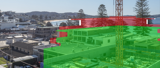
Above: Objector’s image: Level 5 (unit 16 standing) Approved (green); modified (red) with extent of change (white).
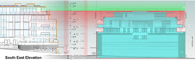
Above: Applicant’s plan showing the extent of impact in elevation between the site and 15 Kurrawyba Avenue
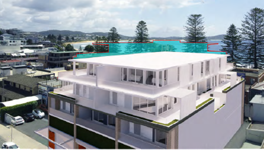
Above: Applicant’s image showing the modified proposal outlined in blue (viewpoint 1)
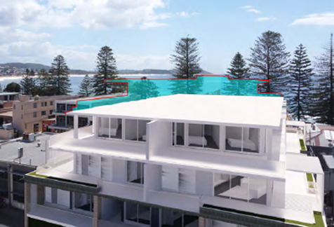
Above: Applicant’s image showing the modified proposal outlined in blue (viewpoint 2)
· Step 4 – Assess the reasonableness of the proposal that is causing the impact.
The LEC principle states: A development that complies with all planning controls would be considered more reasonable than one that breaches them. Where an impact on views arises as a result of non-compliance with one or more planning controls, even a moderate impact may be considered unreasonable.
The views are adversely and unreasonably impacted as a result of the modified height which further exceeds the planning controls for the site.
In this instance, the view impacts arise directly as a result of the proposal’s further non-compliance with both the building height and floor space ratio development standards under Gosford LEP 2014.
The additional floor area to which the site is not entitled (as it has already exceeded the maximum permitted under the planning controls) is proposed to be in a position outside of the approved envelope, and above the highest part of the approved building, and unreasonably exceeding Council’s planning controls for height.
The applicants view analysis acknowledges that existing development within the street and neighbourhood context of the site are all oriented to maximise ocean and district views and that the iconic views from the site and neighbouring properties are to the east and the ocean.
The applicant has concluded the following under their View Impact Assessment prepared by Urbaine Architectural (Nov 21:22):
In relation to visual impact, any view loss caused as a result of the non-compliance would require Step 4 of the Tenacity ruling to be considered, specifically in relation to a more skilful design. Since this design largely complies with the DCP and LEP requirements, the assessment should be based upon the nature and quality of the views and whether the skill of the design has enabled these views to be maintained, where possible. As will be seen in Appendix A, the current proposal has sought to maintain view corridors, where appropriate, while still giving the landowner the amenity required from the proposed development. As can be observed in the accompanying panoramic views, contained within Appendix A, the view loss should be considered alongside the overall view available from these locations, which are expansive and encompass a view of approximately 120 degrees to the horizon / ocean interface. This interface remains unobstructed by the new proposal and would be considered a very high value view.
The applicant has argued that the affected properties at Kurrawyba Avenue have expansive views available either side of the site and that the design of the proposal has preserved these views.
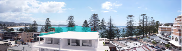
Above: Applicant’s ‘indicative’ image under Appendix A of the views available either side of the development
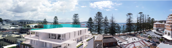
Above: Applicant’s ‘indicative’ image under Appendix A of the views available either side of the development
The objector contends that the applicant’s ‘indicative’ panoramic photomontage images above are misleading and that essentially the integrity of the whole view currently afforded at No.15 has not been maintained under the proposal. The proposed amendments to the street and side boundary building setbacks and the reduced floor plate of the proposed penthouse on the subject land under the review does very little to address the original concerns raised regarding view impacts and view loss.
As outline above, the LEC principle states: A development that complies with all planning controls would be considered more reasonable than one that breaches them. Where an impact on views arises as a result of non-compliance with one or more planning controls, even a moderate impact may be considered unreasonable. In this instance, the impacts to views and view loss are created by a modified development proposal that is a direct consequence of a further non-compliance with the GLEP planning control for height that applies to the site. Therefore, the impacts of the proposal are considered unreasonable and are not supported.
Context and setting – bulk and scale
The increase in height, bulk and scale is considered unreasonable considering the current approval, planning controls and site context. The proposed modification does not suitably recognise and respond to the site constraints posed by the site context being positioned at the lower end of the view catchment. The proposal is not sensitive to the pattern and character of local surrounding development which are all oriented to maximise the iconic ocean and district views over the development located at this lower end of the view catchment closest to the ocean.
The scale (bulk, height, mass), density and design of the development is considered undesirable in the context of the site and results in visual and other impacts to surrounding properties. The modified development extends outside of the approved envelope and obstructs views and vistas from surrounding development and impacts on amenity. Existing development surrounding the site is of a lower scale creating an existing site context such that all four elevations of the new level of the proposed modified building will be readily visible.
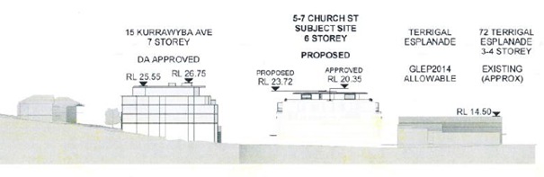
Above: Applicant’s section depicting the building heights along Kurrawyba Ave showing No.15, the subject site and the beach front shops
Whilst these adjoining sites are presently under-developed (within the context of the planning controls), the subject site under the modified proposal will be an overdevelopment of the site. The applicant has pointed to the examples of the Crown Plaza (a large and dated building in appearance), the large redevelopment at 15 Kurrawyba Avenue (which is located as the catchment rises) and other developments at 6 Pine Tree Lane, and 13 Ash Street (which likewise are all located at less critical positions within the visual catchment relative to view impacts) as arguments to support the idea that that the planning controls within the Terrigal CBD have been abandoned. However, there is no substance to support this argument.
The existing scale of development immediately surrounding the site is low being 1 and 2 storeys in height. The approved development on this site did exceed Council’s height controls and the merits of this were assessed in the original decision to approve the development. However, the original height breach was not by a whole storey and this does not equate to an abandonment of the height control altogether.
The proposed amendments to the street and side boundary building setbacks and the reduced floor plate of the proposed penthouse on the subject land under the review does very little to address the original concerns raised in the modification.
The modified development is considered an overdevelopment of the site (further exceeding the applicable FSR and height controls) which will have undesirable and significant adverse impacts on views from surrounding properties within the Terrigal ‘bowl’ hillside area, the existing and likely future streetscape of Church Street and on the overall scenic quality of the area.
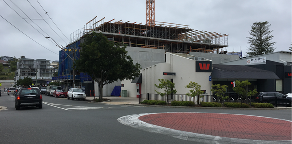
Above: View of development (without the additional floor level)
looking north
Above: View of development (without the additional floor level) looking south
Overshadowing and Public Domain
The applicant has provided shadow diagrams to identify the additional shadowing resulting from the proposal at midwinter, equinox and mid-summer. The diagrams indicate the extent of additional overshadowing impacts resulting from the additional level to the building. This includes additional shadowing of Church Street between 9am and 3pm and although the extent of additional proposed shadowing in itself does not appear significant (due mainly to the large extent of shadowing impacts from the approved building on the site), any additional shadowing to the public domain and to surrounding properties is undesirable and not reasonable.
Above:
Shadow diagram midwinter at 9am
Above: View of the frontage of the development looking north down Church Street
Privacy
There are additional privacy impacts resulting from the creation of an additional dwelling at a wholly higher level of the building than has been previously approved and the application is not supported.
Natural Environment
There will be no significant impact upon the natural environment associated with the development that require discussion.
Suitability of the Site for the Development:
Whether the proposal fits in the locality.
The proposal does not suitably fit into the locality given its unreasonable and excessive building height and FSR. The proposal is not compatible with the scenic qualities of the site and its coastal context.
The site is located at the lower end of the Terrigal “bowl” which is not a suitable context for the additional bulk and scale and altered that is proposed under the modified development, and the modified proposal is not compatible with the site context as it results in unreasonable bulk and scale, visual impacts, view loss and other impacts to surrounding development.
The Public Interest:
The application is considered contrary to the local and community interest.
Submission
The Review application was notified in accordance with DCP 2013 – Chapter 1.2 Notification of Development Proposals from 22 October 2021 to 19 November 2021 with 42 submissions received. Following receipt of amended plans from the applicant, the application was notified a second time from 3 December 2021 to 24 January 2022 with 31 submissions being received.
The specific issues raised in relation to the proposal are outlined below.
· The developer has already been allowed an additional 5th level (above the height controls) which breaches DCP clause 4.3.6.3 Building Envelope controls and results in a bulky building not in character with a small seaside area.
· View loss from development affecting numerous surrounding streets with hundreds of properties impacted in the Terrigal Bowl area (not just 15 Kurrawwyba).
· Existing height restrictions are in place so all surrounding buildings can share and enjoy views.
· Approved DA grossly exceeded Council's permissible height laws and FSR and this application for an extra level further exceeds Council's controls.
· Any additional apartment will add to not only the height, but also to the severely overburdened road corridor that is traffic choked during weekends and holiday periods. Pressure on local services and pressure on infrastructure, causing congestion, pollution, and road safety issues, lack of parking, sewerage issues.
· Loss of amenity which not only reduces individual welfare, but also reduces property values due to additional view loss.
· The modified proposal will destroy the scale and nature of the already constrained Terrigal Town Centre and will fail to deliver any real public benefits including green space and impact through reduction of light on the existing spaces where the community connects.
· Increased building heights are “totally unnecessary” as the council had already delivered medium-density developments other areas of Terrigal to satisfy targets set by the state government.
· Increased wind tunnelling effects. If Council fails to prevent this amended DA it will lead to a windswept, polluted wall of development along Church Street.
· Adverse impact on the value of the investments made by existing stakeholders who have made decisions based on the existing planning controls and sets a precedent for all future developers that Council is ineffective in maintaining building control.
· The overdevelopment of residential flat buildings in the heart of Terrigal has not seen an increase in shops, galleries or interesting architecture. In fact, courtyard cafes/eateries, delicatessens, butchers, baker’s and specialty boutiques are fewer.
· The proposed modification would have additional impacts on adjoining sites resulting in additional view loss and amenity impacts. Approval is not in the public interest.
· I cannot believe that there is another attempt by this developer to once again stretch the boundaries of what is acceptable to the Terrigal and community residents. The initial approval already meant the building would be higher than acceptable. The new proposal does not comply with any set standards.
· The request to again apply for an extra level to their already uncompliant development shows a complete lack of respect for the public opinion and Council’s response in refusing their previous application. For them to state that the proposal is ‘reflective of the changing nature of local development and has the potential to influence future approaches’ is a case of them trying to change the nature of local development NOT ’the changing nature’. The height restrictions that apply in the Terrigal Centre are what the neighbour’s and residents of Terrigal want to see maintained. The ‘changes in the nature’ of Terrigal are all in relation to Council approving non-compliant developments. A level 6 additional does not benefit the public in any way but would be an eyesore. The only people looking to change the nature or future character of Terrigal are the greedy developers.
· Angolet P/L were well aware of the height restrictions that were in place when they purchased the land.
· Maintaining the height restrictions is in the public interest to ensure view sharing around the Terrigal bowl.
· Overshadowing and loss of
sunlight to the street front footpath areas and to surrounding properties
including to the open space areas of buildings along Church Street.
· Privacy/overlooking impacts to existing buildings along Church Street. Cannot even sit in the living rooms with the curtains open as people are literally looking into your own private living area.
· Ongoing noise, dust, disturbance, and construction traffic associated with the building works on the site continuing unabated for more than 2 years. Construction work being carried on outside approved hours - holiday bookings requesting refunds due to construction noise. Crane is lit up all night long causing light spill impacts to surrounding properties.
· New level will impact my privacy as the additional floor looks directly into development at 10 Church Street.
· Major loss of public parking from original development.
· Happy for progress that is in the best interest for the community, but this proposal is not.
· Very little has changed from original modification plans to address the original concerns.
· Applicant’s assertion that “this is contributing to the supply of sustainable and affordable housing” is very funny as the proposal is a penthouse with water views.
· The modified building is bulky, and the proposal is excessive.
· Modified development no longer constitutes substantially the same development originally approved. Further the various breaches of planning controls result in an overdevelopment of the site.
· The reasons for having a planning framework are to ensure that new developments are compatible with the existing neighbourhood and to protect the interests of all stakeholders. The approved plans do neither; the extra storey sought in this DA only makes things worse and sets an undesirable precedent of building limits.
· Do not understand why we need six level buildings in the middle of Terrigal.
· The proponent claims that the increased setbacks proposed for storeys 5 and 6 will diminish the scale and bulk of the building and make it conform more with the objectives set forth for Terrigal CBD buildings. We would suggest that these setbacks should be applied to storeys 4 and 5, with no 6th storey; this would bring the building more into line with the rest of Terrigal's CBD.
· The proposal takes the height of the building to 23 metres. This is the approximate height allowed for the Rapedo/Avanti development at the north end of Terrigal CBD. This height was allowed only because the developer had aggregated a number of lots and promised an outstanding development (yet to be realised in total). The proponent cannot claim such an exemption for his proposal. The other 5-7 storey buildings are at the south end of the CBD in Pine Tree Lane. These buildings are 'behind' the Crown Plaza hotel and thus do not impact the surrounds as much as an isolated free standing building, as the hotel has already impacted the surroundings. Furthermore, in referring to these other 5-7 storey buildings, the developer is doing exactly what we fear the most from granting exceptions to planning rules- using these precedents to justify further breaches in planning codes.
· Adverse and unreasonable view impacts on the approved development at 15 Kurrawyba Avenue (east-facing units 11, 12, 15 and 16 on Levels 4 and 5), and which arise directly as a result of the proposal’s non-compliance with both the building height and floor space ratio development standards under Gosford LEP 2014. Refer to submitted updated view impact assessment prepared by Envisage Consulting and the Cambium Group in accordance with the Land and Environment Court directions for the use of photomontages. The amended plans submitted with the review make minor changes to some setbacks on the upper level, and these are likely to result in a negligible reduction in view impacts.
· Lack of consultation with local residents.
· This building is already considerably out of scale with the surrounding environment without adding another story which would significantly detract from the Terrigal Bowl environment. The approved structure dwarfs surrounding buildings and looks out of place.
· Development within this central CBD core "should maintain panoramic ocean and coastal views that are enjoyed from the surrounding hillside dwellings.
· To compare 5-7 Church St. to the Resort Hotel, the Rapedo amalgamation site, the former Anglican Church site developed on a hillside, or even development along Pine Tree Lane which was the result of a quid pro quo between Council and the Developer of an "upfront" multistorey carpark is therefore unreasonable. Moreover allowing 6 storeys in the Core of the CBD would eventually result in a Gold Coast style wall of development, as a dam face across The Bowl - rather than following the natural lay of the land.
· The proposal will run counter to the natural topography of The Bowl that makes the Terrigal "village" such a unique place.
· The proposal will set a precedent for further height increases of future building applications for the area.
· Gosford Council's Terrigal Bowl Strategic Planning Committee planned that Terrigal's CBD Core - bounded by Campbell Crescent, Terrigal Esplanade, Kurrawyba Ave and Church St - be limited to 4 storeys, to maintain the character and 'village atmosphere' of Terrigal, and keep the 'pedestrian friendly' scale.
· Problems encountered in putting a submission in as Council’s system not working so fewer submissions will have been received as residents gave up trying.
· This amended plan if it proceeds, will destroy the scale and nature of the already constrained Terrigal Town Centre and will fail to deliver any real public benefits including green space and negatively impact Church Street by reduction of light on the existing spaces where the community connects.
· View sharing. Slater Architects identifies recently completed nearby developments. But all of these are situated on the flanks of the town centre: one in Pine Tree Lane behind the Crown Plaza and the others in Campbell Crescent where the land rises behind it and they do not have the same negative impact on view sharing for which Terrigal Bowl is renown.
· The applicant's Visual Impact Assessment report [Nov 2021] targets point iii in attempting to reverse Council's refusal. It does this by creating an independent scope of reference, then creates a biased argument supporting it's own scope. Not bad if you can get away with it. It would have been more believable if it had presented a compelling argument scoping the pertinent parts of the existing SEP, LEP and DCP that form the basis of Council's jurisdiction to determine refusal of the modified application.
· There are many residents in the Terrigal Bowl as well as us, who would be negatively impacted by the modified application through additional view loss and amenity. The information in the modified proposal does not adequately address the negative impacts on a lot of other properties, including ours. Nor does it present fresh facts based on the SEP, LEP and DCP to warranty a change of Council's refusal.
· Proposal is contrary to the historic intent of the controls to allow a maximum height RL18.5 and maximum FSR of 1.8:1 for developments in the central portion of the Town Centre in order to maintain and enhance the established “village” character and “pedestrian scale” along all street frontages, and only where such development would not isolate or sterilize other surrounding development, with anything higher.
· Height of building – further above approval is unreasonable and contrary to LEP.
· Additional traffic added to already congested one way road system.
· FSR increase further above approval is unreasonable and contrary to LEP.
· The amended proposal is still unsatisfactory due to the original reasons for refusal.
· The character and nature of the Terrigal shopping/retail village precinct will be overrun by high rise developments completely out of character.
· Development already rejected three times by Council as contrary to almost all the Council’s planning guidelines but approved by only one vote.
· Approved development already exceeds the height and FSR. To add another floor to this unattractive development is not reasonable and considered to be an overdevelopment of the site.
· Cumulative impacts from overdevelopment decisions- view loss, privacy impacts, traffic congestion, stormwater run off and noise.
· The changes to the approved development do not result in any benefit to the community, instead it results in view loss, traffic and loss of amenity. Shameful the developer is wasting Council time and ratepayers money having to address these requests, they should get on with the job so they can free up parking in Church Street from their construction vehicles.
· As a resident who overlooks the Terrigal ‘bowl’ – strongly object. Amendments put forward do not make any improvement for the benefit of the public. Significant detrimental costs to public from development from original loss of public car park on the site.
· Applicant has no consideration for view sharing. Extra level is not view sharing but greedy.
· Proposed height would set an undesirable precedent for surrounding future development.
· Any level above the
approved level is a radical transformation.
· My understanding is that this was the basis for the maximum height of RL18.5 and an FSR of 1.8:1 for developments in the central portion of the Town Centre in order to maintain and enhance the established “village” character and “pedestrian scale” along all street frontages. Within this Town Centre 5 storey development above street level was only to be permitted subject to: Sites having a minimum area of 2000sq.m and minimum frontages of 20m.
· The Town Centre is situated on level land at the lowest point in The Terrigal Bowl. Ocean and coastal views from many of these dwellings would be impacted by this proposed six storey development.
· It will interrupt the coastal and ocean views currently enjoyed by many dwellings situated in the Terrigal Bowl – not just of those Objectors in the non-complying development situated on the lower ‘hillside’ slope at 15 Kurrawyba Avenue which have been analyzed extensively in the Applicant’s most recent Architectural Statement.
· The proposal is not reflective of the changing nature of local development ….” As in my opinion it may encourage other six storey developments in the Terrigal Town Centre block and become the precedent for the commencement of a ‘dam wall’ across the mouth of the Terrigal Bowl.
· The reasonable expectations and Rights of the Applicant have been already compensated for in Council’s approval of a five storey development that exceeds height and FSR controls for the Terrigal Town Centre block. The addition of a 6th storey in the form of an exclusive Penthouse would be of great financial benefit to the Applicant but of detriment of those of us living in Terrigal.
The application is not supported on a number of grounds including a number of those issues raised in the submissions that were received. It is considered that the issues raised in these submissions have not been addressed under the supporting information accompanying the proposal.
Submissions from Public Authorities
There are no referrals to, or submissions from, any public authorities associated with the proposed development.
Internal Consultation
|
Architect |
Not Supported as discussed earlier in the report under the section of SEPP 65. |
Ecologically Sustainable Principles:
The proposal has been assessed having regard to ecologically sustainable development principles and is considered to be consistent with the principles, however, the proposal is not supported on other grounds.
Conclusion:
The modified proposal is not substantially the same development as the development for which consent was originally granted and before that consent as originally granted was modified (if at all). The modification would further exacerbate non-compliance and be significantly in excess of both the LEP height and FSR controls.
The modified proposal is an overdevelopment of the site which results in unreasonable impacts as a result of non-compliance with GLEP and GDCP planning controls and is considered unsuitable for the site and its context. The issues raised in submissions have substance and validity which are not addressed by in the Review application. The proposed amendments to the street and side boundary building setbacks and the reduced floor plate of the proposed penthouse on the subject land under the review does very little to address the original concerns raised.
The modified proposal is not is not substantially the same development nor in the public interest.
Accordingly, the application is not supported and is recommended for refusal for the following reasons:
1 The modified development proposal is not substantially the same development as the development for which consent was originally granted and before that consent as originally granted was modified (if at all).
2 The modified development proposal results in unreasonable adverse impacts as a result of non -compliance with GLEP and GDCP planning controls.
3 The modified development proposal is considered unsuitable for the site as a result of non-compliance with GLEP and GDCP planning controls.
4 The modified development proposal has not suitably responded to the concerns raised in submissions and is not in the public interest.