 |
Central Coast
Local Planning Panel Meeting
Business Paper
09 June 2022
 |
|
Central Coast
Local Planning Panel Meeting
Business Paper
09 June 2022
|
The Local Planning Panel Meeting
of Central Coast
will be held remotely - online,
Thursday 9 June 2022 at 2.00 pm,
for the transaction of the business listed below:
1 Procedural Items
1.1 Disclosures
of Interest.............................................................................................................................. 3
2 Confirmation of Minutes of Previous Meetings
2.1 Confirmation of Minutes of Previous Meeting................................................................................. 4
3 Planning Reports
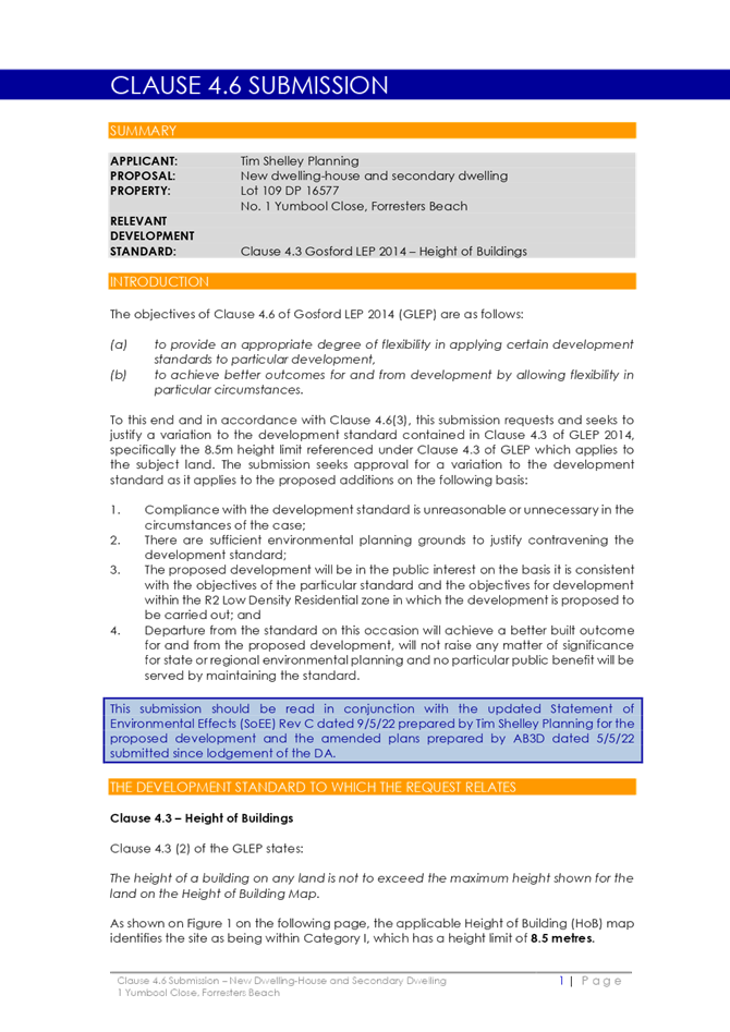
3.1 DA/63207/2021 - 1 Yumbool Close Forresters Beach - Demolition of Existing Dwelling House down to slab level and demolition of Swimming Pool, New Dwelling on existing slab, Secondary Dwelling, Front Fence, Swimming Pool & Associated Works including a Lift and Fire Place 9
Jason Perica
Chairperson
Agenda Version History
|
Version |
Date published |
Details |
|
2 |
08/06/2022 |
Version 2 of agenda published to include 5 pages (pgs.33 to 37) and subsequent repagination of agenda, to correctly reflect the report content. These pages were, inadvertently, not included during the finalisation of the agenda papers, but were part of the finalised report. |
|
1 |
02/06/2022 |
Agenda published |
|
Item No: 1.1 |
|
|
Title: Disclosures of Interest |
|
|
Department: Governance |
|
|
26 May 2022 Local Planning Panel Meeting |
|
Reference: F2020/02502 - D14205789
|
The NSW Local Planning Panel Code of Conduct states that all panel members must sign a declaration of interest in relation to each matter on the agenda before or at the beginning of each meeting.
|
That Panel Members now confirm that they have signed a declaration of interest in relation to each matter on the agenda for this meeting and will take any management measures identified.
|
Item No: 2.1 |
|
|
Title: Confirmation of Minutes of Previous Meeting |
|
|
Department: Corporate Affairs |
|
|
9 June 2022 Local Planning Panel Meeting |
|
Reference: F2020/02502 - D15186530
Author: Rachel Callachor, Meeting Support Officer
|
Summary
The
Minutes of the following Meetings of the Local Planning Panel, which have
been endorsed by the Chair of that meeting, are submitted for noting: · Local Planning Panel Meeting held on 26 May 2022 |
That the minutes of the previous Local Planning Panel Meeting held on 26 May 2022 which were endorsed by the Chair of that meeting, are submitted for noting.
|
1⇩ |
MINUTES - Local Planning Panel - 26 May 2022 |
|
D15181439 |
|
2.1 |
Confirmation of Minutes of Previous Meeting |
|
Attachment 1 |
MINUTES - Local Planning Panel - 26 May 2022 |
|
Item No: 3.1 |
|
|
Title: DA/63207/2021 - 1 Yumbool Close Forresters Beach - Demolition of Existing Dwelling House down to slab level and demolition of Swimming Pool, New Dwelling on existing slab, Secondary Dwelling, Front Fence, Swimming Pool & Associated Works including a Lift and Fire Place |
|
|
Department: Environment and Planning |
|
|
9 June 2022 Local Planning Panel Meeting |
|
Reference: DA/63207/2021 - D15124548
Author: Neil Skeates, Senior Building Surveyor
Manager: Wayne
Herd, Section Manager, Building Assessment and Certification
Andrew
Roach, Unit Manager Development Assessment
Executive: Alice Howe, Director Environment and Planning
|
Summary
An application has been received for Demolition of Existing Dwelling House and Swimming Pool, a New Dwelling, Secondary Dwelling, Front Fence, Swimming Pool & Associated Works including a Lift and Fire Place. The application has been examined having regard to the matters for consideration detailed in Section 4.15 of the Environmental Planning and Assessment Act 1979 and other statutory requirements with the issues requiring attention and consideration being addressed in the report. The application is recommended for approval.
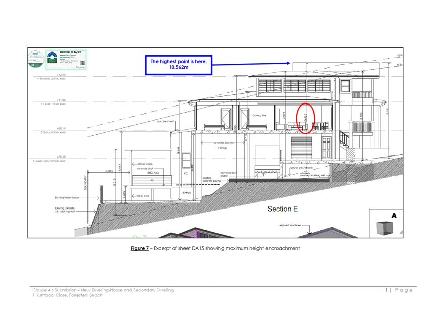
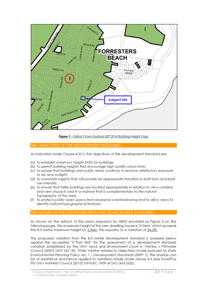
The application is referred to the Local Planning Panel for determination because: · The application proposes a variation to a development standard contained within an Environmental Planning Instrument of greater than 10%. The application proposes a maximum height of 10.56m, which is a 24.2% variation to the 8.5m height requirement; and · The application has attracted 15 unique submissions.
Applicant Mr Tim Shelley Owner Christopher John Hajje Application No DA/63207/2021 Description of Land Lot 109, DP16577, 1 Yumbool Close, Forresters Beach Proposed Development Demolition of Existing Dwelling House down to slab level and demolition of Swimming Pool, New Dwelling on existing slab, Secondary Dwelling, Front Fence, Swimming Pool & Associated Works including a Lift and Fire Place. Site Area 917 m2 Zoning R2 - Low Density Residential Existing Use Dwelling House Employment Generation Yes Estimated Value $693,000.00 |
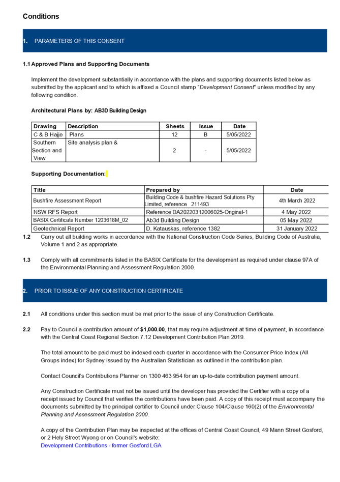
1 The
Local Planning Panel agrees that the applicant’s Clause 4.6 written
request demonstrates that compliance with the Height of Buildings development
standard is unnecessary in the circumstances of the case because of the minimal
environmental impact that would result from non-compliance with the Height of
Buildings standard.
Compliance with the Height of Buildings development standard would be
unreasonable in the circumstances of the case because of the steep sloping
nature of the block. Compliance would not allow the three-storey dwelling house, secondary
dwelling, swimming pool and front fence as currently proposed, and that there are sufficient
environmental planning grounds to justify varying that development standard.
Further, the Panel considers that the proposed
development will be in the public interest because it is consistent with the
objectives of the development standard and the objectives for development
within the R2 Low Density Residential zone in which the development is proposed
to be carried out.
2 That the Local Planning Panel assumes the concurrence of the Secretary of the
Department of Planning to permit the non-compliance with the development
standard under Clause 4.6 of the Gosford Local
Environmental Plan 2014, in accordance with the provisions of Clause 64 of the
Environmental Planning and Assessment Regulation 2000.
3 That
the Local Planning Panel grants development consent to DA/63207/2021 –
1 Yumbool Close, FORRESTERS BEACH NSW to construct a single dwelling house over
three levels, secondary dwelling, swimming pool and front fence subject to
appropriate conditions as detailed in the schedule attached to the report and
having regard to the matters for consideration detailed in Section 4.15 of the
Environmental Planning and Assessment Act 1979 and other relevant issues.
4 Those who made a submission be notified of the outcome of the development application.
Key Issues
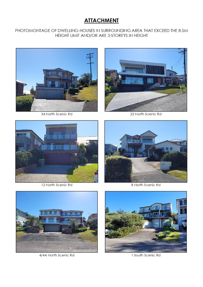
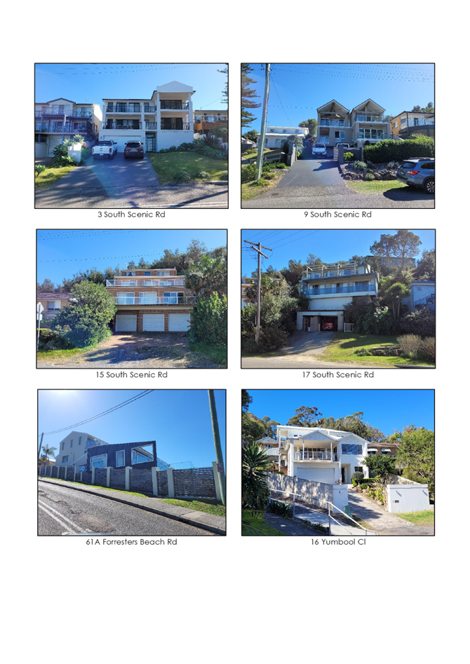
· The current dwelling house is two-storey whereas the proposal adds an additional third level in the design. There is community objection to the additional height. It is noted that the locality has many examples of such buildings.
· The height exceeds the Gosford LEP 2014 and Development Control Plan 2013 height limit of 8.5m (to a maximum height of 10.56m).
· There are 15 unique objections plus 1 additional second comment, thus 16 separate documents total.
Precis:
|
Proposed Development |
Demolition of Existing Dwelling House down to slab level and demolition of Swimming Pool, New Dwelling on existing slab, Secondary Dwelling, Front Fence, Swimming Pool & Associated Works including a Lift and Fire Place.
|
|
Permissibility and Zoning |
The subject site is zoned R2 - Low Density Residential under the provisions of Gosford Local Environmental Plan 2014 (Gosford LEP 2014).
The proposed development is defined as a ‘dwelling house’ and ‘secondary dwelling’ which is defined under the Gosford LEP 2014 as:
‘dwelling house’ means – a building containing only one dwelling.
‘secondary dwelling’ means a self-contained dwelling that— (a) is established in conjunction with another dwelling (the principal dwelling), and (b) is on the same lot of land as the principal dwelling, and (c) is located within, or is attached to, or is separate from, the principal dwelling.
The use is permissible with consent.
|
|
Relevant Legislation |
The following planning policies and control documents are relevant to the development and were considered as part of the assessment.
• Environment Planning and Assessment Act 1979 – section 4.15 (EP&A Act) • Gosford Local Environmental Plan 2014 (GLEP 2014) • Draft Central Coast Local Environmental Plan 2018 (Draft CCLEP 2018) • Gosford Development Control Plan 2013 • Chapter 3.1 “Dwelling Houses, Secondary Dwellings and Ancillary Development” (Gosford DCP 2013)
|
|
Current Use |
Dwelling House
|
|
Integrated Development |
No.
|
|
Submissions |
The development application was notified (in accordance with the provisions of the Gosford Development Control Plan 2013) from 14 October 2021 until 4 November 2021 with subsequently amended plans re-notified from 9 March 2022 until 31 March 2022.
15 unique author submissions were received with one objector adding additional comments. |
Variations to Policies
Gosford Local Environmental Plan 2014
|
Clause |
4.3 (2) |
|
Standard |
Height limit of 8.5m. |
|
Departure basis |
The proposal seeks a maximum height of 10.56m consisting mostly of the upper storey. This represents a variation of 2.06m or 24.2 % at the highest point. |
Chapter 3.1. Dwelling Houses, Secondary Dwellings and Ancillary Structures of Gosford Development Control Plan 2013
|
Clause |
3.1.2.1 |
|
Planning Control |
Height limit of 8.5m |
|
Departure basis |
The proposal seeks a maximum height of 10.56m consisting mostly of the upper storey. This represents a variation of 2.06m or 24.2 % at the highest point. |
The Site
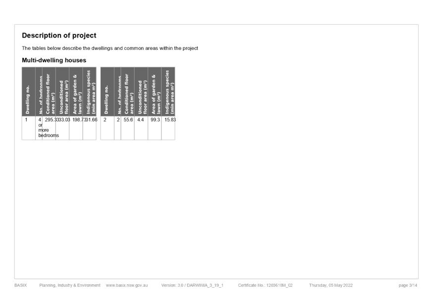
The site is identified as Lot 109 DP 16577, No. 1 Yumbool Close, Forresters Beach (Figure 1).
The site has been partially levelled at the front before falling steeply from behind the parking area to a previously filled rear yard. The site is on a local high point located on a “Y” road junction before Yumbool Close falls steeply downwards whilst the other higher road (North Scenic Road) continues up the hillside. There is some vegetation along the rear boundary line with the rear neighbour being lower by more than 1m.
Access to the proposed dwelling will be from the northern side of the existing traffic islands at the “Y” junction, in a similar position to the current driveway with the internal driveway turning into an additional under croft “carport” parking area creating an aggregate of four parking spaces on site.
The subject site is zoned R2 - Low Density Residential under the provisions of Gosford Local Environmental Plan 2014 (Gosford LEP 2014) (Figure 2).
The site is mapped as bushfire prone land. The application is supported by a Bushfire Assessment Report, reference 211493, prepared by Building Code & Bushfire Hazard Solutions Pty Limited and dated 4 March 2022. The report was referred to the NSW RFS for comment and the application was supported. The report concludes the bushfire attack level (BAL) design specification for the development to be BAL 29, as outlined in AS3959 – 2018 Construction in Bushfire-prone Areas and the NSW RFS’s Planning for Bushfire Protection 2019. The recommendations of this report are supported and are included in the proposed conditions of development consent.
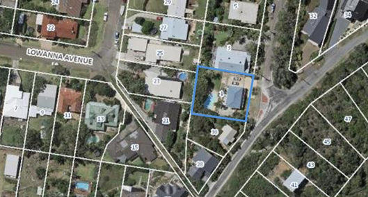
Figure 1: Aerial photograph of subject site with the site etched in blue.
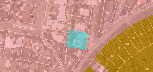
Figure 2: Aerial photograph of subject site with zoning overlay included.
Surrounding Development
The subject site is surrounded on its north, south and west sides by existing R2 – low density zoned residential allotments, generally containing a mixture of older style single and two storey dwellings, some with open subfloors. To the east is mostly vegetated vacant land zoned C1 National Parks and Nature Reserves.
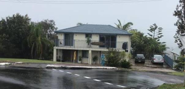
Figure 3: Front elevation of existing dwelling house.
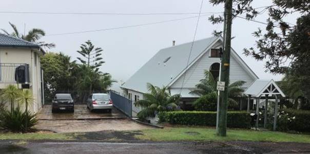
Figure 4: R.H.S. neighbour (north).
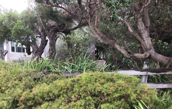
Figure 5: L.H.S. neighbour (south).
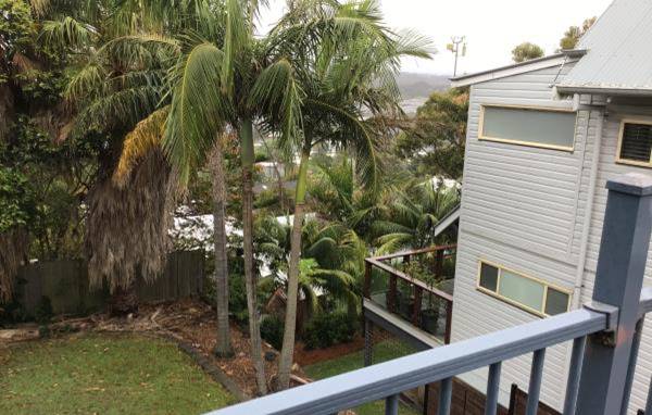
Figure 6: R.H.S. neighbour towards rear of their dwelling house.
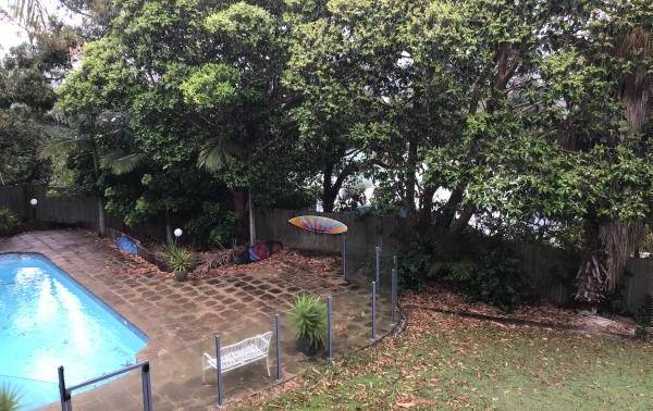
Figure 7: Subject site rear yard (1 of 2 south side).
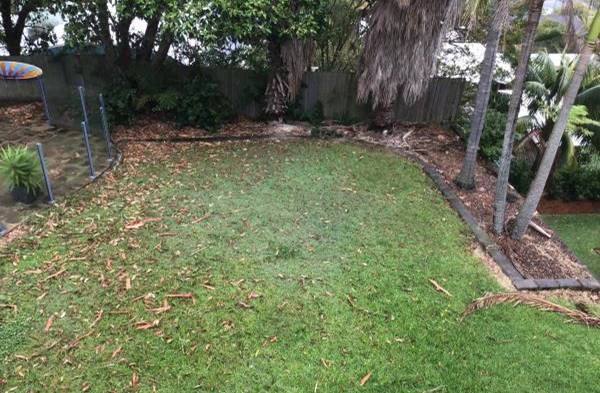
Figure 8: Subject site rear yard (2 of 2 north side).
The Proposed Development
The application comprises construction of a new four-bedroom dwelling over three levels and a secondary dwelling located to the eastern side of the building with two-bedrooms on the mid-level, a laundry and storage area being underneath and verandah being on the topmost level. A fire wall is proposed internally to separate both occupancies.
The garage and entrance to the dwelling is orientated towards the north side of the lot with internal access to the extra two parking spaces. A new swimming pool will be constructed in the rear yard replacing the existing swimming pool. A new open style timber front fence is proposed along the boundary line.
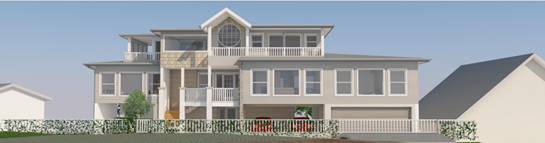
Figure 9: Photomontage of proposed dwelling from Yumbool Close.
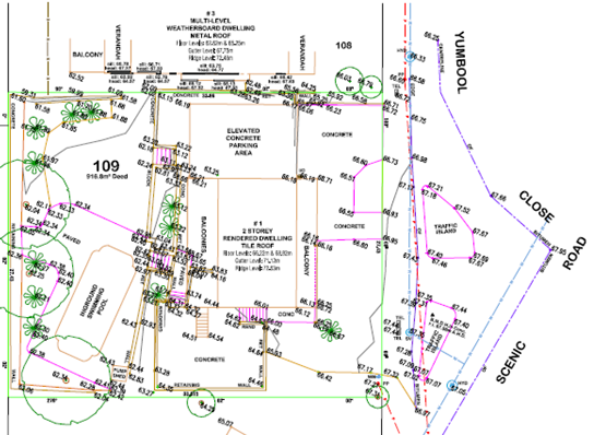
Figure 10: Detailing the site survey report.
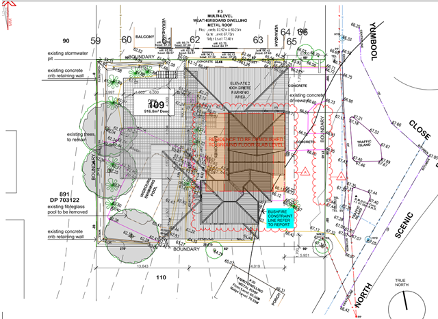
Figure 11: Detailing the proposed site plan.
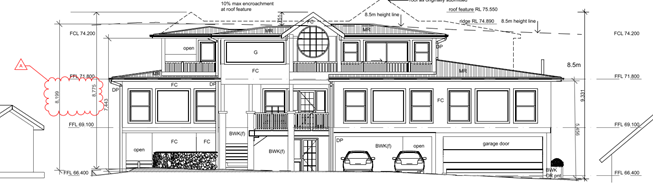
Figure 12: Detailing the east (street) elevation.
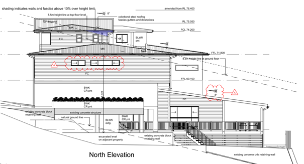
Figure 13: Detailing the proposed north side elevation.
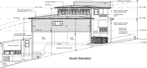
Figure 14: Detailing the proposed south side elevation.
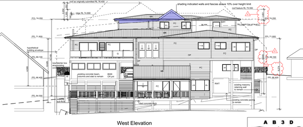
Figure 15: Detailing the proposed west (rear) elevation.
ASSESSMENT:
Having regard for the matters for consideration detailed in Section 4.15 of the Environmental Planning and Assessment Act 1979 and other statutory requirements, the assessment has identified the following key issues.
State Environmental Planning Policy No 71 – Coastal Protection
State Environmental Planning Policy No 71 (Coastal Protection) (SEPP 71) was repealed on 3 April 2018 when the State Environmental Planning Policy (Coastal Management) 2018 (SEPP Coastal Management) came into effect. The savings and transitional provisions contained within SEPP Coastal Management state the SEPP 71 provisions continue to apply if a development application is lodged and not finally determined prior to the commencement of SEPP Coastal Management.
The provisions of SEPP 71 require Council (or the Local Planning Panel) to consider the Aims and Objectives of the SEPP No 71 together with the matters for consideration listed in Clause 8 of the SEPP 71 when determining an application within the Coastal Zone. The Coastal Zone is an area defined on maps issued by the NSW Department of Planning & Environment and the subject property falls within this zone.
The relevant matters have been considered in the assessment of this application. The application is considered consistent with the stated aims and objectives.
State Environmental Planning Policy (Resilience and Natural Hazards) 2021
Whilst the savings and transitional provisions of SEPP Coastal Management apply, the proposed development has also been considered against the provisions of SEPP (Resilience and Natural Hazards) 2021, which include the provisions of the former SEPP Coastal Management, and is considered satisfactory.
State Environmental Planning Policy (Building sustainability Index) BASIX 2004
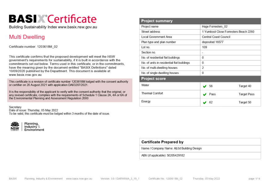
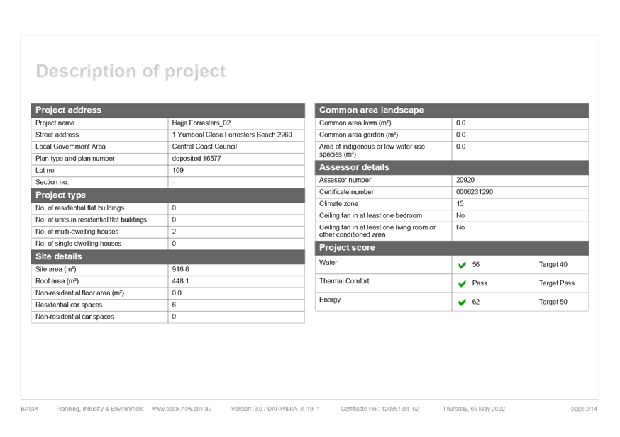
A compliant BASIX certificate achieving the NSW Government’s energy efficiency targets has been provided in support of the application.
State Environmental Planning Policy (Affordable
Rental Housing) 2009
The provisions of State Environmental Planning Policy
(Affordable Rental Housing) 2009 (savings provisions are applied) aim to better
encourage home owners, social housing providers and developers to invest and
create new affordable rental housing to meet the needs of our growing
population and existing residents.
The table below summarizes the main requirements of the SEPP relevant to secondary dwellings.
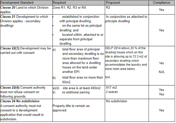
Gosford Local Environmental Plan 2014 - Permissibility
The subject site is zoned R2 - Low Density Residential under the provisions of Gosford LEP 2014.
The proposed development is best defined as a ‘dwelling house’ and ‘secondary dwelling’, which are defined under the Gosford LEP 2014 as:
‘dwelling house’ means – a building containing only one dwelling.
‘secondary dwelling’ means a self-contained dwelling that—
(a) is established in conjunction with another dwelling (the principal dwelling), and
(b) is on the same lot of land as the principal dwelling, and
(c) is located within, or is attached to, or is separate from, the principal dwelling.
The use is permissible with consent.
The development is permissible in the zone, with development consent.
Gosford Local Environmental Plan 2014 – Objectives of Zone
The Objectives of the R2 - Low Density Residential zone are:
· To provide for the housing needs of the community within a low density residential environment.
· To enable other land uses that provide facilities or services to meet the day to day needs of residents.
· To ensure that development is compatible with the desired future character of the zone.
· To encourage best practice in the design of low-density residential development.
· To promote ecologically, socially and economically sustainable development and the need for, and value of, biodiversity in Gosford.
· To ensure that non-residential land uses do not adversely affect residential amenity or place demands on services beyond the level reasonably required for low-density housing.
In this instance, it is considered that the proposal is consistent with the stated objectives of the zone. The proposal provides for a form of residential development that is consistent with the emerging development in the locality, is appropriately designed, does not have an adverse economic, environmental or social impact, nor places inappropriate demands on services in the locality.
Gosford Local Environmental Plan 2014 Clause 4.3 - Height of buildings
The proposed development proposes a form that exceeds the maximum ‘height of buildings’ set out in Clause 4.3 of the Gosford LEP 2014.
|
Development Standard |
Required |
Proposed |
Compliance with Controls |
Variation % |
Compliance with Objectives |
|
4.3 – Height of buildings |
8.5 metres |
The proposal seeks a maximum height of 10.56m. |
No – see comments below |
24.2 % |
Yes – see comments below |
The proposed variation to the maximum height limit is supported by a submission under the provisions of Clause 4.6 of the Gosford LEP 2014 (see below) and a request to vary the development standard.
Gosford Local Environmental Plan 2014 Clause 4.6 - Exceptions to Development Standards
Requested Height Variation
The applicant seeks a variation to Clause 4.3(2) of Gosford LEP 2014 in relation to the proposed maximum height of the dwelling (Figure 16).
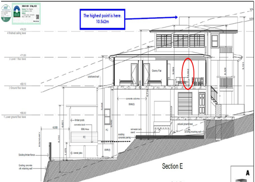
Figure 16: Clause 4.6 height variation dimensions.
In this regard, the proposal seeks a maximum overall height of 10.56m in lieu of the 8.5m mapped maximum height limit applicable to the allotment, resulting in a variation of 24.2 %.
Clause 4.6 (3) of Gosford LEP 2014 requires consideration of the following:
‘Development consent must not be granted for development that contravenes a development standard unless the consent authority has considered a written request from the applicant that seeks to justify the contravention of the development standard by demonstrating –
(a) that compliance with the development standard is unreasonable or unnecessary in the circumstances of the case, and
(b) that there are sufficient environmental planning grounds to justify contravening the development standard.’
and Clause 4.6 (4) of Gosford LEP 2014 requires consideration of the following:
‘Development consent must not be granted for development that contravenes a development standard unless—
(a) the consent authority is satisfied that—
(i) the applicant’s written request has adequately addressed the matters required to be demonstrated by subclause (3), and
(ii) the proposed development will be in the public interest because it is consistent with the objectives of the particular standard and the objectives for development within the zone in which the development is proposed to be carried out, and
(b) the concurrence of the Planning Secretary has been obtained.’
The applicant has provided a detailed request to vary the mapped height development standard by the proposed 24.2 %. In requesting the variation, the applicant has provided the following matters in support of the proposal: -
‘The objectives of Clause 4.6 of Gosford LEP 2014 (GLEP) are as follows:
(a) to provide an appropriate degree of flexibility in applying certain development standards to particular development,
(b) to achieve better outcomes for and from development by allowing flexibility in particular circumstances.
To this end and in accordance with Clause 4.6(3), this submission requests and seeks to justify a variation to the development standard contained in Clause 4.3 of GLEP 2014, specifically the 8.5m height limit referenced under Clause 4.3 of GLEP which applies to the subject land. The submission seeks approval for a variation to the development standard as it applies to the proposed additions on the following basis:
1. Compliance with the development standard is unreasonable or unnecessary in the circumstances of the case;
2. There are sufficient environmental planning grounds to justify contravening the development standard;
3. The proposed development will be in the public interest on the basis it is consistent with the objectives of the particular standard and the objectives for development within the R2 Low Density Residential zone in which the development is proposed to be carried out; and
4. Departure from the standard on this occasion will achieve a better built outcome for and from the proposed development, will not raise any matter of significance for state or regional environmental planning and no particular public benefit will be served by maintaining the standard.
This submission should be read in conjunction with the Statement of Environmental Effects (SoEE) prepared by Tim Shelley Planning for the proposed development and the plans prepared by AB3D (dated 16/8/21) submitted with the development application.
In reviewing the proposed variation, consideration of the Residential R2 Low Density Residential Zone objectives is also considered necessary. Residential R2 Low Density Residential Zone objectives are as follows:
• To provide for the housing needs of the community within a low-density residential environment.
• To enable other land uses that provide facilities or services to meet the day to day needs of residents.
• To ensure that development is compatible with the desired future character of the zone.
• To encourage best practice in the design of low-density residential development.
• To promote ecologically, socially and economically sustainable development and the need for, and value of, biodiversity in Gosford.
• To ensure that non-residential land uses do not adversely affect residential amenity or place demands on services beyond the level reasonably required for low-density housing.
In considering these zone objectives, the following points are considered relevant:
· Dwelling Houses are permissible within the zone and satisfies the zone objective in terms of the provision of low-density residential development.
· The proposed dwelling design is considered in keeping with the existing and desired future character of the area.
· The design of the dwelling incorporates suitable architectural design elements and incorporates sustainable design features.
The Gosford LEP 2014 sets out six objectives pertaining to the building height development standard. The objectives are contained within clause 4.3 (1) (a) to (f). These objectives are replicated below and commentary in respect to compliance or otherwise with each objective in relation to the proposed development:
a) to establish maximum height limits for buildings,
The proposed height of the building, whilst exceeding the numerical height limit, is consistent to numerous other dwellings within the vicinity on this steep coastal hillside locality.
b) to permit building heights that encourage high quality urban form,
The design is of a high-quality urban form with visual interest and high functionality to the occupants.
c) to ensure that buildings and public areas continue to receive satisfactory exposure to sky and sunlight,
The only practical impact is on the southern neighbour who does receive sufficient solar access with very little impact on public land with existing vegetation already impacting the road reserve area.
d) to nominate heights that will provide an appropriate transition in built form and land use intensity,
The site is the equal highest on the road area and provides transitions to the higher still upslope buildings to the north east of the site.
e) to ensure that taller buildings are located appropriately in relation to view corridors and view impacts and in a manner that is complementary to the natural topography of the area.
No impacts occur.
f) to protect public open space from excessive overshadowing and to allow views to identify natural topographical features.
Impact on public space is minimal and still allows the coastal dunes to be observed and upper hillside to be observed from expected vantage points.
In terms of the proposed design, it is noted that the height exceedance is predominately halfway up the wall on the upper storey on the front elevation and is of similar appearance in height of other buildings in the suburb. The upper storey is well setback from both side boundaries. The proposal meets the relevant zone objectives and does not cause view loss impacts to the adjoining properties.’
It is considered that the development, as proposed, would be consistent with the height and scale of other dwellings within the immediate area. In addition, the development would not impose any unreasonable level of detrimental impact on the amenity of residents in nearby dwellings. The sloping nature of the site contributes to the difficulty in complying with the height controls whilst achieve maximum site development with a secondary dwelling and control site coverage.
Having regard to the site factors, minimal impact on the character of the area and that of the residents, the applicants request to vary the height development standard is considered reasonable and therefore supported.
Draft Central Coast Local Environmental Plan 2018 (Draft CCLEP 2018)
The Draft Central Coast Local Environmental Plan 2018 (Draft CCLEP 2018) was exhibited until 27 February 2018 and is anticipated to be gazette mid-2022. Under the provisions of the draft LEP the subject site retains its R2 - Low Density Residential zoning, with dwelling houses remaining permissible with consent.
Gosford Development Control Plan 2013 Chapter 2.1 – Character
The site is located within the Forresters Beach 3: Prominent Open Hillsides Character Area.
The new development does not dominate the landscape setting and offers improved standards of scenic-and-urban design quality are achieved by the dwelling. The swimming pool and retaining walls are below street level on the side and rear of the dwelling footprint would otherwise visibly compromise the desired leafy hillside character.
The design avoids disturbing natural slopes by use of low-impact construction such as suspended floors and retaining the existing subfloor area and slab rather than new extensive cut-and-fill. Avoidance of the appearance of a continuous wall of development along any street or hillside is controlled by locating buildings behind front setbacks that appear similar to their surrounding properties and providing at least one wide side setback and stepping the shape of front and rear facades.
Minimisation of the scale and bulk of the building is achieved by stepping floor-levels to follow natural slopes and by using irregular floorplans to create well-articulated forms. The front and rear facades that are taller than neighbouring dwellings are screened by balconies, verandahs, stepped forms and extra setbacks. The amended roof design is gently-pitched to minimise the height of ridges, and flanked by wide eaves to disguise the scale of exterior walls.
Minimisation of the scale of prominent facades by using extensive windows and verandahs plus a variety of materials and finishes rather than expanses of plain masonry has occurred. The dwelling displays a traditional “street address” with verandahs or decks and living rooms or front doors that are visible from the roadway. There are no wide garages that would visually-dominate any front façade or block views from dwellings to the street. The location and screening of balconies or decks maintain the existing levels of privacy and amenity that are enjoyed by neighbouring dwellings. The suburb has many examples of similar scale and style buildings on steep sites.
Gosford Development Control Plan 2013 Chapter 3.1 – Dwelling Houses, Secondary Dwellings & Ancillary Structures
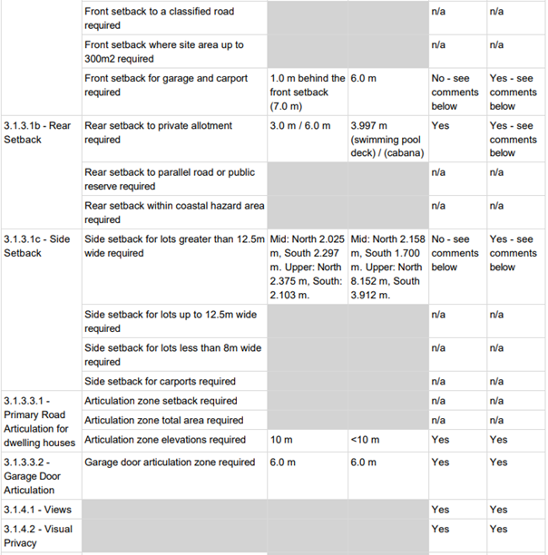
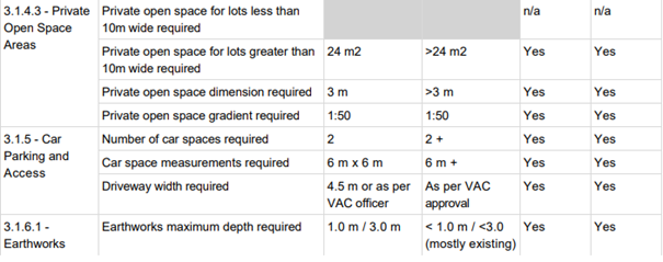
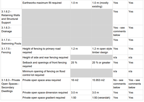
An analysis of the key requirements of Gosford DCP 2013 Chapter 3.1 is set out in the table below:
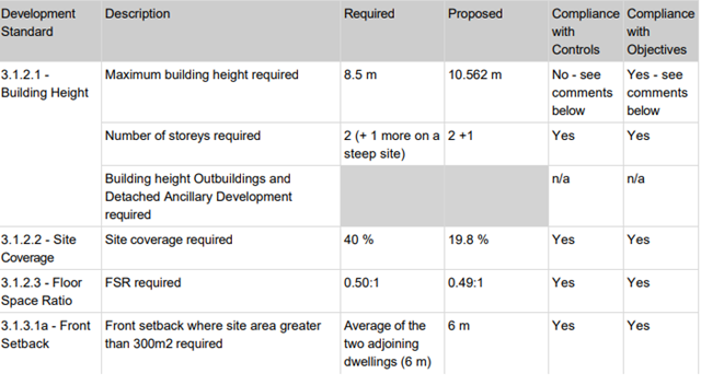

Clause 3.1.2.1 Building Height
The applicant seeks a variation to the proposed maximum height of the dwelling. In this regard, the proposal seeks a maximum overall height of 10.56m in lieu of the 8.5m mapped maximum height limit applicable to the allotment. The variation proposed is 24.2 %.
An assessment of the building height has been carried out under the Gosford LEP 2014 (previously in this report).
In summary, the proposed development will be consistent with the height of other buildings on the hillside. The proposal meets the relevant zone objectives and does not cause view loss impacts or an unreasonable level of overshadowing to the adjoining properties.
It is considered the applicant’s request to vary the development standard would be consistent to the height and scale of other dwellings within the area. In addition, the development would not impose any unreasonable level of detrimental impact on the amenity of residents in nearby dwellings. It has been concluded the steepness of the site contribute to the difficulty in complying with the height controls and comparisons to the height and scale of other dwellings along the hillside provide justification to vary them.
Gosford Development Control Plan 2013 Chapter 6.3 Erosion Sedimentation Control
Appropriate siltation control are included in the proposed development consent.
Gosford Development Control Plan 2013 Chapter 6.4 Geotechnical Requirements for Development Applications
The property is assessed as being only partially in a “Category 2 -Medium Hazard Area” for potential landslip hazard as defined within tables M1 and M2 of the document with the majority being in a Low Hazard Area. The implications of Category 2 are that a ‘Class 2’ geotechnical report may be required. Upon completion of the development a ‘post development report’ as defined within Chapter 6.4 of the Gosford DCP 2013, is not required but foundation inspections during works is required to confirm that foundations are suitable and works have been carried out in accordance with all provided geotechnical advice.
The application has been accompanied by a geotechnical investigation and slope stability assessment prepared by D. Katauskas, reference 1382, dated 31 January 2022. The report considers the extent of excavation and foundation support for the dwelling. The report is sufficient given the site is barely in the medium hazard area and there is limited new excavation on site given the existing lower slab is to be retained.
Gosford Development Control Plan 2013 Chapter 7.2 Waste Management
A Waste Management Plan has been submitted in support of the proposed development.
The Likely Impacts of the Development
Built Environment
Given the position of the proposed dwelling and garage on the allotment and comparison of bulk and scale with other dwellings, the proposal is considered to be suitable with regard to the context and setting of the subject site and is considered to be in keeping with the character of the area where there is a high degree of difference in height from adjacent lots and street to street.
A thorough assessment of the proposed development’s impact on the built environment has been undertaken in terms of compliance with Gosford LEP 2014 and Gosford DCP 2013. It is considered, on balance, that the potential impacts are reasonable.
Natural Environment
The proposal involves some minor excavation given the site’s sloping topography and retention of the subfloor. Whilst there is some impact upon the natural environment, this is considered to be reasonable as the main bulk of excavation is limited and is relatively concealed by the proposed works. Accordingly, the proposal is considered satisfactory in relation to impacts on the natural environment.
Submission made in accordance with this Act or Regulations
The application was notified (in accordance with the provisions of the Gosford DCP 2013 on two occasions:
· from 14 October 2021 until 4 November 2021; and
· amended plans were received and the application was re-notified from 9 March 2022 until 31 March 2022.
Fifteen unique author submissions were received with one objector adding additional comments.
The key issues raised in submissions, with relevant comments, are below:
ISSUE: More transparency is required from the applicant. Design is too big and imposing for the site and is four storeys high.
Comment - The applicant has provided Council with all the necessary information to consider the application with relevant application information being available on Council's website for community access as part of the usual notification process. The design generally meets the bulk and scale controls, except for the height control which has been considered elsewhere in the report against the relevant controls.
The area features many dwelling houses of a similar height and scale on sloped sites. The proposed development does present a generally complying height at the front façade when viewed from the public street. The proposed height non-compliance cane be considered and varied under certain circumstances (Clauses 4.3 / 4.6 of the Gosford LEP 2014). The proposal is not four storeys high but does feature several subfloor areas.
ISSUE: What does the "A" mean on the amended plans from the re-notification period?
Comment - The "A" is accompanied by red "clouding" which denotes the amended height numbers and areas of design change from the originally submitted plan set. Further, dotted lines represent the original plan set outline.
ISSUE: Concern the proposal is out of character and streetscape and will create a precedent for future development. Concern the house will be a "party house" or short stay holiday let and will cause traffic delays and noise issues. Size is of commercial purposes. Not in accordance with the objectives of the zone.
Comment - The proposal is not considered to be out of character as the character clause of this report with the character statement covers a very large portion of this suburb. The streetscape is highly varied and features a high and low side of the street further altering the apparent variety of housing stock. The proposal does fit with the streetscape with similar setbacks and will likely be an option for future style of dwelling houses given current design trends. There is no reference to short term holiday let in the application, if that was to be a future use, would need to be the subject of further applications to Council as necessary. There is only a very minor increase in traffic from the secondary dwelling on the site which is a permissible use with the existing dwelling house traffic already existing. The application is not for commercial use and will have a condition of consent imposed preventing commercial use. The objectives of the zone are considered under the objectives part of this report.
ISSUE: Concern over dual occupancy or Bed and Breakfast. Garages are near the intersection. Too close to north and south side boundaries and solar access impacts. No access information for the granny flat and may impact on privacy and noise. No geotechnical engineering report publicly available and slip across the road and on site driveway subsidence. Concern over storm water infrastructure in the street.
Comment - The application is not for a dual occupancy or a bed and breakfast development. The application is for a dwelling and secondary dwelling. If any development is undertaken outside of that which is approved on a site, it would be subject to investigated and compliance by the relevant compliance team within Council.
The lot has a dwelling entitlement and access is available to a public read. The driveway is as far away from the intersection as possible with the initially proposed second access now deleted from the plans. Council's vehicle access crossing officer has inspected the site and supports the current proposal. The northern neighbour is not impacted by the solar access at all. The southern neighbour has sufficient solar access as per the shadow diagrams. Access to and from the secondary dwelling is via a front door facing the road and is no closer than many other front doors on everyday dwellings and is an acceptable low impact. Council does not routinely make geotechnical reports available to the public. The owner is entitled to discharge stormwater to the public road reserve. The proposal will install a total of 12,000 litres of rainwater tank capacity which is not insignificant. The geotechnical report contains recommendations that will protect the works as much as another from public land failure.
ISSUE: Concern over release of the Geotechnical report close to the close date of notification and content of the report and internet searches by author for information.
Comment - Geotechnical engineering reports and mapping are not generally published as they are highly technical and subject to misinterpretation. Upon becoming aware a submission was concerned about not being able to access the report, the report was published.
It is noted that the proposal seeks to retain the existing slab and subfloor and will require very little new excavation into natural ground level.
Councils DCP identifies, at Chapter 6.4, four categories of landslip risk:
Category 1 – Low Hazard
Category 2 – Medium Hazard
Category 3 – High Hazard
Category 4 – Immediate High Hazard
A very small proportion of the site (along the southern boundary of the property) is identified as being Category 2 - medium hazard’ (see Figure 17, following page).
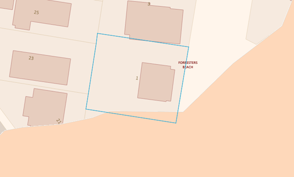
Figure 17: Southern portion of the property identified as medium hazard for landslip
As per Council's DCP 2013, Chapter 6.4, a report is not mandatory sites identified as low or medium hazard (category 1 or 2). However, in this instance Council staff requested that a geotechnical assessment be prepared.
A Geotechnical Assessment & Risk Analysis has been undertaken by a suitably qualified Geotechnical Engineer. The report concludes that there are no significant hazards to the construction identified, and that any that arise during construction can be readily resolved.
ISSUE: Not consistent with the objectives of the zone. There are no environmental planning grounds for the height variations.
Comment - The works are consistent with the R2 zone objectives as discussed elsewhere in this report. The consideration of the environmental planning grounds for the height variations are also discussed elsewhere in this report.
ISSUE: Concern regarding the lack of floor plans on public exhibition and request for those plans to be made available and they Geotech report was uploaded without notice.
Comment - Floor plans are not provided to neighbours or made public for security and privacy reasons. All appropriate documents were available as part of the usual notification process.
ISSUE: Survey plan is inadequate. Has a Clause 4.6 been provided and amended BASIX been received and request the BASIX be re-notified. Structural engineering is of concern for existing subfloor. Concern is raised about the placement of air conditioning units.
Comment - The survey plan is sufficient and similar to that which Council receives as a matter of daily business. A Clause 4.6 variation application has been submitted and the BASIX assessment is sufficient. Further re-notification of documents/plans is not required nor necessary.
A condition of consent is recommended for the provision of a structural engineering assessment for the new and imposed loads. It is unreasonable to require details of acoustic housing for domestic air conditioning units. In an urban setting some noise is unavoidable although there is enough space to locate units sufficiently far from boundaries to reduce impacts (currently more than 5m from the south side boundary).
Internal Consultation
|
VAC |
Supported with conditions numbers 2.6, 5.6 & 6.6 |
||
|
Water and Sewer |
Supported subject to condition 2.7 |
External Consultation
|
NSW Rural Fire Service |
Supported subject to conditions 2.5, 3.12, 4.16, 4.17 & 6.5 |
Other Matters for Consideration:
Acid Sulfate Soils
A review of Council’s records identifies that the site may be subject to acid sulfate soils. The subject site has been identified as a Class 5 area, which means acid sulfate soils are not typically on site but may be located within 500m. As such, it is considered that the provisions of an acid sulfate soils management plan is not required.
Bushfire
The subject site is mapped as being bushfire affected.
A report prepared by a Bushfire Planning & Design (BPAD) Certified Practitioner bushfire consultant has been included with the application.
Removal of Trees
No trees are to be removed.
Development Contribution Plan
The subject site is located within Central Coast Regional Section 7.12 Development Contribution Plan 2019, where secondary dwelling developments are subject to Section 7.12 contributions. The applicable contribution amount was calculated and is proposed to be imposed as a standard condition of consent requiring the contribution to be paid prior to the issue of any Construction Certificate.
Water and Sewer Contributions
The proposed development will be subject to Water & Sewer Contributions for the secondary dwelling via a Section 307 Certificate and has is proposed to be imposed as a condition of consent, with contributions to be paid before the issue of the Construction Certificate.
Ecologically Sustainable Principles:
The proposal has been assessed having regard to ecologically sustainable development principles and is considered to be consistent with the principles.
The proposed development is considered to incorporate satisfactory stormwater, drainage and erosion control and the retention of vegetation where possible, is unlikely to have any significant adverse impacts on the environment and will not decrease environmental quality for future generations. The proposal does not result in the disturbance of any endangered flora or fauna habitats and is unlikely to significantly affect fluvial environments.
The Public Interest
The proposed development is seen to be in the public interest by providing assurance that the subject land can be developed in proportion to its site characteristics.
Conclusion:
The development application has been assessed in accordance with Section 4.15 of the Environmental Planning and Assessment Act 1979, and all relevant instruments and polices. The proposed development is considered suitable for the site despite the listed variations. The proposal is therefore recommended for approval pursuant to Section 4.16 of the Environmental Planning and Assessment Act 1979.
|
1⇨ |
Redacted Plans for LPP 1 Yumbool Close FORRESTERS BEACH DA/63207/2021 |
Provided Under Separate Cover |
D15154589 |
|
2⇨ |
Statement of Environmental Effects Rev C May 2022, DA63207/2021, H1 Yumbool Close FORRESTERS BEACH |
Provided Under Separate Cover |
D15165122 |
|
3⇩ |
Clause 4.6 to GLEP Height Rev B May 2022 DA63207/2021, H1 Yumbool Close FORRESTERS BEACH |
|
D15165119 |
|
4⇩ |
BASIX Certificate 1 Yumbool Close, Foresters Beach DA/63207/2021 |
|
D15154590 |
|
5⇩ |
Proposed Conditions Summary DA/63207/2021, H1 Yumbool Close FORRESTERS BEACH |
|
D15165145 |
|
3.1 |
DA/63207/2021 - 1 Yumbool Close Forresters Beach - Demolition of Existing Dwelling House down to slab level and demolition of Swimming Pool, New Dwelling on existing slab, Secondary Dwelling, Front Fence, Swimming Pool & Associated Works including a Lift and Fire Place |
|
Attachment 3 |
Clause 4.6 to GLEP Height Rev B May 2022 DA63207/2021, H1 Yumbool Close FORRESTERS BEACH |
|
DA/63207/2021 - 1 Yumbool Close Forresters Beach - Demolition of Existing Dwelling House down to slab level and demolition of Swimming Pool, New Dwelling on existing slab, Secondary Dwelling, Front Fence, Swimming Pool & Associated Works including a Lift and Fire Place |
|
|
Attachment 4 |
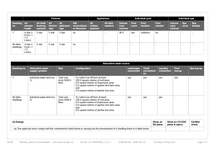
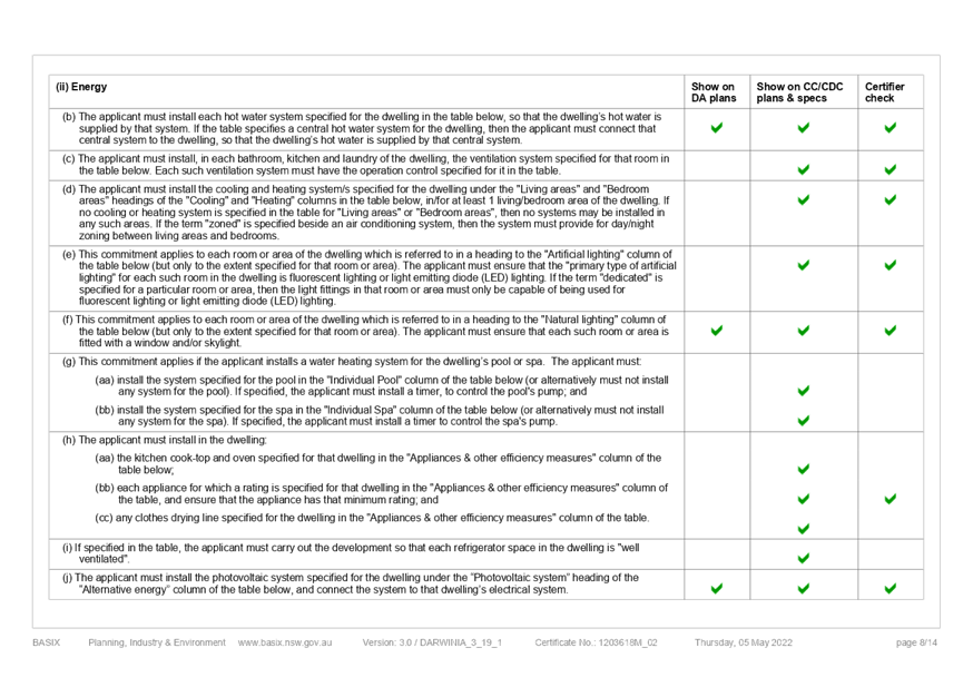
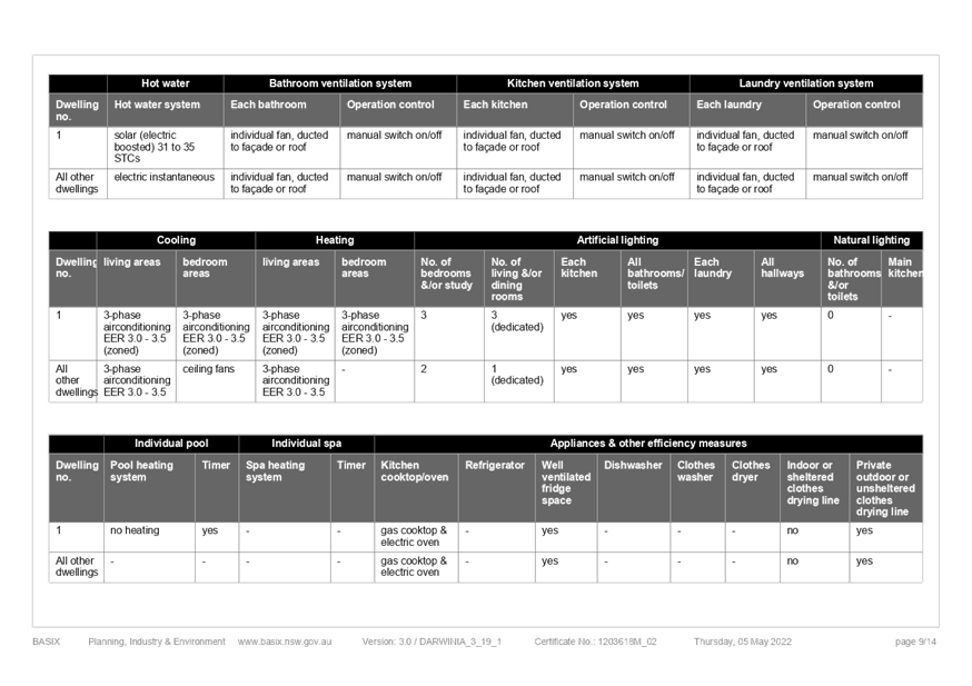
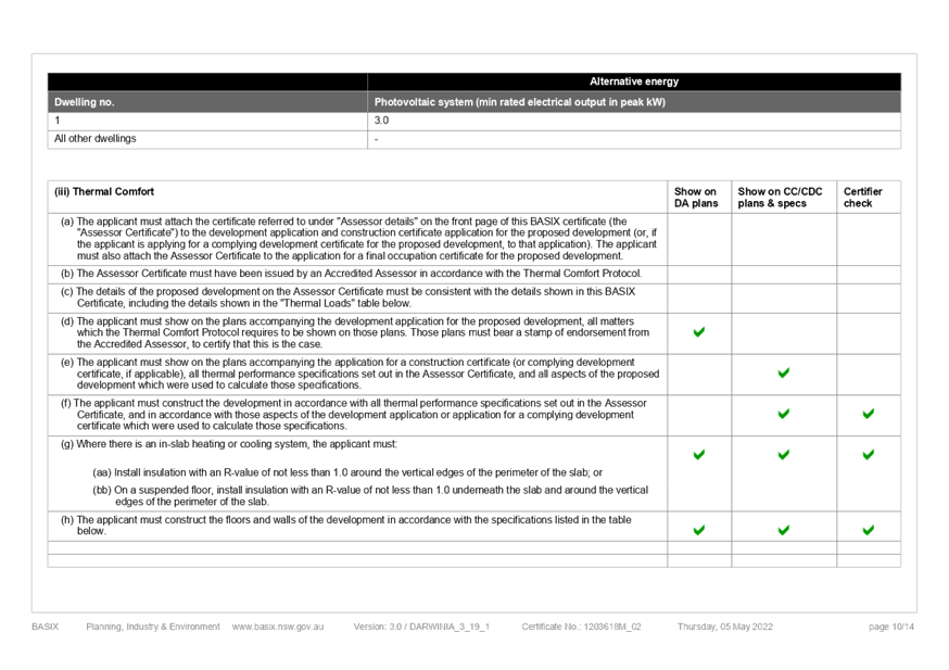
BASIX Certificate 1 Yumbool Close, Foresters Beach DA/63207/2021 |
|
DA/63207/2021 - 1 Yumbool Close Forresters Beach - Demolition of Existing Dwelling House down to slab level and demolition of Swimming Pool, New Dwelling on existing slab, Secondary Dwelling, Front Fence, Swimming Pool & Associated Works including a Lift and Fire Place |
|
|
Attachment 5 |
Proposed Conditions Summary DA/63207/2021, H1 Yumbool Close FORRESTERS BEACH |