 |
Central Coast
Local Planning Panel Meeting
Business Paper
23 June 2022
 |
|
Central Coast
Local Planning Panel Meeting
Business Paper
23 June 2022
|
The Local Planning Panel Meeting
of Central Coast
will be held remotely - online,
Thursday 23 June 2022 at 2.00 pm,
for the transaction of the business listed below:
1 Procedural Items
1.1 Disclosures
of Interest.............................................................................................................................. 3
2 Confirmation of Minutes of Previous Meetings
2.1 Confirmation of Minutes of Previous Meeting................................................................................. 4
3 Planning Reports
3.1 DA/47946/2015
-10-16 Painters Lane, Terrigal - Modification of Consent for Commercial
Premises and Shop Top Housing.......................................................................................................................... 10
3.2 DA/62839/2021
- 149 Somersby Falls Road, Somersby - DESIGNATED & NOMINATED INTEGRATED
Expansion to Concrete Manufacturing Facility.................................................. 114
4 Planning Reports - Outside of Public Meeting
4.1 DA1209/2021 - Lot R/918 Rd, The Entrance Road, The Entrance - Markets and Function Centre for community events................................................................................................................................. 170
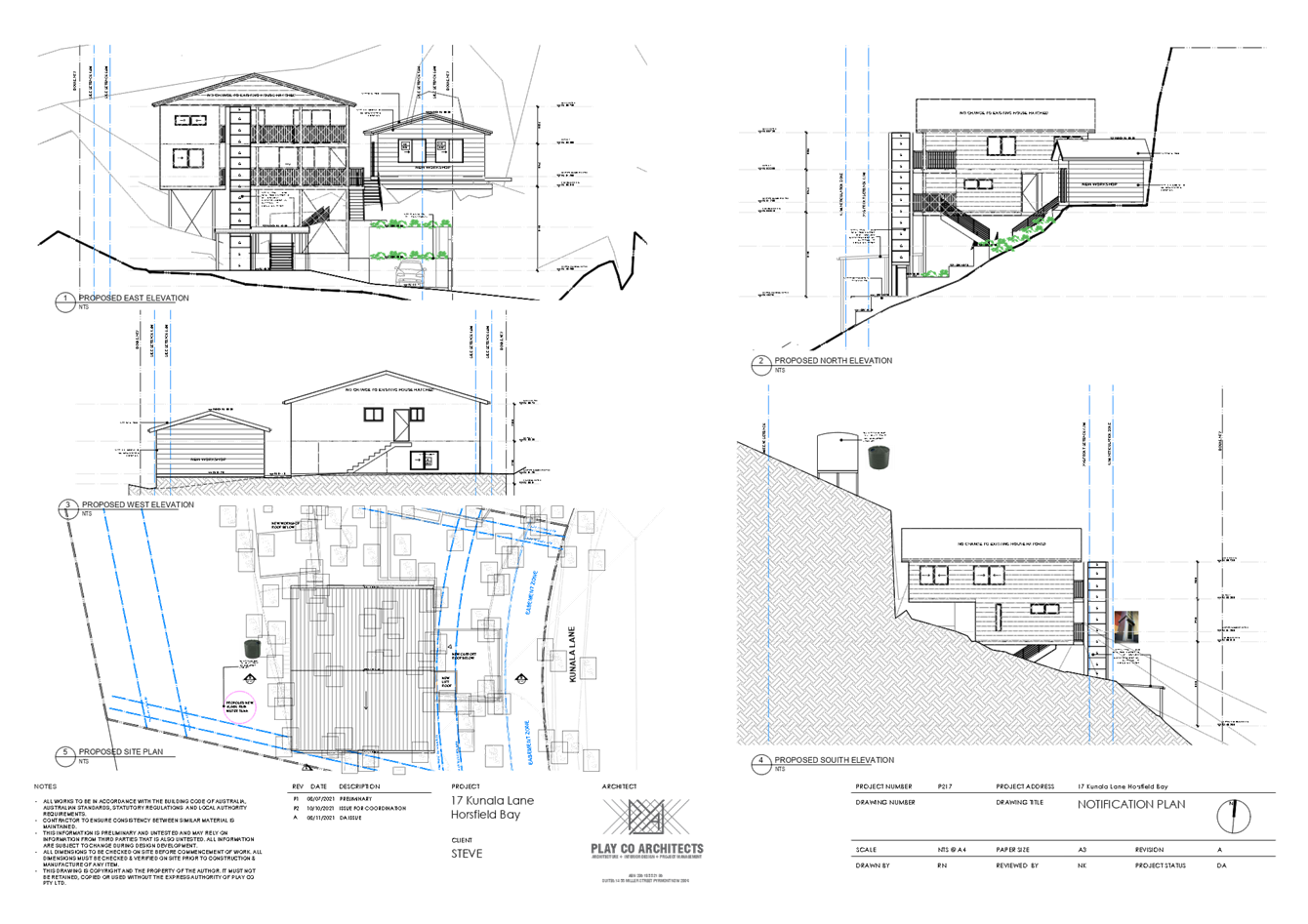
4.2 DA/2059/2021
- 17 Kunala Lane Horsfield Bay - Alterations & Additions to Existing
Dwelling..................................................................................................................................................................... 186
4.3 Request
to prepare a Planning Proposal for 60 Wyong Road, Tuggerah
(Tuggerah Gateway Site)..................................................................................................................... 227
5 General Reports
5.1 Central Coast Local Planning Panel - Membership.................................................................... 297
Donna Rygate
Chairperson
|
Item No: 1.1 |
|
|
Title: Disclosures of Interest |
|
|
Department: Governance |
|
|
23 June 2022 Local Planning Panel Meeting |
|
Reference: F2020/02502 - D14205789
|
The NSW Local Planning Panel Code of Conduct states that all panel members must sign a declaration of interest in relation to each matter on the agenda before or at the beginning of each meeting.
|
That Panel Members now confirm that they have signed a declaration of interest in relation to each matter on the agenda for this meeting and will take any management measures identified.
|
Item No: 2.1 |
|
|
Title: Confirmation of Minutes of Previous Meeting |
|
|
Department: Corporate Affairs |
|
|
23 June 2022 Local Planning Panel Meeting |
|
Reference: F2020/02502 - D15203681
Author: Rachel Callachor, Meeting Support Officer Civic Support
|
Summary
The Minutes
of the following Meetings of the Local Planning Panel, which have been
endorsed by the Chair of that meeting, are submitted for noting: · Local Planning Panel Meeting held on 9 June 2022 |
That the minutes of the previous Local Planning Panel Meeting held on 9 June 2022 which were endorsed by the Chair of that meeting, are submitted for noting.
|
1⇩ |
MINUTES - Local Planning Panel - 9 June 2022 |
|
D15199769 |
|
2.1 |
Confirmation of Minutes of Previous Meeting |
|
Attachment 1 |
MINUTES - Local Planning Panel - 9 June 2022 |
|
Item No: 3.1 |
|
|
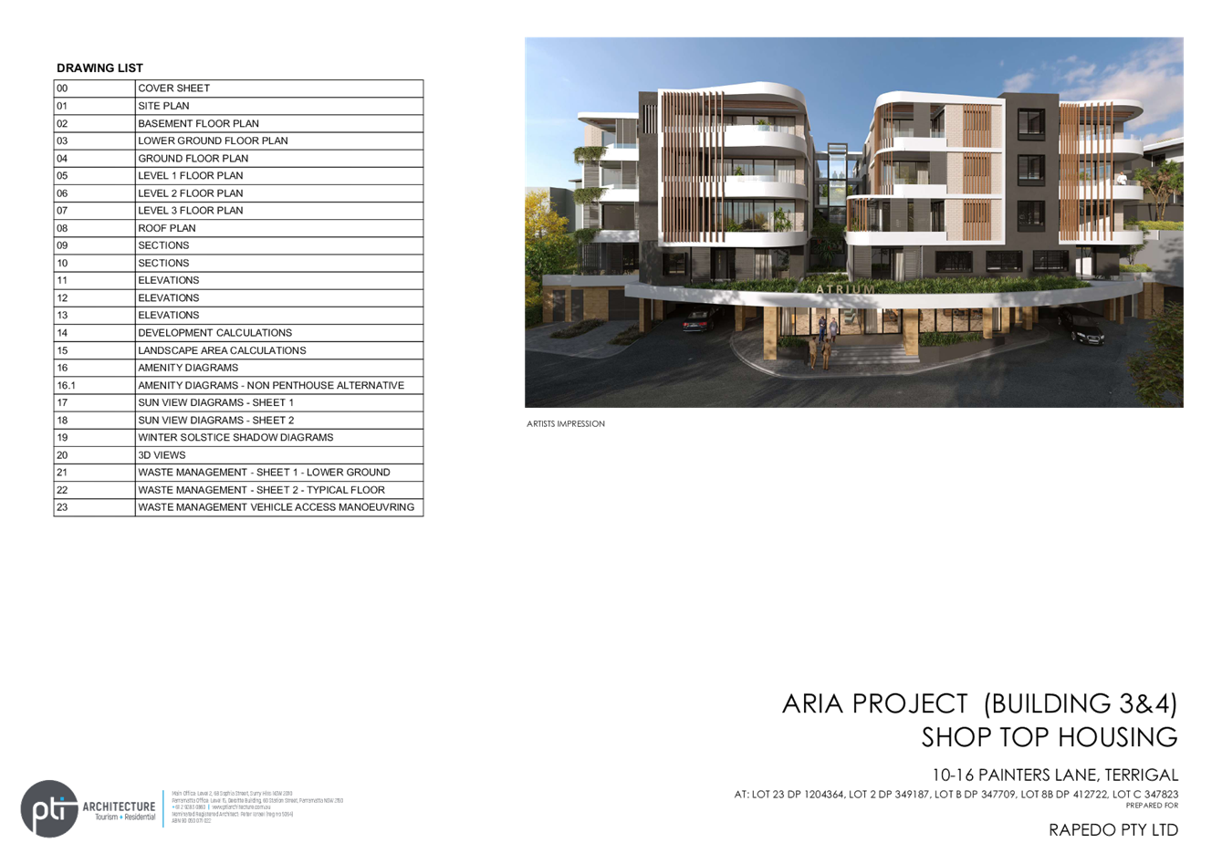
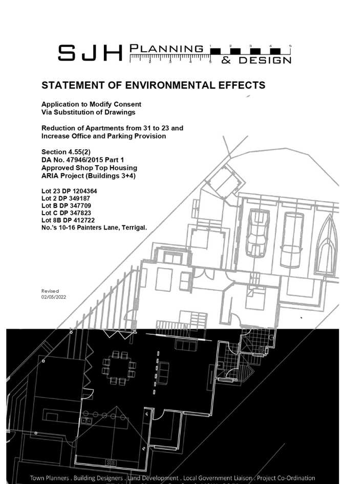
Title: DA/47946/2015 -10-16 Painters Lane, Terrigal - Modification of Consent for Commercial Premises and Shop Top Housing |
|
|
Department: Environment and Planning |
|
|
23 June 2022 Local Planning Panel Meeting |
|
Reference: DA/47946/2015/A - D14970574
Author: Robert Eyre, Principal Development Planner South
Ailsa Prendergast, Section Manager. Development Assessment South
Manager: Andrew Roach, Unit Manager, Development Assessment
Executive: Alice Howe, Director Environment and Planning
|
Summary
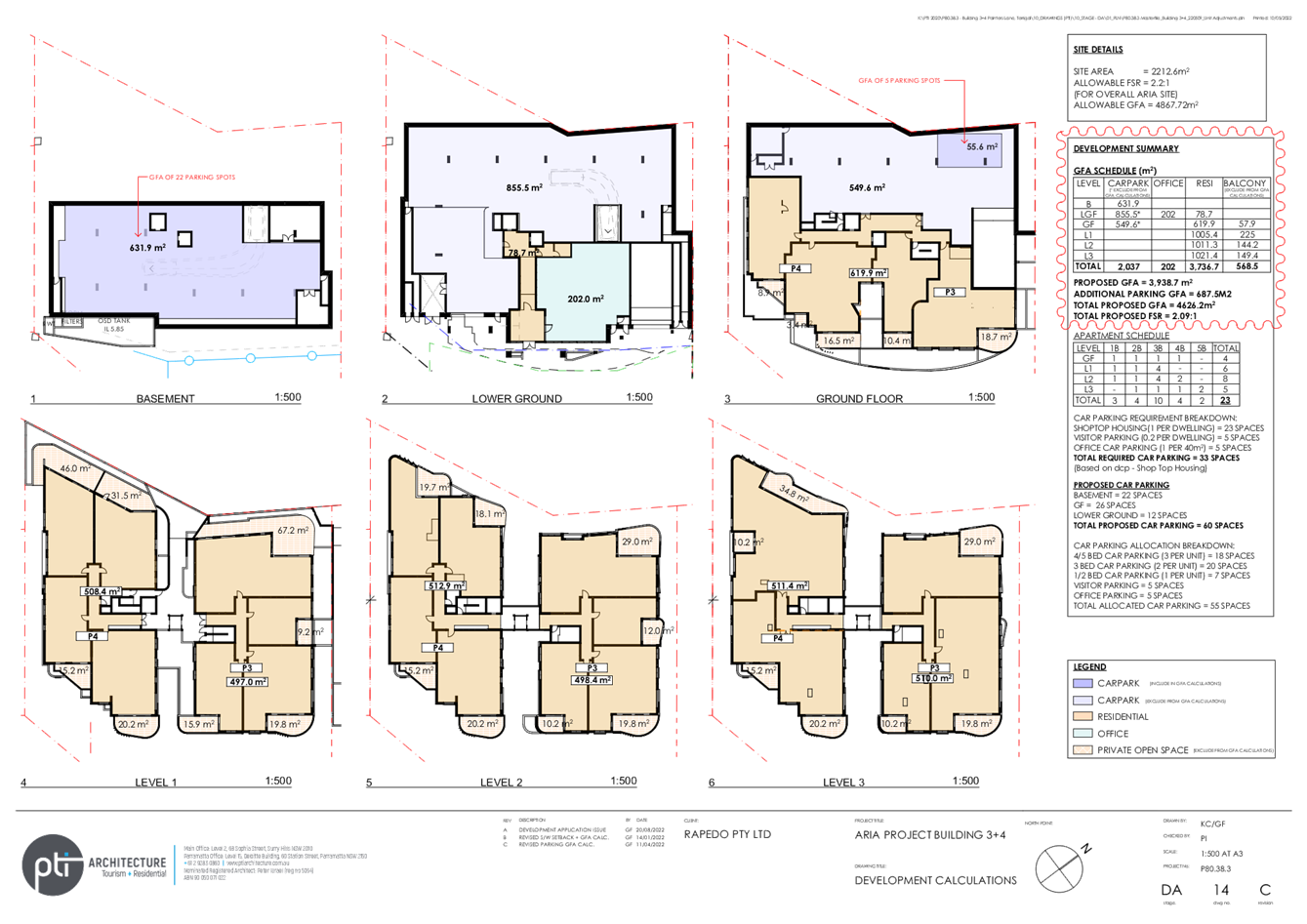
An application has been received for modification of consent for DA/47946/2015 for Commercial Premises and Shop Top Housing on 10-16 Painters Lane, Terrigal. The application has been examined having regard to the matters for consideration detailed in section 4.15 and 4.55 of the Environmental Planning and Assessment Act 1979 and other statutory requirements with the issues requiring attention and consideration being addressed in the report. The application is recommended for refusal.
The application is required to be referred to the Local Planning Panel due to the number of public submissions in excess of 10. Twenty-two submissions have been received.
Applicant J Hancock Owner D Seraglio Application No 47946/2015/2 Description of Land Lot 23 DP 1204364, Lot 2 DP 349187, Lot B DP 347709, Lot 8B DP 412722, Lot C DP347823, No 10-16 Painters Lane, Terrigal Proposed Development Modification of consent Site Area 2212.6m2 Zoning B2 Local Centre Existing Use Vacant Employment Generation No Estimated Value $9,800,000.00
|
Recommendation
1 That the Local Planning Panel refuse consent to DA47946/2015/2 for modification of commercial premises and shop top housing on 10-16 Painters Lane Terrigal for the reasons in the attached schedule and having regard to the matters for consideration detailed in Section 4.15 and 4.55 of the Environmental Planning and Assessment Act 1979.
2 That Council advise those who made written submissions of the Panel’s decision.
Key Issues
· Whether the proposed modification is substantially the same development.
· Floor space ratio
· Building bulk and scale
· View/visual impact
· Issues raised in public submissions
Precis:
|
Proposed Development |
Commercial premises and shop top housing |
|
Permissibility and Zoning |
Permissible with consent under B2 zone |
|
Relevant Legislation |
· Environmental Planning & Assessment Act 1979 – Sections 4.15 and 4.55 · Local Government Act 1993 – Section 89 · State Environmental Planning Policy (Building Sustainability Index: BASIX) 2004 · State Environmental Planning Policy (Coastal Management) 2018 · Gosford Local Environmental Plan 2014 · Gosford Development Control Plan 2013 · State Environmental Planning Policy (SEPP) No 65 - Design Quality of Residential Apartment Development |
|
Current Use |
Vacant |
|
Integrated Development |
No |
|
Submissions |
Twenty-two (22) |
Variations to Policies
|
Clause 4.3 and 4.4 |
Height of Building and Floor Space Ratio |
|
Standard |
RL 23.6m and 2.3:1 |
|
LEP/DCP |
Gosford Local Environmental Plan 2014 |
|
Departure basis |
Nil to 2.42m or 10.2% (Lift Overrun) |
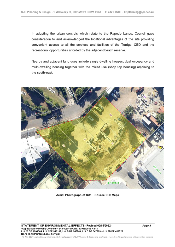
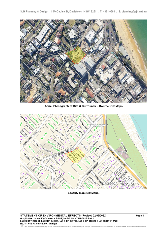
The Site and Surrounding Development
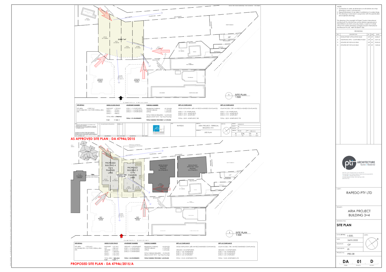
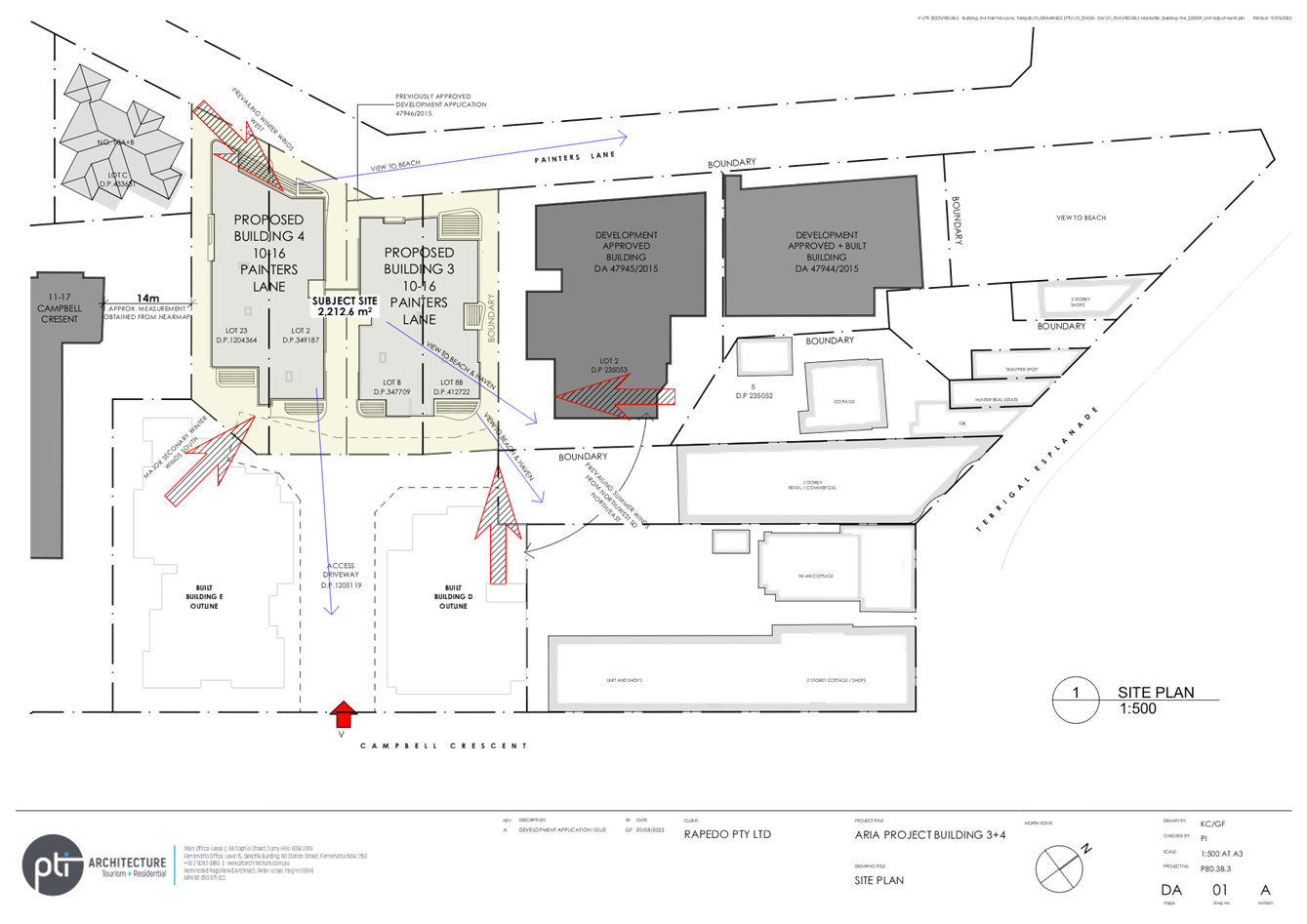
The site is located on the south-eastern side of Painters Lane and adjoins other holdings that together comprise the “Rapedo” site, which is the subject of a previous masterplan. The larger Rapedo holdings have an area of approximately 7,658m2, and contain a number of separate development sites with frontage to Painters Lane and Campbell Street, Terrigal along with lesser frontages to Terrigal Esplanade.
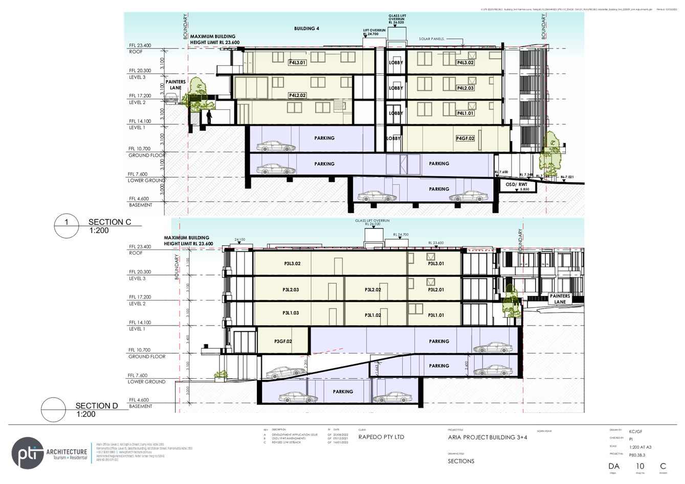
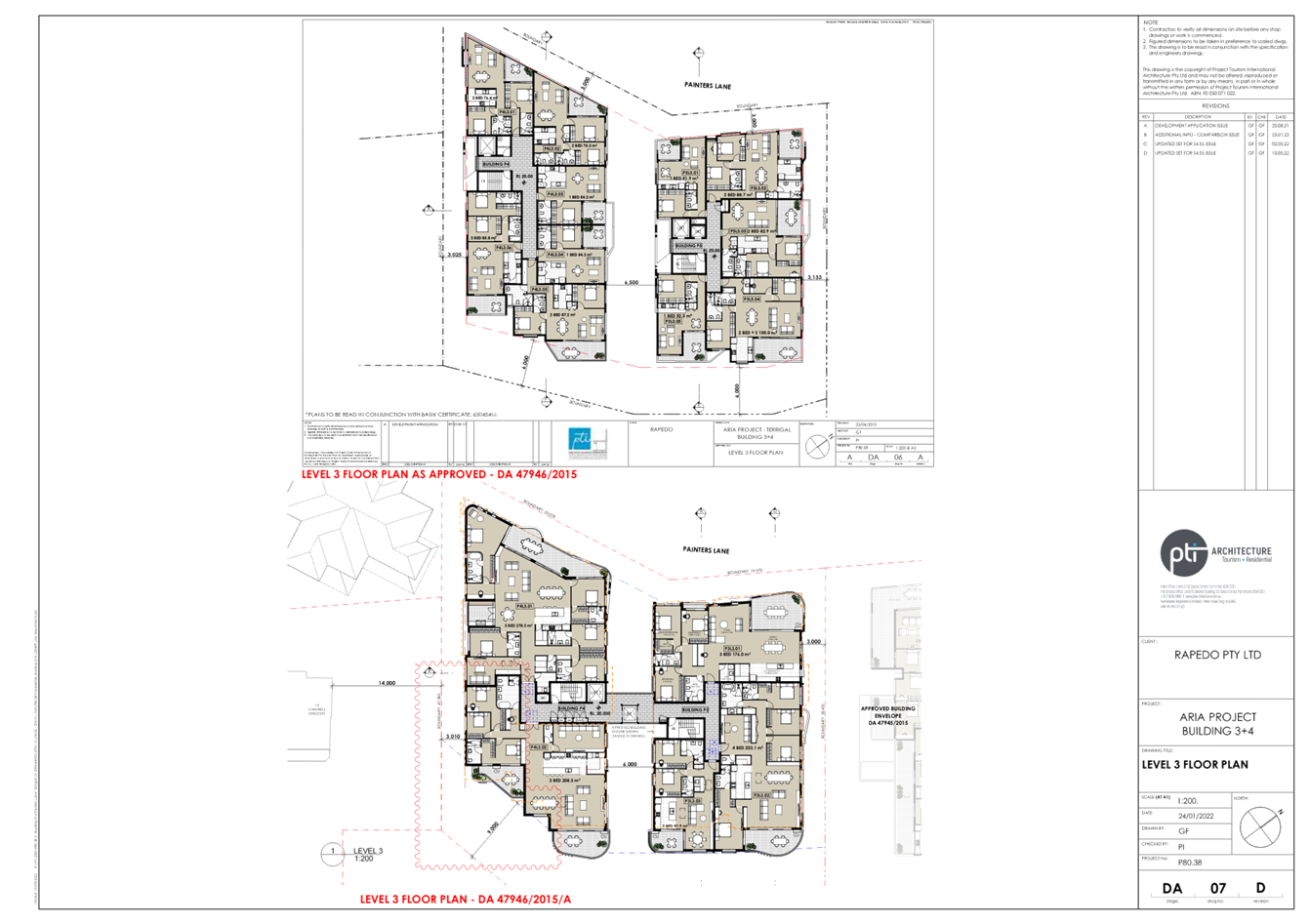
The development area, subject of this application, is identified as Buildings 3 & 4 (refer to Figure 1), which have a frontage of 53.04m to Painters Lane, and a combined area of 2,212.6m2.
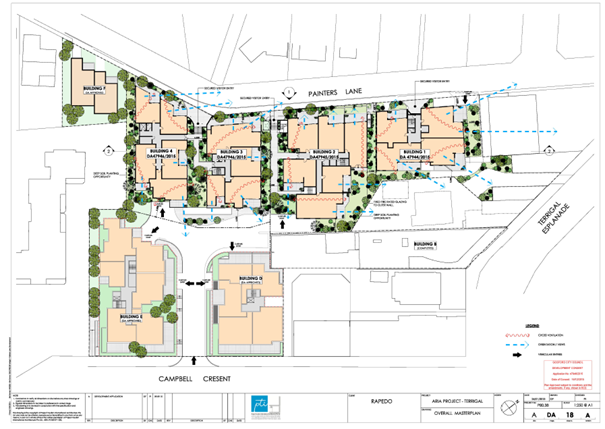
Figure 1 - Rapedo Masterplan
The site has frontage to Painters Lane with access to Campbell Crescent via a right of way over the adjoining sites which form part of the wider Rapedo development.
The site falls from about RL 16 at Painters Lane to about RL 6.5 at the rear boundary with the right of way.
Adjoining the development site to the north-east is (Figures 2 and 3):
· Proposed Building 2 (DA47945/2015), which is located at a lower level down Painters Lane.
· Beyond that is proposed Building 1 (DA47944/2015), a residential unit development and retail/ commercial development fronting Terrigal Esplanade.
· To the south-east there are two existing residential/commercial buildings fronting Campbell Crescent.
· To the south-west is the vacant land with approval for serviced apartments.
· To the north-west, on the opposite side of Painters Lane, is residential development including residential flat developments and elevated dwelling houses.
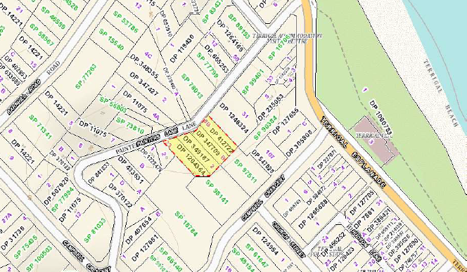
Figure 2 - Land Subject to Proposed Development
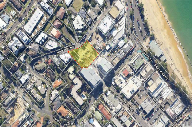
Figure 3- Aerial Photo
History
Zoning history
Until 2002, the entirely of the Rapedo site, including the land the subject of this application, was zoned to permit residential flat buildings and other development to a maximum height of 10m, with design requirements under the [then] Gosford Development Control Plan No. 100. These statutory controls extended across much of the area surrounding Terrigal Central Business District and examples of development approved under these controls include the ‘Star of the Sea’ residential resort complex.
In 2000-2001, the whole of the Rapedo Site was subject of detailed urban design investigations culminating, initially, in the gazettal of Local Environmental Plan Amendment No. 489 in 2002. That LEP amendment introduced a site specific maximum height control of 23.6m AHD and a floor space ratio (FSR) of 2.3:1.
By its gazettal, Gosford Local Environmental Plan 2014 (GLEP 2014) zoned the whole of the Rapedo land B2 – Local Centre. The site retains it FSR (2.3:1) and height (23.6m AHD) controls for the whole of the Rapedo Lands under GLEP 2014.
Development approvals
There have been multiple development schemes over the years for the larger Rapedo site.
The current approach to developing the site is for separate development applications for separate development sites, which are primarily residential, with retail/commercial along Terrigal Esplanade and the ground floor of the Campbell Crescent frontage:
· Approvals have been issued for two residential flat buildings fronting Campbell Crescent, with ground floor retail space. These developments have been completed and are each six storeys with a vehicular driveway in between the buildings providing access to car parking and waste collection for a number of buildings on the site.
· A three storey serviced apartment development with two units has been approved on No. 18 Painters Lane.
· At 100–102 Terrigal Esplanade, a three storey development with retail/commercial and a top floor residential apartment has been constructed.
Previous development applications over the subject land are set out below:
DA47946/2015 (Approved on 17 December 2015)
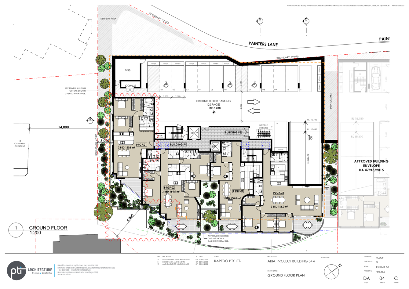
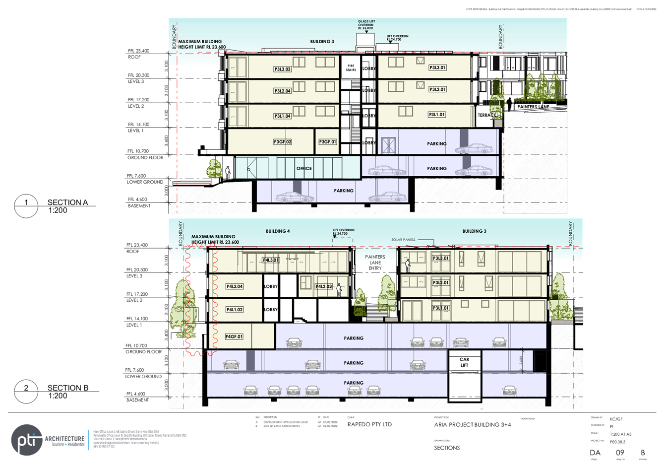
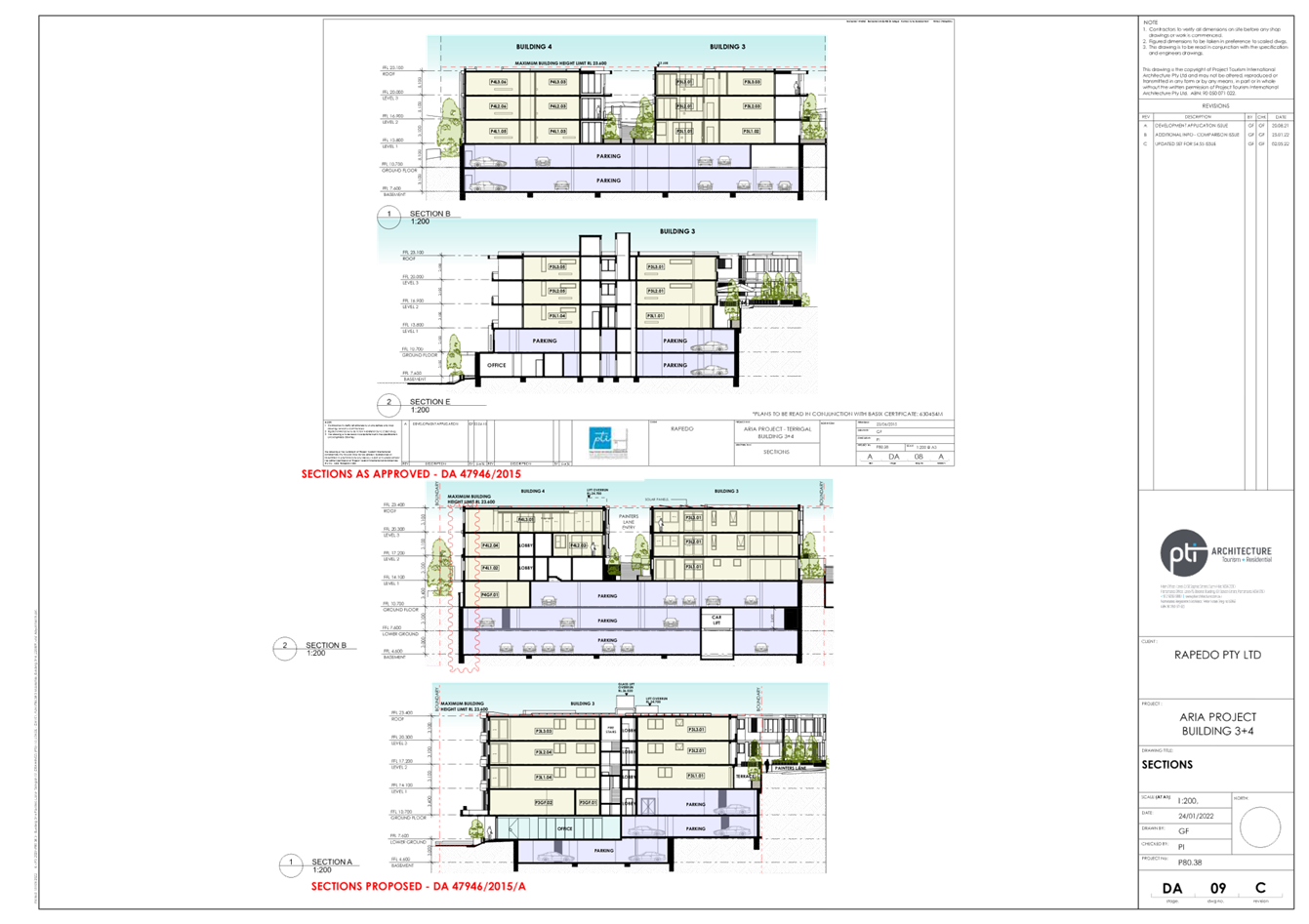
The approved development was for a mixed use development with 31 shop top housing units above a 145.7m2 commercial office space (Figures 4 and 6). The approved development consists of two separate buildings located over combined lower levels containing car parking and the commercial premises. The development presents as two storeys to Painters Lane and there is an additional residential level below that which is located partly below the street level. There are two parking levels below that, which are oriented to the south-west and Campbell Crescent. The elevation to the south-east, toward Campbell Crescent is five storeys. Vehicular access is provided from Campbell Crescent via an access driveway and parking is provided for 61 cars, including 10 stacked spaces (5 x 2 spaces).
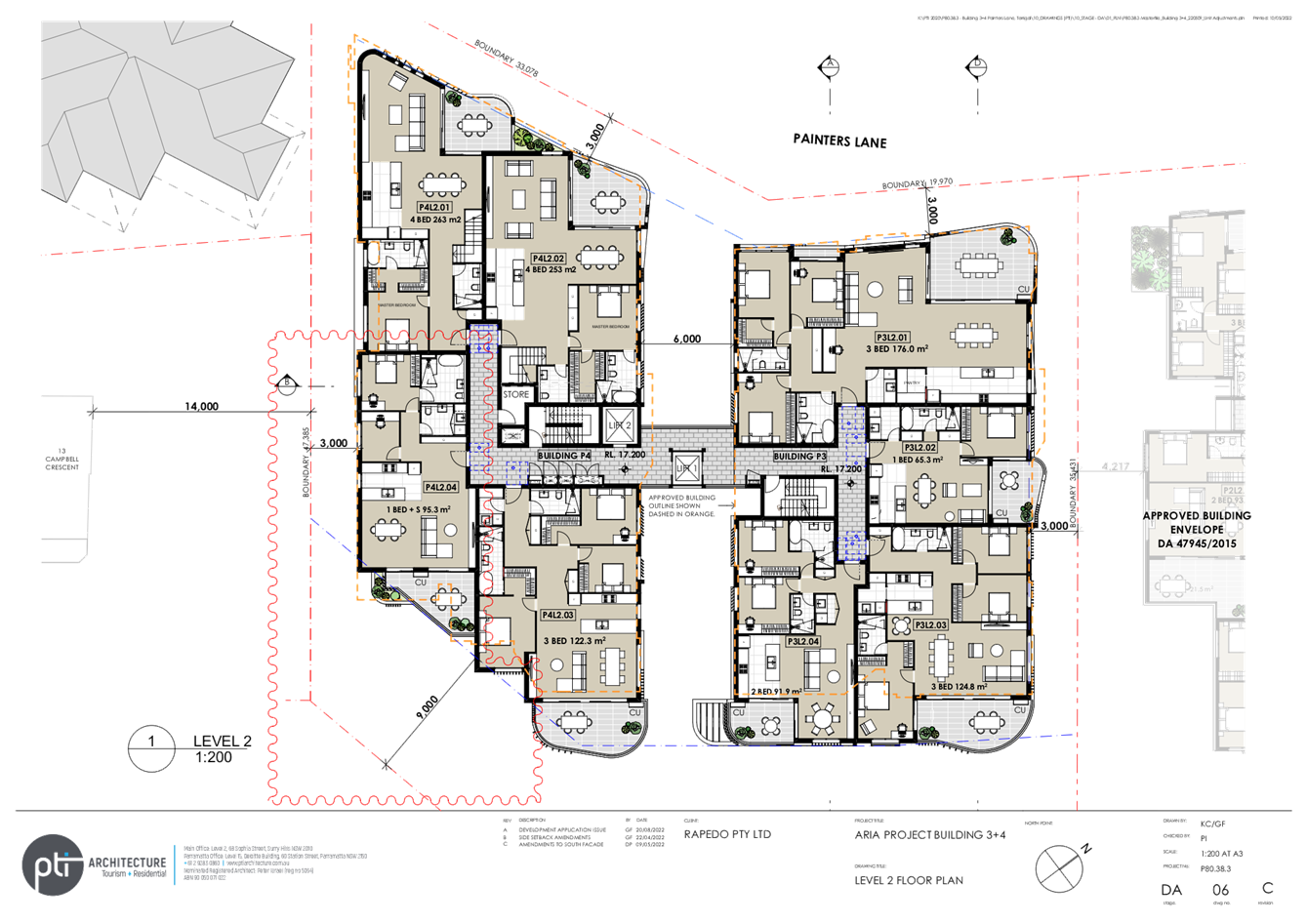
The shop top units are located on levels above the commercial space, with entry provided from Painters Lane. The approved proposal consists of 14 units in Building 3 and 17 units in Building 4, comprising 1 x 4 bedroom unit, 2 x 2 bedroom + study units, 19 x 2 bedroom units and 9 x 1 bedroom units.
Buildings 3 and 4 have an internal separation of 6.5m and the buildings maintain the same setbacks at each level.
The Proposed Development (Modification to Approved DA/47946/2015)
The original application lodged and exhibited proposed a reduction in building setbacks as well as the reduction in separation of the buildings and the addition of a lift between Building 3 and Building 4.
Upon preliminary review, Council advised that the proposed modification to the development was unlikely to be supported.
The applicant amended the plans to retain or increase the building setbacks but not the separation between them. The amended plans were not advertised as the amendments were considered to be relatively minor, made an improvement to the overall design and addressed some of the issues raised in public submissions.
The proposed modifications, for consideration, include (Figures 5 and 7):
· a reduction of residential units from 31 to 23
· relocation of four residential units to the ground floor level
· increasing excavation and providing parking spaces in an additional basement level
· increasing commercial office space for adaption to the demands of the ‘work from home’ executive
· changes to architectural features including a glass framed lift well from Level 1 to roof top, improved articulation and building elevations
The assessment is based on the amended plans in Attachment 1.
A set of approved and proposed comparison plans are included in Attachment 2.
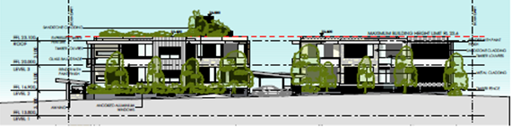
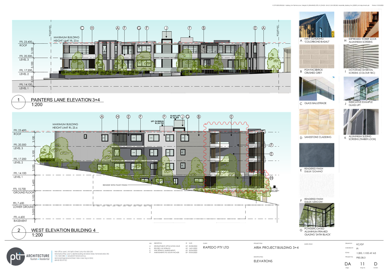
Figure 4 – Approved Elevation Painters Lane
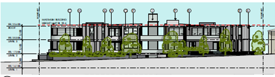
Figure 5 - Proposed Elevation Painters Lane
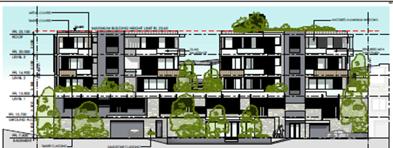
Figure 6 - Approved Eastern Elevation
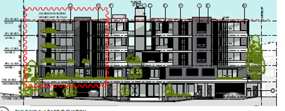
Figure 7 – Proposed Eastern Elevation
ASSESSMENT
Having regard for the matters for consideration detailed in Section 4.15 and Section 4.55 of the Environmental Planning and Assessment Act 1979 and other statutory requirements, the assessment has identified the following key issues.
Section 4.55(2) Assessment Considerations
The proposal is required to be assessed having regard to Section 4.55(2) of the Environmental Planning and Assessment Act 1979, which enables a consent authority to modify a development consent upon application being sought by the applicant or any person entitled to act on the consent, provided that the consent authority:
(a) it is satisfied that the development to which the consent as modified relates is substantially the same development as the development for which consent was originally granted and before that consent as originally granted was modified (if at all), and
(b) it has consulted with the relevant Minister, public authority or approval body (within the meaning of Division 4.8) in respect of a condition imposed as a requirement of a concurrence to the consent or in accordance with the general terms of an approval proposed to be granted by the approval body and that Minister, authority or body has not, within 21 days after being consulted, objected to the modification of that consent, and
(c) it has notified the application in accordance with—
(i) the regulations, if the regulations so require, or
(ii) a development control plan, if the consent authority is a council that has made a development control plan that requires the notification or advertising of applications for modification of a development consent, and
(d) it has considered any submissions made concerning the proposed modification within the period prescribed by the regulations or provided by the development control plan, as the case may be.
Therefore, Council’s assessment of the application to modify the subject development consent must consider the following issues:
1. Is the proposed development as modified substantially the same development approved by Council?
2. Consultation with other authorities.
3. Responses to notification of proposed modification in accordance with relevant policies.
4. Consideration of relevant matters under section 4.15(1) of the Environmental Planning and Assessment Act 1979.
Each of these matters is dealt with separately below.
Section 4.55(2) of the Environmental Planning and Assessment Act 1979 provides that a consent authority may, on application being made by the applicant, modify a development consent if it is satisfied that the development to which the consent as modified relates is substantially the same development as the development for which consent was originally granted.
The Land and Environment Court (LEC) consistently describes Section 4.55 (formerly Section 96) of the Environmental Planning and Assessment Act 1979 modification provision as “beneficial and facultative”. It is designed to assist the modification process rather than to act as an impediment to it:
‘It is to be construed and applied in a way that is favourable to those who seek to benefit from the provision’ (North Sydney Council v Michael Standley & Associates Pty Limited [1998]).
Therefore, the modification power is there for a reason, namely, to avoid the full development application process that is always otherwise available.
Nevertheless, there are legal tests that need to be satisfied before a modification application can be considered on its merits. Firstly, a proposal can only be regarded as a modification if it involves ‘alteration without radical transformation’ (Sydney City Council v Ilenace Pty Ltd [1984]). If the proposed changes results in a ‘radical transformation’, they will need to be dealt with as a new development application, rather than a modification application. The term ‘radical transformation’ is a very broad term, leaving much scope to change a development consent via Section 4.55.
Secondly, the consent authority must also be ‘satisfied’ that the modified development will be ‘substantially the same development’ as authorised by the original development consent. A threshold exercise requirement that the consent authority be satisfied as to a subjective matter before it proceeds further with its merit assessment is to compare the proposed modified development against the development as it was originally approved.
In addition, the environmental impacts of the proposed modification are relevant to the legal question of whether it is ‘substantially the same development’. This means it is possible for some issues that might be characterised as ‘merit’ issues, to also arise in addressing the ‘substantially the same’ test.
In the case Moto Projects (No 2) Pty Ltd v North Sydney Council 1999, the LEC said that any comparison exercise cannot be undertaken in a sterile vacuum. Rather, the comparison involves consideration of quantitative and qualitative elements of the development. These elements must be considered in their proper contexts – which include the circumstances in which the development consent was granted (i.e. all of the changes to the consent should be considered, not just changes to plans.)
The task of comparing the modified and originally approved development involves more than a comparison of the physical features or components of the development as currently approved and modified. The comparison will need to involve both ‘an appreciation, qualitative, as well as quantitative, of the developments being compared in their proper contexts (including the circumstances in which the development consent was granted)’ (Moto Projects (No.2) Pty Ltd v North Sydney Council [1999] NSWLEC 280; 106 LGERA 298 at [56]).
Chief Justice Preston reiterated the statutory approach, with reference to relevant sections of the Environmental Planning & Assessment Act 1979 in Arrage v Inner West Council [2019] NSWLEC 85 at paragraphs [24-28]. Those paragraphs are outlined below:
24. ‘First, the essential elements to be identified are not of the development consent itself, but of the development that is the subject of that development consent. The comparison required by s 4.55(2) is between two developments: the development as modified and the development as originally approved: see Scrap Realty Pty Ltd v Botany Bay City Council (2008) 166 LGERA 342; [2008] NSWLEC 333 at [16].
25. Second, the essential elements are not to be identified “from the circumstances of the grant of the development consent”; they are to be derived from the originally approved and the modified developments. It is the features or components of the originally approved and modified developments that are to be compared in order to assess whether the modified development is substantially the same as the originally approved development.
26. The choice of language in the judicial decisions of “material and essential features” or a “material and essential physical element” of the development (see, for example, Moto Projects at [58], [59] and [64]) derives from judicial interpretations of the statutory test that the modified development be “substantially the same” development as the originally approved development. In Vacik Pty Ltd v Penrith City Council [1992] NSWLEC 8, p 2 Stein J interpreted the word “substantially” in the former s 102(1)(a) of the EPA Act to mean “essentially or materially or having the same essence”. That interpretation of the word “substantially” was accepted in North Sydney Council v Michael Standley & Associates Pty Ltd (1998) 43 NSWLR 468 at 475 by Mason P (with whom Sheppard AJA agreed at 403) and at 481-482 by Stein JA and in Moto Projects by Bignold J at [30] and [55].
27. This interpretation of the statutory test that the modified development be substantially the same development as the originally approved development, that the modified development be “essentially or materially” the same or “having the same essence” as the originally approved development could support an inquiry to identify the material and essential features of the originally approved and modified developments in order to undertake the comparative exercise required, but it does not demand such an inquiry.
28. That is one way, probably in most cases the most instructive way, to identify whether the modified development is substantially the same development as the originally approved development, but it is not the only way to ascertain whether the modified development is substantially (in the sense of essentially or materially) the same development as the originally approved development. For example, comparison could be made of the consequences, such as the environmental impacts, of carrying out the modified development compared to the originally approved development: see Moto Projects at [62] and Tipalea Watson Pty Ltd v Ku-ring-gai Council (2003) 129 LGERA 351; [2003] NSWLEC 253 at [17].’
A qualitative and quantitative analysis between the development as originally consented to and the proposed modification is required, and the modification must render the altered development ‘essentially’ or ‘materially’ the same.
Having regard for paragraphs 24 and 25 above, the proposed modifications to the development as originally approved and proposed are as follows (refer to Attachment 2 for comparison of the approved and proposed plans):
|
Development
|
Approved |
Proposed Modification |
Difference |
|
Site Area
|
2053.7m2 |
2212.6m2 |
158.9m2 |
|
No. of Units
|
31 |
23 |
-8 |
|
Unit Types |
9X1 bedroom 11X2 bedroom 11X3 bedroom |
3X1 bedroom 4X2 bedroom 10X3 bedroom 4X4 bedroom 2X5 bedroom |
-6 -7 -1 +4 +2
|
|
Commercial Area
|
129.9m2 |
280.7m2 |
+150.8m2 |
|
Development
|
Approved |
Proposed Modification |
Difference |
|
GFA |
2757.9m2 |
4626.2m2 (includes 687.5m2 excess car parking.
|
+1868.3m2 |
|
Building Height-Roof
|
RL23.6 |
RL23.6 |
Nil |
|
Building Height Lift overrun
|
RL 26.0m |
RL 26.02m |
+0.02m |
|
Number of storeys
|
5 |
5 |
Nil |
|
|
1.34:1 |
1.78:1 (2.09:1Including excess car parking) |
+0.75:1 |
|
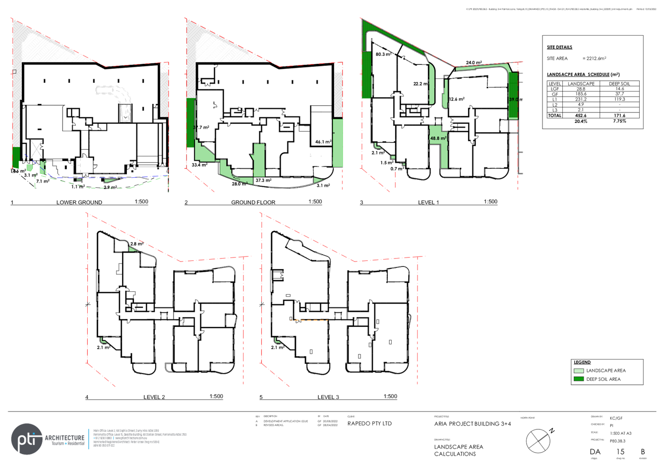
Landscape Area
|
|
452.6m2 (20.4%) |
|
|
Deep Soil planting
|
|
171.6m2 (7.75%) |
|
In addition to the amendments set out in the table above, every floor of the approved development design is proposed to be modified as part of the current application. A summary of the amendments for each level of the development, is listed in the table below page (refer to Attachment 2 for the comparison plans).
|
Level
|
Approved |
Proposed |
|
Basement
|
No Basement |
22 car spaces |
|
Lower Ground Level |
29 car spaces No car lift 129.9sqm office 1 lobby Lift for each separated building 1 Vehicular Access |
26 car spaces Car lift 202sqm office space (including fit out) 2 Lobby areas Relocation of 1 passenger lift to the central location Two vehicular accesses
|
|
Ground floor |
32 car spaces No units No balconies |
12 car spaces 4 units Balcony design changes Façade changes in materials and design
|
|
Level 1 |
9 units |
8 units Relocation of services Redesign of whole floor in term so cross ventilation, access, privacy Walkways and central lift Façade changes in materials and design
|
|
Level 2 |
11 units Lift located in each separate block. |
6 units Balcony redesign, Façade changes in materials and design
|
|
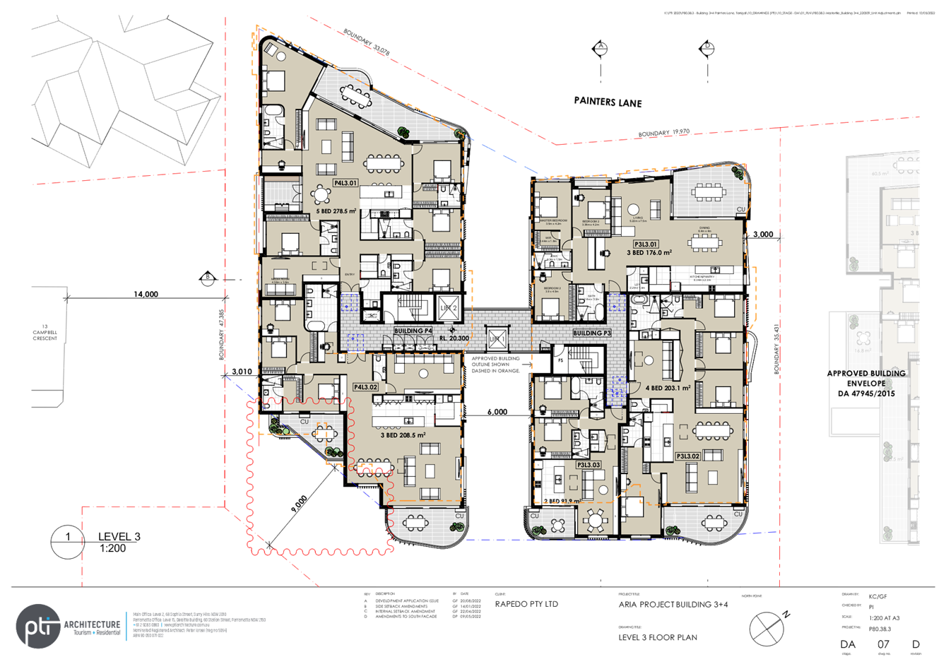
Level 3 |
11 units |
5 units Balcony redesign, Façade changes in materials and design
|
|
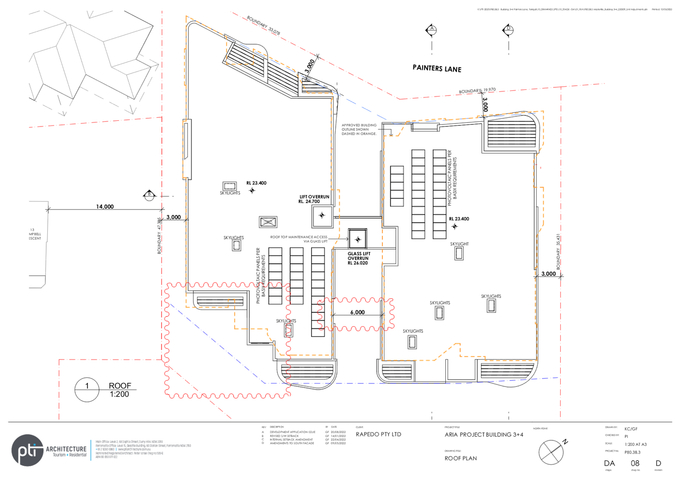
Roof level |
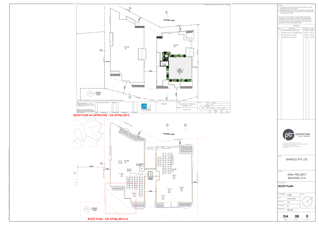
Roof top terrace
|
No terrace |
The modification proposes to reduce the number of units (from 31 to 23) which reduces the car parking requirements. However, the proposal aims to reduce parking by one space (from 61 spaces to 60), and alter the design from one vehicular entry to two. It could be argued that the additional parking and amendment to vehicular access points is beneficial to the design overall, but in the context of determining whether the proposed development is substantially the same. This amendment only emphasises that the design amendment results in significant modifications - highlighting that the proposal is not substantial the same development.
In conjunction with the increase the commercial floor space, the additional basement level, the reduction in the building separation and the lift tower and walkways all add to the bulk and scale of the proposed development. Although there is no change in overall height, there is a change in the visual bulk and building footprint.
The change in design to now block the ‘view corridor’ between the two buildings (with a lift and pedestrian walkways) is a significant change to the design and goes against the approved plans to keep this corridor open. This corridor was highlighted in the original approval in both the separation distance of 6.5m and also under the view assessment as important aspect of the original design (refer page 9 of original assessment report, at Attachment 5). The installation of a lift tower does not itself result in a significant impacts itself, but it is the design of the lift tower represents a significant change in the design.
The reconfiguration of the development increases FSR, while reducing unit numbers. Gross Floor Area (GFA) is significantly increased (by more than 1,868m2).
The cumulative changes to the original approved development are considered to result in a substantially different development to that which was originally approved and are considered to alter the essential elements of the originally approved development.
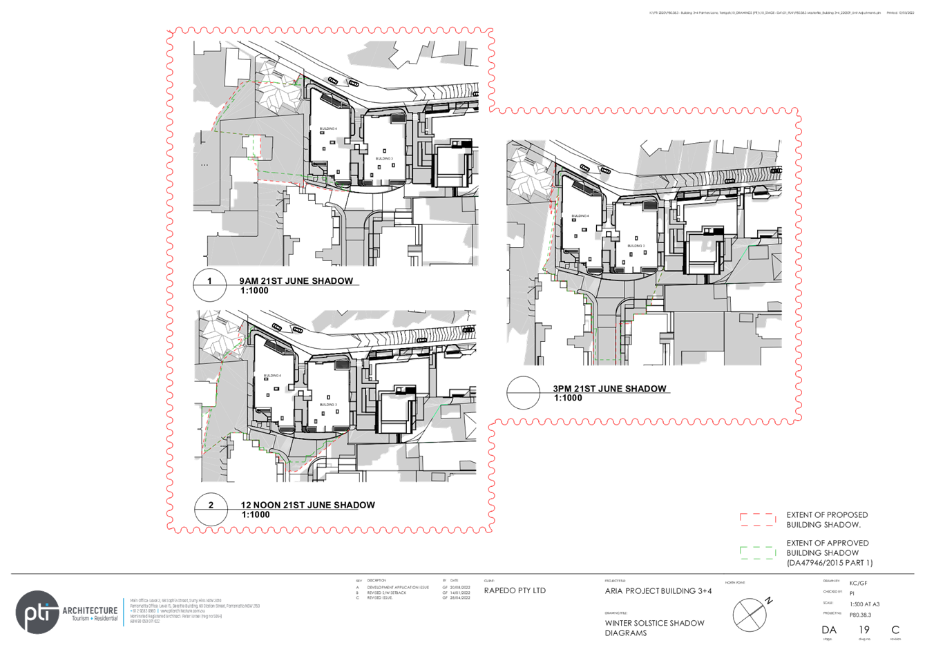
The consequences of carrying out the modified development, compared to the originally approved development, will be noticeable, particularly in relation to the overall scale, the reduction in setbacks and the lift tower between the buildings, resulting in loss of the ‘view corridor’ between the buildings that was a key design feature.
It is considered that the bulk and scale of the development as perceived from surrounding viewpoints from both public and private property will significantly and materially change under the proposed modifications. The scale and external appearance of the proposal are different that originally approved.
As a result, it is considered the proposed modification is not substantially the same development, as the proposed changes have additional impacts on adjoining developments and the locality due to increase in bulk and scale and FSR.
A quantitative and qualitative assessment of the proposed modification concludes that the proposal is not substantially the same development.
CONSIDERATION 2 - Consultation with other authorities.
No consultation was required with other authorities.
CONSIDERATION 3 - Notification of proposed modification.
The proposed modification was notified and 22 public submissions were received. The issues raised have been are considered (refer to the Public Submissions section later in this report).
CONSIDERATION 4 - relevant matters under section 4.15(1) of the EP&A Act 1979
Section 4.55 (3) reads:
‘In determining an application for modification of a consent under this section, the consent authority must take into consideration such of the matters referred to in section 4.15(1) as are of relevance to the development the subject of the application. The consent authority must also take into consideration the reasons given by the consent authority for the grant of the consent that is sought to be modified.’
Section 4.55(3) requires the consent authority to consider matters referred to in Section 4.15(1) as are relevant to the application for modification of the development consent. The modification has been assessed against the matters for consideration under Section 4.15 of the Act and found to be unsatisfactory with regard to impacts including, visual impacts and bulk and scale impacts and compliance with planning controls. These are discussed further in the report. Additionally, consideration must be given to the reasons for the granting of the original approval.
Although there were no formally specified reasons for the granting of the original consent, a review of the report for the originally approved application has been undertaken and the conclusion and findings of that original assessment have been taken into consideration as part of the assessment of the subject application.
State Environmental Planning Policy (Building Sustainability Index: BASIX) 2004
The application is supported by an amended BASIX certificate which confirms the proposal will meet the NSW Government's requirements for sustainability, if built in accordance with the commitments in the certificate.
The proposal is considered to be consistent with the requirements of State Environmental Planning Policy (Building Sustainability Index: BASIX) 2004.
State Environmental Planning Policy (Resilience & Hazards) 2021
The subject land is located within the ‘coastal environment area’ and ‘coastal use area’ as identified in the NSW Coastal Management Act 2016.
A such, the provisions of Chapter 2 of State Environmental Planning Policy (Resilience & Hazards) 2021 requires Council to consider the matters set out in Section 2.10 of the SEPP (with regard to development in the coastal environment area) and Section 2.11 of the SEPP (with regard to development in the coastal use area)
The relevant matters have been considered in the assessment of this application. The application is considered consistent with the stated aims and objectives.
The original application was assessed under the provisions of the former State Environmental Planning Policy No. 71 – Coastal Protection (SEPP 71). The proposed amendments do not alter the assessment of the application against the relevant provisions of the former SEPP or raise any additional issues.
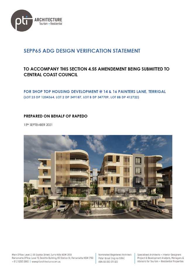
State Environmental Planning Policy (SEPP) No 65 - Design Quality of Residential Apartment Development
This policy applies as the building is a residential flat building more than three storeys in height. The application has been considered by Council’s architect with the following key points noted:
The amended application proposes the following:
· Increase in the site area from 2057m2 to 2212m2 achieved by moving the laneway boundary further to the south west.
· An additional basement carpark level for 22 cars accessed by a car lift.
· Enlarging units and reducing unit numbers from 31 to 23, increasing the building footprint on the south and increasing FSR from 1.34:1 to 2.09:1.
· Addition of pedestrian bridges on the first, third and roof levels between the two buildings and the addition of a central lift between the buildings.
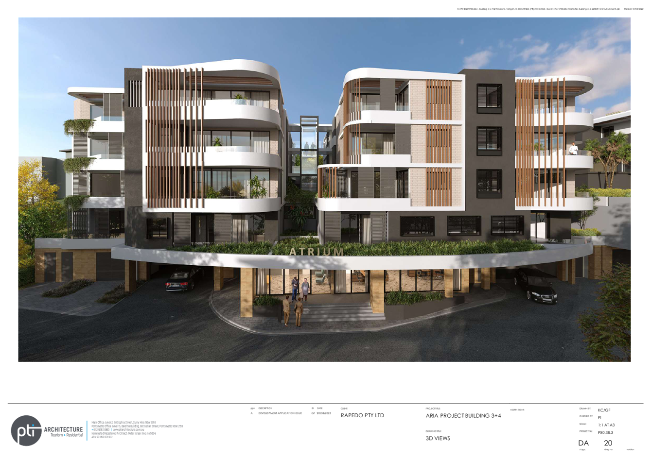
Context and Neighbourhood Character
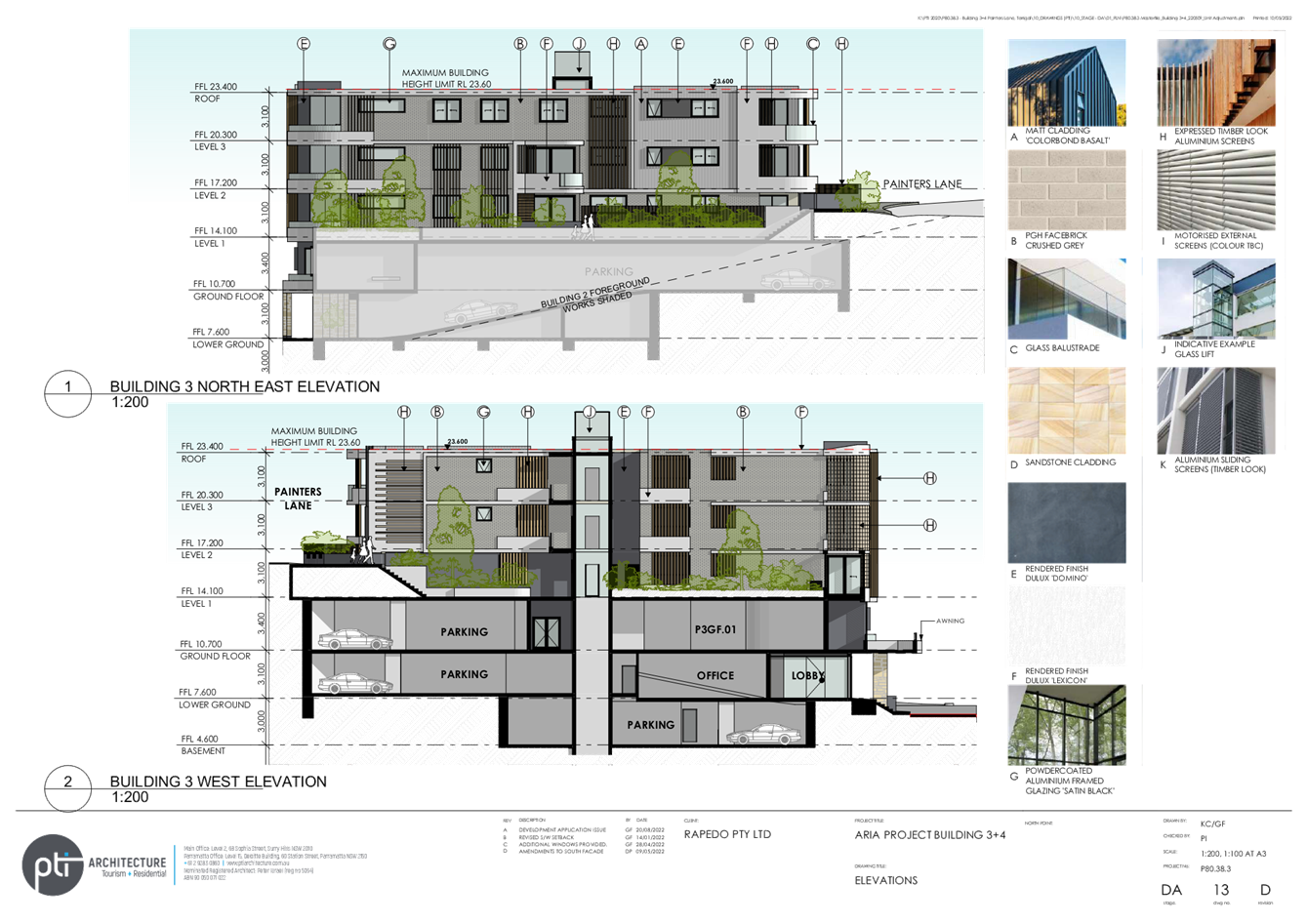
The approved application provided a 6.5m-wide gap between the buildings to provide a view corridor from Painters Lane and to disguise the bulk and scale of the development.
The addition of a lift, connecting walkways and enlargement of balconies on levels 1 and 2 have eliminated this view corridor and increased bulk and scale and the amended application is now considered inconsistent with the desired character and the approved application.
Built Form and Scale
Proposed side setbacks are approximately 3m, which is 50% non-complying with the Apartment Design Guidelines (ADG), but consistent with the approved application and therefore considered acceptable.
The south western boundary has been moved further south towards the adjoining site. This has reduced the proposed building separation has been increased to approximately 9metres with landscaped screening added to improve privacy and outlook and is now considered acceptable.
An external lift and pedestrian bridges are now proposed within the 6m gap between the two buildings. This originally provided a view corridor between the buildings and disguised the visual scale. The proposed bridges and lift obstruct any views between the buildings and add visual bulk and scale and are not supported.
Density
Has been increased from 1.34:1 to 2.09:1. Though this complies, when combined with the loss of the view corridor and other detrimental impacts on adjoining sites, it indicates the application is an overdevelopment of the site.
Sustainability
BASIX certificate supplied indicating compliance with minimum sustainability requirements.
Landscape
The landscaping between public and private spaces on level one is located on the slab and is unlikely to achieve the size necessary to provide screening or disguise the bulk and scale resulting from increased building footprint, FSR and the removal of the view corridor.
Amenity
Inadequate building separation results in visual and acoustic privacy conflicts between adjoining sites and between units within the site.
Safety
Acceptable. Upper level units have windows and balconies overlooking the entry and street to increase surveillance of public areas.
Housing Diversity and Social Interaction
The application provides a mix of one, two, three and four bedroom units and adaptable units for different needs of occupants.
Aesthetics
Acceptable subject to addressing issues raised under Built Form and Scale. The stepped profile recessed and articulated facade and variations in material and colours attempt to break up and disguise the scale resulting from non-compliance but are not an adequate response to this problem.
Conclusion & Recommendation from Council’s architect
The addition of the external lift and walkways within the former through site link is a major change to the approved application. It results in significant loss of amenity for adjoining sites, adds to bulk and scale and is inconsistent with the desired character.
The increase in FSR and built area could only be considered if the external lift and walkways are removed and the approved through site link is fully restored.
Detrimental impacts resulting from non-compliance are not supported. The application should comply with approved setbacks on all boundaries.
The amended application is not supported.
Gosford Local Environmental Plan 2014 - Permissibility
The subject site is zoned B2 Local Centre under the provisions of GLEP 2014.
The proposed development is defined as ‘commercial premises’ and ‘shop top housing’.
The proposed development is permitted with development consent.
Gosford Local Environmental Plan 2014 - Zone Objectives
The objectives of the B2 Local Centre zone are:
· To provide a range of retail, business, entertainment and community uses that serve the needs of people who live in, work in and visit the local area.
· To encourage employment opportunities in accessible locations.
· To maximise public transport patronage and encourage walking and cycling.
· To provide for residential uses, but only as part of a mixed use development.
· To ensure that development is compatible with the desired future character of the zone.
· To promote ecologically, socially and economically sustainable development.
· To ensure that the town centres of Erina and Woy Woy are recognised as providing a higher level, and greater diversity, of services and facilities to serve a wide population catchment from numerous localities and as key public transport nodes, secondary to Gosford City Centre.
· To ensure that village centres such as Avoca, East Gosford, Ettalong Beach, Kincumber, Lisarow, Niagara Park, Terrigal, Umina Beach, West Gosford and Wyoming are recognised as providing a broad range of services and facilities to serve the population of the locality.
· To ensure that villages are recognised as providing local level services and facilities and are developed at a scale that reflects their population catchment and as a focus for public transport routes.
· To ensure that the different roles of villages are recognised with some villages being key tourist destinations with boutique activities in addition to serving the needs of local residents, while other villages are purpose-built centres to serve the needs of the local population.
· To encourage the residential population of villages and town centres to contribute to the vitality of those locations.
The proposed modified development is incompatible with the desired future character of the zone in this location proposed modifications which result in addition bulk and impacts on the approved open corridor between the buildings.
The modified scale and external appearance of the proposal is not respectful of future expected development on surrounding land, particularly land that is upslope of the subject site. The proposed modification to close in the open corridor between the buildings results in additional bulk and impacts negatively to the external appearance of the proposal.
Gosford Local Environmental Plan 2014 – Development Standards
The following table provides an analysis against the development standards (Height of Buildings and Floor Space Ratio) as set out in GLEP 2014.
|
Development Standard |
Required |
Approved |
Proposed |
Variation to development standard |
Compliance with Objectives |
|
Clause 4.3 Height |
RL 23.6m |
Roof-RL 23.6m (Lift overrun RL 26.0m) |
Roof-RL23.6m (Lift Overrun RL24.7m and 26.02m) |
Yes |
Yes |
|
Clause 4.4 FSR |
2..3:1 |
1.34:1 |
2.09:1 |
Yes |
Yes |
Height
The current approved building height is 23.6m with lift overrun to RL 26.0m. This was a variation to the development standard of up to 2.4m or 10.1%. The current application to modify the approved development results in an increase in height of 0.02m to the lift overrun. The lift overruns coverage is approximately 0.5% only of the site area.
The increase in height to the approved development is minor or negligible.
In considering the additional building height, there is established case law that a variation to development standards is not required for a modification under Section 4.55. (NSW Court of Appeal North Sydney Council v Michael Standley & Associates Pty Ltd (1998), and the Land and Environment Court Gann v Sutherland Shire Council (2008)). However, Council is still required to undertake an assessment of the variation and its impact under Section 4.15 of the Environmental Planning and Assessment Act 1979.
In this case:
· The proposed increase in height results in no increase in overshadowing; and
· The increase in height and the lift overruns is only over a total area of about 12.1m2 towards the centre of the roof area has no increase in shadow impact on the adjoining sites.
It is noted that although the height does, in itself, not cause any impacts, the design of the lift tower is not supported.
Floor Space Ratio
In considering the additional Floor Space Ratio (FSR), as discussed above there is established case law that a variation to development standards is not required for a modification under Section 4.55. However, Council is still required to undertake an assessment of the variation and its impact under Section 4.15 of the Environmental Planning and Assessment Act 1979.
The proposal results in a significant increase in floor space and FSR due to the additional levels and increase in car parking. The increase in FSR, reduction in distance between Building 3 and Building 4 and the addition of the lift /connection between the two buildings add to the bulk and scale of the proposed building particularly when viewed from Painters Lane and Campbell Crescent.
Draft Central Coast Local Environmental Plan 2018
Draft Central Coast Local Environmental Plan 2018 (Draft CCLEP 2018) was adopted by Council at its meeting of 14 December 2020. Gazettal is anticipated in mid-2022, and has been considered during the assessment of the application.
Draft CCLEP 2018 does not propose a change to the zoning of the site or significant change to other relevant statutory matters.
Gosford Development Control Plan 2013
Chapters 2 and 4.3 and the environmental and parking controls under GDCP 2013 are relevant to the application.
The land is located in the ‘Mainstreet Centre’ character area, which encourages on going mixed use, including accommodation for residents and visitors, with high levels of street activity and improved standards of amenity and design.
The location of the site is on the fringe of the commercial area, at an interface with residential areas, and is not a primary ‘mainstreet’ location.
The proposed modification is not consistent with the desired character as:
· The lift tower and walkways result in an intrusive building form that impacts adversely on the views that are enjoyed from surrounding hillside dwellings and on the informal scenic qualities of the foreshore setting.
· The building form does not step the top level back from all site boundaries in accordance with that required in the DCP.
· The modified development is not sensitive to the topographic or scenic context, does not respect visual amenity nor maintain the pedestrian friendly scale of existing one and two storey shop front developments being visible as a backdrop.
Gosford Development Control Plan Chapter 4.3 – Terrigal Village Centre
GDCP 2013 Chapter 4.3 has the following objectives:
· Ensure that future buildings neither dominate this coastal setting nor intrude unreasonably onto coastal and ocean views that are available from surrounding residential hillsides, and
· Promote the highest standards of urban and architectural design quality.
The proposal does not meet the intent of these objectives in that design modifications intrude upon the views from surrounding properties and do not contribute to a high standard of design suitable for the scenic qualities of a foreshore setting.
Clause 4.3.4.3 (Controls – Desired character of buildings)
This clause states development should:
Provide a backdrop that
is appropriate to the scenic quality of this coastal setting
i. Limit overall height to maintain existing streetlevel amenity and to prevent unreasonable obstruction of coastal and ocean views that are available from surrounding residential hillsides
ii. Vary the profile and silhouette of buildings within a framework set by height and building envelope controls
The proposal does not satisfy the above controls as the design modifications and floor area obstructs views that are available from surrounding properties and the proposal does not conform to the framework set by the FSR and building envelope controls.
Side Setbacks
The approved development approved a variation to the side setbacks under the DCP. A 4m setback is required at lower levels to residential development, stepping in at upper levels. The approved north-eastern side setback from Building 3 is 3.1m, the rear setback is 6m (which complies) and the south-west side setback from Building 4 is 3m. There is a setback of 6.5m between Buildings 3 and 4. The proposed side setbacks were considered acceptable given the orientation of the units and the treatment of the interface of buildings to the side boundaries.
The proposed modification generally retains or increases the boundary setbacks. The proposed modification reduces the building separation between Buildings 3 and 4 from 6.5m to 6m and adds a lift which impacts the bulk and scale of the proposed development. This is not supported.
Public Submissions
Contributions
The land is subject to contribution plan for Terrigal. The modifications would require an update to the contributions specified in condition 2.2 applicable for open space, footpaths, town centre improvements and stormwater and flood mitigation.
Internal Consultation
The following internal consultations have been undertaken:
|
Traffic Engineer |
Supported without conditions. |
||
|
Development Engineer |
Supported subject to amended conditions 1.1 and 2.10. See comments below. |
||
|
Architect |
|
Not supported. See SEPP 65 comments. |
|
|
Waste Services |
Supported subject to conditions. |
||
|
Water and Sewer |
Supported subject to conditions |
Development Engineer
Road works
The existing development consent requires the construction of road works, footway formation and concrete footpath within Painters Lane. The proposed Section 4.55 amendment does not alter these existing development consent requirements.
Access
The existing development approval is accessed from Campbell Crescent via existing right of access arrangements over SP98141 (7 Painters Lane) and SP97511 (5 Painters Lane). This arrangement will remain unaltered with the proposed Section 4.55 modification.
Within the development site, access and parking arrangements are being modified to now propose the following:
· Ground Floor
This level is accessed from the proposed eastern ramp arrangement adjoining the existing right of access. This level accommodates 12 car parking spaces including four accessible spaces.
· Lower Ground Floor
This level is accessed directly off the existing right of access near the southern area of the site. A modified ‘lower ground floor’ level with access at the southern end of the site accommodating 26 car parking spaces including two accessible spaces is proposed together with a car lift within the level of car parking for access to the basement level. An access ramp is proposed from the right of access arrangements at the eastern end of the site to provide access to the ground floor level. The residential waste bin storage room is retained on the Lower Ground Floor level.
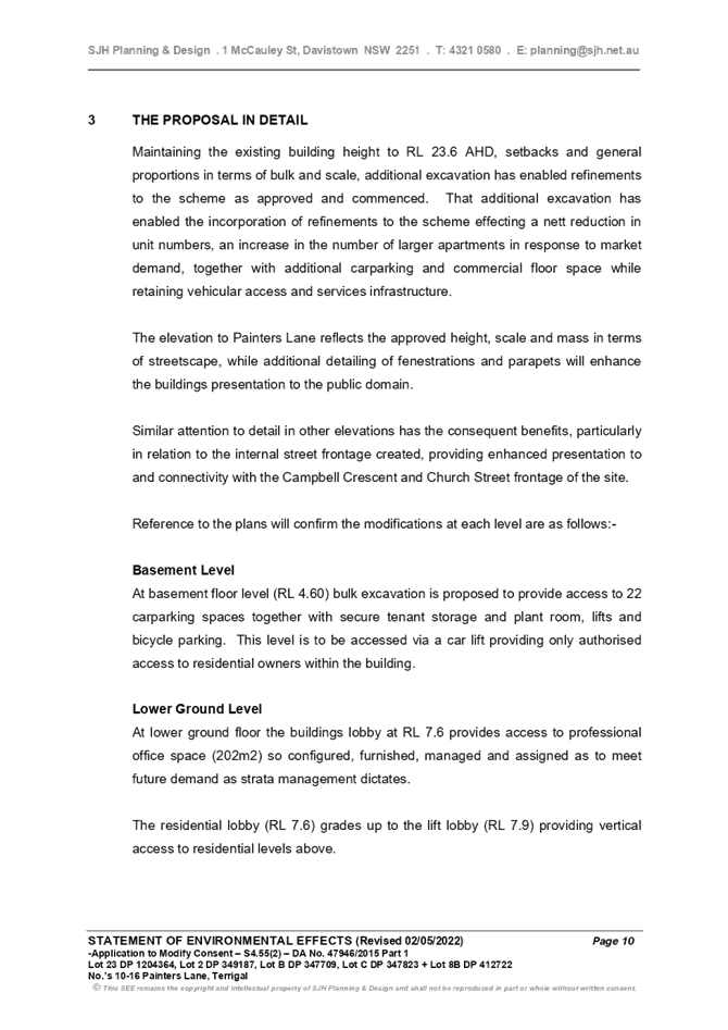
· Basement Level:
Addition of a basement car parking level which will involve additional bulk excavation works to provide 22 car parking spaces together with secure tenant storage and plant room, lifts and bicycle parking. This level will be accessed via a car lift from the Lower Ground Floor Level.
The proposed access and parking modifications appear to generally comply with AS2890 - Parking Facilities.
Waste
The application indicates waste collection is to be undertaken by garbage trucks (9.8m in length), with separate collection areas located within the right of way, adjacent to the respective car park access driveways. Although this truck size is less than the standard 12.5m heavy rigid vehicle (HRV) to be designed for waste servicing, this arrangement appears to be consistent with the existing development consent which allowed the 9.8m vehicle in this instance.
Traffic
A ‘Traffic and Parking Assessment Report’ prepared by Varga Traffic Planning Pty Ltd (Ref 21481 dated 6 September 2021) was submitted with the application. This traffic assessment report indicates:
· The proposed modifications would result in a reduction in traffic generation of 1.3 peak hour trips compared to the existing development consent.
· The access and parking arrangements have been designed to comply with the relevant requirements specified in the Standards Australia publication Parking Facilities Part 1 - Off-Street Car Parking AS2890.1:2004 and Parking Facilities Part 6 - Off-Street Parking for People with Disabilities AS2890.6 in respect of ramp grades & transitions, driveway & aisle widths, parking bay dimensions and overhead clearances.
· The vehicular access arrangements have been designed to accommodate the swept turning path requirements of the B99 design vehicle as specified in AS2890.1:2004 - Parking Facilities – Off Street Car Parking, allowing them to enter and exit the car lift without difficulty, and to enter and exit the site in a forward direction at all times.
Flooding
Council’s records do not indicate the site as being affected by flooding.
Drainage
The water management of the development associated with the existing development consent was based on the Water Cycle Management Report prepared by SRB Consulting Civil Engineers (Project No 21518b Issue 1 dated May 2015) as reflected in parts ‘b’, ‘c’, & ‘d’ of condition 2.10 of the development consent. As supporting documentation for this Section 4.55 application, a Water Cycle Management Plan prepared by SRB Consulting Civil Engineers (Project 21316 Issue 2 dated August 2013) together with plans prepared by SRB Consulting Civil Engineers (Project No 21316, Sheets 1, 2, & 3, all Issue B dated 6 August 2013) were lodged, however, these details are associated with DA/43874/2013 and DA/44795/2013 for an adjoining (completed) developments on 3-5 and 7-9 Campbell Crescent Terrigal and were not relevant to the subject DA (DA/47946/2015) for the purposes of internal water cycle management requirements within this site.
In response to Council’s request for additional information, a revised Water Cycle Management Plan prepared by CUBO Consulting (Ref: 21120_WCMP_1.0 dated 7 December 2021) was submitted to address the water cycle management controls related to on-site detention, stormwater pollution controls and retention requirements for the altered development design. In this regard the revised measures propose a combination of 3,000L rainwater tank, a 52m3 retention tank, and 10 ‘Ocean Protect Storm Filters (or similar)’. This revised WCMP is acceptable for the purposes of the Section 4.55 assessment.
It is recommended that parts ‘b’, ‘c’, & ‘d’ of Condition 2.10 are revised to reflect the reference of the Water Cycle Management Plan prepared by CUBO Consulting (Ref: 21120_WCMP_1.0 dated 7 December 2021).
Ecologically Sustainable Principles
The proposal has been assessed having regard to ecologically sustainable development principles and is considered to be consistent with the principles.
The proposed development is considered to incorporate satisfactory stormwater, drainage and erosion control and the retention of vegetation where possible and is unlikely to have any significant adverse impacts on the environment and will not decrease environmental quality for future generations. The proposal does not result in the disturbance of any endangered flora or fauna habitats and is unlikely to significantly affect fluvial environments.
The proposal has been assessed having regard to ecologically sustainable development principles and is considered to be consistent with the principles; however, the proposal is not supported on other grounds.
Other Matters for Consideration
View Impact Assessment
The original application was supported by a Visual Impact Assessment, which addresses view impacts from the public domain and in relation to surrounding private properties.
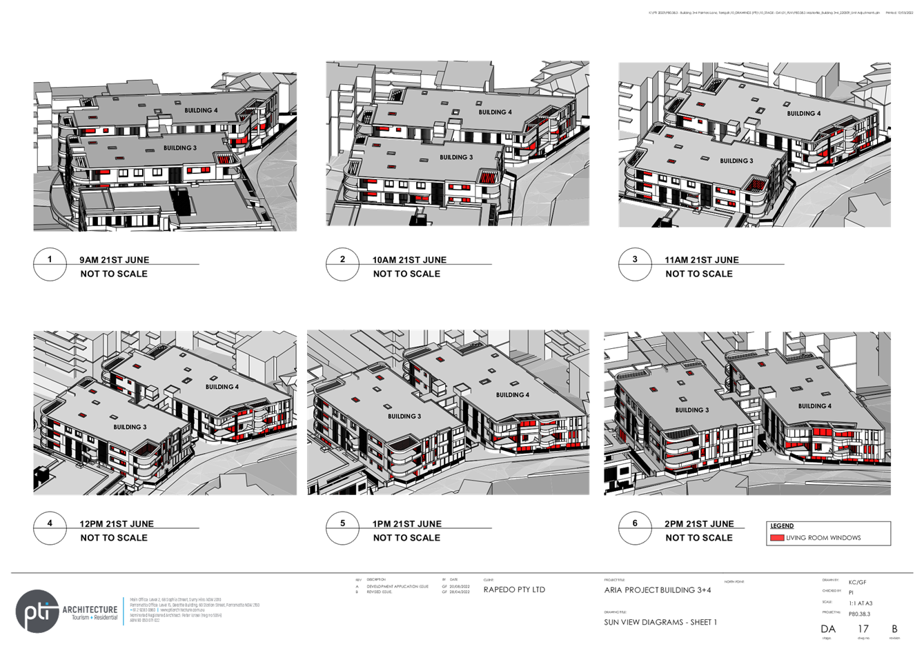
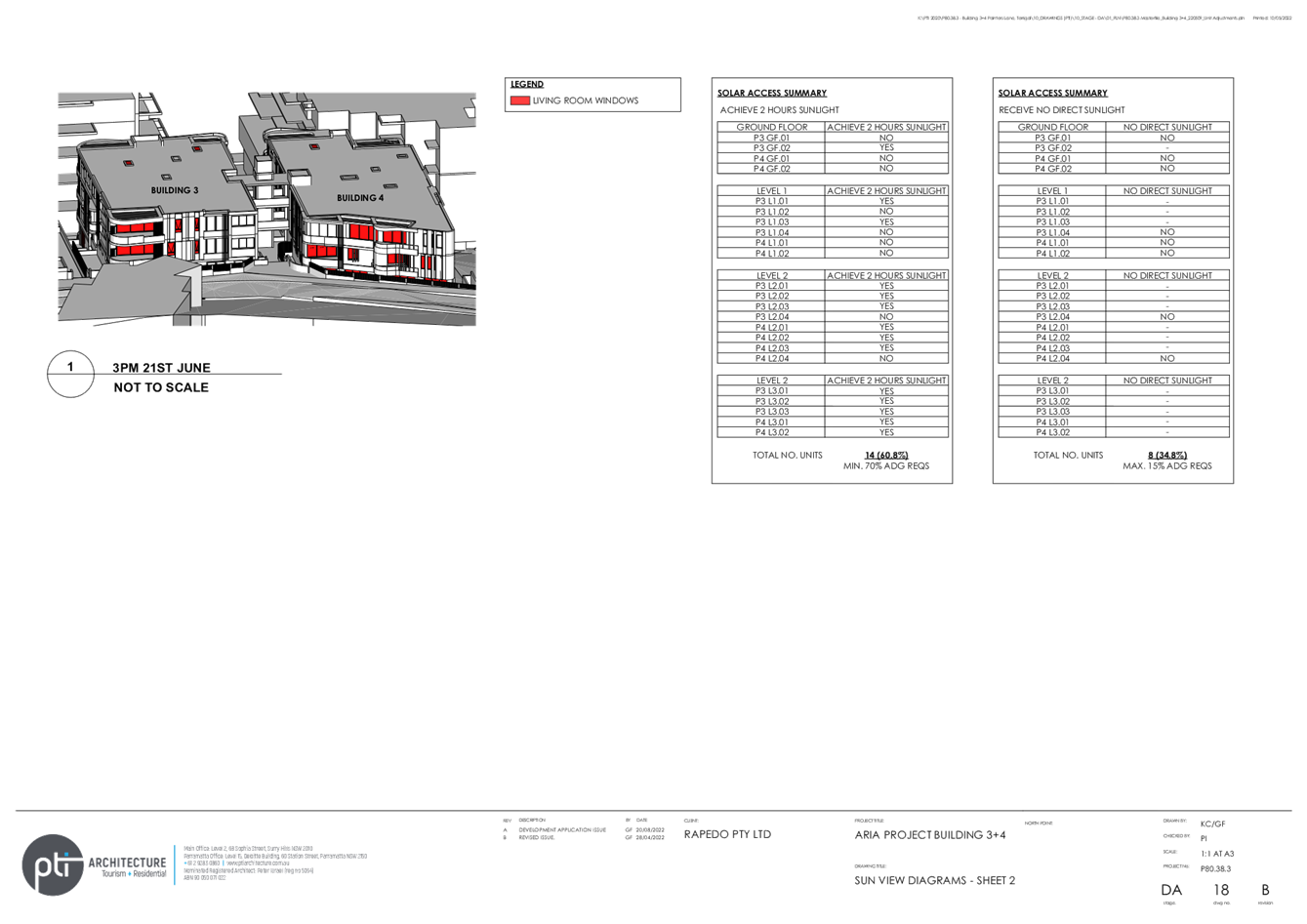
The proposed modification reduces the distance between Buildings 3 and 4 and with the addition of a lift significantly adds to the bulk and scale and reduces views through the site from opposite sites. The previous visual impact assessment submitted with the original application has not been updated to take into account the lift tower. An amended visual assessment was not requested due to the concerns raised at lodgement of the modification with the lift tower. As the lift tower design was not altered in the amended plans and as it was not supported from the beginning an additional visual impact assessment was not requested. The lift tower and walkways will result in blocking the open corridor but due to the location of the development there are limited views to water so it is not a specific view loss impact but rather the openness that the corridor provided.
Likely Impacts of the Development:
Acid Sulfate Soils
This land has been identified as being affected by the Acid Sulfate Soils Map (Class 5) and the matters contained in Clause 7.1 of GLEP 2014 have been considered.
Climate Change and Sea Level Rise
Climate change and sea level rise have been considered in the assessment of this application, and refusal of this application is not warranted on these grounds.
The Public Interest:
The application is considered contrary to the local and community interest, as detailed throughout this report.
Conclusion
This application has been assessed against the heads of consideration of Section 4.15 of the Environmental Planning and Assessment Act 1979 and all relevant instruments and policies. The increase in FSR, reduction in separation between Buildings 3 and 4, and addition of a lift between the buildings impacts the bulk and scale of the proposal. The proposed modification is not substantially the same development.
Accordingly, the application is recommended for refusal pursuant to Section 4.16 of the Environmental Planning and Assessment Act 1979.
Reasons for Refusal
1 The proposed modification is not substantially the same development for which consent was originally granted.
2 The proposed
modification results in additional unreasonable impacts as a result of
additional floor space and reduction in distance between buildings as required
under SEPP 65 and Apartment Design Guidelines.
3 The proposed modification has not suitably responded to the concerns raised in public submissions and is not in the public interest.
|
1⇩ |
PTI Plans_PAN-147069 |
|
D15158873 |
|
2⇩ |
220510_Comparison Set_PAN-147069 |
|
D15158874 |
|
3⇩ |
SEE__DA47946_2015_S4.55_2_Revised 020522_10_16 Painters Lane, Terrigal_PAN-147069 |
|
D15147518 |
|
4⇩ |
PUBLIC SEPP 65 Design verification Statement 16 Painters Lane TERRIGAL DA/47946/2015/2 |
|
D14855448 |
|
5⇩ |
GOV.177 DA47946/2015 Applicant: SJH Planning & Design Proposed Shop Top Housing (31 Units) & Office (Buildings 3 & 4) on Various Lots, No 10 - 16 Painters Lane & No 3 -9 Campbell Crescent Terrigal (IR 21781971) |
|
ECMD20434761 |
|
3.1 |
DA/47946/2015 -10-16 Painters Lane, Terrigal - Modification of Consent for Commercial Premises and Shop Top Housing |
|
Attachment 1 |
PTI Plans_PAN-147069 |
|
DA/47946/2015 -10-16 Painters Lane, Terrigal - Modification of Consent for Commercial Premises and Shop Top Housing |
|
|
Attachment 2 |
220510_Comparison Set_PAN-147069 |
|
DA/47946/2015 -10-16 Painters Lane, Terrigal - Modification of Consent for Commercial Premises and Shop Top Housing |
|
|
Attachment 3 |
SEE__DA47946_2015_S4.55_2_Revised 020522_10_16 Painters Lane, Terrigal_PAN-147069 |


|
DA/47946/2015 -10-16 Painters Lane, Terrigal - Modification of Consent for Commercial Premises and Shop Top Housing |
|
|
Attachment 4 |
PUBLIC SEPP 65 Design verification Statement 16 Painters Lane TERRIGAL DA/47946/2015/2 |
|
DA/47946/2015 -10-16 Painters Lane, Terrigal - Modification of Consent for Commercial Premises and Shop Top Housing |
|
|
Attachment 5 |
GOV.177 DA47946/2015 Applicant: SJH Planning & Design Proposed Shop Top Housing (31 Units) & Office (Buildings 3 & 4) on Various Lots, No 10 - 16 Painters Lane & No 3 -9 Campbell Crescent Terrigal (IR 21781971) |

|
Item No: 3.2 |
|
|
Title: DA/62839/2021 - 149 Somersby Falls Road, Somersby - DESIGNATED & NOMINATED INTEGRATED Expansion to Concrete Manufacturing Facility |
|
|
Department: Environment and Planning |
|
|
23 June 2022 Local Planning Panel Meeting |
|
Reference: DA/62839/2021 - D15148306
Author: Karen Hanratty, Principal Development Planner. Development Assessment South
Ailsa Prendergast, Section Manager. Development Assessment South
Manager: Andrew Roach, Unit Manager, Development Assessment
Executive: Alice Howe, Director Environment and Planning
|
Summary
An application has been received for DESIGNATED & NOMINATED INTEGRATED Expansion to Concrete Manufacturing Facility. The application has been examined having regard to the matters for consideration detailed in section 4.15 of the Environmental Planning and Assessment Act 1979 and other statutory requirements with the issues requiring attention and consideration being addressed in the report. The application is recommended for approval.
The application is referred to the Local Planning Panel for determination as a result of the number of submissions. Ten submissions by way of objection have been received.
Applicant Reinforced Concrete Pips Australia Pty Ltd Owner Somersby Land Investments Pty Ltd Application No DA/62839/2021 Description of Land Lot 4 DP 654894, 149 Somersby Falls Road, SOMERSBY Proposed Development DESIGNATED & NOMINATED INTEGRATED Expansion to Concrete Manufacturing Facility Site Area 159100 m2 Zoning IN1 General Industrial / part C2 Environmental Conservation Existing Use Concrete Pipe Manufacturing Employment Generation Yes Estimated Value $440,000 |
1 That the Local Planning Panel grant consent to DA/62839/2021 149 Somersby Falls Road, Somersby - DESIGNATED & NOMINATED INTEGRATED Expansion to Concrete Manufacturing Facility subject to the conditions detailed in the schedule attached to the report and having regard to the matters for consideration detailed in Section 4.15 of the Environmental Planning and Assessment Act 1979.
2 That Council advise those who made written submissions of the Panel’s decision.
3 That Council advise relevant external authorities of the Panel’s decision.
Key Issues
· Amenity impact on neighbouring properties for the expansion of the site and proposed 24 hour/7 days per week operation proposed
· Public submissions and matters contained therein.
Precis:
|
Proposed Development |
DESIGNATED & NOMINATED INTEGRATED Expansion to Concrete Manufacturing Facility.
|
|
Permissibility and Zoning |
The subject site is zoned IN1 General Industrial / part C2 Environmental Conservation under the provisions of Gosford Local Environmental Plan 2014. The proposed development is defined as general industry which is permissible in the zone with consent. |
|
Relevant Legislation |
The following planning policies and control documents are relevant to the development and were considered as part of the assessment. · Environment Planning and Assessment Act 1979 - Section 4.15 (EP&A Act) · Environment Planning and Assessment Regulation 2000 (EP&A Reg) · Protection of the Environment Operations Act 1997 (POEO Act) · Roads Act 1997 (Roads Act) · Rural Fires Act 1997 (RF Act) · Water Management Act 2000 (WM Act) · State Environmental Planning Policy (Biodiversity and Conservation) 2021 · State Environmental Planning Policy (Primary Production) 2021 · State Environmental Planning Policy (Resilience and Hazards) 2021 · State Environmental Planning Policy (Transport and Infrastructure) 2021 · Gosford Local Environmental Plan 2014 (GLEP 2014) · Draft Central Coast Local Environmental Plan 2018 (Draft CCLEP 2018) · Gosford Development Control Plan 2013 (GDCP 2013) |
|
Current Use |
Concrete Pipe Manufacturing
|
|
Designated Development |
Environmental & Planning Regulation 2000 Part 1 of Schedule 3 (14) Concrete Works |
|
Integrated Development |
Protection of the Environment Operations Act 1997 Schedule 1 (13) Concrete Works Water Management Act 2000 (WM Act) Section 91, Part 3 of Chapter 3 requiring a controlled activity approval |
|
Submissions |
Ten |
The Site
The site is located on the western side of Somersby Falls Road, just north of the intersection with Myoora Road.
The site has an area of 15.91 hectares and contains an approved level building pad occupying approximately 9.5 hectares. The site is zoned IN1 General Industrial with a vegetated buffer along the northern, western and southern boundaries zoned C2 Environmental Conservation.
The site generally slopes from the southeast to the northwest corner to an existing stormwater detention/water quality basin. The level building pad has been established by cutting into the southeast portion of the site by approximately 8m and filling up to approximately 9m to the northern side of the hardstand storage area.
Reinforced Concrete Pipes Australia (RCPA) operate from the site. The site is currently used for the manufacturing and storage of steel reinforced concrete pipes and associated concrete products. Steel reinforced concrete pipes are manufactured and stored on site prior to dispatch. The site also contains the concrete batching plant, offices, car parking, driveway, landscaping and associated site works (refer to Figures 1 and 2).
Vehicle access to the site is available directly from Somersby Falls Road via an existing entry/exit concrete driveway towards the southern portion of the site.
The site is identified as bushfire prone land.
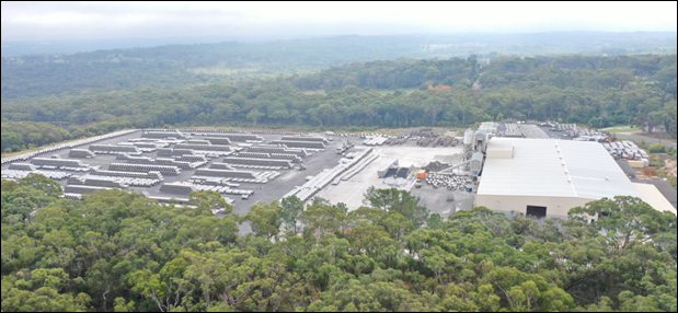
Figure 1 – Aerial View of Site
Source: EIS - Beveridge Williams - Drone Survey, dated 5 May 2021
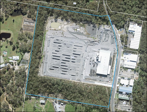
Figure 2 – Site Plan
Surrounding Development
To the west, south and north of the site is rural land with dwelling-houses and ancillary buildings. To the east of the site on the opposite side of Somersby Falls Road are a number of existing industrial buildings. Further to the west is Brisbane Water National Park (refer to Figure 3).
The site is located adjacent the north-western fringe of the Somersby Industrial Estate and identified with an Urban Release Area. The Kariong interchange and M1 Motorway is situated approximately 2.5km south-east of the site as shown in Figure 4.
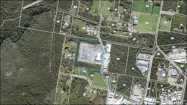
Figure 3 – Locality Plan

Figure 4 – Cadastre Plan, subject site is outlined in blue,
Somersby Industrial Estate is identified by green outline
Site History
GLEP 2014 (Amendment No 2) rezoned the land from RU1 to Part E2 Environmental Conservation and Part IN1 General Industrial on 9 May 2014.
DA/44996/2013 was granted consent on 9 May 2014 for a four lot subdivision of the land, subject to conditions. This consent has not physically commenced.
DA/55111/2018 was granted consent on 30 October 2018 for a temporary storage facility, subject to conditions. A construction certificate has not been issued.
DA/47599/2015 was granted consent on 26 June 2015 for the staged construction and use of a concrete pipe manufacturing facility with ancillary offices, amenities, car parking, driveways and associated site works. The then proposal consisted of a pipe manufacturing facility and associated concrete products to be constructed in stages consisting of:
· A 5000m² pipe manufacturing building consisting of 2400mm high precast concrete dado walls and Colorbond sheet metal walls and roof containing steel reinforcement cage making machines, pipe making machines, testing equipment, forklifts, front end loader, product moulds and pallets, ancillary equipment;
· 500m² awning on the northern elevation of the manufacturing facility;
· A concrete batching plant, raw material hoppers/silos and conveyors, aggregate storage bins, storage containers, concrete pipe repair benches. The four concrete silos will be approximately 16m in height;
· Offices and amenities;
· Additional 1200m² workshop;
· Stabilised gravel hard stand product storage areas;
· 10000 litre diesel fuel tank;
· 41 space car park including one disabled car parking space, two motorbike parking spaces and bicycle parking;
· Earthworks;
· Signage; and
· Associated site works including landscaping, driveways, fencing and concrete pavement
The original consent identified the following stages for the construction of the facility:
· Stage 1A – main manufacturing building (5000m²), concrete batching plant, 500m² awning adjacent to the northern elevation of the building, driveways, car parking, landscaping, signage, temporary offices, amenities and product storage;
· Stage 1B – office and amenities (415m²);
· Stage 1C – additional workshop (1200m²); and
· Stage 2 – additional external product storage.
Up to 20 staff were estimated to be employed initially. Increasing to 35 staff when the site is fully operational.
On 27 August 2015 a modified consent DA/47599/2015 (Part 2, now Part A) was issued to Amend Staging to Allow Preliminary Site Works that provided for:
· The addition of new ‘Stage 1 – Clearing of IN1 Zoned Land, Fencing, Demolition and Temporary Buildings’;
· The addition of new ‘Stage 2 – Stormwater Detention Basin’; and
· The re-numbering of the Stages 1a, 1b, 1c and 2 to Stages 3a, 3b, 3c and 4.
On 15 February 2016 a modified consent DA/47599/2015 (Part 3, now Part B) was issued that provided for:
· Relocation of the main building further to the north;
· Relocation of the car park to the south of the main building and include new driveways to provide separate access for trucks and cars;
· Connect all gravel hardstand areas on site into Stage 3a*;
· Delete Stage 4 ;and
· Connect the office building and amenities building and reduce the floor area of these buildings to 375m².
(*By way of clarification, all hard stand areas are presently in Stage 3a, but the number of areas will be reduced from three to one through consolidation of areas, yet will remain in Stage 3a.)
On 5 September 2016 a modified consent DA/47599/2015 (Part 4, now Part C) was issued that amended the development by making minor changes to ramp, fencing, car park, drainage, landscaping and pavement.
On 27 October 2017, an application was lodged to modify DA/47599/2015 (Part 5 now Part D), Condition 6.5 in approved Stage 3A, to Allow Deliveries to be Made to and from the Site from 5am to 5pm Weekdays and 7am to 4pm on Saturdays, Sundays and Public Holidays. On 22 March 2018 consent was refused for the following reasons:
i. Pursuant to Section 4.15 (1) (b) the subject proposal has failed to demonstrate that varying of conditions of consent relating to delivery hours will not detrimentally impact upon residential noise receivers in the vicinity.
ii. Pursuant to Section 4.15 (1) (e) the subject proposal has not adequately proven the amendment is in the public interest due to limitations within the submitted Noise reporting.
A Section 8.2(1(b)) review was subsequently lodged with Council for the refusal of the Section 4.55 (1A) amendment to DA/47599/2015 (Part 5) to modify Condition 6.5 to increase delivery hours. The time frame to determine the Section 8.2A Review lapsed and no determination could be made.
On 26 April 2019, a modified consent DA/47599/2015 (Part 6 now Part E) was issued that amended the development by amending Stage 3a Condition 6.5 to allow deliveries to and from the site from 5am to 5pm weekdays. Condition 6.5 currently allows deliveries from 8am to 4pm on Saturdays, Sundays and Public Holidays; these hours were not amended. Additional conditions were applied for noise mitigation measures as follows:
· Condition 6.11 – required an acoustic assessment to be undertaken one month from the date of operation at the hours of 5am to 5pm weekdays and identify area where further noise mitigation measures will be required and provide the report to Council.
· Condition 6.12 - During the hours of 5am to 7am weekdays, delivery and despatch trucks must load/unload from within the Concrete Hardstand Product Storage Area.
· Condition 6.13 - No more than two forklifts (total) are permitted to be operating at any one time between the hours of 5am to 7am weekdays.
· Condition 6.14 - No more than 3 (total) delivery and dispatch trucks are permitted to access the site per day during the hours of 5am to 7am weekdays.
· Condition 6.15 - Delivery and dispatch trucks contracted by Reinforced Concrete Piping Australia are not permitted to enter and exit the site via Howes Rd Somersby.
· Condition 6.16 - Power tools are not permitted to be used between the hours of 5am to 7am weekdays.
On 30 September 2020 a pre-development meeting was held on site to discuss future works. Prior to the meeting Council was contacted by the proponent’s consultant, Beveridge Williams, to discuss the scope of the future works as a modification to DA/47599/2015.
Following discussion with the consultant, Council advised that the scope of works would not be considered a modification to the DA as the likely increase in production would be greater than 30,000t/year for concrete works. The activities on the site would fall under the parameters for designated development and a new DA would be required.
Council staff met with RCPA management including their planning consultant and specialist consultants to discuss a proposed expansion of the site operations requiring site/environmental assessment for the following:
· Illumination Engineer to consider and certify lighting plans etc. for the night-time operation;
· Engineering design to consider retaining walls, planted batters, stormwater and water cycle management strategy, soil and water management, any required re-design of on-site detention basin, truck turning movements, internal circulation etc;
· Preparation of a Traffic Impact Assessment to address proposed truck entry and potential increase in truck movements to/from the site;
· Ecological assessment to consider potential impacts, if any, on existing vegetation within the C2 zoned portion of the site;
· Extensive acoustic assessment (to include both fixed acoustic measures and operational controls);
· Geotechnical Assessment (site and soil classification, foundation considerations with appropriate fill suitable for intended use, pavement design, progressive testing of controlled fill during construction etc.);
· Visual Impact Assessment (in relation to proposed acoustic barriers/walls) to consider potential impacts and appropriate mitigation measures;
· Air Quality and Odour Assessment to address potential sources of air and odour emissions from the expansion including potential cumulative impacts; and
· Updated Waste Management Plan in response to the proposed expansion.
On 12 November 2020, Council received notification from RCPA that they were extending operating hours in line with the current approved conditions stated below:
· Condition 6.6 - Except as restricted under Condition 6.5, the hours of operation shall be restricted to:
6am to 10pm Monday to Saturday; and
8am to 6pm Sundays and Public Holidays.
· The current approval allows production up to 10pm in the evening Monday to Saturday; previously operated until 6pm. Council was advised that RCPA intend to produce until approximately 8pm and finish any cleaning and end of shift activities by 10pm. In order to further limit potential impacts on adjoining properties an acoustic curtain is to be fitted to the weigh conveyor and trialling the use of adjustable broadband reversing alarms on the loader and forklifts which will only be operating in the vicinity of the factory.
Since the commencement of the revised delivery/dispatch hours Council has received complaints from the adjoining neighbour to the west raising concern from sleep disturbance from the early morning delivery trucks and forklifts. Council’s Compliance Team have continually liaised with RCPA management and the neighbour in relation to the matter.
Operational requirements of DA/47599/2015/E and the proposed development
DA/47599/2015/E is a staged DA. Stages 1 ,2 and 3a have been completed, Stage 3c has granted approval for an additional workshop (1,200m2 in size) is yet to be constructed. Additions to the approved workshop is included in the proposal description under this application DA/62839/2021.
The Applicant has not requested the proposal to be staged; however, has provided a schedule of works with the intention to construct the acoustic mound/walls, then extend hours of operation and phased increase in production capacity before constructing the new hardstand area followed by the erection of buildings. Stage 3c for the additional workshop of DA/47599/2015 is then likely to be completed with the building works under this application.
It is considered both DAs would operate concurrently for a time during the construction of the acoustic walls. Current restrictions for ongoing operations on the site will not change until the relevant acoustic walls are constructed to allow the proponent to commence 24 hour/7 days per week operations as required by EPA conditions.
To ensure all stakeholders are aware of the operational conditions on the site, prior to the commencement of operations 24-hours/7days per week Council is to be notified two days prior to the intended commencement wherein the restrictions imposed by development consent DA/47599/2015 (Part 6 now Part E) Stage 3a, Section 6 (Ongoing), no longer apply to the operation of the site, refer conditions 1.4 and 1.5 respectively.
The Proposed Development
The proposal comprises the following:
i. Import, place and compact fill (approximately 56,000m3) to a maximum height of 8.4m in the central northern portion of the site (surface area including batters equal to 13,828m2) to provide additional hard stand storage area (between existing hard stand storage area and detention/water quality basin). This area is already disturbed and clear of vegetation.
Pavement to match that of existing hardstand storage area, being cement stabilised road base.
ii. Construction of fixed acoustic walls as recommended by the Applicant’s Acoustic Engineer along the top northern edge of the proposed batter (filled area) and along the top western edge of the existing hardstand area with adequate return along the south-west corner. Internal noise walls are also proposed to the north and west of the existing batching plant.
Acoustic wall heights vary from approximately 1.7m to 8.5m;
iii. Formalise second vehicle entry point, approx. 10m wide, at northern end of the property frontage to facilitate truck entry ONLY from Somersby Falls Road and improve efficiency of vehicle movements within the site. Existing access at southern end of the property frontage is to be retained and will continue to be used as a combined entry/exit point for standard vehicles and exit only for trucks.
During filling of the proposed hardstand storage area in the northern portion of the site, the second vehicle access will be particularly important to avoid congestion within the yard from multiple truck movements that will be required to import fill while carrying on normal business activities.
A plan showing Articulated Vehicle Swept Paths is Drawing Number EB14 of the Concept Engineering Design Plans. The plan has been prepared having regard for the largest heavy vehicle expected to enter and exit the site and demonstrates compliant vehicle manoeuvring within and around designated circulation paths.
iv. Additional covered storage (awning) to eastern side of existing production building and via proposed container dome shelter to the north of the existing batching plant. The approved but not yet constructed workshop to the south-western side of the existing production building is to be extended to increase floor area. Refer below details:
· proposed awning dimensions (eastern side of production building) - 31.5m x 5m (157.5m2)
· proposed container dome shelter (north of existing batching plant) 27.3m x 24m (655m2) with an overall height of 6.9 metres
· extension to approved workshop (south-western side of production building) 25m x 18m (450m2) giving a total floor area once constructed of 1250m2
v. Increase production capacity from the approved 22,000t/year to above the designated development production threshold of 30,000t/year to respond to changing market requirements.
The existing batching plant is to remain unchanged. Existing equipment and machinery are adequate to service the production capacity increase. RCPA proposes a phased increase in production capacity over several years up to a maximum of 100,000t/year. However, during busier times and in response to market demand, this throughput may be slightly exceeded periodically. Minor fluctuations are considered acceptable and a realistic response to an ever evolving and changing market. A reasonable degree of fluidity and common-sense approach should be applied in this regard.
While an increase in production capacity and hours of operation is proposed, the concrete batching process and ancillary operational characteristics will generally remain as per the original approval.
vi. Extend approved operation hours to 24 hours, 7 days per week;
The aim of 24-hour operation is to increase production capacity to help meet market demand. Twenty-four-hour operation provides additional flexibility to extend production time to increase output as needed. While the majority of truck movements will continue to be within normal working hours, lifting restrictions on times that trucks can access the site allows for top up of raw material and pre-loading of dispatch trucks if needed. Truck sizes for dispatch are generally semi- trailers or rigid trucks with load capacities in the range of 8‑30t. Trucks for raw material deliveries are generally truck and trailers, rigid trucks or semitrailers with similar load capacities.
Night-time operations would primarily occur within the main production building. Truck movements and work activities within the existing hardstand storage area directly west of the batching plant would be necessary but carried out in accordance with the recommendations, mitigation and management measures advised by the Acoustic Engineer.
The proposed hardstand storage area is not be used during night-time operations. These activities shall be limited to occur within the eastern half (close to batching plant) of the existing hardstand storage area.
Cement truck loading into cement silos will not occur during night-time operations (10pm – 7am). Sand and gravel cement truck deliveries will also not take place during night-time operations (10pm to 7am).
Refer to Acoustic Assessment for further mitigation and management measures (fixed and operational).
RCPA currently employ a total of 35 full and part-time employees at the Somersby facility. This figure would increase to approximately 55 employees as a result of the proposed development. The number of employees on site at any one time during a day shift would be approximately 35 and a night shift approximately 20.
vii. Proposed development works will include modifications to the existing stormwater system and stormwater detention/water quality basin.
Items v and vi above would generate a need for an additional 18 – 20 full-time and part-time staff offering shift work opportunities. The increased production capacity would, in turn, have a multiplier effect on employment opportunities external to the business operation such as transport contractors, local material suppliers and maintenance contractors.
While no formal staging of the works is proposed, the following is the preferred structure and logical approach to facilitate an immediate incremental increase in production capacity, extended hours of operation and establishment of noise mitigation measures respective to the gradual stages of works:
1. Erection of internal acoustic noise walls to the north and west of the existing batching plant and along the top, western edge of the existing hardstand area with adequate return along the south-west corner. Works include associated stormwater treatment works as recommended (ie: provision of a turfed swale along the western edge of the existing gravel hardstand area)
2. Extend hours of operation
3. Phased increase in production capacity
4. Bulk earthworks, new heavy vehicle entry access, erection of acoustic noise wall along top northern edge of the proposed batter (filled area) and modifications to stormwater system and stormwater detention/water quality basin
5. Erection of new storage structures (awning and dome shelter)
6. Addition to approved workshop.
The proposed development is to be wholly located within the IN1 zoned portion of the site, being an already cleared and disturbed area. Removal of trees and vegetation is not required.
The proposed works are shown in the overall site plan in Figure 5, inclusive of new hardstand area, detention basin, buildings and acoustic walls and Figures 6, 7 & 8 identify the building additions floor plan, west and east elevations.
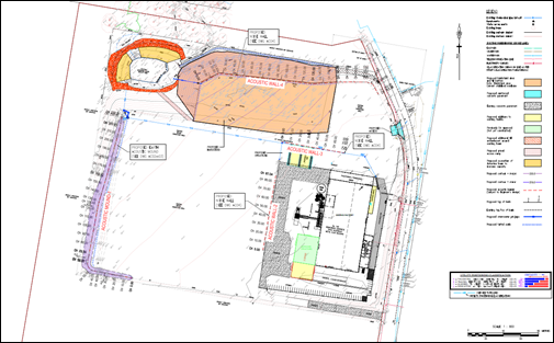
Figure 5 – Overall site plan of works
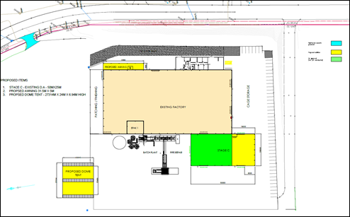
Figure 6 – Building additions - floor plan
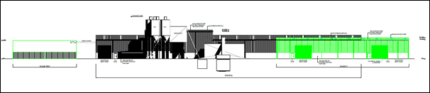
Figure 7 – Building additions shown green - west elevation
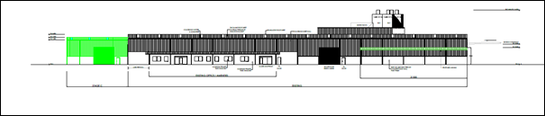
Figure 8 – Building additions shown green – east elevation
ASSESSMENT:
Having regard for the matters for consideration detailed in Section 4.15 of the Environmental Planning and Assessment Act 1979 and other statutory requirements, Council’s policies and Section 10.7 Certificate details, the assessment has identified the following key issues.
Environmental Planning and Assessment Act 1979 (EP&A Act) - Integrated Development
The proposed development is considered Integrated Development in accordance with Section 4.46(1) the Environmental Planning and Assessment Act 1979 and requires that the consent authority must, in accordance with the Environmental Planning and Assessment Regulation 2000, obtain from each relevant approval body the general terms of any approval proposed to be granted by the approval body in relation to the development.
The application was referred to and General Terms of Approval provided by the relevant authorities as follows:
· Natural Resources Access Regulator (NRAR) has issued General Terms of Approval (IDAS-2021-10174 dated 6 October 2021) for part of the proposed development requiring a controlled activity approval under section 91, Part 3 of Chapter 3 of the Water Management Act 2000.
· NSW Environment Protection Authority (EPA) has issued General Terms of Approval (DOC21/805193 dated 18 October 2021) under Section 48, Part 3.2 of Chapter 3 of the Protection of the Environment Operations Act 1997, requiring an Environment Protection Licence for scheduled activities where Schedule 1 of the Protection of the Environment Operations Act 1997 indicates that a licence is required for premises at which the activity is carried on.
Environmental Planning and Assessment Regulation 2000 (EP&A Regulation) - Designated Development
The application is Designated Development in accordance with the provisions of Part 1 of Schedule 3 of the Environmental Planning and Assessment Regulation 2000, which sets out the criteria for the proposed development for concrete works as follows:
14 Concrete works
(1) Concrete works that produce pre-mixed concrete or concrete products and—
(a) that have an intended production capacity of more than 150 tonnes per day or 30,000 tonnes per year of concrete or concrete products, or
(b) that are located—
(i) within 100 metres of a natural waterbody or wetland, or
(ii) within 250 metres of a residential zone or dwelling not associated with the development.
(2) This clause does not apply to concrete works located on or adjacent to a construction site exclusively providing material to the development carried out on that site—
(a) for a period of less than 12 months, or
(b) for which the environmental impacts were previously assessed in an environmental impact statement prepared for that development.
The activities on the site will increase in production volumes above the 30,000t/year threshold. The site is within 100m to the north of the site of a natural waterbody and within 250m of a dwelling not associated with the development. Accordingly, the proposal is classified as Designated Development.
The Applicant sought and received the Secretary's Environmental Assessment Requirements (SEARS) from the [then] Department of Planning, Industry and Environment (DPIE) for the preparation of an Environmental Impact Statement (EIS), which was prepared by Beveridge Williams.
Protection of the Environment Operations Act 1997
The underlying objective of the Protection of the Environment Operations Act 1997 is to reduce pollution and manage the storage, treatment and disposal of waste.
The increase in operating capacity evokes Schedule 1 of the Protection of the Environment Operations Act 1997, which requires the facility to operate within an Environmental Protection Licence issued and regulated by the EPA.
The application was referred to the EPA, who identified several environmental issues that will require conditions put on an Environment Protection Licence as follows:
· Impacts on air quality
· Potential noise impacts
· Surface water controls
· Bunding and chemical storage.
The EPA issued its General Terms of Approval for the proposal dated 14 February 2022 and recommended conditions which are incorporated into conditions of consent as Schedule A.
The EPA is the approved regulatory authority for works, as well as the ongoing operation and management of this site, and as such no additional environmental health conditions will be applied for the operational period of this development.
Rural Fires Act 1997
The site is identified as bushfire prone land on Council's bushfire maps. In accordance with Section 4.14 of the Environmental Planning and Assessment Act 1979, development on bushfire prone land is required to comply with the provisions of the Rural Fires Act 1997 and Planning for Bushfire Protection 2019 (PBP 2019) published by the NSW Rural Fire Service (RFS).
The consent authority must be satisfied the development conforms to PBP 2019 otherwise it must consult with the RFS. The proposed development is considered ‘other development’ addressed by Clause 8.3.10 of PBP 2019 and shall demonstrate the proposal meets the aims and objectives of PBP 2019. It is considered referral to the RFS is not required in this instance as Council is satisfied the Applicant has demonstrated the proposal meets the aims and objectives and the level of risk has been adequately considered for the scale of the development and number of people likely to be occupying the building.
The Applicant states that consultation was undertaken in relation to the proposal with the relevant authorities in the preparation of the EIS in accordance with the SEARS.
The Applicant has demonstrated the proposal meets the aims and objectives of PBP 2019 in the EIS (Section 5.11.1 Bushfire) and provides the following in relation to access, water supply, services and emergency and evacuation planning as follows:
a. To provide safe access to/from the public road system for firefighters providing property protection during a bushfire and for occupant egress for evacuation.
· The Site has direct frontage to Somersby Falls Road which is adequately serviced and maintained, with consistent surfacing and well-preserved road shoulder for much of its length. The speed limit on Somersby Falls Road is consistent with other local roads within the area at 60km/h.
· Access to the site is available directly from Somersby Falls Road via an existing concrete driveway approx. 10 metres wide and a proposed second concrete driveway approx. 11 metres.
· Existing and proposed hard stand surfaces are flat and would provide a suitable pavement for firefighters protecting the property during a bushfire event.
· The proposed vehicle access arrangements and adjoining sealed public road networks are considered satisfactory to provide adequate and safe evacuation in the event of a fire emergency.
b. To provide suitable emergency and evacuation (and relocation) arrangements for occupants of the development.
· It is recommended that suitable emergency and evacuation planning procedures be established generally in the form of an emergency and evacuation plan/map to be erected in a location that can be viewed by staff and visitors of the facility.
c. To provide adequate services of water for the protection of buildings during and after the passage of bush fire and to locate gas and electricity so as not to contribute to the risk of fire to a building.
· Council’s reticulated water main supply is available to the site from Somersby Falls Road. Several rainwater tanks are also available on site. The site is provided with all essential infrastructures.
d. Provide for the storage of hazardous materials away from the hazard wherever possible.
· Storage of any hazardous goods or materials shall be located well away from the adjoining bushfire hazard and within the existing production building, where possible.
The assessment of the application has considered the following:
· The development has been operating for a number of years on the site and currently employs a total of 35 full and part time employees which is likely to increase to approximately 55 employees: day shift 35 employees and night shift 20 employees as a result of the extended hours of operation.
· Based on the scale and nature of development proposed, involving the establishment of an additional hard stand area within an already cleared and disturbed area of the site and the erection of storage structures over existing hard stand areas, additional bushfire planning measures are not considered relevant or required and further consultation with RFS is not considered necessary subject to conditions for water/utilities, landscaping and preparation of an Emergency and Evacuation Plan.
· It is noted that the application was referred to the RFS upon lodgement of the application, who requested additional information by way of a bushfire report prepared by a bushfire consultant. Discussion was held with RFS on this matter stating a report is not required in this instance, a report was not requested of the Applicant and the RFS closed the referral on this basis stating the proposal was not supported.
· Referral to RFS is not required in accordance with s4.14(1) (a) of the Environmental Planning and Assessment Act 1979. Council is satisfied the proposal meets the aims and objectives of PBP 2019.
Water Management Act 2000
To the north of the site beyond Anulka Road (not formed) on adjoining land is an unnamed tributary to Floods Creek, which is located further west and north-west within Brisbane Water National Park. In accordance with the Strahler Stream Order guidelines, field-based investigation and the tributary being within 40m of the proposed works, it will be necessary to obtain a Controlled Activity Approval in accordance with section 91 of the Water Management Act 2000. The proposal is Integrated Development in accordance with Section 4.46 of the EP&A Act under Section 91 of the Water Management Act 2000.
Draft Environmental Planning Instruments
The following draft Environmental Planning Instruments apply to this application:
Draft Central Coast Local Environment Plan 2018
The draft Central Coast Local Environment Plan 2018 (Draft CCLEP 2018) is a matter for consideration under section 4.15(1)(a)(ii) of the Environmental Planning and Assessment Act 1979. Draft CCLEP 2018 was exhibited from 6 December 2018 to 28 February 2019 and adopted by Council on 14 December 2020.
Draft CCLEP 2018 is pending finalisation by Parliamentary Counsel for the Minister and is expected to be made, as CCLEP 2022, by the end of June 2022. The commencement date will be announced on the making of the plan.
The application has been assessed under the provisions of Draft CCLEP 2018 with respect to zoning, development standards and special provisions. The proposed development is consistent with Draft CCLEP 2018.
Under Draft CCLEP 2018 the site will retain the split zoning: IN1 General Industrial and C2 Environmental Conservation. The proposed development is a permitted use in the IN1 zone with consent. The proposal is consistent with Draft CCLEP 2018.
State Environmental Planning Policies (SEPP)
A number of State Environmental Planning Polices (SEPPs) have been consolidated to align with the new planning framework developed by the Department of Planning and Environment (DPE).
It is noted no policy changes have been made as a result of this consolidation and it does not change the legal effect of the existing SEPPs, with Section 30A of the Interpretation Act 1987 applying to the transferred provisions.
State Environmental Planning Policy (Resilience and Hazards) 2021
State Environmental Planning Policy (Resilience and Hazards) 2021 commenced on 1 March 2022 incorporating and repealing the provisions of State Environmental Planning Policy 55 – Remediation of Land.
The relevant provisions of the SEPP are addressed as follows:
Chapter 4 Remediation of Land
Clause 4.6 requires that a consent authority must not consent to the carrying out of any development on land unless it has considered whether the land is contaminated and suitable for the proposed use.
The existing operation and proposed development are wholly within the IN1 zoned portion of the site, which is suited to the intended development purpose, being for industrial activities.
Previous and current land uses are not expected to be potentially contaminating. The Preliminary Contamination Investigation prepared by Douglas Partners confirms this and proposes that fill material to be imported to site will be virgin excavated natural material (VENM) or excavated natural material (ENM).
State Environmental Planning Policy (Biodiversity and Conservation) 2021
State Environmental Planning Policy (Biodiversity and Conservation) 2021 commenced on 1 March 2022 incorporating and repealing the provisions of Sydney Regional Environmental Plan No 20—Hawkesbury-Nepean River (No 2—1997).
The relevant provisions of the SEPP are addressed as follows:
Chapter 9 Hawkesbury-Nepean River
The aim of this Chapter is to protect the environment of the Hawkesbury-Nepean River system by ensuring that the impacts of future land uses are considered in a regional context.
Part 9.2 stipulates the general planning considerations, specific planning policies and recommended strategies to achieve the aim of the chapter. The specific planning policies and recommended strategies that apply to the proposal are water quality and water quantity.
A Water Cycle Management and Soil and Water Management Report prepared by Beveridge Williams (Project No 2000438 dated 02/02/2022) was submitted with the application. Supporting preliminary engineering plans prepared by Beveridge Williams (Project Ref 2000438, Drawings EB01-EB14, all Rev C dated 01/02/2022) were also submitted in relation to proposed drainage and associated civil works.
It is proposed to import 56,000m3 of VENM/ENM with a surface area of 13,828m2. Soil disturbance will affect an area of approximately 18,000m2. The revised Soil and Water Management Plans produced by Beveridge Williams are generally satisfactory.
All surface water flows are to be directed into an existing detention pond which overflows into an unnamed creek located north of the site, which is a tributary of Floods Creek within Brisbane Water Natural Park. Spel Ecoceptors are proposed within two stormwater pits on site with all surface waters flowing into a stormwater retention dam on site.
A water quality monitoring program is proposed to be undertaken at the discharge point of the site, as well as the unnamed creek (upstream and downstream of the discharge point) prior to, during and post construction. Appropriate water quality parameters have been set and monitoring frequencies, as well as corrective actions for non-compliance.
The reports and plans have been reviewed. The recommended treatment controls and mitigation measures are considered satisfactory in relation to stormwater quantity and quality proposed to be treated and mostly managed on site to minimise potential impacts on the water table and downstream environment as a result of the existing and proposed development.
State Environmental Planning Policy (Primary Production) 2021
State Environmental Planning Policy (Primary Production) 2021 commenced on 1 March 2022 incorporating and repealing the provisions of Sydney Regional Environmental Plan No 8 (Central Coast Plateau Areas).
The relevant provisions of the SEPP are addressed as follows:
Chapter 3 Central Coast plateau areas
The Chapter aims to predominantly provide for the environmental protection of the Central Coast plateau areas and to provide a basis for evaluating competing land uses whilst encouraging the use of land having a high agricultural capability and enable development for the purposes of extractive industries in specific locations.
Although the site is located on the Central Coast plateau, it is not identified as prime agricultural land. The rezoning of the site in 2014 to IN1 General Industrial has excluded the land for rural/agricultural purposes.
Notwithstanding this, consideration has been given to the environmental impacts of the proposed additions to the approved development on the natural ecosystems of the region and the adjoining properties as stated elsewhere in this report. The proposed development does not involve an extractive industry and does not require clearing of land. Council is satisfied that the carrying out of the development would not adversely affect the present or future use of other prime agricultural land for the purposes of agriculture.
State Environmental Planning Policy ((Transport and Infrastructure) 2021
State Environmental Planning Policy (Transport and Infrastructure) 2021 commenced on 1 March 2022 incorporating and repealing the provisions of State Environmental Planning Policy (Infrastructure) 2007.
The SEPP deals with traffic generating development and requires referral to and concurrence from Transport for NSW (TfNSW) for certain development that is expected to generate significant traffic in accordance with Clause 2.121 and Schedule 3 ‘traffic generating development’ which must be referred to TfNSW for consideration.
The schedule includes development for the purposes of industry incorporating 20,000m2 or more of gross floor area (GFA) for a site with access to a road (generally) or 5,000m2 or more of GFA for a site with access to classified road or to road that connects to classified road (if access within 90m of connection, measured along alignment of connecting road).
The Applicant states that the site has an area of 15.96 hectares. The GFA of the existing pipe manufacturing building is approximately, 5,000m2. The increase in GFA relates to storage structures only and equates to a total of approximately 1,260m2. Based on these areas, the proposed development is not captured under Schedule 3 of the SEPP and referral to TfNSW was not necessary.
However, for the avoidance of doubt the proposal was referred to TfNSW for comment in accordance with the relevant planning provisions in force under Clause 104 / Schedule 3 of the State Environmental Planning Policy (Infrastructure) 2007, with respect to traffic generating developments (applicable policy at the time of lodgement). TfNSW advised in comments dated 13 October 2021 that the proposal is not of a size or scale that requires referral to TfNSW under Clause 104. Council is the Roads Authority in this instance.
A Traffic and Parking Impact Assessment prepared by Intersect Traffic Pty Ltd and dated 23 July 2021 was submitted with the application. The impacts of the proposal in relation to traffic generation has been reviewed by relevant Council officers and deemed satisfactory (refer to discussion under GDCP 2013 Chapter 7.1 Car Parking).
Gosford Local Environmental Plan 2014 (GLEP 2014) - Zoning and Permissibility
The subject site is partly zoned IN1 General Industrial and C2 Environmental Conservation under the GLEP 2014.
The proposal is located wholly within the IN1 General Industrial zone and is a permissible form of development within that zone. The part of the site zoned C2 is heavily vegetated as shown in the zoning map (refer to Figure 9), and acts as a buffer between the operation of the subject site and the neighbouring properties.
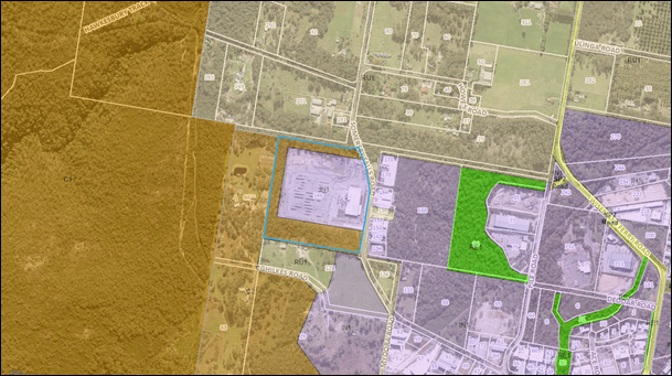
Figure 9 – Zoning Map GLEP 2014
Development for the purposes of a general industry is permissible within the IN1 zone with consent.
general industry means a building or place (other than a heavy industry or light industry) that is used to carry out an industrial activity.
industrial activity means the manufacturing, production, assembling, altering, formulating, repairing, renovating, ornamenting, finishing, cleaning, washing, dismantling, transforming, processing, recycling, adapting or servicing of, or the research and development of, any goods, substances, food, products or articles for commercial purposes, and includes any storage or transportation associated with any such activity.
The objectives of the IN1 General Industrial zone are:
· To provide a wide range of industrial and warehouse land uses.
· To encourage employment opportunities.
· To minimise any adverse effect of industry on other land uses.
· To support and protect industrial land for industrial uses.
· To promote ecologically, socially and economically sustainable development.
· To ensure that retail, commercial or service land uses in industrial areas are of an ancillary nature.
· To ensure that development is compatible with the desired future character of the zone.
The objectives of the C2 Environmental Conservation zone are:
· To protect, manage and restore areas of high ecological, scientific, cultural or aesthetic values.
· To prevent development that could destroy, damage or otherwise have an adverse effect on those values.
· To promote ecologically, socially and economically sustainable development and the need for, and value of, biodiversity in Gosford.
· To ensure that development is compatible with the desired future character of the zone.
· To limit development in areas subject to steep slopes and flooding.
The Applicant states the proposed development to utilise the remaining IN1 zoned portion of the site to increase in production capacity and hours of operation is in direct response to market demand and to prevent the sourcing and purchasing of concrete products from interstate.
The assessment has considered the cumulative impacts of the site expansion. The proposal addresses environmental impacts and represents an acceptable design. The proposed acoustic walls are required to mitigate offsite noise impacts although will have some visual impact to the north and east of the site which can be reduced by materials used and additional landscaping to blend into the landscape.
The proposal will provide appropriate measures to address the zone interface and potential amenity impacts with the adjoining sites and their residences zoned RU1 Primary Production to the north, C2 Environmental Conservation to the west and south. No development is permitted or proposed on the part of the site zoned C2 Environmental Conservation. The proposal is not considered to have adverse impact on the amenity of the surrounding area and is compatible with the desired future character of the land zoning.
The proposal is also consistent with the principles of ecologically sustainable development as specified within the Local Government Act 1993.
Gosford Local Environmental Plan 2014 - 4.3 Height of building
There is no height of building development standard in the IN1 General Industrial zone relevant to this application.
The height of building development standard is applicable to land zoned C2 Environmental Conservation. In accordance with the Height of Building map in GLEP 2014 the maximum building height is 8.5m in the C2 zone. No development is proposed within part of the site zoned C2 Environmental Conservation.
Gosford Local Environmental Plan 2014 - 4.4 Floor Space Ratio
There is no floor space ratio development standard in the IN1 General Industrial zone relevant to this application.
Gosford Local Environmental Plan 2014 – 7.1 Acid sulfate soils
This land has been identified as being affected by the Acid Sulfate Soils Map and the matters contained in Clause 7.1 of Gosford Local Environmental Plan 2014 have been considered. The site is mapped as containing Class 5 acid sulfate soils (ASS).
Clause 7.1(2) defines Class 5 Acid Sulfate Soils as follows:
“Works within 500 metres of adjacent Class 1, 2, 3 or 4 land that is below 5 metres AHD and by which the watertable is likely to be lowered below 1 metre AHD on adjacent Class 1, 2, 3 or 4 land”
The proposed works are not within 500m of any adjacent Class 1, 2, 3 or 4 land. While site disturbance is proposed, namely fill, it is unlikely the proposed development would disturb, expose or drain acid sulfate soils or cause environmental damage. The works do not require any excavation below 5m AHD and the water table is not likely to be lowered below 1m AHD.
In this instance, the proposal works are not considered to impact on acid sulfate soils and a preliminary assessment is not required. Notwithstanding this, a condition is recommended that ensure any unexpected finds of acid sulfate soils will be appropriately managed.
Gosford Development Control Plan 2013 (GDCP 2013)
Gosford Development Control Plan 2013 (GCDP 2013) provides objectives, design criteria and design guidance on how development proposals can achieve good design and planning practice.
Gosford Development Control Plan 2013 - Chapter 2.1 Character
The site is located within the character area: Somersby 3: Agricultural Plateau & Hillsides of Gosford GDCP 2013 Chapter 2.1 Character. The desired character of this area is set out below:
These areas should remain productive rural landscapes that accommodate broad-hectare agricultural or livestock activities, together with a scattering of residential and small-scale tourist activities that do not interfere with the preferred primary-productive uses. Future development and land management, including major developments such as extractive industries, should not compromise scenically-distinctive qualities of backdrops to Gosford City’s major tourist routes.
Conserve scenic qualities and habitat values by retaining natural slopes and visible rock outcrops, as well as by preventing further fragmentation of the existing bushland canopy. Conserve existing bushland remnants that provide scenically-prominent backdrops to any road or nearby property, particularly trees that are located along road verges and frontages, as well as along the side and rear boundaries to each property. Screen any large existing structures as well as restoring the desired pattern of “green” boundaries by planting new trees that are predominantly-indigenous. Noxious or environmental weeds must not be planted, and existing infestations should be controlled. Concentrate new buildings and works within existing clearings, away from prominent ridgelines, watercourses or any areas that are prone to flooding. Use low-impact framed construction with suspended floors rather than masonry structures that require extensive cut-and-fill, particularly on visually-prominent slopes or next to bushland.
Achieve bushfire asset protection zones preferably by thinning the canopy to establish breaks between existing trees. Locate new dwellings and accommodation buildings to avoid extensive additional clearing, and use fire-resistant design and construction techniques for all new structures as well as effective land management. Screen all verandahs, windows and suspended floors to exclude bushfire embers and sparks.
Complement the existing informal landscape quality of buildings scattered across paddocks or slopes that are surrounded by trees. Locate all new buildings and works (other than roadside stalls) well back from road frontages, and vary both siting and form of adjacent structures in order to avoid the appearance of continuous walls of development or visually-dense clusters of buildings. Promote the natural or informal scenic qualities of existing road verges and frontages by avoiding opaque fences, urban-style entrance walls, extensive landfilling or terracing, and large commercial signs. Conceal wastewater treatment systems, and ensure that any discharges would not compromise the composition or scenic quality of bushland, encourage weed growth, or affect water quality within any watercourse.
Ensure that new buildings would not visually-dominate any property within these scenically-prominent settings. Minimise scale and bulk by using strongly-articulated forms, such as stepped floor-levels that follow natural slopes, and irregular floorplans, such as linked pavilions that are capped by individual roofs and separated by landscaped courtyards. Roofs should be simple forms without elaborate articulation, with wide eaves plus gentle pitches. Use extensive windows and shady verandahs, as well as a variety of exterior finishes and cladding rather than expanses of plain masonry or metal sheeting. Ensure that outbuildings are compatible with scale and design quality of the principal structures upon any property by using similar roof pitches and eaves, plus appropriate exterior materials and finishes.
The site is located to the east of land located in the Somersby Industrial Area, which is identified as being within the character area of Somersby 2: Employment Estate and west of land identified as being within the character area of Somersby 5: Scenic Conservation.
GLEP 2014 (Amendment No 2) rezoned the land from RU1 to Part E2 Environmental Conservation and Part IN1 General Industrial on 9 May 2014, after the commencement of GLEP 2014 and GDCP 2013. The land may have once been used for agricultural purposes; however, is approved for and developed for the purposes of industry and the manufacturing of concrete pipes.
Notwithstanding this, the proposal seeks to further develop a presently disturbed and unused area of the site to expand the existing operation within the portion of the site zoned for this purpose. The vegetation surrounding the development on the C2 zoned portion of the site will remain, will not be disturbed and will continue to provide a visual buffer to the site operations.
The buildings proposed have been designed to integrate with the existing buildings and are not considered to have any adverse visual or amenity impact to that currently erected on the site or alter the existing or desired character of the area. The overall height of proposed acoustic walls along the edge of hardstand storage areas is appropriate to mitigate noise impacts and will not be visually intrusive subject to additional landscaping and materials and external finishes used to blend and integrate with the built and natural environment.
Further details are provided in the visual impact assessment under Other Matters for Consideration in the report. The proposal will not have a significant impact on the character of the area.
Gosford Development Control Plan 2013 - Chapter 2.2 Scenic Quality
The proposal is located within the Kulnura to Somersby Plateau landscape unit, which is of local significance although areas viewed from the Freeway and escarpment areas are of more than local significance.
The principle aim of the Scenic Quality Development Control Plan is to provide guidelines for the interpretation and management of the scenic quality of the area in accordance with the development objectives of the landscape unit.
As stated under Chapter 2.1 Character the structures proposed have been designed to integrated with existing buildings. No change is proposed to building setbacks, the existing vegetation buffer approximately 40m wide and greater will remain and not be disturbed.
Additional plantings shall be established along the site frontage adjoining Somersby Falls Road. Batters associated with proposed fill for the new hardstand storage area shall also be appropriately planted. Landscape plantings will be established to external facing sides of acoustic walls to be located along the northern and western edges of existing and proposed hardstand storage areas in accordance with the recommendations of the visual impact assessment.
The proposal is consistent with the development objectives and will not have adverse impact on the landscape character and scenic quality of the area.
Gosford Development Control Plan 2013 - Chapter 3.11 Industrial Development
The relevant provisions of Chapter 3.11 Industrial Development have been considered in the assessment of application as summarised in the table below.
|
Proposed |
Compliance with control |
Compliance with objective |
|
|
3.11.5.2.a Setbacks and boundaries – site frontage – 10m |
· Awning – east elevation 23m · Dome shelter - >25m · Addition to approved (not yet constructed) workshop = >80m |
Yes |
Yes |
|
Development Controls |
Proposed |
Compliance with control |
Compliance with objective |
|
3.11.5.2.c Side and rear setbacks for lots > 4000m2 in area – 5m |
Side and rear >5m |
Yes |
Yes |
|
3.11.5.2.e Setbacks to creek - 6m from top of the bank |
Complies |
Yes |
Yes |
|
3.11.5.3 Building Height A maximum requirement is not prescribed |
The proposed building additions are less in height than existing structures on site and will not impact on the privacy and amenity of adjoining properties. |
Yes |
Yes |
|
3.11.5.4 Building Appearance As per relevant design principles |
· The appearance of the existing buildings on site generally remains unchanged. · The small awning addition and increase in floor area to the approved (but not yet constructed workshop will integrate with existing structures. · External materials and colours shall be selected to match existing. · The proposed dome (igloo style) shelter is for the storage of pallets etc and is a lightweight structure to be located within the central portion of the site close to the existing batching plant and main production building. The dome structure is approximately 6.9m high and less than the height of the existing main production building and silo structures. |
Yes |
Yes |
|
3.11.6.2 Ancillary Uses – Outdoor storage Areas Not to encroach on carparking areas, driveways or landscaped areas. Screen from view from any road or public area. |
· The proposed hardstand storage area will not encroach on carparking areas, existing driveway and internal circulation paths or landscaped areas. · Proposed acoustic walls, landscaped batters and additional plantings along the frontage of the site will assist to screen the new hardstand area from Somersby Falls Road and adjoining properties. |
Yes |
Yes |
|
3.11.7 Parking and Loading |
· Refer discussion Chapter 7.1 Car Parking. |
Yes |
Yes |
|
Development Controls |
Proposed |
Compliance with control |
Compliance with objective |
|
3.11.8.3 Landscaping – 5m site frontage |
· Landscape plan conditioned to provide 5m depth at site frontage · Landscape Plan integrates with the building and car parking areas - Existing landscaping as established for the approved development will remain undisturbed. · Landscape plantings will be established to battered areas of the proposed filled area and along the outer facing elevation of perimeter acoustic walls to be located along the northern edge of the proposed hardstand storage area and the acoustic mound at the western edge of the existing hardstand storage area. · A Biodiversity Management Plan (BMP) is to be prepared. The subject area is to include the C2 Environment Conservation portion of the Lot and the detention basin area. The primary objective of the BMP is restoration of native vegetation and threatened species habitat management. |
Yes |
Yes |
|
3.11.8.4 Pollution Control |
· Air quality, noise and lighting are addressed under Other Matters for Consideration |
Yes |
Yes |
|
3.11.9 Site Services |
· Refer Chapter 7.1 Car Parking – Access · Refer Chapter 6.7 Water Cycle Management & Stormwater Drainage · Refer comments under WM Act – Water and Sewer · Refer Chapter 7.2 Solid Waste Management. |
Yes |
Yes |
The proposal is consistent with the requirements in GDCP 2013 for industrial development.
Gosford Development Control Plan 2013 - Chapter 6.3 Erosion and Sediment Control
It is proposed to import 56,000m3 of VENM/ENM with surface area of 13,828m2. Soil disturbance will affect an area of approximately 18,000m2. Council’s Environmental Health Officer has reviewed the revised Soil and Water Management Plans produced by Beveridge Williams, which are satisfactory and comply with the minimum requirements of Clause 6.3 of the GDCP 2013.
GDCP 2013 - Chapter 6.7 Water Cycle Management
The civil works has been considered by Council’s Development Engineer for the proposed development as follows:
Flooding
Council’s records do not indicate that the site is affected by flooding.
Drainage
The site generally grades from the south-eastern corner of the site to the north-western corner of the site. There is an existing on-site detention / water quality basin within the north-western area of the site that was constructed in conjunction with the existing development on the site associated with DA/47599/2015.
Water Cycle Management Plan
A Water Cycle Management Plan prepared by Beveridge Williams (Project No 2000438 Rev 3 dated 02/02/2022) was submitted with the application. Supporting preliminary engineering plans prepared by Beveridge Williams (Project Ref 2000438, Drawings EB01-EB10, all Rev C dated 01/02/2022) were also submitted in relation to proposed drainage and associated civil works.
This Water Cycle Management Plan addresses the requirements of Chapter 6.7 of GDCP 2013 as follows.
Storm water retention and reuse:
Please refer to the separate report by James E Allen and Partners Titled “Existing Concrete Batching Project, 149 Somersby Falls Road, Somersby – Water Usage Report”, which is summarized below.
Stormwater quantity
In relation to stormwater quantity, the objectives of this report are indicated as to:
· Model the site in the pre-development (No development) condition to determine the predevelopment peak storm water discharge from the site for peak storm events up to and including the 1% Annual Exceedance Probability (AEP) storm events.
· Model the site with the existing and proposed development to determine if the basin requires modification to contain up to the 1% Annual Exceedance Probability (AEP) peak storm event runoff and/or requires modification to the outlet control structures to ensure post proposed development peak flows leaving the site are less than predevelopment peak flows for peak storm events up to and including the 1%AEP storm event.
· Model the site with the existing and proposed development with modifications to the stormwater basin to contain up to the 1%AEP storm event runoff to result in peak flows that are less than pre-development peak flows for peak storm events up to and including 1% AEP peak storm event.
· Recommend works required to mitigate the impact of stormwater flows from the development site.
A runoff routing method (DRAINS) was utilised to analyse the pre-and post-development scenarios for rainfall events from five minutes to two hours duration and annual exceedance probabilities (AEPs) from 50% to 1%.
The Water Cycle Management Plan indicates:
· Discharge from the existing stormwater basin is controlled by a combination of pipe/orifice outlets and a high flow weir. Lower flows are controlled by a 450mm diameter pipe with an outlet invert of RL 208.45. This pipe is connected to a pit with a high- level inlet at RL 210.00 and a 750mm diameter basin outlet pipe. When the water in the basin reaches the high- level inlet the 450mm diameter pipe is flooded and the 750mm diameter pipe becomes the flow control. Further high- level flow from the basin occurs via a weir at RL 210.05 that is approximately 4m wide.
· The post-development modelling found that the existing stormwater basin didn’t have sufficient capacity to contain the 1% AEP storm event with the water level exceeding a level of RL 210.30 indicating insufficient capacity. This result is not unexpected due to the increase in impervious area from the proposed development and increased flows from using rainfall data based on AR&R 2019 versus previous rainfall data from the original basin modelling which used AR&R 1987.
· To maintain the pre-development peak storm water discharge from the site for all AEPs up to and including the 1%AEP for the existing and proposed development it is recommended to increase the storage capacity of the existing stormwater basin by at least the amounts identified in 3.5 above. This can be achieved by some minor earthworks to the northern and western sides of the basin. The proposed works to modify the existing storm water basin are shown on the preliminary engineering drawings sheets 1 to 15 titled “PROPOSED DEVELOPMENT LOT 4 DP 654894 SOMERSBY FALLS ROAD, SOMERSBY Project No. 2000438 EB01-EB15” by Beveridge Williams that are provided separate to this report.
· With the additional storm water basin capacity proposed, the bank level would need to be raised above RL 210.31 which is the 1% AEP top water level reached in the basin. It is recommended that the top of the wall be increased to RL. 210.61 to allow a 300mm freeboard above the 1% AEP. The existing spillway level remains unchanged.
· Adoption of the measures shown on the drawings will mitigate the effects of increased peak flows from the proposed development on existing flow paths and waterways downstream of the development site.
The results of the modelling and proposed amendments to the existing basin indicate that the proposed measures will limit post-development flows back to pre-development flows for the design storms analysed for recurrence intervals up to and including in the 1% AEP event.
Stormwater quality
In relation to stormwater quality, the objective of this report is to demonstrate that by the introduction of storm water treatment measures into the storm water system that the percentage reductions in annual pollutant loads indicated in Chapter 6.7 of GDCP 2014 will be achieved. In this regard the MUSIC (Model for Urban Stormwater Improvement Conceptualisation) modelling software was utilised to analyse the pre- and post-development scenarios. The proposed treatment train approach incorporates the following elements:
· Rainwater tanks and reuse of roof water for non-potable water uses as noted in the report by James E Allen & Partners (Project No 2021-06 Rev P3 dated 11 April 2021).
· Use of Ecosol litter baskets with media filtration pillow in the nominated pits.
· Installation of a Spel Ecoceptor 1500 series and 4000 series at the locations indicated on the plans. (Note: Alternative equivalent devices can be used. This can be assessed further with design for Construction Certificate).
· Construction of a turfed swale along the northern edge of the proposed hardstand area.
· Construction of a turfed swale along the western edge of the existing gravel hardstand area.
· Provision of a buffer strip at the north east corner of the site along the existing toe of batter.
· The storm water detention basin in north western corner of the site.
The results of the modelling indicate that the provision of the stormwater treatment measures proposed will achieve the percentage reductions in annual pollutant loads required under Chapter 6.7 of GDCP 2013.
The Water Cycle Management Plan recommends that stormwater treatment devices equivalent to those modelled and noted above are adopted within the stormwater network to service the existing and proposed development. The location of the various device and their integration into the proposed development is indicated on preliminary engineering drawings sheets 1 to 15 titled “PROPOSED DEVELOPMENT LOT 4 DP 654894 SOMERSBY FALLS ROAD, SOMERSBY Project No. 2000438 EB01-EB15” by Beveridge Williams.
Note: the revised engineering drawings, 14 sheets, numbered EB01-EB14 dated 01/02/2022 do not conflict with the information provided in the Water Cycle Management Plan.
Monitoring and maintenance measures for the stormwater devices to be utilised in the treatment train approach has been included in the Water Cycle Management Plan.
The Water Cycle Management Plan is deemed to be acceptable for assessment of the application for the purposes of the matters indicated above.
Water conservation
A ‘Water Usage Report’ prepared by James E Allen & Partners (Project No 2021-06 Rev P3 dated 11 April 2021) was submitted with the application. This report analyses the existing water minimisation strategies adopted for the existing development on the site and analyses the performance and expectations of the existing development against the future performance and expectations related to the increase in staff (10 persons) and double the increase in production of concrete pipes proposed with this development application.
In summary, the retention/reuse measures provided with the existing development for the site would reduce the demand on potable water supplies by 89%. Utilising the same retention/reuse measures but doubling production and increasing staff as proposed would increase the demand on potable water supplies resulting in an overall reduction in demand on potable water supplies for the future development to 51.76%. However, the development would still result in achieving a reduction of demand on potable water supplies over and above the minimum 40% required.
Gosford Development Control Plan 2013 - Chapter 7.1 Car Parking
Parking
The existing development approved under DA/47599/2015 required 71 car parking spaces in accordance with the car parking requirements for industrial development based on floor area; 41 car parking spaces were approved. The Applicant submitted a Traffic and Parking Assessment Report, which identified that the development, whilst having a large floor area, only generates a need for parking of about 41 spaces based on projected employee and visitor numbers.
A “Traffic & Parking Assessment” prepared by Intersect Traffic (20/196 Rev E dated 23 July 2021) was submitted with the application. The report states 54 car parking spaces exist on site, with a maximum of 30 car parking spaces utilised on any given day as evidenced by on-site observations and one accessible space is provided.
The proposal requires car parking to be provided at the rate of 1 space /100m2 of industrial floor space i.e. the additional floor area of 450m2 requires five car spaces. Fifty-four car spaces are provided on site, which is in excess of five or more spaces unused on any given day. There is sufficient space to accommodate the car parking requirements for the proposed additions.
As per the consent for DA/47599/2015 is it recommended that an ‘Ongoing’ condition be imposed to indicate that “The road reserve of Somersby Falls Road is not to be utilised for the parking needs of the development”.
Road, Access, Traffic
The civil works has been considered by Council’s Development Engineer for the proposed development as follows:
Road works
The site has a frontage to Somersby Falls Road. Somersby Falls Road was upgraded by Council to provide a full width road pavement (11m wide) with kerb and gutter both sides and associated drainage infrastructure across the frontage of the site, and a full width road pavement (11m-12m wide) with kerb and gutter both sides and associated drainage infrastructure between the subject site and the intersection of Somersby Falls Road and Pile Road. The pavement in Somersby Falls Road is in very good condition.
Road works in Somersby Falls Road are not required for the proposed development.
Access
Within the road reserve
As part of the original development application on this site associated with DA47599/2015, a concrete heavy-duty vehicular access crossing was constructed near the southern end of the site frontage to provide for all traffic movements (cars & trucks) into and out of the site.
The subject application now proposes an additional vehicular access point. This new vehicular access is to be used for entry only for trucks with the 19m semi-trailer reflective of an AS2890.2:2018 Articulated Vehicle nominated as the vehicle to service the development.
The use of the existing vehicle access at the southern end of the site frontage is to be changed to combined entry/exit point for cars and an exit only for trucks.
The AS2890.2:2018 19m Articulated Vehicle is nominated as the largest vehicle to enter and exit the site. Conceptual swept turn paths for the AS2890.2:2018 vehicle entering the site at the location of the new vehicular access crossing were provided with the application to indicate that this access point would cater for this design vehicle.
The new vehicular access crossing is to be 11m wide (as proposed with the plans) and splayed to accommodate the swept turning path of the AS2890.2:2018 19m Articulated Vehicle. Footway formation to the boundary with appropriate tie-in fill batter works will be required around the proposed access crossing.
The pavement for the new vehicular access crossing is to be in accordance with recommendation is “Report on Geotechnical Assessment” prepared by Douglas Partners (Project 82819.01 dated July 2021).
Although the new vehicular access crossing is proposed for truck ingress only, it is recommended that vegetation within the footway is removed as required to provide sight distance compliant with AS2890.2:2018.
The location of the proposed vehicle access crossing is in conflict with an existing kerb inlet pit on the kerb line. This kerb inlet pit will need to be adjusted to provide a heavy duty double V-grate to assist vehicles entering the site at this location. To ensure that the inlet capacity of stormwater into the street drainage system is not reduced, a new kerb inlet pit is to be constructed on the uphill southern side of and clear of the proposed vehicle access crossing, with a new pipeline connecting to the existing kerb inlet pit to be modified.
Within the site
On-site access and car parking arrangements are to be in accordance with AS2890, in particular, AS2890.1:2004, AS2890.2:2018, and AS2890.6:2009.
Details have been provided through the swept turning path of the AS2890.2:2018 19m Articulated Vehicle to indicate how these vehicles will be able to enter the site via the new vehicle access crossing, manoeuvre through the site, and the proceed to exit the site via the existing vehicle access crossing.
B-Doubles
DA/47599/2015 for the existing development on the site required the existing access be designed for the AS2890.2:2002 Articulated Vehicle and the Austroads 25m B-Double vehicle entering and exiting the site, however B-Doubles could not be utilised with the development until such time as the section of Somersby Falls Road from the intersection of Somersby Falls Road and Myoora Road to the access point of the development was formally designated and/or gazetted as a B-Double route.
The development now proposes all ingress truck movements to be via the new vehicle access crossing, however, the application (EIS and Traffic & Parking Assessment indicate that this access has been specifically designed for the largest vehicle to access the site being the AS2890.2:2018 19m Articulated Vehicle. No B-Double vehicles are indicated in the application to be used with the development. Therefore it is recommended that the “Ongoing” conditions include a requirements to indicate that the largest vehicle to access the site being the AS2890.2:2018 Articulated Vehicle, and that no B-Double vehicles are to service the development.
Traffic
A Traffic & Parking Assessment prepared by Intersect Traffic (20/196 Rev E dated 23/07/2021) was submitted with the application. This report includes: an outline of the existing situation in the vicinity of the site; an assessment of the traffic impacts of the proposed development including the predicted traffic generation and its impact on existing road and intersection capacities; consideration of parking, public transport, pedestrian, and cycle way requirements for the proposed development, including assessment against Council, Australian Standards and TfNSW’s Roads and Maritime Services (RMS) standards as required; and, a presentation of conclusions and recommendations. This report concluded that:
· The proposed vehicle access arrangements, on site car parking and internal circulation paths are compliant with relevant Council requirements and Australian Standards and are deemed to be suitably safe.
· The Articulated Vehicle Swept Paths plan being prepared with regard for the largest heavy vehicle expected to enter and exit the site and demonstrates compliant vehicle manoeuvring within and around designated circulation paths.
· The modelling clearly shows that the Wisemans Ferry Road / Somersby Falls Road / Gindurra Road roundabout will continue to operate satisfactorily (all at LOS A) even with the additional traffic generated by the development and with background traffic growth through to 2030. The average delay, levels of service and queue lengths for all movements remain well within the thresholds determined by the TfNSW as representing satisfactory operation.
· The Traffic Impact Assessment assumes that 65 % of traffic will have an origin / destination to or from the south via Wisemans Ferry Road; however, it is more likely development traffic would select Piles Road and Old Pacific Highway.
· Given the priority treatment the roundabout affords the turn manoeuvre from Old Pacific Highway into Wisemans Ferry Road south, this 65% apportionment will most likely use Pile Road for access to the Old Pacific Hwy. For both peaks, development induced traffic to likely to use the approaches to the roundabout.
· It is noted the intersection of Pile Road / Old Pacific Highway has spare capacity for right turns into Pile Road and left turn from Pile Road into Old Pacific Highway. There are currently few traffic delays at the intersection.
· If concerns are raised over congestion impacts, TfNSW could request the Applicant to carry out the additional traffic counts and SIDRA analysis of the Old Pacific Highway / Wisemans Ferry three leg roundabout.
The proposal is considered to meet the objectives of Chapter 7.1 Car Parking of GDCP 2013.
GDCP 2013 - Chapter 7.2 Waste Management
Council’s Solid Waste Assessment Officer has reviewed the submitted Waste Management Plan and raises no objection to the proposal. The following comments are provided:
The revised Waste Management Plan and attachments have not provided a site plan indicating waste storage area for ongoing operation but has provided advice and photographs to indicate waste storage and waste servicing locations as previously requested.
The site is very large with multiple options for appropriate mixed and recyclables waste storage and heavy vehicle access for servicing of waste generated by the activities at the site.
The Waste Management Plan can be considered sufficient for an industrial development. Conditions are imposed to comply with the Waste Management Plan and for the waste bin location to be accessible and out of public view.
Other Matters for Consideration
Section 7.11 Contributions
The site is not subject to the provisions of any Section 7.11 development contribution plan. Therefore, no contributions are applicable.
Section 7.12 Contributions
The proposal is subject to the Section 7.12 Contribution Levy under the Central Coast Regional Section 7.12 Contributions Plan 2019. The estimated cost of the proposed development is $440,000 and a 1% levy is applied as specified by Schedule 2 of contributions plan.
Water and Sewer Contributions
Water and sewer services are available to the land. The proposed increase in production will likely result in increasing demand on water and sewer from Council’s system. The Applicant will be required to detail information on the increase in demand on water and sewer and Section 64 developer charges will be applicable for the proposal. The proponent will be required to submit a Section 305 application to obtain a section 307 Certificate of Compliance under the Water Management Act 2000 and conditions of consent are applied.
Geotechnical Requirements
A Report on Geotechnical Assessment prepared by Douglas Partners (Project 82819.01 dated July 2021) was submitted with the application. The aims of that assessment are to provide comments and recommendations on foundation conditions and geotechnical parameters for the design of high level or shallow bored pier footings for the proposed factory extension; flexible pavement thickness design for the proposed unsealed hardstand storage area; rigid pavement thickness design for the new access crossover/driveway; and site preparation and bulk earthworks. It is recommended that engineering works for this development be designed and constructed in accordance with the recommendations in this report.
Environmental Impact Assessment
Air Quality
The Air Quality Assessment prepared by GHD Pty Ltd modelled TSP, PM10 and PM2.5 as the identified pollutants. The assessment identifies forklift and truck movements on the unpaved hardstand area as the primary source of dust emissions during the operational phase resulting in exceedances of the cumulative 24-hour PM10 criteria at one industrial receiver. Watering of the handstand area is required to mitigate this impact, in addition to sweeper trucks. Dust suppression using water carts and wind breaks are required during the construction phase. Conditions are applied for the construction phase.
Noise
Potential noise impacts from the proposal will be due to additional activities within the new hardstand storage area in the northern portion of the site, increased night-time operational hours and short-term impacts from the construction phase. Council has received complaints from neighbouring properties on the noise emissions and operations from the existing site operations.
Acoustic Consulting Engineers have prepared a Noise Assessment for the additional storage area and the night-time operation. The additional information, dated 1 February 2022 and 6 January 2022, has also been reviewed. Project-specific noise criteria are set based on the former Global Acoustics acoustic reports. Sound power levels were measured for each individual plant and equipment on site.
Fixed acoustic barriers/earth mounds are proposed along to the top northern edge of the batter and along the top western edge of the existing hardstand area with a return on the south west corner and internal noise walls along the north and west of the existing batching plant ranging from 1.7 metres to 7 metres in height. For the location of the acoustic barriers, refer to Figure 5 which indicates the Overall Site Plan of Works as part of the proposal description.
To minimise potential noise impact from the proposed additional storage area and extension of night-time operation the Acoustic Assessment recommends control measures in Section 7.1 and management measures in Section 7.2.
Recommended control measures are as follows:
· Construction of an acoustic barrier/earth mound or combination of acoustic barrier and earth mound on the western boundary (acoustic mound-1). The top of the acoustic barrier/earth mound shall be at RL225 (or higher) commencing from the south to RL223 (or higher) finishing at the north.
· Construction of acoustic barriers on the northern and western sides of the factory (acoustic wall-2 and wall-3). The top of the acoustic barrier shall be at RL232 (or higher) (the acoustic barriers shall be a minimum of 7m above the ground level outside the western side of the factory where the front-end-loader and cement truck work).
· Construction of an acoustic barrier/earth mound or combination of acoustic barrier and earth mound on the northern boundary (acoustic wall-4). The acoustic barrier/earth mound shall be a minimum of 3.5m above the finished ground level where the forklifts work (RL224 commencing from the west to RL227 finishing at the east).
· The acoustic barriers shall be constructed of masonry (eg. concrete) or propriety lightweight concrete panel achieving a weighted sound reduction index of not less than Rw32. A combination of acoustic barriers and earth mounds may be constructed to the recommended heights. Any gaps between the construction elements and/or between the construction elements and the ground shall be back-filled with soil/ overlapped/detailed to control noise from flanking paths.
· The factory-side of 7m high acoustic barriers (acoustic wall-2 and acoustic wall-3) shall be backed with 50mm thick acoustic absorptive lining (eg. Reapor or Stratocell Whisper) on the upper half of the barriers.
· Fork lift reverse alarms shall be replaced with broadband reverse alarms.
· The northern storage area shall not be used during night-time (refer to Figure 10).
· Only half of the western storage area (closer to factory) shall be used during night-time, refer Figure 10.
· Cement truck loading cement into cement silos shall not take place during night-time (10pm – 7am).
· Sand and gravel cement truck deliveries shall not take place during night time (10pm – 7am).
· Flexible acoustic screen (e.g. Flexshield Sonic Curtain with a weighted sound reduction index of not less than Rw27) shall be provided around the batching area (refer to Figure 11).
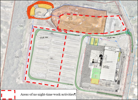
Figure 10 – Areas of no night-time work activities
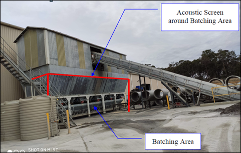
Figure 11 – Acoustic Screen around batching area
Recommended management measures are as follows:
· Replacement of reverse alarms on fork lifts with broadband reverse alarms and provision of acoustic screen around the batching area shall be implemented prior to any construction works.
· Construction of the acoustic barrier/earth mound on the western boundary and return along the south-west corner prior to filling/construction of the additional storage area.
· Construction of the acoustic barrier/earth mound on the northern boundary as soon as practical, following filling/compaction for the additional storage area.
· Truck movements in one direction (forward) to minimise reversing and manoeuvring on site.
· Closing the roller doors on the southern façade of the manufacturing building during night-time operation.
· Arranging/planning work so as only the storage areas closed to the manufacturing building are used during night-time to maximise the distances from fork lift operations to the residences.
· Site inductions and personnel/contractor training to ensure correct use of construction plant and equipment.
· Construction only to occur during the standard work hours only:
o 7am to 6pm Monday to Friday
o 8am to 1pm Saturday
o no construction on Sunday or public holidays.
· Use well maintained construction equipment and check to ensure mufflers are in good condition.
· Where extended high construction noise activities are anticipated, consult with affected receivers to determine whether noisy activities can be scheduled outside most sensitive hours or provide respite periods.
· Inform the residential neighbours in advance the types of construction work that could generate high noise levels and duration.
Council’s Environmental Health Officer has reviewed the proposal and the Noise and Vibration Assessment, Proposed Additional Storage Area and Night-time Operation, prepared by Acoustic Consulting Engineers, dated 1 February 2022 and supports the proposal. Provided the noise mitigation measures are implemented the project specific noise criteria for day, night and sleep disturbance criteria can be met. A condition is included to implement the recommendations of Section 7.2 of the Acoustic Report (refer to Condition 4.11).
The EPA is the appropriate regulatory authority for the proposed development. In addition to the above, conditions are applied by the EPA for noise limits and operational noise, which are included in the consent as Schedule A. The proponent shall obtain an Environmental Protection Licence from the EPA prior to commencing operations on the site under this consent (refer to Condition 1.6).
The site is currently operating under conditions of consent in DA/47599/2015/E, which applied restrictions to operation hours, number of delivery and dispatch trucks including hours and location for loading/unloading, use of forklifts and power tools.
Council is to be notified two days prior to the intended commencement of operations 24-hours/7days per week, wherein the restrictions imposed by development consent DA/47599/2015 (Part 6 now Part E) Stage 3a, Section 6 Ongoing, will no longer apply to the operation of the site (refer to Conditions 1.4 and 1.5, respectively.
A comprehensive assessment of the potential noise impacts has been undertaken and it is considered the installation of the acoustic measures including the acoustic barriers will mitigate adverse amenity impacts on adjoining properties.
Timing of the construction of the acoustic walls
The EIS submitted with the application identifies the schedule of works intending to establish the acoustic walls in the first instance as follows:
1 Erection of internal acoustic noise walls to the north and west of the existing batching plant and along the top, western edge of the existing hardstand area with adequate return along the south-west corner. Works include associated stormwater treatment works as recommended (ie: provision of a turfed swale along the western edge of the existing gravel hardstand area).
2 Extend hours of operation.
3 Phased increase in production capacity.
4 Bulk earthworks, new heavy vehicle entry access, erection of acoustic noise wall along top northern edge of the proposed batter (filled area) and modifications to stormwater system and stormwater detention/water quality basin.
5 Erection of new storage structures (awning and dome shelter).
6 Addition to approved workshop.
The EPA has applied conditions for the timing of the construction of the acoustic walls, which require Acoustic Barrier 1-3 to be constructed prior to the commencement of night-time operations. Acoustic Barrier 4 is to be constructed prior to the commencement of the operations of the northern expansion area.
Water
It is proposed to import 56,000m3 of VENM/ENM with surface area of 13,828m2. Soil disturbance will affect an area of approximately 18,000m2.
The application was referred to the National Parks and Wildlife Service (NPWS) and comments received raising concern for the management of potential increase overflow/water contamination downstream into Floods Creek via Somersby Falls picnic area in Brisbane Water National Park.
Council’s Environmental Health Officer has reviewed the revised Soil and Water Management Plans produced by Beveridge Williams, which are satisfactory and complies with the minimum requirements of Clause 6.3 of the GDCP 2013. The following comments are provided:
· All surface water flows are to be directed into an existing detention pond which overflows into an unnamed creek located north of the site, which is a tributary of Floods Creek within Brisbane Water Natural Park. Spel Ecoceptors are proposed within two stormwater pits on site with all surface waters flowing into a stormwater retention dam on site.
· A water quality monitoring program is proposed to be undertaken at the discharge point of the site, as well as the Unnamed creek (upstream and downstream of the discharge point) prior to, during and post construction. Appropriate water quality parameters have been set and monitoring frequencies, as well as corrective actions for non-compliance.
The EPA has set water quality parameters for the discharge point in their General Terms of Approval and recommended conditions (refer to Schedule A of the consent).
The matters raised by the NPWS have been appropriately considered and addressed.
Visual Impact Assessment
A visual impact assessment prepared by Beveridge Williams has been submitted with the proposal. The greatest visual changes are located outside of the site activity areas with the addition of the new noise walls to mitigate noise impacts from the production facility and loading areas. The walls are placed to mitigate noise emissions from the production facility and storage yard. The indicative location of the acoustic walls is shown in Figure 12.
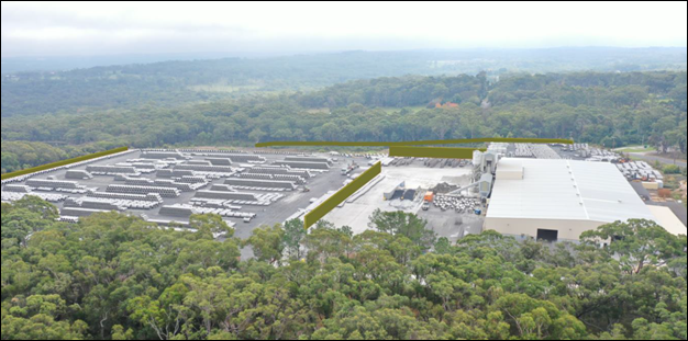
Figure 12 - Aerial photo of site and surrounding properties
with indicative location of acoustic walls
(source Beveridge Willams – Visual Impact Assessment)
The visual assessment concluded the following:
· The existing landscape character is a mix of industrial development and rural residential land uses. The scale of the built form on the site is comparable with other industrial development in the Somersby industrial locality.
· The proposed additions are well sited to integrate with the existing structures and natural vegetation surrounding the site. The proposed works are not visible from neighbouring rural allotments and are minimal from the street and industrial businesses across the road. The works integrate with the site and are consistent with an industrial use.
· The site is considered to have a low visual impact rating and therefore minimal mitigation measures are recommended as follows:
o Where required, select colours to blend with the existing buildings and landscape.
o The existing vegetation along Somersby Falls Road is to be embellished with additional plantings and species consistent with the existing vegetation (except where new driveway is proposed).
o Planting should aim to fragment views rather than blocking completely.
o A landscape plan should be prepared incorporating the recommendations above.
The visual impact of the proposal including the acoustic barriers is considered acceptable. The proposal is not considered to impact on the visual amenity of the landscape or surrounding properties. Conditions are included to submit a Landscape Plan to Council for approval prior to the issue of a construction certificate, and will incorporate the stated recommendations (refer to Condition 2.8).
Lighting
The visual impact assessment has considered areas where the proposal could provide privacy to the surrounding residential community. As the proposal is located in an elevated position to that of their neighbours the additional recommended mounds and fencing will complement the setback of the development (a minimum of 200m) with natural vegetative buffers between all of the adjoining properties.
Aligning the visual impact recommendations to the location and type of lighting proposed for the use of this development, it is anticipated that any impacts of “light spill” on the amenity of the neighbourhood will be minimal and if required mitigated through conditional restrictions for any development consent issued.
The proposal has been reviewed by Council’s Environment Protection Officer. There is no objection to the proposal subject to the following conditions being included in the consent:
· Prior to the issue of an Occupation Certificate, lighting shall be constructed and implemented in accordance with the requirements of AS/NZS 1158 and AS/NZS 2890.1.
· All lighting is restricted to the existing hardstand as shown on the plans by Decrolux dated 17/2/21.
· All lighting must be managed in a manner that does not unreasonably impact the amenity of the surrounding neighbourhood.
· All lighting must be directed away from all adjoining properties and towards the ground.
Ecology
Council's Ecologist has assessed the ecological impact of the proposed development in accordance with Section 4.15 of the Environmental Planning and Assessment Act 1979 and the Environment Protection and Biodiversity Conservation Act 1999. Impacts to biodiversity values have been assessed in accordance with the Biodiversity Conservation Act 2016.
Additional information has been submitted on amphibian surveys. A targeted amphibian survey was conducted on December 10-11, 2021 during suitable survey conditions. No threatened amphibians were recorded. In addition the existing detention pond does not support suitable habitat for known local threatened amphibians.
Revised engineering plans show the addition of an acoustic barrier along part of the western IN1 zone boundary and south west corner. The barrier is located in an existing cleared area with some regrowth vegetation.
Council’s Environmental Health Officer has conditioned recommendations contained in Section 3.6 of the Water Cycle Management Report. NRAR and EPA have provided General Terms of Approval. The application appears to satisfactory limit post-development flows back to pre-development and provide water quality protection measures.
No threatened entities are likely to be significantly impacted by the proposal. A Biodiversity Management Plan is required prior to issue of any construction certificate to ensure impacts on biodiversity during the construction and operational phase are appropriately mitigated and managed.
The objectives of the relevant policies, zoning objectives and potential environmental impacts associated with the proposal have been considered. Council’s Ecologist has no objection to the proposal subject to the conditions being included in the consent (refer to Conditions 2.9, 3.11, 4.8, 5.14, 6.7 and 6.8).
Likely Impacts of the Development:
Section 4.15 (1)(b) of the Environmental Planning and Assessment Act 1979 requires consideration of the likely impacts of the development including environmental impacts on both the natural and built environments, and social and economic impacts in the locality. The likely impacts of the development are addressed below.
Built Environment Context and Setting
The proposed development will result in the ongoing industrial use of the land which is consistent with the IN1 zone objectives and development controls and provides for employment opportunities (both internal and external to the operation) in line with the strategic goals for the Central Coast.
A thorough assessment of the impacts of the proposed development on the built environment has been undertaken in terms of relevant acts and policies, GLEP 2014 and GDCP 2013 compliance.
The cumulative impacts of the proposed development have been considered. The proposal is not considered to have adverse amenity impacts to adjoining development from air quality, noise, lighting, stormwater management and hours of operation subject to the recommended conditions of consent.
Natural Environment
The relationship between the site and surrounding rural and environmental conservation zoned land will be protected with the retention of appropriate setbacks, natural vegetation buffers, implementation of acoustic measures (fixed and operational), appropriate pollution control. stormwater management and water quality treatment systems.
The proposal is satisfactory in relation to impacts on the natural environment as identified throughout this report. There will be no significant impact upon the natural environment as a result of the proposal.
Economic and Social Impacts
The proposed development will contribute to employment opportunities. The proposed increase in production capacity and hours of operation is in direct response to market demand and to prevent the sourcing and purchasing of concrete products from interstate. The proposal is considered to be satisfactory from an economic perspective.
The social impacts of the proposed development are the environmental impacts on the landscape and amenity impacts of the operations of the site on surrounding rural residential properties. The proposal has been considered in accordance with all relevant legislative requirements, objectives of the IN1 zone, Council’s planning controls and with appropriate management and mitigation measures the will reduce potential for adverse social impacts.
Suitability of the Site for the Development:
The site is zoned IN1 General Industrial under GLEP 2014 which permits industrial activity.
There are no environmental hazards which would prevent development of the site. Potential environmental impacts can be managed or mitigated through the implementation of appropriate ameliorative measures (fixed and operational) and recommendations contained in the supporting documentation.
As such the site is considered suitable for the proposal and adequately addresses the site constraints and impacts subject to conditions of consent relating to civil works, traffic, visual and acoustic measures, stormwater, water quality and biodiversity management.
Any Submission made in Accordance with this Act or Regulations
Section 4.15 (1)(d) of the Environmental Planning and Assessment Act 1979 requires consideration of any submissions received during notification of the proposal.
The proposal was formally advertised and notified, in accordance with GDCP 2013 Chapter 7.3.2 Notification of Development Proposals, between 10 September 2021 and 18 October 2021.
A total of 10 unique submissions were received in relation to the application. Those issues associated with key issues have been addressed in the above report. The remaining issues pertaining to various concerns were addressed in the assessment of the application pursuant to the heads of consideration contained within Section 4.15 of the Environmental Planning and Assessment Act 1979.
A summary of the submissions objecting to the proposal is detailed below.
1. Difficulty in accessing the documents subject of the development application
Comment – Concerns with Council regarding access to the submitted documents were addressed by Council staff on 30 September 2021, when the submitter was advised the link was correct and staff provided guidance in accessing the documents.
An extension of time of a further two weeks was granted to lodge a submission from 18 October 2021 until 29 October 2021 in lieu of difficulties in accessing the development application documents.
2. Concern regarding noise impacts of the current and proposed operations, inability of RCPA to adhere to noise restrictions, the resultant impact on adjoining properties, intrusive nature in a quiet rural residential area.
Comment – Complaints have been received and have been attended to on a regular basis by Council’s Compliance Team, since operations have commenced on the site and the commencement of the revised delivery/dispatch hours raising concern from sleep disturbance from the early morning delivery trucks and forklifts and the taking up of the of previously approved operation hours to 10pm.
Council has investigated concerns and liaised with RCPA to ensure the site operations are in accordance with current conditions of consent. It has been necessary to take compliance action to bring operations back in line on several occasions; however, the Compliance Team has advised that the site is generally operating in accordance with conditions of consent imposed under DA/47599/2015/E.
Council’s Environmental Health Officer has reviewed the submitted noise and vibration assessment and states that provided the noise mitigation measures are implemented the project specific noise criteria for day, night and sleep disturbance criteria can be met.
The proposed operations are a scheduled activity in accordance with the Protection of the Environment Operations Act 1997 with the intention/capacity to produce in excess of 30,000t/year of concrete products and will require an Environmental Protection Licence to be issued by the EPA.
The EPA is the appropriate regulatory authority under the Protection of the Environment Operations Act 1997 for works, as well as the ongoing operation and management of this site.
The EPA has considered the potential operation impacts and identified environmental issues including impacts on air quality, potential noise impacts, surface water controls, bunding and chemical storage and determined the way forward is to apply conditions to mitigate these impacts; refer Schedule A of the conditions of consent. In relation to noise, conditions of consent are applied for noise limits and timing of the construction of the proposed acoustic walls.
The concerns raised in all submissions in relation to noise impacts and the construction of the acoustic walls have been considered in the assessment of the proposed development. It is considered that a satisfactory level of assessment has been undertaken by relevant public authorities and Council officers to make a recommendation of approval to the proposal.
3. Timing of construction of acoustic walls
Comment – The EIS submitted with the application identifies the schedule of works intending to establish the acoustic walls in the first instance:
1. Erection of internal acoustic noise walls to the north and west of the existing batching plant and along the top, western edge of the existing hardstand area with adequate return along the south-west corner. Works include associated stormwater treatment works as recommended (ie: provision of a turfed swale along the western edge of the existing gravel hardstand area).
2. Extend hours of operation.
3. Phased increase in production capacity.
4. Bulk earthworks, new heavy vehicle entry access, erection of acoustic noise wall along top northern edge of the proposed batter (filled area) and modifications to stormwater system and stormwater detention/water quality basin.
5. Erection of new storage structures (awning and dome shelter).
6. Addition to approved workshop.
The EPA is the appropriate regulatory authority and has applied conditions for the timing of the construction of the acoustic walls which require Acoustic Barrier 1-3 to be constructed prior to the commencement of night-time operations. Acoustic Barrier 4 to be constructed prior to the commencement of the operations of the northern expansion area.
4. Concern regarding visual impact and effectiveness of screening whether installed around the boundary or adjacent to the equipment.
Comment – Council and the EPA have reviewed the proposed acoustic screening in relation to the effectiveness to mitigate noise and visual impacts for the proposed development. It is considered that a satisfactory level of assessment has been undertaken by relevant public authorities and Council officers, subject to conditions to make a recommendation of approval to the proposal, refer detailed discussion under Other Matters for Consideration in this report.
5. Concern regarding one day noise level test – not in accordance with NSW EPA Noise Policy for Industry 2017 Fact Sheet A: Determining existing noised levels – requires long term method – equivalent of one week’s worth of data.
Comment – Unattended monitoring was undertaken by the Applicant’s acoustic consultant for a week in accordance with the EPA’s Noise Policy for Industry 2017. Attended monitoring was conducted to obtain maximum sound power levels of the plant and equipment on site and is only to be conducted on one day.
6. Concern regarding the Traffic and Parking Assessment
Comment – The traffic and parking considerations for the proposal have been reviewed by Council’s Development Assessment Engineer and Traffic and Transport Engineer. The proposal will not have material adverse traffic impacts, subject to conditions applied in the consent. Consideration has been given to ongoing operations on the site in the following conditions:
· The road reserve of Somersby Falls Road is not to be utilised for the parking needs of the development.
· The largest vehicle to access the site shall be the AS2890.2:2018 Articulated Vehicle. No B-Double vehicles are to service the development.
· All vehicles servicing the site are not permitted to enter and exit the site via Howes Rd Somersby.
7. Concern regarding the Air quality Assessment
Comment – Council and the EPA have reviewed the proposal and potential impacts on air quality. It is considered that a satisfactory level of assessment has been undertaken by relevant public authorities and Council officers, subject to conditions to make a recommendation of approval to the proposal, refer detailed discussion under Other Matters for Consideration in this report.
8. Historical planning and development of the site / Council’s accumulative failures in assessment of development on the site
Comment – The submission refers to the planning process for rezoning of the site. The rezoning of the land was made by GLEP 2014 (Amendment No 2), which rezoned the land from RU1 to Part E2 Environmental Conservation and Part IN1 General Industrial on 9 May 2014.
The approval of development on the site under DA/47599/2015 and subsequent modifications have been considered in accordance with the relevant planning provisions applying to industrial developments, the production capacity of the concrete works including amenity impacts and the assessment of noise impacts and submitted noise reports.
The submission refers to the assessment of the original application in relation to the classification of the development as potentially designated development based on the proposal being defined as Concrete Works in Schedule 3 of the Environmental Planning and Assessment Regulation 2000.
In response, the statutory provision of Schedule 3 of the Environmental Planning and Assessment Regulation 2000 was considered in the assessment. The assessment stated:
The proposal produces 85-90 tonnes per day or 22,000 tonnes per year. The nearest dwelling house is greater than 250m from the proposed development concrete works, and there is no natural water body or wetland within 100m.
Therefore, the proposal is not classified as designated development and an Environmental Impact Statement (EIS) is not required.
The original application was supported and determined by Council under delegation.
Council has considered the cumulative impacts of the existing development approved and operating on the site and the proposed development, the relevant planning legislation polices and development controls applying to the site, the reports submitted with the application, consideration of public submissions. The submitted peer review by Spectrum Acoustics of the Noise and Vibration Assessment by Acoustic Consulting Engineers is noted.
It is considered that a satisfactory level of assessment has been undertaken by relevant public authorities and Council officers in relation to DA/47599/2015 and the proposed development to make a recommendation of approval.
Council has managed the impact of RCPA on nearby residents and in all instances thoroughly considered the relevant matters in the assessment of applications and neighbours’ objections.
The proposed development is Designated Development. The determining body is the Central Coast Local Planning Panel.
Internal Consultation
|
Traffic Engineer |
Supported without conditions |
||
|
Development Engineer |
Supported subject to Conditions 2.4-2.6, 3.9-3.10, 5.5-5.11, 6.10, 6.11, Advisory |
||
|
Ecology |
|
Supported subject to Conditions 2.9, 3.11, 4.8, 5.14, 6.7, 6.8 |
|
|
Environmental Health |
|
Supported subject to Conditions 4.9-4.16, 1.6 |
|
|
Environmental Protection |
|
Supported subject to Conditions 5.13, 6.4-6.6 |
|
|
Waste Services |
Supported subject to Conditions 4.6. 6.12-6.19 |
||
|
Water and Sewer |
Supported subject to Conditions 2.10, 5.15 |
Public Authority / External Consultation
|
NSW Environment Protection Authority – Integrated approval body |
General Terms of Approval and recommended conditions included as Schedule A in conditions of consent. EPA Licence to be obtained for the proposed scheduled activity, |
||
|
Natural Resources Access Regulator – Integrated approval body |
|
General Terms of Approval - Controlled Activity Approval |
|
|
NSW Rural Fire Service |
Discussion with RFS indicated referral not required. However, it is noted that RFS provided a determination of not supported due to information not provided. |
||
|
NSW National Parks & Wildlife Service |
|
Comments received are addressed under Other Matters for Consideration - Water |
|
|
Transport for NSW |
|
Referral not required – Council is the Roads Authority |
|
The Public Interest
The approval of the application is considered to be in the public interest. The proposal will not have any adverse impact on the natural environment and will not unreasonably impact the amenity of neighbouring properties.
Political Donations
During assessment of the application there were no political donations were declared by the
Applicant, Applicant’s consultant, owner, objectors and/or residents.
Ecologically Sustainable Principles:
The proposal has been assessed having regard to ecologically sustainable development principles and is considered to be consistent with the principles.
The proposed development is considered to incorporate satisfactory stormwater, drainage and erosion control and the retention of vegetation where possible and is unlikely to have any significant adverse impacts on the environment and will not decrease environmental quality for future generations. The proposal does not result in the disturbance of any endangered flora or fauna habitats and is unlikely to significantly affect fluvial environments.
Conclusion:
This application has been assessed under the heads of consideration of Section 4.15 of the Environmental Planning and Assessment Act 1979 and relevant instruments and policies. Subject to the imposition of appropriate conditions, the proposed development is not expected to have any material adverse social or economic impact.
Accordingly, the application is recommended for approval pursuant to Section 4.16 of the Environmental Planning and Assessment Act 1979.
Reasons for the Decision
The reasons for the decision as recommended under the assessment of this application are as
follows:
1 The proposal is satisfactory having regard for the relevant environmental planning instruments, plans and policies.
2 There are no significant issues or impacts identified with the proposal under Section 4.15 of the Environmental Planning and Assessment Act 1979.
|
1⇨ |
Draft Conditions including Schedule A & B - 149 Somersby Falls Rd Somersby - DA/62839/2021 |
Provided Under Separate Cover |
D15194535 |
|
2⇨ |
PUBLIC Plans 149 Somersby Falls Road, SOMERSBY DA/62839/2021 [PAN-133855] |
Provided Under Separate Cover |
D14799710 |
|
3⇨ |
Revised Acoustic Barrier Plan set - 149 SOMERSBY FALLS ROAD SOMERSBY DA/62839/2021 |
Provided Under Separate Cover |
D15042063 |
|
4⇨ |
Revised Engineering Plans 149 Somersby Falls Rd Somersby DA/62839/2021 |
Provided Under Separate Cover |
D15030611 |
|
5⇨ |
PUBLIC Air Quality Assessment 149 Somersby Falls Road, SOMERSBY DA/62839/2021 [PAN-133855] |
Provided Under Separate Cover |
D14799730 |
|
6⇨ |
Revised Noise and Vibration Assessment 149 Somersby Falls Road SOMERSBY DA/62839/2021 |
Provided Under Separate Cover |
D15027400 |
|
7⇨ |
Preliminary Contamination Review and Water Quality Monitoring Plan - Rev 1 - 149 SOMERSBY FALLS ROAD, SOMERSBY DA/62839/2021 |
Provided Under Separate Cover |
D15030165 |
|
8⇨ |
PUBLIC Environmental Impact Statement 149 Somersby Falls Road, SOMERSBY DA/62839/2021 [PAN-133855] |
Provided Under Separate Cover |
D14799723 |
|
9⇨ |
PUBLIC Flora and Fauna Assessment 149 Somersby Falls Road, SOMERSBY DA/62839/2021 [PAN-133855] |
Provided Under Separate Cover |
D14799722 |
|
10⇨ |
PUBLIC Additional Information Ecology 149 Somersby Falls Road SOMERSBY DA/62839/2021 |
Provided Under Separate Cover |
D15019610 |
|
11⇨ |
PUBLIC Geotechnical Report 149 Somersby Falls Road, SOMERSBY DA/62839/2021 [PAN-133855] |
Provided Under Separate Cover |
D14799721 |
|
12⇨ |
Decrolux Proposal - Re-inforced Concrete Pipes Australia Hardstand Area 149 Somersby Falls Road, SOMERSBY DA/62839/2021 [PAN-133855] |
Provided Under Separate Cover |
D14799675 |
|
13⇨ |
PUBLIC Survey Plan 149 Somersby Falls Road, SOMERSBY DA/62839/2021 [PAN-133855] |
Provided Under Separate Cover |
D14799701 |
|
14⇨ |
PUBLIC Traffic and Parking Report 149 Somersby Falls Road, SOMERSBY DA/62839/2021 [PAN-133855] |
Provided Under Separate Cover |
D14799698 |
|
15⇨ |
PUBLIC Visual Impact Assessment Report 149 Somersby Falls Road, SOMERSBY DA/62839/2021 [PAN-133855] |
Provided Under Separate Cover |
D14799696 |
|
16⇨ |
REVISED Waste Management Plan Revision 1 - RCPA Somersby_PAN-133855 |
Provided Under Separate Cover |
D15077040 |
|
17⇨ |
Water Cycle Management Report - revision 3 Final - 149 SOMERSBY FALLS ROAD, SOMERSBY DA/62839/2021 |
Provided Under Separate Cover |
D15030174 |
|
18⇨ |
Water Usage Report 149 Somersby Falls Road, SOMERSBY DA/62839/2021 [PAN-133855] |
Provided Under Separate Cover |
D14799688 |
|
19⇨ |
EPA GTA and Conditions DA62839 149 Somersby Falls Rd Somersby |
Provided Under Separate Cover |
D14893017 |
|
20⇨ |
NRAR Response GTA IDAS-2021-10174 149 Somersby Falls Rd Somersby DA62839/2021 |
Provided Under Separate Cover |
D14878757 |
|
21⇨ |
SEARS 1511 - Applicant Package 149 Somersby Falls Road, SOMERSBY DA/62839/2021 [PAN-133855] |
Provided Under Separate Cover |
D14799691 |
|
Item No: 4.1 |
|
|
Title: DA1209/2021 - Lot R/918 Rd, The Entrance Road, The Entrance - Markets and Function Centre for community events |
|
|
Department: Environment and Planning |
|
|
23 June 2022 Local Planning Panel Meeting |
|
Reference: DA/1209/2021 - D15157367
Author: Katrina O'Malley, Development Planner
Emily Goodworth, Section Manager Development Assessment North
Manager: Andrew Roach, Unit Manager, Development Assessment
Executive: Alice Howe, Director Environment and Planning
|
Summary
An application has been received for Markets and Function Centre for community events. The application has been examined having regard to the matters for consideration detailed in Section 4.15 of the Environmental Planning and Assessment Act 1979 and other statutory requirements with the issues requiring attention and consideration being addressed in the report. The application is recommended for approval.
The matter is referred to the Local Planning Panel as Council is the applicant and owner of the land.
Applicant Central Coast Council Owner Central Coast Council Application No DA/1209/2021 Description of Land Lot R/918 Rd The Entrance Road, THE ENTRANCE NSW 2261 Proposed Development Markets and Function Centre for community events Site Area 266m2 Zoning RE1 Public Recreation Existing Use Pedestrian waterfront plaza Employment Generation N/A Estimated Value N/A
|
|
|
1 That the Local Planning Panel grants consent to DA/1209/2021 – Lot R/918 Rd ROAD, The Entrance Road, THE ENTRANCE – Markets and Function Centre for community events subject to the conditions detailed in the schedule attached to the report and having regard to the matters for consideration detailed in Section 4.15 of the Environmental Planning and Assessment Act 1979.
Precis:
|
Proposed Development |
Community and Market Events
|
|
Permissibility and Zoning |
RE1 Public Recreation Ancillary use to existing recreation area and markets |
|
Relevant Legislation |
State Environmental Planning Policy (Resilience and Hazards) 2021 Wyong Local Environmental Plan 2013 (WLEP 2013) Development Control Plan 2013, Chapter 2.11 – Parking and Access Development Control Plan 2013, Chapter 3.7 – Heritage Conservation Development Control Plan 2013, Chapter 5.3 – The Entrance Peninsula The Entrance Peninsula Planning Strategy The Entrance Town Centre Masterplan
|
|
Current Use |
Pedestrian waterfront plaza
|
|
Integrated Development |
No
|
|
Submissions |
Nil
|
Variations to Policies
There are no variations proposed under the current application.
The Site
The site is known as Lot R/918 Rd (The Entrance Road), The Entrance. The site forms part of the Waterfront Plaza, which is an existing pedestrian plaza. The existing pedestrianised Waterfront Plaza area is located on part of The Entrance Road and is still classified as a road. The site is, however, closed to vehicle traffic and allows for a safe pedestrian link between the Memorial Park public recreation area and the adjoining commercial/residential area.
The Waterfront Plaza area was created in the late 1990s, closing this section of the road to vehicular traffic. This area of the Waterfront Plaza is paved and includes several trees within the site. The site also contains several outdoor dining areas which are leased and utilised by food and drink premises adjoining the site (refer to Figure 1).
The site is not subject to a Plan of Management (as it is a road, and not a Council reserve). The land is, however, captured by several other planning policies and covered by The Entrance Town Centre Strategy.
Surrounding Development
The surrounding development is a mixture of recreation, commercial and residential development. Land immediately to the east of the site consists of an existing recreation area known as Memorial Park. The park adjoins The Entrance Channel which forms part of the Tuggerah Lakes system.
Land to the north of the site is dominated by commercial development which is predominantly a mixture of food and drink premises and shops (refer to Figure 2). There is also shop top housing and tourist accommodation within the area. The larger locality continues the trend of a mixture of commercial and residential development of varying scales.
Figure 1. The site as viewed from the south
Figure 2. The site within the locality
The Proposed Development
The proposed development is for the use of the Waterfront Plaza for markets and as a function centre that will be used for a number of community events. The proposed events are to be small-scale community events that will include pop up activities, school holiday activities, market stalls and craft activities. The use of the land will involve the following:
· School holiday activities
The proposed use of the site will include school holiday activities (refer to Figure 3) that will operate Monday to Friday within school holiday periods and generally between the hours of 7:00am to 4:30pm. These events would include 5-10 activities that would operate under a booking system.
· Activation/market events
The proposal also includes activation/ market events that will operate on the second Friday and third Saturday of each month. These events will have between 10-20 market stalls, craft, or other activities (refer to Figures 4 and 5). The Friday events will operate generally between 12 midday and 9:00pm, whilst the Saturday events will either be a morning or afternoon event that will operate between 6.00am and 8.00pm, which includes bump in (set up) and bump out (pack up).
· Pop up events
Pop up events will form part of the larger events that operate within Memorial Park. These events will have between 10-20 market stalls, craft, or other activities. The event will either be a morning or afternoon event that will operate between 6.00am and 8.00pm, which includes bump in and bump out. The events are proposed to be held between Friday and Sunday (inclusive).
Operation
The proposed use of the land will not require the closure of any roads as there is no through traffic through the plaza area. The proposed events will be advertised prior to the day by the operator and have the correct insurances in place. Events will also operate in accordance with the relevant COVID-19 requirements at the time (if applicable).
Events proposed under the current application would generate attendance figures of approximately 100 to 1,000 people based on previous similar events within the locality. School holidays activities will generate attendances of around 100 people and will be required to be pre-booked. The market events will generate attendance of between 1,000 to 2,000 people depending on the season, school holidays and the like.
Parking for the event will be provided for within the existing locality through a combination of on-street parking and public carparks within Coral Street and adjoining Memorial Park.
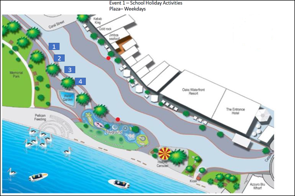
Figure 3. School holiday activities
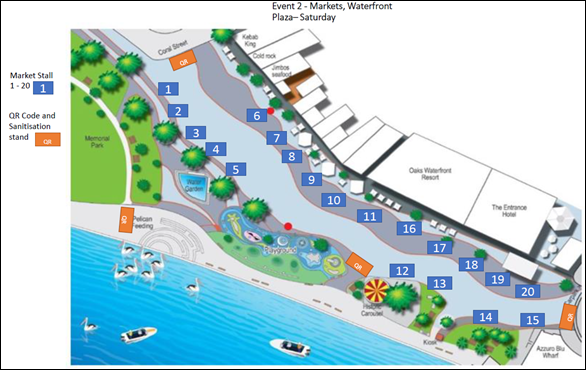
Figure 4. Saturday waterfront markets
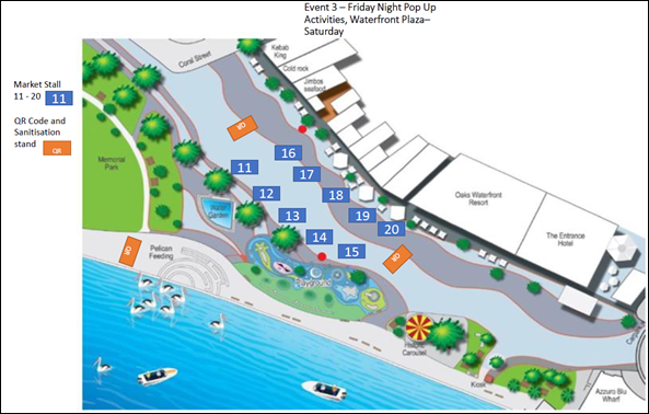
Figure 5. Friday night or Saturday pop up activities
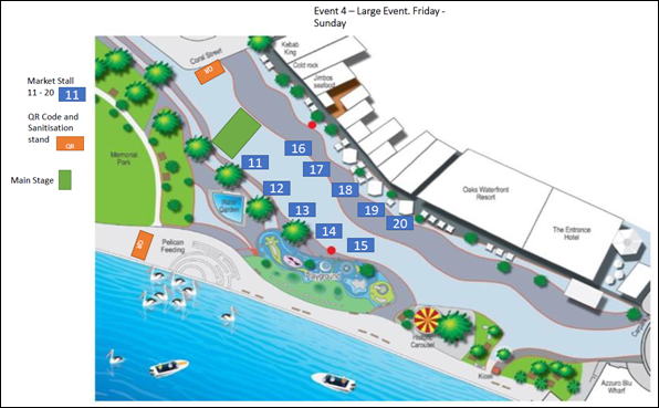
Figure 6. Larger activities Friday, Saturday, or Sunday
History
The site has historically been utilised for a number of community events and market stalls over the years and this development consent will formalise the use of the land for this use in the future.
A recent development consent (DA/1056/2018) for the site was issued for Christmas light displays within this space.
ASSESSMENT:
Having regard for the matters for consideration detailed in Section 4.15 of the Environmental Planning and Assessment Act 1979 and other statutory requirements, the assessment has identified the following key issues.
State Environmental Planning Policies (SEPP)
State Environmental Planning Policy (Resilience and Hazards) 2021
The site is currently located within a coastal environment area under the above SEPP. Any development on land identified as a coastal environment area is required to be in accordance with Clause 2.10 – Development on land within the coastal environment area of the above SEPP. The proposal will not have an impact upon the coastal environment and given the nature of the proposal to be undertaken on the site it would not have any impacts to any items of Aboriginal heritage, should they be in the locality. The proposal is therefore consistent with the requirements of Clause 2.10.
The site is also located within a coastal use area under the SEPP. Any development on land identified as a coastal use area is required to be in accordance with Clause 2.11 – Development on land within the coastal use area of the above SEPP. The proposal will not have an impact upon the coastal environment and is therefore consistent with the requirements of Clause 2.11.
Wyong Local Environmental Plan 2013 (WLEP 2013)
Permissibility
The site is currently zoned RE1 Public Recreation under the WLEP 2013. The proposed development is for the use of the waterfront plaza area for markets and community events. Market stalls are a permitted use within the RE1 zone and are defined as follows:
“market means an open-air area, or an existing building, that is used for the purpose of selling, exposing or offering goods, merchandise or materials for sale by independent stall holders, and includes temporary structures and existing permanent structures used for that purpose on an intermittent or occasional basis.”
For other activities that are to be undertaken on the site the definition that best fits the proposed use of the land is that of a function centre which is defined as follows:
function centre means a building or place used for the holding of events, functions, conferences and the like, and includes convention centres, exhibition centres and reception centres, but does not include an entertainment facility.
A function centre is a permissible use in the RE1 Public Recreation zone. Consent is sought for the proposed use of Waterfront Plaza area for the holding of events.
Despite the fact there is no definition of ‘event’ in any relevant environmental planning instrument, the common use definition of ‘event’, as defined in the Oxford Dictionary, is “occurrence of a thing”. Similarly, the Collins Dictionary defines an ‘event’ as “a planned and organized occasion”. The activities to be undertaken on the site fit the broad definition of an event. Some events will be small in nature whilst others will be undertaken in conjunction with larger events held on the Memorial Park site.
Heritage
Schedule 5 of the WLEP 2013 identifies that the subject site adjoins several heritage items of local significance. These items include the carnival including carousel and Alfred Bruder Organ at 46 Marine Parade (identified as heritage item I81), WW1 monument at 1 Marine Parade (corner The Entrance Road) (identified as heritage item I97), concrete groyne off Marine Parade (identified as heritage item I83), and ferry master’s cottage at 101 the Entrance Road (identified as heritage item I87).
The proposed use of land does not propose any structures or activities that would have any impact to, or alteration of, any heritage item. The proposed development would therefore have no impact upon the heritage items in proximity to the subject site.
Acid Sulphate Soils
The site is identified as containing potentially Class 3 acid sulfate soils. The proposed development does not involve the disturbance of any soils and as such an Acid Sulphate Soils Management Plan is not required for the proposal.
Draft Central Coast Environmental Plan 2018 (DCCEP 2018)
Draft Central Coast Local Environmental Plan 2018 (Draft CCLEP 2018) was publicly exhibited from 2 December 2018 until 28 February 2019 and will consolidate the planning instruments of the former Wyong and Gosford local government areas. The final version of this consolidated LEP is yet to be gazetted.
Under Draft CCLEP 2018, the site will retain its RE1 Public Recreation zoning and development for the purpose markets and a function centre will remain permissible within the zone. There are no new or amended clauses or provisions warranting further discussion.
Wyong Development Control Plan 2013 (WDCP 2013)
Chapter 2.11 – Parking and Access
Under the provisions of the above policy there are no specific parking requirements for community events. The parking requirements for such a use are therefore assessed on merit. It is considered that those attending the event would utilise the existing public street parking around The Entrance town centre and parking in the public car parks located at Coral Street and Memorial Park. The existing parking areas have the capacity to cater for the proposed events. It is anticipated that dual and/or complementary uses of parking areas will occur. Accordingly, it is considered parking associated with the events can be adequately catered for with the existing car parking in The Entrance.
Parking for market stalls is required to be provided based on two spaces per stall. The proposal will have a maximum of 20 stalls at any one event, which would therefore require the provision of a minimum of 40 car spaces. There are currently over 3,000 on-street public parking spaces and 700 parking spaces provided in public car parks, that are within walking distance of Waterfront Plaza. There would be more than sufficient parking to cater for the use of the public land for the events and markets proposed.
The proposal is to be undertaken on public land and as such it would be suitable for the proposal to utilise the existing public car parking available within the locality.
Figure 7. The site (green) in proximity to public parking (red) within the locality
Chapter 3.7 - Heritage Conservation
The site of the proposal does not contain any items of heritage. However, the site is located in proximity to a number of heritage items. The site is also not within an identified heritage conservation area.
The proposed development is to be for the use of the land for markets and community events which only involve the erection of temporary structures. The proposal will therefore have no impact on the conservation of any heritage items within the locality. Given the type of development proposed it is not considered necessary for a heritage impact assessment to be undertaken given the proposed location of the events and markets on site and the temporary nature of associated structures. It is considered there will be no impact to existing heritage items within the locality.
Chapter 5.3 – The Entrance Peninsula
The subject site has been identified as being located within the area identified as part of The Entrance Town Centre. The proposal does not include any permanent structures and as such many of the controls of the above chapter are not applicable to the proposal.
The objectives of the area, however, aim to promote an outdoor lifestyle and increased pedestrian activity in the locality. The proposed development is consistent with the objectives of WDCP 2013 as the proposal will increase usage of the pedestrian area of this part of The Entrance Road and assist in activating The Entrance Town Centre precinct.
Relevant Regulations
There are no specific matters under the Environmental Planning & Assessment Regulation 2021 that require further specific discussion.
Likely Impacts of the Development:
Built Environment
A thorough assessment of the aspects of the proposed development on the built environment has been undertaken in terms of WDCP 2013 compliance.
As a result, the proposed development is considered to be satisfactory in terms of impacts on the built environment.
Access and Transport
As previously discussed, parking for the proposal can be catered for within the existing public parking areas within The Entrance town centre. It is highly likely that those attending the event would also be visiting other premises within the town centre, resulting in dual usage of the public car parking areas.
There is also the potential that visitors will come from the surrounding residential areas and would therefore not generate a need for parking. Overall, there is sufficient parking in the locality to cater for the proposal whilst ensuring enough parking is available to cater for other uses.
Context and Setting
The proposal is located within an area that has historically provided a number of activities for both residents and visitors to the area. The proposed development will allow the continued activation of the space for the community and will have an indirect positive impact to local premises by bringing additional people to the locality to visit.
Natural Environment
There will be no significant impact upon the natural environment as a result of the proposal. Existing trees within the locality are to be maintained and there are no other flora or fauna within the locality that would be impacted by the proposal.
All other relevant issues regarding the likely impacts of the development have been discussed throughout this report. In general, it is considered that the property is suitable for an approval subject to conditions.
Suitability of the Site for the Development:
A review of Council’s land information mapping has identified no site constraints. The site is therefore suitable for development. As discussed above, the site is mapped as a coastal use area and coastal environment area. The proposed development would not have any impact on either of these areas.
The proposed markets and community events are located within an area that contains a mixed use of development. The proposed development is compatible with the existing development in the locality and would potentially attract additional visitors to the area. These visitors could have a positive flow on impact to existing businesses within the locality.
Community Submissions
The application was notified from 8 October to 29 October 2021 in accordance with WDCP 2013 – Chapter 1.2 Notification of Development Proposals, with no submissions being received.
External Consultation
No
external consultation was required for the proposal.
Internal Consultation
|
Traffic Engineer |
Supported without conditions. |
||
|
Environmental Health Officer |
Supported subject to conditions |
Ecologically Sustainable Principles:
The proposal has been assessed having regard to ecologically sustainable development principles and is considered to be consistent with the principles.
The proposed development is considered to incorporate satisfactory stormwater, drainage and erosion control and the retention of vegetation where possible and is unlikely to have any significant adverse impacts on the environment and will not decrease environmental quality for future generations. The proposal does not result in the disturbance of any endangered flora or fauna habitats and is unlikely to significantly affect fluvial environments.
Other Matters for Consideration:
Contributions
Given the type of development proposed and the value of works, Section 7.11 and 7.12 Contributions are not applicable to the proposal.
The Entrance Peninsula Planning Strategy (2009)
The subject site has been identified as being located within Precinct 3 of the above strategy as part of The Entrance Peninsula. The proposal does not include the construction of any permanent structures; however, the proposal is consistent with the objectives of the area. Some of the objectives for the area relate to creating a high-quality tourist destination and facilitating a mix of activities within the precinct.
The proposal will fit in with the desired tourist activity destination of the precinct by providing events, markets and other activities for both residents and tourists within the area. The proposal will further activate the existing pedestrian plaza and ensure that it is utilised to its full potential. The proposal is also consistent with the strategy’s vision of providing more attractions and activities within the town centre.
The Entrance Town Centre Masterplan (2011)
The Entrance Town Centre Masterplan outlines the proposed direction for The Entrance Town centre in terms of redevelopment of the area and development of public spaces. Similar to The Entrance Peninsula Planning Strategy, the masterplan looks to create a waterfront area that will attract tourist and permanent residents.
It is considered that the proposed development makes use of an existing public area for public benefit whilst the development proposed would not limit the site’s ability to be used for additional public uses in the future.
Conclusion:
The proposed development is for the use of the site for markets and a function centre for the holding of community events. The proposed development is permissible under WLEP 2013 and proposes no variations to the plan or WDCP 2013. The proposal is consistent with The Entrance Peninsula Planning Strategy, The Entrance Town Centre Masterplan and other relevant plans and policies applying to the land. The proposed development is consistent with the anticipated future direction of the site.
The Development Application has been assessed against the heads of consideration under Section 4.15(1) of the Environmental Planning and Assessment Act 1979, and is considered satisfactory for the site and surrounding area. Accordingly, DA/1209/2021 is recommended for approval subject to the imposition of appropriate conditions.
Reasons for decision
The reasons for the decision as recommended under the assessment of this application are as follows:
· The proposal is considered satisfactory under the heads of consideration set out in Section 4.15 of the Environmental Planning and Assessment Act 1979.
· The proposal is considered satisfactory with regard to WLEP 2013 with regard to permissibility, and zone objectives.
· The proposal is considered satisfactory in relation to the requirements of WDCP 2013, Chapters 2.11, 3.7 and 5.3.
· The proposed development is consistent with the aims and objectives of The Entrance Town Centre Masterplan and The Entrance Planning Strategy.
|
1⇩ |
Draft conditions/reasons - The Entrance Road, THE ENTRANCE NSW 2261 - DA/1209/2021 - Central Coast Council |
|
D15169391 |
|
4.1 |
DA1209/2021 - Lot R/918 Rd, The Entrance Road, The Entrance - Markets and Function Centre for community events |
|
Attachment 1 |
Draft conditions/reasons - The Entrance Road, THE ENTRANCE NSW 2261 - DA/1209/2021 - Central Coast Council |
|
Item No: 4.2 |
|
|
Title: DA/2059/2021 - 17 Kunala Lane Horsfield Bay - Alterations & Additions to Existing Dwelling |
|
|
Department: Environment and Planning |
|
|
23 June 2022 Local Planning Panel Meeting |
|
Reference: DA/2059/2021 - D15121379
Author: Mark Earl, Building Surveyor
Manager: Wayne Herd, Section Manager, Building Assessment and Certification
Andrew Roach, Unit Manager, Development Assessment
Executive: Alice Howe, Director Environment and Planning
|
Summary
An application has been received for alterations and additions to an existing dwelling (lift, carport, turning bay, retaining walls, workshop and water tank). The application has been examined having regard to the matters for consideration detailed in section 4.15 of the Environmental Planning and Assessment Act 1979 and other statutory requirements with the issues requiring attention and consideration being addressed in this report. The application is recommended for approval.
This development application is required to be reported to Local Planning Panel due to the development exceeding the ‘Height of Buildings’ development standard specified and calculated within clauses 4.3 and 4.5 of Gosford Local Environment Plan 2014 (GLEP 2014) by more than 10%. The height of the proposed lift exceeds the permissible maximum Height of Buildings of 8.5m by 2.03m (this represents a variation of 23.8%).
Applicant Plan Urbia Owner Stephen Morrison Application No 2059/2021 Description of Land Lot 80 DP253201 17 Kunala Lane Horsfield Bay Proposed Development Alterations and Additions Site Area 882m2 Zoning R2 Low Density Residential Existing Use Residential Employment Generation N/A Estimated Value $148 500.00
|
1 The Local Planning Panel agrees the Applicant’s Clause 4.6 written variation request demonstrates compliance with the Height of Buildings development standard is unnecessary in circumstances of the case because of the minimal environmental impact that would result from the noncompliance with the Height of Buildings standard.
Compliance with the Height of Buildings development
standard would be unreasonable in the circumstances of the case because of the
steep sloping nature of the block, compliance would not allow
the lift,
and that there are sufficient environmental planning grounds to justify
contravening that development standard. Further, the Panel considers that the
proposed development will be in the public interest because it is consistent
with the objectives of the development standard and the objectives for
development within the R2 Low Density Residential zone in which the development
is proposed to be carried out.
2 That the Local Planning Panel assumes the concurrence of the Secretary of the Department of Planning to permit the non-compliance with the development standard under Clause 4.6 of the Gosford Local Environmental Plan 2014, in accordance with the provisions of Clause 64 of the Environmental Planning and Assessment Regulation 2000.
3 That the Local Planning Panel grants development consent to DA2059/2021 – 17 Kunala Lane Horsfield Bay to construct a lift over two levels, carport and turning bay subject to appropriate conditions as detailed in the schedule attached to the report and having regard to the matters for consideration detailed in Section 4.15 of the Environmental Planning and Assessment Act 1979 and other relevant issues.
4 Those who made a submission be notified of the outcome of the development application.
Precis:
|
Proposed Development |
Lift, carport, turning bay, retaining walls, workshop and water tank. |
|
Permissibility and Zoning |
The subject site is zoned R2 – Low Density Residential under the provisions of Gosford Local Environmental Plan 2014.
The proposed development is defined as a dwelling house (alterations and additions) which is defined under the GLEP 2014 as a building containing only one dwelling.
The use is permissible with consent of the relevant Authority within the zone. |
|
Relevant Legislation |
The following planning policies and control documents are relevant to the development and were considered as part of the assessment.
· Environment Planning and Assessment Act 1979 - section 4.15 (EP&A Act) · Gosford Local Environmental Plan 2014 (GLEP 2014) · Draft Central Coast Local Environmental Plan 2018 (Draft CCLEP 2018) · Gosford Development Control Plan 2013 Chapter 3.1 “Dwelling Houses, Secondary Dwellings and Ancillary Development” (Gosford DCP 2013) |
|
Current Use |
Dwelling |
|
Integrated Development |
No |
|
Submissions |
The development application was notified (in accordance with the provisions of the Gosford Development Control Plan 2013) from 17 March 2022 until 4 April 2022.
One submission was received. |
Variations to Plans and Policies
Gosford Local Environmental Plan 2014
|
Clause |
4.3 (2) |
|
Standard |
Height limit of 8.5m |
|
LEP/DCP |
Gosford LEP 2014 |
|
Departure basis |
The proposal seeks a maximum height of 10.53m consisting of the proposed lift to the eastern elevation. This represents a variation of 2.03m or 23.8%. |
Chapter 3.1. Dwelling Houses, Secondary Dwellings and Ancillary Structures of Gosford Development Control Plan 2013
|
Clause |
3.1.2.1 |
|
Planning Control |
Height limit of 8.5m |
|
Departure basis |
The proposal seeks a maximum height of 10.53m consisting of the lift to the eastern elevation. This represents a variation of 2.03m or 23.8%. |
|
Clause |
3.1.3.1a |
|
Planning Control |
Front setbacks – 9.5m |
|
Departure basis |
The proposal seeks a front setback to the carport of 4m. This represents a variation of 5.5m or 58%. |
The Site
The site is identified as Lot 80 DP253201, 17 Kunala Lane Horsfield Bay.
The lot is an irregularly shaped allotment located on the western side of Kunala Lane, having a site area of 882m2. Whilst the site enjoys a frontage to Woy Woy Road to the west, it is effectively cut in two by a rock ledge which bisects the site, with the rear elevated portion densely vegetated and unlikely to be developable. The rear portion of the site provides high quality amenity, setting and aesthetic qualities to residents, adjoining sites and the locality.
The site rises steeply from Kunala Lane and is located on the western side with a total area of 882m2. The site is occupied by an existing two-storey cladded dwelling with metal roof, undercroft area to the front and rear, being partially built on supporting posts, due to the variation in topography.
Access is via a steep concrete driveway from Kunala Lane.
The subject site is zoned R2 - Low Density Residential under the provisions of GLEP 2014.
The site is identified as bushfire prone land.
Figure 1 Aerial Photograph showing location of subject site
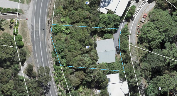
Figure 2 Aerial view of site
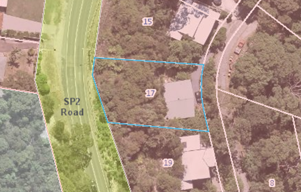
Figure 3 Zoning. The subject site and nearby residential lots are zoned R2 - Low Density Residential under the provisions of GLEP 2014
Existing Height of Development on Site
It is noted that this matter is referred to the Local Planning Panel as a result of the proposed development exceeding the maximum permitted height set out within clauses 4.3 and 4.5 of GLEP 2014 by more than 10%. The height of the proposed lift exceeds the permissible maximum Height of Buildings of 8.5m by 2.03m to a total height of 10.53m (this represents a variation of 23.8%). It is noted that, as a result of the steeply sloping nature of the site, the existing dwelling already exceeds the 8.5m height limit, having a height of 12.69m.
Surrounding Development
The area generally contains a mixture of older style elevated dwellings on the steep hillside. The dwellings along the western and eastern side of Kunala Lane are of similar construction typology comprising a mix of cladded and brick single and two storey dwellings, many with carport and garage structures having direct address with the Kunala Lane street frontage, more particularly on the eastern side of Kanala Lane where the escarpment fall is the greatest.
The Kunala Lane streetscape is heavily landscaped and is not designed as a pedestrianised roadway being devoid of footways, with vegetative cover and rock outcrops largely extending to the road verge.
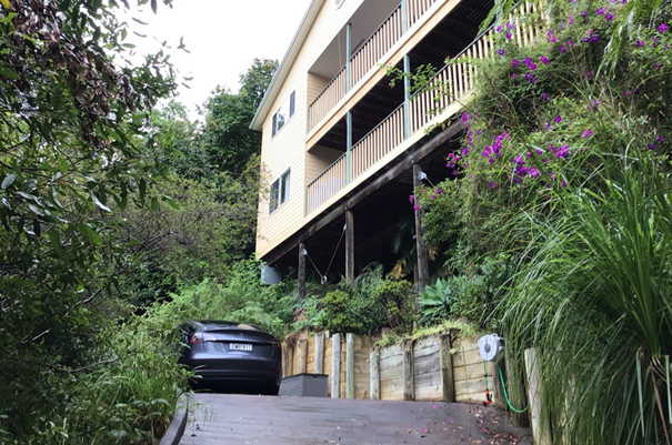
Figure 4 Front elevation
History
Council’s records show that there have been a range of previous applications on the site, this includes approved works to repair a fire damaged dwellings in 2006 (DA/29963/2006 and CC/29963/2006), a new dwelling in 2000 (DA/12438/2001 and CC/12438/2001) and a new dwelling (DA/6950/2000 and CC/6950/2000).
The Proposed Development
The application seeks approval for the following:
1. Construction of detached carport with integrated lift structure at the Kunala Lane frontage
2. Construction of reversing car turning bay including associated retaining walls
3. Construction of single storey detached rear structure for use as a workshop
4. Reconfiguration of existing stair arrangement and landings at northern elevation of dwelling to form a link element between existing dwelling and detached shed structure
5. An 8,000 litre rainwater tank contained within the existing building envelope (within the undercroft area at the south eastern corner of the existing dwelling) and new 10,000 litre rainwater tank located behind the dwelling atop the escarpment.
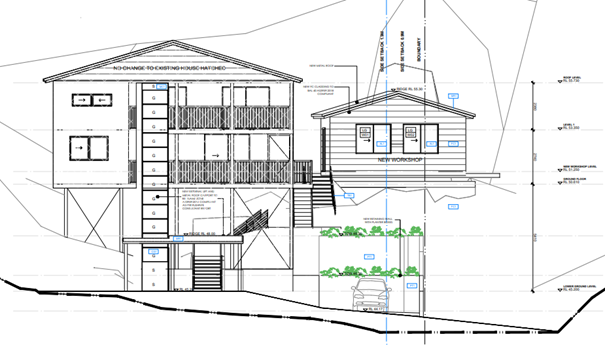
Figure 5 Proposed lift, carport and workshop
ASSESSMENT:
Having regard for the matters for consideration detailed in Section 4.15 of the Environmental Planning and Assessment Act 1979 and other statutory requirements, the assessment has identified the following key issues.
State Environmental Planning Policy (Building sustainability Index) BASIX 2004
A compliant BASIX certificate achieving the State Governments Energy Efficiency targets has been provided in support of the application.
State Environmental Planning Policy No 71 – Coastal Protection
The subject land falls within the ‘Coastal Zone’ under [now repealed] State Environmental Planning Policy No 71 – Coastal Protection.
State Environmental Planning Policy No 71 (Coastal Protection) (SEPP 71) was repealed on 3 April 2018 when the State Environmental Planning Policy (Coastal Management) 2018 (SEPP Coastal Management) came into effect. The savings and transitional provisions contained within the SEPP Coastal Management state the SEPP 71 provisions continue to apply if a development application is lodged and not finally determined prior to the commencement of the SEPP Coastal Management.
The provisions of SEPP 71 require the consent authority to consider the aims and objectives of SEPP 71 together with the matters for consideration listed in Clause 8 of SEPP 71 when determining an application within the Coastal Zone. The Coastal Zone is an area defined on maps issued by the NSW Department of Planning and Environment and the subject property falls within this zone.
The relevant matters have been considered in the assessment of this application. The application is considered consistent with the stated aims and objectives of SEPP 71.
State Environmental Planning Policy (Coastal Management) 2018
Whilst the savings and transitional provisions of SEPP Coastal Management apply, the proposed development has also been considered against the provisions of SEPP Coastal Management and considered satisfactory.
Gosford Local Environmental Plan 2014- Zoning and Permissibility
The subject site is zoned R2 - Low Density Residential under the provisions of GLEP 2014.
The proposed development is best defined as a ‘dwelling house’:
‘dwelling house means a building containing only one dwelling.’
The development of a dwelling house is permitted in the zone with consent.
Gosford Local Environmental Plan 2014 - Objectives of Zone
The subject site is zoned R2 - Low Density Residential under the provisions of GLEP 2014, which has the following objectives:
· To provide for the housing needs of the community within a low density residential environment.
· To enable other land uses that provide facilities or services to meet the day to day needs of residents.
· To ensure that development is compatible with the desired future character of the zone.
· To encourage best practice in the design of low-density residential development.
· To promote ecologically, socially and economically sustainable development and the need for, and value of, biodiversity in Gosford.
· To ensure that non-residential land uses do not adversely affect residential amenity or place demands on services beyond the level reasonably required for low-density housing.
In this instance, it is considered that the proposal is consistent with the stated objectives of the zone and consistent with the principles of Ecologically Sustainable Development as specified within the Local Government Act 1993.
The proposed development provides for residential development that is consistent with the nature of the locality, does not have unacceptable impacts on the natural environment and does not adversely impact residential amenity.
Gosford Local Environmental Plan 2014 Clause 4.3 - Height of buildings
The proposed development proposes a height that does not comply with the development standard set out in GLEP 2014.
|
Development Standard |
Required |
Proposed |
Compliance with Controls |
Variation % |
Compliance with Objectives |
|
4.3 – Height of buildings |
8.5m |
The proposal seeks a maximum height of 10.53m. |
No – see comments below |
23.8% |
Yes – see comments below |
The proposed mapped height limit variation is supported by a Clause 4.6 application to vary the development standard. The elevations and site plan for the development are provided within this report.
Gosford Local Environmental Plan 2014 Clause 4.6 - Exceptions to development standards
The proposed application seeks to vary the mapped permissible height controls provided for within GLEP 2014.
Height Variation
The applicant seeks a variation to Clause 4.3(2) of GLEP 2014 in relation to the proposed maximum height of the dwelling. In this regard, the proposal seeks a maximum overall height of 10.53m in lieu of the 8.5m maximum height limit applicable to the allotment, resulting in a variation of 23.8%.
Clause 4.6 (3) of GLEP 2014 requires consideration of the following:
‘Development consent must not be granted for development that contravenes a development standard unless the consent authority has considered a written request from the applicant that seeks to justify the contravention of the development standard by demonstrating –
(a) that compliance with the development standard is unreasonable or unnecessary in the circumstances of the case, and
(b) that there are sufficient environmental planning grounds to justify contravening the development standard.’
and Clause 4.6 (4) of GLEP 2014 requires consideration of the following:
‘Development consent must not be granted for development that contravenes a development standard unless—
(a) the consent authority is satisfied that—
(i) the applicant’s written request has adequately addressed the matters required to be demonstrated by subclause (3), and
(ii) the proposed development will be in the public interest because it is consistent with the objectives of the particular standard and the objectives for development within the zone in which the development is proposed to be carried out, and
(b) the concurrence of the Planning Secretary has been obtained.’
The height of the proposed development is described, by the applicant, in the table below:
|
Height of Buildings Control |
8.5m |
|
Existing Height of Building |
12.69m |
|
Max. Proposed Height (m) – measured from EGL |
Proposed height of 10.53m (Lift Structure) - variation of 2.03m (Lift Structure). |
The variation in height is illustrated at Figure 6 and Figure 7, which also illustrates that, due to the steeply sloping topography, the existing two storey dwelling also exceeds the maximum height limit, having a height of 12.69m. The current variation is a consequence of this exceedance with the lift structure required to service all habitable areas of the dwelling.
In accordance with Clause 4.6 of GLEP 2014, the applicant has provided a detailed request to vary the height development standard by the proposed 23.8 %. This written submission is included as Attachment 4.
Figure 6 East (Front) Elevation
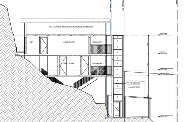
Figure 7 – Cross-Section through dwelling showing height of existing dwelling (12.69m) and height of proposed lift (10.53m)
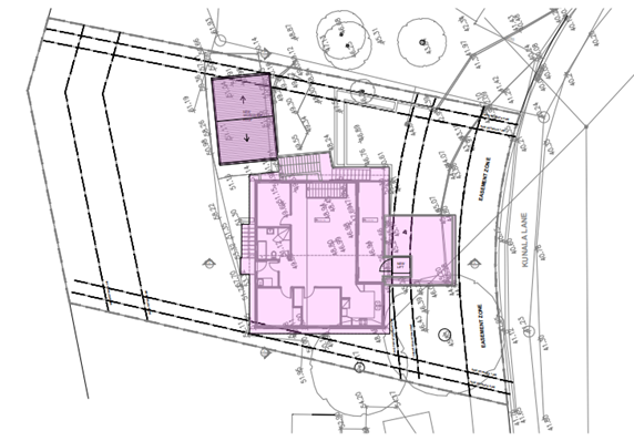
Figure 8 Site Plan
Council Consideration of Proposed Variation
In reviewing the proposal, the objectives of the R2 Low Density Residential Zone have been undertaken in the context of the height variation. In considering these zone objectives, the following points are considered relevant:
• Dwelling Houses are permissible within the zone and the proposal satisfies the zone objective in terms of the provision of low-density residential development.
• The proposed dwelling design is considered in keeping with the existing and desired future character of the area.
• The design of the dwelling incorporates suitable architectural design elements and incorporates sustainable design features.
GLEP 2014 sets out six objectives pertaining to the building height development standard. The objectives are contained within Clause 4.3 (1) (a) to (f). These objectives are replicated below and commentary in respect to compliance or otherwise with each objective in relation to the proposed development are included as follows:
a) to establish maximum height limits for buildings,
The proposed height of the building, whilst exceeding the numerical height limit, is consistent with numerous other dwellings within the vicinity on this steep coastal hillside locality.
b) to permit building heights that encourage high quality urban form,
The new lift incorporating a skillion roof form and extensive glass material will result in a contemporary design and use of quality materials that will encourage a desired urban form in the locality.
c) to ensure that buildings and public areas continue to receive satisfactory exposure to sky and sunlight,
The proposed alterations and additions will not result in any overshadowing.
d) to nominate heights that will provide an appropriate transition in built form and land use intensity,
The height exceedance relates to the proposed lift on the eastern elevation. The lift exceeds the 8.5m building height requirement by 2.03m, but is less than the 12.69m height of the existing dwelling roof.
e) to ensure that taller buildings are located appropriately in relation to view corridors and view impacts and in a manner that is complementary to the natural topography of the area,
The proposed design meets the relevant zone objectives and does not cause any unreasonable level of view loss impacts to the adjoining and surrounding properties.
f) to protect public open space from excessive overshadowing and to allow views to identify natural topographical features.
The proposed design and height will not create any overshadowing to public open spaces and not impact on viewing natural topographical features from surrounding open spaces within the Horsfield Bay locality.
In terms of the proposed design, it is noted that the height exceedance is the proposed lift on the eastern elevation. The proposal meets the relevant zone objectives and does not cause view loss impacts to the adjoining properties.
It is considered that the applicant’s request to vary the development standard would be consistent to the height and scale of other dwellings within the immediate area. In addition, the development would not impose any unreasonable level of detrimental impact on the amenity of residents in nearby dwellings. It has been concluded the steepness of the site contribute to the difficulty in complying with the height controls.
Having regard to the site factors, minimal impact on the character of the area and neighbouring residents, the applicant’s request to vary the height development standard is considered reasonable and therefore supported.
Gosford Local Environmental Plan 2014 Clause 7.1 - Acid Sulfate Soils
The subject site has been identified as containing potential Class 5 acid sulfate soils. Clause 7.1 of the GLEP 2014 requires that an acid sulfate soils management plan must be prepared where:
· work within Class 5 Acid Sulfate Soils are located below 5m AHD, and
· the water table is likely to be lowered below 1m AHD on adjacent lands containing class 1, 2, 3 or 4 soils.
It is considered that an acid sulfate soils management plan is not required in this instance.
Draft Central Coast Local Environmental Plan 2018 (Draft CCLEP 2018)
Following a review of the Draft Central Coast Local Environmental Plan 2018 (Draft CCLEP 2018), which was exhibited until 27 February 2018, the subject site retains its low density R2 residential zoning, with dwelling houses remaining permissible with consent.
Gosford Development Control Plan 2013
Gosford Development Control Plan 2013 Chapter 2.1 – Character
The subject land is situated within the Horsfield Bay 1: Woodland Hillsides Character Area, as set out in the Gosford Development Control Plan 2013 (GDCP 2013)
The GDCP 2013 sets out the following desired character attributes:
‘Horsfield Bay 1: Woodland Hillsides – Desired Character
These should remain very
leafy low-density residential hillsides, conserving natural and scenic
qualities of the bushland backdrops that are fundamental features of Gosford
City’s identity, where landscape settings that adjoin bushland reserves
are not dominated by new development.
Conserve natural and scenic characters of wooded hillside properties plus unformed road verges by retaining natural slopes and the continuity of tree-canopy that is provided by existing bushland remnants. Complement the established tree canopy by new plantings that are predominantly indigenous, and do not plant any identified noxious or environmental weeds. Facing all boundaries, emphasise a leafy garden character by avoiding tall retaining walls, fences that are not see-through, elevated structures such as terraces or pools, and steep driveways that would visibly compromise the existing bushy hillside character.
In areas that are defined
as bushfire prone, hazard must not be increased by inappropriate new plantings
or structures. Minimise the extent of cleared asset protection zones by
fire-resistant siting, design and construction for all new structures plus
effective management of gardens. The ideal compromise between desired scenic
quality and hazard-reduction would limit clearing to thinning of the canopy to
establish breaks between existing trees. Screen or shield all verandahs,
windows, roofs and suspended floors to prevent the entry of sparks and flying
embers.
Avoid disturbing natural
slopes and trees by appropriate siting of structures plus low-impact
construction such as suspended floors and decks rather than extensive
cut-and-fill. On the steeper sites, locate parking next
to the street in structures that are designed to blend with their natural
setting. Avoid the appearance of a continuous wall of development along any
street or hillside by locating buildings within setbacks that are similar to
their surrounding properties, and by providing at least one wide side setback
or stepping the shape of front and rear facades.
Minimise the scale and
bulk of buildings by strongly-articulated forms that sit beneath the canopy,
with floor-levels that step to follow natural slopes and irregular floorplans,
such as linked pavilions that are separated by courtyards and capped by
individual roofs. Front or rear facades that are taller than neighbouring
dwellings should be screened by balconies, verandahs, stepped forms or extra
setbacks. Roofs should be gently pitched to minimise the height of ridges, and
flanked by wide eaves to disguise the scale of exterior walls.
Minimise the scale of prominent facades by using extensive windows and verandahs plus a variety of materials and finishes rather than expanses of plain masonry. Where dwellings would be visible from their road frontage, display a traditional “street address” with verandahs or decks, and living rooms or front doors that are visible from that roadway. Avoid wide garages that would visually-dominate any front façade. Locate and screen all balconies or decks to maintain the existing levels of privacy and amenity that are enjoyed by neighbouring dwellings.’
The proposed development is consistent with the desired character of the area. The proposal does not cause any significant detrimental impact in terms of the scenic character of the location. In this respect, the vegetated hillsides and road verges are maintained, with work undertaken primarily within the existing developed portion of the lot. Suspended floors and decks are preferred over extensive cut-and-fill and the proposal is appropriately designed gene the topography and constraints of the site. The proposal does not have any adverse impact in terms of amenity of privacy for adjoining dwellings.
Gosford Development Control Plan 2013 Chapter 3.1 – Dwelling Houses, Secondary Dwellings and Ancillary Development
The following table provides an evaluation of the development against the provisions of GDCP 2013 Chapter 3.1:
|
Chapter 3.1 |
Requirement |
Proposed |
Compliance |
|
Clause 3.1.2.1 Building Height |
Three storeys on steeply sloping sites. 8.5m building height |
The dwelling has two storeys
10.53m |
Yes
No – see comments below |
|
Clause 3.1.2.2 Site Coverage |
Maximum 50% site coverage. |
24.9% |
Yes |
|
Clause 3.1.2.3 FSR |
0.5:1 floor space ratio |
0.21:1 |
Yes |
|
Clause 3.1.3.1a – Front Setback |
This is the average of the nearest two dwellings having the same primary road boundary and located within 40m of the lot on which the dwelling house is to be erected. |
4m |
No -see comments below
|
|
Clause 3.1.3.1b – Rear Setback |
3m Rear setback to a parallel road
|
13.9m
|
Yes
|
|
Clause 3.1.3.1c – Side Setback |
Height up to 4.5m – 0.9m |
Workshop 0.9m to 2.5m |
Yes
|
|
Clause 3.1.4.1 |
To encourage view sharing between properties
|
Existing views to and from the site are not obstructed due to the low scale nature of the proposed development |
Yes
|
|
Clause 3.1.4.2 Visual Privacy |
To minimise direct overlooking between main living areas and areas of principle private open space within the site and adjoining sites |
Given the steep topography of the site, the proposal is considered to meet the requirements of this clause |
Yes |
|
Clause 3.1.5 – Car Parking and Access |
2 car spaces
|
2 car spaces
|
Yes
|
|
Clause 3.1.6 Earthworks, Structural Support and Drainage |
Cut – 3m when more than1m from the boundary |
2.0m |
Yes |
|
Clause 3.1.6.2 Retaining wall |
1m above ground designed by a Structural Engineer |
Structural Engineer designed |
Yes |
|
Clause 3.1.7.3 Detached Studios |
No. required 1
Max. floor area 50m2 |
No. proposed 1
Floor area 30m2 |
Yes
Yes |
Gosford Development Control Plan 2013 Clause 3.1.2.1 Building Height
The applicant seeks a variation to the proposed maximum height of the dwelling. In this regard, the proposal seeks a maximum overall height of 10.53m in lieu of the 8.5m maximum height limit applicable to the allotment. The variation proposed is 23.8%.
An assessment of the building height has been carried out under the GLEP 2014. The proposed development is consistent to the height of other buildings on the hillside. The proposal meets the relevant zone objectives and does not cause view loss impacts or an unreasonable level of overshadowing to the adjoining properties.
It is considered the applicants request to vary the development standard would be consistent to the height and scale of other dwellings within the immediate area. In addition, the development would not impose any unreasonable level of detrimental impact on the amenity of residents in nearby dwellings. It has been concluded the steepness of the site contribute to the difficulty in complying with the height controls and comparisons to the height and scale of other dwellings along the hillside provide justification to vary them.
Gosford Development Control Plan 2013 Clause 3.1.3.1a Front Setback
The development proposes a front setback of 4m to the carport. The average setback distance calculated using the two adjacent properties is 8.5m. A carport is required to be setback 1m behind the front building line which would be 9.5m. The proposed setback is a variation of 5.5m or 58%.
The setback variation is considered against the objectives of the clause
Objectives: To ensure that setbacks are compatible with adjacent development and complements the character, streetscape, public reserve, or coastal foreshore
Comment – the location of the parking platform is existing on the site. The Character Statement for the locality recommends, “On the steeper sites, locate parking next to the street in structures that are designed to blend with their natural setting”. The proposed carport complies with this requirement.
Objective: To ensure the visual focus of a development is the dwelling, not the garage
Objective: To protect the views, privacy and solar access of adjacent properties
Comment – the carport and lift structure do not impact on views, privacy or solar access of neighbouring properties.
Objective: To maintain view corridors to coastal foreshores and other desirable outlooks
Comment – the carport and lift structure do not impact on views corridors.
Objective: To maintain the scenic and environmental qualities of natural waterbodies and their foreshores and respond to site attributes such as topography
Comment – both the lift and carport are transparent in appearance and do not require removal of vegetation for their construction and installation on site.
Objective: To provide deep soil areas sufficient to conserve existing trees or accommodate new Landscaping
Comment - Neither the lift and carport require removal of vegetation for their construction and installation on site. The front setback of the site will remain vegetated.
Objective: To provide appropriate articulation of facades and horizontal elements reduce the appearance of bulk and provides visual interest to the building and subsequent streetscape where they face a street frontage(s)
Comment - both the lift and carport are transparent in appearance. The lift represents only 11.1% of the building façade width.
Giving consideration to the objectives related to front setback, the proposed variation is considered acceptable and is recommended for approval.
Gosford Development Control Plan 2013 Chapter 6.3 Erosion Sedimentation Control
Appropriate conditions for erosion and sediment control are recommended within the proposed conditions of consent, for the consideration of the Panel.
Gosford Development Control Plan 2013 Chapter 6.4 Geotechnical Requirements for Development Applications
The subject land is not identified as being at risk of land slip, as defined within the GDCP 2013.
The application has been accompanied by a Geotechnical Assessment prepared by Ascent Geotechnical Consulting (reference AG 21318 dated 18 October 2021). The report notes that the proposed development is suitable for the site and provides recommendations as to construction methodologies.
Gosford Development Control Plan 2013 Chapter 7.2 Waste Management
A waste management plan has been submitted in support of the proposed development. The waste management plan is considered appropriate, given the scale and nature of the development.
Bushfire
The subject land is identified as being bushfire prone land. The site is constrained by vegetation classified as ‘Category 1 Bushfire Vegetation’.
The application is supported by a Bushfire Assessment Report referenced 79BA-2254, prepared by Sydney Bushfire Consultants dated 4 November 2021.
The report concludes the bushfire attack level (BAL) for the development to be constructed to BAL FZ for the carport and lift, BAL 40 for the workshop as outlined in AS3959 – 2018 and NSWRFS ‘Planning for Bushfire Protection’ (November 2019). The recommendations of this report are supported and appropriate conditions of consent are included for the consideration of the Panel.
The likely impacts of the development
Built Environment
Given the position of the proposed dwelling on the allotment and comparison of bulk and scale with other dwellings, the proposal is considered to be suitable with regard to the context and setting of the subject site and is considered to be in keeping with the character of the area.
A thorough assessment of the proposed development’s impact on the built environment has been undertaken in terms of the GLEP 2014 and GDCP 2013 compliance. It is considered, on balance, that the potential impacts are reasonable.
Natural Environment
The proposal involves some site excavation given the site’s sloping topography. Whilst there is some impact upon the natural environment, this is considered to be reasonable as the main bulk of excavation occurs to the north of the existing dwelling. Accordingly, the proposal is considered satisfactory in relation to impacts on the natural environment.
Public Submissions
The application was placed on public exhibition in accordance with the provisions of the GDCP 2014 and one submission has been received. The concerns are as follows:
1. Want to ensure there is no dumping of building material and green waste onto adjacent property.
Comment: A sediment and erosion control plan and a waste management plan have been submitted in support of the application. The requirements of these plan and appropriate conditions of consent will mitigate against impacts on adjoining lands, including dumping of material, green waste and other such matters.
Other Matters for Consideration:
Removal of Trees
Minimal clearing is proposed with the structures to be constructed on already built upon land, retaining the existing landscaping qualities of the site.
Development Contribution Plan
The proposed development is not a development type that is subject to Section 7.11 or Section 7.12 of the Environmental Planning and Assessment Act 1979. Therefore, no development contributions are applicable.
Water and Sewer Contributions
The proposed development is not subject to water and sewer contributions, as the site is already connected to these services and no increase in loading is proposed.
Ecologically Sustainable Development Principles:
The proposal has been assessed having regard to ecologically sustainable development principles and is considered to be consistent with the principles.
The proposed development is considered to incorporate satisfactory stormwater, drainage and erosion control, retention of vegetation where possible, is unlikely to have any significant adverse impacts on the environment and will not decrease environmental quality for future generations. The proposal does not result in the disturbance of any endangered flora or fauna habitats and is unlikely to significantly affect fluvial environments.
The Public Interest
The proposed development represents a relatively modest addition to an existing residence. The proposal, despite the proposed variation to height, is consistent with the locality and an appropriate development given constraints if the site presented by topography. The public interest is best served by approval of the application.
Conclusion:
The development application has been assessed in accordance with Section 4.15 of the Environmental Planning and Assessment Act 1979 and relevant instruments and polices. The proposed development is considered suitable for the site, despite the identified variations. The proposal is therefore recommended for approval pursuant to Section 4.16 of the Environmental Planning and Assessment Act 1979.
|
1⇩ |
Draft Conditions of Consent |
|
D15124320 |
|
2⇨ |
Unredacted Development Plans - provided to Panel only as contain internal floor plans |
Provided Under Separate Cover |
D14986625 |
|
3⇩ |
Redacted Development Plans |
|
D14986643 |
|
4⇩ |
Applicant's Objection Under Clause 4.6 - Height |
|
D14986628 |
|
4.2 |
DA/2059/2021 - 17 Kunala Lane Horsfield Bay - Alterations & Additions to Existing Dwelling |
|
Attachment 1 |
Draft Conditions of Consent |

|
DA/2059/2021 - 17 Kunala Lane Horsfield Bay - Alterations & Additions to Existing Dwelling |
|
|
Attachment 3 |
Redacted Development Plans |
|
4.2 |
DA/2059/2021 - 17 Kunala Lane Horsfield Bay - Alterations & Additions to Existing Dwelling |
|
Attachment 4 |
Applicant's Objection Under Clause 4.6 - Height |
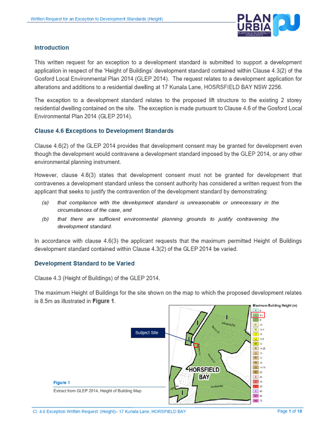
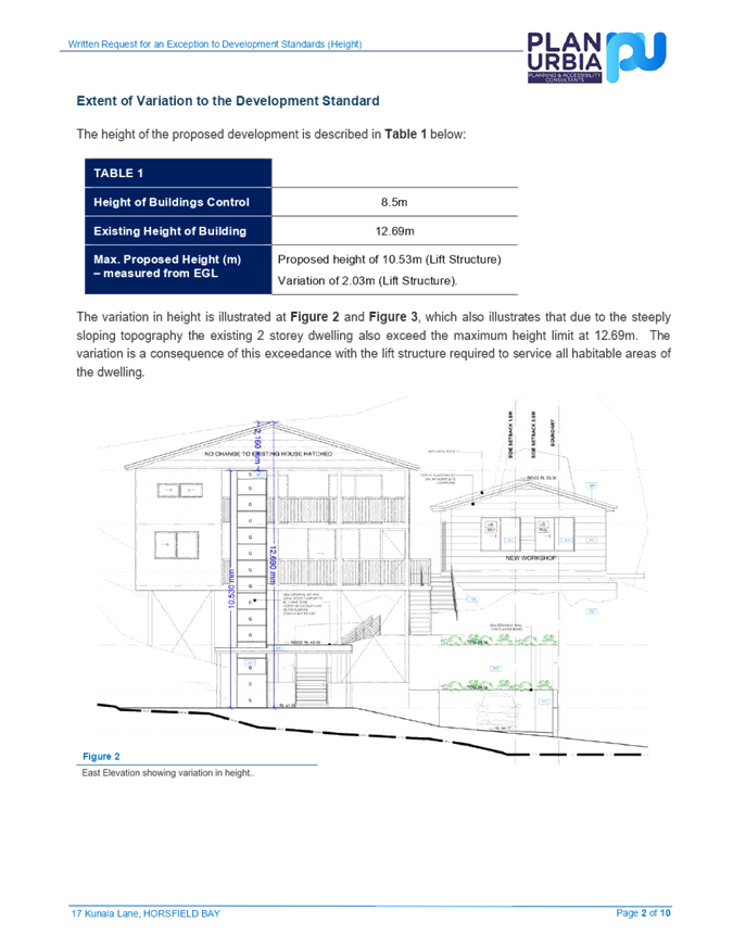
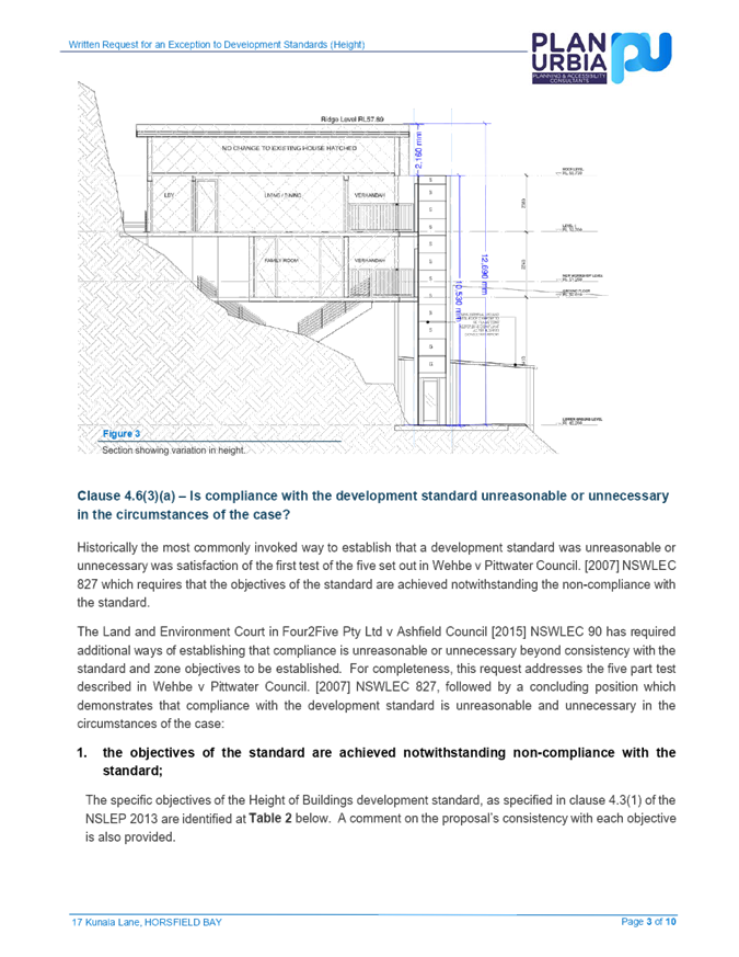
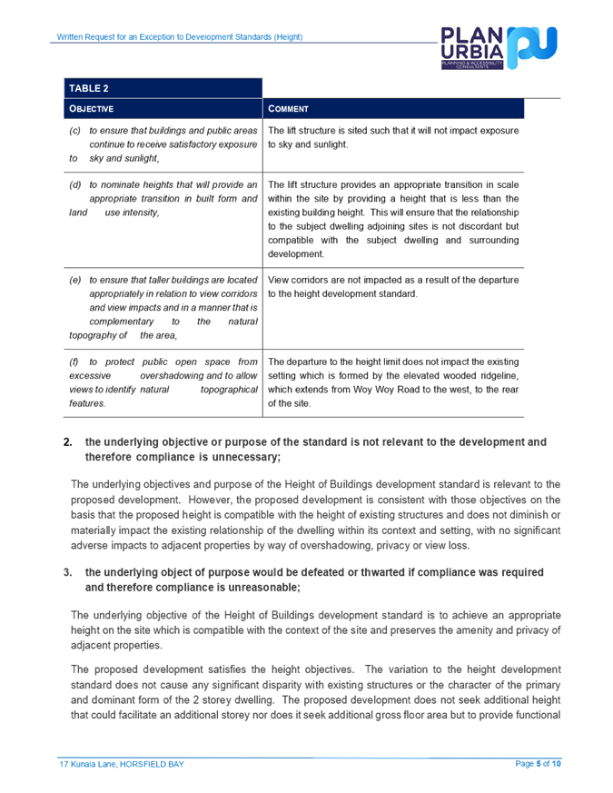
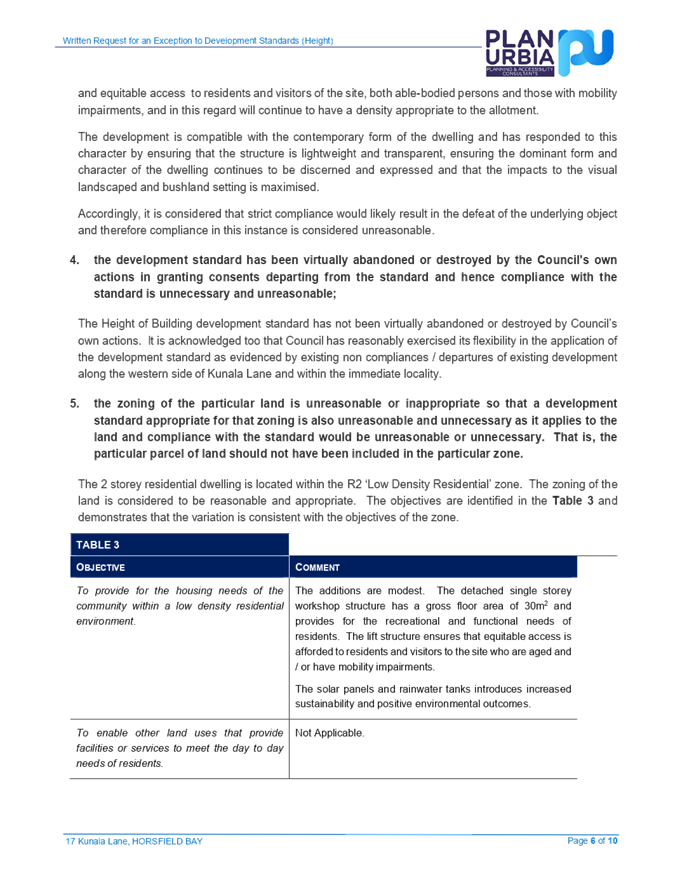
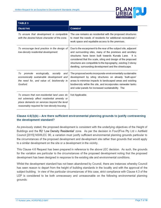

|
Item No: 4.3 |
|
|
Title: Request to prepare a Planning Proposal for 60 Wyong Road, Tuggerah (Tuggerah Gateway Site) |
|
|
Department: Environment and Planning |
|
|
23 June 2022 Local Planning Panel Meeting |
|
Reference: RZ/2/2021 - D15180762
Author: Lynda Hirst, Principal Strategic Planner
Manager: Scott Duncan, Section Manager Land Use and Policy
David Milliken, Unit Manager Strategic Planning
Executive: Alice Howe, Director Environment and Planning
Summary
A request to prepare a planning proposal has been received for Lot 2 DP1056960 and Lot 3 DP1084221, 60 Wyong Road, Tuggerah.
The proposal (RZ/2/2021) is referred to the Local Planning Panel for advice prior to reporting the matter to Council.
The proposal seeks to rezone part of the site from RU6 Transition to R1 General Residential and undertake a minor realignment of the existing B4 Mixed Use zone. The existing C2 Environmental Conservation zone will be retained.
Please refer to supporting attachments, including the Council Report and strategic assessment, that outline how the proposal satisfies the relevant legislation and strategic planning policies.
Recommendation
That the Local Planning Panel:
1 Consider the planning proposal (Attachments 2 and 3) and draft Council report (Attachment 1).
2 Provide independent advice on the planning proposal for consideration by Council.
|
1⇩ |
Draft Council Report - Request to prepare a Planning Proposal for 60 Wyong Road, Tuggerah (Tuggerah Gateway Site) |
|
D15181521 |
|
2⇩ |
Planning Proposal Assessment Report - Tuggerah Gateway Site |
|
D15181925 |
|
3⇩ |
Planning Proposal Strategic Assessment - Tuggerah Gateway Site |
|
D15181926 |
|
4.3 |
Request to prepare a Planning Proposal for 60 Wyong Road, Tuggerah (Tuggerah Gateway Site) |
|
Attachment 1 |
Draft Council Report - Request to prepare a Planning Proposal for 60 Wyong Road, Tuggerah (Tuggerah Gateway Site) |
|
Request to prepare a Planning Proposal for 60 Wyong Road, Tuggerah (Tuggerah Gateway Site) |
|
|
Attachment 2 |
Planning Proposal Assessment Report - Tuggerah Gateway Site |
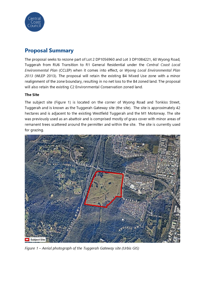
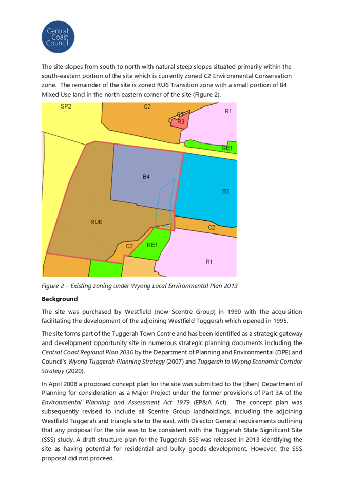
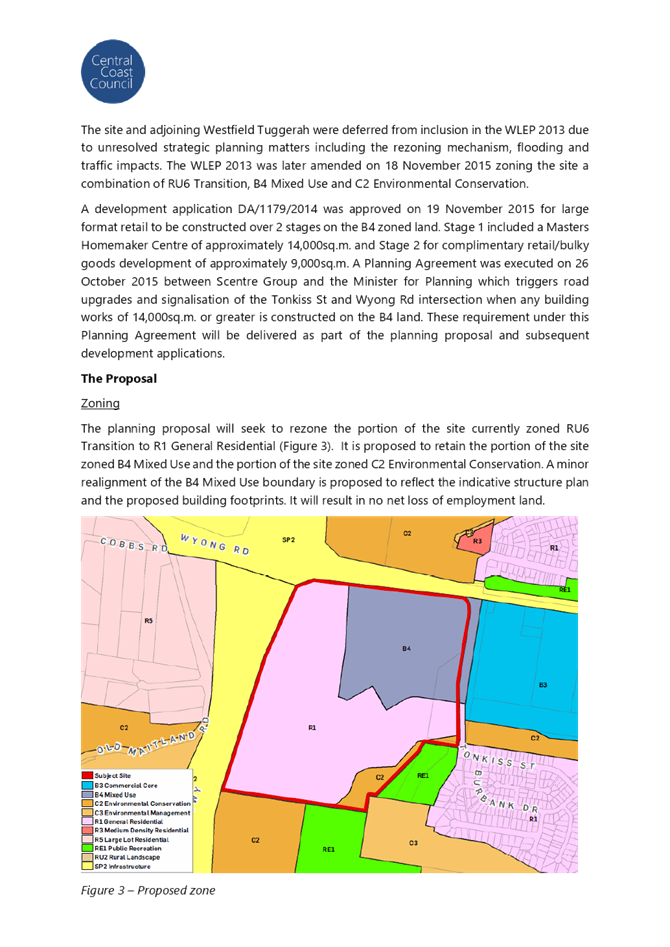
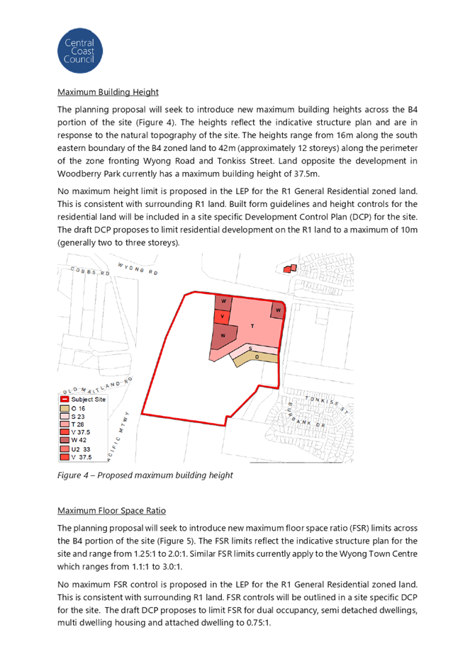
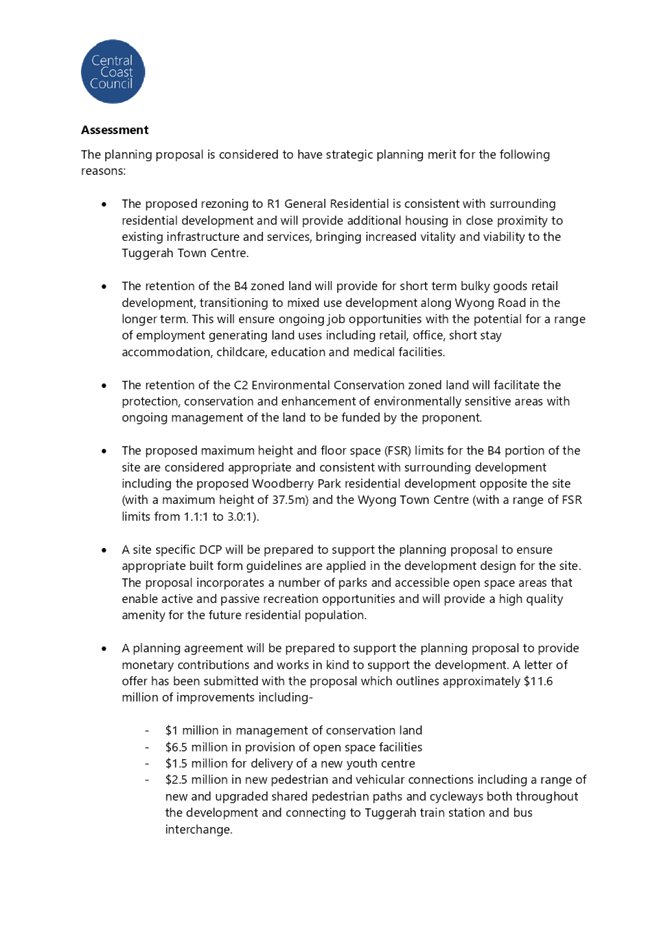
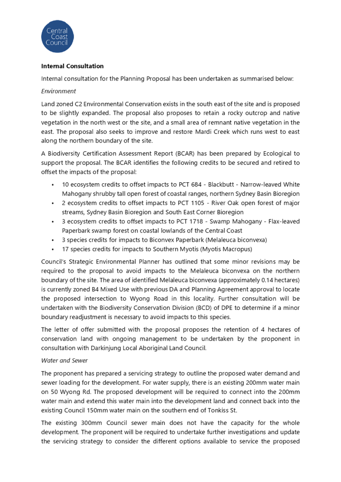
|
Request to prepare a Planning Proposal for 60 Wyong Road, Tuggerah (Tuggerah Gateway Site) |
|
|
Attachment 3 |
Planning Proposal Strategic Assessment - Tuggerah Gateway Site |
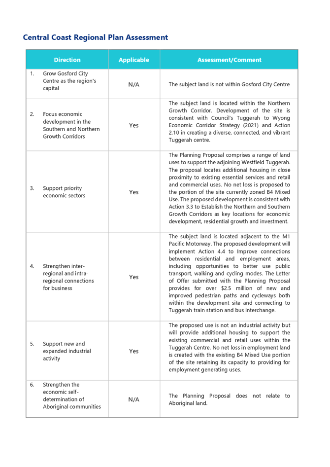
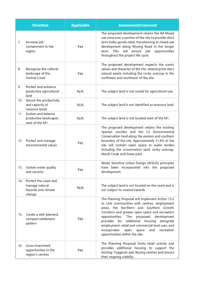
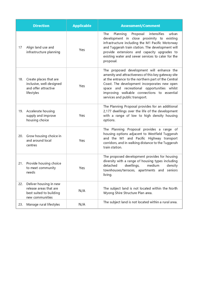
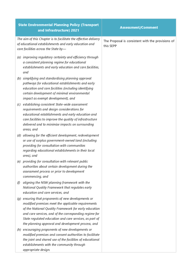
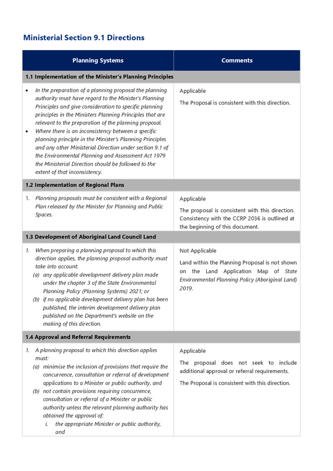
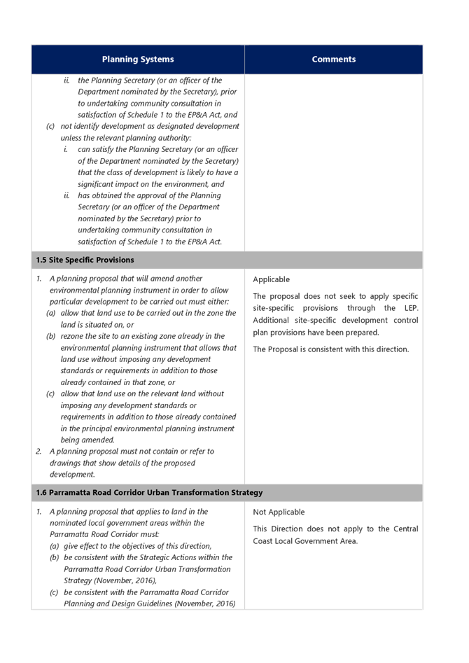
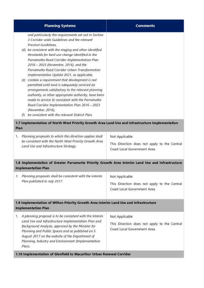
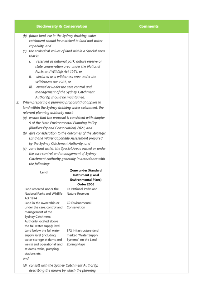
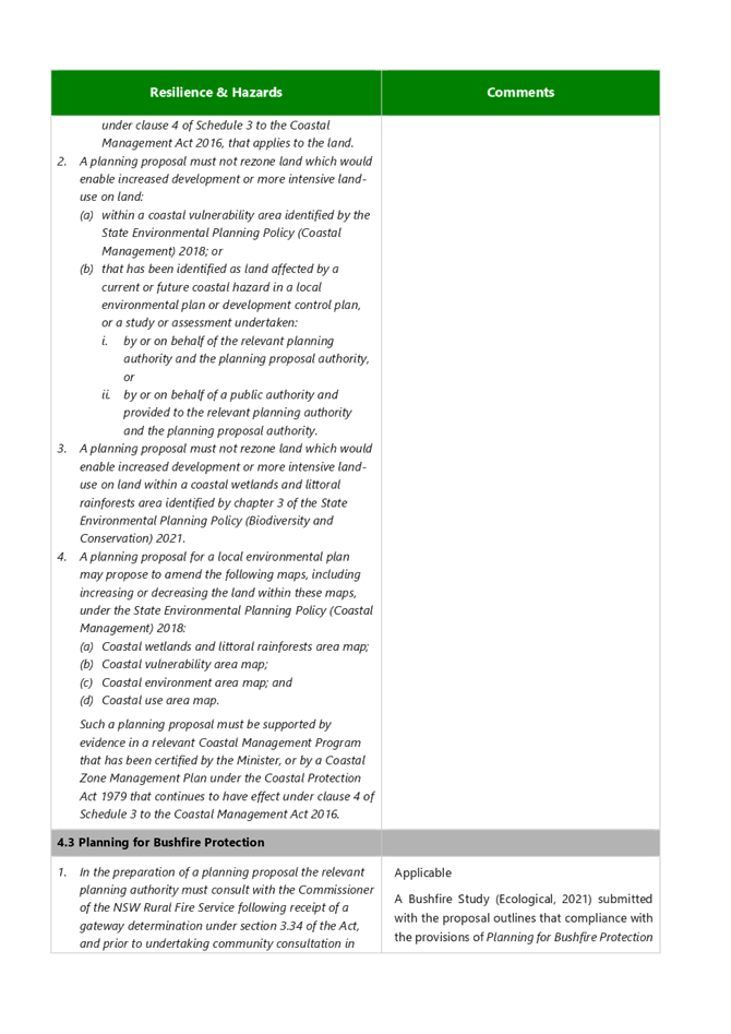
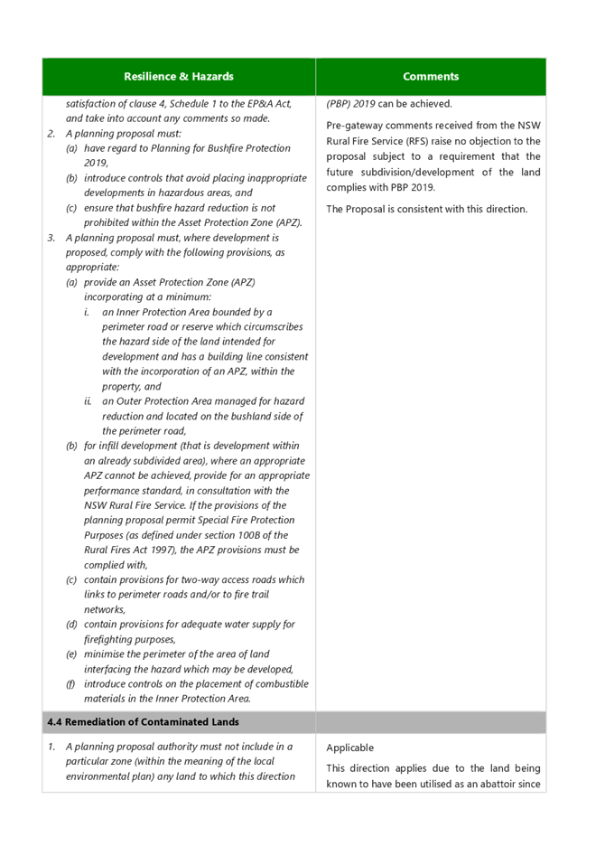
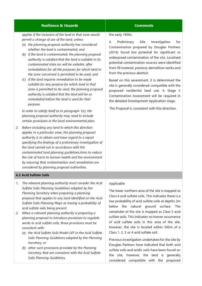
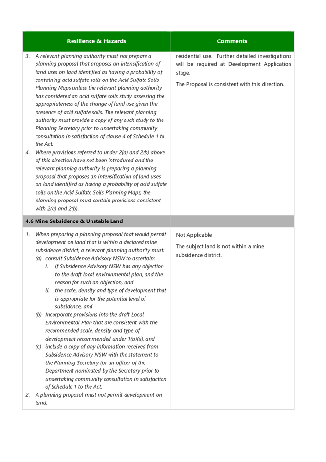
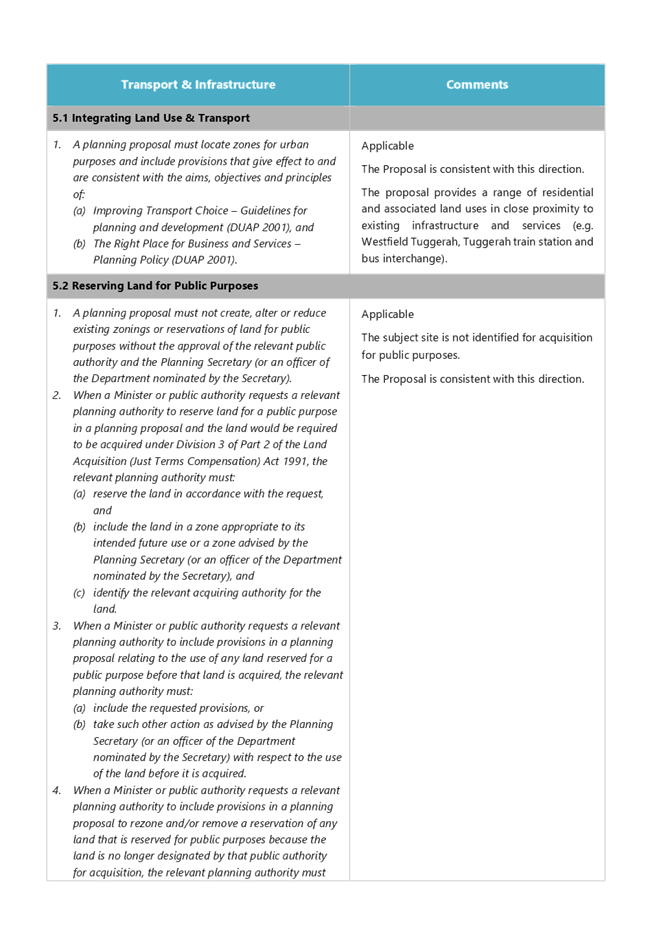
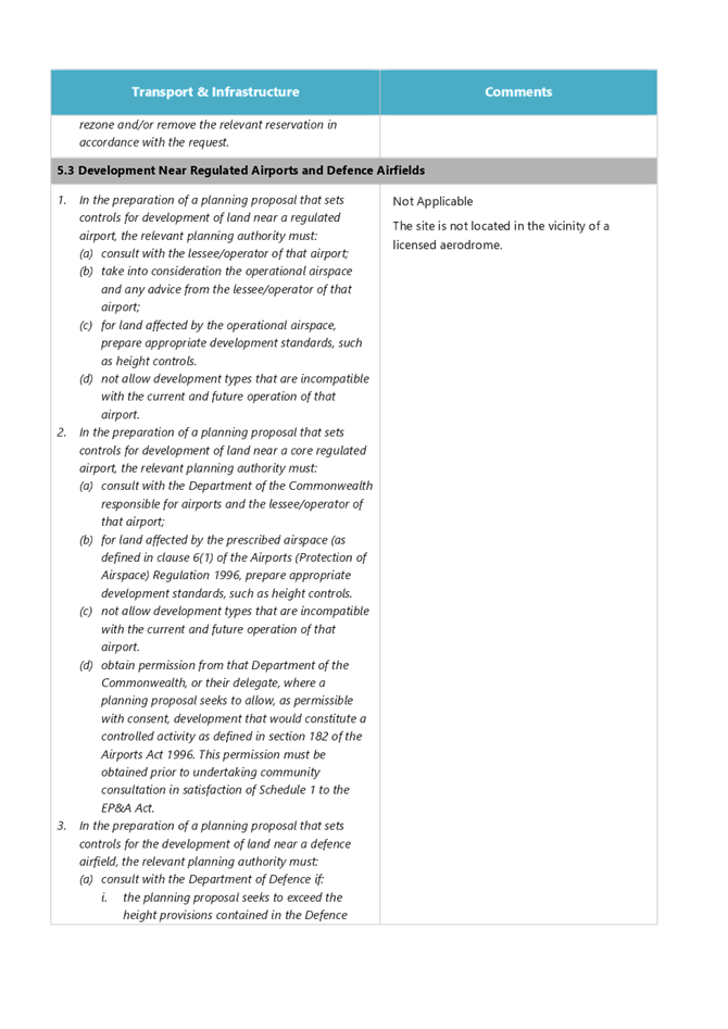
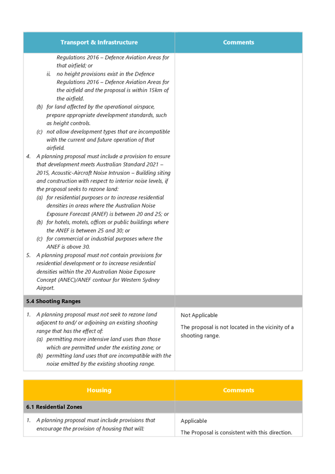
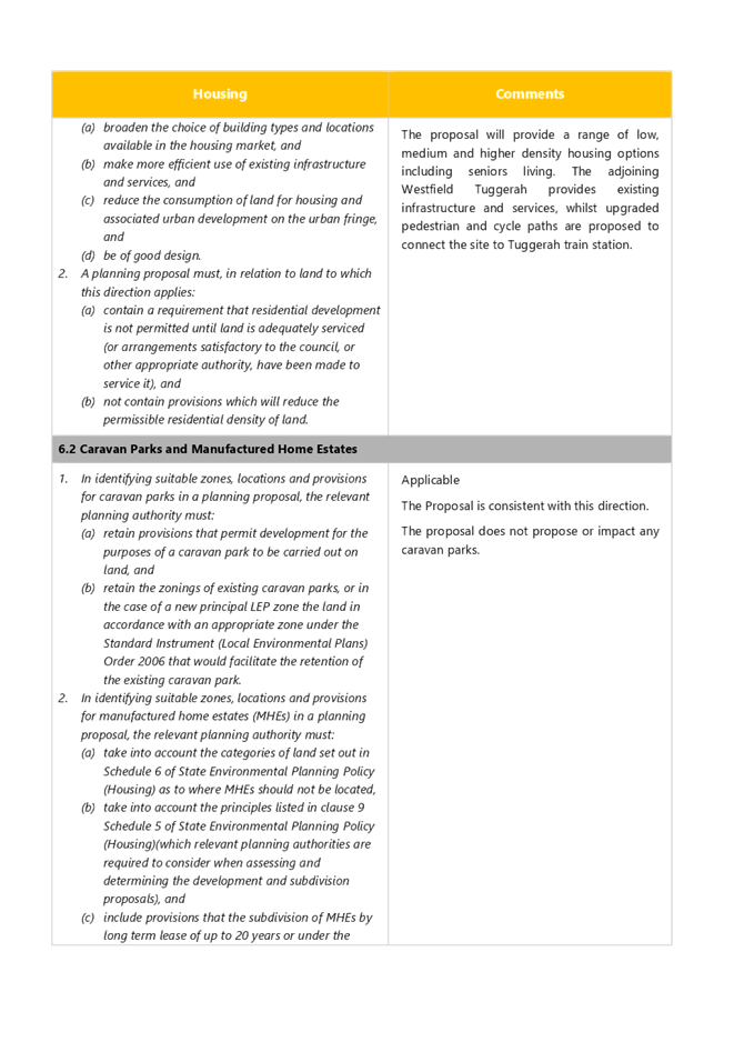
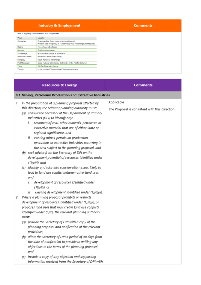
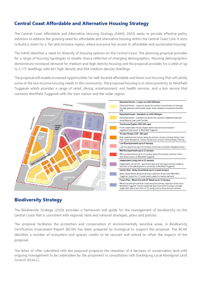
|
Item No: 5.1 |
|
|
Title: Central Coast Local Planning Panel - Membership |
|
|
Department: Environment and Planning |
|
|
23 June 2022 Local Planning Panel Meeting |
|
Reference: F2020/02502 - D15189801
Author: Andrew Roach, Unit Manager, Development Assessment
Executive: Alice Howe, Director Environment and Planning
Summary
The purpose of this report is to advise that:
· The appointment period of current Central Coast Local Planning Panel members has been extended until 29 February 2024, and
· Two additional members have been appointed to the Central Coast Local
Planning Panel.
Recommendation
That the Local Planning Panel:
1 Note the information contained within this report.
2 Write to retiring Panel member, Mr Garry Fielding, thanking him for his service on the Panel.
Background
The Central Coast Local Planning Panel was constituted via resolution at the Ordinary Meeting of Central Coast Council on 11 May 2020. Panel appointments were due to expire on 11 May 2023.
Extension of Term of Appointment
The Department of Planning and Environment (DPE) has advised its intention to bring into alignment the appointment periods of all Local Planning Panels throughout NSW. On this basis, the Minister for Planning has required that all councils appoint their Local Planning Panel to a term expiring on 29 February 2024.
Consequently, at the Ordinary Meeting of Council on 24 May 2022 it was resolved that the appointment period for current Central Coast Council Panel members be extended to 29 February 2024.
Appointment of Additional Expert Local Planning Panel Members
Since the inception of the Local Planning Panel, one of the appointed expert Panel members has advised that they are no longer able to fulfil their Panel commitments as a result of other commitments.
In order to ensure that the Central Coast Local Planning Panel is capable of functioning as intended, and in order to meet the legislative requirements for Panel operations, at the Ordinary Meeting of Council on 24 May 2022 it was also resolved that the appointment of two additional expert Panel members be made.
A copy of the report to Council on 24 May 2022 is included as Attachment 1, with the full list of current Panel membership at Attachment 2.
|
1⇩ |
Report to Council - 24 May 2022 - Central Coast Local Planning Panel Membership |
|
D15158832 |
|
2⇩ |
Local Planning Panel Members May 2022 |
|
D15193751 |
|
5.1 |
Central Coast Local Planning Panel - Membership |
|
Attachment 1 |
Report to Council - 24 May 2022 - Central Coast Local Planning Panel Membership |