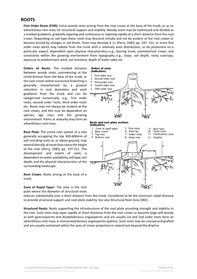
 |
Central Coast
Local Planning Panel Meeting
Business Paper
13 July 2023
 |
|
Central Coast
Local Planning Panel Meeting
Business Paper
13 July 2023
|
The Local Planning Panel Meeting
of Central Coast
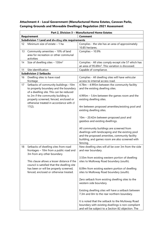
will be held remotely - online,
Thursday 13 July 2023 at 2.00 pm,
for the transaction of the business listed below:
1 Procedural Items
1.1 Disclosures of Interest.............................................................................................................................. 3
2 Confirmation of Minutes of Previous Meetings
2.1 Confirmation of Minutes of Previous Meeting................................................................................. 4
3 Planning Reports
3.1 DA/2807/2022 - 36 Kourung Street Ettalong Beach - Multi Dwelling Housing.................... 8
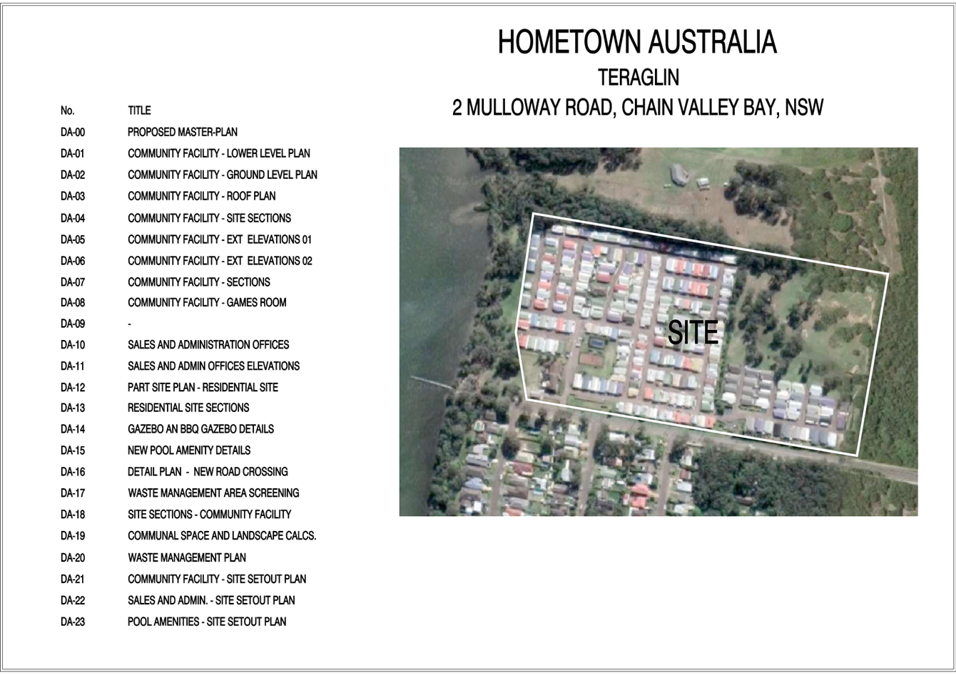
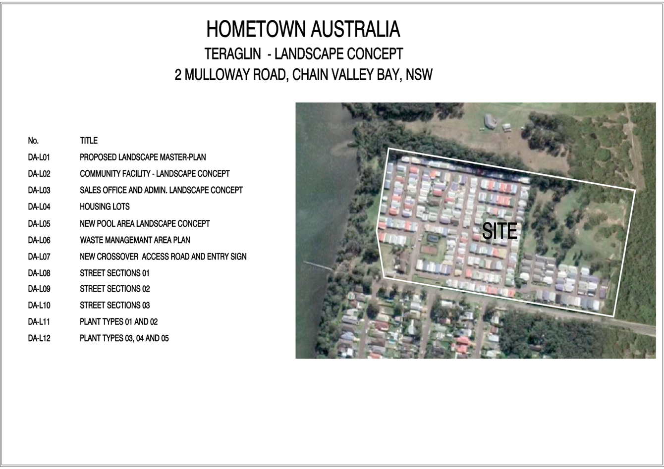
3.2 DA/1708/2021 - Teraglin Lakeshore Village, 2 & 10 Mulloway Road, Chain Valley Bay - Nominated Integrated and Integrated Development - Change of use to manufactured home estate, including 73 additional dwelling sites, new communal amenities, demolition & environmental protection works......................................................................................................................................................... 158
Donna Rygate
Chairperson
|
Item No: 1.1 |
|
|
Title: Disclosures of Interest |
|
|
Department: Governance |
|
|
13 July 2023 Local Planning Panel |
|
Reference:
|
The NSW Local Planning Panel Code of Conduct states that all panel members must sign a declaration of interest in relation to each matter on the agenda before or at the beginning of each meeting.
|
That Panel Members now confirm they have signed a declaration of interest in relation to each matter on the agenda for this meeting and will take any management measures identified.
|
Item No: 2.1 |
|
|
Title: Confirmation of Minutes of Previous Meeting |
|
|
Department: Corporate Services |
|
|
13 July 2023 Local Planning Panel Meeting |
|
Reference: F2020/02502 - D15751133
Author: Rachel Callachor, Meeting Support Officer
|
Summary
The
Minutes of the following Meeting of the Local Planning Panel, which have been
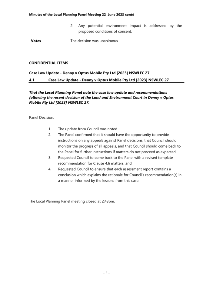
endorsed by the Chair of that meeting, are submitted for noting: · Local Planning Panel Meeting held on 22 June 2023
|
That the minutes of the previous Local Planning Panel Meeting held on 22 June 2023 which was endorsed by the Chair of that meeting, are submitted for noting.
|
1⇩ |
Minutes – Local Planning Panel – 22 June 2023 |
|
D15729900 |
|
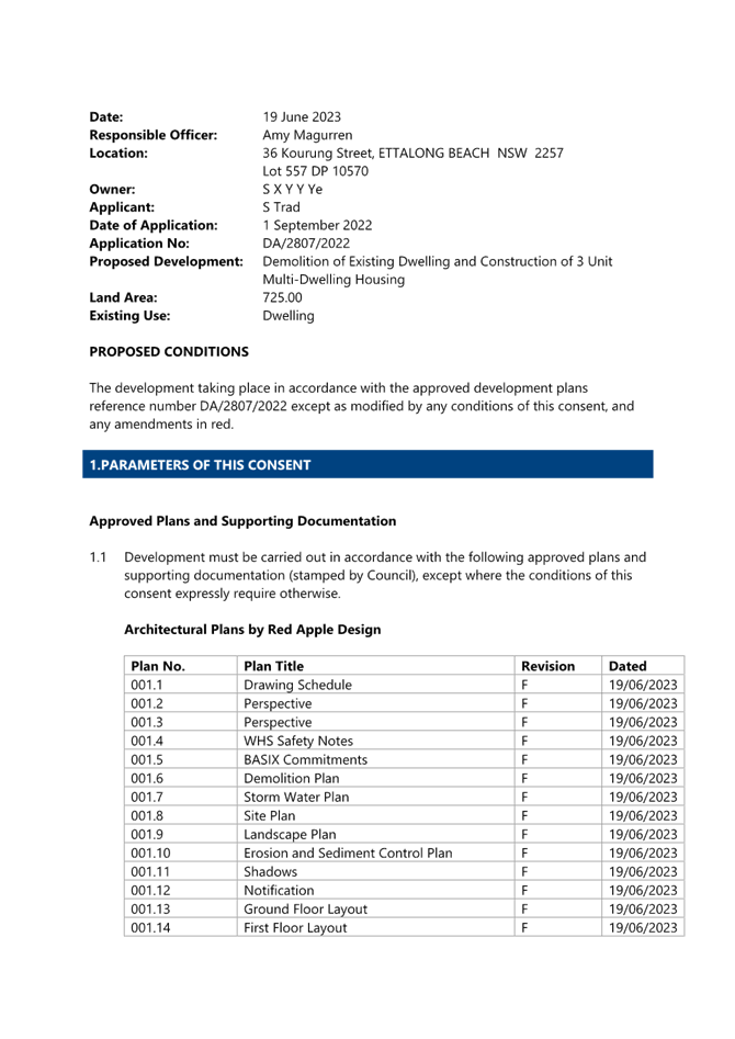
Item No: 3.1 |
|
|
Title: DA/2807/2022 - 36 Kourung Street Ettalong Beach - Multi Dwelling Housing |
|
|
Department: Environment and Planning |
|
|
13 July 2023 Local Planning Panel Meeting |
|
Reference: DA/2807/2022 - D15596124
Author: Amy Magurren, Development Planner Residential Assessments
Section Manager: Ailsa Prendergast, Section Manager Development Assessment South
Unit Manager: Andrew Roach, Unit Manager Development Assessment
Executive: Alice Howe, Director Environment and Planning
|
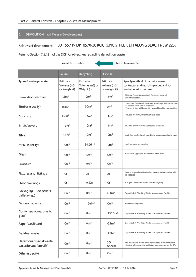
Summary
An application has been received for the demolition of an existing dwelling and ancillary structures and construction of Multi Dwelling Housing (comprising three units) at 36 Kourung Street, Ettalong Beach. The application has been examined having regard to the matters for consideration detailed in Section 4.15 of the Environmental Planning and Assessment Act 1979 with the issues requiring attention and consideration being addressed in the report.
The application is required to be referred to the Local Planning Panel as a result of submissions received during notification. Fifteen (15) submissions were received in total in relation to the application comprising eleven (11) unique submissions and four (4) duplicate submissions.
The application is recommended for approval, subject to conditions.
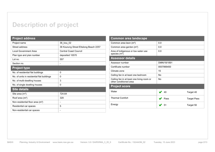
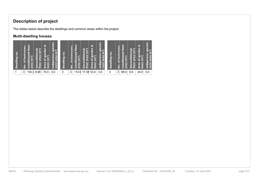
Applicant Red Apple Design – Sandra Trad Owner Mr Simon Ye Application No DA/2807/2022 Description of Land 36 Kourung Street, Ettalong Beach – Lot 553 in DP 10570 Proposed Development Multi Dwelling Housing and demolition of existing dwelling Site Area 724.64m2 Zoning R1 General Residential Existing Use Single Dwelling Employment Generation No Estimated Value $1,157,583.00
|
Recommendation
1 That the Local Planning Panel grant consent to DA/2807/2022 – 36 Kourung Street, Ettalong Beach – Lot 553 in DP 10570 subject to the conditions detailed in the schedule attached to the report and having regard to the matters for consideration detailed in Section 4.15 of the Environmental Planning and Assessment Act 1979.
2 That Council advise those who made written submissions of the Panel’s decision.
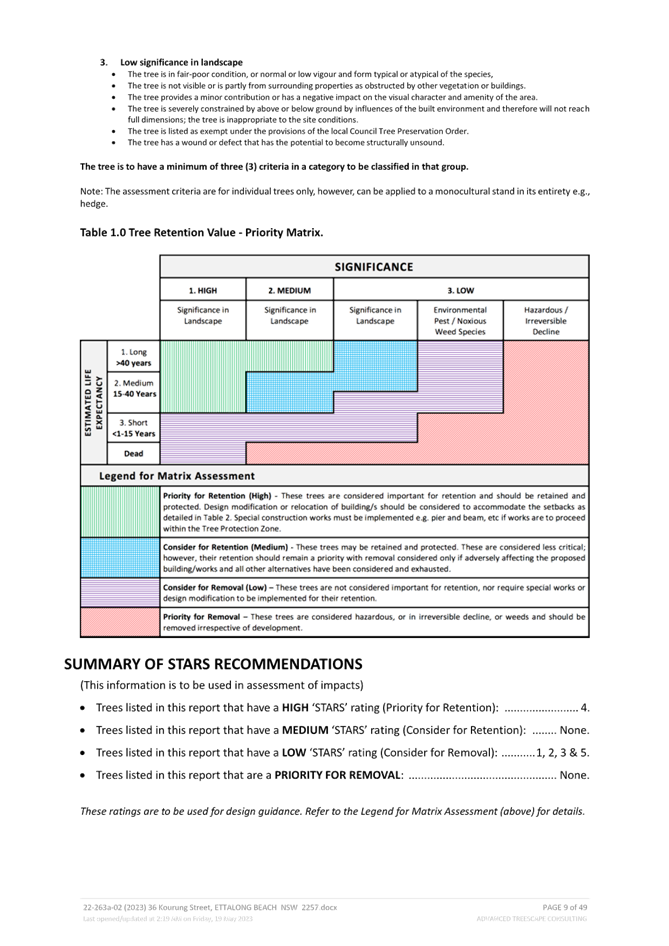
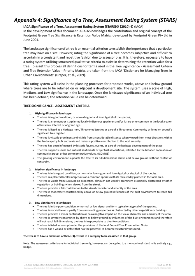
Key Issues
· Non-compliance with Chapter 2.2 Dual Occupancy & Multi Dwelling Housing of the Central Coast Development Control Plan 2022 in regard to the front setback, street tree and retaining walls.
· Matters raised in public submissions, including parking, tree removal, overshadow, private open space, setbacks and amenity impacts.
Precis:
|
Proposed Development |
Multi Dwelling Housing (3 units) and Demolition of existing dwelling.
|
|
Permissibility and Zoning |
The subject site is zoned R1 General Residential under the provisions of Central Coast Local Environmental Plan 2022 (CCLEP 2022). The proposed development is defined as multi dwelling housing, which is permissible in the zone with consent of Council. |
|
Relevant Legislation |
The following planning policies and control documents are relevant to the development and were considered as part of the assessment: · Environment Planning and Assessment Act 1979 - Section 4.15 · State Environmental Planning Policy (Building Sustainability Index: BASIX) 2004 · State Environmental Planning Policy (Resilience and Hazards) 2021 · Central Coast Local Environmental Plan 2022 (CCLEP 2022) · Central Coast Development Control Plan 2022 (CCDCP 2022) |
|
Current Use |
Dwelling House |
|
Integrated |
No |
|
Submissions |
15 submissions (11 unique, 4 duplicate) |
Variations to Policies – Central Coast Development Control Plan 2022.
|
Clause |
2.2.5 Building Setbacks – Front Setback |
|
Standard |
Average of the nearest two dwellings being 8.45m |
|
Departure basis |
Front setback proposed 7.020m or 1.43m or 17% variation |
|
Clause |
2.2.9.2 Retaining walls and structural support |
|
Standard |
Retaining walls that are more than 600m below existing ground level |
|
Departure basis |
Retaining walls in height up to 2.46m (eastern side boundary) and 1.72m (western side boundary) are proposed. |
|
Clause |
2.2.10.1 Street Trees |
|
Standard |
Provide 2 replacement trees per 15m of frontage |
|
Departure basis |
1 street tree provided – 50% Variation |
The Site and Surrounding Development
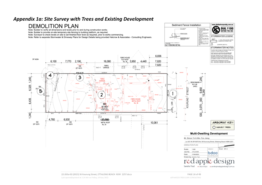
The site is described as Lot 553 in DP 10570 and known as No. 36 Kourung Street, Ettalong Beach, which is located on the southern side of Kourung Street between Springwood Street and Barrenjoey Road.
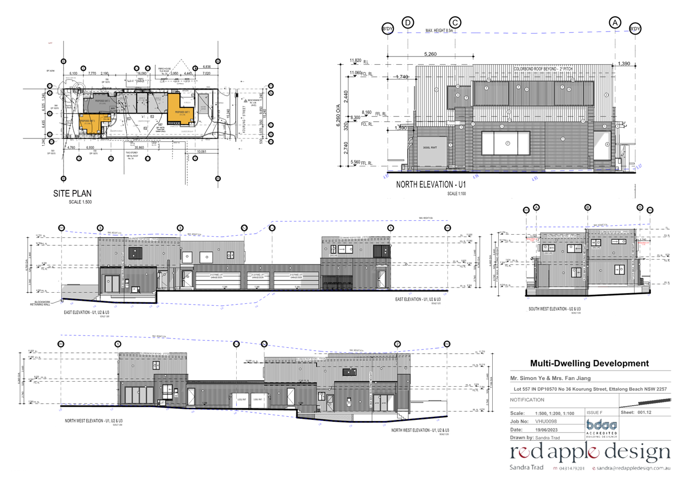
The site is regular in shape with a width of 15.24m and a depth of 47.55m and an area of 724.64m2 and currently contains a single storey dwelling house and ancillary structures.
While the topography of the area is generally flat, the site has a high point of approximately 5.23m AHD at the front with a ‘dip’ towards the rear of the site to a low point of approximately 2.76m AHD though the back portion of the site, and 3.70m AHD at the rear boundary.
The site is immediately bordered to the west by a single storey dwelling and to the east by a double storey dwelling. The wider area is a mix of one and two storey dwelling and multi dwelling housing developments.
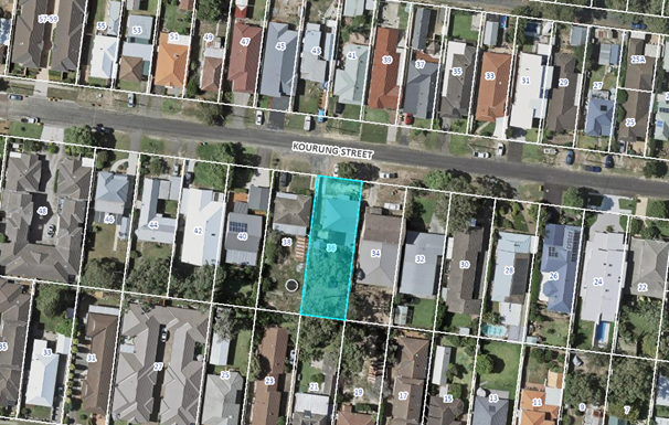
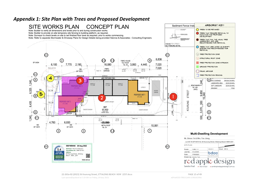
Figure 1 – Site Locality Plan
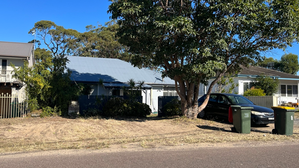
Figure 2 – Site as viewed from Kourung Street
The proposed development
The application seeks development consent for the redevelopment of the subject site including:
· Demolition of all existing structures
· Construction of a 3 x 3 bedroom multi-unit development on the site.
· 5 x car parking spaces and 1 visitor space.
· Vehicular access is proposed via a driveway that would run along the eastern boundary
· Landscaping and access
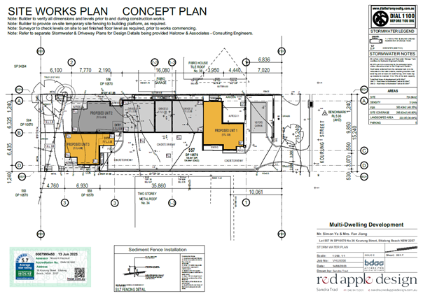
Figure 3 – The proposed site plan
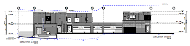
Figure 4 –East side elevation
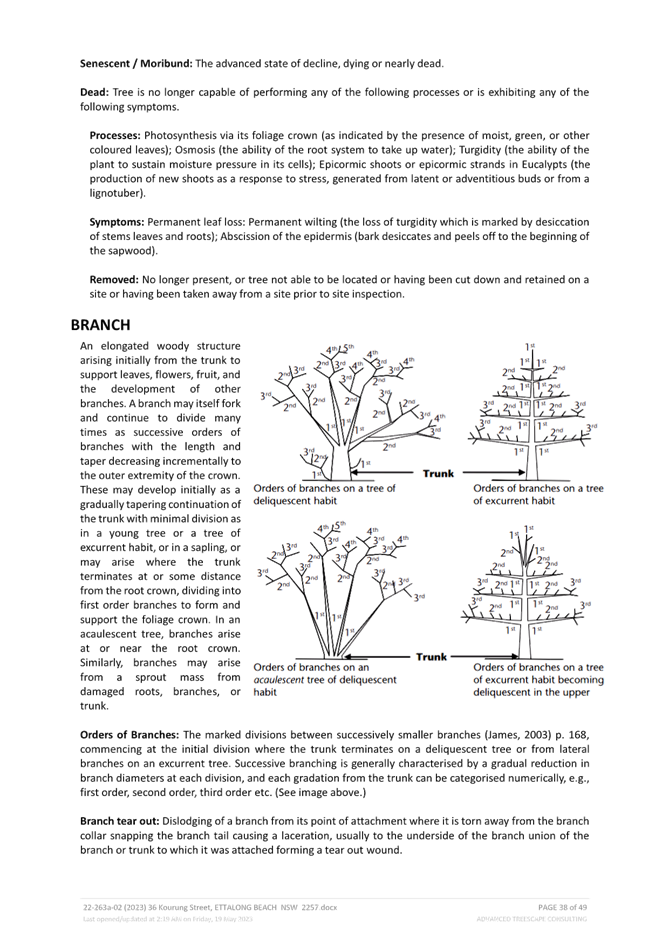
Application background
The application was lodged on the 21 November 2022.
On 3 April 2023 the applicant was asked to address issues in relation to visitor parking, setbacks, private open space and street trees in compliance with CCDCP 2022 and CCLEP 2022.
Following further discussions with the applicant, a set of amended plans were received on 17 May 2023. The amended plans and information included the following:
· The addition of a visitor parking space in the front setback of the development, surrounded by substantial landscaping.
· Increased front, rear and side setbacks.
· Re-configuration of Unit 1 to remove private open space behind the front setback and remove the bedroom from the ground floor.
· Updates Arborist report to address the removal of a street tree within the proposed driveway.
· Updated civil engineering plans to demonstrate swept paths comply.
Given the change to the plans were minor and resulted in a marginally reduced scheme with no greater or additional impacts the plans were not re-notified in accordance with CCDCP 2022.
ASSESSMENT:
Having regard for the matters for consideration detailed in Section 4.15 of the Environmental Planning and Assessment Act 1979 and other statutory requirements, the assessment has identified the following key issues, which are elaborated upon for Council’s information.
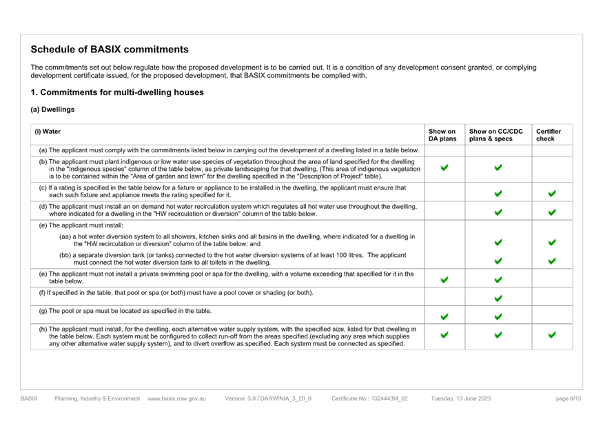
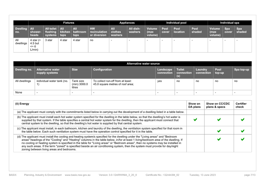
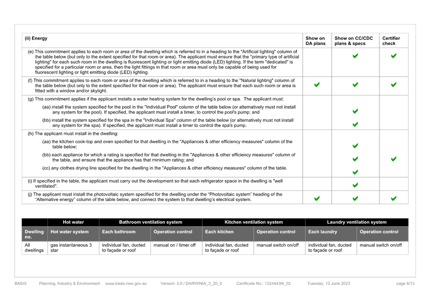
State Environmental Planning Policy (Building Sustainability Index: BASIX) 2004
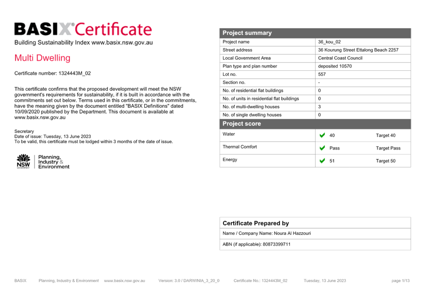
The application is supported by a BASIX certificate which confirms the proposal will meet the NSW government's requirements for sustainability, if built in accordance with the commitments in the certificate.
The proposal is considered to be consistent with the requirements of State Environmental Planning Policy (Building Sustainability Index: BASIX) 2004.
State Environmental Planning Policy (Resilience and Hazards) 2021
State Environmental Planning Policy (Resilience and Hazards) 2021 came into force on 1 March 2022 and replaces / consolidates State Environmental Planning Policy No. 55 – Remediation of Land and State Environmental Planning Policy (Coastal Management) 2018. However, it is noted that no policy changes have been made. All savings and transitional provisions of the repealed SEPPs are still in force despite their repeal, due to Sections 5(6) and 30(2)(d) of the Interpretation Act 1987.
The provisions for the former State Environmental Planning Policy No 55 Remediation of Land (SEPP 55) still apply to all development and requires consideration and management of site contamination issues as part of the development assessment process. The current use of the site is for domestic residential purposes, and there are no known previous uses that would lead to the site being contaminated or unsuitable for the proposed use.
The provisions of State Environmental Planning Policy (Coastal Management) 2018 (Coastal Management SEPP) require Council consider the aims and objectives of the SEPP when determining an application within the Coastal Management Area. The Coastal Management Area is an area defined on maps issued by the NSW Department of Planning and Environment and the subject property falls outside the mapped coastal management areas. However, the relevant matters have been considered in the assessment of this application and it is considered consistent with the stated aims and objectives.
Central Coast Local Environmental Plan 2022 (CCLEP 2022) - Zoning and Permissibility
The subject site is zoned R1 General Residential under the provisions of CCLEP 2022.
Development for the purposes of multi-dwelling housing is permissible within the R1 General Residential zone:
multi dwelling housing means three or more dwellings (whether attached or detached) on one lot of land, each with access at ground level, but does not include a residential flat building.
The R1 General Residential zone is based on the following objectives:
· To provide for the housing needs of the community.
· To provide for a variety of housing types and densities.
· To enable other land uses that provide facilities or services to meet the day to day needs of residents.
· To ensure that development is compatible with the desired future character of the zone.
· To promote best practice in the design of multi dwelling housing and other similar types of development.
· To ensure that non-residential uses do not adversely affect residential amenity or place demands on services beyond the level reasonably required for multi dwelling housing or other similar types of development.
The proposal would assist in meeting the housing needs of the community within a medium density residential environment. The proposed development presents a two storey form towards the Kourung street frontage and has adequate building articulation to vary the two storey built form at the rear of the site which generally maintains the residential character and amenity of the surrounding area.
The proposal appropriately addresses its impacts and represents and acceptable design and is therefore consistent with the R1 General Residential zone objectives.
Central Coast Local Environmental Plan 2022 – Minimum lot sizes for Multi-Dwelling Housing
The former Gosford Local Environmental Plan 2013 which applied to the site prior to the adoption of CCLEP 2022 included clause 4.1(B) which provided that minimum lot size for multi dwelling housing is 750m2. However, this clause was removed from CCLEP 2022. As a result, there is no minimum lot size applicable to the land for multi-dwelling developments.
Central Coast Local Environmental Plan 2022 – 4.3 Height of Buildings
Clause 4.3(2) of CCLEP 2022 provides that the height of a building on any land will not to exceed the maximum height shown for the land on the Height of Buildings Map. The maximum height shown on the relevant map is 8.5m.
The proposed development has a maximum building height of 8.2m at the maximum and complies with this development standard.
Central Coast Local Environmental Plan 2022 – 4.4 Floor Space Ratio
The provisions of clause 4.4 establish the Floor Space Ratio (FSR) for the land. The site is identified on the CCLEP 2022 FSR map as being 0.5:1.
The proposed development has a 0.48:1 FSR and complies with this development standard.
Central Coast Local Environmental Plan 2022 – 5.21 Flood Planning
The site is identified as being affected by Woy Woy Peninsula Flood Study and subject to the imposition of a minimum floor level.
Council’s Senior Engineer has reviewed the application and noted that the 1% Annual Exceedance Probability (AEP) flood level is 3.6m AHD and Probable Maximum Flood (PMF) is 4.1m AHD. The proposed floor levels are 5.56m AHD for Unit 1 and 4.614m AHD for Units 2 and 3 which all satisfy the minimum floor level requirements (i.e. the flood planning level requirements). The level of the proposed garages is 5.388m AHD, which is also above the flood planning level for this site.
Central Coast Local Environmental Plan 2022 – 7.1 Acid Sulfate Soils
The site is mapped as containing Class 4 acid sulfate soils (ASS). The site is approximately 4.20m AHD with minimal excavation required for the establishment of footings, with no works more than 1m below natural ground surface. In this instance, the proposal works are not considered likely to impact on Acid Sulfate Soils.
Standard conditions of consent are included to ensure any unexpected finds of acid sulfate soil will be appropriately managed.
Central Coast Development Control Plan 2022 (CCDCP 2022)
CCDCP 2022 provides objectives, design criteria and design guidance on how development proposals can achieve good design and planning practice.
CCDCP 2022 – Chapter 2.2 Dual Occupancy and Multi Dwelling Housing
The relevant provisions of Chapter 2.2 have been considered in the assessment of application as summarised in the table below.
|
Required |
Proposed |
Complies |
Compliance With Objectives |
|
|
Height |
· Max height LEP = 8.5m
· Max 3 storeys |
· Max height = 8.2m
· Max 2 storeys |
Yes
Yes |
Yes |
|
2.2.4.2 Floor Space Ratio |
· 0.5:1 |
· 0.48:1 |
Yes |
Yes |
|
2.2.4.3 Site Coverage |
· Minimum 25% soft landscaping |
· 35.5% |
Yes |
Yes |
|
Clause |
Required |
Proposed |
Complies |
Compliance With Objectives |
|
2.2.5 Building Setbacks |
· Front Setback – Average distance of the nearest two houses having the same primary road being 8.45m |
· Front setback – 7.020m 1.42m or 16% Variation |
No |
Yes – See comments below |
|
· Side setbacks - for any part of the building with a height of up to 4.5m—0.9m, and ii for any part of the building with a height of more than 4.5m—0.9m plus one-quarter of the height of the building above 4.5m |
· Unit 1 – West side setback required is 0.9m for Ground floor = proposed 1m to 1.240m. · First floor setback required is 1.34m and 1.390m is proposed. · Unit 2 – West side setback required is 0.9m for ground floor = proposed 1m to 1.240m. · First floor setback required is 1.716m and 1.740m is proposed. · Unit 3 – East side setback required is 0.9m for ground floor = proposed 1.240m · First floor setback required is 1.750 – Proposed is 1.740m · Minor variation of 0.01m proposed or 0.5% |
Yes |
Yes – See comments below. |
|
|
· Rear setback – 4.5m |
· Unit 2 = 6.1m · Unit 3 – 4.7m |
Yes |
Yes |
|
|
Articulation |
· Unbroken lengths of wall not to exceed 10m in length and 3m in height · Garages are to be located behind the front setback of the building to not dominate the street scape. |
There are no blank walls longer than 10m proposed above ground level.
Garages are located within the site and are hidden from view of the street. |
Yes
|
Yes |
|
Clause |
Required |
Proposed |
Complies |
Compliance With Objectives |
|
2.2.6.2 Roof Elements |
· Roof design does not detract from the architectural merit of the building and maintains the privacy of adjoining sites. |
The roof form is varied through the site for the various units and has architectural merit.
Louvres and highlight windows have been used throughout the site to reduce any overlooking or privacy impacts for adjoining sites. |
Yes |
Yes |
|
2.2.6.3 Residential Address |
· Ensure that the street can be seen from windows of regularly occupied rooms, as well as from upper-storey balconies and private terraces or courtyards at ground level. |
The street can be viewed clearly from Unit 1. The north facing bedroom of Unit 3 is able to see down the driveway to the street as well. |
Yes
|
Yes |
|
2.2.6.4 Design Integration |
· To ensure that building elements are integrated into the overall building form and façade design |
A high level of architectural detail has been provided with the application. |
Yes |
Yes |
|
2.2.7.1 Views |
· Facilitate view sharing outcomes |
The proposed development does not unreasonably obstruct any public or private views. |
Yes |
Yes |
|
2.2.7.2 Privacy |
· Maintain reasonable levels of privacy both internally and externally. · Maximise outlook and views from living rooms and private open space. · Protect the privacy of residents both within dwellings and in POS. |
Reasonable levels of privacy is achieved both internally and externally. Any windows overlooking neighbouring dwellings are either highlight windows or will have louvres. This will be conditioned.
Privacy is protected in the Private open space. |
Yes |
Yes |
|
Clause |
Required |
Proposed |
Complies |
Compliance With Objectives |
|
2.2.7.3 Private Open Space |
· POS for each dwelling is to have a min area of 45m2 · Minimum dimension of 4.5m |
Unit 1 – 44.97m2
Unit 2 – 53m2
Unit 3 – 49m
All units meet the minimum 4.5m dimension |
No – Unit 1 shortfall of 0.03m2 |
Yes – See comments below |
|
2.2.7.5 Sunlight Access |
· Sunlight min 3 hrs/day in living, dining, family rooms and 50% of principle Open Space areas. · Sunlight retained to existing neighbours |
Shadow diagrams have been provided to demonstrate the minimum levels of sunlight can be achieved. |
Yes |
Yes |
|
2.2.8.1 Car Parking |
· At least one of the required resident spaces is to be enclosed in a garage. · Visitor parking must be provided at a rate of 1 space per 5 units. · Comply with requirements of Chapter 2.13 being 1.5 spaces per dwelling. |
5 Spaces provided. All units have one garage enclosed. Visitor parking has been provided in the front setback surrounded by substantial landscaping. |
Yes |
Yes |
|
2.2.8.2 Access Design |
· Access is to comply with relevant standards and councils’ civil works specification. |
Swept paths have been provided demonstrating compliance with AS1890. |
Yes |
Yes |
|
2.2.9.1 Earthworks |
· Excavation must not exceed a maximum depth measured from existing ground level of 1m if less than 1m from a boundary or 3m if greater than 1m. |
No excavation greater than 1m is proposed. |
Yes |
Yes |
|
Clause |
Required |
Proposed |
Complies |
Compliance With Objectives |
|
2.2.9.2 Retaining Walls |
· No more than 600mm with 1m of boundary. |
Retaining walls of 2.46m on the eastern side and 1.72m on the western side are proposed |
No |
Yes – See comments below |
|
2.2.10 Landscaping |
· Landscaping to contribute to the amenity and character of the area |
Landscape plan provided and is considered to meet the objectives of the controls. |
Yes |
Yes |
|
2.2.10.2 Street Trees |
· 2 street trees provided per 15m of frontage |
Conditions have been applied. Only 1 street tree will be able to be accommodated within the frontage |
No |
Yes- See comments below. |
|
2.2.10.3 Deep Soil |
· 50% of soft landscaping be capable of deep soil |
Landscape plan provided and is considered to meet the objectives of the controls. |
Yes |
Yes |
|
2.2.10.4 Fencing |
· Meets the requirements of privacy and security |
Fencing to be conditioned. 1.2m front fence has been provided and is decorative in nature. |
Yes |
Yes |
|
2.2.11 Building Services |
· Have adequate services to cater for the residents’ needs. |
Council is satisfied all required services are available to the property. |
Yes |
Yes |
|
2.2.11.3 Stormwater Management |
· Complies with Councils Civil specifications. |
A stormwater Management Plan has been submitted with the application and complies with councils specifications. |
Yes |
Yes |
|
2.2.11.4 Garbage and Waste Services |
· Complies with Councils Chapter 2.14 Waste Management. |
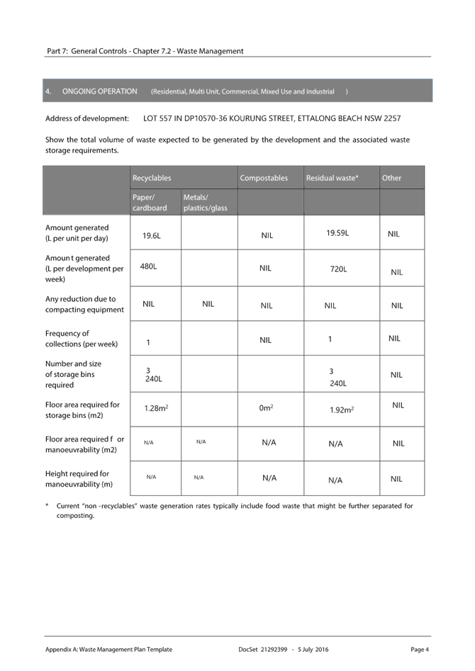
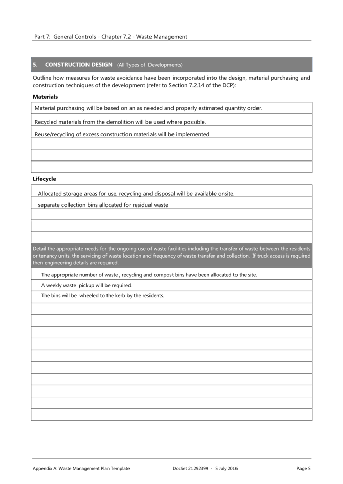
Waste management plan has been provided to support the application. 3 x mobile bins are proposed per dwelling. Bin storage for Unit 1 and 2 will be located within the proposed garages and bin storage for Unit 3 has been provided outside Unit 1 and travel paths are clear and level for moving bins to the street. |
Yes |
Yes |
The non-compliances with Chapter 2.2 Dual Occupancy and Multi Dwelling Housing of the CCDCP 2022 are discussed below.
CCDCP 2022 – Chapter 2.2.5 Building Setbacks
The variation to the setbacks and deep soil planting requirements are to be assessed against the stated purposes of the setbacks clause in the CCDCP 2022. The purposes of setbacks are:
· To ensure that setbacks are compatible with adjacent development and complements the character, streetscape and natural areas
· To ensure the visual focus of a development is the dwelling, not the garage
· To ensure views, privacy and solar access of adjacent properties are reasonably maintained
· To reasonably maintain view corridors to coastal foreshores and other desirable outlooks
· To maintain the scenic and environmental qualities of natural waterbodies and their foreshores and respond to site attributes such as topography
· To provide deep soil areas sufficient to provide new landscaping
· To provide appropriate articulation of facades and horizontal elements reduce the appearance of bulk and provides visual interest to the building and subsequent streetscape where they face a street frontage/s.
Clause 2.2.5 building setbacks requires that the front setback for new dwellings be equal to the average distance of the front setbacks of the nearest 2 dwelling houses having the same primary road boundary and located within 40m of the lot on which the dwelling house is erected. The neighbouring dwelling to the east is setback 10.061m and the to the west is 6.836, therefore the calculated setback would be 8.45m.
The initial development plans lodged with the original application proposed a building setback of 6.060m. A request for further information was sent to the applicant requesting the front setback be moved back in line with the neighbouring dwelling to the west being setback 6.836m.
The neighbouring dwelling to the east is setback greater than 10m which is an unusual distance to be set back from the primary frontage and would unreasonably set the proposed development back over 8m. By mirroring the proposed development with the neighbouring development to the west the character of the immediate area can been maintained. It will also make use of the additional space the rear of the development in Units 2 & 3 private open space which are afforded sufficient setbacks and private open space.
A reasonable level of amenity is achieved for both existing and proposed dwellings. The limited height of the building and setbacks will limit overshadowing. The proposed first floor contains primarily bedrooms which overall will result in a reasonable privacy amenity and for adjoining neighbours. The development provides usable open space and is consistent with the existing development pattern in the area. Greater amenity, compliance with the objectives and a better planning outcome is achieved by the variation to the front setback in this instance.
CCDCP 2022 – Chapter 2.2.7.3 Private Open Space
The purpose of this section of the CCDCP 2022 is to provide a well-designed private open space for every new dwelling and requires:
· Private open space all dwellings - min area 45m2
· Min dimension is 4.5m
Unit 1 is provided with 44.97m2 of open space, measuring 4.7m. The private open space for Unit 1 was previously nominated within the front setback as allowed under Gosford Development Control Plan 2014 (GDCP 2014), however under CCDCP 2022 the private open space is required to be relocated behind the front setback. The applicant amended the plans to include the visitor parking and amend the private open space for Unit 1 to comply with the amended clauses. This resulted in a minor numerical non-compliance of 0.03m2 in the total open space calculation.
The site is north/south facing which will ensure adequate sunlight and amenity to be provided to the open space of Unit 1. The front setback is proposed to provide an adequate landscape buffer which will provide a green leafy outlook and expanded feel of the Unit 1 open space.
Unit 2 is provided with 53m2 of open space, measuring 6.1m.
Unit 3 is provided with 49.06m2 of open space, measuring 4.7m
CCDCP 2022 – Chapter 2.2.9.2 Retaining Walls
This section of CCDCP 2022 requires that the design of the development is appropriate for the site conditions with consideration given to the slope, stability of the land and the privacy of adjoining properties.
Filling and retaining walls are proposed to facilitate access and drainage provisions for the proposed development. The proposed retaining walls measure in height up to 2.46m (eastern side boundary) and 1.72m (western side boundary) this is due to the natural dip in the rear section of the site. In accordance with the clause retaining walls over 600mm within 1m of the boundary must be designed by a professional engineer. A condition of consent has been imposed to require civil engineering plans to be prepare to support the construction certificate for the proposed retaining walls.
The retaining walls have the potential to impact the boundary fencing to the neighbouring dwellings. Conditions of consent have been provided to ensure the boundary fencing will be maintained at no greater than 1.8m to avoid unnecessary overshadowing and amenity impacts to the neighbouring dwellings.
CCDCP 2022 – Chapter 2.13 Transport and Parking
This section of CCDCP 2022 requires 1.5 resident car spaces per dwelling, and 0.2 visitor spaces per dwelling, (rounded up to the next whole number). This results in a minimum of five (5) spaces and one (1) visitor space, which have been provided in the amended development plans.
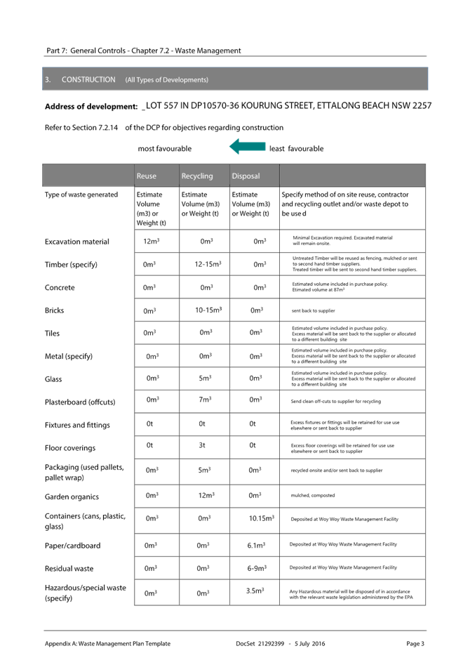
CCDCP 2022 - Chapter 2.14 Site Waste Management
An appropriate Waste Management Plan has been provided. Three mobile bins are proposed per dwelling. Plans indicate the location of the bins per unit within the double garages and the allocated bin storage area and appropriate travel paths have been provided. The proposal has demonstrated compliance with this chapter of CCDCP 2022.
CCDCP 2022 – Chapter 2.17 Character and Scenic Quality
Chapter 2.17 of CCDCP 2022 requires consideration of character and scenic value. The subject land lies within the Ettalong Beach 7: Sandplain Mixed Density area as set out in the ‘Scenic Value and Character Statements’ referenced in Chapter 2.17 of CCDCP 2022 (and included as Attachments to CCDCP 2022).
The desired character of this area is set out below:
“These areas should remain leafy mixed-density residential neighbourhoods that retain some of the original mid- Twentieth Century bungalows which remain distinctive elements of the Woy Woy Peninsula's identity, and future developments achieve significantly improved standards of amenity and urban design quality by reflecting features of those traditional bungalows, as well as providing a variety of low-rise dwellings that include apartments, town houses and Villas. Surround each development With leafy gardens to conserve existing visually-prominent trees, particularly along back fences and street frontages or verges, as well as to provide space for shady trees and shrubs planted as backdrops to new buildings. Maintain the informal qualities Of existing Wide grassy street verges and conserve existing shady street trees.
Complement the surviving canopy by planting a combination Of trees and shrubs that are mostly- indigenous along all property boundaries, and use hedges or fences that are IOW or see-through rather than tall and opaque in order to maintain the informal character Of existing street frontages Ensure that new developments complement the siting, form and scale Of surviving traditional bungalows upon nearby properties, as well as maintaining reasonable levels Of sunlight, privacy and amenity for neighbouring dwellings plus their private open spaces.
Maintain street setbacks that are similar to surrounding properties, and minimise the extent
Of hard-paved surfaces. Avoid the appearance Of long or continuous buildings facing any front or side boundary by stepping the shape Of Visible facades, by providing at least one Wide landscaped setback that varies in Width, and lining driveways with avenues of trees and shrubs
Reflect the modest scale of traditional mid-Twentieth Century bungalows, for example by dividing new developments into individual dwelling pavilions with a varied form or orientation. separated by landscaped courtyards and verandahs or parking structures Any facades that are taller or longer than neighbouring buildings should be disguised by a combination of extra setbacks, stepped forms, and balconies or verandahs. Roofs should be gently-pitched to minimise the height of ridges, and flanked by wide eaves that disguise the scale and bulk of exterior walls. Parking is preferable in open carports or part-basements, rather than in wide garages that would accentuate building bulk or dominate visible facades.
In order to complement the scale and design character of traditional bungalows. a "light-weight appearance" is preferable for all visible facades, incorporating walls of windows that are shaded by framed balconies or verandahs plus exterior sunscreens, painted finishes and some sheet or board cladding rather than extensive plain masonry.
Where facades face a street, a laneway or a driveway, provide a traditional "street address" with visible verandahs, living rooms and front doors.
Screen driveways, terraces, courtyards and balconies to protect the privacy and amenity of neighbouring dwellings.”
The proposal will largely retain the streetscape character and presentation with a simple modern design with appropriate materials and articulation. Courtyards are located at the rear of the site with the exception of the Unit 1 courtyard which is located within the screened front setback. The proposal is consistent with the existing and emerging residential character and amenity of the surrounding area.
CCDCP 2022 – Chapter 3.1 Floodplain Management and Water Cycle Management
The Water Cycle Management Plan submitted has been reviewed by Council’s Development Engineer and addresses the requirements of the Chapter 6.7 of CCDCP 2022.
CCDCP 2022 – Chapter 3.5 Tree and Vegetation Management
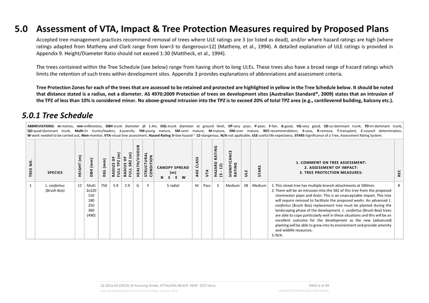
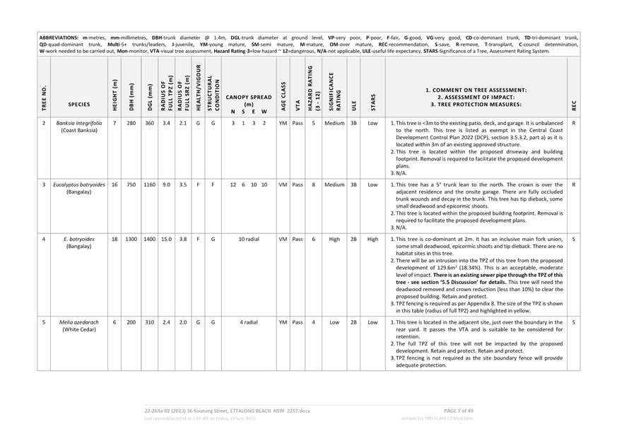
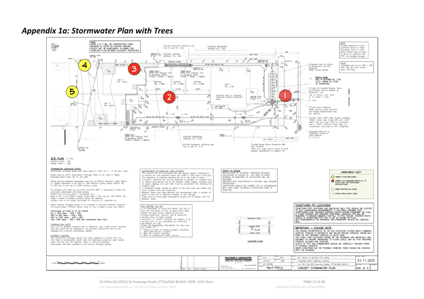
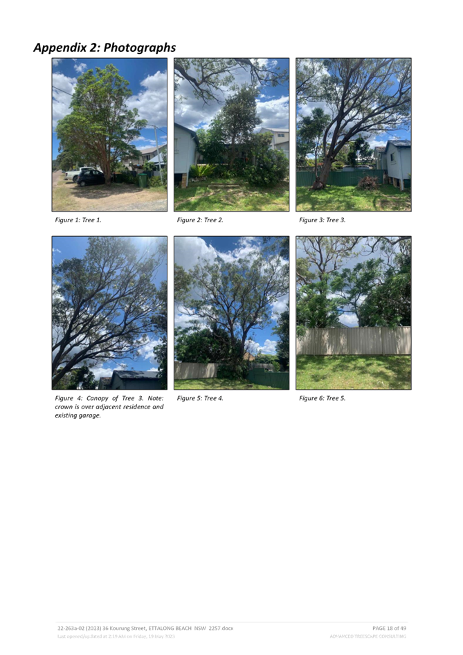
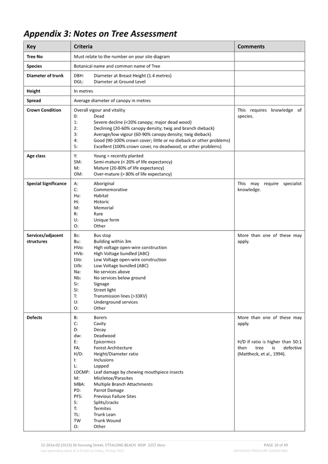
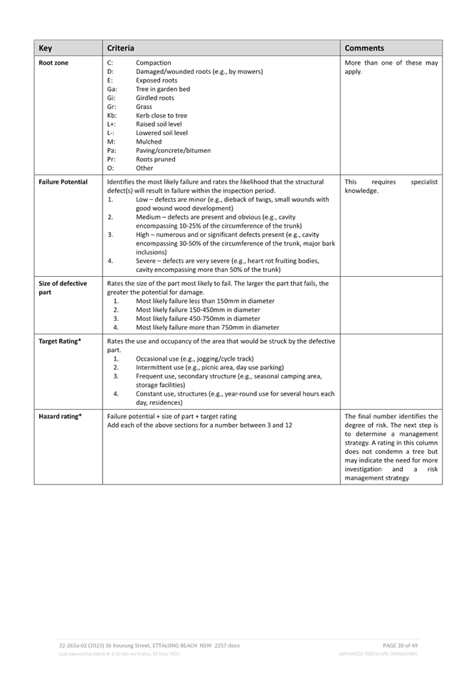
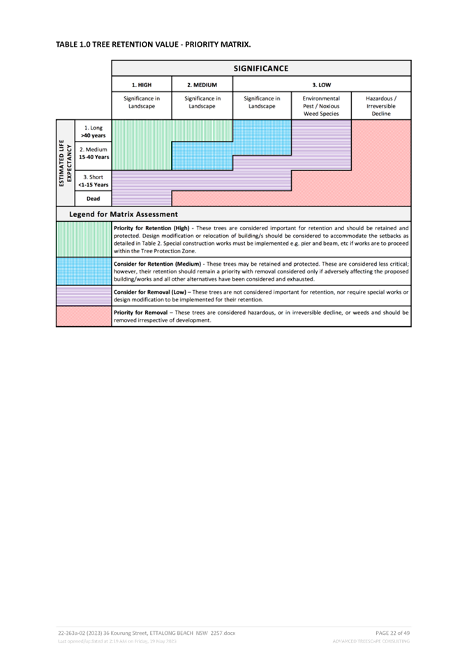
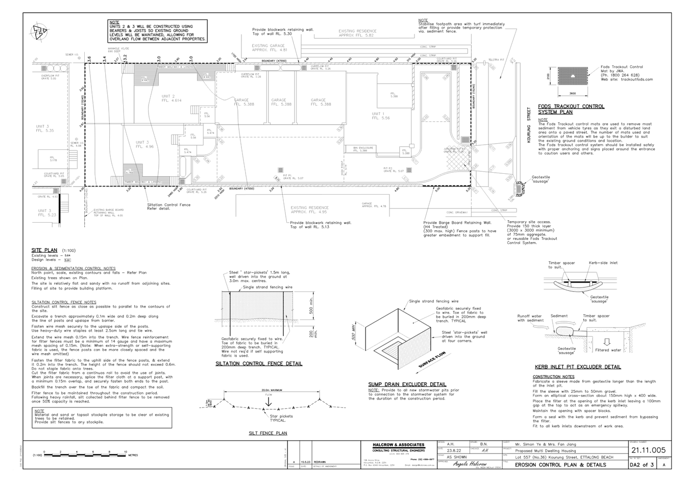
The proposed development seeks approval for the removal of three (3) trees to accommodate the development, with a total of five (5) trees impacted by the development. An arborists report prepared by Advanced Tree Consulting dated 19 May 2023 has been provided to support the application.
The two of the trees which require removal are located within the development footprint and one is located within the street which is impacted by construction of the driveway, footpath and stormwater infrastructure. Relocation of the driveway, footpath and stormwater infrastructure was considered however due to the 15.240m width of the lot and the location and size of the existing street tree, impact to the tree is unavoidable for reasonable development of the land. Similar proposed developments located at 24 Kourung and 44 Kourung street have set the general alignment for footpath along the frontage to the site.
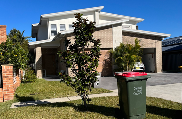
Figure 5: 24 Kourung Street – Completed development demonstrating footpath alignment and street tree planting.
Clause 2.2.10.2 requires that at least two-semi advanced trees per 15m of frontage are required to be replaced, however the location of the civil infrastructure and the space required to support healthy semi-advanced trees only provides reasonable space of one semi-advanced tree in this instance. One (1) street tree has been required to be provided and has been nominated on the Landscape and Architectural plans. Conditions requiring the replacement of the street tree within the road reserve have been included.
The proposal includes a medium scaled feature tree for the open space of each unit as well as substantial planting of shrubs and hedging and is considered acceptable. The proposal has adequately addressed this Chapter of CCDCP 2022.
The amended application plans have been reviewed by Council’s Tree Officer who now accepts that the street tree requires removal and replacement. A standard condition has been provided to address removal and replacement of the street tree and it was recommended that the Plans be amended to show that the tree is to be removed and show a replacement street tree which has been done and included in the final set of plans.
CCDCP 2022 – Chapter 3.7 Geotechnical Requirements
The site is not located within an area mapped as being impacted by landslip. The proposed development is not impacted by this Chapter of CCDCP 2022.
Likely Impacts of the Development:
Built Environment, Context and Setting
The subject site is zoned R1 General Residential and is surrounded by a mix of one and two storey single dwelling and multi dwelling housing developments.
A thorough assessment of the impacts of the proposed development on the built environment has been undertaken in terms of CCLEP 2022 and CCDCP 2022 compliance. Despite the non-compliance to the front setback discussed in this report the proposal will not have any unreasonable impacts on the character or amenity of the area. The proposed built form is considered acceptable in the context of the site.
The proposed development is not considered to have adverse amenity impacts to adjoining development from overshadowing, privacy, noise generating activities and views subject to the recommended conditions of consent.
Natural Environment
The subject site does not contain any threatened species or habitat. The proposal is satisfactory in relation to impacts on the natural environment as identified throughout this report. There will be no significant impact upon the natural environment as a result of the proposal.
Economic and Social Impacts
The proposed development will contribute to the supply of housing needs in the locality and is considered to be satisfactory from an economic perspective. No unreasonable social impacts will arise from the approval of this residential development.
Suitability of the Site for the Development:
The site is zoned R1 General Residential which permits multi dwelling housing.
There are no environmental hazards which would prevent development of the site, existing utilities are available to the site and is located near public transport facilities as well as public recreation / community facilities.
The site is suitable for the proposal in principle and adequately addresses the site constraints and impacts.
Any Submission made in Accordance with this Act or Regulations
Section 4.15 (1)(d) of the Environmental Planning and Assessment Act 1979 requires consideration of any submissions received during notification of the proposal.
The proposal was formally advertised and notified, in accordance with CCDCP 2022 Chapter 1.2 Notification of Development Proposals, between 9 December 2022 and 20 January 2023.
A total of fifteen (15) submissions were received. It is noted that four (4) submissions were not unique submissions and were exact duplicates of other submissions.
The number of submissions considered under the application is eleven (11), which requires the application to be considered by the Local Planning Panel.
The issues raised are summarized as follows:
|
Summary of Submissions |
Response |
|
Minimum Lot size for multi-unit dwellings |
No longer applies to the site under CCLEP 2022. |
|
Non-compliance with private open space located in the front setback for Unit 1 |
The applicant was requested to amend the design for the open space for Unit 1 to be relocated behind the front setback. |
|
Non-compliance with the size of the private open space for Unit 3 |
The applicant was requested to amend the design for the rear setback which increased the private open space for Unit 3 to 60m2. |
|
Non-compliance with visitor parking |
The applicant was requested to amend the design to include a visitor parking space which is located in the front setback screened by landscaping. |
|
The plans show no tree preservation |
The Arborist’s report shows the tree retention and removal for the proposed development. |
|
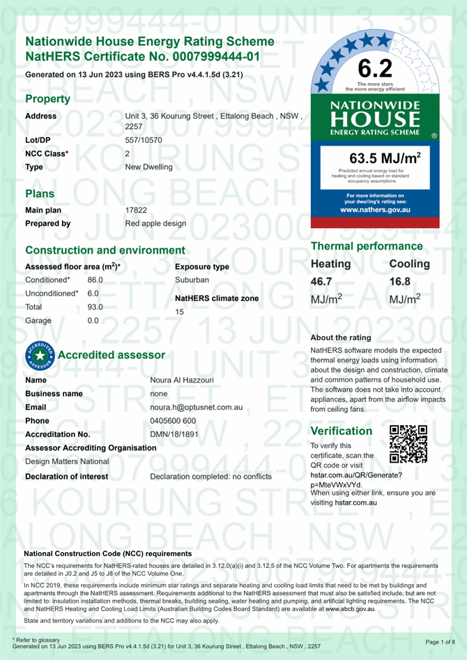
Compliance with NatHers |
NatHers isn’t required for the proposed development, however NatHers certificates have been provided. |
|
Retention of the street tree |
This is discussed above under the heading CCDCP 2022 – Chapter 3.5 Tree and Vegetation Management |
|
Summary of Submissions |
Response |
|
Bulk and scale will change the streetscape |
The developments scale is under the maximum potential for the site and is consistent with the existing, emerging and desired future character of the area.
The desired future character for this area requires “Ensure that new developments complement the siting, form and scale Of surviving traditional bungalows upon nearby properties, as well as maintaining reasonable levels of sunlight, privacy and amenity for neighbouring dwellings plus their private open spaces.”
The proposal comprises a new development that compliments the form and sitting of the neighbouring dwellings and is consistent with desired character. |
|
Overshadowing of neighbours – Shadow diagrams not provided in notification plans |
Some overshadowing of the property to the east (No. 34) will occur in the afternoon hours, however a minimum of 3 hours solar access will be retained to both the dwelling and open space. |
|
Concrete in the driveway is excessive |
The driveway design provides for the garages to be access from the side of the development rather than visible from the street which is consistent with the controls for multi dwelling units. |
|
Loss of Privacy, and increased noise |
To improve the levels of privacy louvres or an opaque finish to the window glazing to a height of 1.6m is proposed and required via a condition of consent to ensure all views are directed up and out, rather than looking down into the adjoining properties open space.
There are no unreasonable noise impacts expected from a typical residential development. Standard conditions in relation to construction noise and vibration are recommended. |
|
Traffic and unsafe driving |
The small scale of the development is under the potential density for the site and area. The additional vehicle movements are minimal and considered capable of being accommodated within the road network. Unsafe driving is a matter for the police. |
|
Insufficient parking |
The number of car parking spaces complies with the car numerical parking requirement of CCDCP 2022. |
Internal Consultation
|
Internal Referral Body |
Comments |
|
Development Engineer |
Supported subject to Conditions 2.3, 2.4, 2.5 4.3 4.4, 6.4, 6.5, 6.6, 6.7, 6.8, 6.9 & 6.10. See comments below. |
|
Water and Sewer |
Water and Sewer is available to the land. A Section 307 certificate of compliance under the Water Management Act 2000 is required Supported subject to standard Conditions |
|
Tree Officer |
Supported subject to Conditions 4.1, 5.2, 6.11 & 6.12. See comments below. |
Development Engineer Comments:
Road works
There is no existing kerb and gutter across the frontage of the site in Kourung Street. Road works, kerb and gutter, footway formation and concrete footpath will be required across the frontage of the site in Kourung Street in conjunction with this development. Appropriate conditions of consent are recommended.
Stormwater
Street Tree Impact from Drainage Works
There is a street tree (Brush Box) located within the footway that may be impacted by the construction of civil works within its structural root zone including the infiltration trench within the front boundary, the infiltration trench (not indicated on the Halcrow stormwater plan but would be required within the blind pit as per Council’s Civil Works Specification), the footpath, and the vehicle access crossing.
The impact of these works on this tree has been considered in the revised Arboricultural Impact Assessment prepared by Advanced Treescape Consulting dated 19/05/2023 that recommends the removal of this tree.
Furthermore, Council’s Tree Assessment Officer supports the removal of the street tree and replacement with a suitable species.
Access
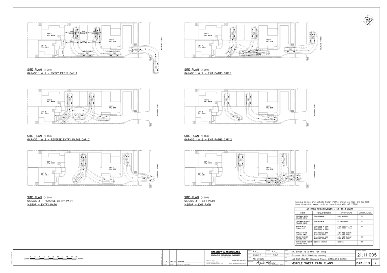
Vehicular access for the proposed development is to be provided via a driveway within the eastern side boundary of the site. It is noted that this driveway is near level to facilitate drainage to the street and provide for some on-site detention storage area within the driveway. The driveway is setback at the front corner of the site to comply with the sight distance to pedestrian splay required under Section 3.2.4 and Figure 3.3 of AS/NZS2890.1:2004.
Vehicular swept turning paths provided on the revised plan prepared by Halcrow & Associates (Drawing No 21.11.005 Sheet DA3 Amendment A dated 16.5.23) indicate that the AS/NZS2890.1:2004 B85 vehicle can enter and exit the site in a forward direction via a three point turn through the garage spaces of the units and the visitor car space located within the front setback of the site.
Access and parking provisions will need to comply with AS/NZS 2890.1:2004. Appropriate conditions recommended
Traffic
The surrounding road network would have the capacity to accommodate the additional traffic generated by the proposed development.
Flooding
Council’s Woy Woy Peninsula Flood Study indicates that the site is affected by flooding in the 1% AEP storm event and flood related development controls. Floor levels in this area have generally been adopted to allow drainage overflow to the street. Flooding on this site is deemed to be ‘flood fringe’.
In this regard:
· The 1%AEP flood level is 3.6m AHD.
· The 5%AEP flood level is 3.37m AHD.
· The respective Flood Planning Level is 4.1m AHD.
The proposed floor levels are 5.56m AHD for Unit 1 and 4.614m AHD for Units 2 and 3, which all satisfy the minimum floor level requirements (i.e. the flood planning level requirements). The level of the proposed garages is 5.388m AHD, which is also above the flood planning level for this site.
It is recommended that materials used below 4.1m AHD are of a type that can withstand the effects of immersion in floodwaters.
Drainage
The site generally grades to a localised depression within the rear third of the site. The development has been designed in a matter to remove this depression from within the site and facilitate overflow stormwater discharges to the street frontage. The topographical nature of this depression within this site and neighbouring lots does not lend itself to any inter-allotment drainage options.
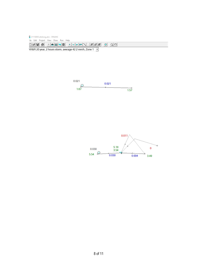
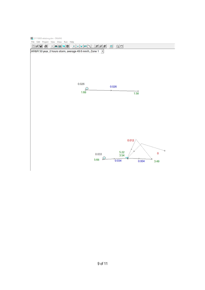
A Water Cycle Management Plan (WCMP) prepared by Halcrow & Associates (dated 25 August 2022) was submitted with the application, which indicates the following in relation to addressing the requirements of the current Chapter 3.1 Part C of CCDCP 2022 (which is the same as Chapter 6.7 of the former Gosford Development Control Plan 2013 (GDCP 2013) referred to in this document).
· Deemed to comply provisions have been adopted on the basis that the site has an area less than 2000m2.
· Water conservation. Covered by BASIX.
· Retention. The required retention volume is 14.2m3. This is being provided as follows: three 3000 litres rainwater tanks totalling 9,000 litres are proposed (one for each unit). Weekly reuse is estimated at 5,900 litres. An infiltration trench is proposed within the front setback with a storage capacity of 4.92m3 which considering the 30 minute infiltration volume is estimated at 6.2m3.
· Stormwater Quality. All stormwater is discharged via rainwater tanks or the infiltration trench. Therefore, the Site Discharge Index (SDI) is 0 which is less than the required 0.1. Overflows from the rainwater tanks discharge to the infiltration trench prior to overflows from that system discharging to the kerb and gutter.
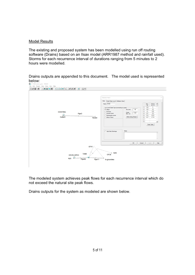
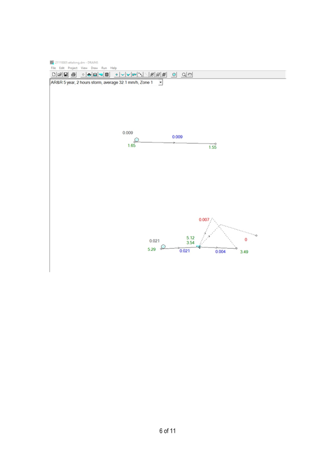
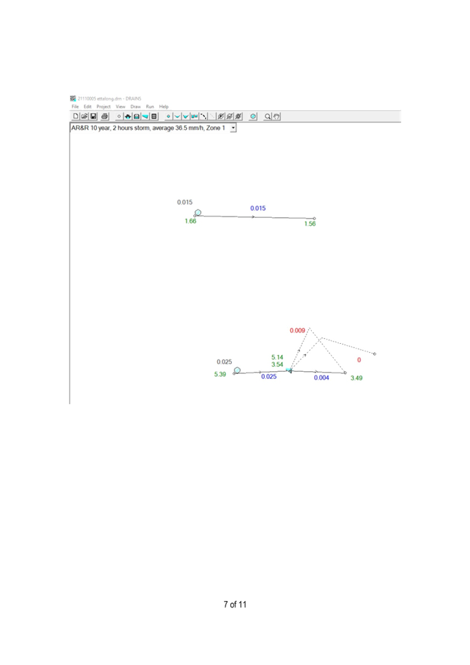
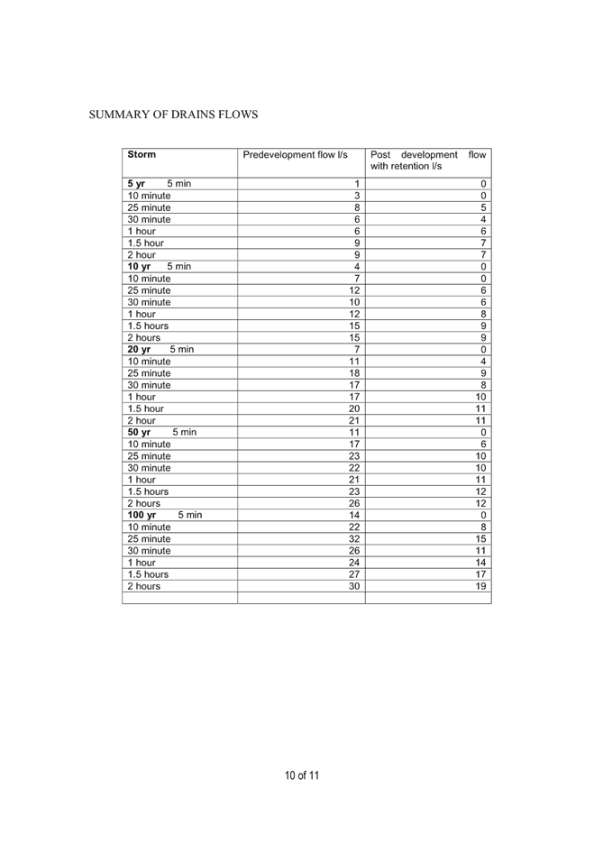
· On site detention. A runoff routing method (Drains) was utilised to design an on-site detention system to limit post development flows to less than or equal to predevelopment flows for all storm events up to and including the 1% AEP recurrence interval. The on-site detention system was modelled as a tank system including the credit from the rainwater tanks (as permitted in CCDCP 2022), the modular infiltration storage, and surface storage within driveway pavements. The results of the modelling indicate the design objectives are satisfied. The total detention storage proposed equates to 20.22m3.
· Local overland drainage. The site is not in a designated overland flow path. The WCMP indicates:
“The adjoining property to the west is lower than this property and is designated as flood storage. Under current condition water would flow from this site to the adjoining property to the west. This flow will be contained within the on site systems and overflow from the development will then be drained to the street drainage. Fill on site is required to allow this to happen. Fill is confined to the front section of the site as shown on drawing 2111005 DA2 (Halcrow & Associates plan) with the rear of the site being left at natural levels to allow for ponding to occur in this area in large flood events. Unit 2 and Unit 3 will be constructed with open sub floor and elevated floor levels.”
Landscaping
The initially submitted landscape plans indicates proposed “low scale hedging shrubs” along the eastern boundary. These shrubs were not supported by engineering staff as they would impede vehicular swept turning path manoeuvres. Note: These shrubs have been removed from the final plans.
Tree Assessment Officer Comments:
As previously noted, concerns were raised over the viability of the existing Brush Box street tree due to required civil works and Council’s Tree Assessment Officer accepts that the street tree requires removal and replacement.
A standard condition has been provided to address removal and replacement of the street tree.
Two (2) other trees are nominated for removal consisting of a Banksia and Bangalay Gum located within the works footprint.
The proposal also includes retention a mature Bangalay Gum located in the rear corner of the lot. The Bangalay Gum is located approximately 4m from the new building. This large tree will require future pruning of overhanging branches.
The application is supported by Council’s Tree Assessment Officer subject to conditions.
Other Matters for Consideration:
Development Contribution Plan
The subject site is located within Contribution Plan No. 31 Peninsula, where multi-dwelling housing developments are subject to Section 7.11 Contributions under the Environmental Planning and Assessment Act 1979.
The applicable contribution amount was calculated and recommended as a condition of consent (requiring the contribution to be paid prior to the issue of any Construction Certificate) (refer to Condition 2.7).
Ecologically Sustainable Principles:
The proposal has been assessed having regard to ecologically sustainable development principles and is considered to be consistent with the principles.
The proposed development is considered to incorporate satisfactory stormwater, drainage and erosion control and the retention of vegetation where possible and is unlikely to have any significant adverse impacts on the environment and will not decrease environmental quality for future generations. The proposal does not result in the disturbance of any endangered flora or fauna habitats and is unlikely to significantly affect fluvial environments.
Climate Change
The potential impacts of climate change on the proposed development have been considered by Council as part of the assessment of the application.
This assessment has included consideration of such matters as potential rise in sea level; potential for more intense and/or frequent extreme weather conditions including storm events, bushfires, drought, flood and coastal erosion; as well as how the proposed development may cope, combat, withstand these potential impacts. The proposed development is considered satisfactory in relation to climate change.
Political Donations
During assessment of the application there were no political donations were declared by the applicant, applicant’s consultant, owner, objectors and/or residents.
The Public Interest
The approval of the application is considered to be in the public interest. The proposal will not have any adverse impact on the natural environment and will not unreasonably impact the amenity of neighbouring properties.
Conclusion
This application has been assessed under the heads of consideration of Section 4.15 of the Environmental Planning and Assessment Act 1979 and all relevant instruments and policies.
Following an assessment of the application, it is concluded that:
1. The proposal is satisfactory having regard for the relevant environmental planning instruments, plans and policies; and
2. There are no significant issues or impacts identified with the proposal under Section 4.15 of the Environmental Planning and Assessment Act 1979.
Accordingly, the application is recommended for approval pursuant to Section 4.16 of the Environmental Planning and Assessment Act 1979, subject to the recommended conditions included in Attachment 9.
|
FINAL Plans - ISSUE F - 36 Kourung Street ETTALONG BEACH - DA/2807/2022 |
Provided Under Separate Cover |
D15727713 |
|
|
2⇩ |
PUBLIC REVISED Notification Plans - 36 Kourung Street ETTALONG BEACH - DA/2807/2022 |
|
D15727734 |
|
3⇩ |
Basix Certificate Rev 1- 36 KOURUNG STREET, ETTALONG BEACH DA/2807/2022 |
|
D15724494 |
|
4⇩ |
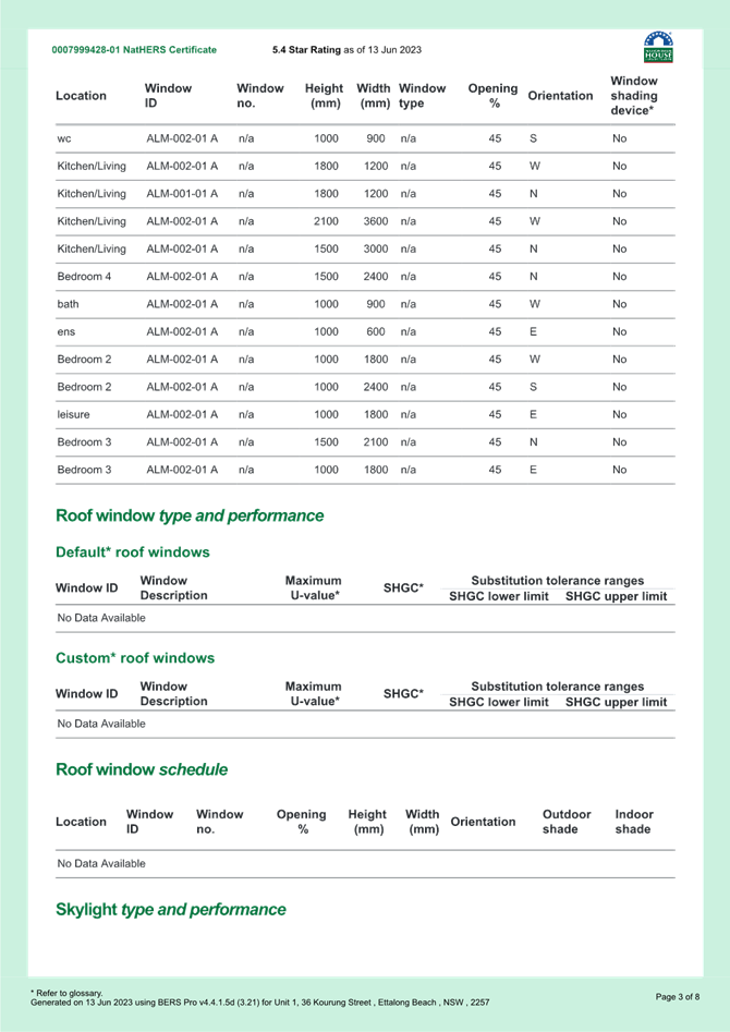
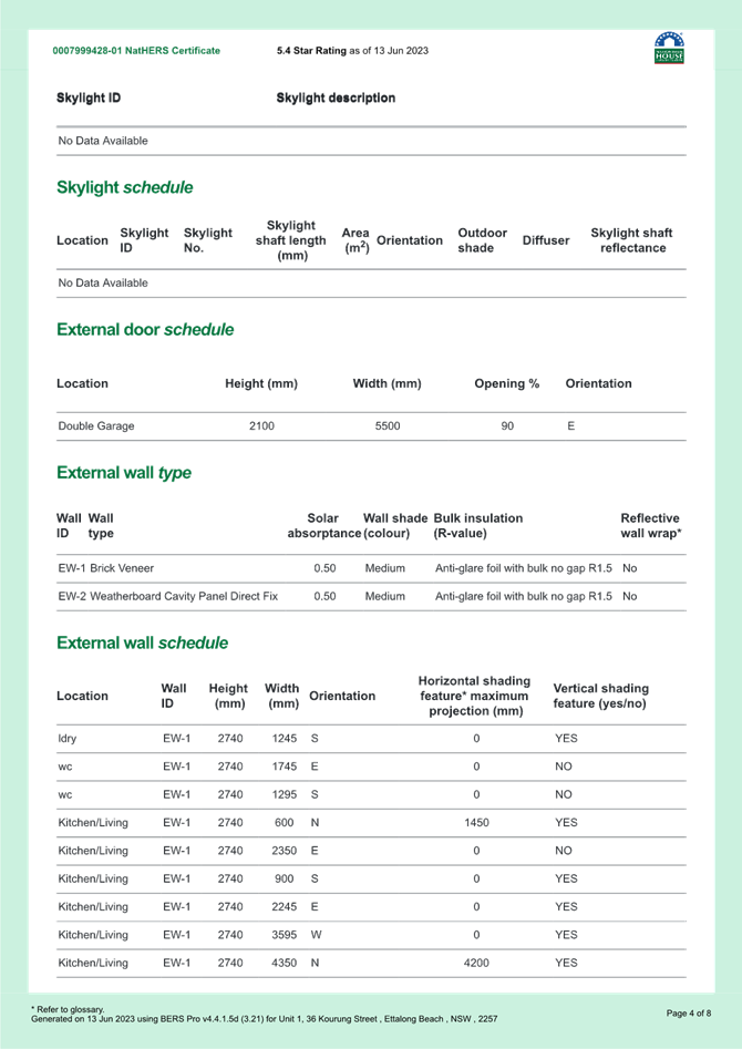
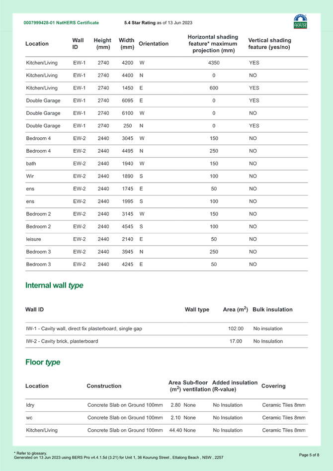
Combined NAThers Certificates - Units 1-3 - 36 Kourung Street ETTALONG BEACH - DA/2807/2022 |
|
D15727154 |
|
5⇩ |
PUBLIC REVISED Civil Engineering Plans - Rev A - 36 Kourung Street ETTALONG BEACH - D/2807/2022 |
|
D15727072 |
|
6⇩ |
UPDATED Arborists Report - DA/2807/2022 - 36 Kourung Street, ETTALONG BEACH NSW 2257 |
|
D15695531 |
|
7⇩ |
PUBLIC - Water cycle management plan - 36 KOURUNG STREET ETTALONG BEACH 2257 - PAN-259497 - DA/2807/2022.pdf |
|
D15319179 |
|
8⇩ |
PUBLIC - Waste management plan - 36 KOURUNG STREET ETTALONG BEACH 2257 - PAN-259497 - DA/2807/2022.pdf |
|
D15319180 |
|
9⇩ |
Draft conditions - 36 Kourung Street, ETTALONG BEACH NSW 2257 - DA/2807/2022 - Central Coast Council |
|
D15726675 |
|
3.1 |
DA/2807/2022 - 36 Kourung Street Ettalong Beach - Multi Dwelling Housing |
|
Attachment 2 |
PUBLIC REVISED Notification Plans - 36 Kourung Street ETTALONG BEACH - DA/2807/2022 |
|
3.1 |
DA/2807/2022 - 36 Kourung Street Ettalong Beach - Multi Dwelling Housing |
|
Attachment 3 |
Basix Certificate Rev 1- 36 KOURUNG STREET, ETTALONG BEACH DA/2807/2022 |
|
DA/2807/2022 - 36 Kourung Street Ettalong Beach - Multi Dwelling Housing |
|
|
Attachment 4 |
Combined NAThers Certificates - Units 1-3 - 36 Kourung Street ETTALONG BEACH - DA/2807/2022 |


|
DA/2807/2022 - 36 Kourung Street Ettalong Beach - Multi Dwelling Housing |
|
|
Attachment 5 |
PUBLIC REVISED Civil Engineering Plans - Rev A - 36 Kourung Street ETTALONG BEACH - D/2807/2022 |
|
DA/2807/2022 - 36 Kourung Street Ettalong Beach - Multi Dwelling Housing |
|
|
Attachment 6 |
UPDATED Arborists Report - DA/2807/2022 - 36 Kourung Street, ETTALONG BEACH NSW 2257 |
|
DA/2807/2022 - 36 Kourung Street Ettalong Beach - Multi Dwelling Housing |
|
|
Attachment 7 |
PUBLIC - Water cycle management plan - 36 KOURUNG STREET ETTALONG BEACH 2257 - PAN-259497 - DA/2807/2022.pdf |
|
DA/2807/2022 - 36 Kourung Street Ettalong Beach - Multi Dwelling Housing |
|
|
Attachment 8 |
PUBLIC - Waste management plan - 36 KOURUNG STREET ETTALONG BEACH 2257 - PAN-259497 - DA/2807/2022.pdf |
|
DA/2807/2022 - 36 Kourung Street Ettalong Beach - Multi Dwelling Housing |
|
|
Attachment 9 |
Draft conditions - 36 Kourung Street, ETTALONG BEACH NSW 2257 - DA/2807/2022 - Central Coast Council |

|
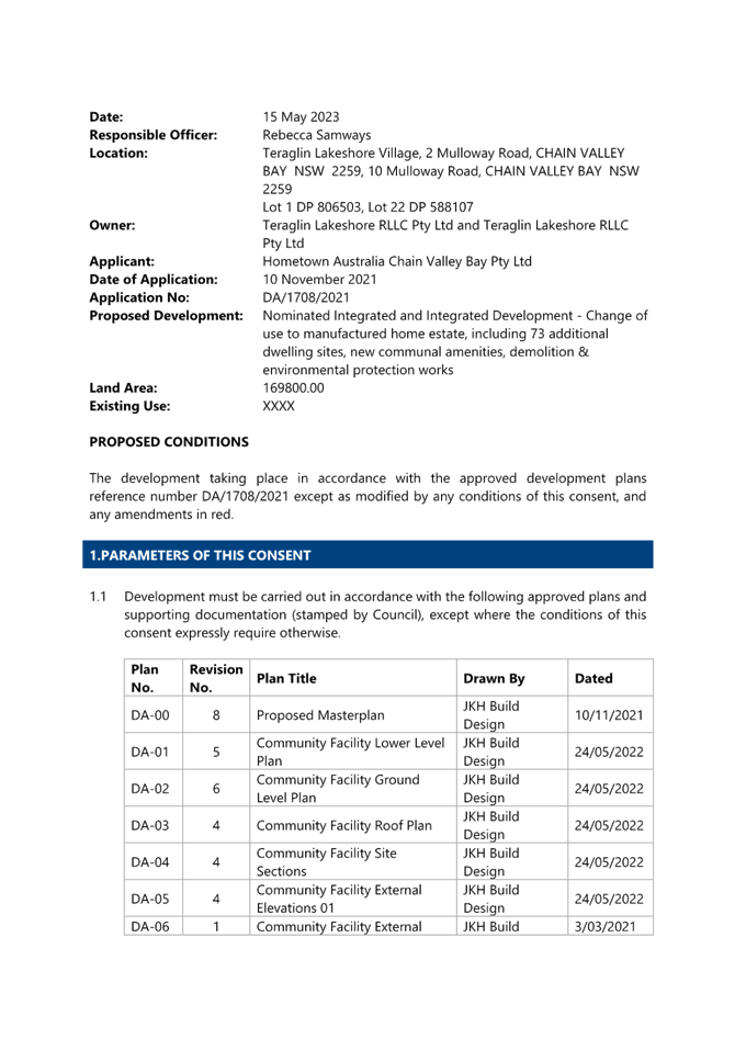
Item No: 3.2 |
|
|
Title: DA/1708/2021 - Teraglin Lakeshore Village, 2 & 10 Mulloway Road, Chain Valley Bay - Nominated Integrated and Integrated Development - Change of use to manufactured home estate, including 73 additional dwelling sites, new communal amenities, demolition & environmental protection works |
|
|
Department: Environment and Planning |
|
|
13 July 2023 Local Planning Panel Meeting |
|
Reference: DA/1708/2021 - D15452529
Author: Rebecca Samways, Development Planner Employment and Urban Release
Manager: Emily Goodworth, Section Manager Employment and Urban Release
Andrew Roach, Unit Manager Development Assessment
Executive: Alice Howe, Director Environment and Planning
|
Summary
An application has been received for a change of use from a caravan park to a manufactured home estate, including 73 additional dwelling sites, new communal amenities, demolition and environmental protection works. The application has been examined having regard to the matters for consideration detailed in Section 4.15 of the Environmental Planning and Assessment Act 1979 and other statutory requirements with the issues requiring attention and consideration being addressed in the report.
The application is required to be determined by the Local Planning Panel as a result of submissions. Fourteen (14) submissions by way of objection have been received during the notification period, in addition to 30 submissions in support. The application is recommended for approval, subject to conditions.
Applicant Hometown Australia Chain Valley Bay Pty Ltd Owner Teraglin Lakeshore RLLC Pty Ltd Application No DA/1708/2021 Description of Land Lot 1 DP 806503, Lot 22 DP 588107 (Teraglin Lakeshore Village), 2 & 10 Mulloway Road, Chain Valley Bay Proposed Development Change of use to manufactured home estate, including 73 additional dwelling sites, new communal amenities, demolition and environmental protection works Site Area 16.98Ha Zoning C2 Environmental Conservation and C3 Environmental Management and RE2 Private Recreation (Wyong Local Environmental Plan 2013) Existing Use Caravan park containing 230 long term sites (Lot 1) and single storey dwelling and shed (Lot 22) Estimated Value $7,320,612 |
1 That the Local Planning Panel grant consent to DA/1708/2021 – Lot 1 DP 806503 and Lot 22 DP 588107, Teraglin Lakeshore Village, 2 & 10 Mulloway Road, CHAIN VALLEY BAY NSW 2259, for the change of use to a manufactured home estate, including 73 additional dwelling sites, new communal amenities, demolition and environmental protection works, subject to the conditions detailed in the schedule attached to the report and having regard to the matters for consideration detailed in Section 4.15 of the Environmental Planning and Assessment Act 1979.
3 That Council advise those who made written submissions of the Panel’s decision.
4 That Council advise relevant external authorities of the Panel’s decision.
Key Issues
· The proposed development includes the change of use of the existing 100% long-term caravan park to a manufactured home estate, which is considered to formalise the current use of the site.
· The proposed development is permissible in the zone and is consistent with the zone objectives.
· The additional sites and proposed new community facilities have suitable regard for amenity to existing dwelling sites and will contribute to the provision of additional and improved facilities for residents.
· 14 submissions in objection and 30 submissions in support to the proposed development were received.
· The proposed development is suitable with regard to biodiversity, drainage and flooding and traffic.
Precis:
|
Proposed Development |
Change of Use to a Manufactured Home Estate, including 73 Additional Dwelling Sites, New Communal Amenities, Demolition and Environmental Protection Works |
|
Permissibility and Zoning |
RE2 Private Recreation C2 Environmental Conservation C3 Environmental Management (Wyong Local Environmental Plan 2013)
Manufactured home estates are permissible in the RE2 Private Recreation zone. Environmental protection works are permissible in both the C2 Environmental Conservation zone and the C3 Environmental Management zone. |
|
Relevant Legislation |
· Environmental Planning & Assessment Act 1979 – Section 4.15 · Biodiversity Conservation Act 2016 · Local Government Act 1993 · Rural Fires Act 1997 · Water Management Act 2000 · State Environmental Planning Policy (Housing) 2021 · State Environmental Planning Policy (Resilience and Hazards) 2021 · State Environmental Planning Policy (Biodiversity and Conservation) 2021 · Wyong Local Environmental Plan 2013 · Wyong Development Control Plan 2013 · Local Government (Manufactured Home Estates, Caravan Parks, Camping Grounds and Moveable Dwellings) Regulation 2021 |
|
Current Use |
Caravan park with 100% long term sites (230 sites). |
|
Integrated Development |
Yes
Natural Resources Access Regulator (NRAR) NSW Rural Fire Service (NSW RFS) |
|
Submissions |
14 submissions in objection 30 submissions in support |
Variations to Policies
There are no variations proposed.
The Site
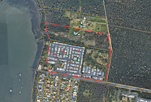
The site is located at 2 and 10 Mulloway Road, Chain Valley Bay, and comprises two lots:
· Lot 1 DP806503
· Lot 22 DP588107
The site is located to the north of Mulloway Road. The site has an irregular shape and has an area of approximately 16.98Ha (Figure 1). The site generally has a gentle slope gradually falling from the eastern boundary to the western boundary along the foreshore. Across the whole site is a fall of approximately 10m. The informal golf course area in the north-eastern corner of Lot 1 has a fall from the north eastern corner of the lot to the drainage swale in the centre of the lot of approximately 7m.
A caravan park with 230 long term sites has operated on Lot 1 for many years. All sites currently contain a single storey manufactured home. The caravan park also currently contains a manager’s office and residence, pool, tennis court, amenities block, community hall, a waste servicing area and an informal golf course area in the north-eastern corner of Lot 1 as shown in Figure 2. The caravan park is currently accessed from an entry/exit on Mulloway Road near the south-western corner of the site. All existing internal access roads are sealed, and visitor parking is provided new the entry to the site.
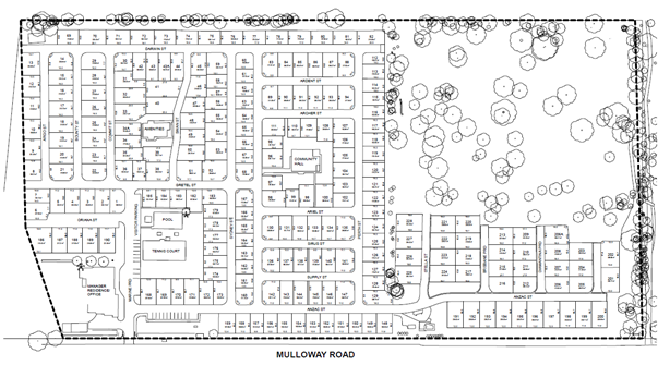
Figure 2 – Community map of existing caravan park
Lot 22 contains a single storey dwelling and shed. Lot 22 is cleared around the dwelling to accommodate asset protection zones (APZs) and is currently used for horse grazing. The remainder of the site is covered in vegetation.
A right of carriageway for access to Lot 22 and Lot 21 (adjoining to the north) is identified on DP588107. The right of carriageway is located along the battle-axe handles of Lots 22 and 21, both lots being benefitted and burdened by the easement.
The site contains a private sewer pump station in the north-western corner of Lot 1.
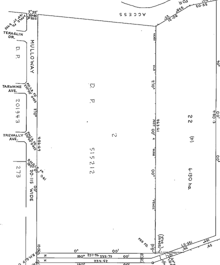
Figure 3 – Deposited Plan for Lots 2 and 22
The site is identified as "bushfire prone land". A Bushfire Assessment Report prepared by Bushfire Planning Australia (Version Final – November 2021 dated 3/11/2021) was submitted with the application recommending the proposal comply with BAL levels of either BAL-12.5, BAL-19 or BAL-29.
Figures 4 to 15 below show the existing development on the site.
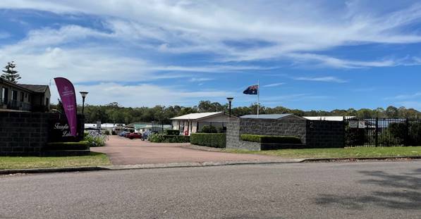
Figure 4 – Existing main entrance from Mulloway Road
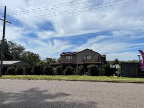
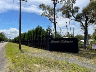
Figure 5– Site as viewed from the street
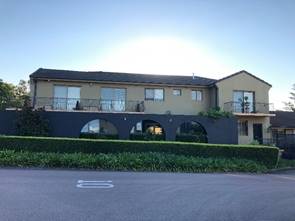
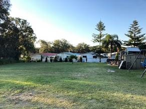
Figure 6 – Existing manager’s residence/office proposed to be demolished (left)and behind the manger’s residence/office (right)
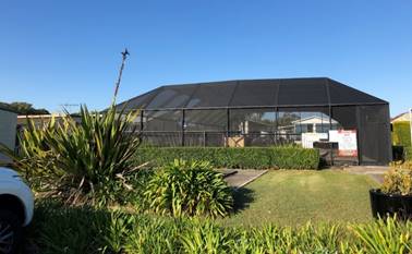
Figure 7 – Existing swimming pool to be retained
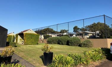
Figure 8 – Existing tennis court proposed to be demolished
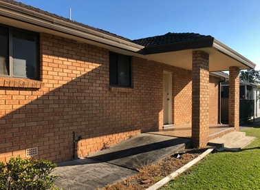
Figure 9 – Existing amenities block proposed to be demolished
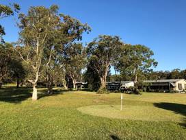
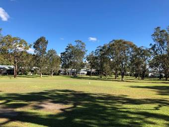
Figure 10 – Existing informal golf course area in the north-eastern corner of Lot 1
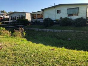
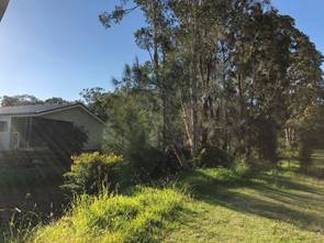
Figure 11 – Existing drainage swale
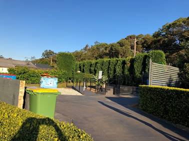
Figure 12 – Existing waste servicing area
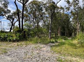
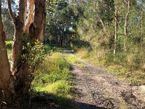
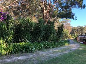
Figure 13 – Existing access along the eastern battle-axe handle to Lot 22
Figure 14 – Easternmost manufactured homes as viewed from the eastern battle-axe handle to Lot 22
Figure 15 – Northern boundary between Lot 1 and Lot 22
Surrounding Development
The site is surrounded by a mix of low density residential development and bushland. To the north of the site is a single dwelling and ancillary structures located within a cleared part of a large lot. The remainder of the area to the north contains bushland. To the east of the site is Lake Macquarie State Conservation Area.
Low density residential development which comprises of a mix of single storey and two storey dwellings is located to the south of the development on the opposite side of Mulloway Road (refer to Figure 16). A single dwelling and ancillary structures surrounded by bushland is also located to the south of the site. The site adjoins a reserve (comprised of Council and Crown land) along Lake Macquarie containing a playground and boat ramp directly to the west.
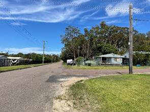
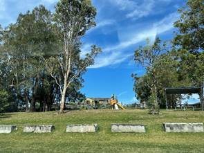
Figure 16 – Surrounding residential development south of the site and park adjoining the site to the west
The Proposed Development
The proposed development includes a change of use to manufactured home estate, construction of an additional 73 dwelling sites, new communal amenities, demolition, and environmental protection works including:
· Change of use from a caravan park currently containing 230 sites to a manufactured home estate
· Construction of an additional 73 dwelling sites in the north- eastern corner of the site
· A new Community Building for ancillary resident use, containing a resident kitchen, dining, amenities, lounge and gym
· New communal facilities, including a pool, men’s shed, games room, bowling green, amenities and barbeque facilities
· Additional visitor parking, internal roads, and secondary exit/entry to Mulloway Road
· New Manager Office and Sales Office
· Demolition of existing Manager Office and house, amenities block and tennis court
· Design for works associated with the above alterations, including:
o Landscaping
o Earthworks and tree removal
o Services and stormwater management
o Demolition and removal of existing structures
· Environmental protection works in Lot 22 associated with the proposed Vegetation and Fauna Management Plan.
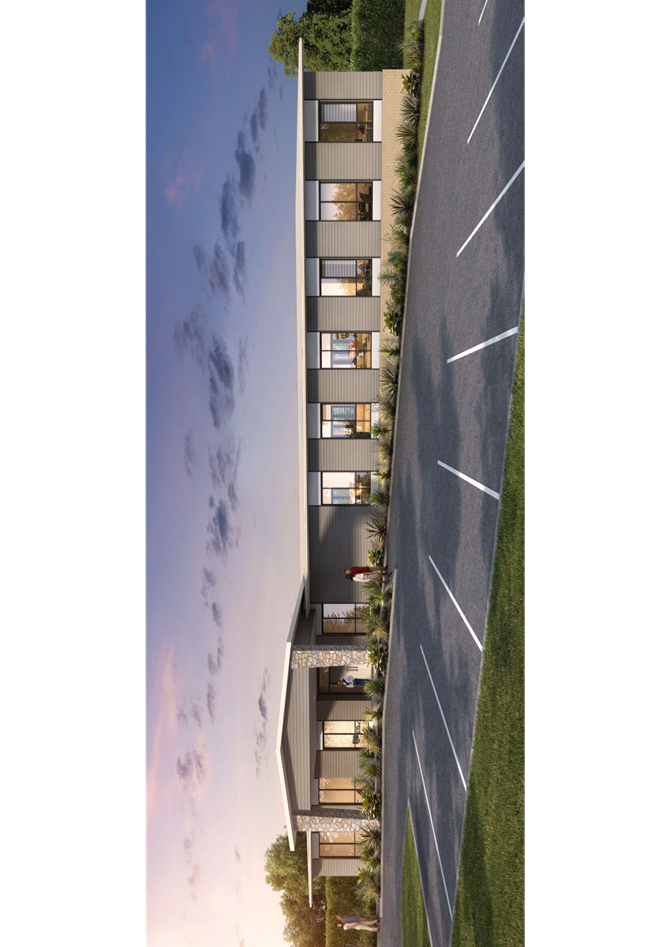
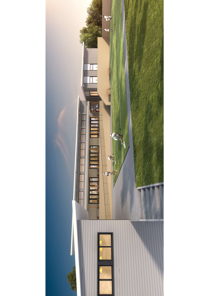
Figures 17-21 provide an extract of the plans accompanying the application, which identify the location of the different uses on site and the elevations and floor plans of the proposed buildings and manufactured homes.
The new 73 dwelling sites will contain future manufactured homes that will be manufactured off site and transported to the site for installation. The type of manufactured homes that were submitted with the application are shown as generally single storey and containing two bedrooms, carport, kitchen, living and amenities.
Vehicular access to the site is provided via an existing two-way driveway and a new secondary entry/exit to Mulloway Road.
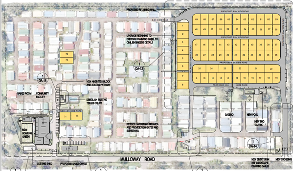
Figure 17 – Site plan of proposed development
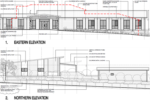
Figure 18 – Elevations of proposed community facility building
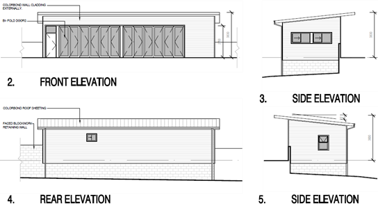
Figure 19 – Elevations of proposed games room
Figure 20 – Elevations of proposed sales office
Figure 21 – Indicative site layout plan of manufactured dwellings
History
· DA/1066/1995 was approved on 28 November 1995 for the formalisation of the existing caravan park, mobile home park and caravan ground
· DA/3631/1999 was approved on 22 December 1999 for the conversion of sites within Teraglin Lakeshore Village.
· DA/1050/2000 was approved on 25 May 2000 for the conversion of three short term caravan sites to long term mobile home sites.
· DA/3458/2000 was approved on 8 October 2001 for 24 additional mobile home sites.
· DA/998/2004 was approved on 27 July 2004 for a tennis court and two additional sites.
· DA/22/2011 was approved on 30 May 2011 for the creation of two additional sites. The consent was modified on 3 April 2012.
· DA/78/2012 was approved on 16 July 2012 for the creation of 12 additional sites. The consent was modified on 31 August 2012.
· DA/918/2016 was approved on 13 October 2016 for an addition to the existing community hall.
· A pre-lodgement meeting (PL/96/2020) was held on 26 May 2020 for the extension of a caravan park -additional 69 long term sites.
· A pre-lodgement meeting (PL/269/2020) was held on 9 November 2020 for the extension of a caravan park -additional 88 long term sites, communal facilities and ancillary landscaping.
· DA/373/2021 was lodged for a manufactured home estate comprising of an additional long-term sites and associated works. The application was withdrawn on 7 July 2021 due to insufficient information and issues related to amenity, consistency with the Local Government (Manufactured Home Estates, Caravan Parks, Camping Grounds and Moveable Dwellings) Regulation 2005, landscaping, waste management, ecology, engineering social impacts and bushfire.
Application background
· The application was lodged on 13 January 2022.
· On 12 April 2022 the applicant provided additional flora surveys.
· On 13 May 2022 the applicant provided a response to submissions.
· On 16 May 2022 Council requested further information, as follows;
o Clarification whether the BAM assessor will update the BDAR to consider the additional orchid surveys for Corunastylis sp. Charmhaven.
o Including the Regent Honeyeater as an ecosystem credit in an updated BDAR.
o The norther and eastern elevations of the community building was not submitted with the plans.
o Fencing details between the community building/games room and the adjoining dwelling sites.
o Additional details of the proposed screen fencing around the waste area.
· On 27 May 2022 Council received additional information to address the issues raised in the request for information sent on 16 May 2022.
· On 22 June 2022 Council requested a Waste Management Plan be submitted. The applicant provided the Waste Management Plan on 22 June 2022.
· On 3 August 2022 Council requested further information as follows:
o Additional catchment information to be included I the drainage catchment analysis/modelling.
o Provide the electronic stormwater analysis and water quality modelling.
o Demonstrate compliance of the existing sites with Local Government (Manufactured Home Estates, Caravan Parks, Camping Grounds and Moveable Dwellings) Regulation 2021 (Local Government Regulation 2021).
o Additional details to be included in the Waste Management Plan.
· On 26 August 2022 Council received additional information to address the issues raised in the request for information sent on 3 August 2022.
· On 24 October 2022 Council requested a compliance table demonstrating the existing caravan park will comply with the Local Government Regulation 2021 for a manufactured home estate. On 6 December 2022 Council advised that a compliance table would no longer be required as there is no requirement for the application to demonstrate compliance at the development application stage, however, it was noted that this will need to be addressed when obtaining approval to operate.
· On 6 December 2022 an Acid Sulfate Soils Management Plan was requested to be submitted. An acid sulfate soils management plan was submitted to Council on 10 January 2023. Council also requested a copy of the Preliminary Contamination Report referred to in the Acid Sulfate Soils Management Plan be provided on 20 February 2023, the Preliminary Contamination Report was submitted to Council on the same day.
· On 24 May 2023 Council requested the soil sampling and analysis recommended in the Preliminary Contamination Report submitted on 20 February 2023 to be carried out to support the content of the Preliminary Contamination Report. A Preliminary Site Investigation Report was submitted to Council on 16 June 2023.
ASSESSMENT:
Having regard for the matters for consideration detailed in Section 4.15 of the Environmental Planning and Assessment Act 1979 and other statutory requirements, Council’s policies and Section 10.7 Certificate details, the assessment has identified the following key issues, which are elaborated upon for Council’s information. Any tables relating to plans or policies are provided as an attachment.
Integrated Development Provisions
Water Management Act 2000
The proposed development included the carrying of work within 40m of waterfront land and is classified as Integrated Development. The application was referred to NRAR who advised that a controlled activity approval is not required for the proposed works and no further assessment by this agency was necessary.
Rural Fires Act 1997 & Planning for Bushfire Protection
The subject site is located within a designated bushfire prone area and is classified as Integrated Development. General terms of approval were sought from the NSW Rural Fire Service for the subject Integrated Development in accordance with Division 4.8 of the Environmental Planning and Assessment Act 1979.
Pursuant to Section 100B of the Rural Fires Act 1997 NSW RFS provided General Terms of Approval, which have been included as part of the recommended conditions (see Condition 1.2).
Given the application has been assessed by NSW RFS and a Bushfire Safety Authority under Section 100B of the Rural Fires Act 1997 has been issued, Council can be satisfied the application meets the requirements of Planning for Bushfire Protection 2019 subject to compliance with the General Terms of Approval provided by NSW RFS.
Biodiversity Conservation Act 2016 (BC Act)
Section 7.16 of the Biodiversity Conservation Act 2016 specifies that the consent authority must determine whether or not any of the impacts of a proposed development on biodiversity values are serious and irreversible. Where the consent authority determines that the impacts are serious and irreversible, the consent authority must refuse to grant development consent. This decision is to be made in accordance with principles set out in clause 6.7 of the Biodiversity Conservation Regulation 2017. The process outlined in the “Guidance to assist a decision-maker to determine a serious and irreversible impact” has also been considered.
Under clause 6.7 (2), an impact is to be regarded as serious and irreversible (SAII) if it is likely to contribute significantly to the risk of a threatened species or ecological community becoming extinct because:
· it will cause a further decline of the species or ecological community that is currently observed, estimated, inferred or reasonably suspected to be in a rapid rate of decline (principle 1), or
· it will further reduce the population size of the species or ecological community that is currently observed, estimated, inferred or reasonably suspected to have a very small population size (principle 2), or
· it is an impact on the habitat of the species or ecological community that is currently observed, estimated, inferred or reasonably suspected to have a very limited geographic distribution (principle 3), or
· the impacted species or ecological community is unlikely to respond to measures to improve its habitat and vegetation integrity and therefore its members are not replaceable (principle 4).
In determining whether a proposal is likely to result in a SAII, according to Guidance to assist a decision-maker to determine a serious and irreversible impact (DPIE, September 2019), Council is required to:
· take likely SAII into consideration, and
· determine if there are any additional and appropriate measures that will minimise the impact if the activity is to be carried out or approved.
The application submitted a Biodiversity Development Assessment Report (BDAR) prepared by AEP, dated 19 May 2022, which provided information relating to two potential SAII entities; Swift Parrot and Charmhaven Orchid. Council’s Ecologist also considered SAII in relation to the Regent Honeyeater.
For the reasons outlined below, Council’s Ecologist is satisfied that the impacts of the proposed development on biodiversity are not serious and irreversible.
Swift Parrot
The principles considered applicable influencing the extinction risk of Swift Parrot are:
· Rapid decline (Principle 1);
· Small population size (Principle 2); and
· The species being unlikely to respond to management (Principle 4).
Some vegetation on both 2 and 10 Mulloway Road is included on the NSW Swift Parrot Important Areas map. The Swift Parrot forages on nectar and lerp. Tree species within the area proposed to be cleared include locally favoured nectar food tree species; Swamp Mahogany (Eucalyptus robusta), Spotted Gum (Corymbia maculate), Red Bloodwood (Corymbia gummifera) and Forest Red Gum (Eucalyptus tereticornis.
During a number of winter migrations Swift Parrots have been known to forage near Chain Valley Bay, particularly in trees within Joshua Porter Reserve. Surveys did not detect the Swift Parrot on site, but presence of the species is required to be assumed in mapped important areas (NSW Threatened Biodiversity Data Collection).
The proposal would impact 2.56Ha or 0.6% of the 420ha of mapped important habitat within 1500m of the subject site (areas quoted in BDAR). The habitat on the site consists of scattered trees, whilst the other habitat mapped land in the locality includes large areas reserved in the adjoining National Parks estate and in environmental zones surrounding the foreshore.
The habitat on site is already partially cleared and fragmented. The proposal is unlikely to significantly reduce connectivity or result in edge effects that significantly reduce the viability of adjoining foraging habitat for the Swift Parrot.
The proposal provides increased avoidance of Swift Parrot feed trees within the mapped important habitat when compared with an earlier application. The extent of habitat identified to be removed or modified is considered the minimal amount required to facilitate the proposal. The applicant has also taken the step of purchasing the property to the north which also contains more than 4Ha of mapped important Swift Parrot, and through this application, proposes to rehabilitate and manage this property for the benefit of local biodiversity.
Charmhaven Orchid Corunastylis sp. Charmhaven
The BDAR included an expert report Corunastylis sp. Charmhaven. The presence of the species was assumed areas of the site based on the expert report because at the time of submission of the application, seasonal targeted surveys had not been undertaken. Within the development footprint, 0.73Ha was mapped by the species expert as suitable habitat for the species, with 0.71Ha within the APZ, and 230m2 within the development proper. As presence was assumed, mainly within the APZs, species credits were applied.
Targeted surveys for this species were undertaken during the 2021/2022 flowering period after the development application was lodged (letter from AEP dated 12 April 2022). AEP did not detect the species on site or on adjoining land surveyed. Council’s Ecologist also undertook a site inspection of the higher quality native vegetation area along the access to 10 Mulloway in December 2021 and did not observe any Corunastylis or Genoplesium orchids.
Potential habitat within APZs and 10 Mulloway will be managed in a way that may benefit the species if it was to be present in soil seedbank. Based on these further surveys that did not detect the species on site, it is determined that the development is unlikely to have a serious and irreversible impact on this species. The applicant has elected to still retire the species credits within the BDAR, rather than update the credit requirement to take into account the surveys.
Regent Honeyeater
The Regent Honeyeater is identified as a SAII candidate species in the relevant state guidelines. However, the NSW Threatened Biodiversity Data Collection (TBDC) states that SAII is only likely for this species if the proposal includes clearing of mapped important habitat. In this case, there is no mapped important habitat on the subject site. However, the vegetation on the site includes feed trees favoured by this species, and there are known records at Chain Valley Bay, as recently as May 2021.
Dr Ross Crates previously provided expert advice to Council relating to a development that proposed clearing of potential Regent Honeyeater foraging habitat at Wadalba. Dr Crates advised that Council should consider the potential for SAII on this species where there is foraging habitat but there is no identified breeding habitat in the important areas map. Recent Land and Environment Court judgements have expanded SAII considerations beyond those entities specifically listed in NSW Government Guidance material (Planners North v Ballina Shire Council [2021] NSWLEC 120, White v Ballina Shire Council [2021] NSWLEC 1468).
As a precautionary measure, Council’s Ecologist has completed a SAII assessment for the Regent Honeyeater, as the species meets one or more of the principles outlined in clause 6.7 of the Biodiversity Conservation Regulation 2017. The foraging requirements for this species on the site are similar to that of the Swift Parrot. Preferred nectar feed trees present on site include Swamp Mahogany (Eucalyptus robusta) and Spotted Gum (Corymbia maculata).
The proposal provides increased avoidance of Regent Honeyeater feed trees as discussed above. The applicant has also taken the step of purchasing the property to the north which also contains suitable Regent Honeyeater habitat, and through this application, proposes to rehabilitate and manage this property for the benefit of local biodiversity.
It is concluded that the development is not likely to have a serious and irreversible impact on biodiversity values.
State Environmental Planning Policy (Housing) 2021
The proposal has been assessed under State Environmental Planning Policy (Housing) 2021.
The principles of the SEPP are provided in Section 3 as follows:
The principles of this Policy are as follows –
(a) enabling the development of diverse housing types, including purpose-built rental housing,
(b) encouraging the development of housing that will meet the needs of more vulnerable members of the community, including very low to moderate income households, seniors and people with a disability,
(c) ensuring new housing development provides residents with a reasonable level of amenity,
(d) promoting the planning and delivery of housing in locations where it will make good use of existing and planned infrastructure and services,
(e) minimising adverse climate and environmental impacts of new housing development,
(f) reinforcing the importance of designing housing in a way that reflects and enhances its locality,
(g) supporting short-term rental accommodation as a home-sharing activity and contributor to local economies, while managing the social and environmental impacts from this use,
(h) mitigating the loss of existing affordable rental housing.
The proposed development will provide for additional manufactured homes within Teraglin Lakeshore Village and formalise the existing use. It is considered that the proposed housing will meet the needs of more vulnerable members of the community and the housing and new community facilities will provide a reasonable level of amenity to the residents.
The existing infrastructure within the site will be appropriately upgraded to support the new houses and the existing infrastructure to the site is adequate to support the proposed development. The proposed development has been designed to manage the environmental constraints of the site by including a vegetation management area on Lot 22 and where possible, retaining vegetation within the setbacks to the proposed manufactured home estate and the open space areas. The proposed development is suitable having regard for the existing characteristics of the locality which contains low density residential and a long-term caravan park.
Part 8 – Manufactured home estates applies to the proposed development and the following aims and strategies are provided in Section 118:
(1) The aims of this Part are—
(a) to facilitate the establishment of manufactured home estates as a contemporary form of medium density residential development that provides an alternative to traditional housing arrangements, and
(b) to provide immediate development opportunities for manufactured home estates on the commencement of this Part, and
(c) to encourage the provision of affordable housing in well designed estates, and
(d) to ensure that manufactured home estates are situated only in suitable locations and not on land having important resources or having landscape, scenic or ecological qualities that should be preserved, and
(e) to ensure that manufactured home estates are adequately serviced and have access to essential community facilities and services, and
(f) to protect the environment surrounding manufactured home estates, and
(g) to provide measures which will facilitate security of tenure for residents of manufactured home estates.
(2) The strategies by which those aims are to be achieved are—
(a) by allowing, with development consent, manufactured home estates on certain land on which caravan parks are permitted if the land meets the suitable locational criteria stipulated in this Part (which it would not do if, for example, it contains important resources, is subject to natural or man-made risks or has sensitive environmental or ecological features), and
(b) by applying this Part to areas where there is likely to be a demand and suitable opportunities for the development of manufactured home estates, and
(c) by allowing manufactured home estates to be subdivided with development consent either by way of leases for terms of up to 20 years or under the Community Land Development Act 1989, and
(d) by enabling the Minister for Planning to exclude from this Part any land that is subject to a local environmental plan prepared in accordance with the principles of a direction issued in conjunction with this Part under section 117 of the Act.
The applicant provided the information below to demonstrate that the proposed development meets the aims and strategies of the SEPP.
Applicant’s submission:
The proposed development achieves the aims of SEPP 36 by:
a. Facilitating contemporary, medium density housing and providing a viable alternative to traditional housing.
b. Providing an immediate opportunity for additional manufactured homes within an established community, with existing facilities and infrastructure;
c. Providing affordable housing within an established and popular community of manufactured homes;
d. Situating the manufactured home estate within an established community, while containing new homes within an existing disturbed area and incorporating land for flora and fauna management;
e. Ensuring the manufactured home estate is adequately serviced with easy access to community facilities and services;
f. Protecting and enhancing the surrounding environment through rehabilitation and flora and fauna management.
g. Providing security of tenure for residents in accordance with the Residential (Land Lease) Communities Act
The proposed development fulfils the strategies, as follows:
a. the site is currently improved by a caravan park and the proposed MHE is permissible on the land. An assessment of the locational criteria in Schedule 2 is included below and confirms the site is not excluded from MHE development. Key points in this regard:
· The proposed development is located outside of mapped flood and wetland areas;
· The land is not mapped as extractive resources, service corridor, airport/industry buffer, littoral rainforest or water catchment.
· The land is not mapped as a habitat corridor. The development area is mapped as having habitat values which have been comprehensively assessed in this application. The BDAR confirms the development provides potential seasonal foraging habitat, is not mapped as important habitat for Swift Parrot and no roost camp is present within the site. The BDAR confirms that no Serious and Irreversible Impact is likely to occur as areas of high-quality habitat are retained and
b. restoration of moderate habitat is undertaken.
c. A Social Impact Assessment has been submitted with the application and confirms demonstrated demand for housing in this location and the need for affordable housing supply to be delivered efficiently.
d. The community will be operated in accordance with the Residential (Land Lease) Communities Act 2013.
e. Noted
Comment:
The proposed development will facilitate affordable, contemporary, medium density housing to provide a viable alternative to traditional housing. The proposed development is within an established caravan park with existing infrastructure and facilities to enable the immediate opportunity for additional manufactured homes to be installed. The proposed development is located within an existing caravan park and the expansion is to occur on the part of the site that has been previously disturbed (informal golf course) and will preserve areas of ecological value. The proposed development will be adequately serviced and has suitable access. It will incorporate security measures that will provide security to residents. It is considered that the proposed development satisfies the aims and strategies of the SEPP.
Section 122 identifies development for the purposes of a manufactured home estate may be carried out pursuant to Part 8 on any land on which development for the purposes of a caravan park may be carried out except on land within one or more of the categories in Schedule 6, land dedicated or reserved under the National Parks and Wildlife Act 1974 or land within a Crown reserve.
Lot 1, where the manufactured home estate is proposed, is zoned RE2 Private Recreation. Under Wyong Local Environmental Plan 2013 (WLEP 2013), a caravan park is permissible with consent. The proposed manufactured home estate is not to be carried out on land identified within Schedule 6, the land is not dedicated or reserved under the National Parks and Wildlife Act 1974 and the land is not a Crown reserve. Having regard for the above a manufactured home estate is permissible on the site.
Section 123 provides the following:
(1) Development for the purposes of a manufactured home estate permitted to be carried out by this Part may be carried out only with the development consent of the council.
(2) A council must not consent to any such development unless it imposes, as a condition of the consent, a requirement that an approval to operate a manufactured home estate on the land on which the development is to be carried out must be obtained under Part 1 of Chapter 7 of the Local Government Act 1993.
(3) Nothing in this Part requires a separate development consent to authorise the placing of each manufactured home within a manufactured home estate.
A condition of consent is recommended requiring approval to operate a manufactured home estate under Part 1 of Chapter 7 of the Local Government Act 1993 (Condition 1.6). It is also noted that a separate development consent is not required for the placement of each manufactured home.
Section 124 applies to subdivision of manufactured home estates. The proposed development does not include subdivision.
Section 125 of this SEPP includes the matters to be considered by Council. The matters to be considered have been addressed in the following table.
|
Requirement |
Comment |
|
1(a) that each of the sites on which a manufactured home is or will be installed within the manufactured home estate is or will be adequately provided with reticulated water, a reticulated sewerage system, drainage and electricity |
All homes will be serviced with reticulated water, sewer, drainage and electricity. |
|
1(b) that the manufactured home estate is or will be provided with adequate transport services |
Teraglin has a community bus service for residents. Details of the bus service are provided in the Social Impact Assessment prepared by AIGIS Group dated November 2021. The site has access to roads, public transport and pathways as detailed in the submitted social impact assessment and the Traffic Report prepared by Intersect Traffic dated 16 October 2021. |
|
1(c) that sufficient community facilities and services, whether situated within or outside the estate, are or will be available and reasonably accessible to the residents of the manufactured home estate |
The proposal will retain an existing communal pool and community building; and provide a new community building, second pool, amenities, bowling green and internal paths. Open space areas will be landscape and managed to provide a high-amenity and safe community environment. Community facilities are provided in Local Government (Manufactured Home Estates, Caravan Parks, Camping Grounds and Moveable Dwellings) Regulation 2021. |
|
1(d) that the development will not have an adverse effect on any— · conservation area · heritage item · waterway or land having special landscape, scenic or ecological qualities, which is identified in an environmental planning instrument applicable to the land concerned. |
A BDAR and Vegetation and Fauna Management Plan has been prepared and submitted with this application. A condition of consent has been recommended for this to be updated prior to commencement of any works. The BDAR confirms that no Serious and Irreversible Impact is likely to occur as areas of high-quality habitat are retained and a vegetation management plan prepared will be in place for retained areas. |
|
Requirement |
Comment |
|
2(a) the cumulative impact of the proposed development and other manufactured home estates in the locality |
Cumulative population growth for the LGA over the period 2016 to 2041 is estimated to be approximately 28.3%. The 75 years and over group is forecast to significantly increase from being the smallest cohort on 2016 counts, to approaching comparable size to other groups, and in fact becoming larger than the 15-29 years group, by 2041.
As the proposed project is specifically aimed at addressing the housing needs of older people, the data demonstrate that this need is likely to noticeably increase over the next two decades and likely beyond. Part 6 of the SIA assesses the potential for impacts of the proposal across the broader community, including services, infrastructure, transport, retail, and community facilities. It notes the potential increase in population is small in the context of the area and will likely be accommodated within the existing and future capacity of the various networks.
The proposed additional 73 sites will not have a significant impact on the existing road network given the minor increase in traffic (additional 14 AM and 11 PM vehicle trips). TfNSW has also advised that the intersection with Chain Valley Road and the Pacific Highway has funding to be upgraded which will improve traffic management in the area and support the manufactured home estates in the locality. |
|
2(b) any relevant guidelines issued by the Director |
There are no relevant guidelines to consider. |
|
2(c) the provisions of the Local Government (Manufactured Home Estates) Transitional Regulation 1993 |
The Local Government (Manufactured Home Estate) Transitional Regulation 1993 amended certain ordinances because of the repeal of the Local Government Act 1919 and the enactment of the Local Government Act 1993. As a result, the Manufactured Home Estates Ordinance 1992 was repealed. As the proposed development is for the change of use to a manufactured home estate, there are no historic requirements that would relate to the land, notwithstanding, there would be historic licenses for the existing caravan park. |
Whilst the SEPP does not require an assessment against the Local Government (Manufactured Home Estates, Caravan Parks, Camping Grounds and Movable Dwellings) Regulation 2021, as this is undertaken as part of the Section 68 approval under the Local Government Act 1993, an assessment has been undertaken (refer to Attachment 4) to demonstrate how the existing caravan park will comply with the Regulation.
It should be noted that the new section of the site achieves compliance with the Regulation whilst the existing caravan park, which is proposed to be changed to a manufactured home estate, will involve some minor variations which are a result of existing dwelling setbacks and existing road widths.
The variations that will be proposed under the Section 68 Approval are considered acceptable in this instance given there is already an established built form and character within the park which residents are familiar with. The existing development will continue to achieve a high level of amenity for users of the development and the design of the proposed manufactured home estate is suitable for the intended purpose.
State Environmental Planning Policy (Resilience and Hazards) 2021
Chapter 2 – Coastal Management
The site is identified as being located within a Coastal Wetland, Coastal Wetland Buffer, Coastal Environment Area, Coastal Use Area.
Environmental Protection Works are proposed within the Coastal Wetland area. Environmental Protection Works are permitted with consent within the Coastal Wetland area in accordance with Section 2.7(1). In accordance with Section 2.7(2) the proposed development is not designated development as the proposed works within the Coastal Wetland area are for Environmental Protection Works.
In accordance with Section 2.7(4), a consent authority must not grant consent for development referred to in subsection 1 unless the consent authority is satisfied that sufficient measures have been, or will be, taken to protect and where possible enhance, the biophysical, hydrological and ecological integrity of the coastal wetland. The proposed environmental protection works will protect and enhance the existing vegetation on Lot 22 and will have minimal to no impact on the Lake Macquarie catchment area, provide regeneration of the creek line, improving the biodiversity, and is also likely to improve the water quality entering the lake.
In accordance with Section 2.8 council must not grant consent unless Council is satisfied that the proposed development will not significantly impact on the following:
(a) the biophysical, hydrological or ecological integrity of the adjacent coastal wetland or littoral rainforest, or
(b) the quantity and quality of surface and ground water flows to and from the adjacent coastal wetland or littoral rainforest.
The Coastal Wetlands Buffer covers part of Lot 22 (No. 10 Mulloway) and the north-western corner of Lot 1 (Figure 22). The works proposed within the coastal buffer include the environmental protection works and a change of use of the existing caravan park. The change of use to a manufactured home estate will not involve any physical works within the coastal wetland buffer. All physical works within the existing caravan park are proposed south of the wetland buffer area and in the vacant land which is east of the wetland buffer area. Having regard for this the proposed works will not significantly impact on the biophysical, hydrological or ecological integrity of the adjacent coastal wetland. The quantity and quality of the surface water and groundwater flows to and from the adjacent coastal wetland will not be impacted by the proposed development.
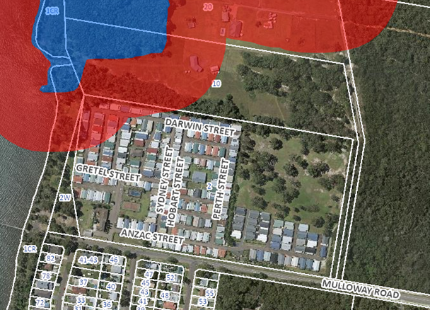
Figure 22 – Mapped wetland and wetland buffer
Any development identified within a Coastal Environment Area and Coastal Use Area is required to be in accordance with Sections 2.10 and 2.11 of the above SEPP. The proposed development has satisfactorily addressed the matters for consideration outlined in Sections 2.10 and 2.11. The proposal has been found to be consistent with the requirements of the above policy. An assessment against Sections 2.10 and 2.11 of the policy can be found below.
Clause 2.10 – Coastal Environment Area
|
Matters for Consideration |
Compliance Y/N/NA |
|
1(a) the integrity and resilience of the biophysical, hydrological (surface and groundwater) and ecological environment |
Yes - The proposed development will have no impact on biophysical, hydrological or ecological environment |
|
(b) coastal environment values and natural coastal processes |
Yes – The proposed development will have no impact on the surrounding coastal environmental values or natural coastal processes. |
|
(c) the water quality of the marine estate (within the meaning of the Marine Estate Management Act 2014), in particular, the cumulative impacts of the proposed development on any of the sensitive coastal lakes identified in Schedule 1, |
Yes - The proposed development will not cause an adverse impact on the water quality of the marine estate. |
|
(d) marine vegetation, native vegetation and fauna and their habitats, undeveloped headlands and rock platforms |
Yes – The proposed development will not cause adverse impacts upon the marine vegetation, native vegetation, fauna or their habitats, undeveloped headlands or rock platforms. |
|
(e) existing public open space and safe access to and along the foreshore, beach, headland or rock platform for members of the public, including persons with a disability |
N/A- The site not located directly on the foreshore. |
|
(f) Aboriginal cultural heritage, practices and places |
Yes – The site (lot 1) has been previously disturbed and has a history of being used for a caravan park. An Aboriginal Due Diligence Assessment prepared by McCardle Cultural Heritage, dated 13 January 2021 was also submitted with the application, which did not identify any archaeological sites, however a Potential Archaeological Deposits (PAD) was identified in the western portion of lot 22. No works are proposed within the PAD area and as such the proposed development will not impact on any Aboriginal cultural heritage, practices and places. Notwithstanding, a recommended condition of consent requires all works on site to cease in the event that any cultural heritage is discovered. |
|
(g) The use of the surf zone |
Yes – The proposed development has no impact on the surf zone. |
|
2(a) the development is designed, sited and will be managed to avoid an adverse impact referred to in subclause (1), or |
Yes – The development will not cause any adverse impact on the coastal environment area. |
|
Matters for Consideration |
Compliance Y/N/NA |
|
(b) if that impact cannot be reasonably avoided-the development is designed, sited and will be managed to minimise that impact, or |
Yes – The proposal will have a minimal impact. |
|
(c) if that impact cannot be minimised-the development will be managed to mitigate that impact |
Yes – The proposal will have a minimal impact. |
|
(3) This Clause does not apply to land within the Foreshores and Waterways Area within the meaning of Sydney Regional Environmental Plan (Sydney Harbour Catchment) 2005 |
N/A |
Clause 2.11 – Coastal Use Area
|
Matters for Consideration |
Compliance Y/N/NA |
|
(i) existing, safe access to and along the foreshore, beach, headland or rock platform for members of the public, including persons with a disability |
N/A- the site is not directly on the foreshore but foreshore reserve. |
|
(ii) overshadowing, wind funnelling and the loss of views from public places to foreshores |
Yes – The proposal will not have an impact of overshadowing, wind funnelling or loss of views from a public place. |
|
(iii) the visual amenity and scenic qualities of the coast, including coastal headlands |
Yes – The proposal will not impact the visual amenity or scenic qualities of the coast. |
|
(iv) Aboriginal cultural heritage, practices and places |
Yes – The site has been previously disturbed and has a history of being used for a caravan park and as such the proposed development will not impact on any Aboriginal cultural heritage, practices and places. |
|
(v) cultural and built environment heritage |
Yes – There are no identified cultural and building heritage items on the site. |
|
(i) the development is designed, sited and will be managed to avoid an adverse impact referred to in paragraph (a), or |
Yes – The proposed development will not have any adverse impact referred to in paragraph (a). |
|
(ii) if that impact cannot be reasonably avoided—the development is designed, sited and will be managed to minimise that impact, or. |
N/A |
|
(iii) if that impact cannot be minimised - the development will be managed to mitigate that impact, and |
N/A |
|
(a) has taken into account the surrounding coastal and built environment, and the bulk, scale and size of the proposed development |
Yes – The proposal will have minimal impact upon the existing coastal and built environment. |
Chapter 4 – Remediation of Land
In accordance with Section 4.6, a consent authority must not consent to the carrying out of development unless it has considered whether the land is contaminated and if the land requires remediation to be made suitable for the development.
A preliminary contamination assessment, prepared by Qualtest, dated 30 August 2019, was submitted with the application. The site history showed the site was used for rural residential and agricultural purposes from the mid-1950s to the 1970s. Four Areas of Environmental Concern (AECs) with low to medium likelihood of contamination were identified for the site, relating to:
· Former dams (probable sewage treatment facility) on north-eastern portion of Lot 1
· Construction waste, general rubbish and stockpiles
· Former and current buildings and sheds
· Former cropping in south-western portion of site (in 1950s).
The report concluded that based on the site history and observations during the site walkover, it was recommended that additional assessment, comprising intrusive investigations (e.g. sampling of surface soils, fill, stockpiles, and fill backfilled in former dams, surface water sampling and installation of groundwater wells and sampling) be further undertaken in the AEC.
Having regard for the recommendations of the Preliminary Contamination Assessment, further sampling was required, and a preliminary site investigation, which satisfied the provisions of Section 4.6(2) was also required to be prepared. A Preliminary Site Investigation Report, prepared by WSP and dated 16 June 2023, was submitted to Council.
The Preliminary Site Investigation Report included soil sampling and analysis to support the conclusions of the report and to satisfy the requirements of the contaminated land planning guidelines. Although exceedances were detected in two of the 22 samples for “Total Recoverable Hydrocarbons” (TRH) and “Thermotolerant Coliforms”, they were localised and limited in extent. The exceedance in both areas was not considered to present a significant risk to human health or the environment and the localized, shallow contamination is likely to ‘break down’ over time through degradation and microbiological activity or be removed as part of surface preparatory works for the proposed development. This has been addressed via Conditions 4.31 and 5.7. The preliminary site investigation concluded that the site was suitable for the proposed development and future use for residential purposes.
Having regard for the above, it is considered that the requirements of Section 4.6 have been satisfied as staff have received and considered the findings of a preliminary investigation of the land concerned, and that investigation has been carried out in accordance with the contaminated land planning guidelines (Section 4.6(2)). The findings of this investigation do not require further investigation to be carried out (Section 4.6(3)) and accordingly, the consent authority can be satisfied that the land can be made suitable for the purpose for which the development is proposed to be carried out.
State Environmental Planning Policy (Biodiversity and Conservation) 2021
Chapter 4 – Koala Habitat Protection 2021
Chapter 4 of the State Environmental Planning Policy (Biodiversity and Conservation) 2021 applies to Central Coast local government area. In accordance with Section 4.9 before a consent authority can grant consent, it must assess whether the development is likely to have any impact on koalas or koala habitat. In accordance with Section 4.9(5) consent may be granted where the applicant provides satisfactory information that demonstrates that the land subject of the development application is not core koala habitat.
The Biodiversity Development Assessment Report (BDAR) submitted with the application undertook an assessment to determine if the site was core koala habitat. Council’s Ecologist reviewed the BDAR and was satisfied that the site is not core koala habitat.
Central Coast Local Environmental Plan 2022 (CCLEP 2022)
CCLEP 2022 was published on 24 June 2022 and commenced on 1 August 2022 and has been considered in the assessment of the application. However, in accordance with the savings provisions under clause 1.8A, this application has been lodged prior to the commencement of CCLEP 2022, and as such the provisions of the WLEP 2013 continue to apply.
Under the published and adopted CCLEP 2022, the site will retain its RE2, CC2 and C3 zoning and a manufactured home estate remains permissible within the RE2 zone. There are no new or amended clauses or provisions warranting further discussion.
Wyong Local Environmental Plan 2013
Zoning and Permissibility
Lot 1 is zoned RE2 Private Recreation and Lot 22 is zoned C2 Environmental Conservation and C3 Environmental Management (refer figure 23). Manufactured home estates are permissible with consent within the RE2 Private Recreation zone pursuant to Section 122 of SEPP (Housing) 2021.
Environmental protection works are permissible within both the C2 Environmental Conservation zone and the C3 Environmental Management zone.
Figure 23 – Zoning of the site and surrounding area
A manufactured home estate is defined as follows under the Local Government Act 1993:
manufactured home estate means land on which manufactured homes are, or are to be, erected.
The proposed development involves the change of use of a caravan park containing 230 dwelling sites to a manufactured home estate and the construction of an additional 73 dwelling sites, an associated community building, amenities block, pool and gazebos.
It is important to note that this application is for the use of the site for a manufactured home estate and the operation of the manufactured home estate is subject to a section 68 approval under the Local Government Act 1993 and the provisions of Local Government (Manufactured Homes Estates, Caravan Parks, Camping Grounds and Moveable Dwellings) Regulation 2021.
The Local Government Act 1993 defines a manufactured home as follows:
Manufactured home means a self-contained dwelling (that is, a dwelling that includes at least one kitchen, bathroom and living area and that also includes toilet and laundry facilities), being a dwelling-
(a) that comprises one or more major sections, and
(b) that is not a motor vehicle, trailer or other registrable vehicle within the meaning of the Road Transport Act 1909,
and includes any associated structures that form part of the dwelling.
The operator intends to install manufactured homes on the dwelling sites and the applicant has advised that the manufactured homes provided as part of the application documentation will be manufactured off site and transported to the site for installation.
The proposed development also includes environmental protection works on Lot 22 which are defined as follows under WLEP 2013:
environmental protection works means works associated with the rehabilitation of land towards its natural state or any work to protect land from environmental degradation, and includes bush regeneration works, wetland protection works, erosion protection works, dune restoration works and the like, but does not include coastal protection works.
The proposed rehabilitation, planting, protection, and maintenance on Lot 22 detailed in the Vegetation and Fauna Management Plan submitted with the application satisfies the above definition for environmental protection works and is permitted with consent on Lot 22 within the C2 and C3 zones.
Objectives of the zone
The proposed manufactured home estate is proposed on Lot 1 which is zoned RE2. The objectives of the RE2 zone are as follows:
· To enable land to be used for private open space or recreational purposes.
· To provide a range of recreational settings and activities and compatible land uses.
· To protect and enhance the natural environment for recreational purposes.
· To offer opportunities for tourism development that is compatible with the natural environment.
· To allow for alternative uses of open space areas for community purposes that are compatible with surrounding areas.
· To enable land uses that are compatible with, and complementary to, recreational uses.
The objectives of the RE2 zone relate to the provisions of recreational, tourism and alternative uses of open space for community purposes. The provisions of Section 122 of SEPP (Housing) 2021 states that a manufactured home estate is permissible on any land on which development for the purposes of a caravan park may be carried out except on land within one or more of the categories in Schedule 6, land dedicated or reserved under the National Parks and Wildlife Act 1974 or land within a Crown reserve.
As previously discussed in the report, the proposed manufactured home estate is permitted with consent on the RE2 zoned land. To the extent that the objectives of the RE2 zone and the objectives of SEPP (Housing) 2021 are inconsistent, Section 8 of SEPP (Housing) 2021 states if there is an inconsistency between the SEPP (Housing) 2021 and another environmental planning instrument, that SEPP (Housing) 2021 prevails. Therefore, the objectives of SEPP (Housing) 2021 have been considered with regard to the suitability of the development in within the RE2 zone.
An assessment regarding the objectives of SEPP (Housing) 2021 has been previously undertaken in the report and it is considered that the proposed development is consistent with the objectives of SEPP (Housing) 2021.
The proposed environmental protection works are proposed on Lot 22 which is zoned C2 and C3. The objectives of the C2 zone are as follows:
· To protect, manage and restore areas of high ecological, scientific, cultural or aesthetic values.
· To prevent development that could destroy, damage or otherwise have an adverse effect on those values.
· To protect endangered ecological communities, coastal wetlands and littoral rainforests.
· To enable development of public works and environmental facilities if such development would not have a detrimental impact on ecological, scientific, cultural or aesthetic values.
The objectives of the C3 zone are as follows:
· To protect, manage and restore areas with special ecological, scientific, cultural or aesthetic values.
· To provide for a limited range of development that does not have an adverse effect on those values.
The proposed environmental protection works facilitate the objectives of the C2 and C3 Zones by protecting and managing ecological communities and enhancing the ecological value of Lot 22. The conditioned Vegetation and Fauna Management Plan will ensure the rehabilitation of the land and its protection in perpetuity.
Clause 7.1 Acid Sulfate Soils
The site is mapped as potentially containing Class 2 and Class 5 acid sulfate soils. In accordance with clause 7.1, the applicant has submitted an Acid Sulfate Soils Management Plan prepared by Qualtest Laboratory, dated 20 December 2022, which states that the location of the works is in areas of no known occurrence of ASSS however, the site is affected by areas of high probability of acid sulfate soils. Although these areas are outside the building works, they are along the north-western boundaries of Lots 1 and 22 and as such an ASSMP was prepared. The plan shows that there is a low probability of acid sulfate soils on the site (refer to Figure 24).
The Acid Sulfate Soils Management Plan has been prepared in accordance with the Acid Sulfate Soils Manual and accordingly the Panel, as the consent authority, can be satisfied that the prerequisite condition to the granting of consent has been met.
Figure 24 – Acid Sulfate Soils map for the site as provided in the Acid Sulfate Soils Management Plan
Clause 5.21 Flood Planning
The site is identified as flood planning land under clause 5.21 of WLEP 2013 as shown in Figure 25.
In accordance with clause 5.21(2) development consent must not be granted to development on land the consent authority considered to be within flood planning land unless the consent authority is satisfied the development:
(a) is compatible with the flood function and behaviour on the land, and
(b) will not adversely affect flood behaviour in a way that results in detrimental increases in the potential flood affectation of other development or properties, and
(c) will not adversely affect the safe occupation and efficient evacuation of people or exceed the capacity of existing evacuation routes for the surrounding area in the event of a flood, and
(d) incorporates appropriate measures to manage risk to life in the event of a flood, and
(e) will not adversely affect the environment or cause avoidable erosion, siltation, destruction of riparian vegetation or a reduction in the stability of river banks or watercourses.
Figure 25 – Flood planning land on the subject site
The consent authority must also consider the following in deciding whether to grant development consent in accordance with clause 5.21(3):
(a) the impact of the development on projected changes to flood behaviour as a result of climate change,
(b) the intended design and scale of buildings resulting from the development,
(c) whether the development incorporates measures to minimise the risk to life and ensure the safe evacuation of people in the event of a flood,
(d) the potential to modify, relocate or remove buildings resulting from development if the surrounding area is impacted by flooding or coastal erosion.
A flood impact assessment prepared by BMT, dated 21 October 2021, was submitted with the application. The flood assessment provided the following conclusions:
The following flood mitigation measures have been proposed:
· 2 x 3.3m x 0.6m trunk drainage culvert and 8m long by 2m wide grated inlet to capture the 1% AEP peak from the main external catchment.
· A V-shaped channel at the outlet of the trunk drainage culvert to convey overflows.
· 2 x 1.5m x 1.5m cross-drainage box culvert under the internal road that links the proposed development site with the existing developed village.
· Flood relief berm and bund along the eastern, northern, and western boundaries of the development site to prevent overtopping of overland flows and mitigate offsite flood impacts.
· Diversion of flow from Mulloway Road using a pit and pipe drainage running under the proposed access road to the proposed trunk drainage culvert to mitigate flood impacts within the existing developed village.
· Suitable site grading has been completed by ADW Johnson civil designers.
The flood modelling and impact assessment demonstrated the following outcomes:
· The pre-development and post-development overland flow flood behaviour, such as peak flood level, depth velocity and flood hazard have been defined for the 20% AEP, 1% AEP, 1% AEP with climate change and PMF events.
· With the proposed site grading and flood mitigation works in place, the proposed development has been predicted to be compatible with the predicted flood hazard up to the PMF event.
· The proposed development is not predicted to result in significant modifications in design flood behaviour beyond the boundaries of the site (i.e., no increase in peak flood level and velocity within building footprints of the neighbouring properties).
· The predicted increases in peak flood levels beyond the boundaries of the development site (north western boundary) were confined to underdeveloped open spaces. In cases of offsite impacts on road flooding (eastern boundary), the predicted increase did not cause any actionable flooding nuisance that would affect the trafficability of access road (i.e., the flood hazard classification remained to be low for both the pre-development and post-development scenarios).
· The proposed development is not predicted to result in significant changes to the existing flood risk to life, property, or infrastructure in the extreme flood event (PMF).
· Modelling of severe flooding scenarios (assuming the proposed trunk drainage culvert being fully blocked) were undertaken for the 1% and PMF events which demonstrated that the predicted flooding would not result in unacceptably high risks to the existing and proposed dwellings.
With the flood mitigation measures proposed, any flooding on the site will be redirected via a culvert so that the area of the proposed expansion will not be impacted by flooding (Figures 26 and 27). Flooding on the remainder of the site will not be increased from the current flood impact and access to the site will be maintained during a 1% AEP flood event.
The proposed development will be compatible with the flood function and behaviour on the land and changes to flooding has been minimised on adjoining properties. The proposed development will not adversely affect the safe occupation and efficient evacuation of people. The measures proposed to reduce the flood impact on site and maintain access to the site are suitable to manage risk to life in the event of a flood.
The flooding will not adversely affect the environment on the site or adjoining properties. Accordingly, the proposal is considered to have suitable regard for the flood impact on the site and the provisions of clause 5.21 have been satisfied.
Figure 26 – 1% AEP peak flood levels (base case)
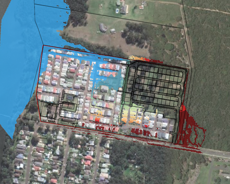
Figure 27 – 1% AEP peak flood levels (developed case)
Clause 7.9 – Essential Services
The proposal is supported by a Civil Engineering Report and Civil Engineering Plans which confirm the development has access to essential services including:
· Access roads, including an additional site access on to Mulloway Road
· Additional parking in both the existing village and expansion area
· Stormwater infrastructure
· Water and sewer infrastructure including connections to each new site
· Electrical, telephone and gas services to each new site.
The consent authority can be satisfied that the services essential for the development are available or can be made available, when required.
Central Coast Development Control Plan 2022
CCDCP 2022 commenced on 1 August 2022. However, in accordance with the savings provisions under Clause 1.1.4 of Chapter 1.1, this application has been lodged prior to commencement of CCDCP 2022 and as such the provisions of the WDCP 2013 continue to apply.
Wyong Development Control Plan 2013
Chapter 2.11 - Parking and Access
A Traffic and Parking Assessment prepared by Intersect Traffic, dated 16 October 2021 was submitted with the application. The Traffic and Parking Assessment recommended that ’the proposal can be supported from a traffic impact perspective as suitably conditioned it will not adversely impact on the local and state road network and complies with the Local Government (Manufactured Home Estates, Caravan Parks, Camping Grounds and Moveable Dwellings) regulation 2005 as well as all relevant Central Coast Council, Austroads, Australian Standard and TfNSW requirements.’ The Traffic and Parking Assessment provided the following conclusions:
· Existing traffic volumes on the local road network are within the technical mid-block road capacities determined by Austroads and TfNSW therefore the local road network has capacity to cater for additional traffic associated with new development in the area.
· The development is likely to generate 14 vtph during the AM peak and 11 vtph during the PM peak traffic periods.
· The local and state road network currently has sufficient spare two-way mid-block capacity to cater for the traffic generated by this development without adversely impacting on current levels of service experienced by motorists on the local road network.
· Sidra modelling of the Pacific Highway / Chain Valley Bay Road intersection has shown that the right hand turn movement onto the Pacific Highway from Chain Valley Bay Road currently operates with unsatisfactory average delays, LoS and 95 % back of queue lengths. However, the proposed development only has a minor impact on the operation of the intersection and could be supported by Council prior to the upgrading of the Pacific Highway / Chain Valley Bay Road intersection.
· It is the responsibility of the road authority to upgrade the intersection as the intersection is already failing. The road authority can only seek a fair and reasonable contribution to the upgrade of the intersection from new developments. The contribution amount should be apportioned on the basis of the percentage of additional traffic compared to the existing traffic through the intersection. In other words the road authority is responsible for funding the contribution required for existing traffic through the intersection.
· The Chain Valley Bay Road / Mulloway Road intersection by observation is currently operating with uninterrupted flow conditions. The addition of only an additional 12 vtph during peak periods resulting from this development will not result in any loss of Level of Service through this intersection.
· Overall the development will not adversely impact on the operation of intersections on both the local and state road network.
· The proposed site access, suitably conditioned on the consent for the 8 metre wide secondary access, would comply with the Local Government (Manufactured Home Estates, Caravan Parks, Camping Grounds and Moveable Dwellings) regulation 2005 and Australian Standard AS2890.1-2004 Parking facilities Part 1: Off-street car parking and Austroads Guide to Road Design Part 4A – Unsignalised and signalised intersections (2010). Therefore the site access arrangements will be suitably safe for use by the development.
· Sufficient and suitable on-site car parking has been provided on the site such that the development is compliant with the Local Government (Manufactured Home Estates, Caravan Parks, Camping Grounds and Moveable Dwellings) regulation 2005 and Australian Standard AS2890.1-2004 Parking facilities Part 1: Off-street car parking in regard to on-site car parking.
· Waste servicing of the site will not change as a result of this development with waste collection undertaken by a private contractor in an MRV size vehicle on-site with forward entry and exit from the site. The additional waste generation from the site will however result in an increased frequency of waste collection from the site.
· The proposed development will generate pedestrian and cycle traffic therefore a nexus would exist to provide additional facilities. However existing facilities in the immediate vicinity of the site are already considered satisfactory for the development whilst internal facilities within the planning proposal will be constructed to Central Coast Council’s requirements.
Council’s Traffic Engineer reviewed the submitted Traffic and Parking Assessment and advised that the proposed additional 73 sites will not have a significant impact on the existing level of service at the intersection of Pacific Highway and Chain Valley Bay Road and therefore, the additional 14 AM vehicle trips and 11 PM trips would not trigger a nexus to upgrade the existing intersection of Pacific Highway and Chain Valley Bay Road to traffic signals.
Chapter 2.11 does not provide any requirements for the number of parking spaces, however the Traffic and Parking Assessment has considered the number of parking spaces provided on the site to be suitable for the proposed development. Parking rates are provided in clause 23 of the Local Government Regulation 2021 which requires the following:
· Visitor parking for MHE containing more than 105 sites – 20 spaces plus 1 additional space for every 7 sites above 140 sites.
· Minimum dimensions of parking spaces – angled parking 5.4m x 2.5m or otherwise 6.1m x 2.5m.
A merit assessment has been undertaken with regard to the Local Government Regulation 2021 in Attachment 4. Forty-four spaces are required, and 56 parking spaces have been provided. It is noted that dimensions are not provided for all the spaces and some parking spaces do not meet the minimum dimensions specified within the Regulation. Notwithstanding, the dimensions proposed meet the minimum dimensions outlined within AS2890.
Chapter 3.1 - Site Waste Management
A suitable Waste Management Plan that details waste management for the demolition, construction and operation of the proposed development has been submitted with the application. The existing waste management area on the site is proposed to be upgraded and waste collected on site from the waste area as discussed further in the report. The Waste Management Plan satisfies the requirements of Chapter 3.1.
Chapter 3.3 - Floodplain Management
Chapter 3.3 requires the submission of a performance based flood assessment for a manufactured home estate. A performance based flood assessment prepared by BMT, dated 21 October 2021 was submitted with the application and was reviewed by Council’s Flood Engineer who raised no concerns with the proposal. As previously discussed in the report, the proposed development is considered suitable having regard for the flooding on the site.
Chapter 3.6 - Tree and Vegetation Management
The provisions of Chapter 3.6 do not apply to the proposed development involves the removal of vegetation on land which is mapped on the Biodiversity Values Map and a BDAR is required under Section 6.4 of the Biodiversity Conservation Act 2016. The applicant has prepared a BDAR which has been reviewed by Council’s Ecologist and is discussed further in the report.
Chapter 3.10 - Wetlands Management
The site is partially mapped as containing Coastal Wetland Area under SEPP (Resilience and Hazards) 2021 and as Wetland Management Area under WDCP 2013, Chapter 3.10.
Clause 3.1 refers to the provisions of SEPP (Resilience and Hazards) 2021 for the mapped Coastal Wetland Area. An assessment has previously been undertaken with regard to the SEPP and it is noted that the proposal is not designated development. There are no proposed works within the wetland area and the area within the wetland buffer will only involve the management of vegetation on Lot 22 in accordance with the Vegetation Management Plan. The proposed development will not have an impact on the mapped wetland.
Relevant Regulations
Local Government (Manufactured Home Estates, Caravan Parks, Camping Grounds and Moveable Dwellings) Regulation 2021
A merit assessment has been untaken with regards to the Local Government (Manufactured Home Estates, Caravan Parks, Camping Grounds and Moveable Dwellings) Regulation 2021 in order to provide guidance as to whether the proposed manufactured home estate will comply with the relevant Regulations when obtaining a Section 68 Approval to operate. A compliance table is provided in Attachment 4.
It is noted that the proposed manufactured home estate will involve variations to the setbacks to community buildings, setbacks of dwelling sites to the road frontage and western side boundary, the main entrance access width, the width of road reserves and sealed portion of the road, provision of passing bays, and visitor parking dimensions. These variations are predominantly a result of the existing built form of the caravan park.
The existing caravan park currently operates with 100% long term dwelling sites and in such a manner that is similar to the operation of a manufactured home estate. The proposed change of use will not result in any changes to the current operation of the site and as such it is considered that the change of use will formalise the existing use and will not result in any adverse environmental impacts.
The variations to the Local Government Regulation 2021 are subject to a Section 82 objection, which is to be assessed as part of the Section 68 Approval to operate. A condition of consent has been recommended requiring an application under Section 68 to be submitted to Council in accordance with SEPP (Housing) 2021.
Environmental Planning and Assessment Regulation 2000
The Environmental Planning and Assessment Regulation 2000 applies to all development applications regarding such items as application type, compulsory contributions, notification of development applications and a range of many other details regarding development application requirements. In regard to this application, there is no specific clause that warrants discussion.
Built Form, Character, Locality and Context
Lot 1 where the manufactured home estate is proposed is zoned RE2 Private Recreation which permits the development. The site currently contains a caravan park which consists of 100% long term sites currently containing manufactured homes.
There will be no change to the manufactured homes on the existing sites or the layout of the existing sites. The additional sites will retain the same character and are of similar size and layout to the existing sites. All new manufactured home will be single storey, in keeping with the scale of the existing manufactured homes. The density proposed is commensurate with the surrounding low-density residential zone.
The change of use and additional sites are consistent with the character of the area which currently contains low density residential development directly opposite the site to the south and Valhalla Over 50s Lifestyle Community to the south-east of the site. The proposed development is consistent with other development in the locality.
The location of the additional sites means there is limited visibility from any public streets and the appearance of the development will generally remain the same from the street. Trees have been retained where possible along the boundaries including along Mulloway Road to assist in maintaining the existing streetscape. There are no changes to dwelling sites or vegetation removal along the foreshore.
A new community building, games room and bowling green is proposed in the south-western corner of the site to replace the existing manager’s office/residence (Figure 28) and grassed area behind. The new community building, games room and bowling green will enhance the presentation to the street.
A new sales office is also proposed at the existing entry within the currently vacant front setback area to Mulloway Road. The sales office provides sufficient articulation the street and will be screened by existing landscaping along the boundary to maintain the streetscape. The new facilities proposed near the new sites are in keeping with the existing character of the area and will provide improved facilities for residents within the manufactured home estate.
The proposed built form is considered acceptable in the context of the site.

Figure 28 – Existing manager’s office/residence proposed to be replaced with new community building
Overshadowing, privacy, overlooking and boundary treatments
All the existing and new manufactured homes are single storey and as such will not result in overshadowing and sufficient solar access to each dwelling site and the open space areas will be available.
The new community building at the existing entrance to the site will replace an existing two storey building and will have a similar location on the site and will be single storey. Overshadowing will be primarily over the existing shed, the carparking area, access and the bowling green. As the dwelling sites are located to the north of the building, they will not be overshadowed. All other community facilities are either single storey in height or at grade and will not result in any adverse overshadowing to dwelling sites or open space areas.
All community facilities have been designed to minimise windows and balconies facing adjoining dwelling sites to maintain privacy for the dwelling sites. The new pool and gazebos proposed are setback 10m – 20.42m from the existing dwelling sites to provide separation between the existing residents and new community facilities (refer to Figure 29).
Existing landscaping including trees and hedge planting and small tree planting by the residents along the dwelling site boundaries is proposed to be retained (refer figure 30). Additional landscaping has also been proposed along the side of the pool which includes large and small shrubs to provide additional privacy for residents (refer to Figures 31 and 32).
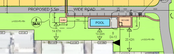
Figure 29 – Setbacks to proposed community facilities
Figure 30 – Existing landscaping
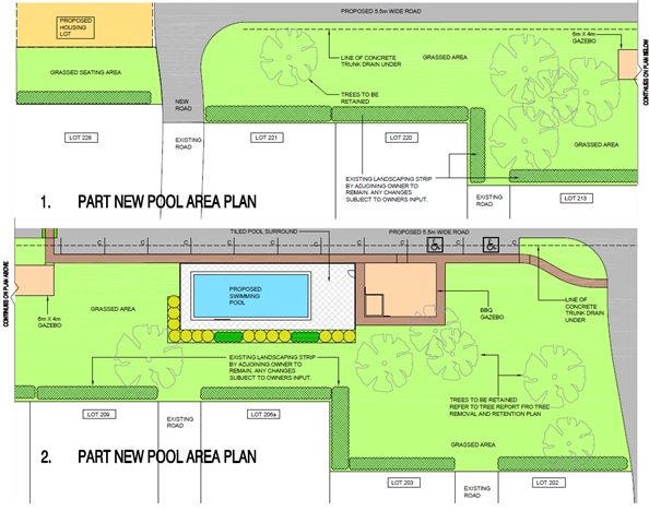
Figure 31 – Landscape plan of proposed landscaping to community facilities
A number of trees are proposed to be removed along the northern and eastern side boundary of the new dwelling sites and access for the establishment of an APZ and for the access road around the perimeter area of the new dwelling sites as shown in Figure 33. No tree removal or other changes to the boundary treatment is proposed to the western portion of the northern boundary, the southern boundary and the majority of the western boundary.
Along the eastern portion of the northern boundary and the eastern boundary trees will be retained on the adjoining Lot 22, which will be subject to a Vegetation Management Plan. To maintain the amenity of the existing residents at dwelling sites 201 and 202, new landscaping including large and small shrubs is proposed along the eastern boundary of the dwelling sites (Figure 34).
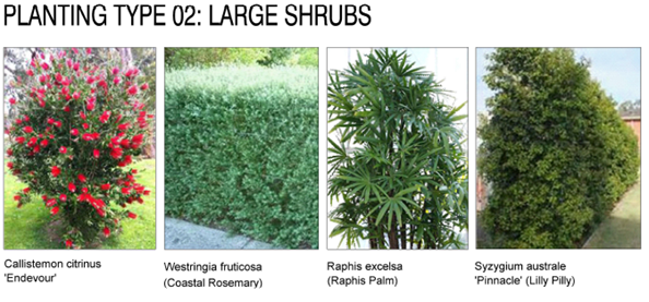
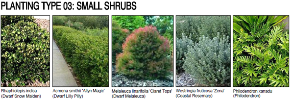
Figure 32 – Proposed landscaping to community facilities
Figure 33 – Proposed tree removal along the northern boundary and eastern boundary
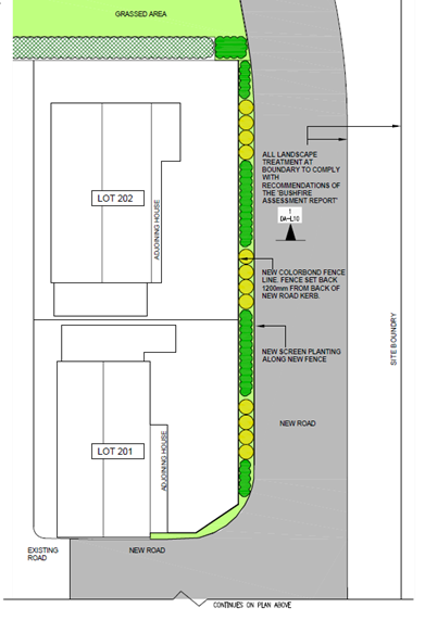
Figure 34 – Landscaping proposed along boundary of dwelling sites 201 and 202
The boundary treatment to the western boundary behind the existing manager’s office/residence which is proposed to be replaced with a new community building, games room and bowling green, currently consists of low shrubs along the western boundary and a grassed area as shown in Figure 35. The landscaping is proposed to be retained along the western boundary; however it is noted that the proposed bowling green and games room will replace an existing grassed area and some fill and retaining walls are proposed around the bowling green and games room (refer to Figure 36).
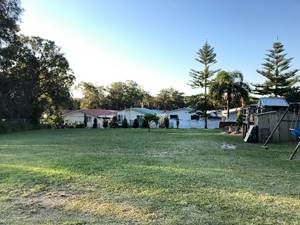
Figure 35 – Existing western boundary behind the manager’s office/residence
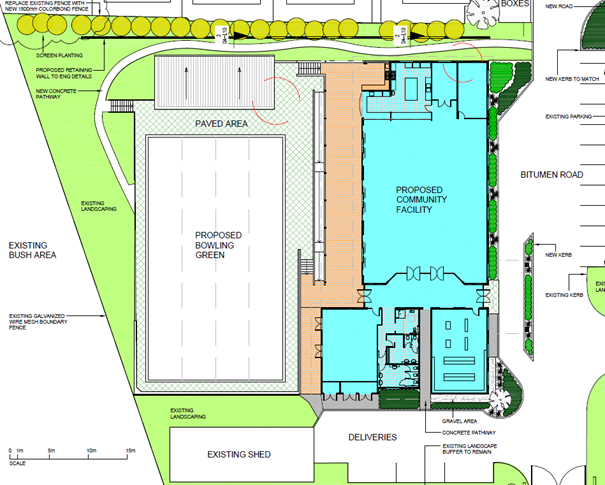
Figure 36 – Landscape plan for new community building, games room and bowling green
Earthworks / Cut and Fill
Cut and fill is proposed across the site where the new dwelling sites are proposed to level the area for the dwelling sites and access roads. A maximum 1.5m high retaining wall is proposed along the proposed northern perimeter road to retain the cut.
Upgrades to the existing swale in the site will also require additional cut and the construction of 2.2m high retaining walls.
Figure 37 – Cut and fill plan of the north-eastern corner of the site

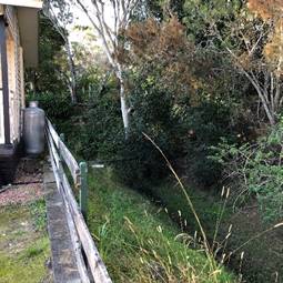
Figure 38 – Existing swale between existing dwelling sites and the existing informal golf course area
Cut and fill is proposed within the south-west corner of the site to level the area for the construction of the new community building, games room and bowling green (refer to Figure 39). Some retaining will be required around the new community building, games room and bowling green as detailed in the elevations and sections in the architectural plans. Cut is also proposed for the construction of the new dwellings sites 71 and 70 which will replace the existing tennis court which is currently built up as shown in Figure 40.
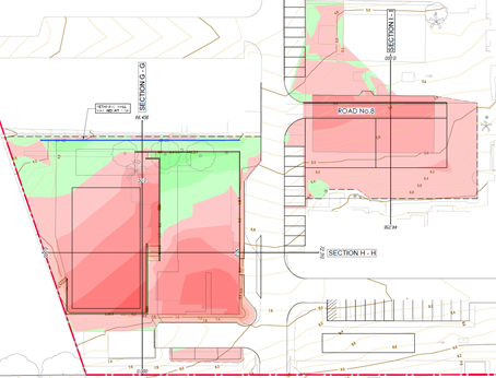
Figure 39 – Cut and fill plan of the south-west corner of the site
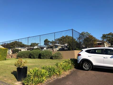
Figure 40 – Existing tennis court to be demolished
Safety, security and crime prevention
The proposed development will provide suitable passive surveillance of the site and surrounding public areas. Conditions are recommended to require a Plan of Management as well as requiring Safer by Design strategies in regard to lighting, landscaping and fencing, signage and CCTV (Condition 5.6). The application was also referred to NSW Police who raised no objections to the proposed development.
Road Works and Access
Access to the existing development is from Mulloway Road. Mulloway Road is classified as a Category B road and has a bus route and a bus stop located adjacent to the entry to the development.
The applicant is proposing to construct a new vehicle access towards the western boundary. New internal roads are 5.5m in width and the perimeter road is 8.0m.
The development will necessitate the need for road widening works including kerb and guttering, shoulder pavement works, new access crossing and the construction of a shared path along the frontage of the development to connect to the existing bus stop.
Traffic and Transport
A Traffic and Parking Assessment prepared by Intersect Traffic, dated 16 October 2021 was submitted with the application. As previously discussed in the report, the Traffic and Parking Assessment recommended that the proposal can be supported from a traffic impact perspective and will not adversely impact on the local and state road network.
Council’s Traffic Engineer reviewed the submitted Traffic and Parking Assessment and advised that the proposed additional 73 sites will not have a significant impact on the existing level of service at the intersection of Pacific Highway and Chain Valley Bay Road given the minor increase in traffic and the application was referred to TfNSW for comment who advised that the intersection has funding to be upgraded and therefore can support the additional sites.
A bus stop is located outside Teraglin Lakeshore Village. Three bus services are available from the bus stop as follows:
· Route 95 – Morisset to Lake Haven via Mannering Park and Gwandalan
· Route 98 – Lake Haven to Chain Valley Bay via Blue Haven
· Route 99 – Lake Haven to Charlestown via Blue Haven, Gwandalan and Swansea
Because the population increase associated with the additional dwellings is contextually small, it is assessed that this is unlikely to materially increase demand on the available services.
A community bus from Teraglin Lakeshore Village is also available which is provided on demand, having regard for passenger numbers and destinations.
Waste
The site is currently serviced by a waste servicing area located in the middle of the southern boundary. The waste servicing area is proposed to be upgraded by demolishing the existing ramp and stairs and increasing the hardstand area to accommodate the bins. A new 1.8m high fence and gates are proposed to secure the waste. New screen planting is proposed adjacent to the dwelling to the east and to fill the gaps along the southern boundary (refer to Figure 41).
General waste and recycling are proposed to be emptied by a licensed contractor three times a week and green waste is proposed to be collected twice a week from the waste servicing area. The upgrades to the waste servicing area will be sufficient to cater for the additional waste generated from the additional sites and the new screening and fencing will alleviate amenity impacts.
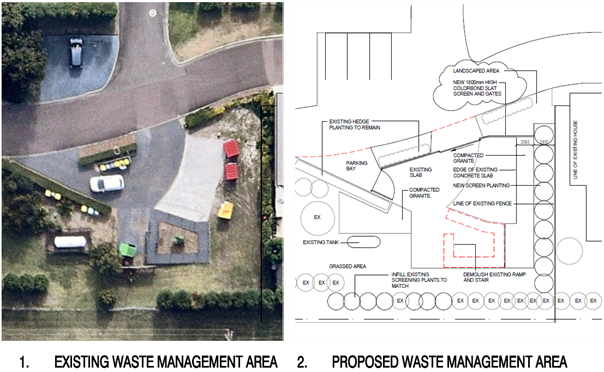
Figure 41 – Waste management area
Natural Environment
Ecology and Trees
The BDAR and Vegetation and Fauna Management Plan (VFMP) submitted with the application have been reviewed by Council’s Ecologist and it has been concluded that the site is suitable for the proposed development. 10 Mulloway Road will provide for a suitable local biodiversity outcome. Through the current application it is proposed to remove the horses currently present and rehabilitate and manage this property for the benefit of local biodiversity. This property is designated a “future development area” in the North Wyong Structure Plan, so the commitment to manage this property for biodiversity values in perpetuity provides certainty beyond the current or future zoning.
The proposal will allow the existing residence on 10 Mulloway to be retained and provided with a specified APZ, whilst the remainder of the site is rehabilitated and managed for biodiversity. This will remove the possibility of further development of 10 Mulloway and provide certainty about the management regime to be maintained in perpetuity. Recommended wording for 88E positive covenants and 88B restrictive covenants to be placed on the title of the property are included in the conditions of consent (Condition 6.15).
Further ecological survey, including seasonal orchid surveys, and a revised BDAR has been submitted. This includes revised Plant Community Type mapping. Technical issues previously identified have been addressed in the revised BDAR. The BDAR also includes an expert report in relation to Charmhaven Orchid Corunastylis sp. Charmhaven.
Assessment against Koala Habitat SEPP 2021 has been provided and accepted. Council’s Ecologist is satisfied that the site is not core koala habitat.
The proposed development retains vegetation on the site where possible and the Vegetation Management Plan will ensure the ongoing management of vegetation at 10 Mulloway Road.
Economic and Social Impacts
Social Impacts
A Social Impact Assessment (SIA) prepared by Aigis Group, dated November 2021 was submitted with the application. The additional dwellings will result in an increase in the number of dwellings in Teraglin Lakeshore village of 34% and approximately 49.2% increase in population in Teraglin Lakeshore Village. However, at local and regional levels, such a small increase in population is likely to result in negligible effects on other members of the community, particularly as the net increase in local and regional population may be smaller, if internal migration accounts for some occupancy of the new dwellings.
The SIA identified there will be some short-term effects on village residents during the construction stage and some lower level impacts may also be experienced by other residents in the parts of Chain Valley Bay that are close to the site (principally Mulloway Road and parts of Tarwhine Avenue, Teraglin Drive and Trevally Avenue), such as increased vehicle movements from construction vehicles, noise and dust. A Construction Management Plan prepared in accordance with the recommendations of the SIA to mitigate the potential effects on residents during construction is recommended in Condition 2.7.
The proposed development will increase the amount of affordable housing available to older residents in the area. Housing in the area predominately consists of three and four-plus bedroom dwellings. The proposed development will also provide more smaller houses to improve housing diversity in the area. The proposed upgrades to the existing facilities and proposed new facilities will improve the amenity and support recreation within Teraglin Lakeshore Village for the residents.
Economic Impacts
The proposed development will provide additional affordable housing in the area for senior residents. The proposed development will also result in positive economic effects in the near term, as initial site development is undertaken, and over a somewhat longer period as dwellings are progressively developed onsite.
Given the concentration of small businesses in the construction industry and their tendency to operate within the regions in which they are based, it is anticipated that some proportion of both civil construction and subsequent dwelling installation and other construction-related work will be carried out by locally and regionally based contractors. The development will also provide an ongoing source of employment and supporting economic activity, subsequent to these establishment stages. These works include occasional and ongoing maintenance, repair and related works required in respect of individual dwellings on the site, and maintenance of the property and assets in respect of the new dwellings.
Suitability of the Site for the Development
Having regard for the above assessment of the impacts to the built environment, natural environment, and economic and social impacts the site is considered suitable for the proposed development.
The proposed development is considered to be in the public interest as it is generally consistent with the relevant development controls. The proposed development will formalise the existing use on the site to a manufactured home estate and will provide more diverse affordable housing choice in the area for elderly residents. The proposed development will improve the provisions of facilities on the site for the existing residents and new residents.
The additional sites and new facilities have been designed to provide sufficient buffers between existing residents to manage potential amenity impacts. The proposed development has had suitable regard for the environmental impacts on the site and will support the management of vegetation north of the site to provide habitat. It is considered that the proposed development will be in the public interest.
Submissions
The application was initially publicly exhibited from 11 February 2022 to 11 March 2022. During this notification period 30 submissions in support and 14 submissions in objection were received. It was identified after the initial notification of the application that the description of the proposed development was not clear as it only referred to the change of use and environmental protection works, while the proposed also included the construction of an additional 73 sites and new communal amenities. To ensure that the application was notified correctly a second notification period was undertaken from 11 November 2022 to 9 December 2022 during which one submission in support and one submission in objection were received.
Thirty submissions in support were received. General reasons for support were:
· Increased/improved amenities for existing and additional residents including the new community building, bowling green, swimming pool, barbeques, and amenities block.
· Bushfire plan supported
· Improved drainage
· Aware golf course was only temporary when residents moved in.
· Improved lifestyle for residents
· Additional access security
· Increase value of homes
· Improve environment
· Increase desirability of the village
· Increased security and lighting
· Purchased dwelling in Teraglin because of proposed development
· Environmental works.
The submissions of support also included suggestions/issues which are considered in the below table.
|
Summary of Submissions |
Response |
|
Provide a men’s shed, plastic recycling and community vegetable garden. |
Noted. This is a matter for the developer. |
|
More trees should be provided within the new area. Every mature tree will be removed from the existing informal golf course |
Trees have been retained in the open space around the new pool, BBQ are and gazebo. A number of trees have also been retained along the boundaries of the site and an offset area will be established on Lot 22 to the north. |
|
Some of the green space shown on the proposal includes upgraded waterways which should not be included as green space. |
The area that has been included as communal amenities to comply with the LG Regulations is shown on DA-19 ‘Site Communal Space and Landscape Area Calculations’ prepared by JKH Build Design, Dated 22 October 2021. The drainage has not been included as communal amenities. |
|
In the last five months green space has been replaced by two homes at number 9 and 10 In Aggro Street. The current homeowners were not notified of the new homes which reduced the green space. |
Noted. Dwellings sites number 9 and 10 were previously approved under DA/1050/00 on 17 May 2000. |
|
Summary of Submissions |
Response |
|
The new club house and bowling green will back right onto existing homes taking away green space from behind them. |
Planting and fencing have been provided to screen the new club house and bowling green from adjoining dwellings. The new club house is located in generally the same building footprint as the existing managers residence/office. While the open space area will be replaced with a bowling green, the area will be provided with a more formalised recreation use which is considered to be suitable. |
|
Second entry – Mulloway Road is not wide enough to add a turning lane, which would mean traffic flow would be affected and cause problems for all motorists. |
The proposed development is expected to generate an additional 14 AM and 11 PM vehicle trips during peak traffic periods which will not have significant impact on the road Mulloway Road. The second access is suitable. |
|
Second entry – homeowners will be impacted due to through and constant traffic flow. |
Traffic is expected to be dispersed through the site with those living in the western part of the site using the existing entry and those living in the new eastern part of the site using the new entry. The additional 14 AM and 11 PM vehicle trips in peak traffic periods are also minor and will not cause a significant increase in traffic through the site. |
|
Internal road systems should be planned to minimise light spill from headlights into existing homes. |
Light spill will be minimal from headlights within the internal road system and will not be frequent. It is noted that fencing is proposed around existing dwelling sites 201 and 202 which are most likely to experience light spill. |
|
Lack of security is a concern. All homeowners will become vulnerable to break ins and intruders coming into the village. Security cameras should be installed for surveillance. |
The proposed development will provide suitable passive surveillance of the site and surrounding public areas. Conditions are recommended to require a Plan of Management as well as requiring Safer by Design strategies regarding lighting, landscaping and fencing, signage and CCTV. The application was also referred to NSW Police who raised not objections to the proposed development. |
|
Visitor parking appears to be insufficient for the expected volume of visitors and traffic. |
Visitor parking complies with the Local Government Regulations. |
|
Bushfire management and evacuation of elderly residents. |
A bushfire report has been submitted with the application to address Planning for Bushfire Protection 2019 and has been referred to the RFS who have supported the proposed development. |
|
Traffic management at the intersection of Chain Valley Bay Road and the Pacific Highway and the intersection with Chain Valley Bay Road and Mulloway Road. |
Noted. Previously addressed in the report. |
|
Summary of Submissions |
Response |
|
Drainage should take into account the future impact of climate change. |
The proposed development has taken into account climate change. Flood modelling of severe flooding scenarios were undertaken for the 1% and PMF events which demonstrated that the predicted flooding would not result in unacceptable high risks to the existing and proposed dwellings. Council’s Development Engineer and Flood Engineer has reviewed the application and confirmed the proposed drainage is suitable to manage stormwater and flooding on the site. |
|
Concern about the sediment management in Lake Macquarie so that is will not cause localised flooding or deterioration of the water quality. |
The applicant has demonstrated that adequate water quality from the drainage to Lake Macquarie will be achieved. |
A total of 14 submission in objection were received. The submissions are summarised in the table below:
|
Summary of Submissions |
Response |
|
The traffic generated from the site will utilise the intersection at the Pacific Highway and Chain Valley Bay Road which is already failing. The intersection needs to be upgraded due to the risks to public safety. |
The traffic impacts have been previously discussed in the report. The application was referred to TfNSW, who have advised that funding for the intersection has been secured. |
|
The garbage collection area is currently inadequate and overflowing with garbage, the proposed development does not include any extra bins for the additional sites.
At present all garbage vehicles come in on Anzac Street causing a problem to the entrance or egress. There is already a gate from Mulloway Road to the current garbage area. Why can't this be accessed and refurbished? |
The applicant has submitted a waste management plan which demonstrates suitable bins for the waste generated. The waste is also proposed to be emptied more regularly.
The proposed development has the garbage truck accessing the waste area from the existing entry/exit via Anzac Road and leaving the site through the new entry/exit. Council has no objection with the garbage truck accessing the waste servicing area vias Anzac Road. |
|
The expansion will mean that Stella Street will become a main thoroughfare. |
There will be new alternate routes created around the site to alleviate traffic impacts. |
|
There will only be a 6m buffer of green space between the existing dwelling sites on Stella Street and the new dwelling sites. While the other dwelling sites on Brisbane Parade and Diamantina Parade will have 20m of space. |
The 6m buffer space is sufficient to alleviate impacts between the new dwellings. It is note that the dwelling sites on Brisbane Parade and Diamantina Parade have larger buffer distances as they are setbacks to proposed community facilities. |
|
Gas bottles located within the waste collection area is potentially dangerous. |
The gas bottles are existing and there are no proposed changes to the gas bottles. They are currently setback from the waste storage area and dwelling sites and the proposed construction works within the waste management area will not impact the gas bottles. |
|
Summary of Submissions |
Response |
|
The new entry is in the wrong place. It will result in an increase in traffic for the residents in the eastern part of the site and is also located near the bushfire source (National Park) to the east. It should be in the middle where the waste is to disperse the traffic through the site and where it is away from the bushfire source for evacuation. |
The new entry is in addition to the existing entry, and it is anticipated that the existing entry will be used by those who live in the western part of the site and the new entry will be used by those living in the eastern part of the site.
A bushfire report was submitted with the application which demonstrated that the access is suitable with regard to bushfire. The application was also referred to NSW RFS who supported the proposed development and issued General Terms of Approval. |
|
Bushfire – There is only one evacuation route via Mulloway Road/Chain Valley Road to the Pacific Highway for vulnerable people living in Teraglin and the other manufactured home estates in the area. |
A bushfire report was submitted with the application which stated that the safest option is to leave early, however in the event that access to the Pacific Highway a Neighbourhood Safer Place has been identified located on the Chain Valley Bay (North) foreshore which is located immediately to the west of the site and is directly accessible from the site by pedestrians. The application was also referred to NSW RFS who supported the proposed development and issued General Terms of Approval. |
|
Flooding |
A flood study has been submitted with the application and has been reviewed by Council’s Flood Engineer who supported the application. Measures are proposed to minimise flooding on the site and mitigate impacts on adjoining sites as previously discussed in the report. |
|
Paid extra money for green space and was promised by previous owners 20m buffer |
The setbacks from existing dwelling sites to new dwelling sites and community facilities comply with the LG Regulations. The applicant has provided some green space adjoining the dwelling sites to alleviate some impacts from the expansion which is considered suitable. |
|
The two homes to be built on the old tennis courts will impact on the views of adjoining residents which currently has open space. |
A buffer of approximately 9m is provided between the new dwelling sites (70 and 71) and the existing dwelling sites to minimise the impact on exiting residents. |
|
The excavation of the old tennis courts will create dust. |
A construction management plan will be required in Condition 2.7, which will be required to address the management of dust during demolition and construction. |
|
The existing drain and retaining walls behind the homes along the northern side of Darwin Street should be upgraded for what is proposed for the engineer design drain behind the homes in Perth Street as this is all part of the same drainage system flowing down to Lake Macquarie. |
Civil plans have and a civil engineering report have been submitted with the application which have demonstrated that the proposed works to the drainage are suitable to manage stormwater for the proposed development. |
|
Summary of Submissions |
Response |
|
The proposed 1.8m Colorbond fence behind the dwellings along the new entry will replace all the natural bushland. |
The Colorbond fence is proposed along the boundary of existing dwelling sites 201 and 202. The fencing will be located on the western side of the road and be setback from the road kerb by 1.2m which will be landscaped with screen planting. The fence will be 6m from the closest point of the rear of the dwelling on the dwelling site 201 and 4.83m to the closest point of the rear of the dwelling on the dwelling site 202. This will provide sufficient open space and opportunity for landscaping by the residents. |
|
Removal of the trees along the new entry. |
Trees are proposed to be removed along the new entry due to encroachment from the access road and to provide the required APZs for the development. Where trees will not be impacted by the development or are outside the required APZ they have been retained. It is also noted that a National Park is also located approximately 30 to the east of the nearest dwellings which will maintain the natural outlook. |
|
Setback to the new pool, BBQ area, gazebo, and loss of green space.
|
The proposed new pool is setback 10m from the nearest dwelling, the BBQ is setback approximately 13m from the nearest dwelling and the gazebo is setback 14.87m from the nearest dwelling. The pool, BBQ and gazebo have been located to avoid the removal of trees within the area adjoining the existing dwellings to help retain the amenity of the dwellings and the outlook. All setbacks to the community facilities are complaint with the LG Regulations which require a 10m setback. The setbacks are considered to be sufficient to provide a buffer between the existing dwellings and the development. |
|
Once the area is developed and vegetation removed, we will lose all wildlife, ie wallabies, birds, rabbits and ducks which visit the area on a daily basis |
Trees are proposed to be retained near the new pool, BBQ and gazebo and some trees along the boundaries. An offset area is also proposed on Lot 22 which will provide habitat animals. |
|
Noise from the new pool. |
The site currently has a plan of management which restricts pool use to daylight hours only. A condition of consent (Condition 7.11) will be included to ensure that the new pool is also restricted to daylight hours to ensure that noise will be limited. |
|
Home values will decrease. |
This is not a planning consideration. |
|
Once the golf course has been built out with the proposed new homes, where is the green space going to be? |
Open space is provided around the existing pool and proposed new pool. The community facilities and open space provided is compliant with the Local Government Regulations. |
|
Summary of Submissions |
Response |
|
Noise from the new entrance. |
Noise from the new entrance will be infrequent and minor. It is noted that the proposed development is expected to generate an additional 14 AM and 11 PM vehicle trips during peak traffic periods which will not have significant impact. Furthermore, traffic will be distributed between the two accesses to the site to minimise noise from vehicles. |
|
Demolition of tennis court and replacement with new dwelling sites (70 and 71). |
While the tennis court is proposed to be demolished and replaced with dwelling sites, additional community facilities including a new pool, BBQ area, community building with library and fitness area, bowling green and games room are proposed. |
Submissions from Public Authorities
No submissions from public authorities were received.
Internal Consultation
|
Development Engineer |
Supported subject to conditions. |
|
||
|
Traffic Engineer |
Supported without conditions. |
|
||
|
Flooding |
|
Supported subject to conditions. |
|
|
|
Ecologist |
|
Supported subject to conditions. |
|
|
|
Tree Assessment Officer |
Supported subject to conditions 3.15, 3.16, 4.24 - 4.30. |
|
||
|
Waste Services |
Supported. |
|
||
|
Water and Sewer |
Supported. |
|
||
|
Contributions |
|
Supported subject to condition 2.15. |
|
|
|
Environmental Health Officer |
|
See comments below. |
|
|
Environmental Health Officer
The Environmental Health Officer who specializes in land contamination, reviewed the preliminary contamination assessment, prepared by Qualtest, dated 30 August 2019 and the preliminary investigation undertaken by WSP dated 16 June 2023. The preliminary investigation prepared by WSP satisfies the provisions of Section 4.6 of SEPP (Resilience and Hazards) as discussed previously in the report. Accordingly, the consent authority can be satisfied that the land will be suitable for the proposed residential use.
Another Environmental Health Officer reviewed the application in terms of other matters such as acoustic, acid sulphate soils, and the Local Government Regulation 2021. The officer had no concerns with acoustic impacts and the development was considered satisfactory with regard to satisfying clause 7.1 of WLEP 2013 in terms of acid sulfate soils. However, the officer raised concerns with the proposed change of use from a caravan park to a manufactured home estate, specifically the ability for the existing portion of the caravan park to comply with the requirements for a manufactured home estate as detailed within the Local Government Regulation 2021.
As previously noted, the provisions of SEPP Housing do not require an assessment to be undertaken against the provisions of the Local Government Regulation 2021, however, this has been undertaken to ensure that any change of use will not result in an estate that contains significant non-compliances when considered in accordance with Section 68. Any variation to the Local Government Regulation 2021 will require the submission of a Section 82 Objection (condition 1.6).
External Consultation
|
NSW Rural Fire Service |
Supported and General Terms of Approval Issued. Condition 1.2 will require compliance with General Terms of Approval. |
||
|
NRAR |
|
Supported. Advised no requirement for a Controlled Activity Approval. |
|
|
Transport for NSW |
|
Supported. See comments below. |
|
|
NSW Police |
|
Supported without conditions. |
|
Transport for NSW (TfNSW)
The application was referred to TfNSW for comment who provided comments on the proposed development on 16 December 2022. TfNSW indicated in their comments dated 16 December 2022 that any additional sites in the area would require the upgrade of the Pacific Highway and Chain Valley Road intersection due to the additional traffic associated with any additional sites in the area and also advised that additional traffic would result in further safety issues.
Council sought clarification from TfNSW of their comments dated 16 December 2022, as it was noted that the proposed development only generates an additional 14 AM vehicle trips and 11 PM vehicle trips and as such does not constitute traffic generating development. Further clarification was sought regarding specifically how the development would impact on the safe operation of the intersection and whether TfNSW objected to the proposed development.
TfNSW provided further comment on 20 January 2023, which advised that due to the significant crash history of the intersection that any additional traffic would worsen service levels and exacerbate safety issues. TfNSW did not confirm if they objected to the proposed development.
Further correspondence was received from TfNSW on 2 March 2023 advising full funding for the intersection upgrade was secured, which would enable the release of additional sites in the area and would enable the expansion of Teraglin Lakeshore Village. Having regard for the latest correspondence from TfNSW, it is understood that TfNSW no longer have any concerns with the proposed development.
TfNSW’s correspondence is provided in Attachment 5.
Ecologically Sustainable Principles:
The proposal has been assessed having regard to ecologically sustainable development principles and is considered to be consistent with the principles.
The proposed development is considered to incorporate satisfactory stormwater, drainage and erosion control and the retention of vegetation where possible and is unlikely to have any significant adverse impacts on the environment and will not decrease environmental quality for future generations. The proposed development has had regard for the impact on the Swift Parrot, Charmhaven Orchid and Regent Honeyeater and demonstrated that the development is not likely to have a serious and irreversible impact on biodiversity values on the site.
Climate Change
The potential impacts of climate change on the proposed development have been considered by Council as part of its assessment of the application.
This assessment has included consideration of such matters as potential sea level; potential for more intense and/or frequent extreme weather conditions including storm events, bushfires, drought, flood and coastal erosion; as well as how the proposed development may cope, combat, withstand these potential impacts. The proposed development is considered satisfactory in relation to climate change.
Other Matters for Consideration:
Development Contributions
There are no contributions for the subject proposal under the Northern Districts Section 7.11 Plan. Contributions apply under the Shire Wide Section 7.11 Plan. The contributions have been calculated based on an addition 73 sites. The applicable contributions have been included in Condition 2.15.
Water and Sewer Contributions
Water and Sewer contributions will be applicable and will be outlined in the Section 306 letter issued upon the submission of a Section 305 application to Council.
Conclusion:
The proposal has been assessed using the heads of consideration in Section 4.15 of the Environmental Planning and Assessment Act 1979. It is considered the proposed additional sites and change of use of the development to a manufactured home estate is satisfactory having regard for the proposed and established built form which will remain consistent with the character of surrounding development.
The retirement of species credits for the vegetation proposed to be removed and the retention of vegetation for biodiversity conservation on Lot 22 DP 588107 10 Mulloway Road Chain Valley Bay, in perpetuity, is considered an appropriate outcome and in the public interest. The proposed development is considered suitable and accordingly is recommended for approval subject to the recommended conditions provided in Attachment 1.
|
1⇩ |
Draft conditions |
|
D15670188 |
|
2⇩ |
Development plans |
|
D15674642 |
|
3⇩ |
Landscape plans |
|
D15674646 |
|
4⇩ |
Local Government Regulations assessment table |
|
D15674652 |
|
5⇩ |
TfNSW correspondence |
|
D15674654 |
|
6⇩ |
Applicant response to submissions dated 13 May 2022 |
|
D15674682 |
|
3.2 |
DA/1708/2021 - Teraglin Lakeshore Village, 2 & 10 Mulloway Road, Chain Valley Bay - Nominated Integrated and Integrated Development - Change of use to manufactured home estate, including 73 additional dwelling sites, new communal amenities, demolition & environmental protection works |
|
Attachment 1 |
Draft conditions |
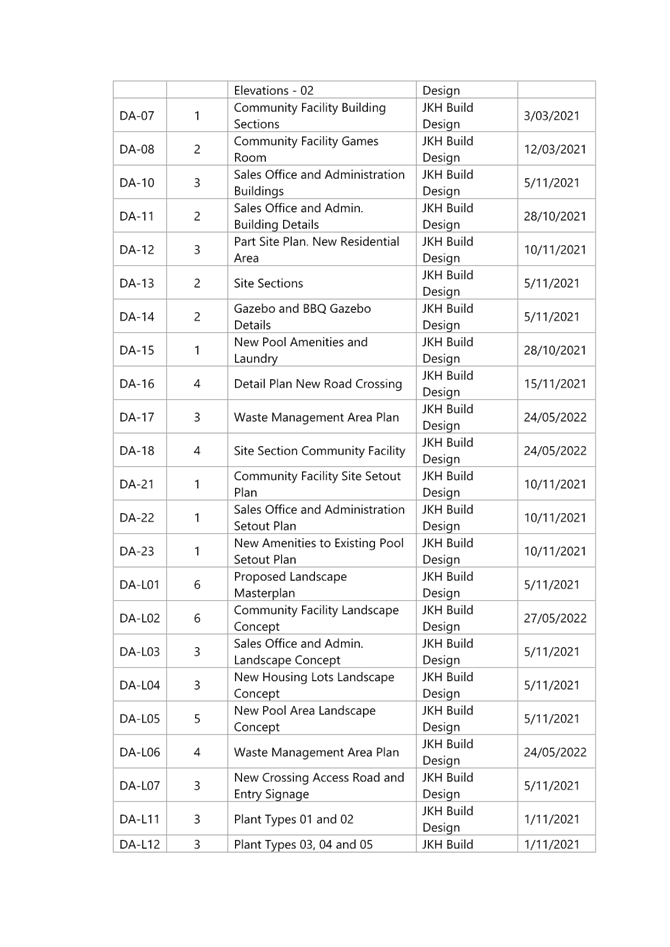
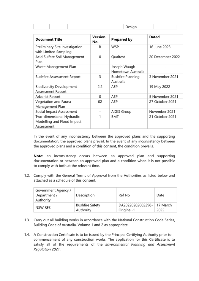
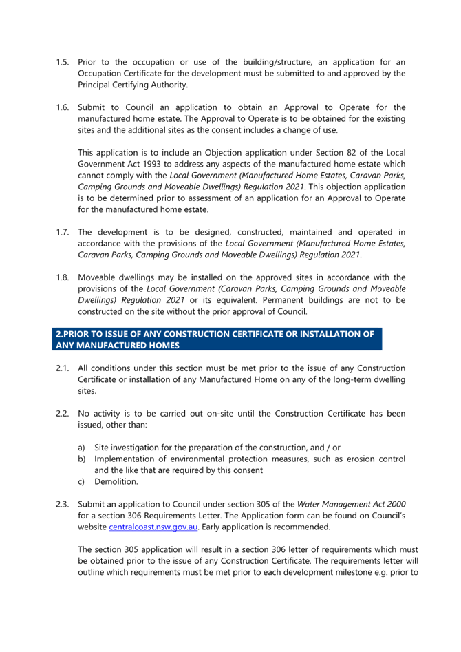
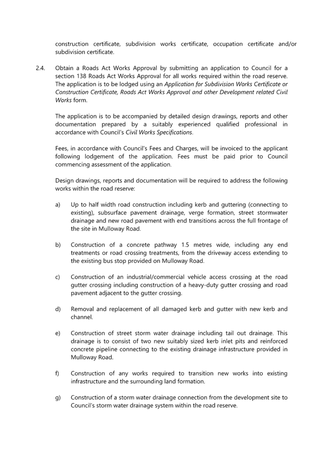
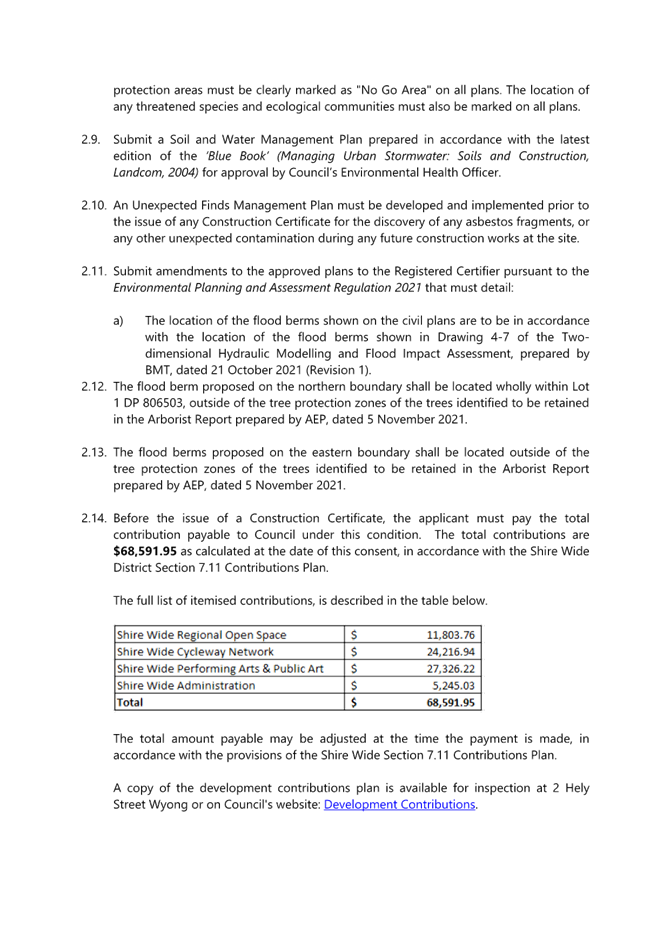
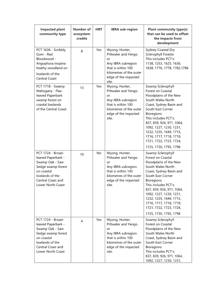
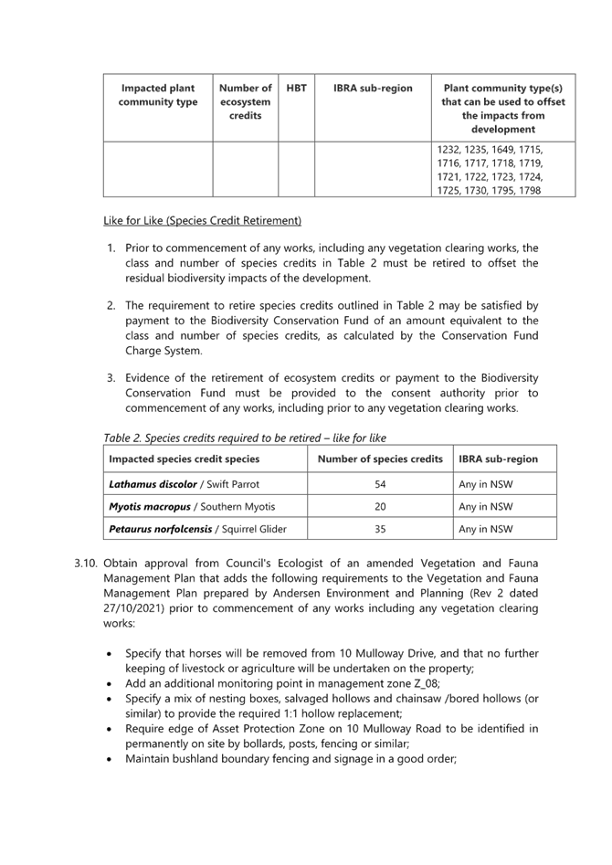
|
DA/1708/2021 - Teraglin Lakeshore Village, 2 & 10 Mulloway Road, Chain Valley Bay - Nominated Integrated and Integrated Development - Change of use to manufactured home estate, including 73 additional dwelling sites, new communal amenities, demolition & environmental protection works |
|
|
Attachment 2 |
Development plans |
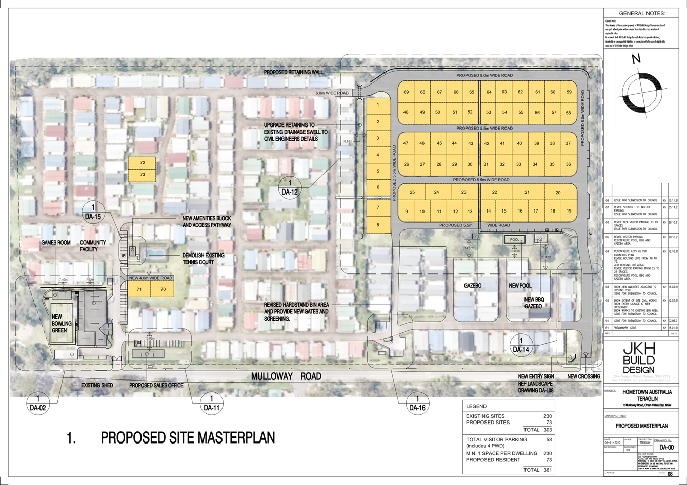
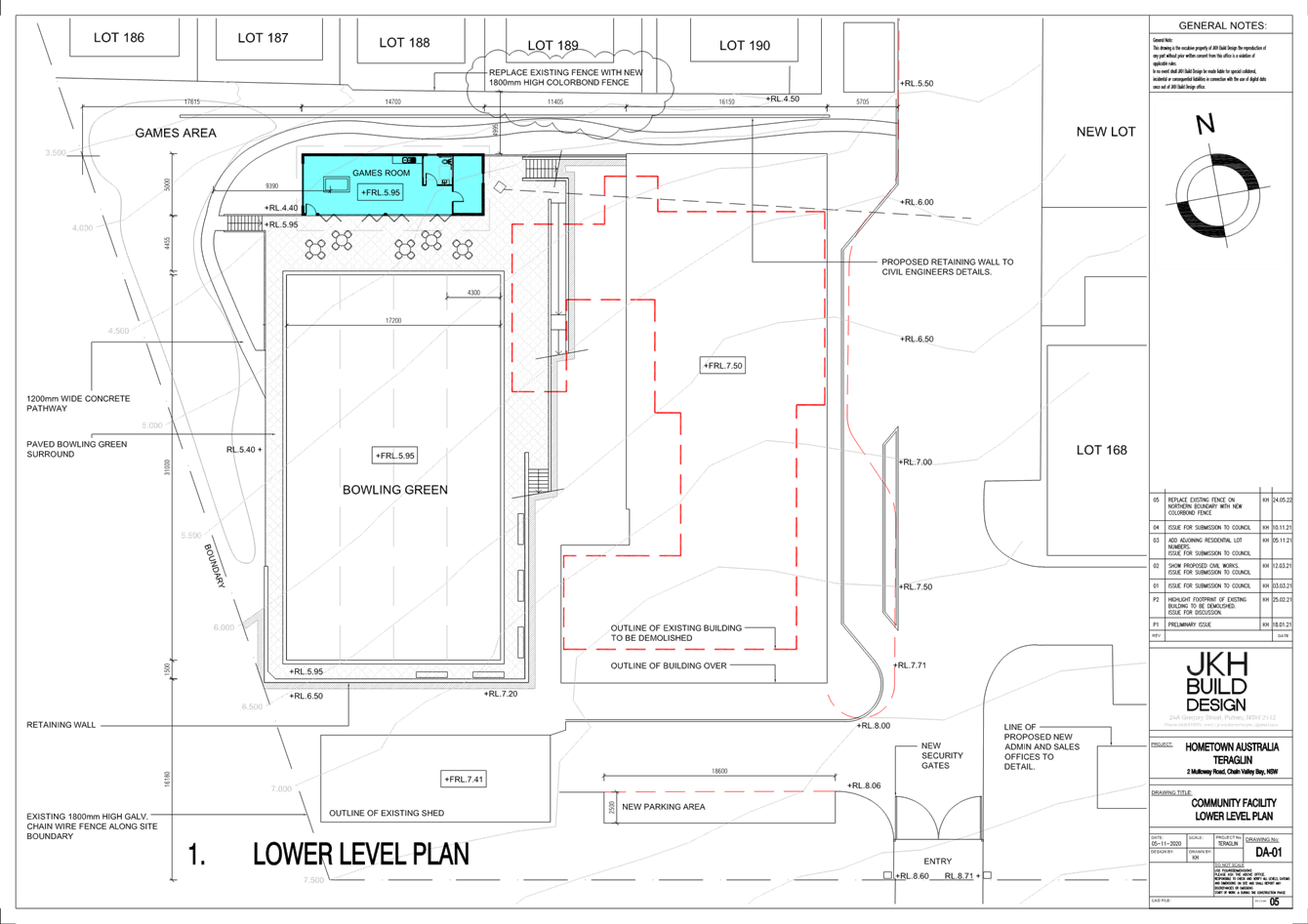
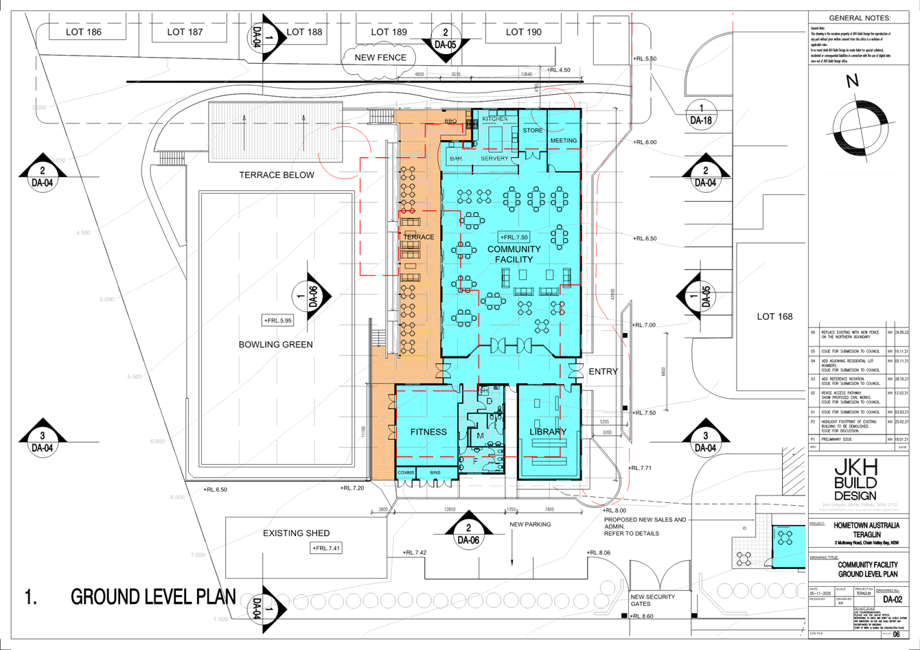
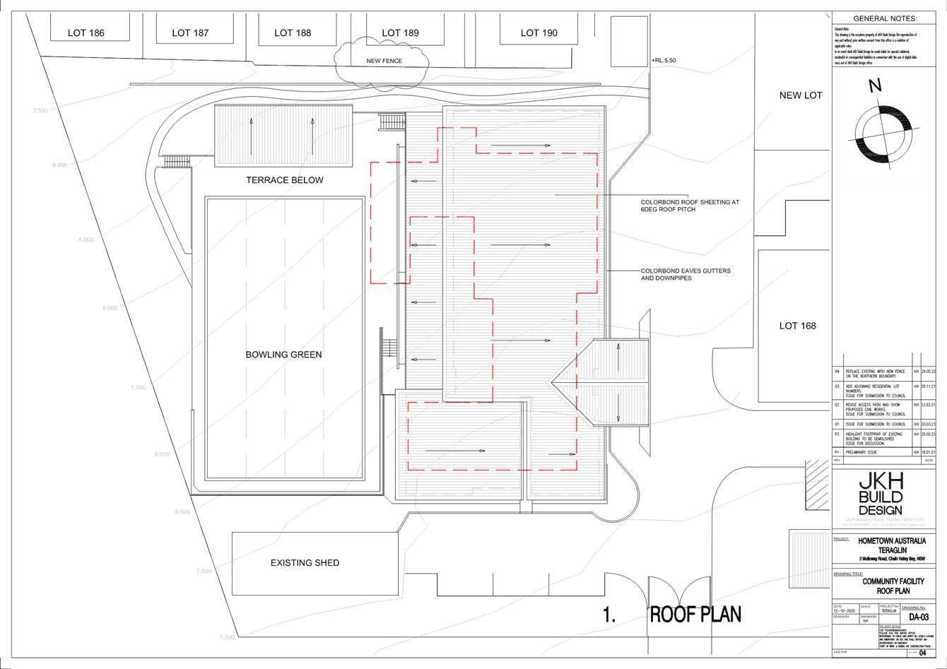
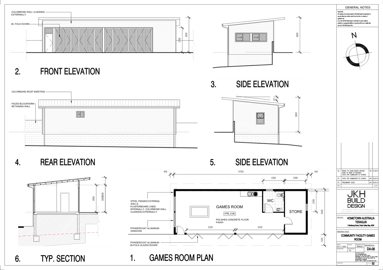
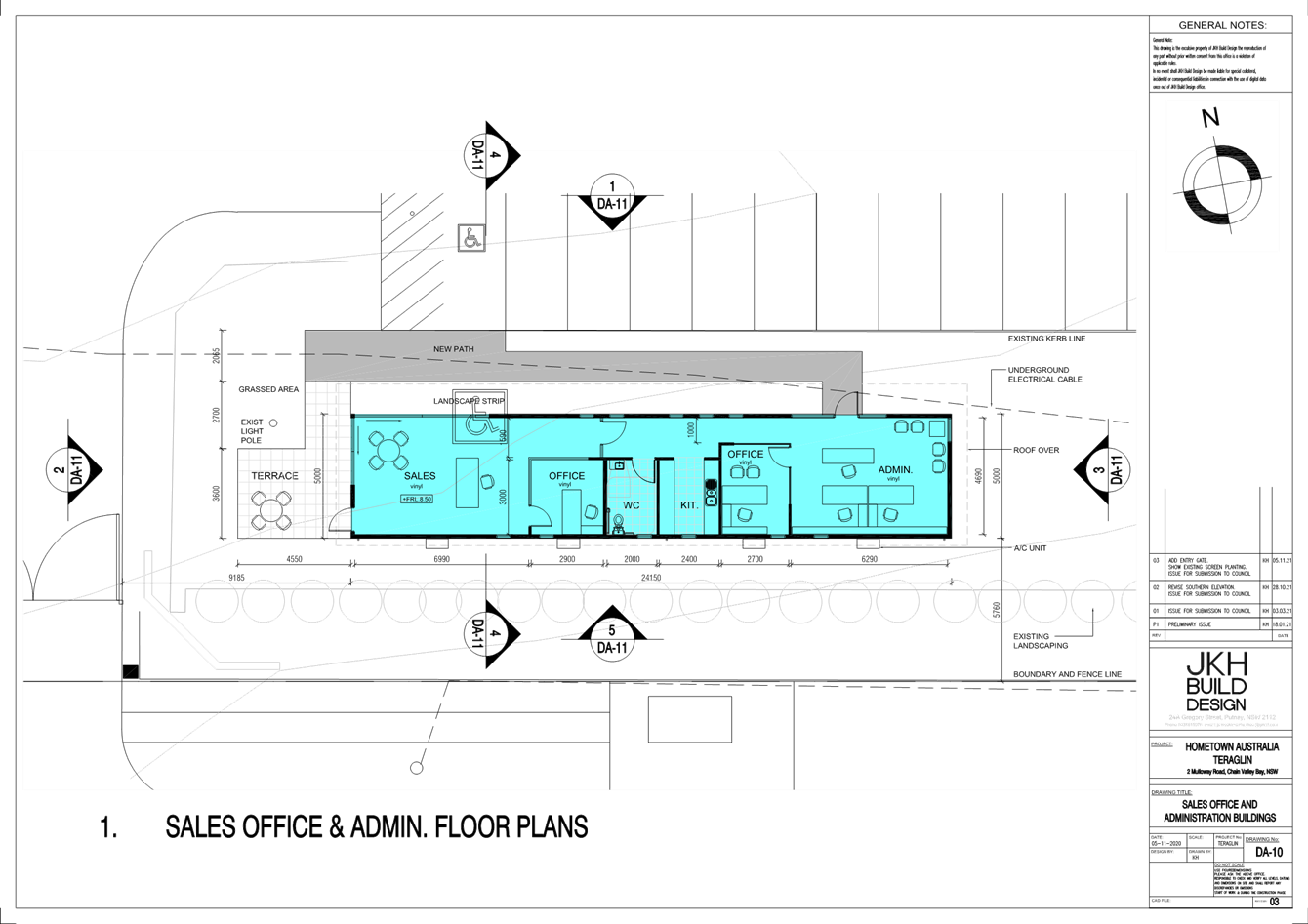
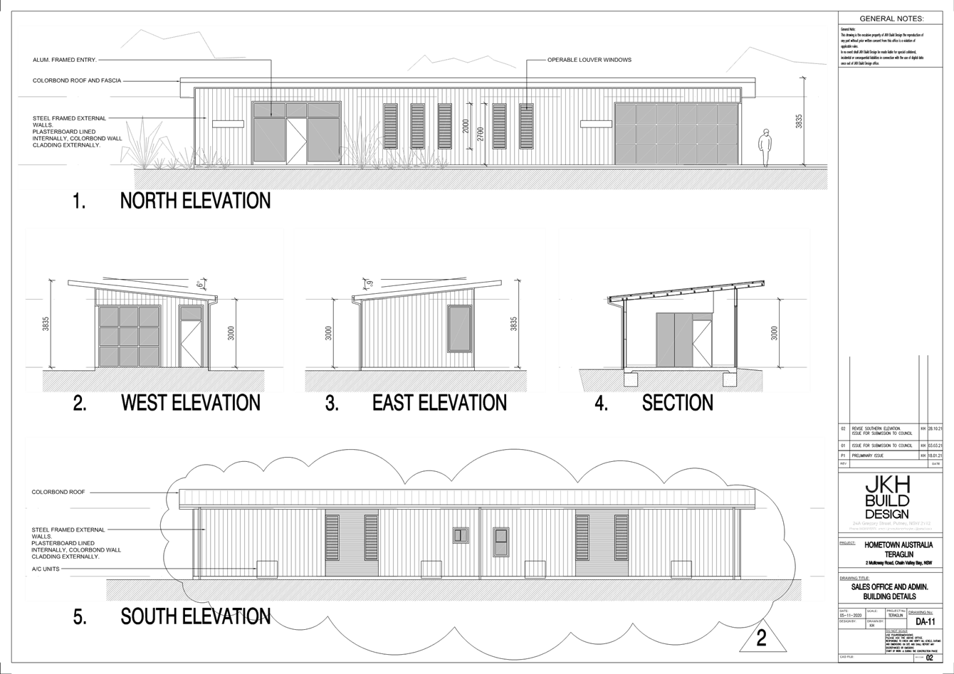
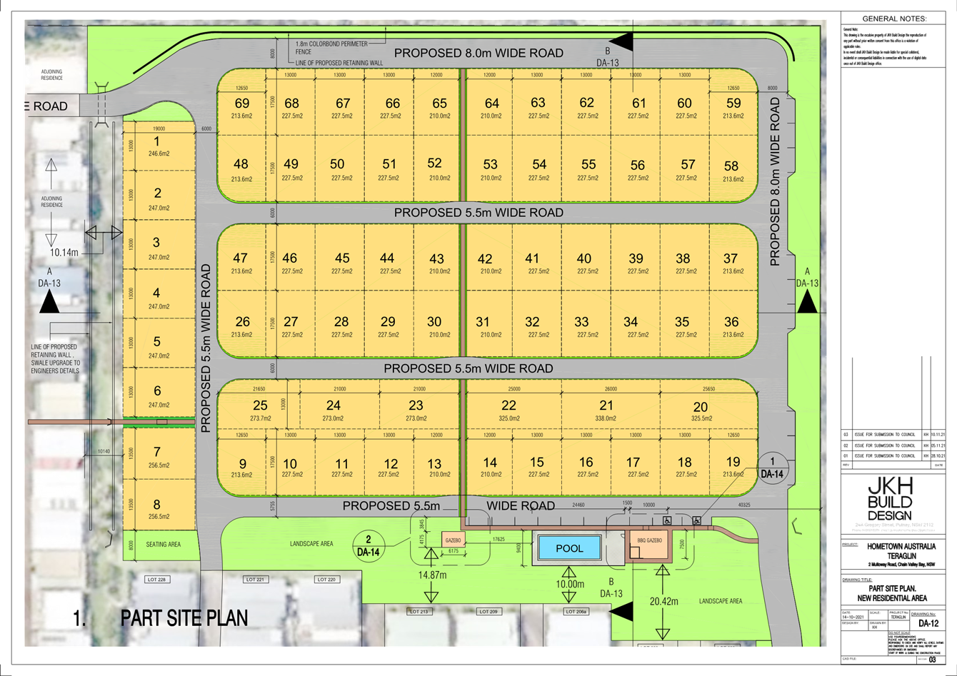
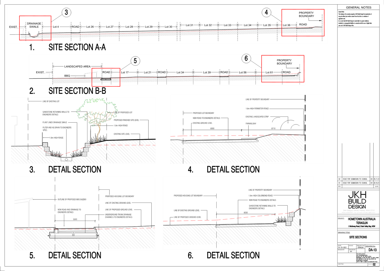
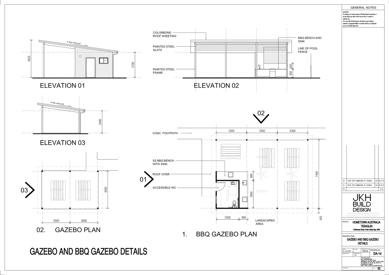
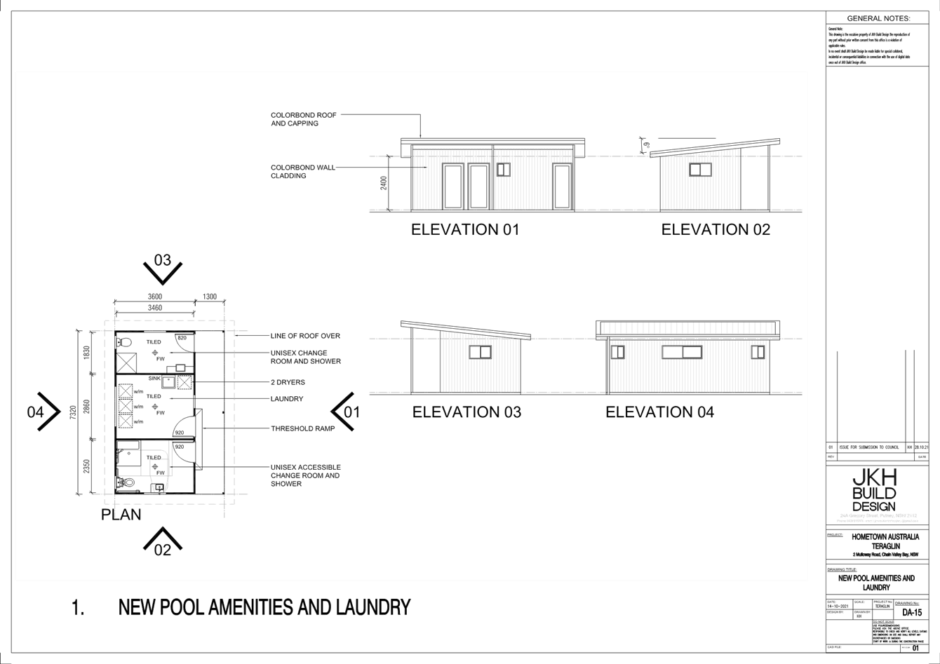
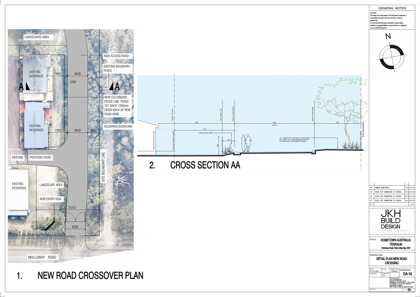
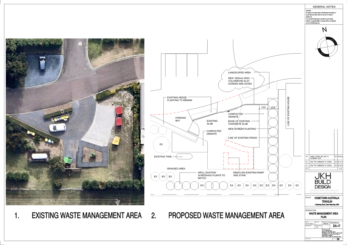
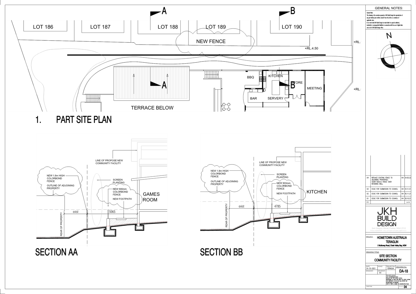
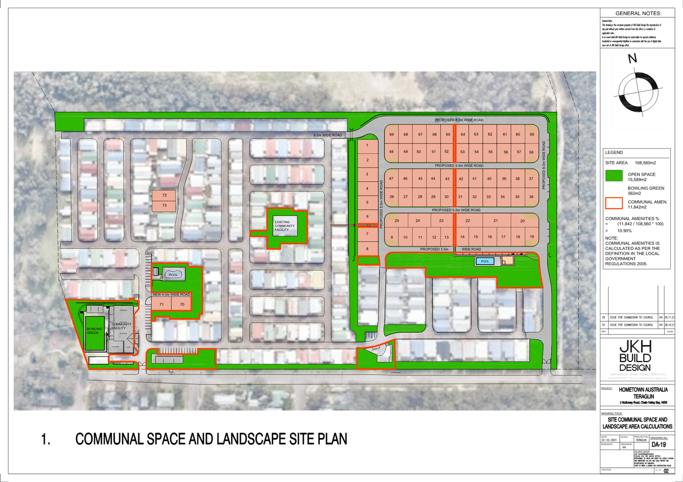
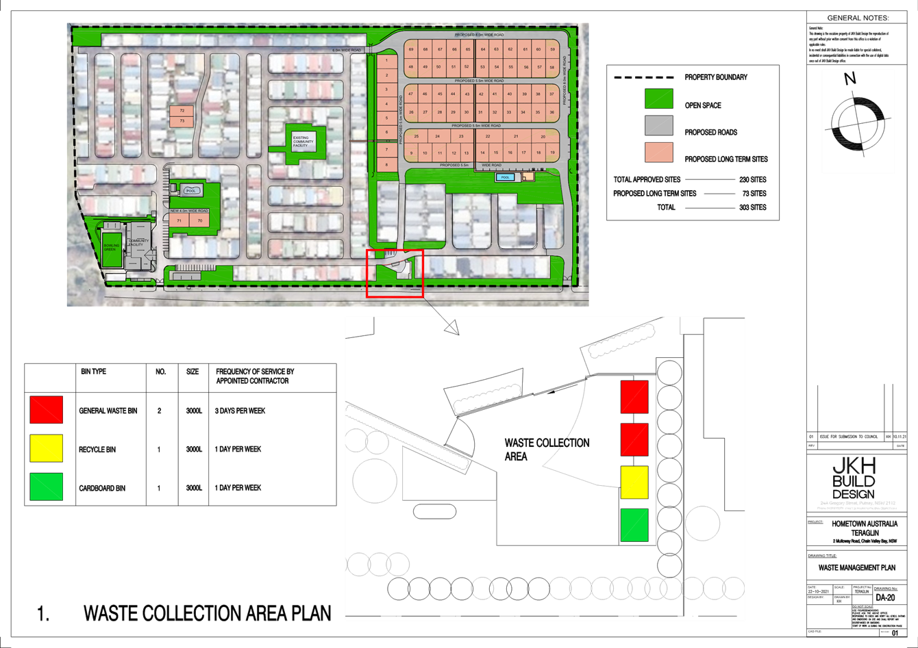
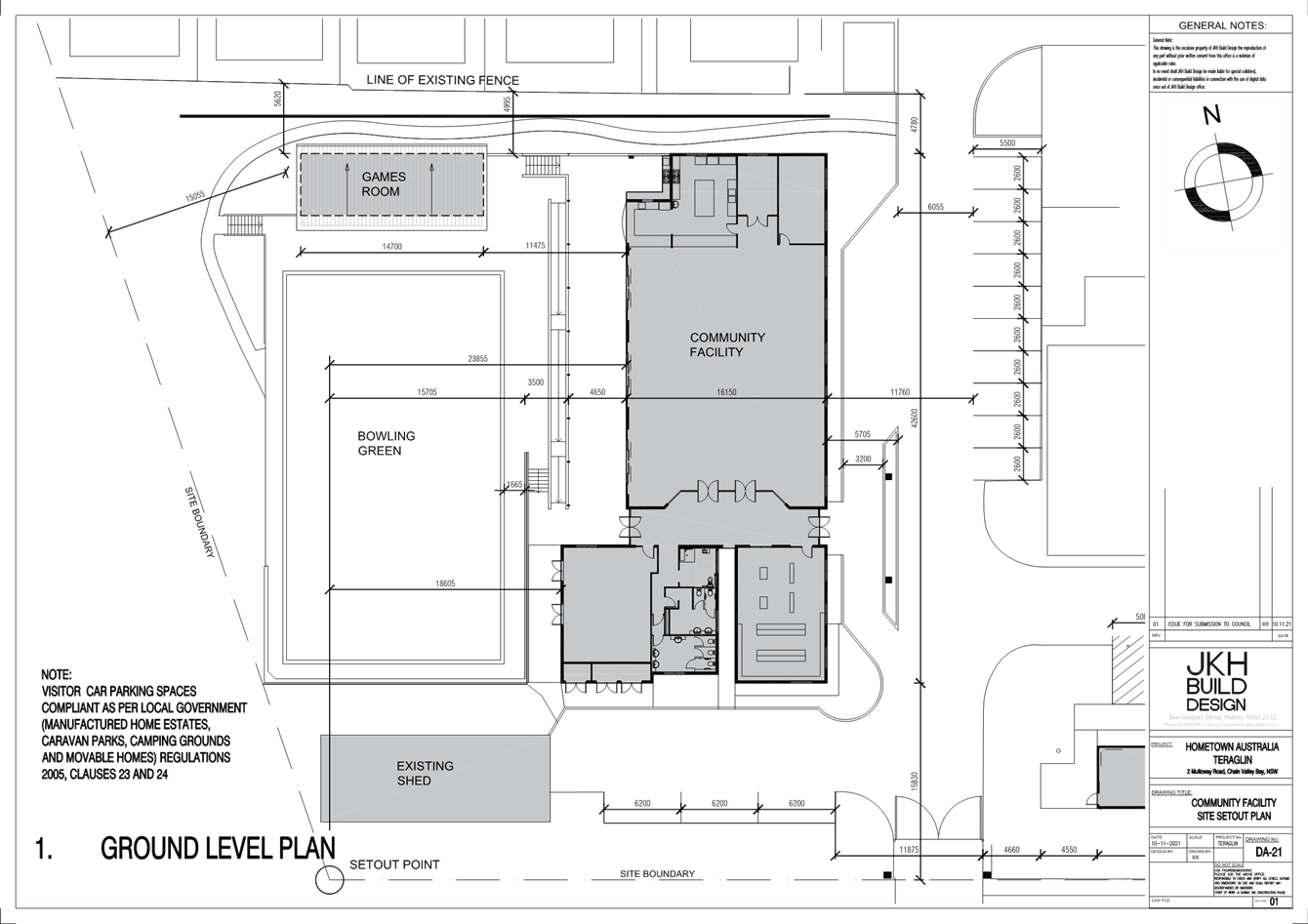
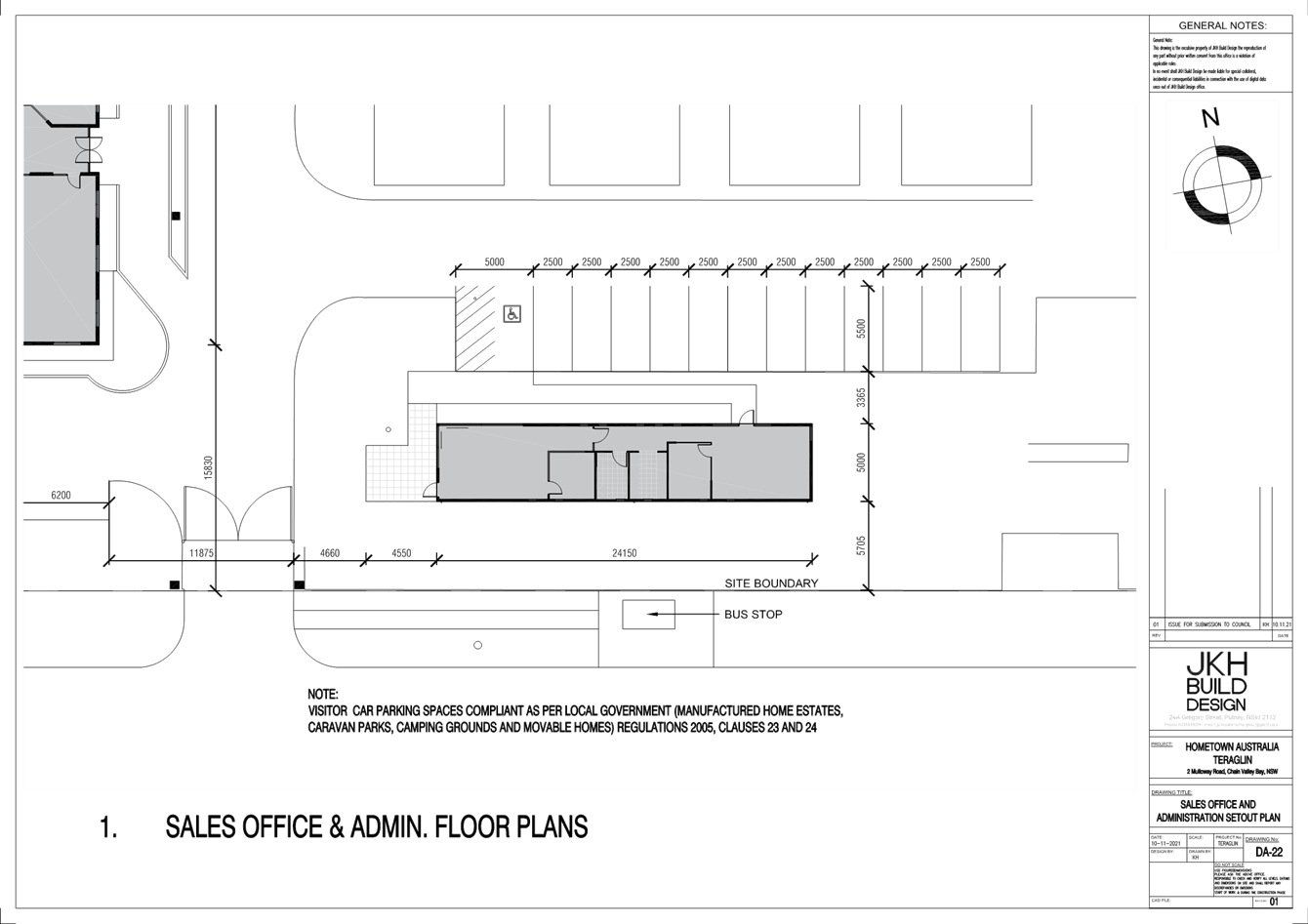
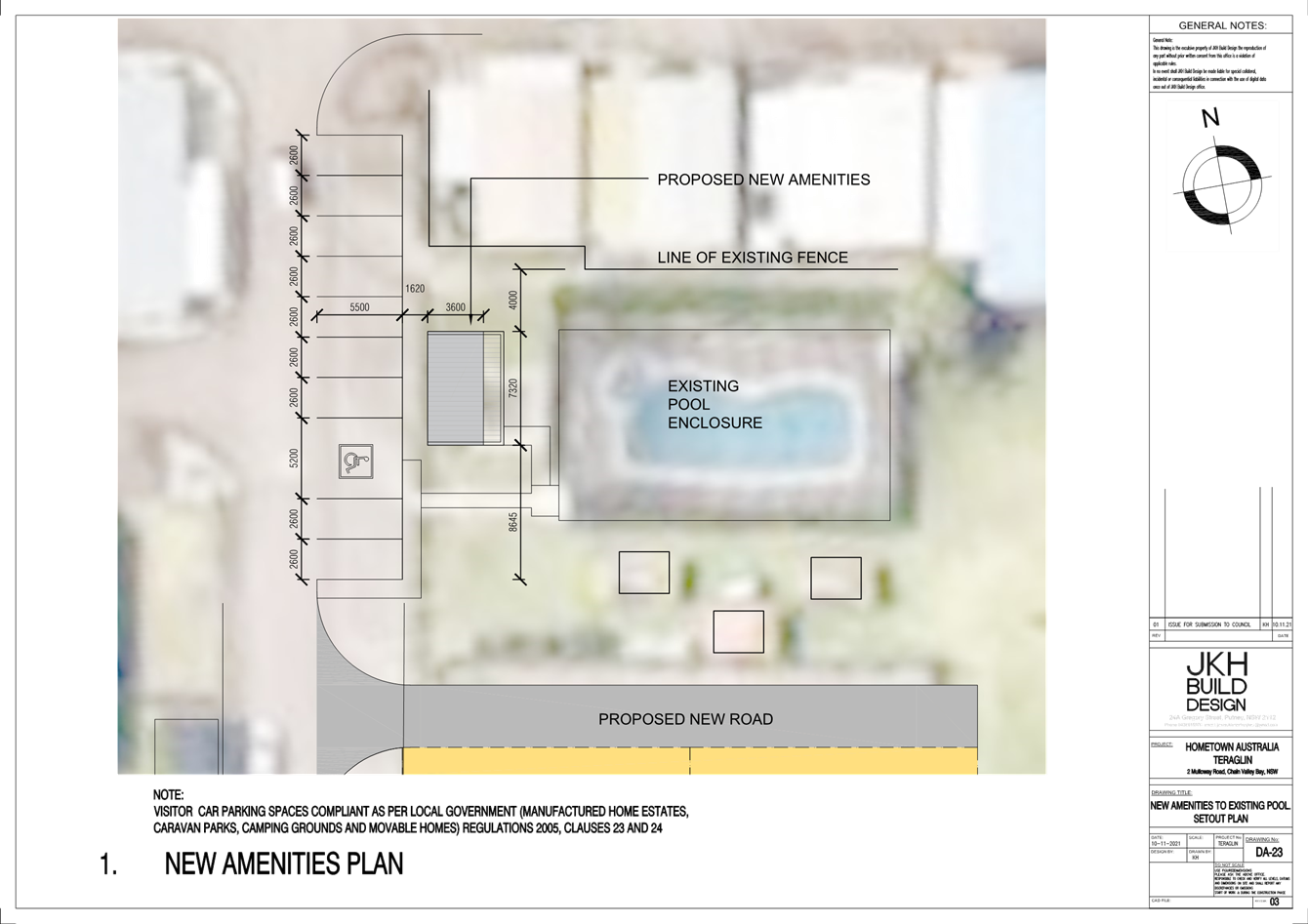
|
DA/1708/2021 - Teraglin Lakeshore Village, 2 & 10 Mulloway Road, Chain Valley Bay - Nominated Integrated and Integrated Development - Change of use to manufactured home estate, including 73 additional dwelling sites, new communal amenities, demolition & environmental protection works |
|
|
Attachment 3 |
Landscape plans |
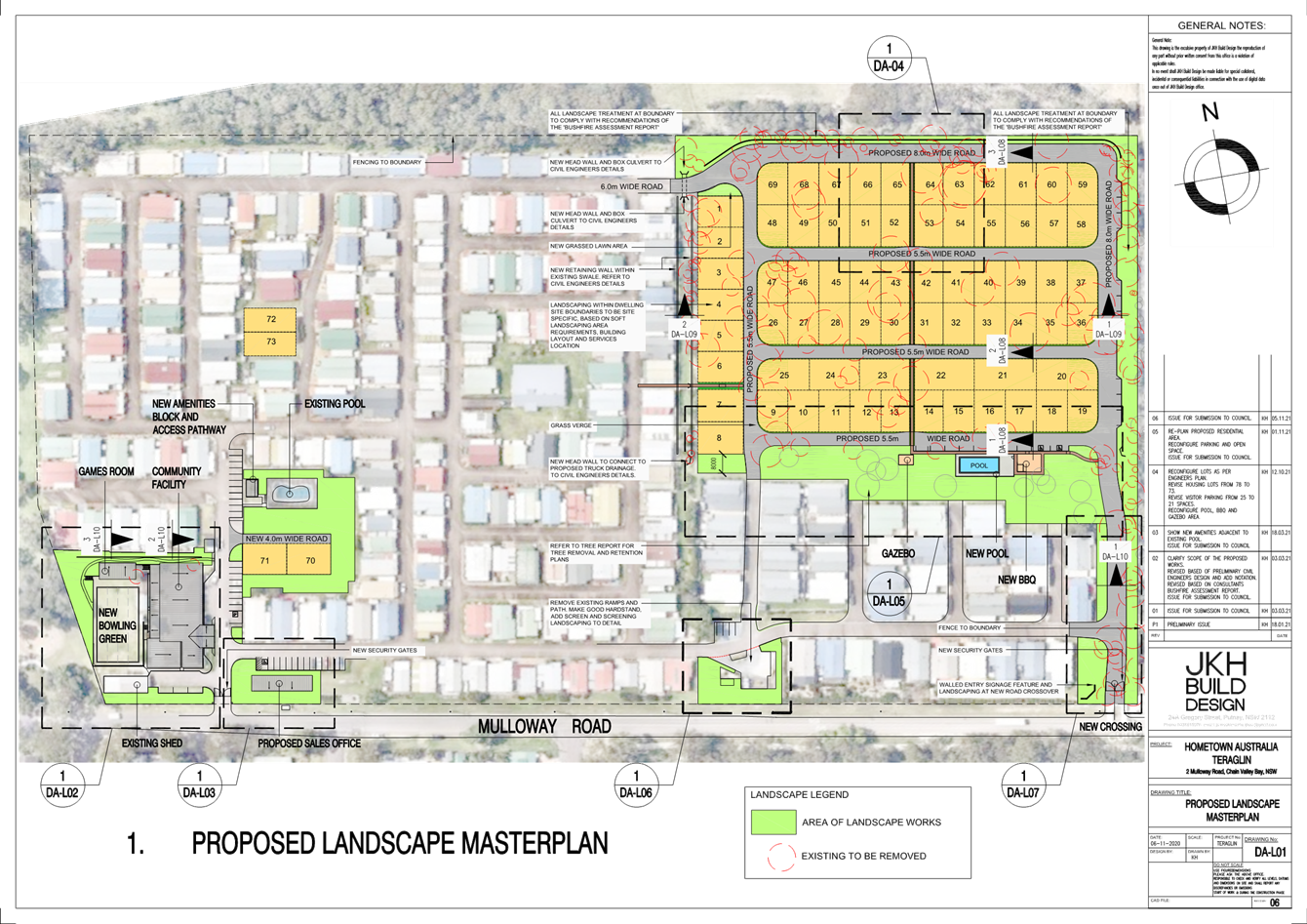
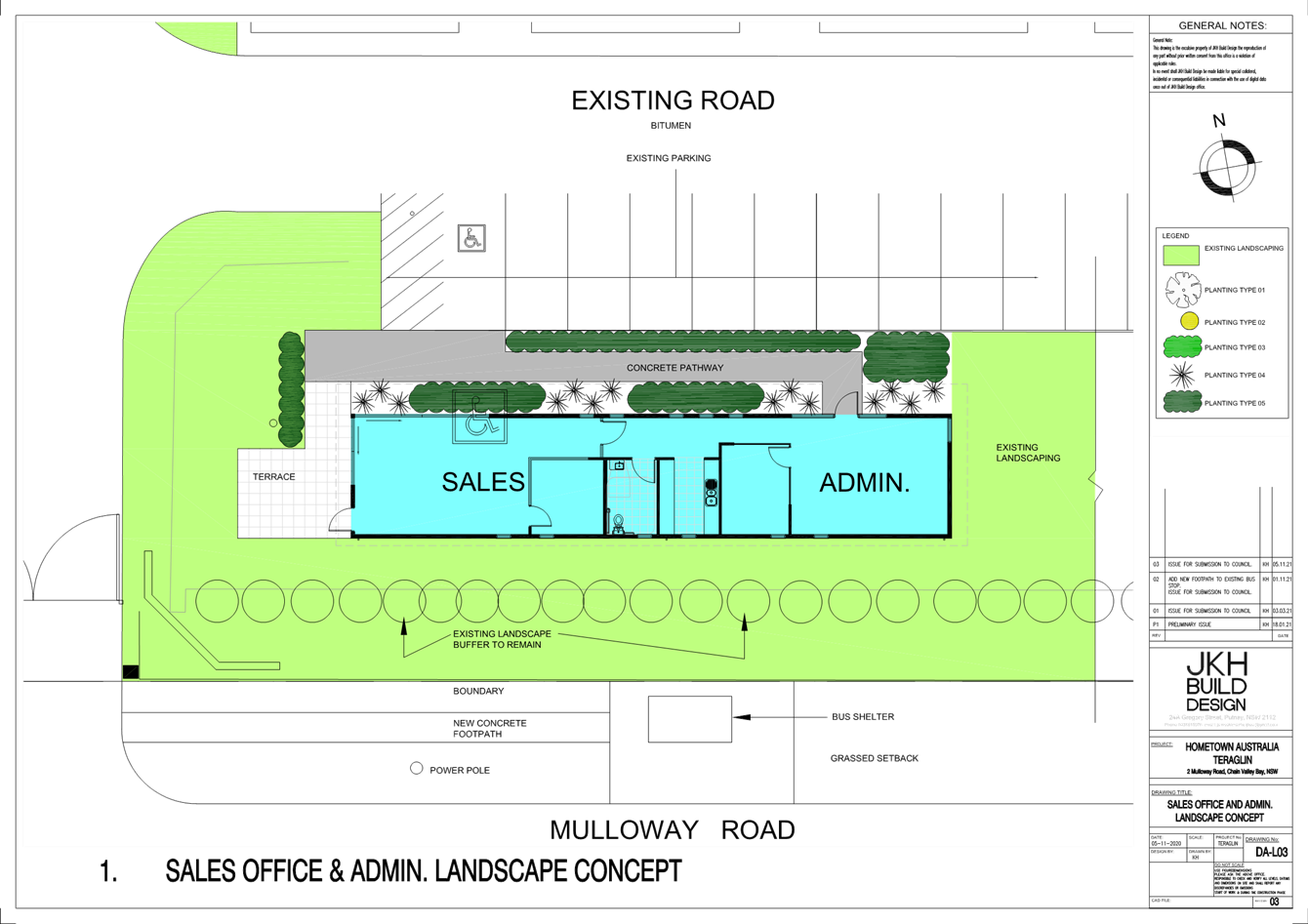
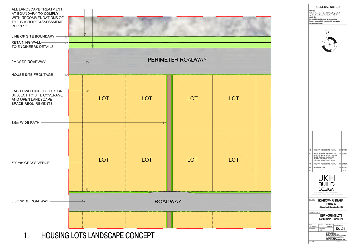
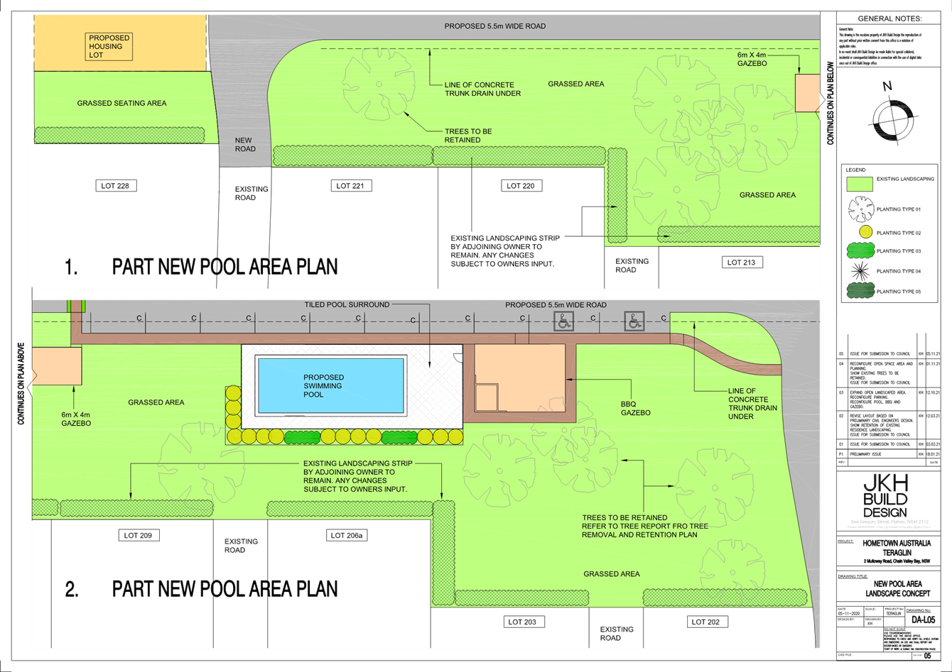
|
DA/1708/2021 - Teraglin Lakeshore Village, 2 & 10 Mulloway Road, Chain Valley Bay - Nominated Integrated and Integrated Development - Change of use to manufactured home estate, including 73 additional dwelling sites, new communal amenities, demolition & environmental protection works |
|
|
Attachment 4 |
Local Government Regulations assessment table |
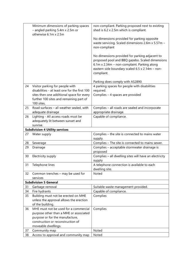
|
DA/1708/2021 - Teraglin Lakeshore Village, 2 & 10 Mulloway Road, Chain Valley Bay - Nominated Integrated and Integrated Development - Change of use to manufactured home estate, including 73 additional dwelling sites, new communal amenities, demolition & environmental protection works |
|
|
Attachment 5 |
TfNSW correspondence |

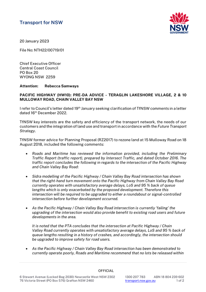

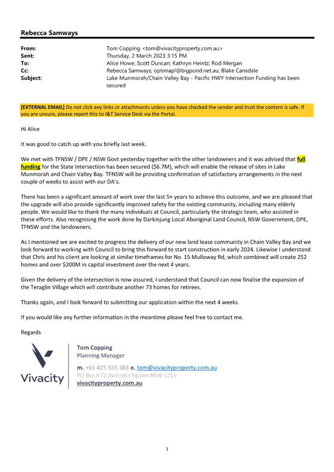
|
DA/1708/2021 - Teraglin Lakeshore Village, 2 & 10 Mulloway Road, Chain Valley Bay - Nominated Integrated and Integrated Development - Change of use to manufactured home estate, including 73 additional dwelling sites, new communal amenities, demolition & environmental protection works |
|
|
Attachment 6 |
Applicant response to submissions dated 13 May 2022 |