 |
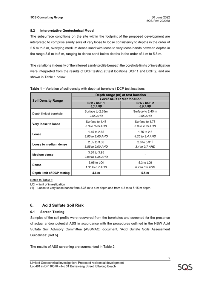
Central Coast
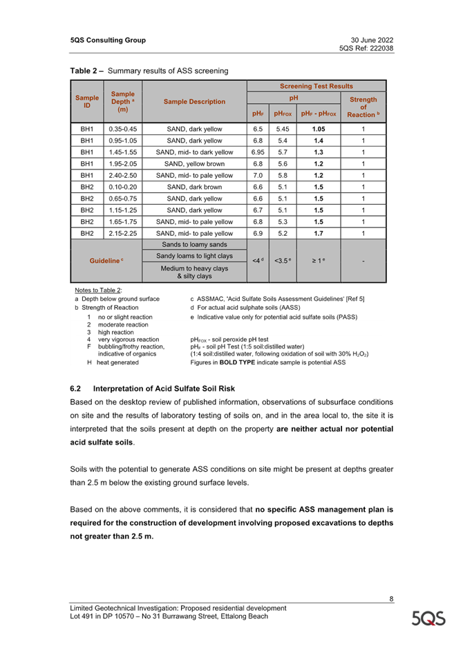
Supplementary Local Planning Panel
Business Paper
07 December 2023
 |
|
Central Coast
Supplementary Local Planning Panel
Business Paper
07 December 2023
|
The Supplementary Local Planning Panel
of Central Coast
will be held remotely - online,
Thursday 7 December 2023 at 2.00 pm,
for the transaction of the business listed below:
1 Procedural Items
1.1 Disclosures of Interest......................................................................................................................... 3
2 Planning Reports
2.1 DA/733/2023 - 22 Melba Road, Woy Woy - Staged Development Consisting of Demolition of Existing Primary Dwelling, Construction of Three Multi Dwelling Units, Change of Use of Existing Secondary Dwelling to a Fourth Multi Dwelling Unit and Strata Subdivision................................................................................................................................................ 4
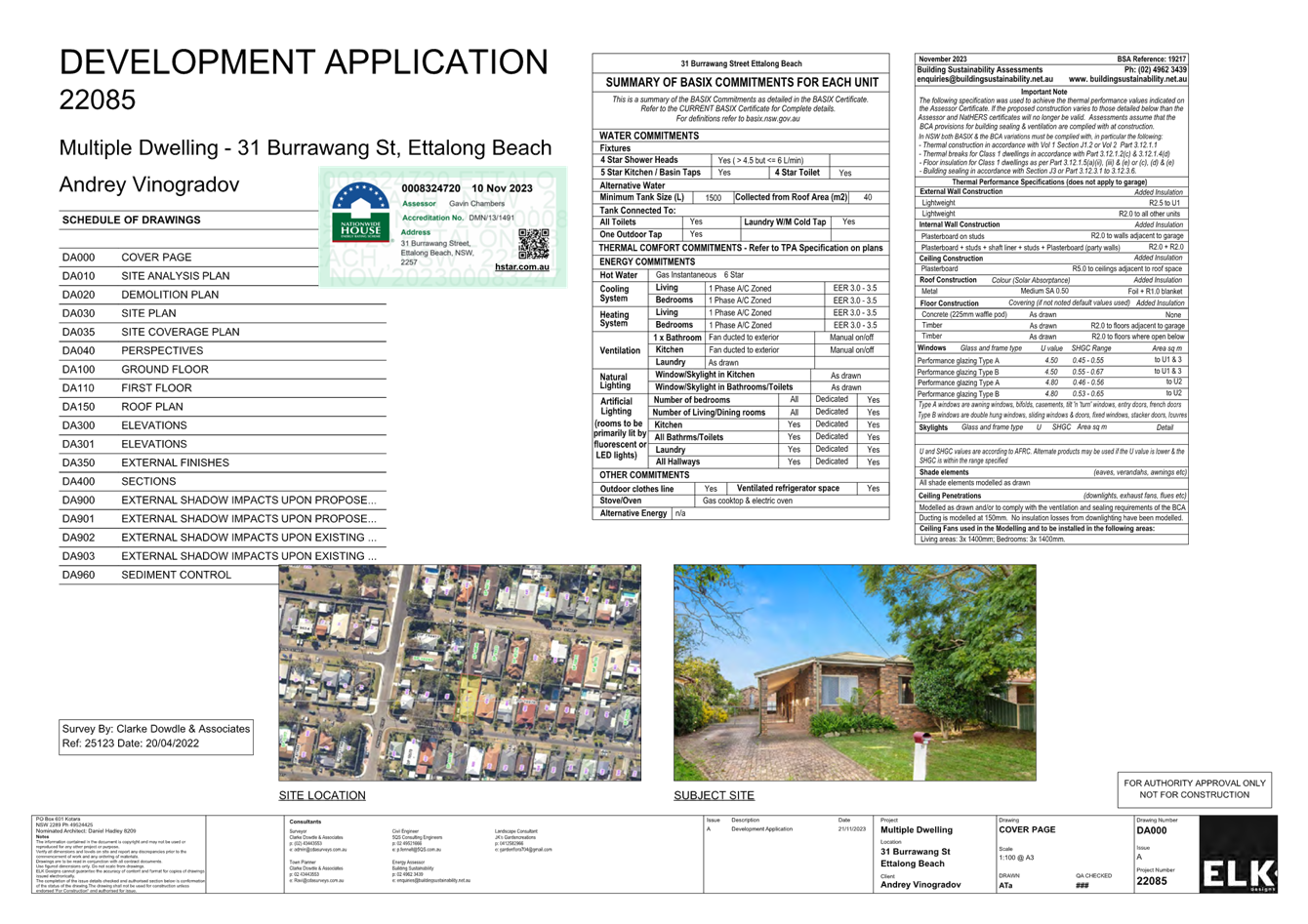
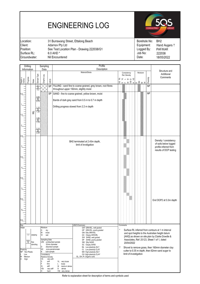
2.2 DA/4365/2022 - 31 Burrawang Street Ettalong Beach - Multi-Dwelling housing (3 Units) & Demolition of Existing Structures........................................................................................... 78
Jason Perica
Chairperson
|
Item No: 1.1 |
|
|
Title: Disclosures of Interest |
|
|
Department: Governance |
|
|
7 December 2023 Local Planning Panel |
|
Reference:
|
The NSW Local Planning Panel Code of Conduct states that all panel members must sign a declaration of interest in relation to each matter on the agenda before or at the beginning of each meeting.
|
That Panel Members now confirm that they have signed a declaration of interest in relation to each matter on the agenda for this meeting and will take any management measures identified.
|
Item No: 2.1 |
|
|
Title: DA/733/2023 - 22 Melba Road, Woy Woy - Staged Development Consisting of Demolition of Existing Primary Dwelling, Construction of Three Multi Dwelling Units, Change of Use of Existing Secondary Dwelling to a Fourth Multi Dwelling Unit and Strata Subdivision |
|
|
Department: Environment and Planning |
|
|
7 December 2023 Supplementary Local Planning Panel |
|
Reference: DA/733/2023 - D15907685
Author: Rebecca Samways, Development Planner.Employment and Urban Release
Manager: Emily Goodworth, Section Manager Employment and Urban Release
Executive: Alice Howe, Director Environment and Planning
|
Summary
An application has been received for a staged development consisting of demolition of the existing principal dwelling house, construction of three Multi Dwelling Units, change of use of the existing Secondary Dwelling to a fourth Multi Dwelling Unit and strata subdivision. The application has been examined having regard to the matters for consideration detailed in Section 4.15 of the Environmental Planning and Assessment Act 1979 and other statutory requirements with the issues requiring attention and consideration being addressed in this report.
The application is required to be determined by the Local Planning Panel as a result of 14 public submissions by way of objection being received during the notification period.
The application is recommended for refusal.
Applicant Jamie Harris Building Design Owner R E Tauni and C S R Tauni Application No DA/733/2023 Description of Land Lot 44 DP 13501 22 Melba Road, WOY WOY NSW 2256 Proposed Development Staged Development Consisting of Demolition of Existing Primary Dwelling, Construction of 3 Multi Dwelling Units, Change of Use of Existing Secondary Dwelling to a Fourth Multi Dwelling Unit and Strata Subdivision Site Area 627.9m2 Zoning R1 General Residential Existing Use Dwelling and Secondary Dwelling Employment Generation No Estimated Value $1,200,000
|
1 That the Local Planning Panel refuse the application DA/733/2023 at Lot 44 DP 13501, 22 Melba Road, WOY WOY for Staged Development Consisting of Demolition of Existing Primary Dwelling, Construction of three Multi Dwelling Units, Change of Use of Existing Secondary Dwelling to a fourth Multi Dwelling Unit and Strata Subdivision subject to the reasons for refusal detailed in this report and having regard to the matters for consideration detailed in Section 4.15 of the Environmental Planning and Assessment Act 1979.
2 That Council advise those who made written submissions of the Panel’s decision.
Key Issues
· The proposed development is permissible in the zone.
· The proposed development results in a number of non-compliance’s with Central Coast Local Environmental Plan 2022 and Central Coast Development Control Plan 2022.
· The proposed development is considered an overdevelopment of the site.
· Public submissions and matters raised therein. 14 submissions in objection to the proposed development were received during the notification period.
· Insufficient information has been provided to accurately assess the proposed development.
Precis:
|
Proposed Development |
Staged Development Consisting of Demolition of Existing Primary Dwelling, Construction of 3 Multi Dwelling Units, Change of Use of Existing Secondary Dwelling to a Fourth Multi Dwelling Unit and Strata Subdivision |
|
Permissibility and Zoning |
R1 General Residential
Multi dwelling housing and strata subdivision is permissible with consent in the R1 General Residential zone. |
|
Current Use |
Dwelling house and Secondary Dwelling |
|
Integrated Development |
No |
|
Submissions |
14 submissions received |
Variations to Policies
|
Clause |
Clause 2.2.5(a)(ii) Building Setbacks |
|
Standard |
Front setback – average of the nearest two dwellings which is 3.45m. |
|
LEP/DCP |
Central Coast Development Control Plan 2022, Chapter 2.2 |
|
Departure basis |
1m front setback to carport proposed. 71.01% variation. |
|
Clause |
Clause 2.2.5(b)(i) Building Setbacks |
|
Standard |
Side setback for any part of the building up to 4.5m – 0.9m |
|
LEP/DCP |
Central Coast Development Control Plan 2022, Chapter 2.2 |
|
Departure basis |
Zero side setback proposed. 100% variation. |
|
Clause |
Clause 2.2.5(c)(i) Building Setbacks |
|
Standard |
Rear setback – 4.5m |
|
LEP/DCP |
Central Coast Development Control Plan 2022, Chapter 2.2 |
|
Departure basis |
4m rear setback proposed to unit 1 alfresco. 0.5m or 11.1% variation. |
|
Clause |
Clause 2.2.5(d)(i) Building Setbacks |
|
Standard |
Garage setback to local road – 5.5m |
|
LEP/DCP |
Central Coast Development Control Plan 2022, Chapter 2.2 |
|
Departure basis |
4.61m setback to garage proposed. 0.9m or 16.18% variation. |
|
Clause |
Clause 2.2.6.3(c) Residential Address |
|
Standard |
Street numbers and building access easily identified from the street. |
|
LEP/DCP |
Central Coast Development Control Plan 2022, Chapter 2.2 |
|
Departure basis |
Front entry of unit 4 proposed to be relocated to the rear corner of the carport which will result in poor access and is not easily identifiable from the street. Non-numerical variation. |
|
Clause |
Clause 2.2.6.4(a) Design Integration |
|
Standard |
Where existing buildings are to be retained as part of the overall proposal, they shall be sufficiently upgraded to integrate with the new development. |
|
LEP/DCP |
Central Coast Development Control Plan 2022, Chapter 2.2 |
|
Departure basis |
Proposed unit 4 (existing secondary dwelling) has minor alterations proposed however will result in poor integration with the development. Non-numerical variation. |
|
Clause |
Clause 2.2.7.3(a) Private Open Space |
|
Standard |
Private open space areas for each dwelling to have a minimum area of 45m2, minimum dimensions of 4.5m, and be accessible from a living area within the dwelling. |
|
LEP/DCP |
Central Coast Development Control Plan 2022, Chapter 2.2 |
|
Departure basis |
Unit 1 - area =41.7m2 =7.33% variation Minimum dimension of 3.1m =31.11% variation
Unit 2 – area =25.9m2 =42.44% variation Minimum dimension tapers to zero, 2.8m along the western side boundary =37.78% - 100% variation
Unit 3 – area=14.7m2 =67.33% variation Minimum dimension tapers to zero, 0.5m along the western side boundary =88.89% - 100% variation
Unit 4 – area =29.1m2 =35.33% variation Minimum dimension tapers to zero, 1.1m along the western side boundary =75.56%% - 100% variation
Private open space not accessed off a living room (non-numerical variation). |
|
Clause |
Clause 2.2.7.5(a) Sunlight Access |
|
Standard |
On June 21 at least 50% of the required private open space to receive at least 3 hours of unobstructed sunlight between 9am and 3pm. |
|
LEP/DCP |
Central Coast Development Control Plan 2022, Chapter 2.2 |
|
Departure basis |
Unit 3 received solar access to up to 14.4m2 for 3 hours =36% variation. |
|
Clause |
Clause 2.2.7.5(b) Sunlight Access |
|
Standard |
Dwellings should be orientated to allow optimum solar access to internal living areas. |
|
LEP/DCP |
Central Coast Development Control Plan 2022, Chapter 2.2 |
|
Departure basis |
Unit 4 living areas are facing south, and a bathroom/laundry is located on the northern elevation resulting in poor solar access to the living areas. Non-numerical variation. |
|
Clause |
Clause 2.2.8.1(c) Car Parking |
|
Standard |
One resident parking space for each dwelling to be provided in the form of an enclosed space. |
|
LEP/DCP |
Central Coast Development Control Plan 2022, Chapter 2.2 |
|
Departure basis |
Unit 4 has a carport which is not considered to be an enclosed space. Non-numerical variation. |
|
Clause |
Clause 2.2.8.1(g)(iii) Car Parking |
|
Standard |
When locating visitor space within front setback, the space is to be setback a minimum of 3m and be screened by landscaping. |
|
LEP/DCP |
Central Coast Development Control Plan 2022, Chapter 2.2 |
|
Departure basis |
Visitor space setback 1m (66.67% variation) from the front boundary and is not screened by landscaping (non-numerical variation). |
|
Clause |
Clause 2.2.8.1(i) Car Parking |
|
Standard |
Where car parking is proposed via a common driveway, adequate manoeuvring area must be provided on site so vehicles can enter and exit in a forward direction. |
|
LEP/DCP |
Central Coast Development Control Plan 2022, Chapter 2.2 |
|
Departure basis |
Units 2 and 3 have a common driveway, however, do not allow for entry and exit in a forward direction. Non-numerical variation. |
|
Clause |
Clause 2.2.8.2.2(d) Access Design |
|
Standard |
Driveways to be offset from any side boundary by a minimum of 2m at the front boundary and may taper to 0.5m at the front building line. |
|
LEP/DCP |
Central Coast Development Control Plan 2022, Chapter 2.2 |
|
Departure basis |
Unit 1 driveway offset 0.9m at the front boundary and tapers to a zero side setback. 55% - 100% variation. |
|
Clause |
Clause 2.2.9.1(b) Earthworks and Structural Support |
|
Standard |
No retaining wall or fill is to be within 1m of a side or rear boundary unless within 1.5m of any external wall of a dwelling. |
|
LEP/DCP |
Central Coast Development Control Plan 2022, Chapter 2.2 |
|
Departure basis |
Retaining walls for fill on the boundary which are not within 1.5m of any external wall of a building are proposed. Non-numerical variation. |
|
Clause |
Clause 2.2.10.2(a) Landscaping |
|
Standard |
Two street trees per 15m frontage. In this instance six street trees would be required. |
|
LEP/DCP |
Central Coast Development Control Plan 2022, Chapter 2.2 |
|
Departure basis |
SEE indicates two street trees will be provided, however, one of these trees will not be able to be retained. Therefore, only one will be provided (83.33% variation). Notwithstanding this, street tree planting has also not been shown on the landscaping plan. |
|
Clause |
Clause 2.13.3.2(c)(i) Car Parking Requirements |
|
Standard |
1.5 resident parking spaces per dwelling. In this instance 6 resident spaces are required. |
|
LEP/DCP |
Central Coast Development Control Plan 2022, Chapter 2.13 |
|
Departure basis |
Three compliant spaces proposed. 50% variation. |
|
Clause |
Clause 2.13.3.3(b) Dimensions of Parking Spaces |
|
Standard |
Garage or enclosed carport to have clear internal dimensions of a minimum of 3m x 5.4m. |
|
LEP/DCP |
Central Coast Development Control Plan 2022, Chapter 2.13 |
|
Departure basis |
Proposed carport has dimensions of 3.11m x 5.1m. 5.55% variation. |
|
Clause |
Clause 2.13.3.4(c) Stacked Parking |
|
Standard |
Stacked parking not recognised for car parking calculations for multi dwelling housing. |
|
LEP/DCP |
Central Coast Development Control Plan 2022, Chapter 2.13 |
|
Departure basis |
Three stacked parking spaces which overhang in the road reserve by approximately 900mm are proposed. Non-numerical variation. |
|
Clause |
Clause 2.13.3.10(b) Visitor Parking |
|
Standard |
The location of the visitor parking is to have regard for the site conditions, relationship of the building to the visitor parking area and the proximity of the visitor parking to any neighbouring residential areas. |
|
LEP/DCP |
Central Coast Development Control Plan 2022, Chapter 2.13 |
|
Departure basis |
Location of visitor parking does not have a suitable relationship to units 1, 2 and 3. Non-numerical variation. |
|
Clause |
Clause 2.17.1(a) Matters for Consideration |
|
Standard |
Demonstrate consistency or compatibility with the Character and Scenic Quality statements in the DCP. |
|
LEP/DCP |
Central Coast Development Control Plan 2022, Chapter 2.17 |
|
Departure basis |
The proposed development is not considered to adequately demonstrate consistency or compatibility with the desired character in the DCP Character and Scenic Quality statement. Non-numerical variation. |
The Site
The site is located at 22 Melba Road, Woy Woy and is legally described as Lot 44 DP 13501.
The site is located on the northern side of Melba Road. The site is triangular in shape and has an area of 627.9m2. The site has a frontage to Melba Road of 40.13m. The site generally has a gentle slope gradually falling from the southern boundary to the norther rear corner of the site. Across the whole site is a fall of approximately 1.7m.
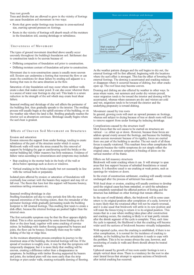
The site currently contains an existing principal dwelling house and secondary dwelling. Both the principal and secondary dwelling are clad with a metal roof. The principal dwelling has a detached carport and shed, while the secondary dwelling has an attached carport. The site contains some gardens and trees along the front boundary (refer to Figures 1 and 2).
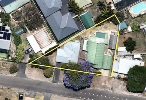
Figure 1 – Aerial photograph of the site
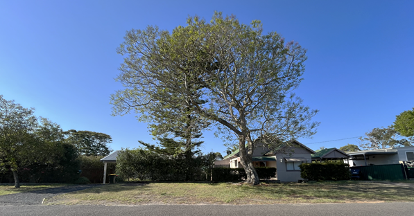
Figure 2 – Site as viewed from the street
Surrounding Development
The site is surrounded by residential development, comprising a mix of single dwellings with and without secondary dwellings, dual occupancies and multi dwelling housing. The southern side of Melba Road contains residential development and access to Brisbane Water Secondary College which is located behind the residential development (refer to Figures 3-8).
A childcare centre is located further to the East near the intersection with Edward Street and Melba Road. Further to the north and south-west of the site is commercial development located between approximately 180m and 250m from the site.
Figure 3 – Surrounding residential development to the north, east and west of the site and Brisbane Water Secondary College to the south
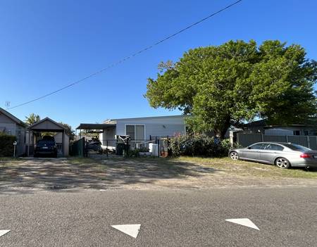
Figure 4 – Adjoining property to the east
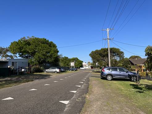
Figure 5 – Melba Road facing east
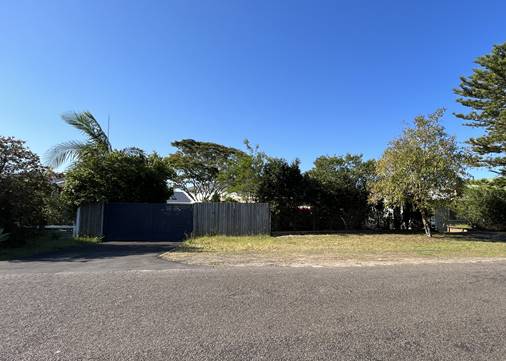
Figure 6 – Adjoining property to the west
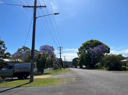
Figure 7 – Melba Road facing west
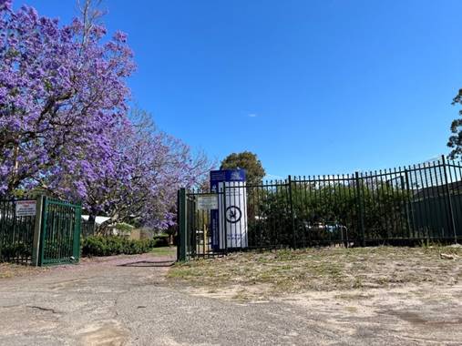
Figure 8 – Brisbane Water Secondary College access from Melba Road
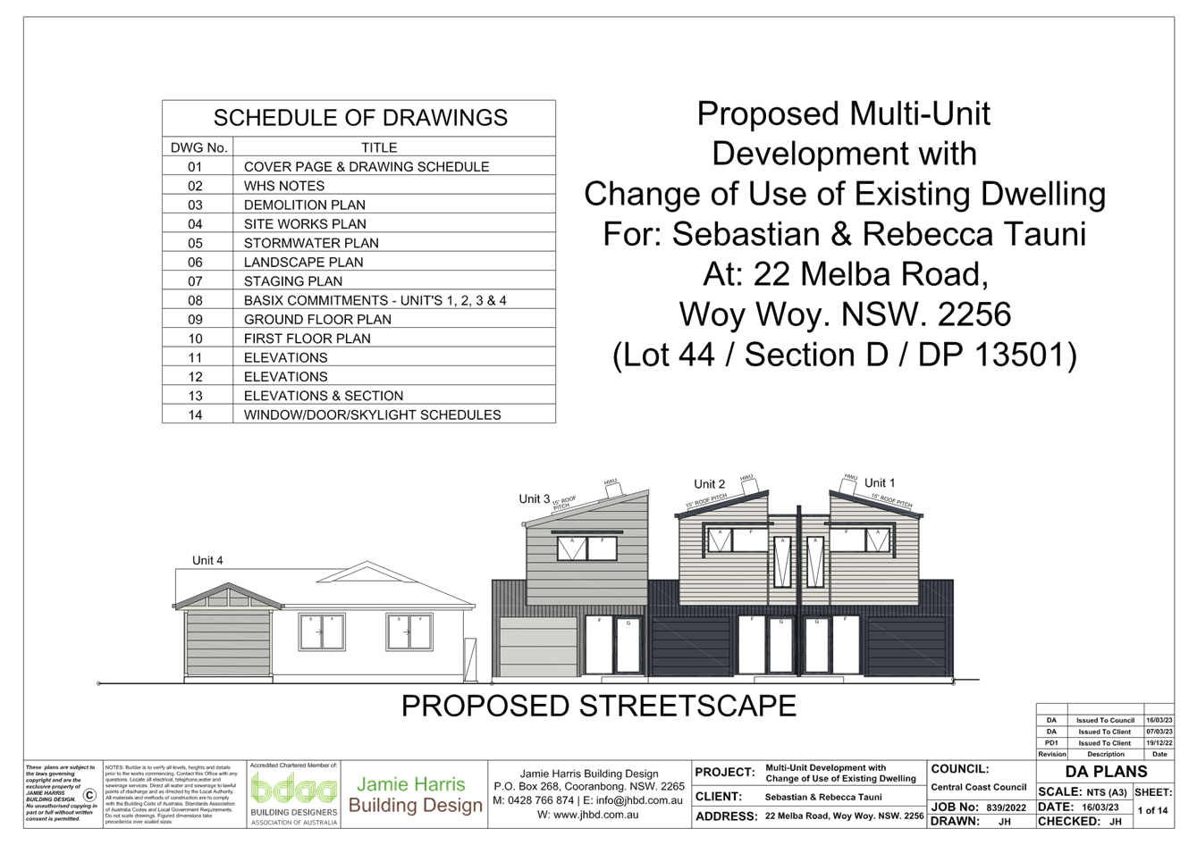
The Proposed Development
The subject development application seeks consent for the demolition of the existing dwelling house, construction of three multi dwelling units and a change of use of the existing secondary dwelling to a multi dwelling unit.
The development is proposed in two stages as detailed below.
Stage 1
Stage 1 will consist of the demolition of the existing principal dwelling house and associated structures, the construction of three multi dwelling units and the change of use of the secondary dwelling to become the fourth multi dwelling unit.
This stage involves demolition of the principal dwelling house, detached carport, and shed (Figures 9 and 10). The existing fence along the eastern side boundary is also proposed to be removed and a new 1.8m high metal panel fence reinstated along the correct boundary alignment.
Proposed units 1, 2 and 3 will be newly constructed, two storey attached units, and will contain the following:
· Proposed unit 1 will consist of three bedrooms, a bathroom, an ensuite, a combined laundry/powder room, a kitchen, a combined living/dining area, an alfresco area, a front porch and single car garage. The garage will be accessed via a new driveway access.
· Proposed unit 2 will consist of two bedrooms, two ensuites, a combined laundry/powder room, a kitchen, a combined living/dining area, a front porch and single car garage. The garage will be accessed via a new shared driveway access with proposed unit 3.
· Proposed unit 3 will consist of two bedrooms, two ensuites, a combined laundry/powder room, a kitchen with breakfast/dining bar, a living area, a front porch and single car garage. The garage will be accessed via a new shared driveway access with proposed unit 2.
A change of use of the existing secondary dwelling to turn it into the fourth unit as part of the whole multi dwelling development is proposed as part of stage 1. There are no proposed works for the change of use to the fourth secondary dwelling unit to be undertaken in stage 1. Unit 4 will consist of two bedrooms, a combine laundry/bathroom and an open plan kitchen, dining and loungeroom.
Stage 2
Stage 2 will consist of alterations and additions to proposed unit 4 (the existing secondary dwelling), along with strata subdivision and associated driveway works for unit 4.
The alterations and additions to unit 4 will include the construction of a third bedroom within a portion of the existing carport, relocation of the front entry door, the construction of a new carport, the construction of a paved parking area adjacent to the carport and the widening of the existing driveway access.
Consent for the strata subdivision of the multi dwelling development is also being sought, however, the details of the strata subdivision have not been provided and no strata subdivision plans were submitted with the application.
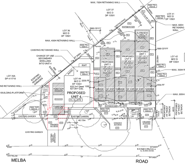
Figure 9 – Site plan of proposed development
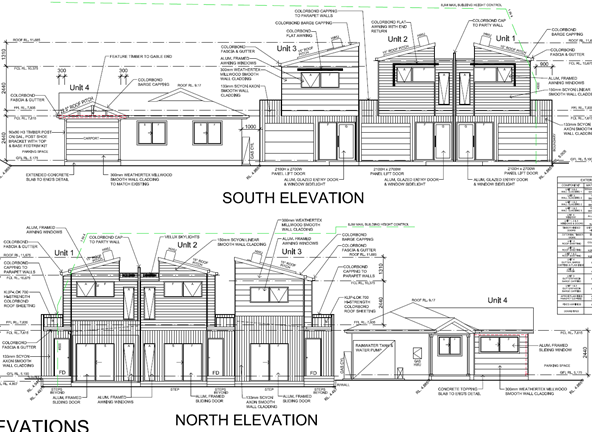
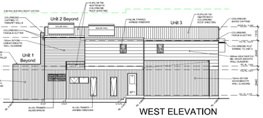
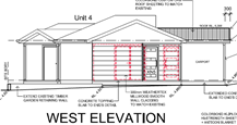
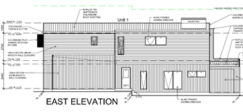
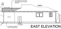
Figure 10 – Elevations of proposed development
History
A search of Council records reveals the following previous applications for the site:
· BC/6567/97 was approved on 7 January 1998 for a dwelling and carport additions.
· CDC/50601/2016 was approved on 26 August 2016 for a secondary dwelling.
Application Background
On 1 September 2023 Council requested the application be withdrawn due to the number of non-compliances and insufficient information.
On 4 September 2023, Council was advised that the applicant did not wish to withdraw the application. They raised concerns with the delay in the assessment of the application and requested that Council proceed with assessment of the application on the information available which is what Council has done.
Although Council did not request additional information, the applicant submitted additional information on 24 October 2023 when Council was finalising the assessment of the application and preparing the assessment report for the Local Planning Panel agenda. Accordingly, Council has not accepted the amended plans having regard for the provisions of Section 38 of Environmental Planning and Assessment Regulation 2021 and the requests of the applicant to determine the application on 4 September 2023.
Notwithstanding the above, a preliminary review of the additional information was undertaken which identified the proposal was substantially unchanged, with the following amendments to the design noted:
· The two existing street trees are shown to be removed.
· Site plan and stormwater plan show shared driveway between proposed units 2 and 3 has been widened, while the remaining plans show units 2 and 3 will have separate driveways (inconsistent plans)
· Garages of proposed units 1, 2 and 3 have been setback further to allow stacked parking.
· Removal of proposed alterations to proposed unit 4.
· ‘Potential’ visitor space/parking bay adjacent to proposed unit 4 has been deleted.
· Landscape plan prepared by landscape architect submitted which includes a plant schedule and shows landscaping on the site and three street trees.
· Amended stormwater plan to reflect amended plans.
Based on the preliminary review of the draft amended plans, the proposed amended design still represented an overdevelopment of the site.
ASSESSMENT:
Having regard for the matters for consideration detailed in Section 4.15 of the Environmental Planning and Assessment Act 1979 and other statutory requirements, Council’s policies and Section 10.7 Certificate details, the assessment has identified the following key issues, which are elaborated upon for Council’s information. Any tables relating to plans or policies are provided as an attachment.
State Environmental Planning Policy (Resilience and Hazards) 2021
Chapter 4 – Remediation of Land
In accordance with Section 4.6 of the Resilience and Hazards SEPP, a consent authority must not consent to the carrying out of development unless it has considered whether the land is contaminated and if the land requires remediation to be made suitable for the development.
The site and existing structures have been historically used for residential purpose. Therefore, it is not considered to be of any risk of contamination and no further assessment under the provisions of the SEPP is required in this regard.
Having regard for the above, it is considered that the requirements of Section 4.6 have been satisfied and accordingly, the consent authority can be satisfied that the land is suitable for the purpose for which the development is proposed to be carried out.
State Environmental Planning Policy (Building Sustainability Index: BASIX) 2004
State Environmental Planning Policy (Sustainable Buildings) 2022 commenced on 1 October 2023. In accordance with Section 4.2(1)(a), and because the development application was submitted on the NSW planning portal but not determined before 1 October 2023, the provisions of SEPP (Sustainable Buildings) 2022 do not apply to the proposed development and SEPP (Building Sustainability: BASIX) 2004 has been considered.
The BASIX Certificates submitted with the application were over three months old at the time of lodgement and are therefore invalid. Having regard for this, the proposed development does not satisfy the requirements of SEPP (BASIX) 2004 (recommended reason for refusal 1).
Central Coast Local Environmental Plan 2022 (CCLEP 22)
Permissibility
The site is zoned R1 General Residential under the CCLEP 2022 (Figure 11). The proposed development is defined as a multi dwelling housing under the CCLEP 2022 which provides the following:
multi dwelling housing means 3 or more dwellings (whether attached or detached) on one lot of land, each with access at ground level, but does not include a residential flat building.
Multi dwelling housing is permitted with consent in the R1 General Residential zone.
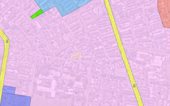
Figure 11 – Zoning map of surrounding development
Zone objectives
Subclause 2.3(2) of the CCLEP 2022 requires the consent authority to have regard for the objectives for development in a zone when determining a development application. The objectives of the R1 General Residential zone are as follows:
· To provide for the housing needs of the community.
· To provide for a variety of housing types and densities.
· To enable other land uses that provide facilities or services to meet the day to day needs of residents.
· To promote best practice in the design of multi dwelling housing and other similar types of development.
· To ensure that non-residential uses do not adversely affect residential amenity or place unreasonable demands on services.
While the proposal will provide additional housing to the community it is considered that the proposed development will result in poor amenity for future residents of the proposed development. It is not considered that the proposed development displays best practice in the design of multi dwelling housing and will not enhance the residential amenity of the surrounding development as it does not have regard to the physical, spatial and environmental quality of the surrounding development, including maintaining visual privacy between adjoining properties.
The inconsistency of the proposal with the R1 General Residential zone objectives is identified in recommended reason for refusal 2.
Clause 4.3 Height of buildings
Clause 4.3 specifies the building height for the site shall not exceed that indicated on the applicable map. Council’s height of building map identifies the site with a maximum permissible building height of 11.5m. The proposal has a height of 7.5m which is compliant with the maximum permissible height, however, this cannot be accurately confirmed as no survey plan has been submitted with the application. This height is determined off finished floor levels provided on the architectural plans.
Clause 4.4 Floor space ratio
Clause 4.4 specifies the floor space ratio for the site shall not exceed that indicated on the applicable map. Council’s floor space ratio maps identify the site with a maximum permissible floor space ratio of 0.5:1. The proposed development has a floor space ratio of 0.569:1 which is over the maximum permitted floor space ratio in accordance with clause 4.4. However, as discussed further below, clause 4.4A provides exceptions to the floor space ratio on the site.
Clause 4.4A Exceptions to floor space ratio – General
The site is identified as being located in “Area 2” on the Floor Space Ratio Map. Clause 4.4A(5) states the following in relation to Area 2:
(5) The maximum floor space ratio of a building on land identified as “Area 2” on the Floor Space Ratio Map is—
(a) 0.85:1, if all of the following applies—
(i) the building is to be used for the purposes of a residential flat building or multi dwelling housing,
(ii) all on-site parking is located in the basement of the building,
(iii) the site area is at least 1,000m2, or
(b) 0.7:1, if all of the following applies—
(i) the building is to be used for the purposes of a residential flat building or multi dwelling housing,
(ii) all on-site parking is located in the basement of the building,
(iii) the site area is less than 1,000m2, or
(c) 0.6:1, if subclause (a) or (b) do not apply to the building.
As the proposed development does not propose basement car parking, a maximum permissible floor space ratio of 0.6:1 is applicable to the proposed development in accordance with clause 4.4A(5)(c). The proposed development has a floor space ratio of 0.569:1 which is under the maximum permitted floor space area in Area 2 applicable to the proposed development.
Clause 5.21 Flood Planning
The site is identified as within the mapped flood planning area under clause 5.21 of CCLEP 2022 as shown in Figure 12.
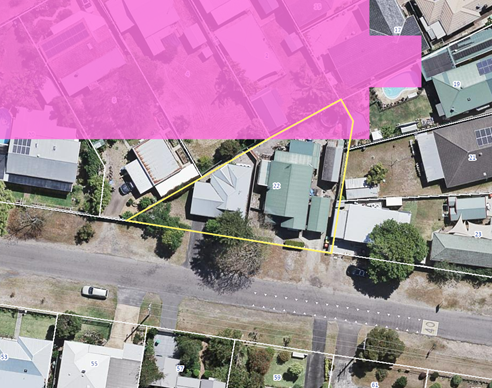
Figure 12 – Flood planning land on the site
In accordance with clause 5.21(2) development consent must not be granted to development on land the consent authority considers to be within the flood planning area unless the consent authority is satisfied the development:
(a) is compatible with the flood function and behaviour on the land, and
(b) will not adversely affect flood behaviour in a way that results in detrimental increases in the potential flood affectation of other development or properties, and
(c) will not adversely affect the safe occupation and efficient evacuation of people or exceed the capacity of existing evacuation routes for the surrounding area in the event of a flood, and
(d) incorporates appropriate measures to manage risk to life in the event of a flood, and
(e) will not adversely affect the environment or cause avoidable erosion, siltation, destruction of riparian vegetation or a reduction in the stability of river banks or watercourses.
The consent authority must also consider the following in deciding whether to grant development consent in accordance with clause 5.21(3):
(a) the impact of the development on projected changes to flood behaviour as a result of climate change,
(b) the intended design and scale of buildings resulting from the development,
(c) whether the development incorporates measures to minimise the risk to life and ensure the safe evacuation of people in the event of a flood,
(d) the potential to modify, relocate or remove buildings resulting from development if the surrounding area is impacted by flooding or coastal erosion.
The submitted Statement of Environmental Effects (SEE) incorrectly states that the property does not fall within any Flood Planning Areas and that subsequently the Floodplain Development Controls for residential developments do not apply to this property, contrary to Council’s flood maps.
However, the site is subject to an overland flow study which is determined by the 1% AEP and 300mm freeboard to determine the Flood Planning Level. The proposed development includes a floor level of 4.807m (AHD) which would be above the FPL for the site and accordingly, the development would comply with the provisions of clause 5.21 having regard for the flood behaviour, and safe evacuation would be available to the site and in this regard risk to life could be adequately managed. Given the proposal is recommended for refusal based on other matters, no further information is required in relation to flooding.
Clause 7.1 Acid Sulfate Soils
The site is mapped as potentially containing Class 3 acid sulfate soils. In accordance with clause 7.1, development consent is required for works more than 1m below the natural ground surface and works by which the watertable is likely to be lowered more than 1m below the natural ground surface.
The proposed development includes a maximum cut of 600mm and is not likely to lower the water-table more than 1m below the natural ground surface and accordingly the Panel, as the consent authority, can be satisfied that the proposed development is consistent with the requirements of clause 7.1 and an acid sulfate soils management plan is not required in this instance.
Clause 7.6 Essential Services
In accordance with clause 7.6, development consent must not be granted to development unless the consent authority is satisfied that all of the following services that are essential for the development are available or that adequate arrangements have been made to make them available when required:
(a) the supply of water,
(b) the supply of electricity,
(c) the disposal and management of sewage,
(d) stormwater drainage or on-site conservation,
(e) suitable vehicular access,
(f) the collection and management of waste.
Stormwater drainage or on-site conservation
Insufficient information has been provided to demonstrate that the proposed development can provide adequate stormwater drainage arrangements or on-site conservation having regard for the submitted concept stormwater plan prepared by Jamie Harris Building Design (Ref: 839/2022 dated 16.03.2023 Sheet 05 of 14). Moreover, the proposed development has not provided sufficient information to demonstrate compliance with Chapter 3.1 Floodplain Management and Water Cycle Management (CCDCP 2022) having regard for infiltration, retention and on site detention (OSD).
Suitable Vehicular access
The location of the driveway of proposed unit 1 is unacceptable as there is no required 2m pedestrian safety triangle offset for the driveway. The sight lines may further be obscured if 23 Edward Street constructs a fence or landscaping. In addition, swept paths were not provided for vehicle movements into the garage of unit 3. Considering the dimensions, the vehicle manoeuvring will not be practical within the given driveway envelope.
Having regard for the above, the Panel cannot be satisfied that the proposed development can provide adequate stormwater and on-site conservation, or suitable vehicular access, in accordance with clause 7.6 (recommended reason for refusal 3).
Central Coast Development Control Plan 2022 (CCDCP 2022)
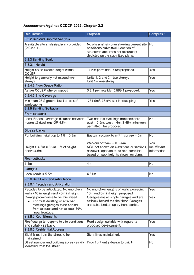
Chapter 2.2 – Dual Occupancy and Multi Dwelling Housing
An assessment has been undertaken in relation to the provisions of Chapter 2.2 which is provided in Attachment 3. A number of non-compliances with Chapter 2.2 have been identified which are discussed below (recommended reason for refusal 4).
Clause 2.2.2.1.1 Site Analysis
Clause 2.2.2.1.1 requires the submission of a site analysis plan with any development application. A site analysis plan has not been submitted with the application. Furthermore, upon review of the submitted plans in conjunction with a review of aerial images and a site inspection, the following inconsistencies have been identified in relation to details on the plans showing existing structures:
· A site inspection and review of aerial images revealed that the driveway to unit 4 is straight, however, the demolition plan shows unit 4’s existing driveway is angled upon approach to the existing carport.
· An existing street tree is located west of the driveway of unit 4, however it is not detailed on any plans.
· There is an existing fence between the primary and secondary dwelling, which is not shown on the plans.
In addition to the above, insufficient information, such as the location of structures on adjoining properties, has been provided to accurately assess the impacts of the proposed development.
Clause 2.2.5 Building Setbacks
The proposed development includes variations to the front setback, side setback, rear setback and setbacks to the garage, which are discussed further below. The objectives of the setback controls are as follows:
· To ensure that setbacks are compatible with adjacent development and complements the character, streetscape and natural areas.
· To ensure the visual focus of a development is the dwelling, not the garage.
· To ensure views, privacy and solar access of adjacent properties are reasonably maintained.
· To reasonably maintain view corridors to coastal foreshores and other desirable outlooks.
· To maintain the scenic and environmental qualities of natural waterbodies and their foreshores and respond to site attributes such as topography.
· To provide deep soil areas sufficient to provide new landscaping.
· To provide appropriate articulation of facades and horizontal elements reduce the appearance of bulk and provides visual interest to the building and subsequent streetscape where they face a street frontage/s.
Front Setback
In accordance with clause 2.2.5(a)(ii), the minimum permitted front setback for the proposed development is the average of the nearest two dwelling houses having the same primary road boundary and located within 40m of the site, which in this instance is a minimum front setback requirement of 3.45m. The proposed development has a minimum front setback of 1m to the proposed carport of proposed unit 4 which is a variation of 71.01% as shown in Figure 13.
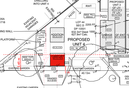
Figure 13 – Extent of non-compliance with the front setback
The SEE provides the following justification for the front setback to the carport:
‘The existing front setback is an established setback as it was the same as the primary dwelling that is proposed to be demolished. The proposed carport is well forward of the building line but is consistent with other past developments that we’ve worked on with the carport being forward of the building line. It should be noted that an open hardstand parking area is adjacent to the proposed carport, which will allow for further off-street parking.’
The justification provided does not address the objectives of the control. The variation to the front setback does not result in setbacks that are compatible with adjacent development (noting the front setback is ‘well forward of the building line’ as stated in the SEE) and does not positively contribute to the streetscape.
While the surrounding development does include dwellings with small front setbacks, including in some instances carports which are in front of the building line of the dwelling, the smallest of the front setbacks are still generally between 2.8m and 4m. These properties are located on the same side of Melba Road as the subject site. On the opposite side of Melba Road, the front setbacks vary from 3.7m to 8.3m.
The proposed front setback to the carport does not meet the objectives of the control as it is not compatible with the adjacent development or streetscape. Moreover, the proposed development is for multi-dwelling housing, not a dwelling house, and there is an expectation that this form of development provides appropriate setbacks and presentation to the street.
Side Setback
In accordance with clause 2.2.5(b)(i), the minimum permitted side setback for any part of the building up to 4.5m is 0.9m. The proposed development has a zero side setback to the eastern side boundary of the proposed unit 1 garage, which is a variation of 100% as shown in Figure 14.
The SEE provides the following justification for the ground floor setback to the carport:
‘This is an acceptable setback for a garage, provided it is fire rated to the boundary wall.’
The SEE does not address the objectives of the control to justify the non-compliance. Notwithstanding the location of the carport on the adjoining property to the east which has a near zero side setback, and other existing carports and garages surrounding the site with similar side setbacks, the intent of the setback controls includes the provision of reasonable amenity to adjoining properties and to enable maintenance of the building. There are no site constraints or otherwise that do not allow for the development to comply with the 0.9m setback.
In accordance with clause 2.2.5(b)(ii), the minimum permitted side setback for any part of the building with a height of more than 4.5m is 0.9m plus one-quarter of the height of the building above 4.5m. The SEE has stated that the proposed side setbacks above 4.5m are compliant, however, it is noted that natural ground level has not been shown on the elevations and sections. Without this information, Council is unable to confirm that the side setbacks are compliant with the controls.
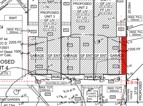
Figure 14 – Extent of non-compliance with the ground floor side setback
Based on the spot heights on the plans, it appears that the side setback to the first floor above the garage of unit 1 may be non-compliant. No survey plan was provided to enable an assessment of the proposed height of the buildings and compliance with this clause. The lack of information inhibits a comprehensive assessment of the application to be undertaken in accordance with the relevant controls.
Rear Setback
In accordance with clause 2.2.5(c)(i), the minimum rear setback permitted is 4.5m. The minimum rear setback proposed is 4m, which is a variation of 11.1%.
The SEE provides the following justification for the variation:
We seek a variation of the rear setback to the alfresco area of Unit 1 but argue that this area forms part of the private open space for this unit which allows for indoor to outdoor transition access, subject to council approval.
The SEE does not address the objectives of the control to justify the non-compliance nor is adequate justification provided as to why the design of the development cannot comply with the 4.5m setback (Figure 15). The intent of setbacks is to ensure adequate amenity is provided for the adjoining properties and occupants of the proposed development.
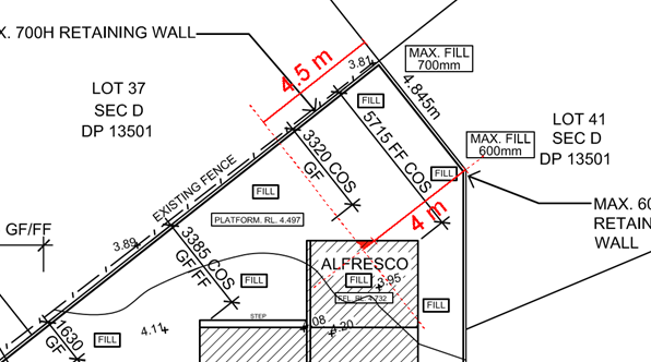
Figure 15 – Extent of non-compliance with the rear setback
Garage Setback
In accordance with clause 2.2.5(d)(i), the minimum setback from a local road to a garage is 5.5m. The setback to the garages is proposed to be 4.61m which is a variation of 16.18% as shown in Figure 16. The SEE does not address compliance with clause 2.2.5(d)(i) or provide justification for the variation. The proposed setback is considered inadequate having regard for manoeuvring, streetscape presentation, and the desired future character of the area.
The proposed development relies on stacked parking in front of the garages; however, the stacked parking will overhang into the road reserve by approximately 900mm due to the non-compliance with the garage setback. This is an additional reason for the proposed variation to the garage setbacks not be supported.
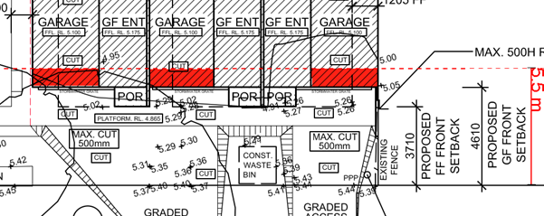
Figure 16 – Extent of non-compliance with the garage setback
Clause 2.2.6.3 Residential Address
Clause 2.2.6.3(c) states that street numbers and building access is to be easily identified from the street. The front entry door of the existing secondary dwelling is proposed to be relocated from the front corner of the existing carport to the rear corner of the proposed carport. It is considered that the relocation of the front door to the rear corner of the carport results in poor access to the proposed unit 4. It also does not provide an easily identifiable entry into the unit.
Clause 2.2.6.4 Design Integration
Clause 2.2.6.4(a) states the following:
(a) Where existing buildings are to be retained as part of an overall proposal, they shall be sufficiently upgraded to integrate with the new development. The integration of old and new shall be carefully considered in terms of:
i architectural features and form;
ii roof form;
iii external building materials colours and finishes;
iv Location and orientation; and
v Dwelling curtilage.
Details of how the proposed development responds to these items are to be included in the Statement of Environmental Effects.
The proposed development includes the retention of a secondary dwelling to be converted to unit 4. While it is noted there are some minor alterations and additions to the secondary dwelling, the design of the secondary dwelling does not integrate with the new proposed units with regard to the architectural features, external building colours/finishes, roof form and dwelling curtilage.
Clause 2.2.7.3 Private Open Space Areas
Clause 2.2.7.3(a) requires private open space for each dwelling to have a minimum area of 45m2 with minimum dimensions of 4.5m in any direction and are to be accessible from a living area within the dwelling. The SEE states that the private open space of units 1 and 4 are compliant with the controls, while the private open space of units 2 and 3 do not achieve the minimum required area.
An assessment of the plans has identified that while unit 1 is generally compliant with the minimum dimensions, it does not provide a minimum area of 45m2, and the private open space areas of units 2, 3 and 4 do not comply with minimum dimensions or minimum area. The location of the private open space of unit 4 is also not accessed from a living area within the dwelling.
The applicant has provided the following private open space areas and minimum dimensions in the SEE:
Unit 1
POS = 54.2m2 / Min. dimensions = 5.1m x 5.9m
Unit 2
POS = 37.4m2 / Min. dimensions = 5m x 7m
Unit 3
POS = 23.8m2 / Min. dimensions = 5.3m x 4.8m
Unit 4
POS = 53.8m2 / Min. dimensions = 5m x 5.5m
It is noted that the extent of the private open space areas or minimum dimensions have not been shown on the plans. Council has reviewed the plans and highlighted the areas with dimensions to show the extent of the assumed area which has been included in the private open space areas in Figures 17-20. Contrary to the SEE, the private open space areas all have a minimum dimension under 4.5m.
The table below summarises the identified areas by the applicant and the minimum dimensions based on the assumed extent of the private open space areas in contrast to Council’s assessment of the private open space areas. It should be noted that the private open space areas considered in Council’s assessment have included some areas which do not meet the minimum dimensions. Figures 17-20 also show the area Council has considered in the assessment of the private open space in contrast to the area identified by the applicant.
|
|
Areas Detailed by the Applicant |
Council’s Assessment |
||
|
Unit |
Area
|
Minimum Dimension (based on POS shown in Figures 23-26) |
Area |
Minimum Dimension |
|
Unit 1 |
54.2m2 |
1.7m |
41.7m2 |
3.1m |
|
Unit 2 |
37.4m2 |
Tapers to zero in the north-eastern corner, 1.6m minimum in the side yard. |
25.9m2 |
Tapers to zero in the north-eastern corner, 2.8m minimum along the western side of the POS. |
|
Unit 3 |
23.8m2 |
Tapers to zero in the north-eastern corner, 1.7m minimum in the side yard. |
14.7m2 |
Tapers to zero in the north-eastern corner, 0.5m minimum along the western side of the POS. |
|
Unit 4 |
53.8m2 |
Tapers to zero in the north-eastern and western corners, 1m minimum in the side yard between the rainwater tank and eastern side boundary. |
29.1m2 |
Tapers to zero in the north-eastern and western corners, 1.1m minimum between the unit and the north-western boundary. |
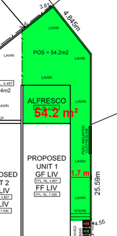
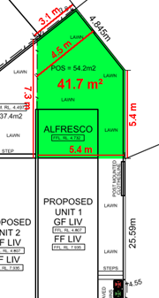
Figure 17 – Location of proposed private open space for proposed unit 1 (left); Area considered as part of Council’s assessment not including side yard area (right)
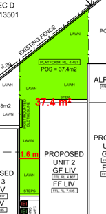
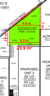
Figure 18 – Location of proposed private open space for proposed unit 2 (left); Area considered as part of Council’s assessment not including side yard area (right)
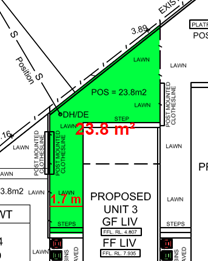
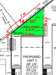
Figure 19 – Location of proposed private open space for proposed unit 3 (left); Area considered as part of Council’s assessment not including side yard area (right)
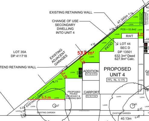
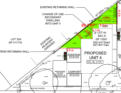
Figure 20 – Location of proposed private open space for proposed unit 4 (top); Area considered as part of Council’s assessment not including side yard area (bottom)
Having regard for the areas Council has included in the assessment of the private open space, the following variations are summarised in the table below.
|
Unit |
Area |
Minimum Dimension |
Variation to area |
Variation to dimension |
|
Unit 1 |
41.7m2 |
3.1m |
7.33% |
31.11% |
|
Unit 2 |
25.9m2 |
Tapers to zero in the north-eastern corner, 2.8m minimum along the western side of the POS. |
42.44% |
37.78% - 100% |
|
Unit 3 |
14.7m2 |
Tapers to zero in the north-eastern corner, 0.5m minimum along the western side of the POS. |
67.33% |
88.89% - 100% |
|
Unit 4 |
29.1m2 |
Tapers to zero in the north-eastern and western corners, 1.1m minimum between the unit and the north-western boundary. |
35.33% |
75.56% - 100% |
In addition to the identified non-compliances with the private open space areas and dimensions, it is noted that the private open space area of unit 4 is accessed from the bathroom/laundry rather than the living area as per clause 2.2.7.3(a). This is not an appropriate, nor desirable, design outcome for a multi-unit housing development.
The SEE states the following in relation to the variation to the private open space area of units 2 and 3:
‘This is due to the nature of the angled side boundary of the property. If this was a more squared off boundary alignment, then compliance would be achieved. We seek a variation to the POS for Unit’s 2 & 3, with the consent of Council.’
The objectives of the control are as follows:
· To ensure private open space areas are functional and responsive to the environment, thereby promoting the enjoyment of outdoor living for residents.
· To ensure private open space areas (in particular balconies) integrate with the overall architectural form and detail of the development.
The justification provided in the SEE does not address the objectives of the control. The proposed development results in private open space areas which are not functional, and do not provide adequate area for the enjoyment of future occupants.
Whilst it is acknowledged that the angled boundary results in site constraints, the proposed development has failed to respond appropriately to this site constraint which is demonstrated in the number of non-compliances associated with the development. A proper site analysis may have concluded that the site may only be able to accommodate a dual occupancy development or three units, not the four which are proposed. The retention of the existing secondary dwelling inhibits an appropriate development of the site.
Furthermore, it is noted that while Council has not included the extent of areas proposed by the applicant in the private open space, as per the SEE, even when considering these areas, the private open space of units 2 and 3 (which appear to include areas well under the minimum dimension) are still under the minimum area required (unit 2 – 7.6m2 under, unit 3 – 21.2m2 under). Consequently it is considered that the proposed private open space areas are unsuitable as they result in poor amenity for the residents due to the small area and dimensions.
Clause 2.2.7.5 Sunlight Access - Private Open Space Solar Access
Clause 2.2.7.5(a) states that on June 21, 50% of the required principal private open space area for each dwelling should receive at least 3 hours of unobstructed sunlight access between 9am and 3pm. Having regard for this, at least 22.5m2 of the principal private open space should receive at least 3 hours solar access between 9am and 3pm.
While the private open space areas of the units face north, it is noted that the majority of the private open space area which has been considered for units 2, 3 and 4 do not meet the minimum dimension and therefore, these areas should technically not be included in the areas counted for solar access. Notwithstanding this, an assessment of the solar access to the areas considered in Council’s assessment has been undertaken and summarised in the following table and is shown in Figures 21 and 22.
|
Proposed Unit |
9am |
12pm |
3pm |
Compliant |
|
Unit 1 |
25.8m2 |
25.8m2 |
25.8m2 |
Yes |
|
Unit 2 |
25.8m2 |
25.8m2 |
25.8m2 |
Yes |
|
Unit 3 |
14.2m2 |
14.4m2 |
14.4m2 |
No, 36% variation |
|
Unit 4 |
23.5m2 |
25.8m2 |
25.8m2 |
Yes |
*Note – areas that receive solar access include areas that are non-compliant with the minimum dimensions for POS.
Having regard for the non-compliance with the minimum solar access requirements it is considered that the proposed development does not meet the objective of the control to facilitate solar access to private open space areas and results in poor amenity for future occupants.
Figure 21 – Solar access at 9am (Note – shadow has been assumed for unit 4 as shadows for unit 4 have not been provided)
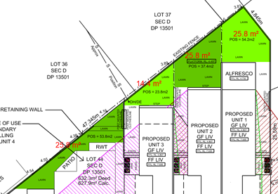
Figure 22 – Solar access at 12pm and 3pm
Clause 2.2.7.5 Sunlight Access - Internal Solar Access
In accordance with clause 2.2.7.5(b), dwellings should be orientated to allow optimum solar access to internal living areas. The internal layout of unit 4 does not allow adequate solar access to internal living areas, noting the lounge is south facing and the bathroom/laundry is located on the northern side of the dwelling. As such, the orientation and layout results in poor internal amenity to the dwelling.
Clause 2.2.8.1 Car Parking
Clause 2.2.8.1(c) requires one resident space for each dwelling to be provided in the form of an enclosed space with minimum dimensions of 3m x 5.5m and a minimum opening of 2.7m wide. The proposed development only provides an enclosed parking space to units 1, 2 and 3, which each meet the minimum dimensions. The secondary dwelling on the site currently contains a carport. The proposed development includes the partial retention and extension of the carport further forward of the existing building line to form a carport partially within the front setback with dimensions of 3.11m x 5.1m for proposed unit 4. The proposed carport is not considered an enclosed space and it also does not meet the minimum dimensions required for an enclosed space. The SEE does not address the non-compliance.
In accordance with clause 2.2.8.1(g), one visitor space shall be provided at a rate of one space per five units, with a minimum of one visitor space per development. The visitor space must be clearly identifiable, where required be available for car washing with appropriate tap and drainage facilities and are generally not encouraged within the front setback. The SEE indicates a ‘potential’ visitor space is proposed adjacent to the carport for proposed unit 4.
Neither the SEE or plans provide any details to confirm the visitor space is proposed to be utilised for car washing. Furthermore, the visitor space is located within the required front setback area. In accordance with clause 2.2.8.1(g)(iii), when locating the visitor space within the front setback it must be considered to be the only feasible alternative, with a minimum setback of 3m from the front boundary and to be suitably screened by landscaping. The proposed visitor space is partially located within the front setback, is only setback 1m from the front boundary and is not screened by landscaping. The space is also not in a suitable location for equitable access and use for all units within the development. Having regard for this, the visitor parking is not supported in the proposed location.
In accordance with clause 2.2.8.1(i), where car parking is proposed via a common driveway, adequate manoeuvring area must also be provided on site so vehicles can enter and exit in a forward direction. Units 2 and 3 are proposed to have a common driveway and do not allow for entry and exit in a forward direction. The SEE did not address clause 2.2.8.1(i) or provide justification for the variation and the variation is not supported in this instance.
Clause 2.2.8.2 Access Design
In accordance with clause 2.2.8.2.2(d), driveways are required to be offset from any side boundary by a minimum of 2m at the front boundary and may taper back to a 0.5m side setback within the front building line. The offset area is also required to be landscaped with trees and shrubs. The driveway of proposed unit 1 is offset only 0.9m at the front boundary and tapers to a zero metre side setback. The proposed landscaping within the offset area has also not been adequately detailed, with the landscape plan only detailing a ‘garden’ is proposed in the offset area. The SEE has not provided justification for the non-compliance and the proposed variation is not supported.
The objectives of the control are as follows:
· To position street vehicular crossings and driveways to minimise adverse visual impact.
· To use existing rear lanes for vehicular access where appropriate.
· To ensure safe entry and exit from the site.
The proposed offset of the driveway is not considered to adequately minimise adverse visual impact as it does not allow sufficient area for landscaping to soften the proposed driveway area and provide a buffer between the adjoining property.
Clause 2.2.9 Earthworks and Structural Support
In accordance with clause 2.2.9.1(b), no retaining wall for fill is to be within 1m of a side or rear boundary unless within 1.5m of any external wall of a dwelling. The proposed development includes retaining walls for fill on the boundary which are not within 1.5m of a dwelling as shown in red in Figure 23. The SEE did not address clause 2.2.9.1(b) and has not provided any justification for the non-compliance.
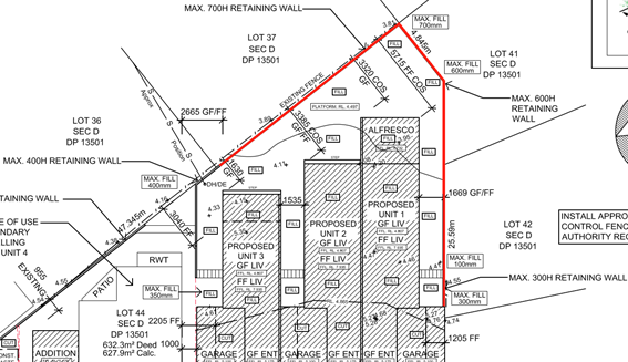
Figure 23 – Extent of proposed retaining wall shown in red which is over 1.5m from the external wall of the proposed units
The objectives of the control are as follows:
· To accommodate the proposed development on site, without the need for excessive cutting and filling of the site or construction of high retaining walls.
· To control surface water and / or stormwater on the subject land with any changes to water flows, as a result of cut or fill, not impacting upon any adjoining properties.
· To ensure that the design of the development is appropriate for site conditions with consideration given to slope, stability of the land and the privacy of adjoining properties
· To ensure all boundary fencing is erected at natural ground level, permitting light and ventilation to ensure reasonable amenity to adjacent developments.
Fill is proposed within the backyards and side yards of units 1, 2 and 3. The site works plan details the proposed fill varying from 100mm to 700mm. Fill of up to 400mm along the north-western boundary near unit 3 and up to 700mm of fill within the northern corner of the site is proposed. Up to 300mm of fill is also proposed in the side yard of unit 1 along the eastern boundary.
The demolition plan indicates a portion of the fencing along the northern portion of the eastern boundary and the rear boundary will be relocated to the boundary. Given retaining for fill is proposed along the boundary, it is anticipated that the fencing will then not be erected at natural ground level in accordance with the objectives. The remainder of the existing boundary fencing is proposed to be retained. Having regard for this and given the extent of fill proposed where the fencing is proposed to be retained (between 400mm and 700mm), the fill will result in overlooking from the subject site into adjoining properties over the existing fences. It is also considered that the proposed fill within the rear yards of units 1, 2 and 3 is excessive, the design of the development has not been designed to appropriately address the slope of the site and will result in privacy impacts to adjoining properties.
Clause 2.2.10 Landscaping
In accordance with clause 2.2.10.1(a), a landscape design, prepared by a suitably qualified landscape professional, is to be provided indicating shade from trees and structures, the use of planting, fencing and other landscape elements appropriate to the scale of the development, the visually softening of the bulk and scale of the development from the street, visually softening hardstand areas and the incorporation of native trees, shrubs and ground covers. The landscape plan submitted with the application has not been prepared by a suitably qualified landscape professional and provides insufficient details (no plant schedule) to adequately assess the suitably of the proposed landscaping. Having regard for this, insufficient information has been provided to demonstrate that the proposed landscaping satisfies clause 2.2.10.1(a) and the objectives of the clause.
In accordance with clause 2.2.10.2(a), six street trees would be required for the proposed development. The landscape plan does not detail any proposed street tree planting. The SEE states, the following in relation to the street trees:
‘The existing site has one very large street tree that is to remain as part of the proposed development, as shown on the DA plans. Due to the number of driveway crossovers, there is a provision to add one additional street tree to the western side of the driveway to Unit 4 which can be required to be planted as a condition of consent.’
The SEE indicates only two street trees will be provided and no justification for the variation has been provided. Two street trees currently exist in the road reserve in front of the site (Figure 24), however, only one existing street tree is shown on the plans (Jacaranda). It is noted that the arborist report recommends the removal of the Jacaranda, despite the plans and SEE indicating its retention. The additional existing street tree not shown on the plans is located to the west of the existing driveway to the secondary dwelling. This street tree is not included in the arborist report.
It is noted that the existing driveway to the secondary dwelling is proposed to be widened to access a proposed parking bay adjacent to the carport. It is unclear if there would be any impacts to the existing street tree and whether it can be retained.
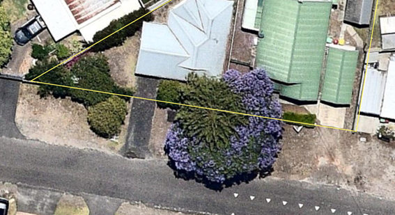
Figure 24 – Location of two existing street trees within the road reserve
Clause 2.2.10.4 Fencing
Clause 2.2.10.4(a) requires details of material, height, type, and extent of all proposed fencing to be shown on the plans. The landscape plan shows fencing between each of the units and the demolition plan indicates the relocation of the eastern side fence to the boundary (although it is noted that no fencing is shown on the eastern boundary on the landscape plan), however, no details of material, height or type of fencing has been provided with the application. Without details of the fencing, the consent authority is unable to be satisfied that the proposed development meets the objectives of the control to ensure fencing meets the requirements for residents in terms of privacy and security and to select fencing that integrates with the overall development.
Chapter 2.13 – Transport and Parking
An assessment has been undertaken in relation to the provisions of Chapter 2.13. A number of non-compliances with Chapter 2.13 have been identified which are discussed below (recommended reason for refusal 5).
Clause 2.13.3.2 Car Parking Requirements
In accordance with clause 2.13.3.2(c)(i), 1.5 spaces per dwelling are required to be provided for the proposed development. In this instance, 6 resident parking spaces are required. The proposed development only includes the provision of 3 compliant resident parking spaces located within each of the single garages. The proposed carport does not meet the minimum dimensions in clause 2.13.3.3(b) and therefore cannot be included in the number of parking spaces provided. Furthermore, the SEE states that the proposed development also includes stacked parking in front of units 1, 2 and 3, however, as stated in the SEE the spaces will overlap the front boundary by approximately 900mm.
The applicant has provided the following justification in relation to the overhang of the stacked parking:
‘The footpath verge is actually much wider along the frontage of this property than other properties within the area, thus allowing this overhang of under 1 metre to be acceptable.’
The justification provided within the SEE for the overhang into the road verge is not supported as the parking is required to be provided wholly within the site. Having regard for this, the stacked parking cannot be included in the calculation of parking spaces.
Given the carport and stacked parking is non-compliant the proposed development only provides 3 parking spaces which is a 50% variation to the number of required parking spaces.
Clause 2.13.3.3 Dimensions of Parking Spaces
In accordance with clause 2.13.3.3(b) a garage or enclosed carport for all residential dwellings are to have clear internal dimensions of a minimum of 3m x 5.4m. The proposed carport has dimensions of 3.11m x 5.1m which is under the minimum dimensions.
The objective of the control is as follows:
· To provide for parking spaces and aisles in a development that is adequate and has appropriate dimensions for safe and efficient operation of the carpark.
The proposed carport is not supported as the dimensions do not allow for the efficient operation of the parking space. It is also noted that the front door is located at the rear of the carport which further results in an unfunctional space.
Clause 2.13.3.4 Stacked Parking
Clause 2.13.3.4(c) states that with the exception of dwelling houses and dual occupancies, stacked parking will not be recognised for the purpose of car parking calculations. The SEE has failed to address clause 2.13.3.4(c) and provide any justification for the non-compliance and as discussed previously in the report, the stacked parking is also not located wholly within the site which is not supported.
Clause 2.13.3.10 Visitor Parking
In accordance with clause 2.13.3.10(b), to achieve an acceptable level of amenity and a satisfactory relationship between adjoining land uses, the location of the visitor parking area within the site is to have regard to the site conditions, relationship of the building to the visitor parking area and the proximity of the visitor parking area to any neighbouring residential areas. The location of the ‘potential’ visitor parking is not considered to have a suitable relationship to units 1, 2 and 3. Notwithstanding this, it is noted that the SEE states that it is a ‘potential’ visitor space and plans only show a ‘proposed paved driveway and parking bay’. Concern is raised with whether the ‘potential’ visitor space will in fact be utilised for visitor parking, noting the poor connection to units 1, 2 and 3 and as it appears to be related to unit 4.
The objective of the control is as follows:
· To provide for safe access and parking for visitors
The location of the proposed potential visitor space is unsuitable to provide for safe access for visitors and results in poor connectivity to units 1, 2 and 3.
Chapter 2.4 – Subdivision
The provisions of Chapter 2.4 are applicable to the proposed development as it includes strata subdivision. However, a strata subdivision plan was not submitted with the application. Having regard for this, insufficient information has been provided to enable assessment against the provisions of Chapter 2.4 (recommended reason for refusal 6).
Chapter 2.14 – Site Waste Management
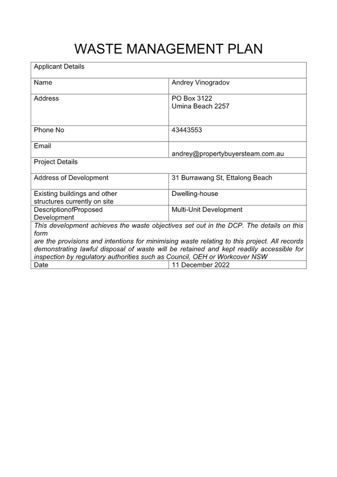
Clause 2.14.2.1 requires a waste management plan to be submitted with all development applications requiring consent, including residential development. A suitable waste management plan which includes details in relation to demolition/site preparation, construction and the ongoing use has been submitted with the application.
Chapter 2.17 Character and Scenic Quality
Clause 2.17.1(a) requires the proposed development to demonstrate consistency or compatibility with the Character and Scenic Quality Statements in the DCP. The proposed development is located within ‘Woy Woy 9: Sandplain Mixed Density’. The desired character of the area is described as follows in the character statement:
These areas should remain leafy mixed-density residential neighbourhoods that retain some of the original mid-Twentieth Century bungalows which remain distinctive elements of the Woy Woy Peninsula’s identity, and future developments achieve significantly improved standards of amenity and urban design quality by reflecting features of those traditional bungalows, as well as providing a variety of low-rise dwellings that include apartments, town houses and villas.
Surround each development with leafy gardens to conserve existing visually prominent trees, particularly along back fences and street frontages or verges, as well as to provide space for shady trees and shrubs planted as backdrops to new buildings. Maintain the informal qualities of existing wide grassy street verges and conserve existing shady street trees. Complement the surviving canopy by planting a combination of trees and shrubs that are mostly indigenous along all property boundaries, and use hedges or fences that are low or see-through rather than tall and opaque in order to maintain the informal character of existing street frontages.
Ensure that new developments complement the siting, form and scale of surviving traditional bungalows upon nearby properties, as well as maintaining reasonable levels of sunlight, privacy and amenity for neighbouring dwellings plus their private open spaces. Maintain street setbacks that are similar to surrounding properties, and minimise the extent of hard-paved surfaces. Avoid the appearance of long or continuous buildings facing any front or side boundary by stepping the shape of visible facades, by providing at least one wide landscaped setback that varies in width, and lining driveways with avenues of trees and shrubs.
Reflect the modest scale of traditional mid-Twentieth Century bungalows, for example by dividing new developments into individual dwelling pavilions with a varied form or orientation, separated by landscaped courtyards and verandahs or parking structures. Any facades that are taller or longer than neighbouring buildings should be disguised by a combination of extra setbacks, stepped forms, and balconies or verandahs. Roofs should be gently-pitched to minimise the height of ridges, and flanked by wide eaves that disguise the scale and bulk of exterior walls. Parking is preferable in open carports or part-basements, rather than in wide garages that would accentuate building bulk or dominate visible facades.
In order to complement the scale and design character of traditional bungalows, a “light-weight appearance” is preferable for all visible facades, incorporating walls of windows that are shaded by framed balconies or verandahs plus exterior sunscreens, painted finishes and some sheet or board cladding rather than extensive plain masonry. Where facades face a street, a laneway or a driveway, provide a traditional “street address” with visible verandahs, living rooms and front doors.
Screen driveways, terraces, courtyards and balconies to protect the privacy and amenity of neighbouring dwellings.
The proposed development is inconsistent with the following aspects of the desired character statement:
· The proposed development does not result in significantly improved standards of amenity and urban design quality.
· The proposed development results in the removal of the Jacaranda tree in the road reserve and possibly a second street tree, which does not conserve existing visually prominent trees.
· The landscape plan does not detail leafy gardens particularly along back fences and street frontages or verges or detail the planting of shady trees.
· The landscape plan does not detail planting that would complement the surviving canopy by planting a combination of trees and shrubs that are mostly indigenous along all property boundaries.
· The multiple driveway crossings break up the wide grassy road verge, while the stacked parking also results in cars overhanging into the road verge.
· The form and scale of units 1, 2 and 3 are poorly integrated with proposed unit 4 (existing secondary dwelling) and neighbouring development.
· The bulk and scale of proposed units 1, 2 and 3 are excessive. These units have a long and tall façade with minimal articulation and no variation to built form. The number of dwellings and design resolution is creating a very busy streetscape. The design resolution of the upper storeys appears disjointed rather than providing a unified frontage to the street. The proposed development is visually incompatible with the existing secondary dwelling proposed to be retained.
· The fill results in privacy impacts between the proposed development and adjoining properties.
· The setback of the proposed carport is well forward of the established building line.
· The proposed setbacks are not commensurate with existing building lines.
· The landscape plan does not detail driveways lined with trees and shrubs. It is also noted that as previously discussed in the report, the side driveway setback is non-compliant which also reduces the area for landscaping.
As identified above, the proposed development does not have satisfactory regard for the desired character of the area (recommended reason for refusal 7).
Chapter 3.1 Floodplain Management and Water Cycle Management
Part C of Chapter 3.1 applies to the proposed development as it is located within the former Gosford LGA. As the proposed development is for a smaller scale development (Type 1) the applicant can either adopt Council’s deemed to comply criteria as outline in Clause 3.1.10.4 or submit a detailed WCMP Strategy as described in Clause 3.1.10.5 to address the requirements of Part C. The SEE does not address Chapter 3.1 and there is no WCMP Strategy that has been submitted with the application. Having regard for this an assessment has been undertaken with regard to Council’s deemed to comply criteria in Clause 3.1.10.4.
Clause 3.1.10.4 lists the information which should be submitted with the application to demonstrate that the proposed development meets the deemed to comply solution. The following information has not been submitted with the application:
· Calculations for runoff (with and without blockage).
· Setback distances from buildings to infiltration devices and drainage easements.
· Retention target: Calculations which demonstrate achievement of stormwater capture volumes and replenishment times for each device and for the overall site.
· On Site Detention Target: Calculations which demonstrate the achievement of the predevelopment peak flowrates.
· Stormwater quality target: Show location of each landscaping pollution retention measure (including a table showing calculations, sizes, and details for each; along with a table showing calculations of the overall Site Discharge Index).
· Flooding Targets: Show details of applicable targets, including: floor levels, flood impacts, access & parking.
· Details of the provision for drainage of surface water erosion and siltation control and placement and grading of the fill so as to prevent the shedding of surface water direct to adjoining properties has not been provided.
· Valid BASIX certificate for residential developments.
· Plans and cross-sectional drawings of stormwater treatment systems, showing inlets, outlets and overflow points.
Having regard or the above, there is insufficient information to demonstrate that the proposed development meets the requirements of Chapter 3.1(recommended reason for refusal 8). Furthermore, Council’s Development Engineer has reviewed the submitted stormwater plan and identified that the retention volume is well below the retention requirement targets in Chapter 3.1.
Relevant Regulations
The Environmental Planning and Assessment Regulation 2021 applies to all development applications regarding such items as application type, compulsory contributions, notification of development applications and a range of many other details regarding development application requirements. As previously discussed in the report, the applicant submitted amended plans, however, in accordance with section 38 of the Regulations, Council did not accept the amended plans. There are no other specific sections that warrant further discussion.
Likely Impacts of the Development:
Built Environment
A thorough assessment of the aspects of the proposed development on the built environment has been undertaken in terms of DCP compliance.
As discussed previously in the report there a number of non-compliances with
CCDCP 2022 which result in an unreasonable amenity for future residents and
adjoining properties, including poor functional private open space and parking,
privacy impacts of the multi dwelling housing and the proposal not being
commensurate with the existing streetscape or desired character of the area.
Additionally, there is insufficient information provided with the application
to address the impacts of the development.
As a result, the proposed development is unsatisfactory in terms of impacts on
the built environment (recommended
reason for refusal 8).
Context and Setting
As previously discussed in the report, the proposed development is not consistent with the established and desired character of the area as it does not incorporate with surrounding development and the design of units 1, 2 and 3 poorly integrate with proposed unit 4 and surrounding development.
Moreover, the number of dwellings and design resolution is creating a very busy streetscape. The design resolution of the upper storeys appears disjointed rather than providing a unified frontage to the street. The proposed development is visually incompatible with the existing secondary dwelling proposed to be retained and with development in the immediate surrounding locality. The design of the development is not sympathetic to the existing or desired future character of the area.
Natural Environment
Two street trees are located within the road reserve in front of the site, however, only one street tree (Jacaranda) is shown on the plans. The arborist report submitted with the application, identifies that the proposed works will impact the Jacaranda and it will need to be removed to facilitate the proposed development. The removal of the Jacaranda is not supported given the positive contribution of the Jacaranda to the streetscape and as the arborist report identifies it is in good condition and has a medium useful life expectancy. Furthermore, the other street tree not shown on the plans appears to be located within close proximity to the driveway works for proposed unit 4 and may be impacted by the proposed development (recommended reason for refusal 9).
Suitability of the Site for the Development:
For the reasons identified in the above assessment and contained within Council’s reasons for refusal, it is considered that the proposed development results in an overdevelopment of the site and that the site is not suitable for the proposed development (recommended reason for refusal 10).
Submissions
The application was notified in accordance with CCDCP 2022 – Chapter 1.2 Notification of Development Proposals from 30 June 2023 to 31 July 2023 with 14 submissions being received. The issues raised in the submissions are discussed in the table below.
|
Response |
|
|
Non-compliant private open space. |
Agreed. As discussed in the report, the private open space is non-compliant and is not supported. |
|
Carport non-complaint with the front setback. |
Agreed. As discussed in the report the front setback to the carport is non-compliant and is not supported. |
|
Stacked parking overhangs into the road reserve which is public land and a safety and amenity issue. |
Agreed. As discussed in the report the overhang of the stacked parking is not supported. |
|
Visitor parking should be provided onsite.
The parking bay beside the carport of unit 4 is assumed to be the visitor space. Is it actually on common property or is it within the open space of unit 4 and only available to unit 4? |
One visitor space is required to be provided on the site. As discussed in the report concern is raised with the location of the ‘potential’ visitor space and whether the visitor space will be used for the private use of unit 4. The location of the potential visitor space has also been identified as being inadequate.
The visitor space would be required to be provided on common property. However, as no strata subdivision plan was submitted with the application, there is insufficient information to confirm that the visitor parking would be on common property. |
|
Privacy from first floor rear windows and unit 1 alfresco to neighbouring properties backyards. |
Given the distance to the boundary from the first floor windows, it is considered that there would be no adverse privacy impact. It is also noted that the windows are from a bedroom rather than a regularly occupied room. |
|
Removal of the Jacaranda tree which provides shade and contributes to the streetscape. |
As discussed in the report the Jacaranda provides a positive contribution to the streetscape and the removal of the Jacaranda is not supported. |
|
More street trees for shade should be planted. |
As discussed in the report the proposed development would require the provision of six street trees and this has not been proposed. |
|
Overdevelopment if the site. Number of units should be reduced from 4 to 3. |
The proposed development results in an overdevelopment of the site, noting the numerous non-compliances with the planning controls. It is considered that the proposed number of units is not suitable on the site. |
|
Proposed development out of character. |
As discussed in the report, the proposed development is not consistent with the desired character set out in CCDCP 2022, Chapter 2.17. |
|
Porch and first floor levels are located forward of the front setback. |
The minimum required front setback is 3.45m. The proposed setback to the porches and first floor levels is 3.71m which is compliant. |
|
Liveability of proposed units for future residents. |
The proposed development is considered to result in poor amenity for residents, noting the non-compliant private open space which is not functional, overlooking between the proposed development and neighbouring properties, non-compliant parking which does not provide functional parking, poor location of the visitor space, removal of street trees and poor integration with proposed unit 4 (existing secondary dwelling). |
|
The application does not address flooding. |
As discussed in the report, part of the site is identified as flood planning land. The application does not address CCLEP 2022, clause 5.21 or CCDCP 2022, Chapter 3.1. |
|
Four driveway crossings are excessive and should be reduced so as not to reduce the area of grass on the verge. Loss of on-street parking due to number of driveway crossings. |
The driveway crossings are not supported due to the impact on the Jacaranda tree which is considered to be a prominent tree in the streetscape. It is noted that reducing the number of driveway crossings could enable the Jacaranda to be retained and retain more on-street parking. |
|
Rear setback to alfresco of unit 1 is non-compliant. |
As discussed in the report, a variation to the rear alfresco setback is proposed. Adequate justification has not been provided for non-compliance with the control and why, in this instance, it is reasonable to vary the setback. |
|
Gravel crossovers will pose an obstacle to prams, bicycles, and disability scooters. |
Council’s civil works specification does not permit gravel driveway crossovers. |
|
Growing need for smaller more affordable housing. This could be provided if the units were 1-2 bedrooms and would also enable a compliant development. |
Units 1 and 4 are proposed to have three bedrooms, while units 2 and 3 are proposed to have two bedrooms which provides a mix of housing options. It is acknowledged that the proposed development is an overdevelopment of the site and reducing the size and/or number of units may result in a more appropriately scaled development. |
|
There is no landscape plan. |
A ‘landscape plan’ was submitted with the application, however, as discussed in the report, it was not prepared by a suitably qualified landscape professional and did not include sufficient detail in accordance with CCDCP 2022, Chapter 2.2, clause 2.2.10.1. |
|
Height is an overdevelopment of the site. |
The site has a maximum permissible height of 11.5m. The proposal has a height of 7.5m although this cannot be confirmed by survey. |
|
Little to no room for a garden, let alone deep space for a tree. |
While the soft landscaping area is compliant, additional landscaping including trees should be provided. |
|
Not in the public interest. |
As discussed in the report, it is agreed that the proposed development is not in the public interest. |
Submissions from Public Authorities
No submissions from public authorities were received in relation to the proposed development.
Internal Consultation
The following internal consultations were undertaken:
|
Development Engineer |
Not supported. See comments below. |
||
|
Tree Assessment Officer |
Insufficient information. See comments below. |
||
|
Water and Sewer |
Supported subject to conditions. |
Development Engineer
The application was referred to Council’s Development Engineer who did not support the application and raised the following issues:
· The location of the driveway is unacceptable as there is no required 2m pedestrian safety triangle offset for the driveway. The sight lines may further be obscured if 23 Edward Street constructs a fence or landscaping.
· Swept paths were not provided for vehicle movements into the garage of unit 3. Considering the dimensions, the vehicle manoeuvring will not be practical within the given driveway envelope.
· There is no kerb and gutter or footpath across the frontage of the site. This development will be required to provide half road works in Melba Road including pavement, footpath, kerb and gutter. An absorption kerb inlet pit at the low point in Melba Road would be required in accordance with Council Standard drawing SD102 Sheet 10 of 17 and the driveway in the same drawing. The plans have not considered any of these required road works and the kerb absorption pit.
· A Water Cycle Management Plan (WCMP) was not submitted with the application; only a concept stormwater plan prepared by James Harris Building Design was provided. These plans suggest the onsite infiltration of overflow outflows of stormwater from retention tanks under the garage slabs. The provided stormwater concept plans cannot be supported due to the following reasons:
o Suggested retention volume is well below the CCCDCP 2022, Chapter 3.1 retention requirement targets.
o No OSD measures were considered evaluating pre-DA flows, and post-DA flows as required by CCDCP 2022, Chapter 3.1.
o The small-sized infiltration tank is suggested to infiltrate the entire site stormwater flows in the rear of the property. This infiltration plan was provided without geotechnical recommendations for site soil permeability and there is no calculation provided to demonstrate the adequacy of infiltration during storm events, as required in the CCDCP 2022, Chapter3.1
o For this type of medium-density development, the stormwater plan must be accompanied by a WCMP, which is to be submitted per Chapter 3.1 Part C of CCDCP 2022.
· Council’s Civil Works Specification does not permit gravel driveway crossovers.
· The stacked parking overhangs into the road reserve, which is not supported.
Tree Assessment Officer
The proposal is supported by an Arborist Report that recommends removal of an existing street tree due to unacceptable impacts to its root zone. The tree is a mature Jacaranda that has visible exposed 1st order roots that would be damaged by the proposed driveway and any footpath works required.
Due to the impact of the development on the Jacaranda, Council’s Tree Assessment Officer would support removal and replacement of the street tree and replacement with two street trees.
Notwithstanding this, as previously discussed in the report, the Jacaranda contributes to the streetscape and is in good condition with a medium term useful life expectancy. The removal of the tree is not supported, and the proposed driveway would need to be redesigned to avoid impacting the tree.
Ecologically Sustainable Principles:
The proposal has been assessed having regard to ecologically sustainable development principles and is considered to be consistent with the principles.
The proposal has been assessed having regard to ecologically sustainable development principles. As previously discussed in the report, there is insufficient information to demonstrate that the proposal incorporates satisfactory stormwater management, and the proposed development will result in the removal of two street trees. Having regard for this the proposed development will result in a decrease on the environmental quality for future generations.
Climate Change
The potential impacts of climate change on the proposed development have been considered by Council as part of its assessment of the development application. This assessment has included consideration of such matters as potential rise in sea level; potential for more intense and/or frequent extreme weather conditions including storm events, bushfires, drought, flood and coastal erosion; as well as how the proposed development may cope, combat, withstand these potential impacts.
Other Matters for Consideration:
Development Contribution Plan
Development contributions would be applicable if the proposal was supported.
Water and Sewer Contributions
Water and sewer contributions are applicable to the development and Section 306 requirements under the Water Management Act 2000 would apply if the proposal was supported.
Insufficient and Inconsistent Information
The following insufficient and inconsistent information has been identified which prevents Council from accurately assessing the impacts of the proposed development and compliance with the relevant planning controls (recommended reason for refusal 11):
· No survey plan was submitted with the application showing the existing site conditions. In addition to this it is noted that the demolition plan does not accurately depict the location of all existing structures and vegetation on the site, including the following:
o The location of the existing driveway to the secondary dwelling, which is shown to be angled near the carport. A site inspection revealed the driveway is straight.
o A second street tree (west of the existing driveway to the secondary dwelling) currently exists in the road reserve in front of the site which is not shown on the plans.
o The existing fence between the primary and secondary dwelling is not shown on the plans. Council has insufficient information to confirm if the fence is proposed to remain or be removed.
In the absence of accurate site plans and a survey, insufficient information is available to accurately assess what site works are required and the impacts of the proposed development.
· A site analysis plan has not been submitted with the application.
· The SEE states that strata subdivision is proposed, however, no subdivision plans have been submitted with the application.
· The BASIX Certificates submitted with the application were over 3 months old at the time of lodgement and are therefore invalid.
· The natural ground level is not shown on the elevations and sections and does not provide sufficient information to accurately assess the compliance with the side setbacks above 4.5m. Based on the spot heights it appears that the side setback above 4.5m to the eastern side boundary would be non-compliant.
· The northern elevation appears to indicate cut in the backyards of proposed units 1, 2 and 3 while the site works plans indicate fill in this area.
· The application does not address CCLEP 2022, clause 5.21 in relation to flood planning land on the site.
· Insufficient information has been provided to demonstrate that the site adequately provides stormwater drainage or on-site conservation in accordance with CCLEP 2022, clause 7.6.
· Insufficient information has been provided to confirm that the proposed parking bay adjacent to proposed unit 4 is to be used for visitor parking or whether it is intended to be used as a resident space for unit 4. Furthermore, the SEE does not detail whether the ‘potential’ visitor space will be available for car washing.
· The landscape plan submitted with the application has not been prepared by a suitably qualified landscape professional and provides insufficient details to adequately assess the suitably of the proposed landscaping. Proposed street tree planting has also not been provided.
· The arborist report states that tree 1 is recommended for removal due to the impact of the proposed driveway on the tree, however, the SEE states no trees are proposed to be removed and the plans show the tree to be retained.
· There are two street trees in the road verge in front of the site, however the plans and arborist report only show one street tree.
· The arborist report has only assessed tree 1. There are additional trees located on the site (as shown on the plans) and an additional street (noted above) that have not been considered in the arborist report. Due to the proximity of the development to the trees, the arborist report should have had regard for these trees to confirm they can be retained and provide tree protection measures to ensure the trees are not impacted by the proposed development.
· No details of the material, height, type, and extent of fencing have been provided.
· The details required on the stormwater management plans have not been provided in accordance with CCDCP 2022, Chapter 3.1 to demonstrate that the proposed stormwater management complies with the deemed to comply criteria.
The Public Interest
Conclusion:
The proposal has been assessed under the heads of consideration in Section 4.15 of the Environmental Planning and Assessment Act 1979. As discussed throughout the report, the proposed development application significantly lacks information, or includes conflicting or otherwise inadequate information to enable a proper assessment.
The proposed development does not provide sufficient information to demonstrate that the proposed development will not result in unsatisfactory and unreasonable adverse impacts, does not demonstrate that the site is suitable for the proposed development and is not considered to be in the public interest.
On this basis the application is recommended for refusal, for the following reasons:
1. A valid BASIX Certificate was not submitted with the application upon lodgement to satisfy State Environmental Planning Policy (Building Sustainability Index: BASIX) 2004.
2. The proposal is considered unsatisfactory with regard to the objectives of the R1 General Residential zone under Central Coast Local Environmental Plan 2022 as the proposed development will result in poor amenity for future residents of the development, does not display best practice in multi dwelling housing and will not enhance the residential amenity of surrounding development.
3. The proposed development is unsatisfactory with regard to Central Coast Local Environmental Plan 2022, clause 7.6 in regard to the following:
a. Insufficient information has been submitted in relation to stormwater drainage to demonstrate adequate stormwater management is proposed.
b. The access design does not allow adequate manoeuvring to unit 3 and does not allow adequate sightlines from the unit 1 driveway to demonstrate safe access is available to the site.
4. The proposed development is unsatisfactory with regard to Central Coast Development Control Plan 2022, Chapter 2.2 – Dual Occupancy Development and Multi Dwelling Housing, as the proposal is non-compliant with the following:
a. Clause 2.2.5(a)(ii) which stipulates the minimum front setback. The front setback for the proposed carport of unit 4 is forward of the minimum required front setback.
b. Clause 2.2.5(b)(i) which stipulates the minimum side setback to any part of the building under 4.5m high. The ground floor side setback to proposed unit 1 is non-complaint.
c. Clause 2.2.5(c)(i) which stipulates the minimum rear setback. The rear setback to the proposed alfresco area of unit 1 is non-compliant.
d. Clause 2.2.5(d)(i) which stipulates the minimum garage setback to a local road. The proposed garages of units 1, 2 and 3 are forward of the required garage setback.
e. Clause 2.2.6.3(c) which requires building access to be easily identified from the street. The building access of proposed unit 4 is not easily identified from the street.
f. Clause 2.2.6.4(a) which requires existing buildings to be upgraded where they are being retained to integrate with the new development. Unit 4 is poorly integrated with the new development.
g. Clause 2.2.7.3(a) which stipulates the minimum private open space area for each dwelling, the minimum dimensions of the private open space and that the private open space must be accessed off a living area. The private open space areas and dimensions of all the units are non-compliant and the private open space of unit 4 is not accessed from a living area.
h. Clause 2.2.7.5(a) which stipulates the minimum solar access to the private open space. The private open space of unit 3 does not receive adequate solar access.
i. Clause 2.2.7.5(b) which stipulates that dwellings should be orientated to allow optimum solar access to internal living areas. The living areas of unit 4 face south and does not optimize internal solar access.
j. Clause 2.2.8.1(c) which requires one resident parking space for each dwelling to be provided in the form of an enclosed space. Proposed unit 4 does not include an enclosed space.
k. Clause 2.2.8.1(g)(iii) which stipulates when a visitor space is located within the front setback, the space is to be setback a minimum of 3m and screened by landscaping. The proposed visitor space is not adequately setback or screened.
l. Clause 2.2.8.1(i) which stipulates where parking is accessed via a common driveway, vehicles must be able to enter and exit in a forward direction. Proposed units 2 and 3 have a common driveway which does not allow adequate manoeuvring to enter and exit in a forward direction.
m. Clause 2.2.8.2.2(d) which stipulates the minimum offset driveways from any side boundary. The driveway of proposed unit 1 does not have an adequate offset to the side boundary.
n. Clause 2.2.9.1(b) which stipulates no retaining wall or fill is permitted within 1m of a side or rear boundary unless within 1.5m of an external wall of a building. A retaining wall and fill are proposed in the backyards of units 1, 2 and 3 where it is not within 1.5m of the proposed building.
o. Clause 2.2.10.2(a) which requires two street trees per 15m of frontage. The proposed development does not include the provision of sufficient street trees.
5. The proposed development is unsatisfactory with regard to Central Coast Development Control Plan 2022, Chapter 2.13 – Transport and Parking, as the proposal is non-compliant with the following:
a. Clause 2.13.3.2(c)(i) which in this instance would require six resident parking spaces. The proposed development only provides three compliant resident parking spaces.
b. Clause 2.13.3.3(b) which stipulates the minimum dimensions of a carport of garage. The carport of proposed unit 4 does not meet the minimum dimensions.
c. Clause 2.13.3.4(c) which stipulates stacked parking is not recognised for multi dwelling housing. Stacked parking which overhangs approximately 900mm into the road reserve is proposed for units 1, 2 and 3.
d. Clause 2.13.3.10(b) which stipulates the proposed development should have regard to the location of the visitor parking in relation the building. The location of the ‘potential’ visitor parking adjacent to proposed unit 4 has a poor connection to proposed units 1, 2 and 3.
6. Insufficient information has been provided to enable assessment against Central Coast Development Control Plan 2022, Chapter 2.4 – Subdivision as a strata subdivision plan was not submitted with the application.
7. The proposed development is unsatisfactory with regard to Central Coast Development Control Plan 2022, Chapter 2.17 – Character and Scenic Quality as it is not consistent with the desired character within ‘Woy Woy 9: Sandplain Mixed Density’.
8. Insufficient information has been provided to demonstrate that the proposed development complies with Central Coast Development Control Plan 2022, Chapter 3.1 – Floodplain Management and Water Cycle Management. Furthermore, the following issues are identified with regard to Chapter 3.1:
a. A Water Cycle Management Plan was not submitted with the application.
b. The suggested retention volume is well below the retention requirement targets.
c. No OSD measures were considered evaluating pre-DA flows, and post-DA flows.
d. The infiltration plan was provided without geotechnical recommendations for site soil permeability and there is no calculation provided to demonstrate the adequacy of infiltration during storm events.
9. Pursuant to Section 4.15(1)(b) of the Environmental Planning and Assessment Act 1979, the proposed development is considered unsatisfactory with regard to impacts on the built and natural environment as the proposed development results in amenity impacts to future residents of the proposed development and neighbours, does not contribute positively to the streetscape or character of the area and results in the removal of street trees which contribute to the streetscape and amenity of the area.
10. Pursuant to Section 4.15(1)(c) of the Environmental Planning and Assessment Act 1979, the proposed development is considered unsatisfactory with regard to the suitability of the site for the proposed development as the proposed development results in an overdevelopment of the site and insufficient information has been submitted to demonstrate that adequate stormwater arrangements have been made.
11. The application contains the following insufficient and inconsistent information to accurately assess the proposed development and the likely impacts of the development:
a. No survey plan has been submitted with the application.
b. The development plans do not accurately reflect the site conditions including structures to be demolished and vegetation on the site.
c. A site analysis plan has not been submitted with the application.
d. A strata subdivision plan has not been submitted with the application.
e. The natural ground level is not shown on the elevations.
f. The northern elevation appears to indicate cut within the backyards of units 1, 2 and 3 contrary to the site works plan.
g. Insufficient information has been provided to confirm that the proposed parking bay adjacent to proposed unit 4 is to be used for visitor parking or as a resident space for unit 4. Details have also not been provided to confirm if car washing will be available in the visitor space.
h. The landscape plan submitted with the application contains insufficient detail to assess the suitability of the landscaping.
i. The arborist report states that tree 1 is recommended for removal, however, the SEE states no trees are proposed to be removed and the plans show the tree to be retained.
j. The arborist report has only assessed tree 1. There are additional trees located on the site that have not been considered in the arborist report.
k. No details of the material, height, type and extent of fencing has been provided.
l. The details required on the stormwater management plans have not been provided in accordance with CCDCP 2022, Chapter 3.1 to demonstrate that the proposed stormwater management complies with the deemed to comply criteria.
m. Swept paths have not been provided to demonstrate adequate manoeuvring to the garages.
n. The plans have not considered any of these required road works and the kerb absorption pit.
12. For the reasons stated above and pursuant to Section 4.15(1)(e) of the Environmental Planning and Assessment Act 1979, it is considered that the proposed development is not in the public interest.
|
1⇩ |
Attachment 1 - Architectural Plans |
|
D15625092 |
|
2⇩ |
Attachment 2 - CCDCP 2022, Chapter 2.2 Compliance Table |
|
D15943723 |
|
2.1 |
DA/733/2023 - 22 Melba Road, Woy Woy - Staged Development Consisting of Demolition of Existing Primary Dwelling, Construction of Three Multi Dwelling Units, Change of Use of Existing Secondary Dwelling to a Fourth Multi Dwelling Unit and Strata Subdivision |
|
Attachment 1 |
Attachment 1 - Architectural Plans |
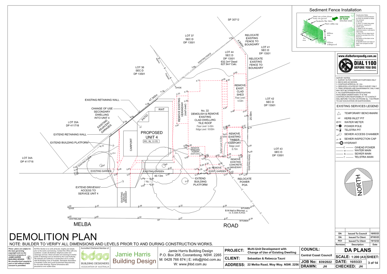
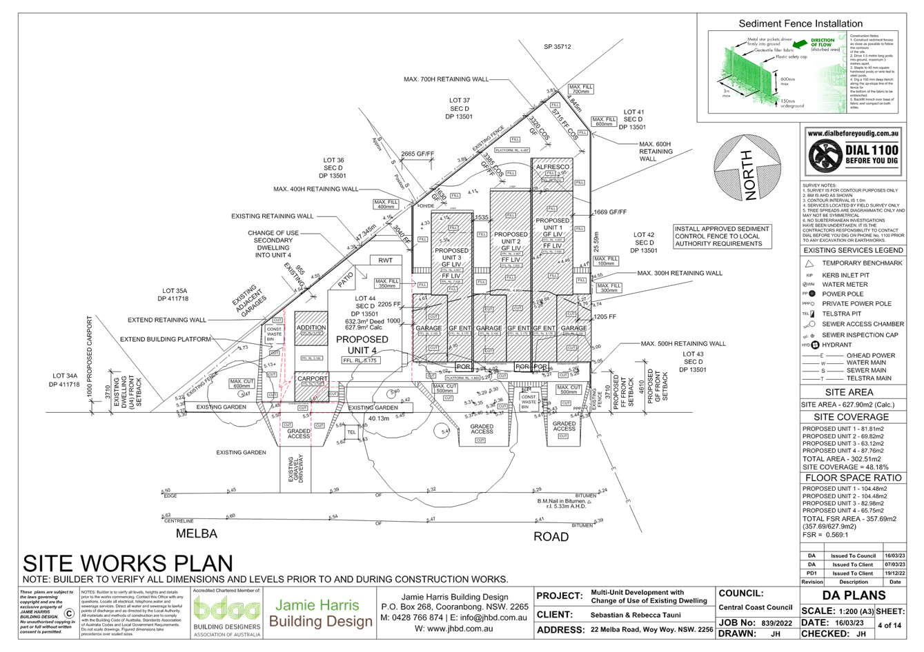
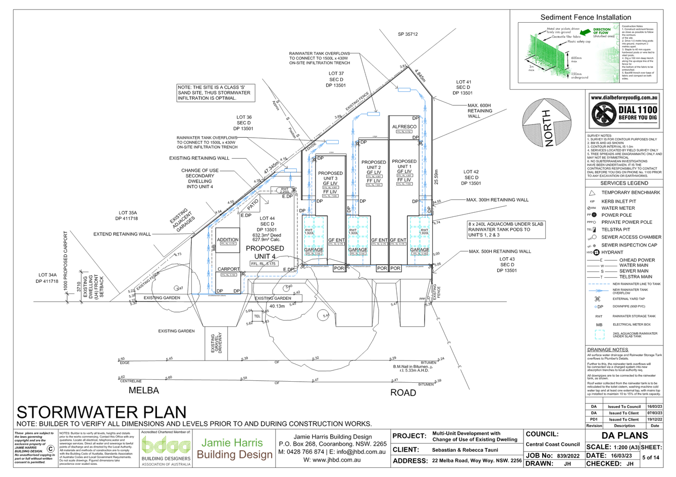
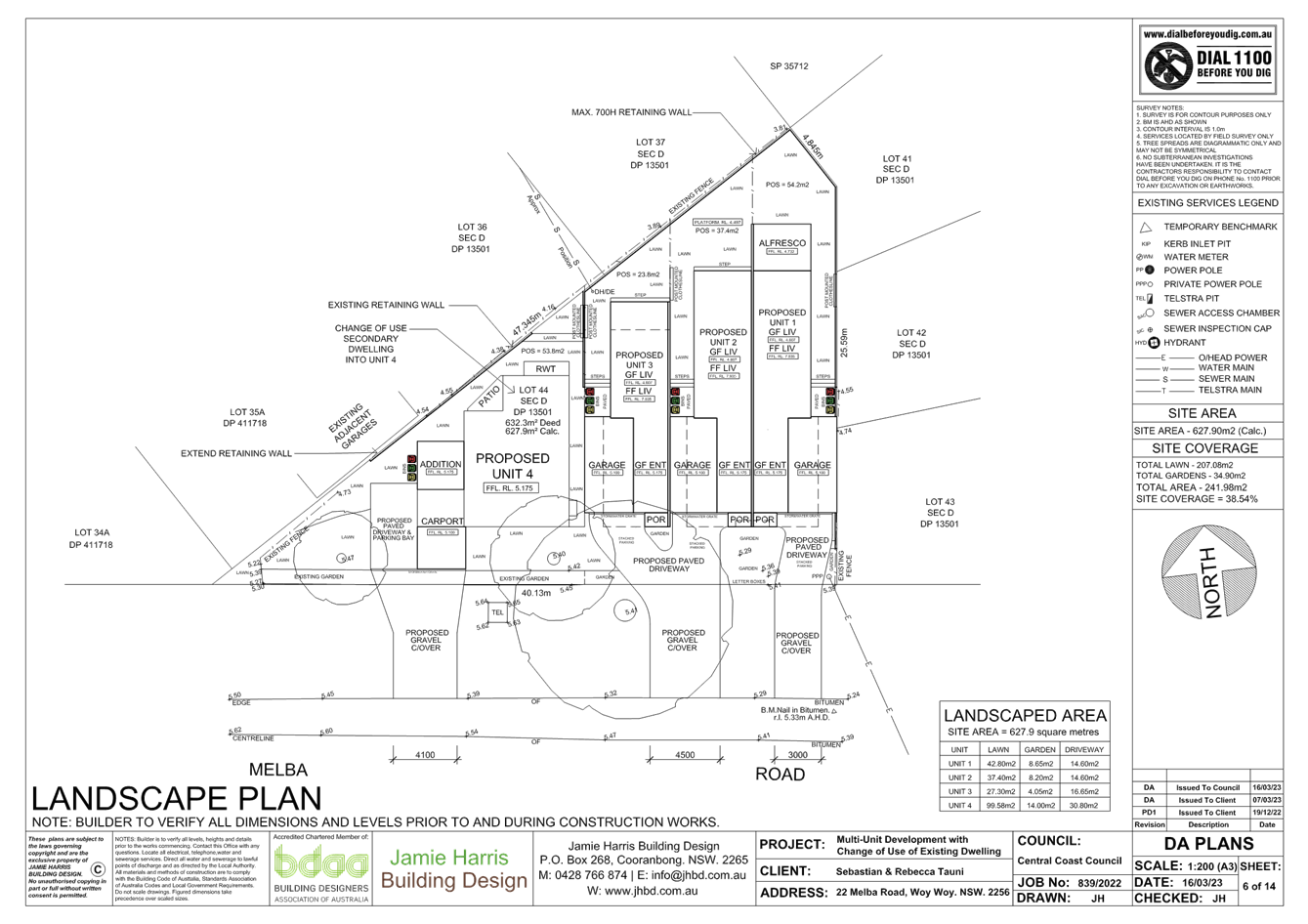
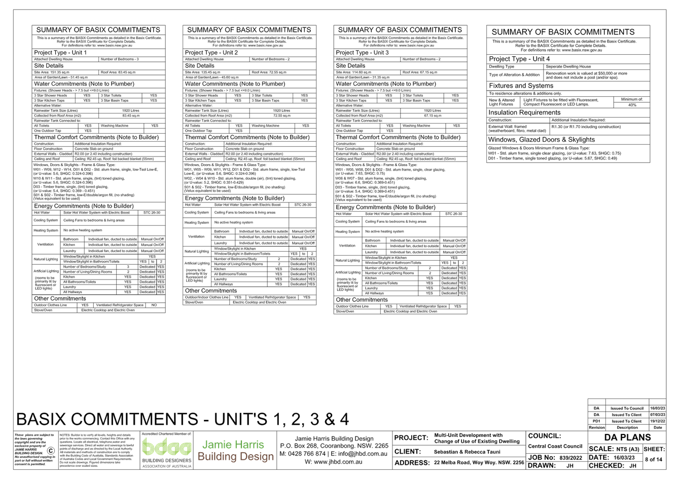
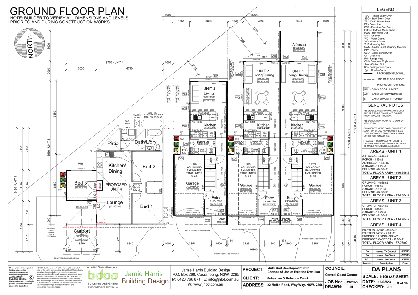
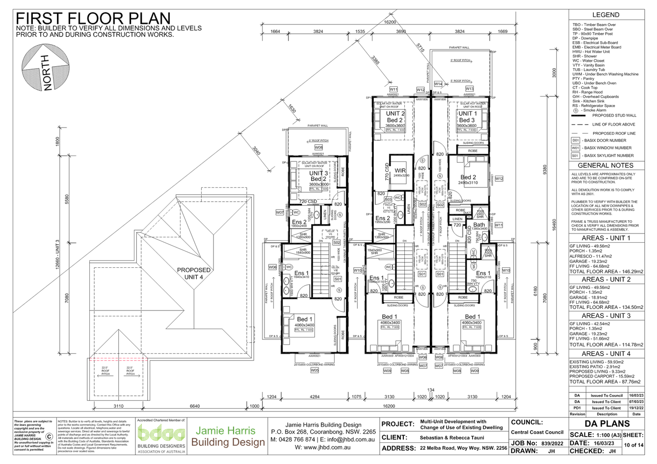
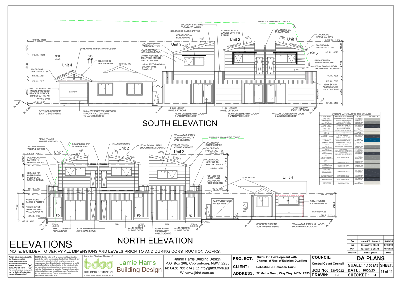
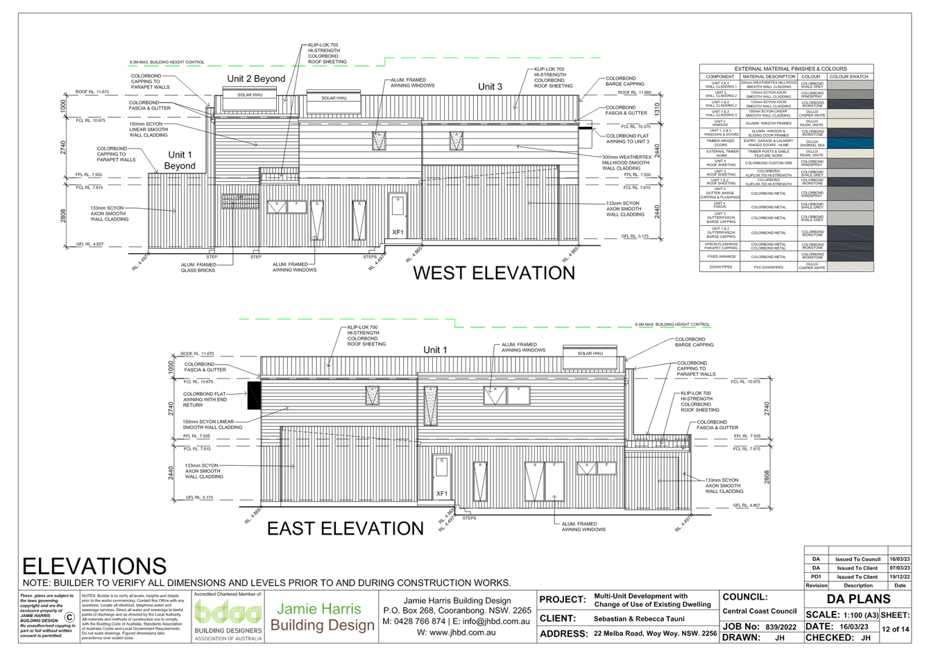
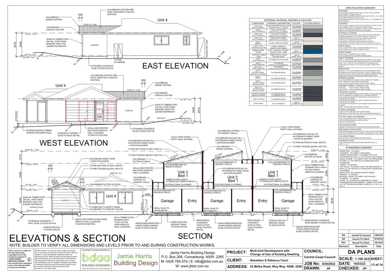
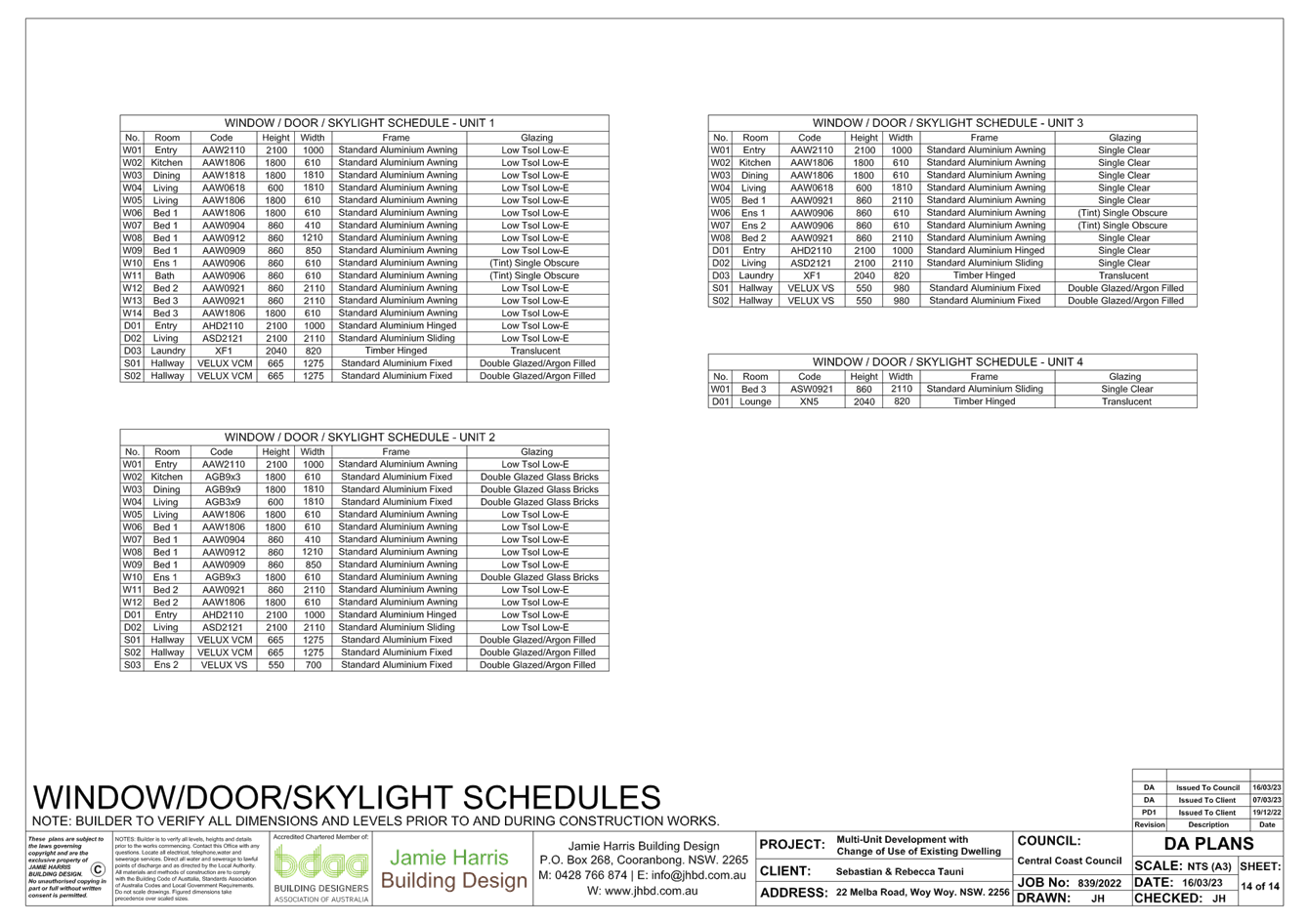
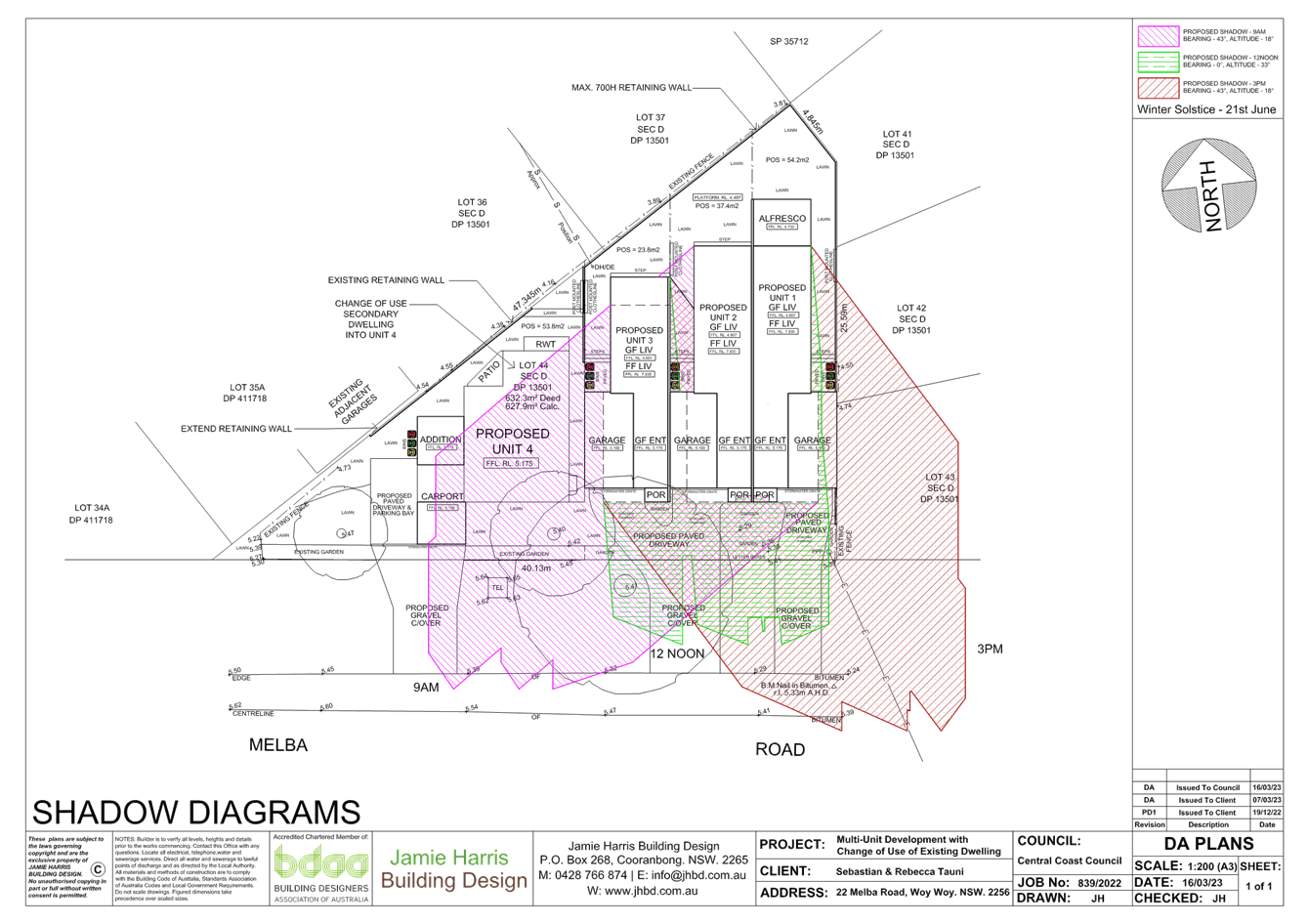
|
DA/733/2023 - 22 Melba Road, Woy Woy - Staged Development Consisting of Demolition of Existing Primary Dwelling, Construction of Three Multi Dwelling Units, Change of Use of Existing Secondary Dwelling to a Fourth Multi Dwelling Unit and Strata Subdivision |
|
|
Attachment 2 |
Attachment 2 - CCDCP 2022, Chapter 2.2 Compliance Table |
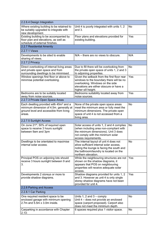

|
Item No: 2.2 |
|
|
Title: DA/4365/2022 - 31 Burrawang Street Ettalong Beach - Multi-Dwelling housing (3 Units) & Demolition of Existing Structures |
|
|
Department: Environment and Planning |
|
|
7 December 2023 Supplementary Local Planning Panel |
|
Reference: DA/4365/2022 - D15951962
Author: Karen Hanratty, Senior Development Planner Residential Assessments
Section Manager: Ailsa Prendergast, Section Manager. Residential Assessments
Unit Manager: Andrew Roach, Unit Manager, Development Assessments
Executive: Alice Howe, Director Environment and Planning
|
Summary
An application has been received for Multi-Dwelling housing (3 Units) & Demolition of Existing Structures at 31 Burrawang Street, Ettalong Beach. The application has been examined having regard to the matters for consideration detailed in Section 4.15 of the Environmental Planning and Assessment Act 1979 and other statutory requirements with the issues requiring attention and consideration being addressed in this report.
The application is required to be referred to the Local Planning Panel as a result of the number of submissions received during the notification period. Twenty-two submissions were received.
The application is recommended for approval, subject to conditions.
Applicant Clarke Dowdle & Associates Owner Adamov Pty Ltd Application No DA/4365/2022 Description of Land Lot 491 DP 10570, 31 Burrawang Street ETTALONG BEACH Proposed Development Multi-Dwelling housing (3 Units) & Demolition of Existing Structures Site Area 695.6m2 Zoning R1 General Residential Existing Use Dwelling House Employment Generation Nil Estimated Value $1,100,000
|
Recommendation
1 That the Local Planning Panel grant consent to DA/4365/2022 - Lot 491 DP 10570, 31 Burrawang Street ETTALONG BEACH - Multi-Dwelling housing (3 Units) & Demolition of Existing Structures subject to the conditions detailed in this report and having regard to the matters for consideration detailed in Section 4.15 of the Environmental Planning and Assessment Act 1979.
2 That Council advise those who made written submissions of the Panel’s decision.
Key Issues
· Compliance with Central Coast Development Control Plan 2022 Chapter 2.2 Dual Occupancy and Multi Dwelling Housing.
· Matters raised in public submissions.
Precis:
|
Proposed Development |
Multi-Dwelling housing (3 Units) & Demolition of Existing Structures |
|
Permissibility and Zoning |
The subject site is zoned R1 General Residential under the provisions of Central Coast Local Environmental Plan 2022. The proposed development is defined as Multi Dwelling Housing which is permissible in the zone with consent. |
|
Current Use |
Dwelling House |
|
Integrated Development |
No |
|
Submissions |
22 submissions received |
Variations to Policies – Central Coast Development Control Plan
|
Clause |
Clause 2.2.5a – Front Setback |
|
Standard |
2.2.5a (ii) – Local roads - Avg distance nearest 2 dwelling houses with same primary road boundary within 40m or 2 dwelling houses not within 40m – 4.5m |
|
Departure basis |
Front setback ground floor 7.45m – 3.87% variation Front setback first-floor balcony 7m – 9.68% variation |
|
Clause |
Clause 2.2.5b - Side Setback |
|
Standard |
2.2.5b (ii) – For any part of the building >4.5m, 0.9m plus 25% of the height of the building above 4.5m i.e., building height of 6.35m = 1.36m setback |
|
Departure basis |
Eave on western elevation encroaches the building envelope by 0.29m horizontally |
|
Clause |
Clause 2.2.7.3 - Private Open Space areas (POS) |
|
Standard |
2.2.7.3 (c) Dimensions less than min area/dimension shall not be counted as POS areas 2.2.7.3 (e) Ground level courtyards not permitted within front building setback area fronting local roads |
|
Departure basis |
Unit 1 - 30m2 of the required 45sqm achieves min dimension 4.5m, 15m2 has a dimension of 3m, and is partly located within the front building setback. |
Clause |
Clause 2.2.8.2.2 Access Design Ground Level Parking |
|
Standard |
2.2.8.2.2 (d) Driveways shall be offset from any side boundary by 2m at the front boundary and may taper back to 500mm side setback within the front building line as illustrated in Figure 1. This offset area, and side setback for the length of the remaining driveway must be landscaped with trees and shrubs to soften the hardstand areas and provide for infiltration and provide visual appeal to the streetscape. |
|
Departure basis |
50% of the length of the driveway achieves required side setback |
The Site
The site is regular in shape and is described as Lot 491 DP 10570, 31 Burrawang Street, Ettalong Beach.
The site has a width of 15.24m and depth of 45.72m and an area of 695.6m2. Located on the northern side of the street the site has a slight grade from the rear to the front boundary and contains a single storey dwelling house and ancillary structures (Figures 1, 2 and 3).
The site is not identified as bushfire prone land and is not affected by flooding or flood planning controls. The site contains Class 4 Acid Sulfate Soils.
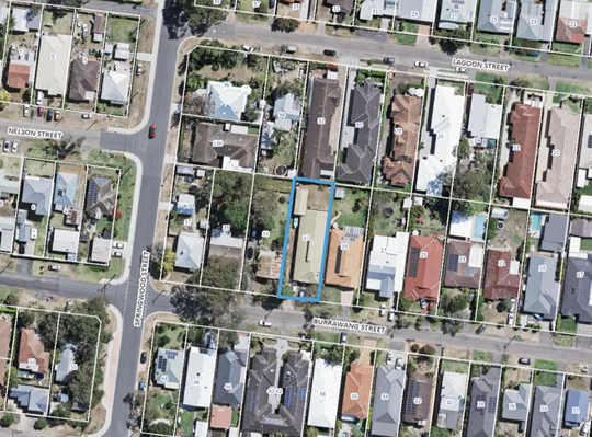
Figure 1 – Site Plan (blue outline)
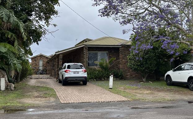
Figure 2 – Subject Site – 31 Burrawang Street Ettalong Beach
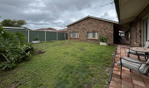
Figure 3 – Subject Site - Rear of site looking south towards the street
Surrounding Development
The context of the area is generally low-density residential developments of one- and two-storey dwelling houses of mixed architectural design interspersed with dual occupancy and multi dwelling housing developments (Figure 4).
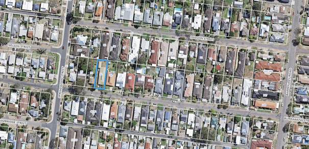
Figure 4 – Site and Locality Plan
The site is located approximately 56m to the east of the intersection of Burrawang Street and Springwood Street, and 280m to its intersection with Barrenjoey Road to the east.
The properties to the east and west of the site contain single storey dwelling houses. Directly to the north and opposite the site to the south contains single storey multi dwelling housing developments.
Application background
The application was notified on lodgement and has been amended following multiple requests for information to address the requirements of Chapter 2.2 Dual Occupancy and Multi Dwelling Housing of Central Coast Development Control Plan 2022 (CCDCP 2022).
Amendments made to the proposal are as follows:
· Provision of a visitor car space at the rear of the site adjacent Unit 3 and the eastern boundary.
· Increase in front setback of the building from 6m to 7.45m (ground level) to align with existing dwellings to the east and west of the site.
· Reduction in size of courtyard area and fencing to Unit 1 at the front of the site.
· Change to the design of the building including the front façade, addition of privacy screens and re-calculation of the floor space ratio to ensure compliance with the CCLEP 2022.
· Increase in common open space at the site frontage to provide for landscaping including landscaping along the driveway and eastern boundary.
· Relocation of on-site detention from the landscaped front setback to the driveway.
A 3-unit multi dwelling housing development is proposed on the adjoining property to the west (DA/4367/2022) and subject of a s34 agreement being reached following an appeal in the Land and Environment Court.
The development proposed on the subject site has been amended and is similar in its site layout, building setbacks, private open space areas, car parking and landscaping provision to DA/4367/2022 considered by the Court.
The Proposed Development
The proposal comprises:
· Demolition of existing dwelling house and ancillary structures.
· Erection of 3 x 3-bedroom 2-storey dwellings.
· 5 car parking spaces within garages and 1 visitor space.
· Vehicle access from Bangalow Street via driveway along the eastern boundary.
· Ancillary site works including landscaping, stormwater drainage and on-site detention.
The proposed site plan is shown in Figure 5, building elevations are shown in Figures 6 and 7 and landscape plan at Figure 8.
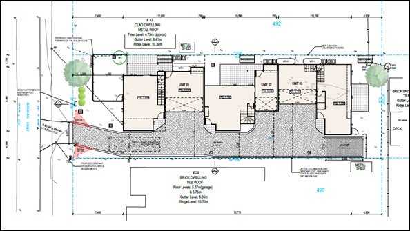
Figure 5 – Site Plan
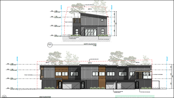
Figure 6 – North & East Elevations
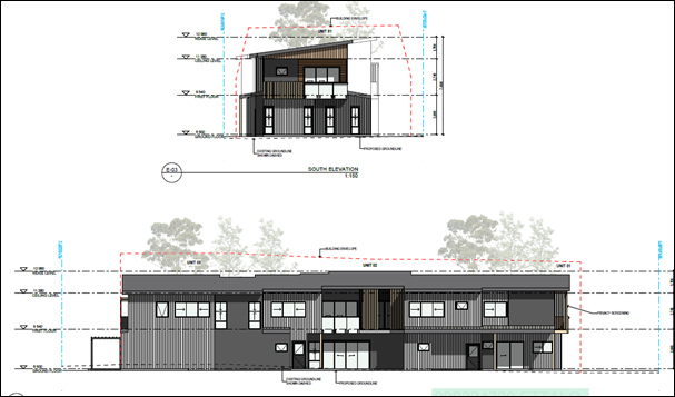
Figure 7 – South (street frontage) & West Elevations
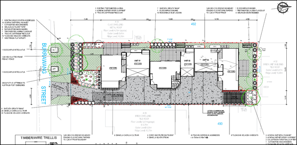
Figure 8 – Landscape Plan
ASSESSMENT:
Having regard for the matters for consideration detailed in Section 4.15 of the Environmental Planning and Assessment Act 1979 and other statutory requirements, Council’s policies and Section 10.7 Certificate details, the assessment has identified the following key issues, which are elaborated upon for the Panel’s information.
State Environmental Planning Policy (Building Sustainability Index: BASIX) 2004
The application is supported by a BASIX certificate which confirms the proposal will meet the NSW government's requirements for sustainability, if built in accordance with the commitments in the certificate.
The proposal is considered to be consistent with the requirements of State Environmental Planning Policy (Building Sustainability Index: BASIX) 2004.
State Environmental Planning Policy (Resilience and Hazards) 2021
The relevant provisions of the SEPP are addressed as follows:
Chapter 4 Remediation of Land
Clause 4.6 of Chapter 4 requires that a consent authority must not consent to the carrying out of any development on land unless it has considered whether the land is contaminated. The current use of the site is for domestic residential purposes, and there are no known previous uses that would lead to the site being contaminated or unsuitable for the proposed use.
Central Coast Local Environmental Plan 2022 (CCLEP 2022) - Zoning and Permissibility
The subject site is zoned R1 General Residential under the provisions of CCLEP 2022, refer Figure 9.
Development for the purposes of multi dwelling housing is permissible within the zone with consent of Council. Multi dwelling housing is defined under the provisions of CCLEP 2022 as:
‘multi dwelling housing means 3 or more dwellings (whether attached or detached) on one lot of land, each with access at ground level, but does not include a residential flat building.’
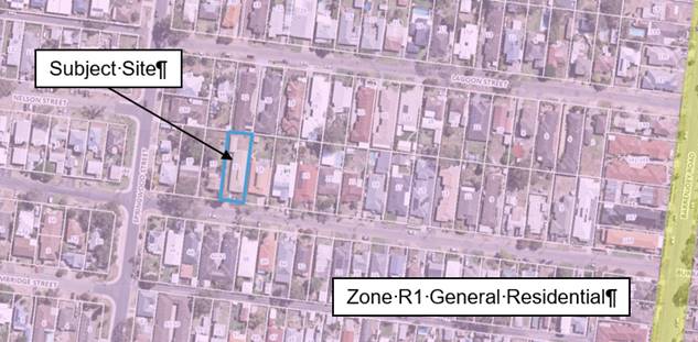
Figure 9 – CCLEP 2022 Zoning Map
Central Coast Local Environmental Plan 2022 – Zone Objectives
The objectives for the R1 General Residential zone are as follows:
· To provide for the housing needs of the community.
· To provide for a variety of housing types and densities.
· To enable other land uses that provide facilities or services to meet the day to day needs of residents.
· To promote best practice in the design of multi dwelling housing and other similar types of development.
· To ensure that non-residential uses do not adversely affect residential amenity or place unreasonable demands on services.
In this instance, it is considered that the proposal is consistent with the stated objectives of the zone as follows:
· The proposal provides additional housing for the local community and will increase housing choice in the area.
· The proposal will have a positive contribution to the streetscape and provides an appropriate transition in built form and land use intensity to surrounding development.
· The siting of the building together with the surrounding garden area is consistent with the predominant pattern of buildings in the vicinity of the site.
· The design provides a quality residential development and responds to the site, provides housing with a high degree of accessibility and does not have adverse impact on the amenity of adjoining residential development.
Central Coast Local Environmental Plan 2022 - 4.3 Height of Buildings
Clause 4.3(2) of CCLEP 2022 provides that the height of a building on any land will not to exceed the maximum height shown for the land on the Height of Buildings Map. The maximum height shown on the relevant map is 8.5m. The CCLEP 2022 defines this as the height above existing ground level.
The proposed development has a maximum height of 7.48m and complies with the development standard.
Central Coast Local Environmental Plan 2022 – 4.4 Floor Space Ratio
Clause 4.4(2) Floor Space Ratio (FSR) of CCLEP 2022 provides the maximum floor space ratio for a building on any land. The site is identified on the CCLEP 2022 FSR map as being 0.5:1.
The proposal is not subject to exceptions to FSR under clause 4.4A(4) as there is no basement car parking.
The proposed development has an FSR of 0.5:1 and complies with the development standard.
Central Coast Local Environmental Plan 2022 – 5.21 Flood Planning
Council’s records do not indicate that the site is affected by flooding or flood planning controls.
Central Coast Local Environmental Plan 2022 – 7.1 Acid Sulfate Soils
This land has been identified as being affected by the Acid Sulfate Soils Map and the matters contained in clause 7.1 of CCLEP 2022 have been considered. The site contains Class 4 Acid Sulfate Soils which are likely to occur where:
· Works more than 2m below the natural ground surface.
· Works by which the water table is likely to be lowered more than 2m below the natural ground surface
Minimal excavation is proposed for slab on ground and the installation of services and stormwater infrastructure. In this instance, the proposed works are not considered to impact on Acid Sulfate Soils on the site or adjoining properties.
However, in the unlikely event acid sulfate soils are found during works a condition is included to cease all excavation works if acid sulfate soils are identified until such time as details of mitigation and treatment measures are submitted to, and approved by, the Principal Certifier (refer to Condition 5.7).
The Panel can be satisfied that the proposed development complies with the provisions of clause 7.1 Acid Sulfate Soils.
Central Coast Local Environmental Plan 2022 – Clause 7.6 – Essential services
Development consent must not be granted to development unless the consent authority is satisfied that all of the following services that are essential for the development are available or that adequate arrangements have been made to make them available when required—
a) the supply of water,
b) the supply of electricity,
c) the disposal and management of sewage,
d) stormwater drainage or on-site conservation,
e) suitable vehicular access
f) the collection and management of waste
The property is connected to electricity, reticulated water and sewer and currently serviced for waste collection.
Water and Sewer is available to the land. Council’s Building in the Proximity of Water & Sewer Pipelines Procedure and water and sewer contributions are applicable to the proposal. A Section 307 certificate of compliance under the Water Management Act 2000 is required to be obtained prior to the occupation of the building.
Satisfactory details have been provided in the Waste Management Plan for waste management procedures associated with the demolition, construction, and ongoing operation of the proposed development.
Satisfactory stormwater drainage can be obtained in accordance with the Stormwater Plans and there is adequate area for vehicle access and manoeuvring within the site to enter and exit the site in a forward direction.
The Panel can be satisfied that the proposed development complies with the provisions of clause 7.6 and that adequate essential servicing is available to the development having regard for water, sewer, electricity, stormwater drainage, waste collection and vehicular access.
Central Coast Development Control Plan 2022
CCDCP 2022 provides objectives, design criteria and design guidance on how development proposals can achieve good design and planning practice.
Consideration of relevant controls from CCDCP 2022 are included in the following sections of this report:
Chapter 2.2 Dual Occupancy and Multi Dwelling Housing of CCDCP 2022
|
Required |
Proposed |
Compliance with Control |
Compliance with Objective |
|
|
2.2.3.1 Height |
a. Max building height mapped CCLEP 2022 8.5m |
7.48m |
Yes |
Yes |
|
b. 2 storeys |
2 storeys |
Yes |
||
|
2.2.4.2 Floor Space Ratio (FSR) |
a. Max FSR mapped CCLEP 2022 0.5:1 |
0.5:1 |
Yes |
Yes |
|
2.2.4.3 Site Coverage |
a. 25% of site area (173.9sqm) at ground level shall be ‘soft’ landscaping, excluding hardstand areas. Private open space areas and setback areas may be included where these do not include hardstand surfaces. |
• 184sqm ‘soft’ landscaping’ or 26.4% of site area is provided as shown on the Architectural Plans, Dwg DA035 Site Coverage Plan. • The proposal originally provided 178sqm of ‘soft’ landscaping being 25.59% of site area. • The arear of soft landscaping has been increased by increase in front setback and relocating the OSD tank from the front setback area to the driveway. |
Yes |
Yes |
|
Development Control |
Required |
• Proposed |
Compliance with Control |
Compliance with Objective |
|
2.2.5a Front Setback |
ii Local roads Avg distance nearest 2 dwelling houses with same primary road boundary within 40m Or 2 dwelling houses not within 40m – 4.5m Note – for calculation purposes disregard ancillary development
Dwellings must have direct access to a public road for pedestrian access, mail and waste collection |
• Avg setback is 7.75m • Proposes 7.45m at ground level and 7m to the front balcony of Unit 1 on the upper level. • The proposal originally provided 6.079m setback to Unit 1 wall at ground level and 5m to entry verandah and first floor balcony. • The revised design and the increase in front setbacks are supported notwithstanding the proposal does not comply with the numerical provisions. • Dwelling have access to a public road. |
No |
Yes - Refer comments below |
|
2.2.5b Side Setback |
i. For any part of the building up to a height of 4.5m, 0.9m, and |
Complies - building envelopes are shown on the Architectural Plans, Dwg DA300 & DA301 Elevations. |
Yes |
Yes - Refer comments below |
|
ii. For any part of the building >4.5m, 0.9m plus 25% of the height of the building above 4.5m i.e. building height of 6.35m = 1.36m setback |
The building elevations have a setback of a minimum of 1.36m however has a minor encroachment of the eave at the rear portion of the dwelling to the western boundary at Unit 3 over a length of approx. 15m of the building. |
No |
||
|
2.2.5c Rear Setback |
i. 4.5m |
4.5m ground level 5.1m upper level |
Yes |
Yes |
|
2.2.5d Garages Setback |
i. Local Roads 5.5m |
Garages not facing street |
Yes |
Yes |
|
Development Control |
Required |
Proposed |
Compliance with Control |
Compliance with Objective |
|
2.2.6.1 Facades & Articulation |
a. No monotonous and unbroken lengths of wall exceeding 10m in length and 3m in height |
Facades are well articulated in length and height. The proposal provides a variety in materials with horizontal and vertical façade treatment which is encouraged to break up the elevations and add visual interest to the building. |
Yes |
Yes |
|
b. Garage prominence i. multi dwelling housing. • Located behind front setback. • Visible from street shall not exceed 50% of lineal frontage of building. • Respect architectural qualities of building. • Integrate with overall presentation of the development. |
Garages are: • Located behind front setback. • Not visible from street. • Respects architectural qualities of building. • Integrates with overall presentation of the development |
Yes |
||
|
2.2.6.2 Roof Elements |
a. Responds to orientation of site |
Complies Roof design responds to the orientation of the site and uses skillion roof to respond to solar access. |
Yes |
Yes |
|
b. Minimise impact of service elements – integrate into design of roof |
|
Development Control |
Required |
• Proposed |
Compliance with Control |
Compliance with Objective |
|
2.2.6.3 Residential Address |
a. Dwellings located at front of each development – street to be visible from regularly occupied rooms as well as upper storey balconies, private terraces or courtyards at ground level |
• Revised plans improve the presentation of the building to the street. • This has been achieved by significantly reducing the POS and the extent of the courtyard fencing to Unit 1. • The street can be seen from windows of regularly occupied rooms on the ground level and on the upper storey / balcony of Unit 1. |
Yes |
Yes |
|
b. Above ground parking and fully-enclosed garages not located in any façade facing street, a park or major communal open space do not block desired sight lines |
Complies
|
|||
|
c. Street number and building access easily identified from street |
Complies |
|||
|
2.2.7.1 Views |
a. Sited and designed to enable view sharing to adjoining / adjacent sites particularly from habitable rooms |
No impact on views of adjoining development |
Yes |
Yes |
|
b. Design roof form for view sharing |
Roof form appropriate for the site. No impact on views of adjoining development |
|||
|
c. Design ‘from the ground up’ – floors located at or near to natural ground level / incorporating reasonable ceiling heights and roof pitch |
Building floor is located near to natural ground level. Incorporates reasonable ceiling heights to minimise height of building. |
|||
|
d. Provide a visual analysis of view impacts of potential to obstruct views |
N/A – no impact on views of adjoining development |
|||
|
e. Address NSW L&E Court planning principles relating to view sharing Tenacity Consulting v Warringah Council [2004] NSWLEC 140 - external site at 25-29 |
N/A – no impact on views of adjoining development |
|
Development Control |
Required |
Proposed |
Compliance with Control |
Compliance with Objective |
|
2.2.7.2.1 Visual Privacy |
a. Minimise direct overlooking of internal living areas and private open space to / from surrounding dwellings |
Privacy screening is provided to balconies to minimise overlooking.
Additional privacy measures are required to the following aspects of the building for sitting rooms being high usage rooms and stairwell windows to minimise overlooking.
An opaque finish to the window glazing to a height of 1.6m above finished floor level at first floor level for: • western elevation plan: • Sitting room and stairwell of Unit 3. • Stairwell of Unit 1. • All bathrooms. • eastern elevation plan: • Sitting room Unit 1. • Stairwell and bathroom of Unit 2. |
Yes, subject to conditions |
Yes – Refer comments below |
|
b. Minimise overlooking of adjacent dwellings: • Offset windows of living areas or balconies within 12m of and facing living areas or balconies of adjacent dwellings. • First floor level windows and above orientated / designed to maintain privacy. • Windows to be opaque finish / have appropriate sill height above floor level. |
||||
|
2.2.7.2.2 Acoustic Privacy |
a. Site layout should separate recreation areas, parking areas, vehicle accessways and service equipment from bedroom areas of dwellings. |
Recreational areas and driveway located away from bedrooms |
Yes |
Yes |
|
|
b. Minimise external noise through building design, window placement, noise attenuation measures and external wall treatment |
|
Development Control |
Required |
Proposed |
Compliance with Control |
Compliance with Objective |
|
2.2.7.3 Private Open Space areas (POS) |
a. Min area 45m2 and min dimension 4.5m Located at ground level and accessible from living area |
Minimum POS of 45sqm provided to all units, located at ground level and accessible from living area.
Dimension of courtyard areas to Units 1 & 2 are variable. |
No |
Yes - Refer comments below |
|
b. Max grade 1:14 for private courtyards |
Complies |
Yes |
||
|
c. Dimensions less than min area/dimension shall not be counted as POS areas |
Dimensions less than minimum area are counted at POS areas. |
No |
||
|
d. Ground level POS may be provided in up to 2 locations for each dwelling subject to min dimension |
POS provided in 2 locations for Unit 2 |
Yes |
||
|
e. Ground level courtyards not permitted within front building setback area fronting local roads |
Ground level courtyard of Unit 1 partly located within front building setback area. |
No |
||
|
2.2.7.4 Common Open Space – Multi Dwelling Housing and Attached Dwellings |
a. Communal open space required >10 dwellings |
The proposed development is 3 units. Communal open space not required. |
N/A |
N/A |
|
Development Control |
Required |
Proposed |
Compliance with Control |
Compliance with Objective |
|
2.3.6.5 Sunlight Access |
a. Minimum 3 hours/day unobstructed sunlight access provided to 50% of required principal POS area for all dwellings on 21 June between 9am and 3pm |
Shadow diagrams provided demonstrate the proposal complies with the required solar access to the living areas and private open space areas of the proposed dwellings and neighbouring dwellings.
|
Yes |
Yes - Refer comments below |
|
b. Dwelling orientated to allow optimum solar access for internal living areas |
||||
|
c. Minimum 3 hours/day unobstructed sunlight access provided to 50% of required principal POS of adjoining land on 21 June between 9am and 3pm |
||||
|
d. Developments of 2 or more storeys in height or greater shall provide shadow diagrams for the site and adjoining development at 9am, 12 noon and 30m on 21 June |
||||
|
2.2.8.1 Car Parking |
Resident parking 1.5 spaces / unit = 5 spaces
Visitor parking 0.2 spaces / unit = 1 space
|
Resident spaces – 5 Visitor space – 1
|
Yes |
Yes |
|
2.2.8.2.1 Access Design General Requirements |
Access is to comply with relevant standards and councils’ civil works specification. |
Driveways and vehicular access comply with AS2890 subject to conditions. |
Yes |
Yes |
|
Development Control |
Required |
Proposed |
Compliance with Control |
Compliance with Objective |
|
2.2.8.2.2 Access Design Ground Level Parking |
• Fully enclosed garages must not visually dominate any building elevation. • Driveways must not be continuous straight lines and shall be offset by landscaped sections. • A minimum pavement width of 3m is required. • Driveways shall be offset from any side boundary by 2m at the front boundary and taper to 500mm side setback and to continue for the length of the driveway |
• Garages do not visually dominate building elevations. • Landscaping to driveway areas as shown on Landscape Plan. • 3m driveway pavement is provided. • Pedestrian sight lines provided to driveway at site frontage in accordance with AS2890. • 2m driveway offset provided at site frontage tapering to 500mm at the front building line - 50% of the length of the driveway achieves required side setback tapering to 150mm over the remaining length of the driveway |
Yes
Yes
Yes
Yes
No |
Yes – refer comments below |
|
2.2.9.1 Earthworks |
Excavation must not exceed a maximum depth measured from existing ground level of 1m if less than 1m from a boundary or 3m if greater than 1m |
Complies – minimal excavation |
Yes |
Yes |
|
2.2.9.2 Retaining Walls and Structural Support |
No more than 600mm with 1m of boundary.
|
No retaining outside of the building footprint proposed. |
Yes |
Yes |
|
2.2.10.1 Landscape Design - General |
• Provide shades from trees or structures. • Screen car parking and courtyards on ground level • Use planting, fencing appropriate to the scale of the development. • Visually soften development to the street • Incorporate suitable deep soil zones. • Visually soften hardstand areas for car parking, • Incorporate native trees/shrubs. • Retention of existing vegetation on site. |
• Landscape plan provided. • The level of landscaping is considered satisfactory and appropriate to the scale of the development and will soften the visual impact of the development to the street and provide garden areas consistent with existing dwellings. |
Yes |
Yes |
|
Development Control |
Required |
Proposed |
Compliance with Control |
Compliance with Objective |
|
2.2.10.2 Street Trees |
Provide street trees |
Street trees x 2 shown on Landscape Plan – condition also applied |
Yes |
Yes |
|
2.2.10.3 Deep Soil |
50% of required ‘soft’ landscaping to be deep soil.
173.9sqm of soft landscaping x 50% = 87sqm of deep soil. |
The Site Coverage Plan -Drawing DA035 indicates areas of soft landscaping.
184m2 (26.4% of site area) of soft landscaping is provided which includes 121m2 of deep soil. |
Yes |
Yes |
|
2.2.10.4 Fencing |
• Retain/enhance amenity of public domain – use plantings to soften fencing • Decorative fencing max 1.2m height on front boundary • Fencing visible from street shall be decorative, form part of • architectural and landscaping design concept for the site • Fencing shown on the development application plans |
1.5m high slatted front privacy fence to courtyard of Unit 1 setback 3m from front boundary and 7m in length (50% of width of the site).
Landscape Plan indicates extensive planting including trees surrounding the courtyard fence which will retain and enhance amenity of public domain.
|
Yes |
Yes |
|
2.2.11.1 Services General |
Provide adequate services to cater for future occupants |
Adequate arrangements have been made for supply of services |
Yes |
Yes |
|
2.2.11.2 Civil Works |
Construction of kerb and guttering, associated street drainage and pavement construction in accordance with Councils Civil specifications. |
Capable of compliance. Conditions applied.
|
Yes |
Yes |
|
2.3.11.3 Stormwater Management |
Ensure land can be adequately drained and not contribute to drainage or flooding problems elsewhere. |
Concept stormwater plans indicate the proposal is capable of compliance. Conditions applied. |
Yes |
Yes |
|
2.2.11.4 Garbage & Waste Services |
Waste management in accordance with Waste Control Guidelines |
Architectural plans indicate garbage bin storage area in courtyard of each unit. Satisfactory access can be achieved from courtyards to collection point in the street. |
Yes |
Yes |
The relevant provisions and non-compliances with Chapter 2.2 of CCDCP 2022 are discussed as follows:
Clause 2.2.5 Building Setbacks
Clause 2.2.5.a requires a front setback to be an average distance of the nearest two dwelling houses having the same boundary to a primary road and in this instance is approximately 7.75m (Figure 10).
The application on lodgement proposed a ground floor front setback of 6.079m to Unit 1 façade and 5m to the first-floor balcony.
The amended proposal provides a ground floor setback to Unit 1 of 7.45m (3.87% variation). The first-floor balcony overhangs the front facade with a front setback of 7m (9.68% variation).
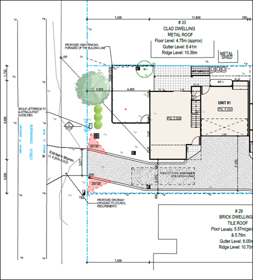
Figure 10 – Front Setback (excerpt from Site Plan)
As shown in Figure 10, whilst the proposal is less than the calculated average setback it is generally consistent with the existing neighbouring dwellings and the proposed 3-unit multi dwelling housing development on the adjoining property to the west under DA/4367/2022, which will have a setback of 7.5m.
In addition, the size of the courtyard of Unit 1 and POS has been reduced. This has been achieved by the increase in setback to the front boundary (now 3m) and reduction in courtyard width across the site to 7m. Notwithstanding this, the minimum area of POS of 45m2 is still achieved although part of the POS area is less than the minimum dimension.
The result of the increase in building setback improves compliance with other controls. Notwithstanding the numerical non-compliance, the proposal complies with the objectives of the DCP as follows:
· The streetscape presentation of the proposal is improved by the increase in landscaped area forward of the building enhanced by the projection of the first-floor balcony which provides articulation and visual interest to the proposed development.
· The proposal provides garden areas consistent with the low-density context of the street which in the majority is single dwellings and consistent with the desired character of the area.
· The proposal complies with the site coverage controls in clause 2.2.4.3 for soft landscaping.
· The side (other than the eave on western elevation to Unit 3) and rear setbacks of the proposal comply with the controls. In this regard the views, privacy and solar access of adjacent properties are reasonably maintained.
Clause 2.2.5b requires a side setback as follows:
· For any part of the building up to a height of 4.5m, 0.9m, and
· For part of building >4.5m, 0.9m plus 25% of the height of the building above 4.5m i.e., building height at the side boundary of 6.35m = 1.36m setback
The building requires a 1.36m setback for the part of the building with a height >4.5m. The façade of the building complies. However, there is an encroachment of the eave at the rear portion of the dwelling to the western boundary at Unit 3. The building envelopes shown in Figures 6 and 7 and on the Architectural Plans, Drawing DA300 & DA301 Elevations show the extent of the encroachment which occurs over a length of approx. 15m and when quantified is approximately 0.07m2 or 0.29m horizontally protruding out of the upper floor envelope.
The encroachment is considered negligible regarding visual impact and in terms of diminished sunlight access on the neighbouring property. The proposal otherwise complies with the objectives of the control.
Clause 2.2.7.2 Privacy
Clause 2.2.7.2 objectives require reasonable levels of privacy to be maintained internally and externally, and a high level of amenity is provided by protecting the privacy of residents both within dwelling and private open space areas.
In accordance with clause 2.2.7.2.1, the building should be designed to minimise overlooking of adjacent dwellings. Where windows of living areas or balconies are within 12m of and facing living areas or balconies of adjacent dwellings windows should be offset from the edge of the opposite window and balconies be screened or oriented to ensure visual privacy. First floor level windows and above should be orientated / designed to maintain privacy. Windows to be opaque finish or have an appropriate sill height above floor level.
Adjoining developments are single storey. The rear of the development complies with the required 4.5m rear boundary setback. Privacy to the north is achieved as there is no opportunity for overlooking as there are no windows on the northern elevation of the building.
Privacy screening is provided to balconies to minimise overlooking of side boundaries which is generally to the rear yard of the existing dwellings to the east and west of the site.
In addition, consideration has been given to the proposed 3-unit multi dwelling housing development on the adjoining property to the west. The subject proposal will have a separation distance of approximately 7m to this proposed development to the west. Consideration has also been given to the unit layout of the subject proposal in the placement of windows on the western elevation.
Whilst the privacy impacts from upper storey windows are not considered to have detrimental impact on adjoining neighbours generally and the design of the proposal has considered offset of windows to that proposed on the adjoining property, windows generally have a sill height of 1.2m. It is considered additional privacy measures are required to the following aspects of the building for sitting rooms being high usage rooms and stairwell windows to minimise overlooking.
An opaque finish to the window glazing to a height of 1.6m or an increase in sill heights to 1.6m above finished floor level at first floor level for:
· western elevation plan:
o Sitting room and stairwell of Unit 3.
o Stairwell of Unit 1.
o All bathrooms.
· eastern elevation plan:
o Sitting room Unit 1.
o Stairwell and bathroom of Unit 2.
On this basis, compliance with the objectives is achieved. A condition is recommended to amend the plans prior to the issue of a construction certificate (refer to Condition 2.3).
Clause 2.2.7.3 Private Open Space areas (POS)
Clause 2.2.7.3 requires POS areas to comply with the following:
a. Private open space for each dwelling is to have with a minimum area of 45 square metres and a minimum dimension of 4.5 metres. These areas are required to be generally located at ground level, directly accessible from a living area within the dwelling.
b. Required private courtyards shall not exceed a maximum grade of 1:14 to optimise useability for residents.
c. Wherever a dimension is less than the required minimum width (i.e. 2 metres for balconies or 4.5 metres for courtyards) it shall not be counted as part of the calculation for private open space areas.
d. Required ground level private open space may be provided in up to two locations for each dwelling, subject to compliance with the minimum dimension.
e. Ground level courtyards are not permitted within the front building setback area fronting local roads.
The proposal provides the minimum 45m2 of POS for each unit. Unit 3 provides all POS at ground level with a dimension of 4.5m. Unit 2 provides POS in two locations, at ground level (36m2) generally 4.5m in dimension and balcony space 13sqm in area and 2m in dimension. The POS for Unit 1 is provided at ground level and is generally 4.5m in dimension with a portion of the POS 3m in dimension. In addition, the POS of Unit 1 is partly within the front building setback area.
While there is a technical non-compliance with the requirements for POS areas regarding Unit 1, the overall objectives are met to create functional POS that meets the minimum area requirement and provides good amenity for future residents without a negative impact on the streetscape.
Clause 2.2.7.5 Sunlight Access
Clause 2.2.7.5 requires:
· On June 21, 50% of the required private open space area for all dwellings should receive at least 3 hours of unobstructed sunlight access between 9am and 3pm.
· On June 21, 50% of the required private open space on adjoining land should receive at least 3 hours of unobstructed sunlight access between 9am and 3pm.
Shadow diagrams have been submitted that demonstrate that 50% of the private open space of all proposed dwellings and the existing dwellings to the east and west of the site achieve the required sunlight access.
Solar panels currently exist on the roof of the dwelling to the east, 29 Burrawang Street, the shadow diagrams indicate that the shadowing on the panels occurs at approximately 2.30pm onwards. Thus, the panels receive approximately 7.5 hours of sunlight during the winter months which is sufficient to generate electricity for the occupants during this time of the year. It is noted that the proposal provides a 4m to 5.7m setback to the eastern boundary which is twice the amount required for the proposed height of building. It is considered the shadow impacts on the solar panels from the proposed development is acceptable.
Shadow diagrams have also been submitted that demonstrate the overshadowing impacts from the proposal on the 3-unit multi dwelling housing development proposed on the adjoining property to the west and its potential impacts to the subject site. Between 12pm and 3pm on June 21, 50% of the POS of all units in the proposed development on the subject site will obtain 3 hours sunlight access.
The proposal complies with the objectives and facilitates solar access to the living areas and private open space areas of the dwelling and neighbouring dwellings.
Clause 2.2.8.2.2 Access Design Ground Level Parking
Clause 2.2.8.2 requires that vehicular access be designed in accordance with the relevant Australian Standard and relevant provisions of Council’s Civil Works Specification.
Ground level parking is to be designed in accordance with clause 2.2.8.2.2 as follows:
a. Fully enclosed garages must not visually dominate any building elevation.
b. Driveways must not be continuous straight lines and shall be offset by landscaped sections.
c. A minimum pavement width of 3m is required.
d. Driveways shall be offset from any side boundary by 2 metres at the front boundary and may taper back to 500mm side setback within the front building line as illustrated in Figure 1. This offset area, and side setback for the length of the remaining driveway must be landscaped with trees and shrubs to soften the hardstand areas and provide for infiltration and provide visual appeal to the streetscape.
Garages do not visually dominate building elevations and the proposal provides a 3m driveway pavement including a 2m offset at the front boundary which provides pedestrian sight line splay adjacent the driveway in accordance with AS2890. The sight line splay is suitably landscaped in accordance with AS2890 and Council’s Civil Works Specification.
The driveway offset of 2m at site frontage tapers to 500mm at the front building line and suitably landscaped with plant species of a height that will not impact on required pedestrian sight lines. The driveway achieves required side setback for 50% of its length (including driveway kerb) and tapers to 150mm over the remaining length of the driveway with lattice and climbers along the driveway edge and visitors space at the boundary fence. The remaining 1.8m of the site behind the visitor space is landscaped.
The Landscape Plan in Figure 8 indicates the extent of landscaping on the site. The level of landscaping at the site frontage inclusive of the planting along the eastern side of the driveway in combination with the planting proposed at the dwellings on the western side of the driveway and to the rear of the visitor space will soften the driveway area to minimise visual impacts of the new development. The objectives for car parking and access are achieved and respects the architectural qualities of the building and integrates with the overall presentation of the development.
Chapter 2.13 Transport and Parking
Car Parking
The proposed development generates an off-street car parking requirement of 5 residential spaces and 1 visitor space which has been provided for by the design amendments. The proposal complies with the car parking requirements for a 3-unit multi dwelling housing development.
Traffic and Road Works
Traffic
The proposal will increase traffic movements in the street however is not considered to have adverse impact on the capacity of the existing road network. The proposal provides for safe access and vehicle manoeuvring on site for vehicles to enter and exit the site in a forward manner.
Council’s Development Engineer has assessed the proposal in relation the required civil engineering works, detailed as follows:
Road works and vehicular access
The proposal requires up to half width road construction including kerb and guttering, subsurface pavement drainage, concrete footpath 1.5m wide for the full street frontage of the development in Burrawang Street, verge formation, street stormwater drainage and new road pavement with end transitions across the full frontage of the site in Burrawang Street.
Vehicular access within the site is proposed via a driveway along the eastern side boundary. The access arrangements appear to comply with AS/NZS 2890.1:2004.
Pedestrian access
There is no footpath across the frontage of the site. It is recommended that concrete footpath be constructed across the site frontage in conjunction with this development.
The proposal indicates compliance with AS2890 can be achieved for the pedestrian sight distance splays adjacent the driveway at the site frontage. Landscaping does not exceed 600mm in height.
A condition is recommended to maintain clear sight distance splays compliant with AS2890 for the vehicular access location to Burrawang Street (refer to Condition 9.8).
The proposal is consistent with the objectives of Chapter 2.13 of CCDCP 2022.
Chapter 2.14 Site Waste Management
A Waste Management Plan has been submitted with the proposal for demolition, construction works and ongoing management of waste. The proposal has demonstrated compliance with this chapter of the CCDCP 2022 and associated Waste Control Guidelines. Appropriate conditions are included in the development consent.
Chapter 2.17 Character and Scenic Quality
Character
The site is located within the character area: Ettalong Beach 7: Sandplain Mixed Density of CCDCP 2022.
The areas should remain leafy mixed-density residential neighbourhoods that retain some of the original mid-Twentieth Century bungalows, and future development should achieve significantly improved standards of amenity and urban design quality.
The desired character seeks to retain traditional bungalows which is not always a desirable outcome. Buildings can exist in harmony without having the same density, scale or appearance. The proposal responds to the essential elements of the character of surrounding area created by the visual relationship of built form to the surrounding space created by building height, setbacks and landscaping.
The proposal is consistent with the desired streetscape and character of the area and provides extensive garden areas with deep soil landscaping, particularly at the site frontage (at the rear of the site, consistent with low-density development, i.e., existing dwellings, in Burrawang Street.
The articulated facade and variations in material and colours disguise the scale of the buildings and provide visual interest. The proposal provides well designed residential units with good amenity, incorporating balconies, a residential address with visible verandahs and use of a variety of materials. Screening is provided to balconies to protect the privacy and amenity of neighbouring dwellings.
The proposal
is compatible with the desired and likely future character of the of the area.
Scenic Quality
The proposal is located within the Peninsula geographic unit and the Woy Woy/Umina Landscape Unit, of CCDCP 2022 which is of local scenic value.
The site is zoned for medium density development which permits a building height of 8.5m and two storeys and a FSR of 0.5:1. The location of the site and building form will not impact on any significant views from surrounding properties. The proposal generally complies with the relevant development controls with minor non-compliance to the front building setbacks and location of private open space. The streetscape is maintained by the proposed landscaped front setback.
The proposal maintains the character and scenic quality of the area while considering the desired and likely future character of the area.
Chapter 3.1 Floodplain Management/Water Cycle Management
Chapter 3.1 seeks to minimise the impact of development on the natural pre-development
water cycle. This will lead to more sustainable outcomes that will protect the environment.
The on-site stormwater detention, retention, re-use and drainage system has been designed to attenuate post developed flow rates to predevelopment flow rates. The site does not receive any concentrated overland flow from upstream properties. Runoff from impervious hardstand areas will be collected and conveyed through a pit and pipe system to a detention tank with a capacity of 10,600 litres beneath the driveway and will then discharge to the kerb inlet pit in the street.
Revised plans were submitted during the assessment to adequately assess the stormwater management of the site. The revised Water Cycle Management Plan prepared by MPC Consulting Engineers has been reviewed by Council’s Development Engineer, subject to conditions, addresses the requirements of the Chapter 3.1 Part C: Southern Area Water Cycle Management.
Chapter 3.5 Tree and Vegetation Management
An Arborist Report was submitted with the proposal. Review of the report by Council’s Tree Assessment Officer indicates a number of inconsistencies in the report that did not reflect in the Landscape Plan or the Architectural Site Plan.
Council’s Tree Assessment Officer has carried out a site inspection and assessment of the proposal. Smaller ornamental trees located within the adjoining property to the west are not expected to be adversely impacted. The quality of existing trees and their location within the building footprint, the proposed tree removal and impact on the streetscape and adjoining neighbours has been considered. The Landscape Plan and Architectural Plans have been amended to show the proposed tree removal, tree replacement and include street tree planting.
In addition, Unit 1 building footprint and courtyard area has been reduced and the plans amended during assessment to address Council’s requirements for an improved streetscape presentation. In this regard the additional building setback to the front boundary provides opportunity for improved level of landscaping which is reflected in the amended Landscape Plan by Tolero Landscape Design dated 13 November 2023.
Three trees on the site and shrubs are proposed to be removed. The affected trees are identified in Figure 11. The proposal includes removal of the Honey Myrtle on the road reserve, which is in poor condition and will be affected by the works for driveway access.
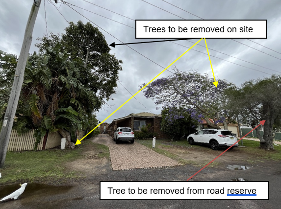
Figure 11 – Trees at site frontage and on road reserve
The Illawarra Flame Tree (identified by the black arrow in Figure 11) is located on the subject site and is proposed to be removed for the 3-unit development proposed at 33 Burrawang Street. It should be noted that this tree is shown to be retained on the Landscape Plan. The owner of 31 Burrawang Street has recently granted consent for its removal for the proposed development on the adjoining site as this tree will impact on pedestrian sight lines and required to be removed for that development by Council.
Amendments to the proposal provide replacement tree planting which has increased from four (4) to six (6) suitable native species (Tuckeroo, Water Gum and Quandong) and retention of an existing tree at the front. In addition, two (2) street trees are proposed.
Subject to conditions, the proposal has adequately addressed this chapter of the CCDCP 2022.
Likely Impacts of the Development:
Section 4.15 (1)(b) of the Environmental Planning and Assessment Act 1979 requires consideration of the likely impacts of the development including environmental impacts on both the natural and built environments, and social and economic impacts in the locality.
In this regard, potential impacts related to the proposal have been considered in response to SEPPs, LEP and DCP controls outlined above and summarised below:
Built Environment, Context and Setting
The subject site is zoned R1 General Residential and is surrounded by a mix of one and two storey single dwellings and multi dwelling housing developments.
A thorough assessment of the impacts of the proposed development on the built environment has been undertaken in terms of CCLEP 2022 and CCDCP 2022 compliance. The proposal is generally consistent with the development controls for multi dwelling housing. The stated non-compliances are minor. Despite non-compliances discussed throughout this report the proposal will not have any unreasonable impacts on the character or amenity of the area in terms of overshadowing, privacy, noise generating activities and views. The proposed built form is considered acceptable in the context of the site, subject to the recommended conditions of consent.
The proposal is consistent with the character of surrounding development and retains large setback to site frontage consistent with existing dwelling houses within the street. Adequate separation distance is provided to adjoining dwellings and therefore does not have detrimental impact on the privacy and amenity of dwellings on adjoining properties.
Access and traffic
The local road network is considered to have adequate capacity to cater for the proposed development and minimal increase in traffic generated by the proposal.
The internal vehicle circulation arrangements can provide for safe and efficient internal manoeuvring allowing access and egress in a forward direction. Adequate pedestrian sight distances are provided at the site frontage.
Natural Environment
The subject site does not contain any threatened species or habitat. The proposal is satisfactory in relation to impacts on the natural environment as identified throughout this report. There will be no significant impact upon the natural environment as a result of the proposal.
Economic and Social Impacts
The proposed development will contribute to the supply of housing needs in the locality and is satisfactory from an economic perspective. No unreasonable social impacts will arise from the approval of this residential development.
Suitability of the Site for the Development
Section 4.15 (1)(c) of the Environmental Planning and Assessment Act 1979 requires consideration of whether the site is suitable for the proposed development.
The site is zoned R1 General Residential under CCLEP 2022. Multi dwelling housing developments are permissible in the zone.
There are no environmental hazards which would prevent development of the site. Existing utilities are available to the site and the site is located within walking distance of public bus services and near public recreation / community facilities.
Previous and proposed use of the site is for a residential purpose. As such the site is considered suitable for this type of development subject to conditions of consent relating to civil works, stormwater/drainage works and the provision of landscaping that include 6 native trees planted throughout the site including 2 street trees.
There will be no significant impact upon the natural environment as a result of the proposal. There are no adjoining land uses which impact upon the development.
Any Submission made in Accordance with this Act or Regulations
Section 4.15 (1)(d) of the Environmental Planning and Assessment Act 1979 requires consideration of any submissions received during notification of the proposal.
The application was formally advertised and notified in accordance with CCDCP 2022 Chapter 1.2 Notification of Development Proposals from 17 February 2023 to 3 March 2023 and re-notified due to extension of notification end date from 17 March 2023 to 12 April 2023. The existing submissions to the first notification period were applied, and any resubmissions were not counted as an additional submission. A total of 22 submissions were received.
Those issues associated with key issues have been addressed in the above report. The remaining issues pertaining to various concerns were addressed in the assessment of the application pursuant to the heads of consideration contained within Section 4.15 of the Environmental Planning and Assessment Act 1979.
A summary of the submissions objecting to the proposal is detailed below.
|
Submission issue |
Response |
|
|
Tree Removal & Landscaping
|
Five mature shade trees are being removed and replaced with hard surfaces. This will add to the heat island that threatens community health and safety. Not consistent with CC Greener Places Strategy.
Removes habitat for birds, small mammals and insects including cicadas and bees, and be detrimental to our street’s biodiversity. It takes decades for trees to grow hollows as nesting sites for birds.
Removal of trees outside 29 Burrawang Street will adversely impact on the shade to the front of the premises.
Just because there is a provision for the planting I am yet to see any recent developments follow through on the actual planting of these trees.
|
Three (3) trees and a number of shrubs are proposed to be removed. Affected trees occur at the site frontage and are generally in poor condition. No trees occur at the rear of the site.
The proposal has been amended increasing the front setback providing opportunity for additional plantings. The revised Landscape Plan is provided in Figure 8 in this report.
Amendment to the proposal provides replacement tree planting which has increased from four (4) to six (6) suitable native species (Tuckeroo, Water Gum and Quandong) and retention of an existing tree at the front. Two (2) street trees are proposed and will provide shade as they mature.
Council’s Tree Assessment Officer supports the proposal, subject to conditions.
The units cannot be occupied until an Occupation Certificate (OC) is issued. The OC cannot be issued until the landscaping is completed in accordance with the landscape plan (refer to Condition 6.5). |
|
Stormwater Management |
Stormwater runoff issues as adjoining premises are not kerbed.
Non-permeable surfaces should be reduced and will cause drainage problems to neighbours.
Stormwater: given the development’s abundance of hard services, stormwater run-off will be an extreme issue for neighbouring properties due to the lack of ability for the water to drain into the sandy soil (the usual source of drainage for this part of the Peninsula) which will be covered extensively by concrete and buildings. |
Council requires kerb and guttering across the site frontage including footpath. Council’s Development Engineer has reviewed the proposed Water Cycle Management and Stormwater Management Plan for the site and raises no objections subject to conditions.
The proposed stormwater management of the site is satisfactory, and the proposal has demonstrated compliance can be achieved with Council’s DCP and Civil Works Specifications. |
|
Car Parking and Traffic Congestion |
No visitor parking provided.
This development will add to traffic and car parking congestion. The streetscape photo provided in the DA is not an accurate reflection of parking on Burrawang Street.
There are families surrounding the property and with all the extra cars that will inevitably be parked on the verge and non-guttered areas, children could be endangered.
Traffic flow: sitting between Barrenjoey Road and Springwood Ave, Burrawang Street is a major traffic thoroughfare with cars travelling towards Umina. The lack of adequate parking, in particular visitors parking, means spill-over parking will eventuate on the street. This will cause reduced line-of-sight for vehicles travelling along Burrawang Street in both directions and reduced road-width. Given there are two more identical multi-dwelling developments proposed at 33 and 21 Burrawang Street, this is a significant safety issue for both cars and pedestrians that cannot be ignored. |
The proposal complies with the car parking requirements of the DCP for residents and visitors. The proposal has been amended during assessment and provides visitor parking adjacent Unit 3 and the eastern boundary at the rear of the site.
Observation of traffic and parking in Burrawang Street has occurred during the assessment of the application. The proposal will increase traffic movements in the street however is not considered to have adverse impact on the capacity of the existing road network and the functioning and traffic flow of the street.
The proposal provides for safe access and vehicle manoeuvring on site for vehicles to enter and exit the site in a forward manner.
Safety of pedestrians has been considered. The proposal provides pedestrian sight splays adjacent the driveway access in accordance with AS2890. Kerb and gutter including footpath is to be provided across the site frontage.
|
|
Disruptions to traffic/parking during construction |
In the short-term (during construction), there would also be parking problems with multiple tradespeople working on site. |
A Construction and Traffic Management is required to be prepared to deal with potential traffic and parking issues during construction (refer to Condition 4.12). |
|
Stormwater runoff issues as adjoining premises are not kerbed.
Non-permeable surfaces should be reduced and will cause drainage problems to neighbours.
Stormwater: given the development’s abundance of hard services, stormwater run-off will be an extreme issue for neighbouring properties due to the lack of ability for the water to drain into the sandy soil (the usual source of drainage for this part of the Peninsula) which will be covered extensively by concrete and buildings. |
Council requires kerb and guttering across the site frontage including footpath. Council’s Development Engineer has reviewed the proposed Water Cycle Management and Stormwater Management Plan for the site and raises no objections subject to conditions.
The proposed stormwater management of the site is satisfactory, and the proposal has demonstrated compliance can be achieved with Council’s DCP and Civil Works Specifications. |
|
Overshadowing |
Privacy adversely affected by size and scale of the dwellings and overshadowing on roof area impacting on solar panel installation of adjoining property. |
Solar panels currently exist on the roof of the dwelling to the east, 29 Burrawang Street, the shadow diagrams indicate that the shadowing on the panels occurs at approximately 2.30pm onwards. Thus, the panels receive approximately 7.5 hours of sunlight during the winter months which is sufficient to generate electricity for the occupants during this time of the year. It is noted that the proposal provides a 4m to 5.7m setback to the eastern boundary which is twice the amount required for the proposed height of building. It is considered the shadow impacts on the solar panels from the proposed development is acceptable. |
|
Privacy |
The proposed development infringes on privacy of neighbours and quality of life.
The West and East elevation diagrams both have multiple elongated windows that will peer into neighbouring sites.
The height of the proposed development will create overshadowing and the loss of privacy in open spaces of neighbouring properties.
On the Eastern elevation of the whole development there are windows and on the front and rear townhouses there are balconies on the upper floor levels, all of which will overlook the backyards and open areas of the properties next door, destroying their privacy.
The upstairs south facing balcony which will overlook all front yards on existing north facing Burrawang Street including 40-42 Burrawang Street x 2 front villa courtyards and existing residential home at 38 Burrawang Street. Additionally, all rear units overlook adjoining properties at 32 Lagoon Street creating zero privacy.
Surely there are design standards that need to be adhered to ensure no negative impact on the neighbouring properties. |
Privacy impacts to adjoining development has been considered. Amended plans submitted during assessment of the development application indicate:
• Improved level of compliance with the development guidelines/controls for multi dwelling housing. • Privacy screening provided to all upper floor balconies; overlooking of neighbouring properties is minimised. • No windows in rear elevation to cause overlooking as stated. • Additional privacy measures are proposed to both the eastern and western elevation to further reduce overlooking from first floor sitting rooms, stairwells and bathroom windows requiring opaque glazing to 1.6m from finished floor level or increased sill heights to 1.6m (refer to Condition 2.3). • The balcony to Unit 1 is reduced in width and the amended design of the front façade reduces the extent of windows facing the street. The proposal will provide reasonable setbacks and building separation for a two-storey development to residents opposite the site and combined with the level of landscaping at the site frontage inclusive of tree planting within the site and 2 street trees on the road reserve, the assessment considers there is no adverse privacy impacts. |
|
Overdevelopment of the site / out of character |
The size of the development footprint is excessive for the site area.
Over development of the site – due to lack of visitor parking.
New development should reflect the existing character of the area which is of traditional bungalows. Whilst there are some 2 storey houses in the street, the vast majority are of single storey design. Even where villas have been built they also are of single storey in height and do not overlook or overshadow neighbouring properties. |
The proposal has been amended since the application was notified to neighbours to address issues raised in submissions.
The proposal is considered to have an appropriate height, scale and visual bulk for the site and the locality. The proposal is below the allowed building height and complies with the required floor space ratio of 0.5:1 for the site and surrounding properties.
Two storey developments are permitted in accordance with Chapter 2.2 of CCDCP 2022. The proposal complies with the side and rear boundary setbacks and provides a front setback generally consistent with adjoining dwellings.
The desired character seeks to retain traditional bungalows which is not always a desirable outcome. Buildings can exist in harmony without having the same density, scale or appearance. The proposal responds to the essential elements of the character of surrounding area created by the visual relationship of built form to the surrounding space created by building height, setbacks and landscaping.
The proposal is consistent with the desired streetscape and character of the area and provides extensive garden areas, particularly at the site frontage, consistent with low-density development, i.e., existing dwellings, in Burrawang Street. |
|
Lot size |
Under the Central Coast Council’s own LEP, multi-dwelling developments of this scale are not permitted on lots of this size. |
Burrawang Street is located within an area zoned R1 General Residential under the LEP. Multi dwelling housing is permitted in the zone.
Under the former Gosford LEP 2014 a minimum lot size of 750m2 was required for multi dwelling housing. As the size of the lots in Burrawang Street are below 750m2 multi dwelling housing could not be considered.
Since the Central Coast LEP 2022 came into effect on 1 August 2022 there is no minimum lot size for multi dwelling housing.
Density provisions are addressed by compliance with the building setbacks, site coverage and landscaping provisions in the development controls for multi dwelling housing in Chapter 2.2 Dual Occupancy and Multi Dwelling Housing of CCDCP 2022 and the proposal generally complies with these controls. |
|
Cumulative impact of 3 developments in Burrawang Street |
Cumulative impact of 3 developments in Burrawang Street is gross over development with the construction of dwellings at 21, 31 and 33 Burrawang Street and will impact on the lives of the residents of the area.
These proposals also include the removal of all existing vegetation and mature trees and adds to the documented Urban Heat Island Effect.
Nine 9 dwellings are proposed over 3 sites and will result in an increase traffic and parking in the street. With the addition of 2 vehicles per dwelling this would increase site traffic by 18 vehicles (excluding visitor parking). A net increase of 23% traffic based on these figures. On a road that struggles with current traffic and parking. This also puts at risk the pedestrian safety due to the narrow road and parking on footpath.
Creates a major change to the streetscape and the appeal of the street. All 3 carrying the same appearance taking from the beach side appeal of the street. Giving more of a state housing appearance which was abolished in the 80’s.
|
The CCLEP 2022 permits multi dwelling housing in the zone and it is likely other sites in the street may be developed as such in the future. Development applications are considered on their merits and the design of the proposal.
All 3 proposed developments have been amended to address the development standards in the CCLEP 2022 and development controls in CCDCP 2022 as follows: • Height of buildings and floor space ratio comply with LEP controls. • The proposals do not rely on on-street parking. The required resident car parking for 3 units is provided. i.e., 5 spaces. One on-site visitor parking space is provided. • There will be an increase in traffic movements in the street however this is not considered to be detrimental to the amenity of existing residents. • The front setback has been increased and the courtyard area to Unit 1 reduced which allows for increased level of landscaping at the site frontage. • The streetscape presentation is consistent with the garden areas for dwellings in the street increasing soft landscaping and minimising impermeable surfaces. • The stormwater detention is relocated from the front setback to the driveway minimise impermeable surfaces. • Privacy screening is provided to balconies to minimise overlooking. • Shadow diagrams indicate the required solar access to adjoining development complies with the controls. • Consideration has been given to the appearance of each building to the street. The roof form, external façade and materials of the proposal at 33 Burrawang Street has been amended and does not have the same architectural appearance as that proposed on 31 Burrawang Street.
|
Submissions from Public Authorities/External Agencies
The application did not require referral to any public authority.
Internal Consultation
The following internal consultations have been undertaken. Where relevant comments from internal officers are provided throughout this report.
|
Development Engineer |
Supported subject to Conditions 2.4-2.7,4.12, 4.13, 6.9-6.15, 9.8. |
||
|
Tree Assessment Officer |
Supported subject to Conditions 4.14, 5.14, 6.17, 6.18. |
||
|
Water and Sewer |
Supported subject to Conditions 2.4, 6.16 |
Ecologically Sustainable Principles
The proposal has been assessed having regard to ecologically sustainable development principles and is consistent with the principles.
The proposed development is considered to incorporate satisfactory stormwater, drainage and erosion control and the retention of vegetation where possible and is unlikely to have any significant adverse impacts on the environment and will not decrease environmental quality for future generations. The proposal does not result in the disturbance of any endangered flora or fauna habitats and is unlikely to significantly affect fluvial environments.
Climate Change
The potential impacts of climate change on the proposed development have been considered by Council as part of the assessment of the application.
This assessment has included consideration of such matters as potential rise in sea level; potential for more intense and/or frequent extreme weather conditions including storm events, bushfires, drought, flood and coastal erosion; as well as how the proposed development may cope, combat, withstand these potential impacts. The proposed development is considered satisfactory in relation to climate change.
The Public Interest
Approval of the proposed development is in the public interest for the following reasons:
· The proposed development has been prepared having regard to the aims and objectives of relevant state and local environmental planning instruments and generally complies.
· Subject to various mitigation measures recommended by consultants and Council’s technical officers, the proposal is deemed to have no negative environmental, social or economic impacts to surrounding residential dwellings or the public domain.
· The proposed development will result in a high-quality residential development.
· The proposed development is designed and sighted to make a positive contribution to the streetscape.
· The proposed development remains sympathetic to the existing character of the surrounding neighbourhood and respects and maintains privacy to and from neighbouring properties.
Political Donations
During assessment of the application there were no political donations were declared by the applicant, applicant’s consultant, owner, objectors and/or residents.
Other Matters for Consideration
Section 7.11 Contributions
Water and Sewer Contributions
Water and sewer services are available to the land. Building adjacent to sewer conditions apply and developer charges are applicable. Therefore, engineering is required to be approved by Council for building in proximity to sewer assets. A Section 307 Certificate of Compliance is required.
Construction Traffic and Pedestrian Management Plan (CTMP)
A Construction Traffic and Pedestrian Management Plan (CTMP), will be prepared and
submitted to the certifying authority which will detail proposed construction works, the traffic impacts on the local area and how these impacts will be addressed. Council is not required to approve these plans (refer to Condition 4.12).
Conclusion
This application has been assessed under the heads of consideration of section 4.15 of the Environmental Planning and Assessment Act 1979 and all relevant instruments and policies. Following a thorough assessment key issues identified in the application as initially lodged have been resolved satisfactorily through amendments to the proposal. it is considered that the application can be supported because the Panel can be satisfied that:
· The provisions of the following State Environmental Planning Policies have been considered and satisfied:
i) State Environmental Planning Policy (Building Sustainability Index: BASIX) 2004
ii) Chapter 4, section 4.6(4) of the State Environmental Planning Policy (Resilience and Hazards) 2021
· The provisions of clause 7.1 Acid Sulfate Soils and 7.6 Essential Services of Central Coast Local Environmental Plan 2022 have been considered and satisfied.
· The proposed development is consistent with the zone objectives as set out in the Central Coast Local Environmental Plan 2022.
· The relevant provisions of the environmental planning instruments, plans and policies that apply to the development have been considered in the assessment of the application.
· The proposed development is considered satisfactory having regard for the matters for consideration provided in section 4.15 of the EP&A Act.
· Subject to the imposition of appropriate conditions, the proposed development is not expected to have any adverse environmental, social or economic impact.
Accordingly, the application is recommended for approval pursuant to Section 4.16 of the Environmental Planning and Assessment Act 1979.
|
1⇩ |
Draft conditions - 31 Burrawang Street, ETTALONG BEACH NSW 2257 - DA 4365 2022 |
|
D15956011 |
|
2⇩ |
Revised Architectural Plans Rev A - 31 Burrawang Street, Ettalong Beach - DA/4365/2022 |
|
D15958575 |
|
3⇩ |
Revised Landscape Plan - 31 Burrawang Street Ettalong Beach - DA/4365/2022 |
|
D15947630 |
|
4⇩ |
BASIX Certificate - 31 Burrawang Street Ettalong Beach - DA/4365/2022 |
|
D15944854 |
|
5⇩ |
Swept Turning Paths - 31 Burrawang Street Ettalong Beach - DA/4365/2022 |
|
D15944852 |
|
6⇩ |
Water Cycle Management Plan - 31 Burrawang Street Ettalong Beach - DA/4365/2022 |
|
D15944849 |
|
7⇩ |
PUBLIC - Geotechnical report - 31 BURRAWANG STREET ETTALONG BEACH 2257 - PAN-295396 - DA/4365/2022.pdf |
|
D15499092 |
|
8⇩ |
PUBLIC - Waste Management plan - 31 BURRAWANG STREET ETTALONG BEACH 2257 - PAN-295396 - DA/4365/2022.pdf |
|
D15525106 |
|
2.2 |
DA/4365/2022 - 31 Burrawang Street Ettalong Beach - Multi-Dwelling housing (3 Units) & Demolition of Existing Structures |
|
Attachment 1 |
Draft conditions - 31 Burrawang Street, ETTALONG BEACH NSW 2257 - DA 4365 2022 |
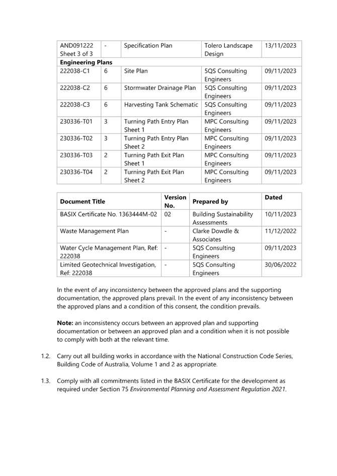
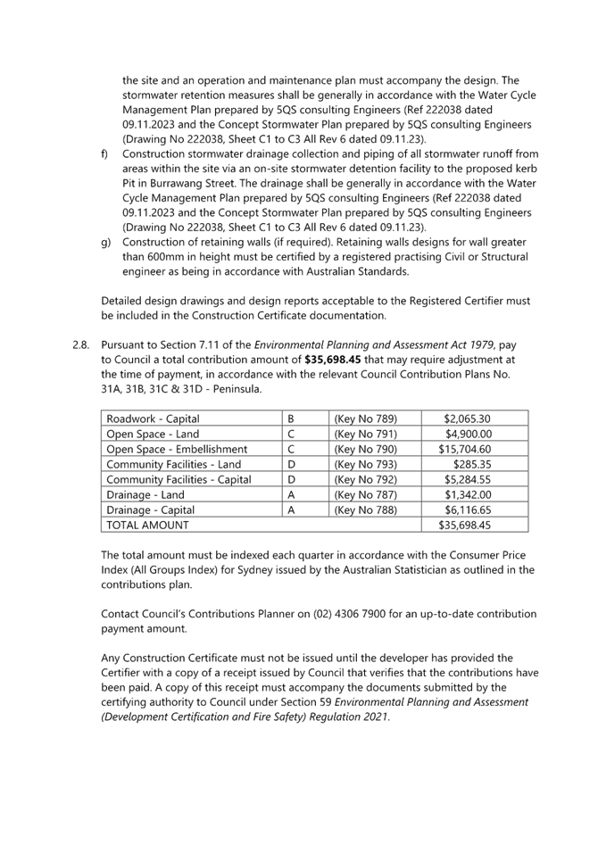
|
DA/4365/2022 - 31 Burrawang Street Ettalong Beach - Multi-Dwelling housing (3 Units) & Demolition of Existing Structures |
|
|
Attachment 2 |
Revised Architectural Plans Rev A - 31 Burrawang Street, Ettalong Beach - DA/4365/2022 |
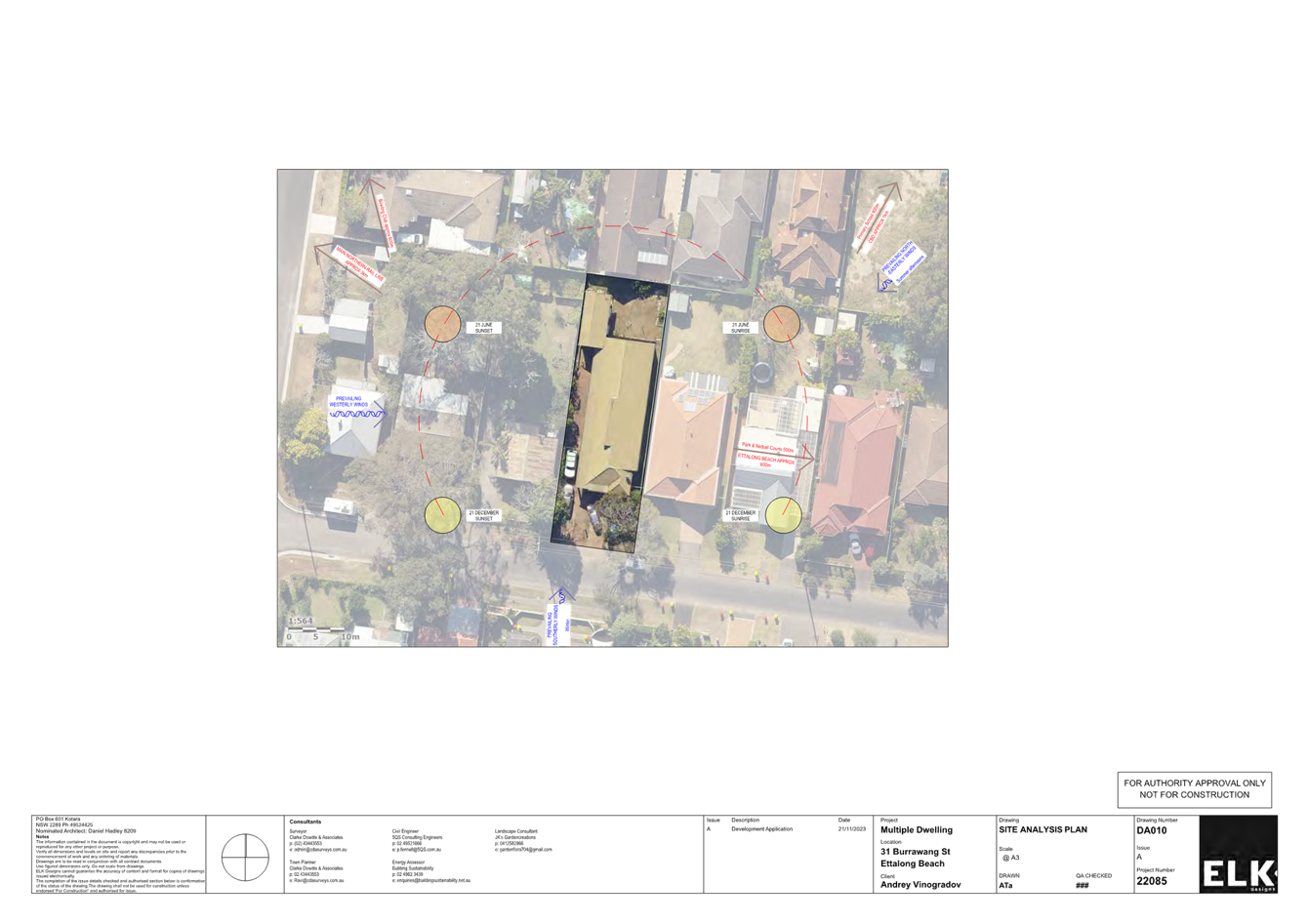
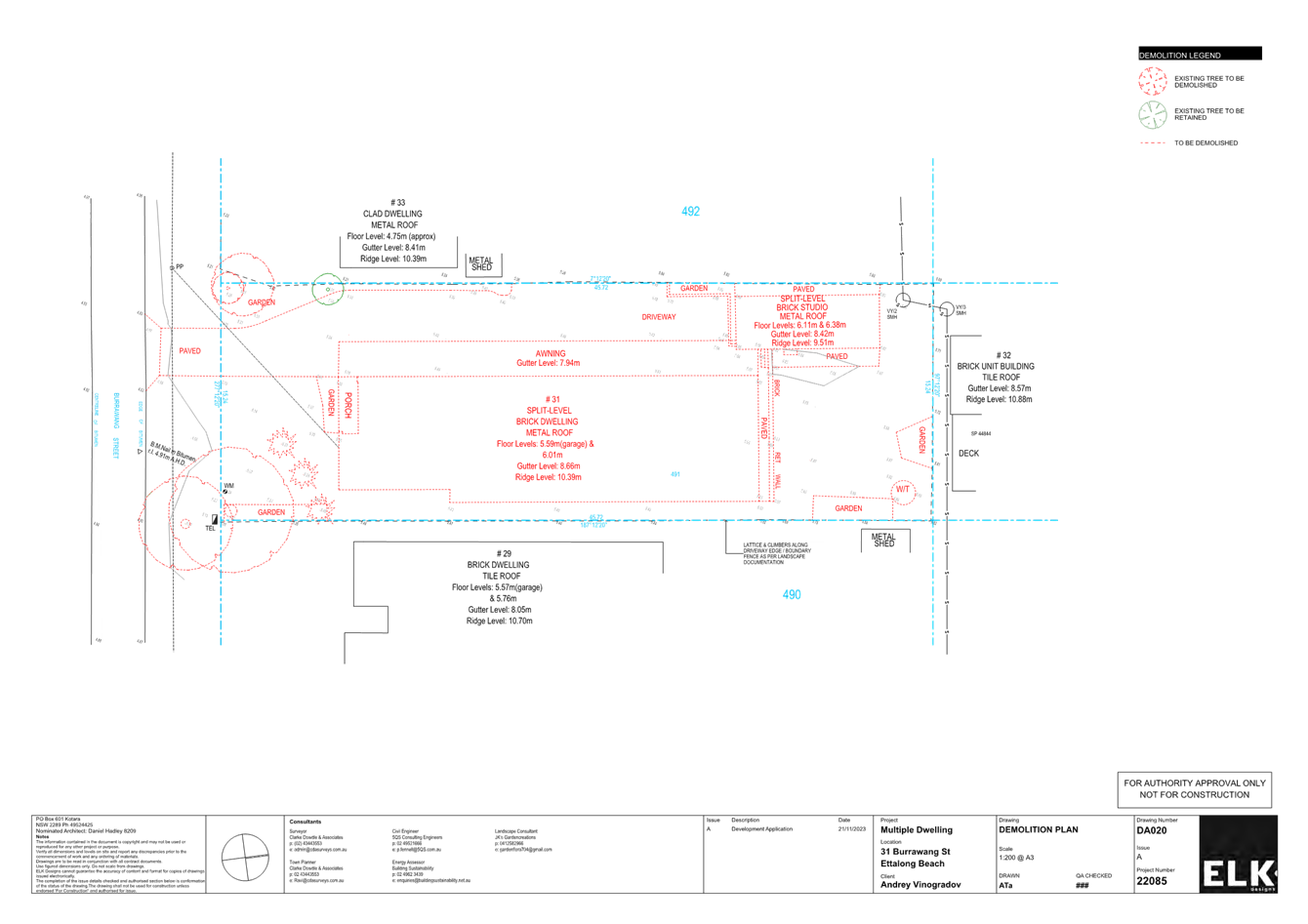
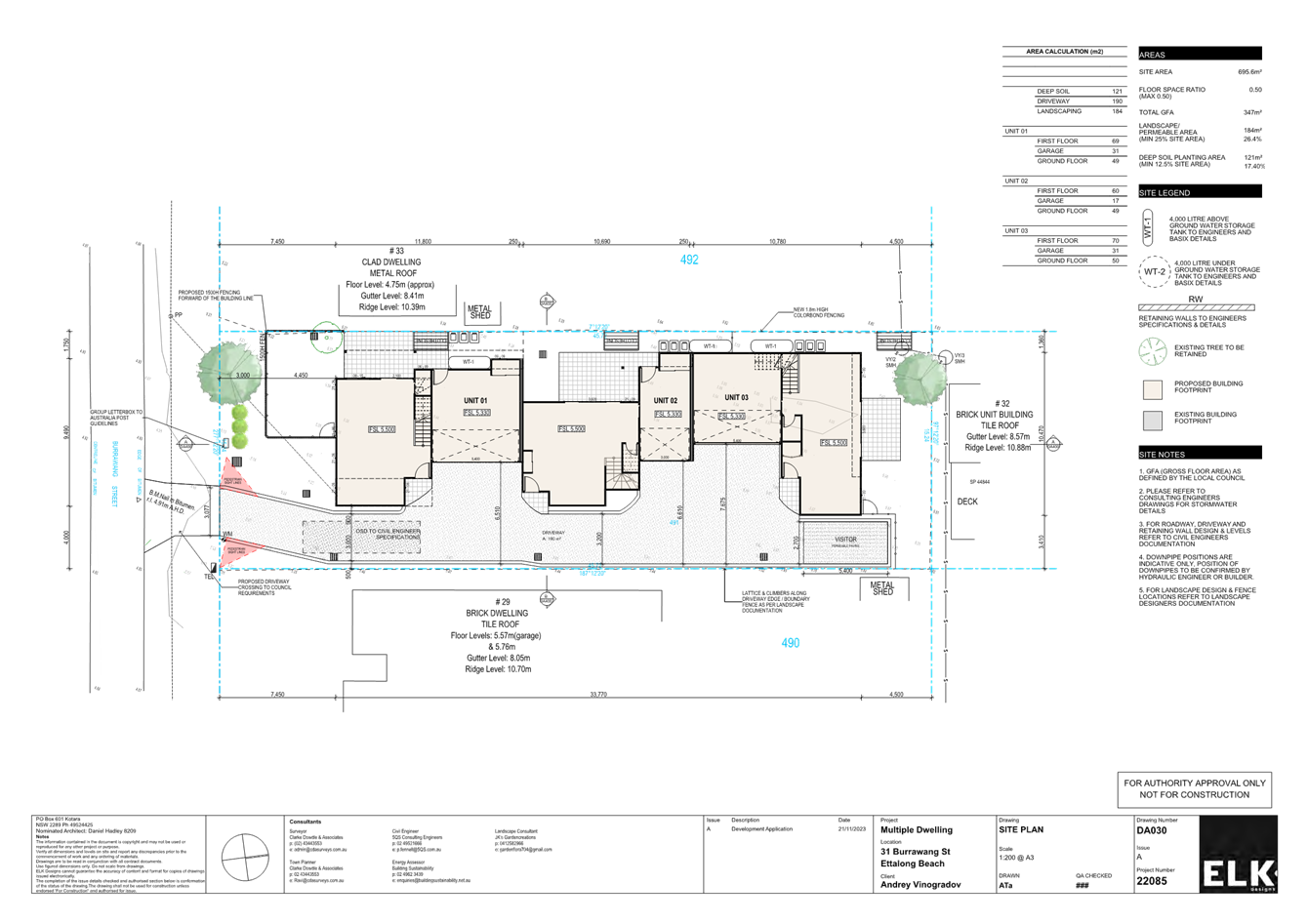
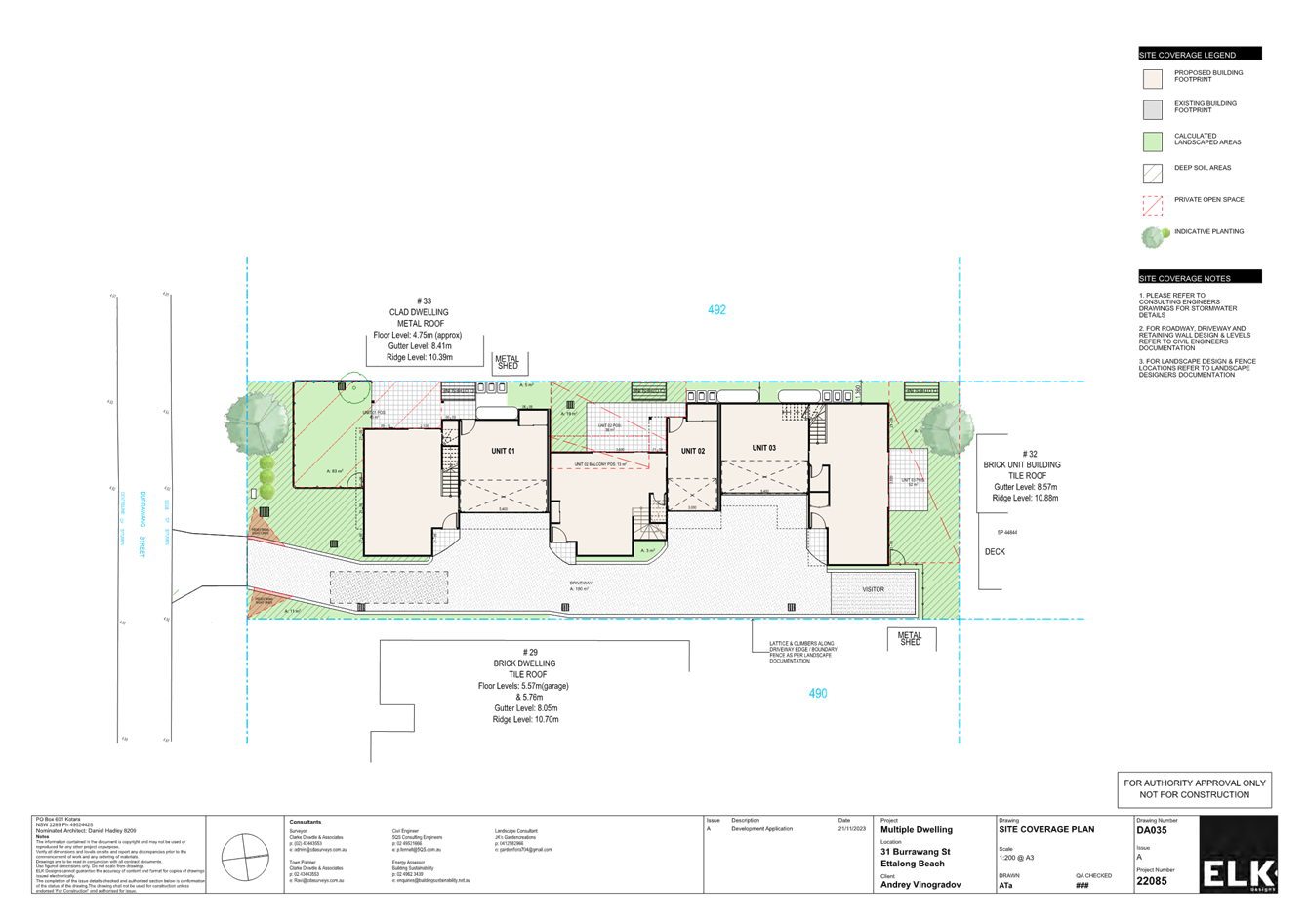
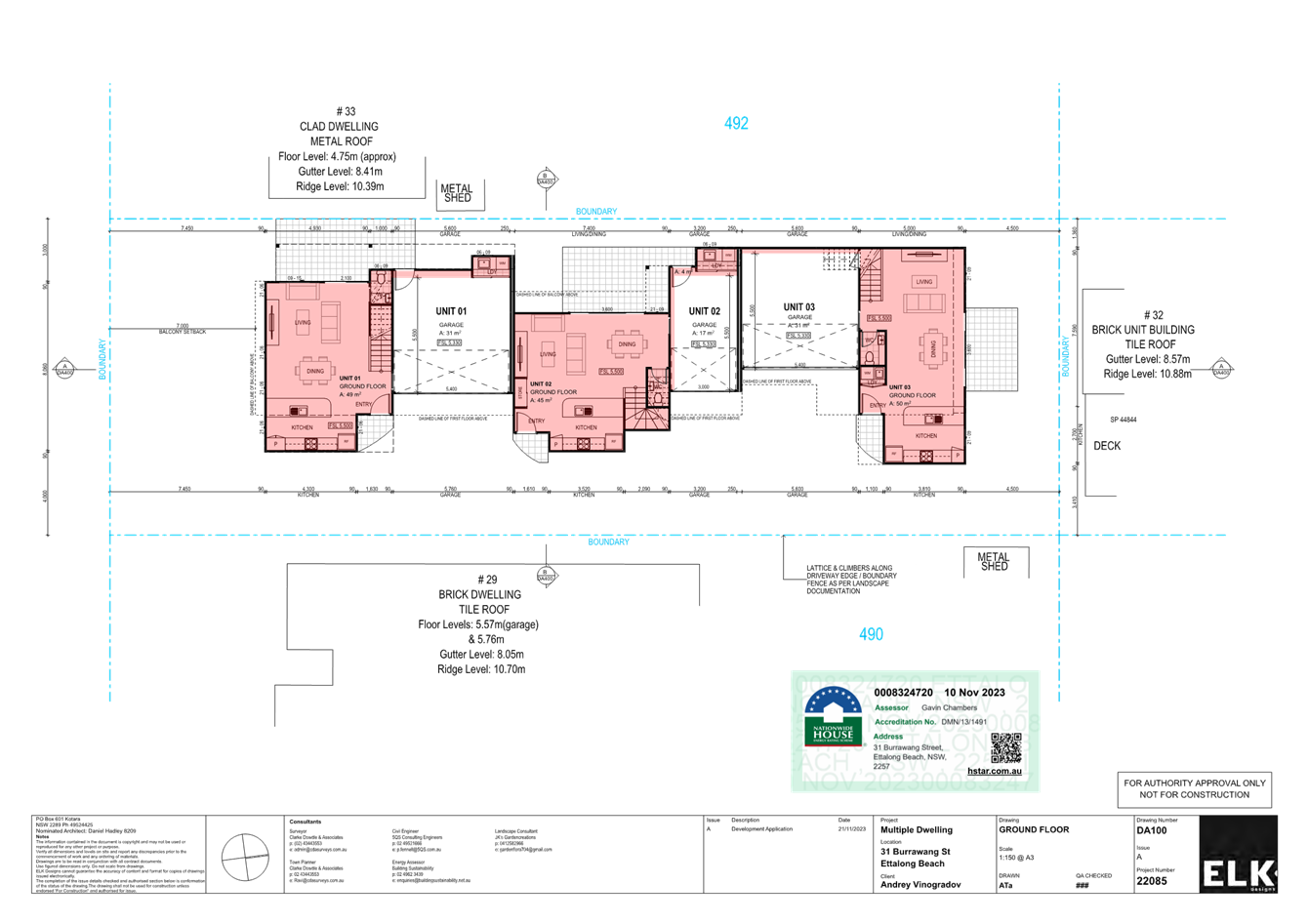
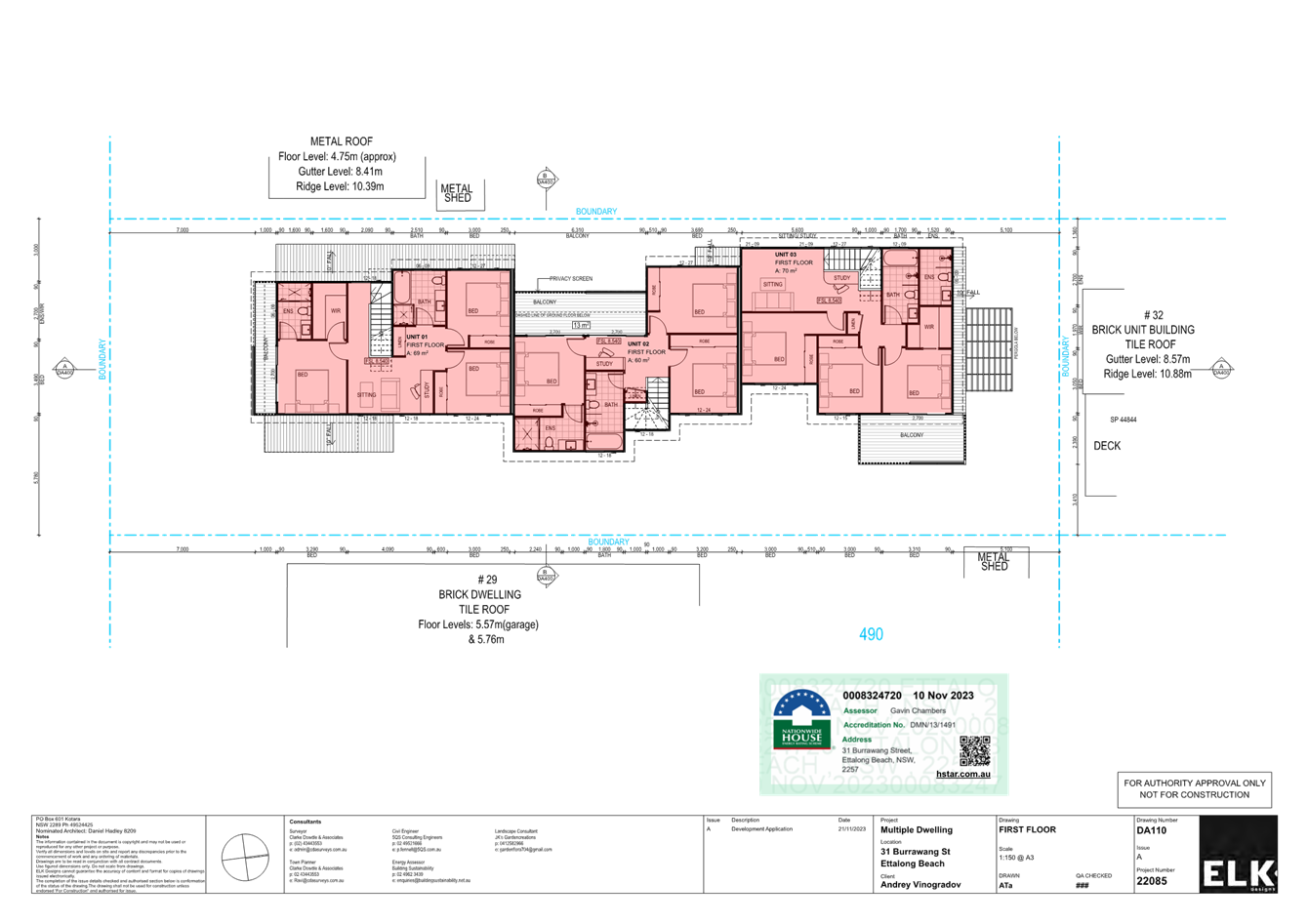
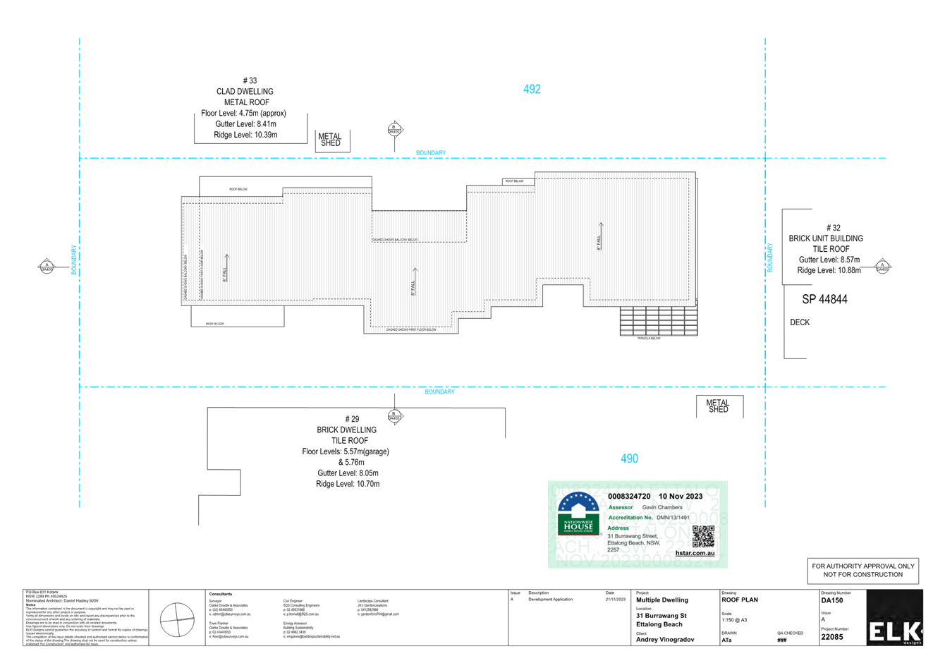
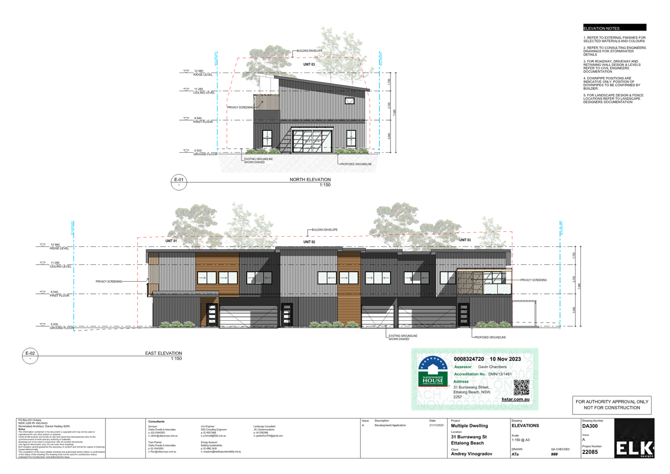
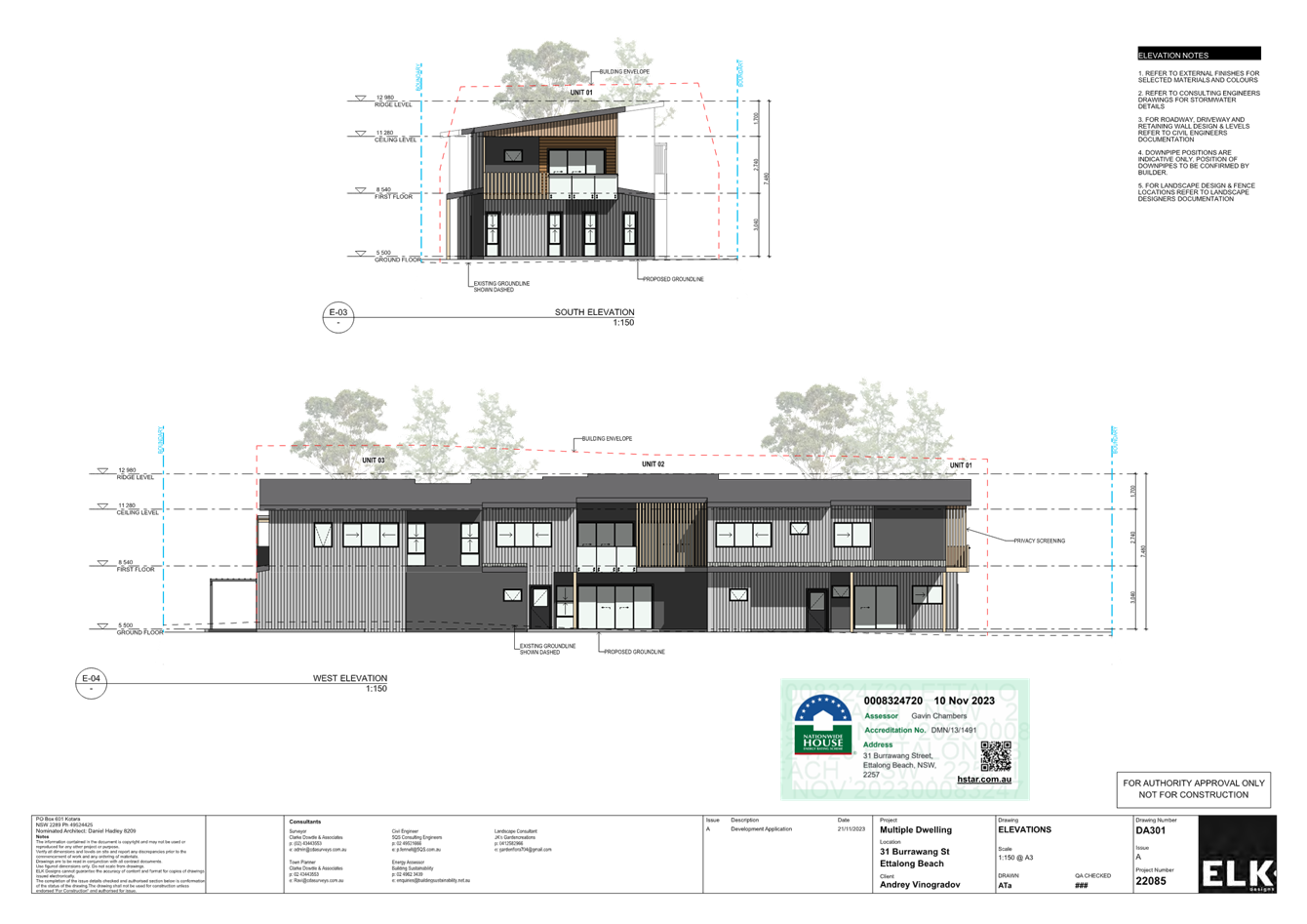
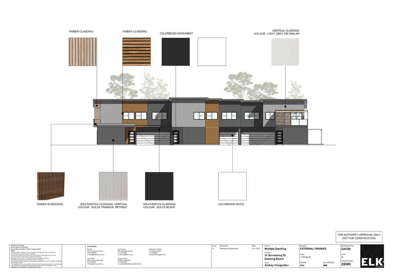
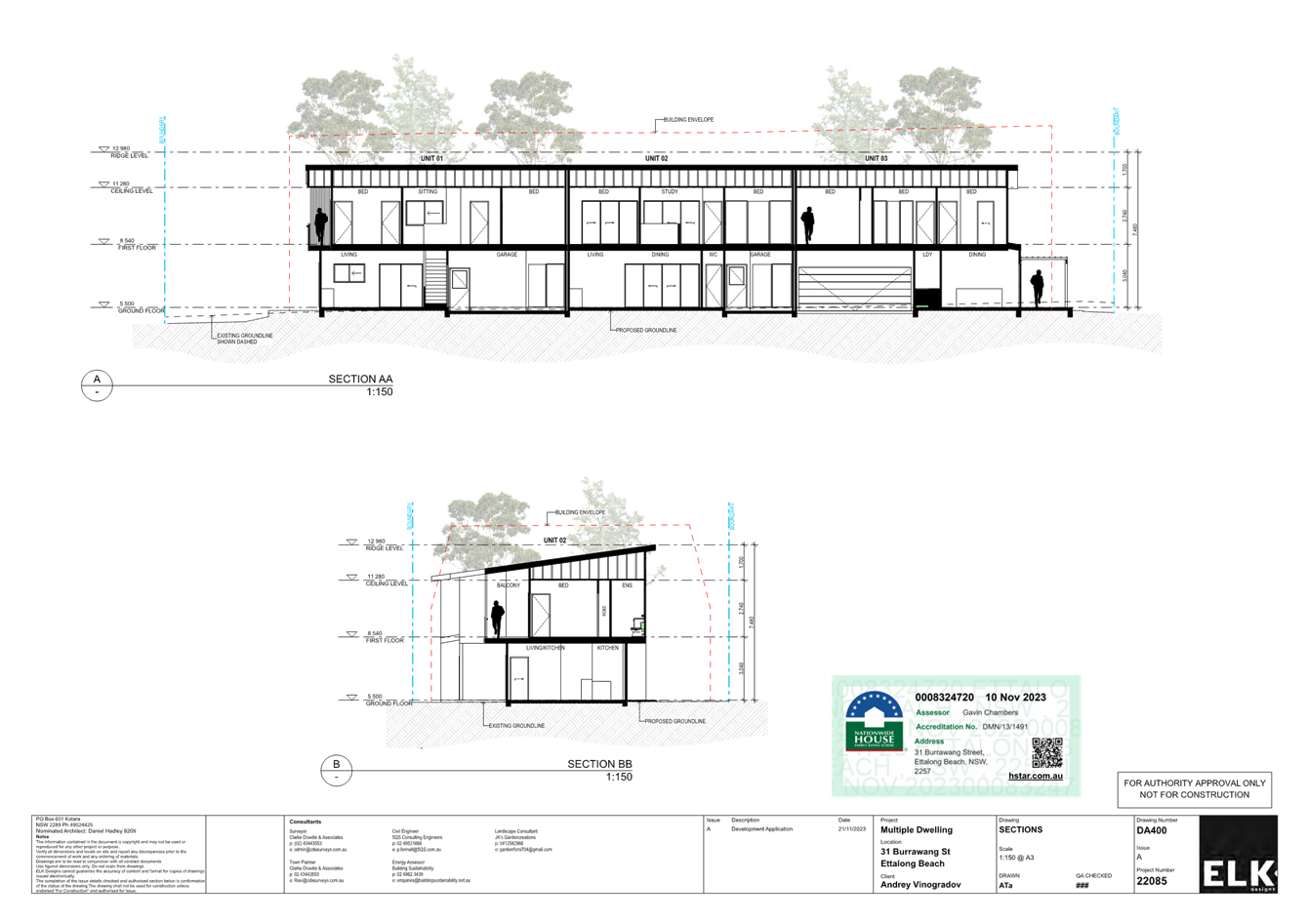
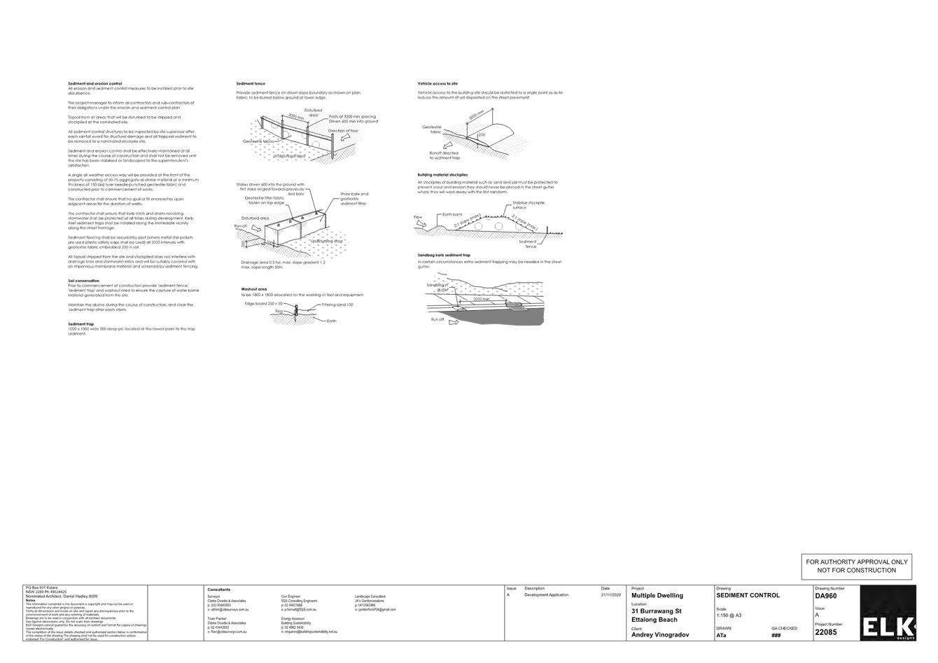
|
DA/4365/2022 - 31 Burrawang Street Ettalong Beach - Multi-Dwelling housing (3 Units) & Demolition of Existing Structures |
|
|
Attachment 3 |
Revised Landscape Plan - 31 Burrawang Street Ettalong Beach - DA/4365/2022 |
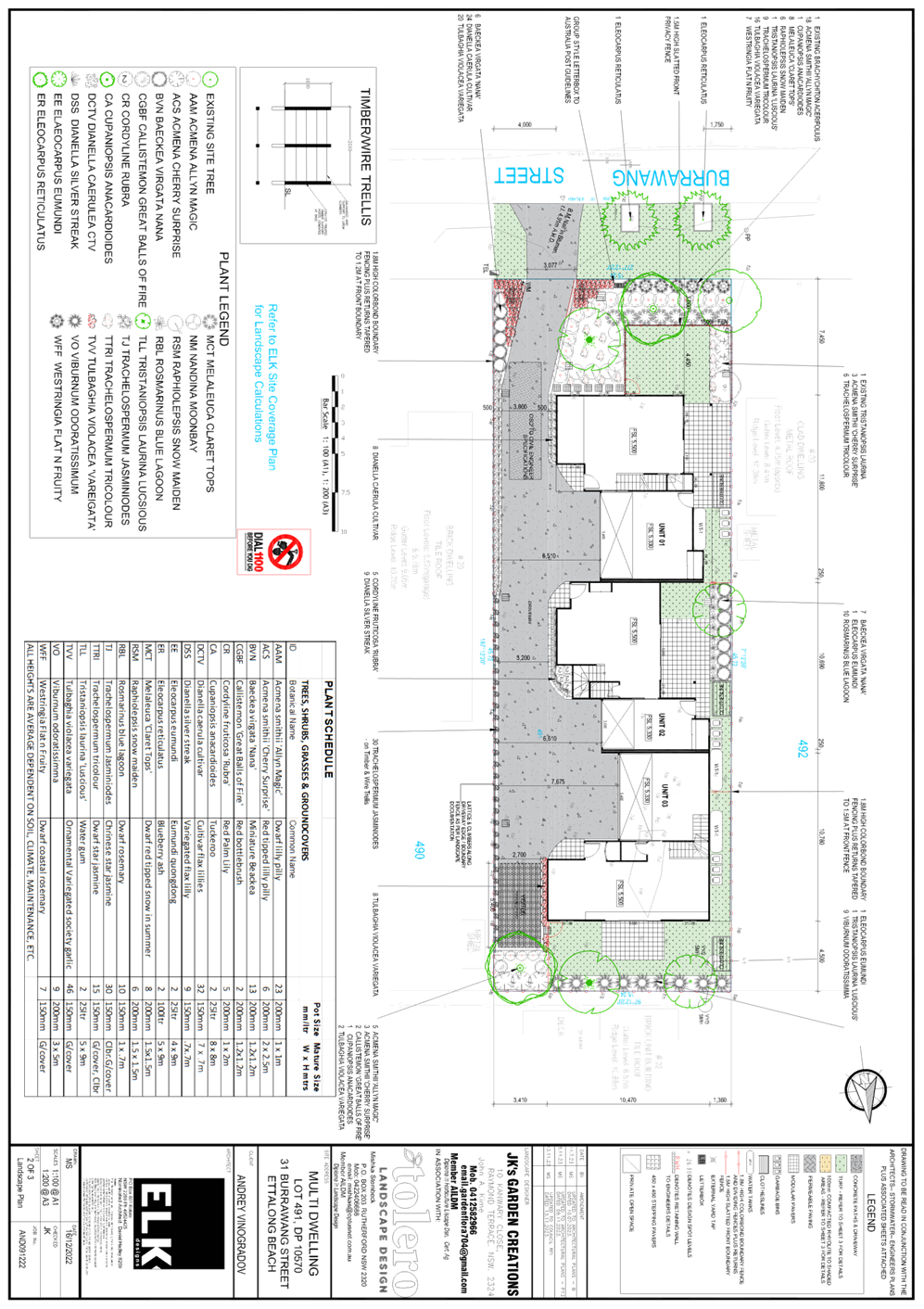
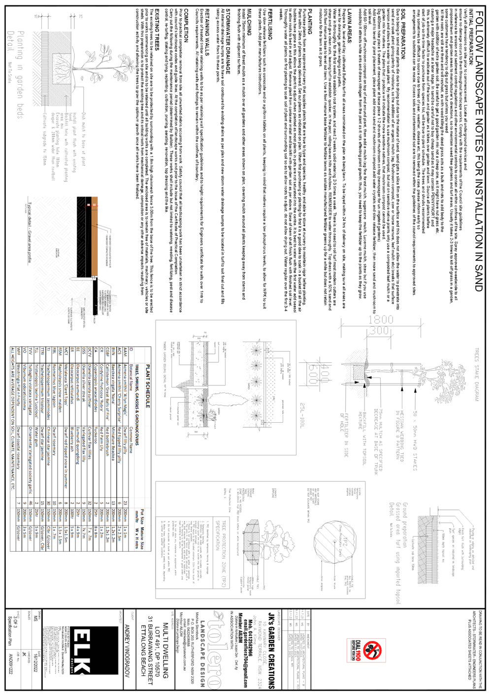
|
DA/4365/2022 - 31 Burrawang Street Ettalong Beach - Multi-Dwelling housing (3 Units) & Demolition of Existing Structures |
|
|
Attachment 4 |
BASIX Certificate - 31 Burrawang Street Ettalong Beach - DA/4365/2022 |
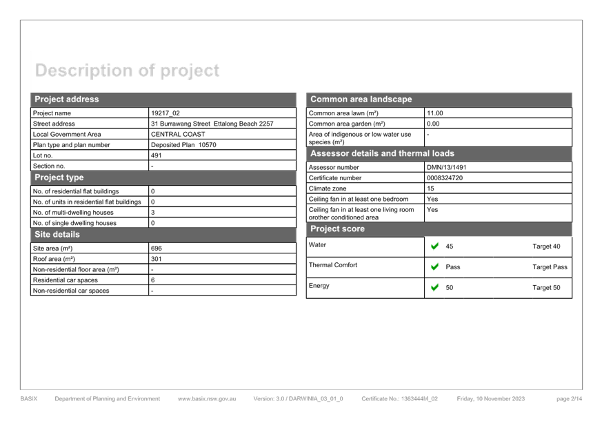
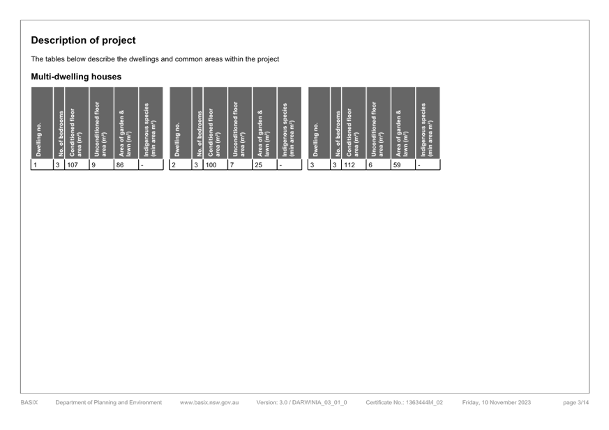
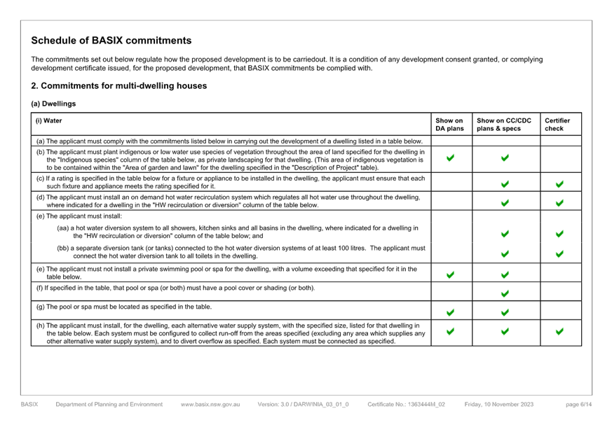
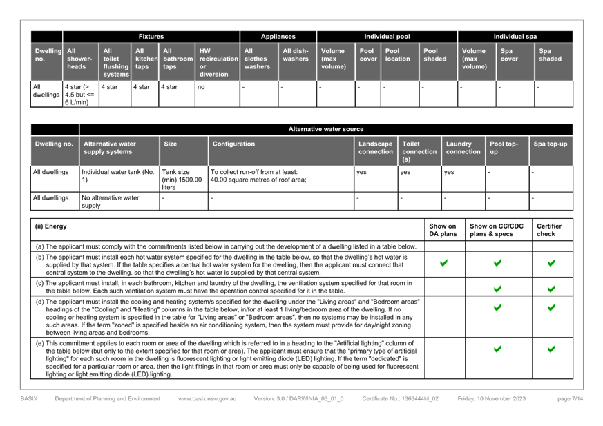
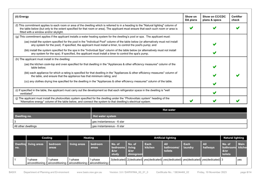
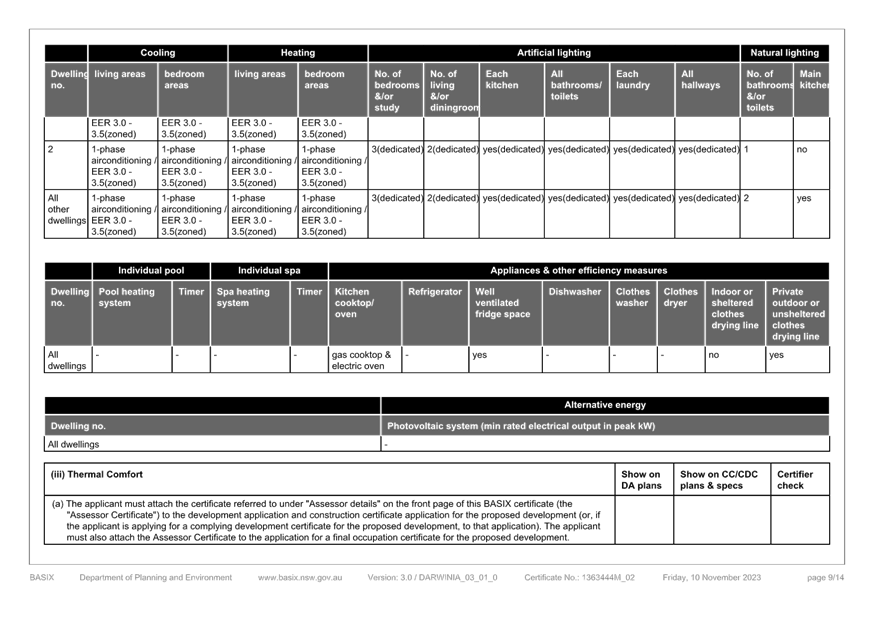
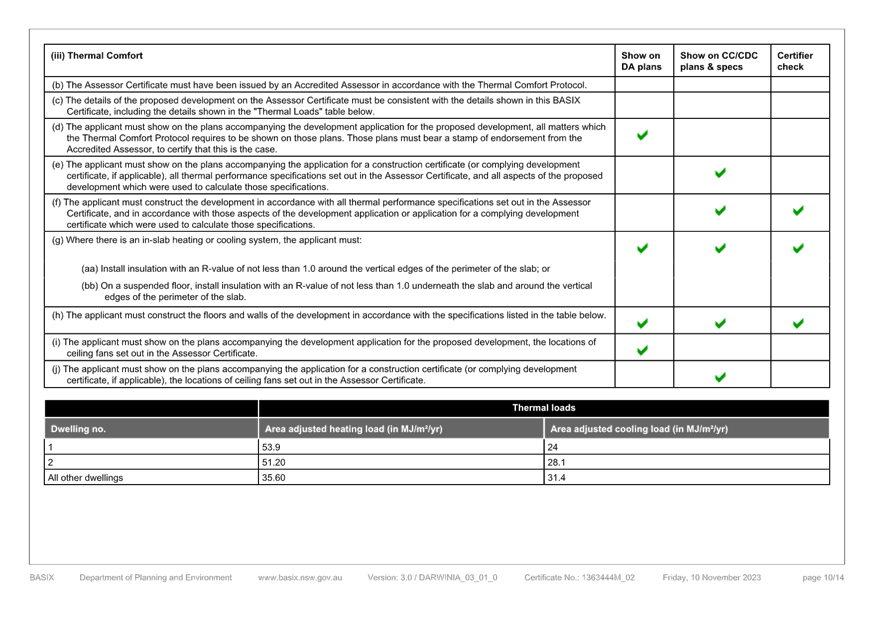
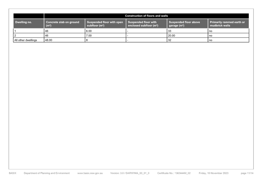
|
DA/4365/2022 - 31 Burrawang Street Ettalong Beach - Multi-Dwelling housing (3 Units) & Demolition of Existing Structures |
|
|
Attachment 5 |
Swept Turning Paths - 31 Burrawang Street Ettalong Beach - DA/4365/2022 |
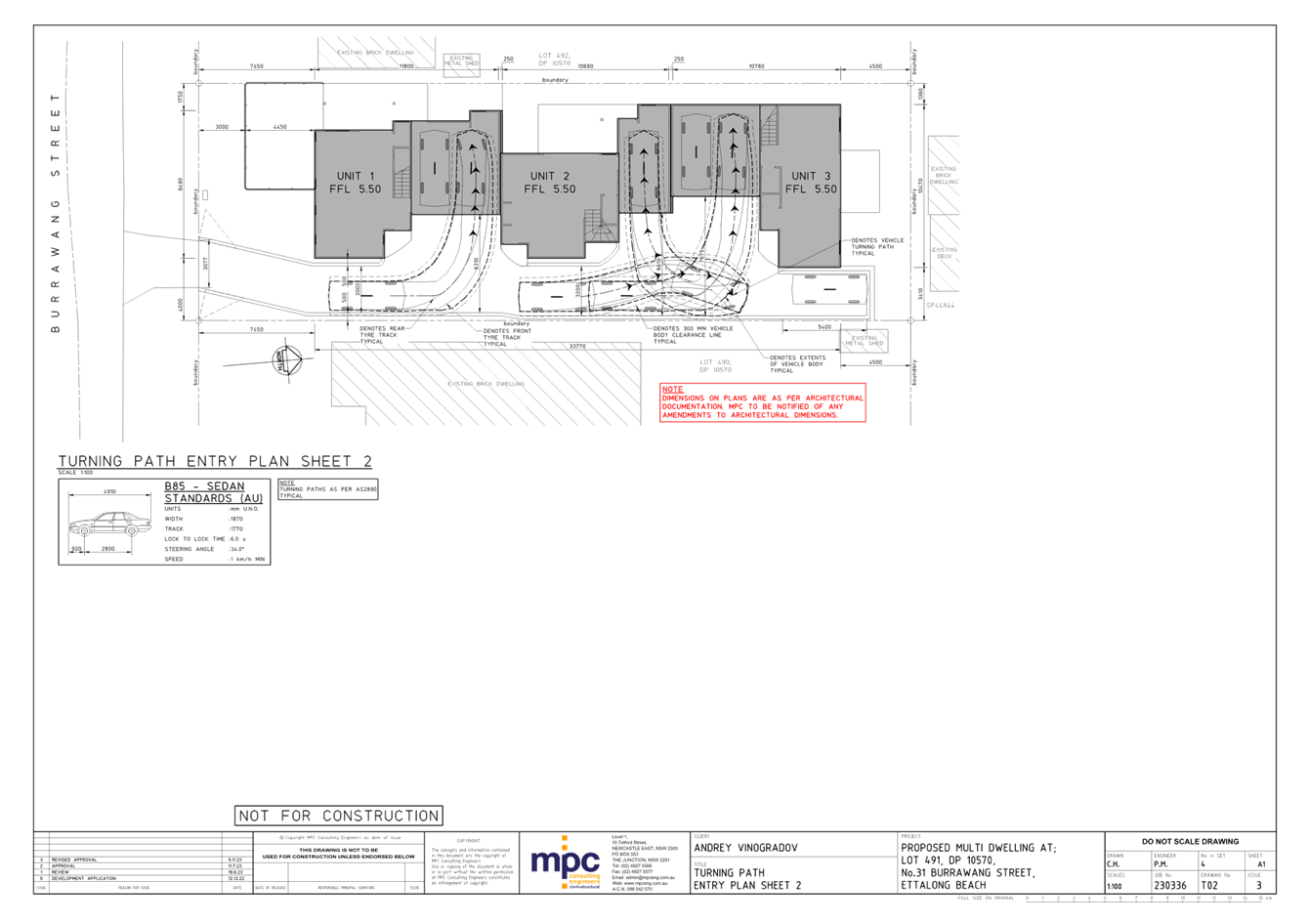
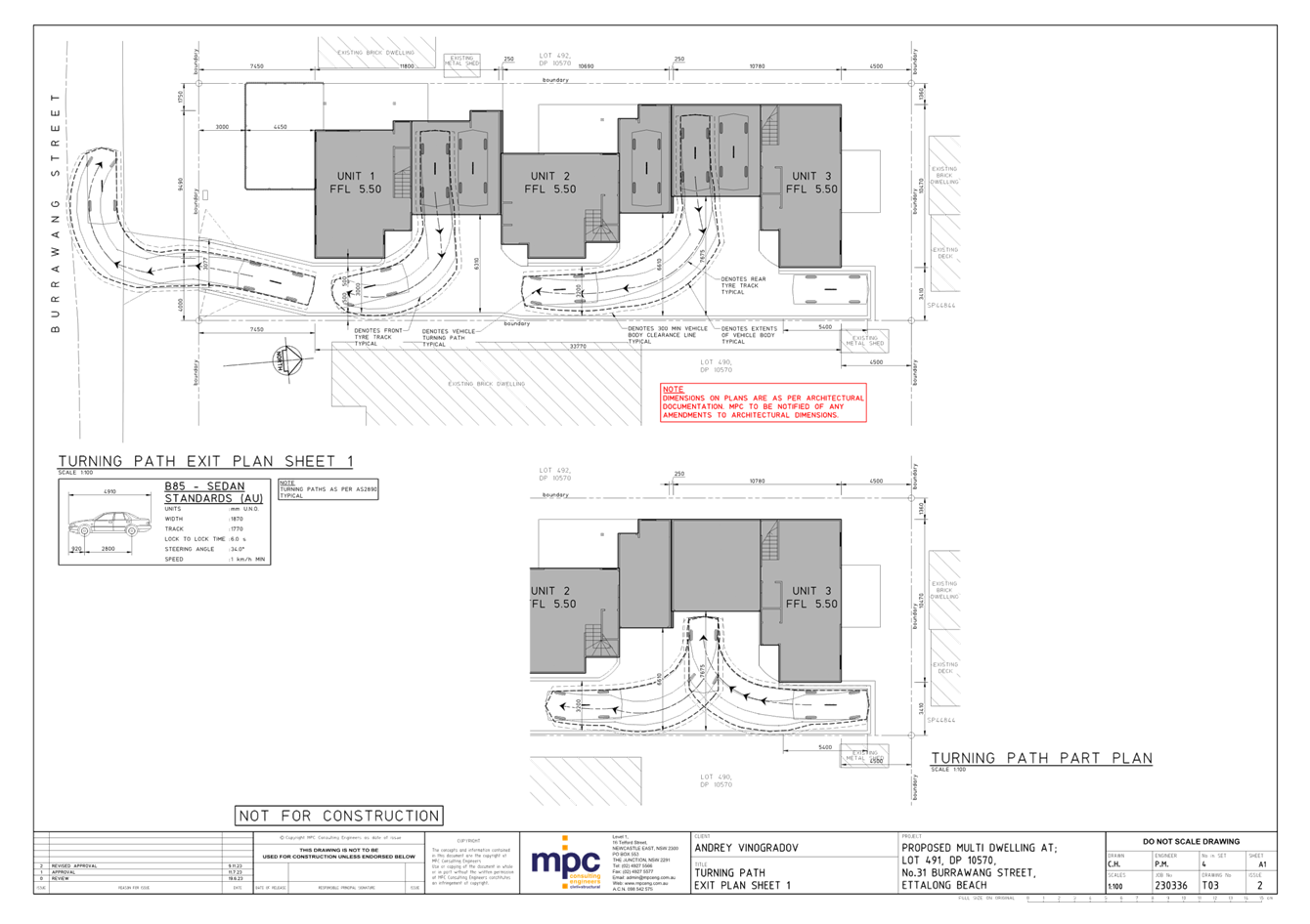
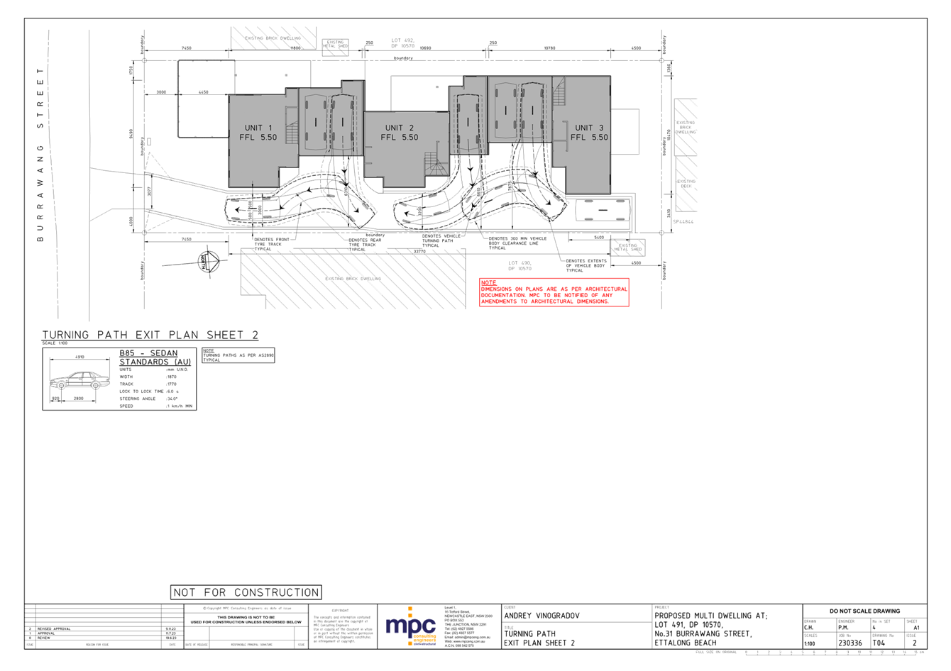
|
DA/4365/2022 - 31 Burrawang Street Ettalong Beach - Multi-Dwelling housing (3 Units) & Demolition of Existing Structures |
|
|
Attachment 6 |
Water Cycle Management Plan - 31 Burrawang Street Ettalong Beach - DA/4365/2022 |
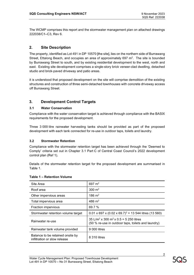
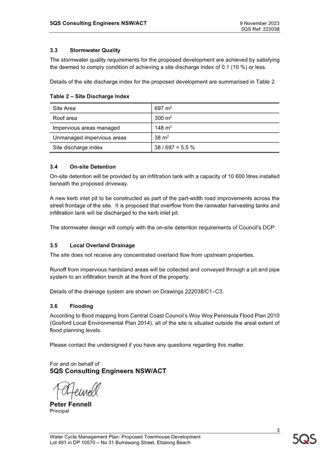
|
DA/4365/2022 - 31 Burrawang Street Ettalong Beach - Multi-Dwelling housing (3 Units) & Demolition of Existing Structures |
|
|
Attachment 7 |
PUBLIC - Geotechnical report - 31 BURRAWANG STREET ETTALONG BEACH 2257 - PAN-295396 - DA/4365/2022.pdf |