 |
Central Coast
Local Planning Panel Meeting
Business Paper
15 February 2024
 |
|
Central Coast
Local Planning Panel Meeting
Business Paper
15 February 2024
|
The Local Planning Panel Meeting
of Central Coast
will be held remotely - online,
Thursday 15 February 2024 at 2.00 pm,
for the transaction of the business listed below:
1 Procedural Items
1.1 Disclosures of Interest.............................................................................................................................. 3
2 Confirmation of Minutes of Previous Meetings
2.1 Confirmation of Minutes of Previous Meeting................................................................................. 4
3 Planning Reports
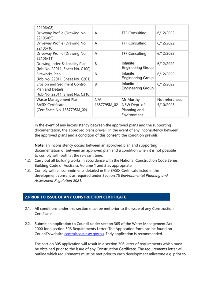
3.1 DA/4112/2022 - 15 Allfield Road WOY WOY................................................................................. 28
4 Planning Reports- Outside of Public Meeting
4.1 Land and Environment Court Proceedings Class 1 - Case 2023/00065846 - Appeal of Deemed Refusal - Central Coast Council ats CCS Design Pty Ltd - DA/3337/2022 - 16 Sydney Avenue Umina Beach............................................................................................................................................. 84
5 Reports
5.1 Supplementary Report - DA/60589/2020 - Dwelling House and Garage - 129 Alan Street, Niagara Park.............................................................................................................................................................. 85
5.2 DA/1436/2023 - 52-54 Fishermans Parade, Daleys Point - Alterations & Additions...... 152
Donna Rygate
Chairperson
|
Item No: 1.1 |
|
|
Title: Disclosures of Interest |
|
|
Department: Governance |
|
|
15 February 2024 Local Planning Panel Meeting |
|
Reference: F2020/02502 - D14205789
|
The NSW Local Planning Panel Code of Conduct states that all panel members must sign a declaration of interest in relation to each matter on the agenda before or at the beginning of each meeting.
|
That Panel Members now confirm that they have signed a declaration of interest in relation to each matter on the agenda for this meeting and will take any management measures identified.
|
Item No: 2.1 |
|
|
Title: Confirmation of Minutes of Previous Meeting |
|
|
Department: Corporate Services |
|
|
15 February 2024 Local Planning Panel Meeting |
|
Reference: F2020/02502 - D15995528
Author: Lisa Martin, Civic Support Officer Civic Support
|
Summary
The
Minutes of the following Meeting of the Local Planning Panel, which have been
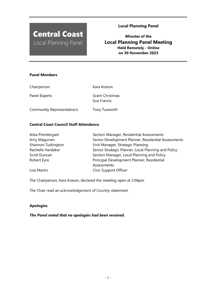
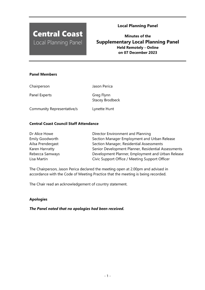
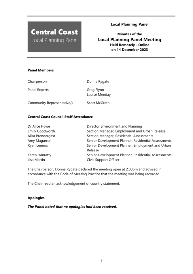
endorsed by the Chair of that meeting, are submitted for noting: · Local Planning Panel Meeting held on 30 November 2023 · Local Planning Panel Meeting held on 7 December 2023 · Local Planning Panel Meeting held on 14 December 2023 |
That the minutes of the previous Local Planning Panel Meeting held on 30 November 2023, 7 December 2023 and 14 December 2023 which was endorsed by the Chair of that meeting, are submitted for noting.
|
1⇩ |
MINUTES - Local Planning Panel - 30 November 2023 |
|
D15975675 |
|
2⇩ |
MINUTES - Local Planning Panel - 7 December 2023 |
|
D15981299 |
|
3⇩ |
MINUTES - Local Planning Panel - 14 December 2023 |
|
D15991866 |
|
2.1 |
Confirmation of Minutes of Previous Meeting |
|
Attachment 1 |
MINUTES - Local Planning Panel - 30 November 2023 |

|
Confirmation of Minutes of Previous Meeting |
|
|
Attachment 2 |
MINUTES - Local Planning Panel - 7 December 2023 |
|
Confirmation of Minutes of Previous Meeting |
|
|
Attachment 3 |
MINUTES - Local Planning Panel - 14 December 2023 |

|
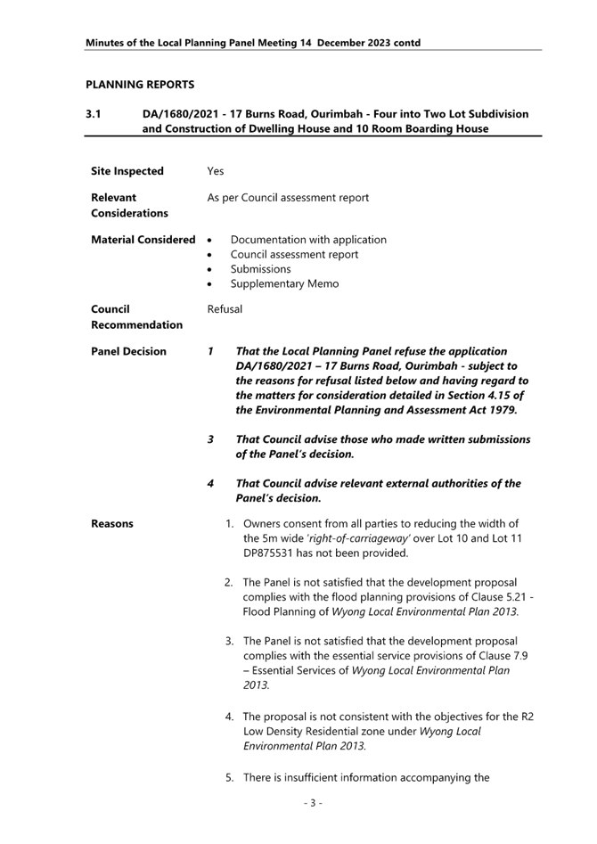
Item No: 3.1 |
|
|
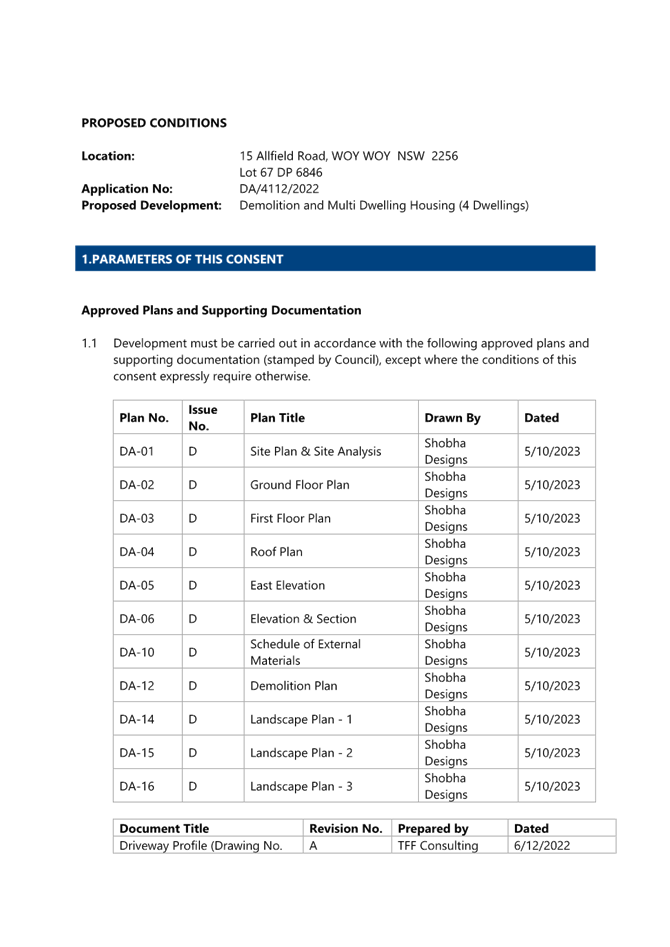
Title: DA/4112/2022 – 15 Allfield Street Woy Woy - Demolition and construction of Multi Dwelling Housing (4 Dwellings) |
|
|
Department: Environment and Planning |
|
|
Local Planning Panel Meeting |
|
Reference: DA/4112/2022 – D16019576
Author: Helena Miller, MG Planning (Development Planner Consultant)
Unit Manager: Andrew Roach, Unit Manager. Development Assessment
Executive: Alice Howe, Director Environment and Planning
|
Summary
An application has been received for the demolition of an existing dwelling house, ancillary structure and tree removal and the construction of Multi Dwelling Housing (consisting of 4 x townhouses) at 15 Allfield Road, Woy Woy. The application has been examined having regard to the matters for consideration detailed in Section 4.15 of the Environmental Planning and Assessment Act 1979 and other statutory requirements with the issues requiring attention and consideration being addressed in this report.
The application is required to be forwarded to the Local Planning Panel for determination as a result of submissions. Eleven unique submissions were received during the notification period.
The application is recommended for approval, subject to conditions.
(Please note that the application assessment has been undertaken by a planning consultant on behalf of Council).
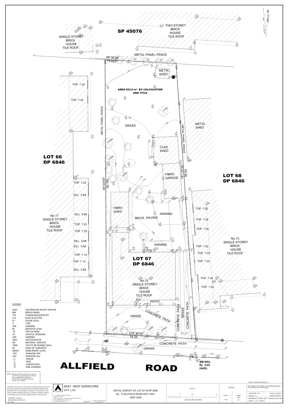
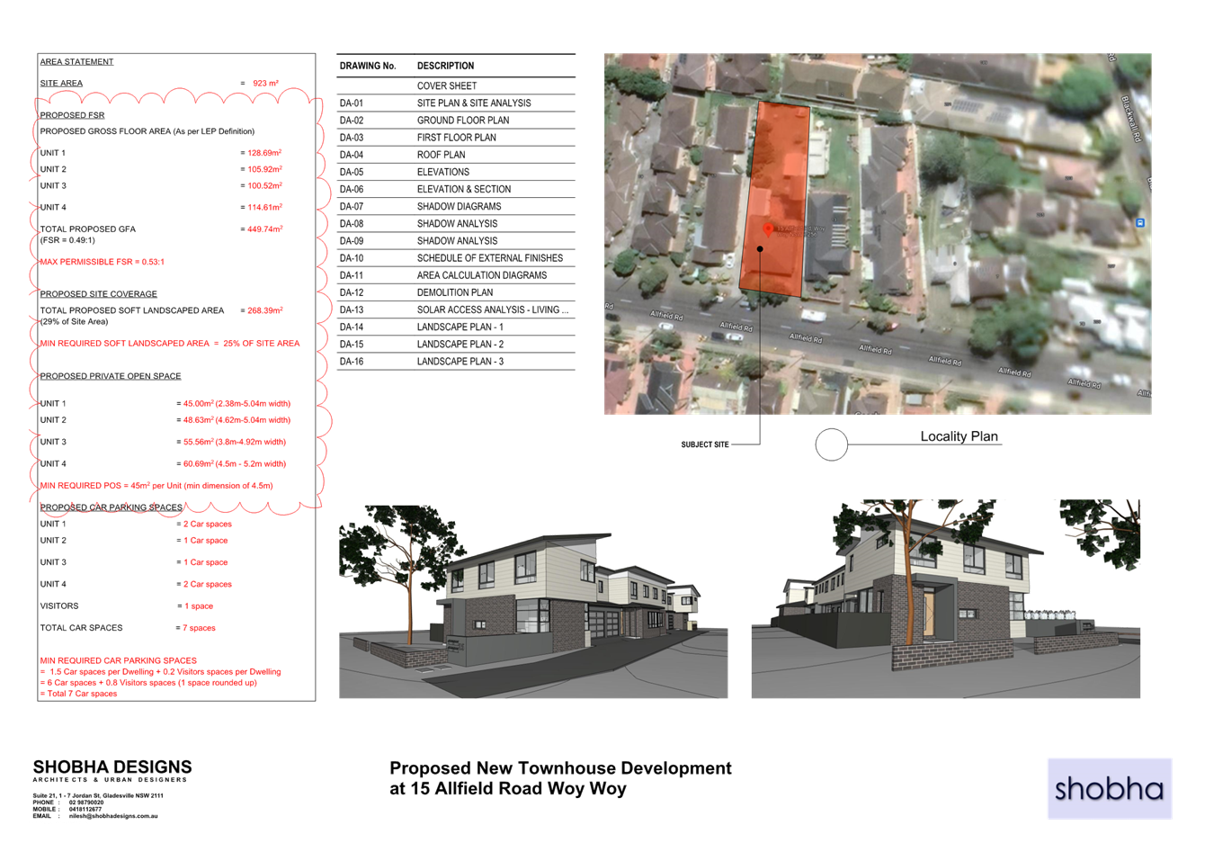
Applicant NM Nagarajan Owner Ms Janice Green Application No DA/4112/2022 Description of Land 15 Allfield Road, Woy Woy - Lot 67 DP 6846 Proposed Development Demolition and construction of Multi Dwelling Housing consisting of 4 x 4 bedroom 2 storey townhouses, parking for 7 cars, associated works and subdivision Site Area 923.20m2 Zoning R1 General Residential under CCLEP 2022 Existing Use Dwelling house Employment Generation No Estimated Value $1,314,500
|
Recommendation
1 That the Local Planning Panel grant consent to DA/4112/2022 – 15 Allfield Road, Woy Woy – Lot 67 DP 6846 subject to the attached conditions and having regard to the matters for consideration detailed in Section 4.15 of the Environmental Planning and Assessment Act 1979.
2 That Council advise those who made written submissions of the Panel’s decision.
Key Issues
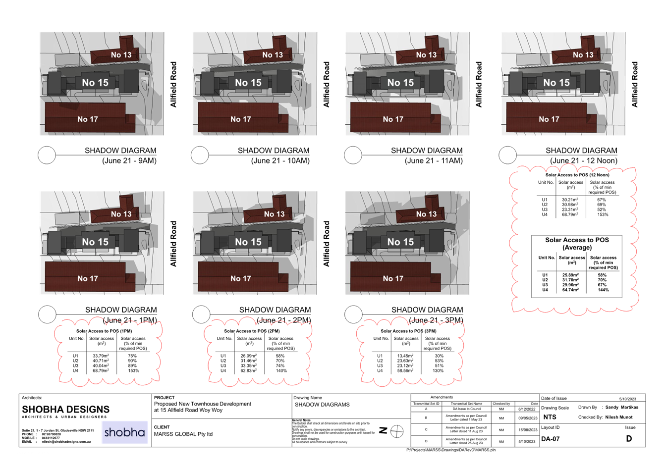
· Non-compliance with Chapter 2.2 Dual Occupancy & Multi Dwelling Housing of the Central Coast Development Control Plan 2022 in regard to width of private open space and the provision of three hours of solar access to 50% of the private open space on 21 June, and
· Matters raised in public submissions, including privacy concerns.
Precis:
|
Proposed Development |
Demolition and construction of Multi Dwelling Housing consisting of 4 x 4 bedroom 2 storey townhouses, parking for 7 cars, associated works and subdivision |
|
Permissibility and Zoning |
The subject site is zoned R1 General Residential under the provisions of Central Coast Local Environmental Plan 2022. The proposed development is defined as multi dwelling housing which is permissible in the zone with consent. |
|
Current Use |
Dwelling house |
|
Integrated Development |
No |
|
Submissions |
11 submissions |
Variations to Policies
|
Clause |
CCDCP 2022 – Part 2.2.7.3 (Private Open Space Areas) |
|
Standard |
Private open space of minimum of 45m2 with minimum dimension of 4.5m |
|
Departure basis |
Achieves minimum of 45m2 for all townhouses however does not achieve minimum 4.5m dimension as follows: Unit 1: 2.38m (2.12m or 47.2% variation) Unit 2: 4.06m (0.48m or 10.07% variation) Unit 3: 3.8m (0.7m or 16% variation) Unit 4: 4.5m – complies
|
|
Clause |
CCDCP 2022 – Part 2.2.7.5 (Sunlight Access) |
|
Standard |
On 21 June 50% of POS to receive at least 3 hours of direct sunlight between 9am and 3pm |
|
Departure basis |
Does not achieve for Unit 1 as follows: Unit 1: receives 2 hours of solar access to > 50% of POS between 12 – 1pm and 1pm and 2pm on 21 June only
|
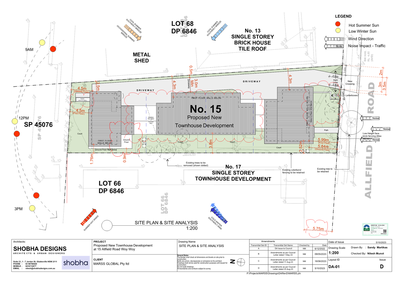
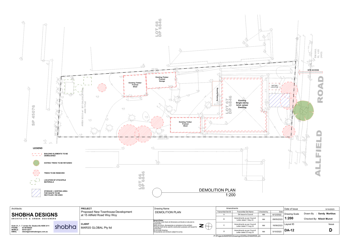
The Site and Surrounding Development
The site is legally described as Lot 67 DP 6846 and known as 15 Allfield Road, Woy Woy. It is located on the northern side of the street between the intersections of Allfield Road and Edward Street (west) and Blackwall Road (east) (Figures 1 and 2).
The site is regular in shape with a width of 18.29m at the front and 14.625m at the rear (north). It has an average depth of 56.37m and an area of 923.20m2. It currently contains a single storey dwelling and three outbuildings. The existing structure is predominantly brick with the outbuildings being a mix of fibro-cement and cladding.
The site topography is generally flat with a slight fall (300mm) from front to the back (north) of the site.
Adjoining development comprises multi dwelling development and detached dwellings with a mix of single and two storey dwellings.
The site is not identified as being "bushfire prone land" on Council's bushfire maps.
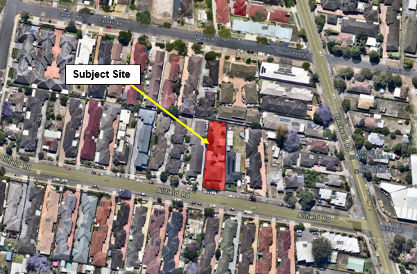
Figure 1 – Site locality plan
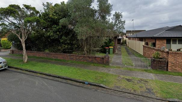
Figure 2 – Site as viewed from Allfield Road looking north
The Proposed Development
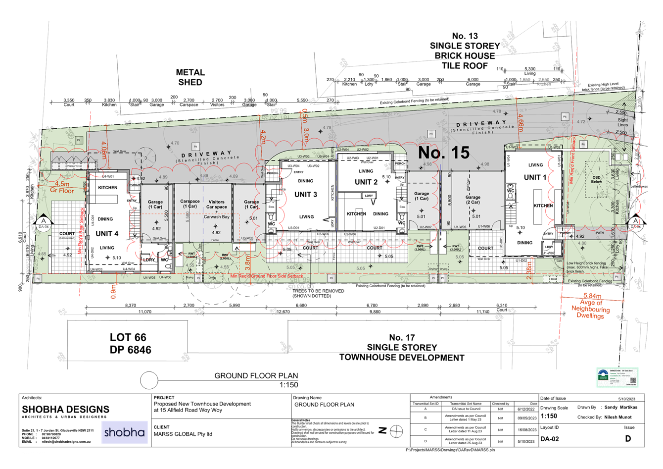
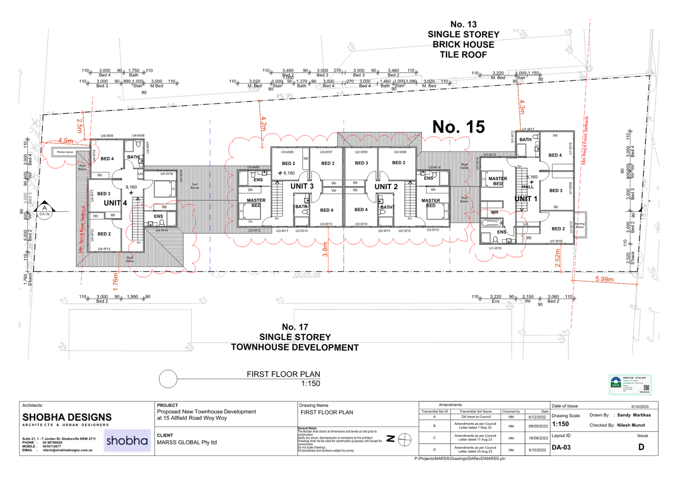
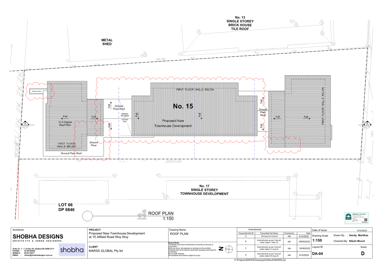
The application seeks development consent for the redevelopment of the subject site including (Figures 3-8):
· Demolition of all existing structures
· Construction of 4 x 4 bedroom 2-storey townhouses
· 6 x car parking spaces plus 1 x visitor space
· Vehicular access via a driveway that would run along the eastern site boundary, and
· Landscaping and services.
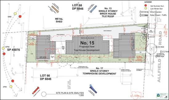
Figure 3 – Site plan
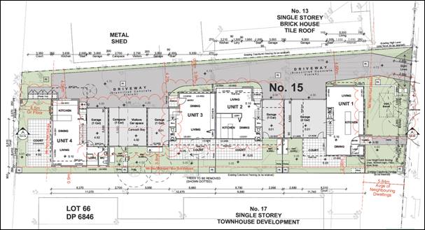
Figure 4 – Ground floor plan

Figure 5 – First floor plan
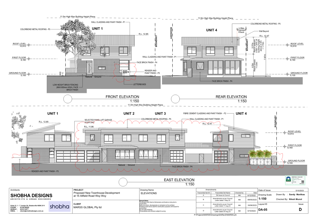
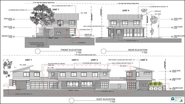 Figure 6 –
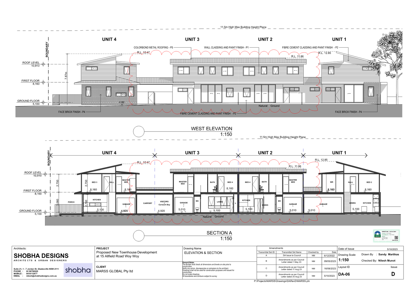
Elevations
Figure 6 –
Elevations
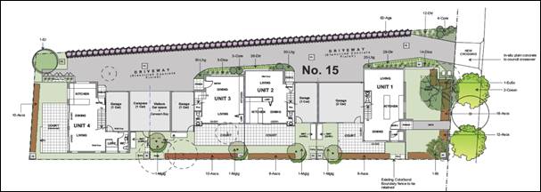
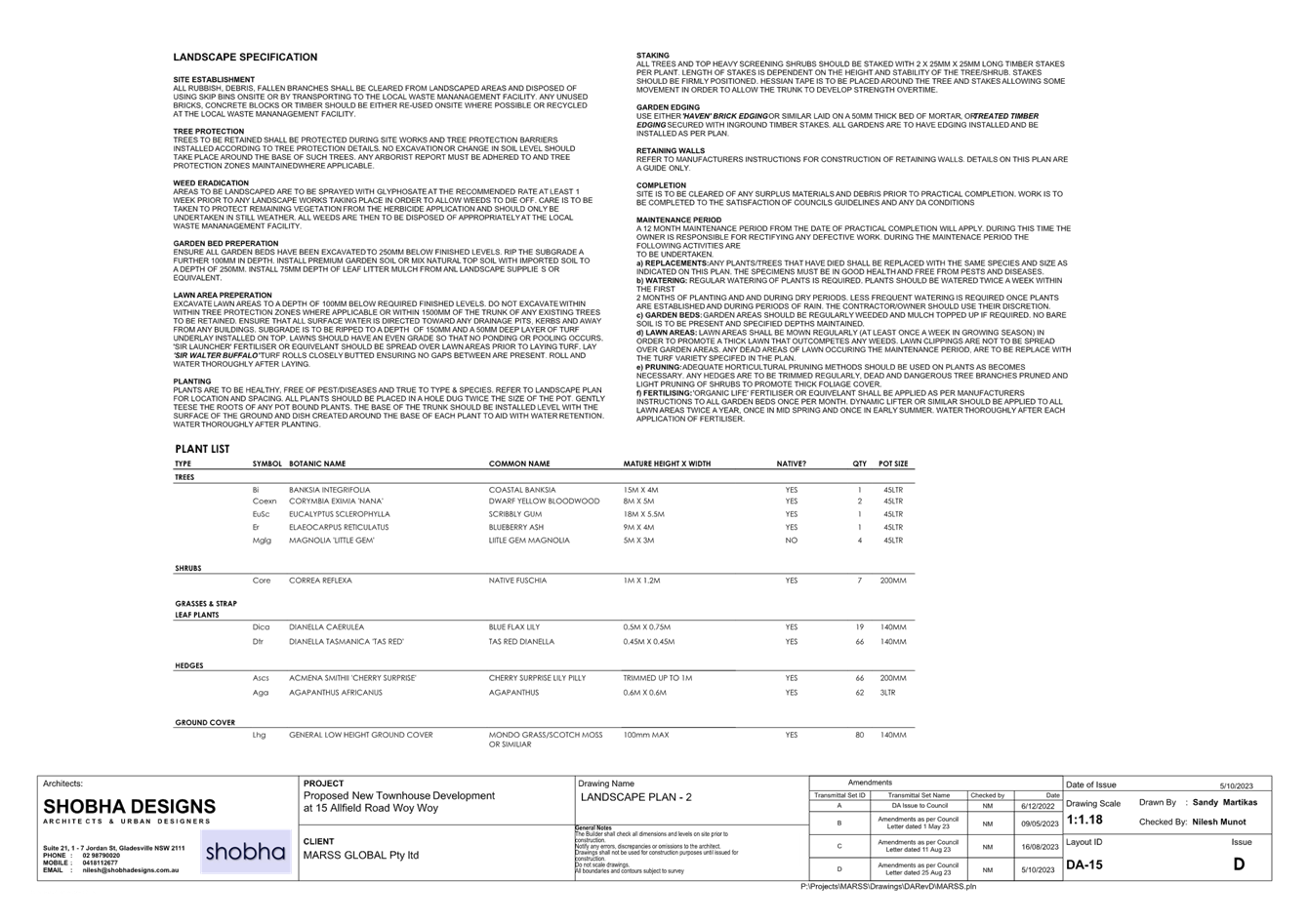
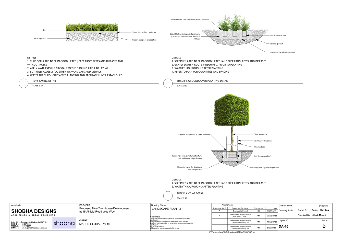
Figure 7 – Landscape plan
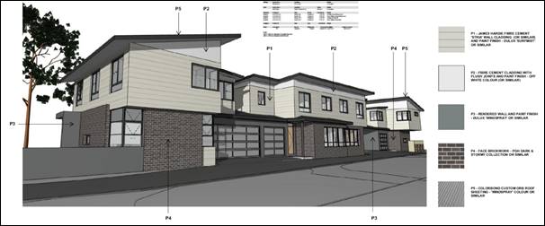 Figure 8 –
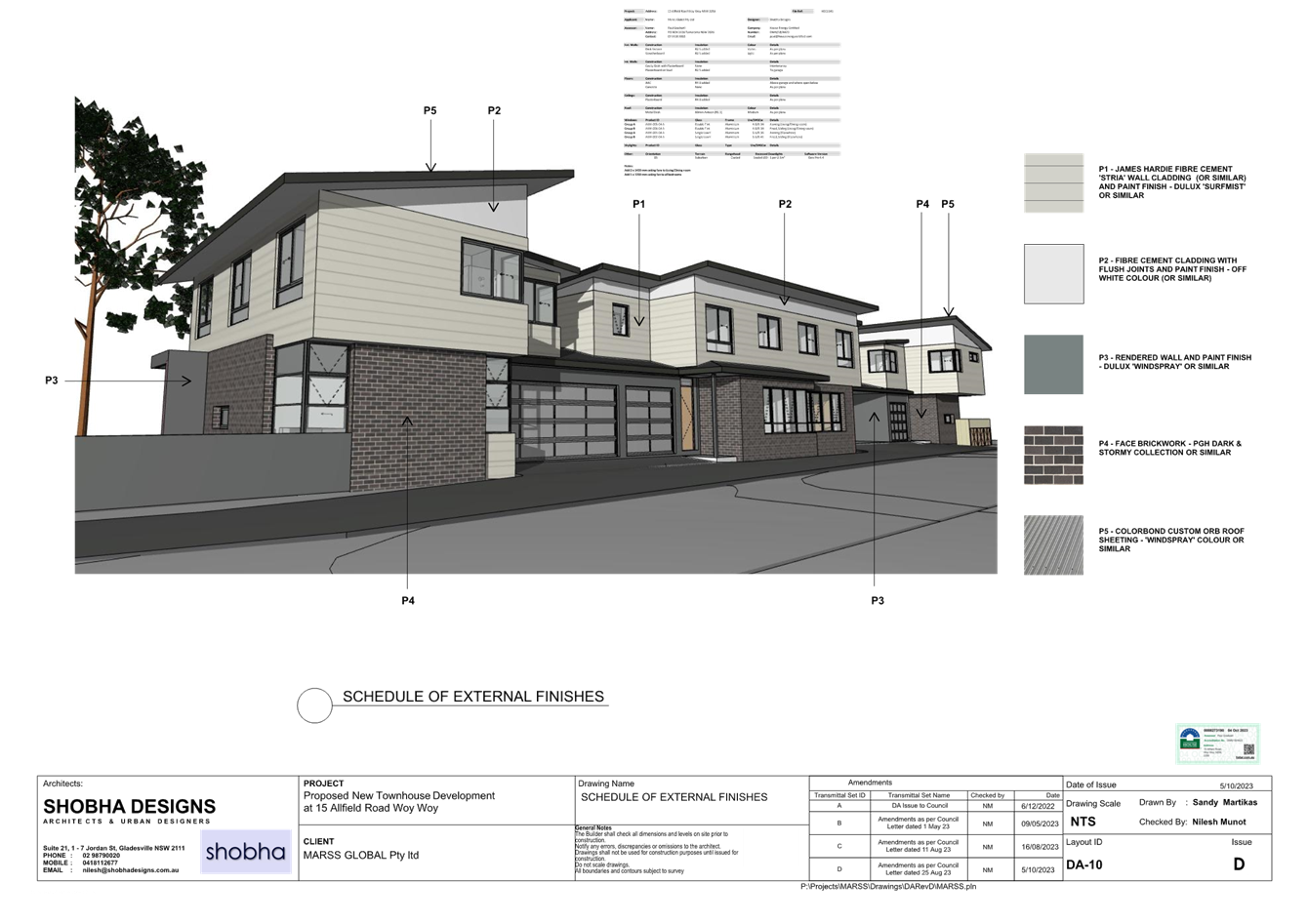
Materials and finishes
Figure 8 –
Materials and finishes
Relevant Background
The application was lodged on 1 November 2022.
Following preliminary assessment, a request for additional information letter (RFI) was issued by Council on 1 May 2023 requesting that the applicant address issues in relation to non-compliances with Central Coast Development Control Plan 2022 (CCDCP 2022) in relation to:
· visitor parking,
· side and rear setbacks, and
· minimum private open space (POS) area and dimensions.
Amended plans were submitted dated 9 May 2023 attempting to ameliorate the abovementioned issues.
A further RFI request was issued on 11 August 2023 identifying the abovementioned non-compliances in addition to inadequate information with regard to the front setback, solar access, building height and finished levels, fencing, driveway surface, landscaping and bin storage areas. A second set of amended plans was submitted on 16 August 2023.
On 25 August 2023 a third (and final) RFI was issued by Council noting that:
· A visitor parking space was proposed in the front setback, which was not supported,
· Three of the four units did not achieve the minimum POS dimension of 4.5m
· Only Unit 4 achieves three hours of sunlight to 50% of POS on 21 June, and
· Bin space was required for three bins per unit and should not require bins to be wheeled through units.
The RFI noted that overall the variations to the POS, carparking and solar access controls are indicative of the proposal being an overdevelopment of the site and accordingly recommended that the proposal be redesigned to remove one of the dwellings to provide sufficient room on-site for full compliance.
On 3 October
2023 a third set of amended plans were submitted by the applicant seeking to
address the final RFI. Amendments to the plans include:
· Inclusion of a visitor parking space behind the building line
· Inclusion of bin storage spaces, and
· Information to demonstrate that three of the four units achieve three hours of solar access to 50% of POS on 21 June.
The proposed 4 x 4 bedroom townhouse development was retained.
In accordance with CCDCP 2022 – Part 1.2.2.10, Control (c), the final set of amended plans were not renotified and readvertised as they were not considered to result in any additional impacts on the surrounding properties or the public domain.
ASSESSMENT:
Having regard for the matters for consideration detailed in Section 4.15 of the Environmental Planning and Assessment Act 1979 and other statutory requirements, Council’s policies and Section 10.7 Certificate details, the assessment has identified the following key issues, which are elaborated upon for the Panel’s information. Any tables relating to plans or policies are provided as an attachment.
Environmental Planning and Assessment Regulation 2021 (Demolition)
With regard to demolition of works as part of a development application, clause 61 of the Environmental Planning and Assessment Regulation 2021 provides additional matters that the consent authority must consider:
(1) In determining a development application for the demolition of a building, the consent authority must consider the Australian Standard AS 2601—2001: The Demolition of Structures.
Comment: The works will be covered by the Australian Standard As 2601-2001 and is conditioned for compliance as per draft conditions.
A waste management plan has been submitted and accepted. The Panel can be satisfied that the necessary demolition works required to facilitate the addition of the proposed lift will occur in accordance with AS2601-2001.
State Environmental Planning Policy (Building Sustainability Index: BASIX) 2004
The application is supported by an updated BASIX certificate (dated 5 October 2023), which confirms that the proposal will meet the NSW Government’s requirements for sustainability, if built in accordance with the commitments outlined in the certificate.
Accordingly, the proposal is considered to be consistent with the requirements of State Environmental Planning Policy (Building Sustainability Index: BASIX) 2004 subject to an appropriate condition of consent requiring compliance with the submitted BASIX certificate.
State Environmental Planning Policy (Resilience and Hazards) 2021 (Resilience and Hazards SEPP)
The Resilience and Hazards SEPP came into force on 1 March 2022 and replaced State Environmental Planning Policy No. 55 Remediation of Land and State Environmental Planning Policy (Coastal Management) 2018; however the provisions remain generally consistent.
Chapter 2 – Coastal Management
In relation to coastal management matters, Part 2.2 of the Resilience and Hazards SEPP requires that a consent authority consider the aims and objectives of the SEPP when determining a development application within the Coastal Management Areas. The subject land falls with the ‘coastal environment area’ under the SEPP. Consent cannot be granted in this area unless the consent authority has considered whether the development will have an adverse impact on:
(a) the integrity and resilience of the biophysical, hydrological (surface and groundwater) and ecological environment,
(b) coastal environmental values and natural coastal processes,
(c) the water quality of the marine estate (within the meaning of the (within the meaning of the Marine Estate Management Act 2014), in particular, the cumulative impacts of the proposed development on any of the sensitive coastal lakes identified in Schedule 1,
(d) marine vegetation, native vegetation and fauna and their habitats, undeveloped headlands and rock platforms,
(e) existing public open space and safe access to and along the foreshore, beach, headland or rock platform for members of the public, including persons with a disability,
(f) Aboriginal cultural heritage, practices and places,
(g) the use of the surf zone.
The proposal will not impact any of these matters. Further the consent authority must be satisfied that:
(a) the development is designed, sited and will be managed to avoid an adverse impact referred to in subsection (1), or
(b) if that impact cannot be reasonably avoided—the development is designed, sited and will be managed to minimise that impact, or
(c) if that impact cannot be minimised—the development will be managed to mitigate that impact.
The proposal satisfies these requirements and will not result in any adverse impacts upon the coastal environment area. Accordingly it is considered that the requirements under Part 2.2 of the Resilience and Hazards SEPP have been satisfied.
Chapter 4 – Remediation of Land
In relation to contamination, Chapter 4 of the Resilience and Hazards SEPP applies across NSW and requires that, prior to the granting of consent, a consent authority must give consideration as to whether the land, the subject of a development application, is contaminated and if so whether it can and will be made suitable for the proposed use. The current and historical use of the subject land is for domestic residential purposes and there are no known previous uses that would render the site contaminated or unsuitable for the proposed use. As such, the Panel can be satisfied that the proposed multi dwelling housing development is acceptable with regard to the provisions in Chapter 4 of the Resilience and Hazards SEPP.
State Environmental Planning Policy (Transport and Infrastructure) 2021 (Transport and Infrastructure SEPP)
Clause 2.48 of Transport and Infrastructure SEPP specifies the following:
(1) This section applies to a development application (or an application for modification of a consent) for development comprising or involving any of the following—
(a) the penetration of ground within 2m of an underground electricity power line or an electricity distribution pole or within 10m of any part of an electricity tower,
(b) development carried out—
(i) within or immediately adjacent to an easement for electricity purposes (whether or not the electricity infrastructure exists), or
(ii) immediately adjacent to an electricity substation, or
(iii) within 5m of an exposed overhead electricity power line,
(2) Before determining a development application (or an application for modification of a consent) for development to which this section applies, the consent authority must—
(a) give written notice to the electricity supply authority for the area in which the development is to be carried out, inviting comments about potential safety risks, and
(b) take into consideration any response to the notice that is received within 21 days after the notice is given
An electricity distribution pole is located on the road reserve adjoining the front boundary of the subject site. As such, consultation with Ausgrid was sought under clause 2.48(2) of the SEPP. Ausgrid raised no objections to the proposed development.
The proposal is therefore acceptable with regard to the provisions in clause 2.48 of the Transport and Infrastructure SEPP.
Central Coast Local Environmental Plan 2022 (CCLEP 2022) - Permissibility
The subject site is zoned R1 General Residential under the provisions for Central Coast Local Environmental Plan 2022 (CCLEP 2022). The proposed land use is consistent with the CCLEP 2022 definition of multi dwelling housing, being:
multi dwelling housing means 3 or more dwellings (whether attached or detached) on one lot of land, each with access at ground level, but does not include a residential flat building.
Development for the purposes of multi dwelling housing is permissible with consent in the R1 zone.
Central Coast Local Environmental Plan 2022 (CCLEP 2022) - Zone Objectives
The objectives of the R1 General Residential zone are as follows:
· To provide for the housing needs of the community.
· To provide for a variety of housing types and densities.
· To enable other land uses that provide facilities or services to meet the day to day needs of residents.
· To promote best practice in the design of multi dwelling housing and other similar types of development.
· To ensure that non-residential uses do not adversely affect residential amenity or place unreasonable demands on services.
The proposed development is consistent with these objectives as it will assist in meeting the housing needs of the community within a medium density residential environment. Further it will contribute to the provision of a variety of housing and densities. The development represents good quality design and will ensure an appropriate level of amenity for neighbouring development as well as for the future residents.
Central Coast Local Environmental Plan 2022 (CCLEP 2022) - Clause 4.3 Height of Buildings
Clause 4.3(2) of CCLEP 2022 provides that the height of any building on the subject land is not to exceed 11.5m in accordance with the Height of Buildings map.
The proposed development has a maximum height of 8.049m (RL12.85) and therefore complies with the maximum building height in clause 4.3(2) of the CCLEP 2022.
Central Coast Local Environmental Plan 2022 (CCLEP 2022) - Clause 4.4 and 4.4A Floor Space Ratio
Clause 4.4(2) of CCLEP 2022 provides that any building on the subject land is not to exceed any relevant floor space ratio (FSR) specified on the FSR map. In accordance with the FSR map, the subject land has a maximum FSR of 0.5:1.
The proposed development as amended has an FSR of 0.49:1 (453.79m2 gross floor area as measured) and therefore complies with the development standard.
Note: The subject site is affected by clause 4.4A – (Exceptions to floor space ratio — general). In particular, clause 4.4A(5)(c) provides an FSR exception of 0.6:1 for the subject site in certain circumstances. Notwithstanding this, as the proposal complies with the 0.5:1 FSR applicable under clause 4.4(2), the exception in clause 4.4A is not relevant in this circumstance.
Central Coast Local Environmental Plan 2022 (CCLEP 2022) - Clause 5.21 Flood Planning
The site is identified as being affected by the Woy Woy Peninsula Flood Study and is therefore subject to the imposition of a minimum floor level.
Council’s Flood Engineer has reviewed the application and noted that the site is not affected by the 1% Annual Exceedance Probability (AEP) flood level and that the Probable Maximum Flood is 4.63m AHD on the rear neighbouring site across the lane. Accordingly the proposed floor level of 5.10m AHD is considered acceptable and no flood condition is required.
Central Coast Local Environmental Plan 2022 (CCLEP 2022) - Clause 7.1 Acid Sulfate Soils
The site is mapped as Class 3 acid sulfate soils (ASS). The site is located at approximately RL4.92 to RL5.01 with minimal excavation required for the establishment of footings, with no works more than 1m below natural ground level. Accordingly it is considered that the works are not likely to impact acid sulfate soils and are acceptable with regard to the provisions in clause 7.1. Notwithstanding standard conditions of consent are included to ensure any unexpected finds in respect of acid sulfate soils will be appropriately managed.
Central Coast Local Environmental Plan 2022 (CCLEP 2022) - Clause 7.6 Essential Services
Clause 7.6 requires the consent authority to be satisfied that essential services such as water, sewer, electricity, stormwater drainage, waste and road access can be adequately provided to the development. The site is serviced by the existing electrical, telecommunication, waste, water and sewerage services. Council’s Development and Water and Sewer Engineers have assessed the proposal and advised that the proposal is acceptable in relation to the provision of stormwater drainage, road access, water, and sewerage services, subject to conditions of consent. The Panel can therefore be satisfied that the proposal is acceptable with regard to the provisions in clause 7.6.
Central Coast Development Control Plan 2022 (CCDCP 2022)
CCDCP 2022 provides objectives, design criteria and design guidance on how development proposals can achieve good design and planning practice.
Chapter 2.2 Dual Occupancy and Multi Dwelling Housing
The relevant provisions of Chapter 2.2 have been considered in the assessment of the application as summarised in the table below:
|
Clause |
Required |
Proposal |
Complies |
Compliance with objectives |
|
2.2.3.1 Height |
Max height LEP = 11.5m
Max 3 storeys |
Max height – 8.049m
Max 2 storeys |
Yes
Yes |
Yes
Yes |
|
2.2.4.2 Floor Space Ratio
|
0.6:1 |
0.49:1 |
Yes |
Yes |
|
2.2.4.3 Site Coverage |
Min. 25% soft landscaping |
29% |
Yes |
Yes |
|
2.2.5 Building Setbacks |
Front setback – average of nearest two houses having the same primary road frontage being 5.83m |
Ground – 5.84m 1st floor – 5.99m |
Yes |
Yes |
|
|
Side setbacks – for any part of the building with a height of up to 4.5m – 0.9m
For any part of the building with a height of more than 4.5m – 0.9m plus 1/4 of the height of the building above 4.5m. |
Unit 1 Ground – 2.38m 1st floor -2.52m
Unit 2 Garage – 3.8m Ground – 4.9m 1st floor – 3.8m
Unit 3 Ground – 4.9m 1st floor – 3.8m
Unit 4 Ground – 0.9m 1st floor – 1.76m |
Yes Yes
Yes Yes
Yes Yes
Yes Yes (1.74m required) |
Yes |
|
|
Rear setback – 4.5m |
4.5m |
Yes |
Yes |
|
2.2.6.1 Articulation |
Unbroken lengths of wall not to exceed 10m in length and 3m in height
Garages are to be located behind the front setback |
There are no blank walls longer than 10m
Garages are located within the site and hidden from view |
Yes
Yes |
Yes
Yes |
|
2.2.6.2 Roof Elements |
Roof design does not detract from the architectural merit of the building and maintains the privacy of adjoining sites |
The roof form is varied and provides visual interest
Privacy of adjoining sites not impacted |
Yes
Yes |
Yes
Yes |
|
2.2.6.3 Residential address |
Ensure that the street can be seen from windows of regularly occupied rooms, as well as from upper storey balconies and private terraces or courtyards at ground level
Street number and building access easily identified from the street |
The street can be clearly viewed from Unit 1
Street number and access clearly identified on street frontage. |
Yes
Yes |
Yes
Yes |
|
2.2.6.4 Design Integration |
To ensure that building elements are integrated into the overall building form and façade design |
The proposal demonstrates a high level of architectural merit |
Yes |
Yes |
|
2.2.7.1 Views |
Facilitate view sharing outcome |
There are no significant public or private views identified in this assessment that would be impacted by the proposed development. |
N/A |
N/A |
|
2.2.7.2 Privacy |
Maintain reasonable levels of privacy both internally and externally
Maximise outlook and views from living rooms and POS
Protect the privacy of residents both within dwellings and POS |
Reasonable levels of privacy are achieved both internal and externally. The proposed development provides for living areas on the ground floor with bedrooms above. This will limit adverse privacy impacts. Further proposed setbacks will minimise potential overlooking. To the east 13 Allfield Road has a defensive façade fronting the site with private open space oriented to the north and east and buffered from the site by an existing large shed at the rear of the dwelling adjoining western boundary. To the west, 17 Allfield is similarly not sensitive to privacy impacts with the common vehicular access driveway separating the dwellings from the subject site. To the north the site abuts the rear of villa homes / town house development fronting Farnell Drive. These dwelling have POS areas adjacent to the shared boundary therefore is it considered appropriate that upper level windows in Unit 4 i.e. windows W-10, W-11 and W-12 be treated with fixed privacy screens or sill heights above 1.5m to limit any potential privacy impacts. A condition of consent to this effect is proposed. |
Yes – As conditioned |
Yes - As conditioned |
|
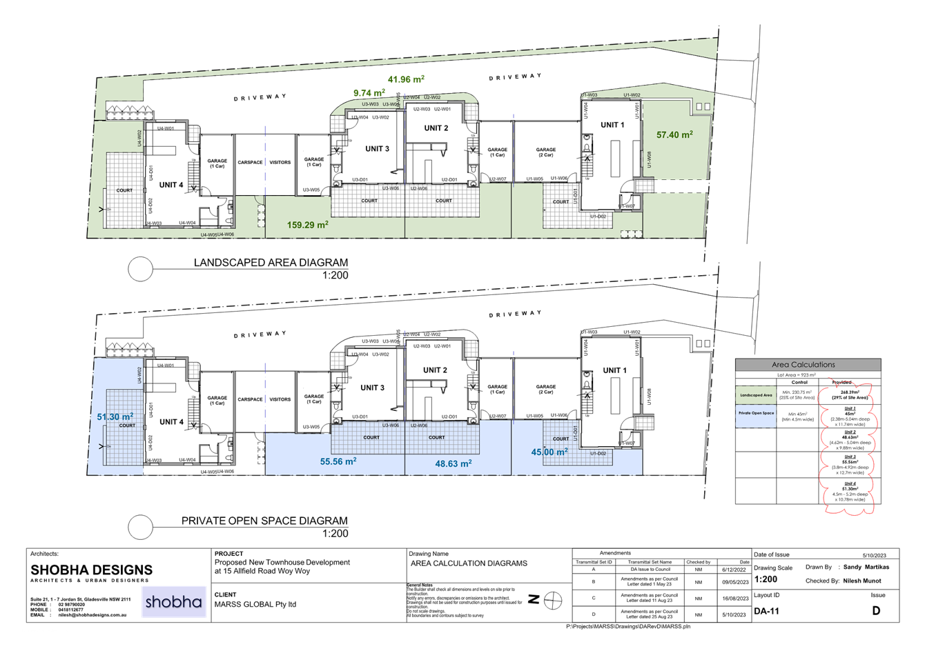
2.2.7.3 Private Open Space |
POS for each dwelling to be min. 45m2 with minimum dimension of 4.5m
May be provided in up to 2 locations
Ground level courtyards not in front setback |
Unit 1 – 31.52m2 Unit 2 – 47.61m2 Unit 3 – 32.61m2 Unit 4 - 51.60m2 with min. 4.5m
Unit 1 – 45.21m2 (min dimension 2.38m) Unit 2 – 47.61m2 Unit 3 – 55.47m2 (min dimension 3.8m) Unit 4 – 68.78m2 if space less than 4.5m dimension included.
|
No Yes No Yes
47.2% variation
15.6% variation
|
Yes – While non-compliant reasonable level and quality of POS provided
|
|
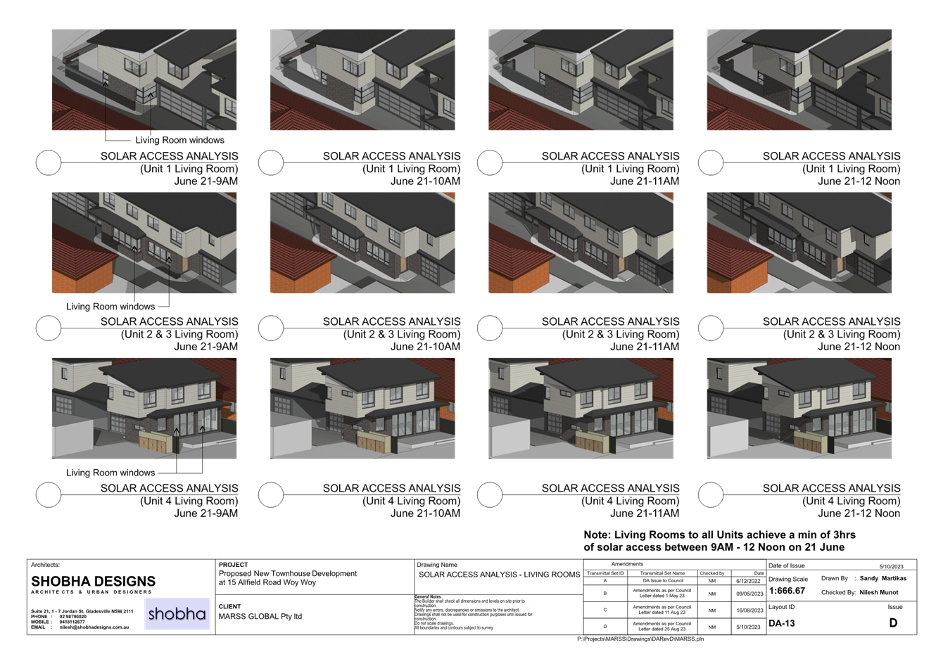
2.2.7.5 Sunlight Access |
Solar access for min 3 hours in living rooms and 50% of POS between 9am and 3pm on 21 June
Sunlight retained to existing neighbours on 21 June |
Living – All units comply
POS – Units 2-4 comply POS – Unit 1 achieves 2 hours |
Yes
Yes No |
Yes – While POS to Unit 1 is non-compliant achieving 2 hours it is considered that this is acceptable given living complies and overall level of amenity provided. |
|
2.2.8.1 Car parking |
At least one of the required resident’s spaces to be enclosed in garage
Visitor parking to be provided at rate of 1 space per 5 units
Comply with the requirements of Chapter 2.13 being 1.5 spaces per dwelling |
Unit 1 – 2 spaces (garaged) Unit 2 – 1 space (garage) Unit 3 – 1 space (garage) Unit 4 – 2 spaces (1 garage)
1 x visitor space
6 spaces provided |
Yes
Yes
Yes |
Yes |
|
2.2.8.2 Access design |
Plain concrete driveways and open parking not supported. |
Stencilled concrete proposed |
Yes |
Yes |
|
|
Vehicle access is permitted from laneway but not pedestrian, mail or garage collection. |
N/A |
N/A |
|
|
|
Garages not to dominate building elevation. |
No garages visible from the street |
Yes |
Yes |
|
|
Driveways to be offset by 2m at side boundary and taper to 0.5m. Offset areas to be landscaped. |
Driveway offset 2.0m as required |
Yes |
Yes |
|
|
Minimum pavement width = 3m |
Min. 3.0m pavement width proposed |
Yes |
Yes |
|
|
Subdivision of dual occupancy into battle-axe to have 3.5m access available. |
N/A |
N/A |
|
|
|
Basement access to have minimal visual impact. |
N/A |
N/A |
|
|
|
Basement may extend up to 1m above ground level. |
N/A |
N/A |
|
|
2.2.9.1 Earthworks |
Excavation must not exceed a maximum depth measured from existing ground level of 1m if less than 1m, from a boundary of 3m if greater than 1m |
No excavation greater than 1m is proposed |
Yes |
Yes |
|
2.2.9.2 Retaining walls |
No more than 600mm wide within 1m of the boundary |
No retaining walls proposed |
N/A |
|
|
2.2.10 Landscaping |
Landscaping to contribute to the amenity and character of the area |
Landscape plan provided and is considered to meet the objectives of the controls |
Yes |
Yes |
|
2.2.10.2 Street trees |
2 street trees provided per 15m of frontage |
2 street trees proposed. |
Yes |
Yes |
|
2.2.10.3 Deep Soil |
50% of soft landscaping to be capable of deep soil |
Landscape plan provided. All landscape area deep soil. |
Yes |
Yes |
|
2.2.10.4 Fencing |
Meets the requirements of privacy and security |
Front fence 600mm have been provided and is considered acceptable. Otherwise existing colorbond fencing to be retained. |
Yes |
Yes |
|
2.2.11 Building Services |
Adequate available services to cater for the residents needs |
All services are available to the property |
Yes |
Yes |
|
2.2.11.2 Civil works |
Kerb and guttering and foot paving to be provided where possible and reasonable |
Council’s Development Engineer has imposed a condition to require replacement kerb and guttering |
Yes – As conditioned |
Yes |
|
2.2.11.3 Stormwater management |
Stormwater management plan to be provided. |
A stormwater management plan has been submitted with the application which complies with relevant requirements |
Yes |
Yes |
|
Stormwater to be disposed of via gravity fed system into drainage easement or the street. |
Complies. Site drains to the street. |
Yes |
Yes |
|
|
Evidence of agreement of downstream easement to be provided when proposed |
N/A |
N/A |
|
|
|
2.2.11.4 Garbage and waste services |
To comply with Chapter 2.14 Waste Management |
Waste management plan has been provided to support the application. 3 x bins per dwelling are proposed. Bin storage for Units 1 and 4 are within the courtyard areas with gates to the street/driveway. Bins for Units 2 and 3 are to be located at the end of the driveway in a bin storage area. Clear paths of travel are available. |
Yes |
Yes |
The non-compliances with provisions of Chapter 2.2 Dual Occupancy and Multi Dwelling Housing area discussed in further detail below.
2.2.7.3 Private Open Space and 2.2.7.5 Sunlight
As noted above the proposal does not comply with Part 2.2.7.3 of CCDCP 2022, which requires a minimum area of 45m2 of POS be provided for each dwelling with a minimum dimension of 4.5m. Further, the POS for Unit 1 does not comply with the requirement for a minimum of 50% of the POS to receive three hours of sunlight on 21 June.
The proposed units will be provided with POS as follows:
|
Unit |
POS (with min. dimension of 4.5m) |
Compliant |
POS -total including area with dimension less than 4.5m |
Min. dimension |
Sunlight hours at 21 June |
Compliant |
|
Unit 1 |
31.53m2 |
No |
45.21m2 |
2.38m |
2 hours to > 50% |
No |
|
Unit 2 |
47.61m2 |
Yes |
47.61m2 |
- |
3 hours to >50% |
Yes |
|
Unit 3 |
32.61m2 |
No |
55.47m2 |
3.8m |
3 hours to > 50% |
Yes |
|
Unit 4 |
51.60m2 |
Yes |
68.78m2 |
- |
3 hours to >50% |
Yes |
The objectives of Part 2.2.7.3 are as follows:
• To ensure private open space areas are functional and responsive to the environment, thereby promoting the enjoyment of outdoor living for residents
• To ensure private open space areas (in particular balconies) integrate with the overall architectural form and detail of the development
In relation to sunlight access, the underlying objective of Part 2.2.7.5 is as follows:
• To facilitate solar access to the living areas and private open space areas of the dwelling and neighbouring dwellings
Notwithstanding the proposed non-compliances with the numerical controls for Units 1 and 3, it is considered that the proposed areas of POS are functional and will provide a high level of amenity for future residents. They will promote outdoor living and respond appropriately to the environment. The areas of POS with dimension of less than 4.5m are usable and make a valuable contribution to the overall available outdoor space for the enjoyment of residents. Further, if included in the calculation, the total area of POS exceeds Council requirements. In addition, while the POS of Unit 1 will only receive two hours of sunlight in midwinter, the living area of the unit will achieve full sun and accordingly, it is considered that notwithstanding the non-compliance, a high level of amenity will be available to the unit. Having regard to these matters it is considered that the proposal satisfies the underlying objectives in Parts 2.2.7.3 and 2.2.7.5 in the circumstances and warrants approval.
Chapter 2.13 Transport and Parking
Part 2.13.3 – Calculation of Car Parking Spaces
The provisions in this part require a minimum of 1.5 residential car parking spaces per dwelling and 0.2 visitor spaces per dwelling (rounded up to nearest whole number) to be provided on-site. Accordingly the proposal requires six (6) spaces for the proposed dwellings and (one) 1 visitor space. As amended, the proposal complies and is consistent with the minimum on-site parking requirements in this part.
Part 2.13.4 – Development Provisions – Access Design
Council’s Development Engineer has assessed the proposal and advised that it is acceptable with regard to vehicular access (internally and externally) and safety, as it generally complies with the requirements in Australian Standard AS2890.1:2004 (Parking Facilities – Off-Street Car Parking). The proposal is therefore acceptable with regard to the provisions in Part 2.13.4.
Chapter 2.14 Site Waste Management
As required by this chapter, a waste management plan has been submitted with the application in accordance with Council’s requirements. Spaces for three bins per unit have been identified. Units 1 and 4 are to have bin storage in the courtyard areas with gates to the street / shared driveway. Units 2 and 3 will share a communal bin storage area at the end of the driveway. This is considered acceptable.
Chapter 2.17 Character and Scenic Quality
Chapter 2.17 requires consideration of character and scenic quality and identifies the site as being within the Woy Woy 8: Sandyplain Medium Density area as set out in the ‘Scenic Value and Character Statements’ referenced in Chapter 2.17 of CCDCP 2022.
The existing character of the Woy Woy 8: Sandyplain Medium Density area is as follows:
A variety of established residential subdivisions on flat land, either surrounding the town centre where a majority of original cottage and mid-century bungalow allotments have been redeveloped for multi-unit housing, or clusters of multi-unit developments on large allotments situated in out-lying areas.
Predominantly flanking major roads and local thoroughfares, redevelopments are visually prominent, and have substantially altered the traditional garden suburb character, defined by individually-designed single storey dwellings that are modestly-scaled timber-frame buildings surrounded by private gardens supporting copses and corridors of woodland remnants and planted trees.
In conjunction with multi-unit development, piecemeal widening of street pavements incorporates kerbing and sometimes footpaths, replacing former wide grassed verges that previously supported shady street trees or woodland remnants.
Multi-unit developments occur either as continuous ribbons of townhouses and villas, or as clusters of one or two sites interspersed by surviving cottages. Universally of brick and tile construction, development varies in age, style and scale from two storey town houses and flats located close to the town centre and station, to newer one and two storey villa developments that are scattered widely. Occurring as rows of attached dwellings, new developments predominantly incorporate “gun-barrel” building forms where dwellings are set close to neighbouring buildings, flanked by narrow private courtyards and extensive paved driveways. By contrast to traditional bungalows, building forms extending into traditional “back yard” areas appear long and bulky.
Surrounding new developments, the limited space retained for gardens is predominantly allocated as small private courtyards that are often narrow paved areas, without shade trees, and surrounded by tall walls. Landscaping predominantly occurs along street frontages and driveways as narrow fringes of ground covers plus small flowering shrubs.
The desired future character of the Woy Woy 8: Sandyplain Medium Density area is as follows:
These areas should remain medium-density residential neighbourhoods where improved standards of amenity and urban design quality are achieved by new low-rise multi-unit developments that reflect features of the traditional mid-Twentieth Century bungalows which remain distinctive elements of the Woy Woy Peninsula’s identity.
Surround each multi-unit development with leafy gardens that conserve existing visually-prominent trees, particularly along back fences and street frontages or verges, as well as providing space for new shady trees and shrubs planted as backdrops to new buildings. Maintain the informal qualities of existing wide grassy street verges and conserve existing shady street trees. Plant a combination of trees and shrubs around courtyards as well as along all property boundaries, and use hedges or fences that are low or see-through rather than tall and opaque in order to complement the informal character of existing garden frontages.
Ensure that new multi-unit developments complement the siting, form and scale of surviving traditional bungalows on nearby properties. Maintain street setbacks that are similar to surrounding properties, and minimise the extent of hard-paved surfaces. Avoid the appearance of long and continuous buildings facing any front or side boundary. Step the shape and height of all visible facades, provide at least one wide landscaped setback that varies in width, and line driveways with avenues of trees and shrubs.
Reflect the modest scale of traditional mid-Twentieth Century bungalows, for example by dividing new developments into individual dwelling pavilions with a varied form or orientation, separated by verandahs or parking structures and landscaped courtyards. Any facades that are taller or longer than neighbouring buildings should be screened by a combination of extra setbacks and balconies or verandahs. Roofs should be gently-pitched to minimise the height of ridges, and flanked by wide eaves that disguise the scale and bulk of exterior walls. Parking is preferable in open carports or part-basements, rather than in wide garages that would accentuate building bulk or dominate visible facades.
In order to complement the scale and design character of traditional bungalows, a “light-weight appearance” is preferable for all visible facades, incorporating walls of windows that are shaded by framed balconies or verandahs plus exterior sunscreens, painted finishes and some sheet or board cladding rather than extensive plain masonry. Where facades face a street, a laneway or a driveway, provide a traditional “street address” with visible verandahs, living rooms and front doors.
Screen driveways, terraces, courtyards and balconies to protect the privacy and amenity of neighbouring dwellings.
The proposed development will achieve a high level of amenity for future residents and is consistent with the scale and design of existing development in the area. Nine new and native trees are proposed to be planted on site, in addition to two new street trees as part of the development, following the removal of seven existing ornamental trees. Accordingly, the proposal is consistent with the development objectives for the land use. The proposed street setback is consistent with the existing established setback and the proposed materials and finishes represent a lightweight form as required and vehicle accommodation will not dominate the street facade. Accordingly it is considered that the proposal is consistent with the desired future character for the area.
Chapter 3.1 Floodplain Management and Water Cycle Management
A civil design report (including stormwater drainage, water cycle management plan and erosion and sediment control plan) has been submitted with the application and reviewed by Council’s Development Engineer. The proposal meets Council’s requirements subject to the imposition of recommended conditions of consent.
Chapter 3.5 Tree and Vegetation Management
The proposal seeks consent for the removal of 7 x trees on site to accommodate the development. Trees to be removed consist of planted ornamentals such as Olive, Callistemon, Mango and Tecoma. Planting of nine new trees is proposed on-site, in addition to two new street trees. Council’s Tree Management Officer has advised that the proposed tree removals are acceptable (subject to a condition requiring the replacement trees to be planted prior to Occupation Certificate), and has supported the provision of two new street trees to be planted, which comprise Dwarf Yellow Bloodwoods. Accordingly, it is considered that the proposal is consistent with the objectives in Chapter 3.5.
Chapter 3.7 Geotechnical Requirements
The site is not located within an area mapped as being impacted by landslip. Accordingly, Chapter 3.7 does not apply.
Likely Impacts of the Development:
Built Environment, Context and Setting
The subject site is zoned R1 General Residential and is surrounded by a mix of one and two storey single dwellings and multi dwelling house developments.
A thorough assessment of the impacts of the proposed development on the built environment has been undertaken having regard to the provisions of CCLEP 2022 and CCDCP 2022. Despite non-compliance with the POS and sunlight access to POS requirements of CCDCP 2022, it is considered that the proposal will not have an unreasonable impact on the character or amenity of the area. Further the proposed built form is considered to be acceptable in the context of the area and will provide a high level of amenity to future residents including in relation to provision of POS and sunlight access.
The proposal will not result in any adverse amenity impacts to adjoining development in respect of overshadowing, privacy, noise, or views and demonstrates a high level of architectural design and materials and finishes. The proposal presents well to the street and will fit positively into the streetscape.
Access and Transport
The proposal provides parking and access in accordance with Council’s requirements. Council’s Transport and Traffic Engineer has reviewed the application and confirmed that the estimated additional trip generation from the proposed development is very low and will have no negative impacts on traffic operations. Further, the proposed driveway satisfies required sight distances along both directions of Allfield Road and complies with requirements of AS2890.1:2004. Accordingly, it is considered that it is acceptable from an access and transport perspective.
Natural Environment
The subject site does not contain any threatened species or habitat. There will be no significant impact upon the natural environment as a result of the proposal.
Suitability of the Site for the Development:
The subject site is zoned R1 General Housing which permits multi-dwelling housing with development consent. The proposal complies with all relevant provisions of CCLEP 2022 and generally complies with the provisions of CCDCP 2022 as outlined within this report. The proposal represents a form and scale of development that is consistent with existing development in the area and the desired future character. It will not result in any adverse impacts to adjacent land and will provide appropriate amenity to the future residents. Accordingly, it is considered that the proposal is suitable for the site.
Whether the Proposal Fits in the Locality
Any Submission made in Accordance with this Act or Regulations:
The proposal was formally advertised and notified in accordance with the requirements of CCDCP 2022 – Chapter 1.2: Notification of Development Proposals between 20 January 2023 and 13 February 2023. In accordance with CCDCP 2022 – Part 1.2.2.10, Control (c), the amendments noted in the ‘Chronology of Development Application’ section at the beginning of this report were not re-notified and re-advertised as they were not considered to result in any additional impacts on the surrounding properties or the public domain.
|
Issue |
Response |
|
No visitor parking |
Amended plans submitted which provide for 1 x visitor car parking space in compliance with Chapter 2.13 of the CCDCP 2022. |
|
Tree removal / lack of arborist report |
Council’s Tree Management Officer has advised that the removal of non-native existing trees on site is acceptable having regard to proposed replacement plantings, which include native species of canopy trees varying between 8m and 18m in mature height. |
|
Impact on services |
All required services are available to the site and Council’s engineers have not raised any issues in this regard. |
|
Not in the public interest |
The proposal has been assessed as being in the public interest as outlined throughout this report. |
|
Non-compliant setbacks (side and rear) |
As amended, the proposal complies with Council’s setback controls. |
|
Private open space non-compliant with area and minimum dimension |
Noted- this issue has been addressed in detail throughout this report. In summary it is concluded that notwithstanding the non-compliance, appropriate and functional private open space will be provided for use by the future residents. |
|
Traffic impacts |
Council’s Traffic Engineer has advised that the traffic impact of the proposal will be minimal and can readily be accommodated within the local road network |
|
Noise impacts |
The proposed 4 x townhouses are not considered likely to result in any significant adverse noise impacts being entirely consistent with the zoning of the site and surrounding development. A condition of consent is imposed to ensure construction noise does not exceed standards or compliant construction hours enforced within the municipality while the development is being carried out. |
|
Light spill |
Concern has been raised by 13 Allfield Road in respect of light spill from headlights. While some impact may result it is considered that this is minimal given the residential nature, and generally low scale, of the proposed use. The existing high colorbond fence (to be retained) on site will block headlight spill as vehicles enter and exit the proposed garages / parking spaces. A condition is imposed to ensure outdoor lighting is compliant with Australian Standards. |
|
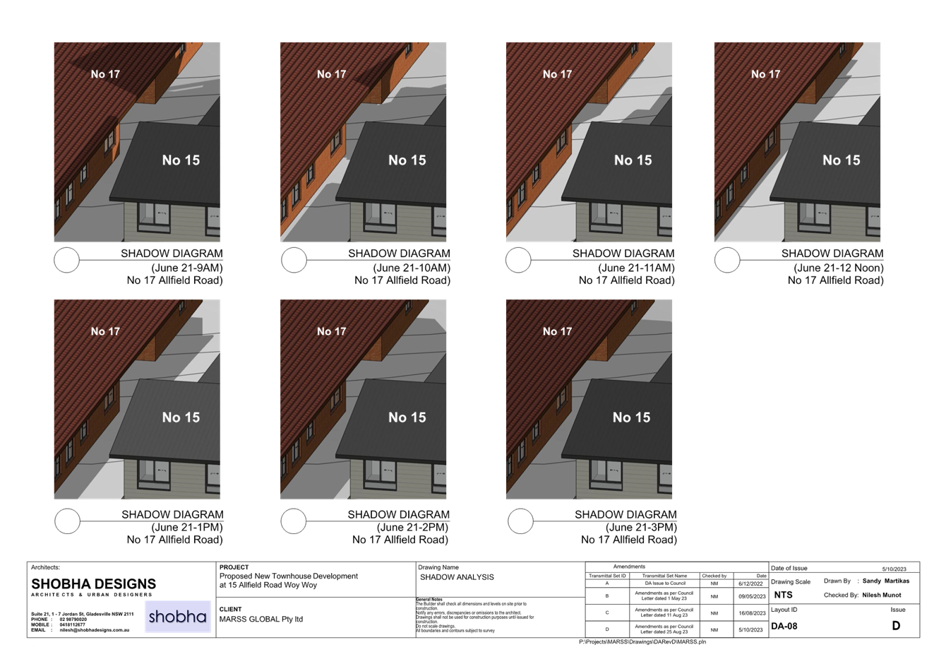
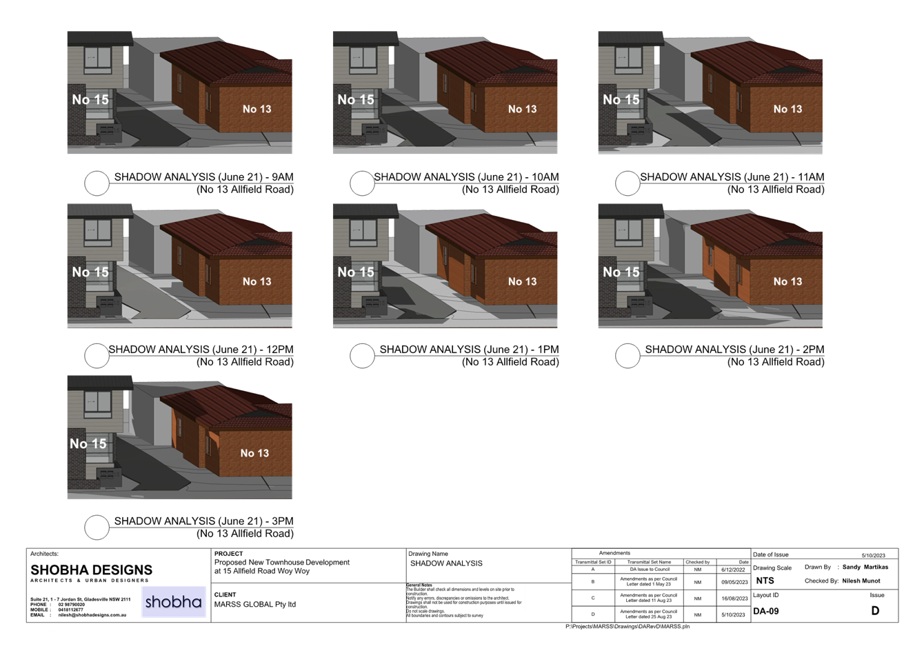
Shadow impact / lack of shadow diagrams |
Amended plans include hourly shadow diagrams which indicate that the proposal will not result in any unacceptable shadow impacts, and is compliant with Council’s DCP in terms of overshadowing of adjoining properties. |
|
Privacy impacts |
As addressed throughout this report the proposed development provides for living areas on the ground floor with bedrooms above. This will limit adverse privacy impacts. Further proposed setbacks will minimise potential overlooking. To the east 13 Allfield Road has a defensive façade fronting the site with private open space oriented to the north and east and buffered from the site by an existing larger shed at the rear of the dwelling going to western boundary. To the west 17 Allfield is similarly not sensitive to privacy impacts with the vehicular access driveway separating the dwellings from the subject site. To the north the site abuts the rear of villa homes / town house development fronting Farnell Drive. These dwelling have POS areas adjacent to the shared boundary therefore is it consider appropriate that upper levels windows in Unit 4 windows W-10, W-11 and W-12 be treated with fixed privacy screens or sill heights above 1.5m to limit any potential privacy impacts. A condition of consent to this effect is recommended. |
|
FSR to be calculated |
The FSR of the amended proposal has been calculated and is 0.49:1 where a maximum of 0.5-0.6:1 is permissible |
|
Overdevelopment of the site |
Having regard to the above assessment it is considered that the proposal does not represent an overdevelopment of the site. |
|
Should be single storey villas |
Proposed use and height permissible on site and generally consistent with planning controls. |
|
13 Allfield Road requests double glazing to prevent noise impacts |
As outlined above it is considered that the proposal will not result in adverse noise impacts. Any such impacts will be consistent with that expected from the proposed low – medium density residential use. |
|
13 Allfield Road seeks to ensure no damage to fence |
Proposal provides for retention of the existing fence on site. |
|
Impact of increased impervious area |
Proposal consistent with Council controls providing greater than 25% landscape area. |
Having regard to the above it is considered that the majority of issues raised in the submissions have been addressed in the amended scheme. Any outstanding concerns are not considered sufficient to warrant refusal of the application and/or have been assessed as satisfactory.
Submissions from Public Authorities
|
Ausgrid |
Consultation was sought from Ausgrid under clause 2.48 of SEPP (Transport and Infrastructure) 2021. No objections were raised. |
Internal Consultation
|
Traffic and Transport Engineer |
Supported without conditions. |
||
|
Development Engineer |
Supported subject to conditions. |
||
|
Tree Assessment Officer |
Supported subject to conditions. |
||
|
Water and Sewer |
Supported subject to conditions. |
Ecologically Sustainable Principles:
The proposal has been assessed having regard to ecologically sustainable development principles and is considered to be consistent with these principles.
The proposed development is considered to incorporate satisfactory stormwater, drainage and erosion control and the retention of vegetation where possible and is unlikely to have any significant adverse impacts on the environment and will not decrease environmental quality for future generations. The proposal does not result in the disturbance of any endangered flora or fauna habitats and is unlikely to significantly affect fluvial environments.
Climate Change:
The potential impacts of climate change on the proposed development have been considered by Council as part of the assessment. This assessment has included consideration of matters such as sea level rise, potential for more intense and /or frequent extreme weather conditions including storm events, bushfire, drought, flood and coastal erosion, as well as how the proposed development may cope, combat and withstand these potential impacts. The proposed development is considered satisfactory in relation to climate change.
The Public Interest:
The proposal will provide an appropriate form of development consistent with the site zoning and relevant planning controls and objectives and the desired future character of the area. It will also provide additional housing supply and choice in a development that provides a high level of amenity to future residents as well as preserving the existing amenity of neighbouring development. Accordingly, it is considered to be in the public interest.
Other Matters for Consideration:
Section 7.11 and 7.12 Contributions
The subject site is located within the area covered by the following contribution plans:
• Contribution Plan No. 31 Peninsula – including contributions for drainage, roadworks, open space and recreation and community facilities and services, and
• Central Coast Regional Section 7.12 Development Contributions Plan 2019 – 1% levy for public cycleway
The applicable contribution amount has been calculated and an appropriate condition of consent recommended.
Water and Sewer Contributions
A water and sewer developer charge is also levied upon development under the Water Management Act 2000. The applicable charge has been calculated and an appropriate condition of consent recommended.
Political Donations
During assessment of the subject application there were no political donations declared by the applicant, applicant’s consultants, owner, objectors and or residents.
Conclusion:
This application has been assessed under the heads of consideration of Section 4.15 of the Environmental Planning and Assessment Act 1979 and all relevant instruments and policies.
Following a thorough assessment of the relevant planning controls and the key issues identified in this report which have been resolved satisfactorily through amendments to the proposal, it is considered that the application can be supported, noting that:
1. The Panel can be satisfied that the provisions in the following State Environmental Planning Policies have been considered and are satisfied:
i) State Environmental Planning Policy (Building Sustainability Index: BASIX) 2004
ii) Chapters 2 (Coastal Management) and 4 (Remediation of Land) of State Environmental Planning Policy (Resilience and Hazards) 2021
iii) State Environmental Planning Policy (Transport and Infrastructure) 2021
2. The Panel can be satisfied that the provisions in clause 7.1 (Acid Sulfate Soils) and 7.6 (Essential Services) of Central Coast Local Environmental Plan 2022 have been considered and satisfied.
3. The Panel can be satisfied that the proposal is permissible in the land use zone, upholds the zone objectives, and complies with the relevant development standards in Part 4 of the Central Coast Local Environmental Plan 2022.
4. The Panel can be satisfied that, as amended and conditioned, the proposal upholds the objectives of the Central Coast Development Control Plan 2022.
5. The Panel can be satisfied that the relevant provisions of the environmental planning instruments, plans and policies that apply to the development have been considered in the assessment of the application.
6. The Panel can be satisfied that the proposal, as amended and conditioned, will not have any non-compliant or unreasonable adverse impacts upon the amenity of the neighbouring properties or the locality.
7. The Panel can be satisfied that the proposed development is considered satisfactory having regard for the matters for consideration provided in Section 4.15 of the Environmental Planning and Assessment Act 1979.
As such, the application is recommended for approval in accordance with Section 4.16 of the Environmental Planning and Assessment Act, 1979, subject to recommended conditions detailed in Attachment 1.
|
1⇩ |
Draft Conditions - 15 Allfield Road, WOY WOY NSW 2256 - DA/4112/2022 |
|
D16019761 |
|
2⇩ |
Survey Plan - 15 Allfield Road WOY WOY 2256 - DA/4112/2022 |
|
D15475848 |
|
3⇩ |
Architectural and Landscape Plans - Revision D - 15 Allfield Road, WOY WOY - DA/4112/2022 |
|
D15889507 |
|
3.1 |
DA/4112/2022 - 15 Allfield Road WOY WOY |
|
Attachment 1 |
Draft Conditions - 15 Allfield Road, WOY WOY NSW 2256 - DA/4112/2022 |

|
DA/4112/2022 - 15 Allfield Road WOY WOY |
|
|
Attachment 2 |
Survey Plan - 15 Allfield Road WOY WOY 2256 - DA/4112/2022 |
|
3.1 |
DA/4112/2022 - 15 Allfield Road WOY WOY |
|
Attachment 3 |
Architectural and Landscape Plans - Revision D - 15 Allfield Road, WOY WOY - DA/4112/2022 |

|
Item No: 4.1 |
|
|
Title: Land and Environment Court Proceedings Class 1 - Case 2023/00065846 - Appeal of Deemed Refusal - Central Coast Council ats CCS Design Pty Ltd - DA/3337/2022 - 16 Sydney Avenue Umina Beach |
|
|
Department: Corporate Services |
|
|
15 February 2024 Local Planning Panel Meeting |
|
Reference: F2019/00883 - D15996507
Author: Michel Duval, Personal Assistant to Unit Manager Governance Risk and Legal
Manager: Edward Hock, Unit Manager Governance, Risk and Legal
Executive: Alice Howe, Director Environment and Planning
1 That the Local Planning Panel note the receipt of a Class 1 appeal in the Land and Environment Court to the deemed refusal of Development Application DA/3337/2022.
2 In accordance with Section 2.20(8) of the Environmental Planning and Assessment Act 1979, the Local Planning Panel delegate to appropriate Council officers the ability to give legal instruction to Council’s external legal counsel at any upcoming proceedings relating to the appeal, including any conciliation conference in accordance with Section 34 of the Land and Environment Court Act 1979.
|
Briefing Note to LPP - CCC ats CCS Design Case 2023/00065846 - |
Provided Under Separate Cover |
D15995784 |
|
|
Statement of Facts and Contentions Case 2023/00065846 - |
Provided Under Separate Cover |
D15995798 |
|
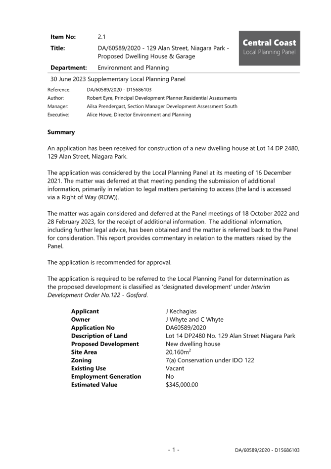
Item No: 5.1 |
|
|
Title: Supplementary Report - DA/60589/2020 - Dwelling House and Garage - 129 Alan Street, Niagara Park |
|
|
Department: Environment and Planning |
|
|
15 February 2024 Local Planning Panel Meeting |
|
Reference: DA/60589/2020 - D15980351
Author: Robert Eyre, Principal Development Planner.Residential Assessments
Section Manager: Ailsa Prendergast, Section Manager. Residential Assessments
Unit Manager: Andrew Roach, Unit Manager, Development Assessment
Executive: Alice Howe, Director Environment and Planning
Summary
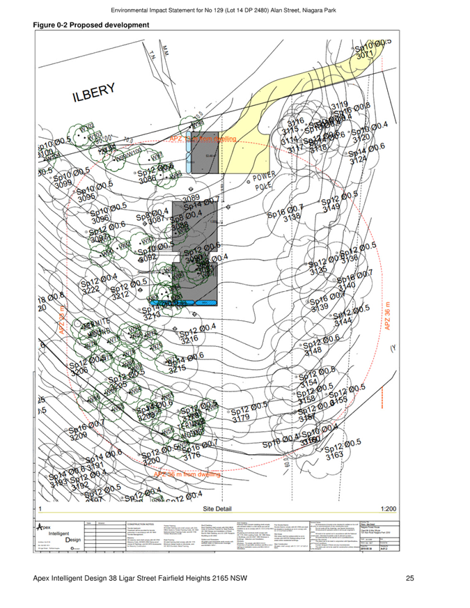
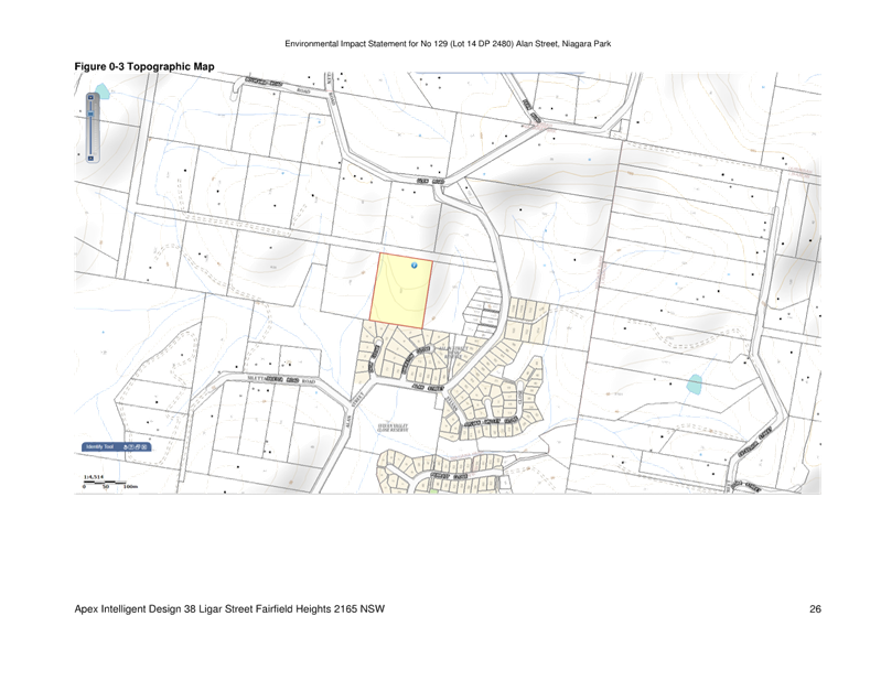
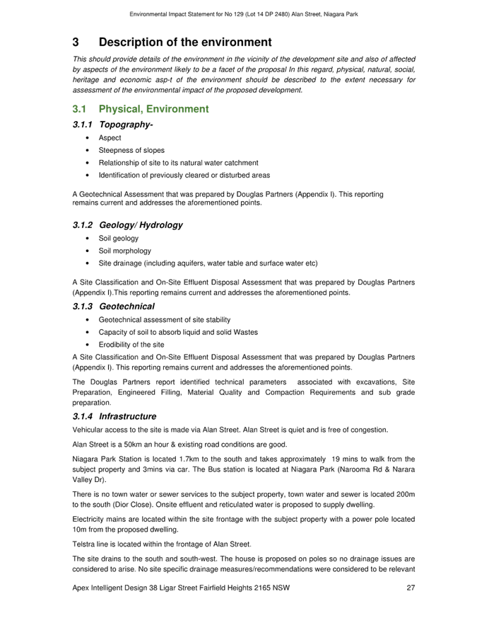
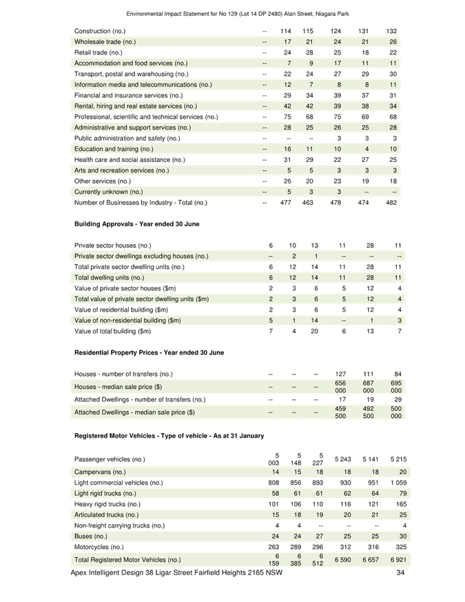
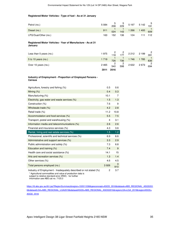
An application has been received for construction of a new dwelling house at Lot 14 DP 2480, 129 Alan Street, Niagara Park.
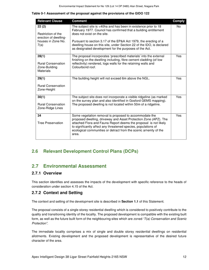
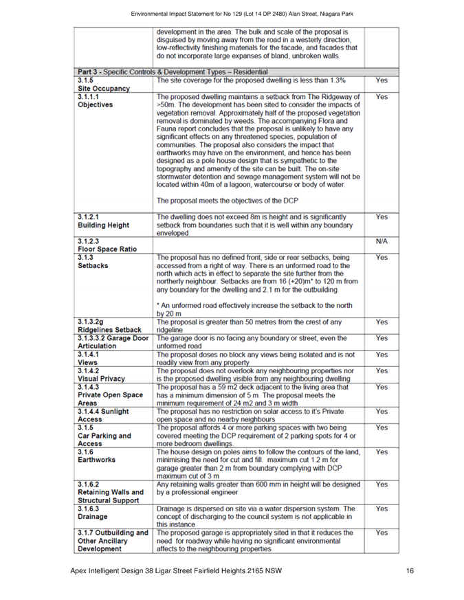
The application is required to be referred to the Local Planning Panel for determination as the proposed development is classified as ‘designated development’ under Interim Development Order No.122 - Gosford.
The application was considered by the Local Planning Panel at its meeting of 16 December 2021. The matter was deferred at that meeting pending the submission of additional information, primarily in relation to legal matters pertaining to access (the land is accessed via a Right of Way (ROW)). The matter was again considered and deferred at the Panel meetings of 18 October 2022 and 28 February 2023, for the receipt of additional information.
The additional information, including further legal advice, has been obtained and the matter is referred back to the Panel for consideration. This report provides commentary in relation to the matters raised by the Panel.
The application is recommended for approval.
Applicant J Kechagias
Owner J Whyte and C Whyte
Application No DA60589/2020
Description of Land Lot 14 DP2480 No. 129 Alan Street Niagara Park
Proposed Development New dwelling house
Site Area 20,160m2
Zoning 7(a) Conservation under IDO 122
Existing Use Vacant
Employment Generation No
Estimated Value $345,000.00
1 That the Local
Planning Panel grant consent to DA/60589/2020 for the development of a dwelling
house on lot 14 DP2480 No. 129 Alan Street, Niagara Park subject to the
conditions detailed in the schedule attached to the report and having regard to
the matters for consideration detailed in Section 4.15 of the Environmental
Planning and Assessment Act 1979.
2 That Council advise relevant external authorities of the Panel’s decision.
Relevant Background
The proposed development was listed for determination at the Panel meeting of 30 June 2023 (a full copy of the report is included as Attachment 1), but withdrawn from the agenda prior to determination. The following points are relevant:
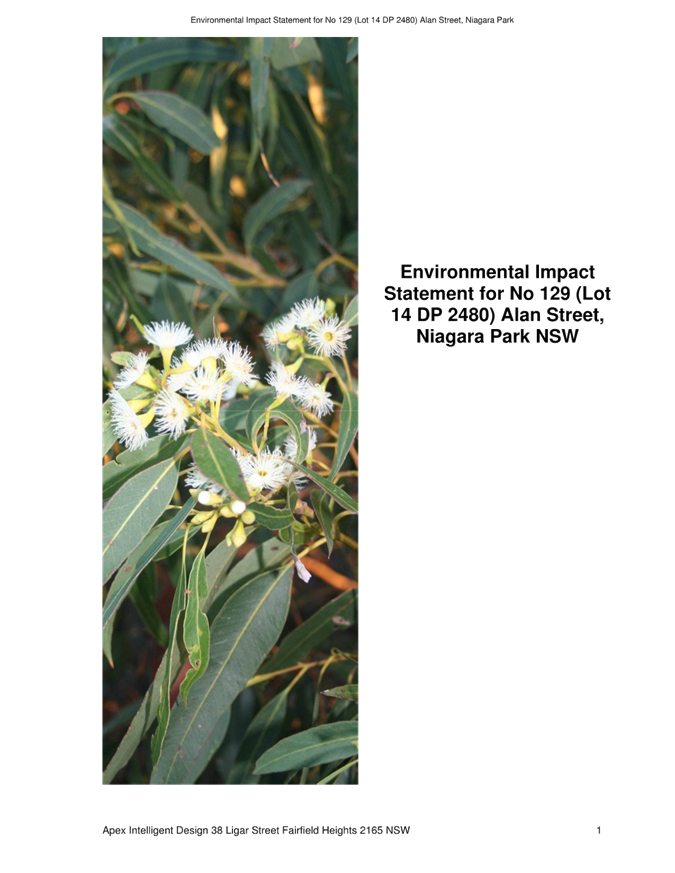
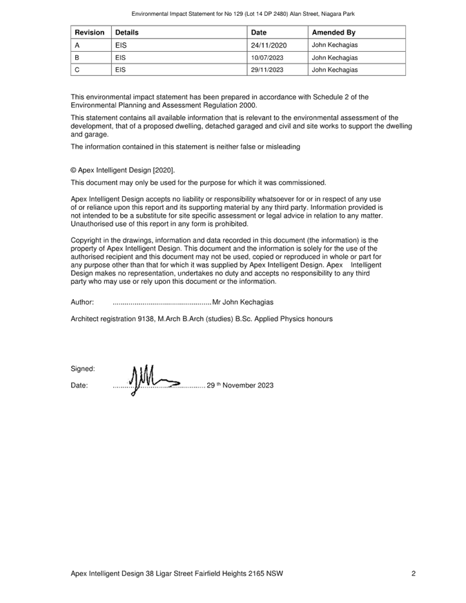
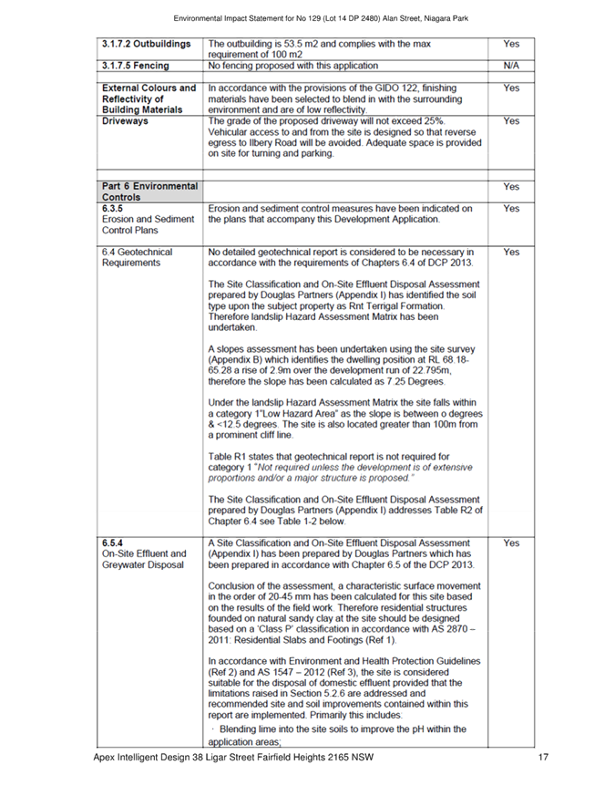
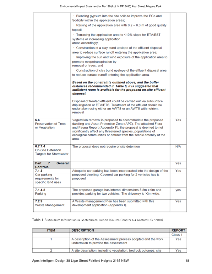
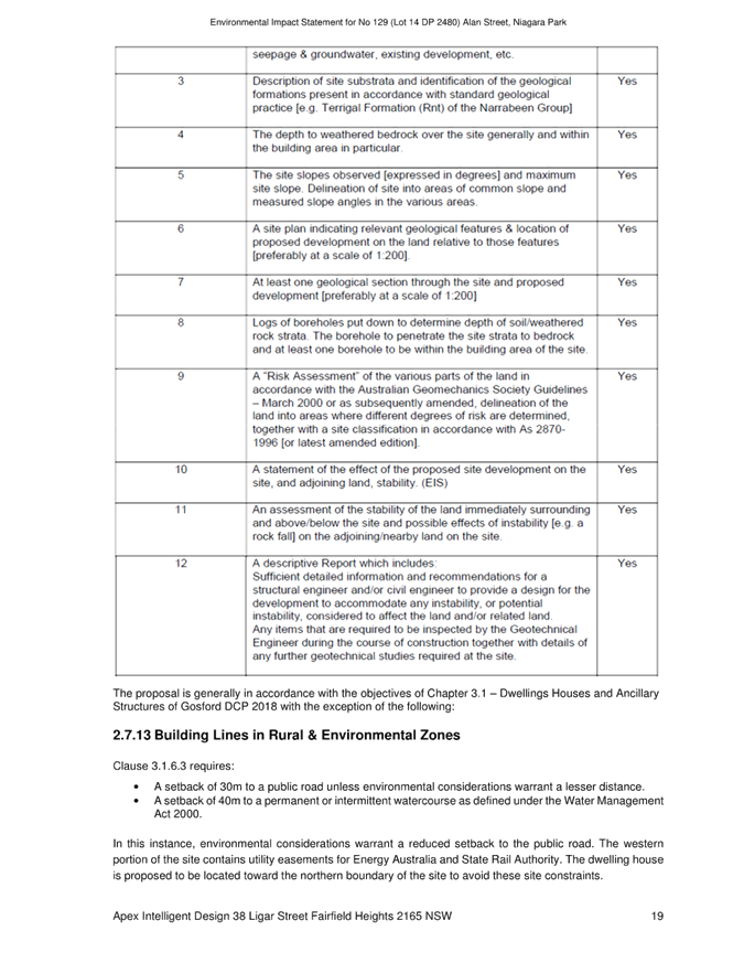
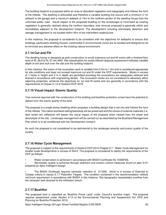
· The application for a dwelling house is classified as designated development as the site is subject to the common-ownership provisions of Interim Development Order No.122 - Gosford. Accordingly, an Environmental Impact Statement (EIS) is required to accompany the development application. An EIS was submitted.
· No public submissions were received to the exhibition of the proposal and associated EIS. No objections were received from the owner of the land, burdened by the right of way which provides access from the site to Alan Street.
· On 28 June 2023, (two days prior to the scheduled Panel meeting on 30 June 2023), a submission was received on behalf of the Central Coast Better Planning Group, which contended that the EIS did not comply with clause 71 of the Environmental Planning and Assessment Regulation 2000. In particular, that the EIS was not signed and did not contain certain statements including the name and address of the person who prepared the EIS.
· As a result of the very late submission, Council withdrew the report from the agenda and sought legal advice as to the adequacy of the EIS.
Legal Advice
Legal advice was received on 23 November 2023 and states:
As discussed below, the remaining matter is for the assessment of the EIS as against item 6 in Part 3 of Schedule 2 of the EP&A Regulation 2000 to be undertaken.
We set out a Table which contains each of the matters set out in item 6, and our comments against each of the requirements, for Council’s assessment and consideration:
|
Item 6 requirement |
Comments |
|
(a) the name, address and professional qualifications of the person by whom the statement is prepared,
|
The name and professional qualifications of John Kechagias is provided on page 2 of the EIS. The author is described on page 2 as John Kechagias. There is not an address detail, but we would assume when the EIS was lodged, or through various email communications with Mr Kechagias, the address of Apex Intelligent Design is provided. |
|
(b) the name and address of the responsible person,
|
A “responsible person’ is not designated in the document but by the detailing of Mr Kechagias as the author of the report and the provision of his details it is reasonable to assume he is the responsible person for the purposes of the Regulations. |
|
(c) the address of the land— (i) in respect of which the development application is to be made, or (ii) on which the activity or infrastructure to which the statement relates is to be carried out,
|
The property description, being the land in respect the development application is made is detailed on page 6 of the EIS, and is No 129 Alan Street Niagara Park (Lot 14 in DP 2480). There is also a detailed description of the property provided on page 6 of the EIS. |
|
(d) a description of the development, activity or infrastructure to which the statement relates,
|
The proposed development is detailed on page 6 to page 7 of the EIS. In summary the application seeks approval for the construction of a single storey dwelling house comprising 4 bedrooms and a study with a detached garage and new driveway on Lot 14, DP 2480 at 129 Alan Street Niagara Park. |
|
(e) an assessment by the person by whom the statement is prepared of the environmental impact of the development, activity or infrastructure to which the statement relates, dealing with the matters referred to in this Schedule,
The matters referred to in the Schedule are contained in item 7 – which provides:
(1) An environmental impact statement must also include each of the following— (a) a summary of the environmental impact statement, (b) a statement of the objectives of the development, activity or infrastructure, (c) an analysis of any feasible alternatives to the carrying out of the development, activity or infrastructure, having regard to its objectives, including the consequences of not carrying out the development, activity or infrastructure, (d) an analysis of the development, activity or infrastructure, including— (i) a full description of the development, activity or infrastructure, and (ii) a general description of the environment likely to be affected by the development, activity or infrastructure, together with a detailed description of those aspects of the environment that are likely to be significantly affected, and (iii) the likely impact on the environment of the development, activity or infrastructure, and (iv) a full description of the measures proposed to mitigate any adverse effects of the development, activity or infrastructure on the environment, and (v) a list of any approvals that must be obtained under any other Act or law before the development, activity or infrastructure may lawfully be carried out, (e) a compilation (in a single section of the environmental impact statement) of the measures referred to in item (d)(iv), (f) the reasons justifying the carrying out of the development, activity or infrastructure in the manner proposed, having regard to biophysical, economic and social considerations, including the principles of ecologically sustainable development set out in subclause (4).
|
The copy of the document we have been provided with does not attach the Appendix A which is titled “EIS Requirements”, however, there are a number of details included within the primary document. · We have not located a “Summary” of the environmental impact statement, however section 6 does provide a summary of the environmental impact measures. · The objectives of the development are not specifically addressed under any heading set out as “objectives of the development”. We consider that this requirement may be met by the “Description of the proposal” which is detailed at pages 6, 7 and 8 in the EIS. · The feasible alternatives to the carrying out of the development, having regard to the objectives, including consequences of no development are analysed over sections 5.1, 5.2, 5.3 and 5.4 of the EIS. · The analysis of the development is undertaken in section 1.2. The description of the environment likely to be affected by the proposal is set out under sections 1.8, 1.9, and Part 2 of the EIS. An analysis of the environmental impacts of the development is undertaken in section 3 of the EIS. The description of the measures proposed to mitigate the impact of the development are addressed in section 6 of the EIS. No other approvals are needed to undertake the proposal on the site. · The section 6 in the EIS deals with the measures set out above, in a single section. The compilation is not detailed however, item 7(1)(e) does not request an analysis, rather just a “compilation” of the environmental impact measures proposed. · The reasons justifying the development are dealt with across the various sections set out above. There is an analysis of the biophysical, economic and social considerations that is dealt with in sections 2 and 3 of the EIS. We have been unable to locate an analysis of the principles of ecologically sustainable development, referrable to the proposal, in the EIS. There is a reference to ESD on page 41 but no analysis referrable to the proposal is undertaken. |
|
(f) a declaration by the person by whom the statement is prepared to the effect that— (i) the statement has been prepared in accordance with this Schedule, and (ii) the statement contains all available information that is relevant to the environmental assessment of the development, activity or infrastructure to which the statement relates, and (iii) that the information contained in the statement is neither false nor misleading.
|
· There is a statement on page 41 of the EIS indicating that the document has been prepared in accordance with the Regulations. Notably, the EP & A Regulation 1980 is referred to, although that is not considered to be a specific concern. · There does not appear to be a statement that the information contained in the statement is neither false nor misleading. That may have been provided separately to Council, but is required. |
|
(2) The person preparing the statement must have regard to the following— (a) for State significant development—State Significant Development Guidelines, (b) for State significant infrastructure—State Significant Infrastructure Guidelines.
|
· The proposal is not in relation to state significant development or infrastructure so this clause is not relevant to this application. |
Summary and Recommendations
The EIS largely addresses the criteria required in items 6 and 7 of Part 3 of Schedule 2 of the EP&A Regulation 2000.
However, we recommend that the EIS be supplemented with a statement that addresses ecologically sustainable development, and in that regard the applicant can be directed to item 7 (4) of Part 3 of Schedule 2 of the Regulation which addresses the particular principles of ESD that should be assessed in the EIS, having regard to the application. We also consider that there should be a clear statement that the information contained in the statement is neither false nor misleading. Both of these matters can be attended to by providing supplementary information. In addition, given these matters are to be addressed in supplementary information, it would also be prudent to obtain a “Summary” of the EIS.
Following the supplement to the EIS addressing the above matters we see no impediment on a legal basis for the grant of consent.’
Applicant’s Submission
The applicant has now submitted a supplement to the EIS addressing the above matters which includes:
1. Address and contact details of person who prepared EIS and their qualifications.
2. The document is signed.
3. It references the Environmental Planning and Assessment Regulation 2000.
4. The is a declaration that the material is neither false nor misleading
5. An executive summary has been provided.
6. A response towards the requirements to the Environmental Planning and Assessment Regulation 2000 for ecologically sustainable development has been added in Section 7 of this EIS.
7. The conclusion has been expanded (refer to Attachment 2).
Advertising/Renotification
Chapter 1.2 of the Central Coast Development Control Plan 2022 sets out in respect of applications where a development application has been amended prior to determination that:
‘ … if in the opinion of Council or staff with the appropriate delegated authority the amendments are minor, or will result in no additional impacts, the amendments will not require readvertisement or re-notification.’
Similar provisions existed in the previous iterations of the Development Control Plan (being the Wyong Development Control Plan 2013 and the Gosford Development Control Plan 2013).
In this case, the amended information submitted (amended EIS with minor changes) are considered minor, they do not significantly change the development proposed and do not create any additional impacts.
As such, it is the view of assessing officers that renotification of the proposal is not warranted.
Conclusion
The EIS has been reviewed, including independent legal review, and minor amendments made to satisfy the requirements of the legislation and the submission received in advance of the previous meeting. As such the application is presented to the Panel with a recommendation for approval as per the previous report. The previous report is included in Attachment 1 for consideration.
|
1⇩ |
DA/60589/2020 - 129 Alan Street, Niagara Park - Proposed Dwelling House & Garage |
|
D15686103 |
|
2⇩ |
Environmental Impact Statement (Rev C) - PAN-52378 - 129 Alan Street, NIAGARA PARK - DA/60589/2020 |
|
D15972541 |
|
5.1 |
Supplementary Report - DA/60589/2020 - Dwelling House and Garage - 129 Alan Street, Niagara Park |
|
Attachment 1 |
DA/60589/2020 - 129 Alan Street, Niagara Park - Proposed Dwelling House & Garage |
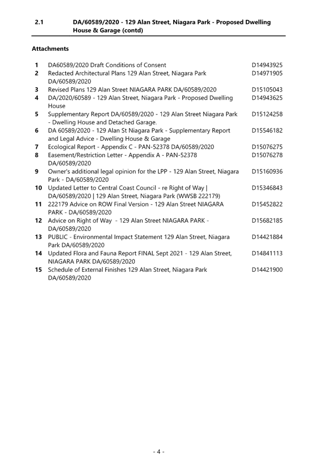
|
Supplementary Report - DA/60589/2020 - Dwelling House and Garage - 129 Alan Street, Niagara Park |
|
|
Attachment 2 |
Environmental Impact Statement (Rev C) - PAN-52378 - 129 Alan Street, NIAGARA PARK - DA/60589/2020 |
|
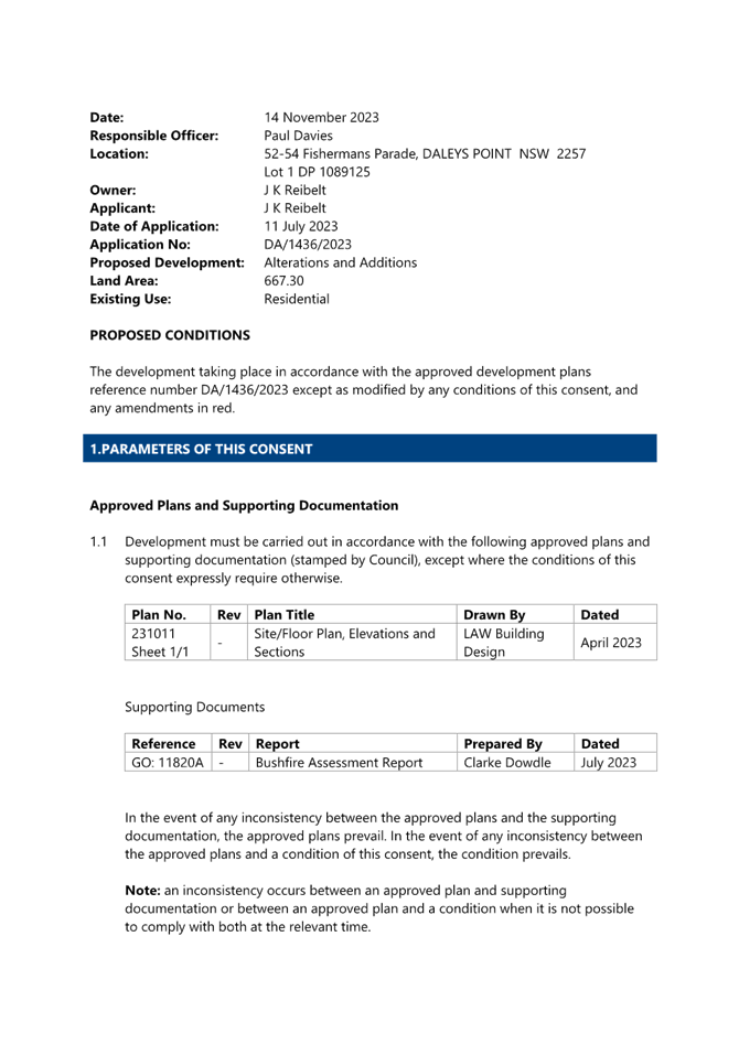
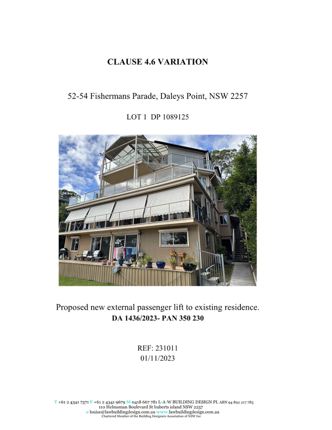
Item No: 5.2 |
|
|
Title: DA/1436/2023 - 52-54 Fishermans Parade, Daleys Point - Alterations & Additions |
|
|
Department: Environment and Planning |
|
|
15 February 2024 Local Planning Panel Meeting |
|
Reference: DA/1436/2023 - D15995101
Author: Paul Davies, Senior Health and Building Surveyor
Manager: Wayne Herd, Section Manager Building Assessment and Certification
Executive: Alice Howe, Director Environment and Planning
An application has been received for the alterations and additions of an existing dwelling at 52-54 Fishermans Parade, Daleys Point. The application has been examined having regard to the matters for consideration detailed in Section 4.15 of the Environmental Planning and Assessment Act 1979 with the issues requiring attention and consideration being addressed in this report.
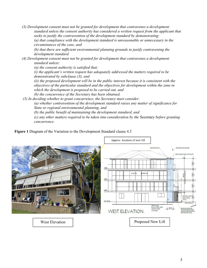
This development application is required to be reported to Local Planning Panel due to the development exceeding the ‘Height of Buildings’ development standard specified within clause 4.3 of Central Coast Local Environment Plan 2022 (CCLEP 2022) by more than 10%. The maximum building height, as set under CCLEP 2014, is 8.5m. The application proposes a maximum height of 10.5m (this represents a variation of 2.0m, or 23.53%).
(Note: the existing dwelling on the site has a height of approximately 12.5m (or 4m over the maximum permitted building height) to the roof ridge. The proposed development itself is for a lift installation that finishes closely in line with the height of the existing eaves, well below the existing building ridge-line).
No submissions have been received.
The application is recommended for approval, subject to conditions.
Applicant LAW Building Design
Owner Mr John Reibelt
Application No 1436/2023
Description of Land Lot 1 DP 1089125 – 52-54 Fishermans Parade, Daleys Point
Proposed Development Alterations and Additions
Site Area 667.3m2
Zoning R2 Low Density Residential
Existing Use Residential Dwelling
Employment Generation N/A
Estimated Value $85,000
Recommendation
1 The
consent authority is satisfied that the applicant’s clause 4.6 written
request adequately demonstrates that compliance with the Height of Buildings
development standard is unnecessary in the circumstances of the case because of
the minimal environmental impact that would result from the noncompliance with
the Height of Buildings standard.
Compliance with the Height of Buildings development standard would be
unreasonable in the circumstances of this application because of the steep
sloping nature of the block, and that there are sufficient environmental
planning grounds to justify contravening the development standard.
Further, the consent authority considers the proposed
development will be in the public interest because it is consistent with the
objectives of the development standard and the objectives for development
within the R2 Low Density Residential zone in which the development is proposed
to be carried out.
2 That the Local Planning Panel grant development consent to DA/1436/2023 – 52-54 Fishermans Parade, Daleys Point to construct the alterations and additions subject to appropriate conditions as detailed in the schedule attached to the report and having regard to the matters for consideration detailed in Section 4.15 of the Environmental Planning and Assessment Act and other relevant issues.
3. The
Local Planning Panel assume the concurrence of the Secretary of the Department
of Planning to permit the non-compliance with the development standard under
clause 4.6 of the Central Coast Local Environmental Plan 2022 in accordance
with the provisions of clause 55 of the Environmental Planning and Assessment
Regulation 2001.
Precis:
|
Proposed Development |
Alterations and Additions to Existing Dwelling (primarily external alterations southern side, with installation of a lift). |
|
Permissibility and Zoning |
The subject site is zoned R2 - Low Density Residential under the provisions of Central Coast Local Environmental Plan 2022 (CCLEP 2022).
The land contains an existing ‘dwelling house’ which is defined under the Central Coast LEP 2022 as;
‘dwelling house’ means – a building containing only one dwelling.
The proposed development is best defined as alterations and additions to an existing dwelling house, and is permissible with consent in the current zone. |
|
Current Use |
Dwelling House |
|
Integrated |
No |
|
Submissions |
The development application was notified (in accordance with the provisions of the Central Coast Development Control Plan 2022 (CCDCP 2022)) from 21 July 2023 until 4 August 2023.
No submissions were received. |
Proposed Variations to Plans and Policies
Proposed Variations to Central Coast Local Environmental Plan 2022
|
Clause |
4.3 (2) |
|
Standard |
Height limit of 8.5m. |
|
Departure basis |
The proposal seeks a maximum height of 10.5m. This represents a variation of 2m or 23.53% at the highest point. |
Proposed Variations to Central Coast Development Control Plan 2022 (Chapter 2.1. Dwelling Houses, Secondary Dwellings and Ancillary Structures)
|
Clause |
2.1.2.1(a) |
|
Planning Control |
Height limit of 8.5m (mapped) |
|
Departure basis |
The proposal seeks a maximum height of 10.5m. This represents a variation of 2m or 23.53% at the highest point. |
|
Clause |
2.1.2.1(c) |
|
Planning Control |
Height exceeds 3 storeys |
|
Departure basis |
The proposal seeks a maximum construction that is 4 storeys. This represents a variation of 1 storey 33.33% at the highest point. |
|
Clause |
2.1.2.2 |
|
Planning Control |
Site Coverage 52.8% (previously approved) |
|
Departure basis |
The proposal seeks a minor increase to the site coverage maximum 2.8m2 for the lift. This represents an increase variation of 0.4% to 53.2% |
The Site
The site (Figures 1-3) is a single lot identified as Lot 1 DP 1089125 (52-52 Fishermans Parade, Daleys Point). The site is located on the westerns side of Fishermans Parade, falling steeply from the road and having a total area of 667.3m2. The site contains an existing residential dwelling.
The subject site is zoned R2 - Low Density Residential under the provisions of CCLEP 2022 (Figure 4).
The site is mapped as bushfire prone land and the application is supported by a Bushfire Assessment Report.
Surrounding Development
The subject site is surrounded by residential lots also zoned as R2 – Low Density Residential, these generally contain a mixture of older style multi storey dwellings interspersed with newer (and renovated) dwellings of mainly two or three-storeys. Surrounding residential lands are similarly steeply sloping sites and this is reflected in the design and siting of the residential development contained on those lots.
Due to the steepness/sloping nature of land in the locality, dwellings along Fishermans Parade and nearby roadways often utilise building height variations in one form or another in order to accommodate residential development.
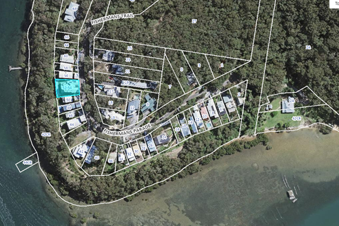
Figure 1 - Aerial photograph of subject site with the site etched in blue
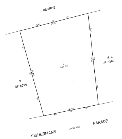
Figure 2 - Deposited Plan extract showing lot 1
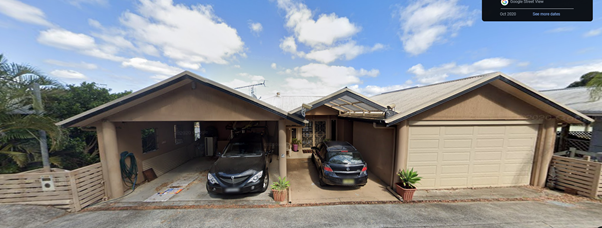
Figure 3 - Dwelling view from Fishermans Parade
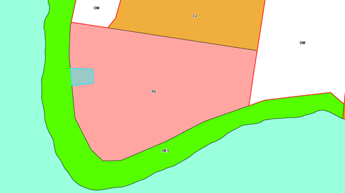
Figure 4 - Aerial photograph of subject site with zoning overlay
The Proposed Development
The application seeks development consent for alterations and additions of the existing dwelling, generally consisting of external alterations to enable the installation of a lift to the southern elevation to enable access to each floor. This necessitates a building height variation to service all floors with the eave height of the upper floor at 10.5m (Figures 5-9).
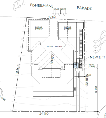
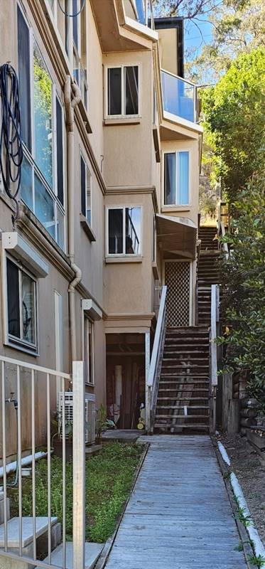
Figure 6 - Image of lift location showing existing stairs and associated ground levels
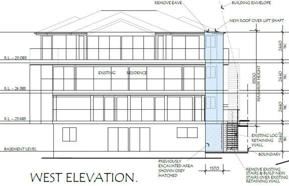
Figure 7 - Detailing the western elevation
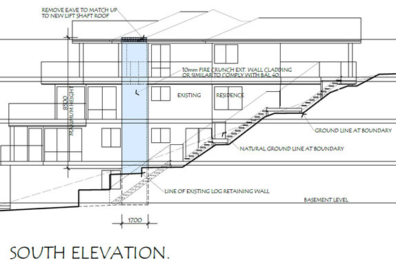
Figure 8 - Detailing the proposed southern elevation
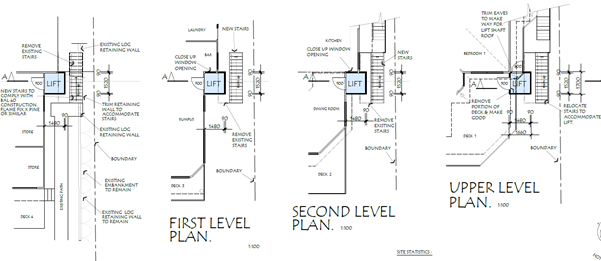
Figure 9 - Detailing the proposed floor plans
ASSESSMENT
Having regard for the matters for consideration detailed in Section 4.15 of the Environmental Planning and Assessment Act 1979 and other statutory requirements, the assessment has identified the following key issues, which are elaborated upon for the information of the Panel.
Environmental Planning and Assessment Regulation 2021 (Demolition)
With regard to demolition of works as part of a Development Application, clause 61 of the Environmental Planning and Assessment Regulation 2021 provides additional matters that the consent authority must consider:
(1) In determining a development application for the demolition of a building, the consent authority must consider the Australian Standard AS 2601—2001: The Demolition of Structures.
Comment: The works will be covered by the Australian Standard As 2601-2001 and is conditioned for compliance as per draft conditions (proposed condition 4.11).
A waste management plan has been submitted and accepted. Council is satisfied the necessary demolition works required to facilitate the addition of the proposed lift will occur in accordance with AS2601-2001.
State Environmental Planning Policy (Resilience and Hazards) 2021
The relevant provisions of the SEPP are addressed as follows:
Chapter 2 Coastal Management
The aims of Chapter 2 are to be considered when determining an application within the Coastal Management Areas. The Coastal Management Areas are defined on maps issued by the NSW Department of Planning and Environment.
The site is located within the Coastal Environment Area as identified on these maps and subject to the provisions of Section 2.10 of the SEPP.
The development is not likely to have an adverse impact on the matters referred to in clause 2.10. The development is not considered likely to cause increased risk of coastal hazards on the site or other land and the site is not subject to the coastal management program for the purposes of Division.5. A summary of considerations is included below.
Section 2.10 - Development on land within the coastal environment area
In accordance with clause 2.10(1) development consent must not be granted unless the consent authority has considered whether the proposed development is likely to cause an adverse impact (see table on following page for considerations).
|
Matters for Consideration |
Compliance |
|
(a) the integrity and resilience of the biophysical, hydrological (surface and groundwater) and ecological environment |
The proposal is not likely to cause adverse impacts on the biophysical, hydrological, or ecological environment. |
|
(b) coastal environmental values and natural coastal processes |
The proposal will not impact on the geological and geomorphological coastal processes. |
|
(c) the water quality of the marine estate (within the meaning of the Marine Estate Management Act 2014, in particular, the cumulative impacts of the proposed development on any of the sensitive coastal lakes identified in Schedule 1 |
The proposal will not result in an adverse impact on the water quality of the marine estate and does not drain to a sensitive lake contained in Schedule 1. |
|
(d) marine vegetation, native vegetation and fauna and their habitats, undeveloped headlands and rock platforms |
The proposal will not result in an adverse impact on native vegetation or fauna, undeveloped headlands, and rock platforms. |
|
(e) existing public open space and safe access to and along the foreshore, beach, headland or rock platform for members of the public, including persons with a disability, |
The site does not have frontage to any foreshore, beach, headland or waterways. |
|
(f) Aboriginal cultural heritage, practices and places |
There are no identified aboriginal cultural heritage items on the site. |
|
(g) the use of the surf zone. |
Not applicable. No frontage to any beach/surf zone. |
There have been no adverse impacts identified in the consideration of Section 2.10(1) that would engage the further considerations under Section 2.10(2).
Chapter 4 – Remediation of Land
The provisions of SEPP (Resilience & Hazards), Chapter 4 (Remediation of Land) have been considered in the assessment of the development application.
Section 4.6 of the SEPP requires consent authorities to consider whether the land is contaminated, and if the land is contaminated, it is satisfied that the land is suitable in its contaminated state (or will be suitable, after remediation) for the purpose for which the development is proposed to be carried out.
A review of the land use history, aerial photographs and an inspection of the site has not revealed any evidence of potentially contaminating land uses being carried out on the site.
The development and the land is not otherwise mentioned in Subsection 4.6(4) and accordingly the provisions of Subsection 4.6(2) are not engaged by the proposal and consent may be granted.
The proposal is considered consistent with the provisions of Chapter 4 of the SEPP.
The Panel can be satisfied that proposed development under DA/1436/2023 complies with the provisions of Chapter 2 Coastal Management and Chapter 4 Remediation of Land of the State Environmental Planning Policy (Resilience and Hazards) 2021.
Central Coast Local Environmental Plan 2022 (CCLEP 2022) - Permissibility
The subject site is zoned R2 - Low Density Residential under the provisions of CCLEP 2022.
The proposed development is best defined as alterations and additions to a ‘dwelling house’ which is defined under CCLEP 2022 as:
‘dwelling house’ means – a building containing only one dwelling.
The development is permissible in the zone, with development consent.
Central Coast Local Environmental Plan 2022 (CCLEP 2022) - Objectives of Zone
The objectives of the R2 Low Density Residential zone are:
· To provide for the housing needs of the community within a low-density residential environment.
· To enable other land uses that provide facilities or services to meet the day to day needs of residents.
· To encourage best practice in the design of low-density residential development.
· To ensure that non-residential uses do not adversely affect residential amenity or place unreasonable demands on services.
· To maintain and enhance the residential amenity and character of the surrounding area.
Following a detailed assessment of the proposed development and with the applicants written request to vary a development standard within CCLEP 2022, it is considered that the proposal is consistent with the stated objectives of the zone, providing housing consistent with the emerging character of the area and does not have adverse impacts on the locality.
Central Coast Local Environmental Plan 2022 (CCLEP 2022) - Principal Development Standards
The proposal has been assessed in accordance with the relevant development standards of CCLEP 2022.
|
Development Standard |
Required |
Proposed |
Compliance with Controls |
Variation % |
Compliance with Objectives |
|
Clause 4.3 Height of Buildings |
8.5m |
The proposal seeks a maximum height of 10.5m. |
No |
23.53% |
Yes |
|
Clause 4.4 Floor Space Ratio |
Not mapped |
0.63:1 |
N/A |
- |
Yes |
Central Coast Local Environmental Plan 2022 Clause 4.3 - Height of buildings
The development proposes a variation to the maximum permitted height set out under clause 4.3 of CCLEP 2022 and is accompanied by a clause 4.6 written request to vary the development standard.
The proposed development seeks a variation to the height of the building of 2m or 23.53%. The existing dwelling has a height at the ridge of 12.3m (or 3.8m over the maximum permitted building height) (Figures 10a and b). The proposed development includes installation of a lift along the southern elevations, finishing at the eave height, being 10.5m, necessitating the variation.
The proposed area of non-compliance is minor. The non-compliance does not result in any adverse amenity impacts to surrounding development. Given the context and characteristics of the subject site, and the nature of the existing development, strict compliance with the maximum building height control is considered unreasonable and unnecessary in this instance. See comments below in relation to the applicant’s clause 4.6 submission.
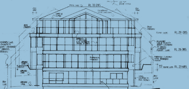
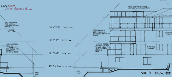
Figure 10a/b - heights of existing building obtained from previously approved plans (DA/49938/2016/A)
Central Coast Local Environmental Plan 2022 Clause 4.6 - Exceptions to Development Standards for Height
The applicant seeks a variation to clause 4.3(2) of CCLEP 2022 in relation to the proposed maximum height of the dwelling (lift shaft). In this regard, the proposal seeks a maximum overall height of 10.5m in lieu of the 8.5m mapped maximum height limit applicable to the allotment. This represents a variation of 23.53%.
Clause 4.6 of CCLEP 2022 provides the ability to grant consent to a development application where the variation to a development standard can be adequately justified and where the objectives of clause 4.6 are satisfied, being:
(a) to provide an appropriate degree of flexibility in applying certain development standards to particular development,
(b) to achieve better outcomes for and from development by allowing flexibility in particular circumstances.
Clause 4.6(2) provides permissive power to grant development consent for a development that contravenes the development standard.
Clause 4.6 (3) of CCLEP 2022 requires consideration of the following:
Development consent must not be granted to development that contravenes a development standard unless the consent authority is satisfied the applicant has demonstrated that—
(a) compliance with the development standard is unreasonable or unnecessary in the circumstances, and
(b) there are sufficient environmental planning grounds to justify the contravention of the development standard.
In reviewing whether the proposed variation is unreasonable or unnecessary, and whether there are sufficient environmental planning grounds to justify contravening the variation, consideration of the objectives for maximum building height controls are relevant.
Clause 4.3(1) of CCLEP 2022 sets out two objectives pertaining to the building height development standard. The objectives and commentary in respect to compliance in relation to the proposed development:
a) to establish maximum height limits for buildings to enable appropriate development density
Comment: The proposed height of the development whilst exceeding the numerical height limit, is necessary for functionality and consistent with the existing building and numerous other dwellings within the vicinity on this steep locality.
b) to ensure that the height of buildings is compatible with the character of the locality
Comment: The height exceedance relates to the necessity for the lift to travel to all floors, including the top. The lift well will cease at the eave line. It is consistent with the height of the subject building and other buildings on the hillside within this locality.
Clause 4.6 (4) of CCLEP 2022 requires consideration of the following:
Development consent must not be granted for development that contravenes a development standard unless—
(a) the consent authority is satisfied that—
(i) the applicant’s written request has adequately addressed the matters required to be demonstrated by subclause (3), and
(ii) the proposed development will be in the public interest because it is consistent with the objectives of the particular standard and the objectives for development within the zone in which the development is proposed to be carried out, and
(b) the concurrence of the Planning Secretary has been obtained.’
Applicant’s Written Clause 4.6 Request
Clause 4.6 (3) of CCLEP 2022 also notes that “The Environmental Planning and Assessment Regulation 2021 requires a development application for development that proposes to contravene a development standard to be accompanied by a document setting out the grounds on which the applicant seeks to demonstrate the matters in paragraphs (a) and (b)”
The applicant has provided a detailed request to vary the mapped height development standard by the proposed 23.53%. In requesting the variation, the applicant has provided the following matters in support of the proposal.
· The proposed development meets all objectives of the DCP and does not impact the amenity of the adjacent neighbours.
· The proposed development is compatible with the height, bulk and scale of the existing character of the area, does not create visual impact, disruption of views, loss of privacy and loss of solar access to existing surrounding development. There is no impact on the streetscape.
· There is no significant overshadowing or visual impact or loss of privacy or impact on open space, nor any impact on the adjoining property.
The applicant’s submission is in accordance with the regulations and council assessment considers it to adequately addresses the provisions of clause 4.6(3)(a) and (b), as set out above.
The applicant’s full clause 4.6 document request is included in Attachment 3.
Zone Objectives
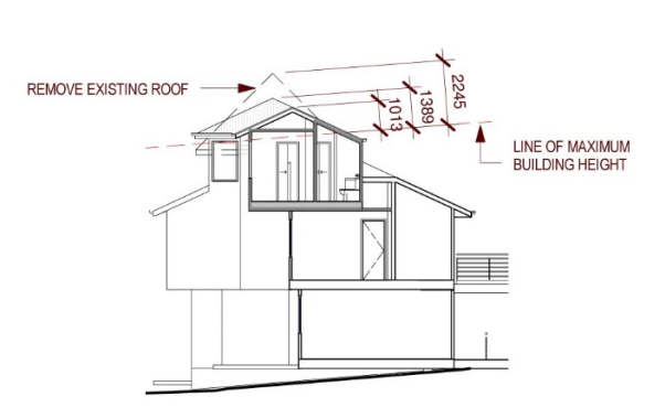
In reviewing the proposed variation, consideration of the Residential R2 Low Density Residential Zone objectives is also considered necessary.
The R2 Low Density Residential Zone objectives are as follows:
· To provide for the housing needs of the community within a low-density residential environment.
· To enable other land uses that provide facilities or services to meet the day to day needs of residents.
· To encourage best practice in the design of low-density residential development.
· To ensure that non-residential uses do not adversely affect residential amenity or place unreasonable demands on services.
· To maintain and enhance the residential amenity and character of the surrounding area.
In considering these zone objectives, the following points are considered relevant:
· Dwelling houses are permissible within the zone and satisfies the zone objective in terms of the provision of low-density residential development.
· The proposed dwelling design is considered in keeping with the existing and desired future character of the area.
· The design of the dwelling incorporates suitable architectural design elements and incorporates sustainable design features.
The proposal meets the relevant zone objectives and does not cause view loss or overshadowing impacts to the adjoining properties. The proposal is consistent with the objectives of the development standard, as noted above, and approval of the development is therefore in the public interest.
In accordance with clause 4.6 (4):
(i) The consent authority can be satisfied the applicant’s written submission has adequately addressed the matters required to be demonstrated under clause 4.6 (3), and
(ii) The consent authority can be satisfied the proposal is in the public interest as it is consistent with the zone objectives and does not cause view loss or overshadowing impacts to the adjoining properties. The proposal is consistent with the objectives of the particular standard (as noted above).
Having regard to the site factors, minimal impact on the character of the area and that of the residents, the applicants request to vary the building height development standard is considered reasonable and therefore supported.
Central Coast Local Environmental Plan 2022 – Clause 5.21 Flood Planning
The site is not subject to flood planning controls.
Central Coast Local Environmental Plan 2022 – Clause 7.1 Acid Sulfate Soils
The site is mapped as containing Class 5 acid sulfate soils.
In accordance with clause 7.1 (3), an Acid Sulfate Soils Management Plan is required for works on land containing Class 5 acid sulfate soils where there are:
· Works within 500m of land in classes 1, 2, 3 or 4 that is less than 5m above the Australian Height Datum (m AHD) and by which the watertable is likely to be lowered below 1m AHD on adjacent class 1, 2, 3 or 4 land.
In accordance with clause 7.1 (6) the development will result in a minor amount of excavation (less than 1 tonne) and no impact on the water table. An Acid Sulfate Soils Management Plan is not required and the provision of clause 7.1 are satisfied.
Central Coast Local Environmental Plan 2022 – Clause 7.6 Essential Services
Development consent must not be granted to development unless the consent authority is satisfied that all of the following services that are essential for the development are available or that adequate arrangements have been made to make them available when required:
a) the supply of water
b) the supply of electricity
c) the disposal and management of sewage
d) stormwater drainage or on-site conservation
e) suitable vehicular access
f) the collection and management of waste
The Panel can be satisfied that the proposed development complies with the provisions of clause 7.6 and adequate servicing arrangements have been made for the proposed development.
Central Coast Development Control Plan 2022
Chapter 2.1 – Dwelling Houses, Secondary Dwellings and Ancillary Development
An assessment against the provisions of Chapter 2.1 of CCDCP 2022 is included in the table below:
|
Chapter 2.1 |
Requirement |
Proposed |
Compliance |
|
Clause 2.1.2.1(a) Building Height |
8.5m building height |
10.5m |
No – see comments elsewhere in this report |
|
Clause 2.1.2.1(c) Building Height |
2 Storeys / 3 Storeys Steeply Sloping |
4 Storeys |
No – see comments elsewhere in this report |
|
Clause 2.1.2.2 Site Coverage |
Maximum 52.8% site coverage. (Previously approved |
53.2% site coverage is proposed (0.4% increase) |
No – see comments elsewhere in this report |
|
Clause 2.1.2.3 Floor Space Ratio |
0.63:1 floor space ratio (previously approved |
0.63:1 no change (vertical circulation spaces are excluded from FSR) |
Yes |
|
Clause 2.1.3.1a – Front Setback |
The current is not changing with the proposed development |
N/A |
Yes
|
|
Clause 2.1.3.1b – Rear Setback |
The current is not changing with the proposed development |
N/A |
Yes
|
|
Clause 2.1.3.1c – Side Setback |
Side boundary setback of 1.4m to south elevation |
2.14m |
Yes
|
|
Clause 2.1.4.1 |
To encourage view sharing between properties
|
No impact on views |
Yes
|
|
Clause 2.1.4.2 Visual Privacy |
To minimise direct overlooking between main living areas and areas of principle private open space within the site and adjoining sites |
Given steep topography and screening, the proposal is considered to meet the requirements of this clause. |
Yes |
|
Clause 2.1.5 – Car Parking and Access |
2 car spaces
|
2+ car spaces
|
Yes
|
DCP Chapter 2.1.2.1(a) Building Height
The applicant seeks a variation to the proposed maximum height of the dwelling. In this regard, the proposal seeks a maximum overall height of 10.5m. The variation proposed is 23.53%.
An assessment of the building height has been carried out under CCLEP 2002 and CCDCP 2022. The proposed development is required for functionality, will be consistent with the heights of the existing building and with heights of other buildings on the hillside. The proposal meets the relevant zone objectives and does not cause view loss impacts or overshadowing to the adjoining properties.
It is considered the applicant’s request to vary the development standard would be consistent to the height and scale of other dwellings within the immediate area. In addition, the development would not impose any unreasonable level of detrimental impact on the amenity of residents in nearby dwellings. It has been concluded the height of the existing dwelling makes it impossible to comply with the height controls while satisfying necessary functionality. Comparisons to the height and scale of other dwellings along the hillside provide justification to vary them.
DCP Chapter 2.1.2.1(c) Building Height (Storeys)
The applicant seeks a variation to the number of storeys, requiring 4 storey construction. The clause permits 3 storeys construction on steeply sloping sites, such as this, thus the variation to 4 storeys is a 33.3% variation.
An assessment of the building height has been carried out under CCDCP 2022. The existing development is 4 storeys and the proposed lift development is required for access to the 4 storeys, thus it must also be 4 storeys. The proposal meets the relevant zone objectives and does not cause view loss impacts or overshadowing to the adjoining properties.
It is considered the applicants request to vary the development standard would not impose any unreasonable level of detrimental impact on the amenity of residents in nearby dwellings. It has been concluded the height of the existing dwelling makes it impossible to comply with the height and storey controls while achieving the necessary functionality.
DCP Chapter 2.1.2.2 Site Coverage
The applicant seeks a variation to the site coverage, requiring an additional 2.8m2 or 0.4% to enable the lift install.
A minor variation of site coverage already exists with existing site coverage at 52.8% approved under previous development consents. The proposed 0.4% increase will make site coverage 53.2%
The location of the lift is tucked into the south side’s elevation articulation of the existing dwelling where hard surface landscaping currently exists. There is vegetation that screens it from the boundary, with all setbacks remaining compliant. The location of the lift is not visible from the street and as it is located on the side of the dwelling, in an internally articulated corner, it has no noticeable change to rear.
The lift’s location and small size mean the environmental impact on the site coverage increase is zero and is a numerical increase only.
DCP Chapter 2.14 Waste Management
A Waste Management Plan has been submitted in support of the proposed development.
The proposal has demonstrated compliance with this chapter of the CCDCP 2022 and associated Waste Control Guidelines. Appropriate conditions are included in the development consent.
DCP Chapter 2.17 – Character and Scenic Quality
The site is located within the Daleys Point 1: Woodland Foreshores precinct of Daleys Point. The desired character of this precinct suggests, amongst other things, buildings to minimize the scale and bulk of buildings by strongly articulated forms that sit beneath the canopy, with floor-levels that step to follow natural slopes and irregular floorplans, such as linked pavilions that are separated by courtyards and capped by individual roofs. Front or rear facades that are taller than neighbouring dwellings should be screened by balconies, verandahs, stepped forms or extra setbacks.
The proposed dwelling design incorporates these desired character features. The proposed dwelling design is considered to be consistent with the desired character of the precinct.
DCP Chapter 6.3 Erosion Sedimentation Control
Appropriate siltation control to proposed to be conditioned within the issued development consent.
The Likely Impacts of the Development
Built Environment
Given the position of the proposed dwelling and garage on the allotment and comparison of bulk and scale with other dwellings, the proposal is considered to be suitable with regard to the context and setting of the subject site and is considered to be in keeping with the character of the area.
A thorough assessment of the proposed development’s impact on the built environment has been undertaken in terms of the CCLEP 2022 and CCDCP 2022 compliance. It is considered on balance that the potential impacts are considered reasonable.
Natural Environment
The proposal involves some minor site excavation given the site’s sloping topography. Whilst there is some impact upon the natural environment, this is considered to be reasonable as the main bulk development is on the existing dwelling. Accordingly, the proposal is considered satisfactory in relation to impacts on the natural environment.
Context and Setting
The proposal is located within the R2 Low Density Residential land under CCLEP 2022 and the Daleys Point character area under Chapter 2.17 of the CCDCP 2022. The proposal provides an alteration to an existing residential dwelling in a residential zone and is consistent with the objectives of the R2 land use. In addition, the proposal is considered to be consistent with the desired character for future development within the Daleys Point 1: Woodland Foreshores precinct of CCDCP 2022.
Economic and Social Impacts
The proposal will provide minor economic benefit through the provision of temporary employment during demolition and construction. Socially, the proposal does not give rise to any adverse environmental impacts in respect to overshadowing or view impacts within either the public or private domain. There is no public benefit in maintaining strict compliance with the development standard given that there are no unreasonable impacts that will result from the variation to the maximum Height of building development standard.
The Suitability of the Site for the Development
Bushfire Considerations
Section 4.14 of the Environmental Planning and Assessment Act 1979 requires consultation with NSW Rural Fire Service and/or compliance with bushfire requirements from NSW Planning for Bushfire Protection 2019 in relation to some types of development of residential land, as follows:
(1) Development consent cannot be granted for the carrying out of development for any purpose (other than a subdivision of land that could lawfully be used for residential or rural residential purposes or development for a special fire protection purpose) on bush fire prone land (being land for the time being recorded as bush fire prone land on a relevant map certified under section 10.3(2)) unless the consent authority—
(a) is satisfied that the development conforms to the specifications and requirements of the version (as prescribed by the regulations) of the document entitled Planning for Bush Fire Protection prepared by the NSW Rural Fire Service in co-operation with the Department (or, if another document is prescribed by the regulations for the purposes of this paragraph, that document) that are relevant to the development (the relevant specifications and requirements)
Comment: The site is mapped as bushfire prone land. The application is supported by a Bushfire Assessment Report, reference GO: 11820, prepared by Clarke Dowdle & Associates, dated July 2023.
The report concludes the bushfire attack level (BAL) design specification for the development to be BAL 40, as outlined in AS3959 – 2018 Construction in Bushfire-prone Areas and the NSW RFS’s Planning for Bushfire Protection 2019. The recommendations of this report are supported and are included in the proposed conditions of development consent. Further, Council conducted its own parallel assessment of the proposal for bushfire and after consideration of the document entitled Planning for Bush Fire Protection 2019 prepared by the NSW Rural Fire Service in co-operation with the Department has concluded the proposal is compliant with Planning for Bushfire Protection 2019.
In accordance with Section 4.14 (1)(a), the Panel can be satisfied the development is compliant with Planning for Bushfire Protection 2019.
Submissions
The development application was notified (in accordance with the provisions of the Central Coast Development Control Plan 2022) from 21 July 2023 until 4 August 2023.
No submissions were received.
Contributions
The proposed development is not a development type that is subject to Section 7.11 or Section 7.12 development contributions. Therefore, no contributions are applicable.
The proposed development is not subject to water and sewer contributions.
Planning Agreements
The proposal is not subject to a Planning Agreement or draft Planning Agreement.
Political Donations
During assessment of the application no political donations were declared by the applicant, applicant’s consultant, owner, objectors or residents.
Ecologically Sustainable Principles:
The proposal has been assessed having regard to ecologically sustainable development principles and is considered to be consistent with the principles.
The proposed development is considered to incorporate satisfactory stormwater, drainage and erosion control and the retention of vegetation where possible and is unlikely to have any significant adverse impacts on the environment and will not decrease environmental quality for future generations. The proposal does not result in the disturbance of any endangered flora or fauna habitats and is unlikely to significantly affect fluvial environments.
Climate Change
The potential impacts of climate change on the proposal have been considered by Council as part of the assessment of the application.
The assessment has included consideration of such matters as potential rise in sea level; potential for more intense and / or frequent extreme weather conditions including storm events, bushfires, drought, flood and coastal erosion; as well as how the proposed development may cope, combat and withstand any resultant impacts. The proposed development is considered satisfactory in relation to climate change.
The Public Interest
The proposed development is seen to be in the public interest by providing assurance that the subject land can be developed in proportion to its site characteristics.
Conclusion
The development application has been assessed having regard for the matters for consideration under Section 4.15 of the Environmental Planning and Assessment Act 1979 and all relevant instruments, plans and policies. Following a thorough assessment of the relevant planning controls and the key issues identified in this report it is considered that the application can be supported because:
1. The Panel can be satisfied the application has been assessed against the requirements of Section 4.14 of the Environmental Planning and Assessment Act 1979 in relation to bushfire prone land.
2. The Panel can be satisfied that the proposed development is considered satisfactory having regard to the matters for consideration provided in Section 4.15 of the Environmental Planning and Assessment Act 1979.
3. The application has been assessed against the requirements of clause 61 of the Environmental Planning and Assessment Regulation 2021 in respect of demolition.
4. The Panel can be satisfied that the provisions of State Environmental Planning Policy (Resilience and Hazards) 2021, Chapter 2 Coastal Management, sections 2.10, 2.11 and 2.15 have been considered and satisfied.
5. The Panel can be satisfied that the proposed development is consistent with the zone objectives as set out in the Central Coast Local Environmental Plan 2022.
6. The Panel can be satisfied the proposed development meets the objectives related to the building height development standard contained in Central Coast Local Environmental Plan 2022.
7. The Panel can be satisfied the requirements of clause 4.6 (3) and (4) of Central Coast Local Environmental Plan 2022 have been satisfied and that variation to the maximum building height provisions of the Central Coast Local Environmental Plan 2022 is warranted.
8. The Panel can be satisfied the assessment of the application has concluded that:
a. The applicant’s written request for a variation to development standards (height) adequately addresses the matters required to be addressed under clause 4.6 (3) of the Central Coast Local Environmental Plan 2022; and
b. The development is in the public interest because it is consistent with the objectives for the particular standard and objectives for development in the zone; and
c. The concurrence of the Secretary can be assumed.
9. The Panel can be satisfied that the provisions of clause 7.1 Acid Sulfate Soils and 7.6 Essential Services of Central Coast Local Environmental Plan 2022 have been considered and satisfied.
10. The Panel can be satisfied that the relevant provisions of the environmental planning instruments, plans and policies that apply to the development have been considered in the assessment of the application.
11. Subject to the imposition of appropriate conditions, the proposed development is not expected to have any adverse environmental, social or economic impact.
As such, the application is recommended for approval in accordance with Section 4.16 of the Environmental Planning and Assessment Act, 1979, subject to recommended conditions detailed in the Attachment 1.
|
1⇩ |
Draft conditions/reasons - 52-54 Fishermans Parade, DALEYS POINT NSW 2257 - DA/1436/2023 - Central Coast Council |
|
D15948382 |
|
2⇩ |
Plans - PAN-350280 - DA/1436/2023 - 52-54 Fishermans Parade, DALEYS POINT |
|
D15765157 |
|
3⇩ |
Revised Clause 4.6 Request Variation to Development Standard |
|
D15948218 |
|
5.2 |
DA/1436/2023 - 52-54 Fishermans Parade, Daleys Point - Alterations & Additions |
|
Attachment 1 |
Draft conditions/reasons - 52-54 Fishermans Parade, DALEYS POINT NSW 2257 - DA/1436/2023 - Central Coast Council |
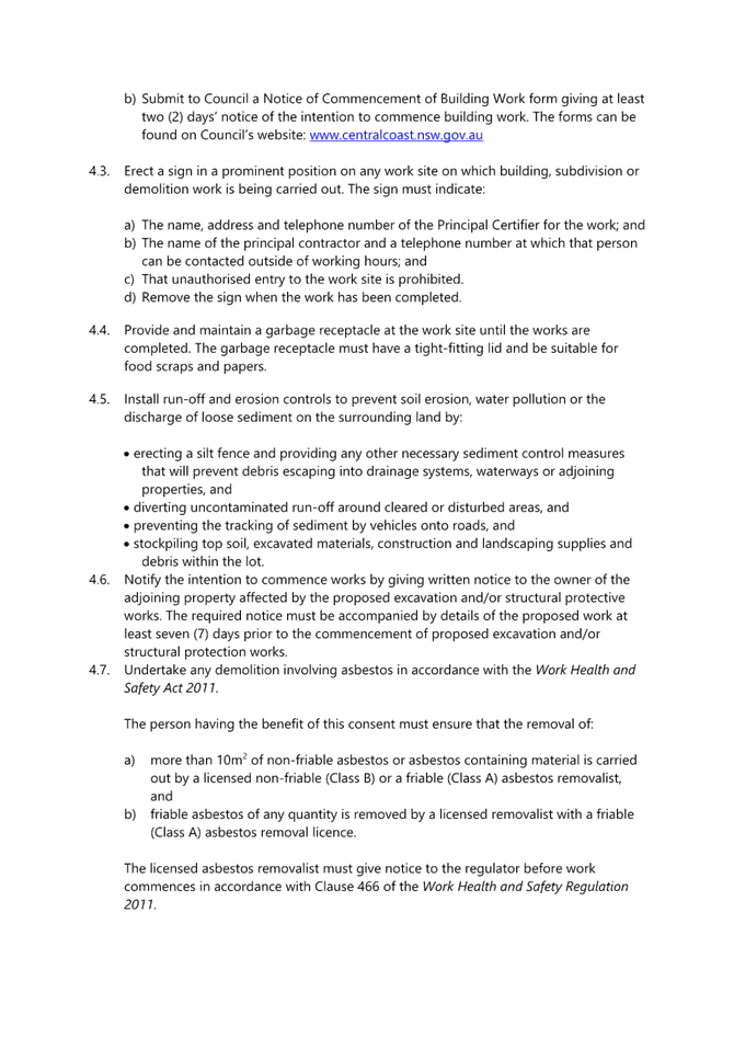
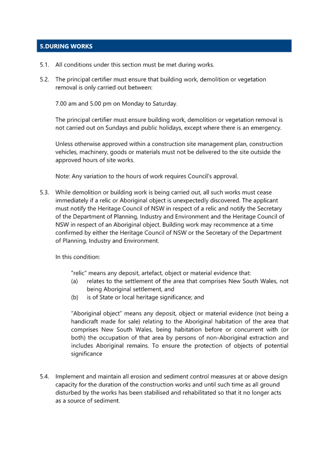
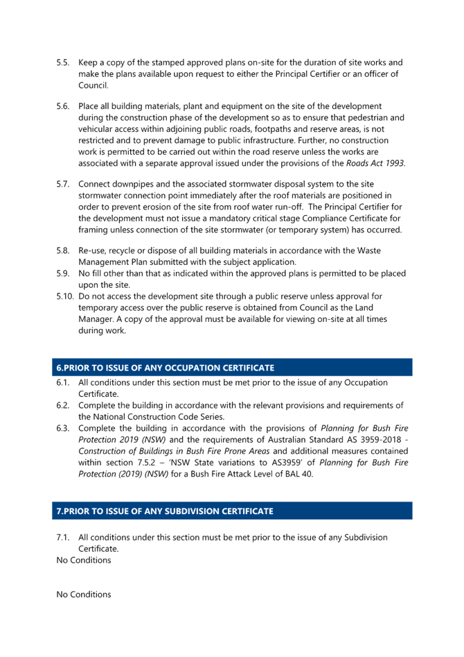
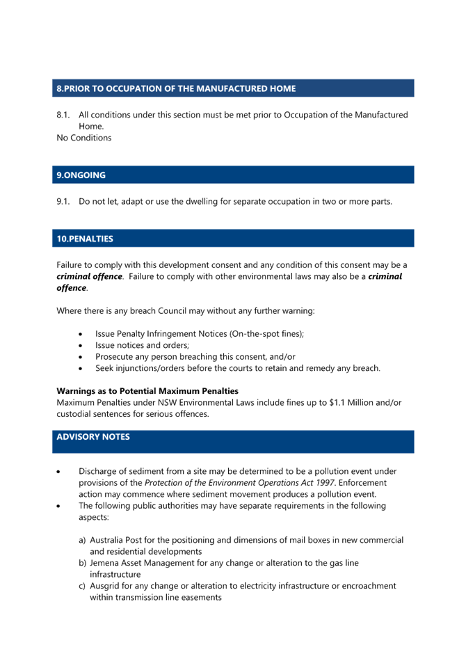


|
DA/1436/2023 - 52-54 Fishermans Parade, Daleys Point - Alterations & Additions |
|
|
Attachment 2 |
Plans - PAN-350280 - DA/1436/2023 - 52-54 Fishermans Parade, DALEYS POINT |