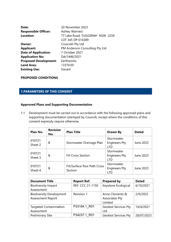
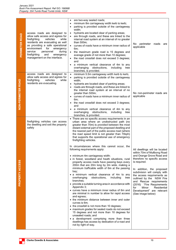
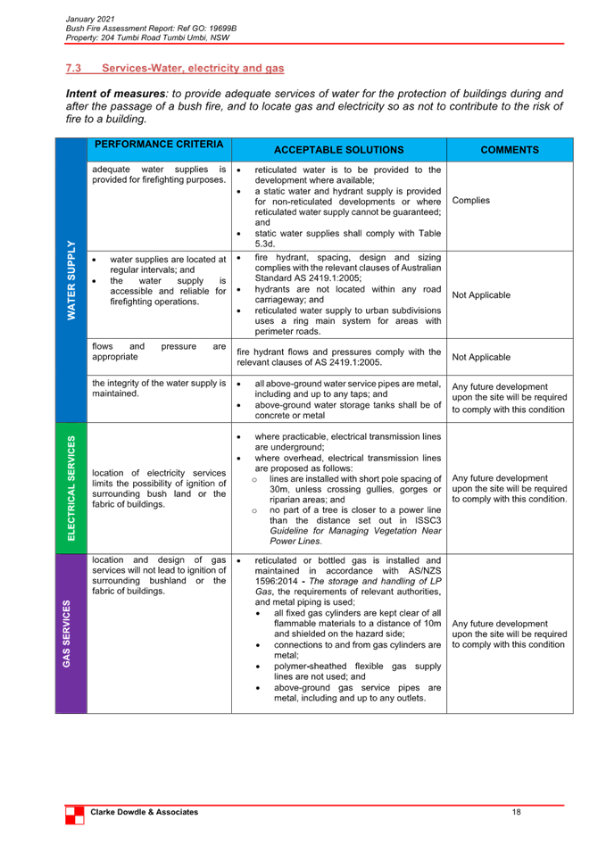
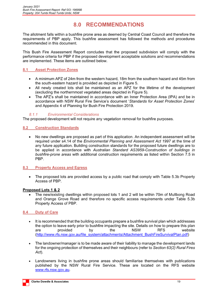
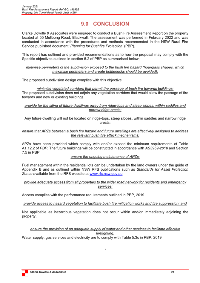
 |
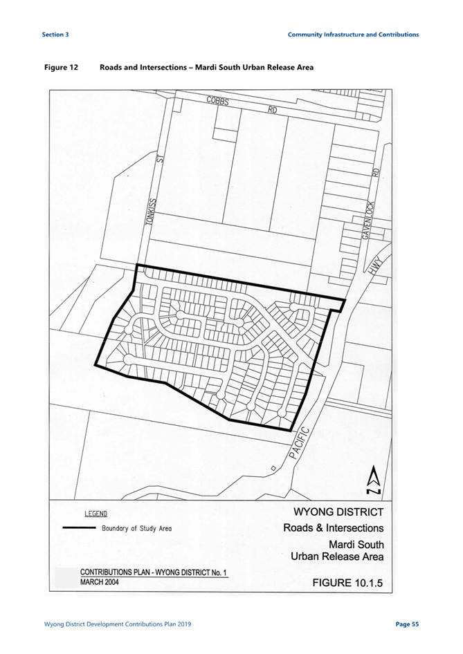
Central Coast
Local Planning Panel Meeting
Business Paper
14 March 2024
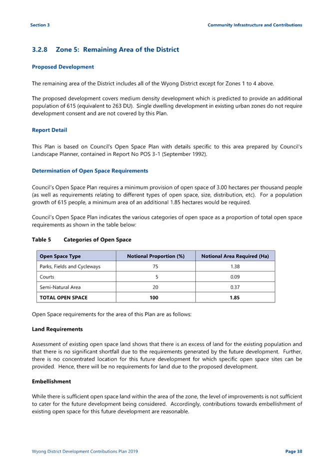
 |
|
Central Coast
Local Planning Panel Meeting
Business Paper
14 March 2024
|
The Local Planning Panel Meeting
of Central Coast
will be held remotely - online,
Thursday 14 March 2024 at 2.00 pm,
for the transaction of the business listed below:
1 Procedural Items
1.1 Disclosures of Interest.............................................................................................................................. 3
2 Confirmation of Minutes of Previous Meetings
2.1 Confirmation of Minutes of Previous Meeting................................................................................. 4
3 Planning Reports
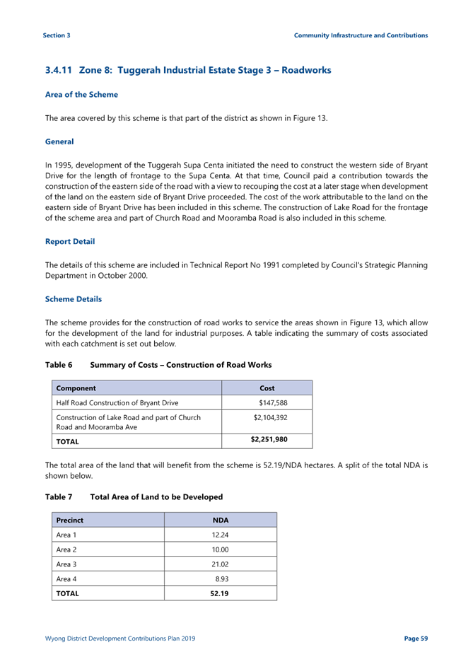
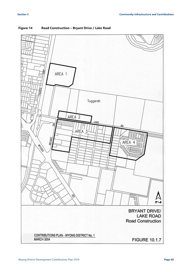
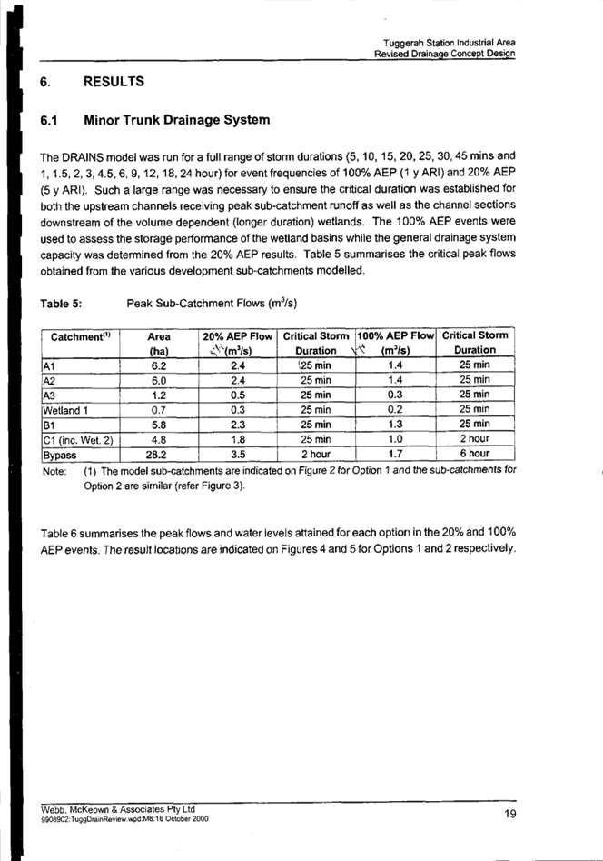
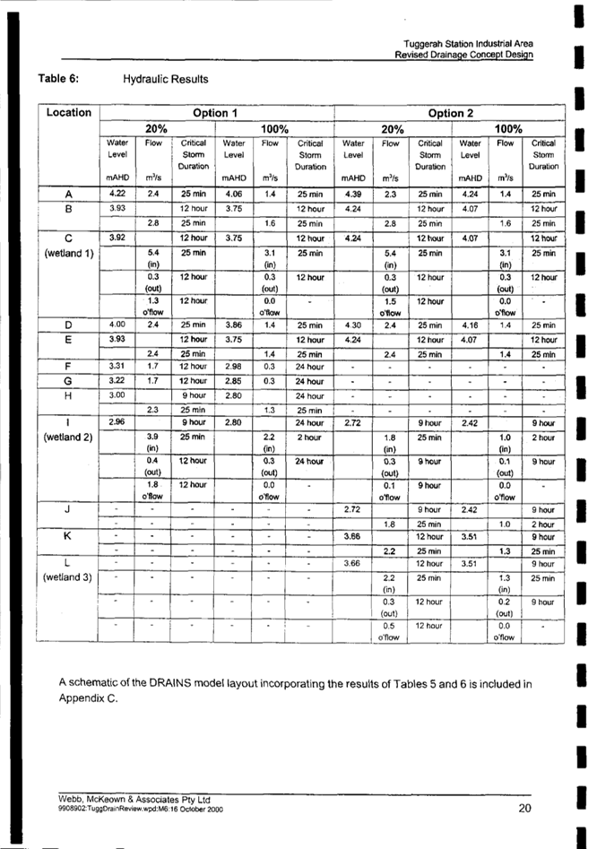
3.1 DA/1446/2021 - 77 Lake Road, Tuggerah - Earthworks and Associated Retaining Walls and Drainage Works........................................................................................................................................ 14
4 Reports
4.1 DA/668/2022 - 55 Mullbong Road, Blackwall - Subdivision into 2 Residential allotments 259
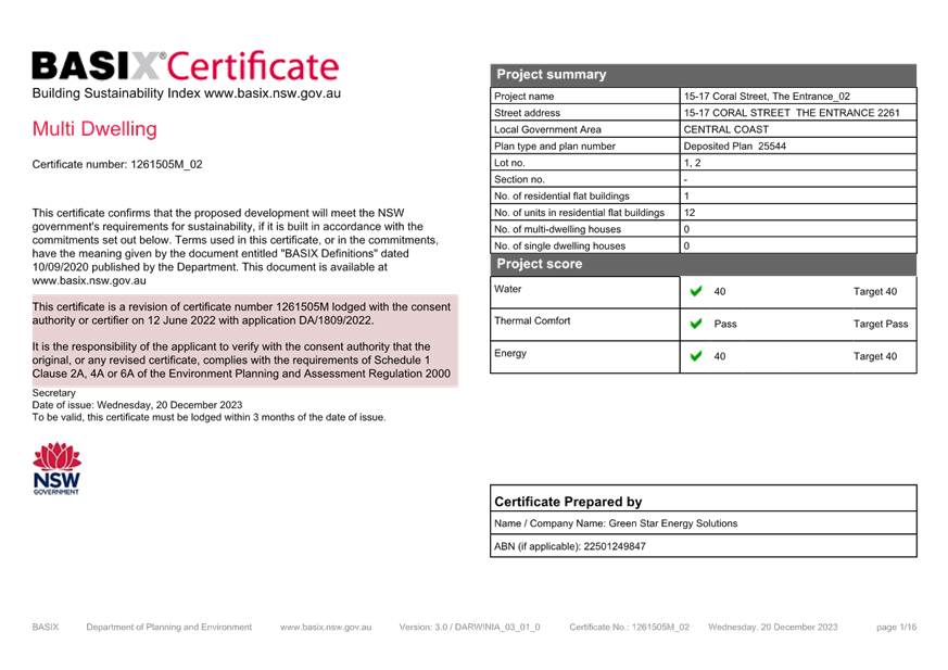
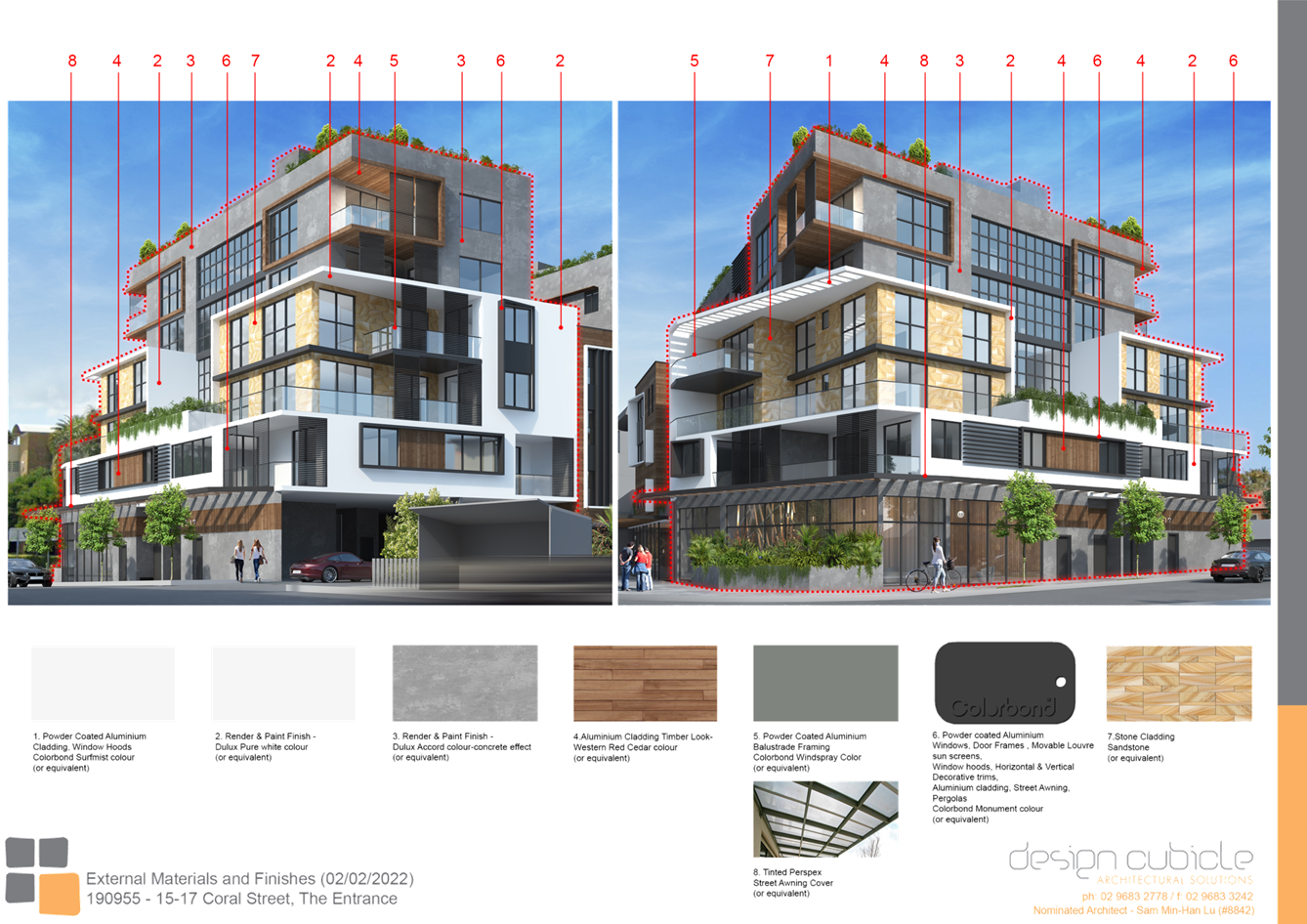
4.2 DA/1809/2022 - 15-17 Coral Street, The Entrance - Construction of a 6 Storey Shop Top Housing development with Basement Level carparking............................................................................ 380
Jason Perica
Chairperson
|
Item No: 1.1 |
|
|
Title: Disclosures of Interest |
|
|
Department: Governance |
|
|
14 March 2024 Local Planning Panel Meeting |
|
Reference: F2020/02502 - D14205789
|
The NSW Local Planning Panel Code of Conduct states that all panel members must sign a declaration of interest in relation to each matter on the agenda before or at the beginning of each meeting.
|
That Panel Members now confirm that they have signed a declaration of interest in relation to each matter on the agenda for this meeting and will take any management measures identified.
|
Item No: 2.1 |
|
|
Title: Confirmation of Minutes of Previous Meeting |
|
|
Department: Corporate Services |
|
|
14 March 2024 Local Planning Panel Meeting |
|
Reference: F2020/02502 - D16094273
Author: Lisa Martin, Civic Support Officer Civic Support
|
Summary
The
Minutes of the following Meeting of the Local Planning Panel, which have been
endorsed by the Chair of that meeting, are submitted for noting: · Local Planning Panel Meeting held on 15 February 2024 |
That the minutes of the previous Local Planning Panel Meeting held on 15 February 2024 which was endorsed by the Chair of that meeting, are submitted for noting.
|
1⇩ |
MINUTES - Local Planning Panel - 15 February 2024 |
|
D16068475 |
|
2.1 |
Confirmation of Minutes of Previous Meeting |
|
Attachment 1 |
MINUTES - Local Planning Panel - 15 February 2024 |
|
Item No: 3.1 |
|
|
Title: DA/1446/2021 - 77 Lake Road, Tuggerah - Earthworks and Associated Retaining Walls and Drainage Works |
|
|
Department: Environment and Planning |
|
|
14 March 2024 Local Planning Panel Meeting |
|
Reference: DA/1446/2021 - D15902676
Author: Ashley Warnest, Development Planner.Employment and Urban Release
Section Manager: Emily Goodworth, Section Manager Employment and Urban Release
Unit Manager: Andrew Roach, Unit Manager Development Assessment
Executive: Alice Howe, Director Environment and Planning
|
Summary
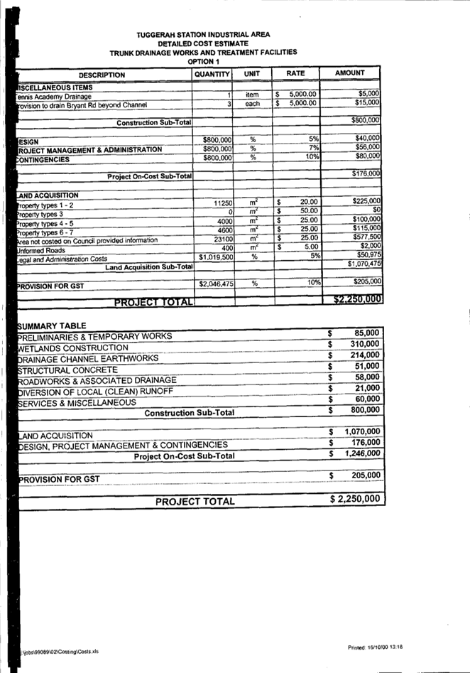
An application has been received for earthworks and associated retaining walls and drainage works at Lot 345 DP 616389, 77 Lake Road, Tuggerah. The application has been examined having regard to the matters for consideration detailed in Section 4.15 of the Environmental Planning and Assessment Act 1979 and other statutory requirements with the issues requiring attention and consideration being addressed in the report.
The application is required to be determined by the Local Planning Panel as the matter requires a variation to the Wyong District Section 7.11 Contributions Plan. Council officers are not delegated to make this variation.
Applicant PM Anderson Consulting Pty Ltd Owner Croscreh Pty Ltd Application No DA/1446/2021 Description of Land LOT 345 DP 616389 Proposed Development Earthworks and associated retaining walls and drainage works Site Area 13,370m2 Zoning IN2 Light Industrial zone Existing Use Vacant Employment Generation No Estimated Value $120,000
|
Recommendation
1 That the Local Planning Panel grant consent to DA/1446/2021 at Lot 345 DP 616389, 77 Lake Road, Tuggerah for Earthworks and Associated Retaining Walls and Drainage Works, subject to the conditions detailed in the schedule attached to the report and having regard to the matters for consideration detailed in Section 4.15 of the Environmental Planning and Assessment Act 1979.
2 That the Local Planning Panel vary the drainage scheme identified in the Wyong District 7.11 Contributions Plan having regard to the matters for consideration detailed in the report and in accordance with the Environmental Planning and Assessment Act 1979.
Key Issues
· Contributions infrastructure
Precis:
|
Proposed Development |
Earthworks and associated retaining walls and drainage works |
|
Permissibility and Zoning |
IN2 Light Industrial zone The earthworks and associated works are permissible in the IN2 zone. |
|
Current Use |
Vacant site |
|
Integrated Development |
No |
|
Submissions |
No submissions |
Variations to Policies
The following variations are proposed to Council policy:
|
Section |
10.4.2 Tuggerah Industrial Estate Stage 3 Drainage |
|
Requirement |
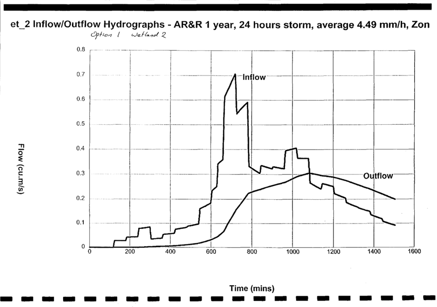
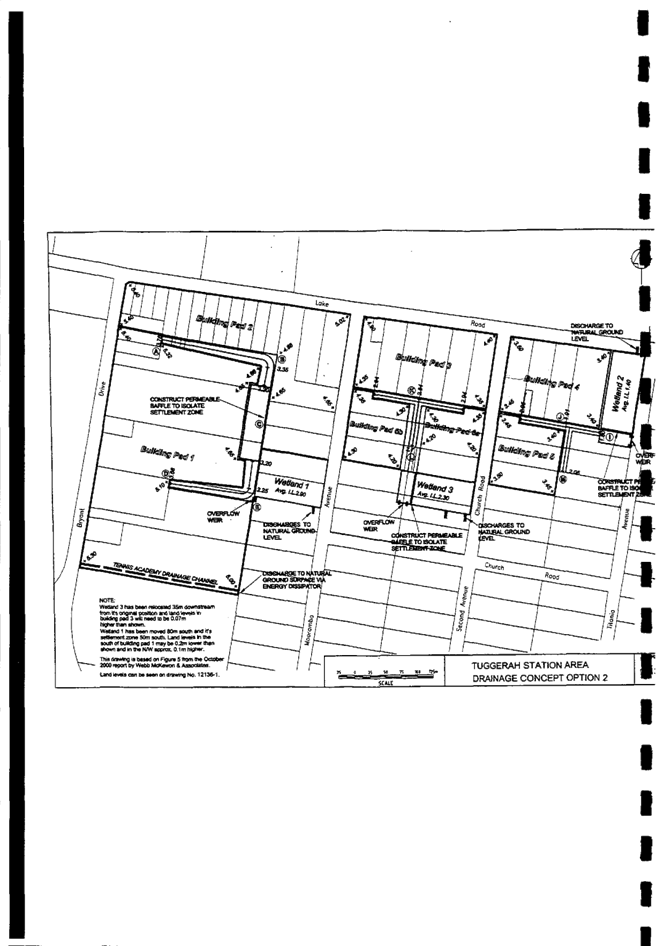
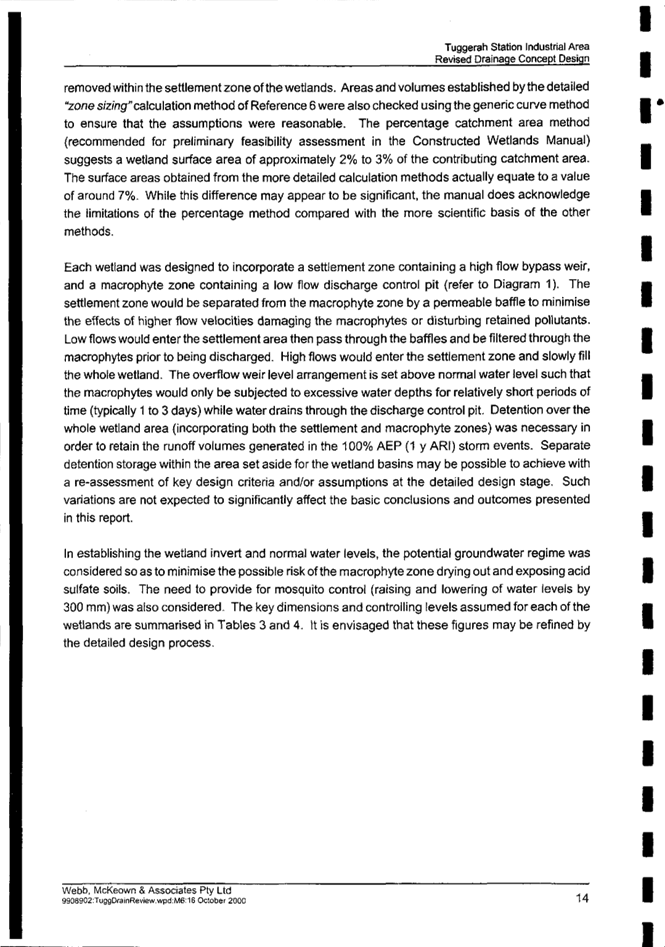
Provision of a wetland on the subject site (Wetland 2 as identified in Figure 16 of the Contributions Plan) |
|
Contributions Plan |
Wyong District Contributions Plan 2020 |
|
Departure basis |
Wetland not proposed |
The Site
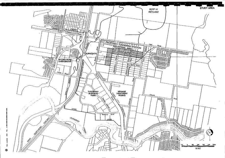
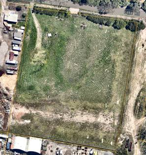
The subject site is of a regular shape that has a frontage of 107m along Lake Road (Figure 1). The site has an average depth of 125m and an area of 13,370m². The topography of the site is generally flat, with a general fall towards the front. The site is currently vacant with a strip of vegetation along the front boundary. Vehicular access is gained along Lake Road.

Surrounding Development
Surrounding land uses are predominantly industrial in nature with a mix of industrial units, bulky goods showrooms and manufacturing and storage businesses in the broader locality along Lake Road and within the industrial area, and in Bryant Drive.
Along the northern side of Lake Road is the regional sporting facility, Pioneer Dairy wetlands, and an electricity substation.
Along the eastern boundary is an unconstructed paper road with dense vegetation in parts except for a cleared powerline easement about 50m wide running southward from the substation. The land immediately to the north and east is zoned C2 Environmental Conservation with RE1 Public Recreation zone to the north-west of the site on the opposite side of Lake Road.
The Proposed Development
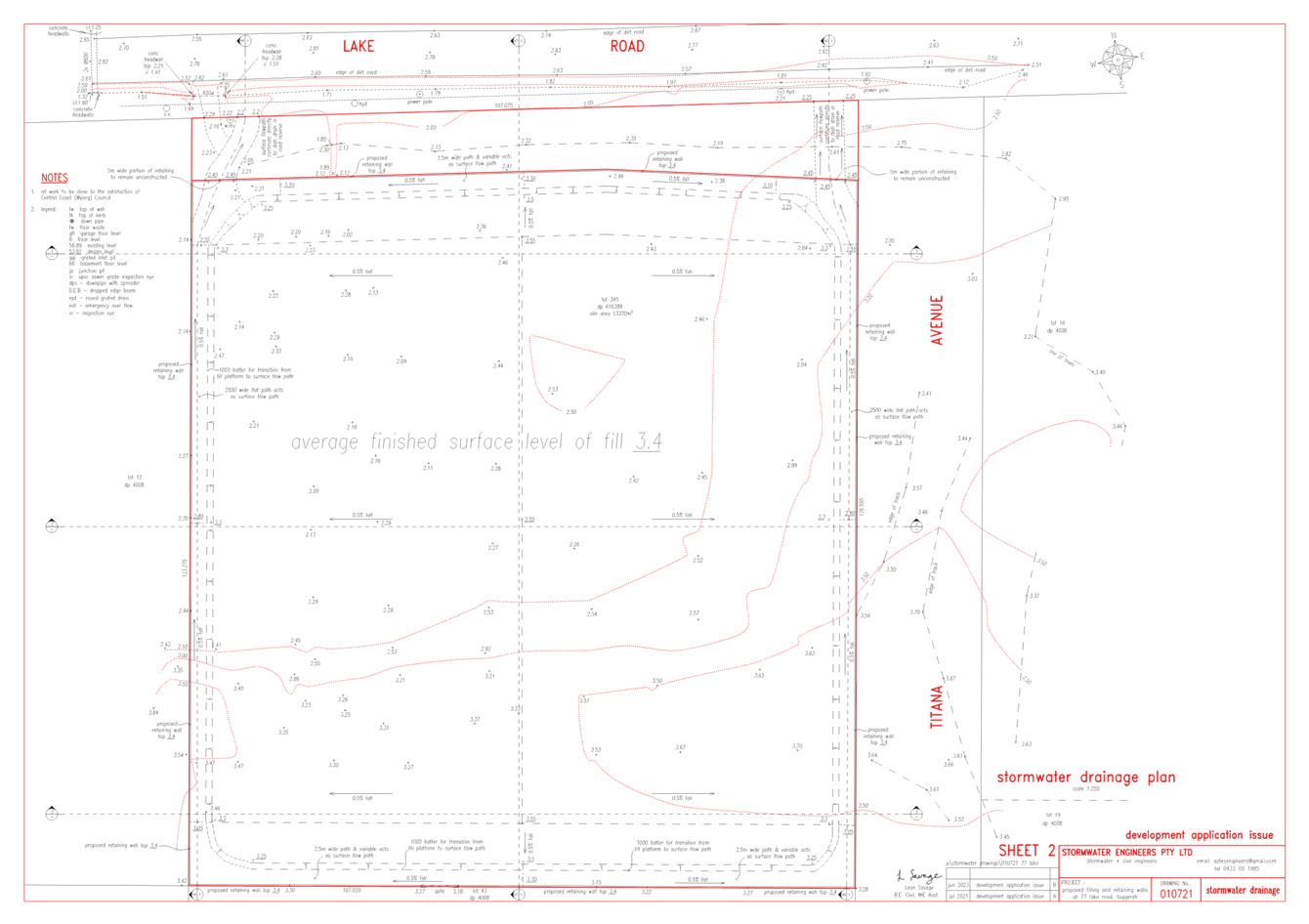
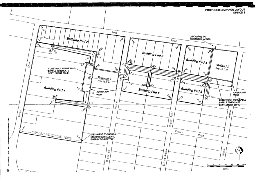
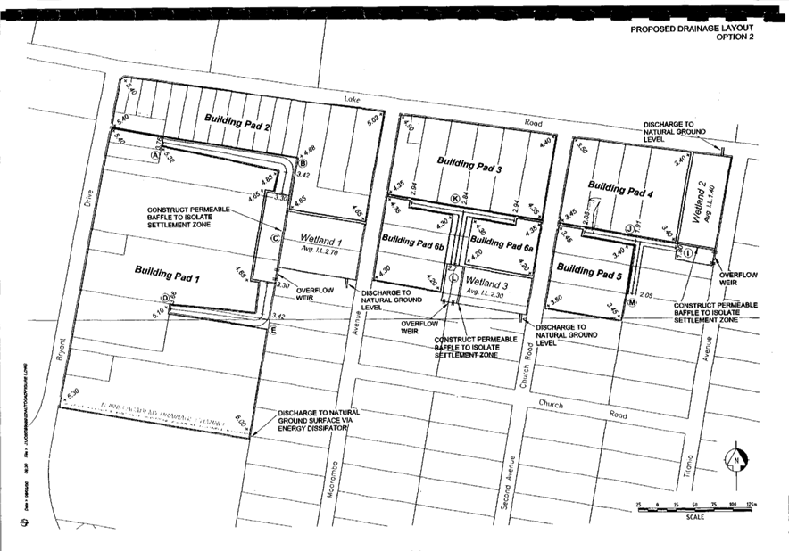
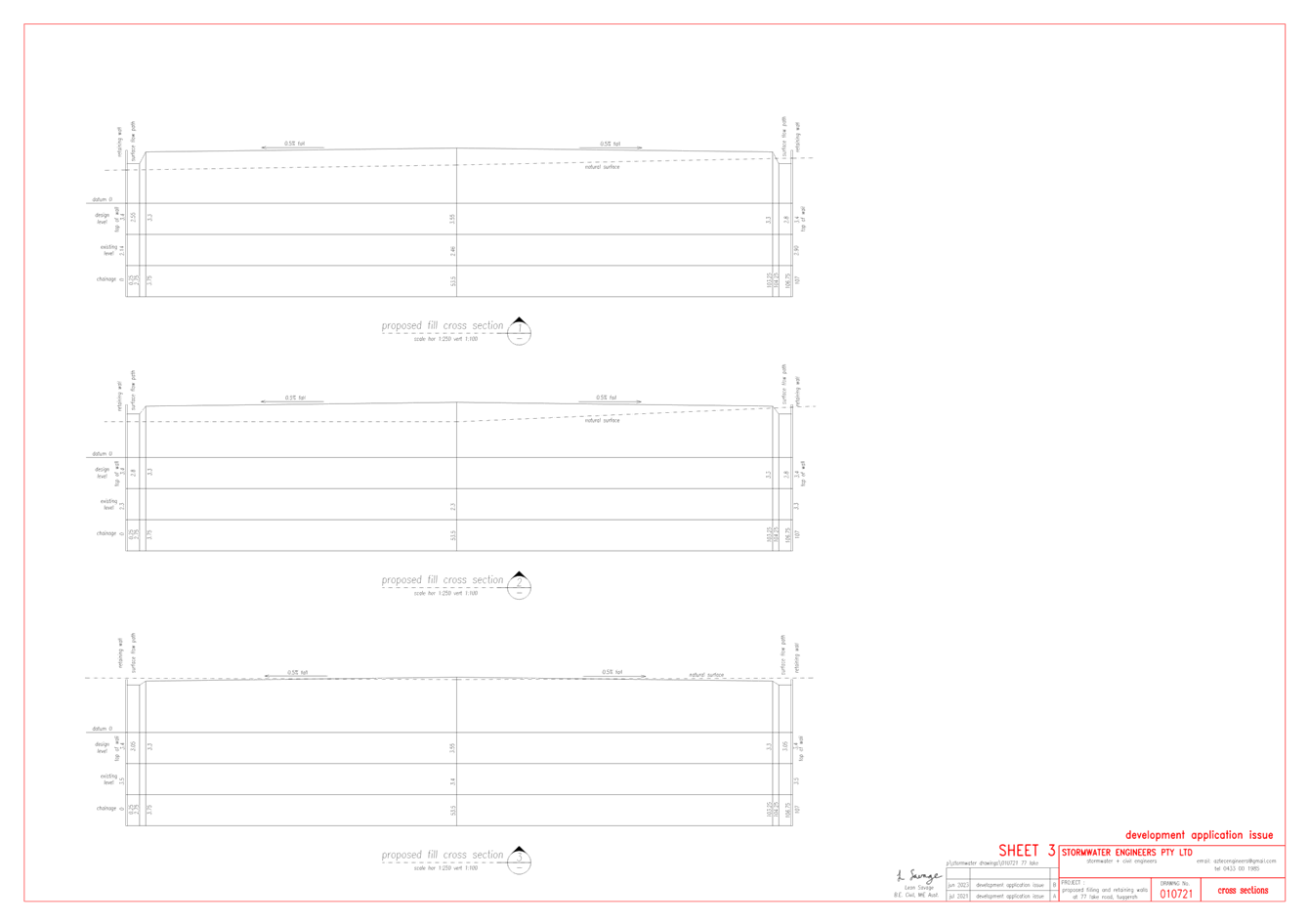
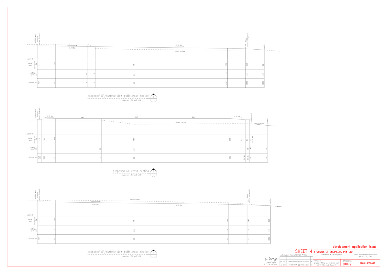
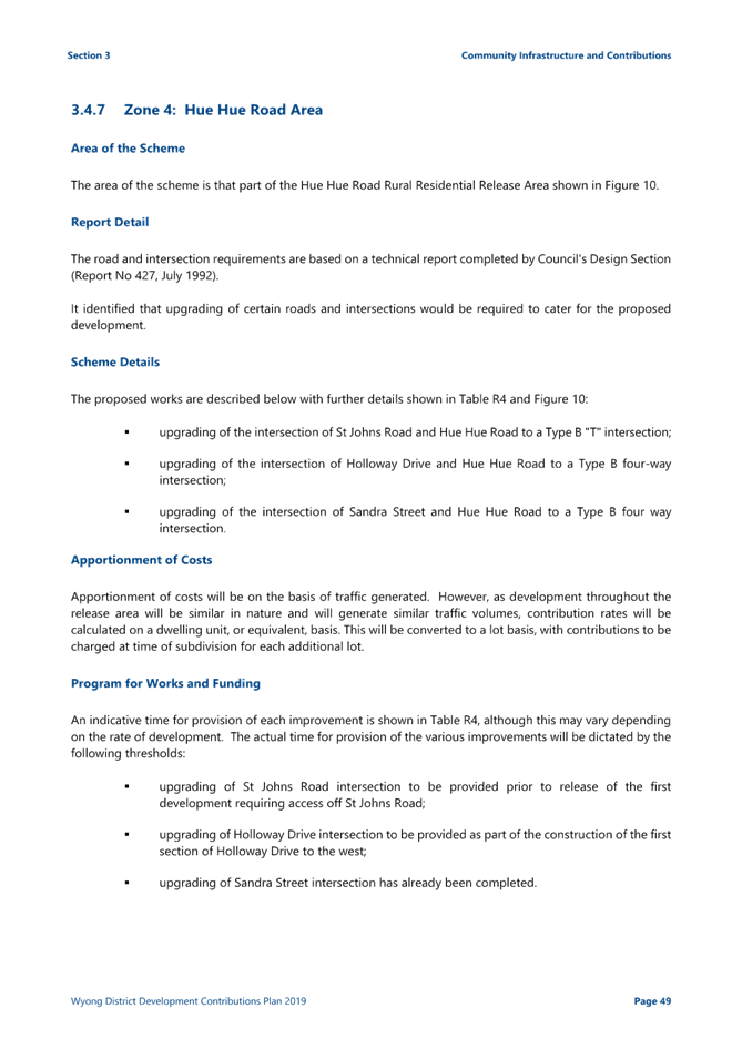
The proposal is to undertake earthworks in the form of filling across the site to the level identified within the contributions plan (RL 3.40), and the construction of retaining walls which have a maximum height of 3.4m. Batter and drainage works are also proposed around the perimeter of the site (Figure 2).
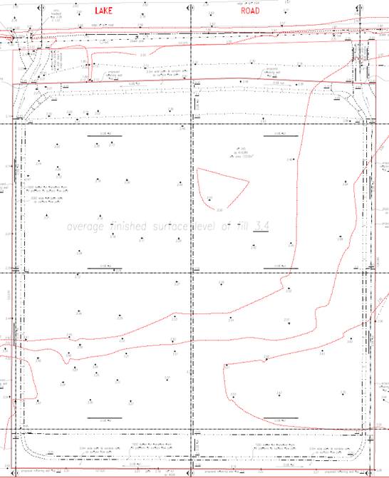
Figure 2: Site Stormwater Drainage Plan
History
· Complying Development Certificate CDC/345/2021
A CDC was issued by a private certifier on 13/5/2021 for the demolition of the existing on-site structures. The demolition works have been undertaken and the site is currently vacant.
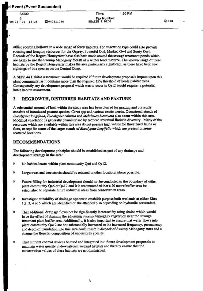
An area of vegetation on the site was cleared in 2018 (NE corner of site) (see Figure 3) and there is no development consent for these works in Council’s records. As such, the land is still mapped on the biodiversity values map and as having vegetation present on site, and a BDAR was requested accordingly. This matter is discussed in further detail within the report.

April 2018 October 2023
Figure 3: Extent of vegetation within subject site in 2018 and 2023
Application Background
The application was lodged 27 October 2021.
Prior to lodgement, clarification was requested regarding the proposed works. A site plan has been provided detailing potential building locations to demonstrate that future development could be accommodated on the site. No building works or use are proposed as part of this application.
During the assessment of the application Council requested additional information in relation to fill levels, flooding and biodiversity. This information was provided by the applicant.
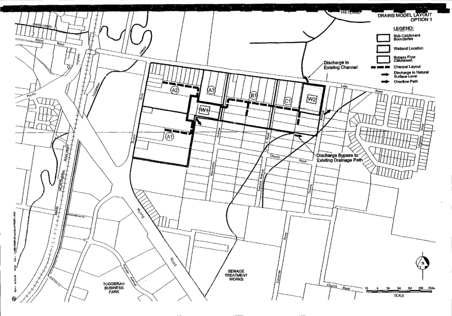
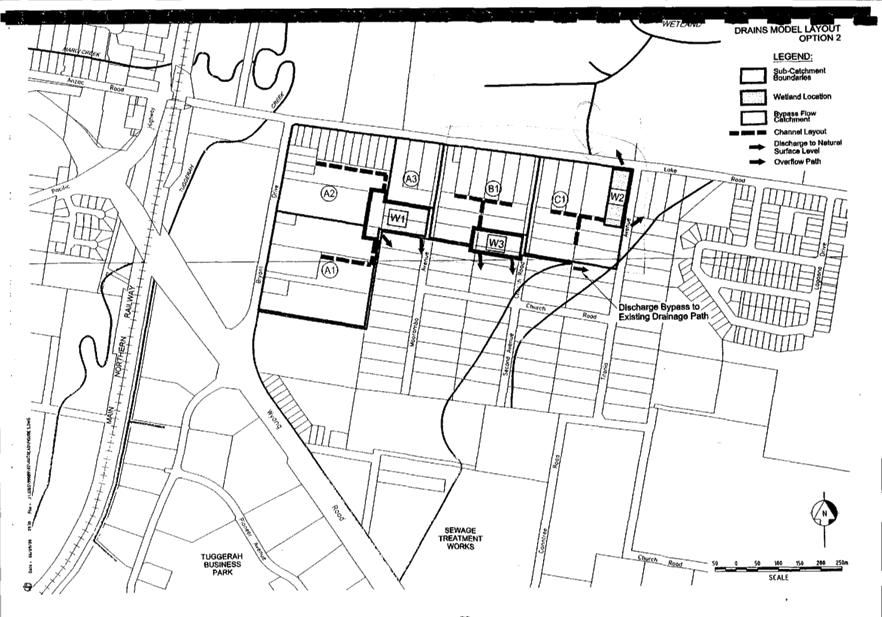
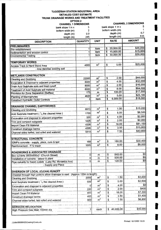
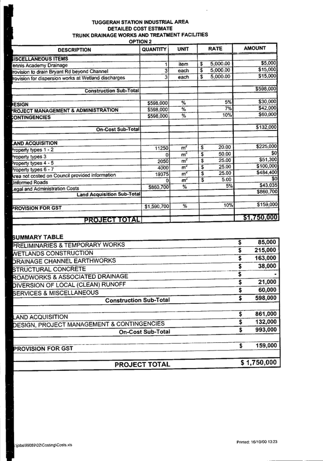
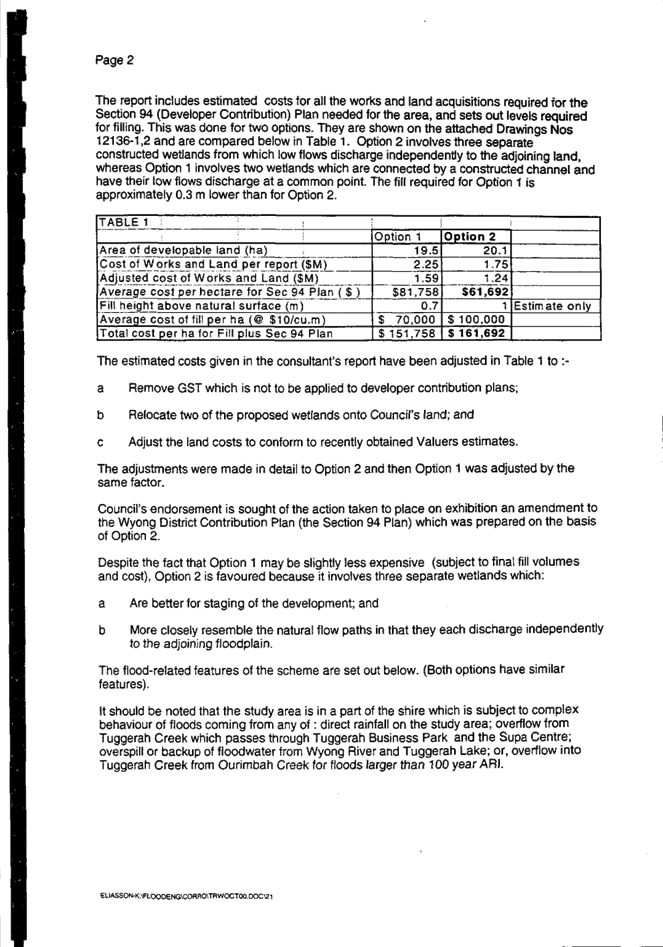
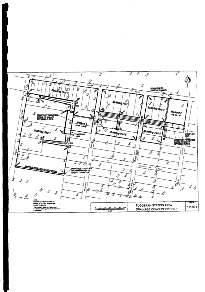
A key matter for consideration in the assessment of the application was the proposed drainage arrangements. The Wyong District Development Contributions Plan 2020 (WDDCP) requires approximately half the subject site to be a man-made wetland, and the applicant requested that Council review this requirement of WDDCP.
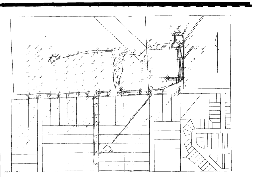
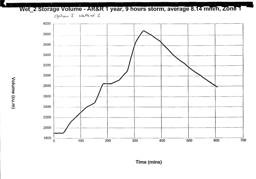
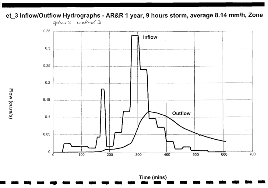
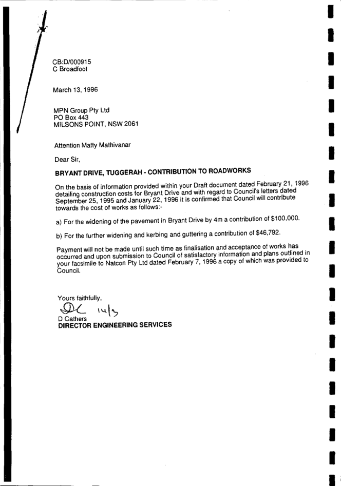
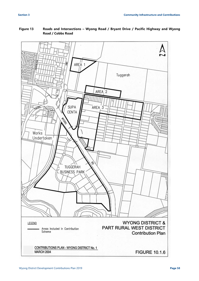
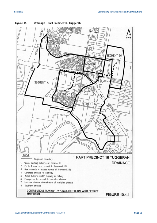
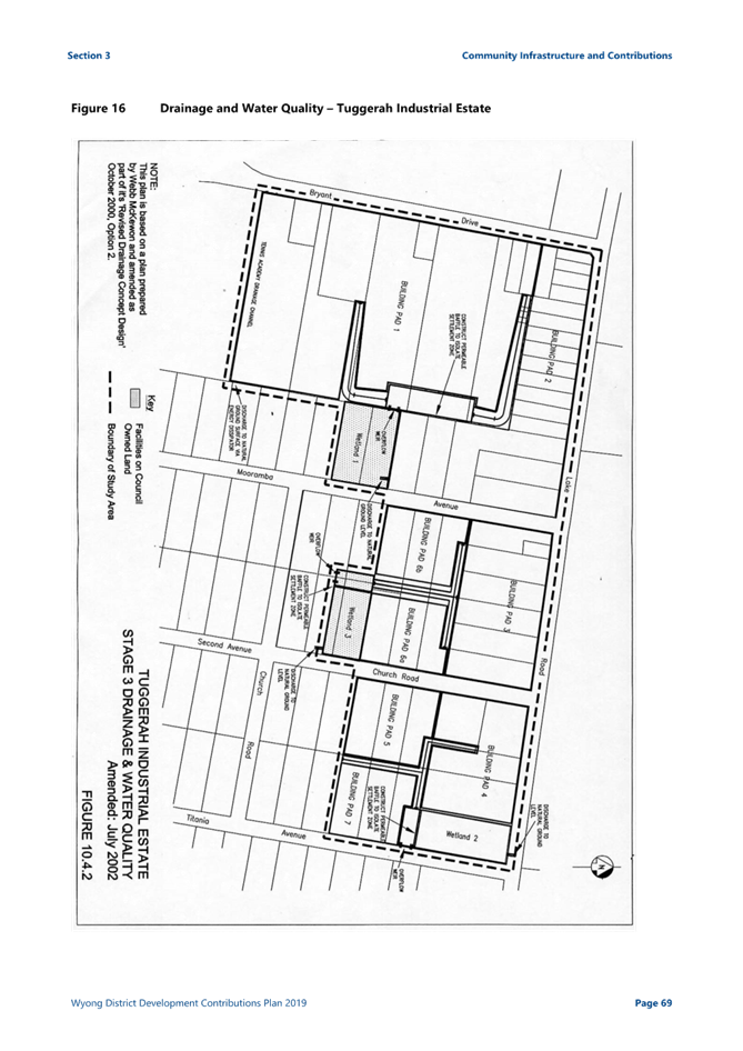
Assessment staff have liaised with the relevant sections of Council to establish the necessity for the wetland identified as ‘Wetland 2’ on the subject site, as per Figure 16 of Section 10.4.2 Tuggerah Industrial Estate Stage 3 Drainage and water quality (reproduced here as Figure 4). Further investigation in relation to WDDCP has revealed that the drainage works within the WDDCP do not form part of Council’s future work schedule in the foreseeable future and the wetland is no longer required. Furthermore, Council does not intend to acquire the private land for use as a wetland as part of the overall drainage scheme for the area and accordingly, the scheme will need to be revised as part of the review of WDDCP that is currently being undertaken.

Figure 4: Extract from Figure 16 showing Drainage and Water Quality -Tuggerah Industrial Estate and proposed wetland on subject site
The applicant has provided an alternative drainage scheme, which satisfies the objectives of the WDDCP, and Council intends to update drainage requirements for the area, which will include removal of ‘Wetland 2’ from the next iteration of WDDCP.
Assessment:
Having regard for the matters for consideration detailed in Section 4.15 of the Environmental Planning and Assessment Act 1979 and other statutory requirements, Council’s policies and Section 10.7 Certificate details, the assessment has identified the following key issues, which are elaborated upon for Council’s information.
Biodiversity Conservation Act 2016 (BC Act)
The NSW Biodiversity Offsets Scheme applies to the development, and a Biodiversity Development Assessment Report (BDAR) has been provided. The BDAR outlines the assessment of the biodiversity values of the site and the impact of the proposed development in accordance with the Biodiversity Assessment Methodology (BAM).
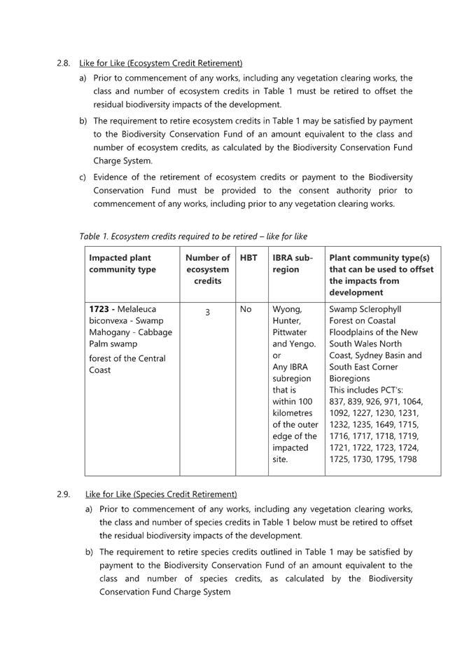
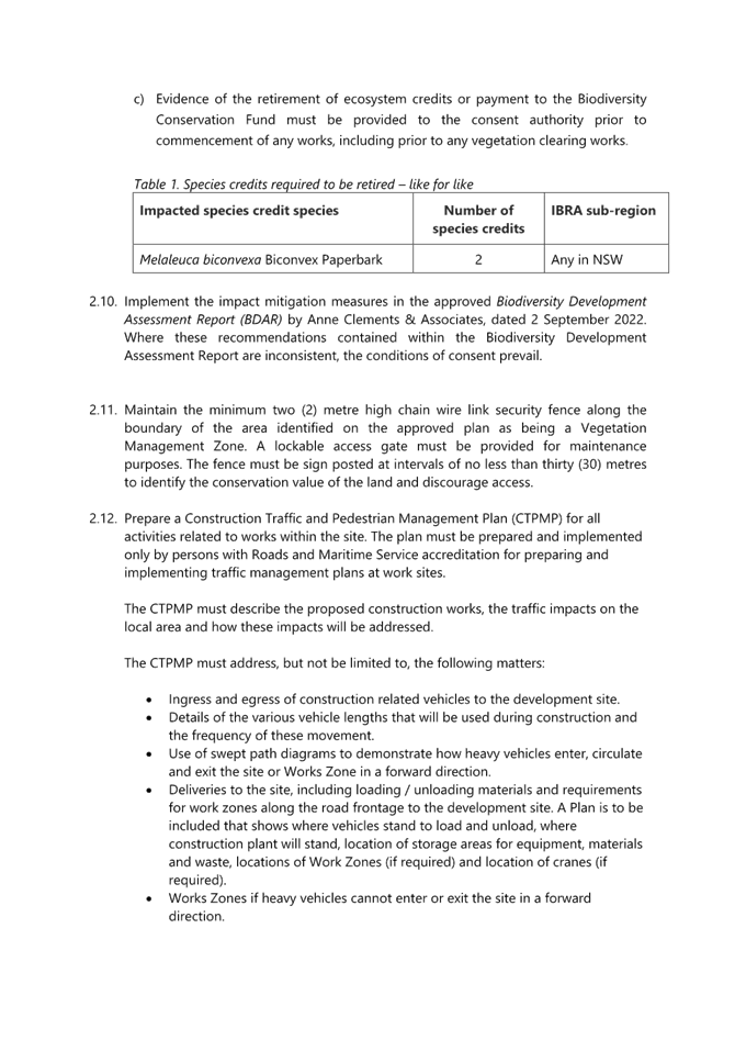
The BDAR outlines that the proposed development requires clearing of 0.1522Ha of PCT 1723 “Melaleuca biconvexa – Swamp Mahogany - Cabbage Palm swamp forest of the Central Coast” containing the threatened tree species Melaleuca biconvexa. This includes 0.1Ha of vegetation cleared without approval in 2018.
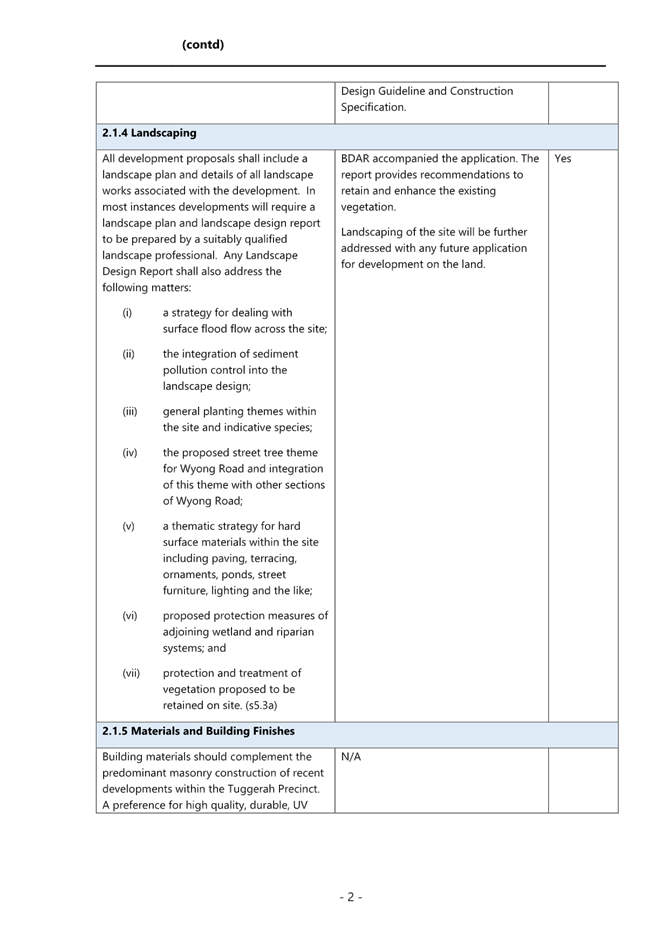
The vegetation proposed to be retained has already been separated from the development area with a 2m high security fence (Figure 5). This is as per the recommendation of the previous (2021) Keystone Ecology report to fence this area. The BDAR states that the fence is 6m in from the surveyed property boundary (variable, marked by survey pegs). The area of vegetation to be retained qualifies as the Endangered Ecological Community Swamp Sclerophyll Forest on Coastal Floodplain and includes many Melaleuca biconvexa. The fence is to remain in place with no further development to impact this vegetation.
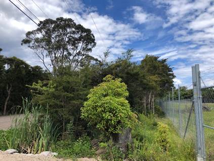
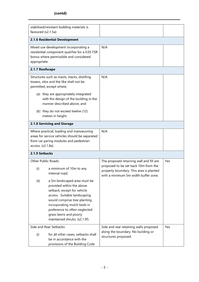
Figure 5: Location of existing chain wire fence and vegetation along Lake Road
The proposed northern retaining wall is proposed to be setback 10m from the property boundary. This area is proposed to be planted with a minimum 5m width buffer zone between the fence and the retaining wall with tube stock of Melaleuca biconvexa grown from seed collected on site. The seed has already been collected and tube stock are ready for planting as detailed in the BDAR.
The clearing, including the unauthorised clearing already undertaken, will generate an offset requirement of three ecosystem credits for PCT 1723 and two species credits for Melaleuca biconvexa. The development is not likely to have a serious and irreversible impact on biodiversity values and conditions have been recommended relating to the retirement of biodiversity credits and compliance with the recommendations and mitigation measures outlined in the BDAR.
State Environmental Planning Policy (Biodiversity and Conservation) 2021
Chapter 4 – Koala Habitat Protection 2021
Chapter 4 of the State Environmental Planning Policy (Biodiversity and Conservation) 2021 applies to Central Coast local government area. In accordance with Section 4.9, before a consent authority can grant consent, it must assess whether the development is likely to have any impact on koalas or koala habitat. In accordance with Section 4.9(5) consent may be granted where the applicant provides satisfactory information that demonstrates that the land subject of the development application is not core koala habitat.
The BDAR submitted with the application undertook an assessment to determine if the site was core koala habitat. Council’s Ecologist reviewed the BDAR and was satisfied that the site is not core koala habitat. Having regard for the provisions of subsection 4.9(5) of the SEPP, the Panel, as the consent authority, can be satisfied the proposed development will have no impact on koalas or koala habitat.
State Environmental Planning Policy (Resilience and Hazards) 2021
Chapter 4 – Remediation of Land
In accordance with Section 4.6, a consent authority must not consent to the carrying out of development unless it has considered whether the land is contaminated, and if the land requires remediation to be made suitable for the development.
A Preliminary Contaminated Site Investigation (PSI), prepared by Geotest Services Pty Ltd, dated 28 July 2023, was submitted with the application. The site was identified to have been historically used as part of an airstrip in the south-eastern portion of the site from around 1942 until after World War II when the airstrip was converted into paddocks to support rural residential living. A light aircraft was understood to have made an emergency landing at the airstrip runway in 1950. Since 1950, the site appears to have been largely used for residential occupancy and is currently vacant with no structures on site.
Several disturbances and filling events are observed across the site based upon the 1966 to 2023 aerial imagery catalogue that has been reviewed, consisting of both localised (stockpiling) and relatively broad filling works. Based on the above findings within the PSI, Geotest Services prepared a Preliminary Conceptual Site Model (CSM). The CSM has further identified several potential Areas of Environmental Concerns (AEC) with associated Contaminates of Potential Concern (CoPCs). The PIS recommended that a Detailed Site Investigation (DSI) be prepared in accordance with the NSW EPA 2020 Guidelines for Consultants Reporting on Contaminated Land.
The applicant provided a DSI report whilst the application was under assessment. The DSI reviewed the AEC and previous reporting and found the site can be made suitable for future commercial or industrial land uses following the delineation, remediation, and validation of identified localised contamination. The DSI report recommended that a Remedial Action Plan (RAP) should be prepared for the site in order to facilitate and guide the known remediation and validation requirements including delineation. A RAP has been prepared and provided by the applicant to accompany the application.
The proposal, RAP and DSI report have been reviewed by Council’s Environmental Health Officer, who is satisfied the proposed development is suitable for the intended use of the land.
The Panel can be satisfied that the proposed works can be undertaken and appropriately managed to reduce the risk of harm to human health or any other aspect of the environment. The provisions of Section4.6 have been appropriately addressed and consent can be granted for the proposed development.
Central Coast Local Environmental Plan 2022 (CCLEP 2022)
provisions under clause 1.8A, this application has been lodged prior to the commencement of CCLEP 2022, and as such the provisions of the Wyong Local Environmental Plan 2013 (WLEP 2013) continue to apply.
Under the published and adopted CCLEP 2022, the site is zoned E4 General Industrial and earthworks remain permissible within the E4 zone. There are no new or amended clauses or provisions warranting further discussion.
Wyong Local Environmental Plan 2013 (WLEP 2013)
Zoning and Permissibility
The site is zoned IN2 Light Industrial (Figure 6), and earthworks are a permissible development in the zone.
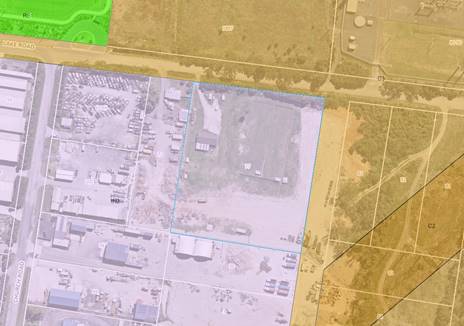
Figure 6: Zoning of the site and surrounding area
Earthworks are defined as follows under the WLEP 2013:
earthworks means excavation or filling.
Earthworks are a type of development as identified in the Environmental Planning and Assessment Act 1979.
Whilst the proposed earthworks are not associated with a use, the proposed works are in line with the works required under WDDCP. The proposed works will result in a building pad and fill that is required in the WDDCP This is discussed in further detail below.
Objectives of the zone
Subclause 2.3(2) of CCLEP 2022 requires the consent authority to have regard to the objectives for development in a zone when determining a development application. The objectives of the IN2 Light Industrial zone are as follows:
· To provide a wide range of light industrial, warehouse and related land uses.
· To encourage employment opportunities and to support the viability of centres.
· To minimise any adverse effect of industry on other land uses.
· To enable other land uses that provide facilities or services to meet the day to day needs of workers in the area.
· To support and protect industrial land for industrial uses.
The proposed earthworks will comply with the building pad level nominated within the WDDCP and will provide a site that can appropriately accommodate future industrial development and employment opportunities. The proposal is considered to achieve the relevant objectives of the site.
Clause 5.21 Flood planning
The site is identified as flood prone land under clause 5.21 of WLEP 2013 as shown in Figure 7.
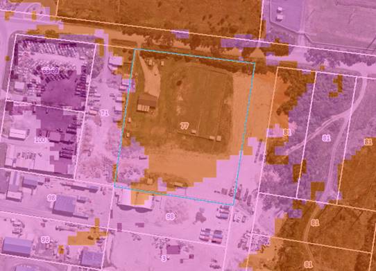
Figure 7: Flood Precinct
State Environmental Planning Policy Amendment (Flood Planning) 2021 (SEPP Flood Planning) removed clause 7.2 from the WLEP 2013 and introduced clause 5.21. The Standard Instrument (Local Environmental Plans) Amendment (Flood Planning) Order 2021 (Flood Planning SI Order) did not include specific savings and transitional provisions to exempt pending development applications from the application of the new flood planning amendments. However, clause 8 of the Standard Instrument (Local Environmental Plans) Order 2006 provides that changes made by an amending order do not apply to or in respect of any development application that was made, but not determined, before the start of the amending order.
This means that the new flood planning amendments that were introduced by the Flood Planning SI Order will not apply to any development application that has been made, but not finally determined, before the start of the Flood Planning SI Order (that is, 14 July 2021). This application was lodged in October 2021 and as such, the provisions of clause 5.21 apply.
In accordance with clause 5.21(2) development consent must not be granted to development on land within flood planning land unless the consent authority is satisfied the development:
(a) is compatible with the flood function and behaviour on the land, and
(b) will not adversely affect flood behaviour in a way that results in detrimental increases in the potential flood affectation of other development or properties, and
(c) will not adversely affect the safe occupation and efficient evacuation of people or
exceed the capacity of existing evacuation routes for the surrounding area in the event of a flood, and
(d) incorporates appropriate measures to manage risk to life in the event of a flood, and
(e) will not adversely affect the environment or cause avoidable erosion, siltation,
destruction of riparian vegetation or a reduction in the stability of river banks or
watercourses.
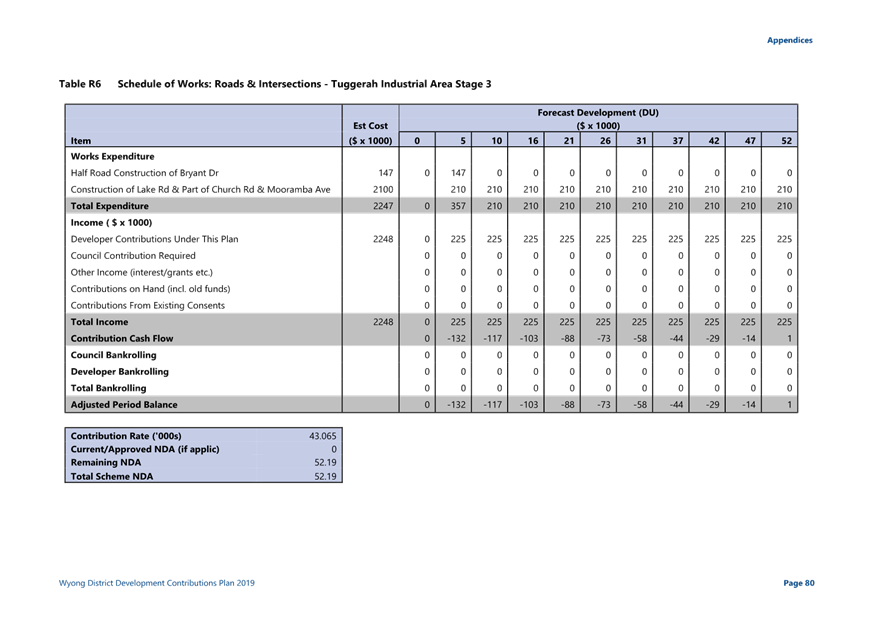
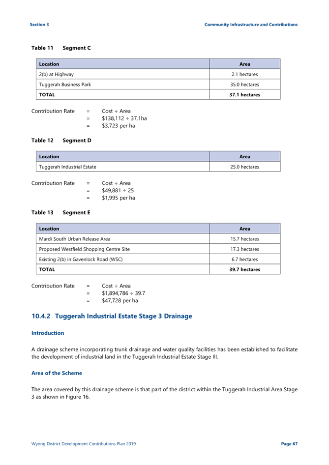
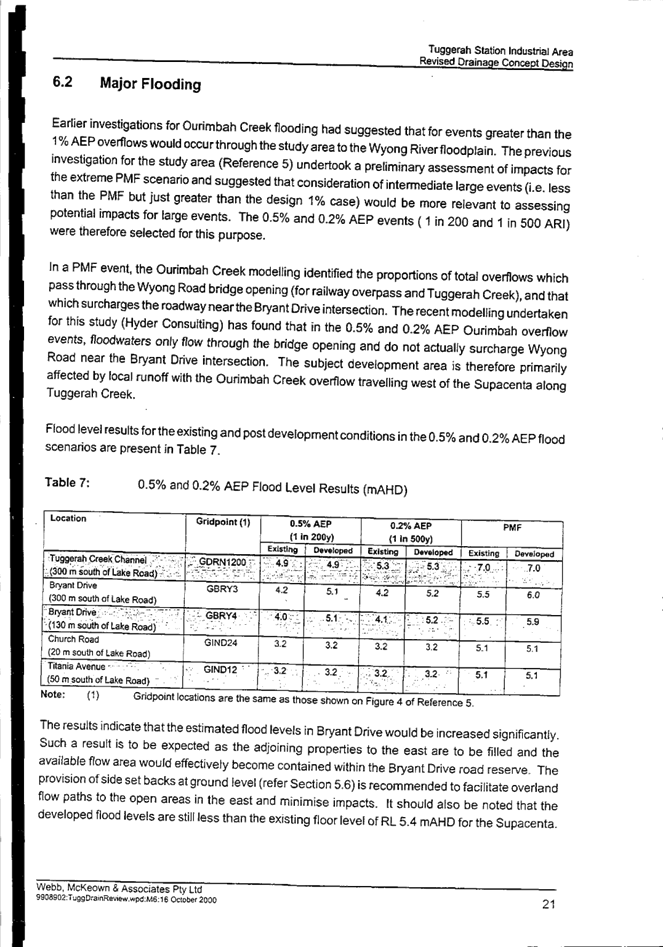
The site is identified as part of WDDCP for the Tuggerah Industrial Area Stage 3. The Technical Report for WDDCP states that this parcel of land may be filled up to 3.40m AHD. Council’s Flood Engineer and Development Engineer have reviewed the proposal and have advised that the proposed filling will be consistent with other sites within this precinct that have developed in accordance with WDDCP. The nominated fill level of up to 3.40m AHD is considered appropriate and consistent with the finished levels envisaged under WDDCP.
The proposal is compatible with the intended flood function and behaviour of the land, and the implementation of WDDCP across the Tuggerah Industrial Area will result in improved drainage and minimise flood affectation for the site and adjoining properties identified within WDDCP.
It is noted that the required works identified within the drainage scheme for the Tuggerah Industrial Estate are undertaken site by site. It is considered the proposed works will not have detrimental flood affectation for other development or properties that have not yet undertaken works in accordance with WDDCP.
The site is currently vacant and no proposed use forms part of this application. The technical document that accompanies WDDCP has considered the flooding impacts as part of the study to ensure that the extent of development does not adversely affect (Ourimbah Creek to Wyong River) flood levels in the area.
A Sediment Erosion Control Plan has been prepared and reviewed by Council’ Development Engineer and Environmental Health Officer. No concerns were raised, and relevant conditions have been prepared to ensure the proposal will not adversely affect the natural environment.
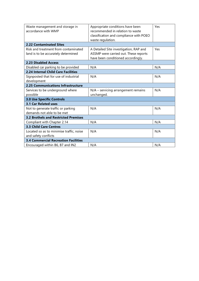
Clause 7.1 Acid Sulfate Soils
The site is identified as being affected by Class 3 acid sulfate soils. The clause identifies where works are more than 1m below the natural ground surface, or works are likely to lower the watertable more than 1m below the natural ground surface, an Acid Sulfate Soils Management Plan (ASSMP) must be prepared for the proposed development. The proposed works include the placement of fill throughout the site, and partial levelling at the southeast corner of the site. The proposed works are not expected to be more than 1m below the natural ground surface or to impact the watertable.
Regardless of the above, an ASSMP has been prepared based on the recommendations of the accompanying Detailed Site Investigation and Acid Sulfate Soils Assessment Report. The proposed development and relevant documentation, including the ASSMP, have been reviewed by Council’s Environmental Health Officer who raised no concerns with the ASSMP.
The Panel can be satisfied that the relevant considerations of this clause have been satisfied and Acid Sulfate Soils can be appropriately managed on site.
Clause 7.9 Essential services
The proposal does not seek any use of the site. However, the building pad will provide opportunity for future development of the site and in this regard, there are adequate arrangements in place for vehicular access, electricity, and water supply. Satisfactory vehicle access to facilitate construction access has been proposed.
The site is currently unsewered. No wastewater requirements are applicable as part of this application and will be addressed with any future development of the site.
The Panel can be satisfied that adequate essential servicing can be made available to future development having regard for water, sewer, electricity, stormwater drainage, waste collection and vehicular access.
Central Coast Development Control Plan 2022 (CCDCP 2022)
CCDCP 2022 commenced on 1 August 2022. However, in accordance with the savings provisions under clause 1.1.4 of Chapter 1.1, this application has been lodged prior to commencement of CCDCP 2022 and as such the provisions of the WDCP 2013 continue to apply.
Wyong Development Control Plan 2013 (WDCP 2013)
Chapter 2.12 Industrial Development
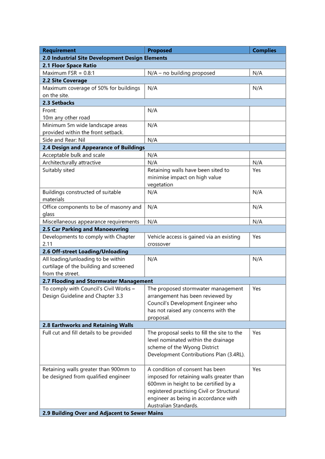
An assessment has been undertaken in relation to the provisions of Chapter 2.12 WDCP 2013. This assessment against the requirements of this chapter is detailed in Attachment 3. The assessment of the proposal has found it to be compliant with the requirements of the Chapter.
Objectives of this Chapter are as follows:
· To encourage employment generating developments
· To promote quality industrial development in Wyong Shire by identifying Council's expectations and requirements relating to design and construction; and
· To control environmental impacts arising from industrial development
The proposed earthworks provide a building pad that achieves the requirements of the drainage scheme detailed within WDDCP. The proposed earthworks improve the drainage arrangement for the subject site and provide a functional building pad for future development that will meet the objectives of the Chapter.
The proposed retaining wall locations are situated to maximise retention and revegetation of the Endangered Ecological Community Swamp Sclerophyll Forest identified within the front setback and road reserve. The design and extent of the earthworks and associated retaining walls and drainage works are located to minimise impacts to the natural environment.
Chapter 3.1 - Site Waste Management
A Waste Management Plan was prepared to accompany the application however, the plan details upgrade of the existing waste collection on site which is not consistent with the scope of the current application being earthworks only. To ensure the proposed earthworks and associated waste generated is suitably disposed of a condition of consent has been imposed to store waste in a manner so that it does not pollute the environment and all waste generated on the premise must be transport to a facility which is licensed to receive that material. The requirements of Chapter 3.1 can be suitably satisfied.
Chapter 3.3 - Floodplain Management
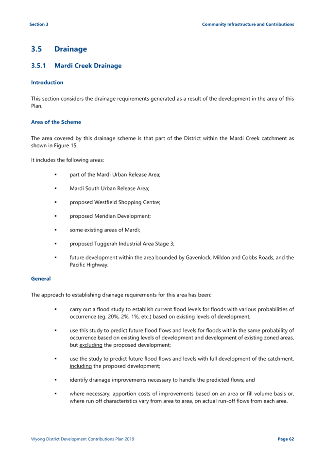
The application is proposing permissible earthworks in Precinct 3 Flood Storage. The provisions of clause 3.1.4.1 require a performance-based assessment to be provided demonstrating that the proposed development is compatible with the flooding characteristics of the site. In this circumstance it is considered that a performance-based assessment is not required as the proposal is consistent with the technical documentation that informs WDDCP, Section 3.5 Drainage (Attachment 6).
Council’s Flood Engineer has reviewed the proposal in terms of the flood planning controls and the requirements of WDDCP and associated drainage strategy, and provided the following comments:
“It is understood that the site was identified as part of an adopted Contributions Plan for the Tuggerah Industrial Area Stage 3. The Technical Report for this Contributions Plan states that this parcel of land may be filled up to 3.40m AHD (pg 76). As action on this Contributions Plan has already commenced, it is considered appropriate to allow filling up to 3.40m AHD.
Filling of the site up to 3.40m AHD is supported for this development.”
The current proposal being for earthworks only it is not expected to result in additional people or vehicles on site. The proposal will not increase risk to human life or unreasonably impact upon the natural environment.
Chapter 3.6 - Tree and Vegetation Management
The provisions of Chapter 3.6 do not apply to the proposed development as it involves the removal of vegetation on land which is mapped on the Biodiversity Values Map and a BDAR is required under Section 6.4 of the Biodiversity Conservation Act 2016. The applicant has prepared a BDAR, which has been reviewed by Council’s Ecologist and is discussed elsewhere in the report.
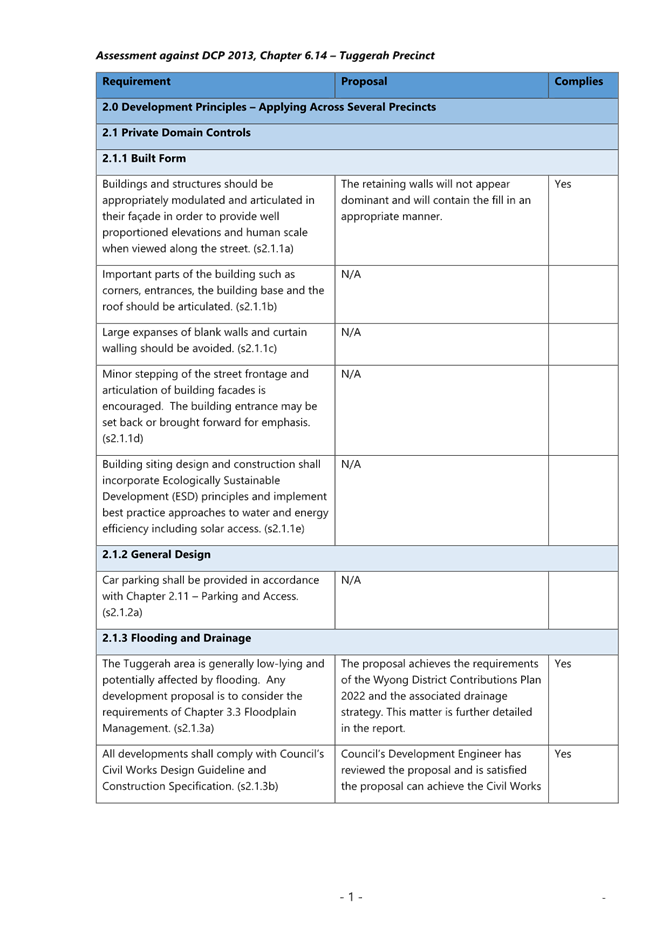
Chapter 6.14 Tuggerah Precinct
An assessment has been undertaken in relation to the provisions of Chapter 6.14 WDCP 2013. This assessment against the requirements this chapter is detailed in Attachment 4. The proposed earthworks comply with the relevant requirements and objectives of the chapter.
Environmental Planning and Assessment Regulation 2021
The Environmental Planning and Assessment Regulation 2021 was commenced on 1 March 2022, however, the savings provisions under Schedule 6 Section 3 apply to this application as it was lodged prior to the commencement of the 2021 Regulation. Accordingly, the Environmental Planning and Assessment Regulation 2000 continues to apply.
Environmental Planning and Assessment Regulation 2000
The Environmental Planning and Assessment Regulation 2000 applies to all development applications regarding such items as application type, compulsory contributions, notification of development applications and a range of many other details regarding development application requirements. In regard to this application, there is no clause that warrants further discussion. It is noted that demolition of buildings on the site was carried out under complying development.
Likely Impacts of the Development:
Built Environment
A thorough assessment of the aspects of the proposed development on the built environment has been undertaken in terms of the relevant planning controls. The proposed earthworks are consistent with WDDCP and future development will achieve the intended outcome for the Tuggerah Industrial precinct. The proposed development is considered satisfactory regarding the built environment.
Natural Environment
The proposal will not result in a significant impact upon the natural environment beyond that anticipated in the development of the site consistent with the zoning. As previously discussed, the proposed development is considered suitable having regard for the natural environment.
Vegetation Impacts
The direct ecological impacts are anticipated to be minimal as the proposal is in an area of mostly cleared land. Vegetation along the northern boundary of the site is identified to contain Melaleuca biconvexa. The vegetation proposed to be retained has already been separated from the development area with a 2m high security fence.
A minimum 5m width buffer zone between the fence and the retaining wall will be planted with tubestock of Melaleuca biconvexa grown from seed collected onsite. The seed has already been collected and tubestock are ready for planting as detailed in the BDAR.
The clearing, including the unauthorised clearing already undertaken, will generate an offset requirement of three ecosystem credits for PCT 1723 and two species credits for Melaleuca biconvexa.
The Panel can be satisfied that the development will not have a serious and irreversible impact on biodiversity.
Suitability of the Site for the Development:
Having regard for the assessment above, and future economic and social benefits of future development of the site, the proposed development is considered suitable for the site.
The proposed development is in the public interest as it is consistent with the relevant development controls. The proposed works achieve the building pad fill level requirements as outlined in the WDDCP.
The proposed development has had suitable regard for the environmental impacts on the site and will support the management of vegetation north of the site to provide retention of important vegetation. It is considered that the proposed development will be in the public interest.
Submission
The application did not require notification under clause 2.3 (b) of Chapter 1.2 Notification of Development Proposals WDCP 2013. The proposed earthworks are not a nominated type of development within Appendix A of this Chapter and as discussed above, it is considered that the proposal will have little to no impact upon the environment.
Submissions from Public Authorities
No submissions from public authorities were received.
Internal Consultation
|
Development Engineer |
Supported subject to conditions. |
||
|
Ecologist |
Supported subject to conditions. |
||
|
Contributions |
Supported subject to conditions. |
||
|
Environmental Health |
Supported subject to conditions. |
||
|
Flood Engineer |
|
Supported subject to conditions. |
|
Ecologically Sustainable Principles:
The proposal has been assessed having regard to ecologically sustainable development principles and is considered to be consistent with the principles.
The proposed development is considered to incorporate satisfactory stormwater, drainage and erosion control and the retention of vegetation where possible and is unlikely to have any significant adverse impacts on the environment and will not decrease environmental quality for future generations. The proposal does not result in the disturbance of any endangered flora or fauna habitats and is unlikely to significantly affect fluvial environments.
Climate Change
The potential impacts of climate change on the proposed development have been considered by Council as part of its assessment of the application.
This assessment has included consideration of such matters as potential sea level; potential for more intense and/or frequent extreme weather conditions including storm events, bushfires, drought, flood, and coastal erosion; as well as how the proposed development may cope, combat, withstand these potential impacts. The proposed development is considered satisfactory in relation to climate change.
Other Matters for Consideration
Development Contribution Plan
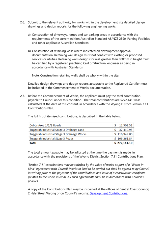
The application falls under WDDCP. The following contributions are applicable:
· Tuggerah Industrial Estate Stage 3 drainage land and works
· Roads – Wyong Rd/Bryant Dr/Pacific Hwy/ Cobbs Rd
· Roads – Tuggerah Industrial Estate stage 3
The contributions have been calculated based on a total net developable area (NDA) of 13,367m2 and a condition recommended accordingly.
Contributions Infrastructure
The currently adopted drainage strategy for the area is identified in Figure 16 of WDDCP. Wetland 2 is located within the eastern half of the subject site.
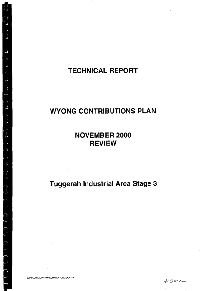
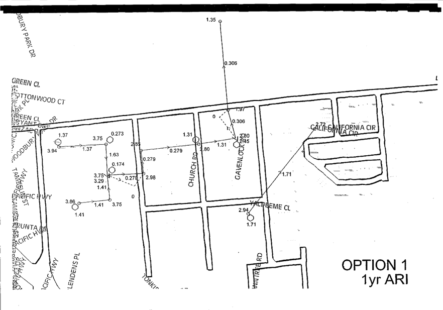
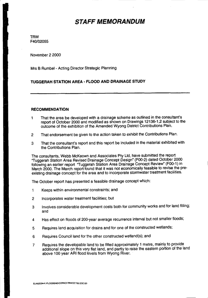
The current drainage strategy is 23 years old. A drainage concept plan for the industrial area was originally devised in 1990, with a study for Tuggerah Business Park Pty Ltd identifying further options to upgrade drainage facilities in the area to cater for the Ourimbah Creek overflow in 1995. A review of these studies was completed in March 2000 with the Revised Drainage Concept Design, to which Figure 16 of WDDCP relates, being finalised in October 2000.
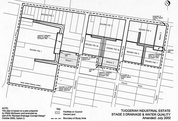
Figure 8: Extract of the contributions plan showing drainage strategy and Wetland 2 identified on subject lot
The drainage scheme for the Tuggerah Industrial Area provides for the construction of trunk drainage and water quality facilities to service several sites which will be filled to allow for the development of the land for industrial purposes. It is considered the current drainage design within WDDCP for the Lake Road precinct is no longer fit for purpose or required for the following reasons:
· The identified wetlands are not the best practice to treat runoff from industrial areas as originally envisaged in the contributions plan.
· The contributions plan for the area is outdated and would result in an unreasonable onerous asset type to create and maintain in the future.
· Wetland 2 is proposed on private property. Council does not intend to acquire the private land for the wetland and as such the scheme would need to be revised.
· Since the creation of the scheme a number of changes in the area have potentially impacted the scheme. The Regional Sporting Complex/Lake Road upgrade including drainage, was never envisaged, and the retention of important biodiversity that occurs in the location of Wetland 2 site is also important.
The contributions plan is collecting for the implementation of the entire drainage strategy. The applicant is obtaining additional development value out of that part of the land that would ordinarily be constrained and dedicated to the provision of drainage infrastructure under WDDCP.
It is anticipated that the currently designated wetland area will be removed at the next review of WDDCP.
Council staff will prepare a report to Council to seek a resolution to levy monetary contributions in the Tuggerah Industrial Estate rather than impose the scheme through Works in Kind and land dedication. This report is anticipated to be reported to Council by the end of 2024.
Based on the above, Council recommends that the Panel vary WDDCP to the extent identified within this report and the submitted plans.
Section 7.13 of the Environmental Planning and Assessment Act 1979 provides the Panel with the authority to determine an application that applies the contributions plan in a varied form.
Planning Agreements
The proposed development is not subject to a planning agreement or draft planning agreement.
Conclusion/Recommendation
This development application has been considered in accordance with the requirements of the Environmental Planning and Assessment Act 1979, as outlined in this report. The potential constraints of the site have been assessed and it is considered that the site is suitable for the proposed development.
The proposal is consistent with the objectives of the IN2 zoning of the land and the development provides a building pad that achieves the required outcomes of WDDCP. Moreover, the proposed development is not likely to have a significant impact on any threatened species, populations or ecological communities, or their habitats, which are listed under the Biodiversity Conservation Act 2016.
Following a thorough assessment of the relevant planning policies and controls, it is considered the application is appropriate and can be supported for the following reasons:
· The Panel can be satisfied that the provisions of the following State Environmental Planning Policies have been considered and satisfied:
i) Chapter 4, subsection 4.9(2) of State Environmental Planning Policy (Biodiversity and Conservation) 2021.
ii) Chapter 4, subsection 4.6(4) of State Environmental Planning Policy (Resilience and Hazards) 2021.
· Having regard for the prerequisite conditions to the granting of consent under the Wyong Local Environmental Plan 2013, the Panel can be satisfied that:
o Clause 5.21 – Flood
Planning
The proposed development:
a) Is compatible with the flood function and behaviour on the land, and
b) Will not adversely affect flood behaviour in a way that results in detrimental increases in the potential flood affectation of other development or properties, and
c) Will not adversely affect the safe occupation and efficient evacuation of people or exceed the capacity of existing evacuation routes for the surrounding area in the event of a flood, and
d) Incorporates appropriate measures to manage risk to life in the event of a flood and
e) Will not adversely affect the environment or cause avoidable erosion, siltation, destruction of riparian vegetation or a reduction in the stability of riverbanks or watercourses.
o Clause 7.1 - Acid sulfate soils
An Acid Sulfate Soils Management Plan has been prepared in accordance with the Acid Sulfate Soils Manual (clause 7.1(3)(a)) and provided to the consent authority (clause 7.1(3)(b)). Any Acid Sulfate Soils that are encountered can be appropriately managed.
o Clause 7.9 – Essential services
All services essential for the proposed development are available and adequate arrangements are in place for the future development of the site.
· The Panel can be satisfied that the proposed drainage arrangements achieve the objectives and intended outcomes of the Wyong District Development Contributions Plan 2020 and associated drainage scheme.
· The Panel can be satisfied that the relevant provisions of the environmental planning instruments, plans and policies that apply to the development have been considered in the assessment of the application.
· The proposed development is considered satisfactory having regard for the matters for consideration provided in Section 4.15 of the Environmental Planning and Assessment Act 1979.
Therefore, DA/1446/2021 for Proposed Earthworks and Associated Retaining Walls and Drainage Works at 77 Lake Road, Tuggerah NSW is recommended for APPROVAL pursuant to Section 4.16(1)(a) of the Environmental Planning and Assessment Act 1979, subject to the draft conditions attached to this report.
|
1⇩ |
Draft conditions - 77 Lake Road, TUGGERAH NSW 2259 - DA/1446/2021 |
|
D15957946 |
|
2⇩ |
Architectural Plans |
|
D15963857 |
|
3⇩ |
Assessment against DCP 2013, Chapter 2.12 – Industrial Development |
|
D15957927 |
|
4⇩ |
Assessment against DCP 2013, Chapter 6.14 – Tuggerah Precinct |
|
D15957929 |
|
5⇩ |
Wyong_District_Development_Contributions_Plan |
|
D15957939 |
|
6⇩ |
Technical Report Wyong Contribution Plan |
|
D15957940 |
|
3.1 |
DA/1446/2021 - 77 Lake Road, Tuggerah - Earthworks and Associated Retaining Walls and Drainage Works |
|
Attachment 1 |
Draft conditions - 77 Lake Road, TUGGERAH NSW 2259 - DA/1446/2021 |

|
DA/1446/2021 - 77 Lake Road, Tuggerah - Earthworks and Associated Retaining Walls and Drainage Works |
|
|
Attachment 2 |
Architectural Plans |
|
DA/1446/2021 - 77 Lake Road, Tuggerah - Earthworks and Associated Retaining Walls and Drainage Works |
|
|
Attachment 3 |
Assessment against DCP 2013, Chapter 2.12 – Industrial Development |
|
DA/1446/2021 - 77 Lake Road, Tuggerah - Earthworks and Associated Retaining Walls and Drainage Works |
|
|
Attachment 4 |
Assessment against DCP 2013, Chapter 6.14 – Tuggerah Precinct |
|
DA/1446/2021 - 77 Lake Road, Tuggerah - Earthworks and Associated Retaining Walls and Drainage Works |
|
|
Attachment 5 |
Wyong_District_Development_Contributions_Plan |


|
DA/1446/2021 - 77 Lake Road, Tuggerah - Earthworks and Associated Retaining Walls and Drainage Works |
|
|
Attachment 6 |
Technical Report Wyong Contribution Plan |

|
Item No: 4.1 |
|
|
Title: DA/668/2022 - 55 Mullbong Road, Blackwall - Subdivision into 2 Residential allotments |
|
|
Department: Environment and Planning |
|
|
14 March 2024 Local Planning Panel Meeting |
|
Reference: DA/668/2022 - D15973999
Author: K. Singh, Senior Development Planner.Residential Assessments
Section Manager: Ailsa Prendergast, Section Manager. Residential Assessments
Unit Manager: Andrew Roach, Unit Manager Development Assessment
Executive: Alice Howe, Director Environment and Planning
Summary
Council is in receipt of Development Application Number DA/668/2022, seeking development consent for the proposed Subdivision of of Lot A DP 378115 No 55 Mullbong Road, Blackwall into two (2) residential allotments, having proposed site areas of 450m2 (proposed lot 1) and 578m2 (proposed lot 2).
The application has been examined having regard to the matters for consideration detailed in Section 4.15 of the Environmental Planning and Assessment Act 1979 and other statutory requirements with the issues requiring attention and consideration being addressed in the report.
This application was lodged prior to the Central Coast Local Environmental Plan 2022 (CCLEP 2022) coming into effect on 1 August 2022 and has therefore been assessed under Gosford Local Environmental Plan 2014 (GLEP 2014).
The application is required to be referred to the Local Planning Panel for determination as the proposed development is accompanied by a Clause 4.6 Variation Request as proposed lot 1 does not comply with the Principal Development Standards associated with the subdivision of land, as prescribed by clause 4.1(3) of GLEP 2014.
The application is recommended for approval, subject to conditions.
Applicant Clare Walker c/ Clarke Dowdle & Associates
Owner Clare Walker
Application No DA/668/2022
Description of Land Lot A DP378115 No 55 Mullbong Road Blackwall
Proposed Development Subdivision into 2 Residential allotments
Site Area 1,018.0m2
Zoning R2 Low Density Residential
Existing Use Dwelling House
Employment Generation No
Estimated Value $50,000.00
Recommendation
1 The Panel agrees that the applicant’s clause 4.6 written request demonstrates that compliance with the Principal Development Standards associated with the subdivision of land, as prescribed by clause 4.1(3) of the Gosford Local Environmental Plan 2014, would be unreasonable and unnecessary in the circumstances because the proposed development meets the underlying intent of the control of the development standard and is a compatible form of development that does not result in unreasonable environmental amenity impacts, and that there are sufficient environmental planning grounds to justify contravening that development standard.
Further, the Panel considers that the proposed development will be in the public interest because it is consistent with the objectives of the development standard and the objectives for development within the R2 Low Density Residential zone in which the development is proposed.
2 That the Local Planning Panel grant consent to DA/668/2022 for the proposed subdivision of Lot A DP 378115 No 55 Mullbong Road, Blackwall into Two (2) Residential Allotments, subject to the conditions detailed in the schedule attached to the report and having regard to the matters for consideration detailed in Section 4.15 of the Environmental Planning and Assessment Act 1979.
3 That Council advise relevant external authorities of the Panel’s decision.
Key Issues
· Clause 4.6 variation to minimum Subdivision allotment size requirement – GLEP 2014
· Variation to minimum Subdivision allotment size and width requirement – GDCP 2013 Chapter 3.5 - Residential Subdivision
· Allotment shape, size and configuration
· Existing pattern of subdivision in immediate locality
· Character and scenic quality
Precis:
|
Proposed Development |
Subdivision - Two (2) Torrens Title Residential Allotments |
|
Permissibility and Zoning |
The proposed development constitutes a Subdivision which is permissible within the prescribed zone with the consent of Council, pursuant to the statutory provisions of Clause 4.13 of Gosford Local Environmental Plan 2014 (GLEP 2014).
The subject site is zoned R2 Low Density Residential under Gosford Local Environmental Plan 2014 (GLEP 2014).
|
|
Current Use |
Dwelling House |
|
Integrated Development |
Yes – Proposal requires Bush Fire Safety Authority from the NSW Rural Fire Service
|
|
Submissions |
Nil |
Variations to Policies
|
Clause |
Clause 4.1(3) of Gosford Local Environmental Plan 2014 (GLEP 2014) Clause 3.5.3.2 (b) (i ) of Gosford Development Control Plan (GDCP) 2013 Chapter 3.5 – Residential Subdivision |
|
Standard |
Minimum Subdivision Allotment Size Minimum Subdivision Allotment Width |
|
LEP/DCP |
GLEP 2014 - Minimum Subdivision Allotment Size GDCP 2013 Chapter 3.5 Residential Subdivision – Minimum Subdivision Allotment Size and Minimum Subdivision Allotment Width |
|
Departure basis |
GLEP 2014 - 18.1% To Minimum Subdivision Allotment Size GDCP 2013 Chapter 3.5 Residential Subdivision - 18.1% To Minimum Subdivision Allotment Size and 11.4 % to Minimum Subdivision Allotment Width |
The Site
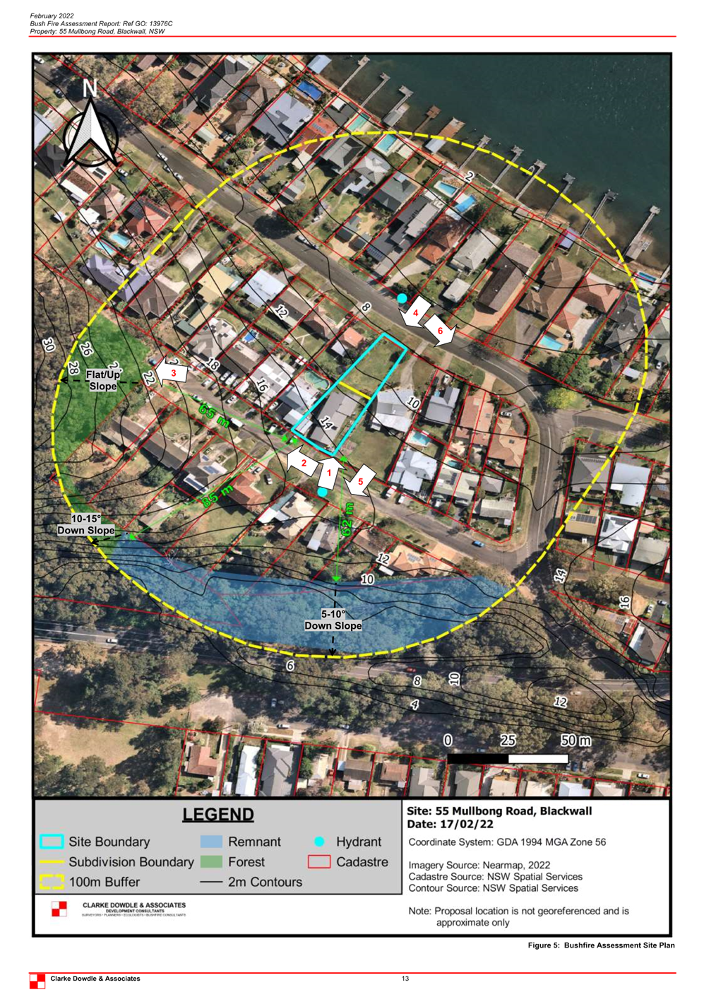
The subject site is legally identified as Lot A DP 378115 No 55 Mullbong Road Blackwall and has a site area of 1,018m2. The allotment concerned is irregular in shape and are located on the northern side of Mullbong Road. The allotment concerned is gently sloping and the land falls from the Mullbong Road to the Orange Grove Road.
The subject site currently occupied by a two storey dwelling house and garage that has frontage to Mullbong Road. The subject site also has the added advantage of being a dual frontage allotment, in that the allotment concerned is bounded by Mullbong Road and Orange Grove Road (Figure 1).
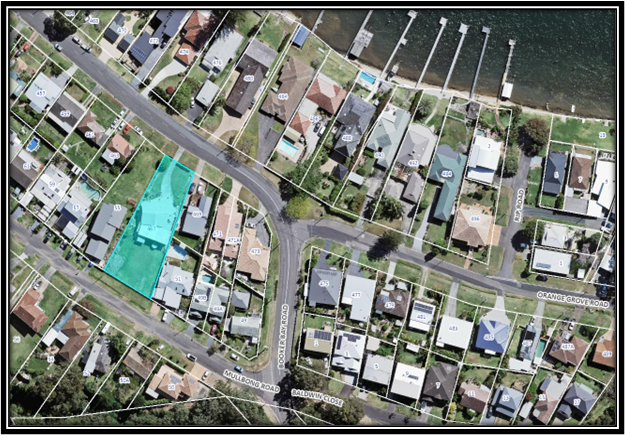
Figure 1 - Site and Locality Plan (Subject Site is in Blue)
Mullbong Road and Orange Grove Road are both sealed roads which currently provide access to the residents of this immediate area. The main services of power, water supply and telecommunications are available for connection. The subject site is fully serviced with all essential infrastructure.
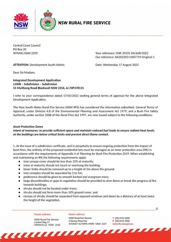
The site is identified as being "bushfire prone land" on Council's bushfire maps. The proposal is accompanied by a Bushfire Hazard Assessment Report which was referred to the NSW Rural Fire Service for assessment, as the proposal is defined as Integrated Development within the meaning of the Environmental Planning and Assessment Act 1979.
The NSW Rural Fire Service has by correspondence dated 17 August 2022, granted a Bushfire Safety Authority under Section 100B of the Rural Fires Act 1997, subject to conditions.
The site is not identified as being affected by the 1% AEP Flood Event.
Surrounding Development
Surrounding development in the immediate vicinity of the subject site is zoned R2 Low Density residential and is predominantly residential in nature. Surrounding developments generally comprises a combination of single and two storey residential developments of varying ages and architecture, all surrounded by well-established trees, and landscaped gardens.
The Proposed Development
Council is in receipt of Development Application Number DA/668/2022, seeking development consent for the proposed subdivision of Lot A DP 378115 No 55 Mullbong Road, Blackwall, into two residential (2) allotments of land, each proposing a site area of 450m2 (proposed lot 1) and 578m2 (proposed lot 2) respectively, pursuant to the statutory provisions of Clause 4.1(3) of GLEP 2014 (refer to Figure 2).
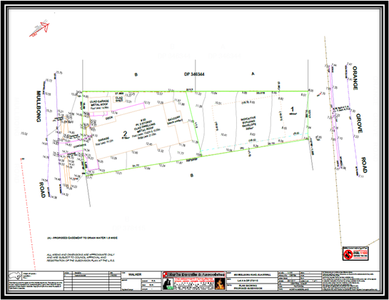
Figure 2 – Plan of Proposed Subdivision
There is presently no numerical development standard contained in GLEP 2014 specifying a minimum width requirement associated with the subdivision of land (unlike the requirements of GDCP 2013 Chapter 3.5 – Residential Subdivision.)
The summary table depicted provides an overview of the proposal in relation to site area, access provisions and improvements.
GLEP 2014 Summary Table
|
Lot |
Lot Size |
Access Provisions |
Improvements |
|
1 |
450m2 |
Orange Grove Road |
Vacant |
|
2 |
578m2 |
Mullbong Road |
Dwelling House |
The GLEP 2014 Summary Table indicates that proposed lot 2 complies with the Principal Development Standards associated with the subdivision of land [Minimum Subdivision Lot Size] as prescribed by clause 4.1(3) of GLEP 2014, which in this instance is mapped at 550m2 per allotment.
However, proposed lot 1 does not comply with the Principal Development Standards associated with the subdivision of land as this allotment proposes a site are of 450m2, and the proposal is accompanied by a Clause 4.6 Variation Request, which is further discussed in the body of this report.
Vehicular ingress and egress provisions associated with the existing dwelling house on proposed lot 2 remains unchanged as a result of the proposed Subdivision and will continue to service the existing dwelling house to and from Mullbong Road. The proposed subdivision incorporates a suitable easement for drainage, as depicted on the proposed plan of subdivision in Figure 2.
The general scope of civil construction works that are required in conjunction with the subdivision, are summarized as follows:
Works in the Road Reserve:
a) Construction of concrete footpath 1.5m wide for the full street frontage of the development in Orange Grove Road.
b) Construction of the road verge/footway formation graded at +2% from the top of existing kerb to the property boundary across the full frontage of the site in Orange Grove Road. Construction to include transitions to existing formation either side of the site.
c) Construction of a storm water drainage connection from the development site to Council’s storm water drainage system within the road reserve.
Works within the Private Property
a) Construction of interallotment stormwater drainage where stormwater from individual allotments cannot be discharged directly into the proposed street drainage system or existing street drainage system.
b) Construction of storm water drainage connection all existing buildings, structures and impervious areas to the proposed stormwater systems.
History
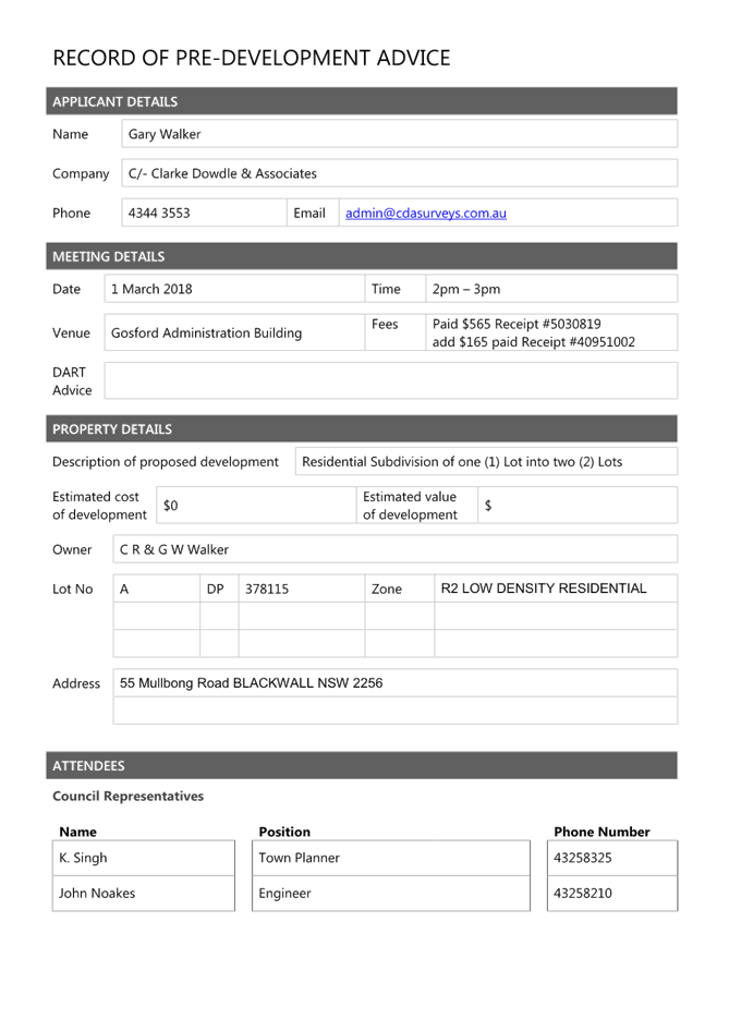
A Pre-DA Consultation Meeting (Pre DA-Meeting) was conducted on 1 March 2018, involving Council’s Technical Assessment staff and the applicant’s Town Planning Consultant. A copy of the Pre DA-Meeting Minutes is included as Attachment 6.
ASSESSMENT
Having regard for the matters for consideration detailed in Section 4.15 of the Environmental Planning and Assessment Act 1979 and other statutory requirements, the assessment has identified the following key issues, which are elaborated upon for the information of the Local Planning Panel.
State Environmental Planning Policy (Resilience and Hazards) 2021
On 1 March 2022 the provisions of the State Environmental Planning Policy (Coastal Management) 2018 and SEPP Policy No 55—Remediation of Land were repealed and incorporated into State Environmental Planning Policy (Resilience and Hazards) 2021 in accordance with Schedule 3 Transfer of Provisions. The relevant provisions of the SEPP are addressed as follows:
Chapter 2 – Coastal Management
The site is located within the Coastal Use Area and the Coastal Environment Area and is therefore subject to the provisions of subsections 2.10 and 2.11 of Chapter 2 – Coastal Management of State Environmental Planning Policy (Resilience and Hazards) 2021 (‘SEPP RH’).
The development is not likely to have an adverse impact on the matters referred to in either Section 2.10 or Section 2.11. The development is not considered likely to cause increased risk of coastal hazards on the site or other land and the site is not subject to the coastal management program for the purposes of Division.5. A summary of considerations is included below.
Section 2.10 - Development on land within the coastal environment area
In accordance with clause 2.10(1) development consent must not be granted unless the consent authority has considered whether the proposed development is likely to cause an adverse impact (see table on following page for considerations).
Section 2.10 SEPP RH considerations
|
Matters for Consideration |
Compliance |
|
(a) the integrity and resilience of the biophysical, hydrological (surface and groundwater) and ecological environment |
The proposal is not likely to cause adverse impacts on the biophysical, hydrological, or ecological environment. |
|
(b) coastal environmental values and natural coastal processes |
The proposal will not impact on the geological and geomorphological coastal processes. |
|
(c) the water quality of the marine estate (within the meaning of the Marine Estate Management Act 2014, in particular, the cumulative impacts of the proposed development on any of the sensitive coastal lakes identified in Schedule 1 |
The proposal will not result in an adverse impact on the water quality of the marine estate and does not drain to a sensitive lake contained in Schedule 1. |
|
(d) marine vegetation, native vegetation and fauna and their habitats, undeveloped headlands and rock platforms |
The proposal will not result in an adverse impact on native vegetation or fauna, undeveloped headlands, and rock platforms. |
|
(e) existing public open space and safe access to and along the foreshore, beach, headland or rock platform for members of the public, including persons with a disability, |
The site does not have frontage to any foreshore, beach, headland or waterways. |
|
(f) Aboriginal cultural heritage, practices and places |
There are no identified aboriginal cultural heritage items on the site. |
|
(g) the use of the surf zone. |
Not Applicable. No frontage to any beach/surf zone. |
The assessment of the proposal concludes that there have been no adverse impacts identified in the consideration of subsection 2.10(1) that would engage the further considerations under subsection 2.10(2).
Section 2.11 Development on land within the coastal use area
Consent must not be granted unless the consent authority has considered the following:
Section 2.11 SEPP RH Considerations
|
Matters for Consideration |
Compliance |
|
(a) whether the proposed development is likely to cause an adverse impact on the following: i. existing, safe access to and along the foreshore, beach, headland or rock platform for members of the public, including persons with a disability, ii. overshadowing, wind funnelling and the loss of views from public places to foreshores, iii. the visual amenity and scenic qualities of the coast, including coastal headlands, iv. Aboriginal cultural heritage, practices and places, v. cultural and built environment heritage, |
The site does not have frontage to any foreshore, beach or waterway and is not visible from any foreshore or beach. The proposal will not cause an adverse impact on access, overshadowing, wind funnelling or view loss form public places to any foreshore. The proposal does not impact the visual amenity or scenic quality of the coast. There are no known objects, areas, or items of heritage significance on the land, and no potentially adverse impacts on cultural or environmental heritage have been identified. |
|
(b) is satisfied that i. the development is designed, sited and will be managed to avoid an adverse impact referred to in paragraph (a), or ii. if that impact cannot be reasonably avoided—the development is designed, sited and will be managed to minimise that impact, or iii. if that impact cannot be minimised—the development will be managed to mitigate that impact, |
There have been no adverse impacts identified in the consideration of ss2.11(1) that would engage the further considerations under ss2.11(2). |
|
(c) has taken into account the surrounding coastal and built environment, and the bulk, scale and size of the proposed development |
The proposed subdivision is consistent with previously approved Subdivisions in the immediate locality and is considered satisfactory in terms of siting and location. |
Chapter 4 – Remediation of Land
The provisions of SEPP Resilience and Hazards - Chapter 4 (Remediation of Land) have been considered in the assessment of the development application.
Section 4.6 of SEPP RH requires consent authorities to consider whether the land is contaminated, and if the land is contaminated, it is satisfied that the land is suitable in its contaminated state (or will be suitable, after remediation) for the purpose for which the development is proposed to be carried out.
A review of the land use history, aerial photographs and an inspection of the site has not revealed any evidence of potentially contaminating land uses being carried out on the site. The subject site is located within a residential zone and the current use of the site is for domestic residential purposes. There are no known previous uses that would lead to the site being contaminated or unsuitable for the proposed use.
The development and the land is not otherwise mentioned in subsection 4.6(4) and accordingly the provisions of subsection 4.6(2) are not engaged by the proposal and consent may be granted. The proposal is considered consistent with the provisions of Chapter 4 of the SEPP.
The Panel can be satisfied that the proposed development complies with the provisions of Chapter 4 Remediation of Land of State Environmental Planning Policy (Resilience and Hazards) 2021.
Gosford Local Environmental Plan 2014
Zoning and Permissibility
The subject sites are zoned R2 Low Density Residential under GLEP 2014. The proposed development constitutes a Subdivision which is permissible within the prescribed zone with the consent of Council, pursuant to the statutory provisions of clause 4.1(3) of GLEP 2014).
Zone Objectives
The subject site is zoned R2 Low Density Residential under GLEP 2014.
The objectives for the R2 Low Density Residential zone are:
· To provide for the housing needs of the community within a low density residential environment.
· To enable other land uses that provide facilities or services to meet the day to day needs of residents. To ensure that development is compatible with the desired future character of the zone.
· To encourage best practice in the design of low-density residential development.
· To promote ecologically, socially and economically sustainable development and the need for, and value of, biodiversity in Gosford.
· To ensure that non-residential land uses do not adversely affect residential amenity or place demands on services beyond the level reasonably required for low-density housing.
Assessment of the application concludes that the proposed development meets the objectives of the zone.
Principal Development Standard
The subject site is zoned R2 Low Density Residential under GLEP 2014 and the proposal has been assessed in accordance with the relevant development standards of GLEP 2014.
The proposal constitutes a subdivision and the Principal Development Standards associated with the subdivision of land is prescribed by clause 4.1(3) of GLEP 2014. Clause 4.1(3) of GLEP 2014 states that the size of any lot resulting from a subdivision of land to which this clause applies is not to be less than the minimum size shown on the Lot Size Map in relation to that land, which in this instance is mapped at 550.0m2 per allotment.
There is presently no numerical development standard contain in GLEP 2014 specifying a minimum width requirement associated with the subdivision of land (unlike the requirements of GDCP 2013 Chapter 3.5 – Residential Subdivision).
The GLEP 2014 summary table depicted provides an overview of the proposal in relation to site area.
Table 1 - Site Area
|
Proposed Lot |
Area Proposed |
Area Required |
Compliance |
% Variation |
|
1 |
450m2 |
550m2 |
No |
18.1% |
|
2 |
578m2 |
550m2 |
Yes |
Nil |
The GLEP 2014 Summary Table indicates that proposed lot 1 does not comply with the Principal Development Standards associated with the subdivision of land, as prescribed by clause 4.1(3) of GLEP 2014.
Clause 4.1(3) of GLEP 2014 states that the size of any lot resulting from a subdivision of land to which this clause applies is not to be less than the minimum size shown on the Lot Size Map in relation to that land, which in this instance is mapped at 550m2 per allotment.
Proposed lot 1 proposes a site area that is 18.1% or 100m2 less than the prescribed minimum development standard contained in clause 4.1(3) of the GLEP.
The applicant has submitted a written request, under the provisions of clause 4.6 of the GLEP 2014, seeking to justify the identified departure from the development standard, and has identified how compliance with this development standard is unreasonable or unnecessary.
Applicant’s Clause 4.6 Exceptions to Development Standards Submission
Under the provisions of clause 4.6 - Exceptions to Development Standards, Council has the ability to grant consent to a development application where the variation to a development standard can be adequately justified and where the objectives of clause 4.6(1) are satisfied, being:
“(a) to provide an appropriate degree of flexibility in applying certain development standards to particular development,
(b) to achieve better outcomes for and from development by allowing flexibility in particular circumstances.”
The application has submitted a written request seeking variation to the minimum subdivision lot size development standard contained within clause 4.1(3) of GLEP 2014, pursuant to clause 4.6 Exception to Development Standard provisions contained in GLEP 2014. Details of the applicant’s request is summarised as follows:
The Gosford LEP 2014 includes clause 4.6 Exceptions to Development Standards. The clause 4.6 of the Standard Instrument LEP is effectively the successor to SEPP 1, as it aims to enable development standards (such as height, FSR and minimum lot size) in the relevant LEP to be varied where appropriate. It allows flexibility in the application of development standards, in order to achieve overall better planning outcomes.
In this case, given the unique location it is considered that the lot area non-compliance will not be detrimental to the appearance of the dwelling-houses (existing and proposed) when viewed from the adjoining properties or from the public domain. As demonstrated, the lot area would not create any further amenity impacts beyond that associated with a compliant lot area. Furthermore, it is considered that lot areas provide for a sustainable, orderly use of the site given that a low density scale is maintained within the R2 – Low Density Residential Zone.
The key tests or requirements arising from recent judgements are that:
· The consent authority be satisfied the proposed development will be in the public interest because it is “consistent with” the objectives of the development standard and zone. It is not a requirement to “achieve” those objectives. It is a requirement that the development be compatible with the objectives, rather than having to ‘achieve’ the objectives.
· Establishing that ‘compliance with the standard is unreasonable or unnecessary in the circumstances of the case’ does not always require the applicant to show that the relevant objectives of the standard are achieved by the proposal (Wehbe “test”. Other methods are available as per the previous 5 tests applying to SEPP 1, set out in Wehbe v Pittwater 2007
· When pursuing a clause 4.6 variation request it is appropriate to demonstrate environmental planning grounds that support any variation; and
· The proposal is required to be in ‘the public interest’.
This clause 4.6 variation demonstrates that the proposed lot sizes:
· Satisfies the relevant objectives of the lot size standard;
· Satisfies the objectives of the R2 – Low Density Residential Zone under Gosford LEP 2014;
· Provides for a better planning outcome;
· Has sufficient environmental planning grounds to permit the variation; and
· Is in the public interest
The relevant clause therein the GLEP sought to be varied:
4.1(2) Minimum subdivision lot size states:
The size of any lot resulting from a subdivision of land to which this clause applies is not to be less than the minimum size shown on the Lot Size Map in relation to that land.
The Nature of the Development Standard sought to be varied and details of the variation:
Proposed lot 1 would be 450m2 and proposed lot 2 would be 578m2. Subsequently proposed lot 1) does not meet the numerical minimum lot size of 550m2 in accordance with the minimum lot size map within the Gosford LEP 2014. As such the proposal entails a numerical variation of 18.1%. Notwithstanding the numerical non-compliance with the development standard, the variation is justified on planning grounds and is discussed below.
In Wehbe v Pittwater Council [2007] NSW LEC 827 Preston CJ set out a new 5-part test and as such outlined below is an assessment of the variation against the development standard.
1. Consistency with the Objectives of the Minimum Lot Size Standard notwithstanding non-compliance with the development standard
The objective of the development standard are:
(a) to reflect State, regional and local planning strategies relating to the provision of various sizes of land,
(b) to ensure that the subdivision of land is compatible with the desired future character of the area,
(c) to promote the ecologically, socially and economically sustainable subdivision of land,
(d) to ensure that the creation of parcels of land for development occurs in a manner that protects the physical characteristics of the land, does not create potential physical hazard or amenity issues for neighbours, can be satisfactorily serviced and will, through its potential cumulative effects, not create capacity problems for existing infrastructure.
In relation to the underlying objective outlined are the reasons of compliance with the set object based on environmental planning grounds:
· The proposal to allow the creation of an additional lot within the Woy Woy Peninsula area is consistent with the directions outlined within the Central Coast Regional Plan 2036. The regional plan identifies a requirement to construct and additional 41,500 homes by 2036.
· The proposed lots would be commensurate with the lot sizes located within the adjoining and surrounding cadaster. Subsequently the proposal would not be consistent with the established density and character as discussed above and would not be setting precedence in this regards.
· The proposed subdivision will have no ecological impacts to the subject land and surrounds. Given the site is located within close proximity of the Woy Woy and Ettalong Town Centres, public transport, essential infrastructure, the proposed development represents a socially, environmentally and economically suitable form of residential subdivision that maintains low density lots.
· The proposal allows the creation of a new allotment and dwelling-house would balance the social needs of the peninsula area (new lots and dwelling-houses) that are essentially more substantial that the typical secondary dwellings that are becoming established on suburban sized allotments – including appropriate land tenure with the provision of all required services and infrastructure required for the creation of Torrens Title lots in an efficient and orderly fashion.
2. The underlying objective or purpose of the standard of not relevant to the development and therefore compliance is unnecessary.
The underlying objectives of the development standard are relevant and as outlined above it is considered that the proposal adheres the underlying objectives of the development standard; in this instance the minimum lot size provision.
3. The underlying object of purpose would be defeated or thwarted if compliance was required and therefore compliance is unreasonable.
As discussed in detail above the development adheres to the objectives of the development standard and therefore the concept of compliance with the objects of the development standard would actually contravene the concept of having these overarching merit based statements (overarching requirements) accompanying the prescriptive measures.
4. The development standard has been virtually abandoned or destroyed by Council’s own actions in granting consents departing from the standard and hence compliance with the standard is unnecessary and unreasonable.
All the surrounding lots are around the 450m2 mark. As such the development standard in the locality has been abandoned and found that the 450m2 to be an acceptable lot area for the area. And as such compliance with the development standard is unnecessary and unreasonable, in this instance.
5. The compliance with the development standard is unnecessary or inappropriate due to the existing use of land and current environmental character of the particular parcel of land. That is, the particular parcel of land should not have been included in the zone.
The subject lot remains in the existing R2 Low Density Residential zone.
Consistency with the Objectives of the Zone
The NSW legislation website indicates the subject site is currently zoned R2 – Residential
Under the LEP the objectives of the R2 Residential zone are:
· To provide for the housing needs of the community within a low density residential environment.
· To enable other land uses that provide facilities or services to meet the day to day needs of residents.
· To ensure that development is compatible with the desired future character of the zone.
· To encourage best practice in the design of low-density residential development.
· To promote ecologically, socially and economically sustainable development and the need for, and value of, biodiversity in Gosford.
· To ensure that non-residential land uses do not adversely affect residential amenity or place demands on services beyond the level reasonably required for low-density housing.
Comment:
· The proposed use falls under the definitions of ‘subdivision’ and under the LEP and is permissible subject to consent.
· The proposed area and dimensions of the lots are commensurate with the area and width of many foreshore lots that are located within the immediate vicinity and surrounds within the lower foreshore area of Blackwall and Orange Grove.
· The surrounding cadastre has no established or regularised ‘standard’ lot size and width. As such the proposal would not be creating precedence to breaking a regularised cadastre pattern along the coastal locale.
· As demonstrated in the plan and the character statement, the proposal would be compatible with the surrounding intensity of low density residential development within the immediate area.
· The proposal would allow the continuation of residential development that would facilitate the incorporation of landscaping that is compatible with the residential zone.
· As addressed within the Statement of Environmental Effects, the proposed dwellings would comply with the prescriptive measures and objectives within relevant chapters of GDCP 2013 and is compatible with the desired future character of the zone.
· The proposal would not be detrimental to the residential amenity and place overbearing demands on services that would be commensurate for low density housing
· The subject site is located within walking distance of public transport and public and private recreational facilities.
· The subject site includes the essential utilities, including reticulated water, sewer, power and telecommunications.
· The development caters for additional lots and dwelling-house in accordance with the Draft Central Coast Regional Plan released in November 2015.
Consistency with State and Regional Planning Policies
The proposed development would be in line with Draft Central Coast Regional Strategy that is the NSW Government's long term land use plan for the region, which covers the Gosford City and Wyong Shire Local Government Areas. The Regional Strategy contains policies and actions designed to cater for the region's projected housing and employment growth over next 20 years. Greater housing choice is prioritised to satisfy the community’s desire for smaller households.
The plan places emphasis on providing new housing in existing and committed growth areas. To meet the projected housing demands over the next 20 years, an average of 1,980 new homes will need to be constructed each year. This is 590 more homes than the average annual housing production of 1,390 dwellings over the 19 years to 2014-15.The proposed subdivision and dwelling-house development would allow for more ‘affordable dwellings’ that is consistent with the policies and strategic actions outlined in the strategy.
The Variation in the Public Interest
The proposal is considered to be in the public interest due to the superior use of the land and subsequent land tenure that would be provided as opposed to secondary dwellings or villas within the low density area. Subsequently the proposal provides a more appropriate use of the land whist maintaining the low density character and housing scale and density within the Woy Woy Bay locale.
Conclusion
For the reasons outlined above the clause 4.6 variation is provided in support of the variation to the minimum lot size at 55 Mullbong Street, Blackwall as detailed above, in this instance the proposal is supported for the following reasons:
· The proposed non-compliance does not raise any matter of significance for State or regional environmental planning as it is peculiar to the creation of a new lot is not readily transferrable to any other site in the immediate locality, wider region of the State and the scale or nature of the proposed development does not trigger requirements for a higher level of assessment.
· As the proposed development is in the public interest because it complies with the objectives of the development standard and the objectives of the zone there is no significant public benefit in maintaining the numerical development standard.
· There are no other matters required to be taken into account by the secretary before granting concurrence.
On the basis outlined above, the proposal satisfies all the requirements of clause 4.6 of the GLEP 2014 with the exception to the development standard providing sufficient environmental planning justification to warrant the proposed lot size to be acceptable in this case.”
Town Planning Assessment - Clause 4.6 Variation
Clause 4.6 of GLEP 2014 provides the applicant with the appropriate statutory planning mechanism to vary the minimum subdivision lot size standard prescribed within clause 4.1(3) of GLEP 2014.
The Clause 4.6 Variation Request submitted by the applicant has addressed why strict compliance with the development standard is unreasonable or unnecessary in this instance, having regard to the relevant Land and Environment Court decisions that have been cited and how there are sufficient environmental planning grounds to justify the non- compliance with the development standard in question.
Clause 4.6 (2) – Exceptions to Development Standards allows development consent to be granted even though the development would contravene a development standard imposed by GLEP 2014, or any other environmental planning instrument.
Clauses 4.6(3), 4.6(4) and 4.6(5) as reproduced below, sets out the tests for establishing if the variation to a development standard is ‘well founded’ and requires the consent authority to be satisfied in relation to the following matters:
“(3) Development consent must not be granted for development that contravenes a development standard unless the consent authority has considered a written request from the applicant that seeks to justify the contravention of the development standard by demonstrating:
(a) that compliance with the development standard is unreasonable or unnecessary in the circumstances of the case, and
(b) that there are sufficient environmental planning grounds to justify contravening the development standard.
(4) Development consent must not be granted for development that contravenes a development standard unless:
(a) the consent authority is satisfied that:
(i) the applicant’s written request has adequately addressed the matters required to be demonstrated by subclause (3), and
(ii) the proposed development will be in the public interest because it is consistent with the objectives of the particular standard and the objectives for development within the zone in which the development is proposed to be carried out, and
(b) the concurrence of the Secretary has been obtained.
(5) In deciding whether to grant concurrence, the Secretary must consider:
(a) whether contravention of the development standard raises any matter of significance for State or regional environmental planning, and
(b) the public benefit of maintaining the development standard, and
(c) any other matters required to be taken into consideration by the Secretary before granting concurrence.
In accordance with clause 4.6(4)(b), development consent must not be granted for a development that contravenes a development standard, unless the concurrence of the Planning Secretary has been obtained.
Planning Circular PS 20-002 issued 5 May 2020, states that Council may assume the concurrence of the [now] Secretary of the NSW Department of Planning and Environment when considering exceptions to development standards under clause 4.6.
The Secretary’s concurrence may not be assumed by a delegate of council if the development contravenes a numerical standard by greater than 10%; however, this restriction does not apply to decisions made by independent hearing and assessment panels. The Local Planning Panel is therefore empowered to determine the application. The concurrence from the Secretary is however now no longer required, under recent directions.
Approaches relating to contravention to a development standard are well documented and demonstrated in case law taken from decisions of the Land and Environment Court and the NSW Court of Appeal, which include:
· Wehbe v Pittwater Council [2007] NSWLEC 827;
· Four2Five Pty Ltd v Ashfield Council [2015] NSWLEC 1009;
· Moskovitch v Waverley Council [2016] NSWLEC 1015 and
· Randwick City Council v Micaul Holdings Pty Ltd [2016] NSWLEC 7
Having regard to the Land and Environment Court case law as outlined, and in considering the requirements of clause 4.6, the following additional matters have been considered in the assessment of the current application and elaborated as follows:
1. Clause 4.6(3)(a) - Whether compliance with the development standard is unreasonable or unnecessary in the circumstances of the case
Comment - Whilst it was prepared in relation SEPP 1, the Land and Environment Court judgment Wehbe v Pittwater Council [2007] NSWLEC 827 (21 December 2007), is referred to in the Four2Five judgment and remains relevant to the consideration of concept of compliance being unreasonable or unnecessary and outlines the following 5 part test used in Wehbe:
1. The objectives of the standard are achieved notwithstanding noncompliance with the standard;
2. The underlying objective or purpose of the standard is not relevant to the development and therefore compliance is unnecessary;
3. The underlying object of purpose would be defeated or thwarted if compliance was required and therefore compliance is unreasonable;
4. The development standard has been virtually abandoned or destroyed by the council’s own actions in granting consents departing from the standard and hence compliance with the standard is unnecessary and unreasonable;
5. The compliance with development standard is unreasonable or inappropriate due to existing use of land and current environmental character of the particular parcel of land. That is, the particular parcel of land should not have been included in the zone.
Having regard to the assessment criteria established in Wehbe, the following Town Planning comments are provided:
i. The variation as proposed, still enables the objectives of the standard to be achieved and does not compromise the future construction of a dwelling-house and ancillary structures on proposed Lot 1.
ii. The underlying objective or purpose of the standard is relevant to the development proposal and compliance is unnecessary given the circumstances of the case.
iii. The underlying objective or purpose is not compromised in this instance.
iv. The development standard has not been abandoned, but has been varied by council, having regard to Council’s approach of assessing Development Application(s) on its merits.
v. The land subject of the current proposal is zoned correctly and therefore point 5 of the Wehbe test is not applicable in this instance.
2 Clause (3)(b) – whether there are sufficient environmental planning grounds to justify contravening the development standard.
Comment- The existing site area of the current allotment does not permit compliance with the minimum subdivision lot size standard prescribed within clause 4.1(3) of GLEP 2014. The variation of the minimum subdivision lot size standard amounting to 18.1% or 100m2 in relation to proposed Lot 1, whilst seemingly large in numerical terms is however considered justifiable form a Town Planning perspective, given the context of the clause 4.6 as discussed in the Town Planning report.
It is considered that the site area of the existing allotment in its present form is considered to be an underutilized resource. In view of the above, it is considered that there are sufficient environmental planning grounds, specifically related to the subject site that warrants contravention of the minimum subdivision lot size standard.
3 Clause (4)(a)(ii) – whether the proposed development will be in the public interest because it is consistent with the objectives of the particular standard and the objectives for development within the zone in which the development is proposed to be carried out
Comment -The proposal will be consistent with the stated objectives of minimum subdivision lot size standard and the objectives of the R2 Low Density Residential zone. The proposal is attempting to efficiently utilize the land for which it is zoned for and provides for the orderly and proper development of land, consistent with the objects of the Environmental Planning and Assessment Act 1979.
4 Clause 5(a) whether contravention of the development standard raises any matter of significance for State or regional environmental planning.
Comment - The variation of the minimum subdivision lot size standard is justifiable in numerical terms from a Town Planning perspective, and does not raise any issues at a regional or state level.
5 Clause 5 (b) the public benefit of maintaining the development standard.
Comment - For the reasons outlined about there is no public benefit in maintaining the minimum subdivision lot size standard. There will be public benefits in allowing a variation, as a better planning outcome will be achieved which facilitates the better utilization of land. This is particularly evident by the existing pattern of subdivision immediately to the east and west of the subject site, which have been subdivided in a generally similar manner.
On balance, it is considered that the clause 4.6 variation has been considered in context of the aims and objectives of the zone and in this instance, the variation is supported for the following reasons:
1 Proposed lot 1, which is the allotment subject of the minimum site area variation, has sufficient site area and width to satisfactorily accommodate the future construction of a dwelling house, associated ancillary structures and private recreation and garden spaces, as demonstrated on the proposed plan of subdivision.
2 Proposed lot 2, which is in compliance with the minimum site area requirement, has sufficient site area, width and depth to accommodate the existing dwelling-house and associated ancillary structures given the existing land characteristics of the site and as demonstrated on the proposed plan of subdivision.
3 The variation to proposed lot 1 whilst high in numerical terms, is, however, considered justifiable and acceptable, as the variation still enables the objectives of the applicable R2 Low Density Residential zone to be achieved, notwithstanding the numerical departure to the development standard in question.
4 The variation would not create an undesirable precedence, taking into account the merit-based approach to the assessment of development applications.
5 The proposal is consistent with the aims and objectives of GDCP 2013 Chapter 2.1 – Character, Chapter 3.1 – Dwelling Houses and Ancillary structures and Chapter 3.5 – Residential Subdivision.
6 The site area of the existing allotment in its present form is considered to be an under-utilised resource and the proposal is attempting to utilize the land/existing holding in an efficient manner.
7 The proposal provides for allotments of a satisfactory shape, size, configuration and utility.
8 The proposal is generally consistent with the existing pattern of subdivision in the immediate locality.
9 The subject site also has the added advantage of being a dual frontage allotment, in that the allotment concerned is bounded by Mullbong Road and Orange Grove Road. This advantage negates the requirement for the proposal to construct and provide for Rights of Access burdening a specific allotment for vehicular access purposes, as well a providing for a reduction in hardstand areas associated with such means of vehicular access.
10 The proposal provides for the orderly and proper development of land, consistent with the objects of the Environmental Planning and Assessment Act 1979, as specified in Section 1.3 therein.
The assessment concludes that the clause 4.6 variation to the minimum subdivision lot size standard prescribed within clause 4.1(3) of GLEP 2014, is well founded and is worthy of support.
Clause 5.10 Heritage Conservation – GLEP 2014
The proposal occurs on an existing, landscaped residential lot and will not impact upon any items of Heritage listed under Schedule 5 of GLEP 2014.
Clause 7.1 Acid Sulfate Soils- GLEP 2014
This land has been identified as being affected by the Acid Sulfate Soils Map and the matters contained in clause 7.1 of GLEP 2014 have been considered. In this instance, the proposal is not considered to impact on Acid Sulfate Soils.
Clause 7.2 Flood Planning – GLEP 2014
The land has not been classified as being under a “flood planning level” and is therefore not subject to the imposition of a minimum floor level. The proposal is therefore satisfactory with respect to clause 7.2 of GLEP 2014.
Gosford Development Control Plan 2013 (GDCP 2013)
The relevant controls of GDCP 2013 are considered below:
Chapter 2.1 Character
The requirements of GDCP 2013 Chapter 2.1 –Character is relevant in the assessment of the application and clause 2.1.3 provides for the following objectives:
1. Protect and enhance environmental character that distinguishes Gosford City’s identity, and
2. Enhance the City’s identity by development that displays improved standards of scenic, urban and civic design quality.
The subject site is located within the Blackwall Character Precinct 3 –Parkland Hillsides. The desired character statements for this locality are described as follows (summarized):
“These should remain leafy low-density residential hillsides, retaining the streetscape and scenic qualities of existing lush hillside gardens that surround each dwelling.
Minimise disturbance to natural slopes and existing trees that are visually-prominent features of any hillside or street frontage by appropriate siting of new structures, plus low-impact construction such as suspended floors and decks rather than extensive cut-and-fill. Complement the established tree canopy by planting additional trees and shrubs throughout each garden as well as along street verges. Facing the street, emphasise a leafy garden character by avoiding wide driveways and terraces, tall fences or multiple retaining walls.
Avoid the appearance of a continuous wall of development along any street or hillside. Locate new buildings behind front setbacks that are similar to their surrounding properties. Provide at least one wide side setback or step the shape of front and rear facades.
Minimise the scale and bulk of buildings by stepping floor-levels to follow natural slopes and by using irregular floorplans to create well-articulated forms. For example, divide floorspace into linked pavilions that are capped by individual roofs and separated by courtyards. Front or rear facades that are taller than neighbouring dwellings should be screened by balconies, verandahs, stepped forms or extra setbacks.
Minimise the scale of prominent facades by using extensive windows and verandahs plus a variety of materials and finishes rather than expanses of plain masonry. All dwellings should display a traditional “street address” with verandahs or decks, and living rooms or front doors that are visible from the roadway. Avoid wide garages that would visually-dominate any front façade or block views from a dwelling to the street. Locate and screen all balconies or decks to maintain the existing levels of privacy and amenity that are enjoyed by neighbouring dwellings.”
The resulting increase in density comprising one additional allotment of land is considered relatively minor from a planning perspective and will not result in any adverse impacts on the character of the immediate locality, given the context, setting and the allotment sizes that are proposed. The resulting increase in density still enables the proposal to provide for a satisfactory buffer between the subject site and the adjoining developments, given the residential nature of the immediate locality.
In relation to density provisions the proposal (with the exception of proposed lot 1), complies with the minimum Subdivision site area requirement prescribed by clause 4.1(3) of GLEP 2014, as previously outlined.
In relation to bushfire risk, the NSW Rural Fire Service has by correspondence dated 17 August 2022 advised that it is prepared to grant a Bushfire Safety Authority under Section 100B of the Rural Fires Act 1997, subject to conditions.
No new dwelling house is proposed in conjunction with the current subdivision proposal. There would, however, be a reasonable expectation that a dwelling house would be constructed within the proposed vacant allotment within the subdivision at some point following registration of the plan of subdivision.
The future construction of the proposed future dwelling house and any ancillary structures will be subject to a merit- based assessment, having regard to the applicable planning controls at the time of lodgement.
The proposal provides for allotments of suitable size, shape and configuration, as well as providing for allotments of suitable utility and amenity. The proposal will have a satisfactory relationship to the adjoining developments given the allotment sizes that are proposed and the degree of spatial separation between the proposed allotments and adjoining developments, which is consistent with other residential dwelling houses in the immediate locality.
The site area of the existing allotment in its present form is considered to be an underutilized resource. It is considered that the proposal is attempting to efficiently utilize the land for which it is zoned for and provides for the orderly and proper development of land, consistent with the objects of the Environmental Planning and Assessment Act 1979.
The proposal is consistent with the provisions of GDCP 2013 Chapter 2.1 – Character.
Chapter 2.2 - Scenic Quality
The proposal is located within the Peninsular Geographic Unit encompassing the landscape units of Woy Woy, Umina, Woy Woy Bays. The principle aim of the scenic quality statement is to provide guidelines for the interpretation and management of the scenic quality of the area and provides for the following objectives:
1. “to provide a detailed assessment of Gosford’s landscape character which highlights the diversity between and within landscape units;
2. to detail the components of that landscape character;
3. to provide a comparative ranking of the landscapes; and
4. to develop appropriate guidelines for the management of the landscape character
The relevant matters specified by GDCP 2013 Chapter 2.2 –Scenic Quality are summarised as follows:
i. Absorption Capacity
In relation to the absorption capacity of the Peninsular Landscape Unit, the DCP in question states:
“For Woy Woy Bays – Low. For Woy Woy/Umina – High.”
Statement of Significance
In relation to the of the Statement of Significance for the Peninsular Landscape Unit, the DCP in question states:
“The Woy Woy Bays Landscape Unit is of regional scenic value because of the mixture of natural and culturalelements, the visibility of the area to tourists and commuters and the importance of the area to the history of railwaydevelopment.
The Woy Woy/Umina Landscape Unit is of local scenic value only. It is an example of low cost
Early suburban and beach retreat development on Brisbane Water. The Brisbane Water
Escarpment provides a significant backdrop to Woy Woy/Umina.”
As previously outlined, the subject site is located within a well-established residential neighbourhood predominantly characterised by low density residential development and the resulting increase in density is considered relatively minor from a planning perspective given the context, setting and the allotment sizes that are proposed. It is therefore considered that the proposal will not result in any adverse impacts on the scenic quality of the immediate locality, given the absorption capacity of the landscape unit.
It is considered that the locality has the ability to absorb the minor increases in density and still retain the attributes of the zone whilst still providing for a satisfactory buffer between the subject site and adjoining allotments, given the allotment sizes that are proposed.
The proposal maintains the character and scenic quality of the area while considering the desired and likely future character of the area.
The proposal is consistent with the provisions of GDCP 2013 Chapter 2.2 – Scenic Quality.
Chapter 3.5 - Residential Subdivision
The objectives of Chapter 3.5 in relation to residential subdivision are specified in clause 3.5.1.3 and are reproduced as follows:
· To ensure that residential land developed for subdivision is done so in an efficient and orderly manner.
· To o ensure that all lots created are satisfactorily serviced by infrastructure.
· To maximise development potential of residential land whilst retaining any significant environmental characteristics that may occur on the land.
· To ensure that geotechnical constraints are taken into consideration.
· To encourage a variety of allotments to cater for differing housing needs.
The provisions of clause 3.5.3.2 (a) (i ) and clause3.5.3.2 (b) (i ) of GDCP 2013 Chapter 3.5 - Residential Subdivision is applicable in the merit assessment of the proposal and requires the minimum site area and width associated with any allotment within a proposed subdivision to be increased in respect to slope.
The minimum allotment size and width requirement associated with the Subdivision of residential land as specified by clause 3.5.3.2 (a) (i ) and clause3.5.3.2 (b) (i ) of the abovementioned DCP, is 550.0m2 (minimum allotment size) and 15.0m (minimum allotment width) respectively per allotment.
Summary Table 2 and Summary Table 3 summarises the assessment of the application against the numerical standards prescribed by the Development Control Plan in question.
Table 2 - Site Area
|
Proposed Lot |
Area Proposed |
Area Required |
Compliance |
% Variation |
|
1 |
450m2 |
550m2 |
No |
18.1% |
|
2 |
578m2 |
550m2 |
Yes |
Nil |
Table 3 – Width
|
Proposed Lot |
Width Proposed |
Width Required |
Compliance |
% Variation |
|
1* |
13.28m |
15.0m |
No |
11.4 % |
|
2 |
21.54m |
15.0m |
Yes |
Nil |
Note: * The minimum width associated with Proposed Lot 1 has been measured at the building line, in accordance with clause 3.5.3.2 (a) (i) of GDCP 2013 Chapter 3.5 - Residential Subdivision.
The summary table indicates that proposed lot 2 complies with the requirements of Chapter 3.5 - Residential Subdivision.; however, proposed lot 1 does not comply with the minimum site area and width requirement specified by clause 3.5.3.2 (b) (i) of GDCP 2013 Chapter 3.5 - Residential Subdivision.
The variation that is proposed by the applicant in relation to the minimum site area and width requirement as outlined in Summary Table 2 and Summary Table 3, has been considered in context of the aims and objectives of the abovementioned DCP and the variation is supported in this instance, for the following reasons:
1 The variation to proposed lot 1 in relation to the minimum site area requirement has been adequately canvassed in the assessment of the clause 4.6 variation in the body of the Town Planning Report.
2 There is presently no numerical development standard contain in GLEP 2014, specifying a minimum width requirement associated with the subdivision of land.
3 The variation to the minimum allotment width requirement associated with proposed lot 1 amounting to 11.4 % or a 1.7m shortfall, is not considered excessive from a Town Planning perspective and from a numerical point of view. It is considered that the variation that is proposed still enables the objectives of the applicable R2 Low Density Residential zone to be achieved, notwithstanding the numerical departure.
4 Proposed lot 1, which is the allotment subject of the minimum site area and width variation has sufficient site area and width to satisfactorily accommodate the future construction of a dwelling house, associated ancillary structures and provides for adequate private recreation and garden spaces.
The variation in question does not compromise on the amenity of developments internal and external to the site and is largely attributed to the siting of the existing dwelling house on the allotment.
5 The proposal is consistent with the aims and objectives of Gosford Development Control Plan (DCP) 2013 Chapter 3.5 - Residential Subdivision.
6 The proposal is consistent with the aims and objectives of GDCP 2013 Chapter 2.1 -Character and of GDCP 2013 Chapter 2.2 -Scenic Quality.
7 The site area of the existing allotment in its present form is considered to be an under-utilised resource.
8 The proposal provides for allotments of a satisfactory shape, size, configuration and utility.
9 The proposal is generally consistent with the existing pattern of subdivision in the immediate locality.
10 The proposal provides for the orderly and proper development of land, consistent with the objects of the Environmental Planning and Assessment Act 1979, as specified in Section 1.3 therein.
For the reasons outlined, the variation that is proposed by the applicant to the minimum site area and width requirement, as specified by GDCP 2013 Chapter 3.5 – Residential Subdivision and as indicated in Summary Table 2 and Summary Table 3, is supported from a Town Planning perspective.
Chapter - 6.3 Erosion and Sediment Control
The requirements of GDCP 2013 Chapter 6.3 – Erosion and Sediment Control is relevant in the merit assessment of the application and clause 6.3.3 provides for the following objectives:
· To prevent land from being degraded by soil erosion or unsatisfactory land and water management practices.
· To protect streams and waterways from being degraded by erosion and sediment caused by unsatisfactory land and water management practices.
· To promote and protect biodiversity
Given the extent of civil engineering works that are proposed, suitable conditions of consent have been imposed in relation to the proposed Subdivision requiring the implementation of appropriate Erosion and Sedimentation Control measures in accordance with the requirements of GDCP 2013 Chapter 6.2 – Erosion and Sediment Control.
The assessment concludes that the proposal is consistent with the objectives of Chapter 6.3
of GDCP 2013.
Chapter 6.6 – Preservation of Trees
The objectives of Chapter 6.6 are specified in clause 6.6.1.4 and provides for the following aims and objectives in relation to tree preservation and vegetation management:
a. To preserve the amenity of the Gosford City Local Government Area through the
Preservation of trees and other vegetation.
b. To define Council's responsibilities and requirements with respect to the protection,
Retention, and replacement of trees and native vegetation.
c. To ensure proper consideration is given to trees and vegetation in planning, designing
and constructing development.
d. To minimise unnecessary injury to, or destruction of, trees and vegetation.
e. To facilitate the removal of undesirable exotic plants, noxious weeds, dangerous trees
and other inappropriate plantings.
f. To specify the requirements for the submission of sufficient and relevant information by
those who wish to ringbark, cut down, top, lop, remove, injure or wilfully destroy any tree
or other vegetation.
No tree removal is proposed in conjunction with the proposed subdivision. The assessment concludes that the proposal is consistent with the objectives of Chapter 6.6 of GDCP 2013.
The assessment concludes that the proposal is consistent with the objectives of Chapter 6.6 of GDCP 2013.
Chapter 6.7 - Water Cycle Management
Chapter 6.7 seeks to minimise the impact of development on the natural predevelopment water cycle. This will lead to more sustainable outcomes that will protect the environment.
The objectives of Chapter 6.7 are specified in clause 6.7.3 and provides for the following objectives in relation to water cycle management:
· Provide direction and advice to applicants in order to facilitate WSUD,IWCM and Flood Mitigation within the development application process
· Provide design principles that will assist development to meet the purpose of this chapter of the DCP.
· Provide objectives and performance targets for specific water management elements including water conservation, retention / detention, stormwater quality, and flooding caused by Local Overland Flooding, Mainstream Flooding or Storm Surge.
The proposal has been assessed by Council’s Senior Development Assessment, who has advised that no objections are raised to the proposal. subject to the imposition of suitable engineering conditions of consent.
The assessment concludes that the proposal is consistent with the objectives of Chapter 6.7 of GDCP 2013.
Chapter 7.2 - Waste Management
The requirements of GDCP 2013 Chapter 7.2 –Waste Management is relevant in the merit assessment of the application and clause 7.2.3.2 provides for the following objectives in relation to waste management:
a. To assist applicants in planning for sustainable waste management, through the preparation of a waste management plan.
b. To assist applicants to develop systems for waste management that ensure waste is transported and disposed of in a lawful manner.
c. To provide guidance in regards to space, storage, steep narrow allotments, amenity and management of waste management facilities.
d. To ensure waste management systems are compatible with collection services.
e. To minimise risks associated with waste management at all stages of development
In relation to domestic waste disposal, existing waste collection available to the subject property is considered adequate to service the proposed development. Household and recycling bins are provided to manage waste disposal for collection and can be contained within the curtilage of the dwelling without nuisance to surrounding land, other than on designated domestic waste and recycling collection days.
A suitable condition of consent has been imposed in relation to the proposal requiring compliance with GDCP Chapter 7.2 Waste Management, given the scope of Civil works that are proposed in conjunction with the proposal.
The assessment concludes that the proposal is consistent with the objectives of Chapter 7.2 of GDCP 2013.
THE LIKELY IMPACTS OF THE DEVELOPMENT - Section 4.15(1)(b):
The relationship to the regional and local context and setting.
The subject site is zoned R2 Low Density Residential under GLEP 2014. The proposed development constitutes a Subdivision, which is permissible within the prescribed zone with the consent of Council. The proposal is in keeping with the character of the local area.
The access, transport and traffic management measures.
The resulting increase in density comprising one additional allotment of land as a result of the proposed subdivision is considered relative minor from a planning perspective and the existing road network system in the immediate locality is able to accommodate this minor increase in density. The proposed subdivision will not create any adverse effect on access, transport and traffic measures within the local area.
The impact on the public domain (recreation, public open space, pedestrian links).
The locality is adequately provided with recreation, public open space and pedestrian links to cope with the maximum population density available within the local area, therefore the proposed subdivision will not impact on the public domain.
The impact on utilities supply.
The proposed subdivision will not impact on the existing utilities supply of the local area.
The effect on heritage significance.
There is no heritage significance on this lot.
Any effect on other land resources.
The proposed subdivision will not have any effect on any other land resources.
Any impact on the conservation of water.
The proposed subdivision will be subject to the requirements of GDCP 2013 Chapter 6.7 – Water Cycle Management.
Any effect on the conservation of soils or acid Sulfate soils.
This has previously been discussed in the report associated with the proposed subdivision and this aspect on the conservation of soils or acid sulfate soils, has been assessed as being manageable and to not cause environmental damage.
Any effect on quality of air and microclimate conditions.
There may be some effect on the air quality during the construction stage associated with the
proposed subdivision. However, it is considered that it would be minimal and of short duration.
Any effect on the flora and fauna.
This has previously been discussed in this report with the proposed subdivision has been assessed as being manageable in terms of the maintenance of biodiversity.
The provision of waste facilities.
Existing waste collection facility is available to the subject property and is considered adequate to service the proposed subdivision and future dwelling houses. Future household and recycling bins will be provided to manage waste disposal for collection and will be contained within the curtilage of the future dwelling houses dwellings, without nuisance to surrounding land.
Whether the development will be energy efficient.
Future dwelling houses will be required to obtain a compliant Basix Certificate achieving energy efficient objectives.
Whether the development will cause noise and vibration.
The civil works proposed in conjunction with the proposed Subdivision during the construction works/phase will be managed through the inclusion of suitable conditions of consent for hours of construction, protection of adjoining land and or assets, and dilapidation as applicable.
Any risks from natural hazards (flooding, tidal inundation, bushfire, subsidence, slip etc).
Flooding
The subject site is not affected by flooding for events up to the 1% AEP recurrence interval.
Bushfire
The site is identified as being "bushfire prone land" on Council's bushfire maps. The proposal is accompanied by a Bushfire Hazard Assessment Report, which was referred to the NSW Rural Fire Service for assessment, as the proposal is defined as Integrated Development within the meaning of the Environmental Planning & Assessment Act 1979.
The NSW Rural Fire Service has by correspondence dated 17 August 2022, granted a Bushfire Safety Authority under Section 100B of the Rural Fires Act 1997, subject to conditions.
Any risks from technological hazards.
There are no risks from any technological hazards that would impose on the proposed development.
Whether the development provides safety, security and crime prevention.
No issues to report.
Any social impact in the locality.
The resulting increase in density is considered modest from a planning perspective and the proposed development will contribute to the supply of additional land and housing stock in the locality and is considered to be satisfactory from an economic perspective.
No unreasonable social impacts will arise from the approval of this residential subdivision. Accordingly, it is considered that the proposed Subdivision will provide a positive social impact for the immediate locality and will successfully integrate with the existing community including access to public open space, transport and support facilities.
Any economic impact in the locality.
The proposed subdivision will impact positively on the local economy by providing additional land and housing stock in the locality and is considered to be satisfactory from an economic perspective.
Any impact of site design and internal design.
No issues to report.
Any impacts of construction activities (construction site management, protection measures).
The site is easily accessible with car parking available on site and within the adjacent roadway during construction. Appropriate sedimentation, storm water disposal and building controls will be implemented as necessary and forms part of the development consent conditions.
It is unlikely that there would be any adverse impacts of construction activities.
Any cumulative impacts.
It is considered that the proposed subdivision will not have any adverse cumulative impacts.
THE SUITABILITY OF THE SITE FOR THE DEVELOPMENT - Section 4.15(1)(c):
Whether the proposal fits in the locality.
The proposal is for the subdivision of land and the proposal is generally consistent with the existing patter of subdivision in the in the locality in terms of shape configuration and site area. The proposal is compatible with the surrounding area.
Whether the site attributes are conducive to development.
The subject site is conducive to development and does not impact adversely on any critical habitats or threatened species.
ANY SUBMISSION MADE IN ACCORDANCE WITH THIS ACT OR REGULATIONS - Section 4.15(1)(d):
Any submission from the public.
The proposal was formally notified in accordance with GDCP 2013 Chapter 7.3 - Notification of Development Proposals between 20 May 2022 and 3 June 2022.
No public submission was received in relation to the development proposal during the notification period.
THE PUBLIC INTEREST - Section 4.15(1)(e):
Any Federal, State and Local Government interests and community interests.
The proposed development in the local context, is seen to be in the public interest and will impact positively on the local economy by providing additional land and housing stock in the locality, as well as providing assurance that the subject land is able to be developed in accordance with the density provisions prescribed by GLEP 2014.
Internal Consultation
The following internal consultation was undertaken:
|
Senior Development Engineer |
Supported subject to Conditions 3.2 to 3.5, 4.2 to 4.3, 5.2 and 7.2 to 7.7 |
|
|
Water and Sewer |
Supported subject to Conditions 3.2 and 7.2 |
External Consultation
The following external consultation was undertaken:
|
NSW Rural Fire Service |
|
Supported subject to Conditions 7.6 (b), 9.1 and advice |
Ecologically Sustainable Principles:
The proposal has been assessed having regard to ecologically sustainable development principles and is considered to be consistent with the principles.
The proposed development is considered to incorporate satisfactory stormwater, drainage and erosion control and the retention of vegetation where possible and is unlikely to have any significant adverse impacts on the environment and will not decrease environmental quality for future generations. The proposal does not result in the disturbance of any endangered flora or fauna habitats and is unlikely to significantly affect fluvial environments.
Climate Change
The potential impacts of climate change on the proposed development have been considered by Council as part of the assessment of the application.
This assessment has included consideration of such matters as potential for more intense and/or frequent extreme weather conditions including storm events, bushfires, drought, flood and coastal erosion; as well as how the proposed development may cope, combat, withstand these potential impacts. The proposed development is considered satisfactory in relation to climate change.
Other Matters for Consideration:
i) Rural Fires Act 1997 - Bushfire Assessment
The proposed Subdivision is deemed to be classified as an Integrated Development within the meaning of the Environmental Planning & Assessment Act 1979 and was accordingly referred to the NSW Rural Fire Service for comment.
The NSW Rural Fire Service has by correspondence dated 17 August 2022, advised that the Service is prepared to grant a Bushfire Safety Authority under Section 100B of the Rural Fires Act 1997, subject to conditions.
The determining body can be satisfied that the development is consistent with Division 4.8 – Integrated Development provisions of the Environmental Planning and Assessment Act 1979 and Section 100B of the Rural Fires 1997 and that the application meets the requirements of Planning for Bushfire Protection 2019, subject to compliance with the general terms of approval provided by the NSW Rural Fire Service.
The comments of the NSW Rural Fire Service are noted and have been included as suitable conditions of consent.
ii) Senior Development Assessment Engineer Comments
The proposal has been assessed by Council’s Senior Development Assessment, who has provided commentary advising that no objections are raised to the proposal. subject to the imposition of suitable engineering conditions of consent.
The comments from Council’s Senior Development Assessment Engineer are noted and, have been included as suitable conditions of consent.
iii) Development Engineer – Water Assessment Comments
Council’s Development Engineer – Water Assessment has advised that no objections are raised to the proposal and has provided the following comments (summarized):
“A section 307 certificate is required prior to subdivision certificate. Separate water & sewer services are required for the proposed allotments.”
The comments from Council’s Development Engineer – Water Assessment are noted and have been included as suitable conditions of consent.
iv) Essential Services
In relation to the provision of essential services, the following services that are essential for the proposed development are available or can be made available when required –
(a) the supply of water,
(b) the supply of electricity,
(c) the disposal and management of sewage,
(d) stormwater drainage or on-site conservation,
(e) suitable vehicular access,
(f) the collection and management of waste.
The application makes adequate arrangements for the essential services required for the development. The Panel can be satisfied that all of the above services are available to the land to service the development.
v) Allotment Shape, Size and Configuration
A review of Deposited Plans in the immediate locality has indicated that the locality is generally characterised by allotments of varying size, configuration and shape.
The existing allotment is regular in shape. The proposed subdivision provides for allotments that are also irregular in shape and configuration, which is mainly attributed to the proposal accommodating the existing dwelling house and ancillary structures.
A review of the Deposited Plans immediately to the east of the subject site being DP 400014, DP832761, DP844061, DP832761, DP416917 and immediately west of the subject site being DP554275, DP513921, DP444570 and DP346344, has revealed that existing properties on both sides of the subject site as described above have been subdivided into two residential allotments, generally similar in manner to that proposed by the current subdivision application (refer Figure 3).
In addition, there are also similar subdivided allotments immediately further to the east of the subject site, bounded by Orange Grove Road, Booker Bay Road and Baldwin Close, as indicated by Figure 3.
The review of the Deposited Plans and Goecortex concludes that the proposal is considered to be generally consistent with the existing patter of subdivision in the immediate locality. The plan of proposed subdivision demonstrates that the proposal provides for allotments of suitable size, shape and configuration, as well as providing for allotment with suitable utility and amenity.
Planning Agreements
The proposed development is not subject to a planning agreement / draft planning agreement.
Development Contribution Plan
Section 7.11 Contributions
Section 7.12 Contributions
The subject site is located within Development Contribution Plan Central Coast Regional Section 7.12 Contributions Plan 2019.
Contributions are applicable to development which is subject to Central Coast Regional Section 7.12 Contributions Plan. Development contributions are only levied where the proposal meets the cost of works thresholds, increase floor area and not subject to any exemption under this plan.
However, in light of the applicability of the Section 7.11 contributions as outlined, the proposal is not subject to Section 7.12 contributions, having regard to the requirements of clause 7.12 (2) of the Environmental Planning and Assessment Act 1979, which stipulates that:
“A consent authority cannot impose as a condition of the same development consent a condition under this section as well as a condition under section 7.11.”
Accordingly, no Section 7.12 contributions are applicable to the proposal.
Political Donations
During assessment of the application there were no political donations were declared by the applicant, applicant’s consultant, owner, objectors and/or residents.
Public Submissions
The development has been notified in accordance with the provisions of GDCP 2013. There were no submissions received in relation to this proposal.
Conclusion
This application has been assessed in accordance with Section 4.15 of the Environmental Planning and Assessment Act 1979 and all relevant instruments and policies. The proposed development is considered suitable for the site despite the listed variation, for the following reasons:
1 The Panel can be satisfied that the proposed development is satisfactory having regard to the matters for consideration specified in Section 4.15 of the Environmental Planning and Assessment Act 1979.
2 The Panel can be satisfied that the development is consistent with Division 4.8 – Integrated Development provisions of the Environmental Planning and Assessment Act 1979 and Section 100B of the Rural Fires 1997 and that the application meets the requirements of Planning for Bushfire Protection 2019, subject to compliance with the general terms of approval provided by the NSW Rural Fire Service.
3 The Panel can be satisfied that the provisions of the following State Environmental Planning Policies have been considered and met:
a. Chapter 2, Section 2.10 and 2.11 of State Environmental Planning Policy (Resilience and Hazards) 2021.
b. Chapter 4, Section 4.6(4) of State Environmental Planning Policy (Resilience and Hazards) 2021.
4 Assessment of the application has concluded the proposed development is permitted within the current R2 – Low Density Residential zone under the provisions of the Gosford Local Environmental Plan 2014 and meets the objectives for the zone.
5 Assessment of the application has concluded the proposed development meets the underlying objective(s) related to the minimum subdivision allotment size development standard contained in Gosford Local Environmental Plan 2014.
6 Assessment of the application has concluded the requirements of clauses 4.6 (3) and (4) of Gosford Local Environmental Plan 2014 have been satisfied and that variation to the minimum subdivision allotment size development standard provisions of Gosford Local Environmental Plan 2014 is warranted.
7 The Panel can be satisfied that the provisions of clause 4.6(4) have been met and has concluded that:
a. The applicant’s written request for a variation to development standards (minimum subdivision allotment size) adequately addresses the matters required to be addressed under clause 4.6(3) of Gosford Local Environmental Plan 2014.
b. The development is in the public interest because it is consistent with the objectives for development in the zone.
c. The concurrence of the Secretary can be assumed.
8 The Panel can be satisfied that the provisions of clause 7.1 Acid Sulfate Soils of Gosford Local Environmental Plan 2014 have been considered and the proposal is not considered to impact on Acid Sulfate Soils.
9 The Panel can be satisfied that the proposed development is within an established residential area and is satisfied that all essential services are available to the subject site or can be made available when required, to service the proposal.
10 The Panel can be satisfied that the proposed development is consistent with the zone objectives, as set out in Gosford Local Environmental Plan 2014.
11 The Panel can be satisfied that the relevant provisions of the environmental planning instruments, plans and policies that apply to the development have been considered in the assessment of the application.
12 Subject to the imposition of appropriate conditions, the proposed development is not expected to have any adverse environmental, social or economic impact.
The proposed development is not expected to have any adverse social or economic impact. It is considered that the proposed development will complement the locality and meet the desired future character of the area.
Accordingly, the application is recommended for APPROVAL, pursuant to Section 4.16 of the Environmental Planning & Assessment Act 1979.
|
1⇩ |
Draft conditions - 55 Mullbong Road BLACKWALL NSW 2256 - DA/668/2022 |
|
D15975280 |
|
2⇩ |
Final Plan of Proposed Subdivision No 55 Mullbong Road Blackwall DA 668 of 2022 |
|
D15907088 |
|
3⇩ |
PUBLIC Updated Statement of environmental effects - 55 MULLBONG ROAD BLACKWALL 2256 - DA/668/2022.pdf |
|
D15146051 |
|
4⇩ |
PUBLIC Bushfire report - 55 MULLBONG ROAD BLACKWALL 2256 - PAN-204387 - DA/668/2022.pdf |
|
D15078506 |
|
5⇩ |
NSW RFS Bush Fire Safety Authority Determination Letter |
|
D15973243 |
|
6⇩ |
RECORD OF PRE-DEVELOPMENT ADVICE - 55 MULLBONG ROAD BLACKWALL 2256 - PAN-204387 - DA/668/2022.pdf |
|
D15078512 |
|
7⇩ |
Clause 4.6 - No 55 Mullbong Rd Blackwall DA/668/2022 |
|
D16094714 |
|
4.1 |
DA/668/2022 - 55 Mullbong Road, Blackwall - Subdivision into 2 Residential allotments |
|
Attachment 1 |
Draft conditions - 55 Mullbong Road BLACKWALL NSW 2256 - DA/668/2022 |
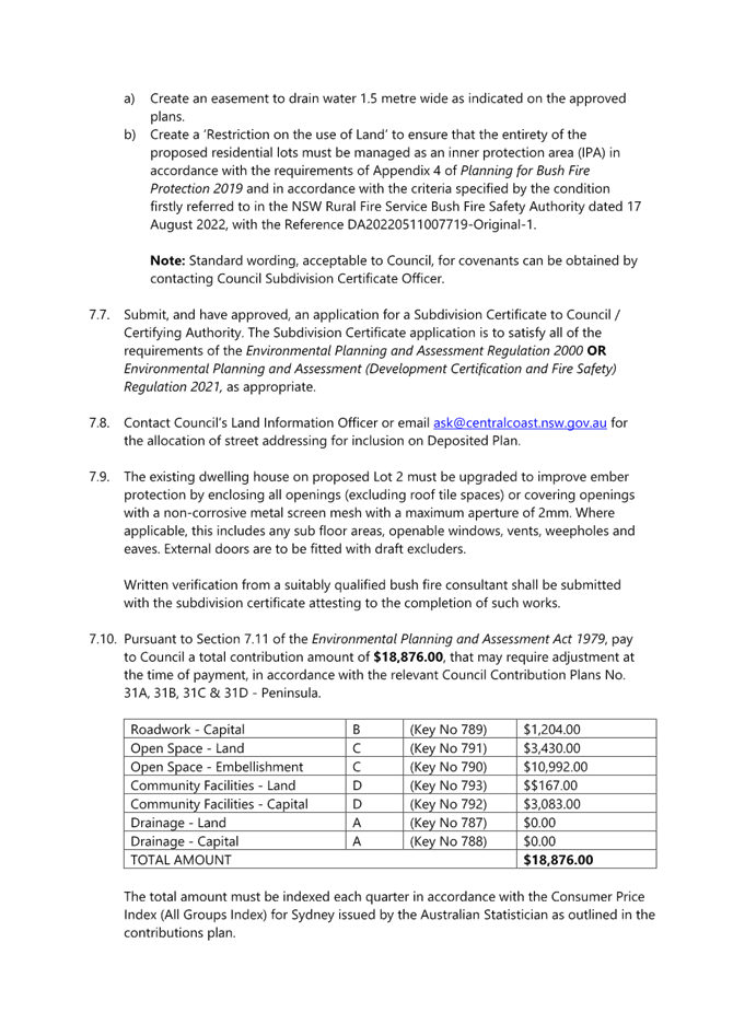

|
DA/668/2022 - 55 Mullbong Road, Blackwall - Subdivision into 2 Residential allotments |
|
|
Attachment 2 |
Final Plan of Proposed Subdivision No 55 Mullbong Road Blackwall DA 668 of 2022 |
|
4.1 |
DA/668/2022 - 55 Mullbong Road, Blackwall - Subdivision into 2 Residential allotments |
|
Attachment 3 |
PUBLIC Updated Statement of environmental effects - 55 MULLBONG ROAD BLACKWALL 2256 - DA/668/2022.pdf |


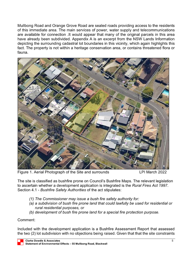
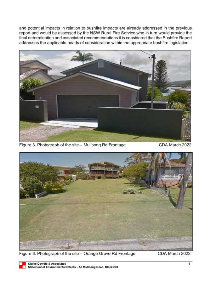
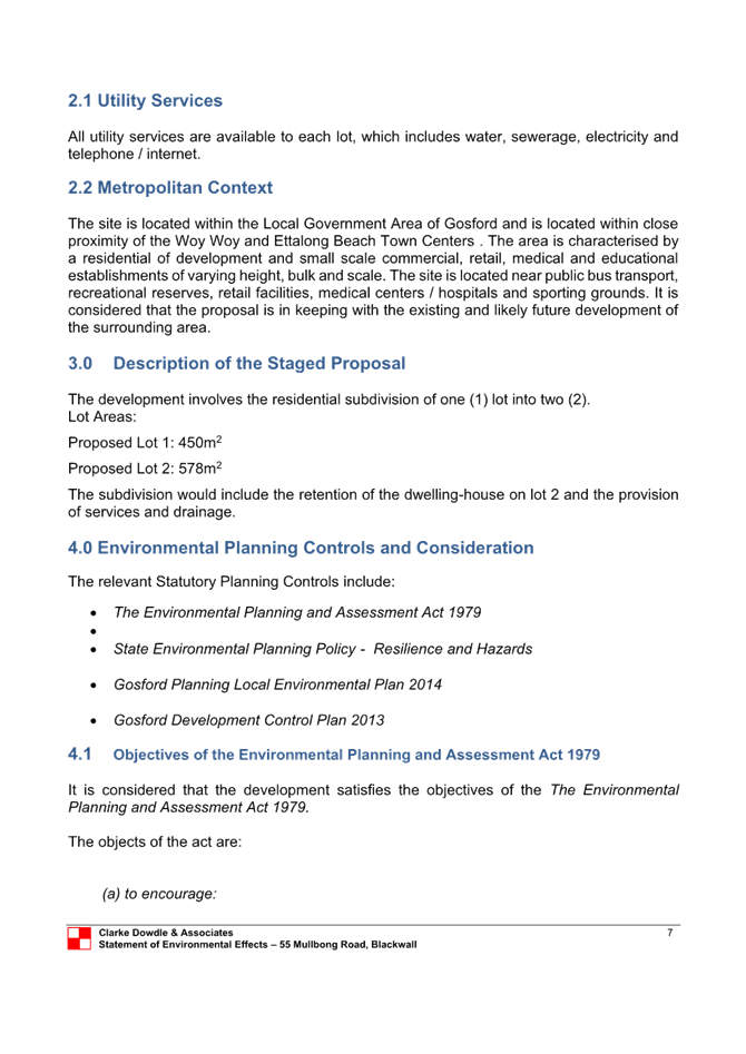


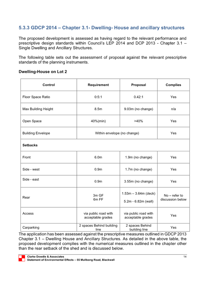
|
DA/668/2022 - 55 Mullbong Road, Blackwall - Subdivision into 2 Residential allotments |
|
|
Attachment 4 |
PUBLIC Bushfire report - 55 MULLBONG ROAD BLACKWALL 2256 - PAN-204387 - DA/668/2022.pdf |

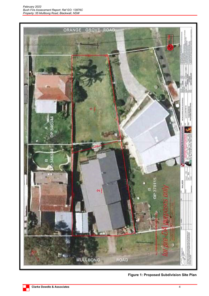


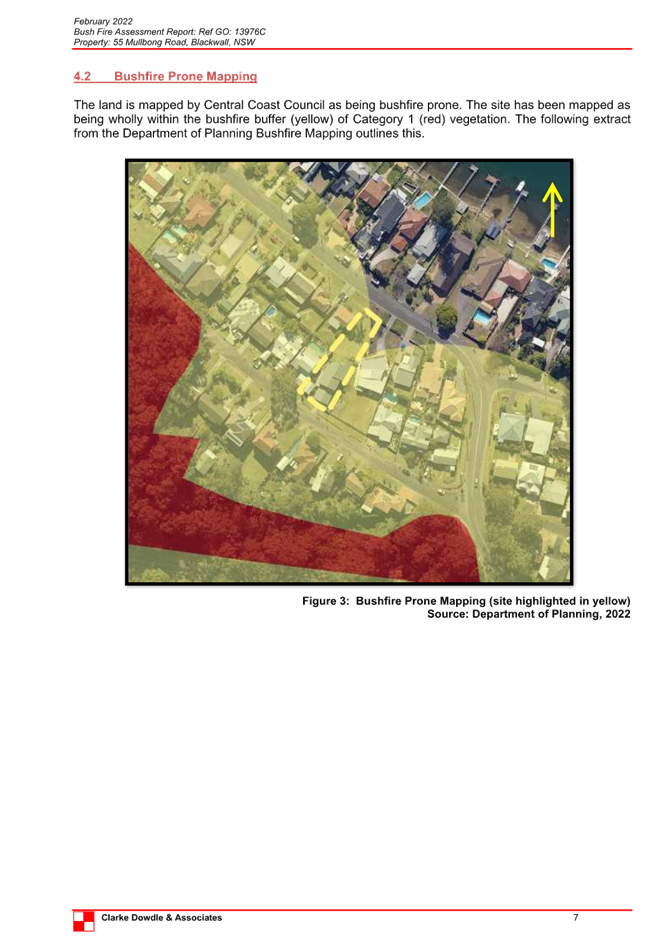
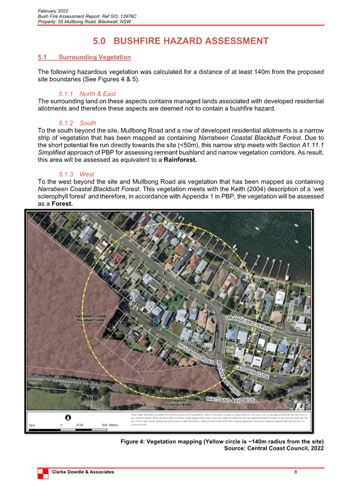
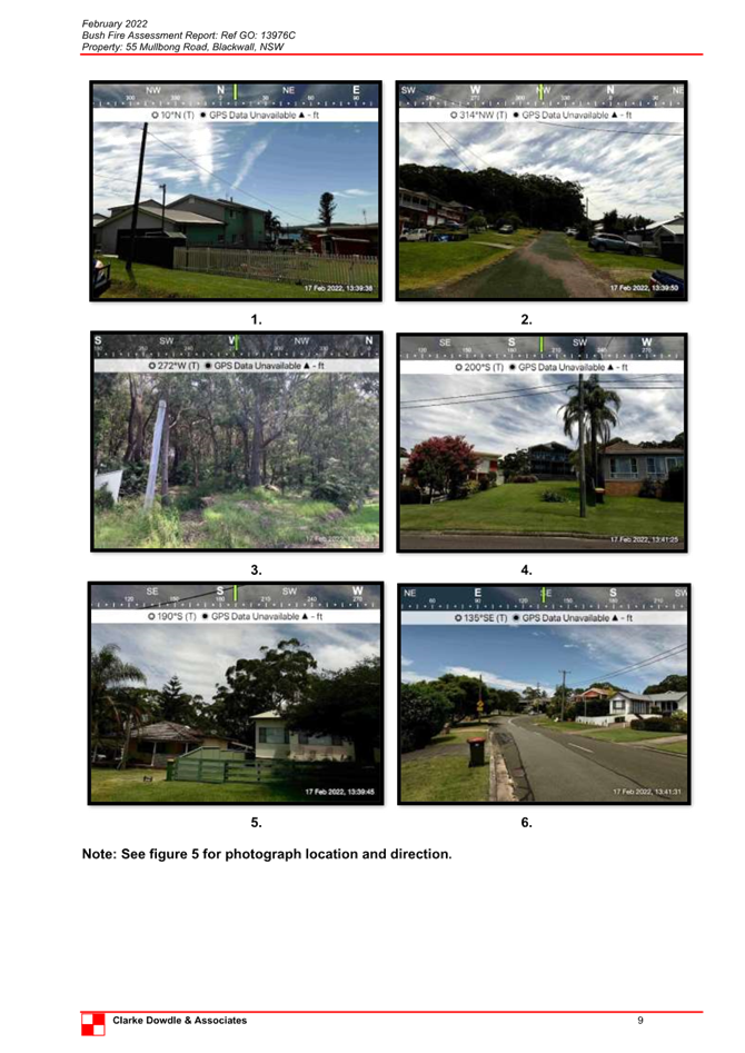
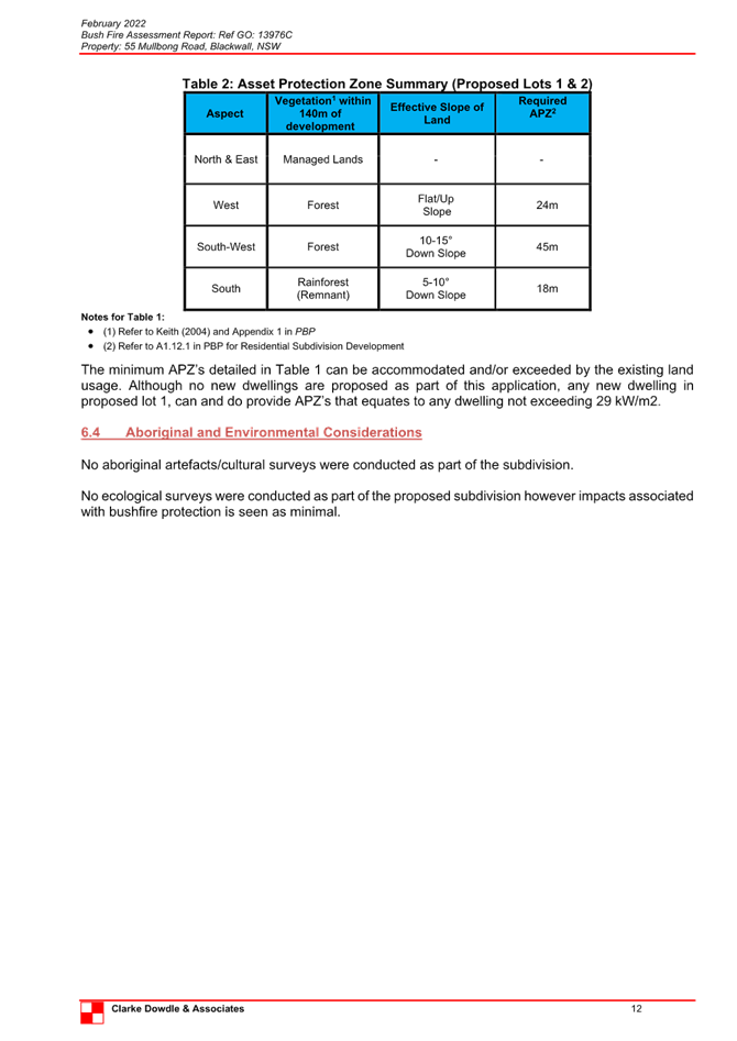
|
DA/668/2022 - 55 Mullbong Road, Blackwall - Subdivision into 2 Residential allotments |
|
|
Attachment 5 |
NSW RFS Bush Fire Safety Authority Determination Letter |

|
DA/668/2022 - 55 Mullbong Road, Blackwall - Subdivision into 2 Residential allotments |
|
|
Attachment 6 |
RECORD OF PRE-DEVELOPMENT ADVICE - 55 MULLBONG ROAD BLACKWALL 2256 - PAN-204387 - DA/668/2022.pdf |


|
DA/668/2022 - 55 Mullbong Road, Blackwall - Subdivision into 2 Residential allotments |
|
|
Attachment 7 |
Clause 4.6 - No 55 Mullbong Rd Blackwall DA/668/2022 |

|
Item No: 4.2 |
|
|
Title: DA/1809/2022 - 15-17 Coral Street, The Entrance - Construction of a 6 Storey Shop Top Housing development with Basement Level carparking |
|
|
Department: Environment and Planning |
|
|
14 March 2024 Local Planning Panel Meeting |
|
Reference: DA/1809/2022 - D15941091
Author: Alexandra Hafner, Development Planner Consultant
Section Manager: Emily Goodworth, Section Manager Employment and Urban Release
Unit Manager: Andrew Roach, Unit Manager Development Assessment
Executive: Alice Howe, Director Environment and Planning
Summary
An application has been received for the consolidation of two allotments and the construction of a six storey shop top housing development comprising 12 residential units with ground floor retail and associated basement car parking at No. 15-17 Coral Street, The Entrance. The application has been examined having regard to the matters for consideration detailed under Section 4.15 of the Environmental Planning and Assessment Act 1979 and other statutory requirements, with issues requiring attention and further consideration addressed in this report.
The application is referred to the Central Coast Local Planning Panel in accordance with the Local Planning Panels Ministerial Directions as the proposal is development to which State Environmental Planning Policy No. 65 – Design Quality of Residential Apartment Development applies and is four or more storeys in height. No submissions have been received.
The application is recommended for approval, subject to recommended conditions.
|
Application Number |
DA/1809/2022 |
|
applicant |
Design Cubicle Pty Ltd |
|
Owner |
Mr M Rammal and Mr A A A Nasrallah |
|
Property Lot and DP |
Lot 2 DP 25544, Pt Lot 1 DP 25544 |
|
Property Address |
15-17 Coral Street, The Entrance, NSW 2261 |
|
Proposal |
Consolidation of two (2) allotments and construction of a six (6) storey shop top housing development. |
|
Application Type |
Development Application – Local |
|
Site Area |
1,093m2 |
|
Zoning |
B2 – Local Centre |
|
Existing Use |
Vacant |
|
Employment Generating |
No |
|
Application Lodged |
6 September 2022 |
|
Estimated Value |
$6,00,496.00 |
|
Exhibition |
23 September to 19 October 2022 inclusive |
|
Submissions |
Nil |
|
Disclosure of Political Donations & Gifts |
No |
|
Site inspection |
14 December 2022 |
1. That the Local Planning Panel grant consent to DA/1809/2022 – 15-17 Coral Street, The Entrance, for construction of a six (6) storey shop top housing development and basement level car parking subject to the conditions detailed in the schedule attached to the report and having regard to the matters for consideration detailed in Section 4.15 of the Environmental Planning and Assessment Act 1979.
2. That Council advise Ausgrid of the Panel’s decision.
Key Issues
The following key issues in consideration of the application, are:
1. Variation to the performance requirements of clause 4.3 – Height of Buildings under the Central Coast Local Environmental Plan 2022 (CCLEP 2022).
2. Minor variation to car parking requirements.
3. Minor variation to ADG design criteria (deep soil planting).
Precis:
|
Proposed Development |
Construction of a six (6) storey shop top housing development with basement level car parking. |
|
Permissibility and Zoning |
Permissibility: The proposed development is defined as a commercial premises and shop top housing, both of which are permissible with consent in the B2 – Local Centre zone. |
|
Current Use |
Vacant land. |
|
Integrated Development |
No |
|
Submissions |
Nil |
Proposed Variations to Policies
The following variations are proposed to Council policy:
|
Clause |
Part 3(e) -Deep Soil Planting |
|
Standard |
7% of total site area to be deep soil planting (76.5m2) |
|
SEPP |
SEPP 65 Design Quality of Residential Apartment Development |
|
Departure basis |
100% |
|
Clause |
4.3 Height of buildings |
|
Standard |
Maximum building height = 23m |
|
LEP |
CCLEP 2022 |
|
Departure basis |
0.9m or 4% |
|
Clause |
2.13.3.2 Car parking requirements |
|
Standard |
Shop top housing Up to 3 bedrooms = 1 space per dwelling 4 bedrooms or more =2 spaces per dwelling Shops = 1 space per 30m2 |
|
DCP |
Chapter 2.13 Transport and Parking |
|
Departure basis |
2 spaces or 12% |
The Site
The site is legally identified as Lots 1 and 2 in DP 25544, No. 15-17 Coral Street, The Entrance and has a total site area of 1,093m2. Located at the intersection of Coral Street and Torrens Avenue, the site is a large irregular shaped allotment with a primary frontage of 10.493m addressing Coral Avenue, a splay of 4.33m and secondary frontage of 32.064m addressing Torrens Avenue. The site is relatively flat with a gentle 0.78m cross fall from Coral Street to Farrell Lane.
The site is currently vacant. There are no trees or vegetation on site.
The site is burdened by a 3.6m wide right-of-carriageway along the rear of the site, which is shared with adjoining properties that also front Coral Street. Informal vehicular access is also provided along the right-of-carriageway between Torrens Avenue and Farrell Lane.
The site is not identified as ‘bush fire prone land’ on Council’s maps.
There are known overland flooding issues in the local catchment due to insufficient drainage capacity of the existing network. This is due to the flat nature of the land and its limited ability to drain via a gravity system to the lake.
The site and surrounding land is not affected by flooding from Tuggerah Lake, rather due to localised overland flooding and back up of the system during prolonged rainfall.
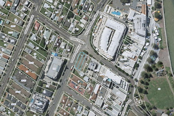
Figure 1 - Aerial of subject site
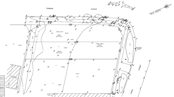
Figure 2 - Survey Plan
Surrounding Development
The site is bound by a vacant parcel to its immediate eastern boundary (19-21 Coral Street, The Entrance) and a 4 storey shop top housing development just beyond, separating the subject site from a large mixed-use building comprised of a hotel with ground floor retail premises to the north.
Torrens Avenue separates the site from a single storey residential dwelling house and a more recently constructed large 6 storey residential flat building to the west with Farrell Lane separating the site from low density housing to the south.
The Proposed Development
The subject development application seeks consent for the following (Figures 3-18):
· Consolidation of two (2) lots
· 15 x parking spaces contained within Basement Level 2 to Ground Floor
· One (1) x loading bay at Ground Floor with six (6) bicycle parking spaces
· Three (3) x commercial/retail tenancies within the Ground Floor
· 12 residential units within Levels 1 to Level 5 comprised of:
o Four (4) x one-bedroom units
o Four (4) x two-bedroom units and
o Four (4) x three-bedroom units.
Typically, each residential unit will comprise of a bathroom, bedroom, ensuite, laundry, combined living/dining, and kitchen with a balcony.
Off street parking is to be provided in a new three-level basement parking area with vehicular access provided via Farrell Lane at the rear of the site. The existing driveway crossover located on Torrens Avenue is to be closed and restored to kerb and gutter.
Off-street parking for 15 cars is proposed, comprising 12 residential spaces, 1 visitor space (including a shared car wash bay) and 2 retail spaces in accordance with Council requirements.
The proposed building has a varied external materials palette that includes rendered and painted finishes for the façade walls, both solid and glazed balustrades with rich and soft landscaping to complement stencil finished concrete.
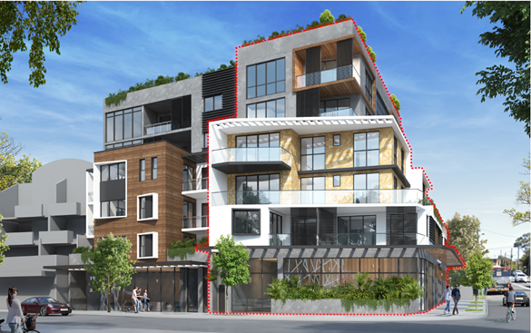
Figure 3 - 3D perspective showing Coral Street façade
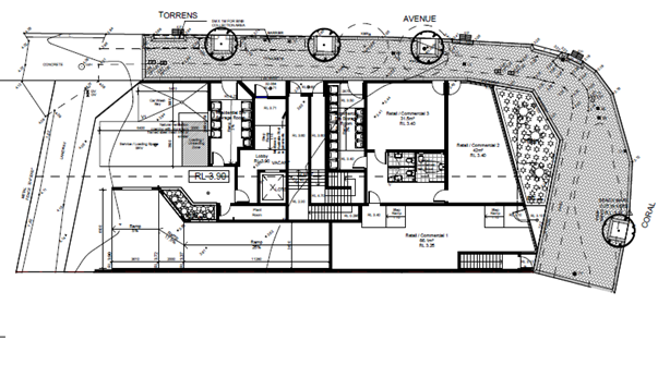
Figure 4 – Site Plan
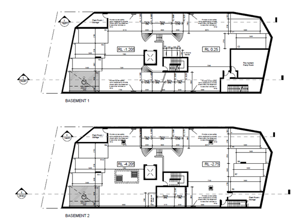
Figures 5 and 6 – Basement 1 and 2 Plan
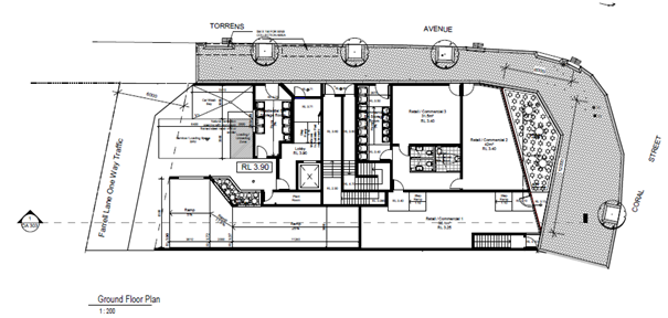
Figure 7 – Ground Floor Plan
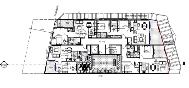
Figure 8 – Level 1 Plan
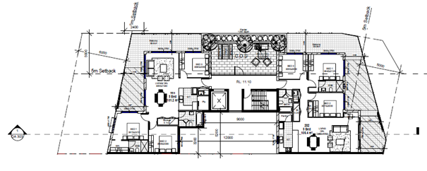
Figure 9 – Level 2 Plan
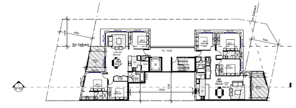
Figure 10 – Level 3 Plan
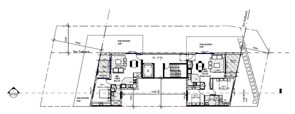
Figure 11 – Level 4 Plan
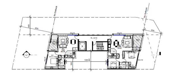
Figure 12 – Level 5 Plan
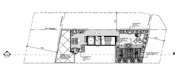
Figure 13 – Roof Plan
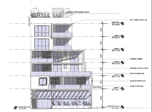
Figure 14 – Northern Elevation
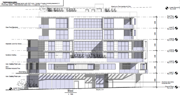
Figure 15 – Western Elevation

Figure 16 – Southern Elevation
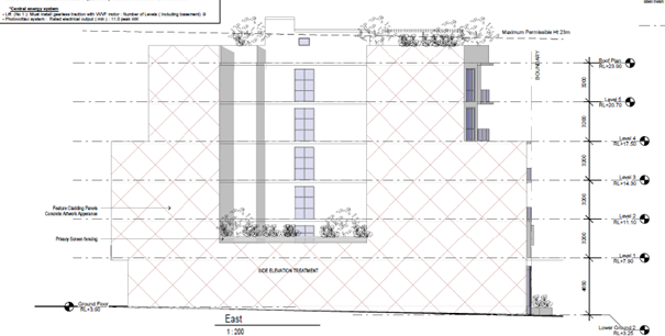
Figure 17 – Eastern Elevation
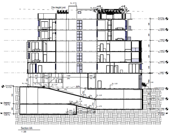
Figure 18 – Section AA
Background
Council’s records show the below history of applications relevant to the site:
|
Application number |
Description |
Status |
Decision |
Determination date |
|
DA/407/1987 |
Motel |
Approved |
Approved |
1987 |
|
BC/522/1991 |
Single dwelling and garage |
Approved |
Approved |
1991 |
|
TA/1524/1994 |
Remove two trees from the frontage and four from the rear |
Approved |
Approved |
1994 |
|
DA/1163/1996 |
Shop and holiday units |
Refused |
Refused |
1996 |
|
DA/1729/2004 |
Mixed use residential and commercial development of 18 units and ground floor commercial and demolition of existing structures |
Approved |
Approved |
19 January 2005 |
|
Construction Certificate for DA/1729/2004 |
Mixed use residential and commercial development of 18 units and ground floor commercial and demolition of existing structures |
Refused |
Refused |
1 September 2006 |
|
RZ/6/2011 |
Rezoning |
Approved |
Approved |
23 December 2013 |
Development Application No. DA/5/2019
Development consent was issued on 11 May 2020 for a comparable shop top housing development at 19-21 Coral Street as shown in Figures 19 and 20. It is intended that the subject development, prepared by the same architect, adopt similar elements to that site, so it forms a cohesive presentation to the street.

Figures 19 and 20 - Photomontage of subject site and adjoining at 19-21 Coral Street
Assessment
Having regard for the matters for consideration detailed in Section 4.15 of the Environmental Planning and Assessment Act 1979 and other statutory requirements, Council’s policies and Section 10.7 Certificate details, the assessment has identified the following key issues, which are elaborated upon for the Panel’s information.
Section 4.15(1)(a) – Assessment against relevant EPI’s, DCPs, etc.
The relevant applicable planning controls for the purpose of this application are:
- State Environmental Planning Policy (Building Sustainability Index: BASIX) 2004
- State Environmental Planning Policy (Biodiversity and Conservation) 2021
- State Environmental Planning Policy (Resilience and Hazards) 2021
- State Environmental Planning Policy (Transport and Infrastructure) 2021
- State Environmental Planning Policy No. 65 – Design Quality of Residential Apartment Development
- Central Coast Local Environmental Plan 2022 and
- Central Coast Development Control Plan 2022.
An assessment against relevant provisions of the above is undertaken below.
State Environmental Planning Policy (Building Sustainability Index: BASIX) 2004
The application is accompanied by a revised Multi Dwelling BASIX Certificate No. 1261505M_02, dated Wednesday 20 December 2023.
State Environmental Planning Policy (Biodiversity and Conservation) 2021
Chapter 2
Chapter 2 of the consolidated SEPP contains planning controls and rules from the former Vegetation SEPP that applies to the site and relates to the clearing of native vegetation in NSW on land zoned for urban and environmental purposes. This chapter aims to protect the biodiversity value of trees and other vegetation in non-rural areas of the state and to preserve the amenity of non-rural areas of NSW through the appropriate preservation of trees and other vegetation.
The site is vacant and does not contain trees or vegetation that would be considered under the remit of the SEPP. No further consideration is required in this regard.
Chapter 4
There is no approved koala plan of management which applies to the site and no koalas are recorded to have occurred on the site. In accordance with Section 4.9(3) of the Biodiversity Conservation SEPP 2021, the application is considered to have no impact on koalas or koala habitat.
State Environmental Planning Policy (Resilience and Hazards) 2021
The aims of Chapter 2 are to be considered when determining an application within Coastal Management Areas. The subject site is located within a coastal environment area and on the periphery of the coastal use area as shown in Figures 21 and 22.
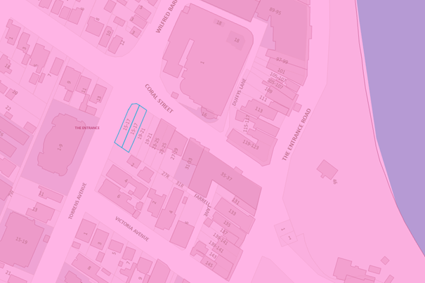
Figure 21 – Coastal Environment Area
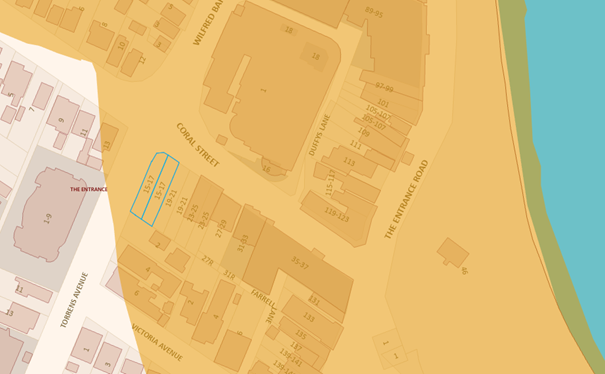
Figure 22 – Coastal Use Area
Sections 2.10 and 2.11 are to be taken into consideration by the consent authority when it determines a development application to carry out development on land to which this SEPP applies. The proposed development has satisfactorily addressed the matters for consideration outlined in Sections 2.10 and 2.11 as shown in the below tables:
Clause 2.10 – Coastal Environment Area
|
Matters for Consideration |
Compliance |
|
(1) Development consent must not be granted to development on land that is within the coastal environment area unless the consent authority has considered whether the proposed development is likely to cause an adverse impact on the following: |
|
|
(a) the integrity and resilience of the biophysical, hydrological (surface and groundwater) and ecological environment |
Stormwater will be captured on the roof and directed via the existing stormwater drainage system, meaning the development is unlikely to have adverse impacts on the biophysical, hydrological, and ecological environment. |
|
(b) coastal environmental values and natural coastal processes |
The site is not located directly near the coastline or beach and on this basis, is considered to have negligible impact upon existing coastal environmental values and natural coastal processes |
|
(c) the water quality of the marine estate (within the meaning of the Marine Estate Management Act 2014), in particular, the cumulative impacts of the proposed development on any of the sensitive coastal lakes identified in Schedule 1 |
The site is not located within a marine estate. The proposed development and existing stormwater system will have negligible impacts upon Tuggerah Lakes, listed as a sensitive coastal lake in Schedule 1 of the SEPP, due to its distance. |
|
(d) marine vegetation, native vegetation and fauna and their habitats, undeveloped headlands and rock platforms |
The proposal is unlikely to adversely impact marine vegetation, native vegetation and fauna and their habitats, underdeveloped headlands and rock platforms due to its distance from both Tuggerah Lakes and beach. |
|
(e) existing public open space and safe access to and along the foreshore, beach, headland or rock platform for members of the public, including persons with a disability |
The site is not in proximity to public open space and does not impact existing safe access to and along the foreshore for members of the public |
|
(f) Aboriginal cultural heritage, practices and places |
The proposal is not likely to cause an adverse impact on Aboriginal cultural heritage, practices and places. Standard conditions are imposed to stop works and report the findings to the AHO if any Aboriginal Engravings or Relics are unearthed. |
|
(g) use of the surf zone. |
The site is not in proximity to the surf zone |
|
(2) Development consent must not be granted to development on land to which this clause applies unless the consent authority is satisfied that: |
|
|
(a) the development is designed, sited and will be managed to avoid an adverse impact referred to in subclause (1) |
The proposed development has been designed, sited to avoid any adverse impact referred to in subclause (1). |
|
(b) if that impact cannot be reasonably avoided - the development is designed, sited and will be managed to minimise that impact |
N/A |
|
(c) if that impact cannot be minimised - the development will be managed to mitigate that impact |
N/A |
Clause 2.11 – Coastal Use Area
|
Matters for Consideration |
Compliance |
|
(1) Development consent must not be granted to development on land that is within the coastal use area unless the consent authority: |
|
|
(a) has considered whether the proposed development is likely to cause an adverse impact on the following: |
|
|
(i) existing, safe access to and along the foreshore, beach, headland or rock platform for members of the public, including persons with a disability, |
The site is not in proximity to public open space along the foreshore and does not impact existing safe access to and along the foreshore for members of the public |
|
(ii) overshadowing, wind funnelling and the loss of views from public places to foreshores, |
The proposal will not result in unreasonable overshadowing, wind funnelling or loss of views from any public places to foreshores. |
|
(iii) the visual amenity and scenic qualities of the coast, including coastal headlands, |
The proposal does not impact visual amenity or scenic qualities of the area |
|
(iv) Aboriginal cultural heritage, practices and places, |
The proposal is not likely to cause an adverse impact on Aboriginal cultural heritage, practices and places. Standard conditions are imposed to stop works and report the findings to the AHO if any Aboriginal Engravings or Relics are unearthed. |
|
(v) cultural and built environment heritage, and |
The site is within a developed urban area and the proposed development is unlikely to adversely impact the cultural and built environment heritage |
|
(b) is satisfied that— |
|
|
(i) the development is designed, sited and will be managed to avoid an adverse impact referred to in paragraph (a), or |
The proposed development has been designed, sited to avoid any adverse impact referred to in paragraph (a). |
|
(ii) if that impact cannot be reasonably avoided—the development is designed, sited and will be managed to minimise that impact, or |
N/A |
|
(iii) if that impact cannot be minimised—the development will be managed to mitigate that impact, and |
N/A |
|
(c) has taken into account the surrounding coastal and built environment, and the bulk, scale and size of the proposed development. |
The proposed development has taken into account surrounding coastal and built environment. The proposed bulk, scale and size of the development is acceptable. |
Having regard for Sections 2.10 (2), 2.11(2) and 2.12 of State Environmental Planning Policy (Resilience & Hazards) 2021, the Panel can be satisfied that the proposed development is designed, sited, and will be managed to avoid an adverse impact referred to in Section 2.10(1) and Section 2.11(1), the bulk, scale and size of the proposed development is satisfactory having regard for the surrounding coastal and built environment (Section 2.11(3)), and the development is not likely to cause increased risk of hazards on the subject site or other land (Section 2.12).
Chapter 4
The provisions of Chapter 4 have been considered in the assessment of the development application and require consent authorities to consider whether the land is contaminated, and if the land is contaminated, it is satisfied that the land is suitable in its contaminated state (or will be made suitable, after remediation) for the purpose for which the development is proposed to be carried out.
The application is accompanied by a Stage 1 Contamination Report, prepared by Ground Technologies NSW and dated 23 May 2022. The report was referred to Council’s Environmental Health Officer for review and comment. The investigation has included limited testing and analysis at the site with the following conclusions made:
· The site has historically been used for residential and commercial purposes from a date prior to 1965.
· The residential structure was removed prior to 2007.
· In 2009, a fire destroyed the commercial structure. The buildings were identified as highly likely to contain asbestos and surficial asbestos contamination was possible. It is understood that the surface was prayed with a binding agent to limit the potential for asbestos to become airborne.
· The subject site appears to have been used for car parking purposes since 2009.
· Potential contamination exists in the form of asbestos within the upper surficial soils.
A Remedial Action Plan (RAP) for the site has been prepared and accompanies the report. As the proposed development requires excavation to basement level, the most appropriate remediation strategy for the site is the classification, excavation and disposal of contaminated materials. The affected fill material will be directly transported off site to landfill as General Solid Waste – Asbestos Contaminated Material.
Following the excavation and removal of the affected fill material, a validation report will be prepared on completion of on-site remedial works. This shall contain an overview of all remediation activities conducted and details of the volumes of excavated fill material.
The underlying natural soils will then be classified as virgin excavated natural material (VENM) for future use.
The site is suitable for the intended use subject to the RAP being implemented and validated. The RAP and validation report form conditions of consent.
Subject to these conditions, the proposal is deemed acceptable with regards to the provisions of the SEPP.
State Environmental Planning Policy (Transport and Infrastructure) 2021
Traffic generating development is identified as sites with access on a road within 90m to a classified road and that includes parking for 50 or more vehicles. The proposed rear lane access is within 90m of the roundabout section of Wilfred Barrett Drive; however, the proposal does not include parking for 50 or more vehicles.
Consideration shall be given to where the site has a frontage to a classified road and is for development sensitive to road noise or vibration. The site is in close proximity to Wilfred Barrett Drive but does not have a frontage to this classified road. The site, however, does front a busy road that intersects with Wilfred Barrett Drive and is for a residential purpose that is likely to be adversely impacted by road noise or vibration.
The application is accompanied by a Traffic Noise Assessment, prepared by Rodney Stevens Acoustics, dated 26 May 2021. The report includes suitable acoustic impact mitigation measures including glazing, which forms conditions of consent.
Subject to these conditions, the proposal is deemed acceptable with regards to the provisions of the SEPP.
State Environmental Planning Policy No. 65 (Design Quality of Residential Apartment Development) (SEPP 65)
SEPP 65 applies to residential flat buildings that are three or more storeys in height and that comprise four (4) or more dwellings. The proposal seeks consent for a six (6) storey residential flat building with 12 dwellings and is therefore subject to the provisions of SEPP 65 and the associated Apartment Design Guidelines (ADG).
As required by Clause 29 of the Environmental Planning and Assessment Regulation 2021, a design verification statement prepared by Design Cubicle Pty Ltd was submitted with the application verifying that the proposal was designed and undertaken by nominated architect Sam Min-Han Lu (#8842). The statement confirms the design objectives of SEPP 65 have been considered in the design and have been met.
The Regulations also require that the statement explains how the development addresses:
(i) The design quality principles, and
(ii) The objectives in Parts 3 and 4 of the Apartment Design Guide
The following table considers the proposal against the SEPP 65 design quality principles and includes the applicant’s relevant design comments.
|
Principles |
Proposal (applicant’s response) |
|
Context and neighbourhood character |
The site is situated at 15-17 Coral Street, The Entrance, NSW. The proposal provides for a quality development that responds to and utilises the advantages of its unique context. The immediate surroundings of the subject site fall within a precinct that is characterised by a nearby future diverse range of land uses, including more proposed medium-high density residential developments, and includes mainly existing residential and commercial/retail uses.
The immediate context for this site is residential development consisting of mainly individual dwellings and selected multi-dwelling developments, as well as commercial/retail premises in the nearby vicinity. The close proximity of the subject site to nearby schools/churches/multitude of clubs/bus services/petrol stations etc and to major arterial roadways and streets as well as the fact the site is within a few minutes to the centre of The Entrance CBS district supports the view for higher residential densities. The site layout of the building generates favourable orientation with respect to solar access which further reinforces the appropriateness of the development.
The most important elements that informed and influenced the design and aesthetics of the building were: · The future vision of high density for the immediate surrounding locality, resulting in the transformation of the surrounding subject area from low to high density. · An opportunity to access the sun, air, distant views and greenery. · Current and future residential developments containing contemporary aesthetics.
The goal of our design is to generate a positive outcome towards the future character of the area, and we believe that our proposed development responds to and creates a transitional buffer zone between the different components of the existing and future precinct situation. |
|
Built form and scale |
The locality displays a traditional mixed character, consisting of mainly small, individual dwellings, selected multi-dwelling developments, as well as nearby commercial/retail premises. However, as discussed above, Council’s vision for the subject area is a transformation from low to high density over the coming years, hence the zoning of the site as high density residential to help accommodate future population growth.
The site is considered suitable for an increased development, and out proposed development, will establish a transitional buffer zone that bridges between the different scales evidence in the surroundings, in addition to creating a climax/landmark effect, especially when perceived from surrounding roads.
The development bulk and scale of this building will complement the surroundings on each elevation, including the main facades to both Coral Street and Torrens Avenue. The proposed building will dialogue with its immediate context and respond adequately, creating a contextual answer to a setting that is due to become more diversified and complex over time.
The proposed design has been developed in keeping with the requirements of the Apartment Design Guide and Council’s requirements in relation to building alignment, proportions, building type, articulation and the manipulation of building elements. The proposal defines and activates the public realm by creating communal and public open space for the residents on both intermediate roof terraces and the rooftop of the proposal.
The proposed built form for the mixed-use development consists of a six-storey building component with Basement and Ground Floor car parking for 15 vehicles. The development contains 12 fully dedicated, consisting of a mixture of 1-, 2- and 3-bedroom apartments.
The proposed building block speaks to its surroundings through interpreting its context in a modern manner, dialoguing with surrounding buildings by interacting with them visually through scale and built form i.e., balcony/blade wall elements will give added interest to the facades with pleasing proportions, as well as reduces the comparable bulk and scale to the elevations of the building.
The shape of the site has informed the composition of the development. The buildings internal room layouts are controlled to achieve better amenities and minimise the impact of traffic noise and pollution. Facades show their protective function yet present a residential face to the public view, using a variety of shapes, materials and colours, with a visual play between walls, entries, balconies and external finishes.
The facades have a variety of elements to reflect a visually softer presentation, to lessen the impact of the building, and to maximise apartments exposure to the sun and views. Façade planes and masses of the building are visually divided into smaller elements by horizontals and verticals, and materials, to reduce building bulk. This composition helps the development to fit into the urban landscape setting, whilst maintaining is contextual uniqueness and importance in the existing streetscapes of both Coral Street and Torrens Avenue. |
|
Density |
The proposed density is a direct response to the regional context, availability of public transport, facilities in this precinct and the development capacity of the site.
The proposed development will consist of 12 apartments, over three levels of Basement and Ground Floor car parking with the following breakdown: · 4 x 1 bed apartments · 4 x 2 bed apartments · 4 x 3 bed apartments.
The proposal presents an adequate variety of apartment mixture and orientation. |
|
Sustainability |
The proposed design will promote ecologically sustainable development (ESD) through: · Benefiting from its orientation more than 70% of the apartments will have adequate sun access. · At least 60% of the units will achieve natural cross-flow ventilation. · The proposal incorporates both active and passive sun controls systems. · Working towards ensuring waste minimisation during the construction phase and the lifespan of the building, including through the recycling and reuse of materials and waste. · The development will incorporate the installation of low energy saving devices wherever possible. · Adhering to BASIX constraints. |
|
Landscape |
The landscape scheme is to incorporate adequate special experience for both the public and private realm. Incorporating a variety of activity spaces, the proposal promotes community involvement in the landscape through communal gardens on various rooftops of the proposal, containing elements such as seating areas and the like. All common areas are accessible for people with a disability.
The landscape solution is designed by an experienced specialist landscape consultant. |
|
Amenity |
Amenities were given high priority in the design through: · Maximising views and exposure · The apartments were orientated to have good solar aspect and enjoy cross-flow ventilation wherever possible. · All apartments will enjoy good visual and acoustic privacy through orientation (the positioning of windows and private open space, setbacks etc) or through materials used. · All apartments will be air conditioned. · All apartments will be equipped with adequate storage space either in the basement or inside each apartment. · All apartments have efficient layouts and have been provided with adequate outdoor space. · All apartments have access to the waste area on the Ground Floor for the deposition of garbage and recyclables. · All apartments will have the adequate number of car spaces required according to Council’s DCP requirements. |
|
Safety |
The proposal optimises safety and security both within the development and the public domain. The proposal affords good casual surveillance of both the street frontages, and the public and communal areas of the site, through the glazed openings and balconies of the upper-level apartments and lobbies, and Ground Floor commercial tenancies.
With regards to parking areas, secure access is to be always maintained to ensure that the parking premises are solely for the occupants of the building, and their visitors. Visitor access will be provided through an intercom system and remote-control access or the like for residents. |
|
Housing Diversity and Social Interaction |
The proposal contributes to its social context by adhering to the desired future character of the areas as highlighted in Council’s LEP and DCP.
The proposal promotes social encounters while providing adequate privacy for each owner, resident or tenant. The public domain through the common open spaces complements the private spaces associated with each apartment, and promotes social interaction between the residents through design and configuration of the landscaped areas and the like, containing things such as seating areas, relaxation areas etc.
The proposal will provide quality residential apartments in multiple plan configurations of varying sixes to cater for a wide variety of people.
Persons with disabilities or restricted/impaired mobility area catered for through the provision of apartments highlighted for future adaptability, complaint with relevant Australian Standards.
The provision of a stretcher lift facility in the building also allows for wheelchair access to be accommodated to the entry door of all units on all floors for persons with a disability as required by the BCA. |
|
Aesthetics |
The creation of a well-articulated proposed building form is outlined in our proposal, along with the quality use of finishes, and will add to the visual interest to be generated by the future residential streetscape and character of this locality, which we aim to be at the forefront of driving forward in the future progress for The Entrance area.
Materials and colours have been selected to add visual interest and identity and to soften the impact of the development’s bulk and scale.
· The proposal incorporates a variety of materials including rendered and painted finishes for the façade walls, a combination of solid balustrades as well as glazed balustrade treatments and special cladding for partial walls. · Balcony balustrades are of various types and serve different purposes: painted and rendered solid walls work as compositional devices to divide facades, whilst the safety tinted glass plate balustrades allow for maximum views. · Glazing will be fixed to powder-coated aluminium frames. · The colours lessen the apparent bulk of the building. The overall external colour scheme helps to give our proposal a sharp, modern look whilst not overpowering its surroundings. The feature colours used add warmth, interest and a sense of identity to the building. The overall colour scheme is designed to complement its surroundings, including the rich surrounding greens of the landscape, and to create a synergy with nearby existing structures. · Together with the rich, soft landscaping, the hard surfaced landscaped areas of the site will contain a variety of materials and finishes, which may include stencil finished concrete, various pavement patterns and colours. · The choice and composition of the building elements are contemporary to reflect the time, but also with a view to becoming a leader and guide towards the future character of the area.
The combination of glazing, blade walls and feature colours and materials help to bring life to the facades and will serve as a positive reinforcement to the urban fabric of the evolving greater area of The Entrance as the years progress. |
Further, an assessment against the design criteria in Parts 3 and 4 of the ADG has been conducted by Council’s Urban Designer and is provided below:
|
Design criteria |
Required |
Proposed |
Compliance |
|
3D – 1 Communal Open Space |
· Minimum communal open space area 25% of the site · Minimum dimension of 3m · 50% direct sunlight to principal usable part for min 2 hours between 9am and 3pm midwinter |
· Communal open space is to have a minimum area equal to 25% of the site, and an area of 261.2m² has been highlighted as communal open space, which equates to approximately 44.2% of the site area, exceeding the minimum requirements. · Direct sunlight is achieved to the principal useable part of the communal open space for a minimum of 2 hours between 9am and 3pm. · Communal open space achieves requirement of a minimum dimension of 3m.
|
Yes |
|
3E – 1 Deep Soil Zone |
· Deep soil zones are to meet the following minimum requirements. · Minimum dimension of 650sqm – 1500sqm · 7% of site area |
The proposed development provides no deep soil zone which is deemed acceptable in a commercial context noting the site configuration and size. |
Acceptable given E1 – Local Centre zone. |
|
3F – 1 Visual Privacy |
· Separation from boundaries and buildings: - Up to 12m/4 storeys – 6m to habitable 3m to non-habitable - Up to 25m /5-8 storeys – 9m to habitable, 4.5m to non-habitable |
With regards to the proposed development, compliance with the numerical standard with regards to habitable room separation from both the side and rear boundaries is achieved, due to the fact blank walls are proposed to the side boundary for portions of the building, as allowed by the ADG along main streets or at podium levels within main centres, or otherwise required separation is achieved.
In addition, the stated setback requirements are met for the rear boundary in respect to the residential levels.
Revised plans have ensured that proposed bathroom windows are higher with improvement to visual privacy. |
Yes |
|
4A – 1 Solar and Daylight Access |
· Living rooms and private open spaces of at least 70% of apartments in a building receive a minimum of 2 hours direct sunlight between 9am and 3pm at mid-winter in the Sydney Metropolitan Area and in the Newcastle and Wollongong local government areas. · A maximum 15% of apartments in a building receive no direct sunlight between 9am and 3pm at mid-winter. |
91% (11 units) receive a minimum of 2 hours of solar access required to the main living area.
There are no proposed units that receive no direct sunlight between 9am and 3pm in midwinter. |
Yes |
|
4B-3 Natural Ventilation |
· At least 60% of units are naturally cross ventilated in the first nine storeys of the building. · Overall depth of a cross-over or cross-through apartment does not exceed 18m, measured glass line to glass line |
100% (12 units) receive natural cross flow ventilation. |
Yes |
|
4C - 1 Ceiling Heights |
· Minimum finished floor level to finished ceiling level heights are: - 2.7m habitable rooms - 2.4m non-habitable rooms |
The proposed development incorporates minimum ceiling heights of 2.7m for habitable rooms and 2.4m for non-habitable rooms. |
Yes |
|
4D – 1 Apartment Size |
· Minimum dwelling sizes are: - Studio: 35sqm - 1 bed: 50sqm - 2 bed: 70sqm - 3 bed: 90sqm - Every habitable room must have a window in an external wall with a total min glass area of not less than 10% of the floor area of the room. Daylight and air may not be borrowed from other rooms. |
All dwelling sizes satisfy the minimum area requirements and are increased by 5sqm with any additional bathrooms. |
Yes |
|
4D – 2 Room Depths |
· Habitable room depths are limited to a max of 2.5m x the ceiling height · In an open plan layout the maximum habitable room depth is 8m from a window. |
Habitable room depths comply with the requirements of 8m from a window in an open plan layout, or else 2.5m x the ceiling height. |
Yes |
|
4D – 3 Apartment Layouts |
· Master bedrooms have a min area of 10sqm and other bedrooms 9sqm (excluding wardrobe space) · Bedrooms have a min dimension of 3m (excluding wardrobe space) · Living rooms or combined living/dining rooms have a min width of: - 3.6m for studio and 1 bed apartments - 4m for 2 and 3 bed apartments · The width of cross-over or cross through apartments are at least 4m internally to avoid deep narrow apartment layouts. |
Master bedrooms have a minimum area of 10m2 and other bedrooms 9m2, excluding wardrobe space.
Bedrooms have a minimum dimension of 3m (excluding wardrobe space).
Living rooms or combined living/dining rooms have a minimum width of 2.6m for 1 bedroom apartments and 4m for 2 and 3 bedroom apartments. |
Yes |
|
4E – 1 Private open space and balconies |
· All apartments are required to have primary balconies as follows: - 1 bed: 8sqm, min 2m depth - 2 bed: 10sqm, min 2m depth - 3 bed: 12sqm, min 2.4m depth |
Revised plans demonstrate that full area and minimum depth dimensions have been satisfied for all Units. |
Yes |
|
4F -1 Common Circulation |
· The maximum number of apartments off a circulation core on a single level is eight |
The maximum number of apartments sought off a circulation core is four. |
Yes |
|
4G – 1 Storage |
· In addition to storage in kitchens, bathrooms and bedrooms, the following storage is provided: - 1 bed: 6m3 - 2 bed: 8m3 - 3 bed: 10m3
At least 50% of the required storage is to be located within the apartment. |
All units comply with the minimum storage requirements. |
Yes |
|
4H Acoustic Privacy |
Noise transfer is limited through the siting of buildings and building layout. |
Development has generally been sited to avoid noise transfer. |
Yes |
|
4J Noise and Pollution |
The impact of external noise transfer and pollution are minimised through the siting and layout of the building. |
As above, the design seeks to minimise this. |
Yes |
|
4K Apartment Mix |
A range of apartment types are provided to cater for different household types and distributed throughout the building. |
The following mix of units are proposed: - Four x 1 bed - Four x 2 bed - Four x 3 bed |
Yes |
|
4L Ground Floor Apartments |
Maximise street frontage activation and amenity. Design of ground floor apartments delivers amenity and safety. |
No apartments are located on the ground floor. |
N/A |
|
4M Facades |
Provide visual interest whilst respecting the character of the area. |
The facades and external appearance of the building are generally considered acceptable. |
Yes |
|
4N Roof Design |
Roof features are incorporated into the roof design, respond to the street and provide sustainability features. |
Roof design is acceptable and responds to the height and character of the development. |
Yes |
|
4O Landscape Design |
Landscape Design is viable, sustainable, contributes to the streetscape and amenity. |
Landscape and planting schemes include an appropriate mix of species. |
Yes |
|
4V Water |
Water Management and Conservation is achieved. |
The application is accompanied by a valid BASIX Certificate which confirms water management and conservation is achieved. |
Yes |
|
4W Waste |
Waste storage facilities are provided to minimise impacts to the streetscape, building entry and amenity of residents. |
Ground floor waste storage are located towards the rear of the development, at ground level. |
Yes |
Central Coast Local Environmental Plan 2022
The relevant local environmental plan applying to the site is CCLEP 2022. The aims of CCLEP 2022 are to promote a high standard of urban design that responds appropriately to the existing or desired future character of areas.
Zoning and Permissibility (Part 2)
The subject site is zoned E1 – Local Centre pursuant to clause 2.2 of CCLEP 2022 (Figure 23).
The CCLEP 2022 defines the development as:
Shop top housing means one or more dwellings located above ground floor retail premises or business premises.
Shop top housing is a type of residential accommodation—see the definition of that term in this Dictionary.
Commercial premises means any of the following-
(a) Business premises
(b) office premises,
(c) retail premises.
residential accommodation means a building or place used predominantly as a place of residence, and includes any of the following:
(a) attached dwellings,
(b) boarding houses,
(c) dual occupancies,
(d) dwelling houses,
(e) group homes,
(f) hostels,
(g) multi dwelling housing,
(h) residential flat buildings,
(i) rural workers’ dwellings,
(j) secondary dwellings,
(k) semi-detached dwellings,
(l) seniors housing,
(m) shop top housing,
but does not include tourist and visitor accommodation or caravan parks.
retail premises means a building or place used for the purpose of selling items by retail, or hiring or displaying items for the purpose of selling them or hiring them out, whether the items are goods or materials (or whether also sold by wholesale), and includes any of the following—
(a), (b) (Repealed)
(c) food and drink premises,
(d) garden centres,
(e) hardware and building supplies,
(f) kiosks,
(g) landscaping material supplies,
(h) markets,
(i) plant nurseries,
(j) roadside stalls,
(k) rural supplies,
(l) shops,
(la) specialised retail premises,
(m) timber yards,
(n) vehicle sales or hire premises,
but does not include farm gate premises, highway service centres, service stations, industrial retail outlets or restricted premises.
Note—
Retail premises are a type of commercial premises—see the definition of that term in this Dictionary.
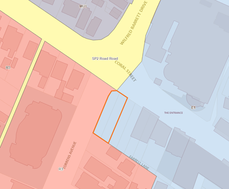
Figure 23 – Land Zoning Map
Shop top housing and commercial premises are permissible with consent within the E1 – Local Centre zone. The design of the development can be properly characterised as “shop top housing” as the residential accommodation is above the retail or commercial parts (Hrsto v Canterbury City Council (No 2) [2014] NSWLEC 121).
Pursuant to the Land Use Table in clause 2.3 of CCLEP 2022, the objectives of the E1 – Local Centre zone are as follows:
· To provide a range of retail, business, entertainment and community uses that serve the needs of people who live in, work in and visit the local area.
· To encourage employment opportunities in accessible locations.
· To maximise public transport patronage and encourage walking and cycling.
· To permit residential uses while maintaining active retail, business and other non-residential uses at street level to contribute to the vitality of the area.
· To minimise conflict between land uses within the zone and land uses within adjoining zones.
The proposed development satisfies the objectives of the zone as it will permit the orderly development of a currently vacant site, contributing to the range of retail uses serving the needs of people who live, work, and visit the local area, whilst also increasing housing and commercial stock in The Entrance.
General Controls and Development Standards (Parts 2, 4, 5, 6 and 7)
CCLEP 2022 contains controls relating to development standards, miscellaneous provisions and local provisions. The relevant controls to the proposal are further set out in the table below.
|
Clause |
Requirement |
Proposal |
Complies |
|
4.3(2) – Height of buildings |
Clause 4.3 permits a maximum overall building height of 23m. |
Overall building height of 23.9m (RL 27.70 – RL 3.80) |
No – discussed below. |
|
4.4(2) – Floor Space Ratio |
Clause 4.4 permits a maximum floor space ratio of 2.75:1. |
2.2:1 |
Yes. |
|
4.6 – Exceptions to Development Standards |
Development consent may, subject to this clause, be granted for development even though the development would contravene a development standard imposed by this or any other EPI instrument. |
Discussed below. |
N/A – discussed below. |
|
5.6 – Architectural roof features |
Development that includes an architectural roof feature that exceeds or causes a building to exceed the height limits set by clause 4.3 may be carried out, but only with development consent. |
The proposed development includes two architectural roof features, 0.9m and 0.1m in height, which causes the building to exceed the height limit set by clause 4.3(2). |
Yes – discussed below. |
|
5.21 - Flooding |
Development consent must not be granted within a flood planning area unless the consent authority is satisfied of the relevant matters in 5.21(2). |
There are known overland flooding issues in the local catchment due to insufficient drainage capacity of the network due to the flat nature of the land and the ability to drain via a gravity system to the lake. The site and its surrounds is not affected by flooding from the lake, rather localized overland flooding and backup of the system during prolonged rainfall. The applicant has proposed a finished floor level of 3.90m AHD, which is above the flood level and satisfies the relevant matters in 5.21(2). |
Yes |
|
7.1 – Acid Sulfate Soils |
Development consent must not be granted until an ASS Plan in accordance with the Acid Sulfate Soils Manual has been prepared. |
The site is identified as Class 3 on the Acid Sulfate Soils map. The clause requires the consideration of the need for an acid sulfate soils management plan where excavation is greater than 1m or will lower the water table by more than 1m below natural ground level.
The application is accompanied by an Acid Sulfate Soils Investigation, prepared by Ground Technologies NSW and dated 23 May 2022. Soil sampling at the site does not indicate the presence of oxidisable sulphur to levels below basement excavation. A condition of consent that covers unexpected finds in relation to acid sulfate soils is imposed. |
Yes |
|
7.6 – Essential Services |
Essential services must be made available or adequate arrangements be made to make them available. |
Services include water supply, electricity supply, sewage management and disposal, stormwater drainage or on-site conservation and suitable road access.
Water and sewer contributions will be applicable to the development in accordance with the Shire Wide charges. The development will require a Section 307Certificate under the Water Management Act 2000. Other services already available to the site include electricity supply, stormwater drainage and suitable road access. The proposed development can be suitably serviced in accordance with the provisions of this clause. |
Yes |
Clause 4.3 – Height of Buildings
The objectives of this clause are:
(a) To establish a maximum height of buildings to enable an appropriate development density,
(b) To ensure that the height of buildings is compatible with the character of the locality.
In accordance with clause 4.3(2), the height of building on the subject site are not to exceed a maximum of 23m (Figure 24).
The proposed development seeks consent for an overall building height of 23.9m (RL 27.70 – RL 3.80) (Figure 25), which exceeds the maximum permitted numerical provisions of this Clause by 0.9m or 4% at its maximum encroachment. This minor height exceedance accommodates a lift shaft, deemed as a by-product of appropriately servicing the building.
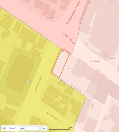
Figure 24 – Building Height Map
A secondary point encroachment of 100m (RL 26.70) is also sought to accommodate a small portion of the staircase.
A Clause 4.6 Variation Request was submitted with the application, seeking to vary the development standard and is discussed below.
![]()
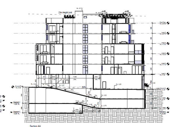
Figure 25 – Point encroachment to maximum building height as shown in red.
Clause 4.4 – Floor Space Ratio
The objectives of this clause are:
(a) To establish standards for the maximum development density and land use intensity,
(b) To ensure the density, bulk and scale of development integrates with the streetscape and character of the area in which the development is located,
(c) To minimise adviser environmental effects on the use or enjoyment of adjoining properties and the public domain,
(d) To facilitate design excellence by ensuring the extent of floor space in building envelopes leaves generous space for the articulation and modulation of design.
In accordance with clause 4.4(2), the maximum permitted floor space ratio for the subject site is 2.75:1 (Figure 26).
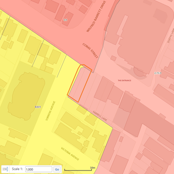
Figure 26 – Floor Space Ratio Map
In accordance with the accompanying Statement of Environmental Effects, the proposed development seeks a GFA of 1,565.6m² or FSR of 2.65:1. Council calculations demonstrate a proposed GFA of 1,312m² or resultant FSR of 2.2:1, which complies with the maximum permitted in accordance with this clause.
Clause 4.6 – Exceptions to development standards
The application is accompanied by a Clause 4.6 Variation Request, prepared by Think Planners, dated 7 June 2022, seeking to vary the maximum permitted building height in accordance with clause 4.3(2) of CCLEP 2022.
Clause 4.6 of the Standard Instrument LEP was revised in November 2023 and was accompanied by the release of a Guide to Varying Development Standards by the Department of Planning and Environment. In accordance with this Guide and under Section 6.2.2, the ‘consent authority must be satisfied the criteria identified in clause 5.6(3) is met. If the proposal does not satisfy the criteria, a written request under clause 4.6 is required’.
Accordingly, for purposes of the assessment of the subject application, reliance will be made upon clause 5.6 of CCLEP 2022 to consider the point encroachment and building height exceedance, discussed below.
Clause 5.6 – Architectural roof features
Clause 5.6 allows the consent authority to approve a development containing an architectural roof feature that exceeds or causes a building to exceed the building height under clause 4.3 without the need for a written request to vary the standard.
In accordance with clause 5.6(3), development consent must not be granted to any such development unless the consent authority is satisfied that –
(a) The architectural roof feature –
(i) Comprises a decorative element on the uppermost portion of the building, and
(ii) Is not an advertising structure, and
(iii) Does not include floor space area and is not reasonably capable of modification to include floor space area, and
(iv) Will cause minimal overshadowing, and
(b) Any building identification signage or equipment for servicing the building (such as plant, lift motor rooms, fire stairs and the like) contained in or supported by the roof feature is fully integrated into the design of the roof feature.
As shown in Figure 27, the non-compliance can be considered as a decorative element of the uppermost portion of the building only, limited to a small portion of the staircase and lift shaft.
The architectural feature is not an advertising structure and does not include floor space area or area which is reasonably capable of modification to include floor area, as all portions of the building height including all habitable rooms are located below the maximum building height. The lift core is fully recessed, causing minimal overshadowing, wholly contained within, and supported by the uppermost level.
The Panel can be satisfied that the considerations of clause 5.6(3) have been met in this instance and in accordance with the aforementioned Guide, a written request under lause 4.6 is not required to vary the height exceedance of the architectural roof feature.
Clause 5.21 – Flood Planning
The land is classified as partially affected by the 1 in 100 Year Flood as shown in Figure 28 and within Precinct 1: Probable Maximum Flood and Precinct 2: Flood Planning Areas as shown in Figure 29.
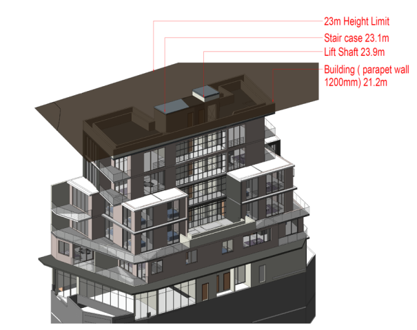 Figure 27
– Height Plane Study
Figure 27
– Height Plane Study
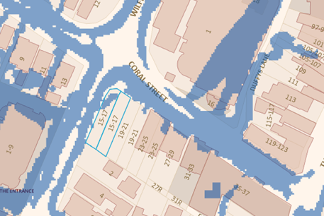
Figure 28 – 1 in 100 Year Flood
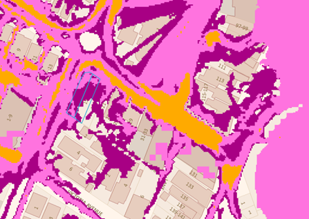
Figure 29: Flood Precincts
Development consent must not be granted to land identified by this clause, unless the Panel is satisfied that the development:
(a) Is compatible with the flood function and behaviour on the land, and
(b) Will not adversely affect flood behaviour in a way that results in detrimental increases in the potential flood affectation of other developments or properties, and
(c) Will not adversely affect the safe occupation and efficient evacuation of people or exceed the capacity of existing evacuation routes for the surrounding area in the event of a flood, and
(d) Incorporates appropriate measures to manage risk to life in the event of a flood, and
(e) Will not adversely affect the environment or cause avoidable erosion, siltation, destruction of riparian vegetation or a reduction in the stability of riverbanks or watercourses.
The application and supporting documentation considered the site’s flood affectation and was referred to Council’s Senior Development Assessment Engineer who has determined flood planning has been satisfactorily addressed in accordance with subclauses 5.21(1) and 5.21(3).
Clause 7.1 – Acid Sulfate Soils
Clause 7.1 requires consideration to be given to certain development on land being subject to actual or potential acid sulphate soils. The site is identified as Class 3 on the Acid Sulfate Soils (ASS) Planning Map which are likely to occur where there are works more than 1m below natural ground level and/or works by which the watertable is likely to be lowered more than 1m below the natural ground surface.
Significant eathworks will be required for the evcavation of the basement (up to 6.7-8.5m). The geotechnical report prepared by ground technologies identified that Acid Sulphate Soils are not present at the site and an Acid Sulphate Soil lManagement Plan is not required.
The applicant has undertaken soil sampling at the site. The soil sampling does not indicate the presence of oxidisable sulfur to levels below the basement excavation. However, in the unlikely event acid sulfate soils are found during works a condition is included to cease all excavation works if acid sulfate soils are identified until such time as details of mitigation and treatment measures are submitted to, and approved by, the Principal Certifier (refer to Condition 5.7).
The Panel can be satisfied that the proposed development complies with the provisions of clause 7.1 Acid Sulfate Soils.
Clause 7.9 – Essential Services
Development consent must not be granted to development unless the consent authority is satisfied that all the following services that are essential for the development are available or that adequate arrangements have been made to make them available when required—
a) the supply of water,
b) the supply of electricity,
c) the disposal and management of sewage,
d) stormwater drainage or on-site conservation,
e) suitable vehicular access
f) the collection and management of waste
The property is connected to electricity, reticulated water and sewer and has the capacity to be serviced for waste collection.
Water and sewer services are available to the land. Council’s Building in the Proximity of Water & Sewer Pipelines Procedure and water and sewer contributions are applicable to the proposal. A Section 307 certificate of compliance under the Water Management Act 2000 is required to be obtained prior to the occupation of the building. Satisfactory details have been provided in the Waste Management Plan for waste management procedures associated with the demolition, construction, and ongoing operation of the proposed development.
Satisfactory stormwater drainage can be obtained in accordance with the Stormwater Plans and there is adequate area for vehicle access and manoeuvring within the site to enter and exit the site in a forward direction.
The Panel can be satisfied that the proposed development complies with the provisions of clause 7.6 and that adequate essential servicing is available to the development having regard for water, sewer, electricity, stormwater drainage, waste collection and vehicular access.
Central Coast Development Control Plan
The following Chapters of CCDCP 2022 are relevant to this application:
· Chapter 1.2: Notification of Development Proposals
· Chapter 2.3: Residential Flat Buildings and Shop Top Housing
· Chapter 2.13: Transport and Parking
· Chapter 2.14: Site Waste Management
· Chapter 3.5 Tree and Vegetation Management
Chapter 1.2 – Notification of Development Proposals
The proposed development was notified and exhibited in accordance with the abovementioned Chapter from 23 September 2022 to 19 October 2022 inclusive. No submissions were received regarding the proposed development.
Chapter 2.3: Residential Flat Buildings and Shop Top Housing
Chapter 2.3 of CCDCP 2022 applies to the proposed residential apartments component of the development. However, there are several requirements under CCDCP 2022 that are relevant to the proposal but superseded by similar controls within the ADG.
These are:
· Communal open space (10m2 per dwelling with a minimum dimension of 5m)
· Private open space (a minimum area of 10m2 and a minimum dimension of 2m)
· Deep soil provision (12.5% site area), site coverage (soft landscaping 25%)
· Solar access (minimum of 3 hours midwinter between 9am and 3pm for 70% of dwellings)
· Building separation
· Storage (3m2 of floor area for 1- or 2-bedroom dwellings)
The following CCDCP 2022 requirements relevant to the proposal that are not provided within the ADG:
Part 2.3.3.1 - Building Height
The objectives of this Part are:
· To ensure that buildings are compatible with the existing and desired future character of the locality.
· To ensure that the height of buildings protects the amenity of neighbouring properties in terms of visual bulk, access to sunlight, privacy and views.
· To ensure that building height is not visually obtrusive, is compatible with the scenic qualities of hillside and ridgetop locations and respects the sites natural topography.
Part 2.3.3.1(a) requires compliance with the Height of Building Map for areas within the LGA where residential flat development can be built in accordance with the CCLEP 2022, permitting an overall building height of 23m.
As discussed above, the proposed development seeks consent for an overall building height of 23.9m, with a resultant 0.1m and 0.9m point encroachment of an architectural roof feature suitably justified under clause 5.6 of CCLEP 2022. No further consideration is required in this regard.
Part 2.3.3.2 – Density – Floor Space Ratio
The objectives of this Part are:
· To have development sites and densities that are appropriate in the zone and compatible with the local context.
· To ensure building bulk and scale provisions are compatible with neighbouring development.
Part 2.3.3.2(a) requires compliance with the Floor Space Ratio map and relevant considerations for areas within the LGA in accordance with CCLEP 2022, permitting a maximum FSR of 2.75:1.
As discussed above, the proposed development seeks consent for an overall FSR of 2.2:1, compliant with the provisions of Part 2.3.3.2 of CCDCP 2022. No further consideration is required in this regard.
Chapter 2.13 – Transport and Parking
The proposed development includes off street parking for 15 cars, comprising 12 residential spaces, 1 visitor parking space (including a shared car wash bay) and 2 retail spaces. Vehicular access to the basement level parking facilities is to be provided via a new entry/exit driveway located from Farrell Lane (see Figures 30-32 for existing condition). A single width basement ramp is proposed with a traffic control system including control signals and convex mirrors to improve circulation within the basement.
Accordingly, the application is accompanied by a Traffic and Parking Assessment Report, prepared by Varga Traffic Planning Pty Ltd and dated 3 May 2022, Ref 20660. The report assesses the traffic and parking implications of the proposed development in terms of road network capacity and the adequacy and suitability of the quantum of off-street parking and loading provided on the site.
Traffic Assessment
Application of the NSW Guide to Traffic Generating Development to the proposed development yields a traffic generation potential of approximately nine (9) vehicle trips per hour during commuter peak periods as set out below:
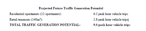
The projected increase in traffic activity because of the proposed development is considered minimal and generally consistent with the planning controls, not resulting in any unacceptable traffic implications in terms of road network capacity. The Panel can be satisfied that no mitigating actions are required in this regard.
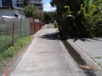
Figure 30: Farrell Lane looking west
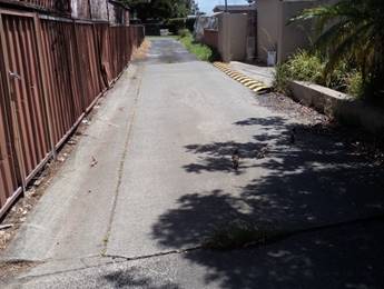
Figure 31: Farrell Lane looking west
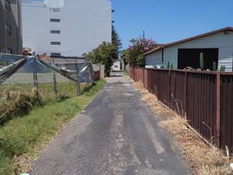
Figure 32: Farrell Lane looking east
Parking Assessment
Chapter 2.13 of CCDCP 2022 requires car parking for the development to be provided at the following rates:
|
Land Use |
Requirements |
|
|
Shop Top Housing |
Up to 3 bedrooms |
1 space per dwelling |
|
4 bedrooms or more |
2 spaces per dwelling |
|
|
Visitor |
|
Nil |
|
Retail (Shops) |
|
1 space per 30m2 GFA |
Based on the above, 17 parking spaces are required:
· Shop Top Housing: 12 x units up to 3 bedrooms = 12 spaces
· Retail: 139.6m2 /30m2 = 4.65 spaces (5 spaces, rounded up)
· Total required: 17 spaces
The application provides 15 spaces in the following mix:
· Shop Top Housing: 12 spaces
· Retail: 2 spaces
· Visitor: 1 space
The proposed development fails to meet the minimum numerical requirements in accordance with this Part by two (2) parking spaces or 12%. The assessment report considers the shortfall acceptable based on the following:
· The site is located within easy walking distance of a variety of bus services into and out of the local area which can also be used to interchange with interconnecting train services at several railway stations such as Gosford, Wyong and Tuggerah Railway Stations.
· The site is also located within The Entrance Town Centre and in close proximity to shops and services.
· The proposed retail component is intended to cater for the local residential and business community who are located within walking distance of the site.
· The accessibility of the site by public transport and its proximity to shops and services will facilitate reduced car usage rates by residents and employees of the retail component of the development proposal.
· As noted in the foregoing Council’s WDCP 2013 permits a residential parking rate of 1 space per dwelling if development is in a major or a town centre subject to submission of a Transport Management Plan and approved by Council.
· Contributions can be considered for the existing multi-storey car park located opposite the site, on the eastern corner of the Coral Street and Wilfred Barrett Drive intersection which has an additional capacity of 470 spaces as per Council’s advice.
Based on the above and given the location of the site and its proximity to The Entrance local centre, the availability of, and accessibility to public transport and the established pedestrian pathways within the centre, the 12% or two (2) spaces variation is considered acceptable in this instance.
Part 2.13.3.5 Servicing, Deliveries & Waste Collection
Loading and servicing for the proposed development is expected to be undertaken at the ground floor level at the rear of the site, and vehicles will be required to reverse off the laneway, due to site constraints. This arrangement is deemed acceptable in a rear service lane environment, particularly given low traffic volumes. Once loaded/unloaded, the service vehicle will exit the site in a forward direction.
The accompanying turning path analysis provided by the applicant of a small rigid vehicle (SRV) in accordance with AS2890.2 demonstrates that servicing from the laneway is achievable. The development will be limited to SRVs for servicing requirements in this regard.
Part 2.13.3.8.1 Bicycle Parking Rates
The following bicycle parking rates are specified under Part 2.13.3.8.1:
· Shop Top Housing: 1 space per 3 dwellings = 4 spaces
· Retail: 1 space per 150sqm GFA = 1 space
· Total required: 5 spaces
The proposed development provides a total of six (6) spaces within the proposed ground floor parking level, compliant with the provisions of this Part.
Part 2.13.3.9 Motorcycles and Motor Scooters
The proposed development incorporates one motorcycle parking space on Basement Level 2 in accordance with this Part.
Right of Carriageway
The site is burdened by a 3.6m wide ROW along the rear of the site which is shared with adjoining properties also fronting Coral Street. Informal two-way vehicular access is currently provided along the ROW between Torrens Avenue and Farrell Lane.
The subject development will necessitate road upgrade works with a full road and drainage design and road reconstruction for the full width and frontage of the development in the laneway. The laneway shall be one-way crossfall (3-4%) to the southern boundary and pavement shall be reinforced concrete 2.8m in width. Foot paving will also be required for the full frontage of the development in Torrens Avenue and Coral Street.
Chapter 2.14 – Site Waste Management
The application is accompanied by a Waste Management Plan, dated December 2023, which discusses both demolition, site preparation, construction, and ongoing waste management for the proposed development.
The Panel can be satisfied that the proposed development is acceptable with regards to this chapter of CCDCP 2022 and associated Waste Control Guidelines. Appropriate conditions have been recommended.
Chapter 3.5: Tree and Vegetation Management
The application was accompanied by an Arborist Report, prepared by Redgum Horticultural dated 3 July 2021. The application and accompanying documentation were referred to Council’s Tree Assessment Officer who undertook a site inspection on 21 September 2022 and carried out an assessment of the proposal.
There are 13 Cocos Palms located forward of the property on the road reserve, which are proposed to be removed and replaced with new plantings as per the accompanying Landscape Plan. The trees cannot be retained due to the proposed building envelopes and infrastructure, such as basement level excavation where encroachment will have an adverse impact on its roots and crown for viability and stability.
Subject to conditions, the proposed development is acceptable with regards to the requirements of this Chapter and suitable replacement landscaping appropriate to its commercial context.
Section 4.15(1)(a)(iiia) – Planning Agreements under Section 7.4 of the EP&A Act
There are no planning agreements or draft planning agreements entered or proposed for the site. No further consideration is required in this regard.
Section 4.15(1)(a)(iv) – Provisions of Regulations
The Environmental Planning and Assessment Regulation 2021 applies to all development applications regarding such items as application type, compulsory contributions, notification of development applications and a range of many other details regarding development application requirements. Regarding this application, there is no specific clause that warrants further discussion.
Section 4.15(1)(b) – Likely impacts of development
Built Form, Character, Locality and Context
The proposal will positively contribute to the character and amenity of the locality and streetscape. The scale, form, character, and density of the development is considered acceptable within the locality given the E1 zoning of the site.
The proposal involves the development of two vacant lots at the end of an existing business and residential street within The Entrance town centre. The design and appearance of the development is of a high quality and satisfactory architectural appearance envisaged by the future character of the streetscape. The proposal provides a well activated ground floor with commercial/retail premises and separate residential entry that continues the existing business typology along Coral Street.
The built form is well articulated and composed and has considered its relationship to surrounding properties in addition to the site’s visual prominence.
External works and road infrastructure
The site is currently vacant with a redundant vehicular crossing fronting Coral Street and upright kerb and channel, service, pedestrian footpath, and vegetation.
The proposed development has been designed with vehicle access via an existing Right of Way connecting Torrens Avenue and Farrell Lane. Dedication to Council of the part of the land that is subject to the existing ROW will be required as part of this application. It is noted that other properties further east where also required to achieve a laneway connection between Torrens Avenue and Farrell Lane (known as Carousel Lane).
The development will therefore necessitate the completion of road infrastructure in accordance with the relevant provisions of Council’s Civil Works Specification Design Guidelines 2019. Conditions have been recommended requiring the provision of a new driveway crossing and layback (Torrens Avenue) and paving similar to the existing infrastructure along Coral Street and removal of the existing redundant driveway crossing and layback (Coral Steet).
Potential conflict with overhead power and streetlights is addressed via conditions of consent.
Traffic and Transport
The application is accompanied by a Traffic and Parking Assessment Report, prepared by Varga Traffic Planning Pty Ltd and dated 3 May 2022. The report concludes that the projected increase in traffic activity because of the proposal is minimal and will not have unacceptable traffic implications in terms of road network capacity.
The site fronts both Coral Street, Farrell Lane and Torrens Avenue, which are local roads. The site is located within The Entrance local centre and is frequently serviced via the local bus network. The site is located within close proximity to the existing shared path bicycle network.
Drainage
The site falls to Coral Street and the proposal includes revised concept stormwater drainage plans, which seek to direct stormwater to Torrens Avenue. The basement and subsoil levels are to be piped via a pump-out system.
No on-site detention is required for this proposal due to the proximity of the receiving downstream drainage system – The Entrance Channel. No rainwater tank storage is required as per the revised BASIX water commitments.
Water and Sewer
The proposed development is located within the Zone of Influence (ZOI) of the sewer main within the lane. Therefore, the development will need to comply with Council’s “Policy for Building Over or Adjacent to Sewer Mains”.
The proposed basement is below the Zone of Influence (ZOI) of the water main servicing the area. The development will require a Section 307 Certificate under the Water Management Act 2000.
Privacy, overlooking and boundary treatments
There is the potential for overlooking to adjoining residential dwellings to the south of the site and privacy impacts from the future intended occupants of the site. These properties however have an R3 – High Density Residential development zoning and are highly likely to be redeveloped in the future. The best and highest use of this land would be a multi dwelling development or residential flat building.
Notwithstanding this, potential overlooking has been minimised in the design through the placement of windows and orientation of dwellings and layouts. Appropriate screening will also be provided to windows to further increase privacy.
Air quality
A condition is imposed in relation to dust control during earthworks, excavation and construction requiring adoption of appropriate measures to minimise emissions into the surrounding environment. Subject to the recommended condition, there is minimal potential for any air pollution, odour, fumes, or other air quality impacts associated with the development on the site.
Noise and vibration
A condition has been recommended in relation to noise and vibration. The condition relates to standard operating hours for the construction of the development. It is not anticipated that the development will cause ongoing excessive or unreasonable noise or vibration.
Natural Environment
There will be no significant impact upon the natural environment resulting from the proposal.
Economic and Social Impacts
Social Impacts
Principles of Crime Prevention Through Environmental Design (CPTED) have been considered under the design of the proposed new development. The application is accompanied by a CPTED assessment within the Statement of Environmental Effects which has identified a number of design considerations to discourage anti-social behaviour and minimise opportunity for criminal activity. Satisfactory consideration has been given to the four CPTED principles.
A condition is imposed to ensure the development is consistent with CPTED proposals as outlined in the accompanying Statement of Environmental Effects.
Economic Impacts
The proposed development will contribute to the supply of housing needs in the locality and is satisfactory from an economic perspective.
THE SUITABILITY OF THE SITE FOR THE DEVELOPMENT
The site is situated within The Entrance town centre and this location is well serviced with a high level of amenity. The site is accessible to public transport and facilities and the proposed development provides benefits to the ongoing viability of The Entrance town centre by encouraging people to live within the centre and by providing active commercial frontage.
The site is located within an area that is undergoing a transition and includes some low scale existing development and vacant sites. The building form is considered consistent with the planned future character of the area. The architectural design and treatment of the building will present well on all facades.
The design of the proposed development is in an appropriate form, layout and scale that suitably balance the opportunities and constraints of the site. There are no significant site constraints or hazards that would render the location of the development as unsuitable. The building form will present well within streetscape and will not adversely impact on the character and amenity of the locality.
Submissions
The application was notified and exhibited in accordance with Chapter 1.2 of CCDCP 2022. No submissions were received.
Submissions from Public Authorities
Other than comments from Ausgrid, which are discussed below, no other submissions from public authorities were received.
Internal Consultation
|
Tree Assessment Officer |
Supported, subject to conditions. |
|
Contributions Officer |
Supported, subject to conditions. |
|
Development Assessment Engineer |
Supported, subject to conditions. |
|
Environmental Health Officer |
Supported, subject to conditions. |
|
Traffic Engineer |
Supported, subject to conditions. |
|
Urban Designer |
Supported. |
|
Waste Officer |
Supported subject to conditions. |
Waste
Waste collection services are intended to be undertaken from the kerbside in Torrens Avenue using the existing line-marked shoulder located immediately adjacent to the site, usually in the early hours of a weekday. This is commonplace within an urban environment and satisfactorily accommodated without causing any obstruction to traffic.
The proposed waste collection arrangements are illustrated on the attached swept turning path and demonstrates the following:
- a 12.5m long waste collection truck can stand within the line-marked road shoulder located adjacent to the site
- another truck can pass the waste collection vehicle stopped in the line-marked road
shoulder without difficulty
- the line-marking defining the road shoulder could be modified, if required by Council,
to introduce a curved approach generally following the swept paths of the truck exiting
the roundabout to further increase the space available for the truck standing in the line marked road shoulder
- alternatively, if required by Council, a kerb blister extension could also be provided on
the exit from the roundabout as indicated by the exiting truck paths to improve the
definition of the line-marked road shoulder,
- waste collection will typically occur in the early hours of the morning, when traffic
activity tends to be minimal
- the stationary waste collection truck will be clearly visible to other vehicles exiting the
roundabout, and will typically be further highlighted by flashing lights as is used by frequently stopping vehicles.
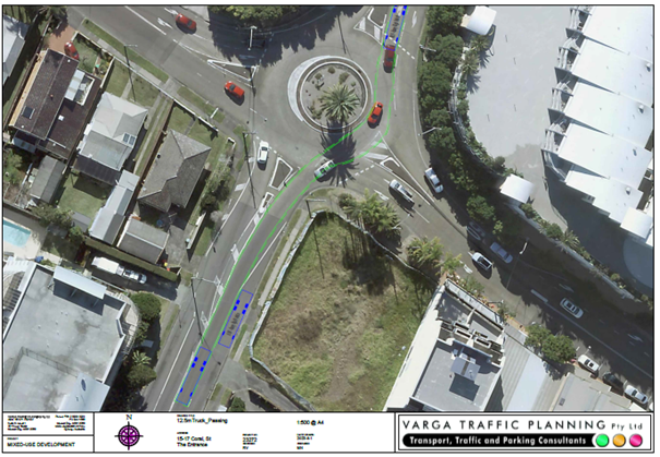
Figure 33: 12.5m truck parking (waste collection)
The application was referred to Council’s Waste Officer who advised that the Waste Management Plan was to be amended to reflect the current proposal.
In response, the applicant advised that a revised Waste Management Plan has been submitted with minor adjustments to the proposed excavation totals in the construction section of the WMP to more accurately reflect the final levels of the development.
Council’s Waste Officer also noted that the proposed residential and commercial waste storage areas do not adequately satisfy Council requirements however further information has been received from the applicant advising of the following:
· Under Appendix 2 - Waste/Recycling Generation Rates of the Central Coast Council Waste Control Guidelines Version 01, multi-unit dwellings are required to cater for 120L / unit / week for waste generation, & a further 120L / unit / week for recyclable material generation. As a result of Council’s latest feedback, we have now amended the Waste Management Plan, as attached dated December 2023, to reflect the required 120L / unit / week rate for both waste & recycling.
Council comment
The Panel can be satisfied that the proposed development adequately satisfies Appendix 2 of Council’s Waste Control Guidelines.
Council’s Waste Officer also requested the provision for future food and garden organics (FOGO) collection; however, further information has been received from the applicant advising of the following:
· We have reviewed Council documentation including the CCDCP 2022 in addition to the Central Coast Council Waste Control Guidelines Version 01 (June 2022) and in all cases found no requirements that future FOGO collection needs to be accommodated. Similarly, our neighbouring approved development for 19-21 Coral Street also has no provision for future FOGO collection, as again no requirement for this exists in the controls either of the developments is assessed against.
Council comment
The Panel can be satisfied that the proposed method for waste collection is satisfactory with regards to the existing and approved arrangements for developments addressing Farrell Lane, the adjoining approved development and future intended development for its surrounds and in accordance with current and existing controls.
External Consultation
|
Ausgrid |
Supported, subject to conditions. |
Ausgrid
Ausgrid consents to the proposed development, subject to the imposition of the following conditions which are listed in the draft conditions of consent (Attachment 1):
Method of Electricity Connection
The method of connection will be in line with Ausgrid’s Electrical Standard ES(1) – Premise Connection Requirements.
Supply of Electricity
The nominated electrical consultant/contractor is to provide a preliminary enquiry to Ausgrid to obtain advice for the connection of the proposed development to the adjacent electricity network infrastructure. An assessment will be carried out based on the enquiry which may include whether or not:
- the existing network can support the electrical load of the development;
- a substation may be required on-site, either a pad mount kiosk or chamber style; and
- site conditions or other issues that may impact on the method of supply.
Reference is made to Ausgrid’s website www.ausgrid.com.au about how to connect to Ausgrid’s network.
Conduit Installation
The need for additional electricity conduits in the footway adjacent to the development will be assessed and documented in Ausgrid’s Design Information, used to prepare the connection project design.
Streetlighting
The developer is to consider the impact that existing streetlighting and any future replacement streetlighting and maintenance may have on the development. Should the developer determine that any existing streetlighting may impact the development, the developer should either review the development design, particular placement of windows, or discuss with Ausgrid the options for relocating the streetlighting. The relocation of streetlighting will generally be at the developers cost. In many cases, it is not possible to relocate streetlighting due to its strategic positioning.
Proximity to existing network assets
Underground cables
There are existing underground electricity network assets in existing conduit and cable in Coral Street adjacent the development. Special care should also be taken to ensure that driveways and any other construction activities within the footpath area do not interfere with the existing cables in the footpath. Ausgrid cannot guarantee the depth of cables due to possible changes in ground levels from previous activities after the cables were installed.
The developer shall locate and record the depth of all known underground services
prior to any excavation in the area.
Safework Australia – Excavation Code of Practice, and Ausgrid’s Network Standard NS156 outlines the minimum requirements for working around Ausgrid’s underground cables.
Ecologically Sustainable Principles
The proposal has been assessed having regard to ecologically sustainable development principles and is consistent with the principles. The proposed development is considered to incorporate satisfactory stormwater, drainage and erosion control and the retention of vegetation where possible and is unlikely to have any significant adverse impacts on the environment and will not decrease environmental quality for future generations. The proposal does not result in the disturbance of any endangered flora or fauna habitats and is unlikely to significantly affect fluvial environments.
Climate Change
The potential impacts of climate change on the proposed development have been considered by Council as part of the assessment of the application. This assessment has included consideration of such matters as potential rise in sea level; potential for more intense and/or frequent extreme weather conditions including storm events, bushfires, drought, flood and coastal erosion; as well as how the proposed development may cope, combat, withstand these potential impacts. The proposed development is considered satisfactory in relation to climate change.
The Public Interest
Section 4.15 (1)(e) of the Environmental Planning and Assessment Act 1979 requires consideration as to whether to proposal is in the public interest.
The proposal will not have any adverse impact on the natural environment and will not unreasonably impact the amenity of neighbouring properties. The approval of the application is in the public interest.
OTHER MATTERS FOR CONSIDERATION
Section 7.11 Contributions
The total contribution payable to Council under this condition is $163,433.20, as calculated at the date of this consent, in accordance with The Entrance District Section 7.11 Plan as is imposed as a recommended condition.
Water and Sewer Contributions
Water and sewer services are available to the land. Building adjacent to sewer conditions apply and developer charges are applicable. A Section 307 Certificate of Compliance is required.
Construction Traffic and Pedestrian Management Plan (CTMP)
A Construction Traffic and Pedestrian Management Plan (CTMP) will be prepared and submitted to the certifying authority which will detail proposed construction works, the traffic impacts on the local area and how these impacts will be addressed. Council is not required to approve these plans, and this is imposed as a condition.
Political Donations
During assessment of the application there were no political donations were declared by the applicant, applicant’s consultant, or owner.
Conclusion
This development application has been considered in accordance with the requirements of the Environmental Planning and Assessment Act 1979 and the Regulations, as outlined in this report. The following is a summary of prerequisite conditions for the granting of development consent that have been considered in the assessment report and provided as part of the conclusion, for the benefit of the Panel:
· Having regard for Sections 2.10, 2.11 and 2.12 of State Environmental Planning Policy (Resilience & Hazards) 2021, the Panel can be satisfied that the proposed development is designed, sited, and will be managed to avoid an adverse impact referred to in s.2.10(1) and s.2.11(1), and the development is not likely to cause increased risk of hazards on the subject site or other land.
· The Panel can be satisfied that the land is suitable for the proposed development and does not include land referenced in Section 4.6(4) of the State Environmental Planning Policy (Resilience and Hazards) 2021 nor does it involve a change of use of the land. Accordingly, the development is satisfactory having regard for the provisions of Section 4.6 of the same SEPP.
· The Panel can be satisfied that the provisions of the State Environmental Planning Policy (Building Sustainability Index: BASIX) 2004 have been met having regard to the thermal, energy and water commitments, subject to conditions.
· The Panel can be satisfied that the provisions of the State Environmental Planning Policy No. 65 – Design Quality of Residential Apartment Development and associated design principles of the ADG have been met.
· The Panel can be satisfied that the proposed development is satisfactory with regards to the permitted uses and objectives of the E1 Zone of the Central Coast Local Environmental Plan 2022.
· The proposal is considered satisfactory with regards to the relevant Chapters of the Central Coast Development Control Plan 2022.
· There are no significant issues or impacts identified with the proposal under Section 4.15 of the Environmental Planning and Assessment Act 1979.
· Having regard for the prerequisite conditions to the granting of consent under the Central Coast Local Environmental Plan 2022, the Panel can be satisfied that:
o Clause 5.21 – Flood Planning
The proposed development:
a) Is compatible with the flood function and behaviour on the land, and
b) Will not adversely affect flood behaviour in a way that results in detrimental increases in the potential flood affectation of other development or properties, and
c) Will not adversely affect the safe occupation and efficient evacuation of people or exceed the capacity of existing evacuation routes for the surrounding area in the event of a flood, and
d) Incorporates appropriate measures to manage risk to life in the event of a flood, and
e) Will not adversely affect the environment or cause avoidable erosion, siltation, destruction of riparian vegetation or a reduction in the stability of riverbanks or watercourses.
o Clause 7.6 – Essential services
All services essential for the proposed development remain available to the subject site.
· Subject to the imposition of appropriate conditions, the proposed development is not expected to have any adverse environmental, social, or economic impact.
RECOMMENDATION
That DA/1809/2022 for the construction of a six (6) storey shop top housing development and basement level car parking at No 15-17 Coral Street, The Entrance, NSW, be APPROVED pursuant to Section 4.16(1)(a) of the Environmental Planning and Assessment Act 1979 subject to the draft conditions attached to this report at Attachment 1.
|
1⇩ |
Draft conditions - 15-17 Coral Street, THE ENTRANCE NSW 2261 - DA/1809/2022 - Central Coast Council |
|
D16062040 |
|
2⇩ |
PUBLIC - Redacted Revised Architectural Plans - Issue D - 15-17 Coral Street, THE ENTRANCE - PAN-233783 - DA/1809/2022 |
|
D16098708 |
|
3⇩ |
SEPP 65 Design Quality Report - Rev B - 15-17 Coral Street, The Entrance |
|
D16094408 |
|
4⇩ |
Stormwater Plans - 15-17 Coral Street, The Entrance |
|
D16094409 |
|
5⇩ |
Revised BASIX Certificate - 15-17 Coral Street, The Entrance |
|
D16094412 |
|
6⇩ |
Revised Landscape Plans - Revision B - 15-17 Coral Street, The Entrance |
|
D16094414 |
|
7⇩ |
Revised Waste Management Plan - December 2023 - 15-17 Coral Street, The Entrance |
|
D16094416 |
|
8⇩ |
Schedule of Finishes - 15-17 Coral Street, The Entrance |
|
D16094417 |
|
4.2 |
DA/1809/2022 - 15-17 Coral Street, The Entrance - Construction of a 6 Storey Shop Top Housing development with Basement Level carparking |
|
Attachment 1 |
Draft conditions - 15-17 Coral Street, THE ENTRANCE NSW 2261 - DA/1809/2022 - Central Coast Council |
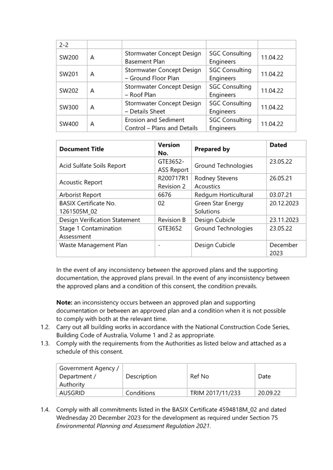
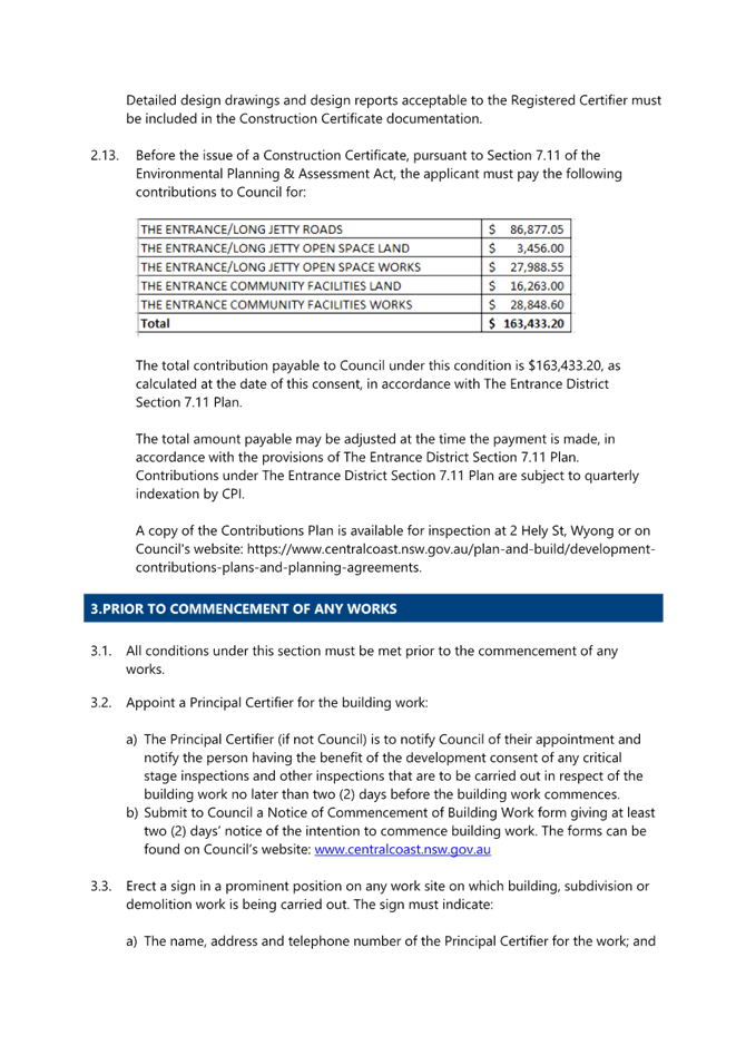


|
DA/1809/2022 - 15-17 Coral Street, The Entrance - Construction of a 6 Storey Shop Top Housing development with Basement Level carparking |
|
|
Attachment 2 |
PUBLIC - Redacted Revised Architectural Plans - Issue D - 15-17 Coral Street, THE ENTRANCE - PAN-233783 - DA/1809/2022 |

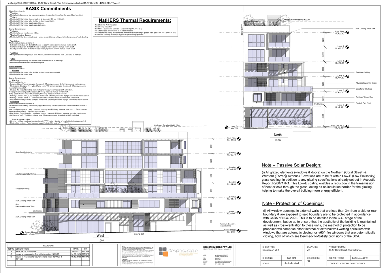

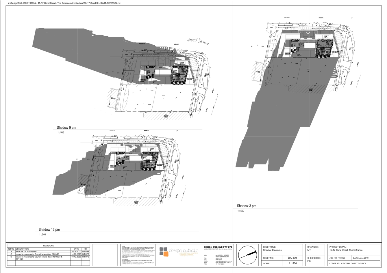

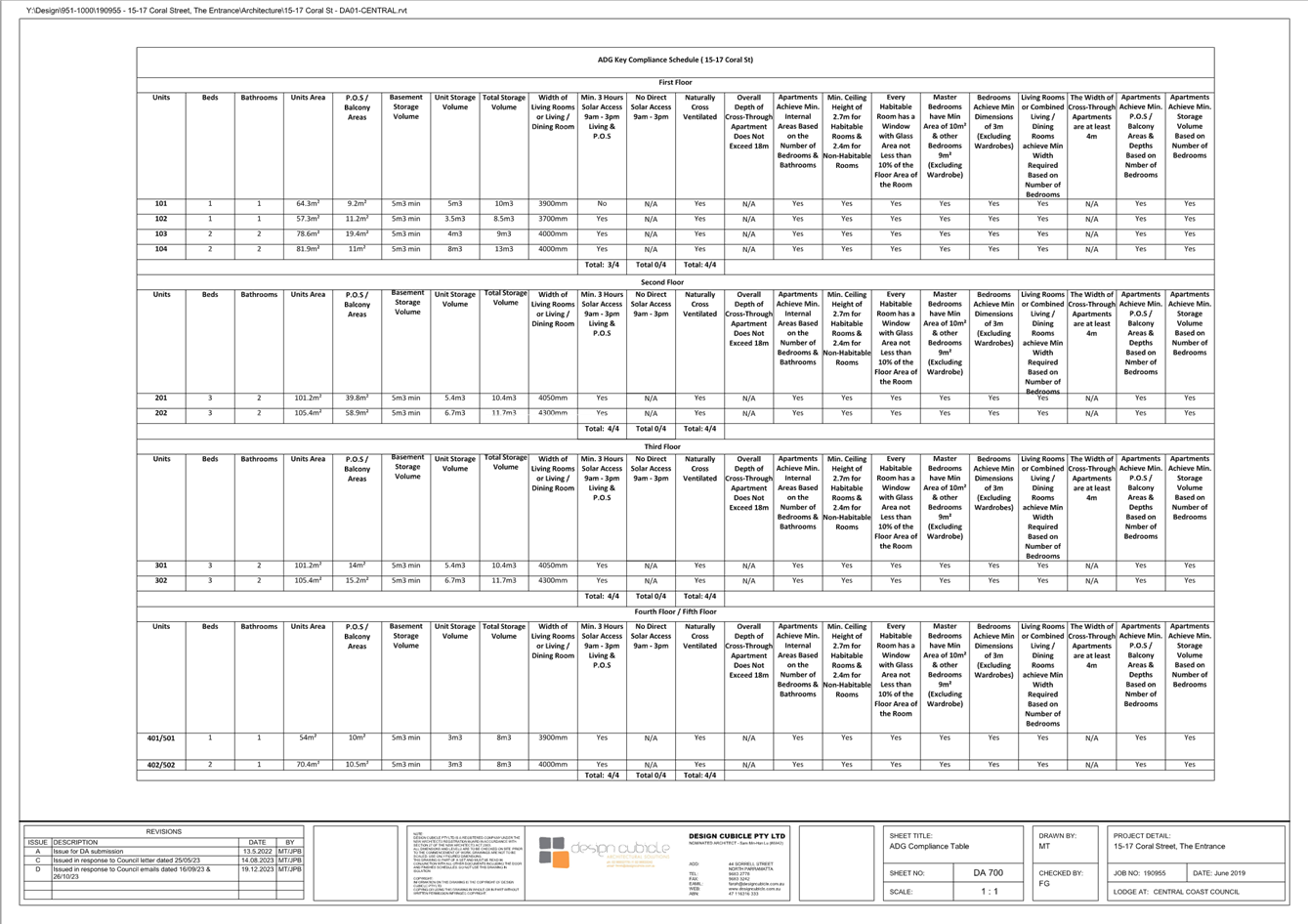
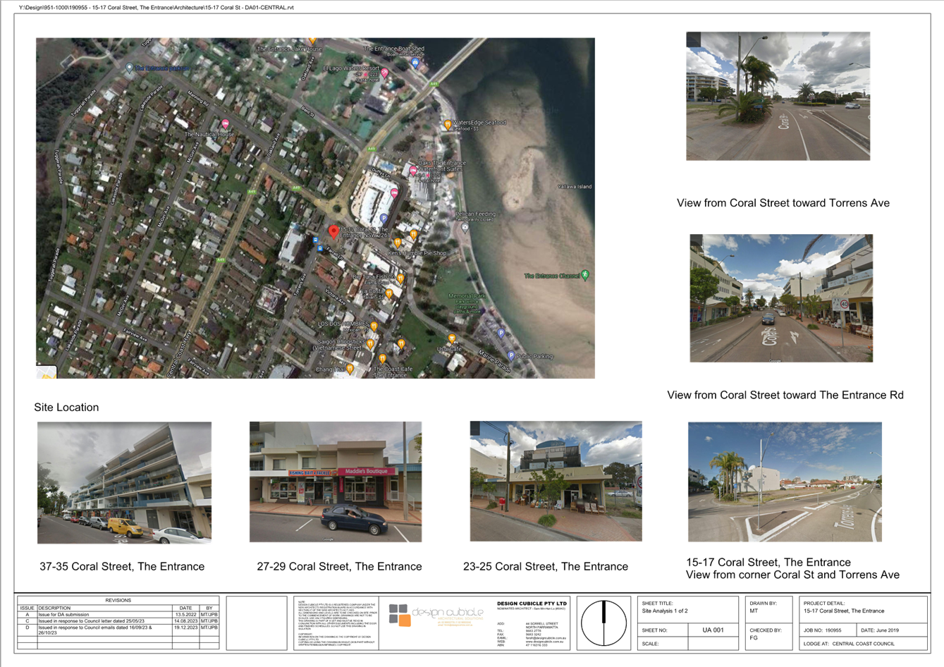
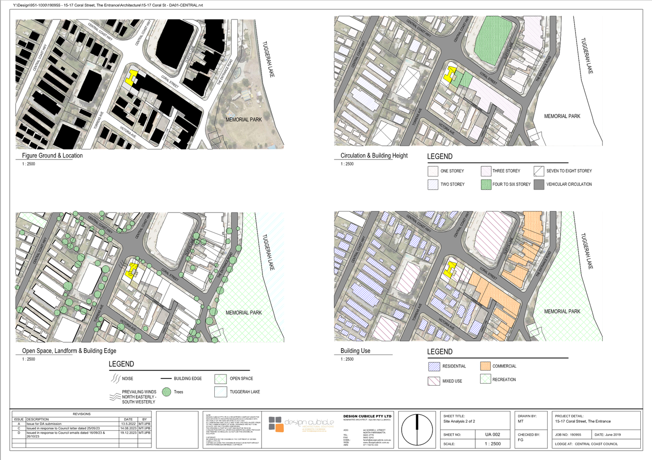
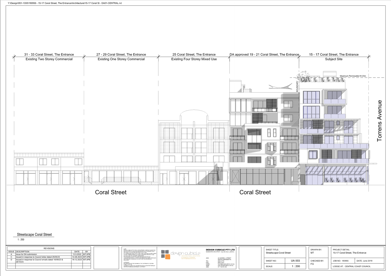

|
DA/1809/2022 - 15-17 Coral Street, The Entrance - Construction of a 6 Storey Shop Top Housing development with Basement Level carparking |
|
|
Attachment 3 |
SEPP 65 Design Quality Report - Rev B - 15-17 Coral Street, The Entrance |

|
DA/1809/2022 - 15-17 Coral Street, The Entrance - Construction of a 6 Storey Shop Top Housing development with Basement Level carparking |
|
|
Attachment 4 |
Stormwater Plans - 15-17 Coral Street, The Entrance |
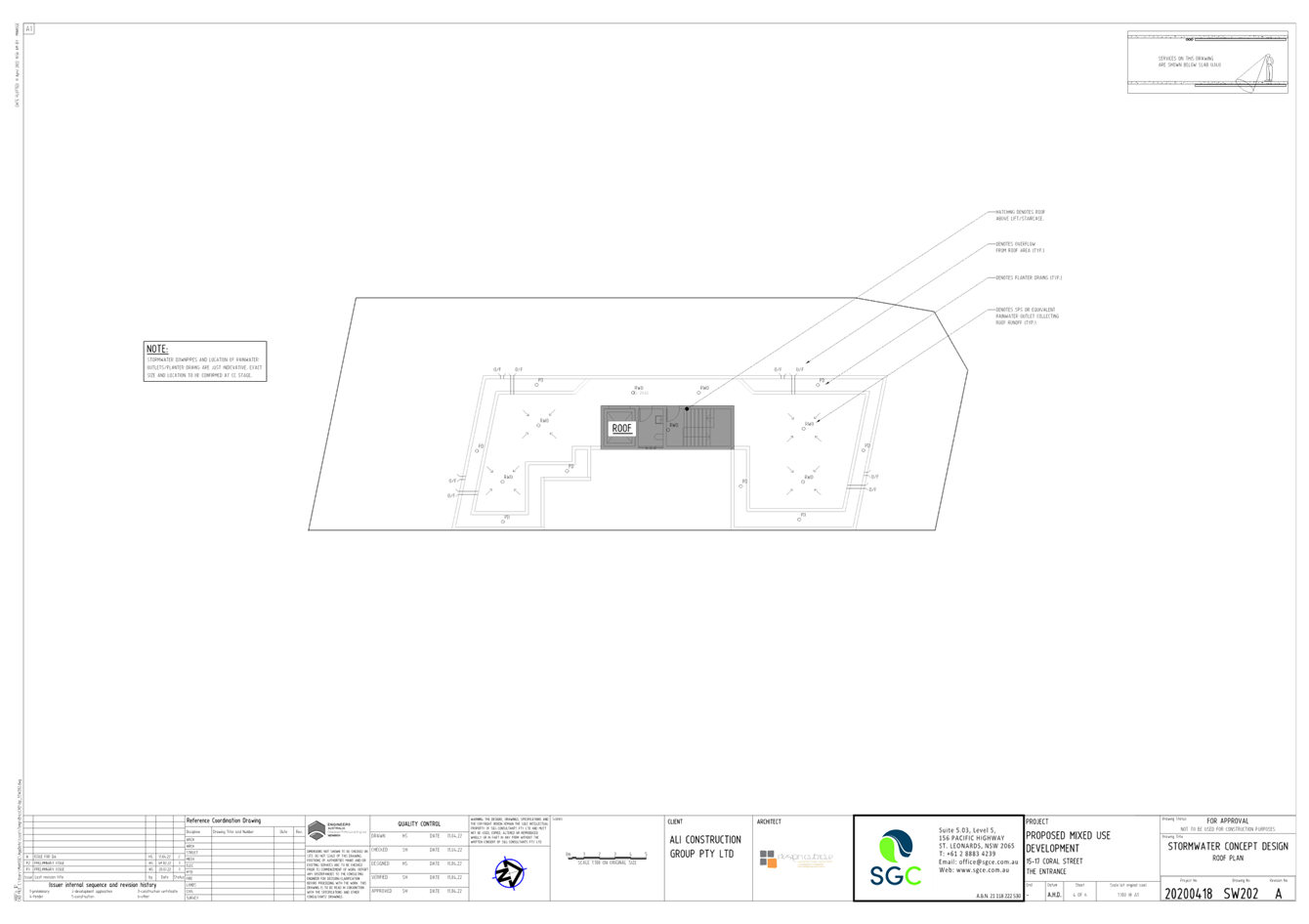
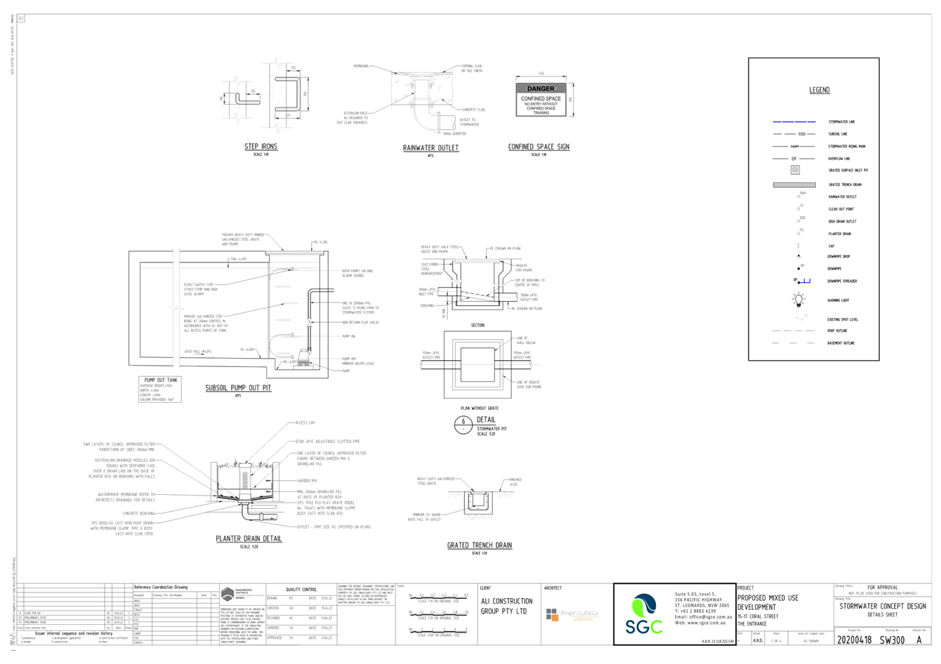
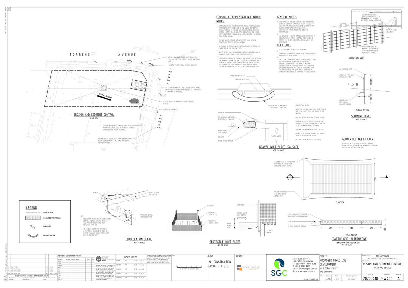
|
DA/1809/2022 - 15-17 Coral Street, The Entrance - Construction of a 6 Storey Shop Top Housing development with Basement Level carparking |
|
|
Attachment 5 |
Revised BASIX Certificate - 15-17 Coral Street, The Entrance |
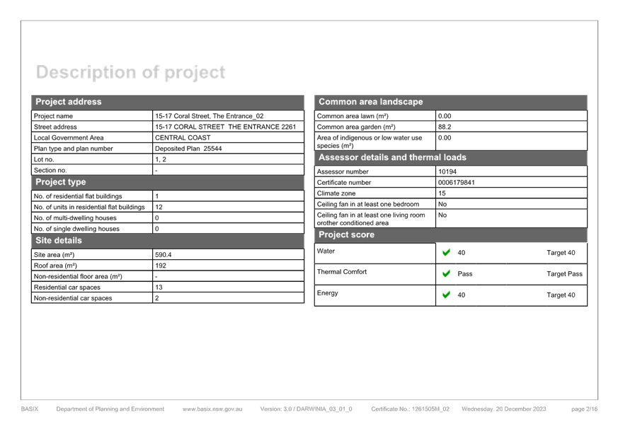

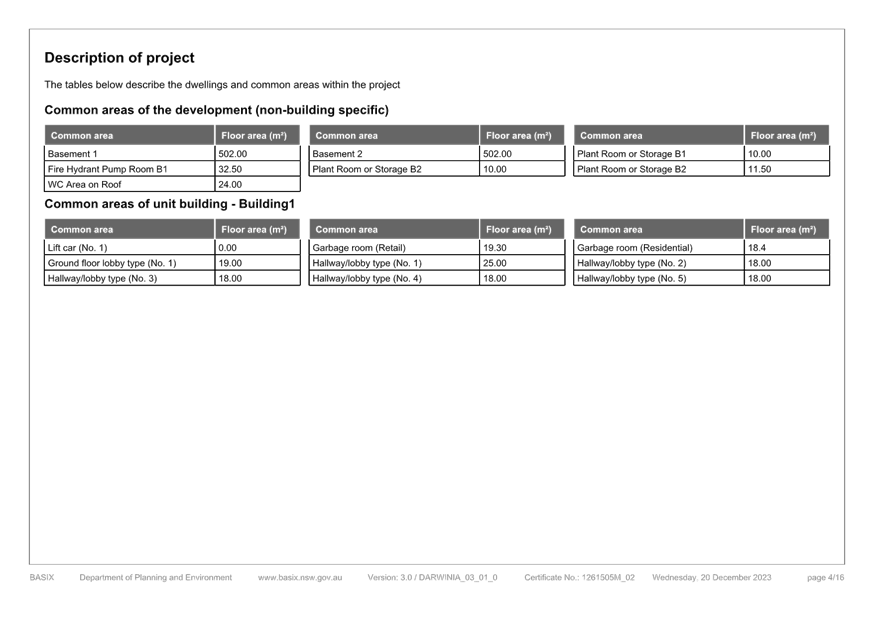

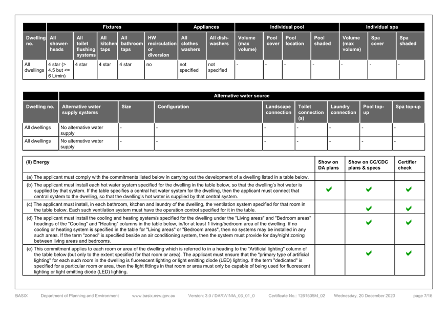
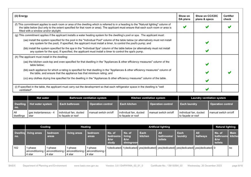
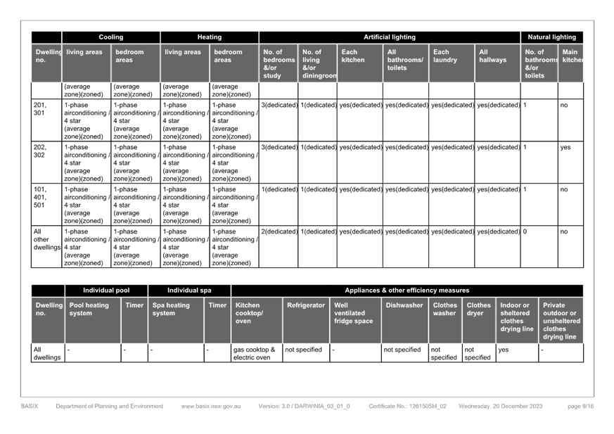
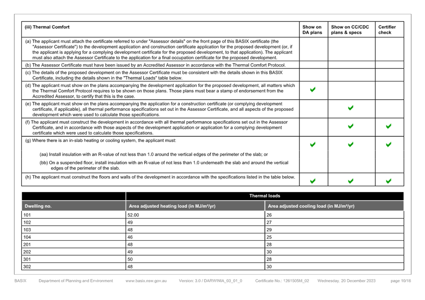
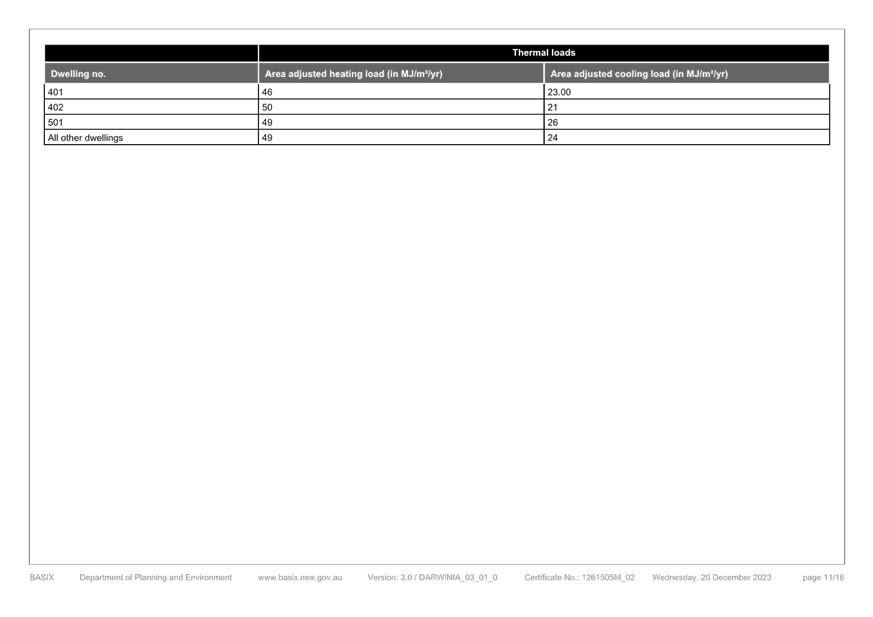
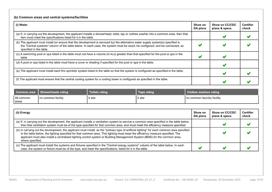
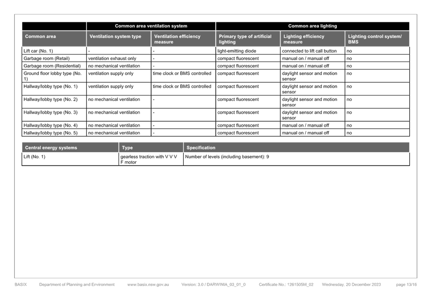
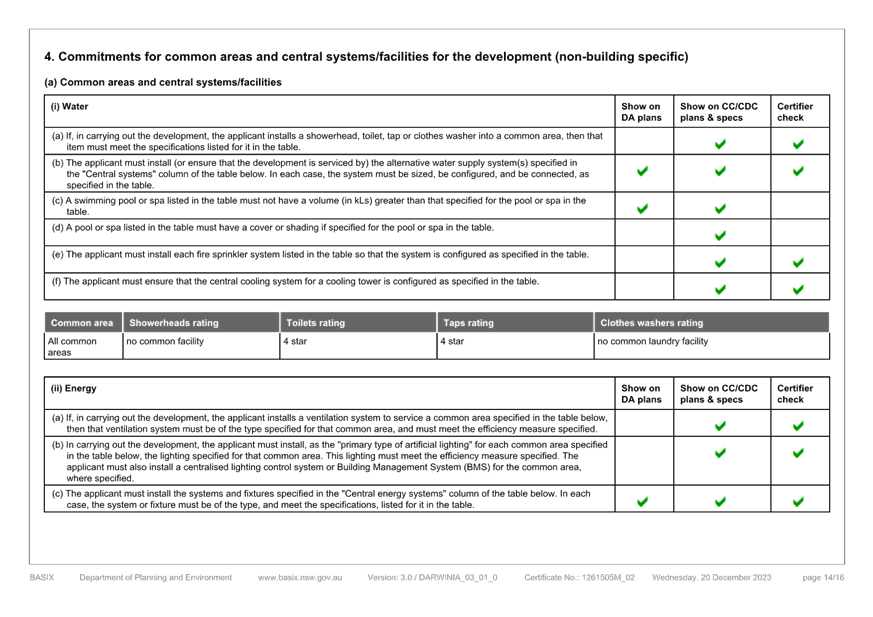
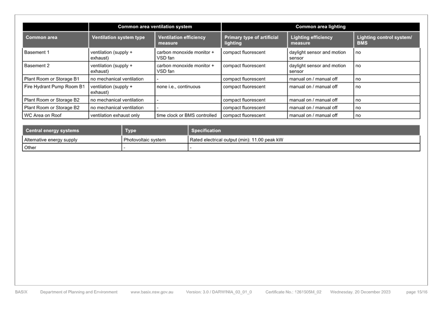
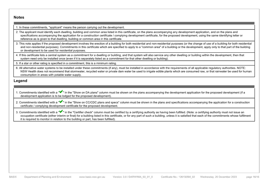
|
DA/1809/2022 - 15-17 Coral Street, The Entrance - Construction of a 6 Storey Shop Top Housing development with Basement Level carparking |
|
|
Attachment 6 |
Revised Landscape Plans - Revision B - 15-17 Coral Street, The Entrance |
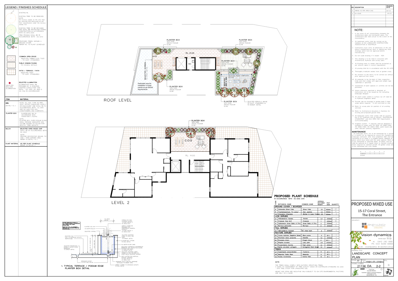
|
DA/1809/2022 - 15-17 Coral Street, The Entrance - Construction of a 6 Storey Shop Top Housing development with Basement Level carparking |
|
|
Attachment 7 |
Revised Waste Management Plan - December 2023 - 15-17 Coral Street, The Entrance |