|
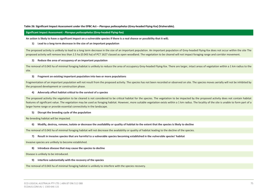
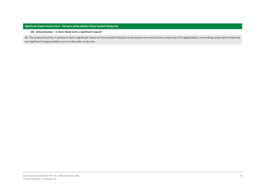
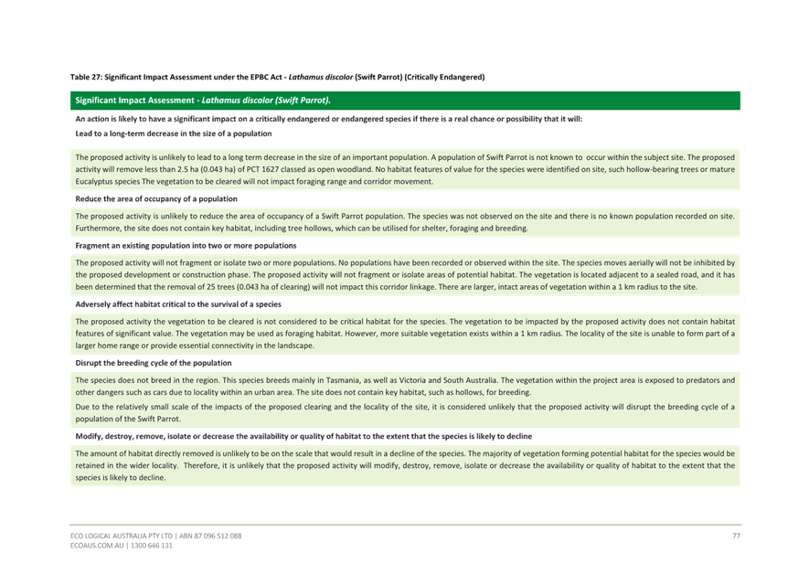
Central Coast
Local Planning Panel Meeting
Business Paper
05 September 2024
 |
|
Central Coast
Local Planning Panel Meeting
Business Paper
05 September 2024
|
The Local Planning Panel Meeting
of Central Coast
will be held remotely - online,
Thursday 5 September 2024 at 2.00 pm,
for the transaction of the business listed below:
1 Procedural Items
1.1 Disclosures of Interest.............................................................................................................................. 3
2 Confirmation of Minutes of Previous Meetings
2.1 Confirmation of Minutes of Previous Meeting................................................................................. 4
3 Planning Reports
3.1 DA3623/2022 - 37 Wards Hill Rd Killcare Heights - Telecommunications Facility............. 15
The Hon Terence Sheahan AO
Chairperson
|
Item No: 1.1 |
|
|
Title: Disclosures of Interest |
|
|
Department: Governance |
|
|
20 June 2024 Local Planning Panel Meeting |
|
Reference: F2020/02502 - D14205789
|
The NSW Local Planning Panel Code of Conduct states that all panel members must sign a declaration of interest in relation to each matter on the agenda before or at the beginning of each meeting.
|
That Panel Members now confirm that they have signed a declaration of interest in relation to each matter on the agenda for this meeting and will take any management measures identified.
|
Item No: 2.1 |
|
|
Title: Confirmation of Minutes of Previous Meeting |
|
|
Department: Corporate Services |
|
|
5 September 2024 Local Planning Panel Meeting |
|
Reference: F2020/02502 - D16377297
Author: Lisa Martin, Civic Support Officer Civic Support
|
Summary
The
Minutes of the following Meeting of the Local Planning Panel, which have been
endorsed by the Chair of that meeting, are submitted for noting: · Local Planning Panel Meeting held on 22 August 2024
|
That the minutes of the previous Local Planning Panel Meeting held on 22 August 2024, which were endorsed by the Chair of that meeting, are submitted for noting.
|
1⇩ |
MINUTES - Local Planning Panel - 22 August 2024 |
|
D16366396 |
|
2.1 |
Confirmation of Minutes of Previous Meeting |
|
Attachment 1 |
MINUTES - Local Planning Panel - 22 August 2024 |


|
Item No: 3.1 |
|
|
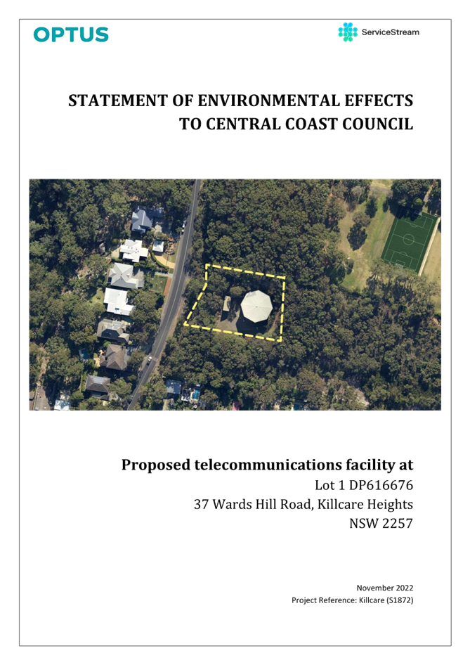
Title: DA/3623/2022 - 37 Wards Hill Rd Killcare Heights - Telecommunications Facility |
|
|
Department: Environment and Planning |
|
|
5 September 2024 Local Planning Panel Meeting |
|
Reference: DA/3623/2022 - D16239156
Author: Alexandra Allouche, Senior Development Planner, Employment and Urban Release
Section Manager: Emily Goodworth, Section Manager Employment and Urban Release
Unit Manager: Andrew Roach, Unit Manager Development Assessment
|
Summary The subject development application seeks consent for a telecommunications facility at No. 37 Wards Hill Road, Killcare Heights. The application has been assessed having regard to the matters for consideration detailed in Section 4.15 of the Environmental Planning and Assessment Act 1979 and other statutory requirements.
The application is referred to the Central Coast Local Planning Panel in accordance with the Local Planning Panels Direction – Development Applications and Applications to Modify Development Consent due to the number of submissions and the site being Council owned land. The proposal was notified from 12 May to 9 June 2023. It was re-notified with an extended notification period commencing on 2 June to 30 June 2023. It was subsequently re-notified again commencing on 30 June to 28 July 2023 to enable public comment on a revised Environmental EME (Electromagnetic Energy) Report submitted and to resolve a technical error with Council’s DA tracker.
A total of 98 submissions were received, 64 submissions in support and 34 objections.
A previous development application was approved by the former Central Coast Council Local Planning Panel at a meeting on 15 November 2021 for a telecommunications facility on this site under DA/57736/2019. The development consent was subject to a Class 4 appeal in the Land and Environment Court (Denny v Optus Mobile Pty Ltd [2023] NSWLEC 27 – Attachment 1). The grounds for appeal were that:
· The Central Coast Local Planning Panel did not provide valid reasons for granting consent as required by Schedule 1, clause 20 of the Environmental Planning and Assessment Act 1979 (EP&A Act) · The Central Coast Local Planning Panel failed to consider section 4.14 of the EP&A Act with respect to consideration of bushfire prone land.
The appeal was successful and the development consent DA/57736/2019 was declared invalid and to have no effect.
Service Stream Maintenance Pty Ltd has since lodged the subject development application for a telecommunications facility on the site.
Insufficient information has been lodged in response to Councils most recent Request for Information dated 4 April 2024 to enable Council to undertake a proper assessment under relevant legislation, and the application is therefore recommended for refusal.
|
1 That the Local Planning Panel REFUSE DA/3623/2022 at 37 Wards Hill Road, Killcare Heights (Lot 1 DP 616676) for telecommunications facilities subject to the recommended reasons for refusal detailed attached to the report and having regard to the matters for consideration detailed in Section 4.15 of the Environmental Planning and Assessment Act 1979 and other relevant legislation.
2 That Council advise those who made written submissions of the Panel’s decision.
3 That Council advise relevant external authorities of the Panel’s decision.
Key Issues
· Visual impact
· Site selection and coverage
· Flora and fauna impacts
· Bushfire
· Tree removal and landscaping
· Aboriginal heritage
· Matters raised in public submissions
Precis:
|
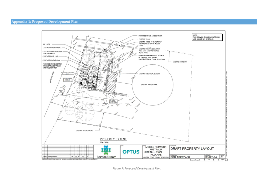
Proposed Development |
The construction and installation of a telecommunications facility comprising a 32.5m monopole telecommunications tower and communications equipment shelter for ancillary infrastructure, an access road track, and the removal of 23 trees. |
|
Permissibility and Zoning |
The site is zoned C4 Environmental Living under Central Coast Local Environmental Plan 2022 (CCLEP 2022). The proposed development is defined as a ‘telecommunications facility’ and is prohibited in the C4 zone. However, under State Environmental Planning Policy (Transport and Infrastructure) 2021, telecommunications facilities are permitted with consent on any land. |
|
Relevant Legislation |
Environmental Planning and Assessment Act 1979 Telecommunications Act 1997 Local Government Act 1993 – Section 89 National Parks and Wildlife Act 1974 Biodiversity Conservation Act 2016 State Environmental Planning Policy (Transport and Infrastructure) 2021 State Environmental Planning Policy (Resilience and Hazards) 2021 Central Coast Local Environmental Plan 2022 Central Coast Development Control Plan 2013 |
|
Current Use |
Water reservoir |
|
Integrated Development |
No |
|
Submissions |
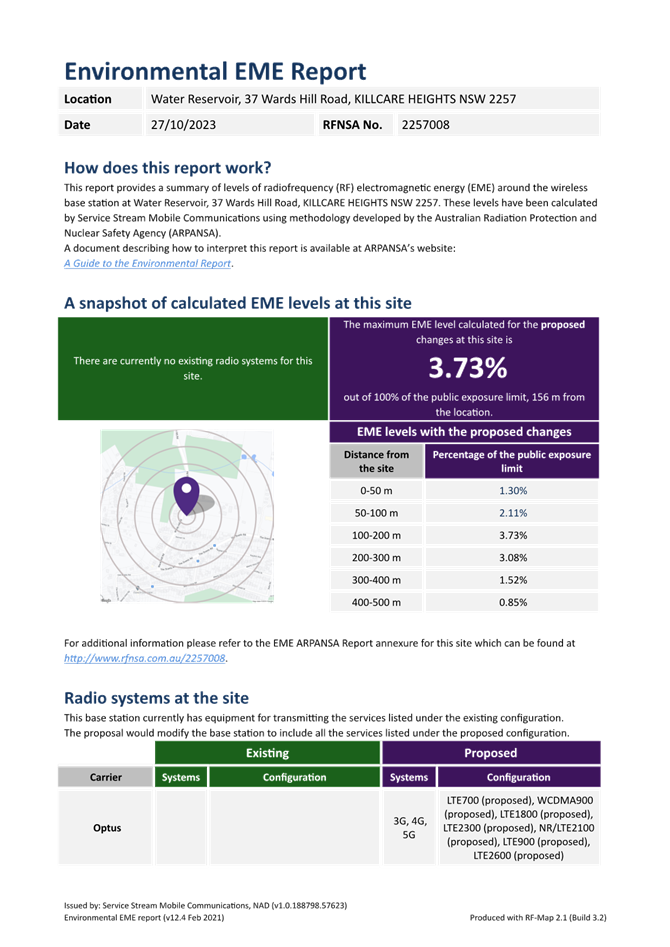
The proposal was notified from 12 May to 9 June 2023. It was re-notified with an extended notification period commencing on 2 June to 30 June 2023. It was subsequently renotified again commencing on 30 June to 28 July 2023 to enable public comment on a revised Environmental EME (Electromagnetic Energy) Report submitted and to resolve a technical error with Council’s DA tracker.
A total of 98 submissions were received, 64 submissions in support and 34 objections. |
The Site
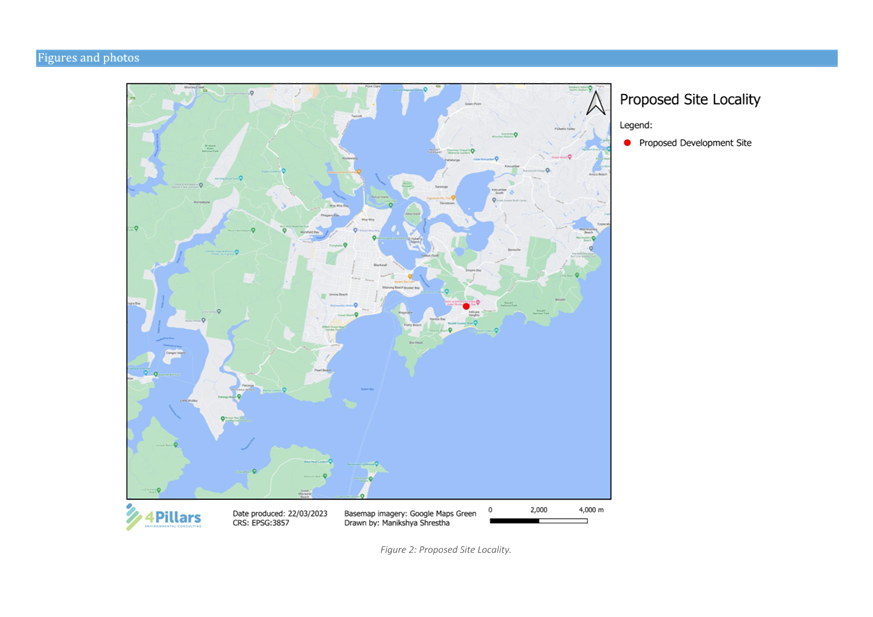
The site is legally identified as Lot 1 in DP 616676, No. 37 Wards Hill Road, Killcare Heights, has a site area of 2,908m2, and is classified as operational land owned by Central Coast Council (Water and Sewer Division (W&S)). The Panel is advised that Operational Land, can be occupied and leased out or otherwise as if the land were private land, subject to the provisions of the Environmental Planning and Assessment Act 1979 and Local Government Act 1993. The Panel is advised that written landowners consent has been obtained in accordance with section 98 of the Environmental Planning and Assessment Regulation 2021 (refer Attachment 2).
The site is located on the eastern side of Wards Hill Road between Maitland Drive and Stewart Street, has an approximate frontage of 48.35m to Wards Hill Road, a rear boundary of 47.00m, a northern side boundary of 58.80m and a southern side boundary of 72.62m. The site runs on an approximate east to west axis, is regular in shape and has a total 10.00m longitudinal section from the south-west corner (RL104) to midsection of the site (RL108) to the north-east corner (RL114).
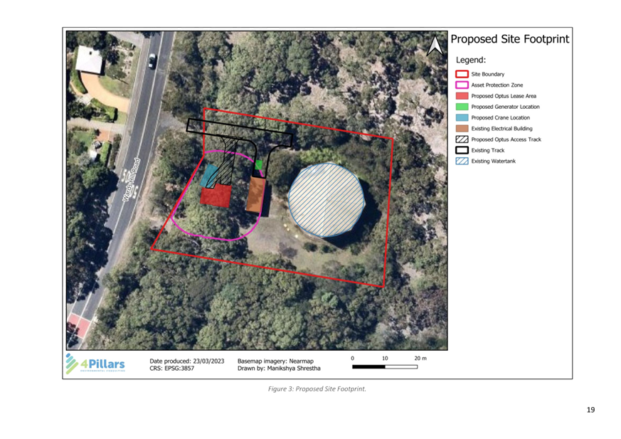
The site currently contains an above ground reservoir tank 10.90m in height and an ancillary electrical building, has two vehicular accesses from Wards Hill Road, and a number of underground services mains.
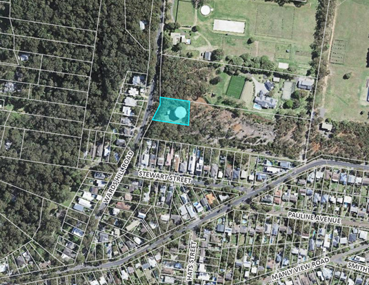
Figure 1: Aerial image of site and surrounding area (Source: Online Mapping (nsw.gov.au) 23 Feb 2024)
![]()
![]()
![]()
![]()
![]()
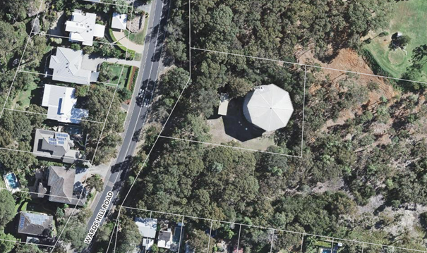
Figure 2: Aerial of subject site (Source: Online Mapping (nsw.gov.au) 23 Feb 2024)

Figure 3: View of frontage showing vegetation in road verge (Source: Google maps, Oct 2023)
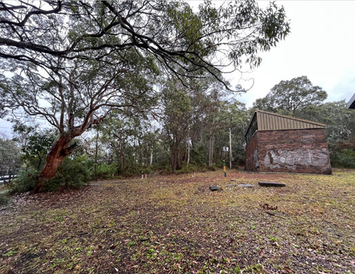
Figure 4: Ancillary pump/electrical building looking north
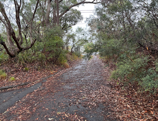
Figure 5: Northern access driveway (looking west)
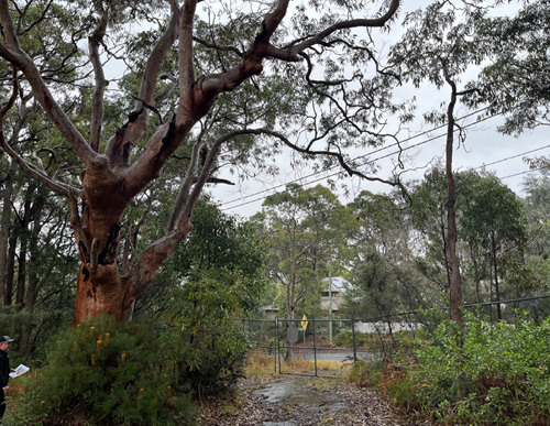
Figure 6: Southern access driveway (looking west)
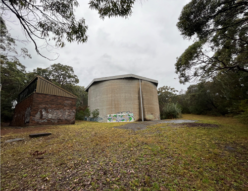
Figure 7: Water reservoir and ancillary building (looking north-east)
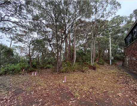
Figure 8: Trees in front setback (looking north-west)
Council’s mapping classifies the perimeter edges of the site (mainly to the west, north and east boundaries) as Killcare Hawkesbury Woodland. No threatened flora or fauna species are known to occur directly within the subject site. The site is also identified as bushfire prone land.

Figure 9: Extent of Killcare Hawkesbury Woodland shown shaded green (Source: Online Mapping (nsw.gov.au) 23 Feb 2024)
Surrounding Development
The lot immediately to the south and east of the subject site is not developed and is characterised by areas of mature vegetation and some clearing. Low density residential development is located further to the south fronting Stewart Street and also on the western side of Wards Hills Road. The dwellings along Wards Hill Road are located considerably lower than the subject site, as shown on the contour map below. Rural residential development is located to the north of the site. The property immediately to the north contains a large area of scattered mature vegetation (approximately 7,000m2) along its Wards Hill Road frontage.
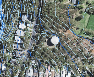
Figure 10: Contours in the vicinity of the site (Source: Online Mapping (nsw.gov.au) 23 Feb 2024)
Bouddi National Park is located further to the north-west and north, as shown in Figure 11.
![]()
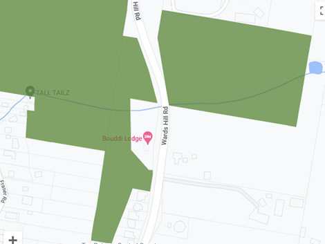
Figure 11: Bouddi National Park in vicinity of the site – site shown circled red (Source: Bouddi National Park | Map | NSW National Parks)
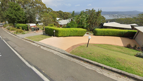
Figure 12: Residences to west fronting Wards Hill Road (Source: Google Maps, Oct 2023)
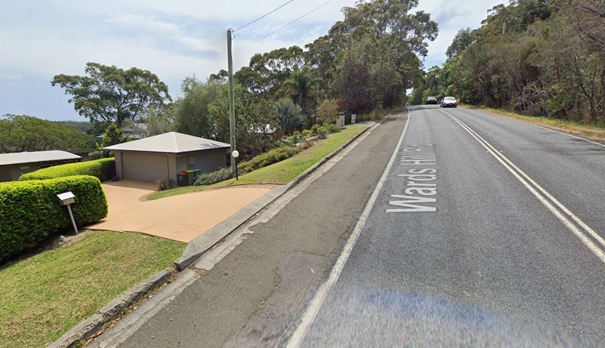
Figure 13: Residences to west fronting Wards Hill Road (Source: Google Maps, Oct 2023)
The Proposed Development
The proposed development comprises of the construction of a telecommunications facility on Council-owned operational land.
Specifically, the development comprises:
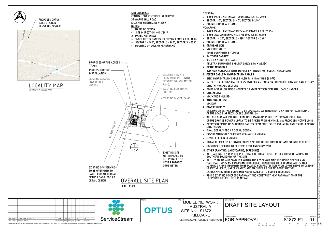
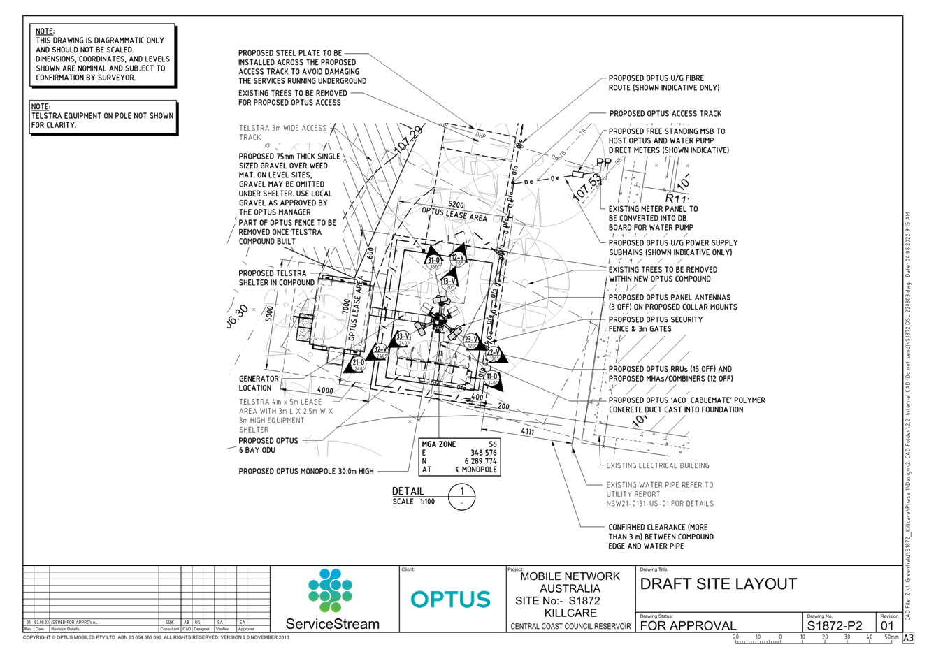
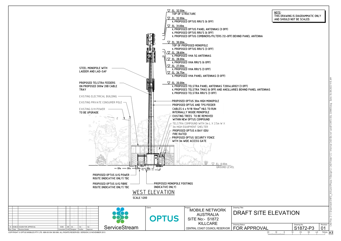
· The installation of a new 30m Monopole with a three-metre pole extension.
· The installation of an Optus headframe bringing the total height of the structure to 32.5m.
· The installation of three panel antennas and 15 Remote Radio Units (RRUs) onto the Optus headframe.
· The installation of a VHA Headframe with six panel antennas and 12 RRUs.
· The installation of a Telstra Headframe with three panel antennas and three RRUs.
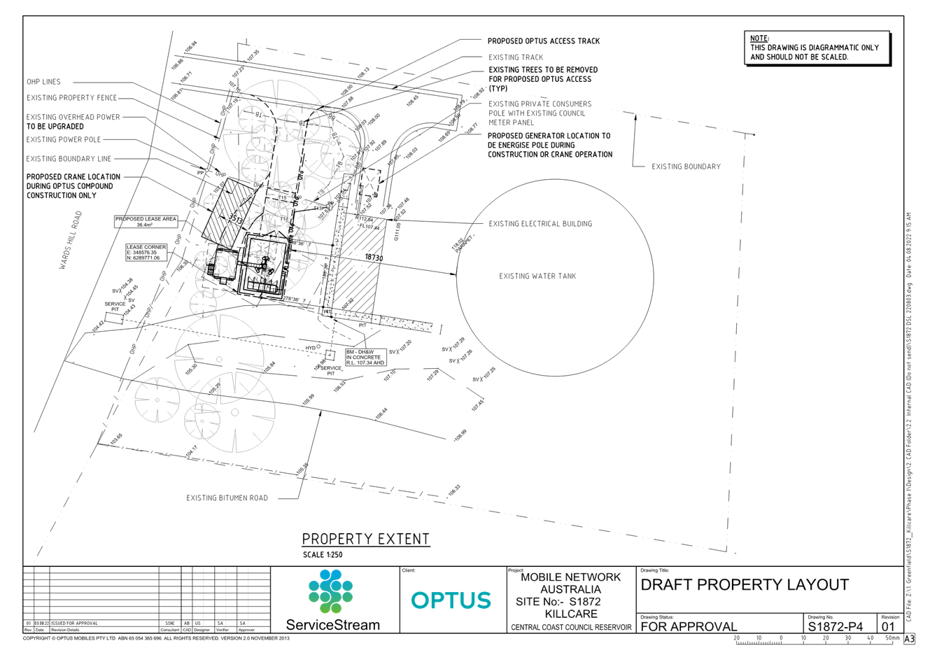
· The establishment of an Optus compound area (7m by 5.2m) enclosed with a security fence.
· The establishment of a Telstra compound area, immediately west of the Optus area (5m by 4m) and also enclosed with a security fence.
· The installation of two equipment shelters, one located in each compound area.
· The installation of ancillary equipment such as feeder cables, combiners, filters, GPS antenna and cable trays.
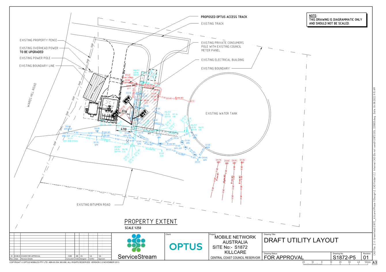
· The construction of an access track to the north and provision for a two-metre construction buffer surrounding the tower infrastructure.
· A 10-metre asset protection zone (APZ) for bushfire protection purposes.
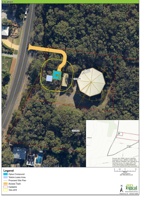
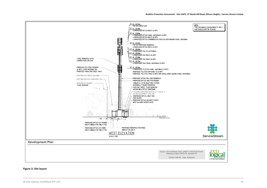
Figure 14. Location and site plan.
The total impact area for the compound, access track and APZ is 0.043ha.
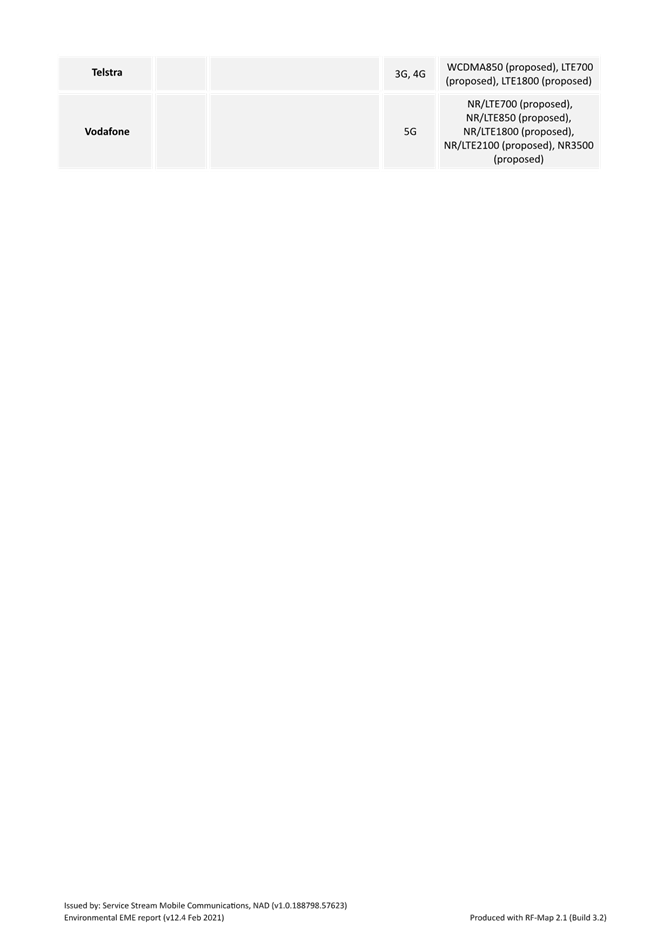
The applicant submits the proposed development is intended to address an identified significant mobile coverage deficiency within Killcare Heights and surrounding suburbs. The proposed facility is argued to provide coverage to an estimated 1300 registered addresses and allow for the provision of coverage in the area from all three major carriers, being Optus, Vodafone Hutchison Australia (VHA) and Telstra.
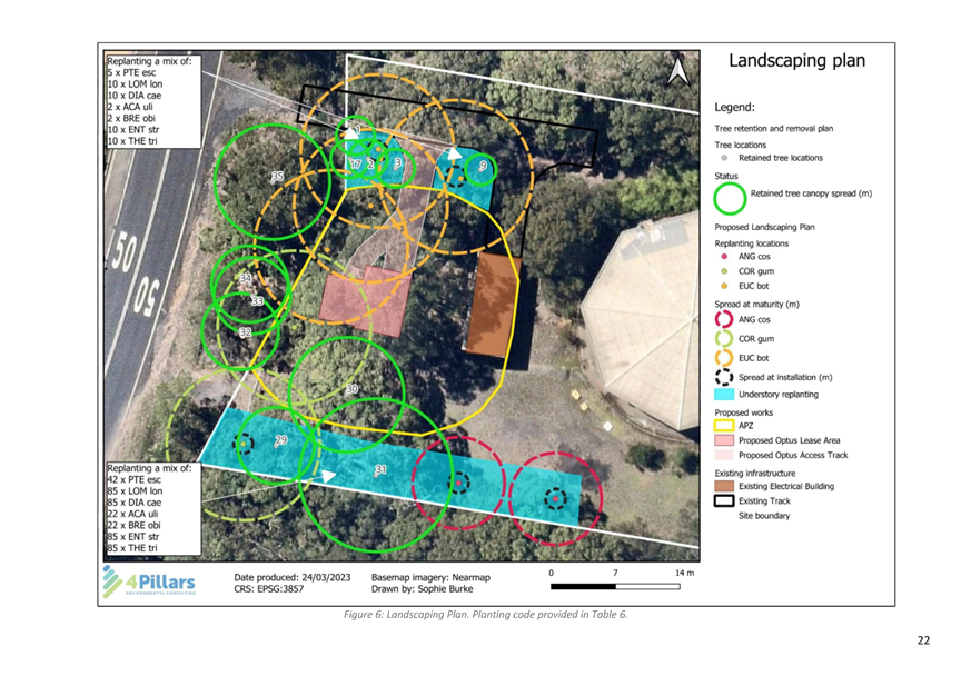
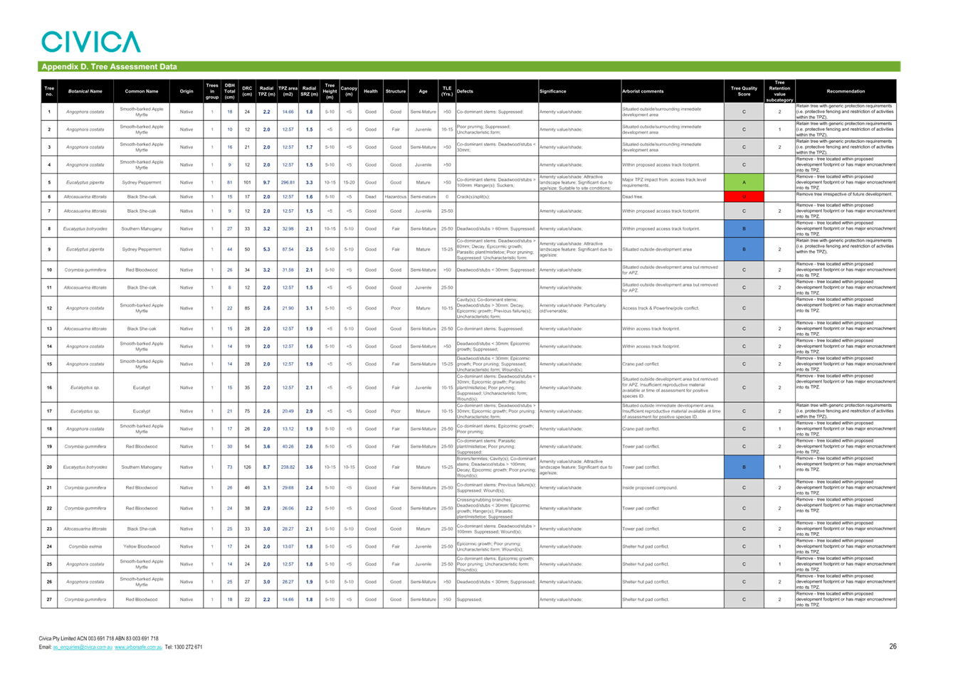
Revised and amended documentation submitted to Council throughout the assessment of the application confirms that overall, a total of 23 trees are proposed to be removed to accommodate the development. A preliminary landscape plan has been provided which proposes revegetation along the site frontage as well as immediately to the north and south. The proposed revegetation is located within the nominated Asset Protection Zone (APZ) which is discussed later in the report.
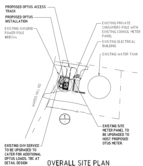
Figure 15: Overall site plan
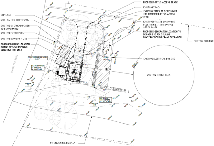
Figure 16: Proposed property layout
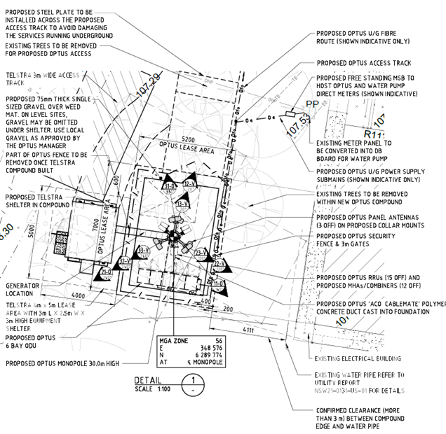
Figure 17: Proposed site layout
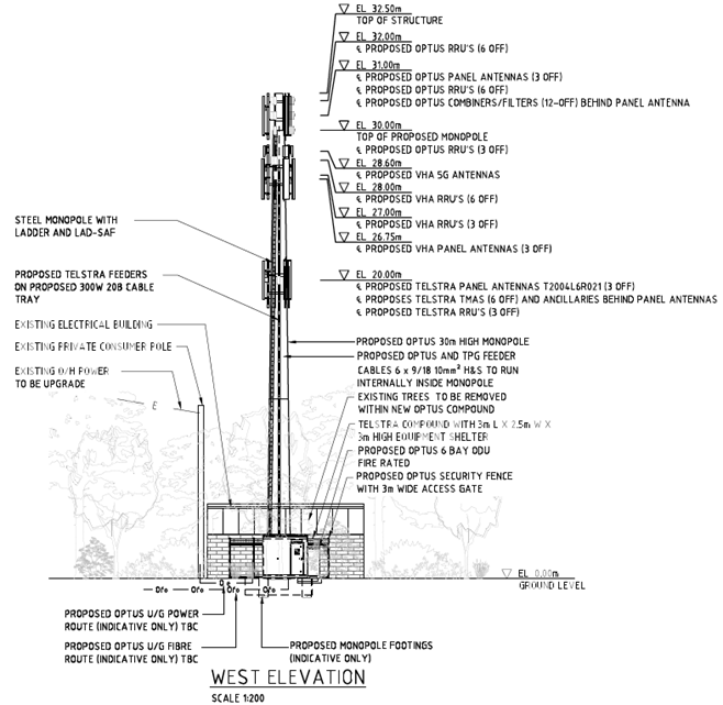
Figure 18: Site elevation
Relevant History
The former Central Coast Local Planning Panel granted development consent on 15 November 2021 for a telecommunications facility on the site, referred to herein as the ‘original proposal’ under DA/57736/2019. The Panel is advised that the development as approved was largely consistent with the telecommunications facility for which development consent is now sought.
DA/57736/2019 was subject to a Class 4 appeal in the Land and Environment Court (Denny v Optus Mobile Pty Ltd [2023] NSWLEC 27). The grounds for appeal were essentially that:
· The former Central Coast Local Planning Panel did not provide valid reasons for granting consent as required by Schedule 1, clause 20 of the Environmental Planning and Assessment Act 1979 (EP&A Act)
· The former Central Coast Local Planning Panel failed to consider section 4.14 of the EP&A Act with respect to consideration of bushfire prone land.
The Court upheld the appeal and the development consent DA/57736/2019 was declared invalid and to have no effect.
Application Background
The subject DA was lodged on 1 May 2023.
On 18 May 2023 a letter was sent to the DA applicant requesting the following:
· Erosion & Sediment Control Plans prepared in accordance with Section 2.2 of the ‘Blue Book’ (Managing Urban Stormwater: Soils and Construction, Landcom, 2004)
· A revised Environmental EME Report to provide the following:
- property addresses for each dwelling location provided in the table under the heading “Calculated EME levels at other areas of interest” and
- clarification on the height range used in the table mentioned above for each dwelling located to the northeast of the site which are elevated.
An Erosion and Sediment Control Report and Plans prepared by JC Engineers, Revision 1 and dated 30 June 2023 together with a revised Environmental EME Report dated 25 May 2023 were provided by the applicant.
Following public notification, a further request for information was sent by Council on 6 October 2023 seeking the following:
· A revised Flora and Fauna Assessment incorporating:
- fauna surveys undertaken in accordance with Council’s Flora and Fauna Guidelines 2019
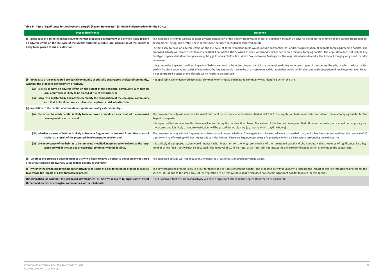
- Tests of Significance prepared in accordance with Section 7.3 of the Biodiversity Conservation Act and the “NSW Threatened Species Test of Significance Guidelines”
- An assessment of any potential impact on fauna of electro-magnetic emissions from telecommunications towers.
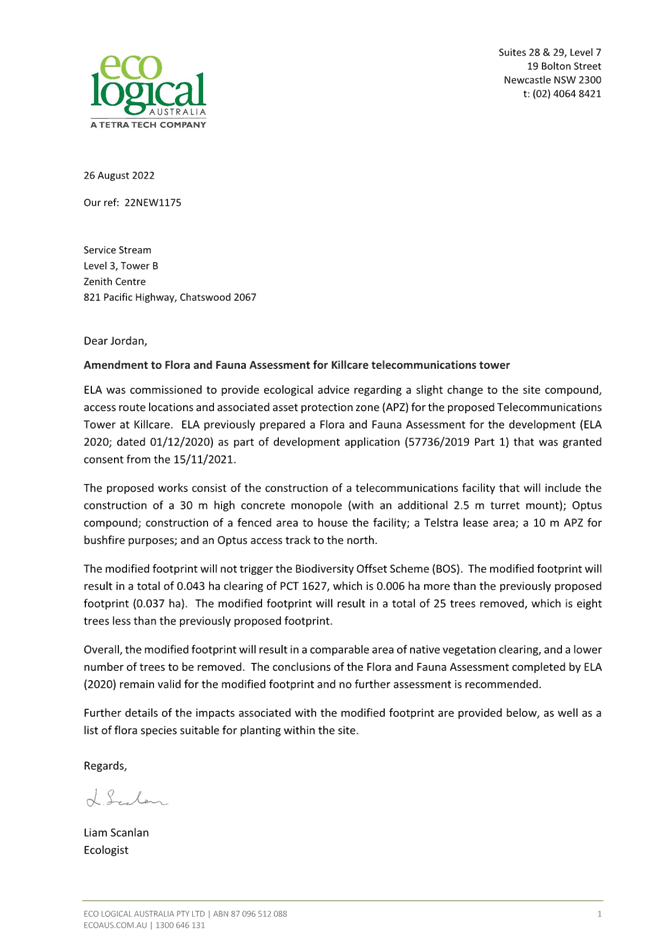
· Clarification regarding trees to be removed, noting inconsistencies between the Flora and Fauna Assessment prepared by Eco Logical dated 26 August 2022, Tree Retention and Landscape Plan prepared by 4Pillars Environmental Consulting, Version 1 and published 28 March 2023 and the accompanying Statement of Environmental Effects
· Clarification as to whether the Arborist Report had taken into consideration all tree impacts from the operation of the crane during construction.
· Calculation of the maximum cumulative EME level and percentage of the public exposure limit in a height range of 0-6m for each of the selected sites due to potential for future residential development in the area being to a height of two storeys
· A survey plan
· Further information to enable Council to undertake assessment under the NSW Telecommunications Facilities Guideline, including:
- Justification for the base station rather than other technologies such as small cell towers
- Confirmation on whether the tower require any lighting at night and
- Additional information on the site selection process.
· An Aboriginal Cultural Heritage Report
A response to each of these matters was submitted by the applicant on 15 January 2024 with the following amended, but inconsistent, documents:
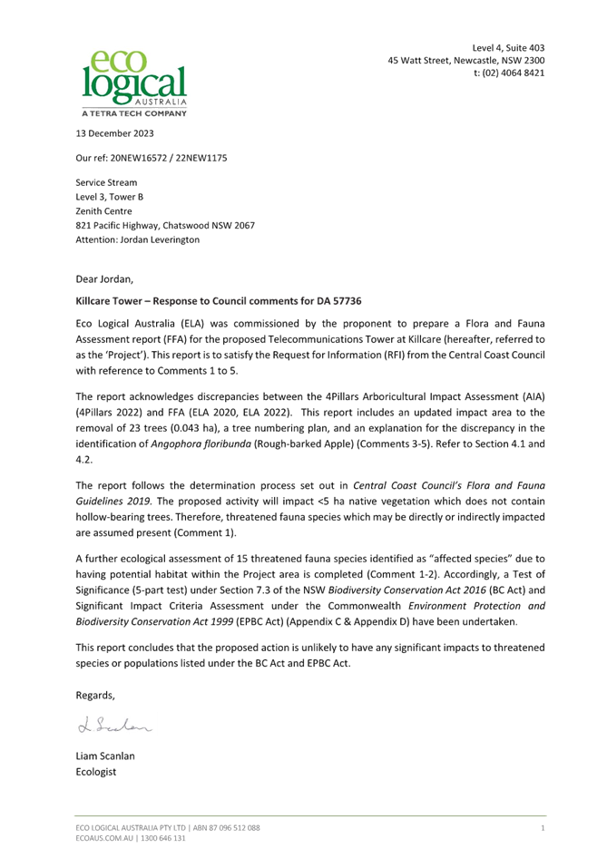
· Flora and Fauna Assessment Report prepared by Eco Logical and dated 13 December 2023, Reference 20NEW16572.
· Environmental EME Report, issued by Service Stream Mobile Communications, NAD (v1.0.188798.57623).
· Tree Retention and Landscape Plan, prepared by 4Pillars Environmental Consulting, Version 1.1 and dated October 2023.
· Candidate Site Coverage Plots.
Council remained unsatisfied with several matters not being adequately addressed and subsequently sent two further RFIs dated 23 February and 4 April 2024 respectively. The issues raised in these RFI’s and the applicant’s responses are provided below.
· Aboriginal Cultural Heritage Due Diligence Report – Council requested that a Due Diligence report be submitted in accordance with the Due Diligence Code of Practice for the Protection of Aboriginal Objects in New South Wales. The applicant had submitted a Peer Review of an Aboriginal Cultural Heritage assessment undertaken for 31 Wards Hill Road to demonstrate that the subject site was unlikely to contain Aboriginal objects or otherwise have Aboriginal cultural significance however Council advised that a site-specific Due Diligence Report was required.
Applicant’s response:
The Due Diligence investigation steps described in the Due Diligence Code of Practice have been followed in the Peer Review of archaeological reports from the immediate area and local region submitted by the applicant.
· Fauna surveys - Fauna surveys in accordance with Council’s Flora and Fauna Guidelines 2019 had not been undertaken as requested and that no satisfactory reason had been provided as to why this was the case. The requirement for fauna surveys in accordance with Council’s Guidelines was reiterated.
Applicant’s response:
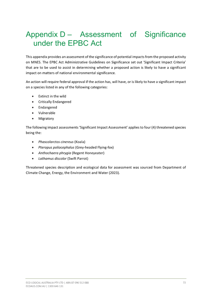
Adequate analysis and fauna surveys have been undertaken and all investigations have consistently concluded that the proposed action is unlikely to have any significant impacts to threatened species or populations listed under the BC Act and EPBC Act.
· Tree removal - Trees to be removed and retained still appeared to be inconsistent between the plans, raising doubt as to whether the ecological impacts of tree removal have been adequately considered in the Flora and Fauna Assessment.
Applicant’s response:
Adequate information has been provided with respect to which trees are to be retained or removed. Any inconsistencies in information are inconsequential.
· Compliance with Transport and Infrastructure SEPP – The application provides an assessment against the July 2010 version of the NSW Telecommunications Facilities Guideline including Broadband which is required under clause 2.143(2) of the State Environmental Planning Policy (Transport and Infrastructure) 2021 (Transport and Infrastructure SEPP). The July 2010 Guideline was superseded by a new Guideline in October 2022, prior to the lodgment of the subject DA. Council advised the applicant that the additional principles contained in the October 2022 Guideline must be addressed.
Applicant’s response:
Additional information addressing new principles was provided.
· Landscaping within the APZ – The NSW Rural Fire Service has required that the APZ must be managed as an inner protection area (IPA), significantly constraining tree planting and other landscaping within 10 meters around the facility. The landscape plan submitted with the application proposed tree planting and other landscaping and therefore Council requested that it be certified by an appropriately qualified bushfire consultant confirming that it meets IPA requirements or that an alternative landscape plan be provided.
Applicant’s response:
Additional information outlining how proposed landscaping is to be managed to adhere to RFS requirements was provided.
The matters raised above are discussed in detail in this report.
Assessment:
Having regard for the matters for consideration detailed in Section 4.15 of the Environmental Planning and Assessment Act 1979 and other statutory requirements, Council’s policies and Section 10.7 Certificate details, the assessment has identified the following key issues, which are elaborated upon for the Panel’s information.
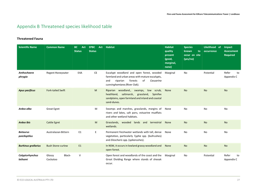
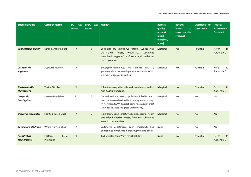
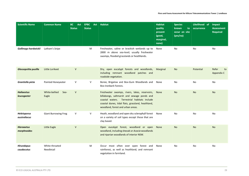
Biodiversity Conservation Act 2016
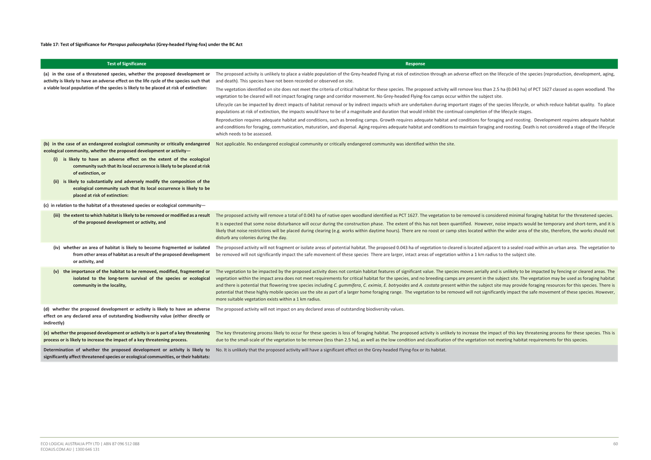
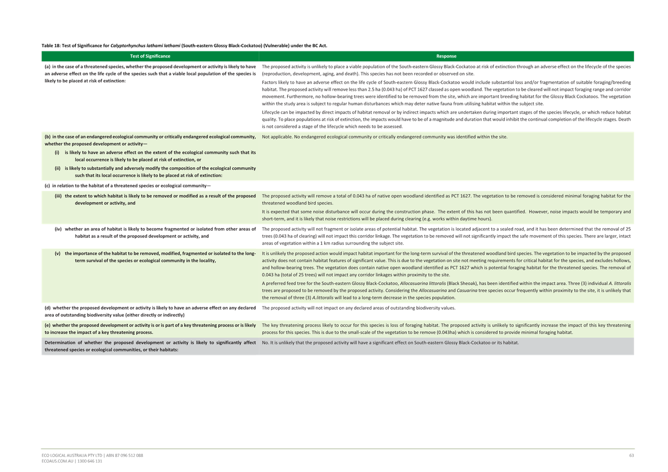
Section 7.2 of the Biodiversity Conservation Act 2016 (BC Act) provides that development under the EP&A Act is likely to significantly affect threatened species if:
(a) it is likely to significantly affect threatened species or ecological communities, or their habitats, according to the test in section 7.3, or
(b) the development exceeds the biodiversity offsets scheme threshold if the biodiversity offsets scheme applies to the impacts of the development on biodiversity values, or
(c) it is carried out in a declared area of outstanding biodiversity value. A development application that is likely to significantly affect a threatened species must be accompanied by a biodiversity development assessment report (BDAR).
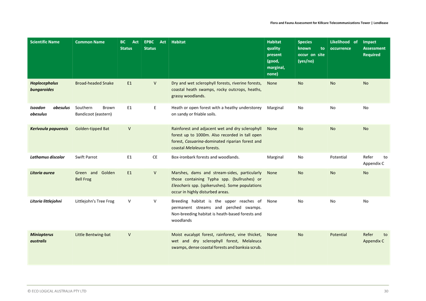
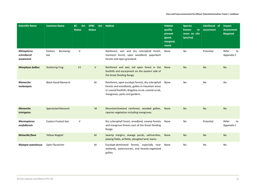
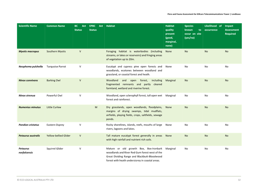
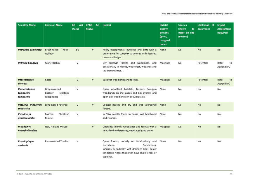
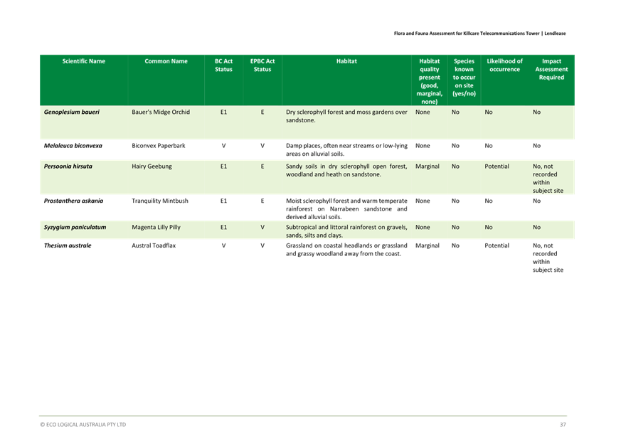
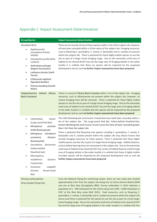
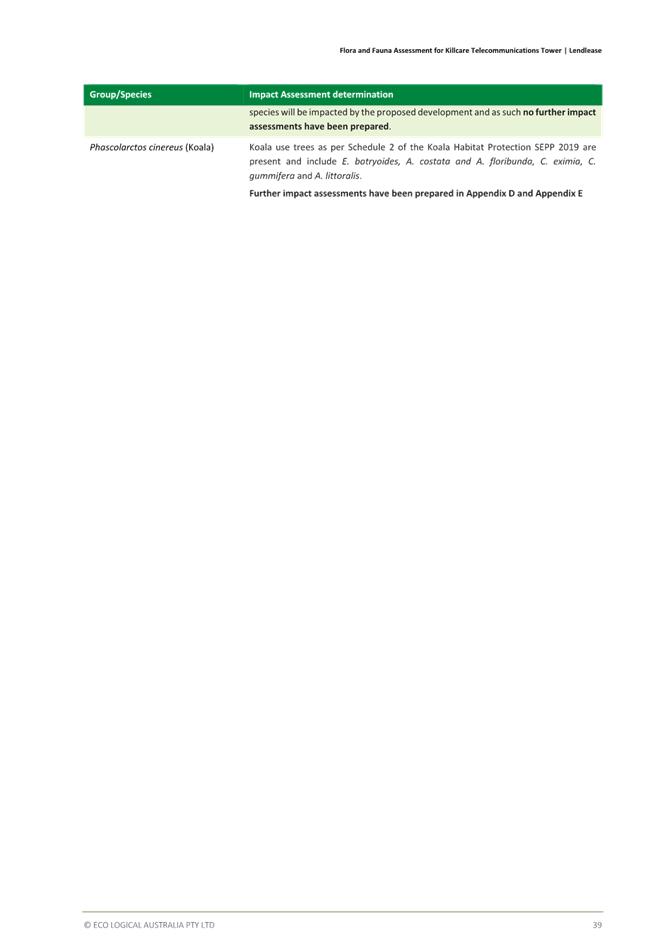
The submitted Flora and Fauna Assessments rely on site surveys conducted in 2020 and NSW Bionet wildlife atlas data from 2019. Both the NSW Biodiversity Assessment Method (BAM) and Councils Flora and Fauna Guidelines 2019 allow for reliance on surveys that are less than five years old. Ideally however, Bionet searches would have been updated as part of the 2023 and 2024 ecological reports which were provided to Council, given that the elapsed time is now at the five year period.
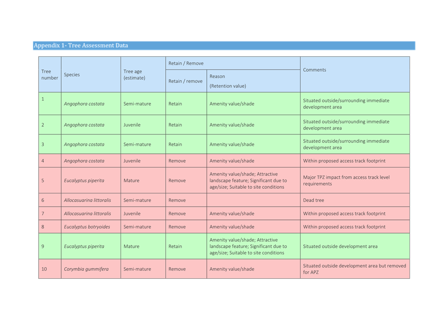
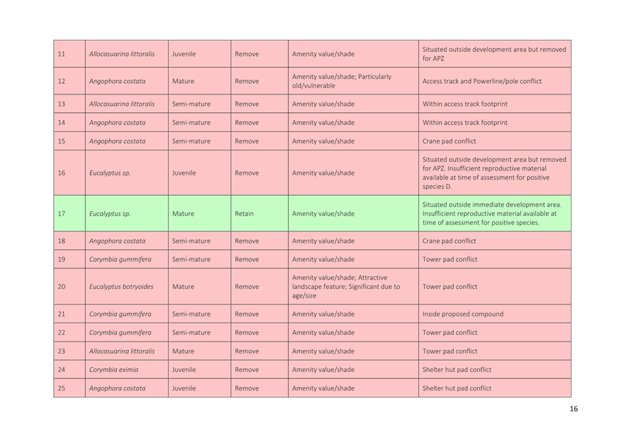
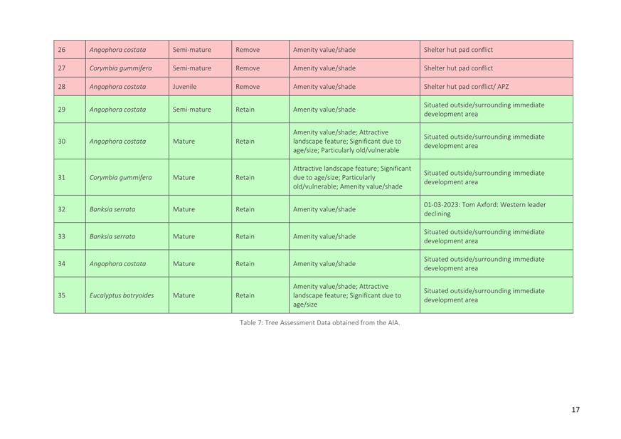
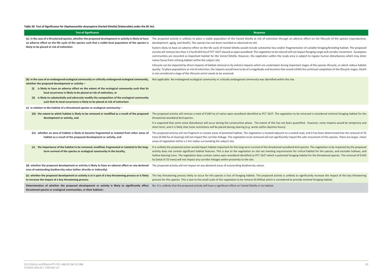
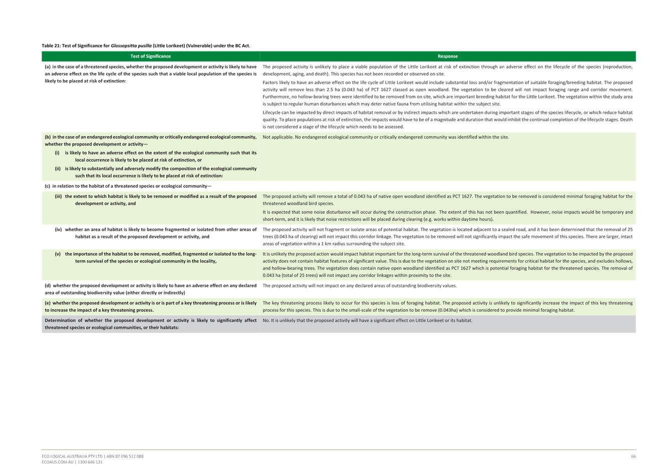
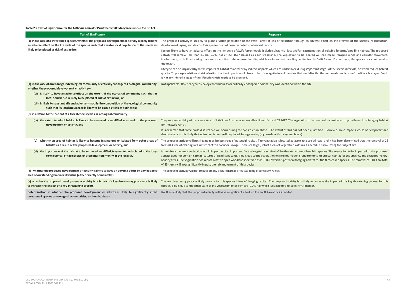
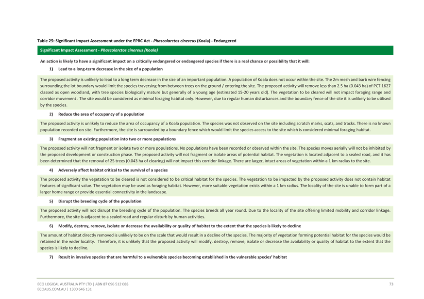
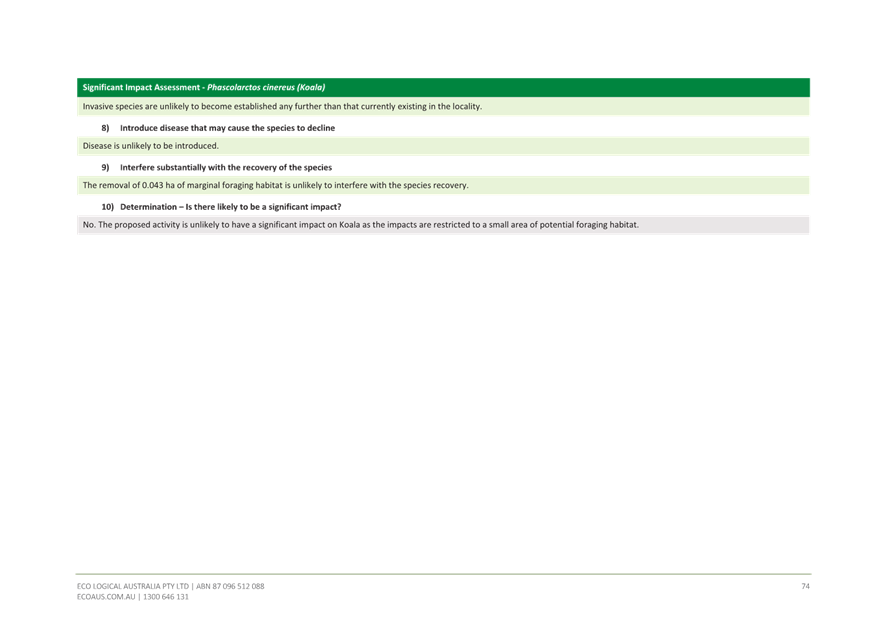
The Flora and Fauna Cover Letter authored by Eco Logical and dated 2022 (Attachment 3) outlines that the application will require the removal of 0.043ha of native vegetation, including 25 trees. This vegetation was classified by Eco Logical as a dominant Plant Community Type (PCT) being 1627 Smooth-barked Apple-Turpentine – Sydney Peppermint heathy woodland integrating with species characteristic of PCT 1645 Old Man Banksia- Rough- barked Apple – Bangalay Shrubby Open Forest. The vegetation community on site is not commensurate with any Endangered Ecological Community.
The ecological report (Attachment 4) outlines that the site represents a potential habitat for up to 15 threatened fauna species. Foraging habitat is present in the form of native trees. There is a hollow bearing tree within the APZ to the south of the proposed tower as shown in the figure below. The tree identified as No. 30 in the arborist and ecological reports is stated as being suitable for retention within the APZ in these reports however any fauna using this hollow is likely to be disturbed by the proposed development.
No nocturnal surveys have been conducted and the hollow tree has not been surveyed for fauna occupation. Ongoing impacts such as the potential impact from lighting on fauna have not been adequately considered, including in relation to foraging habitats for microbats. Additionally, the Bushfire Assessment Report dated August 2022 (Attachment 5) does not make specific commentary on the suitability of retention of this tree within the IPA.
Figure 19. Hollow bearing Angophora costata, canopy spread and proximity to lease area.
Council requested on 6 October 2023 that an additional flora and fauna assessment be undertaken and include the following:
i. Fauna surveys completed in accordance with Table 2 of Council’s Flora and Fauna Guidelines 2019, which outlines the minimum level of field surveys required for clearing of mature trees for areas of impact less than 0.5ha.
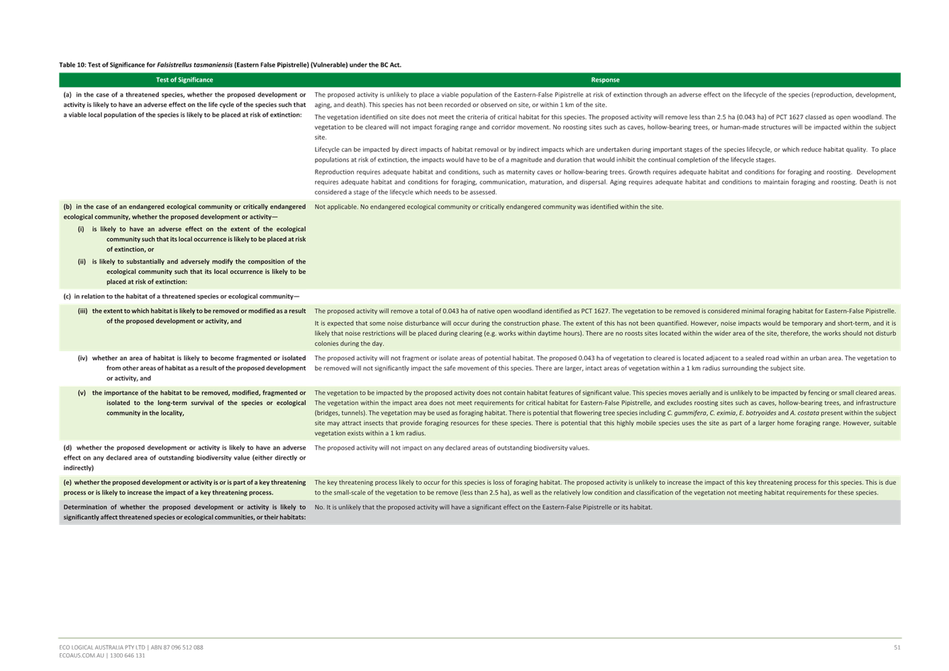
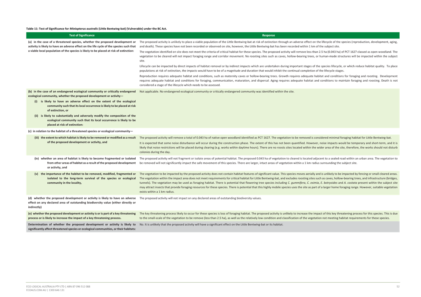
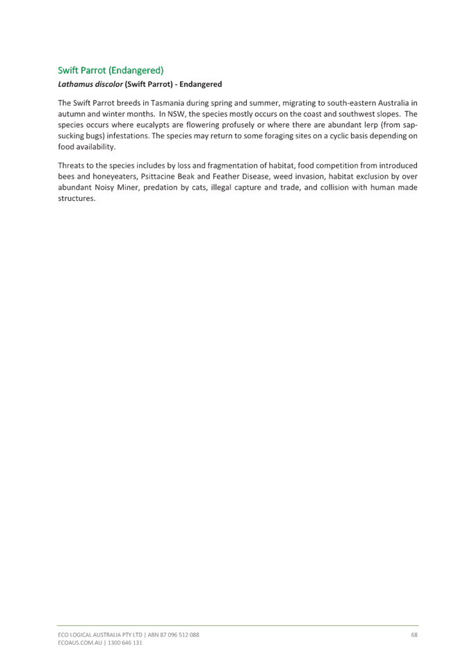
ii. Tests of Significance prepared in accordance with Section 7.3 of the Biodiversity Conservation Act and the “NSW Threatened Species Test of Significance Guidelines” are required for 15 fauna that were assessed as having habitat on the site, and including any species detected during additional field survey. This must include Glossy Black Cockatoo.
iii. Address any potential impact on fauna of electro-magnetic emissions from telecommunications towers, with reference to any relevant peer reviewed literature or studies on the topic.
These additional surveys have not been conducted and no specific rationale is provided by the applicant other than further surveys not considered necessary due to the small area of habitat proposed to be cleared.
Therefore, insufficient information has been provided to enable Council to undertake a proper assessment and the Panel to be satisfied in accordance with Section 7.3 of the Biodiversity Conservation Act including ‘Tests of Significance’ for 15 identified fauna species, assessed as having habitat on the site.
The application is recommended for refusal on this basis (Refusal Reason 1).
Additionally, insufficient fauna surveys completed in accordance with Table 2 of Council’s Flora and Fauna Guidelines 2019, for the clearing of mature trees for areas of impact less than 0.5ha has been submitted.
The application is recommended for refusal on this basis (Refusal Reason 2).
Moreover, the Panel cannot be satisfied that the potential and likely impact on the identified fauna and flora from electromagnetic emissions from telecommunications towers is acceptable.
The application is also recommended for refusal on this basis (Refusal Reason 2).
Environmental Planning and Assessment Act 1979
Section 4.14 - Consultation and development consent—certain bush fire prone land
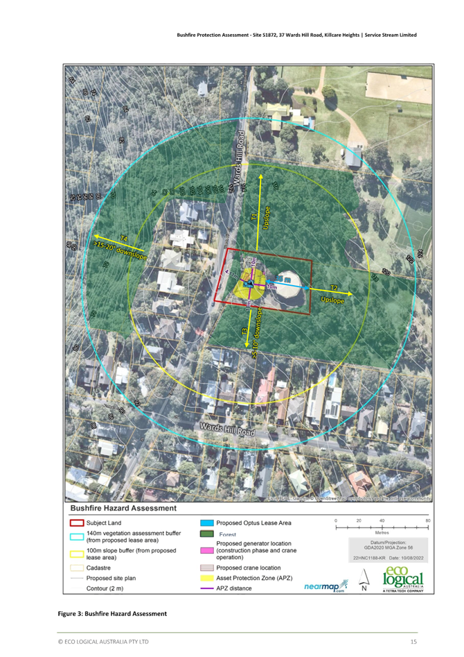
The subject site is identified as bush fire prone land as the site contains Category 1 Vegetation (red) and the vegetation buffer (yellow) therefore Section 4.14 of the EP&A Act is relevant.
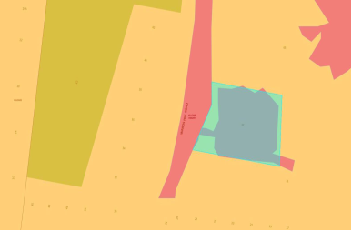
Figure 20. Bushfire affectation.
The subject development is not a listed Special Fire Protection Purpose and is not classified as integrated development under Section 4.46 of the Environmental Planning and Assessment Act 1979 and therefore does not require a Bushfire Safety Authority under Section 100B of the Rural Fires Act 1997.
In accordance with the provisions of Section 4.14 of the Environmental Planning and Assessment Act 1979, consent cannot be granted unless the consent authority is satisfied the development conforms to the relevant specification and requirements of Planning for Bushfire Protection 2019 (PBP) (s.4.14(1)(a)) or alternatively, that certification stating the development conforms to the relevant specifications and requirements from an appropriately qualified person is provided to the consent authority (s.4.14(1)(b)).
The application is accompanied by a Bushfire Assessment Report prepared by Eco Logical, Version 3, Project Number 22HNC_1188 (Attachment 5). The Report provides an independent bushfire assessment of the proposed development together with appropriate recommendations for asset protection zones, construction and access having regard to construction within the designated bushfire prone area.
Both the application and accompanying Report was referred to the NSW Rural Fire Service seeking agency advice. The NSW RFS considered the information and provided a set of recommended conditions on 4 May 2023.
Having regard for the provisions of s.4.14(1)(a), the Panel can be satisfied the development conforms to the specifications and requirements of Planning for Bushfire Protection 2019 (PBP 2019), as the bushfire report submitted by the applicant has been undertaken in accordance with PBP 2019 and NSW Rural Fire Service have raised no concerns with the information provided by the applicant or the proposed development, and have recommended conditions for any consent which may be granted.
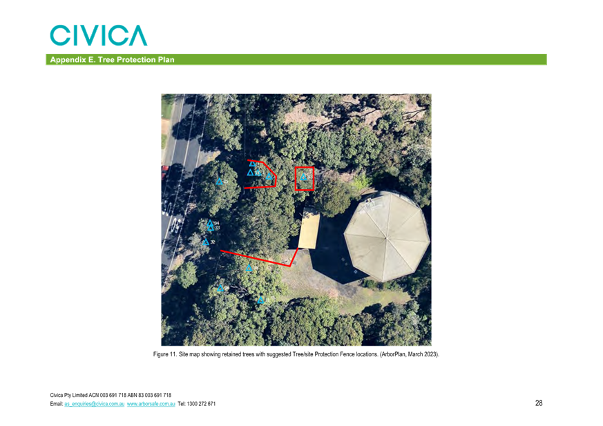
Notwithstanding the above, the Panel is advised that the Tree Retention and Landscape Plan submitted by the applicant (Attachment 6) proposes landscaping within the 10m APZ. The applicant has advised that the proposed landscaping can be managed to meet the RFS conditions dated 4 May 2023.
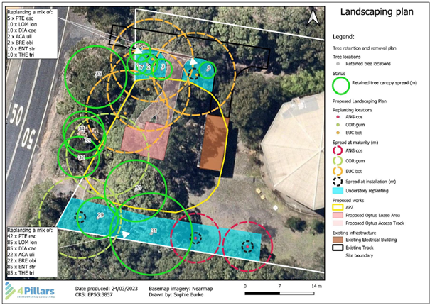
Figure 21: Preliminary Landscape Plan
Should the Panel be of a mind to approve the development, this can be appropriately conditioned as per the below table.
Proposed vegetation maintenance within APZ
|
RFS APZ Requirements |
Applicant’s response |
|
Tree canopy cover should be less than 15% at maturity |
Will be managed as part of ongoing maintenance of the site. |
|
Trees at maturity should not touch or overhang the building |
Will be managed as part of ongoing maintenance of the site. |
|
Lower limbs should be removed up to a height of 2m above the ground; |
Will be managed as part of ongoing maintenance of the site. |
|
Tree canopies should be separated by 2 to 5m |
Will be managed as part of ongoing maintenance of the site. |
|
Preference should be given to smooth barked and evergreen trees |
The proposed species to be planted are smooth barked trees. |
|
Large discontinuities or gaps in vegetation should be provided to slow down or break the progress of fire towards buildings
|
Will be managed as part of ongoing maintenance of the site. |
|
Shrubs should not be located under trees |
Understorey planting has been proposed outside of the 10m APZ |
|
Shrubs should not form more than 10% ground cover |
Shrubs will not form more than 10% ground Cover |
|
Clumps of shrubs should be separated from exposed windows and doors by a distance of at least twice the height of the vegetation. |
There are no exposed doors or windows within twice the height of the vegetation |
SECTION 4.15(1)(a)(i) – PROVISIONS OF ENVIRONMENTAL PLANNING INSTURMENTS
· State Environmental Planning Policy (Biodiversity Conservation) 2021
· State Environmental Planning Policy (Resilience and Hazards) 2021
· State Environmental Planning Policy (Transport and Infrastructure) 2021
· Central Coast Local Environmental Plan 2022
· Central Coast Development Control Plan 2022.
Consideration of the relevant SEPPs is further outlined below.
State Environmental Planning Policy (Biodiversity Conservation) 2021
Chapter 2 Vegetation in non-rural areas
This Chapter applies in accordance with Section 2.3(b) as the site is identified as land within the C4 Environmental Living zone under the Central Coast Local Environmental Plan 2022.
Correspondence and reports, including Section 4.1 of the revised ecology Report dated December 2023 (Attachment 7), acknowledge there are differences between tree removal and retention information between the arborist reports and ecology information, which are also conveyed in proposed plans. Council has provided sufficient opportunity for the applicant to amend the plans and accompanying reports to resolve these issues, with the final opportunity provided on 4 April 2024.
The ecology report shows trees for retention that are shown for removal in the tree assessment, as shown in the comparisons below. Overall tree numbers are also different; the tree plan also shows more trees overall, and more trees to be removed. The ecology report also identifies Angophora floribunda on the site, whereas the arborist report does not. The arborist repot shows two different locations for the crane, when Figure 3 and Figure 4 are compared.
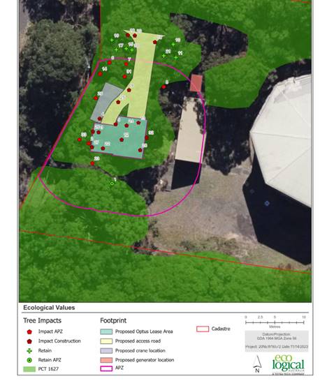
Figure 22. Ecological Report (dated Dec 2023).
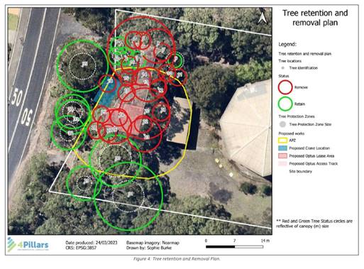
Figure 23 From Tree Report (October 2023).
Tree removal and retention information is also relevant to consideration of bushfire requirements and visual impacts.
Council cannot adequately assess and condition tree removal and retention and related issues, as tree information is not consistent between plans and reports submitted with the application.
The Panel is advised that full assessment of relevant matters under Chapter 2 of the Biodiversity and Conservation SEPP 2021 cannot be undertaken and clear conditions applied, when there remains contradictory information. The application is recommended for refusal on this basis (Refusal Reason 3).
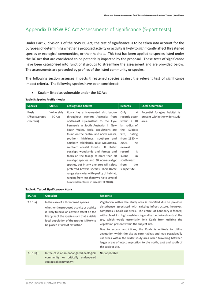
Chapter 4 Koala habitat protection
The Panel is advised that assessment under this Chapter is not required as the subject site is less than 1ha in size and adjoining properties are not under the same ownership. No further consideration is required in this regard.
State Environmental Planning Policy (Resilience and Hazards) 2021
Chapter 2 Coastal Management
The site is not within a coastal use or coastal environment management area and therefore, the provisions of Sections 2.10 and 2.11 do not apply.
Chapter 4 Remediation of Land
This Chapter requires that consent not be granted until the consent authority has considered whether the land is contaminated. If the land is contaminated, the consent authority needs to be satisfied that the land is suitable in its contaminated state (or will be suitable after remediation) for the purposes for which the development is proposed to be carried out.
Section 4.6(2) states that before determining an application for consent to carry out development that would involve a change of use on any of the land specified in subsection (4), the consent authority must consider a report specifying the findings of a preliminary investigation of the land concerned carried out in accordance with the contaminated land planning guidelines. Land specified in subsection (4) includes land on which development for a purpose referred to in Table 1 to the contaminated land planning guidelines is being, or is known to have been, carried out.
A reservoir is not listed in subsection (4) as being an activity that has the potential to cause contamination. Further, the site is not mapped as a potential or known contaminated site and Council records do not indicate potentially contaminated historic land uses. As such, a preliminary investigation of the land is not required in accordance with s.4.6(2) and the Panel can be satisfied that the proposed telecommunications facility is acceptable with regard to the provisions in Chapter 4 of the SEPP.
State Environmental Planning Policy (Transport and Infrastructure) 2021
Chapter 2, Part 2.3, Division 21 – Telecommunications and other communication facilities
Division 21 establishes the approval regimes for telecommunications in NSW. Division 21 classifies certain telecommunications development as being permitted as development with consent, development that is complying or development exempt from local environmental approvals.
Under Division 21, section 2.141 of the Transport and Infrastructure SEPP, a ‘telecommunications facility’ means:
(a) any part of the infrastructure of a telecommunications network, or
(b) any line, cable, optical fibre, fibre access node, interconnect point, equipment, apparatus, tower, mast, antenna, dish, tunnel, duct, hole, pit, pole or other structure in connection with a telecommunications network, or
(c) any other thing used in or in connection with a telecommunications network.
The proposed development is considered to fall under this definition.
Section 2.143 of the Transport and Infrastructure SEPP states as follows:
2.143 Development permitted with consent
(1) Development for the purposes of telecommunications facilities, other than development in section 2.141 or development that is exempt development under section 2.20 or 2.144, may be carried out by any person with consent on any land.
(2) Before determining a development application for development to which this section applies, the consent authority must take into consideration any guidelines concerning site selection, design, construction or operating principles for telecommunications facilities that are issued by the Planning Secretary for the purposes of this section and published in the Gazette.
The proposed development is not of a type that can be carried out without development consent under Section 2.141 and is not exempt development under Section 2.20 and 2.144. It therefore requires development consent in accordance with Section 2.143(1).
In accordance with Section 2.143(2) of the Transport and Infrastructure SEPP, the following is an assessment of the proposed development in relation to the NSW Telecommunications Facilities Guideline, Including Broadband (NSW Department of Planning and Environment, October 2022), which are the relevant guidelines for consideration.
It should be noted that the original Statement of Environmental Effects submitted by the applicant has provided an assessment of the proposed development against the now superseded July 2010 Guideline, notwithstanding that the October 2022 Guideline had been adopted prior to the lodgement of the subject DA. In response to an RFI from Council on this matter, the applicant provided further information addressing the updated Guideline in an amended Statement of Environmental Effects (Attachment 8).
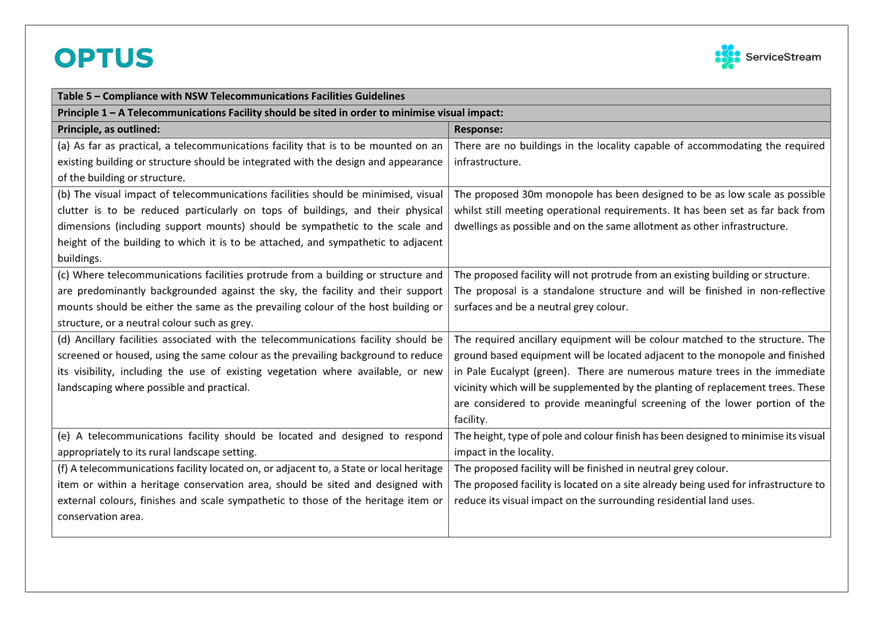
Table 1: Assessment of proposal in relation to NSW Telecommunications Facilities Guideline, Including Broadband
|
PRINCIPLE
|
CONSIDERATION |
CONSISTENT |
|
Principle 1: Design and site telecommunications facilities to minimise visual impact. |
||
|
a. As far as practical, integrate a telecommunications facility that is mounted on an existing building or structure with the design and appearance of the building or structure. |
The proposed facility will not be mounted on an existing building or structure. |
N/A |
|
b. Minimise the visual impact of telecommunications facilities, reduce visual clutter (particularly on tops of buildings) and ensure physical dimensions (including support mounts) are sympathetic to the scale and height of the building to which it is to be attached and to adjacent buildings. |
This principle is not relevant as the proposed tower is a standalone structure. |
N/A |
|
c. If a telecommunications facility protrudes from a building or structure and is predominantly seen against the sky, either match the prevailing colour of the host building or structure or use a neutral colour such as pale grey. |
As above |
N/A |
|
d. Where possible and practical, screen or house ancillary facilities using the same colour as the prevailing background and consider using existing vegetation or new landscaping. |
The ancillary equipment shelter is proposed to be finished in Pale Eucalypt green to blend with the surrounding vegetation. Existing vegetation and new landscaping will also screen the ancillary facilities. |
Yes |
|
e. Locate and design a telecommunications facility in a way that responds to its setting (rural, residential, industrial or commercial). |
The proposal is located within existing bushland surrounded by suburban residential dwellings and large rural residential lots. It is located adjacent to existing public utility infrastructure and surrounded by vegetation which helps to partly screen the facility. In addition, the design and colour of the facility have had regard to the bushland setting. |
Yes |
|
f. Site and design a telecommunications facility located on or adjacent to a listed heritage item or within a heritage conservation area with external colours, finishes and scale sympathetic to the heritage item or conservation area. |
The proposed facility is not a listed heritage item or within a heritage conservation area. |
N/A |
|
g. Locate telecommunications facilities to minimise or avoid obstructing significant views of a heritage item or place, a landmark, a streetscape, vista or a panorama, whether viewed from public or private land. |
While the proposed tower will be visible within the context of surrounding bushland, there are no significant views of heritage items or places, landmarks, streetscapes, vistas or panoramas that will be obstructed by the facility. |
Yes |
|
h. Consult with relevant council when proposing pruning, lopping or removing any tree or vegetation. Obtain a tree preservation order, permit or development consent if required. |
The DA seeks approval for the removal of 23 trees. This has been reduced from 33 trees which were proposed to be removed in the original DA documentation.
Notwithstanding this, inconsistent information is contained within the amended Tree Retention and Landscape Plan, dated October 23 and the amended Ecological Report prepared by Eco Logical and dated 13 December 2023. For example, in the extracts below the tree plan has only one tree to be retained in that part of the site, whereas ecology report shows 3 trees being retained and none being removed. The tree removal and retention shown in the plans should be consistent.
Tree Report
Updated ecology report
The applicant has failed to effectively consult with Council with regards to the removal of identified and nominated trees. Consequently, the Panel cannot be satisfied that the proposed telecommunications facilities has been designed and sited to minimise visual impact in accordance with Principal 1(h). |
No – Refusal Reason 4a. |
|
i. Remove redundant telecommunications facilities and restore the site to the condition it was in prior to the facility’s construction. |
No existing telecommunications facilities exist on the site. |
N/A |
|
j. Remove redundant components of existing facilities after upgrades. |
As per the above. |
N/A |
|
k. Where possible, consolidate telecommunications facilities to reduce visual clutter and work with other users on co-location sites to minimise cumulative visual impact. |
The proposal provides a single location where the three major carriers can collocate, thereby reducing visual clutter and minimising cumulative visual impact. |
Yes |
|
l. Accord with all relevant industry design guides when siting and designing telecommunications facilities. |
The siting and design are considered to be in accordance with the relevant Industry Design Guides. |
Yes |
|
m. Assess potential visual impact in alternative site assessments. |
The application is accompanied by a Visual Impact Assessment prepared by Urbis and dated 27 September 2022.
The approach as detailed within the Report is based on: - Guidance Note EIA-N04 guidelines for Landscape Character and Visual Impact Assessment, NSW State Government, Roads and Maritime Services (2013) and - The Guidance for Landscape and Visual Impact Assessment (GLVIA), Third Edition, Landscape Institute and Institute of Environmental Management & Assessment (2013).
Section 1.1 of the Guidance Note issued by the former NSW Roads and Maritime Services in 2013 specifies that ‘this document has been prepared to guide the preparation of landscape character and visual impact assessments for road and maritime work in accordance with Beyond the Pavement’.
The proposed development does not relate to road and maritime work and therefore the Guidance Note cannot be relied upon for the purpose of a visual impact assessment in this instance.
Additionally, the Guidance for Landscape and Visual Impact Assessment is a UK document that specifies that it should be suitably qualified and experienced landscape professionals that carry out landscape and visual impact assessments. There is no formal certification of specific competence provided by the author of the Visual Impact Assessment nor evidence of a CV with reference to previous assessments or endorsements by other senior professionals with regards to their capacity to undertake such an assessment.
Further, the Report does not provide a specific and accurate understanding of which trees or vegetation is to be retained or removed to facilitate the proposed development or the visual impacts of the proposed development resulting from such works, nor does it undertake an assessment from surrounding residential properties.
As such, insufficient information has been provided to enable Council to undertake a proper assessment against Principle 1(m) relating to visual impacts. |
No – Refusal Reason 4b. |
|
Principle 2: Co-locate telecommunications facilities wherever practical |
||
|
a. As far as practical, locate telecommunications lines underground or within an existing underground conduit or duct. |
No telecommunication lines are proposed as this is a wireless facility. |
N/A |
|
b. Where practical, co-locate or attach overhead lines, antennas and ancillary telecommunications facilities to existing buildings, public utility structures, poles, towers or other radiocommunications equipment to minimise clutter. |
There are no existing structures or buildings that could be used to co-locate/attach facilities. However, the new tower will help to reduce clutter by enabling the co-location of the three carriers. |
N/A |
|
c. Consider extending an existing tower as a practical co-location solution to new towers. |
There is no existing tower in the vicinity of the site that could be extended. |
N/A |
|
d. Demonstrate that co-location is not practicable1 if choosing not to co-locate a facility. |
Co-location is proposed. |
N/A |
|
e. If choosing to co-locate, design, install and operate a telecommunications facility so that resultant cumulative levels of radio frequency emissions are within the maximum human exposure levels set out in RPS |
Council’s Environmental Health Officer reviewed the Environmental EME Report (18/10/22) and amended Environmental EME Report (27/10/23) and confirmed that exposure levels were below the maximum exposure limit.
Following the completion of this particular review, further submissions raise concerns in relation to the human impact resulting from EME. The applicant has requested the application be put to the Panel for determination which is what Council is doing. This has limited our ability to undertake further assessment and scrutiny of information and reports on this particular matter.
Therefore, insufficient information has been received to enable Council to undertake proper assessment with regards to the impact of cumulative levels of radio frequency emissions and maximum human exposure levels. |
No - Refusal Reason 5. |
|
Principle 3: Meet health standards for exposure to radio emissions |
||
|
a. Design, install and operate a telecommunications facility so that maximum human exposure levels to radiofrequency emissions comply with RPS S-1 (see Appendix C). |
The proposal is accompanied by an Environmental EME report (as amended 27/10/23) that confirms compliance with calculated levels as set out by the Australian Radiation Protection and Nuclear Safety Agency (ARPANSA).
As noted above, Council’s Environmental Health officer has assessed the application and is supportive subject to conditions. Submissions from the public have raised concerns with the information contained within the report. |
Insufficient information |
|
b. Using the format required by ARPANSA, report on predicted levels of EME surrounding any development covered by the Industry Code C564:2020 Mobile Phone Base Station Deployment, and how the development will comply with ACMA safety limits and RPS S-1. |
The amended Environmental EME report includes calculated EME levels at other areas of interest. Predicted levels of EME surrounding the development are well below the maximum exposure limit. The report has been prepared using the ARPANSA format and considering the Industry Code C546:2020. |
Insufficient information |
|
Principle 4: Minimise disturbance and risk, and maximise compliance |
||
|
a. Ensure the siting and height of a telecommunications facility complies with the of the Commonwealth Civil Aviation Regulations 1998 and Airports (Protection of Airspace) Regulations 1996. Avoid penetrating any obstacle limitation surface (OLS) shown on a relevant OLS plan for an aerodrome or airport (as reported to the Civil Aviation Safety Authority) within 30 km of the proposed development. |
The proposal will not penetrate the Limitation or Operations Surface for the Central Coast Airport. |
Yes |
|
b. Ensure no adverse radio frequency interference with any airport, port or Commonwealth defence navigational or communications equipment, including the Morundah Communication Facility, Riverina. |
The telecommunications facility has been designed to ensure no electrical interference problems with other radio-based systems and will comply with the requirements of the relevant Australian Standard.
|
Yes |
|
c. Carry out the telecommunications facility and ancillary facilities in accordance with any manufacturer’s installation specifications. |
A condition can be imposed recommending that the telecommunications facility and ancillary facilities are carried out in accordance with any manufacturer’s installation specifications. |
Yes – subject to condition. |
|
d. Protect the structural integrity of any building or structure on which a telecommunications facility is erected. |
The telecommunications facility is stand alone and will not be erected on a building or structure. |
N/A |
|
e. Erect the telecommunications facility wholly within the boundaries of a property as approved by the relevant landowner. |
The telecommunications facility is to be erected wholly within the site for which landowner’s consent has been provided. |
Yes |
|
f. Ensure all construction of a telecommunications facility accords with Managing Urban Stormwater: Soils and Construction – Volume 1 (Landcom 2004), or its replacement. |
A condition can be imposed requiring the construction of the telecommunication facility will be in accordance with Managing Urban Stormwater: Soils and Construction – Volume 1 (Landcom 2004), or its replacement. |
Yes – subject to condition. |
|
g. Mitigate obstruction or risks to pedestrians or vehicles caused by the location of the facility, construction activity or materials used in construction. |
Given the location of the proposed facility away from pedestrians or vehicle access, it is anticipated that there will be minimal obstruction. However, a standard condition can be imposed to ensure compliance with this principle.
|
Yes – subject to condition. |
|
h. Where practical, carry out work at times that minimise disruption to adjoining properties and public access and restrict hours of work to 7.00am and 5.00pm, Mondays to Saturdays, with no work on Sundays and public holidays. |
Standard condition can be proposed to this effect. |
Yes – subject to condition. |
|
Standard condition can be proposed to this effect. |
Yes – subject to condition. |
|
|
Standard condition can be proposed to this effect. |
Yes – subject to condition. |
|
|
k. Minimise disturbance to flora and fauna and restore land to a condition similar to its condition before the work was carried out. |
Insufficient information has been submitted to enable proper assessment and demonstrate that the proposed development will minimise disturbance to flora and fauna and restore land to a condition that is similar to that before the proposed work is carried out.
|
No - Refusal Reason 6a. |
|
l. Identify any potential impacts on threatened species and communities in consultation with relevant authorities and avoid disturbance to identified species and communities where possible. |
As discussed in the above body of this Report, insufficient information has been provided including ‘Tests of Significance’ for 15 identified fauna assessed as having habitat on the site to identify potential impacts and avoid disturbance to these, where possible. |
No - Refusal Reason 6b. |
|
m. Identify the likelihood of harming an Aboriginal place and/or Aboriginal object and obtain approval from the Department of Premier and Cabinet if the impact is likely, or Aboriginal objects are found. |
The applicant has made reference to a report prepared by Kleinfelder Australia Pty Ltd to provide expert opinion on the potential impact on Aboriginal cultural heritage, including a review of a due diligence report by Scribe and Geoarchaeological Report by Down to Earth relating to No. 31 Wards Hill Road, which does not relate to the subject site and cannot be relied upon for the purposes of this Principle.
Therefore, insufficient information has been provided to identify the likelihood of harming an Aboriginal place and/or Aboriginal object. |
No – Refusal reason 6c. |
|
Standard condition can be proposed to this effect. |
Yes – subject to condition. |
|
|
Principle 5: Undertake an alternative site assessment for new mobile phone base stations |
||
|
a. Include adequate numbers of alternative sites in the alternative site assessment as a demonstration of good faith.
|
Seven sites were considered in the alternative site assessment. However, two of these sites were discounted as they did not meet coverage objectives. Notwithstanding, the Panel can be satisfied that that the alternative site assessment involving five sites is adequate and demonstrates good faith. |
Yes |
|
b. In addition to the new site selection matters in Section 4 of the Industry Code C564:2020 Mobile Phone Base Station Deployment: · only include sites that meet coverage objectives, and that have been confirmed as available, with an owner agreeable to having the facility on their land · if the preferred site is a site owned by the Carrier, undertake a full assessment of the site · indicate the weight placed on selection criteria · undertake an assessment of each site before any site is dismissed. |
A detailed discussion of the site selection process is provided later in this report.
The highest coverage location is in fact Candidate E - National Park, Wards Hill Road, Killcare Heights - which has a coverage of 69.53% (over the proposed site which has a coverage of 65.18%). The amended development application states that Candidate E is not considered suitable because it would require extensive tree clearing and it is located within land zoned C1.
Insufficient information is provided to provide a comparative assessment or quantitative analysis of the environmental impacts resulting from the required tree removal at Candidate E, given the proposed 23 trees to be removed at the subject site to facilitate the proposed development.
Similarly, Candidate A, whilst providing a slightly lower coverage of 62.83% than the subject site, contains existing infrastructure with the potential to be a lesser environment impact.
Insufficient information has been provided by way of actual assessment or quantification of the required and proposed tree removal between Candidates in addition to a visual impact assessment to demonstrate that the proposed site is most suitable. |
No - Refusal Reason 7. |
Having regard to the above, the Panel cannot be satisfied that the principles contained in the NSW Telecommunications Facilities Guideline, Including Broadband, being the relevant guidelines for the purpose of clause 2.143(2) of the Transport and Infrastructure SEPP, have been taken into consideration in this assessment.
The application is recommended for refusal on this basis (Refusal Reasons 4(a) and (b), 5, 6(a), (b) and (c) and 7).
Central Coast Local Environmental Plan 2022
The relevant local environmental plan applying to the site is the Central Coast Local Environmental Plan 2022 (CCLEP 2022).
Zoning and permissibility
The site is zoned C4 Environmental Living pursuant to Clause 2.2 of the CCLEP 2022.
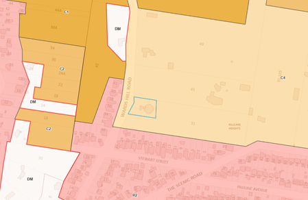
Figure 24. Land Use Zoning Map.
The CCLEP 2022 defines the development as:
Telecommunications facility means –
(a) any part of the infrastructure of a telecommunications network, or
(b) any line, cable, optical fibre, fibre access node, interconnect point equipment, apparatus, tower, mast, antenna, dish, tunnel, duct, hole, pit, pole, or other structure in connection with a telecommunications network, or
(c) any other thing used or in connection with a telecommunications network.
Telecommunication facilities are prohibited within the C4 Environmental Living zone.
The objectives of the C4 Environmental Living zone are as follows:
• To provide for low-impact residential development in areas with special ecological, scientific or aesthetic values.
• To ensure that residential development does not have an adverse effect on those values.
• To allow additional land uses that will not have an adverse impact on those values.
Insufficient information has been submitted by way of correctly surveyed fauna and flora in accordance with the minimum requirements of Table 2 of Council’s Flora and Fauna Guidelines 2019, and in response to Council’s request for information dated 6 October 2023. These additional surveys have not been conducted. No specific reasoning is given other than further surveys were not “considered necessary” due to the small area of habitat proposed to be cleared. Consequently, the Panel cannot be satisfied that the additional land use, being the telecommunications facility, does not have an adverse impact on the special ecological, scientific and aesthetic values as required by the Objectives of the zone.
The information submitted with the development application fails to demonstrate that the proposed development will satisfy the objectives of the C4 Environmental Living zone. The application is recommended for refusal on this basis (Refusal Reason 8a).
Permissibility
Clause 1.9 (1) states that the CCLEP 2022 is subject to the provisions of any State environmental planning policy that prevails over this Plan as provided by section 3.28 of the Environmental Planning and Assessment Act 1979.
Section 3.28(1) states that in the event of an inconsistency between environmental planning instruments, and unless otherwise provided, there is a general presumption that a State Environmental Planning Policy will prevail over the local environmental plan.
As discussed in the above body of this Report, the application is considered under the remit of Chapter 2, Part 2.3, Division 21 – Telecommunications and other communication facilities of the Transport and Infrastructure SEPP, which permits telecommunication facilities with consent.
General Controls and Development Standards (Parts 4, 5, 6 and 7)
The CCLEP 2022 contains controls relating to development standards, miscellaneous provisions and local provisions. An assessment against the relevant controls to the proposal are further set out in the Table below.
|
Clause |
Requirement |
Proposal |
Complies |
|
4.3(2) – Height of Buildings |
The site is not subject to prescribed building heights. |
N/A |
N/A |
|
4.4(2) – Floor Space Ratio |
The site is not subject to prescribed floor space ratios. |
N/A |
N/A |
|
5.10 – Heritage conservation |
The objectives of Clause 5.10 of the CCLEP are as follows: · To conserve the environmental heritage of the Central Coast, · To conserve the heritage significance of heritage items and heritage conservation areas, including associated fabric, settings and views, · To conserve archaeological sites, · To conserve Aboriginal objects and Aboriginal places of heritage significance. |
The site does not contain a heritage item nor is it located within a heritage conservation area.
The applicant has made reference to a report prepared by Kleinfelder Australia Pty Ltd to provide expert opinion on the potential impact on Aboriginal cultural heritage including a review of a due diligence report by Scribe and Geoarchaeological Report by Down to Earth relating to No. 31 Wards Hill Road, which does not relate to the subject site and cannot be relied upon for the purposes of this Clause.
Therefore, insufficient information has been provided to confirm the presence of Aboriginal objects and Aboriginal places of heritage significance and subsequently, its conservation. |
No - Refusal Reason 8b. |
|
7.1 – Acid Sulfate soils |
Pursuant to Clause 7.1 of the CCLEP, consent must not be granted until an ASS Plan in accordance with the Acid Sulfate Soils Manual has been prepared and provided to the Respondent.
|
The site is mapped as Class 5 acid sulfate soils. There is no known occurrence of acid sulfate soils. |
Yes |
|
7.6 - Essential Services |
Pursuant to Clause 7.6 of the CCLEP, essential services must be made available or adequate arrangements be made to make them available. |
The applicant has suitably demonstrated how essential services will be made available or adequate arrangements be made to make them available, including waste management during construction and ongoing operation of the proposed development. |
Yes |
SECTION 4.15(1)(a)(ii) – PROVISIONS OF ANY PROPOSED INSTRUMENTS
There are no draft instruments for consideration in this regard.
SECTION 4.15(1)(a)(iii) – PROVISION OF ANY DEVELOPMENT CONTROL PLAN
Central Coast Development Control Plan 2022
Chapter 1.2 – Notification of Development Proposals
The application was formally notified in accordance with the provisions of this Chapter. The application was placed on public exhibition from 12 May to 9 June 2023. It was re-notified on 30 June to 28 July 2023 to enable comment on a revised Environmental EME (Electromagnetic Energy) Report submitted and because of a technical error with Council’s DA tracker.
A total of 98 submissions were received, 64 in support and 34 objecting to the proposal on various grounds. The issues raised are discussed further in the report.
Chapter 2.13 – Transport and Parking
The proposed telecommunications facility does not generate any parking requirements under the provisions of this Chapter. No further consideration is required in this regard.
Chapter 2.14 – Site Waste Management
The objectives of this Chapter are listed as the following:
· Drive waste avoidance.
· Deliver a step change in diversion from landfill and build a circular economy.
· Strengthen triple bottom line outcomes.
· Enhance street and open space appeal.
The application is accompanied by a Waste Management Plan (Attachment 9) prepared by Jordan Leverington of Service Stream, dated 29 November 2022, and refers to the proposed construction of the telecommunications facility including a waste collection and storage area.
Part 2.14.2.4 specifies submission form and requirements which includes details about the site preparation works, construction works or the development type.
Accompanying DA documentation indicates that a total of 23 trees are nominated for removal however the applicant has failed to nominate these as waste for removal in accordance with Part 2.14.2.4(f) which requires the site plan to clearly indicate the following for site preparation works.
- Areas to be excavated or cleared (i.e. the 23 trees nominated for removal)
- The locations and dimensions of capture and consolidation bins and stockpiles.
- Travel paths of all materials and waste.
- Travel path of bins to collection point.
- Collection point location.
- The number and total area of bins to be presented at the collection point.
- Access paths for collection vehicles.
The accompanying plan also fails to provide the same for construction and occupancy phases of the proposed development.
Therefore, insufficient information is provided to enable proper assessment with regards to Chapter 2.14.2.4 of the Central Coast Development Control Plan, 2022, relating to the standard waste management submission form and requirements.
The Panel cannot be satisfied the requirements of Chapter 2.14.2.4 and the objectives which support them have been met, based on the information submitted within the application, and in this instance and the application is recommended for refusal on this basis (Refusal Reason 9a).
Chapter 2.17 Character and Scenic Quality
The objectives of this Chapter are stated as the following:
· Provide guidance in the assessment of development applications with regards to character and scenic value considerations.
· Maintaining the character and scenic quality of an area while considering the desired and likely future character of the area.
The subject site is located within the Bouddi character area which includes halftide rocks to Mourawaring Point, Wagstaffe, Daleys Point and Killcare Heights. The landscape character states the following:
Killcare Heights Landscape Unit consists of coastal suburb perched on the step midslopes of Bouddi Peninsula above Killcare Beach and surrounded by the spectacular natural landscapes of the Bouddi National Park.
Further, the Statement of Significance states:
The Killcare Heights Landscape Unit is of regional scenic significance because of the areas outstanding natural landscape.
The relevant Development Objectives as contained within the Scenic Quality and Character Statements are as follows:
1. Retain and enforce existing provisions contained within instruments and policies relating to the low-density nature of development in all landscape units.
7. Recognise importance of privately owned Environmental/Conservation zoned land in providing a complimentary land system to and a buffer area for COSS lands and National Parks.
The site is not subject to prescribed maximum building heights under Clause 4.3(2) of the CCLEP 2022, therefore Council would rely upon an evidenced based approach for the preparation of a suitably prepared visual impact assessment that enables characterization of the landscape as an object, to inform an objective judgement about the proposal’s impact, and therefore be satisfied that the development objectives listed above have been satisfied.
As discussed in the above body of this Report, the Visual Impact Assessment, prepared by Urbis dated 27 September 2022, is based on irrelevant and unrelated guidance notes. Consequently, Council cannot be satisfied that the proposed height against the vegetated landscape in which it exists is acceptable and that the development objectives have been satisfied.
Notwithstanding this, should the Panel be of a mind to accept the VIA, the Report recommends that consideration should be given to a revised design which provides for better integration within the setting, including comprising ‘a monopole topped with slimmer profile headframes and antennae’ on page 19. There is no discussion of this recommendation in the accompanying and revised SEE and no change to the design has since been made in response.
Based on the above, the application has not demonstrated that Objectives 1 and 7 of the Scenic Quality and Character Statement relating to Killcare Heights as contained within the CCDCP 2022 has been satisfied. The application is recommended for refusal on this basis (Refusal Reason 9b).
Chapter 3.5 Tree and Vegetation Management
The objectives of this Chapter are stated as the following:
· To declare certain vegetation to be vegetation to which Part 2.3 of the State Environmental Planning Policy (Biodiversity and Conservation) 2021 Chapter 2 Vegetation in Non-Rural Areas applies), such that a permit from the Council is required to remove that vegetation.
· To protect trees on privately owned land that contribute positively to the amenity, scenic landscape characteristics and ecological values of the Central Coast Local Government Area.
· To facilitate the removal of undesirable species, weeds, dangerous trees and inappropriate plantings, and to encourage their replacement with suitable local native species.
· To minimise unnecessary injury to, or destruction of, trees and vegetation.
Council’s Tree Assessment Officer has reviewed the proposed development and removal of nominated trees, in addition to those nominated for retention and protection. Council’s Tree Assessment Officer accepts the proposed development with regards to the provisions of this Chapter.
Chapter 3.6 Heritage Conservation
The objectives of this Chapter are stated as the following:
a Conserve heritage items and Heritage Conservation Areas
b Ensure that significant items and places retain their important character, fabric and setting
c Establish a framework for detailed heritage and conservation planning for the Central Coast
d Ensure that Aboriginal Cultural Heritage and archaeology are taken into due consideration during the development process
e Promote new development that is sympathetic to the identified heritage significance
f Maximise the retention of heritage items, Heritage Conservation Areas and contributory items
g Provide controls for encouraging contemporary design sympathetic with the identified heritage significance
h Enable appropriate and expert consideration to be given by Applicants and Council for development relating to heritage assets
i Provide incentives for owners of properties that are listed as individual heritage items or located in a Heritage Conservation Area
j Facilitate the implementation of the objectives and provisions relating to heritage conservation which are contained within Central Coast LEP 2022.
Part 3.6.1.4 of the CCDCP 2022 requires Applicants to conduct and submit a due diligence assessment for Aboriginal Objects and consider any draft amendments to the LEP which may relate to heritage items. Further, if the site is a heritage item or located within a Heritage Conservation Area, Applicants must refer to clause 5.10 of the LEP and to this Chapter for the relevant provisions.
The Panel is advised that the site is not listed as a heritage item or located within a Heritage Conservation Area.
Notwithstanding this, the Applicant was requested on 6 October 2023 to provide a due diligence assessment relating to Aboriginal Cultural Heritage. Service Stream advised on 15 January 2024 that Kleinfelder Australia Pty Ltd had been engaged to provide an expert opinion on the potential impact on Aboriginal cultural heritage including a review of a due diligence report by Scribe and Geoarchaeological that was prepared for the adjoining allotment at No. 31 Wards Hill Road (Attachment 10).
The Panel is advised that this opinion and accompanying due diligence report cannot be relied upon to satisfy the requirements of Part 3.6.1.4 as it does not relate to the subject site. Therefore, insufficient information has been submitted to enable proper assessment with regards to Part 3.6.1.4 of the CCDCP 2022 in relation to heritage conservation and the objectives which support them. The application is recommended for refusal on this basis (Refusal Reason 9c).
SECTION 4.15(1)(a)(iiia) – PLANNING AGREEMENTS UNDER SECTION 7.4 OF THE EP&A ACT
There are no planning agreements or draft planning agreements entered into, or proposed for the site. No further consideration is required in this regard.
SECTION 4.15(1)(a)(iv) – PROVISIONS OF REGULATIONS
Section 9B Council-related development applications
The Conflict-of-Interest Regulation took effect on 3 April 2023.
Clause 9B(2) of Schedule 1 to the EP&A Act defines council-related development applications to mean:
‘…a development application, for which a council is the consent authority, that is –
(a) Made by or on behalf of the council, or
(b) For development on land –
(i) For which council is an owner, a lessee or a licensee, or
(ii) Otherwise vested in or under the control of the council’.
The subject site to which this application relates is Council owned land.
Accordingly, and for the purposes of Section 2.22 of the EP&A Act, Clause 9B(1) of Schedule 1 requires that the minimum public exhibition period for a council-related development application is 28 days.
Council has satisfied this minimum requirement with each respective notification period.
The application does not have a management strategy as it was determined that one was not required given the application would be determined by the Local Planning Panel, removing any concerns relating to the assessment functions of council.
SECTION 4.15(1)(b) – LIKELY IMPACTS OF DEVELOPMENT
Killcare Heights is coastal suburb perched on the step midslopes of Bouddi Peninsula above Killcare Beach and surrounded by the spectacular natural landscapes of the Bouddi National Park. Killcare Heights is recognised as being of regional scenic significance due to the areas of outstanding natural landscape.
The subject site itself is zoned C4 Environmental Living under the CCLEP 2022 and is surrounded by fringe pockets of National Park and Nature Reserves, large rural residential lots, and low density suburban residential zoning. The subject site is Council-owned operational land and currently used for infrastructure services.
The likely impacts from the proposed development including environmental impacts on both the natural and built environments, and social and economic impacts in the locality must therefore be considered for the Panel to be satisfied that these are acceptable for consent to be granted.
To the detriment of the Applicant, insufficient information has been submitted to enable proper consideration of potential short and long-term impacts relating to flora and fauna, EME, and Aboriginal cultural heritage matters. The application is recommended for refusal on this basis (Refusal Reason 11).
Economic Impacts
The proposed development is argued to have beneficial economic impacts bringing reliable communication services to the locality, boosting stability and ease of communication and trading services throughout the local economy.
Social Impacts
The proposed development has the potential to provide greater range and quality mobile phone coverage for the residents of Killcare Heights, Killcare, Box Head, Hardy’s Bay, Wagstaff, Booker Bay and Ettalong. This will facilitate improved communication between residents, businesses, government, and support services, in turn resulting in beneficial social, health and safety, emergency, financial, technological, educational, cultural, tourism and leisure impacts.
Approval of the application has not been demonstrated to be in the public interest, on the basis of insufficient information as set out in this report.
Any Submission made in Accordance with this Act or Regulations
As previously discussed, the application was notified in accordance with Central Coast Development Control Plan 2022, Chapter 1.2 -Notification of Development Proposals and Schedule 1 of the EP&A Act. The Submissions in favour supported the application on the basis that it will significantly improve mobile phone coverage in the area, facilitating improved communication amongst the community as well as businesses. Many submissions raised concerns about the lack of phone coverage currently available, which increases risks during health emergencies and natural disasters. Several submissions pointed out that there was currently no service available at all in their area.
Key issues raised in objections are detailed below:
Visual impact
Most objections raised concern regarding the visual impact of the tower, arguing that it is too high and entirely out of character with the surrounding residential and bushland environment. Several submissions stated that Wards Hill Road is an important scenic route for tourists, and the Bouddi Peninsula is of regional environmental significance. Locating a mobile phone tower in this location will significantly diminish these scenic and environmental values. The ability to screen the facility, especially along the Wards Hill Road frontage, was strongly questioned.
Council response
Insufficient information has been provided to enable proper assessment to demonstrate that the proposed tower will not have a negative or detrimental visual impact on the surrounding area when seen from various points within the immediate locality and beyond. Whilst there are no prescribed height controls as required by Clause 4.3(2) of the Central Coast Local Environmental Plan 2022, there remains a likely consequence of the proposed height through its visual impacts to directly adjoining properties and further beyond.
As discussed in the above body of this Report, the consent authority cannot be satisfied that the proposed telecommunications facility has been designed and sited to minimise visual impact as the Visual Impact Assessment, prepared by Urbis dated September 2022, relies upon irrelevant guidance notes unrelated to the subject development typology, and fails to provide a specific and accurate understanding of which trees and/or vegetation exist immediately surrounding and further beyond the proposed development site, and the value these add to the landscape.
The application is recommended for refusal on this basis (Refusal Reason 4b).
Health impacts
The potential health impacts of EME levels from the tower were raised in many of the objections, with many arguing that the tower should not be located as close to residential properties as proposed. Various additional reports were submitted in support of concerns regarding the adverse health impacts of EME radiation.
Council Response
In response to queries raised in the submissions, Council requested the applicant revise the EME report to provide further details relating to “Calculated EME levels at other areas of interest”, including considering potential future height increases of affected dwellings that may occur. A revised EME report was submitted on 15 January 2024.
This document was published on Council’s DA tracker and made available for review and comment.
Further submissions received after this date again raised concerns regarding the impact to human health.
To ensure that Council has adequately and suitably assessed the revised EME Report and potential exposure to surrounding residential properties it would need to engage a suitably qualified and independent expert to peer review the Report and be satisfied that the proposed development is acceptable and in accordance with ARPANSA requirements. As the Applicant has requested an expedited finalization of the assessment and determination, Council has not had the opportunity to further consider this matter and request further information in response to these particulars. Therefore, the consent authority has insufficient information is available to enable proper assessment with regards to the impact of EME to human health (Refusal Reason 5).
Many of the objections argued that the monopole tower/base station proposed is not justified and that small cell towers, which would have significantly less visual and other impacts, should be provided instead.
In response, Council requested the applicant to provide advice as to why a base station is considered the best suited technology in this instance rather than other, more discreet technologies such as small cell towers. The applicant advised as follows:
Small cells are not considered a feasible option because they cannot provide a suitable level of service. Whilst small cell facilities would likely be Low Impact (in accordance with the Telecommunications (Low-impact Facilities) Determination 2018, small cells will not provide an acceptable network outcome over this large, undulating and heavily vegetated area. Small cells only have a footprint of a few hundred meters. They only work effectively where there is already core mobile service from a macro site (such as a monopole or tower); they work to supplement the coverage produced by a macro site in specific locations where there is high demand or a very specific blackspot. They are not a replacement for full size base stations.
Council response
Until such time that Council has the relevant technical expertise to undertake a qualitative assessment of alternative technologies against the proposed tower, or engage a suitably qualified and independent expert to do the same, Council is not in a position to form a view on this matter.
Tree removal and biodiversity impacts
The need for extensive tree removal and potential impacts on flora and fauna were highlighted as issues of concern in objections in relation to those which may result from EME.
Council response
As discussed in the above body of this Report and in accordance with the assessment required by the Biodiversity Conservation Act 2016 insufficient information has been provided to enable proper assessment with regards to tree removal and resultant biodiversity impacts pertaining to flora and fauna.
The application is recommended for refusal on the basis (Refusal Reasons 1 and 2).
Other issues
A range of other concerns were raised in the submissions which are considered in the table below.
|
ISSUE |
RESPONSE |
|
DA documentation is inadequate and/or does not meet statutory requirements. |
Agreed.
Insufficient information has been provided to enable proper assessment under the following pieces of legislation and supporting plans:
· Biodiversity Conservation Act 2016 · Chapter 2 of the State Environmental Planning Policy (Biodiversity Conservation) 2021 · Section 2.143(2) of the State Environmental Planning Policy (Transport and Infrastructure) 2021 · The objectives of the C4 Environmental Living zone and Clause 5.10 as contained within the Central Coast Local Environmental Plan 2022 and · Various provisions contained within the Central Coast Development Control Plan 2022.
These form various reasons for refusal as referred to within Attachment 1. |
|
The proposed tower will not achieve adequate coverage/will not satisfactorily address current deficiency in service. |
Until such time that Council has the relevant technical expertise to undertake a qualitative assessment of coverage of proposed technologies or engage a suitably qualified and independent expert to do the same, Council is not able to form a view on this matter. However, the information provided by the applicant advises of adequate coverage. |
|
Construction impacts are likely to be significant. Large crane and heavy vehicles will be in operation within areas of vegetation. |
Agreed.
Insufficient and inconsistent information has been provided to enable proper assessment with regards to existing flora and fauna and subsequent impacts resulting from the proposed development, discussed at length above, and forms various reasons for refusal. |
|
Impact on Aboriginal cultural heritage |
Agreed.
Insufficient information is provided to enable proper assessment with regards to impacts on Aboriginal cultural heritage, discussed at length above and forms a reason for refusal in this instance. |
|
Inadequate community consultation |
Disagree.
Council is satisfied that the proposed development has been notified in accordance with Council’s Community Participation Plan and Chapter 1.2 of the CCDCP 20222 and Schedule 1 of the EP&A Act. |
|
The proposed development includes a generator and air conditioning units. No acoustic assessment has been provided. |
No acoustic report has been provided that demonstrates that any mechanical plant and equipment noise result in negative impacts to surrounding residential development relating to both construction and ongoing operational use.
Notwithstanding this, should the Panel be of a mind to approve the development, Council can impose a condition including the requirement for an acoustic report to be prepared and submitted to Council, prior to the issue of a Construction Certificate for the approved development. |
|
The proposed development is located on bushfire prone land and has been identified as ‘high risk’. 10m APZ on western boundary cannot be achieved. |
The RFS has recommended a 10m APZ, ‘excepting where limited by property boundaries’. This is the case with respect to any APZ to the west, given the proximity of the proposed development to the boundary with the road reserve. A condition is proposed requiring landscaping within the 10m APZ be managed in accordance with the RFS requirements. |
|
The proposed development is inconsistent with the ‘precautionary principle’ |
Refer discussion below. |
|
The proposal does not comply with Zone C4 setbacks as set out in the CCDCP 2022. |
No setbacks are prescribed for utilities under the relevant Guidelines of the SEPP. |
Submissions from Public Authorities
CASA (The Civil Aviation Safety Authority)
The application was referred to CASA who responded to advise that CASA has reviewed the proposal and that the proposed tower is determined to not be a hazard to aircraft operations and will not require marking or lighting.
CASA has no objection to the proposal.
Darkinjung Local Aboriginal Land Council
No response received.
NSW Rural Fire Service
The application was referred to the NSW RFS on 2 May 2023 seeking advice regarding bushfire protection for the proposed development in accordance with section 4.14 of the Environmental Planning and Assessment Act 1979.
The NSW RFS considered the information and provided a set of recommended conditions on 4 May 2023.
Ausgrid
The application was referred to Ausgrid who advised that Ausgrid has no affected assets near the proposed development and that the agency has no objection to the installation of the proposed telecommunications facility.
Internal Consultation
|
Urban Designer |
|
|
Supported. |
|
|
Tree Assessment Officer |
|
Supported. |
||
|
Water and Sewer |
|
Supported. |
||
|
Environmental Health Officer |
|
|
Supported. |
|
|
Ecologist |
|
|
Insufficient information. |
|
Ecologically Sustainable Principles:
The proposal has been assessed having regard to ecologically sustainable development principles. As detailed under the Act, Ecologically Sustainable Development can be addressed through the implementation of the following principles:
a) the precautionary principle, namely, that if there are threats of serious or irreversible environmental damage, lack of full scientific certainty should not be used as a reason for postponing measures to prevent environmental degradation.
As demonstrated throughout this report, potential and/or actual impacts have not yet been fully realised nor considered and mitigated where a known risk is present. Insufficient information has been submitted that demonstrates the precautionary principle has been adopted in the selection of options. Consequently, the Panel cannot be satisfied that the proposed development is unlikely to have serious or irreversible damage to flora, fauna and human life.
b) inter–generational equity, namely, that the present generation should ensure that the health, diversity and productivity of the environment are maintained or enhanced for the benefit of future generations.
Due to insufficient and inconsistent information received by Council, the Panel cannot yet be satisfied that favourable consideration of the proposal would not result in adverse impacts on the health, diversity or productivity of the environment for future generations.
As stated on the ARPANSA website itself, ARPANSA is continuing to conduct studies to ‘assess EME exposure from existing and new telecommunications technologies like 5G’, in 2024. The aim of the studies will include, but not be limited to, the cumulative exposure from different telecommunications sources and how does EME exposure change over time, with the introduction of 5G.
‘ARPANSA will publish the results of these studies to inform the community on EME exposure levels’.
These studies are not yet released and the documentation accompanying the application including the amended ‘Environmental EME Report’ dated 27 October 2023 cannot be relied upon to demonstrate there will be no adverse impacts upon the health, diversity or productivity of the environment.
c) conservation of biological diversity and ecological integrity, namely, that conservation of biological diversity and ecological integrity should be a fundamental consideration.
Insufficient information has been submitted to enable proper assessment under Section 7.3 of the Biodiversity Conservation Act 2016 and therefore, the Panel cannot be satisfied that the conservation of biological diversity and ecological integrity is maintained as a result of the proposed development.
d) improved valuation, pricing and incentive mechanisms, namely, that environmental factors should be included in the valuation of assets and services.
Environmental factors and costs have been included by the applicant in evaluating the preferred site. Notwithstanding this, and as discussed throughout the Report, insufficient information has been submitted pertaining to the flora and fauna surveying and assessment, so the Panel cannot be satisfied that the assessment has examined the environmental consequences of the proposal in totality with a view to managing the potential for adverse impacts.
Environmental resources have not been given an appropriate valuation in this instance.
Climate Change
The potential impacts of climate change on the proposed development have been considered by Council as part of its assessment of the application.
This assessment has included consideration of such matters as potential sea level; potential for more intense and/or frequent extreme weather conditions including storm events, bushfires, drought, flood and coastal erosion; as well as how the proposed development may cope, combat, withstand these potential impacts and is considered satisfactory in relation to climate change.
Other Matters for Consideration:
Development Contributions
The proposed development is a development type that is subject to section 7.12 development contributions under the Contribution Plan as the cost of works amount to that larger than $200,000 threshold. Relevant conditions can be included as part of any consent issued.
Water and Sewer Contributions
There are no water and sewer contributions applicable to the proposed development.
Conclusion
The proposed development has been assessed using the heads of consideration under Section 4.15 of the Environmental Planning and Assessment Act 1979. The application does not contain sufficient information for the consent authority to be satisfied that the development satisfactorily meets the requirements various pieces of applicable legislation including: Section 7.3 of the Biodiversity Conservation Act 1999 and the “NSW Threatened Species Test of Significance Guidelines” or Chapter 2 of the State Environmental Planning Policy (Biodiversity and Conservation) 2021, nor the prescribed requirements of the CCLEP 2022 or standards contained within the CCDCP 2022.
As such, it is recommended that the proposed development be REFUSED for the reasons set out below:
1. Pursuant to Section 7.3 of the Biodiversity Conservation Act 2016 and the “NSW Threatened Species Test of Significance Guidelines”, the proposed development fails to provide sufficient information to enable proper assessment including ‘Tests of Significance’ for 15 fauna that were assessed as having habitat on the site, and including any species detected during additional field survey including the Glossy Black Cockatoo.
2. Pursuant to Table 2 of Central Coast Council’s Flora and Fauna Guidelines 2019, insufficient information has been provided to enable proper assessment under the Biodiversity Conservation Act 2016 in addition to enabling proper assessment with regards to the potential and likely impact on fauna and flora from electromagnetic emissions from telecommunications towers.
3. Pursuant to Chapter 2 of the State Environmental Planning Policy (Biodiversity and Conservation) 2021, insufficient information has been provided to enable proper assessment with regards to the removal of vegetation in non-rural areas in response to a Council request for information dated 6 October 2023 in addition to inconsistent information contained within the Section 4.1 of the revised ecology report provided by Eco Logical and dated December 2023.
4. Pursuant to Section 2.143(2) of the State Environmental Planning Policy (Transport and Infrastructure) 2021 and Principle 1 contained within the NSW Telecommunications Facilities Guideline, Including Broadband (NSW Department of Planning and Environment, October 2022), the Panel cannot be satisfied that the proposed telecommunications facilities has been designed and sited to minimise visual impact in accordance with:
a. Principle 1(h) as inconsistent information is contained within the amended Tree Retention and Landscape Plan, dated October 23 and the amended Ecological Report prepared by Eco Logical and dated 13 December 2023.
b. Principle 1(m) as the Visual Impact Assessment prepared by Urbis and dated 22 September 2022 relies upon irrelevant guidance notes and does not provide a specific and accurate understanding of which trees or vegetation is to be retained or removed to facilitate the proposed development nor the visual impacts of the proposed development resulting from such works, nor does it undertake an assessment from within the surrounding residential properties.
5. Pursuant to Section 2.143(2) of the State Environmental Planning Policy (Transport and Infrastructure) 2021 and Principle 2(e) contained within the NSW Telecommunications Facilities Guideline, Including Broadband (NSW Department of Planning and Environment, October 2022) as insufficient information has been submitted to enable proper assessment and determine that resultant cumulative levels of radio frequency emissions are within the maximum human exposure levels set out in RPS.
6. Pursuant to Section 2.143(2) of the State Environmental Planning Policy (Transport and Infrastructure) 2021 and Principle 4 contained within the NSW Telecommunications Facilities Guideline, Including Broadband (NSW Department of Planning and Environment, October 2022), the Panel cannot be satisfied that the proposed telecommunications facility minimises disturbance and risk whilst maximizing compliance in accordance with
a. Principle 4(m) as insufficient information has been submitted to enable proper assessment and demonstrate that the proposed development will minimise disturbance to flora and fauna and restore land to a condition similar to that before the proposed work is carried out.
b. Principle 4(l) as insufficient information has been provided including ‘Tests of Significance’ for 15 identified fauna assessed as having habitat on the site to identify potential impacts and avoid disturbance to these, where possible.
c. Principle 4(m) as insufficient information has been provided to identify the likelihood of harming an Aboriginal place and/or Aboriginal object.
7. Pursuant to Section 2.143(2) of the State Environmental Planning Policy (Transport and Infrastructure) 2021 and Principle 5(b) contained within the NSW Telecommunications Facilities Guideline, Including Broadband (NSW Department of Planning and Environment, October 2022), the applicant has failed to provide a suitable alternative site assessment.
8. Pursuant to Section 4.15(1)(a)(i) of the Environmental Planning and Assessment Act 1979, the proposed development is inconsistent with the Central Coast Local Environmental Plan, 2022 as:
a. insufficient information has been submitted by way of correctly surveyed fauna and flora to satisfy the Panel that the additional land use does not have an adverse impact on the special ecological, scientific and aesthetic values of the site, as required by the objectives of the C4 Environmental Living zone.
b. insufficient information has been provided to confirm the presence of Aboriginal objects and Aboriginal places of heritage significance and subsequently, its conservation as required by Clause 5.10(2).
9. Pursuant to Section 4.15(1)(a)(iii) of the Environmental Planning and Assessment Act 1979, the proposed development is inconsistent with the Central Coast Development Control Plan, 2022 as:
a. insufficient information is provided to enable proper assessment with regards to Chapter 2.14.2.4 of the Central Coast Development Control Plan, 2022, relating to the standard waste management submission form and requirements.
b. Insufficient information has been provided indicating that the proposed development satisfies Development Objectives 1 and 7 of the Scenic Quality and Character Statement relating to Killcare Heights.
c. insufficient information has been submitted to enable proper assessment with regards to Part 3.6.1.4 in relation to Aboriginal cultural heritage conservation and the objectives which support them.
10. Pursuant to Section 4.15(1)(b) of the Environmental Planning and Assessment Act 1979, insufficient information has been submitted to enable proper consideration of potential short- and long-term impacts on nominated flora and fauna, in addition to those from EME, and Aboriginal cultural heritage resulting from the proposed development.
11. For the reasons stated above, and pursuant to Section 4.15(1)(e) of the Environmental Planning and Assessment Act 1979, it is considered that the application does not contain sufficient information for the consent authority to be satisfied that the development is in the public interest.
|
1⇩ |
Denny v Optus Mobile Pty Ltd [2023] NSWLEC 27 |
|
D16367175 |
|
2⇩ |
Owners consent - 37 WARDS HILL~ - PAN-278500 - DA36232022.pdf |
|
D16367186 |
|
3⇩ |
Flora and Fauna Covering Letter |
|
D15411421 |
|
4⇩ |
Flora and Fauna Assessment Report |
|
D15411424 |
|
5⇩ |
Bushfire Report |
|
D15425581 |
|
6⇩ |
Tree Retention - Landscape Plan |
|
D15611741 |
|
7⇩ |
Amended Ecological Australia Report |
|
D16026811 |
|
8⇩ |
Revised Statement of Environmental Effects |
|
D15611749 |
|
9⇩ |
Waste Management Plan |
|
D15611744 |
|
10⇩ |
Archaeology Peer Review |
|
D16354457 |
|
11⇩ |
Amended EMER Report |
|
D16026807 |
|
12⇩ |
Architectural Plans |
|
D15411418 |
|
3.1 |
DA3623/2022 - 37 Wards Hill Rd Killcare Heights - Telecommunications Facility |
|
Attachment 1 |
Denny v Optus Mobile Pty Ltd [2023] NSWLEC 27 |
|
DA3623/2022 - 37 Wards Hill Rd Killcare Heights - Telecommunications Facility |
|
|
Attachment 2 |
Owners consent - 37 WARDS HILL~ - PAN-278500 - DA36232022.pdf |

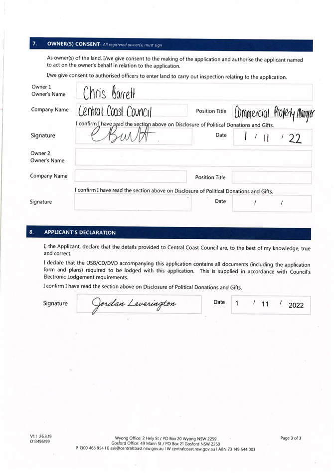
|
DA3623/2022 - 37 Wards Hill Rd Killcare Heights - Telecommunications Facility |
|
|
Attachment 3 |
Flora and Fauna Covering Letter |
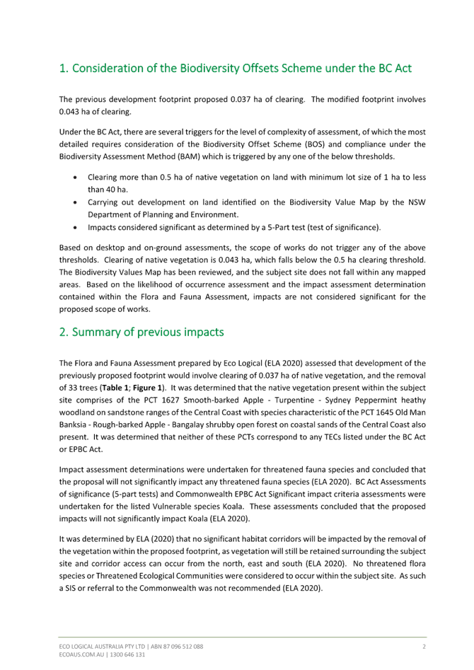
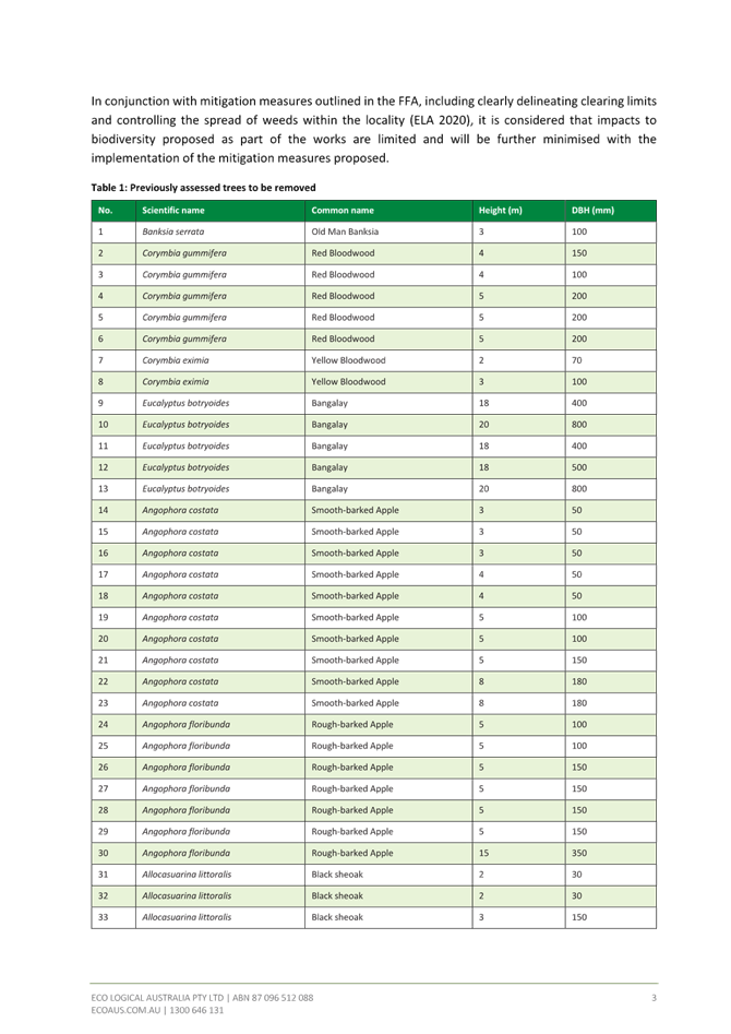
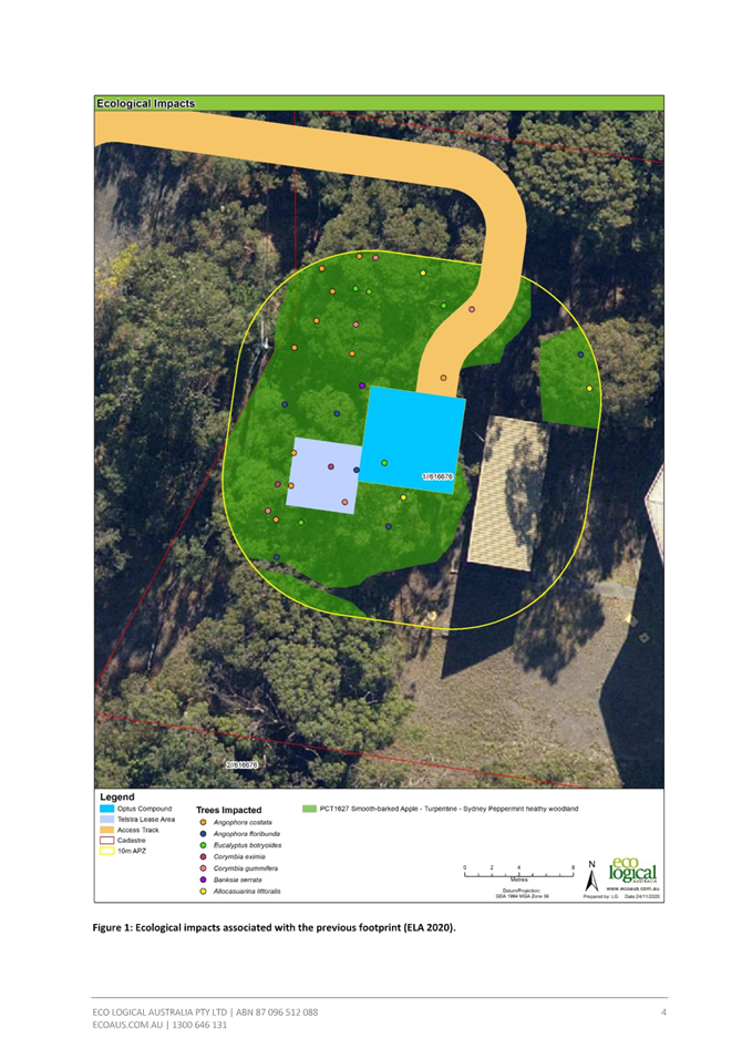
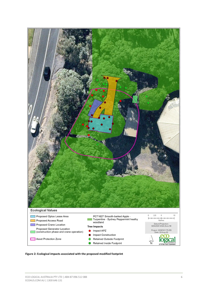
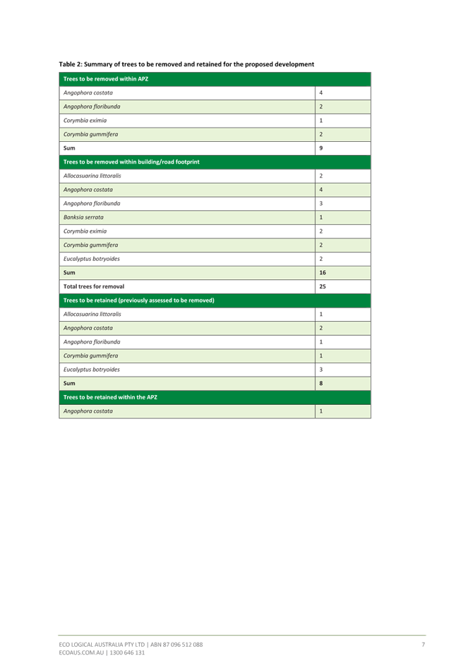
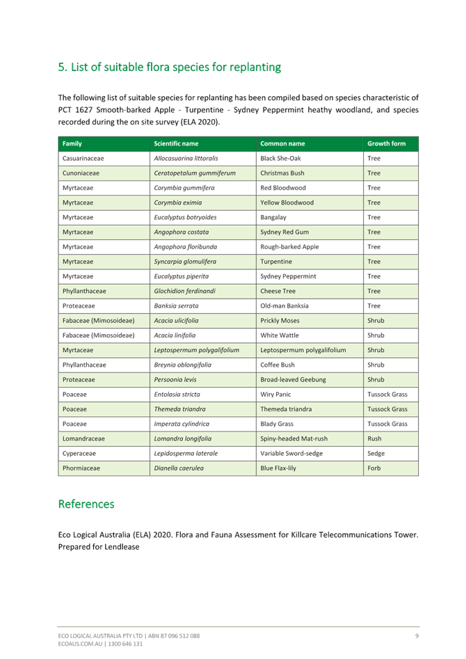
|
DA3623/2022 - 37 Wards Hill Rd Killcare Heights - Telecommunications Facility |
|
|
Attachment 4 |
Flora and Fauna Assessment Report |

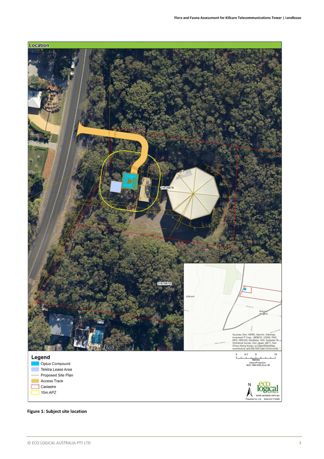
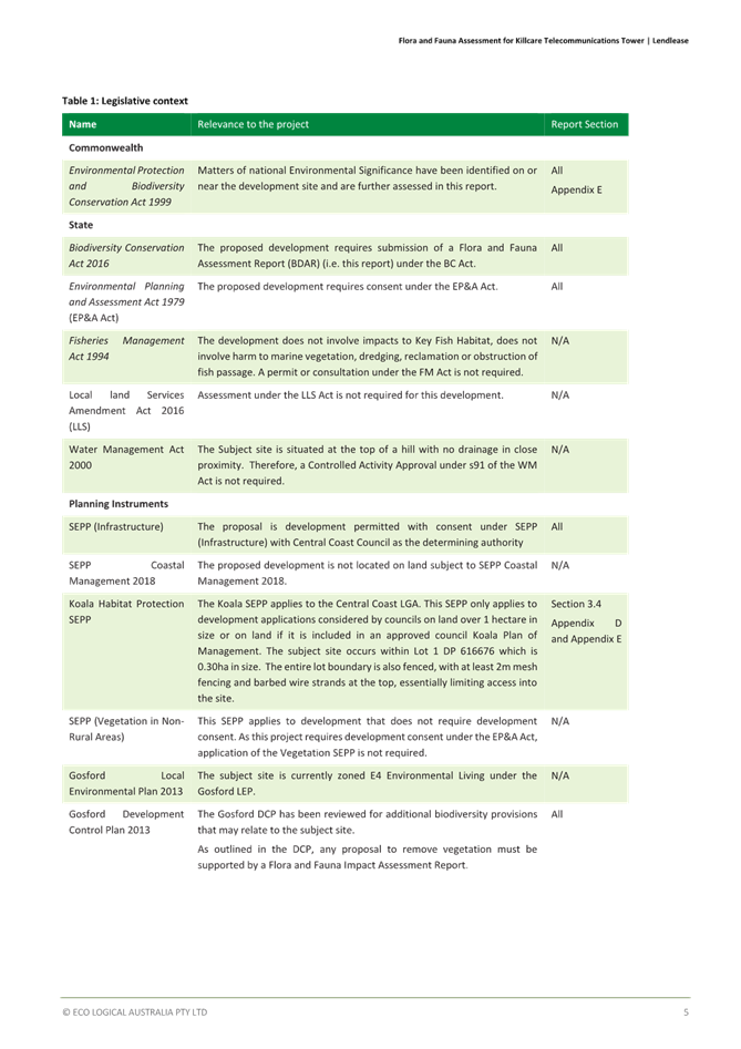
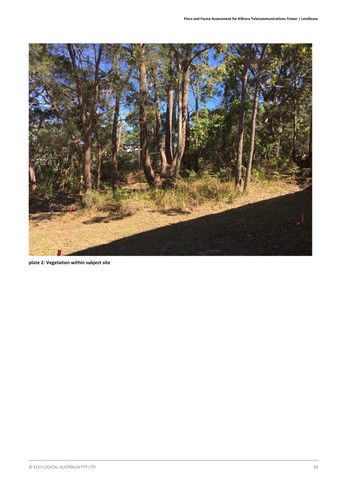
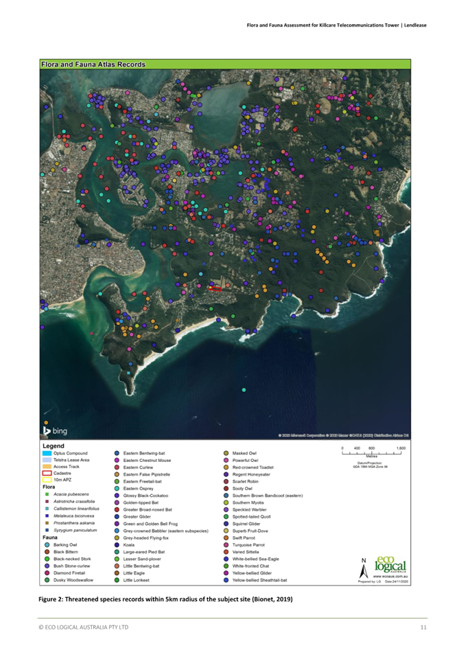
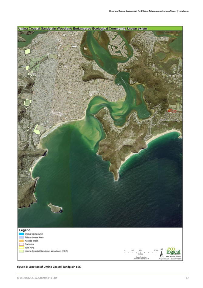
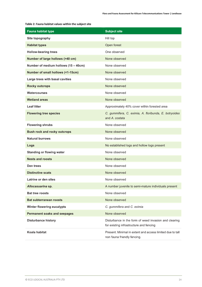
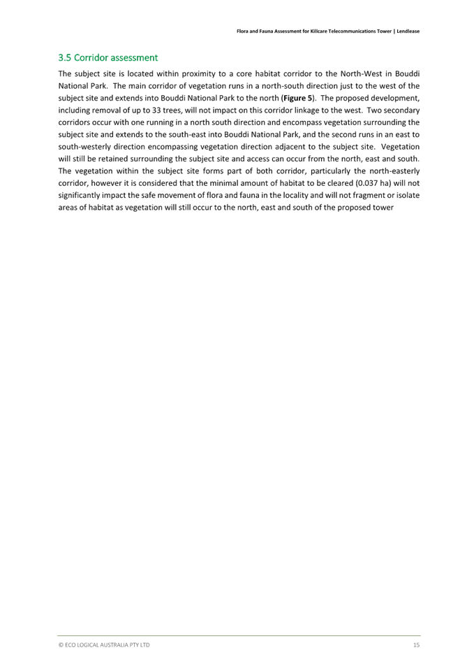

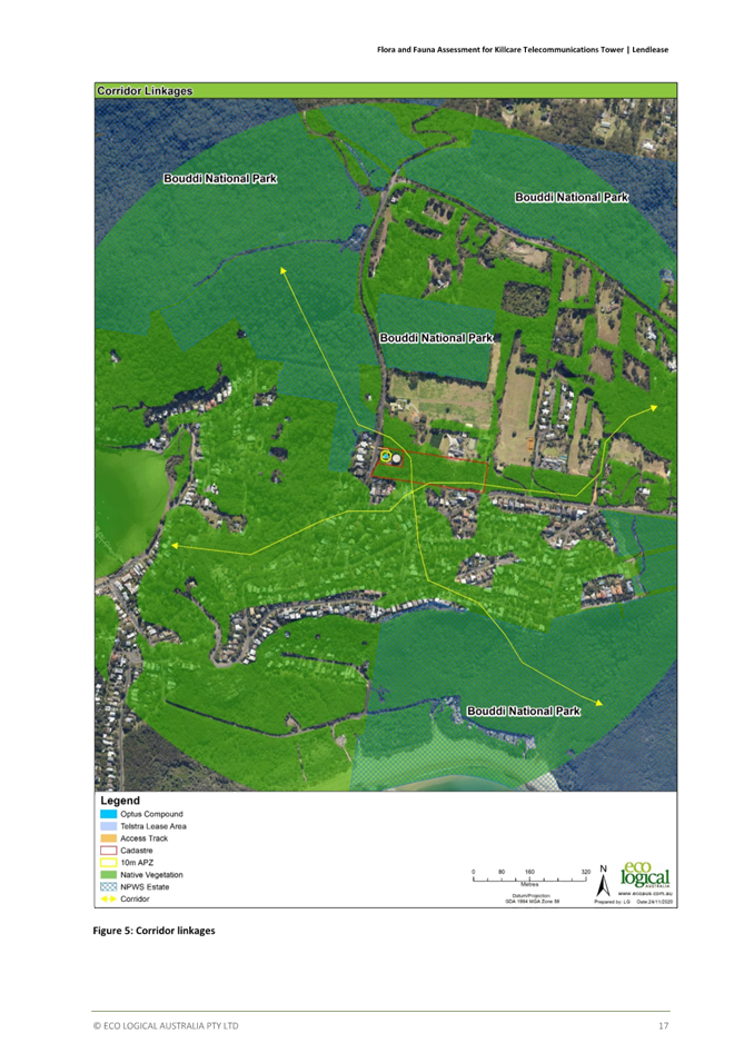
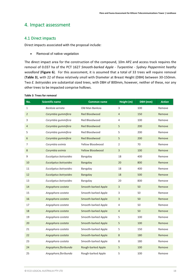
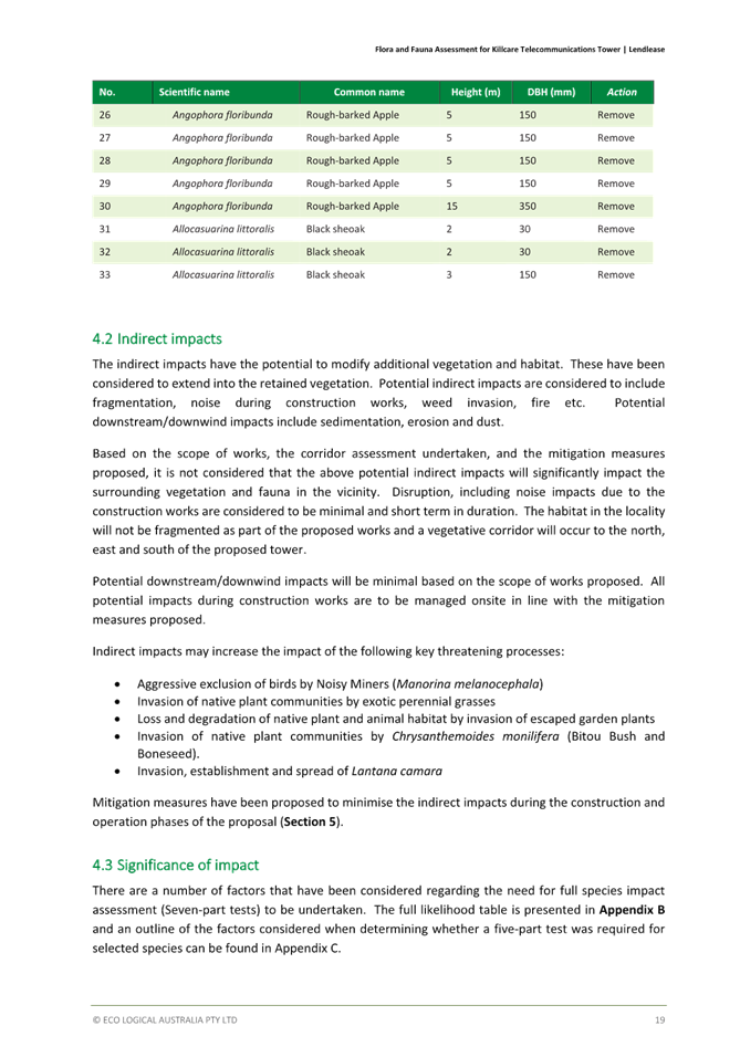
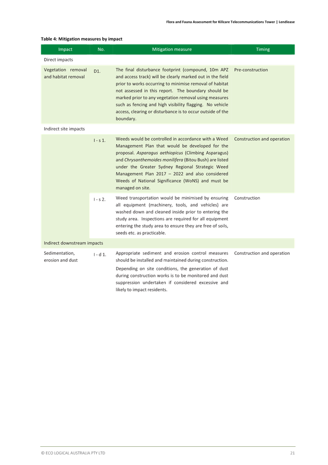
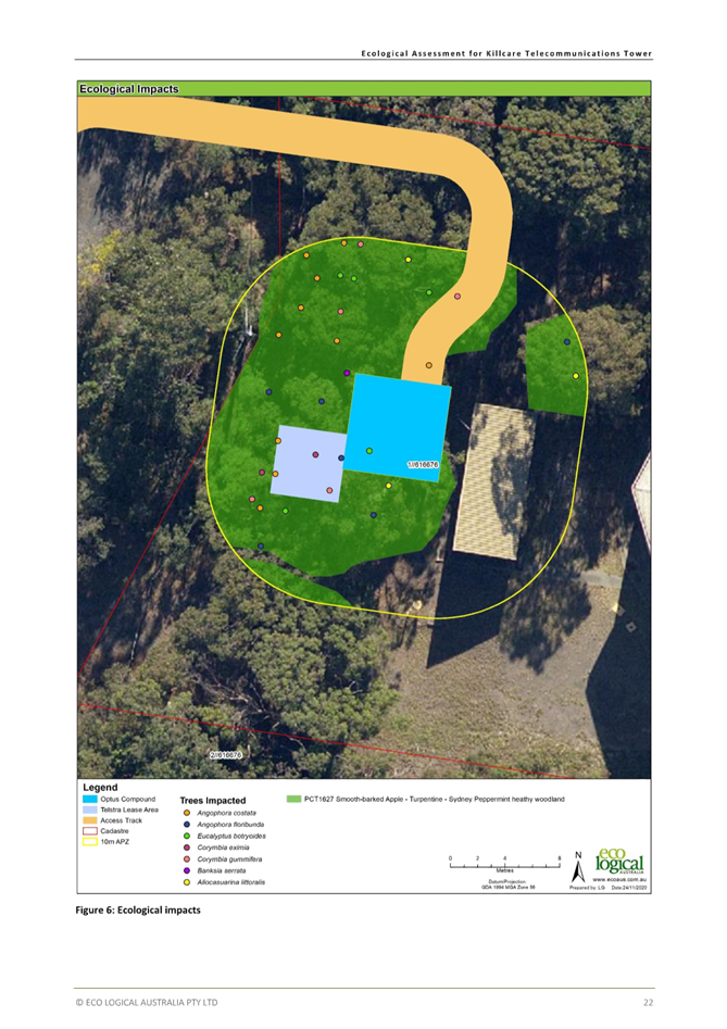

|
DA3623/2022 - 37 Wards Hill Rd Killcare Heights - Telecommunications Facility |
|
|
Attachment 5 |
Bushfire Report |
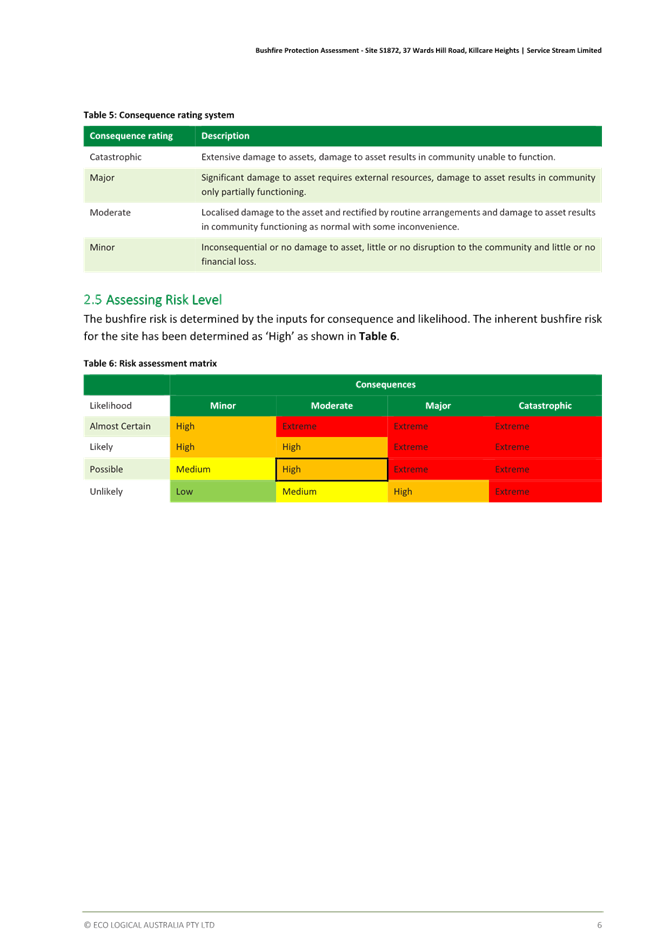

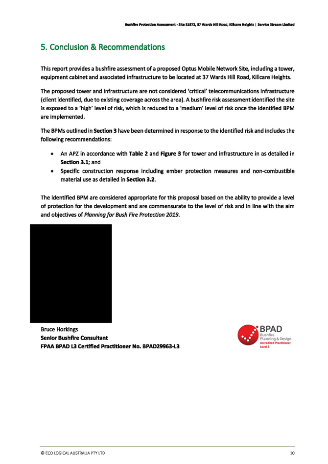

|
DA3623/2022 - 37 Wards Hill Rd Killcare Heights - Telecommunications Facility |
|
|
Attachment 6 |
Tree Retention - Landscape Plan |


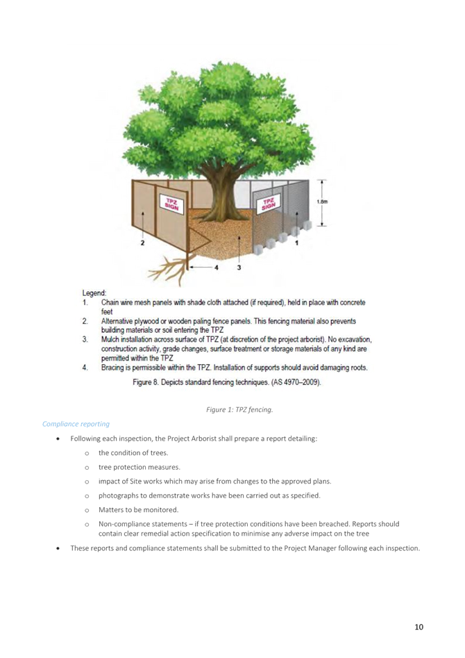

|
3.1 |
DA3623/2022 - 37 Wards Hill Rd Killcare Heights - Telecommunications Facility |
|
Attachment 7 |
Amended Ecological Australia Report |

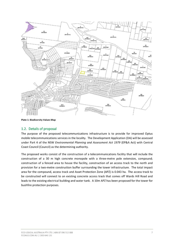


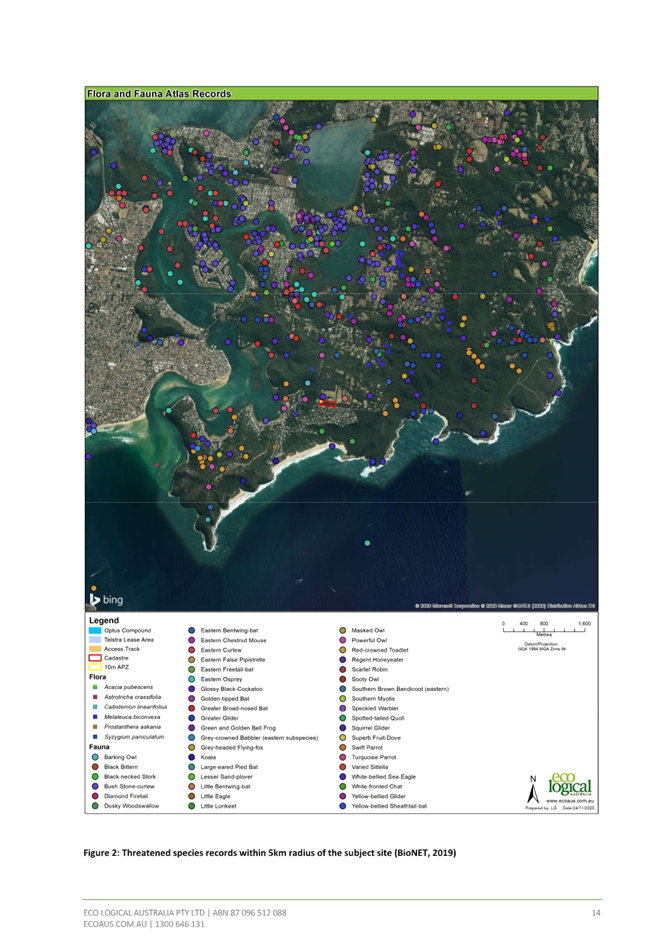
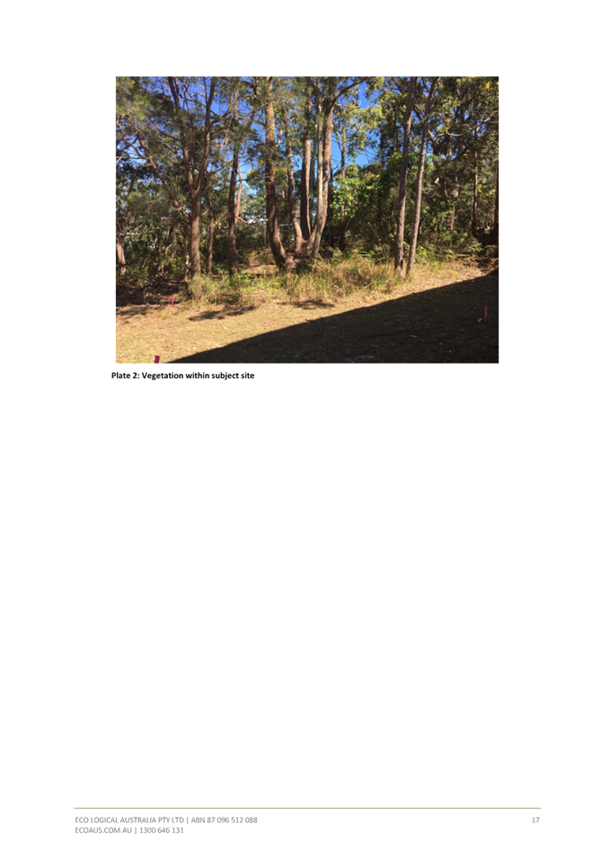
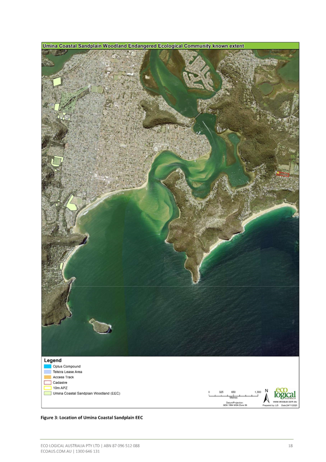

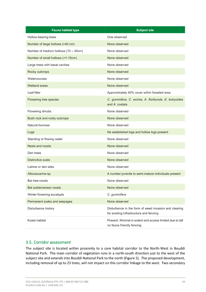
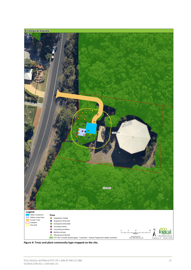
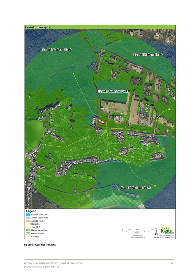
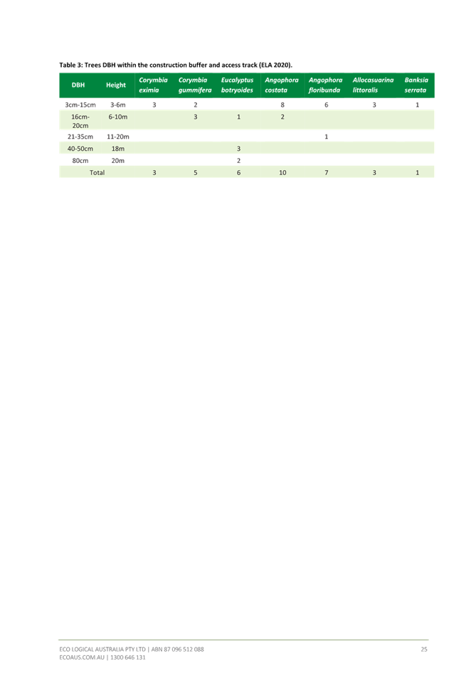
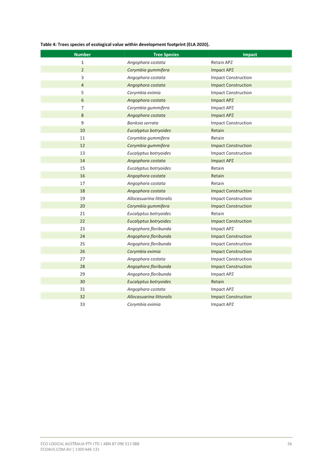
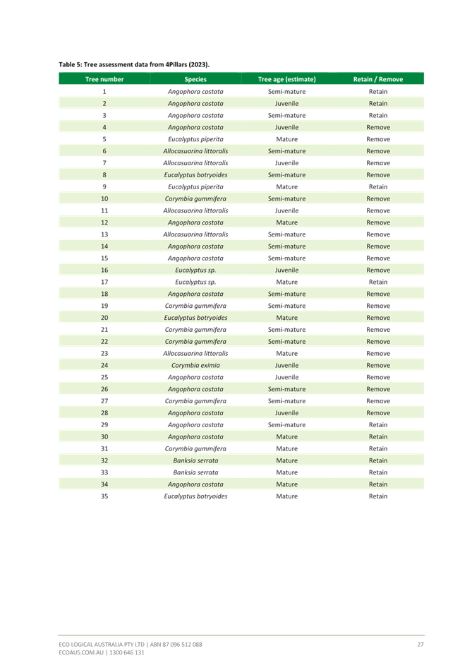
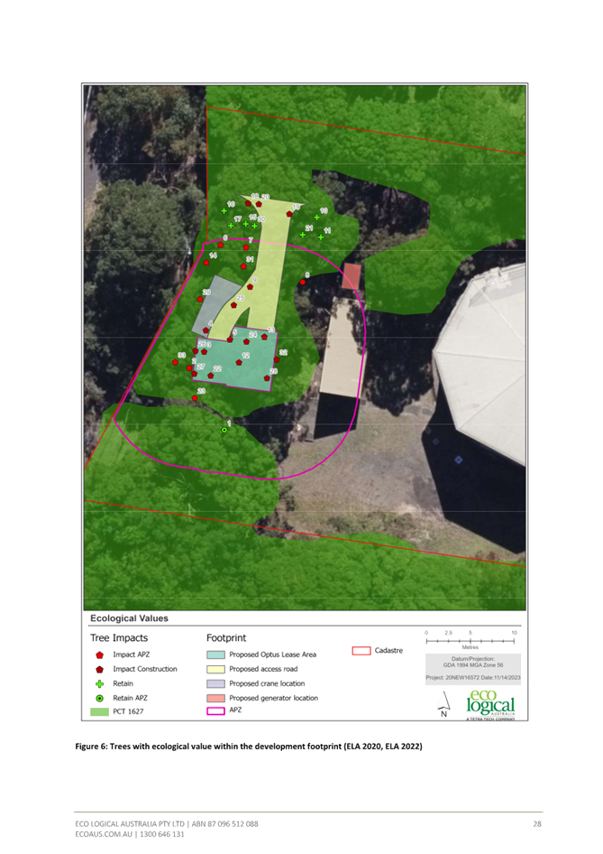


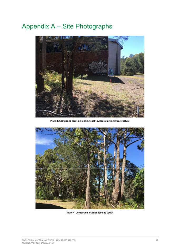
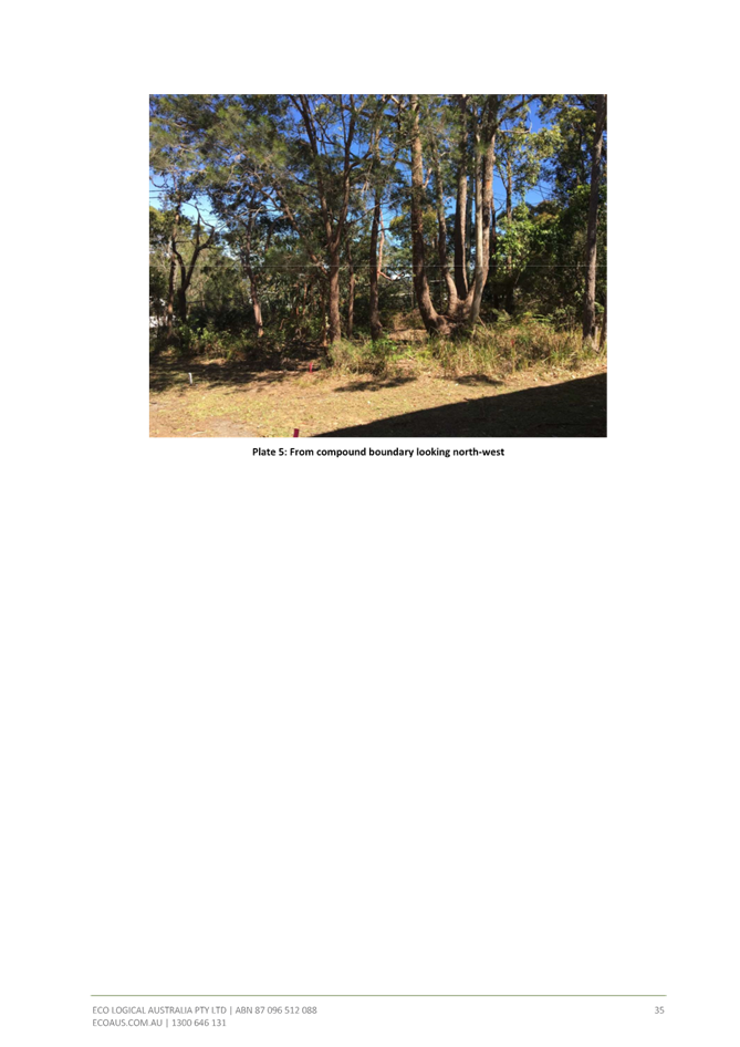
|
DA3623/2022 - 37 Wards Hill Rd Killcare Heights - Telecommunications Facility |
|
|
Attachment 8 |
Revised Statement of Environmental Effects |

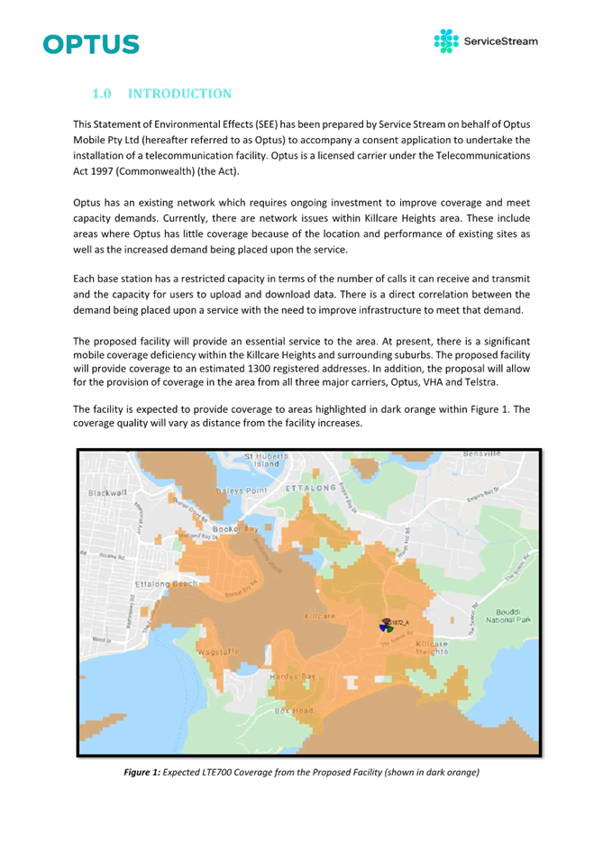


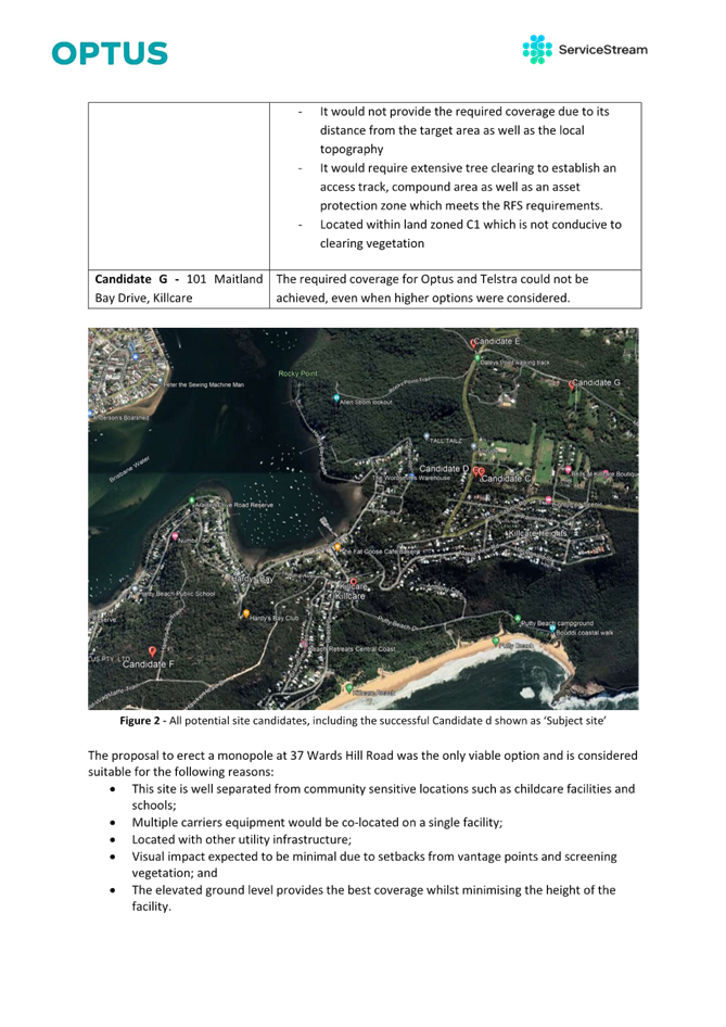

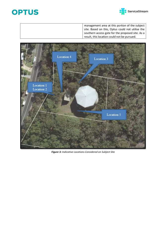
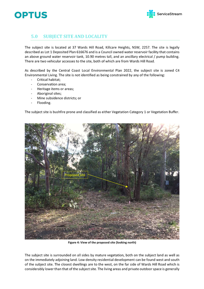

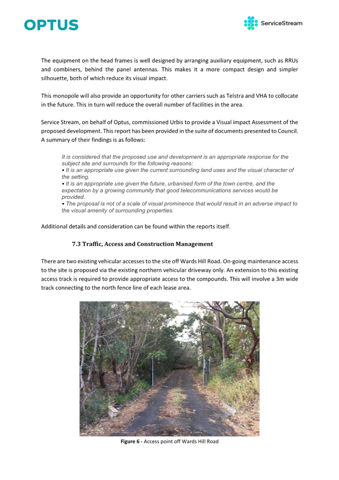

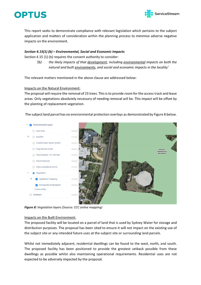

|
3.1 |
DA3623/2022 - 37 Wards Hill Rd Killcare Heights - Telecommunications Facility |
|
Attachment 9 |
Waste Management Plan |
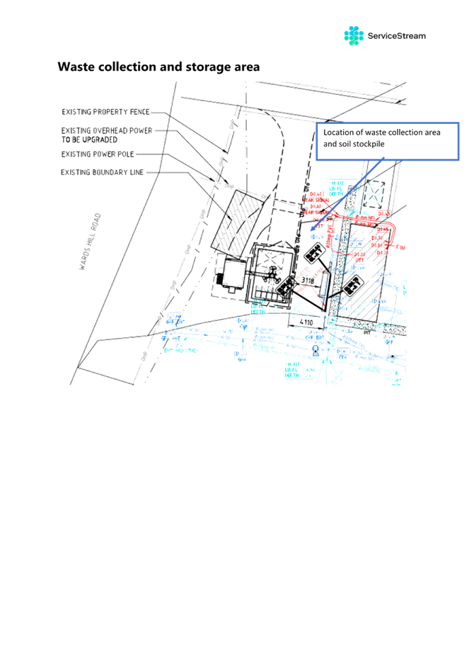
|
DA3623/2022 - 37 Wards Hill Rd Killcare Heights - Telecommunications Facility |
|
|
Attachment 10 |
Archaeology Peer Review |

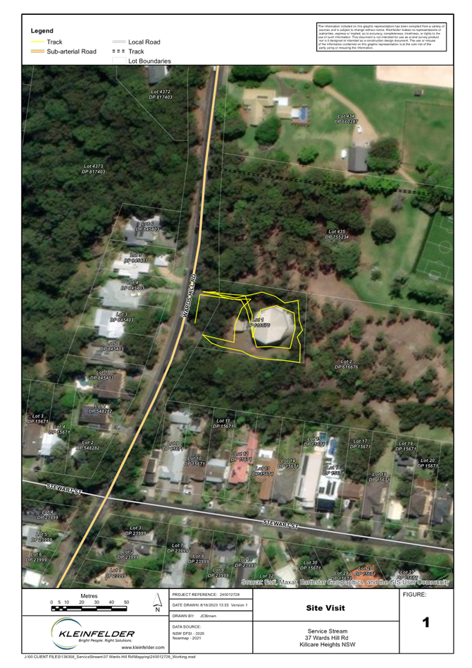
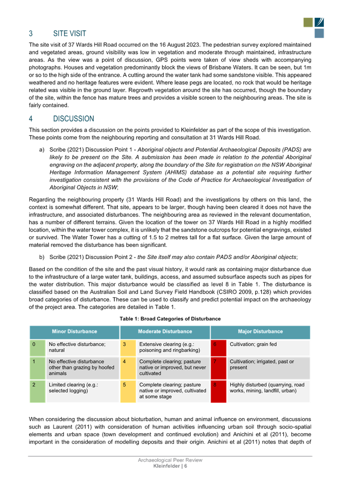

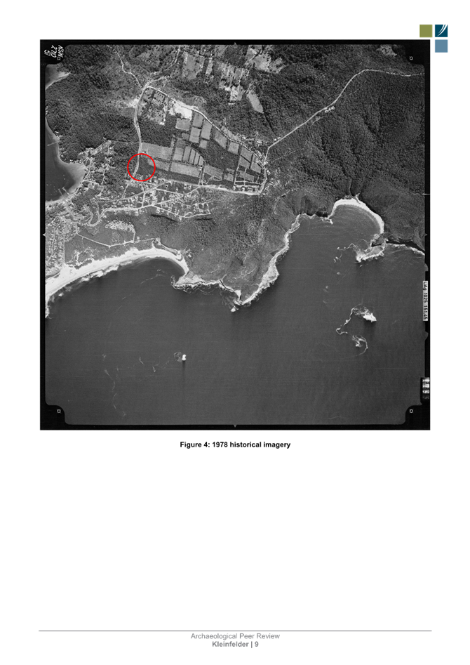
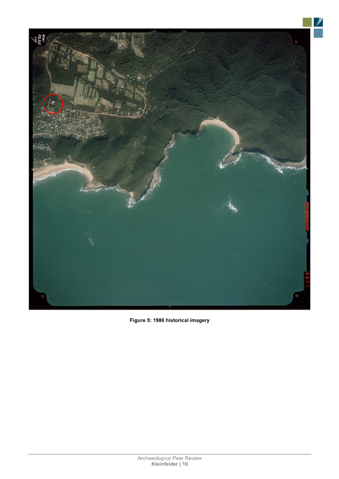
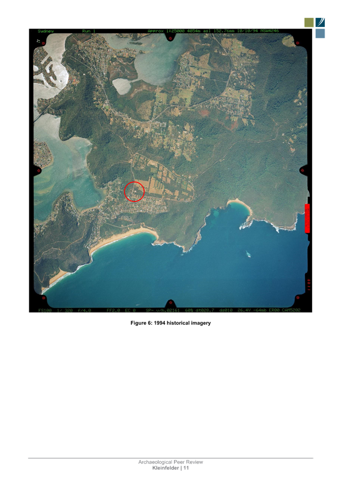
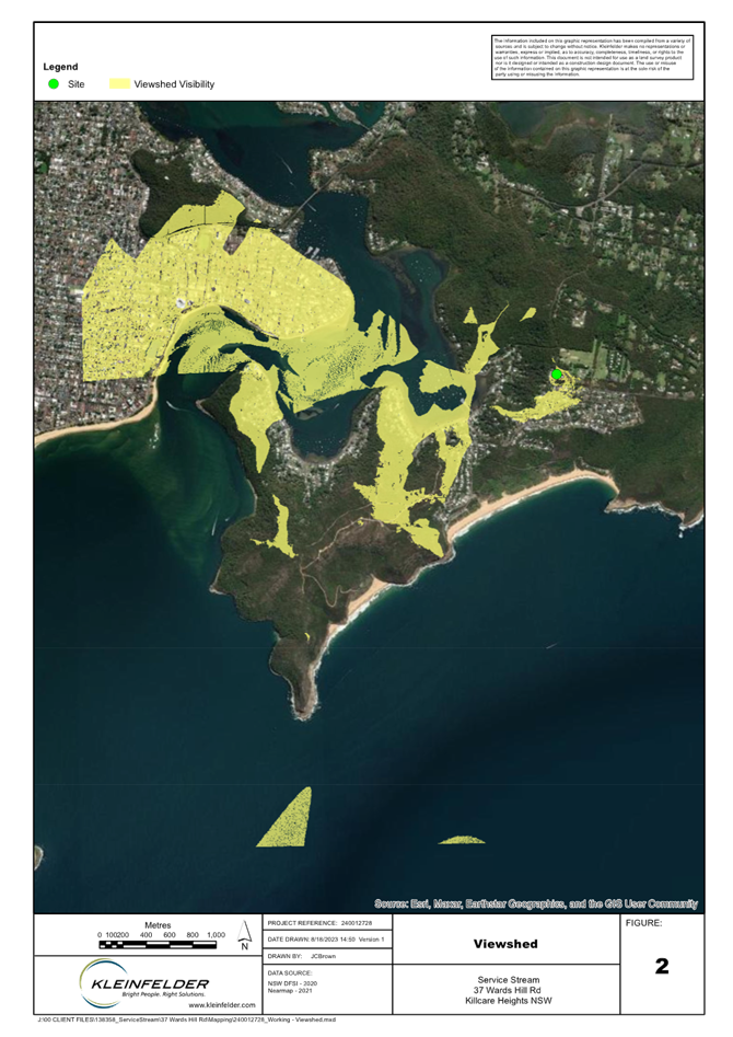

|
DA3623/2022 - 37 Wards Hill Rd Killcare Heights - Telecommunications Facility |
|
|
Attachment 11 |
Amended EMER Report |