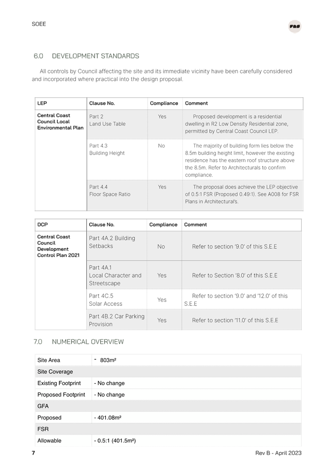
 |
Central Coast
Local Planning Panel Meeting
Business Paper
19 September 2024
 |
|
Central Coast
Local Planning Panel Meeting
Business Paper
19 September 2024
|
The Local Planning Panel Meeting
of Central Coast
will be held remotely - online,
Thursday 19 September 2024 at 2.00 pm,
for the transaction of the business listed below:
1 Procedural Items
1.1 Disclosures of Interest.............................................................................................................................. 3
2 Confirmation of Minutes of Previous Meetings
2.1 Confirmation of Minutes of Previous Meeting................................................................................. 4
3 Planning Reports- Outside of Public Meeting
3.1 DA/1391/2023 - 2 South Scenic Road, Forresters Beach - Alterations & Additions to Residential Development............................................................................................................................................... 9
3.2 DA/1552/2023 - 7 Sun Valley Road Green Point - Proposed Telecommunications and Communication Facilities.................................................................................................................... 148
The Hon Terry Sheahan AO
Chairperson
|
Item No: 1.1 |
|
|
Title: Disclosures of Interest |
|
|
Department: Governance |
|
|
19 September 2024 Local Planning Panel Meeting |
|
Reference: F2020/02502 - D14205789
|
The NSW Local Planning Panel Code of Conduct states that all panel members must sign a declaration of interest in relation to each matter on the agenda before or at the beginning of each meeting.
|
That Panel Members now confirm that they have signed a declaration of interest in relation to each matter on the agenda for this meeting and will take any management measures identified.
|
Item No: 2.1 |
|
|
Title: Confirmation of Minutes of Previous Meeting |
|
|
Department: Corporate Services |
|
|
19 September 2024 Local Planning Panel Meeting |
|
Reference: F2020/02502 - D16397114
Author: Lisa Martin, Civic Support Officer Civic Support
|
Summary
The
Minutes of the following Meeting of the Local Planning Panel, which have been
endorsed by the Chair of that meeting, are submitted for noting: · Local Planning Panel Meeting held on 5 September 2024
|
That the minutes of the previous Local Planning Panel Meeting held on 5 September 2024, which were endorsed by the Chair of that meeting, are submitted for noting.
|
1⇩ |
MINUTES - Local Planning Panel - 5 September 2024 |
|
D16387570 |
|
2.1 |
Confirmation of Minutes of Previous Meeting |
|
Attachment 1 |
MINUTES - Local Planning Panel - 5 September 2024 |

|
Item No: 3.1 |
|
|
Title: DA/1391/2023 - 2 South Scenic Road, Forresters Beach - Alterations & Additions to Residential Development |
|
|
Department: Environment and Planning |
|
|
19 September 2024 Local Planning Panel Meeting |
|
Reference: DA/1391/2023 - D16162000
Author: Robert Eyre, Principal Development Planner.Residential Assessments
Manager: Ailsa Prendergast, Unit Manager. Development Assessments
Executive: Andrew Roach, Unit Manager. Development Assessment
|
Summary
An application has been received for Alterations and Additions to an existing Dwelling House. The application has been examined having regard to the matters for consideration detailed in section 4.15 of the Environmental Planning and Assessment Act 1979 and other statutory requirements with the issues requiring attention and consideration being addressed in the report.
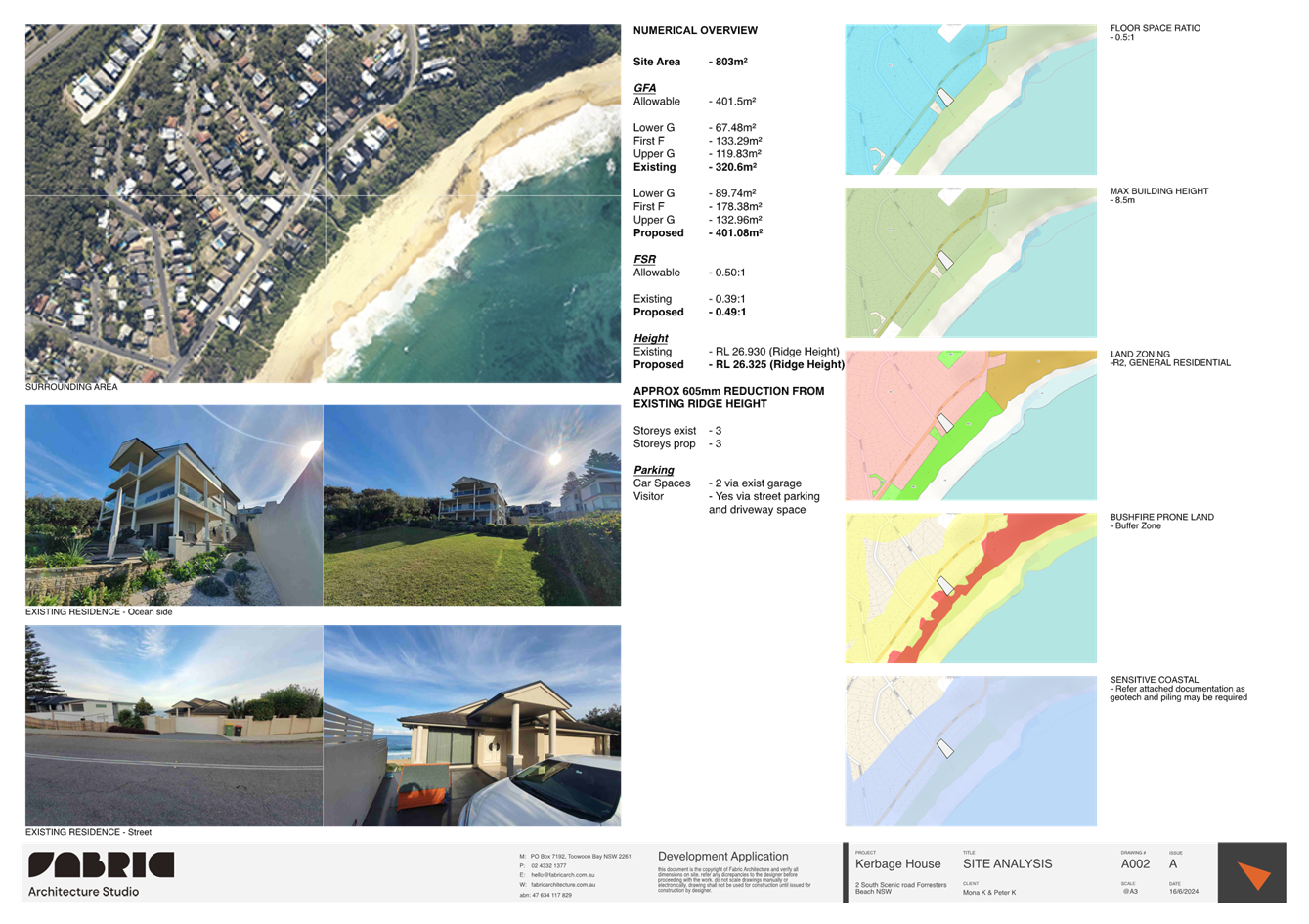
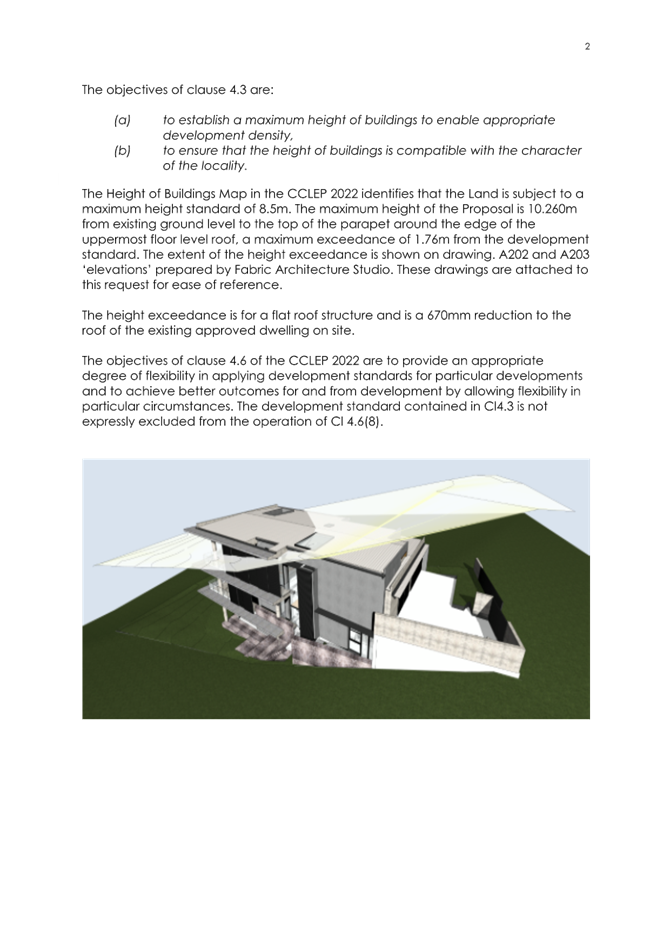
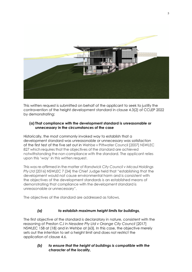
The application is required to be determined by the Local Planning Panel due to the variation to height under the Central Coast Local Environmental Plan 2022. The maximum permitted building height for the locality is 8.5metres. The proposed development proposes a 1.76m (or 20.7%) variation to that standard.
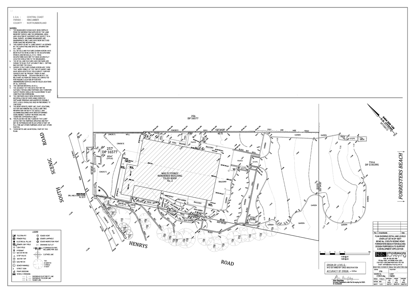
Applicant Damien Furey Owner M Kerbage Application No DA/1391/2023 Description of Land 2 South Scenic Road, Forresters Beach - Lot 257 DP 16577 Proposed Development Alterations and additions to an existing dwelling house Site Area 803m2 Zoning R2 Low Density Residential Existing Use Dwelling House Employment Generation No Estimated Value $2,168,789.00 |
1 The Panel grant consent to DA/1391/2023, 2 South Scenic Road, Forresters Beach, proposed additions and alterations to existing dwelling house, subject to the conditions detailed in the schedule attached to the report and having regard to the matters for consideration detailed in Section 4.15 of the Environmental Planning and Assessment Act 1979.
2 The Panel agrees that the
applicant’s clause 4.6 written request demonstrates that compliance with
the height development standard is unnecessary in the circumstances of the case
because of the proposed height that would result from the noncompliance with
the height development standard, that compliance with the height standard would
be unreasonable in the circumstances of the case because of existing surface
levels and slope and that there are sufficient environmental planning grounds
to justify contravening that development standard.
Further, the Panel considers that the proposed development will be in the
public interest because it is consistent with the objectives of the development
standard and the objectives for development within the R2 Low Density
Residential zone in which the development is proposed to be carried out.
Key Issues
· Height non-compliance with provisions of Central Coast Local Environmental Plan 2022 (and accompanying Clause 4.6 Submission).
· Geotechnical/Coastal Risk issues (noting that there is no coastal building line applicable to this property under the Central Coast Development Control Plan 2022).
· Building Line
Precis:
|
Proposed Development |
Alterations and additions to existing dwelling house |
|
Permissibility and Zoning |
Permissible with consent under R2 Low Density Residential Zone. |
|
Relevant Legislation |
· Environmental Planning & Assessment Act 1979 – Section 4.15 · Local Government Act 1993 – Section 89 · Roads Act 1993 · Water Management Act 2000 · State Environmental Planning Policy (Building Sustainability Index: BASIX) 2004 · State Environmental Planning Policy (Resilience and Hazards) 2021 · Central Coast Local Environmental Plan 2022 · Central Coast Development Control Plan 2022 |
|
Current Use |
Dwelling house |
|
Integrated Development |
No |
|
Submissions |
Nil |
Variations to Policies
|
Clause |
Clause 4.3 Maximum Building Height |
|
Standard |
8.5m |
|
LEP/DCP |
CCLEP 2022 |
|
Departure basis |
1.76m or 20.7%. |
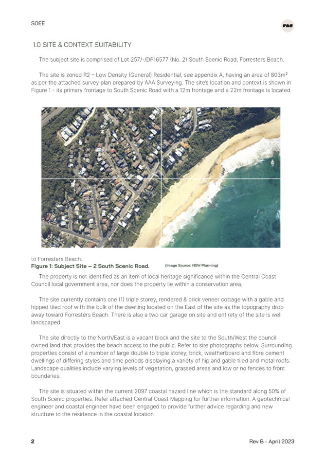
The Site
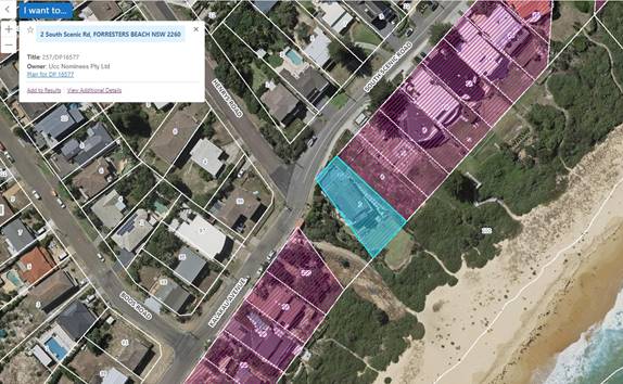
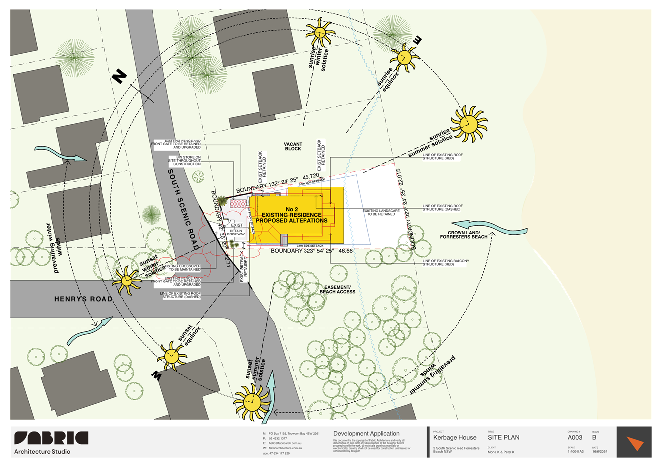
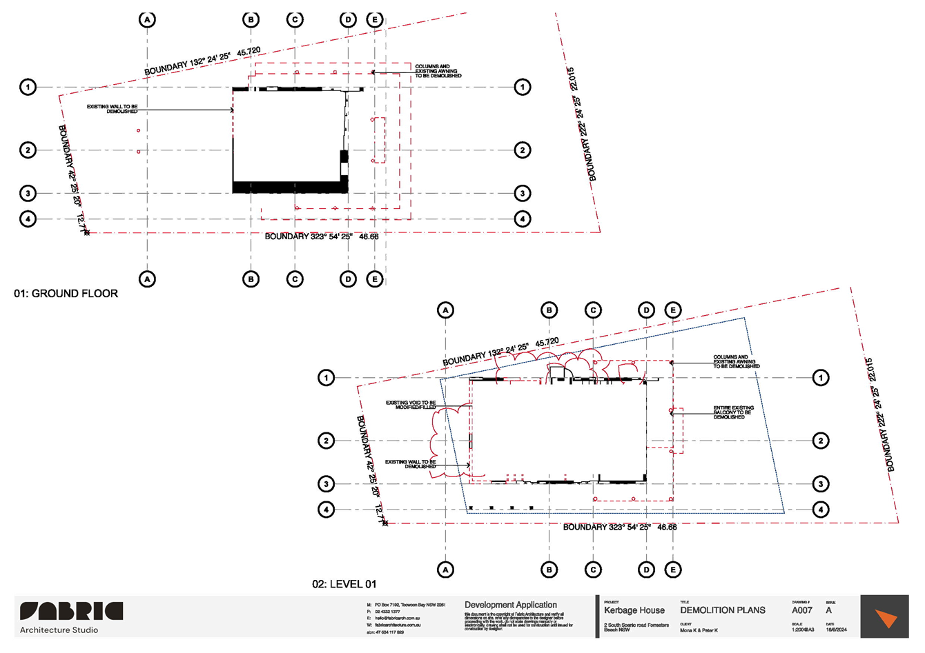
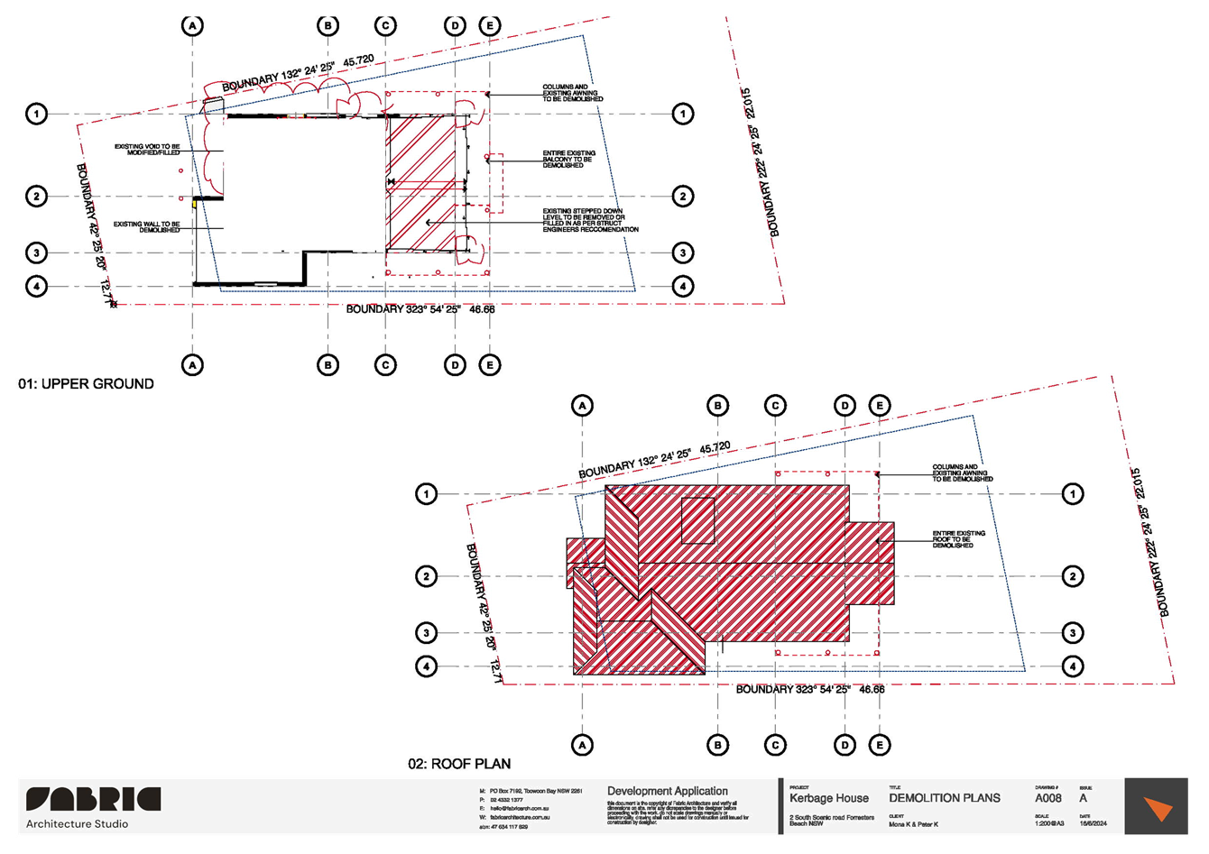
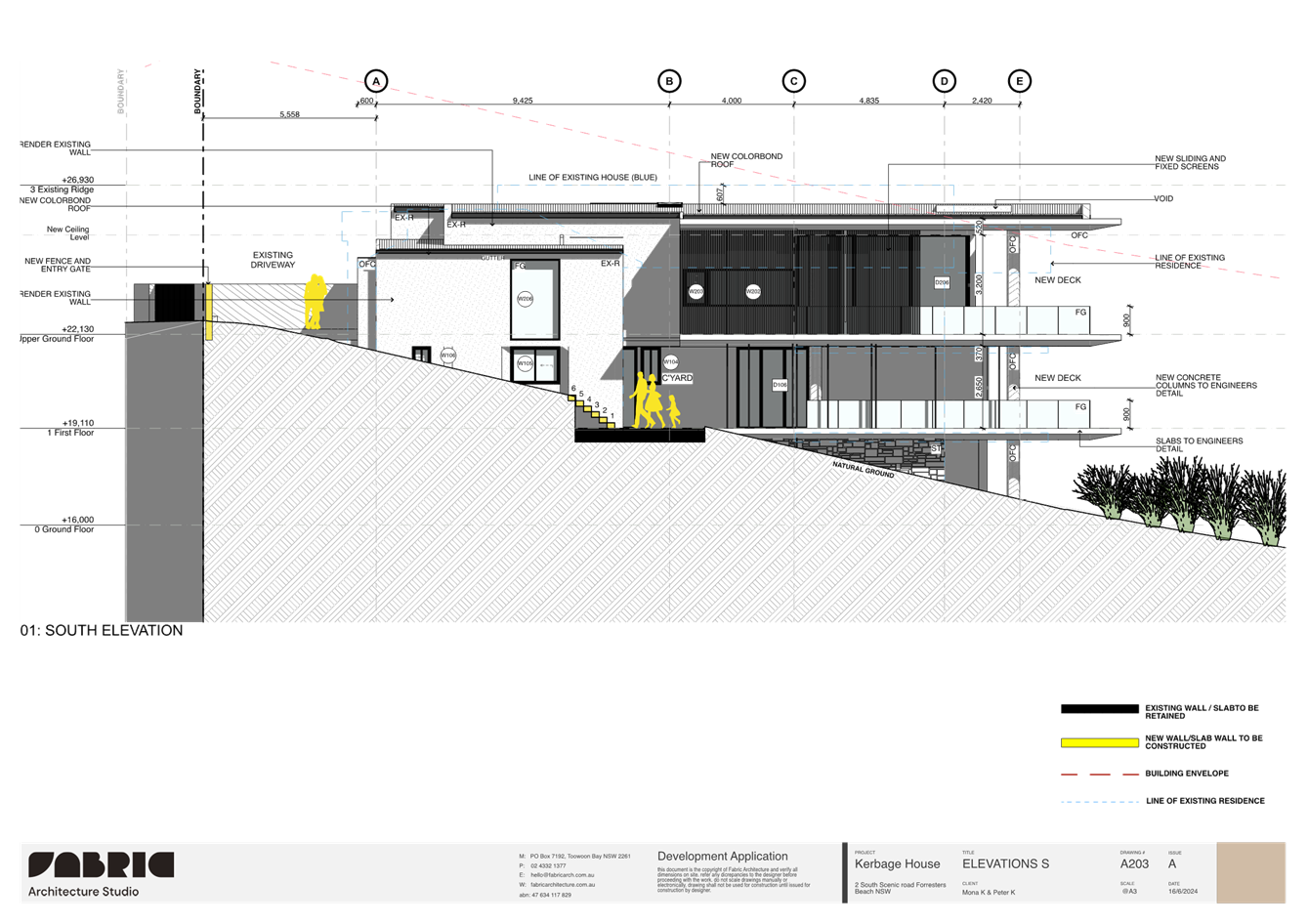
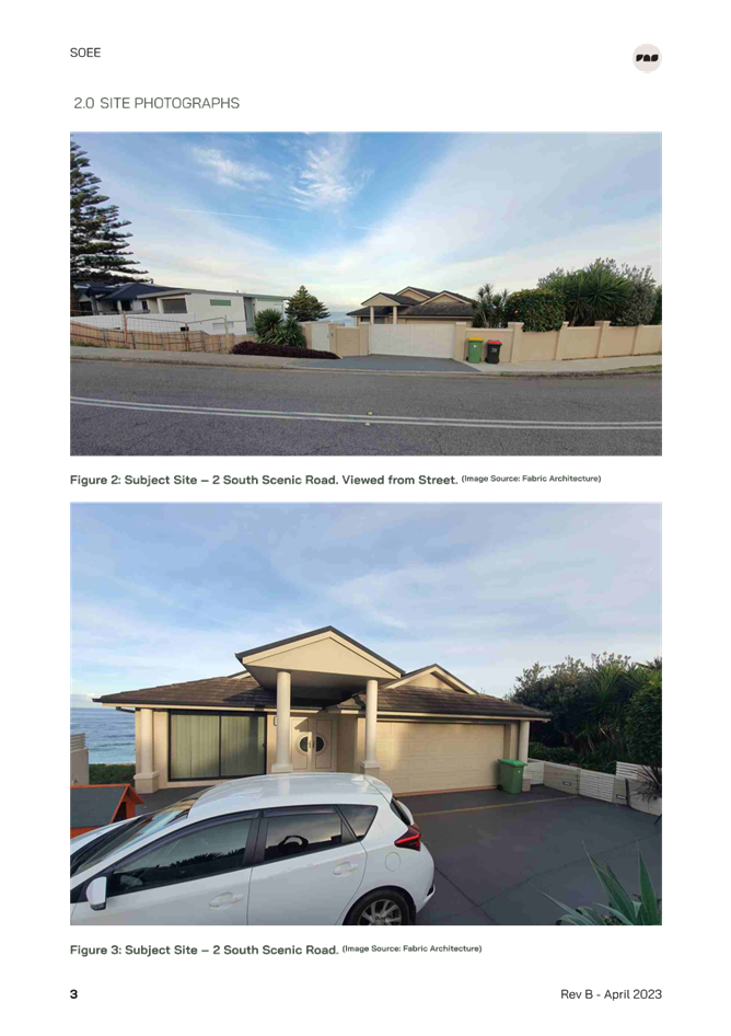
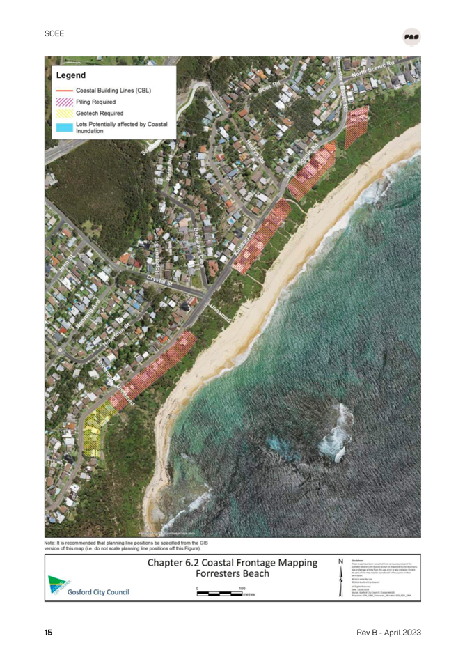
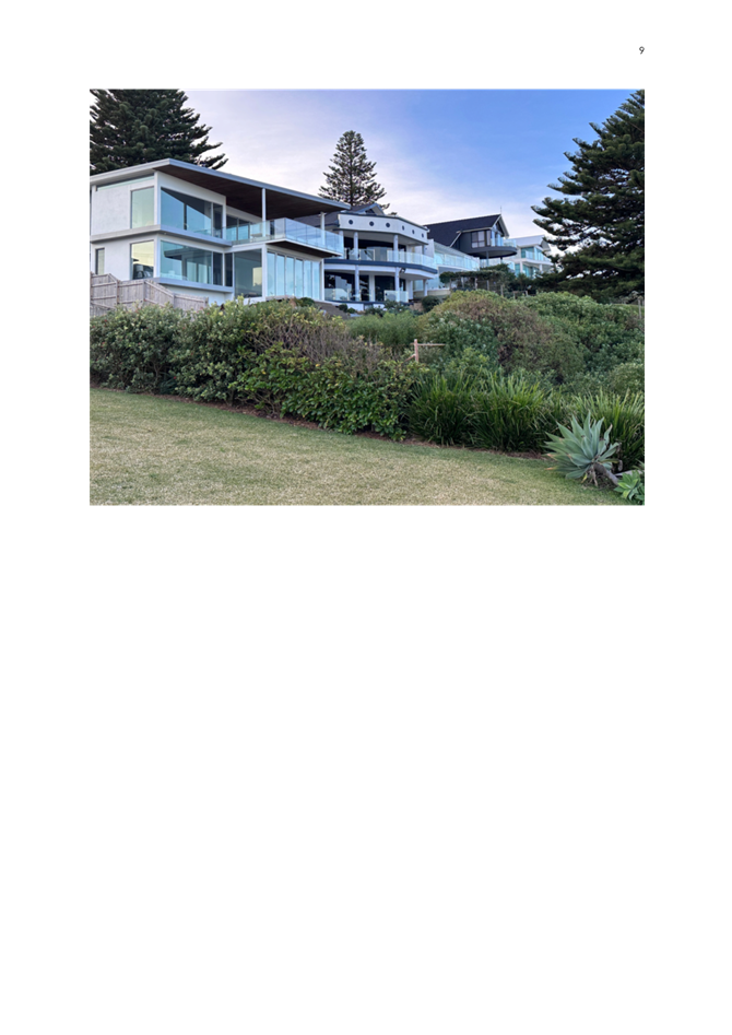
The site is located on the north-eastern side of South Scenic Road and Henrys Road, Forresters Beach. (Refer figure 1).
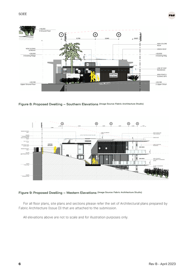
The rear boundary adjoins Forresters Beach.
The site has a 12m frontage to South Scenic Road and a 22m frontage to Forresters Beach.
The site slopes away from South Scenic Road and towards Forresters Beach with the whole site currently landscaped.
The southern side adjoins an unconstructed public road (Henrys Road) which provides pedestrian access to Forresters Beach via stairs and a maintenance track for access by Council to the beach.
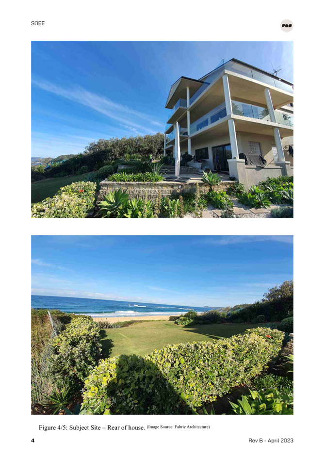
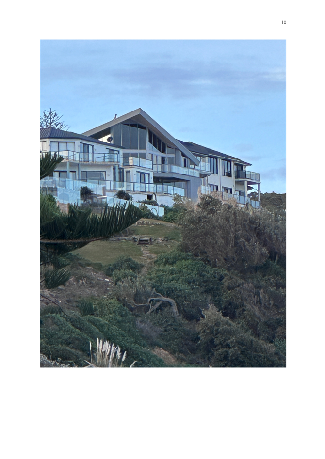
The site contains an existing 3 storey, rendered brick veneer dwelling house with established associated improvements (lawns, landscaping, fencing etc.) The existing dwelling has a gable and hipped, tile roof. A two-car garage is located at the front of the site.
Surrounding Development
Surrounding development is residential in nature, consisting mainly of single and two-storey dwelling houses.
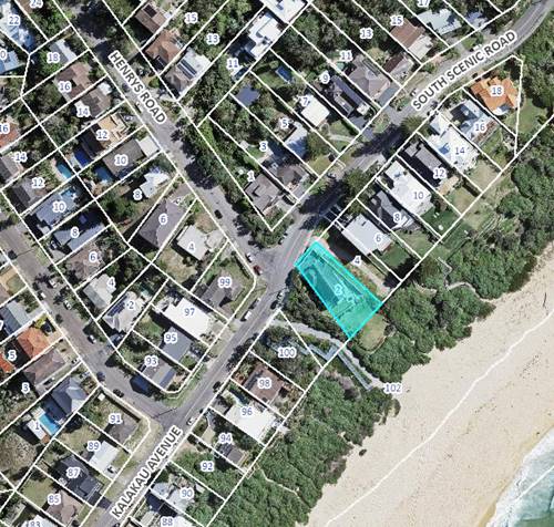
Figure 1 - Locality Plan
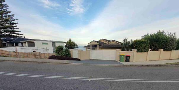
Figure 2 - Existing Street View
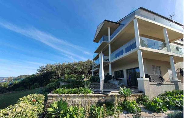
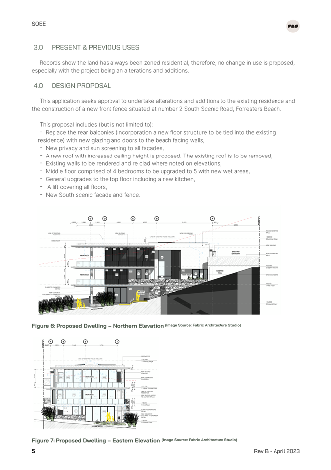
Figure 3 - Rear view of existing dwelling house
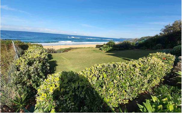
Figure 4 - Existing Rear of Site
The Proposed Development
The proposal includes:
· Replace the rear balconies including a new floor structure tied into the existing dwelling.
· New privacy and sun screening to all facades.
· A new roof with increased ceiling heights.
· Internal alterations with middle floor to be altered from 4 to 5 bedrooms.
· Internal alterations to top floor including a new kitchen.
· A lift to all floors.
· New South Scenic Road façade and fencing.
· A reduction in roof level.
The proposed alterations and additions will increase the GFA from 320.6m2 to 401.08m2 and FSR from 0.39:1 to 0.49:1.
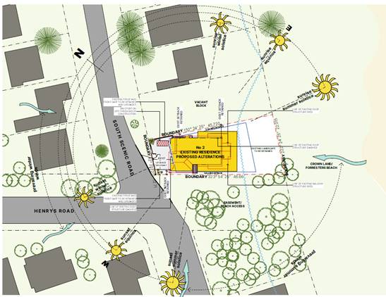
Figure 5 - Site Plan
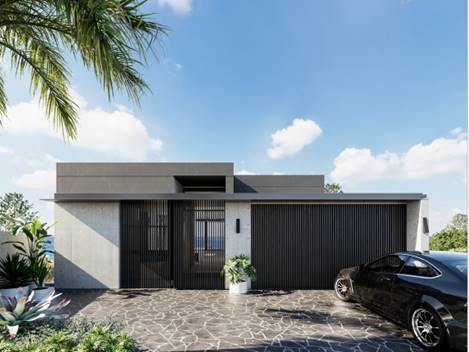
Figure 6 – Architects render showing proposed street elevation
Figure 7 – Architects render of proposed rear elevation
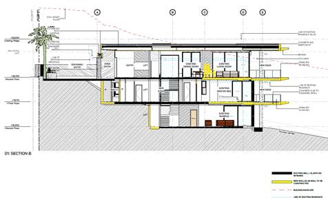
Figure 8 - Section B
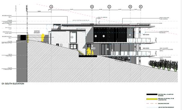 Figure 9 - South
Elevation
Figure 9 - South
Elevation
ASSESSMENT
Having regard for the matters for consideration detailed in Section 4.15 of the Environmental Planning and Assessment Act 1979 and other statutory requirements, the assessment has identified the following key issues, which are elaborated upon for the information of the Local Planning Panel.
Draft Environmental Planning Instruments
No draft Environmental Planning Instruments apply to this application.
State Environmental Planning Policies
State Environmental Planning Policy (Building Sustainability Index: BASIX) 2004
The application is supported by a BASIX certificate which confirms the proposal will meet the NSW government's requirements for sustainability, if built in accordance with the commitments in the certificate.
The proposal is consistent with the requirements of State Environmental Planning Policy (Building Sustainability Index: BASIX) 2004.
State Environmental Planning Policy (Resilience and Hazards) 2021
State Environmental Planning Policy (Resilience and Hazards) 2021 commenced on 1 March 2022 incorporates and repeals the provisions of 3 SEPPs including State Environmental Planning Policy (Coastal Management) 2018 and State Environmental Planning Policy 55 – Remediation of Land.
It is noted no policy changes have been made and the SEPP consolidation does not change the legal effect of the existing SEPPs, with Section 30A of the Interpretation Act 1987 applying to the transferred provisions.
The relevant provisions of the SEPP are addressed as follows:
Chapter 2 Coastal Management
The aims of Chapter 2 are to be considered when determining an application within the Coastal Management Areas. The Coastal Management Areas are defined on maps issued by the NSW Department of Planning and Environment.
The site is located within the Coastal Environment Area and Coastal Use Area as identified on these maps and subject to the provisions of clause 2.10 and clause 2.11 of the SEPP.
The development is not likely to have an adverse impact on the matters referred to in clause 2.10 and clause 2.11. The development is not considered likely to cause increased risk of coastal hazards on the site or other land. A summary of considerations is included below.
Clause 2.10 - Development on land within the coastal environment area
In accordance with clause 2.10(1) development consent must not be granted unless the consent authority has considered whether the proposed development is likely to cause an adverse impact on the following:
|
Matters for Consideration |
Compliance |
|
(a) the integrity and resilience of the biophysical, hydrological (surface and groundwater) and ecological environment. |
The proposal is not likely to cause adverse impacts on the biophysical, hydrological, or ecological environment.
The proposal will be connected to reticulated sewer and stormwater will be managed on-site in accordance with the submitted stormwater plans. Erosion and sediment controls will be in place during demolition and construction, and the proposal will not impact on the environment. |
|
(b) coastal environmental values and natural coastal processes. |
The proposal is subject to a coastal building line under CCDCP 2022. The Coastal Engineering Report prepared by Horton Coastal Engineering dated 5 January 2023 addresses the impacts of the proposal on coastal processes as follows:
· There is rock above -1m AHD that can be resilient against erosion/scour during a storm event. · All foundations will be founded on bedrock. · The minimum ground level of 16m AHD is well above the wave runup levels such that there is a low risk of damage from inundation and wave runup. · Footings will be piled into bedrock.
The proposal will not impact on the geological and geomorphological coastal processes. |
|
(c) the water quality of the marine estate (within the meaning of the Marine Estate Management Act 2014 the cumulative impacts of the proposed development on any of the sensitive coastal lakes identified in Schedule 1. |
The proposal will not result in an adverse impact on the water quality of the marine estate and does not drain to a sensitive lake contained in Schedule 1.
The proposal will be connected to reticulated sewer and stormwater will be managed on-site in accordance with the submitted stormwater plans. Erosion and sediment controls will be in place during demolition and construction, to minimise impacts on water quality, and the proposal will not impact on any sensitive coastal lakes. |
|
(d) marine vegetation, native vegetation and fauna and their habitats, undeveloped headlands, and rock platforms. |
The proposal will not result in an adverse impact on native vegetation or fauna, undeveloped headlands, and rock platforms.
The proposal will not have significant impacts on marine fauna and flora as the development would not interact with subaqueous areas for an acceptably rare storm and acceptably long life. |
|
(e) existing public open space and safe access to and along the foreshore, beach, headland, or rock platform for members of the public, including persons with a disability. |
The proposal will not impact on public access to the foreshore being entirely within the subject site. |
|
(f) Aboriginal cultural heritage, practices, and places. |
The subject land has not been identified as containing or being within 200m of any Aboriginal sites or places. |
|
(g) the use of the surf zone. |
The proposal is located entirely on the subject site and will not impact on use of the surf zone. |
In accordance with clause 2.10(2) development consent must not be granted unless the consent authority is satisfied that:
|
Matters for Consideration |
Compliance |
|
(a) the development is designed, sited and will be managed to avoid an adverse impact referred to in subsection (1), or |
The subject application is for alterations and additions to an existing dwelling house.
The proposed location of the dwelling house is not likely to impact on any future coastal protection works. Beach access from the property is not proposed with the application. The proposed dwelling house is appropriately designed and sited and will be managed to avoid any adverse impacts referred to in clause 2.10(1) having regard to LEP and DCP requirements, the location and characteristics of the site and existing development on the site and surrounding properties. The proposal will maintain a similar presentation to Forresters Beach consistent with adjoining dwelling houses. The proposal does not involve the removal of any significant vegetation. |
|
(b) if that impact cannot be reasonably avoided—the development is designed, sited, and will be managed to minimise that impact, or
|
N/A – no adverse impacts
|
|
(c) if that impact cannot be minimised—the development will be managed to mitigate that impact,
|
N/A – no adverse impacts
|
Clause 2.11 - Development on land within the coastal use area
In accordance with clause 2.11(1) development consent must not be granted unless the consent authority has considered whether the proposed development is likely to cause an adverse impact on the following:
|
Matters for Consideration |
Compliance |
|
(a) whether the proposed development is likely to cause an adverse impact on the following: i. existing, safe access to and along the foreshore, beach, headland, or rock platform for members of the public, including persons with a disability, ii. overshadowing, wind funnelling and the loss of views from public places to foreshores, iii. the visual amenity and scenic qualities of the coast, including coastal headlands, iv. Aboriginal cultural heritage, practices, and places, v. cultural and built environment heritage. |
The site has a direct frontage to the foreshore of Forresters Beach.
The proposal will not cause an adverse impact on access, overshadowing, wind funneling or view loss from public places to any foreshore. There will be some impact from overshadowing of the southern adjoining public beach access in the middle of the day in wintertime which is similar to the shadows cast by the existing development.
The dwelling house will be visible from the beach and coastal areas and will maintain an appropriate presentation that is consistent with other more recent development along the beachfront and is located as far landward as possible as is not likely to have any adverse visual amenity from coastal erosion in a significant storm event.
There are no known objects, areas, or items of heritage significance on the land, and no potentially adverse impacts on cultural or environmental heritage have been identified. |
|
(b) is satisfied that i. the development is designed, sited and will be managed to avoid an adverse impact referred to in paragraph (a), or ii. if that impact cannot be reasonably avoided—the development is designed, sited and will be managed to minimise that impact, or iii. if that impact cannot be minimised—the development will be managed to mitigate that impact, |
The proposal is appropriately designed and sited and will be management to avoid the adverse impacts referred to in clause 2.11(a) having regard to LEP and DCP requirements, the location and characteristics of the site and existing development on the site and surrounding properties.
The proposal will maintain a similar presentation to Forresters Beach consistent with adjoining development along the beach frontage. The proposal does not involve the removal of any significant vegetation. |
|
(c) has considered the surrounding coastal and built environment, and the bulk, scale and size of the proposed development |
The bulk and scale of the proposed development is compatible with the scale and appearance of other development along the Forresters beachfront and is considered satisfactory for the site and location. |
Clause 2.12 - Development in coastal zone generally - development not to increase risk of coastal hazards.
In accordance with clause 2.12 development consent must not be granted to development on land within the coastal zone unless the consent authority is satisfied that the proposed development is not likely to cause increased risk of coastal hazards on that land or other land.
Comment:
The proposal is not subject to a Coastal Building Line under CCDCP 2022. Section 8 of the Coastal Engineering Report prepared by Horton Coastal Engineering dated 5 January 2023 (Horton 2023) addresses the impacts of the proposal on coastal processes and risks of coastal hazards on the land and adjoining land in relation to the requirements of Chapter 3.2 Coastal Frontage of CCDCP 2022.
The Coastal Engineer (Horton 2023) concludes the following:
· The proposed development has been designed to avoid any potential adverse impacts on adjoining land or the coastal area.
· The proposed development does not give rise to increased coastal hazard.
· The proposal satisfies the requirements of CCDCP 2022 and SEPP (Resilience and Hazards) 2021.
Given the recommendations of the Coastal Engineering report accompanying the application, and that the land is not subject to a defined Coastal Building Line under Central Coast DCP 2022, the consent authority can be satisfied that this matter has been appropriately addressed.
Clause 2.13 - Development in coastal zone generally - coastal management programs to be considered.
In accordance with clause 2.13 development consent must not be granted to development on land within the coastal zone unless the consent authority has taken into consideration the relevant provisions of any certified coastal management program that applies to the land.
Chapter 4 Remediation of Land
Clause 4.6 of Chapter 4 requires that a consent authority must not consent to the carrying out of any development on land unless it has considered whether the land is contaminated. and if the land is contaminated, it is satisfied that the land is suitable in its contaminated state (or will be suitable, after remediation) for the purpose for which the development is proposed to be carried out.
The site has been used for residential purposes and is considered suitable for the proposed use.
The development and the land are not otherwise mentioned in Section 4.6(4) and accordingly the provisions of Section 4.6(2) are not engaged by the proposal and consent may be granted. The proposal is considered consistent with the provisions of Chapter 4 of the SEPP.
Council can be satisfied that the proposed development complies with the provisions of Chapter 2 Coastal Management and Chapter 4 Remediation of Land of State Environmental Planning Policy (Resilience and Hazards) 2021.
Central Coast Local Environmental Plan 2022
Zoning and Permissibility
The subject site is zoned R2 Low Density Residential under the provisions of Central Coast Local Environmental Plan 2022 (CCLEP 2022) as shown in the zoning map.
The proposed development is defined as dwelling house which is permissible in the zone with consent of Council.
dwelling house means a building containing only one dwelling.
The R2 Low Density Residential zone is based on the following objectives:
· To provide for the housing needs of the community within a low-density residential environment.
· To enable other land uses that provide facilities or services to meet the day to day needs of residents.
· To ensure that development is compatible with the desired future character of the zone.
· To encourage best practice in the design of low-density residential development.
· To promote ecologically, socially, and economically sustainable development and the need for, and value of, biodiversity in Gosford.
· To ensure that non-residential land uses do not adversely affect residential amenity or place demands on services beyond the level reasonably required for low-density housing.
Properties along Forresters Beach to the north, south and west are zoned R2 Low Density Residential. East of the site, known as Forresters Beach is zoned RE1 Public Recreation.
The proposal will provide a renewal of housing on the site, and the nature of the use is consistent with development in the surrounding area and considered compatible with the desired future character of the area.
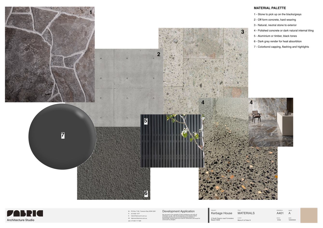
The design of the proposal responds to the beachfront location of the site and is compatible with the scale and nature of more recent development on Forresters beachfront. The proposal demonstrates architectural quality and uses different setbacks and design features to break up the massing of the dwelling house.
The proposed development is ecologically, socially, and economically sustainable in the sensitive coastal location.
4.3 Height of Buildings
Clause 4.3(2) of CCLEP 2022 provides that the height of a building on any land will not to
exceed the maximum height shown for the land on the Height of Buildings Map. The
maximum height shown on the relevant map is 8.5m. The CCLEP 2022 defines this as the
height above existing ground level.
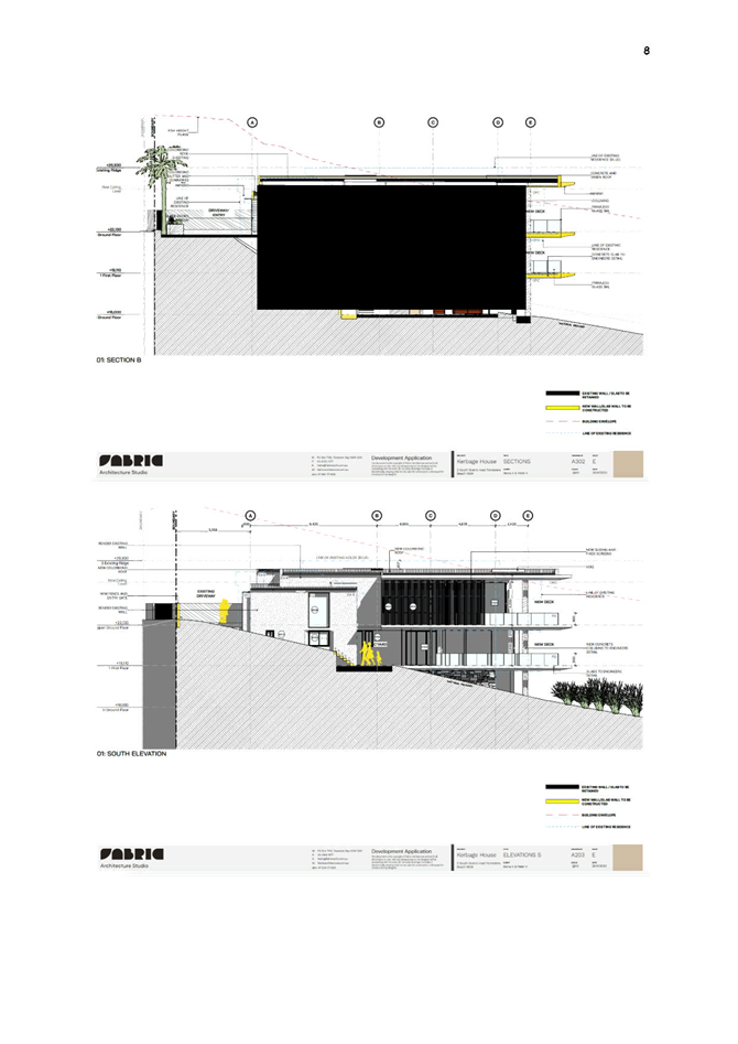
The proposed development predominantly complies with the maximum building height except at the western edge of the roof elevation where the dwelling has a maximum height of 10.26 m from existing ground level as shown in elevations of Figures 8 and 9. This is a variation of 1.76m or 20.7% to the development standard.
A request to vary the development standard under clause 4.6 of GLEP 2014 has been provided (See further details and discussion below).
4.4 Floor Space Ratio
Clause 4.4(2) Floor Space Ratio (FSR) of CCLEP 2022 provides the maximum floor space ratio for a building on any land. The site is identified on the CCLEP 2022 FSR map as being 0.5:1.
The proposal was lodged with an FSR of 0.49:1 which complies with the standard.
4.6 Exceptions to Development Standards
Clause 4.6 of CCLEP 2022 provides the ability to grant consent to a development application where the variation to a development standard can be adequately justified and where the objectives of clause 4.6 are satisfied, being:
a) to provide an appropriate degree of flexibility in applying certain development standards to development,
b) to achieve better outcomes for and from development by allowing flexibility in particular circumstances.
In accordance with clause 4.6(3) the Applicant has submitted a written request seeking variation to the Height of Building development standard of 8.5m in clause 4.3 of GLEP 2014.
A copy of the Clause 4.6 Variation Request is included in the Statement of Environmental Effects and referenced as Appendix H.
The proposed development has a maximum height of 10.26m from existing ground level and results in a variation of 20.7% to the development standard.
The Applicant’s written request submitted states how strict compliance with the development standard is unreasonable or unnecessary having regard to the considerations set out in Wehbe v Pittwater Council [2007] NSWLEC 827 and Four2Five Pty Ltd v Ashfield Council [2015] NSWLEC 90. (Refer attachment 3)
The Applicant’s written request to vary the height of building development standard demonstrates the following (summarised):
· The height exceedance is for a flat roof structure which is 670mm lower than the existing roof.
· The proposal results in a better design outcome and the variation is due to the slope of the land.
· The design responds to the existing site constraints and steepness towards the beach.
· The proposal has no shadow impacts on adjoining residential sites.
· The proposal complies with the objectives of the zone and the objectives of the height development standard.
In accordance with clause 4.6(4), development consent must not grant consent for a development that contravenes a development standard unless:
1. The consent authority is satisfied that the Applicant’s written request has adequately addressed the matters required to be demonstrated in clause 4.6(3).
Comment:
The clause 4.6 submitted by the Applicant has addressed how strict compliance with the development standards is unreasonable or unnecessary having regard to various relevant decisions in the NSW Land and Environment Court and New South Wales Court of Appeal and how there are sufficient environmental planning grounds to justify the contravention.
Council is satisfied that the matters required to be demonstrated in subclause 4.6(3)(a) have been adequately addressed for the variation to the maximum height of building development standard.
2. The consent authority is satisfied that the proposed development will be in the public interest because it is consistent with the objectives of the particular standard and the objectives for development within the zone in which the development is proposed to be carried out.
Comment:
To demonstrate if the proposal has merit, consideration of the proposed building height non-compliance regarding the objectives of the control contained within Clause 4.3(1) of CCLEP 2022 is as follows:
The objectives of clause 4.3 Height of Buildings:
(a) to establish maximum height limits for buildings,
(b) to permit building heights that encourage high quality urban form,
(c) to ensure that buildings and public areas continue to receive satisfactory exposure to sky and sunlight,
(d) to nominate heights that will provide an appropriate transition in built form and land use intensity,
(e) to ensure that taller buildings are located appropriately in relation to view corridors and view impacts and in a manner that is complementary to the natural topography of the area,
(f) to protect public open space from excessive overshadowing and to allow views to identify natural topographical features.
The proposal is consistent with objectives in CCLEP 2022 as follows:
· The proposal generally complies with the 8.5m building height development standard. The elements exceeding the height level are generally located at the eastern side and are well setback from the eastern boundary with Forresters Beach.
· The site has a sloping topography, with greater slope on the eastern side in the vicinity of the proposed variation. The variation is considered well designed to minimise any impact. The roof level overall is being reduced albeit still above the 8.5m height limit. There is no apparent impact from street level and surrounding properties given the inherent design quality of the development.
· The design appears as a 3-storey building from the public domain and side boundaries towards the beach however has a single presentation to the street and is consistent with other development along the beachfront area.
· The extent of the non-compliance does not contribute to the bulk and scale of the building and is not considered to have unreasonable impacts on the amenity of the adjoining residents by overshadowing or overlooking. The design of the development provides for articulation, different materials selection, natural ventilation, acoustic and visual privacy from the neighbours.
· The proposal provides appropriate transition in built form and land use intensity being located adjacent new and existing single dwelling houses and is generally consistent with the underlying zoning and development standards available to the site.
· The proposal does not result in unreasonable overshadowing of public open space areas nor impact on views that identify natural topographical features.
The proposed development is consistent with the objectives for the R2 Low Density Residential zone as follows:
· The proposal does not have a detrimental impact on the amenity of adjoining residences in terms of overshadowing and proposes privacy screening to minimise overlooking of side boundaries.
· The design of the proposal responds to the beachfront location of the site and is compatible with the scale and nature of more recent development on Forresters beachfront. The proposal demonstrates architectural quality and uses different setbacks and design features to break up the massing of the dwelling house.
The assessment of the proposal against the objective of the development standard and the R2 Low Density Residential zone confirms that the proposal complies with these objectives despite the variation.
Council is satisfied that the Applicant has demonstrated compliance with the objectives of the development standard and the zone objectives such that the proposal is in the public interest. The contravention of the building height control does not raise any matter of significance for State or regional environmental planning given the nature of the development proposal. Strict compliance with the prescriptive building height control is unreasonable or unnecessary in the context of the proposal in the circumstances of this case. The proposed development meets the underlying intent of the control and is a compatible form of development that does not result in unreasonable environmental amenity impacts.
This assessment concludes that the clause 4.6 variation of CCLEP 2022 having regard to clause 4.3(2) of CCLEP 2022 is well founded and worthy of support.
7.1 Acid Sulfate Soils
This land has been identified as being affected by the Acid Sulfate Soils Map and the matters contained in clause 7.1 of CCEP 2022 have been considered.
The land is mapped as Class 5, no known occurrence ASS and is within 500m. Therefore, an ASS Management Plan is not required.
The Panel can be satisfied that the proposed development complies with the provisions of clause 7.1 Acid Sulfate Soils.
7.3 Limited Development in Foreshore Area Building Line Map
The site is not identified as subject to a coastal building line.
Central Coast Development Control Plan 2022
The relevant chapters in Central Coast Development Control Plan (CCDCP 2022) pertaining to the proposed development are as follows:
· Chapter 2.1 Dwelling Houses, Secondary Dwellings and Ancillary Development
· Chapter 3.2 Coastal Hazard Management – Part C Southern Area (former Gosford LGA)
Chapter 2.1 Dwelling Houses, Secondary Dwellings and Ancillary Development.
The proposal has been assessed in accordance with the relevant provisions of CCDCP 2022 Chapter 2.1 Dwelling Houses, Secondary Dwellings and Ancillary Development.
|
Development Control |
Required |
Proposed |
Compliance with Control |
Compliance with Objective |
|
2.1.2.1 Building Height |
Max height – 8.5m
|
10.26m |
No |
Yes – refer Clause 4.6 assessment |
|
2.1.2.2 a (iii) Site Coverage |
Max 50% for allotment that has an area of 450sqm to 900sqm |
<50% |
Yes |
Yes |
|
2.1.2.3 Floor Space Ratio |
CCLEP 2022 - 0.5:1 |
0.49:1 |
Yes |
Yes |
|
2.1.3.1a Front Setbacks |
Average distance of the front setbacks to the nearest 2 dwelling houses having the same primary road boundary and located within 40m of the lot on which the dwelling house is erected, or if 2 dwelling houses are not located within 40m of the lot – 4.5m.
|
Existing setbacks retained 5.5m-7.5m |
Yes |
Yes |
|
2.1.3.1b Rear Setbacks |
Where a property is within the Coastal Hazard Area in CCDCP 2022 or any other relevant study- Chapter3.2 Coastal Hazard Management applies. |
Landward of the Coastal Building Line |
Yes |
Yes |
|
3.1.3.2 c Side Setbacks |
Any part of a dwelling with a height of up to 4.5m – 0.9m; and - for any part of the dwelling with a height of more than 4.5m – 0.9m + one quarter of the height of the building above 4.5m. |
Existing setbacks retained 0.9m – 4.3m |
Yes |
Yes |
|
2.1.3.3.2 Garage Door Articulation |
The total width of all garage door openings when within 7.5m and facing a primary road or parallel road on lot zoned R1, R2, or RU5 must not exceed: ii. 6m, or 60% of the width of the building (whichever is the greater) if the lot width has a width measured at the building line of more than 12m. |
Existing garage 6m |
Yes |
Yes |
|
2.1.4.1 Views |
Facilitate reasonable view sharing whilst not restricting reasonable development of the site |
Maintains the established foreshore building line and does not adversely impact existing views. The lowering of the ridge height should improve views from adjoining sites. No submissions were received from surrounding sites. |
Yes |
Yes |
|
2.1.4.2 Visual Privacy
|
Orientation of windows and terrace areas to not directly overlook private open space areas of adjoining allotments |
The extension is mainly the addition of decks on the eastern side with ocean views similar to adjoining developments. |
Yes |
Yes |
|
2.1.4.3 Private Open Space
|
24sqm for allotments with a width greater than 10m wide at the building line Min dimension 3m Not steeper than a 1:50 gradient |
>24 sqm |
Yes |
Yes |
|
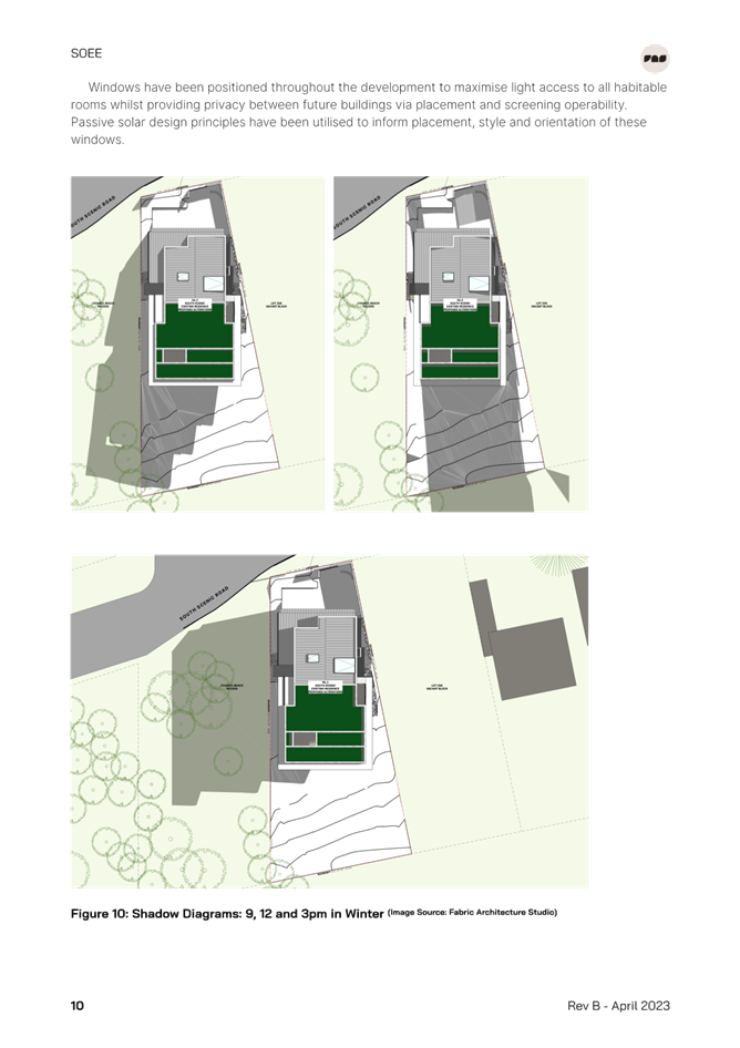
2.1.4.4 Sunlight Access |
Min 3 hrs/day sunlight mid-winter to 50% of principal private open space POS for new dwellings.
Minimum 3 hours/day sunlight mid-winter to 50% of principal POS on adjoining land |
Shadow diagrams indicate compliance is achieved. The rear of the site achieves sunlight in the morning period with shadow impact in the PM period. The additional shadow casted by the extension is minor and not significant and does not impact adjoining residential properties. There is additional shadow cast on the southern and eastern side of the public walkway and beach area in the late afternoon. This is considered to be reasonable. |
Yes |
Yes |
|
2.1.5 Car Parking and Access |
Provide minimum off street parking facilities – 2 spaces for dwelling with 4 or more bedrooms Ensure safe vehicular access to public road Max driveway width 4m at street crossover |
2 spaces provided within garage parking facilities behind the primary road setback.
|
Yes
|
Yes
|
|
2.1.6.1 Earthworks |
Cut/fill maximum 1m within 1m of boundaries, or 3m if more than 3m from boundary |
<1m |
Yes |
Yes |
|
2.1.6.2 Retaining Wall and Structural Support |
More than 600mm above or below existing ground level and within 1m of any boundary, or more than 1m above or below existing ground level in any other location, to be designed by a professional engineer. |
Setbacks to existing dwelling maintained. Geotechnical report submitted for piling/foundations. |
Yes - compliance with the Coastal Engineering reports and plans |
Yes |
|
2.1.6.3 Drainage |
All stormwater drainage collecting must be conveyed by a gravity fed or charged system to a public drainage system, or an inter-allotment drainage system, or an on-site disposal system |
A roof/stormwater plan has been submitted. To be conditioned to dispose of into on site system with water tanks for retention/detention. |
Yes |
Yes |
Chapter 3.2 Coastal Hazard Management
The proposal has been assessed in accordance with the relevant provisions of CCDCP 2022 Chapter 3.2 Coastal Hazard Management.
In accordance with Chapter 3.2 the following documentation has been provided with the development application:
· Coastal Engineering Advice prepared by Horton Coastal Engineering dated 5 January 2023. (Horton 2023) (Attachment 5).
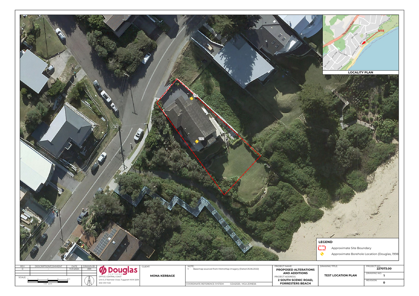
· Geotechnical Assessment prepared by Douglas Partners Project 227073.00 dated 16 January 2024. (Attachment 7)
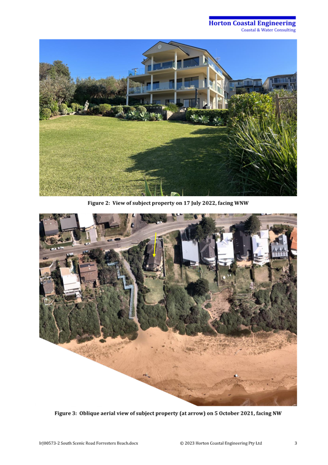
Figure 10 - View of site (at arrow) from Forresters Beach 17/07/2022 (Horton 2024).
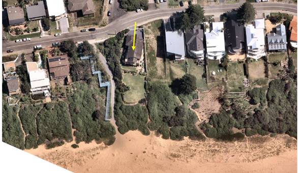 Figure 11 - Aerial
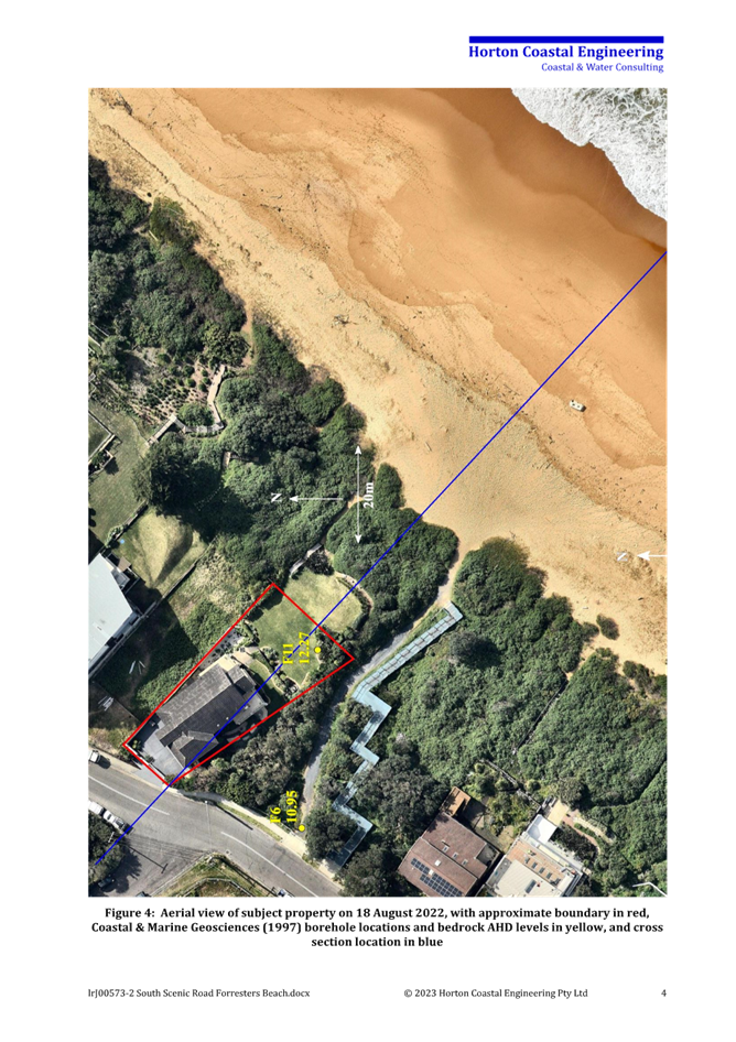
view of site (at arrow) 5/10/2021 (Horton 2024)
Figure 11 - Aerial
view of site (at arrow) 5/10/2021 (Horton 2024)
Clause 3.2.3.3.2(a)
A Coastal Building Line does not apply to Forresters Beach.
Based on clause 3.2.3.3.2(b) of DCP 2022, “all structures constructed within a designated Coastal Hazard Area shall:
i) be compatible with the coastal hazards identified;
ii) be founded landward of the coastal building line;
iii) not give rise to any increased coastal hazard;
iv) be designed to not be damaged by the designated hazard;
v) give consideration to the effects of larger events than the designated hazard;
vi) be constructed in a manner which overcomes any problem from the coastal hazards of run-up and inundation; and
vii) be set back as far landward as practicable”.
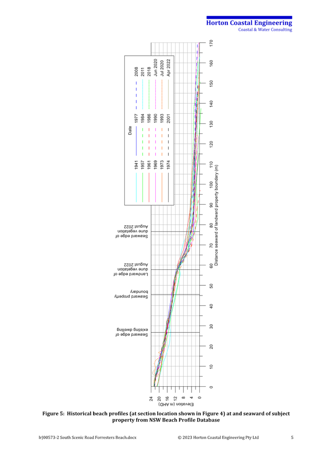
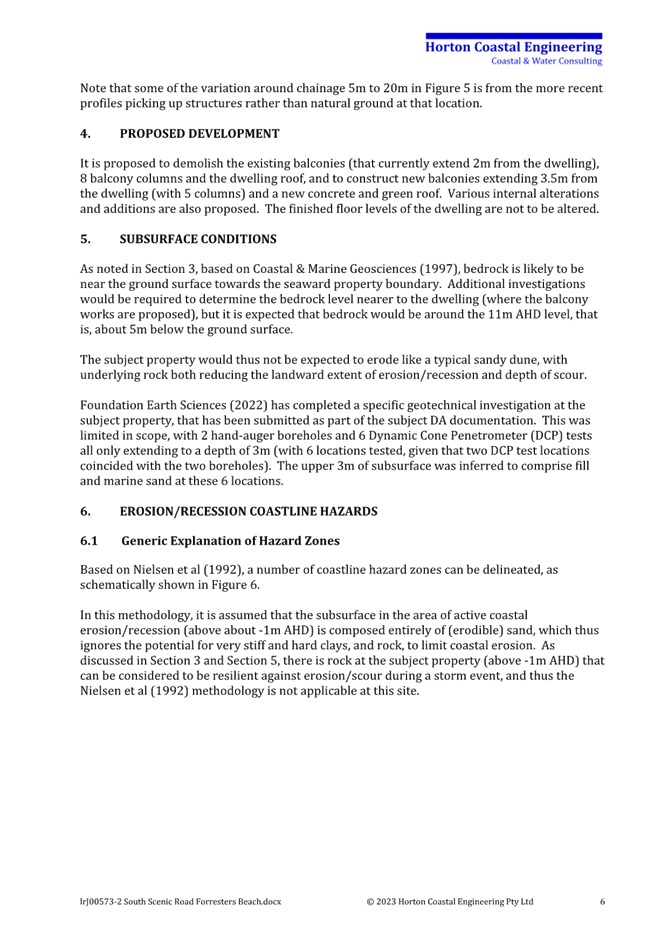
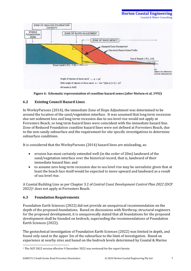
As outlined in Section 6.3 (Horton 2023), the proposed development is at an acceptably low risk of damage as it is to be founded on bedrock, as long as it is assessed as part of detailed design that there is elevated bedrock seaward of the dwelling and a coastal engineer confirms that the foundations of the proposed development do not need to be designed to resist being undermined by coastal erosion. Is this is undertaken, the proposed development would be compatible with the coastal hazards identified, as per (i) and (iv).
Larger events than the design event could occur, as could tsunamis. However, the probabilities of these events are so low that the development remains at an acceptably low risk of damage, which is the desired outcome (zero risk is not possible), and these addresses (v). Factors of safety in design also mean that foundations can be expected to withstand larger storm events than the design storm event. However, it is reiterated though that it is acceptable to design for the design event, by definition.
With regard to (ii), the Coastal Building Line is not applicable at this location.
With regard to (iii), the proposed development will not give rise to any increased coastal hazard on adjacent land, if founded as outlined in Section 6.3, as it would be supported on piles well above wave action in the design erosion event. That stated, it is the expectation that the proposed development would not be undermined in the design event, to be confirmed as part of detailed design.
With regard to (vi), it was noted in Section 7 (Horton 2023) that the proposed development is at an acceptably low risk of damage from runup and inundation.
Item (vii) is not a coastal engineering matter. That stated, it is reiterated that the proposed development is at an acceptably low risk of damage from coastal erosion/recession (if founded as outlined in Section 6.3 (Horton 2023) and bedrock depth is confirmed as part of detailed design) and inundation. It is also noted that the proposed development does not significantly alter the ground floor footprint of the existing dwelling.
Clause 3.2.3.3.2(c)
Based on Chapter 3.2.3.3.2(c) of DCP 2022, “Council will not permit the redevelopment of existing buildings within the Coastal Hazard Area unless the foundation design is demonstrated to have been constructed to withstand designated coastal processes and is certified by a coastal and structural engineer”.
The proposed development is at an acceptably low risk of damage as it is to be founded on bedrock, as long as it is assessed as part of detailed design that there is elevated bedrock seaward of the dwelling and a coastal engineer confirms that the foundations of the proposed development do not need to be designed to resist being undermined by coastal erosion.
Clause 3.2.3.3.2(d) and (e)
Chapter 3.2.3.3.2(d) and (e) of DCP 2022 are not applicable to the proposed development, as there is no Coastal Building Line at the site.
Clause 3.2.3.3.2 (h) to (l)
Based on Chapter 3.2.3.3.2 (h) to (l) of DCP 2022:
· “(h): Structural design of buildings and foundations shall take into account storms greater than the design storm event, and that erosion/run-up/inundation may exceed the design storm event.
· (i): Building footings including strip-footings and/or isolated pier construction are to be designed to ensure safe bearing below or beyond the calculated zone of reduced foundation capacity.
· (j): Where structural consideration of coastal forces is required the engineer shall take into account the forces generated by coastal processes, possible dune slumping, loss of support, slope readjustment, changing water table as well as the normal structural and foundation considerations. Foundation design shall extend beyond the reduced foundation capacity zone of influence.
· (k): In areas of high or moderate cliff instability risk within a Coastal Hazard Area, a geotechnical engineer site assessment will need to demonstrate that the position of the building on the site and its design has considered any expected foundation impediments (Refer Cliffline Hazard Definition Study for Tudibaring Headland).
· (l): Any sand excavated during building works should, where possible, remain within the same embayment, and requires approval by Council to be reused in other beach locations. It should be demonstrated to Council that the sand is clean and free of deleterious matter”.
With regard to (h), storms greater than the design storm event were discussed in Section 8.2 (Horton 2023). With regard to (i), the footings are to extend down to bedrock. CCDCP 2022 identifies that piling is required in this location as well as adjoining residential sites which is supported by the geotechnical report.
With regard to (j), it is unlikely these coastal forces would need to be considered (due to elevated bedrock seaward of the dwelling), and this will be assessed as part of detailed design.
Item (k) is not applicable. The subject property is not in a designated (rocky) cliff area. The “Cliff Line Hazard Definition Study at Tudibaring Headland, Copacabana NSW” prepared in 1996 relates to Tudibaring Headland at the northern end of MacMasters Beach, and has no relevance to the subject DA.
With regard to (l), if the owner proposes to place excavated sand on the beach (and this is not currently proposed), and Council was willing to accept it, then testing would be undertaken to assess its suitability (ie, that it is not contaminated). This could be enforced through a consent condition.
Conclusion
It is concluded that the proposed development satisfies the CCDCP 2022 coastal engineering requirements, as long as it is assessed as part of detailed design that there is elevated bedrock seaward of the dwelling and a coastal engineer confirms that the foundations of the proposed development do not need to be designed to resist being undermined by coastal erosion. (Refer Condition 2.5-2.7, 5.8, 5.9 and 6.4)
Scenic Quality.
The site is located within Forresters Beach 1: Ocean Beachfront. The desired character for this area is;
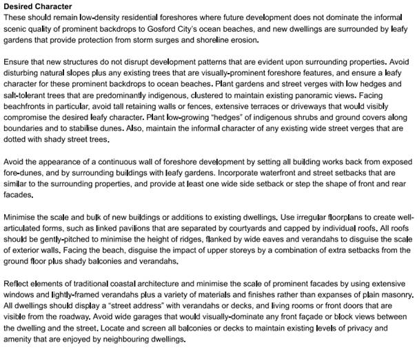
The proposal is considered to comply with the desired character as it:
· Does not dominate the scenic backdrop to the beach.
· Maintains a large open landscape area at the rear.
· Minimises the bulk and scale by reducing ridge height.
· Has extensive balconies on the beach side.
· Has a variety of external finishes and materials and extensive windows.
Likely Impacts of the Development:
Bushfire Risk
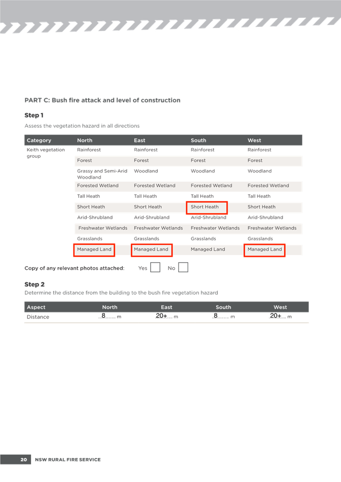
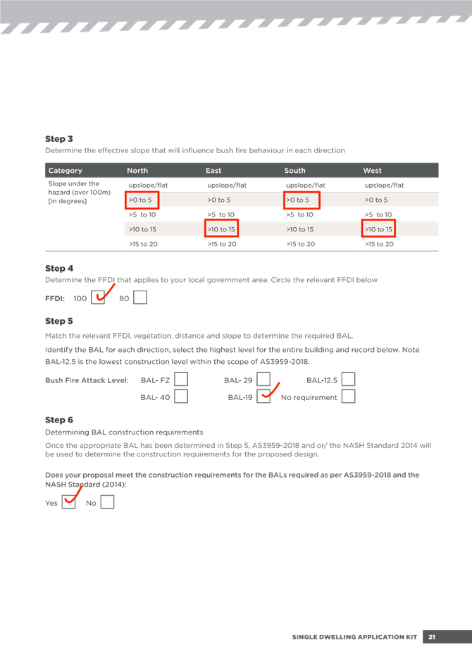
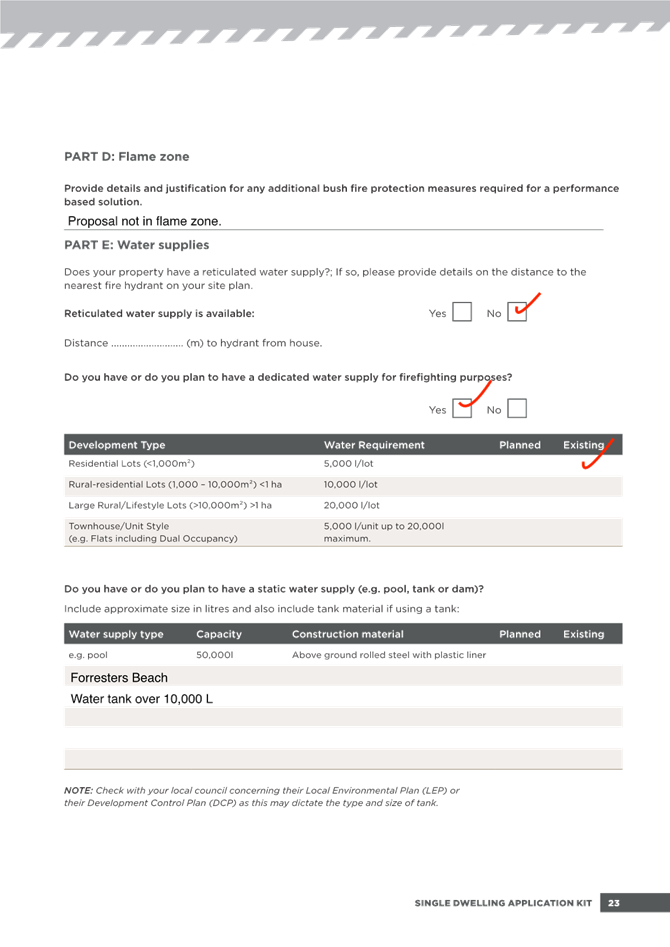
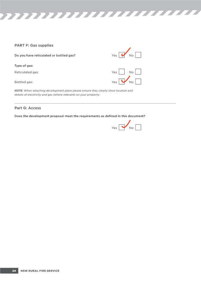
The site is identified as bush fire prone land.
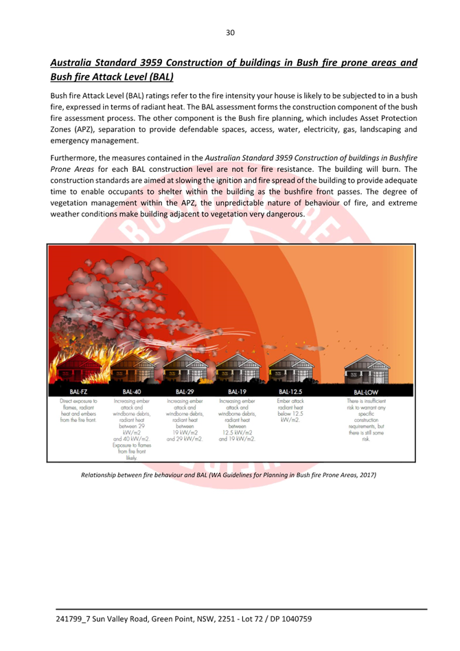
The applicant has submitted a bushfire assessment report which identifies that the proposal construction is required to comply with Bal-19. (Refer condition 2.4)
The Public Interest:
Submissions
None received.
Submissions from Public Authorities
Not required.
Internal Consultation
|
Water and Sewer |
Supported subject to conditions. Refer conditions 2.2 and 6.2. |
||
|
Coastal Engineer |
|
Supported subject to conditions. See comments below. |
|
|
Environmental Health |
|
Supported without conditions. See comments below. Refer conditions 5.11-5.14. |
|
|
Coastal Engineer |
|
||
There is some discrepancy between the alignment of the aerial photography and the plan in relation to the property boundary (cadastre). The coastal hazard maps are rectified against the aerial photography.
DA application documents including Architectural Plans, Statement of Environmental Effect, Geotechnical Report, and Coastal Engineering Report have been reviewed and considered.
Coastal Hazard Recommendations
1. It is assessed that the proposal would not increase the level of coastal hazard at the site and that the proposal at an acceptable risk, provided that recommendations in the Coastal Report (prepared by Horton Coastal Engineering dated 5 January 2023) to be implemented.
2. A detailed geotechnical report will be required for the detailed design of structure. Requirements for geotechnical report are provided in Chapter 3.7 of the DCP 2022, and in Cl. 3.2.3.5.a.(ii): a geotechnical report indicating the sub-strata at the coastal building line alignment, landward extent of footings and the type of foundations required. If geotechnical engineering advice is being used to demonstrate reduced recession/future erosion potential on the subject site then substrata must also be described at the seaward portion of the subject land parcel. In areas of moderate or high-risk cliff instability the geotechnical report must detail the nature of the risks and how they can be mitigated;
3. The DA must be complied with DCP 2022 Cl. 3.2.3.3.2.e.(ii): The structure must not project seaward of a line drawn from the closest corner of the closest neighbouring dwellings either side of the subject lot; the aim being to align with existing buildings’ setbacks to provide equity and consistency.
With regard to the above, a geotechnical report has been submitted which stipulates piling to bedrock. (Refer attachment 7 and Conditions 2.5-2.7, 5.8, 5.9 and 6.4).
The proposed building line/setback on the eastern side with the beach frontage is consistent with and aligns with dwelling setbacks on either side of the site. (Refer Figure 10)
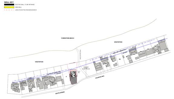
Figure 10 – Building Line
Environmental Health
Noise
· Noise Policy for Industry
· Noise Guide for Local Government
As this proposal is consistent with the surrounding residential land uses, a desktop review has determined that an acoustic impact assessment is not required.
During the construction phase for this proposal, it is anticipated that there maybe minor short-term impacts, but these can be controlled with a conditional requirement for any development consent issued. Although not restrictive to the progression of this application, it is recommended that the following conditions be applied to any development consent issued.
Do not give to offensive noise as defined in the Protection of the Environment Operations Act 1997
Air Quality
It is anticipated that the ongoing use of this proposal will not significantly impact the surrounding environment.
Contamination
Contamination References:
· Managing Land Contamination: Planning Guidelines SEPP55 – Remediation of Land.
· State Environmental Planning Policy (Resilience and Hazards) 2021.
As the proposal does not require major earthworks, the proponent is not required to address State Environmental Planning Policy (Resilience and Hazards) 2021.
Acid Sulfate Soils References:
· Acid Sulfate Soils Assessment Guidelines – Acid Sulfate Soils Management Advisory Committee August 1998
Based on Council’s Acid Sulfate Soil Risk mapping this property has been categorized as not containing any acid sulfate soils. The proponent will not need to provide an Acid Sulfate Soil Assessment and or Management Plan.
Waste
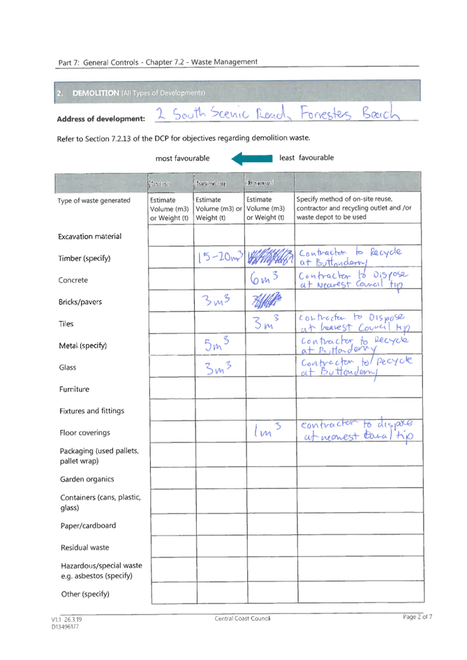
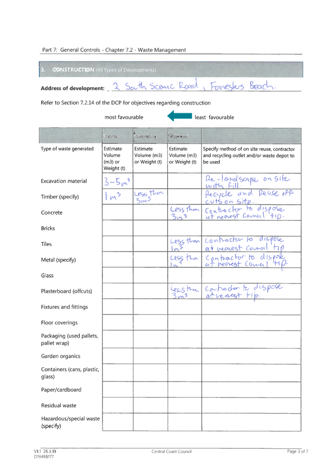
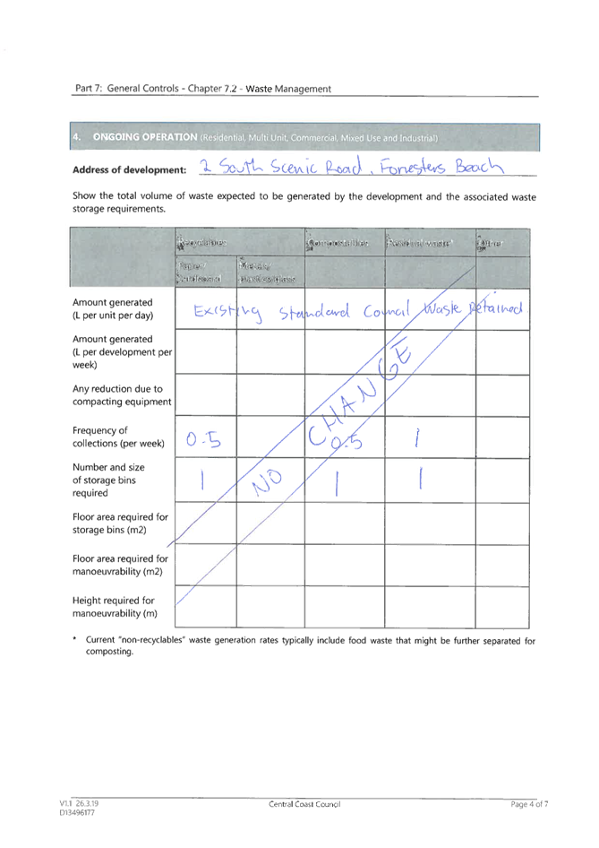
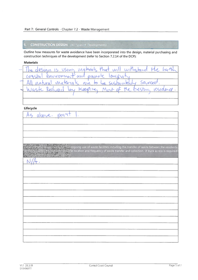
The generation of waste by this proposal is anticipated to be acceptable provided that the appropriate services are arranged to collect, handle and transport to a facility which is licensed to receive that material. The way the waste is to be stored prior to collection must be managed so that it does not pollute the environment.
There is no objection to the proposed “Alterations & Additions to Existing Dwelling “subject to the conditions being included within any consent granted. (Refer conditions 5.11-5.14)
Ecologically Sustainable Principles:
The proposal has been assessed having regard to ecologically sustainable development principles and is consistent with the principles.
The proposed development is considered to incorporate satisfactory stormwater, drainage and erosion control and the retention of vegetation where possible and is unlikely to have any significant adverse impacts on the environment and will not decrease environmental quality for future generations. The proposal does not result in the disturbance of any endangered flora or fauna habitats and is unlikely to significantly affect fluvial environments.
Climate Change
The potential impacts of climate change on the proposed development have been considered by Council as part of the assessment of the application.
This assessment has included consideration of such matters as potential rise in sea level; potential for more intense and/or frequent extreme weather conditions including storm events, bushfires, drought, flood, and coastal erosion; as well as how the proposed development may cope, combat, withstand these potential impacts. The proposed development is considered satisfactory in relation to climate change.
Other Matters for Consideration
Contributions
Section 7.11 and 7.12 Contributions (formerly Sections 94 and 94A Contributions) do not apply to the proposal.
Conclusion
This application has been assessed under the heads of consideration of section 4.15 of the Environmental Planning and Assessment Act 1979 and all relevant instruments and policies. The potential constraints of the site have been assessed and it is considered that:
· the site is suitable for the proposed development; and
· The proposal is satisfactory having regard for the relevant environmental planning instruments, plans and policies; and
· The proposal has been considered against the provisions of State Environmental Planning Policy (Resilience and Hazards) 2021, Central Coast Local Environmental Plan 2022 and Central Coast DCP 2022 and has been found to be satisfactory; and
· There are no significant issues or impacts identified with the proposal under s.4.15 of the Environmental Planning and Assessment Act 1979.
As such, the application is recommended for approval pursuant to section 4.16 of the Environmental Planning and Assessment Act 1979, subject to the Conditions set out in Attachment 10.
|
Revised Plans (Issue F) - PAN-347968 - DA/1391/2023 - 2 South Scenic Road, FORRESTERS BEACH |
Provided Under Separate Cover |
D16269315 |
|
|
2⇩ |
PUBLIC Revised Notification Plans (Issue F) - PAN-347968 - DA/1391/2023 - 2 South Scenic Road, FORRESTERS BEACH |
|
D16269389 |
|
3⇩ |
PUBLIC - Statement of Environmental Effects - PAN-347968 - DA/1391/2023 - 2 South Scenic Road, FORRESTERS BEACH |
|
D15758239 |
|
4⇩ |
PUBLIC - Clause 4.6 Variation - Redacted PAN-347968 - DA/1391/2023 - 2 South Scenic Road, FORRESTERS BEACH |
|
D15758235 |
|
5⇩ |
PUBLIC - Bushfire Report - Redacted PAN-347968 - DA/1391/2023 - 2 South Scenic Road, FORRESTERS BEACH |
|
D15758234 |
|
6⇩ |
Engineers Coastal Report - PAN-347968 - DA/1391/2023 - 2 South Scenic Road, FORRESTERS BEACH |
|
D15758224 |
|
7⇩ |
PUBLIC - Waste Management Plan - PAN-347968 - DA/1391/2023 - 2 South Scenic Road, FORRESTERS BEACH |
|
D15758245 |
|
8⇩ |
PUBLIC Revised Geotechnical Report - PAN-347968 - DA/1391/2023 - 2 South Scenic Road, FORRESTERS BEACH |
|
D16031458 |
|
9⇩ |
PUBLIC BASIX Certificate - PAN-347968 - DA/1391/2023 - 2 South Scenic Road, FORRESTERS BEACH |
|
D15758300 |
|
Survey Plans - PAN-347968 - DA/1391/2023 - 2 South Scenic Road, FORRESTERS BEACH |
Provided Under Separate Cover |
D15758246 |
|
|
11⇩ |
Survey Plans - PAN-347968 - DA 1391 2023 - 2 South Scenic Road FORRESTERS BEACH - redacted |
|
D16401881 |
|
12⇩ |
Draft conditions/reasons - 2 South Scenic Road, FORRESTERS BEACH NSW 2260 - DA/1391/2023 - Central Coast Council |
|
D16273814 |
|
3.1 |
DA/1391/2023 - 2 South Scenic Road, Forresters Beach - Alterations & Additions to Residential Development |
|
Attachment 2 |
PUBLIC Revised Notification Plans (Issue F) - PAN-347968 - DA/1391/2023 - 2 South Scenic Road, FORRESTERS BEACH |
|
DA/1391/2023 - 2 South Scenic Road, Forresters Beach - Alterations & Additions to Residential Development |
|
|
Attachment 3 |
PUBLIC - Statement of Environmental Effects - PAN-347968 - DA/1391/2023 - 2 South Scenic Road, FORRESTERS BEACH |
|
DA/1391/2023 - 2 South Scenic Road, Forresters Beach - Alterations & Additions to Residential Development |
|
|
Attachment 4 |
PUBLIC - Clause 4.6 Variation - Redacted PAN-347968 - DA/1391/2023 - 2 South Scenic Road, FORRESTERS BEACH |
|
DA/1391/2023 - 2 South Scenic Road, Forresters Beach - Alterations & Additions to Residential Development |
|
|
Attachment 5 |
PUBLIC - Bushfire Report - Redacted PAN-347968 - DA/1391/2023 - 2 South Scenic Road, FORRESTERS BEACH |
|
DA/1391/2023 - 2 South Scenic Road, Forresters Beach - Alterations & Additions to Residential Development |
|
|
Attachment 6 |
Engineers Coastal Report - PAN-347968 - DA/1391/2023 - 2 South Scenic Road, FORRESTERS BEACH |
|
DA/1391/2023 - 2 South Scenic Road, Forresters Beach - Alterations & Additions to Residential Development |
|
|
Attachment 7 |
PUBLIC - Waste Management Plan - PAN-347968 - DA/1391/2023 - 2 South Scenic Road, FORRESTERS BEACH |
|
DA/1391/2023 - 2 South Scenic Road, Forresters Beach - Alterations & Additions to Residential Development |
|
|
Attachment 8 |
PUBLIC Revised Geotechnical Report - PAN-347968 - DA/1391/2023 - 2 South Scenic Road, FORRESTERS BEACH |


|
DA/1391/2023 - 2 South Scenic Road, Forresters Beach - Alterations & Additions to Residential Development |
|
|
Attachment 9 |
PUBLIC BASIX Certificate - PAN-347968 - DA/1391/2023 - 2 South Scenic Road, FORRESTERS BEACH |

|
DA/1391/2023 - 2 South Scenic Road, Forresters Beach - Alterations & Additions to Residential Development |
|
|
Attachment 11 |
Survey Plans - PAN-347968 - DA 1391 2023 - 2 South Scenic Road FORRESTERS BEACH - redacted |
|
3.1 |
DA/1391/2023 - 2 South Scenic Road, Forresters Beach - Alterations & Additions to Residential Development |
|
Attachment 12 |
Draft conditions/reasons - 2 South Scenic Road, FORRESTERS BEACH NSW 2260 - DA/1391/2023 - Central Coast Council |

|
Item No: 3.2 |
|
|
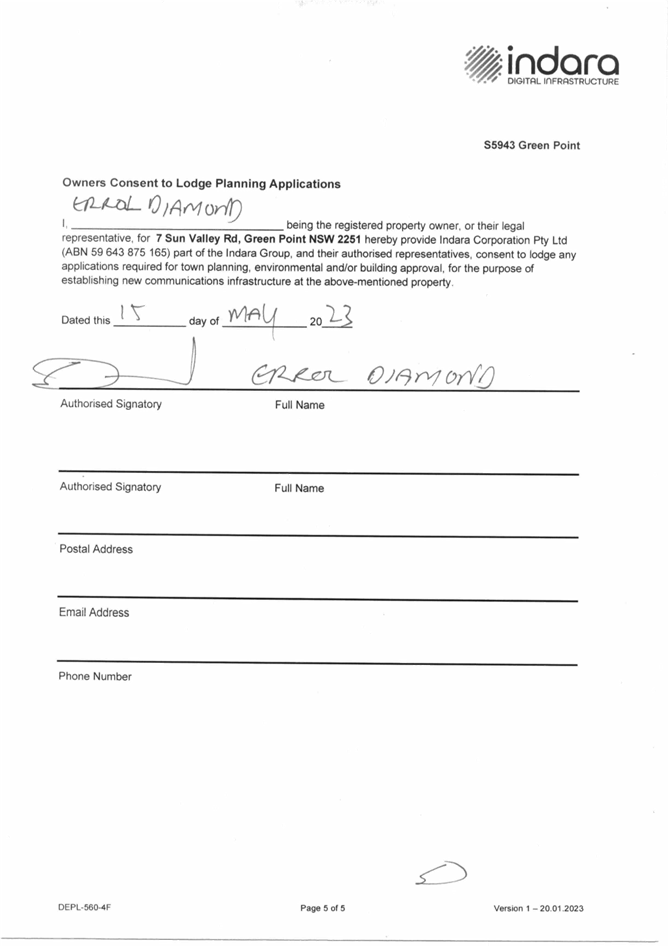
Title: DA/1552/2023 - 7 Sun Valley Road Green Point - Proposed Telecommunications and Communication Facilities |
|
|
Department: Environment and Planning |
|
|
19 September 2024 Local Planning Panel Meeting |
|
Reference: DA/1552/2023 - D16153764
Author: Amy Magurren, Senior Development Planner.Residential Assessments
Manager: Ailsa Prendergast, Unit Manager. Development Assessments
|
Summary
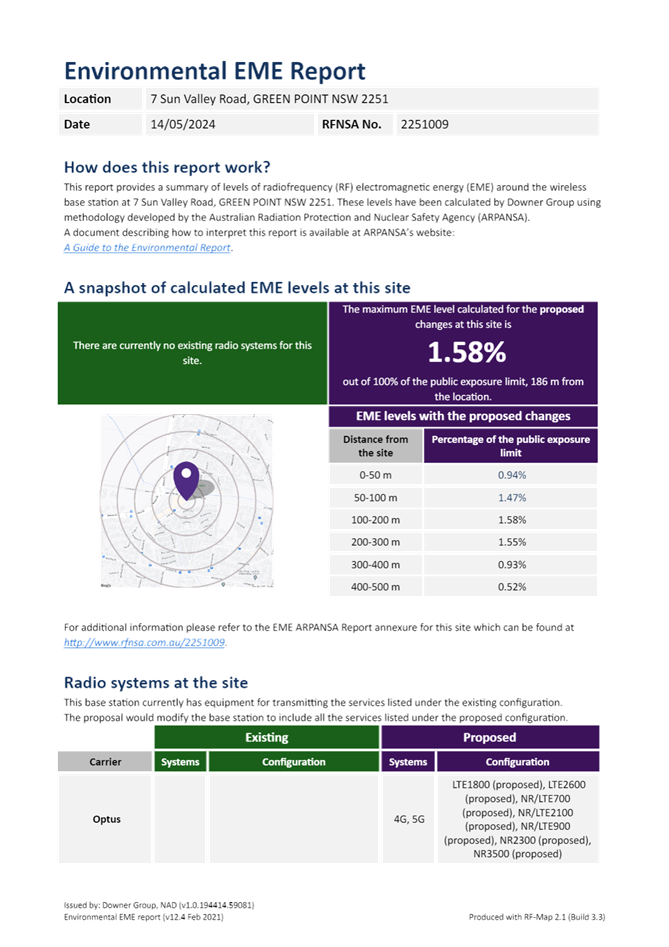
An application has been received for Telecommunications and communication facility at 7 Sun Valley Road, Green Point. The application has been examined having regard to the matters for consideration detailed in section 4.15 of the Environmental Planning and Assessment Act 1979 and other statutory requirements with the issues requiring attention and consideration being addressed in the report.
The application has been referred to the Local Planning Panel because of the variation to Clause 4.3 Height of Buildings development standard with the Central Coast Local Environmental Plan 2022.
In accordance with the Central Coast Development Control Plan 2022 the application was initially notified to adjoining owners from 10th November 2023 to 24th November 2023 and no responses were received. To maintain consistency with recent applications, renotification was undertaken to the radius area identified in the EME Report being 500m from the proposed location. Renotification was undertaken from 26th April 2024. to 10 May 2024 with nine (9) submissions being received during this period.
The application is recommended for approval, subject to conditions.
Applicant Downer Group - Melbourne Owner Diamond Edge Properties Pty Ltd Application No DA/1552/2023 Description of Land Lot 72 in DP 1040759 – 7 Sun Valley Road, Green Point Proposed Development Telecommunications and communication facility Site Area 1.306ha Zoning E1 – Local Centre Existing Use Retail – Shopping Centre Employment Generation Approximately 10 Jobs in construction Estimated Value $350,000 |
Recommendation
1 That the Local Planning Panel grant consent to DA/1552/2023 at 7 Sun Valley Road Green Point for a Telecommunications and communication facility subject to the conditions detailed in the schedule attached to the report and having regard to the matters for consideration detailed in Section 4.15 of the Environmental Planning and Assessment Act 1979.
2 The Panel agrees that the
applicant’s clause 4.6 written request demonstrates that compliance with
the height of buildings development standard is unreasonable in the circumstances
of the case because of the nature of the proposed telecommunications
infrastructure tower which is constructed to the height required to provide
essential mobile telecommunications services. Construction of a
telecommunications tower has an unavoidable noncompliance with the height of
buildings standard, as such are sufficient environmental planning grounds to
justify contravening the development standard.
Further, the Panel considers that the proposed development will be in the
public interest because it is consistent with the objectives of the development
standard and the objectives for development within the E1 Local Centre zone in
which the development is proposed to be carried out.
3 The Local Planning Panel assume the concurrence of the Secretary of the Department of Planning to permit the non-compliance with the development standard under clause 4.6 of the Central Coast Local Environmental Plan 2022, in accordance with the provisions of clause 55 of the Environmental Planning and Assessment Regulation 2021.
4 That Council advise relevant external authorities of the Panel’s decision.
5 That Council advise those who made written submissions of the Panel’s decision.
Key Issues
· Non-compliance with height of buildings standard from the Central Coast Local Environmental Plan 2022.
· Submissions and matters raise therein.
Precis:
|
Proposed Development |
Telecommunications & Communication Facilities
|
|
Permissibility and Zoning |
The subject site is zoned E1 – Local Centre under the provisions of the Central Coast Local Environmental Plan 2022 (Central Coast LEP 2022).
The development is defined as a ‘Telecommunications Facility’ which is defined under the Central Coast LEP 2022 as;
telecommunications facility means— (a) any part of the infrastructure of a telecommunications network, or (b) any line, cable, optical fibre, fibre access node, interconnect point equipment, apparatus, tower, mast, antenna, dish, tunnel, duct, hole, pit, pole or other structure in connection with a telecommunications network, or (c) any other thing used in or in connection with a telecommunications network.
The proposed development is permissible with consent in the zone. |
|
Current Use |
Retail – Shopping Centre
|
|
Integrated Development |
No
|
|
Submissions |
Notification was undertaken from 10th November 2023 to 24th November 2023 with no responses were received.
Renotification was undertaken from 26th April 2024. to 10 May 2024 with nine (9) submissions being received during this period.
|
Variations to Policies
The following variations are proposed to development standards within CCLEP 2022:
|
Clause |
4.3 – Height of Buildings |
|
Standard |
Maximum height limit of 8.5m. |
|
Departure basis |
The proposal seeks a maximum height of the telecommunications tower at 30m. This represents a variation of 21.5m or 252.3% at the highest point. |
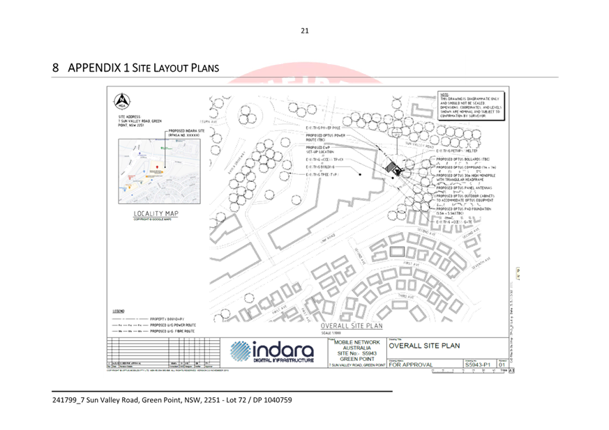
The Site
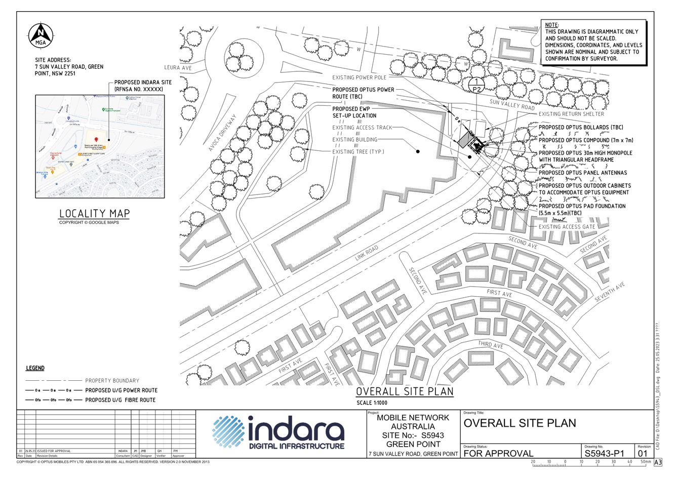
The site is legally identified as Lot 72 in DP 1040759 and is commonly known as 7 Sun Valley Road, Green Point.
The site contains the Green Point Shopping Village and is located on the intersection of Sun Valley Road and Avoca Drive. Access to the shopping centre is via Link Road at the rear of the site. It has an irregular shape and an area of 1.306ha. The proposed site of the telecommunications tower is located on the loading dock area of the on the north western corner of the site at the intersection of Sun Valley Road and Link Road.
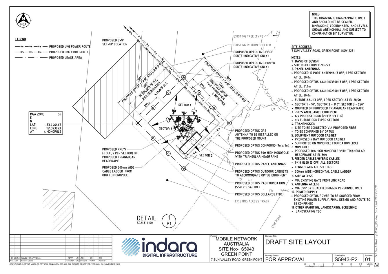
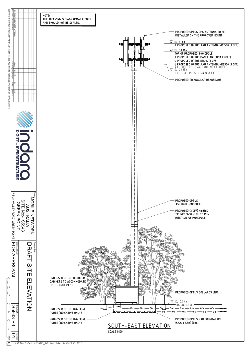
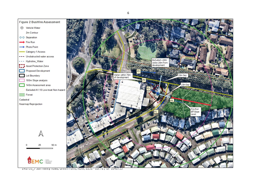
The site is bordered by low density residential dwellings to the north-east, south-east and south-west. A large lot residential property and bushland boarder the site to the west.
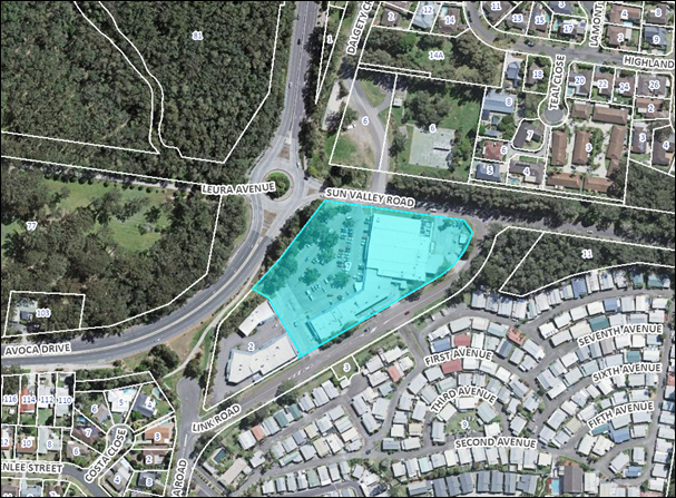
Figure 1: Site Locality Plan
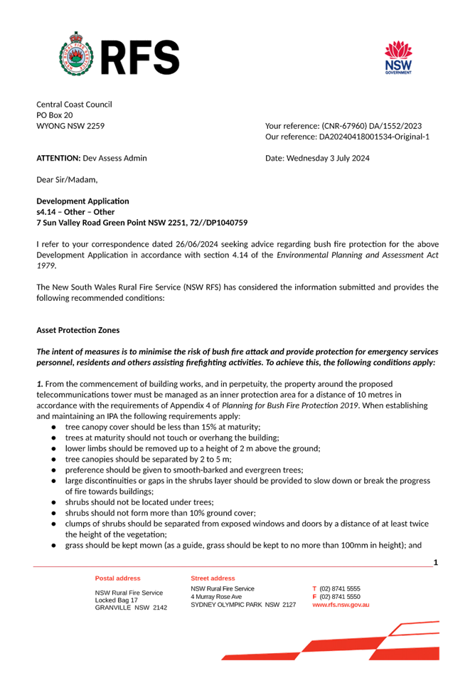
The subject site is identified as being " bushfire prone land" on Council's bushfire maps (refer to figure 2). A bushfire assessment report was submitted with the application recommending the proposed tower and building shelters be maintained in perpetuity within a 10m APZ and the construction of the equipment shelters shall comply with Sections 3 and 9 (BAL FZ) of Australian Standard AS3959-2009.
![]()
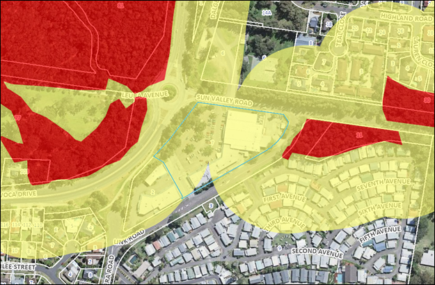
Figure 2: Bushfire Prone Land Mapping
The subject site is located within an E1 Local Centre under the provisions of Central Coast Local Environmental Plan 2022 (Central Coast LEP 2022) (refer to figure 3).
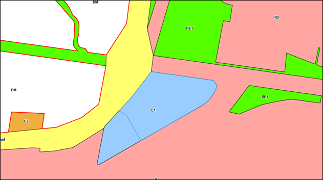
Figure 3: Land Zoning Mapping
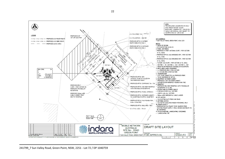
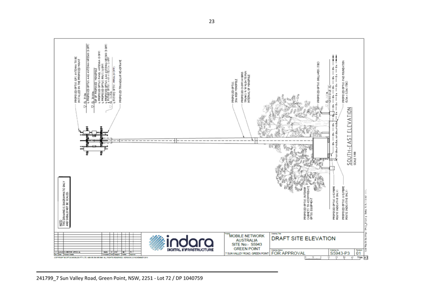
The Proposed Development
The application seeks development consent for the installation of a new telecommunications facility:
The proposal involves:
· One (1) 30m Indara monopole
· One (1) new antenna triangular headframe supporting the following equipment:
· Four (4) compact antennas, each 810mm in length, at a height of 30m, and
· Four (4) panel antennas, each 2.688m in length, at a height of 30m.
· One (1) outdoor equipment cabinet, 3.2m x 1.5m floor area, at ground level and contained within the proposed 7m (w) x 7m (l) compound fenced area.
· Ancillary equipment associated with the operation and safety of the facility, including nine (9) remote radio units, six (6) dual filters, cabling (internal), and antenna support mounts.
The purpose of the project is to significantly improve Optus mobile telecommunications services, including coverage and network capacity, in the Green Point area.
![]()
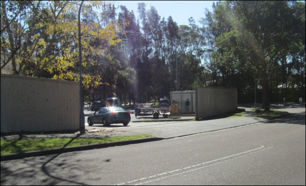
Figure 4: Proposed site location
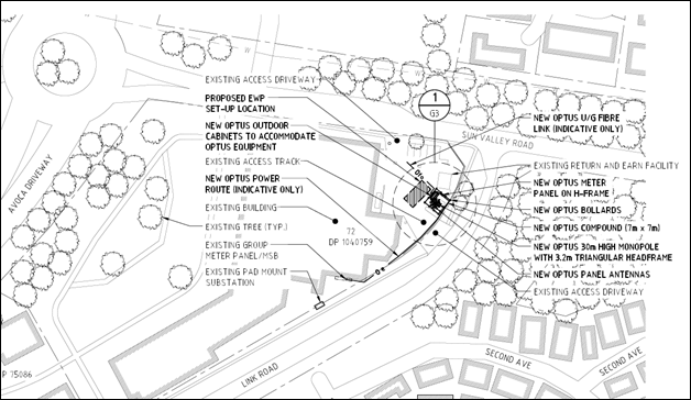
Figure 5: Proposed site plan
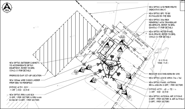
Figure 6: Detailed tower design
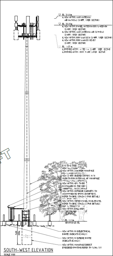
Figure 5: South West Elevation
ASSESSMENT:
Having regard for the matters for consideration detailed in Section 4.15 of the Environmental Planning and Assessment Act 1979 and other statutory requirements, Council’s policies and Section 10.7 Certificate details, the assessment has identified the following key issues, which are elaborated upon for the information of the Local Planning Panel.
Environmental Planning and Assessment Act 1979
Section 4.14 - Consultation and development consent—certain bush fire prone land
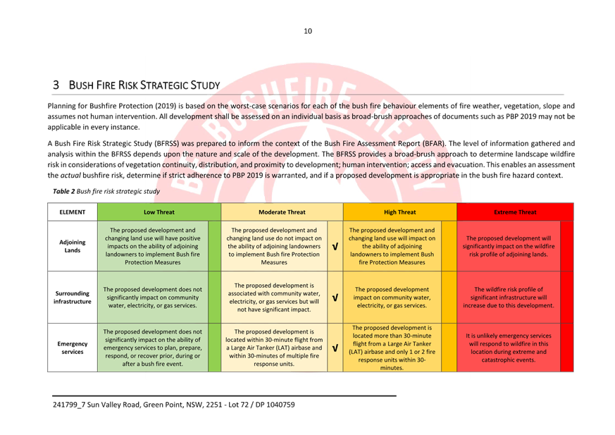
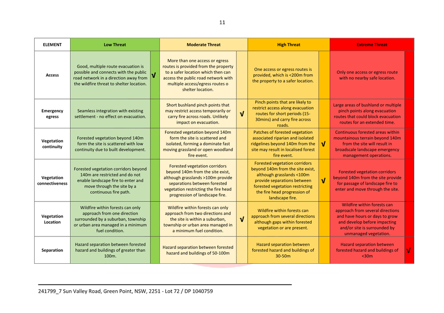
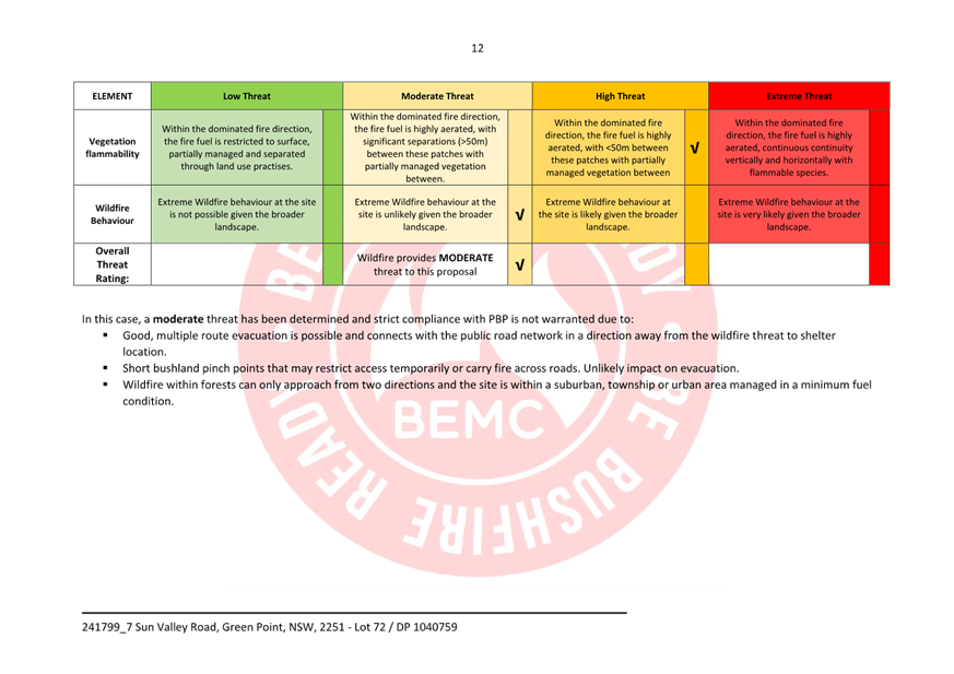
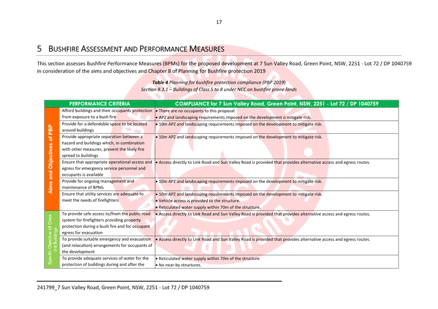
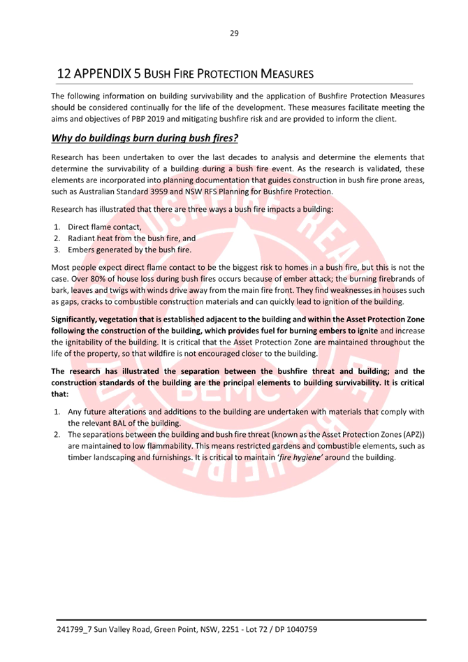
The site is identified as bushfire prone land on Council’s maps. In accordance with the provisions of Section 4.14 of the Environmental Planning and Assessment Act 1979, the consent authority is required to be satisfied that the proposal complies with the relevant requirements of Planning for Bushfire Protection 2019 (PBP).
A Bush Fire Threat Assessment Report was submitted with the application and referred to the NSW RFS for review and comment.
The proposal is for infrastructure (telecommunications tower), no buildings and no habitation. As such, the requirements are that the aim and objectives of PBP are able to be met. The bushfire assessment report has satisfactorily addressed the aims and objectives. It further provides recommendations for the ongoing management of the site against bushfire threat. The New South Wales Rural Fire Service (NSW RFS) has considered the information submitted and provides recommended conditions in relation to Asset Protection zones, Construction Standards, Landscaping Assessment.
The Panel can be satisfied that Section 4.14 of the Environmental Planning & Assessment Act 1979 have been considered and that the proposal complies with the provisions of NSW Planning for Bushfire Protection 2019.
State Environmental Planning Policy (Transport and Infrastructure) 2021
The SEPP (Transport and Infrastructure) 2021 commenced on the 1st March 2022 and provides a consistent planning regime for infrastructure and the provision of services across NSW, along with providing for consultation with relevant public authorities during the assessment process. Division 21 of the TISEPP applies to telecommunications and other communication facilities, establishing the approval regimes for telecommunications in NSW.
Clause 2.140 of the TISEPP defined a ‘Telecommunications Facility’ as:
telecommunications facility means—
(a) any part of the infrastructure of a telecommunications network, or
(b) any line, cable, optical fibre, fibre access node, interconnect point, equipment, apparatus, tower, mast, antenna, dish, tunnel, duct, hole, pit, pole or other structure in connection with a telecommunications network, or
(c) any other thing used in or in connection with a telecommunications network.
Clause 2.143 provides that:
(1) Development for the purposes of telecommunications facilities, other than development in section 2.141 or development that is exempt development under section 2.20 or 2.144, may be carried out by any person with consent on any land.
Telecommunications facilities are therefore permissible in all zones within the Central Coast LGA with development consent.
Clause 2.143(2) requires that the consent authority take into consideration any guidelines concerning site selection, design, construction, and operation of telecommunications facilities issued by the Planning Secretary. In this instance the NSW Telecommunications Facilities Guideline Including Broadband 2010 is one such guideline that applies to the proposal and must be considered. The application has been examined against the provisions of this Guideline in the following section of this report.
Telecommunications Facilities Guideline including Broadband (2010) Principles
The following table represents a consideration of the application against the Principles contained within the ‘Telecommunications Facilities Guideline including Broadband (2010)’, as required by Clause 2.143(2) of SEPP (Transport and Infrastructure) 2021. Council consideration has been also provided under the consistent heading.
|
Principle |
Response |
Consistent? |
|
NSW Telecommunications Facilities Guideline, Including Broadband |
||
|
Principle 1: Design and site telecommunications facilities to minimise visual impact. |
||
|
a. As far as practical, integrate a telecommunications facility that is mounted on an existing building or structure with the design and appearance of the building or structure. |
The proposal will comprise of a new monopole tower that is consistent with the appearance of the already existing structures within the general vicinity, in line with council guidelines. |
Yes |
|
b. Minimise the visual impact of telecommunications facilities, reduce visual clutter (particularly on tops of buildings) and ensure physical dimensions (including support mounts) are sympathetic to the scale and height of the building to which it is to be attached and to adjacent buildings. |
The proposal aims to minimise visual impact, being situated at top right of the land parcel, behind the shopping centre, amongst established, tall vegetation to reduce visual impact on surrounding residents and users of the general area. The proposal will be built to appropriate scale and fitting to the nature of infrastructure within the area. |
Yes |
|
|
|
|
|
c. If a telecommunications facility protrudes from a building or structure and is predominantly seen against the sky, either match the prevailing colour of the host building or structure or use a neutral colour such as pale grey. |
The proposal is coloured a factory grey, as to blend with the sky, which is more often cloudier than not. The design of the proposal aims to minimise visual features and to also match colours of structures within the immediate area. |
Yes |
|
d. Where possible and practical, screen or house ancillary facilities using the same colour as the prevailing background and consider using the existing vegetation or new landscaping. |
The proposal will house ancillary facilities including an equipment cabinet at ground level consistent to the design and colour of surrounding infrastructure. The location of the site is not for public access and the existing vegetation aids in providing a context of screening for the proposed facility. |
Yes |
|
e. Locate and design a telecommunications facility in a way that responds to its setting (rural, residential, industrial or commercial). |
The proposal is located within an E1 – Local Centre zone, situated at the top right of the land parcel behind the shopping centre, fitting well within the infrastructure setting. |
Yes |
|
f. Site and design a telecommunications facility located on or adjacent to a listed heritage item or within a heritage conservation area with external colours, finishes and scale sympathetic to the heritage item or conservation area. |
The proposal is not located on or in the vicinity of a heritage place or items. |
Yes |
|
g. Locate telecommunications facilities to minimise or avoid obstructing significant views of a heritage item or place, a landmark, a streetscape, vista or a panorama, whether viewed from public or private land. |
The proposal is expected to be visual in the surrounding area by virtue of its height, however, blends well into the surrounding context of infrastructure buildings and amongst established tall vegetation. The proposal does not obstruct significant views of a heritage item or place, a landmark, a streetscape, vista, or a panorama |
Yes |
|
h. Consult with relevant council when proposing pruning, lopping or removing any tree or vegetation. Obtain a tree preservation order, permit or development consent if required. |
No clearing of vegetation is proposed in order for the proposed facility to be installed. |
N/A |
|
i. Remove redundant telecommunications facilities and restore the site to the condition it was in prior to the facility’s construction. |
Not applicable. The proposal is a new facility with no prior existing telecommunication facilities present. |
N/A |
|
j. Remove redundant components of existing facilities after upgrades. |
Not applicable. The proposal is a new site with no prior existing telecommunication facilities present. |
N/A |
|
k. Where possible, consolidate telecommunications facilities to reduce visual clutter and work with other users on co-location sites to minimise cumulative visual impact. |
No locations were applicable and within RF objective range, thus no other locations were considered for co-location.
|
Yes |
|
l. Accord with all relevant industry design guides when siting and designing telecommunications facilities. |
Compliance with the NSW Telecommunications Code of Practice 2018 has been addressed. |
Yes |
|
m. Assess potential visual impact in alternative site assessments. |
Not applicable. No alternative site was considered due to no suitable location within RF objective. |
N/A |
|
Principle 2: Co-locate telecommunications facilities wherever practical |
||
|
a. As far as practical, locate telecommunications lines underground or within an existing underground conduit or duct. |
The proposal will include installation of underground power and fibre infrastructure. |
Yes |
|
b. Where practical, co-locate or attach overhead lines, antennas and ancillary telecommunications facilities to existing buildings, public utility structures, poles, towers or other radiocommunications equipment to minimise clutter. |
No overhead lines are proposed as a part of this development. The proposed antennas are to be installed on a new monopole, capable of collocating multiple mobile carriers, reducing the likelihood that an additional tower will be needed in the area. |
Yes |
|
c. Consider extending an existing tower as a practical co-location solution to new towers. |
Consideration for co-location was assessed. |
Yes |
|
d. Demonstrate that co-location is not practicable if choosing not to co-locate a facility. |
During our assessment co-location was impractical. |
Yes |
|
e. If choosing to co-locate, design, install and operate a telecommunications facility so that resultant cumulative levels of radio frequency emissions are within the maximum human exposure levels set out in RPS S-1. |
Not applicable. Co-location could not be achieved for this proposal. |
Yes |
|
Principle 3: Meet health standards for exposure to radio emissions |
||
|
a. Design, install and operate a telecommunications facility so that maximum human exposure levels to radiofrequency emission comply with RPS S-1 (see Appendix3). |
The proposal is compliant with the maximum human exposure levels to radiofrequency emissions. |
Yes |
|
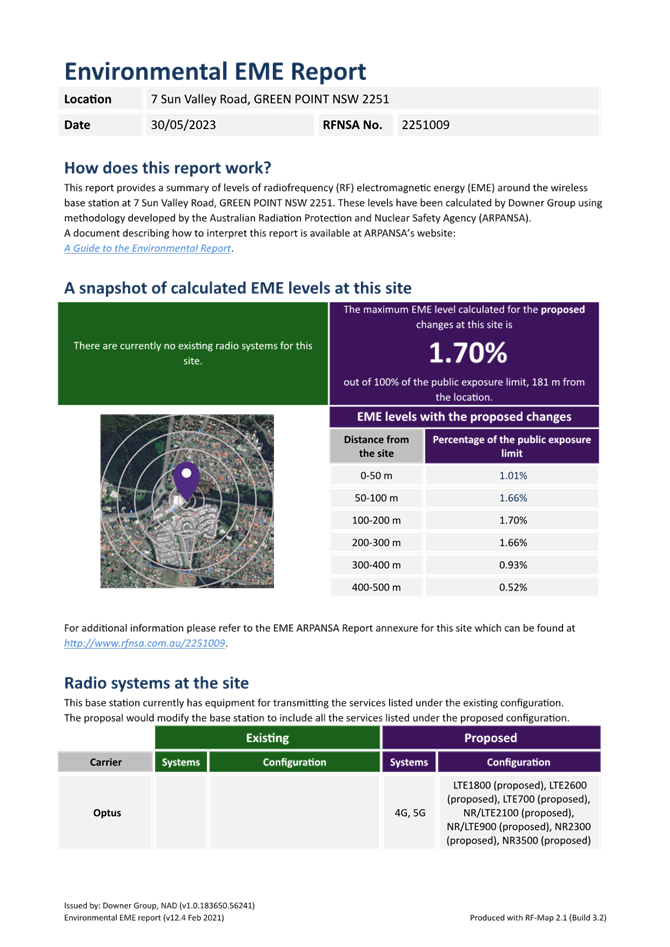
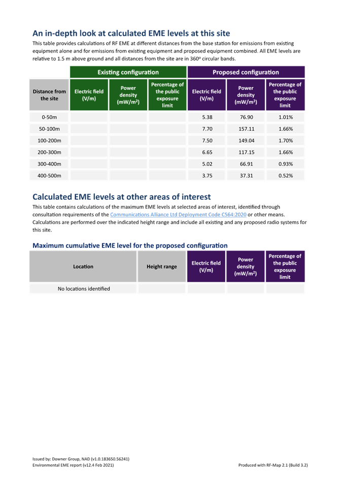
b. Using the format required by ARPANSA, report on predicted levels of EME surrounding any development covered by the Industry Code C564:2020 Mobile Phone Base Station Deployment, and how the development will comply with ACMA safety limits and RPS S-1. |
An EME report has been produced and is attached. |
Yes |
|
Principle 4: Minimise disturbance and risk, and maximise compliance |
||
|
a. Ensure the siting and height of a telecommunications facility complies with the of the Commonwealth Civil Aviation Regulations 1998 and Airports (Protection of Airspace) Regulations 1996. Avoid penetrating any obstacle limitation surface (OLS) shown on a relevant OLS plan for an aerodrome or airport (as reported to the Civil Aviation Safety Authority) within 30 km of the proposed development. |
A thorough assessment of the height restrictions as per the Commonwealth Civil Aviation Regulations 1998 and Airports (Protection of Airspace) Regulations 1996 was completed to ensure a safe distance between airspace and the proposed facility. The proposal is not within an OLS boundary. |
Yes |
|
b. Ensure no adverse radio frequency interference with any airport, port or Commonwealth defence navigational or communications equipment, including the Morundah Communication Facility, Riverina |
The mobile carrier equipment on the proposed tower is designed and will be installed as to not interfere with other radio frequency services within the vicinity. Radio propagation analysis has been used to select the appropriate antennas to meet the requirements for coverage from the facility, while minimising interference to the existing network. |
Yes |
|
c. Carry out the telecommunications facility and ancillary facilities in accordance with any manufacturer’s installation specifications. |
The proposal will be constructed in accordance with relevant manufacturing specifications to optimise safety, during installation and once erected. |
Yes |
|
d. Protect the structural integrity of any building or structure on which a telecommunications facility is erected. |
The proposal does not impede on any already existing structures within the land parcel, nor will it impact the integrity of said structures once erected. |
Yes |
|
e. Erect the telecommunications facility wholly within the boundaries of a property as approved by the relevant landowner. |
The proposal is located wholly within the boundaries of the approved land parcel and does not protrude on to adjacent land. |
Yes |
|
f. Ensure all construction of a telecommunications facility accords with Managing Urban Stormwater: Soils and Construction – Volume 1 (Landcom 2004), or its replacement. |
All construction of the proposed telecommunications facility, including maintenance and future upgrades, adheres by the Managing Urban Stormwater: Soils and Construction – Volume 1 (Landcom 2004) and will abide by any future changes within the construction legislation. |
Yes |
|
g. Mitigate obstruction or risks to pedestrians or vehicles caused by the location of the facility, construction activity or materials used in construction |
The proposal will be housed by a compound security fence, inaccessible to the general public, away from pedestrian walkways and traffic. |
Yes |
|
h. Where practical, carry out work at times that minimise disruption to adjoining properties and public access and restrict hours of work to 7.00am and 5.00pm, Mondays to Saturdays, with no work on Sundays and public holidays. |
The proposal will abide by government and council guidelines to minimise impact on the immediate community during the construction phase and once erect. |
Yes |
|
i. Employ traffic control measures during construction in accordance with Australian Standard AS1742.3-2002 Manual of uniform traffic control devices – Part 3: Traffic control devices for works on roads. |
As a part of the construction phase, appropriate measures to ensure the safety of workers constructing the proposed facility and the general public will adhere by the Australian Standard AS1742.3-2002 Manual of uniform traffic control devices – Part 3: Traffic control devices for works on roads. |
Yes |
|
j. Guard open trenching in accordance with Australian Standard Section 93.080 – Road Engineering AS1165 – 1982 – Traffic hazard warning lamps. |
As a part of the construction phase, open trenching will be conducted and managed appropriately in accordance with the Australian Standard Section 93.080 – Road Engineering AS1165 – 1982 – Traffic hazard warning lamps, to ensure works will be carried out safely and does not endanger workers constructing the proposed facility or the general public. |
Yes |
|
k. Minimise disturbance to flora and fauna and restore land to a condition similar to its condition before the work was carried out |
The location of the proposal was selected in an effort to minimise disturbance to the local flora and fauna, reducing negative impact on the surrounding environment. The land will be restored to a condition similar to how it was before the work was undertaken. |
Yes |
|
l. Identify any potential impacts on threatened species and communities in consultation with relevant authorities and avoid disturbance to identified species and communities where possible. |
Comprehensive preliminary assessment of the proposal’s location was untaken in an attempt to identify and minimise impact on threatened species that inhabit the general area. A thorough assessment through the Environment Protection and Biodiversity Conservation Act 1999 was conducted and indicates no disturbance to threatened species. |
Yes |
|
m. Identify the likelihood of harming an Aboriginal place and/or Aboriginal object and obtain approval from the Department of Premier and Cabinet if the impact is likely, or Aboriginal objects are found. |
A search on the Aboriginal Heritage Information Management Systems (AHIMS) has been conducted and no Aboriginal sites or places have been declared on or within the vicinity of the proposal. Should any Aboriginal objects be found, work will cease, and the appropriate authorities will be contacted to complete a thorough investigation on site. |
Yes |
|
n. Reinstate, at your expense, street furniture, paving or other facilities removed or damaged during construction to at least the same condition as that prior to installation. |
Not applicable. The proposal will not remove any existing street furniture, paving or other facilities within the area. |
N/A |
|
Principle 5: Undertake an alternative site assessment for new mobile phone base stations |
||
|
a. Include adequate numbers of alternative sites in the alternative site assessment as a demonstration of good faith. |
Alternative sites were scoped; however, RF objective could not be met, thus no alternative site was considered. |
Yes |
|
b. In addition to the new site selection matters in Section 4 of the Industry Code C564:2020 Mobile Phone Base Station Deployment: • only include sites that meet coverage objectives, and that have been confirmed as available, with an owner agreeable to having the facility on their land • if the preferred site is a site owned by the Carrier, undertake a full assessment of the site • indicate the weight placed on selection criteria • undertake an assessment of each site before any site is dismissed. |
A thorough assessment of all candidates was completed prior to selection of the proposed location. The selection criteria are designed to gain maximum potential out of the site and provide in depth knowledge to select the most appropriate candidate. Other candidates rejected during assessment as they did not meet RF objective. |
Yes |
Noting comments above, the development application is considered compatible with the principles outlined in the guideline and therefore deemed acceptable in this instance.
State Environmental Planning Policy (Resilience and Hazards) 2021
The relevant provisions of the SEPP are addressed as follows:
Chapter 2 Coastal Management
The aims of Chapter 2 are to be considered when determining an application within the Coastal Management Areas. The Coastal Management Areas are areas defined on maps issued by the NSW Department of Planning and Environment and the subject property falls within the ‘Coastal Environment Area’ and ‘Coastal Use Area’ identified on these maps.
In considering the impact of any development application, the consent authority must have regard to matters within clause 2.10 of the SEPP (for the coastal environment area) and clause 2.11 (for the coastal use area).
The relevant matters have been considered in the assessment of this application. The proposed development is not likely to cause undue impact on the biophysical, hydrological or ecological environment. The values of the natural coastal processes are not likely to be impacted, marine vegetation and fauna habitats will not be disturbed by the proposal and the proposal does not impact on known aboriginal cultural heritage, the surf zone, or existing public spaces. The proposed development will not result in adverse impact on rock shelves, overshadowing, loss of views from public places nor visual amenity.
The Panel can be satisfied that the relevant matters of clause 2.10 for development within the coastal environment and use area and clause 2.11 for development within the coastal use area have been considered in the assessment of this application. The application is considered consistent with the stated aims and objectives.
Chapter 4 Remediation of Land
Clause 4.6 of Chapter 4 requires that a consent authority must not consent to the carrying out of any development on land unless it has considered whether the land is contaminated. The current use of the site is being utilised for a commercial retail purposes, and there are no known previous uses that would lead to the site being contaminated or unsuitable for the proposed use.
The Panel can be satisfied that the proposed development is acceptable with regard to Chapter 4 of the SEPP.
Central Coast Local Environmental Plan 2022
The subject site is zoned E1 Local Centre under the provisions of Central Coast LEP 2022. The proposed development is best defined as a ‘Telecommunications Facility” which is defined under Central Coast LEP 2022 as:
telecommunications facility means—
(a) any part of the infrastructure of a telecommunications network, or
(b) any line, cable, optical fibre, fibre access node, interconnect point equipment, apparatus, tower, mast, antenna, dish, tunnel, duct, hole, pit, pole or other structure in connection with a telecommunications network, or
(c) any other thing used in or in connection with a telecommunications network.
The E1 zone is an open zone and telecommunications towers are permissible in the zone with development consent.
Central Coast LEP 2022 – Zoning
The land is zoned E1 Local Centre under the provisions of Central Coast LEP 2022.
The objectives for the E1 zone are:
· To provide a range of retail, business and community uses that serve the needs of people who live in, work in or visit the area.
· To encourage investment in local commercial development that generates employment opportunities and economic growth.
· To enable residential development that contributes to a vibrant and active local centre and is consistent with the Council’s strategic planning for residential development in the area.
· To encourage business, retail, community and other non-residential land uses on the ground floor of buildings.
· To encourage employment opportunities in accessible locations.
· To maximise public transport patronage and encourage walking and cycling.
· To minimise conflict between land uses within the zone and land uses within adjoining zones.
· To encourage an increased residential population through stand alone development or as part of mixed use development in centres and other local areas where land is not otherwise required to serve local needs.
· To permit residential uses while maintaining active retail, business and other non-residential uses at street level to contribute to the vitality of the area.
The proposal comprises an essential element of infrastructure that will not only provide efficient and equitable provision of public services and amenities to the immediate local and surrounding areas but increase network capacity and high-quality telecommunication delivery and coverage services. Resulting in increased reliability of the emergency services app connectivity, a range of housing, employment and recreational areas that will promote a variety of lifestyle opportunities in a sustainable and safe place to live, work and visit.
Following a detailed assessment of the proposed development and with the Applicant’s written request to vary a development standard within CCLEP 2022, it is considered that the proposal is consistent with the stated objectives of the zone.
Central Coast LEP 2022 – Clause 4.3 Height of Buildings
Clause 4.3 of the Central Coast LEP 2022 establishes the height of buildings on any land is not to exceed the maximum height shown for the land on the height of buildings map and provides the following objectives:
(a) to establish a maximum height of buildings to enable appropriate development density,
(b) to ensure that the height of buildings is compatible with the character of the locality.
Council’s LEP as per the Height of Buildings Map prescribes a maximum height of 8.5m for the subject land. The proposed telecommunications facility exceeds this height as the proposal amounts to a total height of 31.4m, this results in a total height variation of 269.41%.
Clause 4.6 provides for development that contravenes a development standard to be considered by the Consent Authority. A written request to vary a development standard is to accompany the development application. The applicant has provided a written Clause 4.6 request to vary the development standard to support the application.
Central Coast LEP 2022 – Clause 4.6 Exceptions to Development Standards
Clause 4.6 of GLEP 2014 provides the ability to grant consent to a development application where the variation to a development standard can be adequately justified and where the objectives of clause 4.6 are satisfied, being:
(a) to provide an appropriate degree of flexibility in applying certain development standards to particular development,
(b) to achieve better outcomes for and from development by allowing flexibility in particular circumstances.
In accordance with clause 4.6(3) the Applicant has submitted a written request seeking
variation the maximum height of building development standards of 31.4m in clause 4.3 of Central Coast LEP 2022. A copy of the clause 4.6 variation is included in Attachment 3.
Together with the applicant’s written request, Council refers to the first of the five tests
established in Wehbe v Pittwater Council [2007] NSW LEC 827 to demonstrate that
compliance with the numerical standard is unreasonable or unnecessary. The test seeks to demonstrate that the objectives of the standard are achieved notwithstanding non-compliance with the numerical standard, Clause 4.3 Height of Buildings of the Central Coast LEP 2022.
In accordance with clause 4.6, development consent must not grant consent for a development that contravenes a development standard unless:
(3) Development consent must not be granted to development that contravenes a development standard unless the consent authority is satisfied the applicant has demonstrated that—
(a) compliance with the development standard is unreasonable or unnecessary in the circumstances, and
(b) there are sufficient environmental planning grounds to justify the contravention of the development standard.
As a result of the above, Council must consider that the application sufficiently demonstrates that compliance with the development standard for height is unreasonable and that the application to the best of its ability, provides the most reasonable outcome with regards to height limits and other relevant development standards.
The Applicant’s written request to vary the height of building development standard
demonstrates the following:
· The facility cannot function at a lower height and strict compliance with the standard would render the project unfeasible. There is a precedent for telecommunications facilities around Green Point to exceed the height limit.
· The site is well separated from visually sensitive development, and is located where scenic amenity is not a predominant planning consideration. It is in a location where there are already a large number of established industrial style infrastructure, which present a comparable appearance to the telecommunications facility.
· The proposal will have minimal environmental impact and it will not require significant ground works.
· The proposal retains significant merit from a public benefit perspective and warrants approval.
· The height limit does not account for the technical requirements of mobile base stations, which need to be taller than their environment to function.
· Strict compliance with Council’s height limits would prevent new telecommunications facilities from being deployed in much of Green Point. Optus and other mobile carriers would be unable to deliver an effective service to the community, with significant social, economic, and public safety implications.
· Compliance with the standard is considered unreasonable, as it is a technical requirement that the facility be taller than 8.5m.
· The proposal does, however, have sufficient merit on environmental planning grounds. The proposal will have minimal impact on local amenity, generally complies with the LEP, and will have significant public benefit. The public benefit of approving the facility, in terms of improved communications, outweighs the public benefit of maintaining the standard.
· Contravening the development standard will not raise any matter of significance for state or regional environmental planning.
An assessment of the application against the five part planning principals established in Wehbe v Pittwater Council [2007] NSW LEC 827 to demonstrate that compliance with the numerical standard is unreasonable or unnecessary is required.
|
Five Part Test
|
||
|
Objectives |
Applicants Response |
Council Reponse |
|
(1) The objectives of the standard are achieved notwithstanding noncompliance with the standard |
The objects are generally achieved. The height objectives in the standard are not strictly relevant to telecommunications proposals. The specific provisions generally consider appropriateness of building heights in urban areas. The subject site is not a building, and there are no surrounding buildings it can be compared to – though it will have a comparable appearance to established floodlight poles on the same premises. However, the overarching principle of the standard is to protect amenity by preventing inappropriate development. The proposal has sufficiently low amenity impact, and sufficient planning merit, to warrant its proceeding. Strict compliance is unnecessary. |
The variation to the building height does not result in an increase in the density of the area. The proposed telecommunications tower is located in an appropriate location within an existing retail precinct and is compatible with the character of the locality. |
|
(2) The underlying objective or purpose of the standard is not relevant to the development and therefore compliance is unnecessary
|
The purpose of the standard is to prevent inappropriately tall development. The standard is worded to prevent construction of large buildings, with no allowance for utility structures that require height to function. The standard is not strictly relevant to the proposal on this basis.
|
The underlying objective of the standard aims at keeping the scale of buildings under 8.5m and does not consider telecommunications infrastructure. The tower does not impact visual bulk, access to sunlight or privacy of the surrounding properties and therefore strict compliance is unnecessary. |
|
(3) The underlying object or purpose would be defeated or thwarted if compliance was required and therefore compliance is unreasonable.
|
The purpose of the standard would not be defeated if compliance was required. However, the proposal has sufficient merit that strict compliance is unnecessary. Further, the purpose of the project – to improve mobile coverage to Green Point – would be defeated if strict compliance was necessary.
|
The proposed telecommunications tower requires height to be able to function efficiently and the underlying objective is focussed on the height of buildings not taking into account infrastructure. The tower does not have any unreasonable impacts to overshadow, privacy and amenity of surrounding properties and therefore strict compliance would be unreasonable. |
|
(4) The development standard has been virtually abandoned or destroyed by the council’s own actions in granting consents departing from the standard and hence compliance with the standard is unnecessary and unreasonable
|
Telecommunications facilities, for technical reasons, must protrude above the surrounding environment. There are numerous established telecommunications facilities in Green Point that are taller than the height limit because of technical need. Council appear to have taken a pragmatic approach to the standard; whereby strict compliance is not necessary providing the use is otherwise appropriate. |
Council has abandoned the development standard for the construction of essential telecommunications infrastructure. |
|
(5) The compliance with the development standard is unreasonable or inappropriate due to existing use of the land and current environmental character of the particular parcel of land. That is, the particular parcel of land should not have been included in the zone.
|
The site is located in the E1 – Local Centre zone and displays characteristics similar to the already existing structures within the general vicinity. Note telecommunications uses are required in all zones.
|
The proposed development is appropriate for the existing use of the land and compliance with the development standard would be unreasonable in the circumstances of the case. |
Council is satisfied that the Applicant has demonstrated compliance with the objectives of the development standard and the zone objectives such that the proposal is in the public interest. The contravention of the building height control does not raise any matter of significance for State or regional environmental planning given the nature of the development proposal. Strict compliance with the prescriptive building height control is unreasonable and unnecessary in the context of the proposal in the circumstances of this case. The proposed development meets the underlying intent of the control and is identified as the development option that best avoids unreasonable environmental amenity impacts that would otherwise be associated with a standard telecommunications facility.
This assessment concludes that the clause 4.6 variation of GLEP 2014 provided having regard to clause 4.3(2) of GLEP 2014 is well founded and worthy of support.
The request for a variation under Clause 4.6 is considered to be well founded and is recommended for approval.
Central Coast LEP 2022 – Clause 7.1 Acid Sulfate Soils
This land has been identified as being affected by the Acid Sulfate Soils Map and the matters contained in clause 7.1 of Gosford Local Environmental Plan 2014 have been considered. The site contains Class 3 Acid Sulfate Soils. The proposed development does not propose works greater than 1m below the natural ground surface and is unlikely to lower the water table more than 1m below the natural ground surface. In this instance, the proposed works are not considered to impact on Acid Sulfate Soils.
Central Coast LEP 2022 – Clause 7.6 Essential Services
Development consent must not be granted to development unless the consent authority is satisfied that all of the following services that are essential for the development are available or that adequate arrangements have been made to make them available when required—
(a) the supply of water,
(b) the supply of electricity,
(c) the disposal and management of sewage,
(d) stormwater drainage or on-site conservation,
(e) suitable vehicular access,
(f) the collection and management of waste.
Council is satisfied that all required essential services are available to the land and that adequate arrangements have been made.
PROVISIONS OF ANY DEVELOPMENT CONTROL PLAN:
Central Coast Development Control Plan 2022
An assessment of the proposed development against the relevant chapters of the Central Coast DCP 2022 is provided below:
CCDCP – Chapter 2.17 - Character and Scenic Quality
Character
Chapter 2.17 - Character and Scenic Quality applies to the development application. The chapter sets out the ‘existing’ and ‘desired’ character for each precinct and requires that character be considered in the assessment of any development application.
Whilst many of the matters pertaining to character relate to architectural design, scale and appearance of new buildings, streetscapes and the like, which are difficult to apply to infrastructure. However, there are a number of considerations within the ‘existing’ and ‘desired future character’ statement which are relevant to the subject application.
The subject site is located within the Green Point 10: Main Road Centre character area. The desired character statement for this locality (summarized) recommends that:
The existing character statement includes:
“Facing a major coastal thoroughfare, two retail centres provide community gathering places, as well as household goods and a variety of services for the surrounding residential area.
To the south, an established drive-in shopping centre faces two access streets, with two properties accommodating two storey buildings that include a small neighbourhood retail centre and a smaller residential-style building that houses estate agencies and other tenants.
Surrounded by an open carpark with an open canopy of planted eucalypts, the retal centre is a simple building over two levels, accommodating a small supermarket and several shops facing an internal arcade in an upper level that has no windows, plus a colonnaded lower level where a number of shops face the carpark but are concealed from the main road. Tenants in this older-style centre rely upon road-front pylon signs to attract customers.
To the north, facing a major intersection and roundabout, a medium-scale supermarket development has been completed recently, with a number of pavilion-style buildings set behind an open carpark and surrounded by a landscaped perimeter.”
The desired character statements includes:
“This should remain a mixed-use centre that provides a range of
services to the surrounding district and also incorporates some accommodat on,
where the civic quality of prominent backdrops to Gosford City's major arterial
thoroughfares are enhanced by "greening" of the road frontages, and
where new developments in leafy landscaped settings achieve a coordinated
standard of presentation and also display high levels of indoor activity.
Enhance the civic
presentation Of main road backdrops and achieve an improved setting for retail
and business activities by siting buildings behind leafy front gardens and
parking courtyards that provide a buffer to traffic and noise. Ensure that
neighbouring developments promote a co—ordinated network Of landscaped
setbacks, retail frontages plus pedestrian and vehicle access. Landscape all
setbacks and parking courtyards using hedges and rows of tall trees that are
predominantly indigenous, With elevated canopies that maintain the visibility
of shopfronts and commercial signs.
Promote high levels Of Visible retail-type activities along the main roads. Adopt a traditional "main street" configuration for new developments, maximising the number of retailers or businesses plus the continuity Of shop-windows that face the road and surround each parking courtyard. Incorporate footpaths With verandahs, colonnades or balconies that emphasise retail activity and provide sheltered pedestrian access from carparks to dearly-identified building entrances. Avoid delivery entrances that would disrupt the continuity of shopfronts. provide sheltered footpaths between neighbouring buildings, and link the driveways and parking upon neighbouring properties to allow convenient access for customers and deliveries.
Facing the major roads,
promote improved standards of urban design for all new buildings. Avoid the
appearance of uniform building heights facing any street or driveway frontage,
and vary the shape of all visible facades by terraces or balconies. as well as
by stepping the line of roofs or parapets, and by emphasising prominent
building corners or road intersections by taller forms.
Disguise the scale and bulk of new buildings by applying a variety of finishes to all front and side facades, including extensive windows that are shaded by balconies, verandahs or exterior sunshades, plus painted finishes over a mixture of masonry and sheet cladding. rather than expanses of plain masonry or metal cladding. Roofs should be gently-pitched to minimise the height of ridges, flanked by wide eaves that disguise the scale of exterior walls.
Civic presentation of road frontages should be supported by the co-ordination of building colour schemes and commercial signs. Signs should be limited in both size and number, attached to buildings in consistent locations but limited in height to create continuous horizontal bands along awnings or parapets, rather than covering an entire facade. Pylon signs at the street frontage should complement the design of landscaped areas, and should be limited to one per property.”
The visual impact assessment information provided by the applicant appears to represent a fair depiction of the visual impact associated with the proposal. The visual impacts of such towers are generally less in urban settings (than vegetated hillsides or ridgelines, for example) and the development proposes a tower that is situated and designed such that it is suitably located on the lot, behind the existing commercial premises and presented to have as little impact on the character of the area as possible. The proposed development does not dominate the streetscape and would not preclude the ongoing operation of the centre. The proposed development is not inconsistent with the desired character statement for the retail centre of Green Point.
Scenic Quality
The subject site is located within the East Brisbane Water land unit. The proposed development will be contained within an existing commercial area and not located in visually sensitive locations within the precinct such as a waterfront or on visually sensitive slopes or ridgelines. In this instance the proposal is considered acceptable in regard to the stated objectives of the CCDCP 2013 Chapter 2.2 Scenic Quality.
CCDCP – Chapter 3.5 - Tree and Vegetation Management
The proposal does not require the removal of any native vegetation.
Likely Impacts of the Development:
Built Environment
The proposed built form is considered acceptable in the context of the site and the local centre. The visual impacts of such towers as seen in many other areas is often initially seen as intrusive. In urban settings such as that in which the tower is to be located in Green Point the tower over time will ‘blend’ with its local environment and largely become ‘unnoticed’ like many of the other towers in similar urban environments.
The proposed telecommunications facility is situated to the rear of a lot within the retail core of Green Point, behind existing commercial premises. The location of the development will essentially preclude the viewing of the lower components of the tower and supporting infrastructure from most public places – only the upper areas of the tower will be visible.
Although it is difficult to design and locate telecommunications towers in order to completely remove any impact on the built environment, the proposed development is acceptable in terms of its location and design.
Access and Transport
The site is well served by existing roadways having frontage to the main access road to Erina, Gosford, Terrigal, Kincumber, Empire Bay and Woy Woy. Avoca Drive is also well served by public transport.
Context and Setting
The site and proposed development sits within a retail centre surrounded by a mix of residential and retail uses. See previous comments on character.
Natural Environment
The subject site does not contain any threatened species or habitat and will have no impact on the conservation of fish and marine vegetation. The site is completely void of any significant vegetation.
The proposal will not affect any identified wildlife corridor. The proposal is considered satisfactory in relation to impacts on the natural environment as identified throughout this report.
Economic Impacts
The proposed development is considered to be satisfactory from an economic perspective. It forms part of wider telecommunications infrastructure, the cumulative impact of which is likely to have a positive economic benefit through improved services to residents and businesses. There will be minor short term economic benefits during construction.
Social Impacts
No adverse social impacts will arise from the approval of this infrastructure development.
Suitability of the Site for the Development:
A review of Council’s records has identified that the site is not impacted by constraints such as flooding, risk of landslip or acid sulphate soils.
There are no constraints that would render the site unsuitable for the development.
Any Submission made in Accordance with this Act or Regulations
The development application was notified to adjoining owners from the 10th November 2023 to 24th November 2023 in accordance with Chapter 1.2 of the Central Coast Development Control Plan 2022. There were no submissions received during this time.
The development application was renotified to residents within 500m of the proposed development to include a broader area of impact as indicated on the EME report. The application was renotified from the 26th April 2024 to 10 May 2024. There were nine (9) submissions received from eight (8) individual residents during this time.
The issues raised in the public submissions are detailed below:
Submission: EME from the 5G components of the telecommunications facility will adversely affect the health of workers and residents who are located within the vicinity.
Comment: The EME emissions from mobile phone base stations and other communications installations are regulated by the Australian Communications and Media Authority (ACMA). The ACMA’s regulatory arrangements require base stations to comply with the exposure limits in the ARPANSA RF Standard. The ARPANSA Standard is designed to protect people of all ages and health status against all known adverse health effects from exposure to RF EME. The ARPANSA Standard is based on scientific research that shows the levels at which harmful effects occur and it sets limits, based on international guidelines, well below these harmful levels.
It is acknowledged that there is some community fear and perceptions surrounding health associated with EME as well as community questioning of the standards in place. It is not appropriate however for Council or for a court to question, aside or disregard the authoritative or credible standard set out by the ARPANSA, this is stated in the Land and Environment Court in the case of Telstra Corporation Limited v Hornsby Shire Council [2006] NSWLEC 133. It is neither appropriate for new standards be set up by Council as the creation of new standards is the responsibility of other federal authorities that have the expertise such as the ARPANSA. In this instance, the proposal meets the standards set by the ARPANSA.
Submission: The telecommunications facility should be located at another location.
Comment: The applicant has indicated that as part of the requirements under Federal Government legislation and guidelines they must consider possible alternate locations for the installation of the facility. The subject site for telecommunication performance reasons has been considered as the preferred location after the consideration of alternate sites as indicated in the Statement of Environmental Effects.
The Public Interest:
The approval of the application is considered to be in the public interest as it will provide for the future telecommunications needs of the community through provision of this facility. The cumulative impact of improved communications infrastructure is seen to be of a benefit to the community as a whole.
The public interest is best served by approval of the application.
Submissions from Public Authorities
The proposal is identified as ‘bushfire prone land’ on Council’s bushfire mapping system and accordingly was referred to NSW RFS for assessment.
The NSW RFS has by correspondence dated 3rd July 2024, advised that the service has considered the information submitted and is supportive of the application, subject to conditions of consent, which are provided below:
“Asset Protection Zones
The intent of measures is to minimise the risk of bush fire attack and provide protection for emergency services personnel, residents and others assisting firefighting activities. To achieve this, the following conditions apply:
1. From the commencement of building works, and in perpetuity, the property around the proposed telecommunications tower must be managed as an inner protection area for a distance of 10 metres in accordance with the requirements of Appendix 4 of Planning for Bush Fire Protection 2019. When establishing and maintaining an IPA the following requirements apply:
· tree canopy cover should be less than 15% at maturity;
· trees at maturity should not touch or overhang the building;
· lower limbs should be removed up to a height of 2 m above the ground;
· tree canopies should be separated by 2 to 5 m;
· preference should be given to smooth-barked and evergreen trees;
· large discontinuities or gaps in the shrubs layer should be provided to slow down or break the progress of fire towards buildings;
· shrubs should not be located under trees;
· shrubs should not form more than 10% ground cover;
· clumps of shrubs should be separated from exposed windows and doors by a distance of at least twice the height of the vegetation;
· grass should be kept mown (as a guide, grass should be kept to no more than 100mm in height); and
· leaves and vegetation debris should be removed regularly.
Construction Standards
The intent of measures is to minimise the risk of bush fire attack and provide protection for emergency services personnel, residents and others assisting firefighting activities. To achieve this, the following conditions apply:
2. New construction of the telecommunications tower must be undertaken using non-combustible materials.
Landscaping Assessment
The intent of measures is to minimise the risk of bush fire attack and provide protection for emergency services personnel, residents and others assisting firefighting activities. To achieve this, the following conditions apply:
3. Landscaping within the required asset protection zone must comply with Appendix 4 of Planning for Bush Fire Protection 2019. In this regard, the following principles are to be incorporated:
· A minimum 1 metre wide area (or to the property boundary where the setbacks are less than 1 metre), suitable for pedestrian traffic, must be provided around the immediate curtilage of the building;
· Planting is limited in the immediate vicinity of the building;
· Planting does not provide a continuous canopy to the building (i.e. trees or shrubs are isolated or located in small clusters);
· Landscape species are chosen to ensure tree canopy cover is less than 15% (IPA), and less than 30% (OPA) at maturity and trees do no touch or overhang buildings;
· Avoid species with rough fibrous bark, or which retain/shed bark in long strips or retain dead material in their canopies;
· Use smooth bark species of trees species which generally do not carry a fire up the bark into the crown;
· Avoid planting of deciduous species that may increase fuel at surface/ ground level (i.e. leaf litter);
· Avoid climbing species to walls and pergolas:
· Locate combustible materials such as woodchips/mulch, flammable fuel stores away from the building;
· Locate combustible structures such as garden sheds, pergolas and materials such as timber garden furniture away from the building; and
· Low flammability vegetation species are used.”
The comments of the NSW Rural Fire Service are noted and where applicable, have been included as suitable conditions of consent.
Internal Consultation
|
Environmental Health |
Supported, subject to conditions. |
||
|
Tree Assessment Officer |
Supported, subject to conditions. |
External Consultation
|
NSW Rural Fire Service |
Supported, subject to conditions. |
Ecologically Sustainable Principles:
The proposal has been assessed having regard to ecologically sustainable development principles and is considered to be consistent with the principles.
The proposed development is considered to incorporate satisfactory stormwater, drainage and erosion control and the retention of native vegetation where possible and is unlikely to have any significant adverse impacts on the environment and will not decrease environmental quality for future generations. The proposal does not result in the disturbance of any endangered flora or fauna habitats and is unlikely to significantly affect fluvial environments.
Climate Change
The potential impacts of climate change on the proposed development have been
considered by Council as part of its assessment of the application.
This assessment has included consideration of such matters as potential sea level; potential for more intense and/or frequent extreme weather conditions including storm events, bushfires, drought, flood and coastal erosion; as well as how the proposed development may cope, combat, withstand these potential impacts. The proposed development is considered satisfactory in relation to climate change.
Other Matters for Consideration:
Telecommunications Act 1997; and
Telecommunications Code of Practice 1997; and
Industry Code – Mobile Phone Base Station Deployment 2018
The Telecommunications Act 1997 sets up the framework for regulating the actions of telecommunications carriers which includes the installation of any telecommunications facilities. This is achieved through subclause 6(3) of schedule 3 of the act which gives authority to the Telecommunications (Low-impact Facilities) Determination 2018 (TD 2018). The TD 2018 is the instrument containing criteria which specifies when a telecommunications carrier is empowered to undertake any proposed works without approval. In this instance, the proposal is concerned with the installation of a monopole and does not satisfy the criteria specified in the TD 2018, therefore approval is required from the consent authority which in this case is the Local Planning Panel.
Under the Telecommunications Act 1997 the Federal Government established the Telecommunications Code of Practice 1997, which sets out the conditions under which a carrier must operate. Section 2.11 of the Telecommunications Code of Practice 1997 sets out the design, planning and installation requirements for the carriers to ensure the installation of the facilities is in accordance with 'industry best practice'. This is required to:
"...minimise the potential degradation of the environment and the visual amenity associated with the facilities." [Section 2.11(3)]
Best practice also involves the carrier complying with any relevant industry code or standard that is registered by the Australian Communications Authority (ACA) under Part 6 of the Act and includes the Mobile Phone Base Station Deployment Industry Code (C564:2018) (The Deployment Code).
The Deployment Code came into effect 17 December 2018, development of the code has been facilitated by the Communications Alliance through a working committee comprised of representatives from the telecommunications industry and government regulatory agencies and is an ultimate result of intentions of the Commonwealth Parliament as set out under Section 112 of the Telecommunications Act 1997. The Deployment Code is designed to:
· Allow the community and councils to have greater participation in decisions made by carriers when deploying mobile phone base stations; and
· Provide greater transparency to local community and councils when a carrier is planning, selecting site for, installing and operating mobile phone radio communications infrastructure.
The proposal has been considered for consistency with the relevant clauses of The Deployment Code as follows:
|
Assessment of the Mobile Phone Base Station Deployment Industry Code (C564:2018)
|
|||
|
Clause 4.1 Site Selection
|
|||
|
Subclause
|
Comment |
Consistent |
|
|
4.1.1 The Carrier must have written procedures for site selection for Mobile Phone Radiocommunications Infrastructure in relation to factors contained in clause 4.1.4 and make them available to the public on request.
|
Written procedures have been developed and will be made available to members of the public on request. |
Yes |
|
|
4.1.2 Once the preferred option has been selected, the Carrier must make available to the public on request, the summary of the sites considered and the reasons for the selection of the preferred option.
|
The site selection summary will be made available to members of the public on request. |
Yes |
|
|
4.1.3 The Carrier must comply with its procedures as per clause 4.1.1 above.
|
All procedures have been complied with. |
Yes |
|
|
4.1.4 The Carrier must ensure that its written procedures for new site selection require it to have regard to:
a. the reasonable service objectives of the Carrier including: i. the area the planned service must cover; ii. power levels needed to provide quality of service; iii. the amount of usage the planned service must handle;
b. minimisation of EME exposure to the public;
c. the likelihood of an area being a community sensitive location;
d. the objective of avoiding community sensitive locations;
e. relevant state and local government telecommunications planning policies;
f. the outcomes of consultation processes with Councils and Interested and Affected Parties as set out in clause 6.4;
g. the heritage significance (built, cultural and natural);
h. the physical characteristics of the locality including elevation and terrain;
i. the availability of land and public utilities;
j. the availability of transmission to connect the Mobile Phone Radiocommunications Infrastructure with the rest of the network;
k. the radiofrequency interference the planned service may cause to other services;
l. the radiofrequency interference the planned service could experience at that location from other services or sources of radio emissions;
m. any obligation and opportunities to co-locate facilities; and
n. cost factors.
|
a) The objective is for increased mobile coverage of the road corridor through Green Point and the commercial centre.
The power levels of the facilities will be set as low as possible to meet the required service objective. The facilities will also automate their power requirements in response to the demand and number of connections at any one time therefore maximising power efficiency.
The proposed base station needs to ensure that long-term, consistent, high quality voice and mobile data services are provided to businesses in Green Point, commuters and the surrounding area.
b) Antennas will face away from residential areas. The public exposure will be range from 0.52% to 1.58%.
c) Where existing restrictions allow, the proposal has been designed to respond to any community sensitive locations in terms of EME levels and Visual impact.
d) Community sensitive locations have been avoided, where existing restrictions allow.
e) The relevant State and Local government planning instruments have been considered in regards to the proposal.
f) All community consultation has been associated with Council’s notification procedure as per the code.
g) There is no heritage items nearby.
h) Green Point commercial centre is the dominant character of the immediate surrounds with some residential and schools areas nearby which have been considered.
i) The proposal is located in an area with access to adequate land and utilities.
j) The facility will utilize fibre transmission to obtain connectivity to the surrounding network.
k) The proposal is not expected to interfere with any existing services.
l) The proposal is not expected to interfere with any existing services.
m) there were no possible co-location opportunities found.
n) Cost factors are within the normal scope of the proposed facility
|
Yes |
|
Clause 4.2 Mobile Phone Radiocommunications Infrastructure Design
|
|||
|
4.2.1 The Carrier must have written procedures for designing Mobile Phone Radiocommunications Infrastructure.
|
Written procedures have been developed by Indara. |
Yes |
|
|
4.2.2 The Carrier must comply with its procedures as per clause 4.2.1 above.
|
Carrier will comply. |
Yes |
|
|
4.2.3 With the objective of minimising unnecessary or incidental RF emissions and exposure, the Carrier must ensure that its written procedures for designing Mobile Phone Radiocommunications Infrastructure, require it to have regard to:
a. the reason for the installation of the infrastructure, considering coverage, capacity and quality;
b. the positioning of antennas to minimise obstruction of radio signals;
c. the objective of restricting access to areas where RF exposure may exceed limits of the EME standard;
d. the type and features of the infrastructure that are required to meet service needs including: i. the need for macro, or small scale infrastructure ii. the need for directional or non-directional antennas;
e. the objective of minimising power whilst meeting service objectives; and
f. whether the costs of achieving this objective are reasonable.
|
a) The primary requirement for the proposal is to deliver 5G services to the Green Point commercial area .and commuters on Avoca Drive and surrounding residential areas The proposal will ensure that Indara is able to meets its customers’ current and growing demand for mobile data devices.
b) The antennas have been positioned to minimise the obstruction of radio signals as required.
c) The proposed monopole includes anti-climbing measures, preventing public access to this area. The equipment cabinet will be securely locked and appropriate EME signage will be placed on the site.
d) (i)-(ii) The site requires 2 panel antennas to meet its coverage objectives. e) Indara facilities automate power in response to the demand and number of connections.
f) The cost of achieving the objectives are reasonable. |
Yes |
|
|
4.2.4 The Carrier must make site EME assessments for Mobile Phone Radiocommunication Infrastructure in accordance with the ARPANSA prediction methodology and report format
|
Procedures to be complied with. |
Yes |
|
|
4.2.5 The ACMA may request a copy of the site EME estimate, and the Carrier must provide the estimate to the ACMA within two weeks of the request being made.
|
Carrier to comply - Any requests will be complied with within two weeks of the request being made. |
Yes |
|
|
Clause 4.3 Site Operation
|
|||
|
4.3.1 The Carrier must operate their Mobile Phone Radiocommunications Infrastructure in a manner consistent with the objectives in clause 4.2.3. |
Carrier is to comply. |
Yes |
|
|
4.3.2 The Carrier must be able to demonstrate compliance with the ACMA regulations regarding maximum human exposure limits for radiofrequency fields. |
Carrier is to comply. |
Yes |
|
|
4.3.3 The Carrier must take appropriate measures to restrict general public access to RF hazard areas. |
Carrier is to comply. |
Yes |
|
|
4.3.4 For each RF hazard area, the Carrier must ensure warning signs are in place in an appropriate location and manner so that they are clearly visible. |
Carrier is to comply. |
Yes |
|
|
4.3.5 In assessing whether measures are appropriate, the Carrier must have regard to:
a. the kinds of people who may have access to the area;
b. the need for physical barriers;
c. relevant occupational health and safety requirements;
d. the views of the property owner;
e. any site changes that have been made; and
f. any other matter which may be relevant to ensure site safety with regards to EME.
|
Dealt with previously in this report. |
Yes |
|
|
4.3.6 The Carrier must ensure that technical staff of the Carrier who may be involved in activities on or adjacent to Mobile Phone Radiocommunications Infrastructure are trained in radio frequency exposure safety.
|
Carrier is to comply. |
Yes |
|
|
4.3.7 The Carrier must ensure that RF transmission equipment no longer in service does not transmit, or is removed.
|
Carrier is to comply. |
Yes |
|
Development Contributions
The proposed development is a development type that is not subject to section 7.11 development contributions under the Contribution Plan. Therefore, no contributions are applicable.
Water and Sewer Contributions
There are no water and sewer contributions applicable to the proposed development
Ecologically Sustainable Principles
The proposal has been assessed having regard to ecologically sustainable development principles and is considered to be consistent with the principles.
The proposed development is considered to incorporate satisfactory stormwater, drainage and erosion control and the retention of vegetation where possible and is unlikely to have any significant adverse impacts on the environment and will not decrease environmental quality for future generations. The proposal does not result in the disturbance of any endangered flora or fauna habitats and is unlikely to significantly affect fluvial environments.
Climate Change
The potential impacts of climate change on the proposed development have been considered by Council as part of its assessment of the development application having regard to Council’s Climate Change Policy and the following policy commitment statement:
a) ‘Prepare, implement and review plans and strategies inclusive of consideration of risk from future sea level rise, and address the issue of, how to beneficially use coastal areas while recognising the long term need to protect, redesign, rebuild, elevate, relocate or retreat as sea levels rise.’
The potential impacts of climate change on the proposed development have been considered by Council as part of its assessment of the application.
This assessment has included consideration of such matters as potential rise in sea level; potential for more intense and/or frequent extreme weather conditions including storm events, bushfires, drought, flood and coastal erosion; as well as how the proposed development may cope, combat, withstand these potential impacts. The proposed development is considered satisfactory in relation to climate change.
Conclusion
This application has been assessed under the heads of consideration of section 4.15 of the Environmental Planning & Assessment Act 1979 and all relevant instruments and polices.
The potential constraints of the site have been assessed and it is considered that the site is suitable for the proposed development. Subject to the imposition of appropriate conditions, the proposed development is not expected to have any adverse social or economic impact.
The proposed development is considered suitable for the site despite the listed variation for the following reasons,
1. Assessment of the application has concluded the proposed development is permitted with the current R2 – Low Density Residential zone under the provisions of the Central Coast Local Environmental Plan 2022 and meets the objectives for the zone.
2. Assessment of the application has concluded the proposed development meets the objectives related to the building height development standard contained in Central Coast Local Environmental Plan 2022.
Assessment of the application has concluded the requirements of clause 4.6 (3) and (4) of Central Coast Local Environmental Plan 2022 have been satisfied and that
Submissions
The development application was notified in accordance with CCDCP 2022 from 28 April 2023 till 17 May 2023.
No submissions were received.
Contributions
The proposed development is not a development type that is subject to Section 7.11 or Section 7.12 development contributions. Therefore, no contributions are applicable.
The proposed development is not subject to water and sewer contributions.
Planning Agreements
The proposal is not subject to a Planning Agreement or Draft Planning Agreement.
Political Donations
During assessment of the application no political donations were declared by the Applicant. Applicant’s consultant, owner, objectors and / or residents.
Ecologically Sustainable Principles:
The proposal has been assessed having regard to ecologically sustainable development principles and is consistent with the principles.
The proposed development is considered to incorporate satisfactory stormwater, drainage and erosion control and the retention of vegetation where possible and is unlikely to have any significant adverse impacts on the environment and will not decrease environmental quality for future generations. The proposal does not result in the disturbance of any endangered flora or fauna habitats and is unlikely to significantly affect fluvial environments.
Climate Change
The potential impacts of climate change on the proposal have been considered as part of the assessment of the application.
The assessment has included consideration of such matters as potential rise in sea level; potential for more intense and / or frequent extreme weather conditions including storm events, bushfires, drought, flood, and coastal erosion; as well as how the proposed development may cope, combat and withstand any resultant impacts. The proposed development is considered satisfactory in relation to climate change.
The Public Interest
The proposed development is seen to be in the public interest by providing assurance that the subject land can be developed in proportion to its site characteristics.
Conclusion:
The development application has been assessed in accordance with Section 4.15 of the Environmental Planning and Assessment Act 1979, and all relevant instruments and polices. The proposed development is considered suitable for the site despite the listed variation for the following reasons:
1. Assessment of the application has concluded the proposed development is permitted with the current E1 – Local Centre zone under the provisions of the Central Coast Local Environmental Plan 2022 and meets the objectives for the zone.
2. Assessment of the application has concluded the proposed development meets the objectives related to the building height development standard contained in Central Coast Local Environmental Plan 2022.
3. Assessment of the application has concluded the requirements of clause 4.6 (3) and (4) of Central Coast Local Environmental Plan 2022 have been satisfied and that variation to the maximum building height provisions of the Central Coast Local Environmental Plan 2022 is warranted.
4. With regard to the variation to development standards, the assessment of the application has concluded that:
a. The Applicant’s written request for a variation to development standards (height) adequately addresses the matters required to be addressed under clause 4.6(3) of the Central Coast Local Environmental Plan 2022; and
b. The development is in the public interest because it is consistent with the objectives for development in the zone; and
c. The concurrence of the Secretary can be assumed.
The proposal is therefore recommended for approval pursuant to Section 4.16 of the Environmental Planning and Assessment Act 1979, subject to conditions as set out in Attachment 9.
|
1⇩ |
PUBLIC - Statement of Environmental Effects 7 Sun Valley, Green Point PAN-354156 - DA/1552/2023 |
|
D15788671 |
|
2⇩ |
Architectural Plans - 18/06 2024 - FULL SET - 7 Sun Valley Rd, GREEN POINT - PAN-354156 - DA/1552/2023 |
|
D16311028 |
|
3⇩ |
Vary Development Standard NSW Green Point_7 Sun Valley, Green Point PAN-354156 - DA/1552/2023 |
|
D15788647 |
|
4⇩ |
PUBLIC - Bush fire Assessment Report - 7 Sun Valley Rd, GREEN POINT - PAN-354156 - DA/1552/2023 |
|
D16268023 |
|
5⇩ |
PUBLIC - Amended EME Report- 7 Sun Valley Road Green Point - DA/1552/2023 |
|
D16197552 |
|
6⇩ |
AHIMS - 7 Sun Valley Road, Green Point DA/1552/2023 |
|
D15788616 |
|
7⇩ |
Protected Matters - MNES layers - 7 Sun Valley, Green Point PAN-354156 - DA/1552/2023 |
|
D15788659 |
|
8⇩ |
RFS Determination - DA/1552/2023 - 7 Sun Valley Road, GREEN POINT |
|
D16315352 |
|
9⇩ |
Draft conditions/reasons - 7 Sun Valley Road, GREEN POINT NSW 2251 - DA/1552/2023 - Central Coast Council |
|
D16315362 |
|
3.2 |
DA/1552/2023 - 7 Sun Valley Road Green Point - Proposed Telecommunications and Communication Facilities |
|
Attachment 1 |
PUBLIC - Statement of Environmental Effects 7 Sun Valley, Green Point PAN-354156 - DA/1552/2023 |
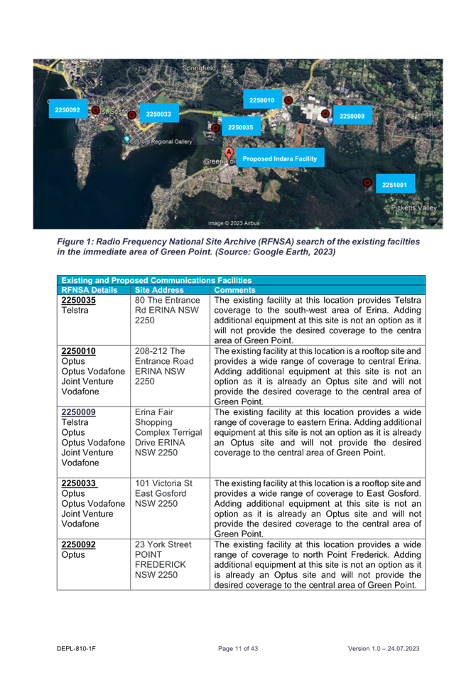
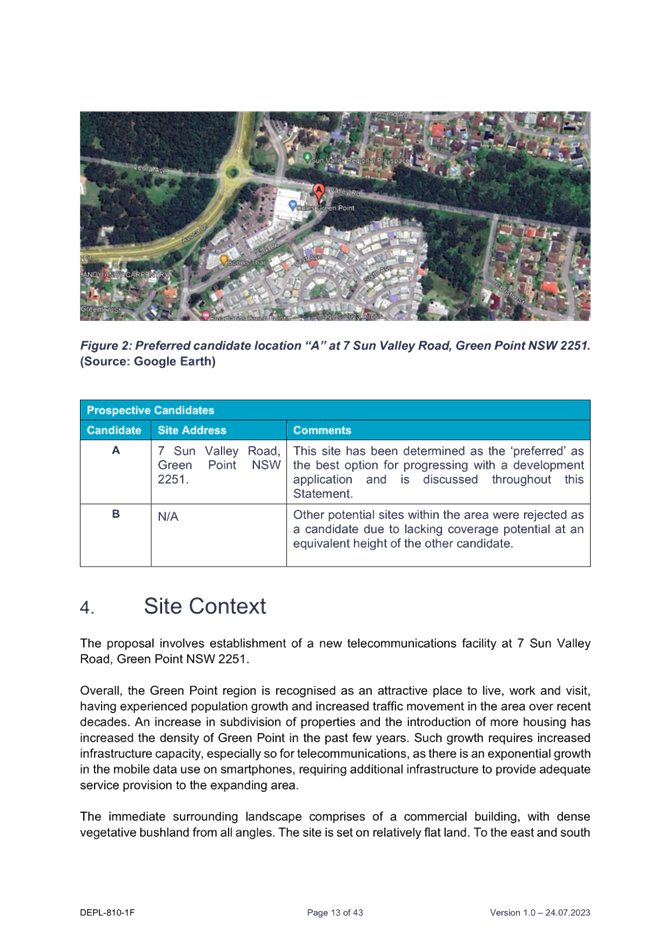
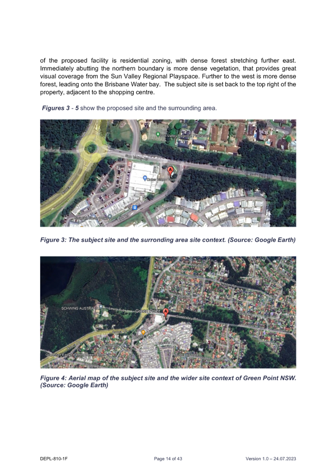
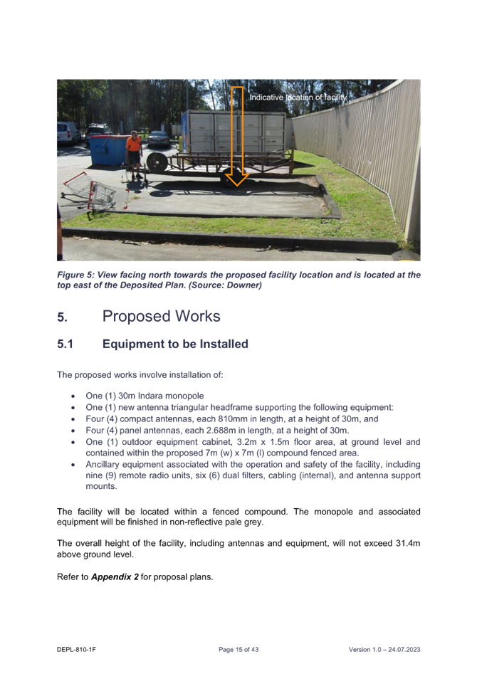
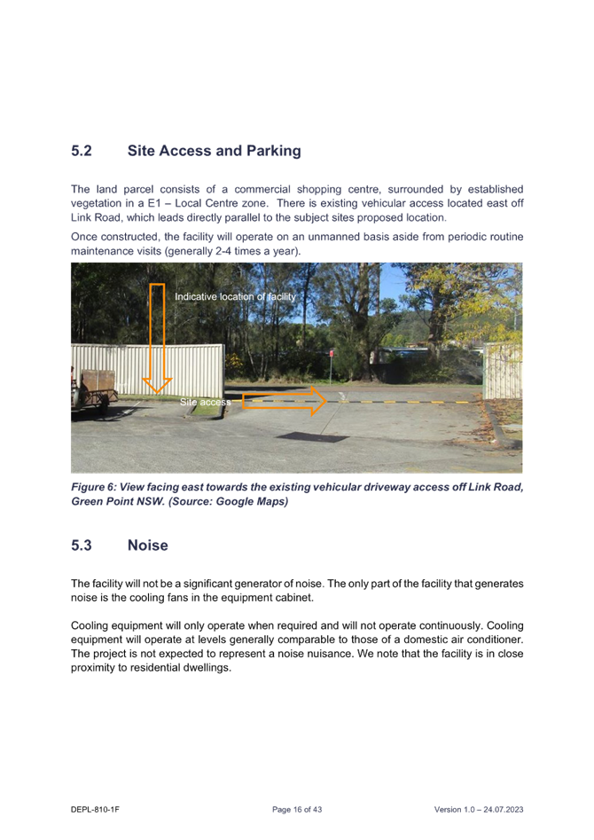
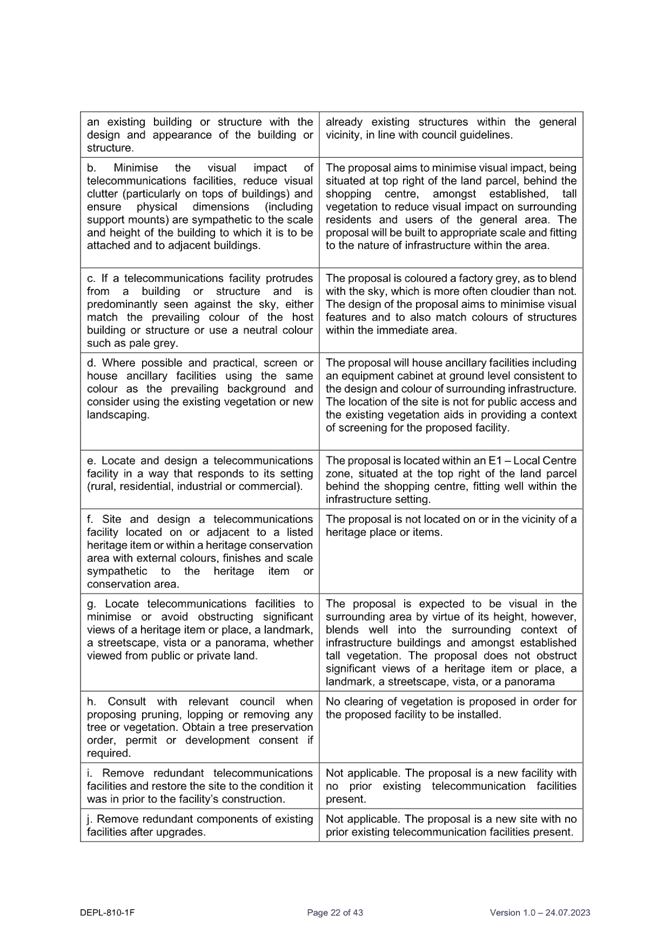
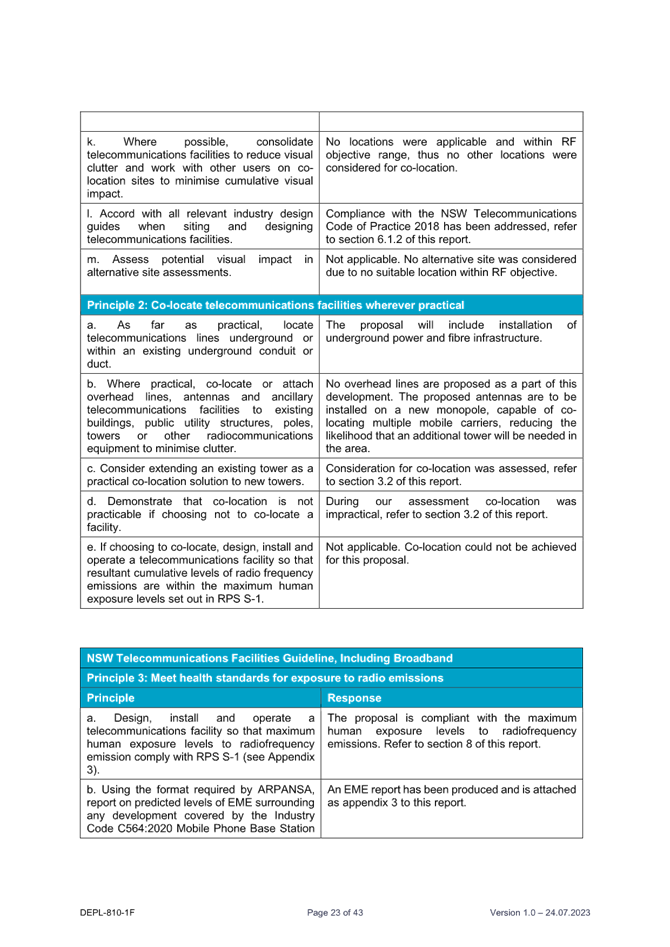
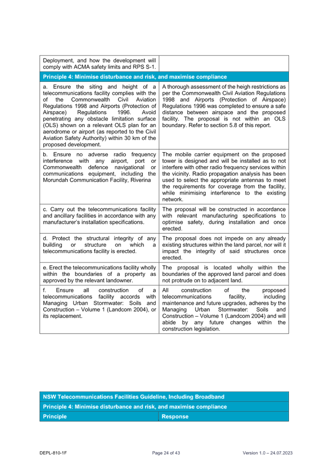
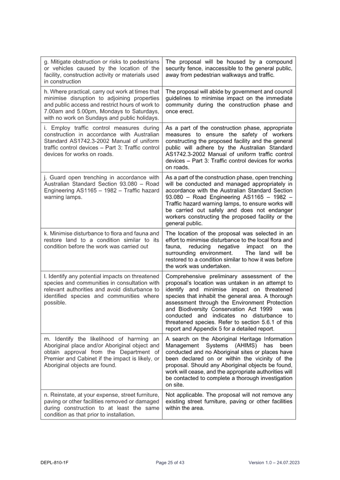
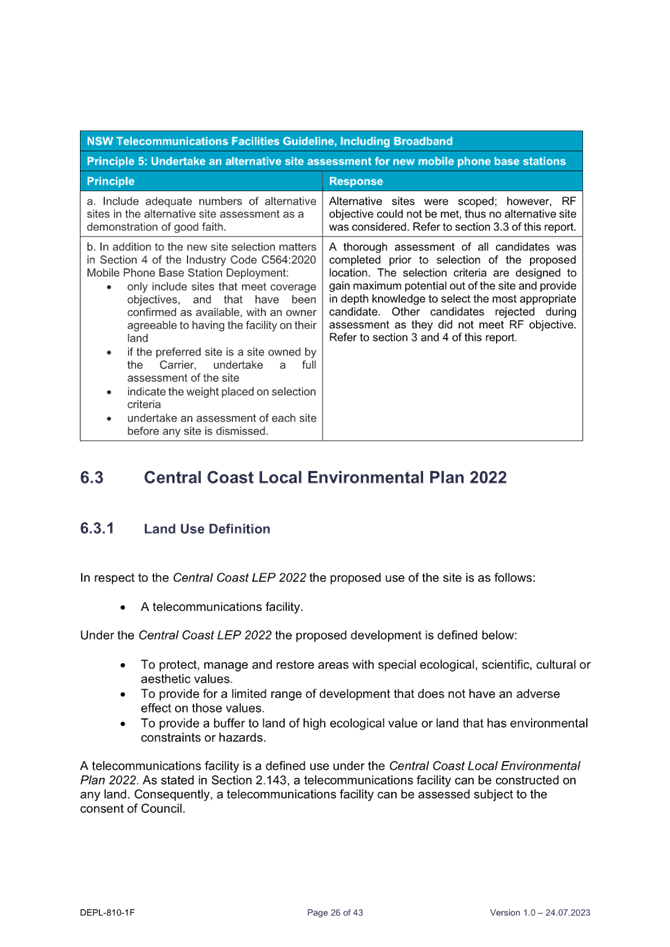
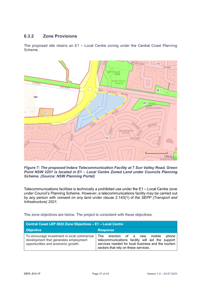
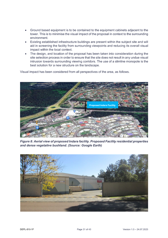
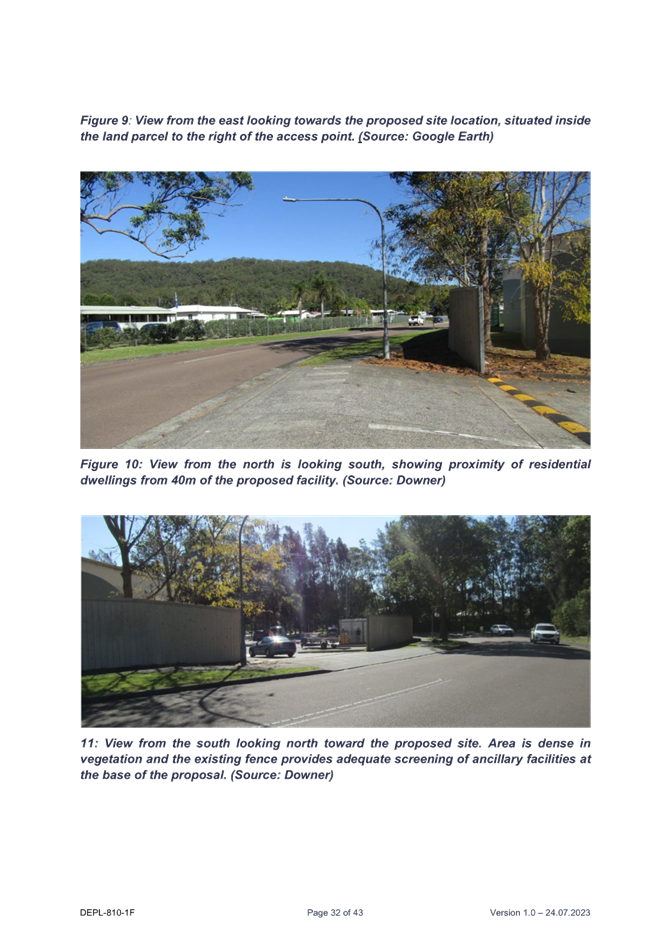
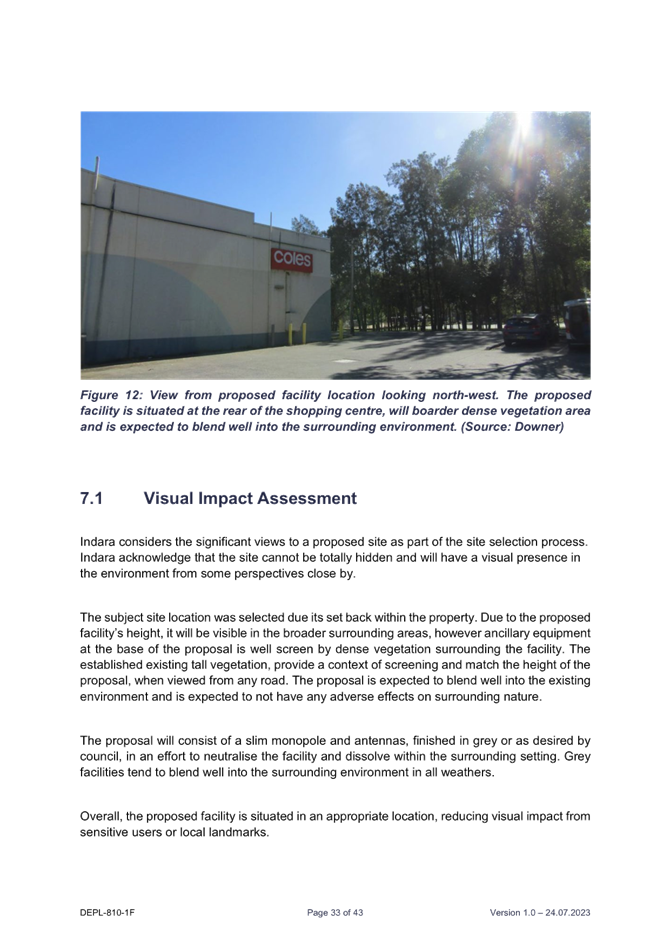
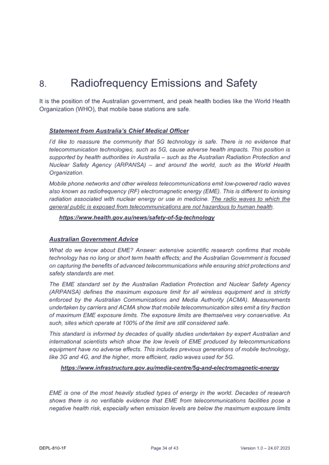

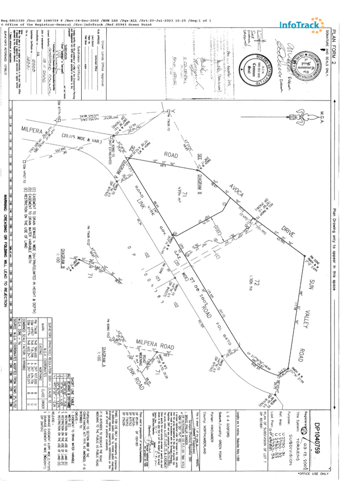

|
DA/1552/2023 - 7 Sun Valley Road Green Point - Proposed Telecommunications and Communication Facilities |
|
|
Attachment 2 |
Architectural Plans - 18/06 2024 - FULL SET - 7 Sun Valley Rd, GREEN POINT - PAN-354156 - DA/1552/2023 |
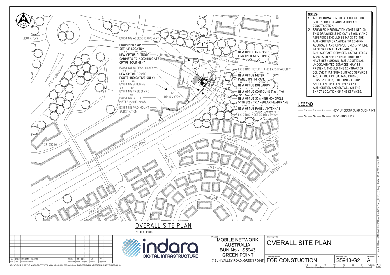
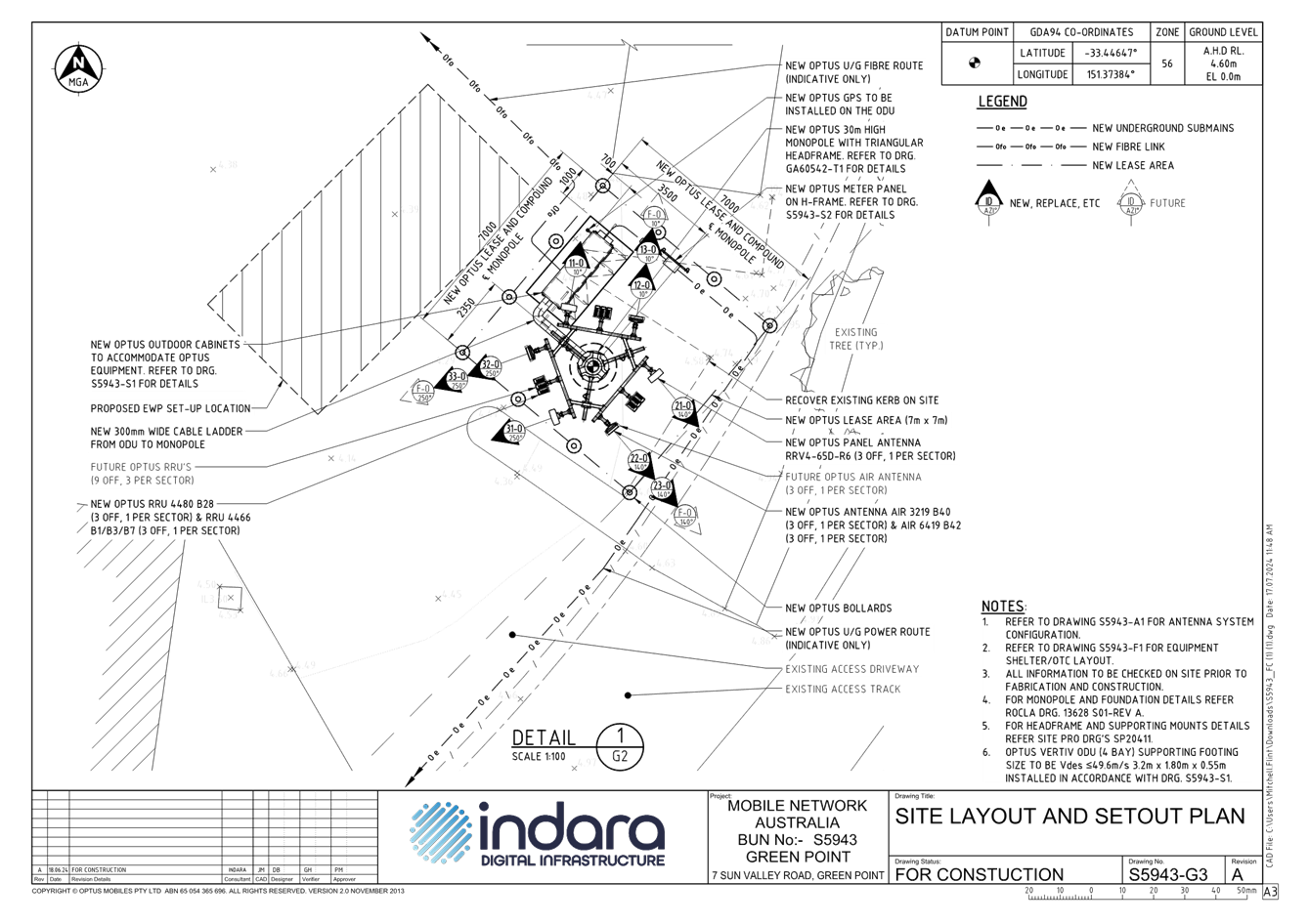
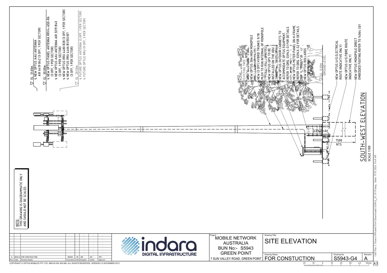
|
DA/1552/2023 - 7 Sun Valley Road Green Point - Proposed Telecommunications and Communication Facilities |
|
|
Attachment 3 |
Vary Development Standard NSW Green Point_7 Sun Valley, Green Point PAN-354156 - DA/1552/2023 |
|
DA/1552/2023 - 7 Sun Valley Road Green Point - Proposed Telecommunications and Communication Facilities |
|
|
Attachment 4 |
PUBLIC - Bush fire Assessment Report - 7 Sun Valley Rd, GREEN POINT - PAN-354156 - DA/1552/2023 |
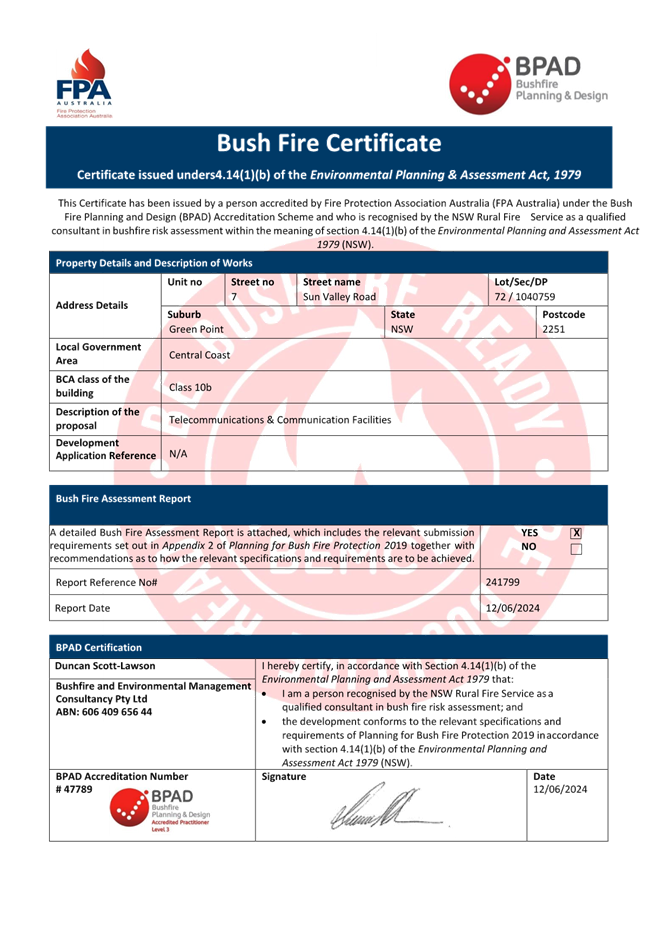
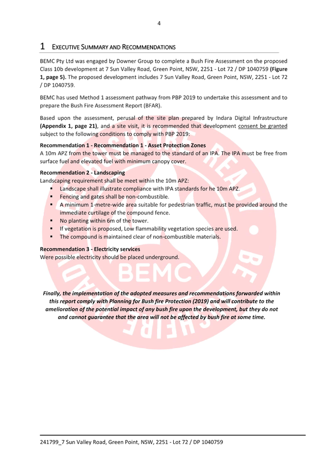
|
DA/1552/2023 - 7 Sun Valley Road Green Point - Proposed Telecommunications and Communication Facilities |
|
|
Attachment 5 |
PUBLIC - Amended EME Report- 7 Sun Valley Road Green Point - DA/1552/2023 |

|
DA/1552/2023 - 7 Sun Valley Road Green Point - Proposed Telecommunications and Communication Facilities |
|
|
Attachment 6 |
AHIMS - 7 Sun Valley Road, Green Point DA/1552/2023 |
|
DA/1552/2023 - 7 Sun Valley Road Green Point - Proposed Telecommunications and Communication Facilities |
|
|
Attachment 7 |
Protected Matters - MNES layers - 7 Sun Valley, Green Point PAN-354156 - DA/1552/2023 |
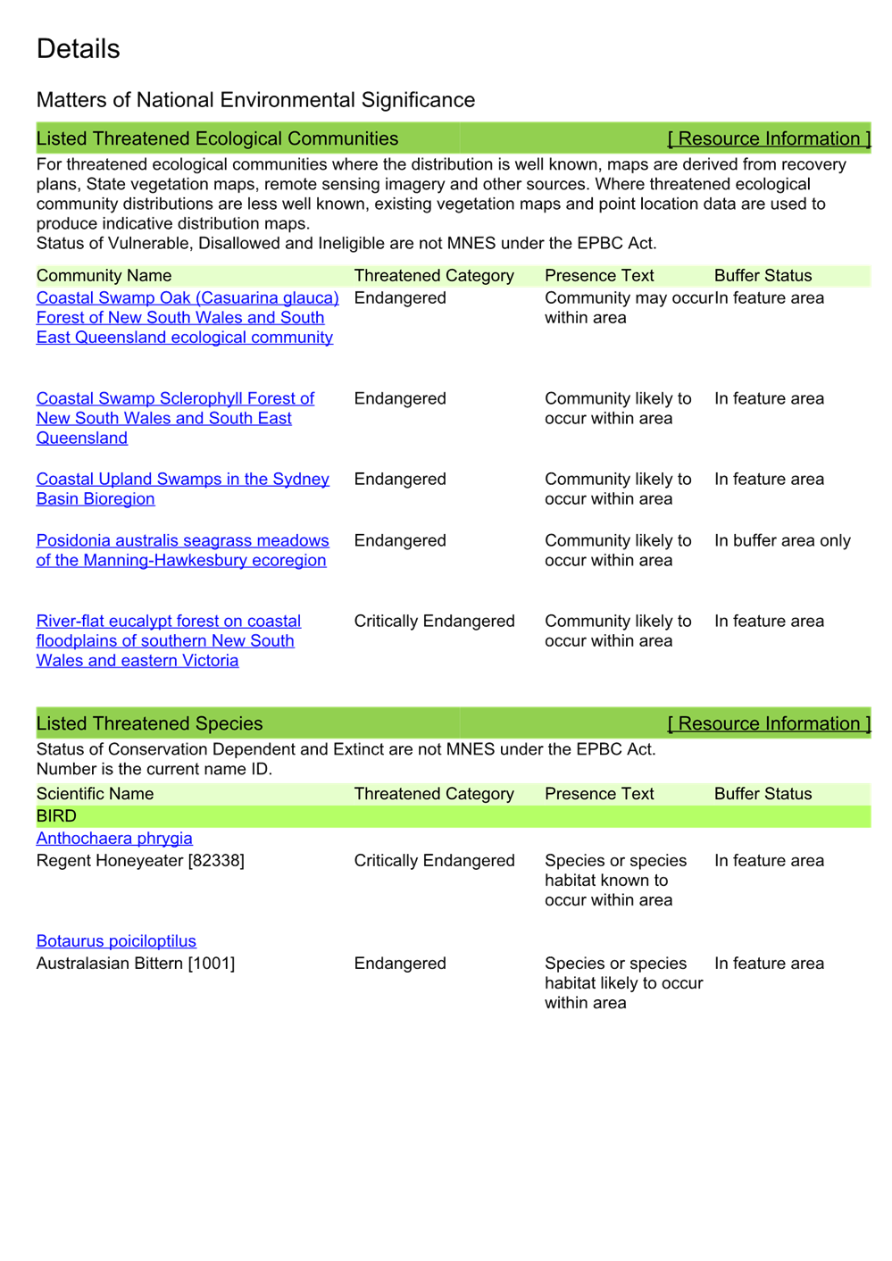
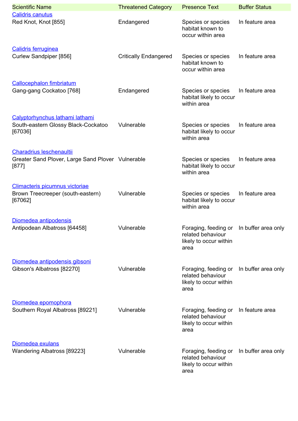
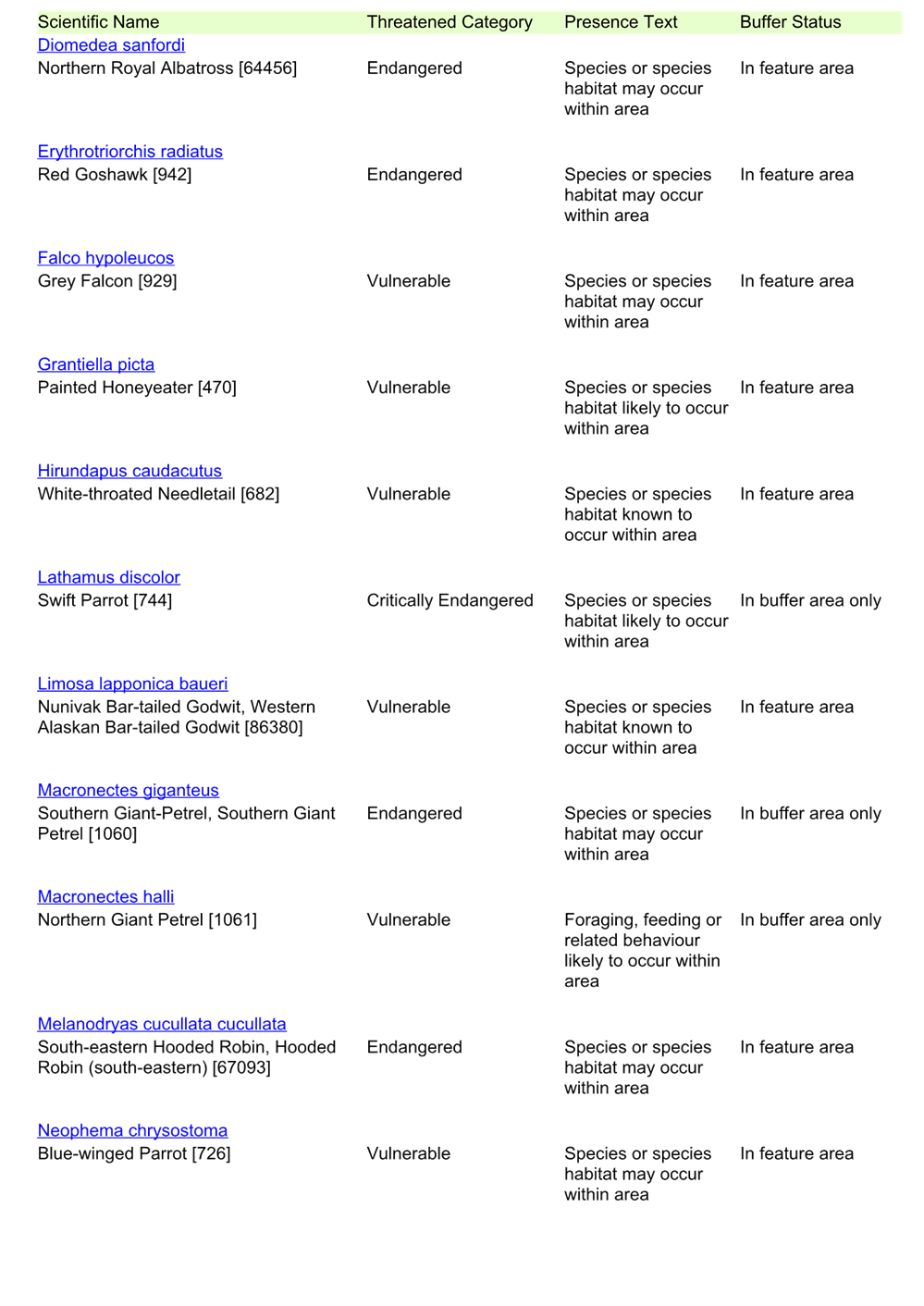
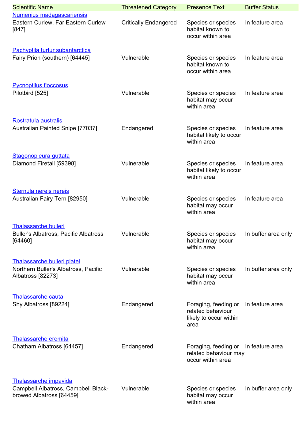
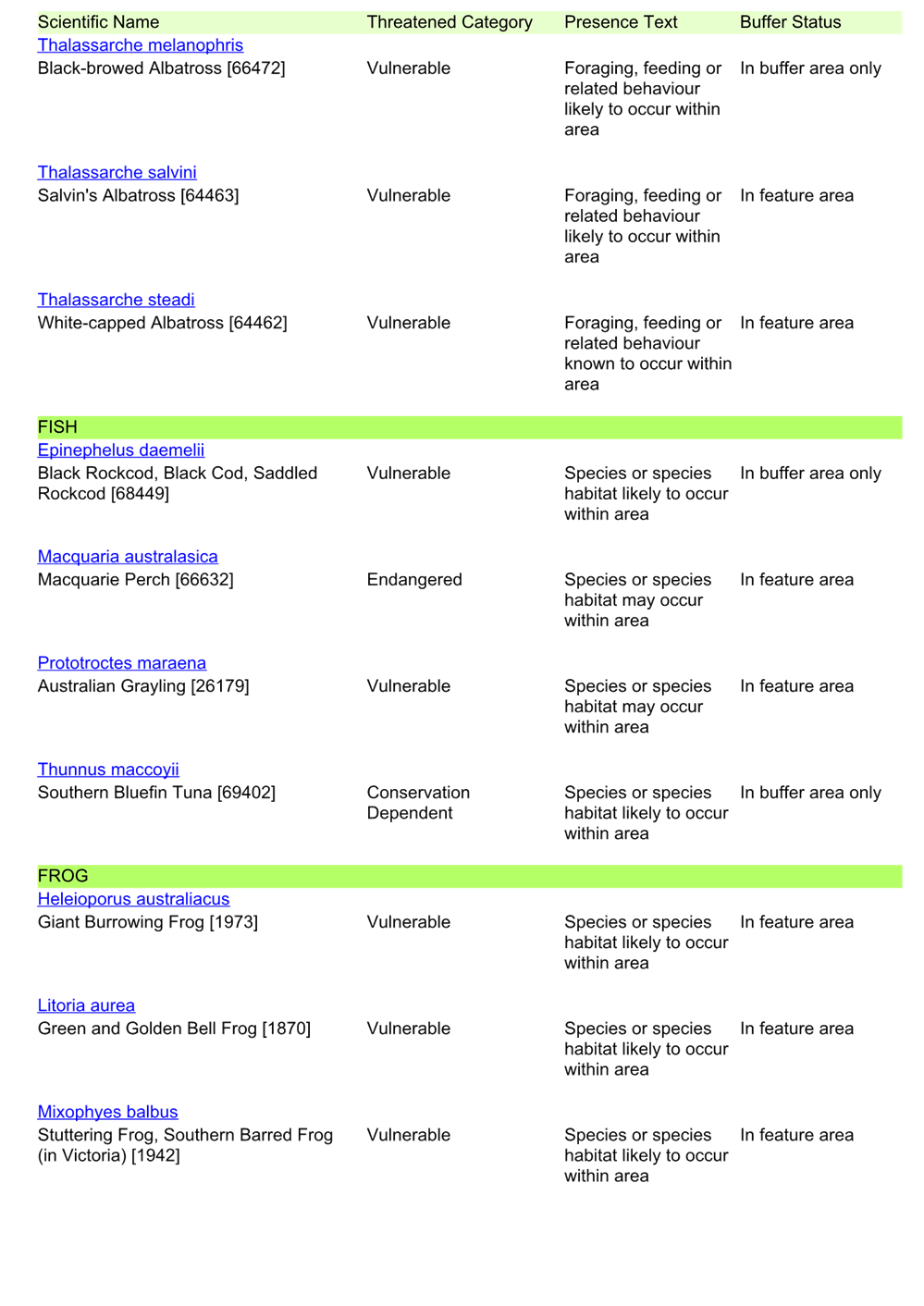
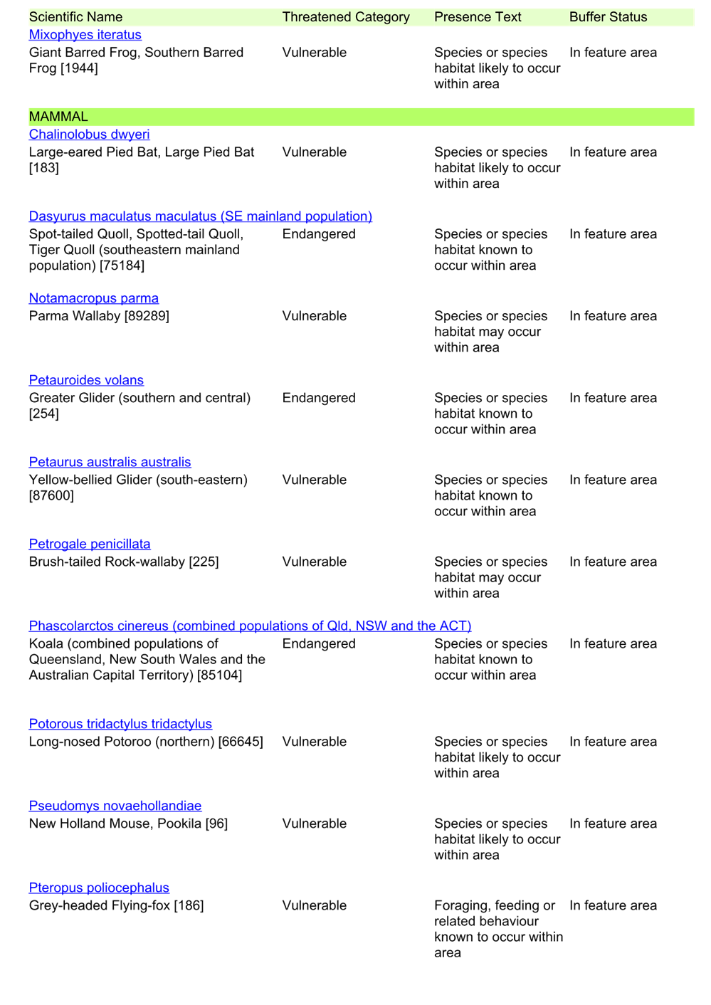

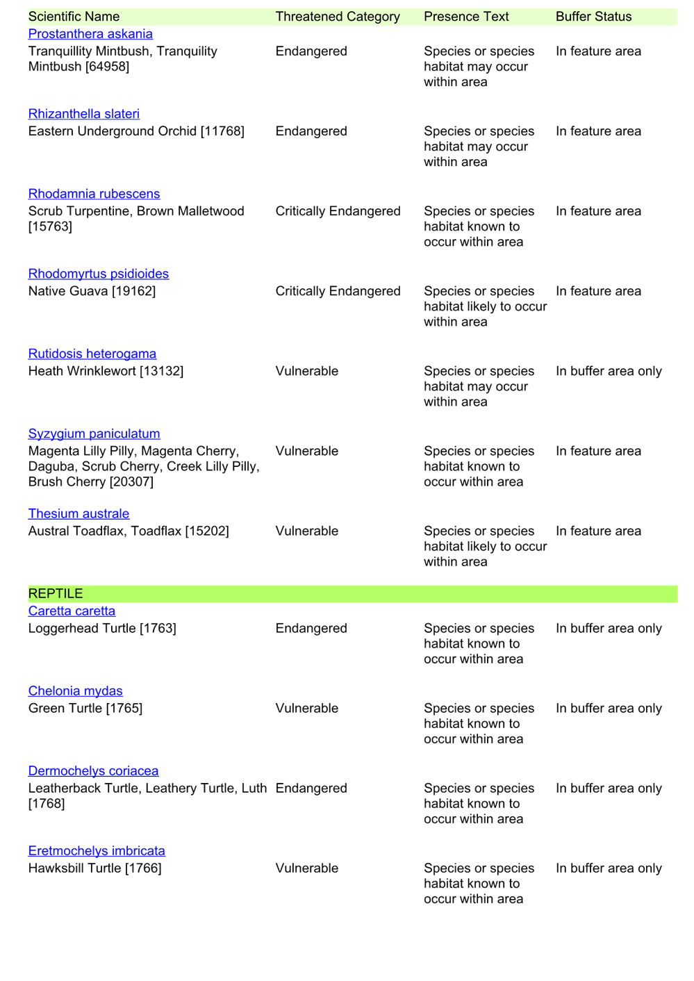
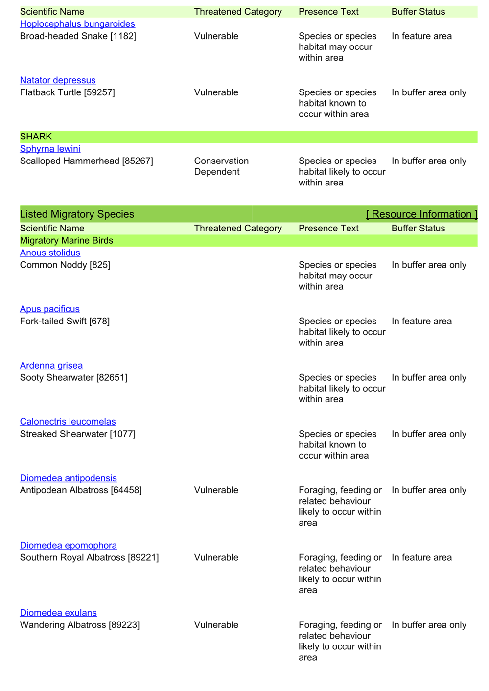
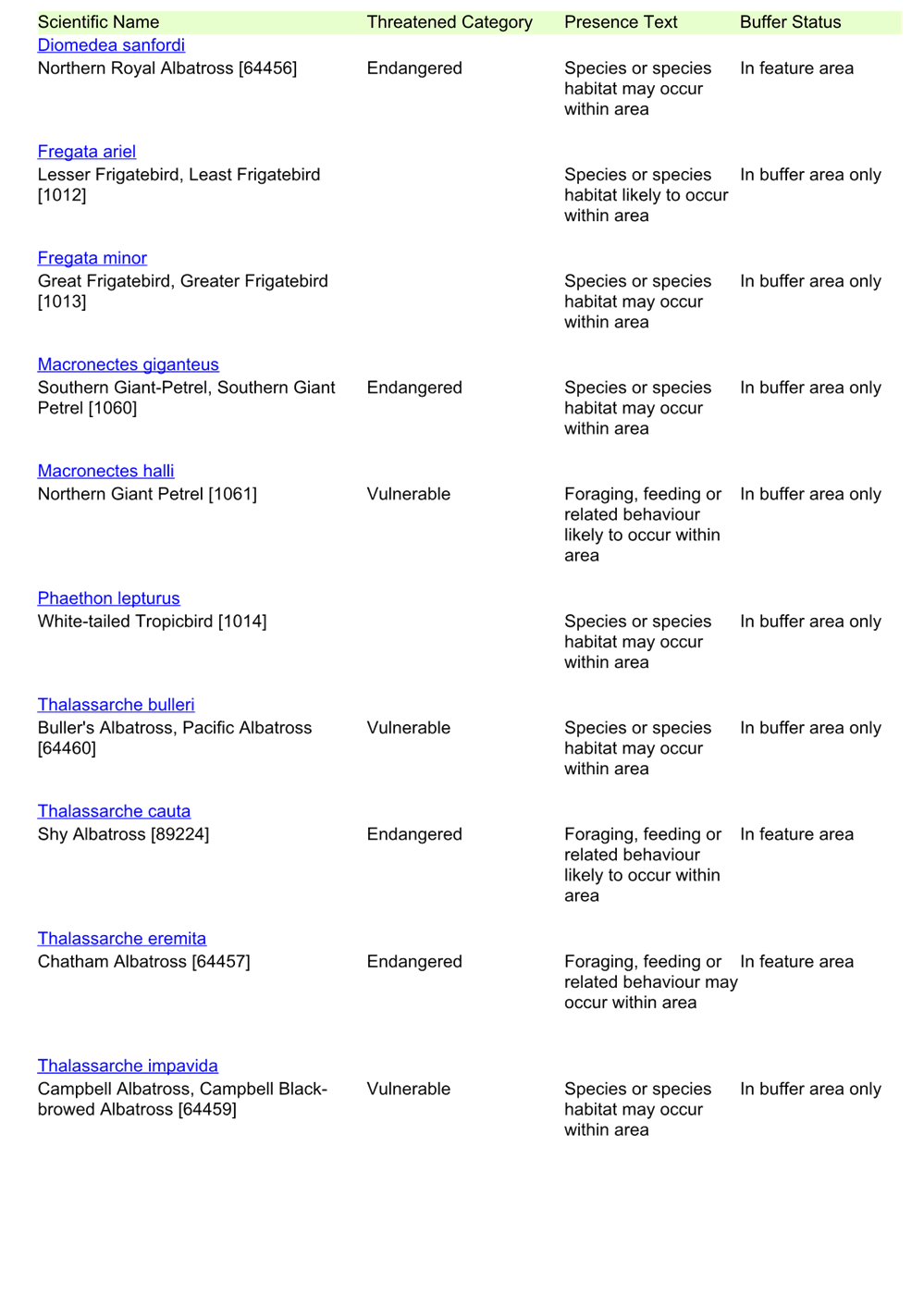
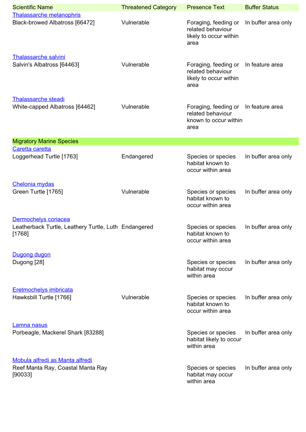
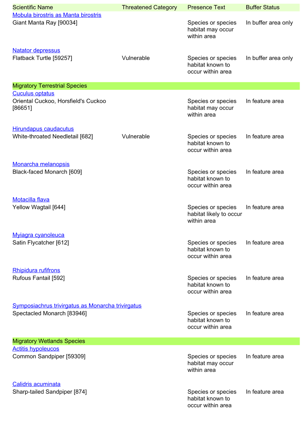

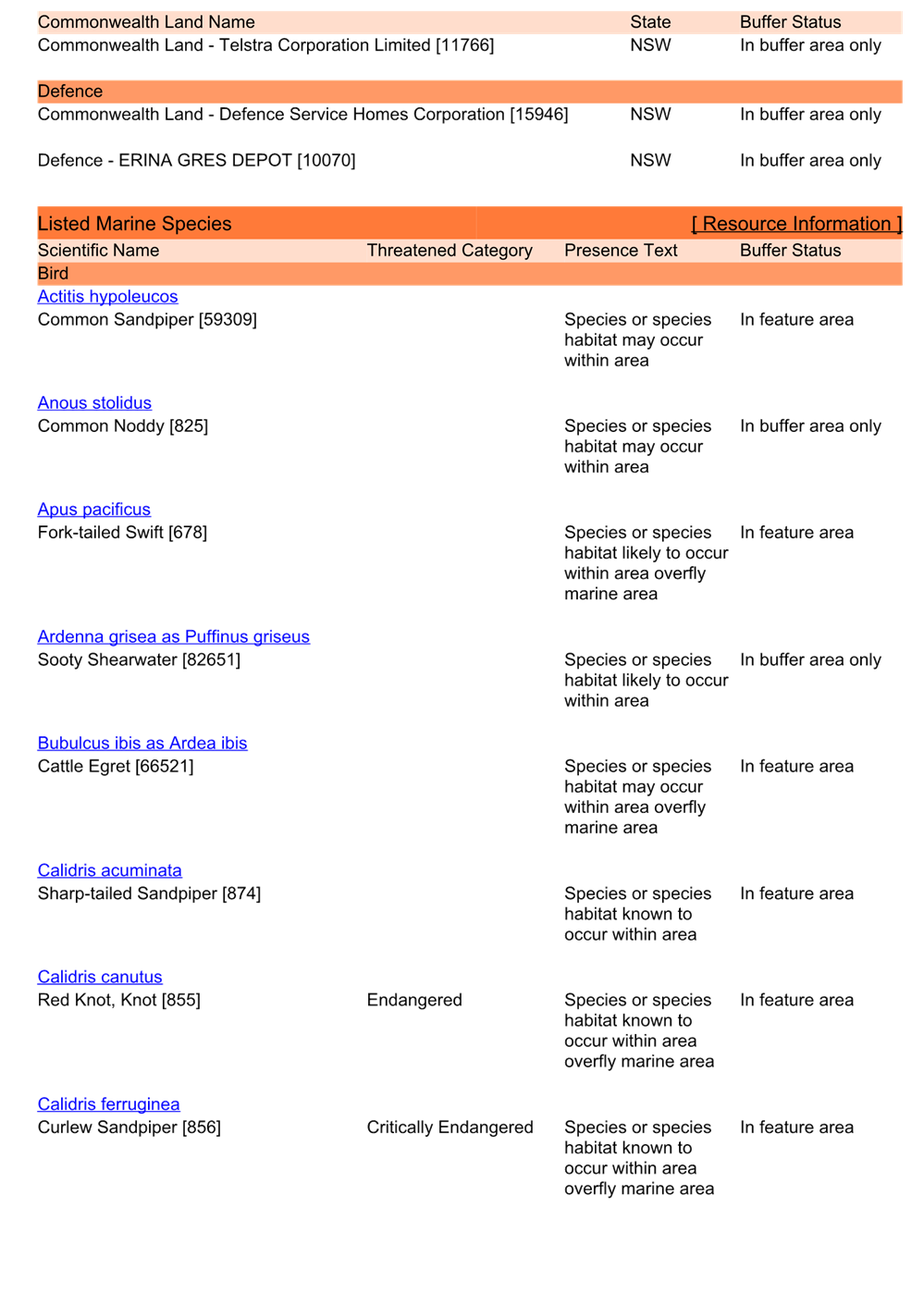
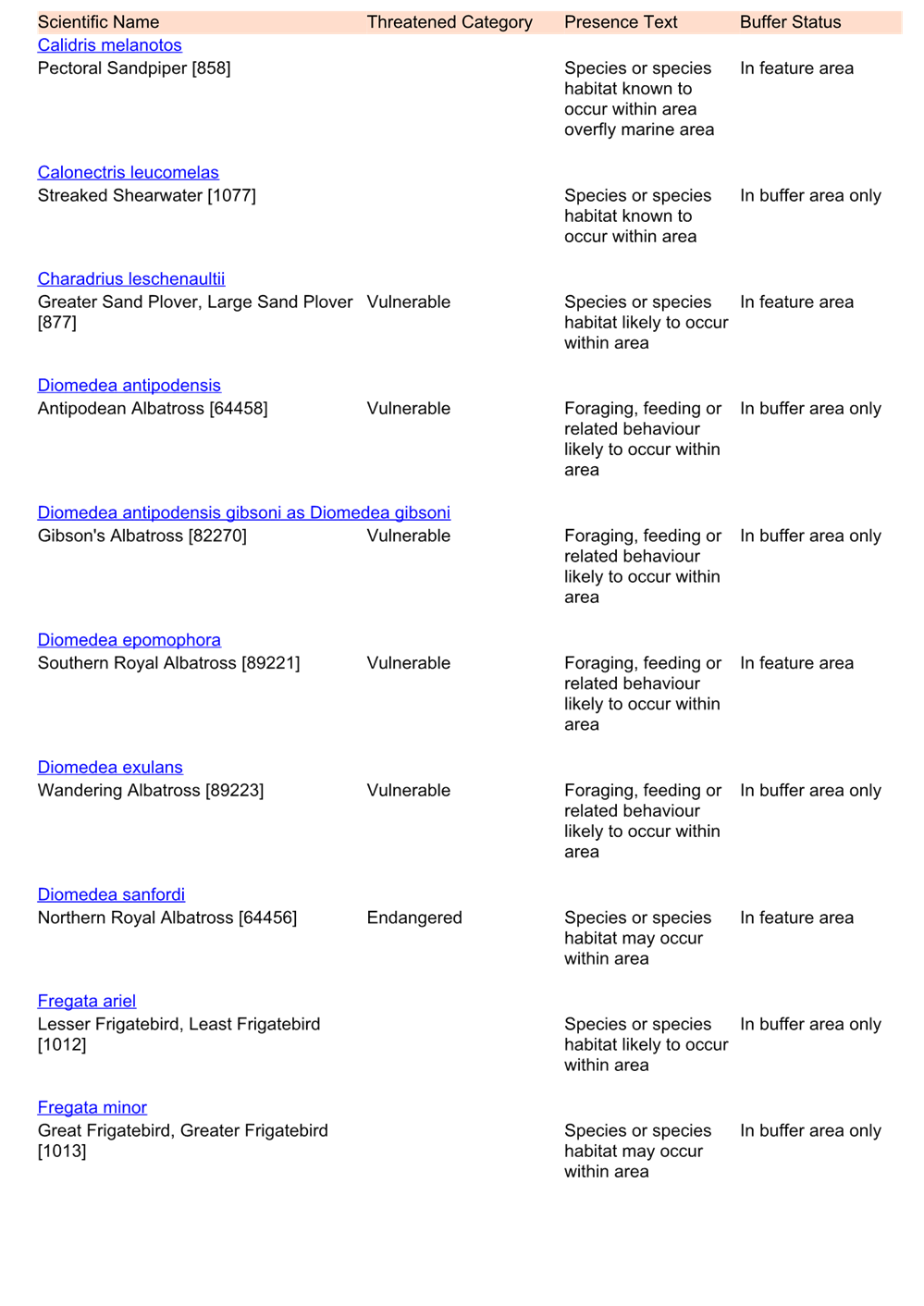
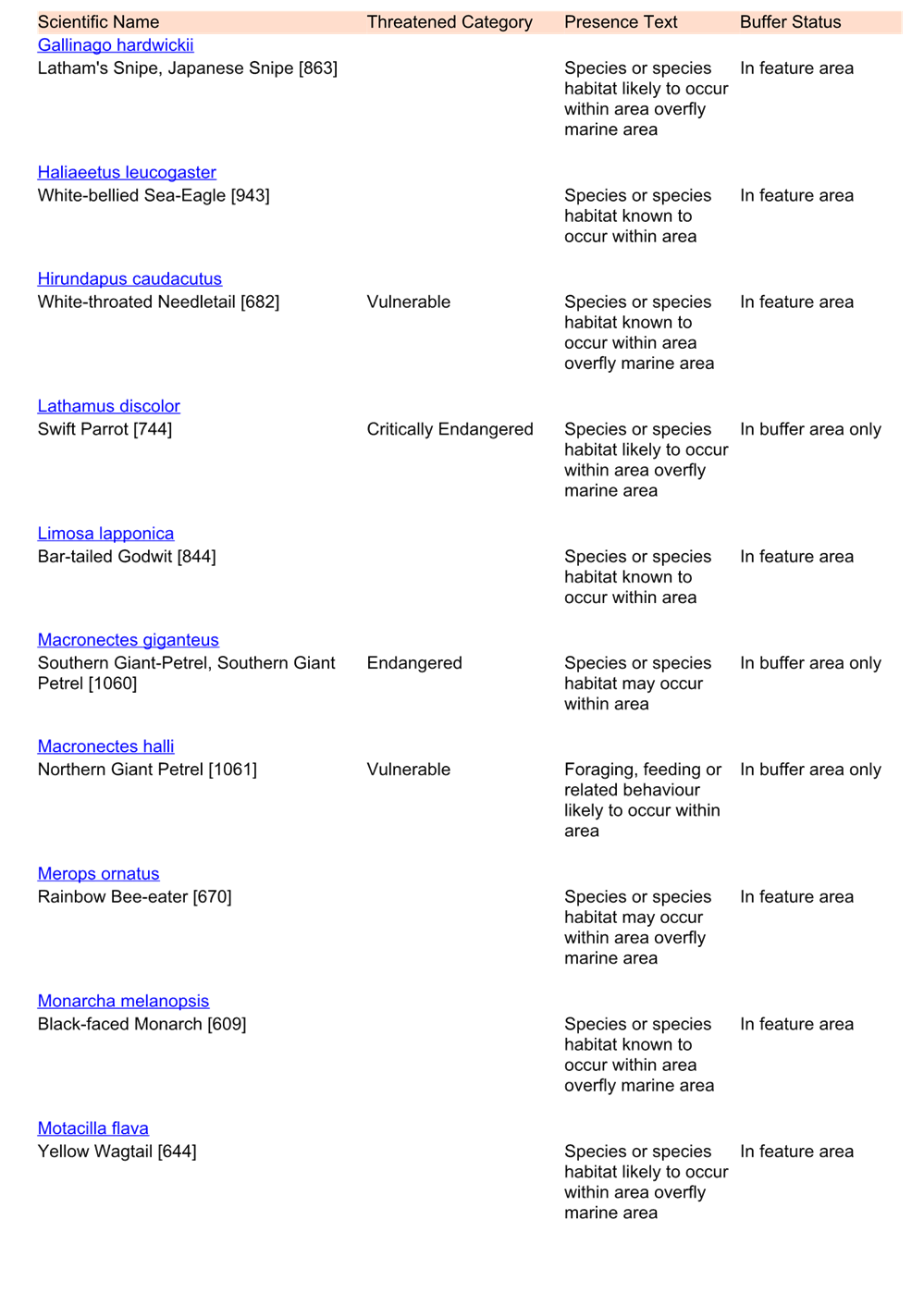
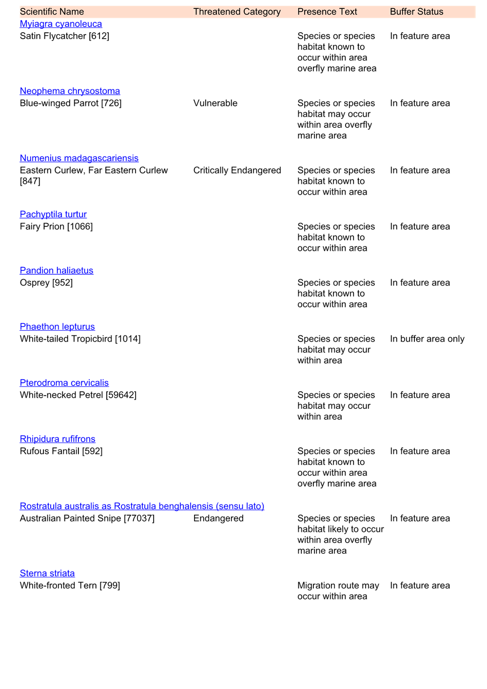


|
DA/1552/2023 - 7 Sun Valley Road Green Point - Proposed Telecommunications and Communication Facilities |
|
|
Attachment 8 |
RFS Determination - DA/1552/2023 - 7 Sun Valley Road, GREEN POINT |