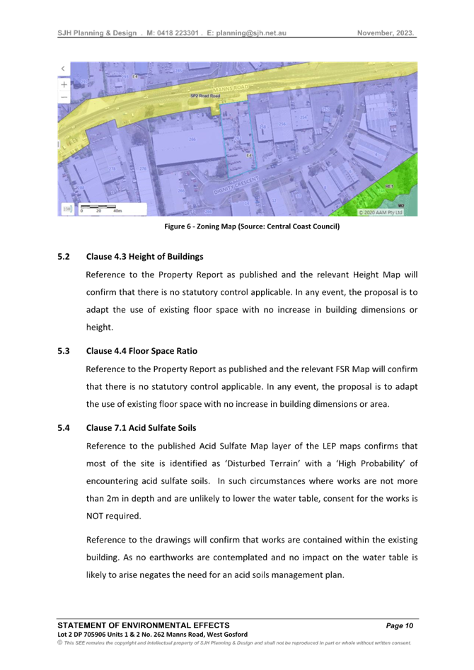
 |
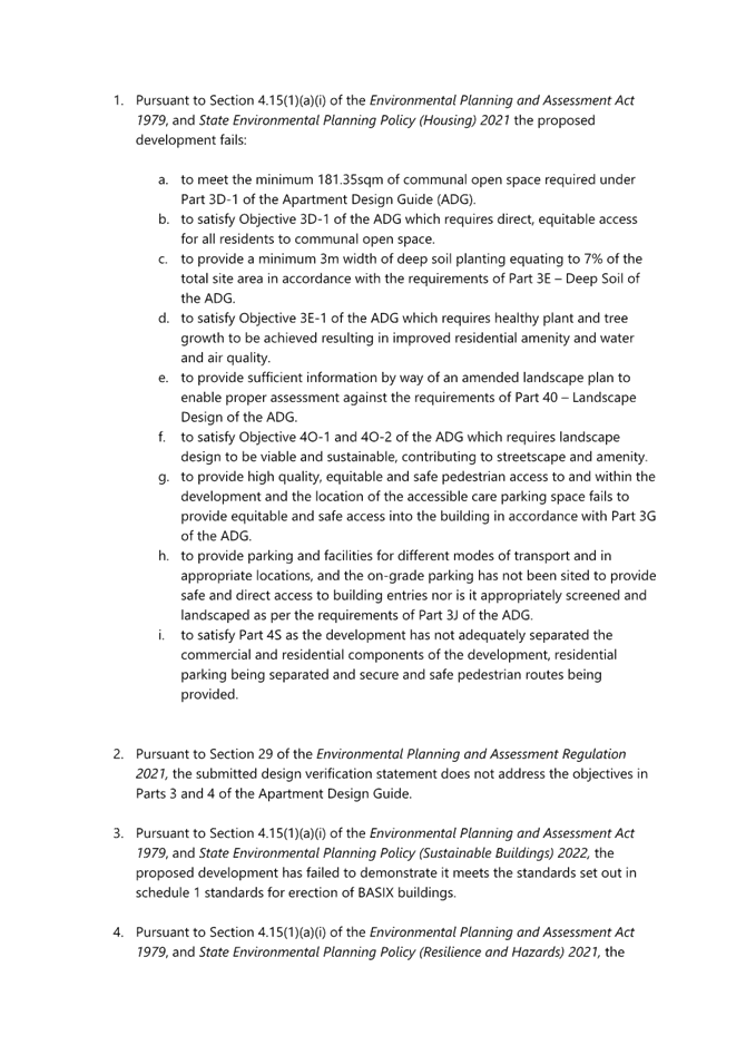
Central Coast
Local Planning Panel Meeting
Business Paper
03 October 2024
 |
|
Central Coast
Local Planning Panel Meeting
Business Paper
03 October 2024
|
The Local Planning Panel Meeting
of Central Coast
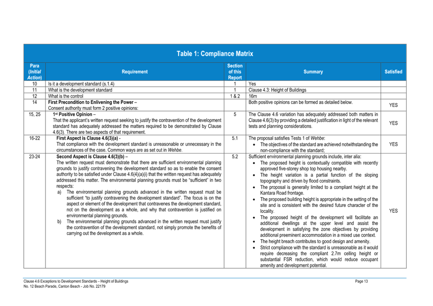
will be held remotely - online,
Thursday 3 October 2024 at 2.00 pm,
for the transaction of the business listed below:
1 Procedural Items
1.1 Disclosures of Interest.............................................................................................................................. 3
2 Confirmation of Minutes of Previous Meetings
2.1 Confirmation of Minutes of Previous Meeting................................................................................. 4
3 Planning Reports
3.1 DA/4077/2022 - 12 Beach Parade Canton Beach - Mixed Use Development..................... 10
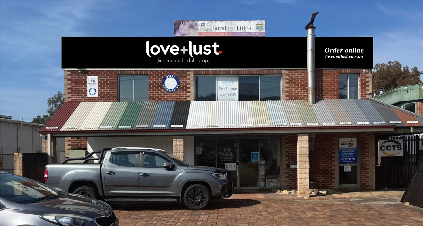
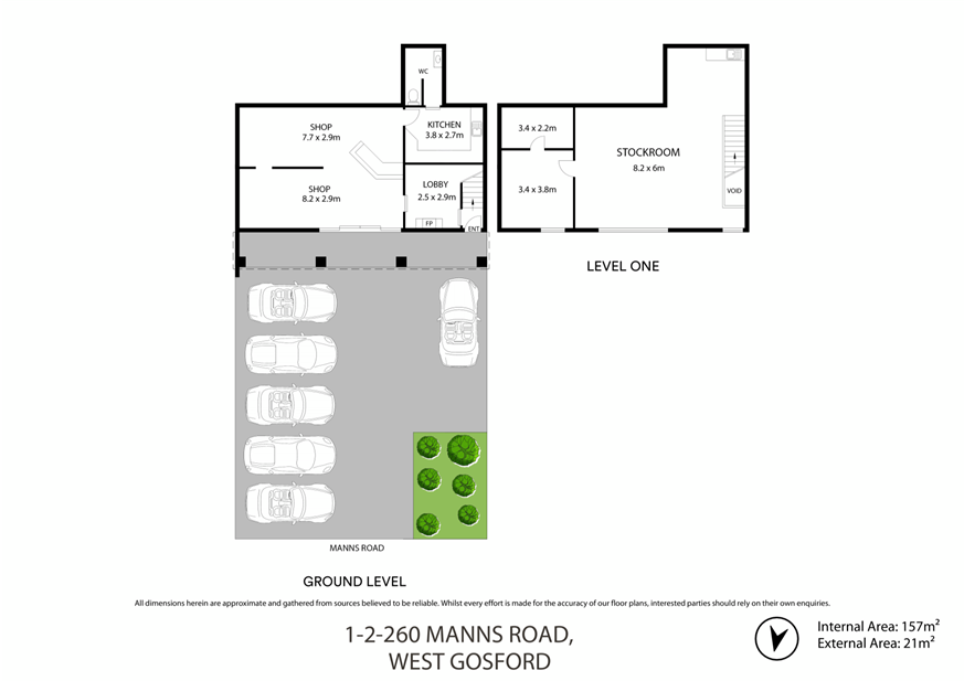
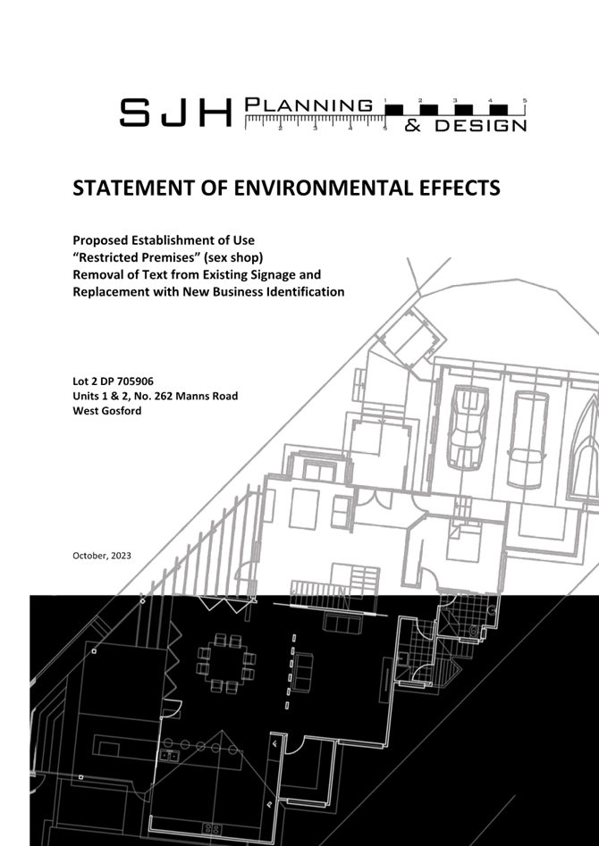
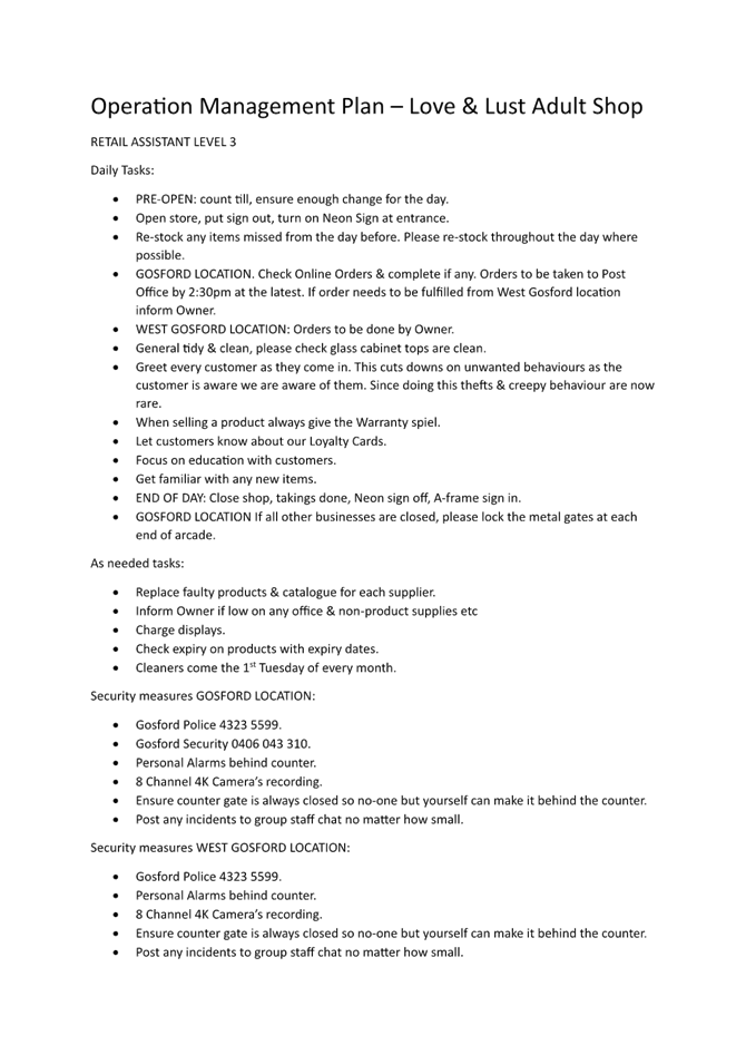
3.2 DA/2267/2023 - 262 Manns Road, West Gosford - Change of Use to Restricted Premises (Sex Shop) - internal alterations & signage........................................................................................... 312
Jason Perica
Chairperson
|
Item No: 1.1 |
|
|
Title: Disclosures of Interest |
|
|
Department: Governance |
|
|
3 October 2024 Local Planning Panel Meeting |
|
Reference: F2020/02502 - D14205789
|
The NSW Local Planning Panel Code of Conduct states that all panel members must sign a declaration of interest in relation to each matter on the agenda before or at the beginning of each meeting.
|
That Panel Members now confirm that they have signed a declaration of interest in relation to each matter on the agenda for this meeting and will take any management measures identified.
|
Item No: 2.1 |
|
|
Title: Confirmation of Minutes of Previous Meeting |
|
|
Department: Corporate Services |
|
|
3 October 2024 Local Planning Panel Meeting |
|
Reference: F2020/02502 - D16425158
Author: Lisa Martin, Civic Support Officer Civic Support
|
Summary
The
Minutes of the following Meeting of the Local Planning Panel, which have been
endorsed by the Chair of that meeting, are submitted for noting: · Local Planning Panel Meeting held on 19 September 2024
|
That the minutes of the previous Local Planning Panel Meeting held on 19 September 2024, which were endorsed by the Chair of that meeting, are submitted for noting.
|
1⇩ |
MINUTES - Local Planning Panel - 19 September 2024 |
|
D16414522 |
|
2.1 |
Confirmation of Minutes of Previous Meeting |
|
Attachment 1 |
MINUTES - Local Planning Panel - 19 September 2024 |
|
Item No: 3.1 |
|
|
Title: DA/4077/2022 - 12 Beach Parade Canton Beach - Mixed Use Development |
|
|
Department: Environment and Planning |
|
|
3 October 2024 Local Planning Panel Meeting |
|
Reference: DA/4077/2022 - D16238596
Author: Alexandra Allouche, Senior Development Planner, Employment and Urban Release
Section Manager: Emily Goodworth, Section Manager Employment and Urban Release
Unit Manager: Andrew Roach, Unit Manager. Development Assessment
|
Summary
The subject development application seeks consent for the construction of a five storey shop top housing development comprising four residential units with ground floor food and drink premises and basement parking at No. 12 Beach Parade, Canton Beach. The application has been examined having regard to the matters for consideration detailed under Section 4.15 of the Environmental Planning and Assessment Act 1979 and other statutory requirements, with issues requiring attention and further consideration addressed in this report.
The application is referred to the Central Coast Local Planning Panel in accordance with the Local Planning Panels Ministerial Directions as the proposal is considered sensitive development under the remit of the former State Environmental Planning Policy No. 65 – Design Quality of Residential Apartment Development and is four or more storeys in height.
No submissions have been received.
The application is recommended for refusal as the application is non-compliant with relevant SEPPs, provisions of the Central Coast Local Environmental Plan 2022, the Central Coast Development Control Plan 2022 and deemed an overdevelopment of the site.
|
1 That the Local Planning Panel refuse development application DA/4077/2022, for construction of a 5-storey mixed use development comprising of shop top housing (4 dwellings), food and drink premises and basement level car parking to 12 Beach Parade, Canton Beach for the reasons detailed in Attachment 1 to this report and having regard to the matters for consideration detailed in Section 4.15 of the Environmental Planning and Assessment Act 1979.
2 That Council advise relevant external authorities of the Panel’s decision.
3 That Council advise Ausgrid of the Panel’s decision.
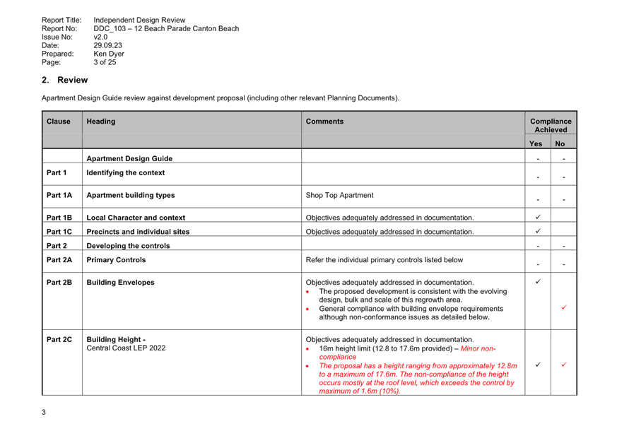
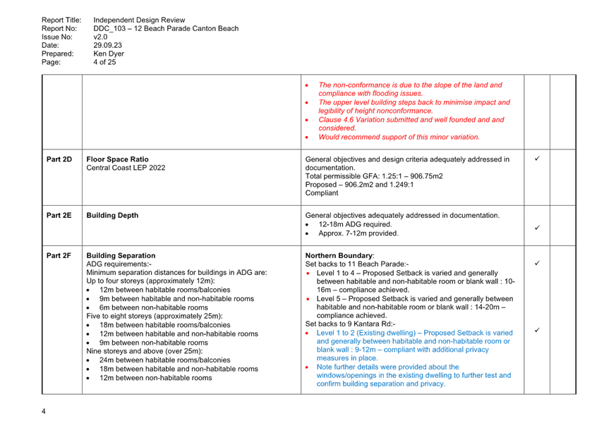
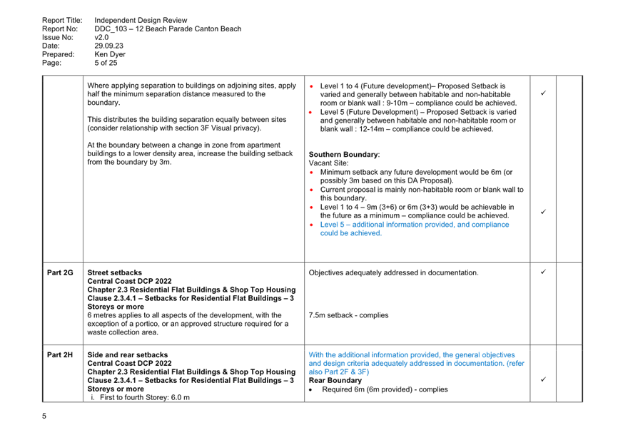
Key Issues
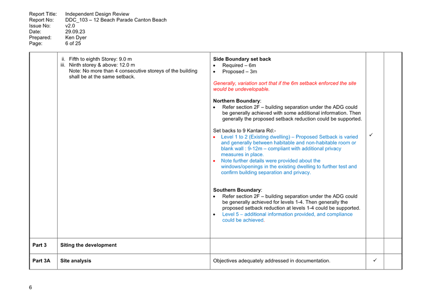
· Variation to the performance requirements of clause 4.3 – Height of Buildings under the Central Coast Local Environmental Plan 2022 (CCLEP 2022).
· Technical non-compliances as required under the Apartment Design Guide (ADG) including communal open space, deep soil planting and visual privacy requirements, parking, and accessibility.
· Minimal on-site car parking in accordance with Central Coast Development Control Plan 2022 (CCDCP 2022) seeking an overall variation to Council’s DCP of 88%.
Precis:
|
Proposed Development |
Construction of a five-storey mixed use building (shop top housing) comprising four residential dwellings, ground floor food and drink premises and basement parking. |
|
Permissibility and Zoning |
The subject site is zoned SP3 Tourist under the provisions of the CCLEP 2022. The proposed development is defined as shop top housing and food and drink premises, which are both permissible with consent in the zone. |
|
Current Use |
Vacant |
|
Submissions |
Nil |
Variations to Policies
|
Clause |
Part 3D-1 Communal and public open space |
|
Standard |
Communal open space to be provided equivalent to 25% of site area |
|
SEPP/LEP/DCP |
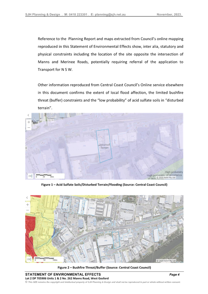
SEPP Housing and ADG |
|
Departure basis |
Numerical. 100% variation sought. Nil communal open space provided |
|
Clause |
Part 3E-1 Deep soil zones |
|
Standard |
7% of site area with minimum dimension of 3m to be provided as deep soil |
|
SEPP/LEP/DCP |
SEPP Housing and ADG |
|
Departure basis |
Numerical. 70% variation sought. 2% deep soil provided. |
|
Clause |
Part 3F-1 Visual privacy |
|
Standard |
Separation from boundaries and buildings: · up to 12m / 4 storeys – 6m to habitable, 3m to non-habitable · up to 25m / 5-8 storeys – 9m to habitable, 4.5m to non-habitable |
|
SEPP/LEP/DCP |
SEPP Housing and ADG |
|
Departure basis |
Numerical and non-numerical. · Minimum 2m setback to boundary and (5-6m setback if easement included). Proposed setbacks are varied. Generally minor windows of habitable rooms, non-habitable rooms, or blank wall. · Level 5 Min 3m setback to boundary (6.5m including easement). Generally minor windows of habitable rooms, non-habitable rooms, or blank wall. |
|
Clause |
4.3 Height of buildings |
|
Standard |
Maximum building height = 16m |
|
SEPP/LEP/DCP |
CCLEP 2022 |
|
Departure basis |
Numerical. 10% variation sought, equating to 1.6m. |
|
Clause |
2.3.3.3 Natural landscape area |
|
Standard |
25% of site to be soft landscaping |
|
SEPP/LEP/DCP |
CCDCP 2022 |
|
Departure basis |
Numerical. 34% variation sought. |
|
Clause |
2.13.3.2 Car parking requirements |
|
Standard |
Residential flat buildings · 1.5 spaces per dwelling for residents · 0.2 spaces per dwelling for visitors Restaurants Whichever is the greater of: · 15 spaces per 100m2 GFA · 1 space per 3 seats |
|
SEPP/LEP/DCP |
CCDCP 2022 |
|
Departure basis |
Numerical. The proposal has a shortfall of 1 resident visitor space and 22 café spaces, deficient by 88% for the commercial component. |
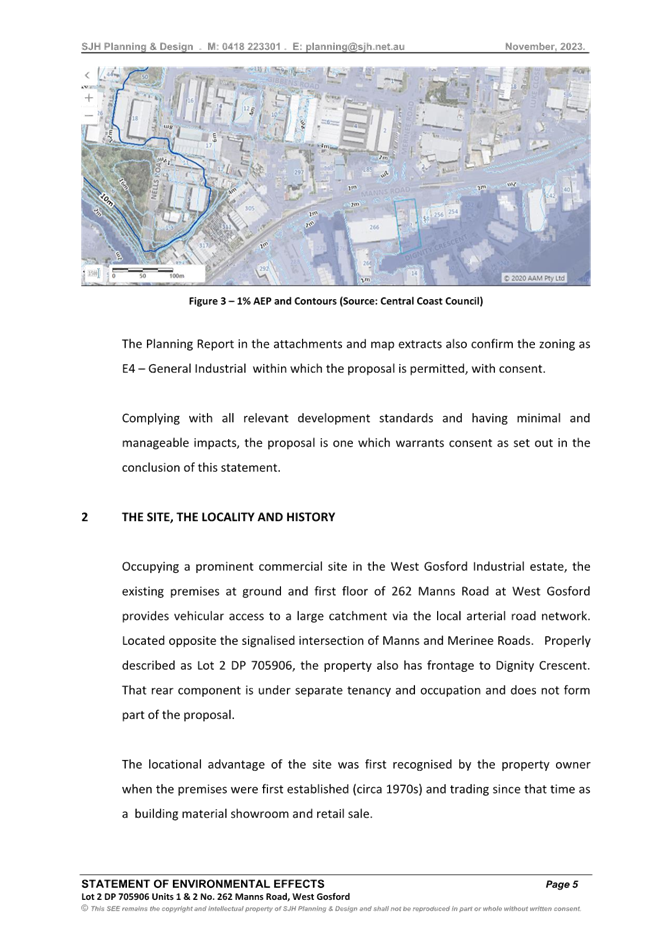
The Site
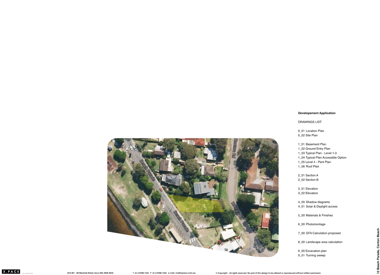
The site is located on the eastern side of Beach Parade and comprises one lot with a total site area of 725.4m2. The site has a secondary frontage to Kantara Road and is generally rectangular in shape with a gentle slope from east to west from Kantara Road to Beach Parade (RL 4.94 to RL 3.00).
The site is currently vacant with a large tree towards the Kantara Road reserve. There is a 3.5m-wide easement between the subject site and the northern neighbouring sites (No. 11 Beach Parade and No. 9 Kantara Road).
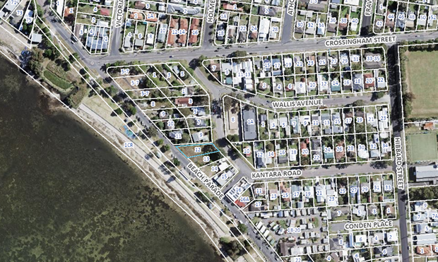
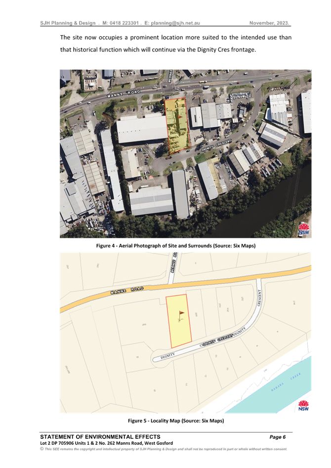
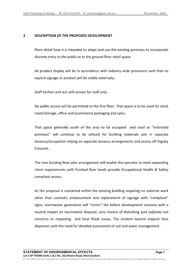
Figure 1. Aerial of subject site.
The site is identified as a Flood Planning Area under Council’s Online Mapping Tool. The land is not ‘bushfire prone land’.
The site is located directly opposite Canton Beach foreshore area which includes a shared pathway and play equipment, adjoining Tuggerah Lake. The western side of Beach Parade has a series of parallel and angled parking spaces which service the beach and playground area.
Canton Beach is under transition, subject to several approvals and recently lodged development and modification applications which remain under assessment.
No 6-8 Beach Parade: Development Application No. DA/7/2017
No 6-8 Beach Parade is currently vacant and previously subject to DA/7/2017 approved by the former Joint Regional Planning Panel on 14 December 2017 for the construction of a shop top housing development comprising four commercial ground floor tenancies with 36 units above, parking, and ancillary works.
The Panel approved a Clause 4.6 variation to the maximum permitted 16m building height by 2.41m in accordance with Clause 4.3 of the Wyong Local Environmental Plan 2013 (WLEP 2013). The Panel also considered a 22% parking variation appropriate in this instance with a total of 83 parking spaces required and 68 spaces provided in the approved basement level with five at-grade parking spaces.
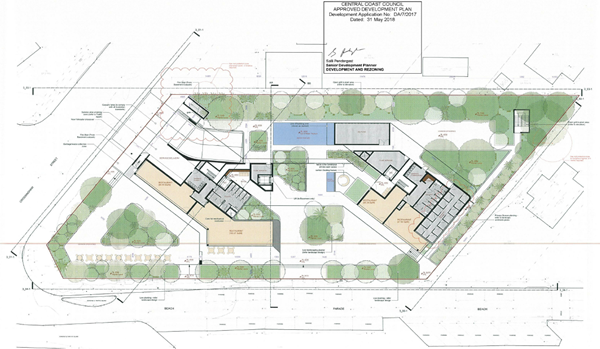
Figure 2. Approved ground floor plan under
DA/7/2017.
Modification Application DA/7/2017/A
Council is in receipt of the abovementioned modification application currently under assessment, which seeks amendments to the approved basement level design, ground floor and upper-level floor layouts including the addition of four units, unit mix and associated changes. Changes also include five additional parking spaces in the approved basement level in lieu of residential storage areas.
No 9-10 Beach Parade: Development Application No. DA/1904/2023
DA/1904/2023 is under assessment for No. 9-10 Beach Parade, 1-5 Crossingham Street and No. 1-7 Kantara Road at Canton Beach for a five-storey mixed use development comprising 91 units, six serviced apartments, a gymnasium and nine retail tenancies. The subject sites are currently occupied by single storey residential dwellings with detached ancillary development.
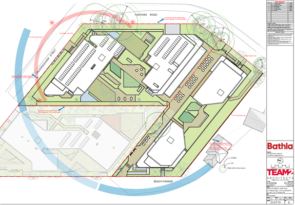
Figure 3. Proposed site plan under DA/1904/2023.
No 11 Beach Parade: Development Application No. DA/243/2015
DA/243/2015 was approved on 3 March 2017 for a shop top housing development comprising basement car parking, two commercial tenancies and seven residential units including demolition of existing structures.
The development complied with the height provisions as required by the WLEP 2013 however sought a 27% variation to the minimum number of parking spaces required, providing 11 out of the 15 total residential parking spaces wholly contained within the basement level.
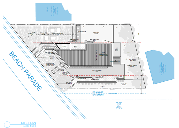
Figure 4. Approved site plan under DA/243/2015
Construction Certificate No. CC/242/2024 was approved on 29 February 2024.
Otherwise, the surrounding area is generally characterised by a mix of single and two storey dwellings.
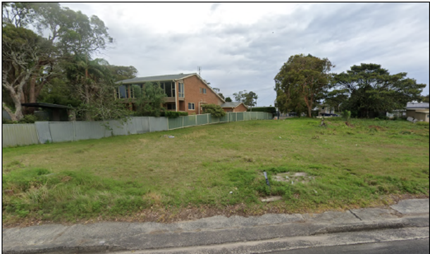
Figure 5: View of site from Beach Parade (Source: GSA Planning)
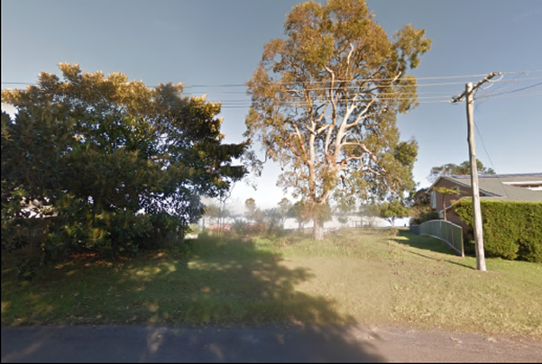
Figure 6: View of site from Kantara Rd (Source: GSA Planning)
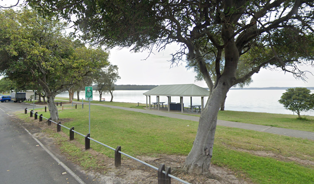
Figure 7: Canton Beach foreshore open space across from subject site.
The Proposed Development
The subject development application seeks approval for removal of one tree and construction of a five storey, mixed use shop top housing development including a basement car park, one ground level retail tenancy (food and drink premises), at grade parking comprising one disabled parking space and one café loading/parking space, and four dwellings on the four levels above the ground floor.
The proposed gross floor area of the development is 906.2m² and the respective areas are as follows:
· Basement – 14.8m²
· Ground floor retail tenancy (food and drink premises) and amenities – 167.2m²
· First floor (residential) – 188.6m²
· Second floor (residential) – 188.6m²
· Third floor (residential) – 188.6m²
· Fourth floor (residential) – 158.4m²
The proposal has a floor space ratio of 1.249:1.
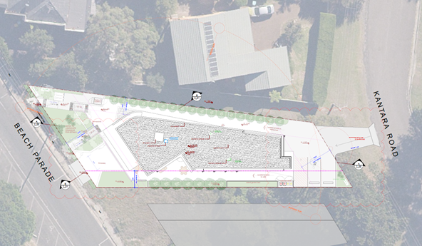
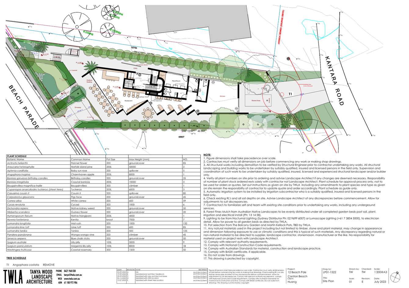
Figure 8. Proposed Site Plan.
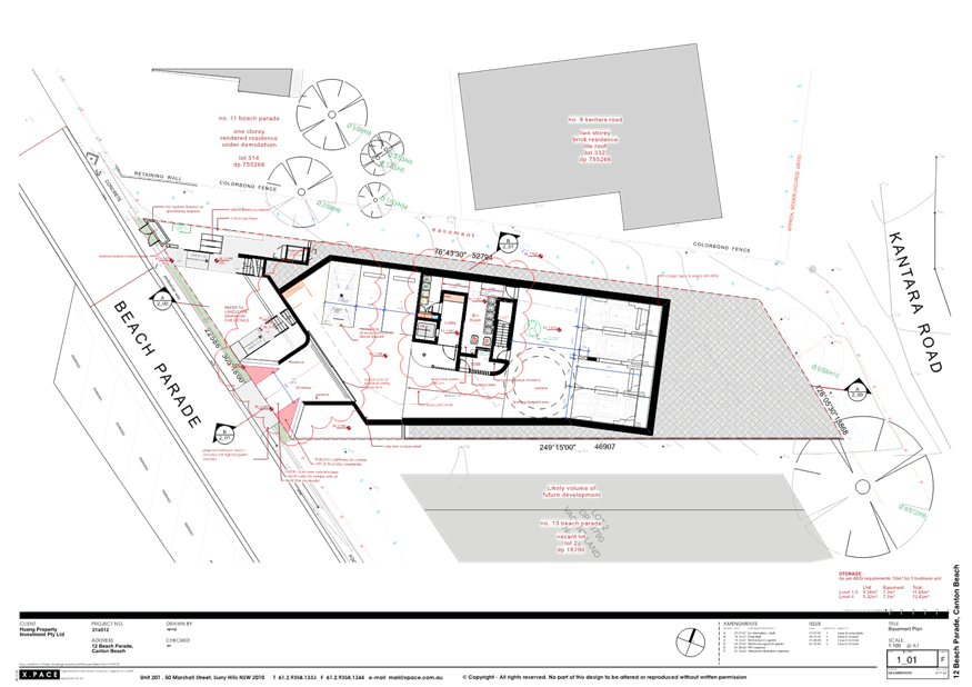
The development shall be accessed by a proposed combined entry and exit vehicle access driveway 3.0m in width off Beach Parade to an off-street basement parking area as shown in Figure 9 below. The basement parking level includes a total of six spaces comprising four spaces for residential uses and two spaces for the ground floor tenancy. A turntable will facilitate vehicles to exit in a forward direction. A car wash bay is also provided.
Rear access is proposed from Kantara Road to service one at-grade disabled parking and one space for loading/unloading for the ground floor retail tenancy (food and drink premises).
The development includes landscaping along the frontage and both side boundaries. No communal open space is provided.
It should be noted that the Landscape Plan submitted with the application has not been updated to reflect the amended architectural plans. The implications of the amended architectural plans for the landscaping scheme are discussed later in this report and form a reason for refusal in this instance (Reason for Refusal 1d).
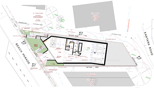
Figure 9. Proposed Basement Plan.
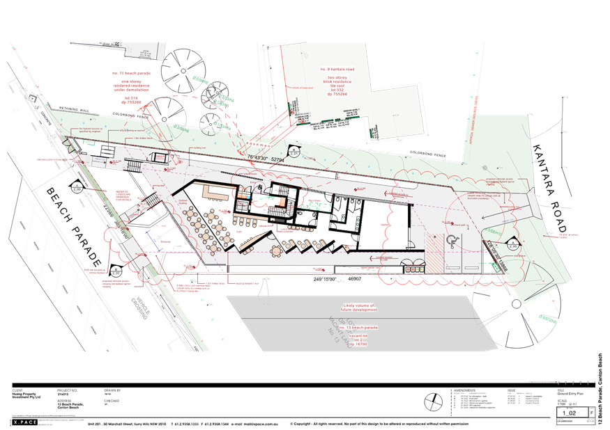
The ground level retail tenancy is shown as a 60-seat café with adjoining forecourt area for outdoor dining fronting Beach Parade as shown in Figure 10 below. The applicant has advised that future fit-out and operational details shall be subject to a separate development application.
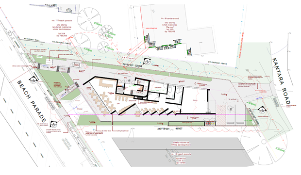
Figure 10. Proposed Ground Floor Plan.
The residential component of the development comprises four whole-floor dwellings of three bedrooms each, including one adaptable dwelling as shown in Figure 11 below. A single lift provides access from the basement to the ground floor retail tenancy (food and drink premises) and dwellings above.
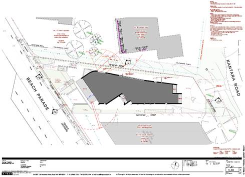
Figure 11. Proposed Levels 1-3 Plan.
Figure 12. Proposed Level 4 Plan (Penthouse).
Figure 13. Proposed Roof Plan.
Figure 14. Proposed Section A-A.
Figure 15. Proposed Section B-B.
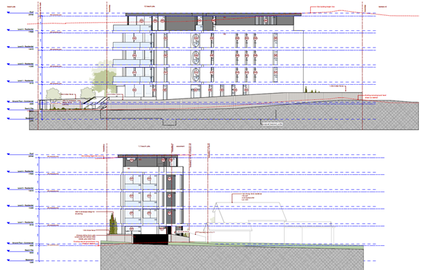
Figure 16. Proposed Elevations.
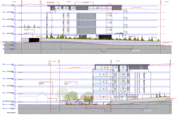
Figure 17. Proposed Elevations.
Proposed materials and finishes generally comprise painted render, metal cladding, fixed aluminium blades over fixed glass, aluminium windows and doors and clear glass as shown in Figure 18 below.
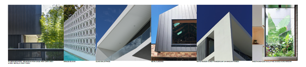
Figure 18. Proposed Materials and Finishes.
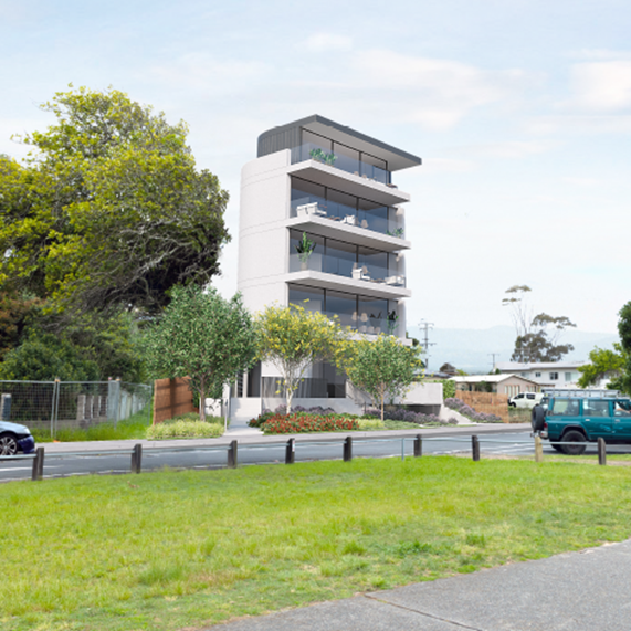
Figure 19: Photomontage
Site History
The following applications have been considered in relation to the subject site:
· Development Application No. DA/1469/2020 for the demolition of existing structures, erection of a residential flat building and Strata Subdivision refused on 15 April 2011.
· Development Application No. DA/1061/2020 for the construction of motel accommodation (4 units) withdrawn on 31 August 2022.
Application History
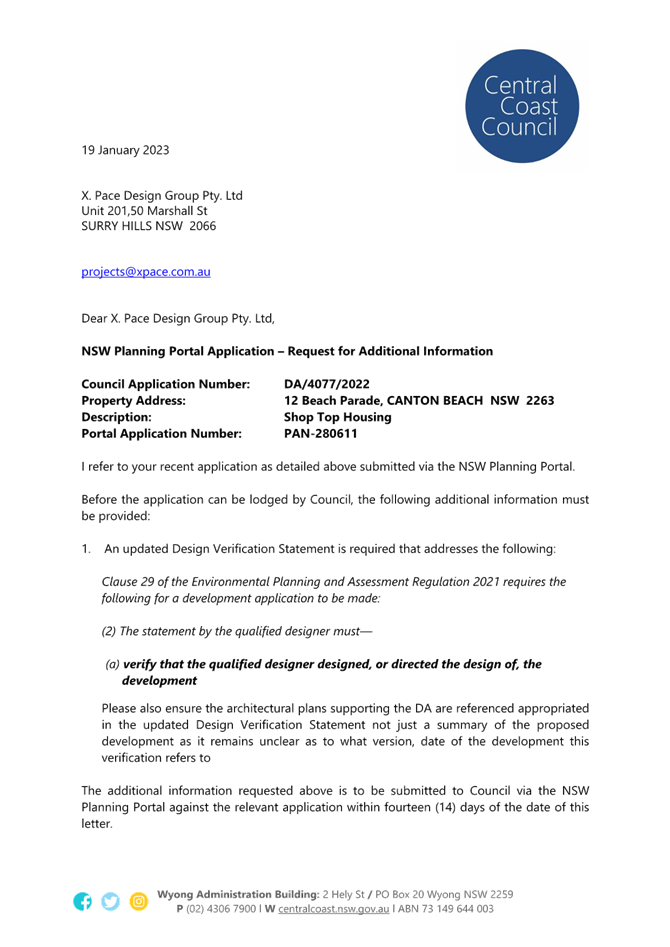
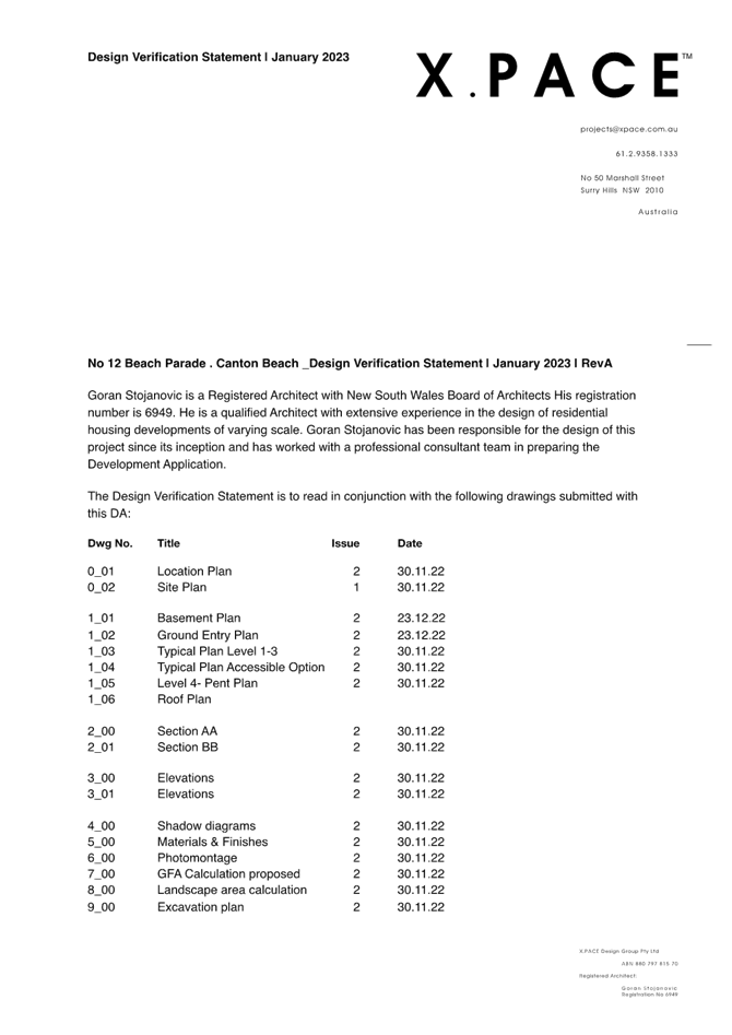
A Request for Information (RFI) was issued by Council on 19 January 2023 requesting that the Applicant provide an updated Design Verification Statement in accordance with Section 29 of the Environmental Planning and Assessment Regulation 2021 (Attachment 2). A revised Design Verification Statement was subsequently submitted by the Applicant (Attachment 3).
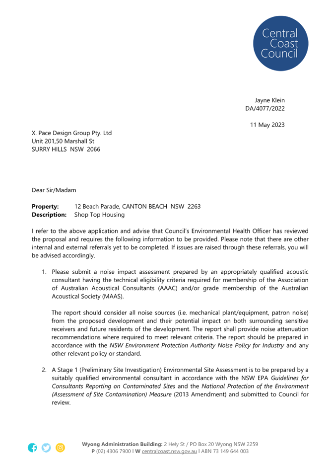
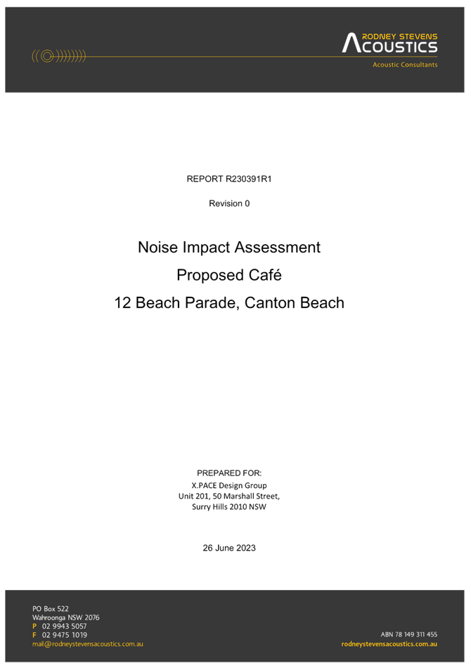
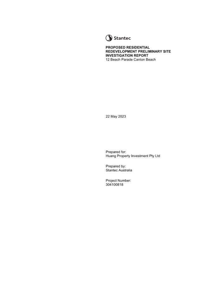
A further RFI was issued on 11 May 2023 requesting that the Applicant provide a noise impact assessment and Stage 1 (Preliminary Site Investigation) Environmental Site Assessment (Attachment 4). Both reports were provided by the Applicant (Attachment 5 and 6 respectively).
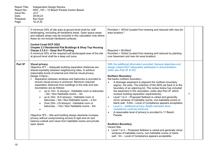
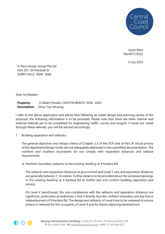
Following an urban design and planning review of the application (including an Independent Design Review by Ken Dyer, Dyer Design Company), a third RFI was issued on 5 July 2023 (Attachment 7) identifying the following issues:
· General objectives and design criteria of Chapter 2.3 of the CCDCP 2022 and Part 3F Visual Privacy of the Apartment Design Guide (ADG) not adequately addressed. The northern and southern boundaries do not comply with separation distances and setback requirements, particularly with respect to the Level 4 (Penthouse).
· No communal open space provided, contrary to Part 3D Communal and open space of the ADG and clause 2.3.3.6 – Common (and Public) Open Space of the CCDCP.
· Miscalculation of deep soil and landscape areas.
· Part 3H Vehicle access of the ADG not adequately addressed. Disabled car park does not exit the site in a forward direction and there is a conflict between the disabled space and service vehicles.
· Proposed use of concrete for driveway not supported.
· A car wash is to be provided in accordance with Clause 2.3.12.2 of the DCP.
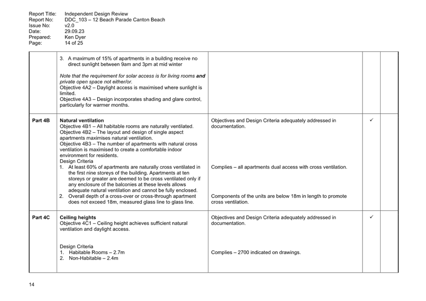
· Part 4A Solar and daylight access of the ADG not adequately addressed. Solar access diagrams not provided and the requirement for 3 hours of direct sunlight to living rooms and private open spaces does not appear to be achieved.
· Proposed 2m width of balconies does not comply with Part 4E Private open space and balconies of ADG.
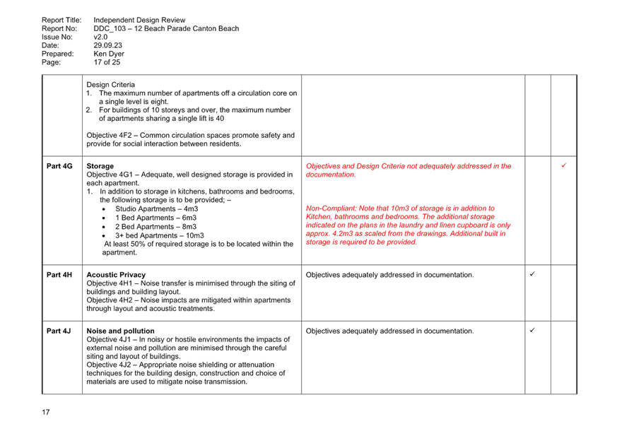
· 10m3 storage requirement under Part 4G of ADG not met.
· Details of street tree planting, letterboxes, and bicycle parking to be provided.
Revised architectural plans and landscape plans (dated 1.8.23) (Attachment 8 and 9 respectively) were submitted to respond to the matters raised in Council’s RFI letter.
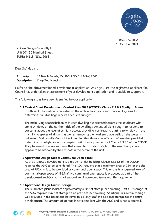
On 13 October 2023, a further letter was sent to the Applicant advising that Council could not support the application on the following grounds (Attachment 10):
· Insufficient information provided on the architectural plans and shadow diagrams to determine if all dwellings receive adequate sunlight (CCDCP Clause 2.3.6.5 Sunlight Access).
· No communal open space proposed, contrary to the ADG which requires that a minimum 25% of the site area be provided as communal open space.
· The proposed storage of 4.2m3 per dwelling not compliant with the ADG minimum requirement of 10m3.
· The proposed car parking does not meet the required number of car parking spaces (CCDCP Ch.2.13).
· The proposed vehicle turntable to facilitate access to two basement spaces for use by customers of the café is not supported as a level of training is required to use a vehicle turntable.
· The accessible car park at the rear of the development is not undercover and does not have direct undercover access to the residential entry. Therefore, the accessible space is not compliant with the provisions of AS/NZS 2890.6 (CCDCP Cl 2.13.3.7).
· A turning area for delivery vehicles is proposed in the vicinity of the accessible car parking space. Swept paths for the accessible space extend outside of the driveway and no swept path for the delivery vehicle space is provided therefore it cannot be determined if compliance is achieved (CCDCP Cl 2.13.3.5).
· Swept paths indicate that cars using car parking spaces 1, 2 and 3 in the basement cannot enter and exit the carpark using a single 3-point turn, which is non-compliant with the requirements of Cl 2.13.4.4 of the CCDCP.
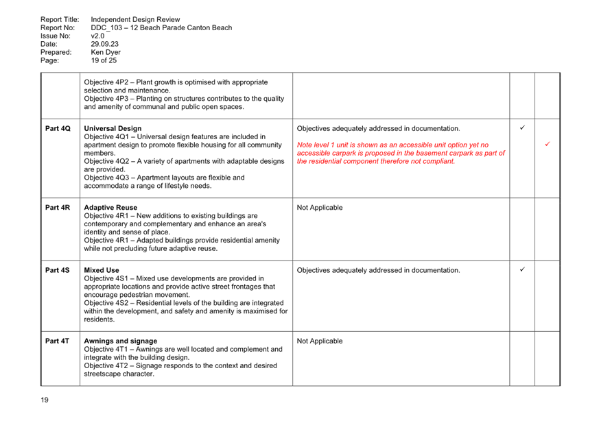
· While Level 1 unit is an accessible option no accessible car parking space is proposed in the basement carpark as part of the residential component (CCDCP Cl 2.13.3.7).
Council concluded in the letter that:
The proposal’s non-compliances with the CCDCP represent an unsuitability of the proposed development to the site. Accordingly, the application is not supported. No amended plans will be accepted for this application given the significance of the variations.
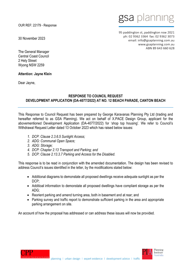
Notwithstanding Council’s advice above, on 30 October 2023 the Applicant responded to the issues raised in Council’s letter (Attachment 11) and amended plans (Attachment 12) were provided (Issue 4 dated 1.12.23). The following amendments to the plans were made:
· Additional diagrams to demonstrate all proposed dwellings receive adequate sunlight as per the DCP.
· Additional information to demonstrate all proposed dwellings have compliant storage as per the ADG.
· Parking and turning area amended, both in the basement and at the rear.
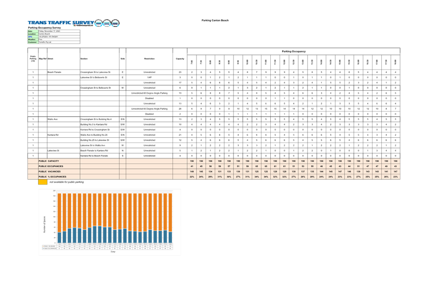
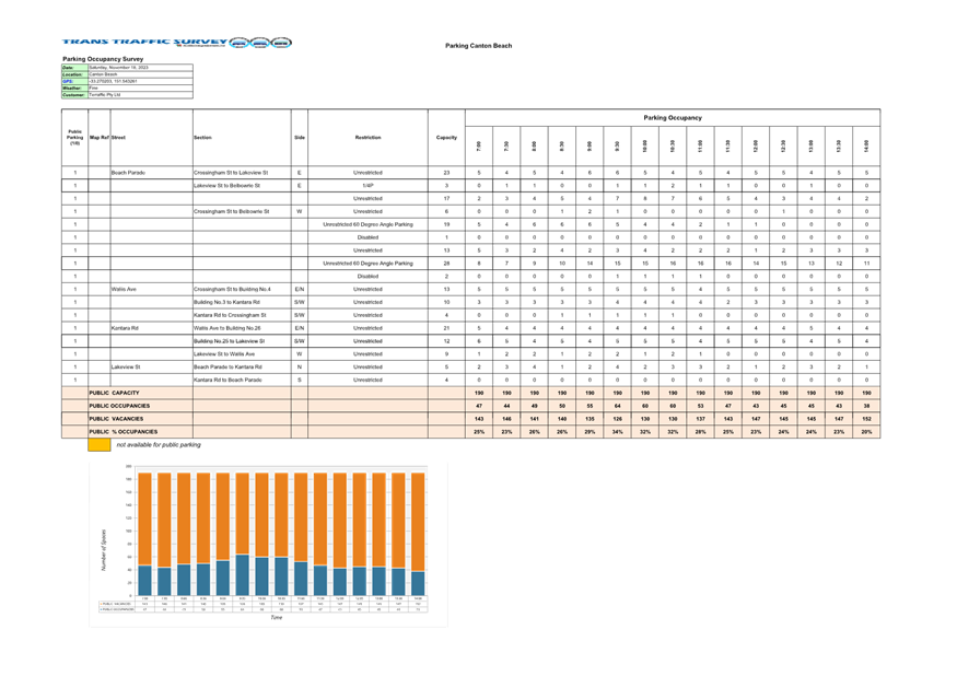
· Parking survey and traffic report provided to demonstrate sufficient parking in the area and appropriate parking arrangement on site (Attachment 13).
A final review was undertaken from the Consultant Urban Designer, which confirmed unresolved design non-compliances with SEPP (Housing) 2021 and ADG (Attachment 14).
A final telephone conversation was had with the Applicant on Wednesday 21 August 2024 confirming that Council could not support the proposed development based on the information before them, noting technical and performance non-compliances with above referenced legislation which remain unresolved post receipt of the final amended information. The Applicant was provided with an opportunity to withdraw the application prior to proceeding to reporting it to the Central Coast Local Planning Panel.
Council did not receive a formal response and the application is progressed to determination.
ASSESSMENT:
Having regard for the matters for consideration detailed in Section 4.15 of the Environmental Planning and Assessment Act 1979 and other statutory requirements, Council’s policies and Section 10.7 Certificate details, the assessment has identified several key planning matters which are discussed in detail below.
SECTION 4.15(1)(a)(i) – THE PROVISIONS OF ANY ENVIRONMENTAL PLANNING INSTRUMENT
The relevant applicable planning controls for the purposes of this application are:
· State Environmental Planning Policy (Building Sustainability Index: BASIX) 2004
· State Environmental Planning Policy (Resilience and Hazards) 2021
· (Former) State Environmental Planning Policy (SEPP) No 65 - Design Quality of Residential Apartment Development
· Central Coast Local Environmental Plan 2022
An assessment against relevant provisions of the above is provided below.
State Environmental Planning Policy (Sustainable Buildings) 2022
The Applicant has failed to submit a revised BASIX Certificate to reflect the revised architectural plans. Under Section 2.1(5) of SEPP (Sustainable Buildings) 2022, development consent must not be granted to development to which Schedules 1 or 2 apply unless the consent authority is satisfied the embodied emissions attributable to the development have been quantified. Schedule 1 applies to the proposed development. Without a revised BASIX certificate, the Panel cannot be satisfied the proposed development meets the standards set out in Schedule 1 (Refusal Reason 3).
State Environmental Planning Policy (Resilience and Hazards) 2021
Chapter 2 Coastal Management
The subject site is located within the coastal environment area and coastal use area. Sections 2.10 and 2.11 are to be taken into consideration by the consent authority when it considers and determines an application to carry out development on land to which this SEPP applies.
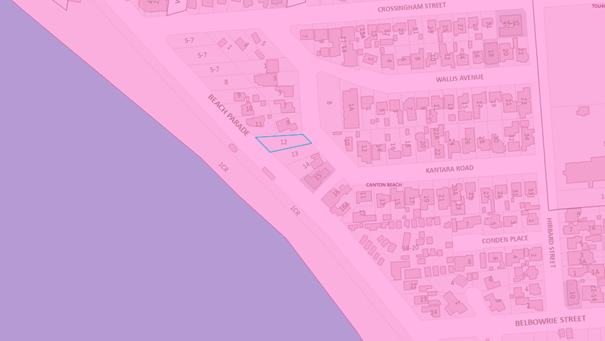
Figure 20. Coastal Environment Area Map.
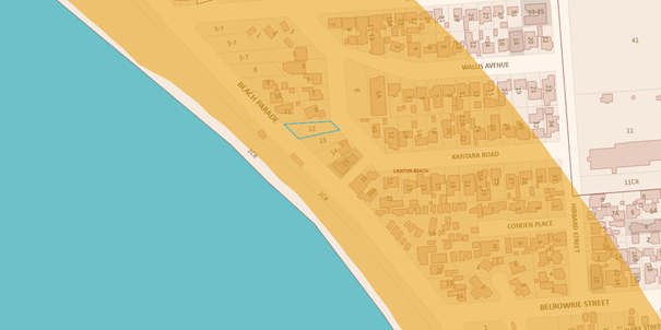
Figure 21. Coastal Use Area Map.
The following table provides an assessment against Clauses 2.10 and 2.11 of the SEPP respectively.
|
Matters for Consideration |
Compliance |
|
(1) Development consent must not be granted to development on land that is within the coastal environment area unless the consent authority has considered whether the proposed development is likely to cause an adverse impact on the following: |
|
|
(a) the integrity and resilience of the biophysical, hydrological (surface and groundwater) and ecological environment
|
Stormwater will be captured on the roof and directed to a rainwater tank and OSD, meaning the development is unlikely to have adverse impacts on the biophysical, hydrological, and ecological environment. |
|
b) coastal environmental values and natural coastal processes
|
While the site is located close to the beach (approximately 35m), it is part of the existing built-up area. The proposed development will not impact on coastal environmental values or natural coastal processes. |
|
(c) the water quality of the marine estate (within the meaning of the Marine Estate Management Act 2014), in particular, the cumulative impacts of the proposed development on any of the sensitive coastal lakes identified in Schedule 1 |
Subject to appropriate stormwater management and the implementation of erosion and sediment control measures during construction, water quality of Tuggerah Lakes will not be impacted by the proposed development. |
|
(d) marine vegetation, native vegetation and fauna and their habitats, undeveloped headlands, and rock platforms
|
The proposal is unlikely to adversely impact marine vegetation, native vegetation and fauna and their habitats, underdeveloped headlands, and rock platforms subject to implementation of appropriate water quality protection as discussed above. |
|
(e) existing public open space and safe access to and along the foreshore, beach, headland, or rock platform for members of the public, including persons with a disability |
The proposal will not adversely impact on existing public open space and safe access to and along the foreshore.
|
|
(f) Aboriginal cultural heritage, practices, and places |
The proposal will not impact on Aboriginal cultural heritage, practices, or places. |
|
(g) use of the surf zone. |
The proposal will not affect use of the surf zone. |
|
(2) Development consent must not be granted to development on land to which this clause applies unless the consent authority is satisfied that: |
|
|
(a) the development is designed, sited, and will be managed to avoid an adverse impact referred to in subclause (1) |
The proposed development has been designed, sited to avoid any adverse impact referred to in subclause (1).
|
|
(b) if that impact cannot be reasonably avoided - the development is designed, sited, and will be managed to minimise that impact
|
N/A |
|
(c) if that impact cannot be minimised - the development will be managed to mitigate that impact
|
N/A |
|
Matters for Consideration |
Compliance |
|
(1) Development consent must not be granted to development on land that is within the coastal use area unless the consent authority: |
|
|
(a) has considered whether the proposed development is likely to cause an adverse impact on the following: |
|
|
(i) existing, safe access to and along the foreshore, beach, headland, or rock platform for members of the public, including persons with a disability, |
The proposal will not impact existing safe access to and along the foreshore for members of the public.
|
|
(ii) overshadowing, wind funnelling and the loss of views from public places to foreshores,
|
The proposal will not result in overshadowing, wind funnelling or the loss of views from public places to foreshores. |
|
(iii) the visual amenity and scenic qualities of the coast, including coastal headlands,
|
The proposal will improve the quality and visual amenity of development in the area. It will not impact on the scenic qualities of the foreshore. |
|
(iv) Aboriginal cultural heritage, practices, and places,
|
The proposal is not likely to cause an adverse impact on Aboriginal cultural heritage, practices, and places. Standard conditions are imposed to stop works and report the findings to the AHO if any Aboriginal Engravings or Relics are unearthed. |
|
(v) cultural and built environment heritage, and
|
The site is within a developed urban area and the proposed development is unlikely to adversely impact the cultural and built environment heritage |
|
(b) is satisfied that— |
|
|
(i) the development is designed, sited and will be managed to avoid an adverse impact referred to in paragraph (a), or |
The proposed development has been designed and sited to avoid any adverse impact referred to in paragraph (a). |
|
(ii) if that impact cannot be reasonably avoided—the development is designed, sited, and will be managed to minimise that impact, or |
N/A |
|
(iii) if that impact cannot be minimised—the development will be managed to mitigate that impact, and |
N/A |
|
(c) has considered the surrounding coastal and built environment, and the bulk, scale and size of the proposed development.
|
The proposed development has considered surrounding coastal and built environment, having regard to Council’s objectives for the area as well as development approved but not yet built. The proposed bulk, scale and size of the development requires greater design resolution having regard for the provision of communal open space, waste servicing, landscaping, deep soil planting, parking, and equitable accessibility arrangements. |
Having regard to the above, the Panel can be satisfied that the proposed development is designed, sited, and will be managed to avoid an adverse impact and is unlikely to cause increased risk of hazards on the subject site or other land. However, the Panel cannot be satisfied the bulk, scale and size of the development is satisfactory as the development requires greater design resolution having regard for parking, landscaping, communal open space, deep soil planting and landscaping, and equitable accessibility arrangements (Refusal Reason 4).
Chapter 4 Remediation of Land
Section 4.6 requires the approval authority to consider whether the land is contaminated and if the land is contaminated, it is satisfied that the land is suitable in its contaminated state (or will be made suitable after remediation) for the purpose for which the development is proposed to be carried out.
Further under Section 4.6(2) before determining an application for consent to carry out development that would involve a change of use of land, the approval authority must consider a report specifying the findings of a preliminary investigation of the land concerned carried out in accordance with the contaminated land planning guidelines.
A Preliminary Site Investigation Report has been prepared by Stantec on behalf of the Applicant. It concludes the following:
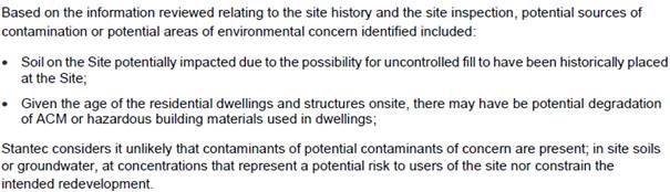
The report does not refer to the provisions of Section 4.6 SEPP Resilience and Hazards and it is unclear whether an assessment has been carried out in accordance with the contaminated land planning guidelines as per the provisions of s.4.6(2).
Section 3.2 of the report states that whilst “a review of historical aerial imagery did not indicate a significant potential for land contaminating activities to have occurred on site…land contaminating activities associated with uncontrolled filling or construction with hazardous materials may have occurred”. No further sampling and analysis appears to have been undertaken to confirm and support any conclusion reached from the site history appraisal as per the requirements of the contaminated land planning guidelines.
It is considered the Panel cannot be satisfied the relevant provisions of Section 4.6 of the SEPP have been met (Refusal Reason 4).
State Environmental Planning Policy (SEPP) (Housing) 2021
The former SEPP 65 was repealed by the Housing SEPP on 14 December 2023. An amendment to the Housing SEPP notified on 15 March 2024, retrospectively amended the Housing SEPP, with subsection 2A of Schedule 8 being introduced which clarifies the new Chapter 4 applies to applications that were made, but not finally determined, before 14 December 2023, when SEPP 65 was repealed.
Accordingly, the provisions of Chapter 4 Design of residential apartment development apply to the proposed development.
Under s.145(2), a consent authority must refer the application to the design review panel for the local government area in which the development will be carried out for advice, prior to the determination of the application. However, a design review panel has not been constituted for the Central Coast local government area therefore this section does not apply (s.145(3)).
Under s.147(1), development consent must not be granted to residential apartment development unless consideration has been given to the design principles set out in Schedule 9 (s.147(1)(a)) and the Apartment Design Guide (s.147(1)(b). An assessment in relation to the design principles and the ADG is provided below.
The provisions of s.148 (2) identify non-discretionary standards for residential apartment development as follows:
a) car parking must be equal to, or greater than the minimum amount of car parking specified in Part 3J of the ADG,
Part 3J does not apply to the subject site as the site is not within 800m of a railway station nor is it within 400m of land zoned B3 (now E2) and B4 (now MU1 Mixed Use).
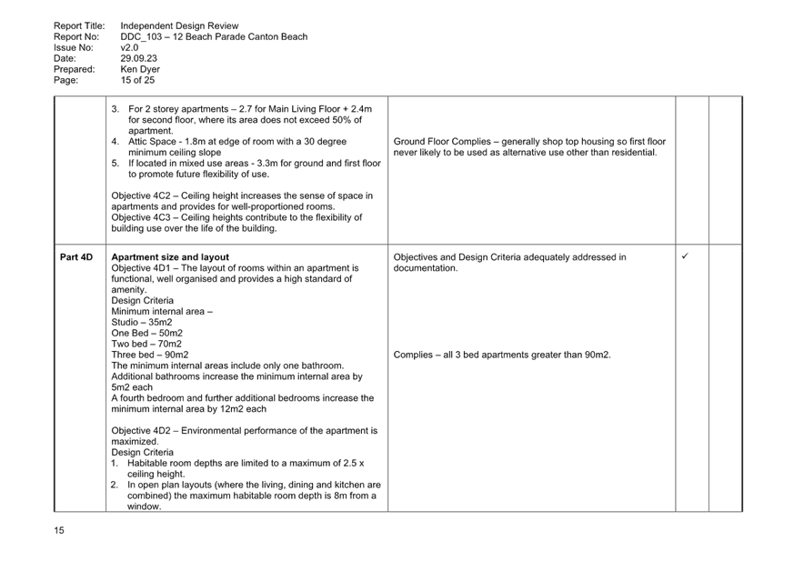
(b) the internal area for each apartment must be equal to, or greater than, the recommended minimum internal area for the apartment type specified in Part 4D of the ADG,
The proposed apartments comply with the minimum internal area required of 90m2.
(c) the ceiling heights for the building must be equal to, or greater than, the recommended ceiling heights specified in Part 4C of the ADG,
The ceiling heights
comply with the minimum 2.7m for habitable rooms and 2.4m for non-habitable
rooms. A ceiling height of 3.1m is provided for the ground floor tenancy.
Design Quality Principles
The application is accompanied by a Design Verification Statement prepared by Goran Stojanovic of X.Pace Design Group as required by Section 29 of the EP&A Regulation 2021.
Section 29 requires that the Design Verification Statement explain how the development addresses:
· the design principles for residential apartment development, and
· the objectives in Parts 3 and 4 of the Apartment Design Guide.
The statement provided by the architect only addresses the design principles but does not address Parts 3 and 4 of the ADG. The submitted statement fails to comply with the provisions of s.29 of the EP&A Regulation 2021 (Refusal Reason 2).
A copy of the Design Verification Statement is provided at Attachment 3.
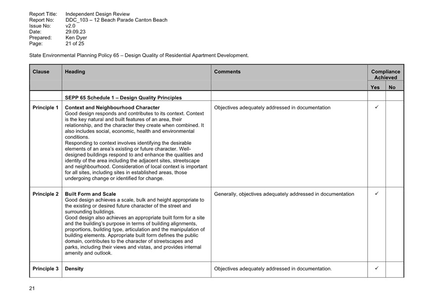
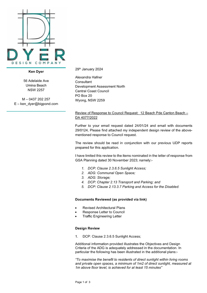
Independent Design Review
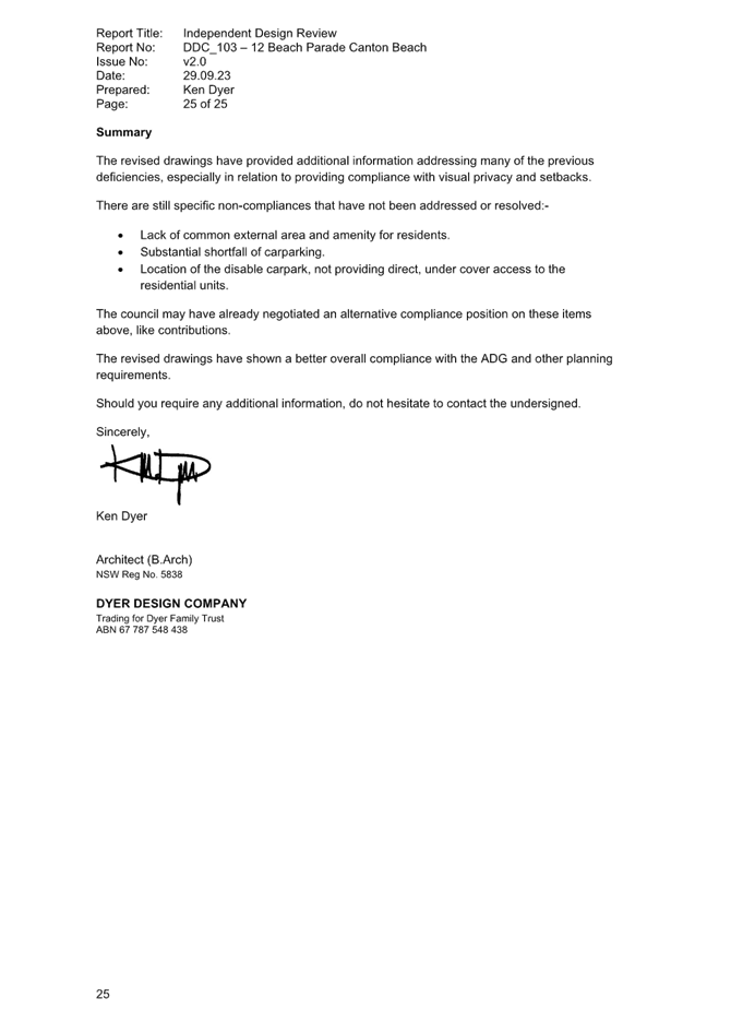
Dyer Design Company (DDC) was engaged by Council to undertake an independent design review to consider the proposal against the SEPP 65 Design Quality Principles and the associated ADG. DDC also considered relevant provisions in the CCDCP 2022. This assessment was undertaken before SEPP 65 was repealed, however, the design principles under Schedule 9 remain the same, as does the ADG.
DDC reviewed the original architectural plans submitted with the application as well as subsequent amendments with Reports submitted back to Council on 16 March 2023, 29 September 2023 and a review letter received on 29 January 2024. The review letter supplements the other assessments undertaken previously and was limited to the assessment of items nominated in the letter of response from GSA planning dated 30 November 2023.
The final review comments provided at Attachment 14.
The following table provides an assessment of the proposal against those principles having regard to the comments from DDC.
SEPP 65 Principles – DDC assessment and response
|
Principle |
DDC Response |
|
Principle 1: Context and neighbourhood character |
Compliance is achieved and objectives are adequately addressed in the documentation. |
|
Principle 2: Built form and scale |
Some non-compliance issues are not adequately addressed in the documentation, including technical non-compliances with the overall building height, building separation and privacy to Kantara Road and the southern lot boundary and side and rear setbacks. |
|
Principle 3: Density |
Some non-compliance issues are not adequately addressed in the documentation. |
|
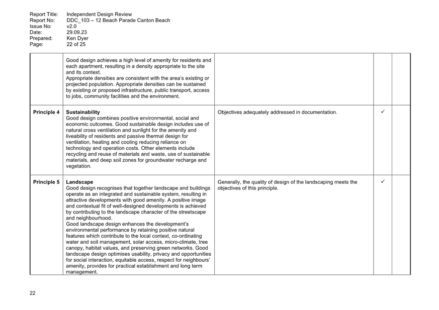
Principle 4: Sustainability |
Compliance is achieved and objectives are adequately addressed in the documentation. |
|
Principle 5: Landscape |
Generally, the quality of design of the landscaping meets the objectives of this principle. |
|
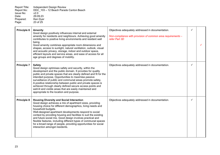
Principle 6: Amenity
|
Technical non-compliance with common area requirements under Part 3D of the SEPP. |
|
Principle 7: Safety and Security |
Objectives are adequately addressed in the documentation. |
|
Principle 8: Housing and diversity and social interaction |
Objectives are adequately addressed in the documentation. |
|
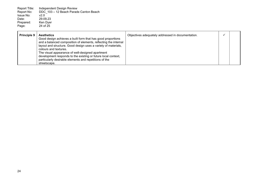
Principle 9: Aesthetics |
Objectives are adequately addressed in the documentation. |
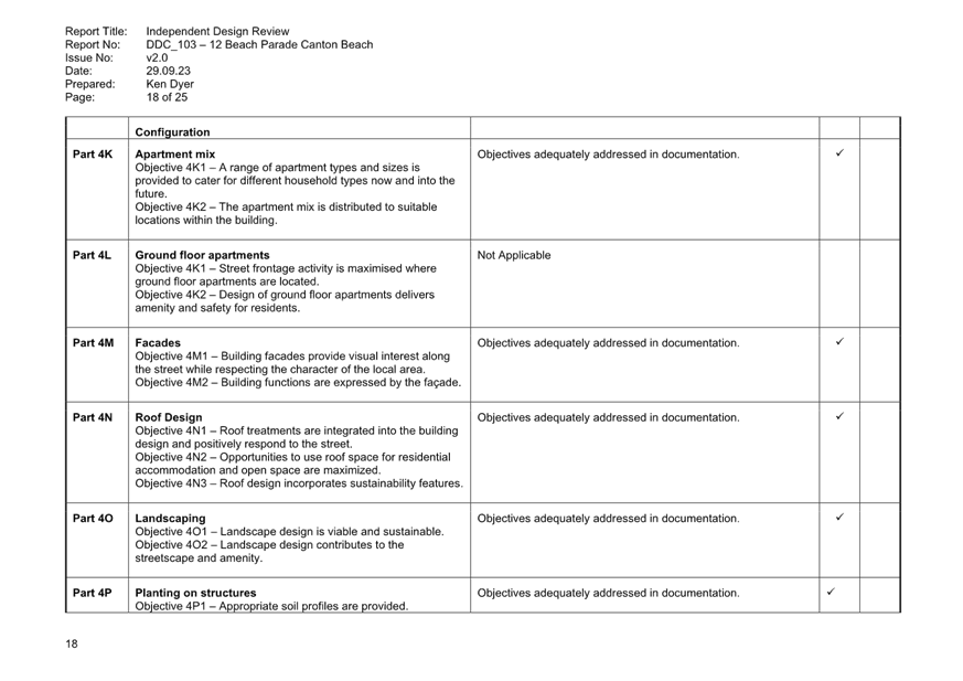
In the absence of an assessment of Part 3 and 4 of the ADG prepared by the relevant designer, an assessment of the development against the ADG design criteria is provided below by DDC and council.
Assessment against Parts 3 and 4 of ADG
|
Design Criteria |
Required |
Proposed |
Compliance |
|
3D-1 Communal Open Space |
· Minimum communal open space area 25% of the site · Minimum dimension of 3m · 50% direct sunlight to principal usable part for min 2 hrs between 9am and 3pm mid-winter |
Nil |
No – Refusal Reason 1a and 1b (discussed further below) |
|
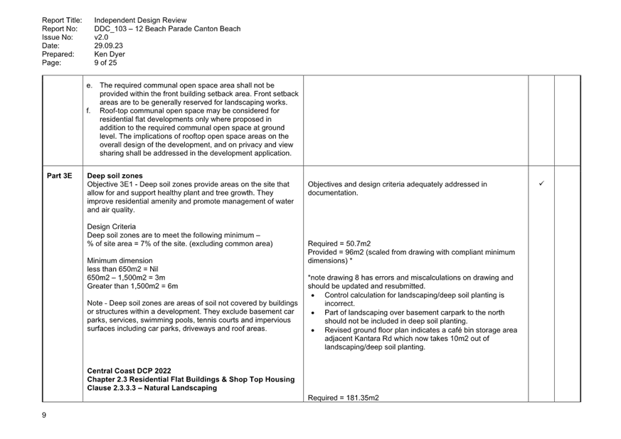
3E-1 Deep Soil Zone |
· Deep soil zones are to meet the following minimum requirements. · Minimum dimension of 3m for site area of 650m2 – 1,500m2 · 7% of site area (50.8m2) |
Deep soil is calculated at 15.2m2 or 2%.
|
No – Refusal Reasons 1c and 1d (discussed further below) |
|
3F-1 Visual Privacy |
Separation from boundaries and buildings: · up to 12m / 4 storeys – 6m to habitable, 3m to non-habitable · up to 25m / 5-8 storeys – 9m to habitable, 4.5m to non-habitable |
Northern boundary
11 Beach Parade/9 Kantara Rd: · Levels 1-4 Min 2m setback to boundary and (5-6m setback if easement included). Proposed setbacks are varied. Generally minor windows of habitable rooms, non-habitable rooms, or blank wall. · Level 5 Min 3m setback to boundary (6.5m including easement). Generally minor windows of habitable rooms, non-habitable rooms, or blank wall.
Southern boundary · Levels 1-4 Min 3m setback to boundary. Proposed Setback is varied and generally minor windows of habitable rooms, non-habitable rooms, or blank wall.
· Level 5 Min 3m setback to boundary. Generally minor windows of habitable rooms, non-habitable rooms, or blank wall.
NB: Setbacks have been reviewed by Independent Urban Designer and confirmed as acceptable – refer discussion below.
|
No. |
|
4A-1 Solar and Daylight Access |
· Living rooms and private open spaces of at least 70% of apartments in a building receive a minimum of 3 hours direct sunlight between 9 am and 3 pm at mid-winter. · A maximum of 15% of apartments in a building receive no direct sunlight between 9 am and 3 pm at mid-winter |
Initial assessment of the original architectural plans demonstrated that the objectives and design criteria was not adequately addressed in the documentation. There were no specific graphic solar access diagrams to provide the statements contained within the SEE, the main living spaces and balconies were orientated towards the southeast and from the review of the Shadow Diagrams, the living spaces and balconies are in complete shade at 9am and 12midday with only some possibility of sunlight at 3pm.
Revised architectural plans were received on 5 December 2023, with commentary from the Applicant stating that as part of the amendments, north facing glazing has been provided for the main living space of all units, and the window size has been increased to allow for additional solar access on Levels 1-3. Furthermore, the window size on level 4 has also been increased to allow for additional solar access. Additional diagrams are provided which demonstrate all proposed dwellings receive direct sunlight to living rooms and principal private open spaces from 9am to 3pm with all dwellings receiving sunlight for at least 3 hours.
The consulting Urban Designer was satisfied that the additional information illustrates the objectives and design criteria relating to solar and daylight access is adequately addressed in the documentation. |
Yes |
|
4B-3 Natural Ventilation |
· At least 60% of apartments are naturally cross ventilated in the first nine storeys of the building. · Overall depth of a cross-over or cross-through apartment does not exceed 18m, measured glass line to glass line |
As there is one dwelling per level, multiple options for cross ventilation are provided. |
Yes |
|
4C-1 Ceiling Heights |
Minimum finished floor level to finished ceiling level heights are: · 2.7m – habitable rooms · 2.4m – non-habitable |
Minimum floor to ceiling heights is: · 2.7m for habitable and non-habitable rooms: · 3.1m for ground floor |
Yes |
|
4D-1 Apartment Size |
Minimum dwelling sizes are: · Studio: 35sqm · 1 bedroom: 50sqm · 2 bedrooms: 70sqm · 3 bedrooms: 90sqm · Every habitable room must have a window in an external wall with a total minimum glass area of not less than 10% of the floor area of the room. Daylight and air may not be borrowed from other rooms |
>90m2 All habitable rooms have windows as required. |
Yes |
|
4D-2 Room depths |
· Habitable room depths are limited to a maximum of 2.5 x the ceiling height. · In open plan layouts (where the living, dining and kitchen are combined) the maximum habitable room depth is 8m from a window |
No habitable room depth is greater than 6.75m. |
Yes |
|
4D – 3 Apartment Layouts |
· Master bedrooms have a minimum area of 10m2 and other bedrooms 9m2 (excluding wardrobe space) · Bedrooms have a minimum dimension of 3m (excluding wardrobe space) · Living rooms or combined living/dining rooms have a minimum width of: o 3.6m for studio and 1-bedroom apartments o 4m for 2- and 3-bedroom apartments · The width of cross-over or cross-through apartments are at least 4m internally to avoid deep narrow apartment layouts |
Minimum bedroom areas meet these requirements. All bedrooms meet the minimum wardrobe space.
|
Yes |
|
4E-1 Private open space and balconies |
All apartments are required to have primary balconies as follows: · 1 bedroom: 8sqm, min 2m depth · 2 bedrooms: 10sqm, min 2m depth · 3 bedrooms: 12sqm, min 2.4m depth |
Primary balconies: Levels 1-3: 21.5m2, min depth 2.4m Level 5: 28m2, min depth 2.4m |
Yes |
|
4F-1 Common Circulation |
· The maximum number of apartments off a circulation core on a single level is eight |
1 dwelling per level. |
Yes |
|
4G-1 Storage |
In addition to storage in kitchens, bathrooms and bedrooms, the following storage is provided: · 1 bedroom: 6m3 · 2 bedrooms: 8m3 · 3 bedrooms: 10m3
At least 50% of the required storage is to be located within the apartment. |
The Consultant Urban Designer’s Review Letter confirms that additional information provided illustrates the objectives and design criteria of the ADG is adequately addresses in the documentation, pertaining to all units complying with the minimum storage requirements. |
Yes |
|
4H Acoustic Privacy |
Noise transfer is limited through the siting of the buildings and building layout |
Development has generally been sited to avoid noise transfer. |
Yes |
|
4J Noise and Pollution |
The impact of external noise transfer and pollution are minimised through the siting and layout of the building. |
As above, the design seeks to minimise this. |
Yes |
|
4K Apartment Mix |
A range of apartment types are provided to cater for different household types, and distributed throughout the building |
Small boutique development comprising 4 X 3-bedroom units. The number of 3-bedroom units available is significantly less than 2-bedroom units therefore the development is catering for a wider market than is generally the case for apartments. |
Yes |
|
4L Ground Floor Apartments |
Maximise street frontage activation and amenity. Design of ground floor apartments delivers amenity and safety |
No apartments are located on the ground floor.
|
N/A |
|
4M Facades |
Provide visual interest whilst respecting the character of the area |
The facades and external appearance of the building is contemporary and provides visual interest. |
Yes |
|
4N Roof Design |
Roof features are incorporated in the roof design, respond to the street, and provide sustainability features |
The design provides for a contemporary flat roof. No sustainability features are provided however this can be imposed as a condition of consent. |
Yes – subject to condition. |
|
4O Landscape Design |
Landscape design is viable, sustainable, contributes to the streetscape and amenity |
No amended landscape plan has been submitted to reflect amended architectural plans, therefore insufficient information has been submitted to enable proper assessment under this Part.
Consequently, the Panel cannot be satisfied Objective 4O-1 and 4O-2 has been met, requiring landscape design to be viable and sustainable, contributing to streetscape and amenity. |
No – Refusal Reasons 1e and 1f |
|
4V Water |
Water Management and Conservation is achieved. |
An amended BASIX Certificate has not been submitted with revised architecturals however, should the Panel see fit to approve the development, can be imposed as a condition of consent. |
Yes – subject to condition. |
|
4W Waste |
Waste storage facilities are provided to minimise impacts on the streetscape, building entry an amenity of residents. |
Waste storage is located within the waste storage area (commercial, residential waste) in the basement. |
Yes |
As noted in the table above, the proposed development does not comply with several of the ADG requirements. These are discussed in further detail below.
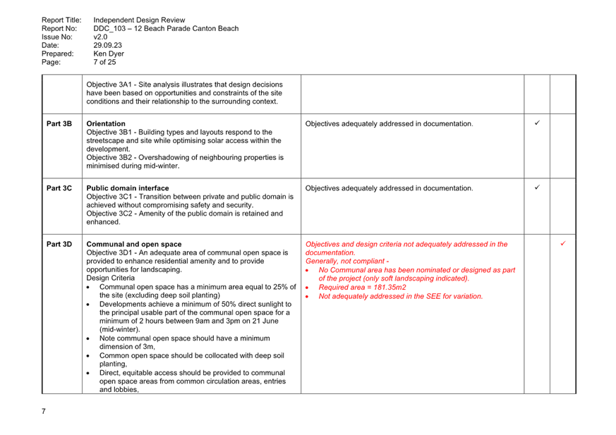
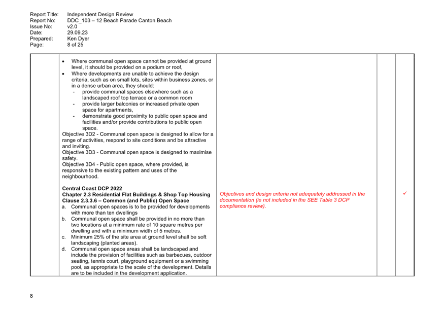
Part 3D - Communal open space
In accordance with Part 3D of the ADG, communal open space is an important environmental resource that provides outdoor recreation opportunities for residents, connection to the natural environment and valuable breathing space between apartment buildings.
181.35sqm of communal open space is required to comply with Part 3D of the ADG, however the proposed development does not provide any form of communal open space, seeking a 100% variation to this standard. An independent design assessment by Dyer Design Company advises that this non-compliance should not be supported on the following grounds:
As stated in the ADG –
“Communal open space is an important environmental resource that provides outdoor recreation opportunities for residents, connection to the natural environment and valuable ‘breathing space’ between apartment buildings. It also contributes to the appeal of a development and the wellbeing of residents.”
The provision of no communal open space within the development deprives the residence the opportunity for immediate access to their own private communal space for enjoyment and wellbeing. The applicant is suggesting it is acceptable to have residence leave the safety of their own development and to travel to external sites to enjoy the outdoors.
It is agreed that the ADG should be seen as a flexible guideline when it comes to the ADG is focused on qualitative objectives, not rigid numeric compliance but the fact remains that no communal open space has been provided, which would seem contrary to the objective of providing “an adequate area of communal open space to enhance residential amenity and to provide opportunities for landscaping”.
Providing a unit development without communal open space is not consistent with the character or amenity of the area. The site is not in a business zone or dense urban environment so the common space should be provided.
It does not appear the applicant has reviewed the opportunity for roof top common areas or the reduction of the restaurant and/or outdoor seating to provide some appropriate common area for the benefit of the residence.
We believe that not providing any open communal area should not be supported.
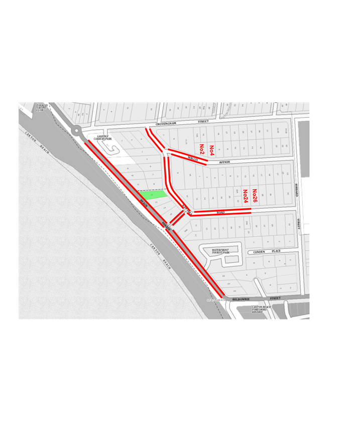
In response to the above, the Applicant advised ‘while the proposal does not provide the communal open space as recommended in the ADG, an analysis of open spaces in the area has been provided which indicates that there is an abundance of public open spaces within walking distance of the site, including, inter alia, Canton Beach, which is a large public open space directly across Beach Parade. Additionally, there are at least seven other public open spaces of various scales and configurations in the vicinity’.
Reference is made to the figure provided below.
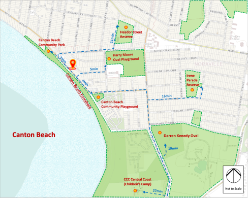
Figure 21. Public open space map.
Further, the Applicant submits that based on the above figure that the development has ‘enhanced residential amenity and provided opportunities for landscaping, which is consistent with Objective 3D-1 of the ADG’. Further reference has been made to a recent LEC decision (Construction Development Management Services Pty Ltd v City of Sydney [2023] NSWLEC 1620) affirming that the ADG is a flexible document where the focus is on the achievement of qualitative objectives.
Whilst Council agrees that technical compliance with the numerical design criteria is not the only pathway to approval, Council notes that the Applicant has the opportunity to lower the development density and provide a rooftop terrace or ground floor communal open space that ensures outdoor recreation opportunities for residents wholly contained within the site itself.
In accordance with the design guidance contained within Objective 3D-1, direct, equitable access should be provided to communal open space areas from common circulation areas, entries, and lobbies. Absolute reliance on surrounding public open space parklands cannot be relied upon to this effect as it is not direct, nor is it equitable, failing to satisfy the objectives of design guidance in and of itself.
Additional guidance provisions requires that communal open space facilities be provided for children and young people that are safe and contained (Objective 3D-3). Again, absolute reliance on surrounding open space areas and parklands cannot be relied upon as it is not contained with potential risks to safety resulting from lack of passive surveillance for envisaged residents.
The 100% variation to communal open space is not supported based on the above and the application is recommended for refusal (Refusal Reasons 1a and 1b).
As previously stated, opportunities exist to demonstrate partial compliance with this requirement by decreasing the development density and providing communal open space on the roof top or via the reduction in the ground floor retail area, however this has not been explored. Decreasing the ground floor retail area would also lower the technical noncompliance generating in terms of parking spaces for the proposed development as well.
Part 3E - Deep soil
In accordance with Part 3E of the ADG, deep soil zones have important environmental benefits, promoting the health and growth of large trees with large canopies, and assist with temperature reduction in urban environments.
Council recognises that the proposed development provides minimal opportunities for deep soil planting and based on the amended architectural plans, only a small area in the south-west corner and front setback may be available to meet the minimum 3m dimension for deep soil planting. This is supported by the independent design review undertaken by DDC provided in March 2023. The Panel is advised that insufficient information is submitted to enable proper assessment by way of revised landscape plans to support the revised architectural plans and ensure that the objectives and design criteria remain adequate since these revisions.
In absence of this information, the Panel cannot be satisfied that the design criteria of Part 3E relating to deep soil zones has been met and the application is recommended for refusal on this basis (Refusal Reason 1c).
Consequently, the Panel cannot be satisfied that healthy plant and tree growth can be achieved, improving residential amenity, and promoting management of water and air quality can be achieved in accordance with Objective 3E-1 (Refusal Reason 1d).
Setbacks
The Statement of Environmental Effects notes the following with respect to side setbacks:
The site adjoins a 3.5m-wide easement to the north. Beyond the easement, No. 11 Beach Parade is under construction for a five-storey shop top housing (DA/243/2015), and No. 9 Kantara Road contains a single dwelling with varied side setbacks. The subject site adjoins a vacant lot to the south. Many nearby developments are underdeveloped or undeveloped as existing, which are not necessarily characteristic of the future built form of the locality.
Recent development of a similar nature in the vicinity has been approved with side setback non-compliances. On 31 May 2018, the Panel (Hunter and Central Coast Joint Regional Planning Panel) approved DA/7/2017 for shop top housing at Nos. 5-8 Beach Parade in the same SP3 Tourist Zone, which had a comparable non-compliant side setback of 3m ... It was supported by Council staff based on similar arguments as those made in our submission (being compatible with surrounding development with no significant impact on neighbours).
Compared to the above recent approval, the subject site is more constrained in achieving compliant side setbacks given the narrower width. The shape of the subject site also tapers to the rear, which is an additional site constraint. Despite the challenging site conditions, the proposed building has been intentionally designed to achieve the 6m side setback on the northern side of the primary frontage, providing a compliant appearance as viewed from the northern part of Beach Parade …. This is considered consistent with the desired future character, through a contemporary mixed-use development that addresses both street frontages with compliant front/rear setbacks and provides a compliant, enhanced landscape setting.
In its initial independent assessment of the building design (dated 16 March 2023) Dyer Design Company noted the following matters needed consideration with respect to setbacks:
Setback to 9 Kantara Road (northern)
· Further detail should be provided about the windows/openings in the existing dwelling to further test and confirm building separation and privacy.
Southern boundary
· Level 5 – 9.5m (3.5+6) or 6.5m (3.5+3) would be achievable in the future as a minimum – compliance difficult to achieve. Need to review the design of level 5 the location of the outer wall setback.
Following design amendments by the applicant, Dyer Design Company issued a further review (dated 29 September 2023) noting that based on the design changes compliance to the northern and southern setbacks could be achieved and no further concerns were raised.
In summary and having regard to the above advice, it is considered that the proposed separation distances are appropriate given the privacy treatments and site circumstances.
Part 3G -Pedestrian access and entries
Pedestrian access should be high quality, equitable, and safe, providing pleasant walking environments along the street, into the development and to individual apartments. Pedestrian access and entries should also be prioritised over vehicle access.
The location of the accessible car parking space does not provide equitable and safe access into the building. Moreover, the pedestrian entry from the rear on-grade car parking to the building entry conflicts with the vehicle access from Kantara Road. The accessible entry to the ground floor level food and drink premises and apartment entry, involving a platform lift, is not considered equitable or of high quality (Refusal Reason 1g).
Part 3J -Bicycle and car parking
Parking and facilities should be provided for different modes of transport such as motorbikes, scooters and bicycle parking, and consideration should be given to charging stations for electric vehicles. In addition, this parking should be secure. The plans do not accommodate parking for other modes of transport except for bicycle parking that is located within the front setback on Beach Parade. The location is not secure and removes landscaping opportunities within the front setback.
On-grade parking should be avoided, but if unavoidable, should be appropriately screened from view of streets, incorporated into the landscape design of the site, and should provide safe and direct access to building entry points (objective 3J-5). The on-grade parking proposed at the rear of the site off Kantara Road has not been screened and any opportunity to provide some form of deep soil planting and landscaping on the Kantara Road frontage has been taken up by the location of the fire hydrant, driveway, and associated hardstand area.
The path of travel from the accessible parking space to the residential building entry point traverses the bin travel path, driveway access from Kantara Road and back of house facilities for the kitchen. This is not considered acceptable (Refusal Reason 1h).
Part 4S -Mixed Use
The ADG promotes non-residential uses on lower levels of buildings that provide active street frontages and address the street. The proposed development includes a food and drink premises on the ground floor level which fronts Beach Parade.
Unfortunately, due to the flood affectation of the site, the proposed development cannot be located at grade and is subject to a minimum floor level which results in a ground floor level that sits above Beach Parade by approximately 1.36m. As such, the frontage of the site contains stairs, a ramp, and platform lift to accommodate the grade change, which leads to a disconnect between the pedestrian footpath on Beach Parade and the ground floor of the development.
The ADG promotes residential entries being separated from commercial entries and directly accessible from the street, with commercial service areas separated from residential components, residential parking separated or secured, and security at entries and safe pedestrian routes being provided. The proposed development provides a separate residential entry to that of the food and drink premises however, the distance from the proposed accessible car park at the rear of the site to the entry lobby is considered excessive and is not protected by the weather which is considered unacceptable. The location of the accessible car parking space to the loading area, assumed to be at the rear of the kitchen, has the potential to result in vehicular and pedestrian conflict, with the commercial and residential components of the development not being appropriately separated.
Furthermore, the accessible car park is not secured, it is easily accessed by members of the public from Kantara Road or those walking through the site, and the car parking space is not exclusive and can easily be utilised by members of the public. In addition, the proposed breeze blocks at the access to the entry lobby has the potential to conceal a person and provide an entrapment point (Refusal Reason 1i).
Central Coast Local Environmental Plan 2022
The relevant local environmental plan applying to the site is the Central Coast Local Environmental Plan 2022 (CCLEP 2022). The aims of CCLEP 2022 are to promote a high standard of urban design that responds appropriately to the existing or desired future character of areas.
Zoning and Permissibility (Part 2)
The subject site is zoned SP3 - Tourist pursuant to clause 2.2 of CCLEP 2022 (Figure 14). Shop top housing and food and drink premises are permissible with consent within the SP3 zone.
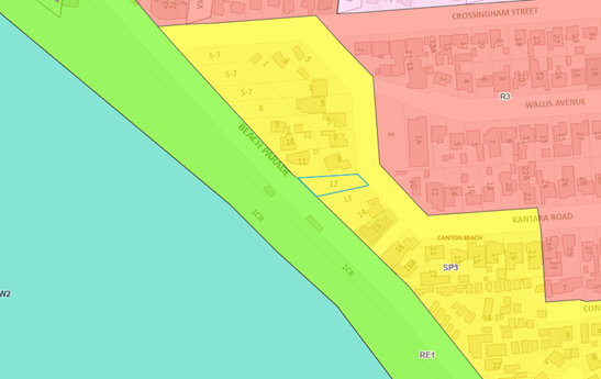
Figure 22: Zoning under CCLEP 2022
The objectives of the SP3 zone are:
· To provide for a variety of tourist-oriented development and related uses.
· To facilitate the provision of limited permanent accommodation in the form of mixed-use development to improve the off-season viability of tourist-based development.
· To protect and enhance the natural environment for tourist and recreational purposes.
Whilst the proposed development seeks to activate the foreshore by providing tourist-oriented development, the scale of the ground floor commercial floor area and resulting car parking deficiency will place additional on-street parking demand on the surrounding street network, and the appropriate studies have not been undertaken, in terms of contamination and acid sulfate soils to satisfy the consent authority that the natural environment will be protected.
The Panel is advised that the proposed development fails to satisfy the objectives of the SP3 Tourist zone and is recommended for refusal on this basis (Refusal Reason 5a).
General Controls and Development Standards (Parts 2, 4, 5, 6 and 7)
CCLEP 2022 contains controls relating to development standards, miscellaneous provisions, and local provisions. The relevant controls to the proposal are further set out in the table below.
Key controls under CCLEP 2022
|
Clause |
Requirement |
Proposal |
Complies |
|
4.3(2) – Height of buildings |
Clause 4.3(2) permits a maximum overall building height of 16m. |
Overall building height of 17.6m. |
No - Further discussion below. |
|
4.4(2) – Floor Space Ratio |
Clause 4.4(2) permits a maximum overall FSR of 1.25:1. |
Floor space ratio of 1.249:1.
|
Yes |
|
4.6 – Exceptions to Development Standards
|
Development consent may, subject to this clause, be granted for development even though the development would contravene a development standard imposed by this or any other EPI instrument. |
The application is accompanied by a written Clause 4.6 submission seeking to vary the maximum permissible building height in accordance with Clause 4.3 of the CCLEP 2022. |
Yes |
|
5.21 Flooding |
Development consent must not be granted within a flood planning area unless the consent authority is satisfied of the relevant matters in 5.21(2).
|
While the site is within a flood planning area, Council’s Development Assessment Engineer has advised that a flood study is not required. The development has been designed to ensure compatibility with matters identified in 5.21(2). |
Yes – further discussion below. |
|
7.1 – Acid Sulfate Soils |
Development consent must not be granted until an ASS Plan in accordance with the Acid Sulfate Soils Manual has been prepared.
|
The site is identified as Class 3 on the Acid Sulfate Soils map. The proposed development includes excavation of more than 1 metre below the ground surface to facilitate the basement car park and is likely to lower the watertable more than 1 metre below the natural ground surface as indicated in the Geotechnical Investigation Report prepared by Cardno.
The Application is accompanied by an Acid Sulfate Soils Management Plan, prepared by Stantec, and dated 19 June 2024. The Report provides a framework for the monitoring and management of impacts of Acid Sulfate Soils in the event they are encountered throughout the construction and operational phasis of the project in accordance with the Acid Sulfate Soils Manual, 1998. |
Yes – subject to conditions. |
|
7.6 – Essential Services
|
Essential services must be made available or adequate arrangements be made to make them available.
|
The proposed development has failed to demonstrate how suitable waste collection can occur during the ongoing operation of the site in addition to failing to demonstrate how suitable vehicular access is achieved for the development, including the proposed disabled access space from Kantara Road. |
No – Refusal Reason 5b.
Further discussion below.
|
Clause 4.3 Height of Buildings
The objectives of the maximum height of building clause are as follows:
(a) to establish a maximum height of buildings to enable appropriate development density,
(b) to ensure that the height of buildings is compatible with the character of the locality.
Under the CCLEP 2022 maximum height of building maps (Clause 4.3), the site is prescribed a maximum building height of 16m (Figure 15).
The proposal seeks a maximum height of 17.6m which exceeds the development standard by 1.6m or 10%. The proposed height exceedance is primarily contained to the front portion of the site. The variation is considered acceptable having regard for the provisions of clause 4.6. A Clause 4.6 application was submitted with the DA which is discussed below.
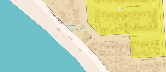
Figure 23: Height of buildings map
Clause 4.4 Floor Space Ratio
The objectives of the maximum Floor Space Ratio clause are as follows:
(a) to establish standards for the maximum development density and land use intensity,
(b) to ensure the density, bulk and scale of development integrates with the streetscape and character of the area in which the development is located,
(c) to minimise adverse environmental effects on the use or enjoyment of adjoining properties and the public domain,
(d) to facilitate design excellence by ensuring the extent of floor space in building envelopes leaves generous space for the articulation and modulation of design.
Clause 4.4(2) of CCLEP 2022 specifies the floor space ratio (FSR) for the site shall not exceed that indicated on the applicable map. The maximum permitted FSR is 1.25:1.
Revised architectural plans and GFA calculation and verification statements provided by the Applicant on Tuesday 4 June 2024 demonstrate compliance with the requirements of this Clause.
Clause 4.6 Exceptions to development standards
Clause 4.6 provides flexibility in applying certain development standards. The proposed development seeks consent for an overall building height of 17.6m, which exceeds the maximum permitted under Clause 4.3(2) of the CCLEP 2022 by 1.6m or 10% and is therefore accompanied by a Clause 4.6 Variation Request, prepared by GSA Planning, dated November 2022, provided at Attachment 15.
Clause 4.6(3) identifies matters to be demonstrated by the applicant in a written clause 4.6 request. These matters are:
· That compliance with the development standard is unreasonable or unnecessary in the circumstances of the case.
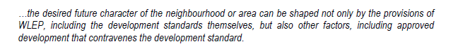
An established way to demonstrate that compliance with the standard is unreasonable or unnecessary is to use one or more of the five justifications identified in Wehbe v Pittwater Council [2007]. This is further detailed in Initial Action where Preston CJ states at [22]:
These five ways are not exhaustive of the ways in which an applicant might demonstrate that compliance with a development standard is unreasonable or unnecessary; they are merely the most invoked ways. An applicant does not need to establish all the ways. It may be sufficient to establish only one way, although if more ways are applicable, an applicant can demonstrate that compliance is unreasonable or unnecessary in more than one way.
The Applicant states the proposed development is unreasonable and unnecessary in the circumstances of this application as ‘the proposed height is driven by flood constraints and the ground floor level is at the level required by the engineer, with a 2.7m floor to ceiling height proposed for all habitable levels to provide the required amenity’.
The Applicant submits the proposal satisfies Test 1 established in Wehbe and for that reason, the development standard is unreasonable and unnecessary in this instance. Further, the Applicant states the proposal is consistent with the objectives of the standard because:
(a) To establish a maximum height of buildings to enable appropriate development density.
Applicant comment
The subject site is zoned SP3 Tourist and adjacent to Lakedge Caravan Park and Waterfront Tourist Park, which has been identified as tourist precincts, to promote tourist and residential accommodation and an active street front of cafes and tourist-related uses along Beach Parade. In our opinion, the proposed building height will enable appropriate development density.
To respond to the desired vision for the locality, the proposed building will have a compliant floor space ratio (FSR) of 1.249:1 and a visually compliant height ranging from 12.8m to 17.6m, which is appropriate for the density provided. The new building generally remains within the height standard along Kantara Road (see Figure below), and the flat roof design will appear height compliant overall as the maximum height proposed is mostly a function of the topography. The additional height is insignificant in the context of the development.
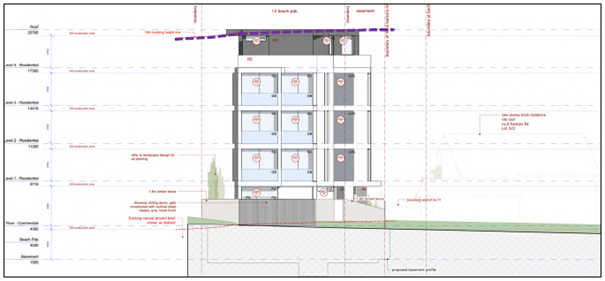
Figure 24. Proposed height exceedance when viewed from Kantara Road elevation.
A high degree of reticulation and recesses are incorporated into the design to present an appropriate height, bulk, and scale, revitalising the vacant lot. The height breach will enable a consistent roof design that is in line with the desired future character of the neighbourhood.
Accordingly, the proposed height is necessary and appropriate for the site and the proposed density, to provide a high-quality urban design outcome for the tourist precinct.
(b) To ensure that the height of buildings is compatible with the character of the locality.
Applicant comment
The SP3 Tourist zoning permits a wide range of uses and built form on the site, which promotes the eclectic desired future character.
The new shop top housing development will contribute to the eclectic mix of permissible uses in the SP3 zone. It is compatible with the envelope of neighbouring developments recently approved and constructed on Beach Parade. This demonstrates the external envelope is contextually compatible. In other words, the proposal is consistent with the built form in the areas and the areas desired future character despite the height breach. In Woollahra Municipal Council v SJD DB2 Pty Limited [2020] NSWLEC 115[63], Preston CJ states, inter alia:
As indicated, the non-compliance is mainly due to the flood constraints and sloping terrain. The proposal will sympathetically respond to the character of adjacent developments. It will not appear out of character when viewed in its context.
Council comment
Council also recently approved a nearby application with a height breach. This indicates that recently Council has considered a height breach in the area can be consistent with the desired future character. It is a relevant consideration to understand if Council has accepted breaches to the building height standard in the past, under what circumstances these were supported and if indeed there are any comparable principles to the subject application.
· That there are sufficient environmental planning grounds to justify contravening the development standard.
The Applicant provides the following grounds/reasons for the proposed variation to the development standard:
1. The proposal will be in keeping with the desired future character of the development along Beach Parade as depicted by the transitioning character of the area. The proposed height of the development will facilitate an ad additional dwelling at the upper level and assist the development in satisfying the zone objectives by providing additional preeminent accommodation in a mixed-use context.
2. Strict compliance with the standard would require the lowering of the entire building. This would unreasonably and unnecessarily reduce the ceiling height of the residential units which currently have a 2.7m floor to ceiling height. This would compromise amenity and architectural design which has carefully considered flood engineering requirements. Alternatively, it would necessitate remove of the entire penthouse level which would result in an FSR that is substantially below the standard.
Council comment
The numerical non-compliance is considered acceptable in this instance as it responds appropriately to a flooding consideration without unreasonably contributing to bulk and scale, nor does it result in adverse impacts to the streetscape or surrounding properties. The proposed floor to ceiling levels are already at the minimum required to ensure appropriate residential amenity and so the minor 1.6m breach is warranted in this instance.
The variation does not result in adverse privacy, overshadowing or view impacts for surrounding residential developments.
The written request has identified, and adequately justified, sufficient environmental planning grounds and the reasons provided have demonstrated circumstances which relate to the specific contravention of the height and how the objectives of the standard can be achieved even though it will not be a wholly compliant development (Al Maha Pty Ltd v Huajun Investments Pty Ltd [2018] NSWCA 245). The written request has also satisfied the consent authority that it is unreasonable to comply with the development standard in this instance. Accordingly, the consent authority is satisfied as to those matters stated in clause 4(3) of CCLEP 2022 (RebelIMH Neutral Bay Pty Limited v North Sydney Council [2019] NSWCA 130).
Clause 4.6(4) requires the consent authority to keep a record of its assessment carried out under subclause (3). Consideration of subclause (3) is contained within this assessment report and may also be included in the decision of the Panel.
As identified in the above body of this Report, the proposal is demonstrated to be consistent with the stated objectives of the developments standard as the resultant density, bulk and scale of the development is deemed negligible in comparison to a compliant scheme and result only due to compliance with minimum floor levels from flooding matters.
Clause 4.6(8) provides circumstances under which the provisions of clause 4.6 cannot be utilised. These circumstances do not arise within this development application.
Having regard for the written request provided by the applicant and the above assessment, the proposed development is considered to satisfy the requirements of clause 4.6, achieving an appropriate built form outcome within the circumstances.
Development Application No. DA/7/2017
Importantly, the Panel shall note that any reference to the approved development at No. 5-8 Beach Parade under DA/7/2017 in the accompanying Clause 4.6 submission is not accepted on the basis that the DA was considered under the former Wyong Local Environmental Plan 2013, a different instrument to the current EPI in force, and determined by the former Hunter and Central Coast Joint Regional Planning Panel.
The request for the 1.6m or 10% variation to the maximum 16m building height permitted under Clause 4.3(2) of the CCLEP 2022 is considered acceptable based on the merit assessment of this application.
Clause 5.21 – Flooding
The site is affected by flood related development controls, being marginally impacted by overland flooding/ponding, and is not affected by Tuggerah Lake flooding. The proposed finished floor level of the café is 4.365m, which is above the minimum habitable floor level of 2.7m AHD. The crest level of the basement driveway is 2.9m AHD which again is above the PMF of 2.7m AHD.
In accordance with Clause 5.21(2), development consent must not be granted to development on land the consent authority considers to be within the flood planning area unless the consent authority is satisfied the development –
(a) Is compatible with the flood function and behaviour on the land, and
(b) Will not adversely affect flood behaviour in a way that results in detrimental increases in the potential flood affectation of other development or properties, and
(c) Will not adversely affect the safe occupation and efficient evacuation of people or exceed the capacity of existing evacuation routes for the surrounding area in the event of a flood, and
(d) Incorporates appropriate measures to manage risk to life in the event of a flood, and
(e) Will not adversely affect the environment or cause avoidable erosion, siltation, destruction of riparian vegetation or a reduction in the stability of riverbanks or watercourses.
Council’s Flood Development Engineer has reviewed the proposed development and confirmed it acceptable with regards to the provisions of Clause 5.21 and no additional flood study is required. They are also satisfied that the proposal does not increase the risk to life or impact evacuation requirements and the design generally avoids impacting on flood behaviour, hence the proposal is supported. In this regard, the Panel can be satisfied that the proposed development, subject to conditions:
(a) is compatible with the flood function and behaviour on the land, and
(b) will not adversely affect flood behaviour in a way that results in detrimental increases in the potential flood affectation of other development or properties, and
(c) will not adversely affect the safe occupation and efficient evacuation of people or exceed the capacity of existing evacuation routes for the surrounding area in the event of a flood, and
(d) incorporates appropriate measures to manage risk to life in the event of a flood, and
(e) will not adversely affect the environment or cause avoidable erosion, siltation, destruction of riparian vegetation or a reduction in the stability of river banks or watercourses.
Clause 7.1 – Acid Sulfate Soils
The site is identified as Class 3 on the Acid Sulfate Soils (ASS) Planning Map which are likely to occur where there are works more than 1m below natural ground level and/or works by which the water table is likely to be lowered more than 1m below the natural ground surface. The proposed basement is to be excavated approximately 3m below the existing ground level.
The Preliminary Site Investigation report prepared by Stantec on behalf of the applicant recommended as follows with respect to acid sulfate soils:
Materials excavated or stockpiled during site development will require acid sulphate soil assessment and waste classification if intended to be disposed off-site to a licensed landfill. The classification should be in accordance with the NSW EPA Waste Classification Guidelines (2014) and should be facilitated by an experienced environmental scientist. Remediation action plan will be required if acid sulphate soil is encountered.
The conclusion of the report advised an acid sulfate soil assessment was required. No Acid Sulfate Soil Management Plan (ASSMP) or preliminary assessment has been undertaken with the Acid Sulfate Soils Manual as per the provisions of clause 7.1(4)(a) therefore the prerequisite to the granting of consent has not been achieved and the Panel cannot be satisfied the development will not disturb, expose, or drain acid sulfate soils and cause environmental damage in the absence of an ASSMP or preliminary assessment (Refusal Reason 5c).
Clause 7.6 – Essential Services
Development consent must not be granted to development unless the consent authority is satisfied that all the following services that are essential for the development are available or that adequate arrangements have been made to make them available when required—
a) the supply of water,
b) the supply of electricity,
c) the disposal and management of sewage,
d) stormwater drainage or on-site conservation,
e) suitable vehicular access
f) the collection and management of waste
The property is connected to electricity, reticulated water and sewer and however does not have the capacity to be serviced for waste collection.
The proposed vehicle ramp gradient is too steep for the safe transfer of mobile garbage bins which requires the travel path to be less than 30m and ramps no more than 1:14 in gradient. Further, any travel paths shall not be shared with vehicles which create an unnecessary vehicle and pedestrian interaction. Finally, the waste generation rates for the proposed café are not consistent with Central Coast Council guidelines or the NSW EPA guidelines.
The Panel cannot be satisfied that the proposed development complies with the provisions of Clause 7.6 having regard for waste collection and is recommended for refusal on this basis (Refusal Reason 5b).
The stormwater plans have not been updated to be consistent with the updated architectural plans. Accordingly, insufficient information has been received to satisfy the consent authority that adequate stormwater arrangements have been made. The Panel cannot be satisfied that the proposed development complies with the provisions of Clause 7.6 having regard for waste collection and is recommended for refusal on this basis (Refusal Reason 5b).
Additionally, the Applicant has failed to provide additional on-site car parking to address the 88% shortfall to Council’s numerical requirements as previously identified. The proposed location of the disabled access space from Kantara Road is deemed unacceptable as it has no wet weather cover with disabled users required to negotiate a 28-metre-long uncovered footpath to access the building. The Applicant has failed to locate the disabled parking space within the proposed basement level directly adjacent to the proposed lift as requested on 13 October 2023.
Consequently, the Panel cannot be satisfied that the proposed development complies with the provisions of Clause 7.6 having regard for suitable vehicular access and is recommended for refusal on this basis (Refusal Reason 5b).
SECTION 4.15(1)(a)(ii) – THE PROVISIONS OF ANY PROPOSED INSTRUMENT
There are no draft instruments for consideration in this regard.
SECTION 4.15(1)(a)(iii) – THE PROVISIONS OF ANY DEVELOPMENT CONTROL PLAN
The following application is considered under the remit of the Central Coast Development Control Plan 2022 (CCDCP) with an assessment provided below.
Central Coast Development Control Plan
The following Chapters of CCDCP 2022 are relevant to this application:
· Chapter 1.2: Notification of Development Proposals
· Chapter 2.3: Residential Flat Buildings and Shop Top Housing
· Chapter 2.13: Transport and Parking
· Chapter 2.14: Site Waste Management
· Chapter 3.5 Tree and Vegetation Management
Chapter 1.2: Notification of Development Proposals
The application was exhibited from 3 to 24 March 2023 inclusive. The Panel is advised that no submissions were received, and no further consideration is required under this Chapter.
Chapter 2.3 Residential Flat Buildings and Shop Top Housing
Chapter 2.3 of CCDCP 2022 applies to the proposed residential apartments component of the development. However, there are several requirements under CCDCP 2022 that are relevant to the proposal but superseded by similar controls within the ADG.
These are:
· Communal open space (required where 10 or more dwellings proposed)
o Revised architectural plans fail to comply with the minimum requirements of communal open space.
· Private open space (a minimum area of 10 m2 and a minimum dimension of 2m)
o Revised architectural plans demonstrate compliance with this Part.
· Deep soil provision (12.5% site area)
o Revised architectural plans fail to comply with minimum deep soil provisions with only 2% of the total site area proposed.
· Solar access (minimum of 3 hours midwinter between 9am and 3pm for 70% of dwellings)
o Revised architectural plans demonstrate compliance with this Part.
· Building separation
o Revised architectural demonstrate varied setbacks with partial non-compliances.
· Storage (3 or more bedrooms - 6m3 per dwelling)
o Revised architecturals demonstrate compliance with this Part.
The following CCDCP 2022 requirements relevant to the proposal that are not provided within the ADG:
Part 2.3.3.1 - Building Height
Part 2.3.3.1(a) requires compliance with the Height of Building Map for areas within the LGA where residential flat development can be built in accordance with the CCLEP 2022, permitting an overall building height of 16m. The objectives are as follows:
▪ To ensure that buildings are compatible with the existing and desired future character of the locality
▪ To ensure that the height of buildings protects the amenity of neighbouring properties in terms of visual bulk, access to sunlight, privacy, and views
▪ To ensure that building height is not visually obtrusive, is compatible with the scenic qualities of hillside and ridgetop locations and respects the sites natural topography
As discussed above, the proposed development seeks consent for an overall building height of 17.6m, being a 10% variation. In accordance with clause 4.6 of CCLEP 2022, the proposed variation is considered suitably justified. Notwithstanding this, the Panel is advised that the minor 10% encroachment is considered acceptable insofar that the technical non-compliance does not detract from the amenity of neighbouring properties in terms of visual bulk, access to sunlight, privacy, and views.
Part 2.3.3.3 Natural Landscape Area
Part 2.3.3.3 requires that a minimum 25% of site area at ground level shall be ‘soft’ landscaping, excluding all hardstand areas. Open space and setback areas may be included in this calculation only where these do not include hardstand surfaces. The objectives are as follows:
▪ To provide an area on site that enables soft landscaping and deep soil planting considered appropriate for the Central Coast
▪ To provide a pleasant outlook
▪ To provide areas on site that permit stormwater infiltration
As noted above, a suitably prepared and amended landscape plan has not been provided to reflect the amended architectural plans (Refusal Reason 6a). The amended architectural plans conflict with the nominated landscaped area along both the north-east and south-east setbacks, largely arising from the need to provide equitable access to the residential building as well as the café from the disabled parking at the rear, shown in figures 25 and 26 below.
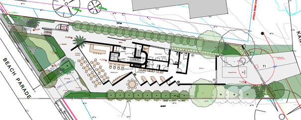
Figure 25: Current landscape plan
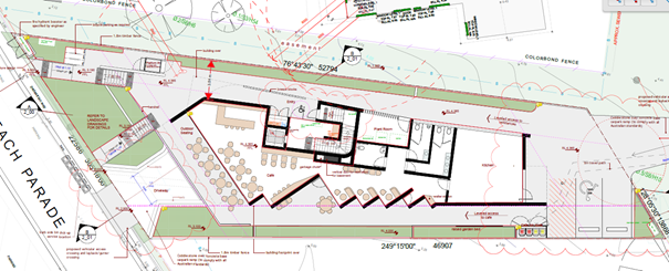
Figure 26: Amended architectural plan showing ground floor and reduced landscape areas.
Consequently, the proposed development fails to achieve the objectives of this Part, to ensure that there is an area on site that enables soft landscaping and deep soil planting, considered appropriate for this type of development.
The Panel is advised the application is recommended for refusal on this basis (Refusal Reason 5b).
Part 2.3.4 1 Setbacks for Residential Flat Buildings – 3 Storeys or more
Part 2.4.3.1 requires a 6m front setback for residential flat buildings 3 storeys or above. The objectives of this Part are as follows:
▪ To maintain and enhance existing streetscapes
▪ To provide adequate privacy and solar access of adjacent properties
▪ Provide visual and acoustic privacy
The proposed development provides the following:
|
Required |
Proposed |
|
Min 6m front setback to all aspects of the development except for a portico or an approved structure required for a waste collection area. |
Ground – 6m to handrail. Level 1 -3 – 6.7m to balcony. Level 4 (Penthouse) – 6.7m to balcony.
|
|
Min 6m side and rear setbacks |
Ground – Varying 5.5m to 6.5m on northern elevation, 2.9m throughout on southern elevation. Level 1 – 3 – 5.8m to 6.4m Level 4 (Penthouse) - 5.8m to 6.4m |
The Applicant has not provided justification for the proposed variation to Council’s DCP with general objectives and design criteria not adequately addressed. Notwithstanding this, Council recognises that compliance is difficult to achieve given the dimensions of the site, complete enforcement of the setbacks would render the site undevelopable and that the extent of the variations is generally between non-habitable and habitable rooms. On this basis, Council deems the variation to minimum setback requirements acceptable in this instance.
Part 2.3.5.1 Facades & Articulation
Part 2.3.5.1 requires that:
· Facades are to be articulated in length and height. Monotonous and unbroken lengths of wall exceeding 10 metres in length and 3 metres in height shall not be permitted. In development of two or more storeys, physical design elements shall be used to provide visual interest to the building.
· For mixed use development, residential apartments are to be separated and distinguished from commercial entries to provide security and an identifiable street address for each of the different users.
· Shop-top housing development should be setback from the front street boundary and buffered from the street by providing a balcony or similar.
The proposed development provides for articulated and modulated facades using balconies, glazing and a mix of materials and finishes. Dwellings are setback from the street and include balconies which buffer them from the street. Clear, separate entry is provided for the residential apartments alongside the northern elevation of the ground floor, however, as previously discussed, the accessible entry to the development from Beach Parade and the on -grade car park at the rear of the site is not considered adequate.
Part 2.3.6.1 Views
Part 2.3.6.1 requires that new development is designed to minimise loss of views from adjoining and adjacent properties.
The proposed development may block views of the water from properties to the east and north. The Statement of Environmental Effects has provided an assessment of view impacts, having regard to the NSW Land and Environment Court’s view sharing principle of the Tenacity v Warringah Council [2004] NSWLEC 140 (Tenacity). The Statement of Environmental Effects notes as follows:
Properties to the rear (east) of the subject site appear to currently obtain views to Tuggerah Lake across the subject site. It is noted that as the topography is relatively flat in the locality and these adjoining properties are one to two storeys, even a modest development on the subject site would impinge on views, such as a compliant dwelling house. Given the low-rise nature of those affected properties, even a two-storey built form on the site would reduce views to an extent like the proposal. In fact, the view impact may even be greater in the alternative scenario as viewed from Kantara Road. This is because dwelling houses are entitled to much smaller side setbacks (0.9m) provided by the DCP, as opposed to the 3m average side setback proposed... On this basis, any compliant scheme on the site would likely result in a similar level of view loss.
Additionally, while Tenacity recognises that views obtained across side boundaries are more difficult to maintain, the proposal has been mindfully designed to comply with the 6m setback for the north-western portion, appropriately maintaining any views obtained across the side boundary by northern neighbours …
For the above reasons, the side setback and height variations of the proposal will not have additional view impact, as a fully compliant development can have greater impact.
On the basis that the proposal does not result in view loss worse than that which would be the result of a compliant scheme, the proposal is considered to satisfy the tests in Tenacity and established by the Court. It is appropriate in this instance.
It is considered that any development of the site per se would impact on views from the east. It is also noted that views from the north-west would still be available. The application was exhibited, and nil submissions were received, and specifically, no submissions were received regarding view loss/impacts which may result from the proposed development. The conclusions of the above assessment are therefore supported, and the proposed view impacts are considered reasonable.
Part 2.3.8 Earthworks
Part 2.3.8 requires that cut and / or fill be minimised and retaining wall details be provided with the development application.
The construction of the basement level will require excavation of up to 3.0 metres below the ground surface and dewatering of the groundwater table to construct the basement. The geotechnical investigation report identifies design parameters for the structural design of the foundation system.
The Panel is advised that due to the need to lower the groundwater table to construct the proposed basement, the Applicant would require a dewatering licence from WaterNSW under the Water Management Act 2000.
Part 2.3.10.2 Stormwater Management
The stormwater plan prepared by Stronghold Engineering Consultants was referred to Council’s Development Engineer for review and comment. The Plan provides provisions for discharge via an on-site stormwater detention system (OSD basin) to limit peak discharge to the kerb and gutter in Beach Parade to 25 litres per second as per Council’s Civil Works Design Specification 2020.
The Panel is advised that the stormwater plans were not updated to reflect most recent revisions to the architectural plans and cannot be relied upon for favourable consideration and determination. Therefore, insufficient information has been submitted by way of amended stormwater plans in accordance with this Part, including the basement, roof, and surface drainage system to be designed in accordance with Council’s Civil Works Design Specification, 2020, Australian Rainfall and Runoff 2019 and Australian Standard AS/NZS 3500.3 – Stormwater Drainage.
The proposed development is recommended for refusal (Refusal Reason 5b and 6c).
Chapter 2.13 – Transport and Parking
Chapter 2.13 of CCDCP 2022 requires car parking for the development to be provided at the following rates:
|
Land Use |
Requirements |
|
Residential flat buildings* |
1.5 spaces per dwelling for residents 0.2 spaces per dwelling for visitors |
|
Restaurants+ |
Whichever is greater of: 15 spaces per 100m² GFA, or 1 space per 3 seats |
*Shop top housing parking rates do not apply to development which is defined as a residential flat building.
+No parking rates are identified for cafes.
Application of these requirements to the proposed development yields a parking requirement of seven residential spaces and 25 cafe spaces calculated as follows:
|
Land use |
Control |
Required |
Provided |
|
Residential flat building |
3-bedroom units – 1.5 spaces per dwelling |
6 spaces
(4 dwellings x 1.5 = 6) |
5
(4 in basement and 1 at grade to rear) |
|
0.2 visitor spaces per dwelling |
0.8 spaces (rounded to 1 space)
(0.2 x 4 = 0.8 spaces) |
Nil |
|
|
Restaurant (café) |
15 spaces per 100m2 or 1 space per 3 seats – whichever is the greatest |
25 spaces
166m2 x 15 spaces per 100m2 |
3
(2 in basement and 1 loading/parking space to rear) |
The application provides 8 spaces in the following mix:
· Residential: 5 spaces (5 in basement and 1 disabled space at grade)
· Café: 3 spaces (2 in basement and 1 space at grade)
The proposal therefore has a shortfall of 1 resident visitor space and 22 café spaces. The shortfall of 22 spaces for the café represents an 88% non-compliance.
The application is accompanied by a Traffic and Parking Assessment Report, prepared by Terraffic Pty Ltd and dated 29 November 2023. The report assesses the adequacy and suitability of the quantum of off-street parking and loading provided on the site as well as vehicle access arrangements.
Revised architectural plans detail basement parking for seven cars, comprising five residential spaces and two café staff/visitor parking spaces. No car wash bay or accessible car parking space is proposed in the basement. At grade parking at the rear of the site is proposed comprising one uncovered disabled parking space and one café loading/parking space.
Vehicular access to the basement level parking facilities is to be provided via a new entry/exit driveway accessed from Beach Parade. A turntable within the basement is intended to facilitate vehicles to exit the basement in a forward direction. The turntable is intended for use for rear residential parking spaces only.
The applicant’s traffic report considers the shortfall acceptable based on the following:
· The proposal caters for the long term (residential) parking demand while relying on the availability of on-street parking for short-term parking.
· Based on parking surveys, the shortfall in parking generated by the proposal will have no unacceptable on-street parking impacts.
· It is expected that a high proportion of cafe patrons will be visitors to Canton Beach who have already parked nearby on the road network.
· Considering dual and complementary use of parking spaces (as referenced under clause 2.13.3.11 of the CCDCP), in this case the peak parking demand of the residents is typically outside of business hours, while the peak parking demand of the cafe will be during the weekday daytime and weekend.
Council’s Development Engineer – Traffic and Transport has reviewed the Report and relevant documentation and concluded that Council cannot accept the survey undertaken as the site and its surrounds is commensurate to a residential area and not a commercial centre as the survey relies upon, therefore, the use of on-street parking to address the DCP variation is not supported. In the absence of a suitably prepared Traffic and Parking Assessment Report, the Panel cannot approve the variation and the application is recommended for refusal on this basis (Refusal Reason 5d).
Traffic generation
Council’s Traffic Engineer has advised that traffic generated by the proposal will have a significant impact on the surrounding road network and is not supported in this instance.
2.13.3.7 Parking and access for the disabled
The path of travel for a disabled parking space is to be a safe route with adequate width, manoeuvring, circulation area and gradients to allow satisfactory access, as a minimum in accordance with AS 1428.1 as amended. Furthermore, Part 2.13.3.7 requires that parking for people with a disability is to be located as close as possible to the nearest access for the disabled within a particular building. If possible, this access path should be covered for all weather use.
The accessible car park at the rear of the development is not undercover and does not have direct undercover access to the residential entry. Therefore, the accessible space is not compliant with the provisions of AS/NZS 2890.6 also contravening the requirements of this Part and is recommended for refusal on this basis (Refusal Reason 6e)
Additionally, the proposed development fails to comply with the following:
· A turning area for delivery vehicles is proposed in the vicinity of the accessible car parking space. Swept paths for the accessible space extend outside of the driveway and no swept path for the delivery vehicle space is provided therefore it cannot be determined if compliance is achieved (CCDCP Cl 2.13.3.5) (Refusal Reason 6f)
· While Level 1 unit is an accessible option no accessible car parking space is proposed in the basement carpark as part of the residential component (CCDCP Cl 2.13.3.7) (Refusal Reason 6g).
Part 2.13.3.8.1 Bicycle Parking Rates
The following bicycle parking rates are specified under Part 2.13.3.8.1:
Shop Top Housing: 1 space per 3 dwellings = 1-2 spaces
Restaurants: 2 spaces = 2 spaces
Total required: 3-4 spaces.
The proposed development provides a total of three spaces within the front setback. The location of these spaces is within the front setback and provides no security. Whilst numerical compliance may be met, the location of the parking is not considered suitable.
Chapter 2.14 – Site Waste Management
The application is accompanied by a Waste Management Plan, dated October 2022, which discusses both construction, and ongoing waste management for the proposed development in accordance with Council Guidelines.
Notwithstanding this, Council’s Waste Officer has reviewed the proposal and determined the proposed vehicle ramp gradient is too steep for the safe transfer of mobile garbage bins which requires the travel path to be less than 30m and ramps no more than 1:14 in gradient. Further, any travel paths shall not be shared with vehicles which create an unnecessary vehicle and pedestrian interaction. Finally, the waste generation rates for the proposed café are not consistent with Central Coast Council guidelines or the NSW EPA guidelines.
The proposed development fails to comply with the performance requirements of Part 2.14.2 and is recommended for refusal on this basis (Refusal Reason 6h).
Chapter 3.5: Tree and Vegetation Management
There is a large Angophora costata straddling the boundary between the site and Kantara Road. The tree is a large canopy tree however there is no mention of tree removal in the Statement of Environmental Effects and no arborist’s report has been provided. The tree is shown for removal on the architectural and landscape plans.
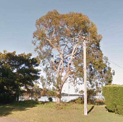
Figure 27: Large tree to rear of site (Source: Google maps)
The tree needs to be removed to enable vehicle access from Kantara Road to the parking within the rear of the site. Whilst Council’s Tree Officer accepts the tree is proposed for removal given it is within the footprint of the proposed VAC, from a design perspective, the removal of the access from Kantara Road would negate the need for its removal. In the absence of an arborist report advising of its health and associated Tree Protection Zone and Structural Root Zone, the Panel cannot be satisfied removal of this tree is warranted in this instance (Refusal Reason 8).
In the event the Panel was of a mind to approve the development and associated tree removal, a condition of consent would need to be included that incorporates tree protection measures to ensure the Ficus tree located on the nature strip next door at No 13 Beach Rd Kantara Rd side remains viable during the development phase.
SECTION 4.15(1)(a)(iiia) – PLANNING AGREEMENTS UNDER SECTION 7.4 OF THE EP&A ACT
There are no planning agreements or draft planning agreements entered or proposed for the site. The Panel is advised that no further consideration is required in this regard.
SECTION 4.15(1)(a)(iv) – PROVISIONS OF REGULATION
Section 23(1)
A development application is required to be accompanied by the written consent of the owner of the land to which a development application relates in accordance with section 23(1) of the EP&A Regulation.
The Panel is advised the Applicant has submitted correct and appropriate landowners consent for the site to which the development relates. No demolition it proposed under this application.
The relevant provisions of the Regulations have been satisfied and no further consideration is required in this regard.
SECTION 4.15(1)(b) – LIKELY IMPACTS OF DEVELOPMENT
The likely impacts of that development, including environmental impacts on both the natural and built environments, and social and economic impacts in the locality must be considered. In this regard, potential impacts related to the proposal have been considered in response to SEPPs, LEP and DCP controls outlined above and below.
Locality and Context
The subject site is zoned SP3 Tourist and shop top housing and food and drink premises are permissible with consent. The site and adjoining are undergoing transition with recent approvals and other applications of various stages of assessment by Council. The proposed built form is well articulated and composed and has considered its relationship to surrounding properties in addition to the site’s visual prominence. However, it is considered the design of the development, particularly in relation to car parking and building entry and access needs greater resolution.
The private lands generally seek to have vehicular access crossings fronting Beach Parade with limited basement level parking and parking variations reliant upon the carrying capacity of the surrounding local street network. View impacts are considered acceptable, noting that any development on the site is likely to restrict views of the water from properties to the east.
Insufficient information has been provided to Council to demonstrate that suitable consideration has been given to the changing context of Canton Beach and the cumulative impact of recent approvals with regards to traffic, transport, and parking on the local street network.
Natural Environment
The subject site does not contain any threatened species or habitat. Insufficient information has been provided to demonstrate there will be no impact to the environment via disturbance to Acid Sulfate Soils, potential land contamination, or through stormwater discharge (Refusal Reason 8).
Economic Impacts
The proposed development is argued to contribute to the supply of housing in the locality and act as a catalyst to help stimulate redevelopment of the area. It is therefore considered appropriate from an economic perspective.
The application has not provided sufficient information to demonstrate that the development has appropriately responded to the site constraints with regards to traffic, transport, parking and accessibility, or how the development provides a high level of amenity for its occupants and neighbours with no communal open space within the site itself. The proposed development cannot be supported on this basis and is recommended for refusal (Refusal Reason 7)
SECTION 4.15(1)(c) – SUITABILITY OF THE SITE
The site is ideally situated opposite the beach front, providing future residents with high quality amenity. More broadly, however, the site and its immediate surrounds is undergoing transition and includes other shop top housing developments that have been approved along Beach Parade. Despite multiple requests for further refinements and information, it is yet to be demonstrated that the generation of the additional parking for the commercial component of the proposed development does not result in unreasonable traffic and parking impacts and congestion to Beach Parade and the surrounding street network.
Parking provisions within the site itself do not satisfy relevant Australian Standards nor the performance requirements of Council’s own DCP, with major impediments and design flaws with regards to the proposed disabled access parking space from Kantara Avenue.
The lack of communal open space and full reliance upon surrounding public areas fails to ensure accessibility and equitability for users as required by the objectives of Part 3D-1 of the ADG. Whilst the proposed development is an appropriate form and scale, the Panel cannot be satisfied that it will not adversely impact on the amenity of the users and residents of Beach Parade, both existing and future intended.
The site is, therefore, not suitable for the proposed development (Refusal Reason 9).
SECTION 4.15(1)(d) – PUBLIC SUBMISSIONS
The application was notified and exhibited in accordance with Chapter 1.2 of CCDCP 2022. No submissions were received.
Submissions from Public Authorities
Ausgrid
The application was referred to Ausgrid who advised the proposal would have no direct impact on its assets and that normal construction considerations would apply.
Internal Consultation
|
Tree Assessment Officer |
Supported. |
|
Environmental Health Officer |
Supported. |
|
Contributions Officer |
Supported. |
|
Development Assessment Engineer |
Supported. |
|
Traffic Engineer |
Not supported. |
OTHER MATTERS FOR CONSIDERATION
Separate Development Application for Food and Beverage Premises
Should the Panel be of a view to approve the proposed development, a separate application is required for the future fit-out and operation of the proposed ground floor food and drink premises.
Section 7.11 Contributions
Should the Panel be of a view to approve the proposed development, the Panel is advised that the application falls under the Toukley District Section 7.11 Contributions Plan and the Shire Wide Section 7.11 Plan and contributions should be levied accordingly.
SECTION 4.15(1)(e) – PUBLIC INTEREST
The proposed development seeks consent for the construction of a 5 storey shop top housing development comprising 4 residential units with ground floor retail and associated basement car parking at No. 12 Beach Parade, Canton Beach, and is permitted with consent.
The proposed development however has failed to meet the minimum requirements of SEPP Resilience and Hazards in relation to consideration of land contamination and Council’s LEP with regards to essential services and acid sulfate soils. The proposal has not provided the minimum necessary requirements under the ADG pertaining to deep soil planting and communal open space. Council cannot rely upon the surveying undertaken by Terraffic Pty Ltd as it is not commensurate with the surrounding residential development in which it exists with unrealized impacts to the local and surrounding street network in terms of traffic and parking.
Council considers that the public interest is maintained by upholding the integrity of the statutory provisions contained within the CCLEP 2022, SEPP Housing and associated ADG and on this basis, is recommended for refusal (Refusal Reason 9).
CONCLUSION
The proposed development has been assessed using the heads of consideration under Section 4.15 of the Environmental Planning and Assessment Act 1979.
As set out in this report, the proposed development:
· Does not satisfactorily meet the requirements or objectives of State Environmental Planning Policy (Housing) 2021 nor the associated Apartment Design Guidelines;
· Fails to meet the objectives nor provisions of the Central Coast Local Environmental Plan 2022 or Central Coast Development Control Plan 2022;
· has unsatisfactory and unreasonable impacts;
· is deemed unsuitable for the site; and
· is not in the public interest.
For these reasons it is recommended that development application DA/4077/2022, for construction of a 5-storey mixed use development comprising of shop top housing (4 dwellings), food and drink premises and basement level car parking at 12 Beach Parade, Canton Beach be refused for the reasons detailed in Attachment 1 to this report.
|
1⇩ |
Recommended Reasons for Refusal |
|
D16401476 |
|
2⇩ |
DAU Request for Information |
|
D15508145 |
|
3⇩ |
Design Verification Statement - Revision A |
|
D15520884 |
|
4⇩ |
Request for Information - 11 May 2023 |
|
D15670491 |
|
5⇩ |
Acoustic Report |
|
D16401504 |
|
6⇩ |
Preliminary Site Investigation |
|
D15715099 |
|
7⇩ |
Urban Design Review by Consultant Urban Designer |
|
D15882370 |
|
8⇩ |
Request for Information - 5 July 2023 |
|
D16401525 |
|
9⇩ |
Revised Landscape Plans |
|
D15814427 |
|
10⇩ |
Request to Withdraw |
|
D15901321 |
|
11⇩ |
Applicant response letter to Council RFI |
|
D15980108 |
|
Further revised architectural plans |
Provided Under Separate Cover |
D15980124 |
|
|
13⇩ |
Traffic Engineering Letter |
|
D15980105 |
|
14⇩ |
Final Urban Design Review Letter from Urban Design Consultant |
|
D16401603 |
|
15⇩ |
Clause 4.6 variation request |
|
D15463257 |
|
16⇩ |
Revised Architectural Plans (Redacted) - 12 Beach Parade CANTON BEACH - PAN-280611 - DA/4077/2022 |
|
D16429216 |
|
3.1 |
DA/4077/2022 - 12 Beach Parade Canton Beach - Mixed Use Development |
|
Attachment 1 |
Recommended Reasons for Refusal |
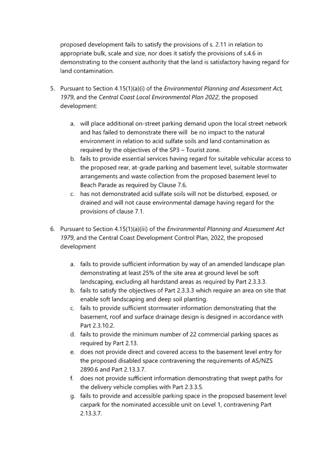
|
DA/4077/2022 - 12 Beach Parade Canton Beach - Mixed Use Development |
|
|
Attachment 2 |
DAU Request for Information |

|
DA/4077/2022 - 12 Beach Parade Canton Beach - Mixed Use Development |
|
|
Attachment 3 |
Design Verification Statement - Revision A |
|
DA/4077/2022 - 12 Beach Parade Canton Beach - Mixed Use Development |
|
|
Attachment 4 |
Request for Information - 11 May 2023 |

|
DA/4077/2022 - 12 Beach Parade Canton Beach - Mixed Use Development |
|
|
Attachment 5 |
Acoustic Report |
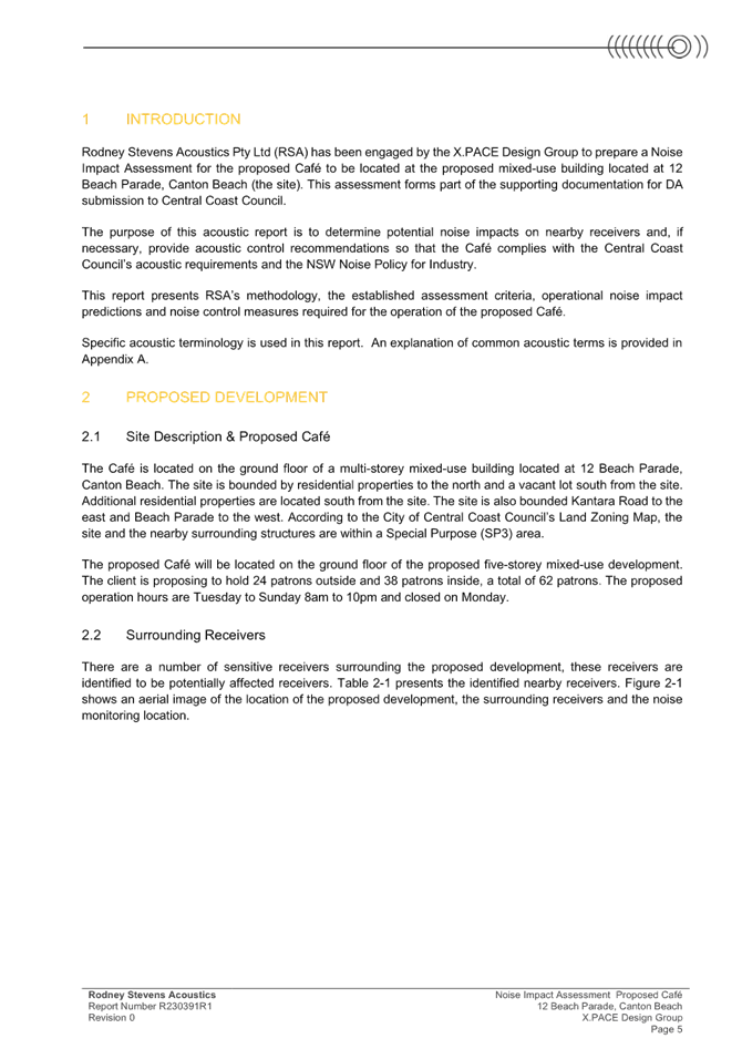
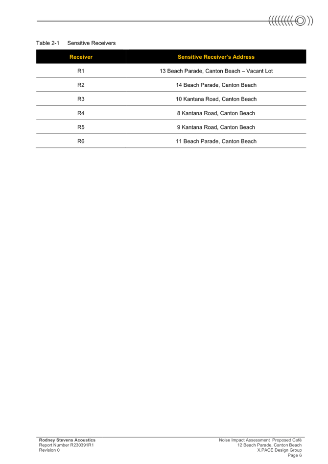
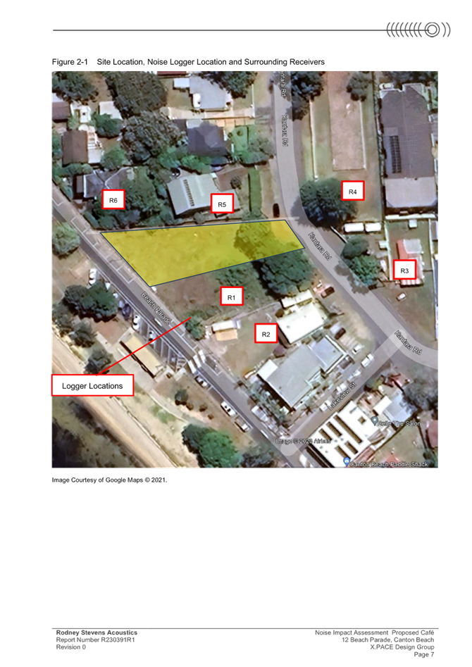
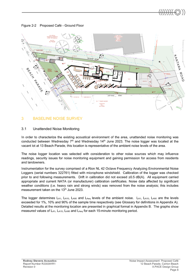
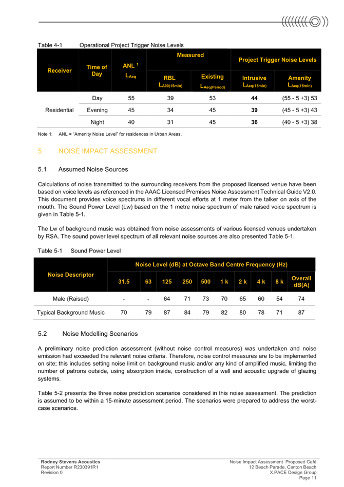
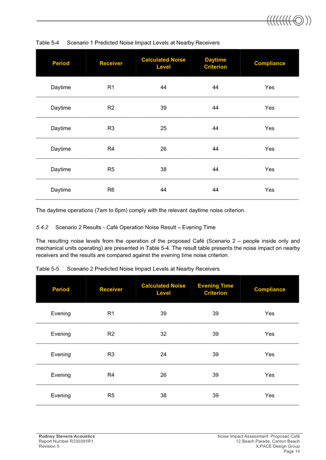
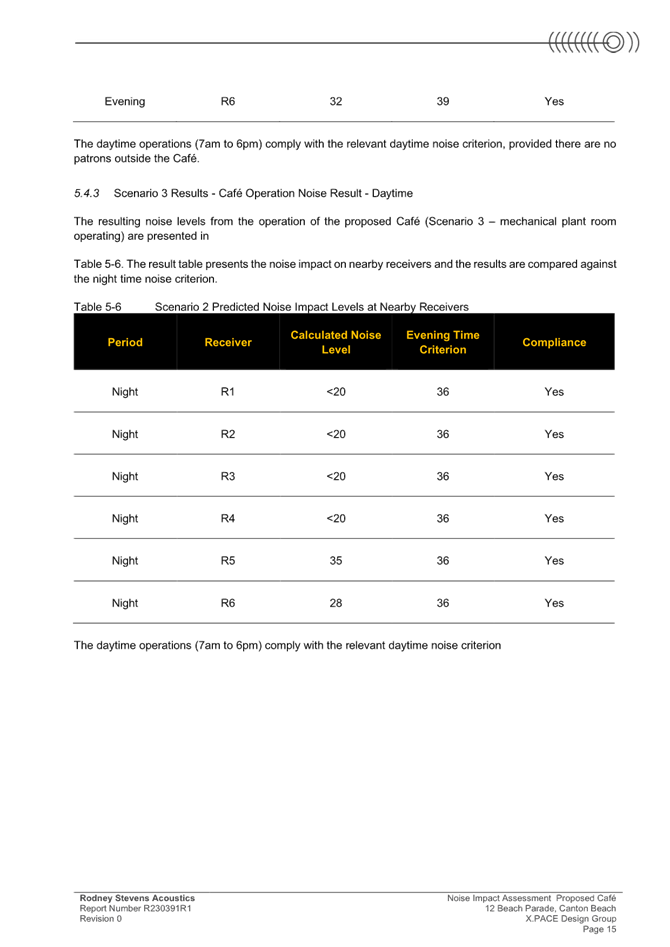
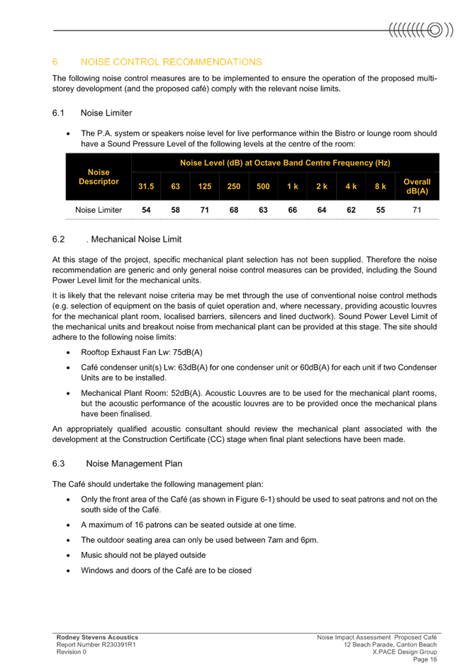
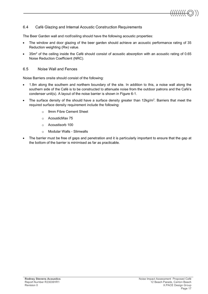
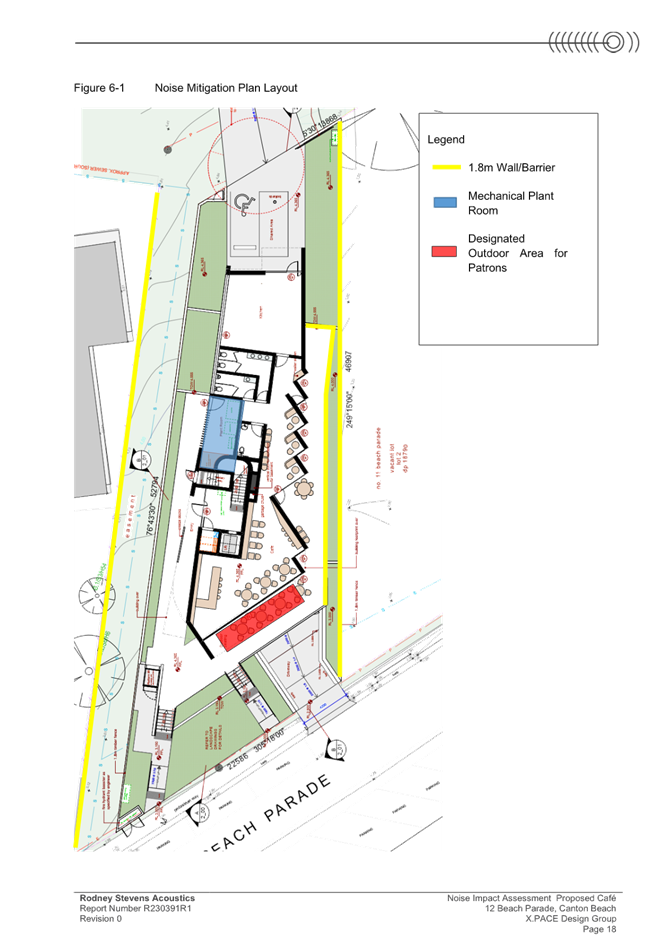
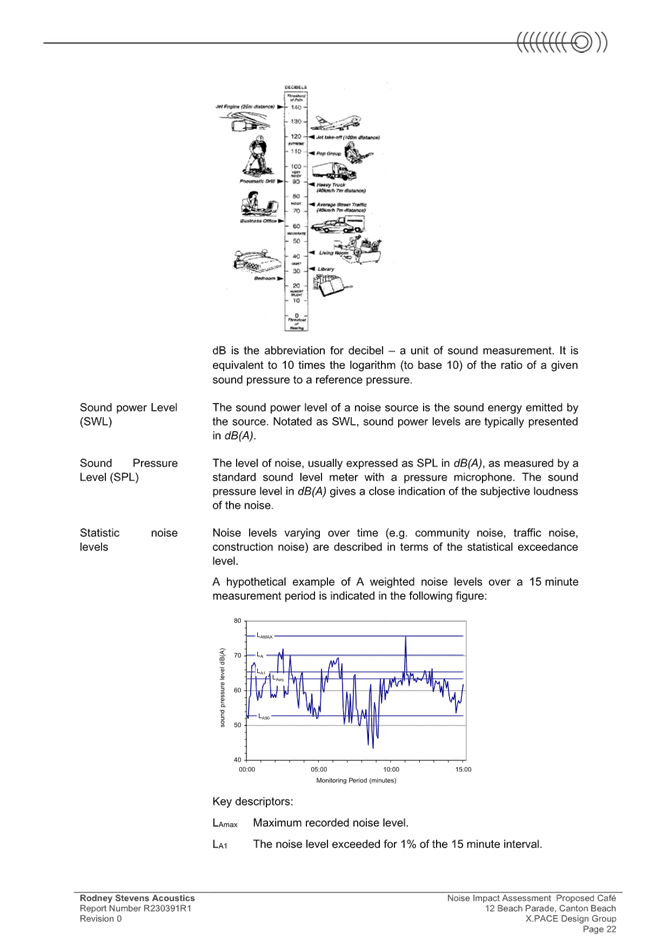
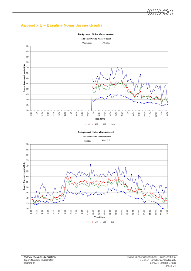
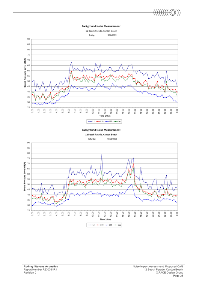
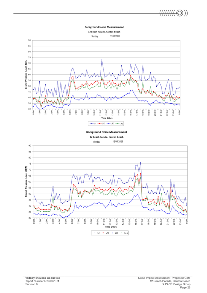
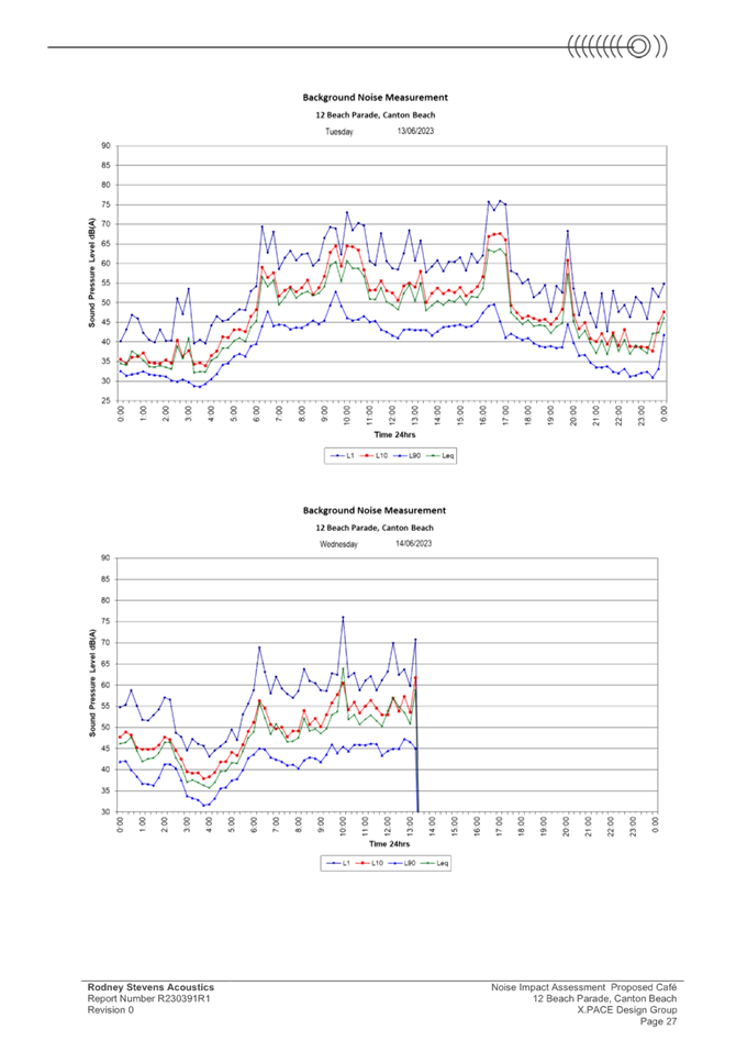
|
DA/4077/2022 - 12 Beach Parade Canton Beach - Mixed Use Development |
|
|
Attachment 6 |
Preliminary Site Investigation |
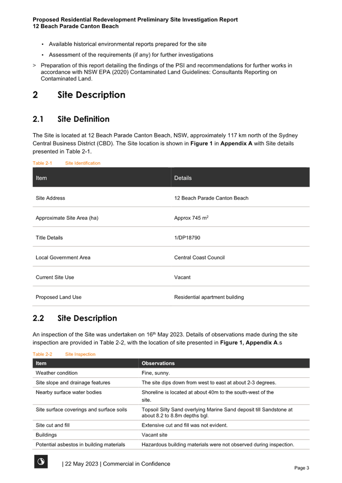
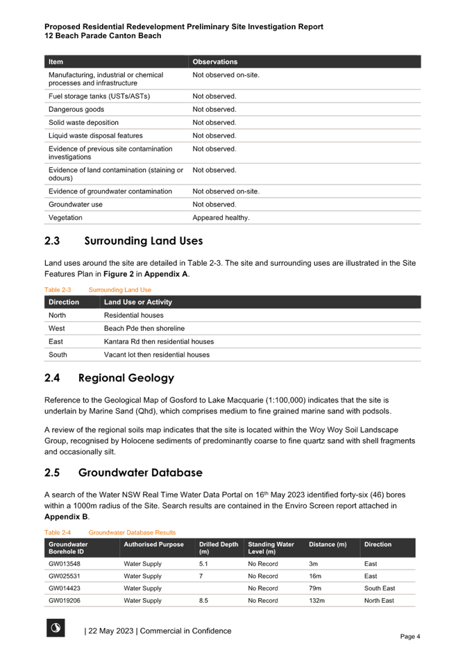
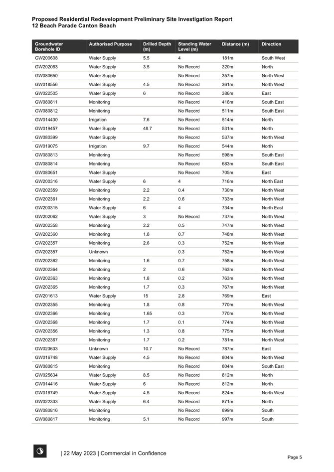
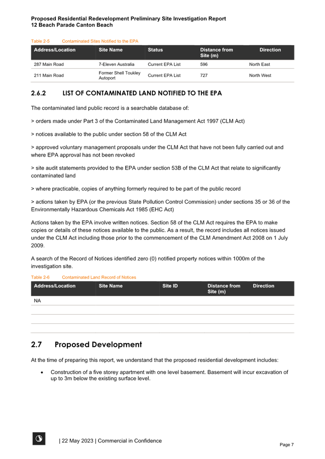
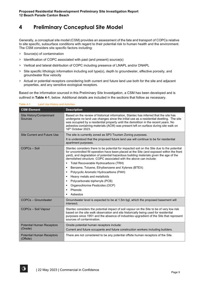

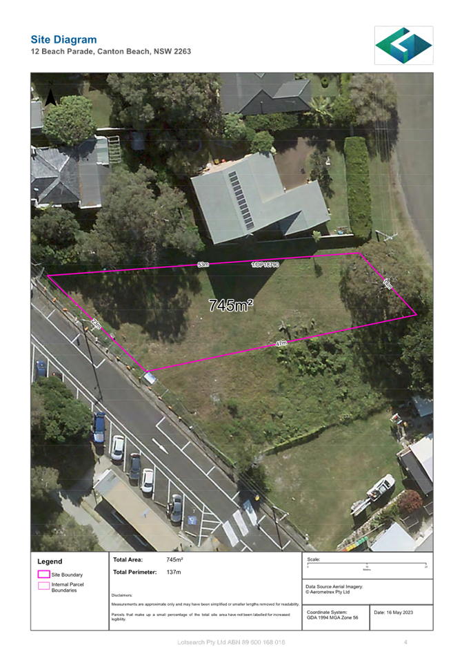


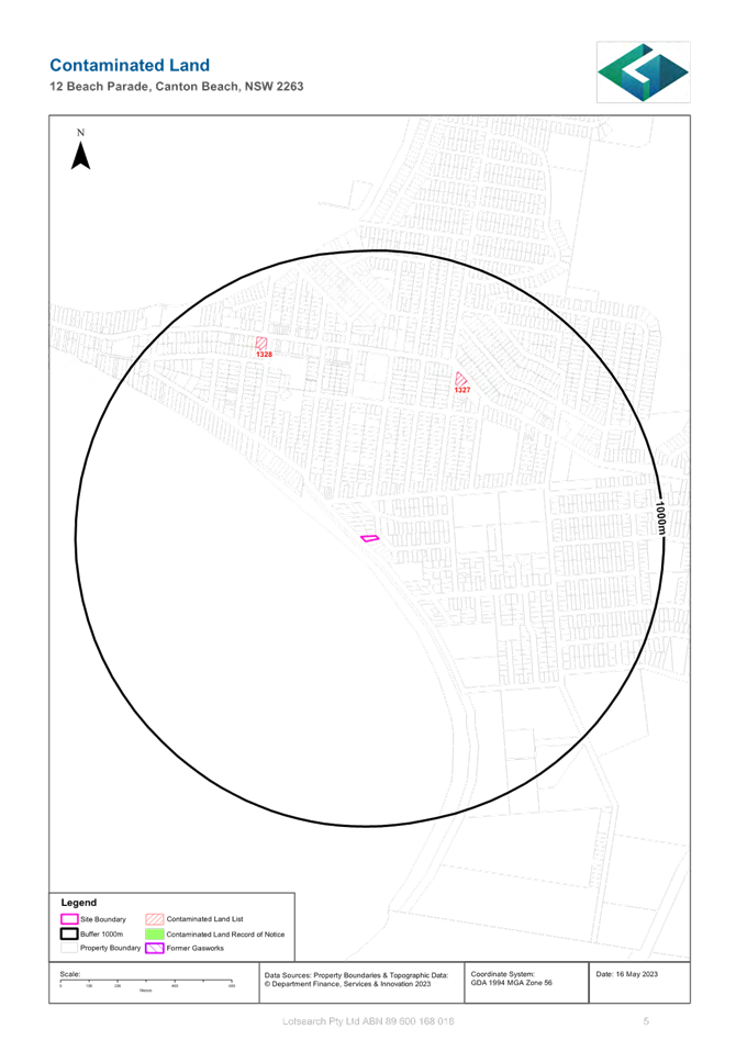
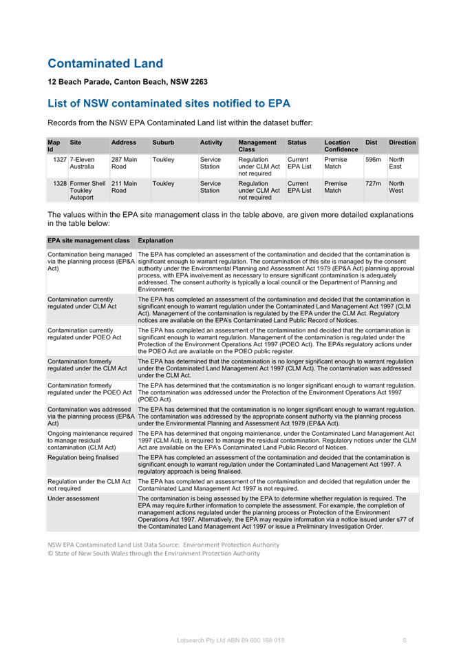
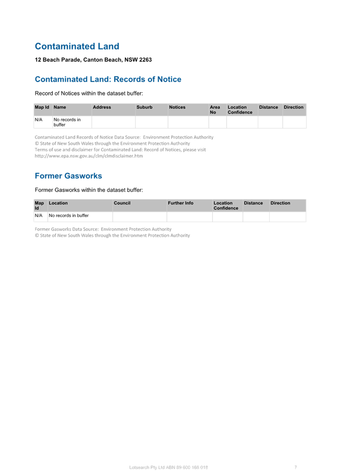

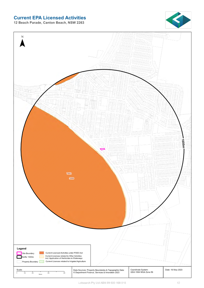
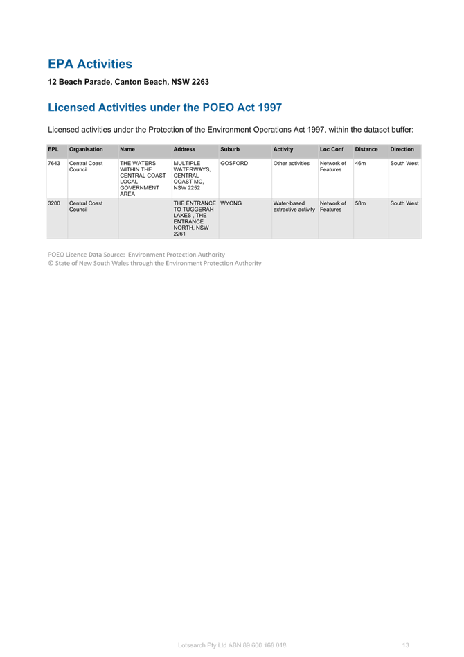
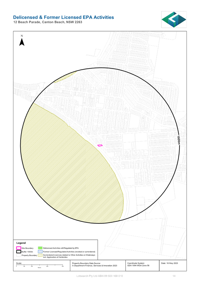
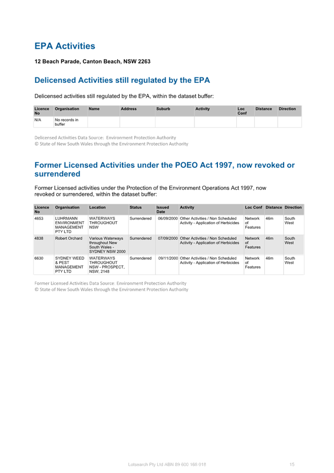
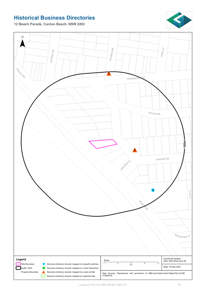
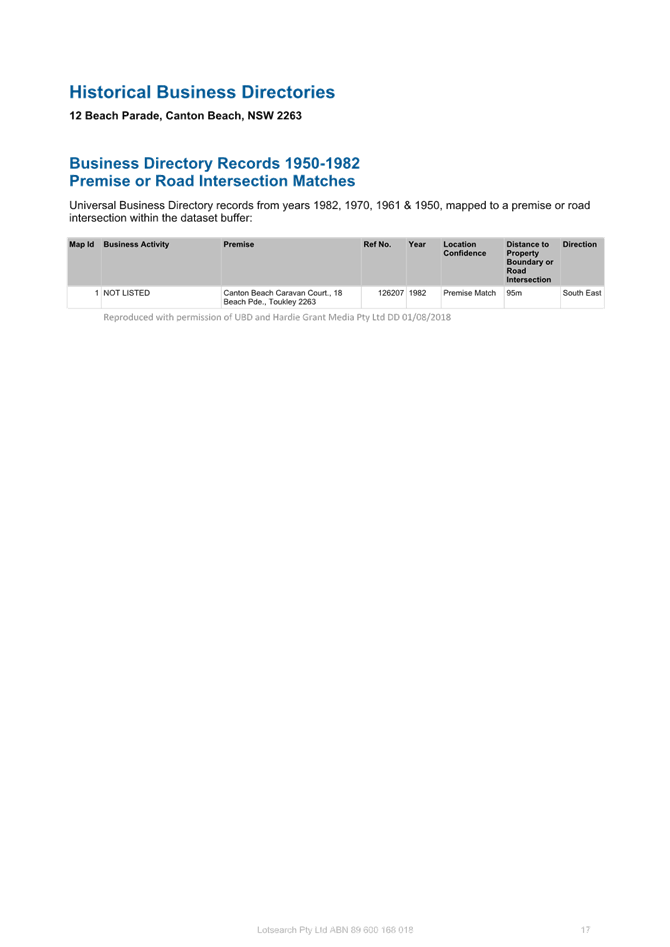
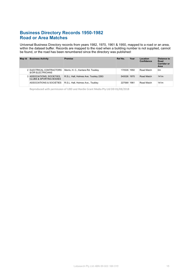

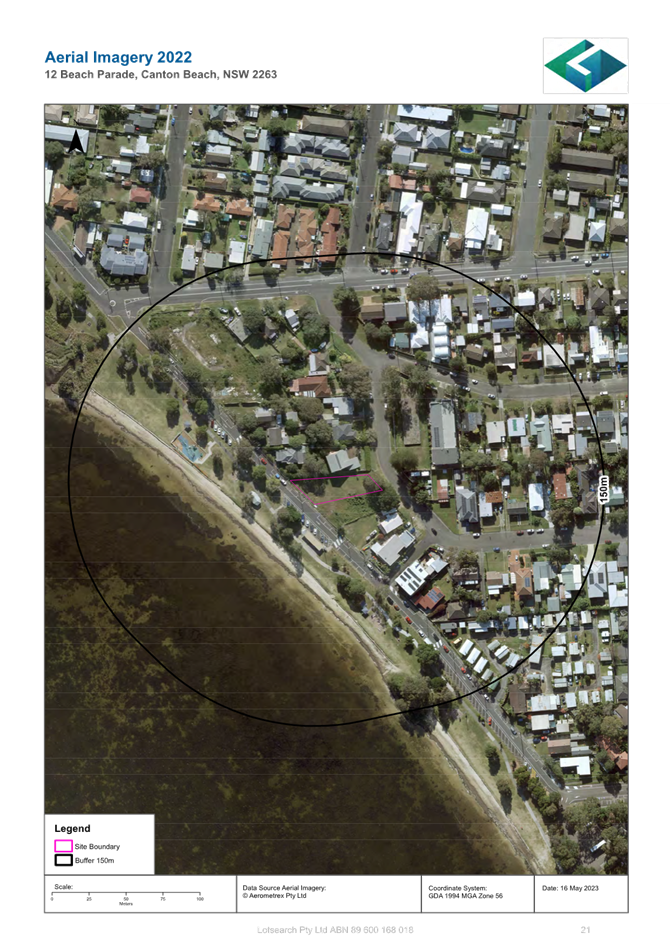
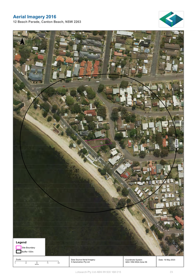
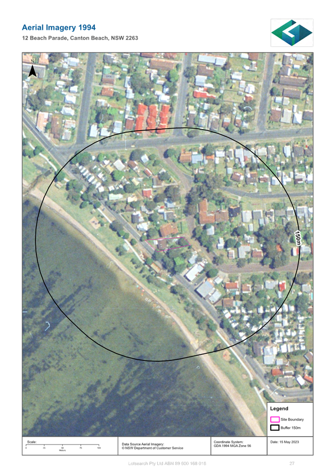
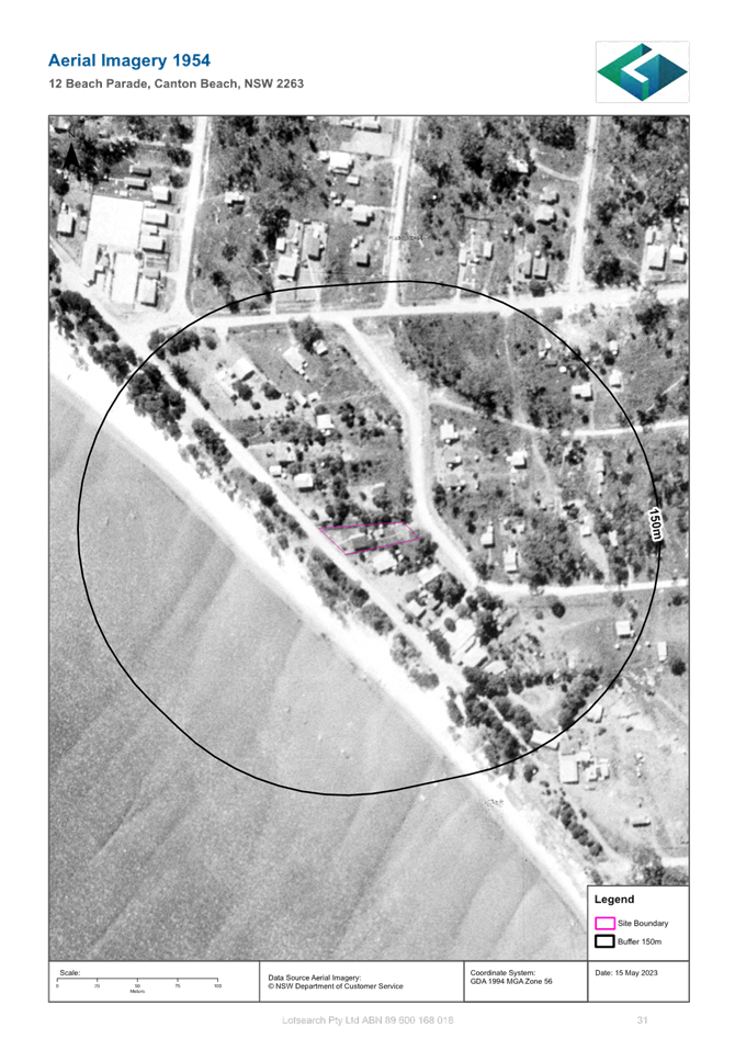
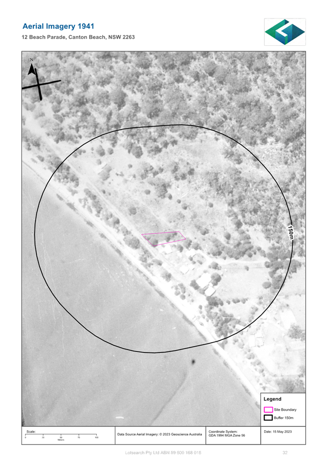
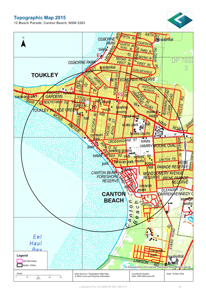
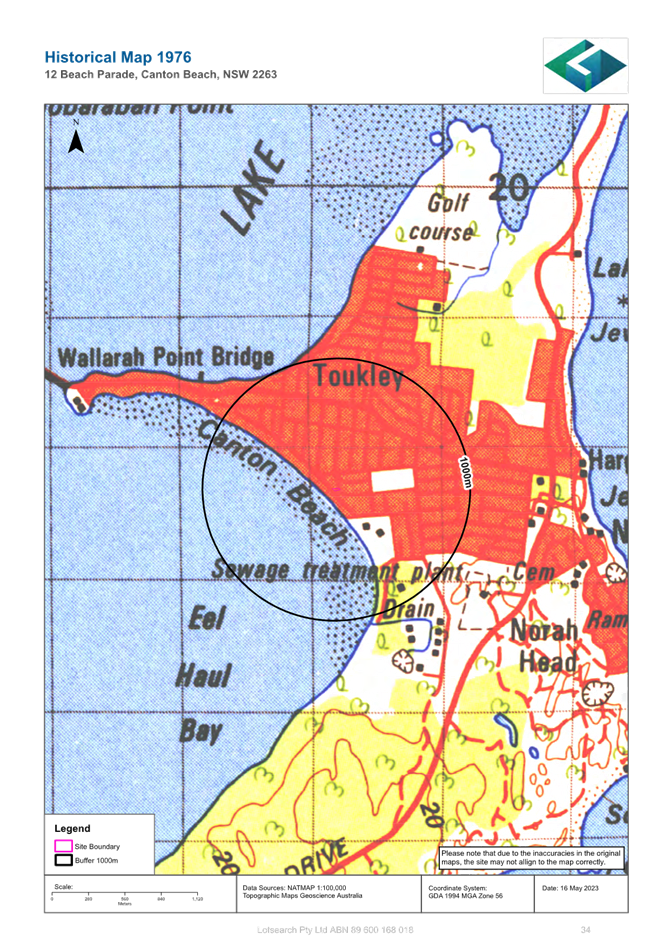
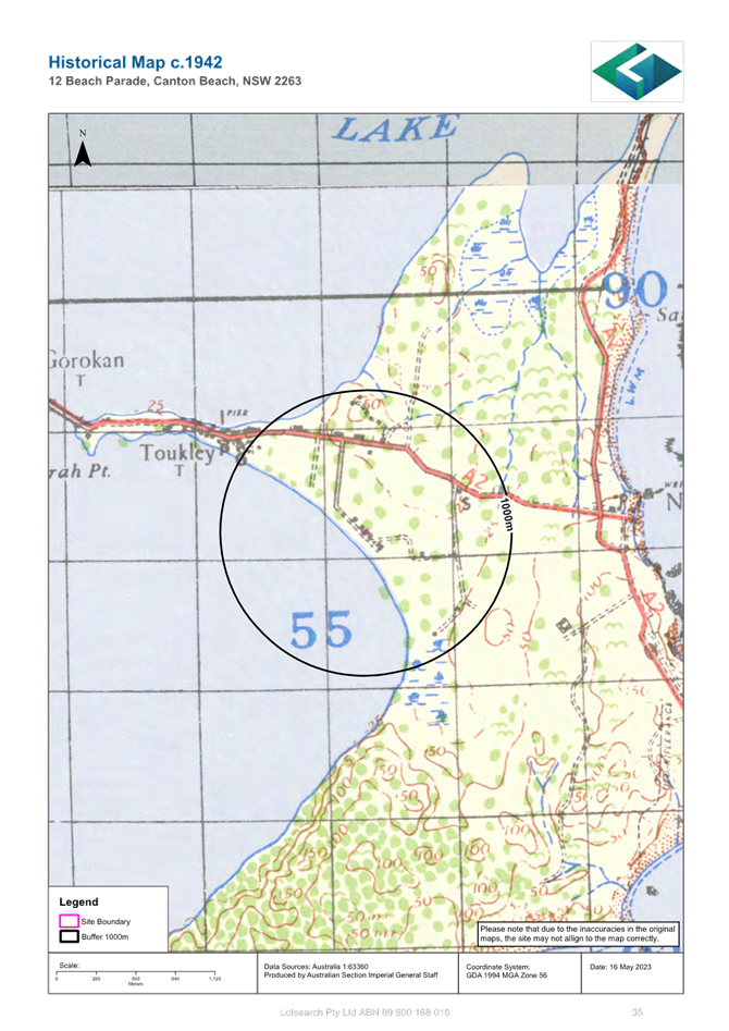
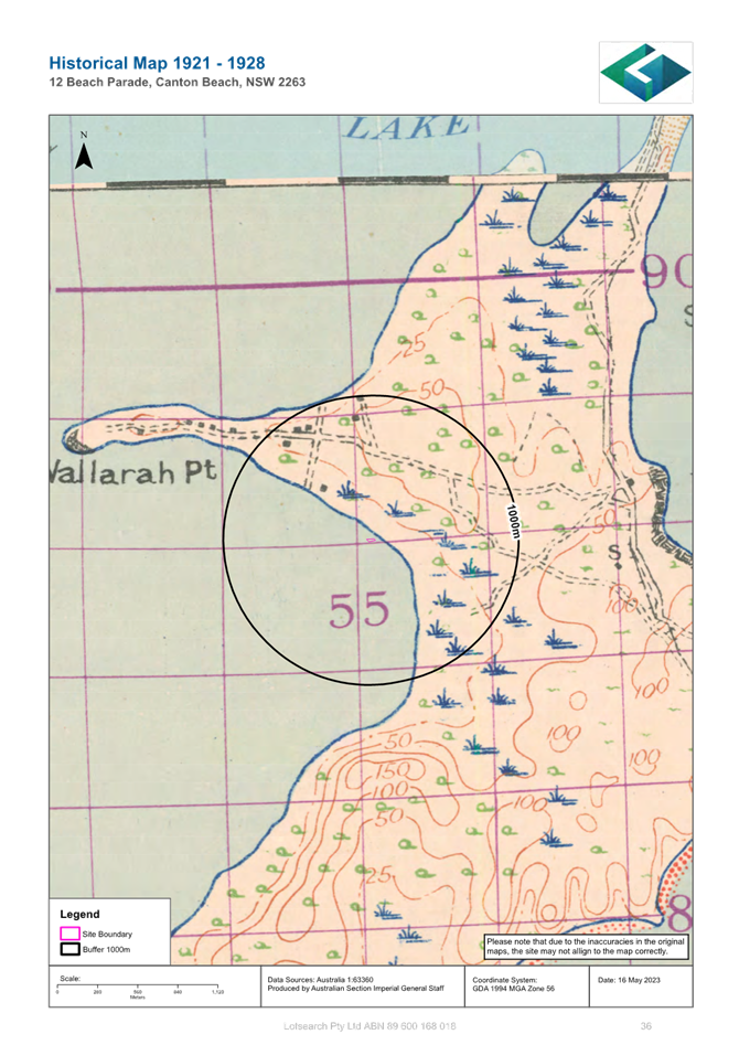
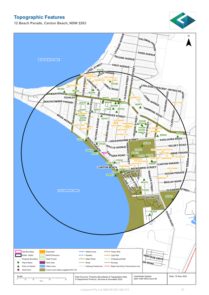
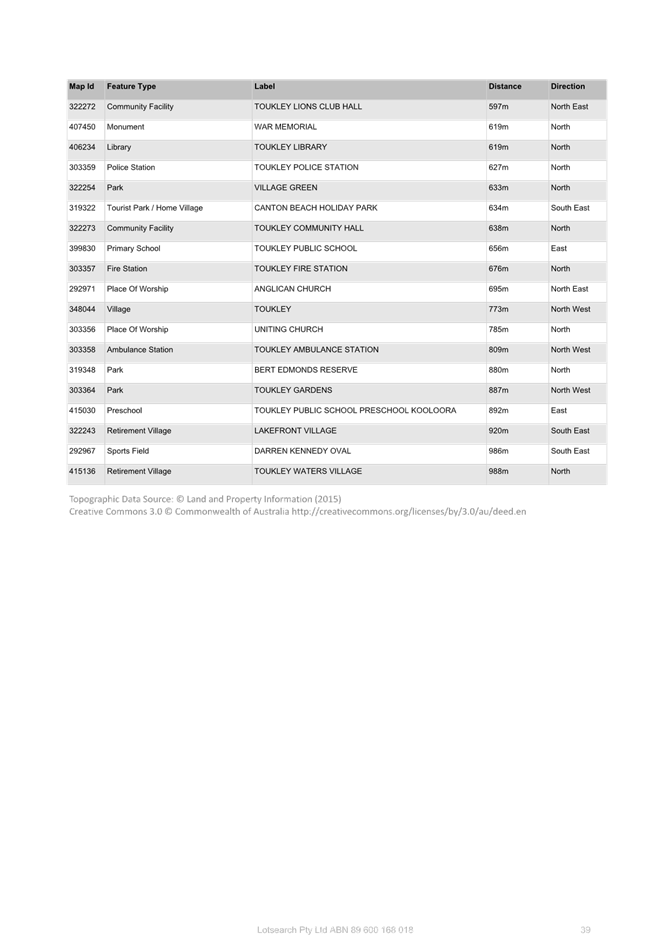
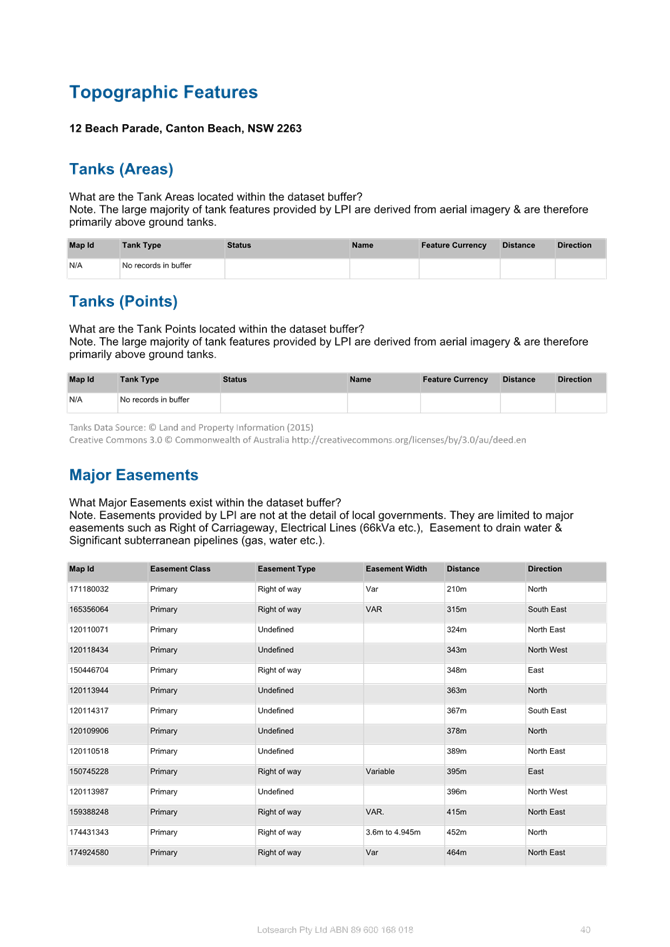
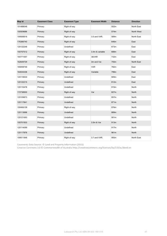
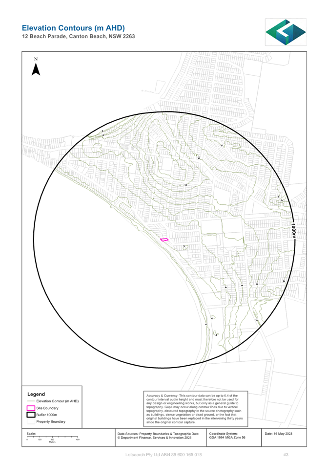
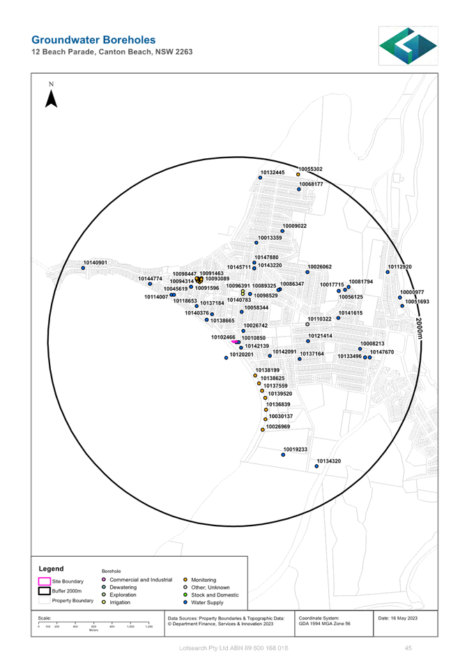
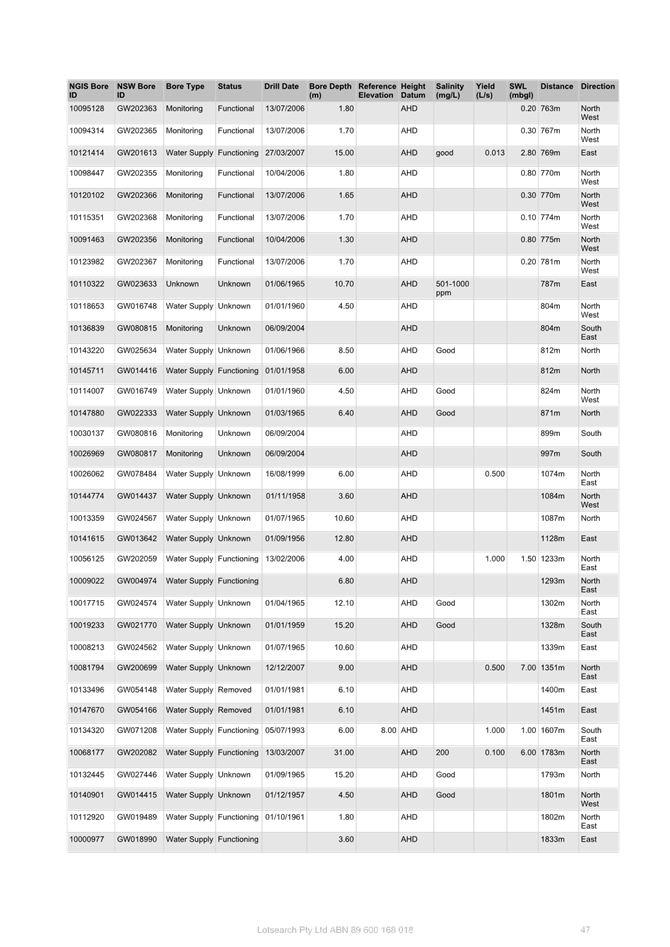

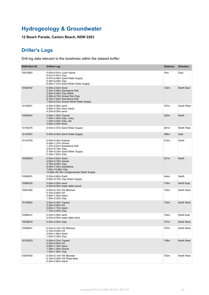
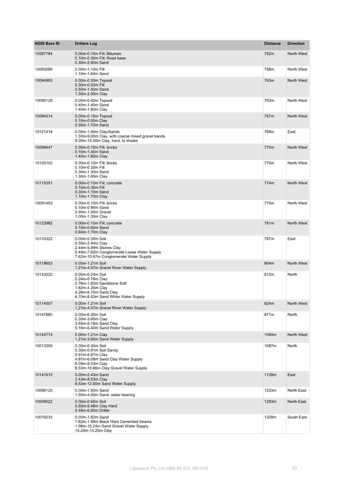
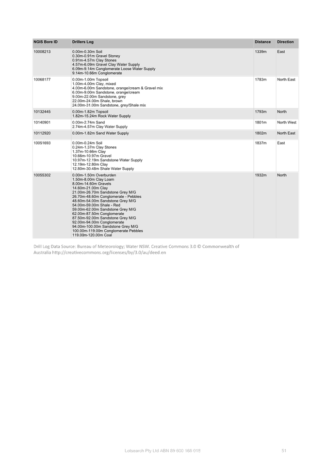
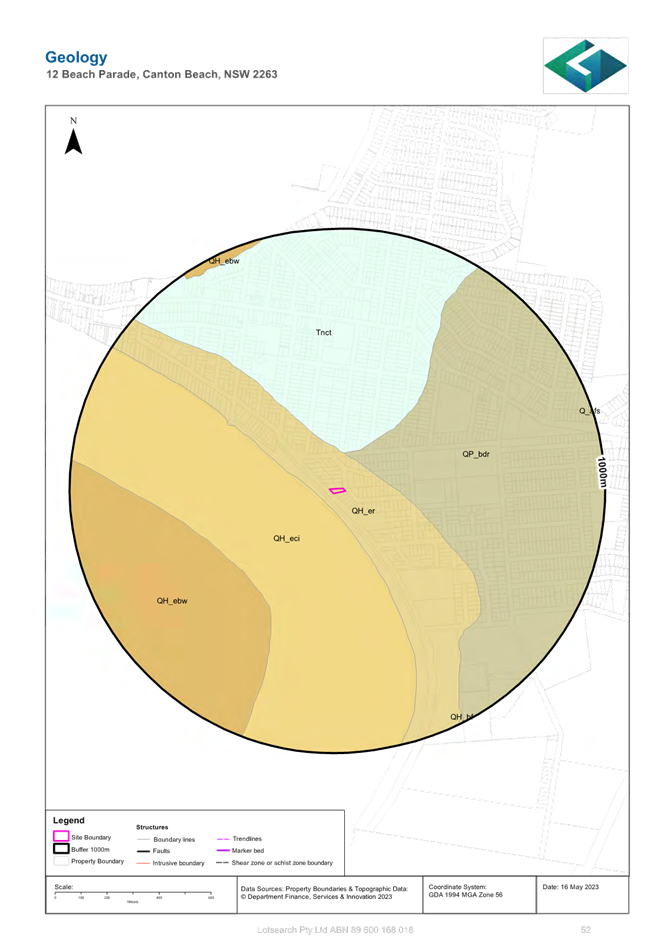
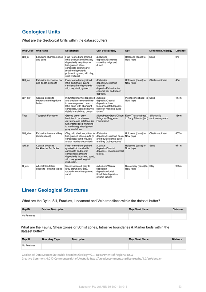
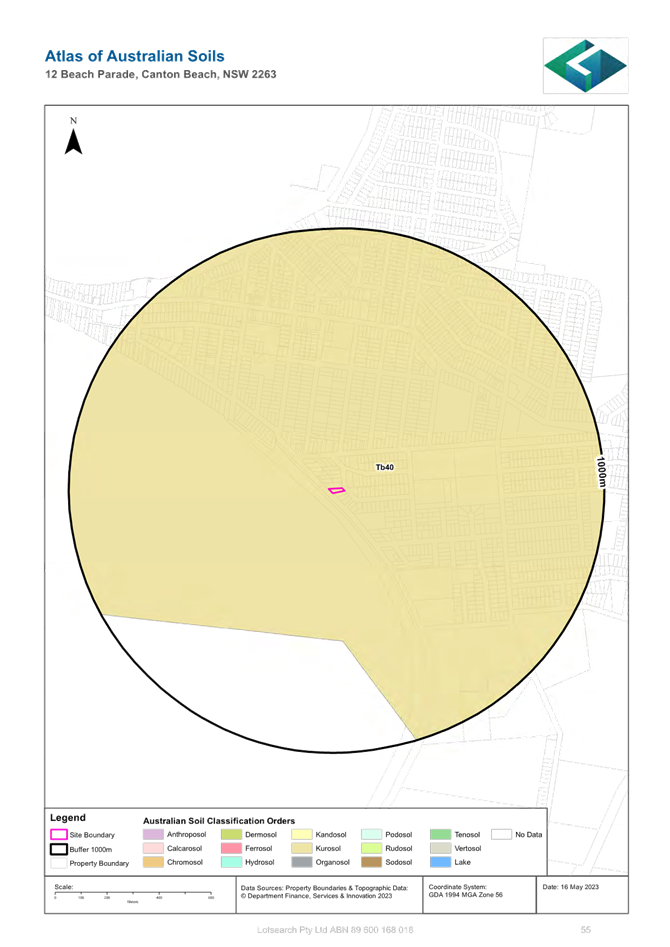
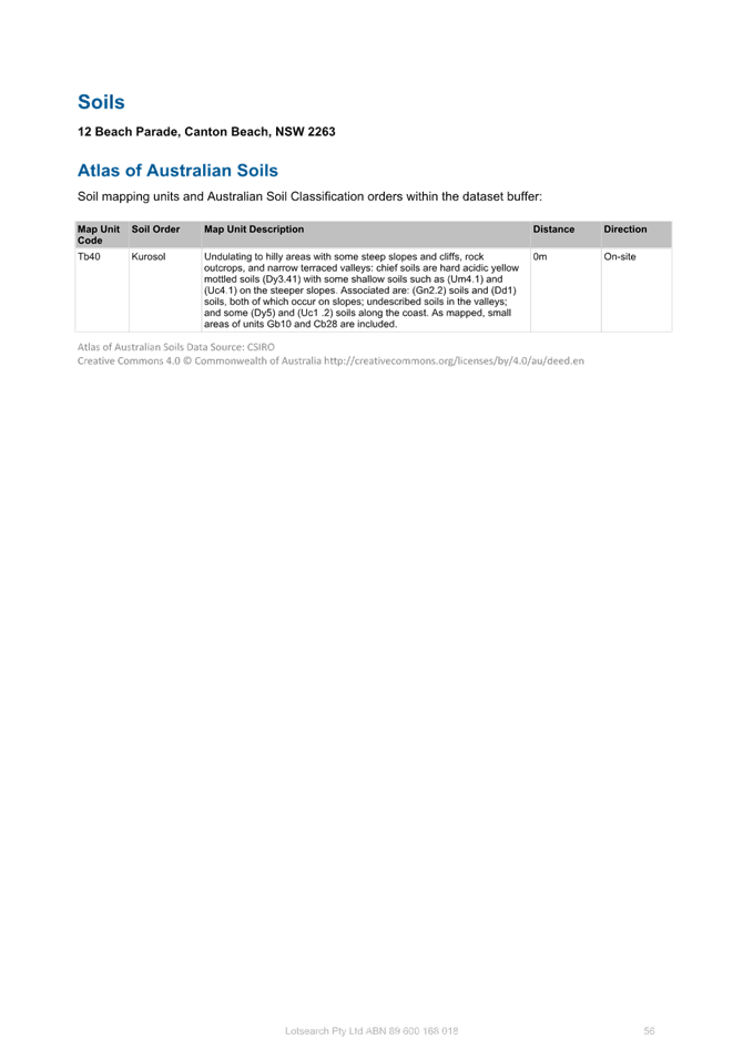
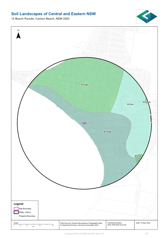
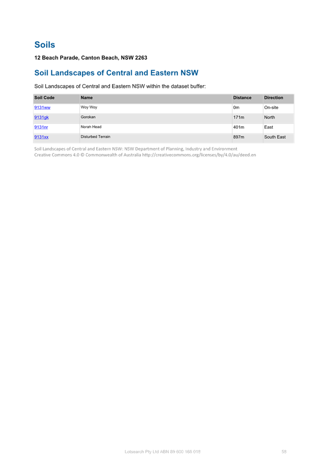
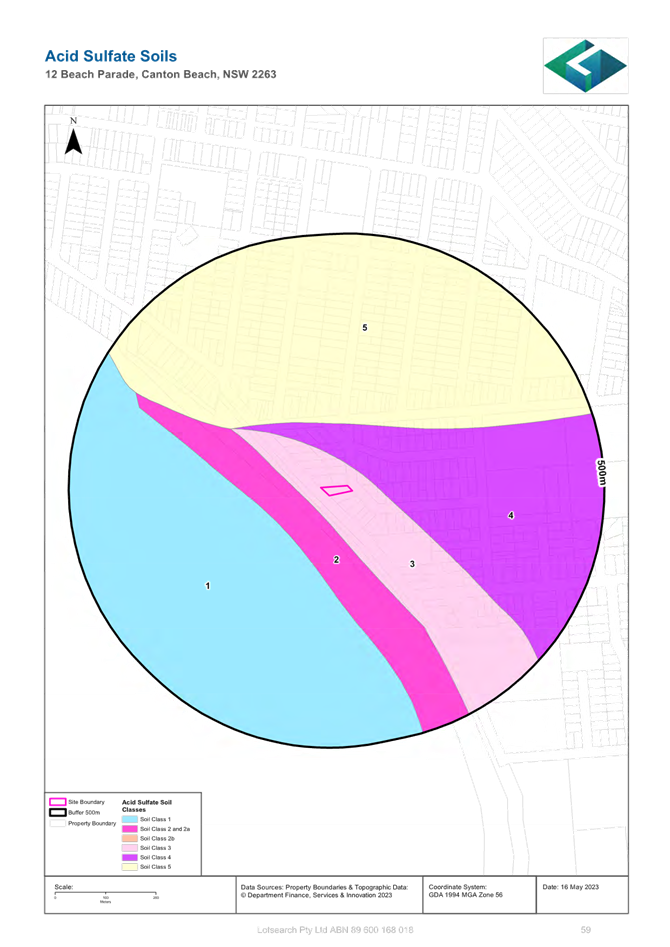
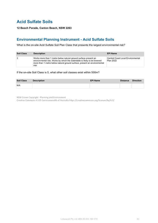
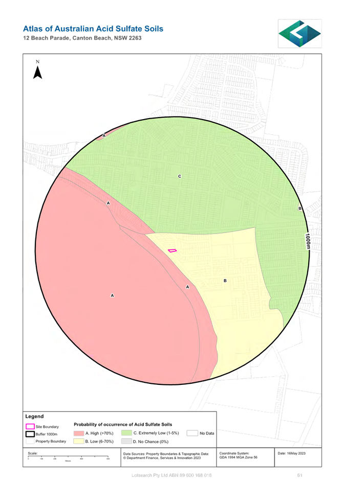
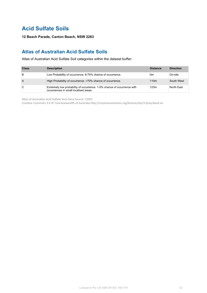
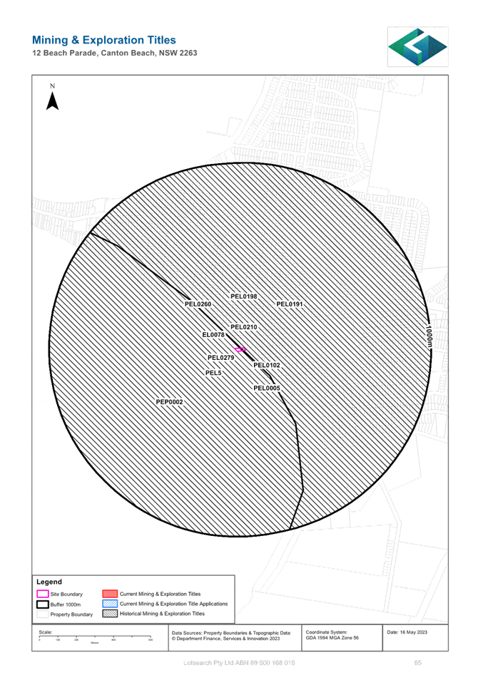
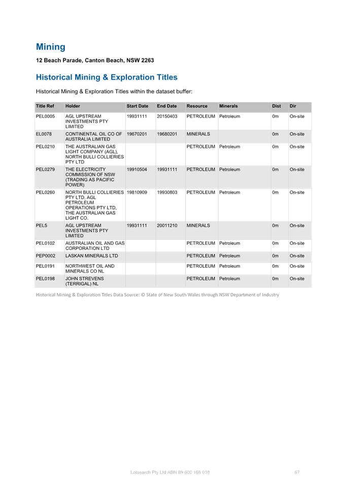
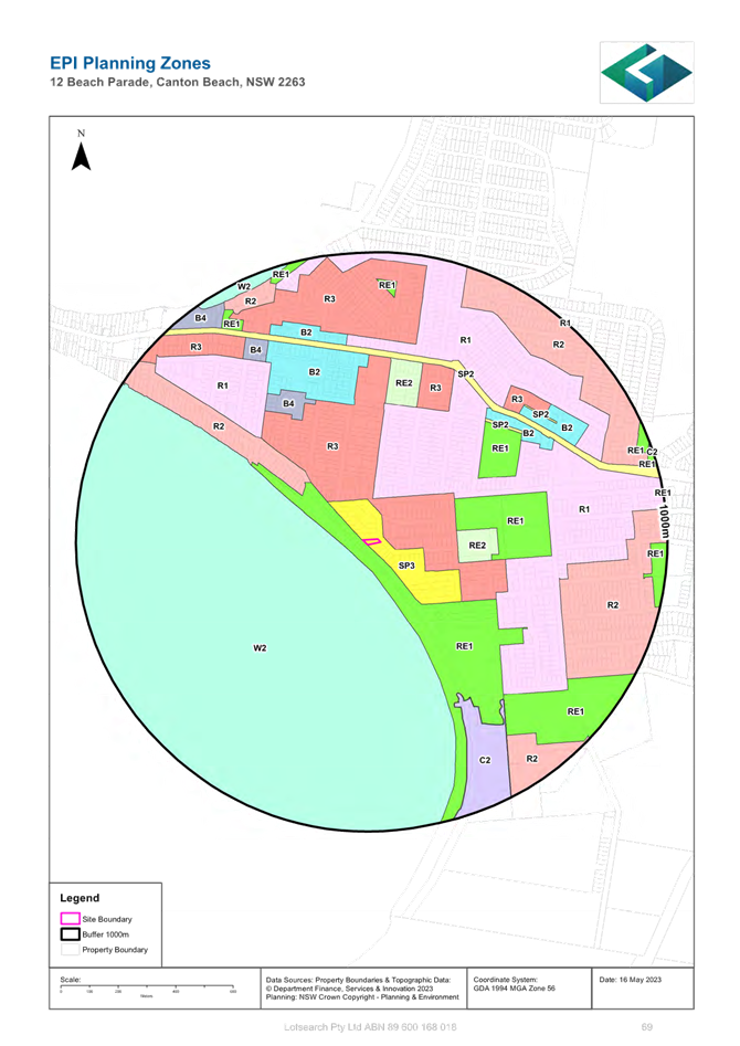
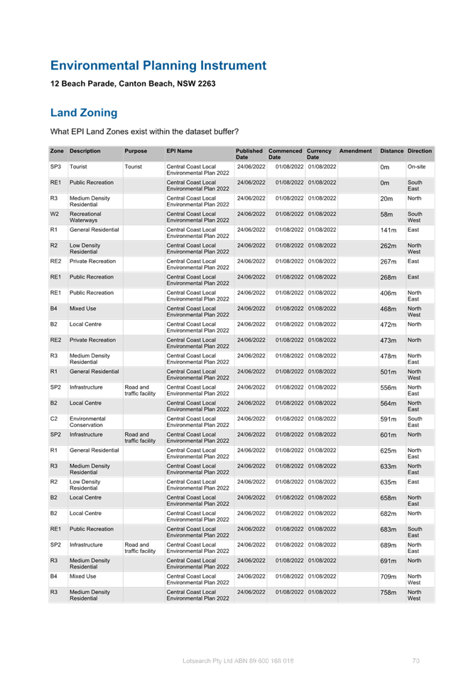
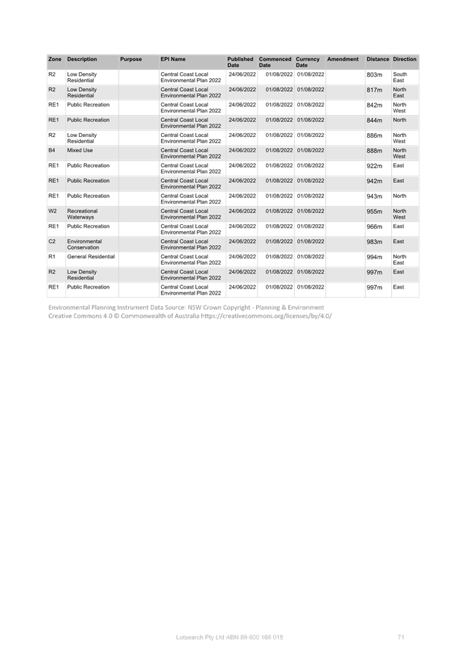
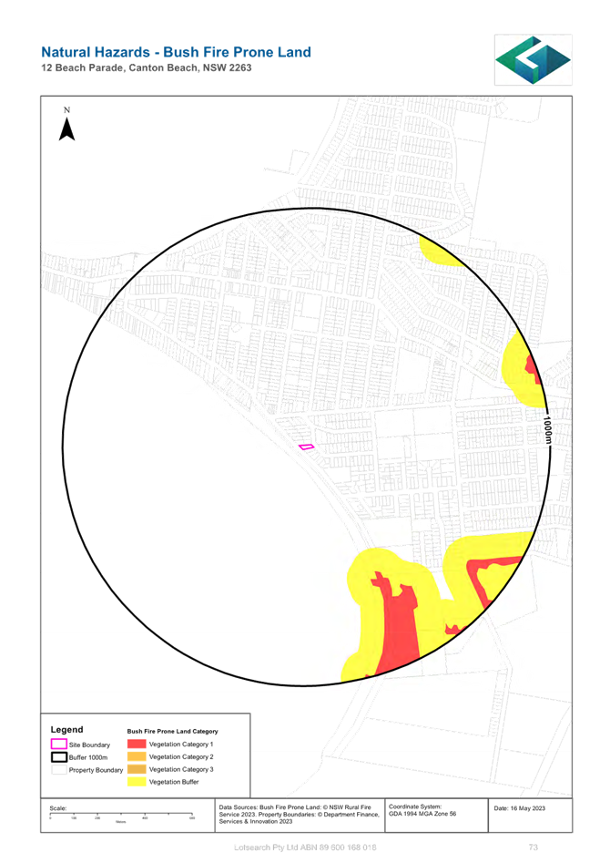
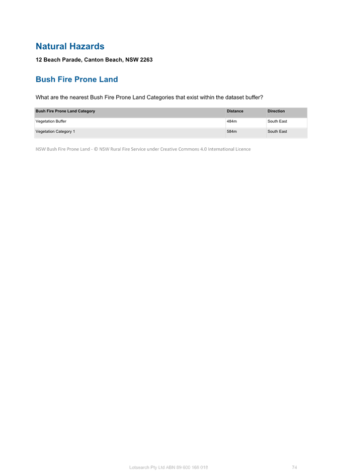
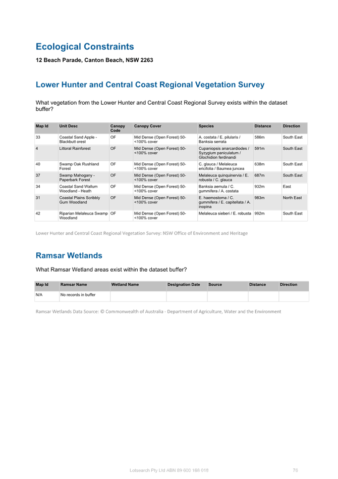
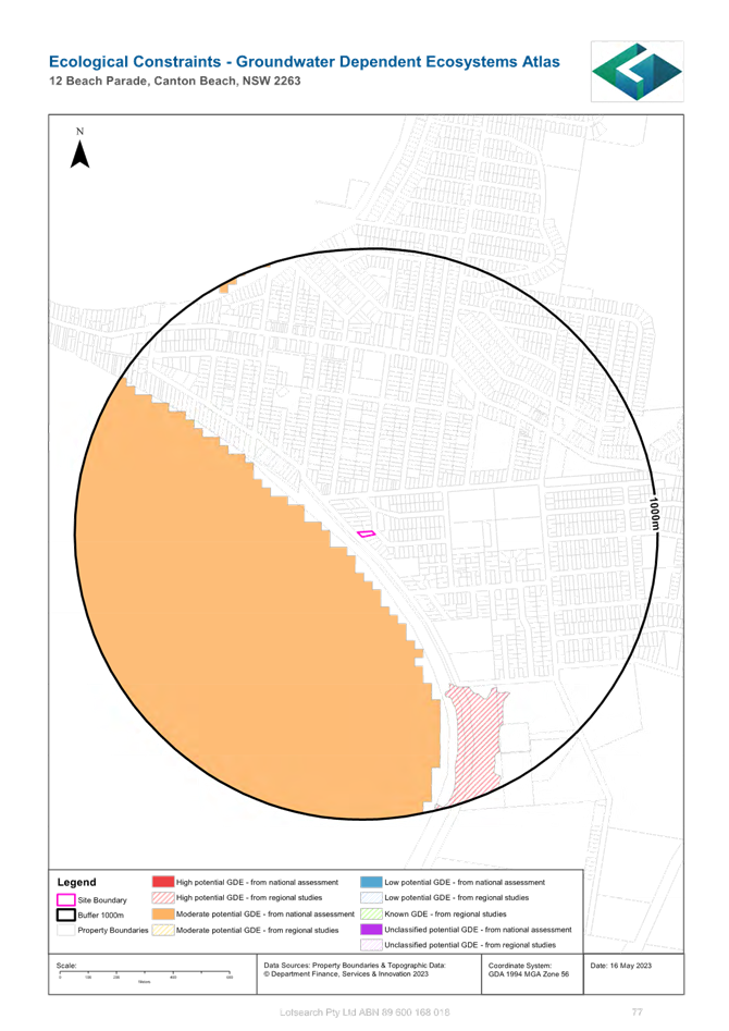

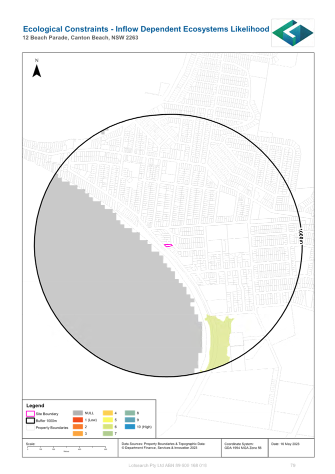

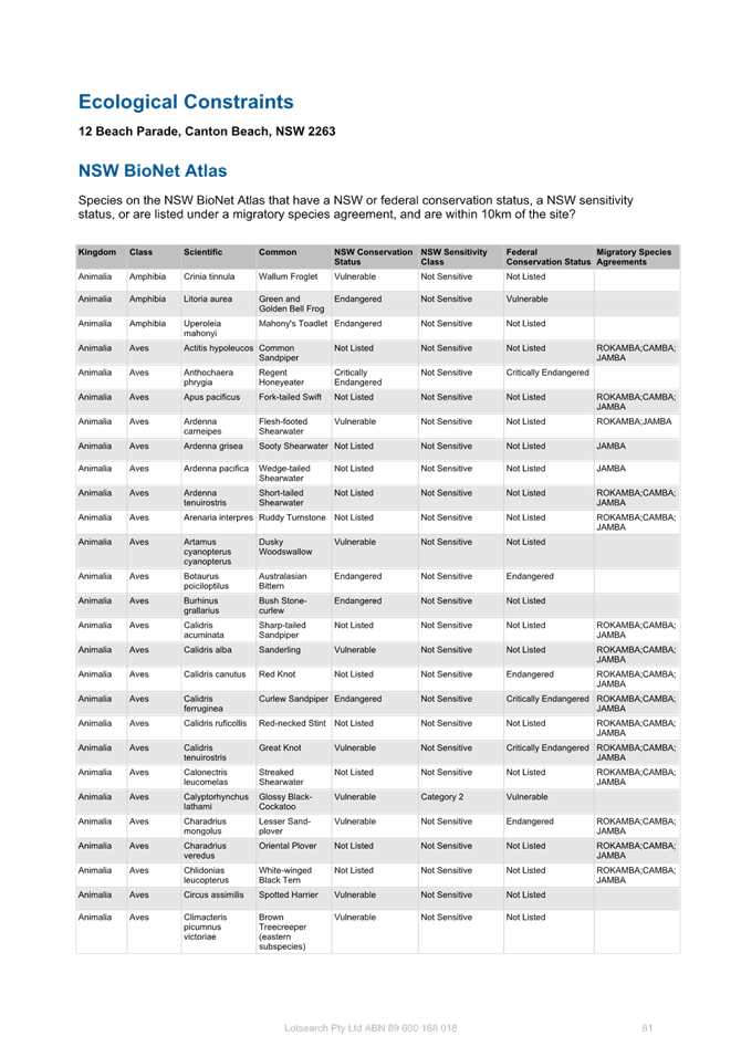
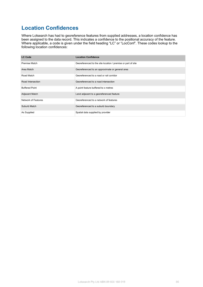
|
DA/4077/2022 - 12 Beach Parade Canton Beach - Mixed Use Development |
|
|
Attachment 7 |
Urban Design Review by Consultant Urban Designer |
|
3.1 |
DA/4077/2022 - 12 Beach Parade Canton Beach - Mixed Use Development |
|
Attachment 8 |
Request for Information - 5 July 2023 |

|
DA/4077/2022 - 12 Beach Parade Canton Beach - Mixed Use Development |
|
|
Attachment 9 |
Revised Landscape Plans |
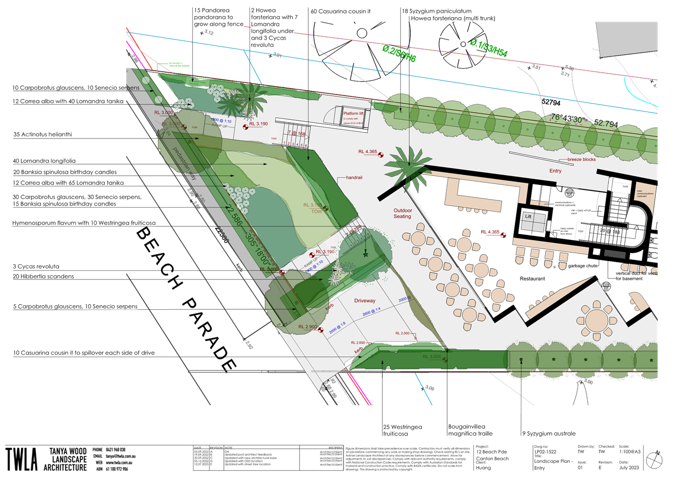
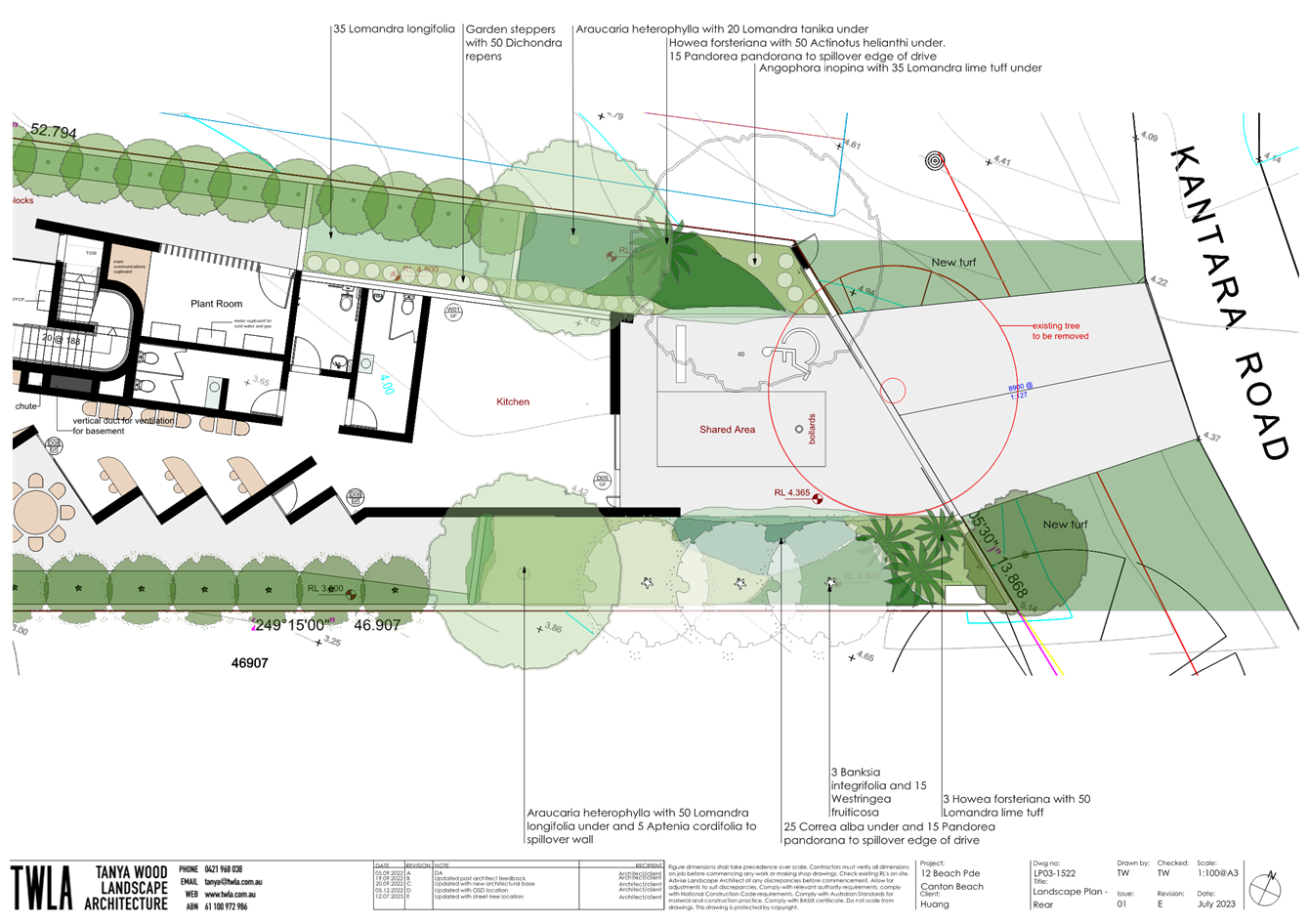
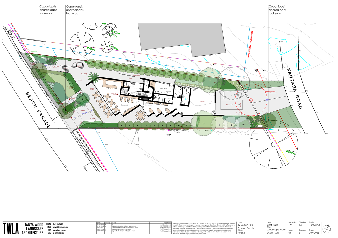
|
DA/4077/2022 - 12 Beach Parade Canton Beach - Mixed Use Development |
|
|
Attachment 10 |
Request to Withdraw |


|
DA/4077/2022 - 12 Beach Parade Canton Beach - Mixed Use Development |
|
|
Attachment 11 |
Applicant response letter to Council RFI |
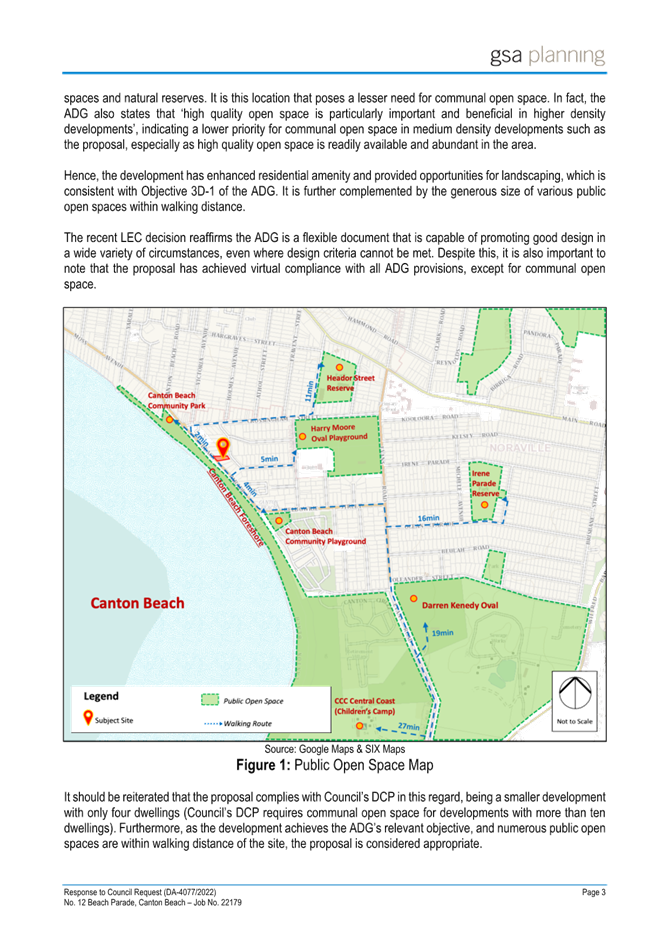
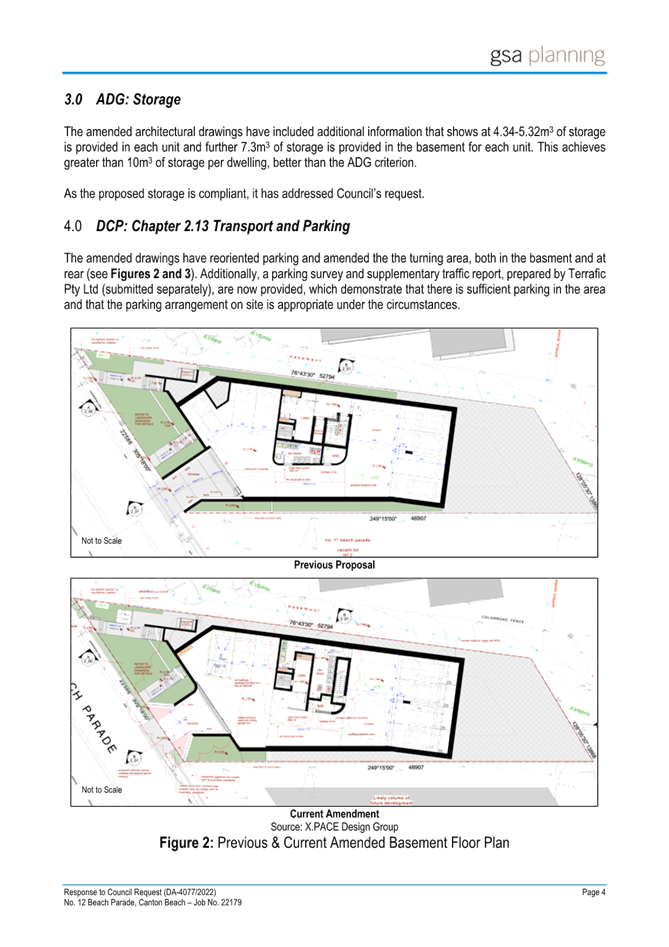
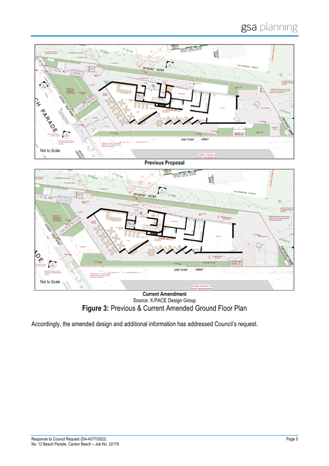
|
DA/4077/2022 - 12 Beach Parade Canton Beach - Mixed Use Development |
|
|
Attachment 13 |
Traffic Engineering Letter |
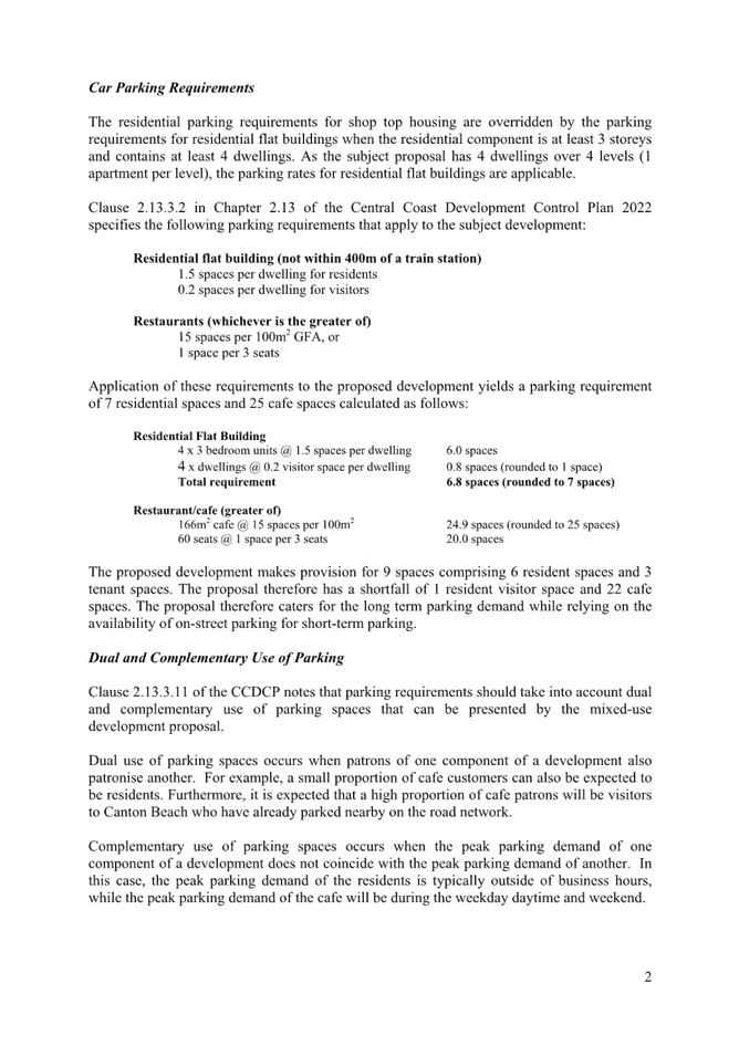
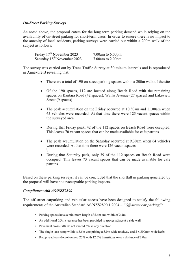
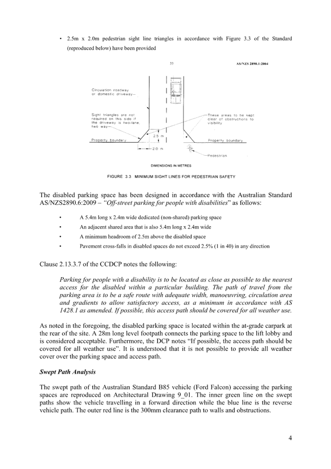

|
DA/4077/2022 - 12 Beach Parade Canton Beach - Mixed Use Development |
|
|
Attachment 14 |
Final Urban Design Review Letter from Urban Design Consultant |
|
DA/4077/2022 - 12 Beach Parade Canton Beach - Mixed Use Development |
|
|
Attachment 15 |
Clause 4.6 variation request |
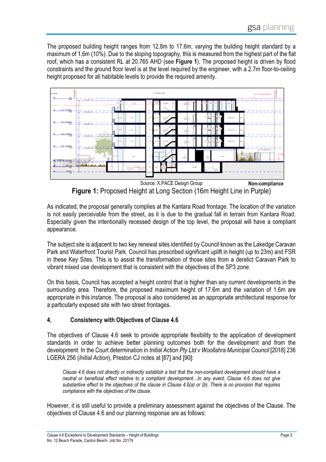
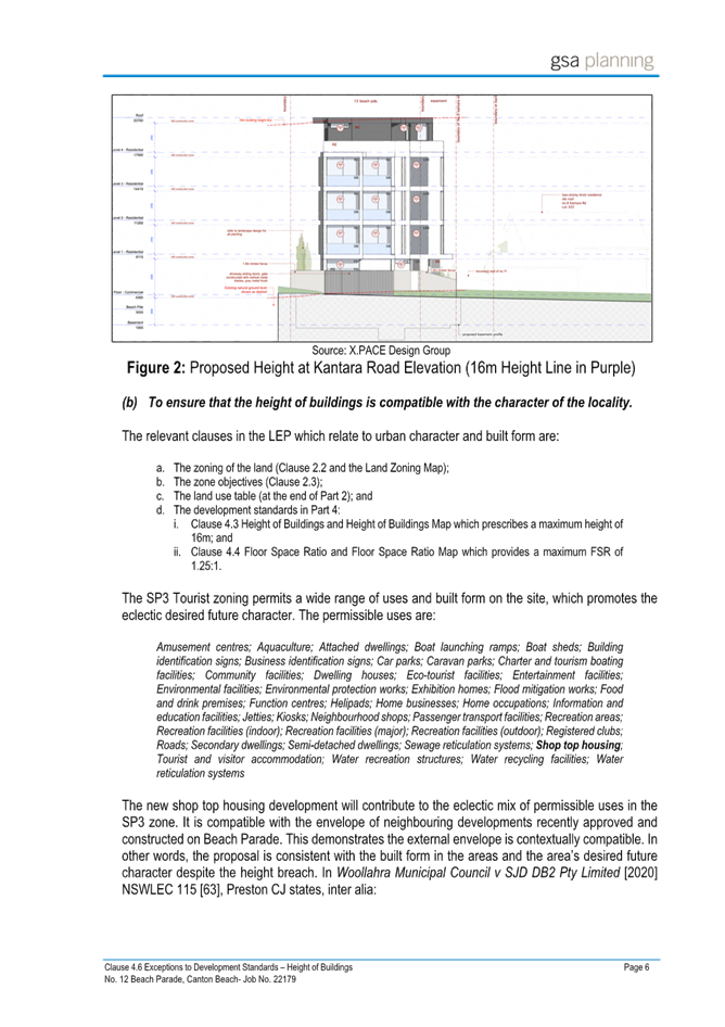
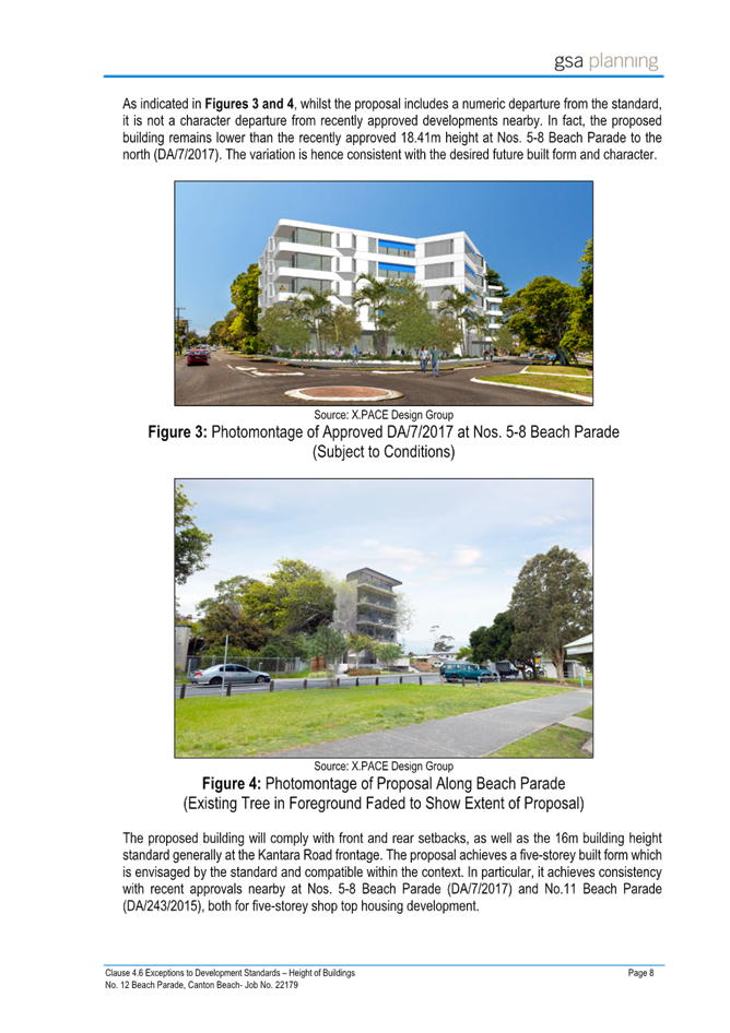
|
DA/4077/2022 - 12 Beach Parade Canton Beach - Mixed Use Development |
|
|
Attachment 16 |
Revised Architectural Plans (Redacted) - 12 Beach Parade CANTON BEACH - PAN-280611 - DA/4077/2022 |
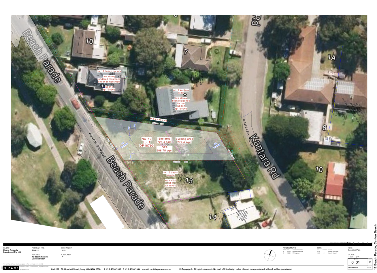
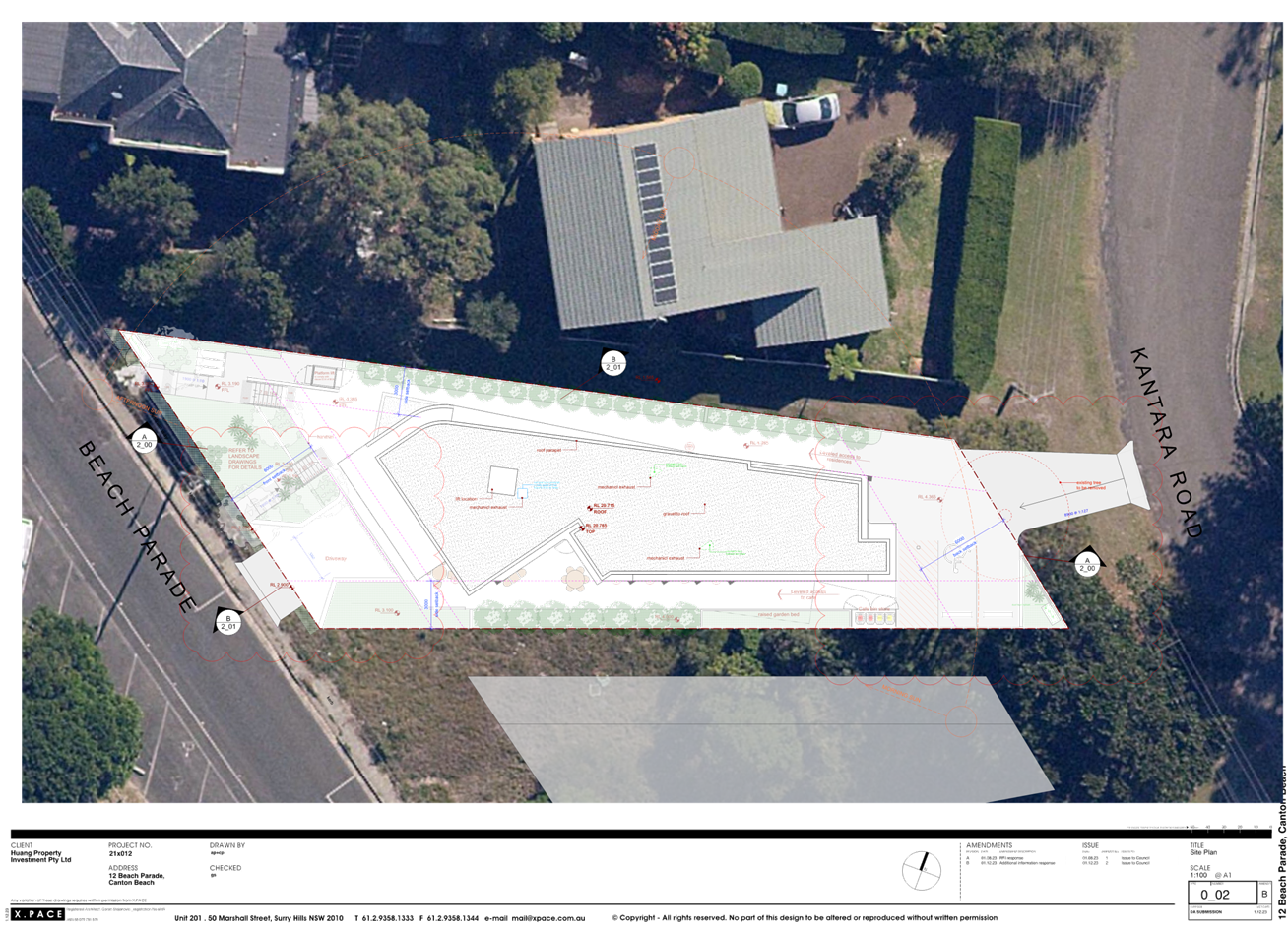
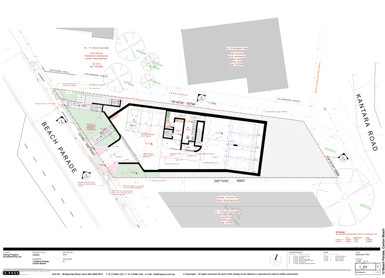
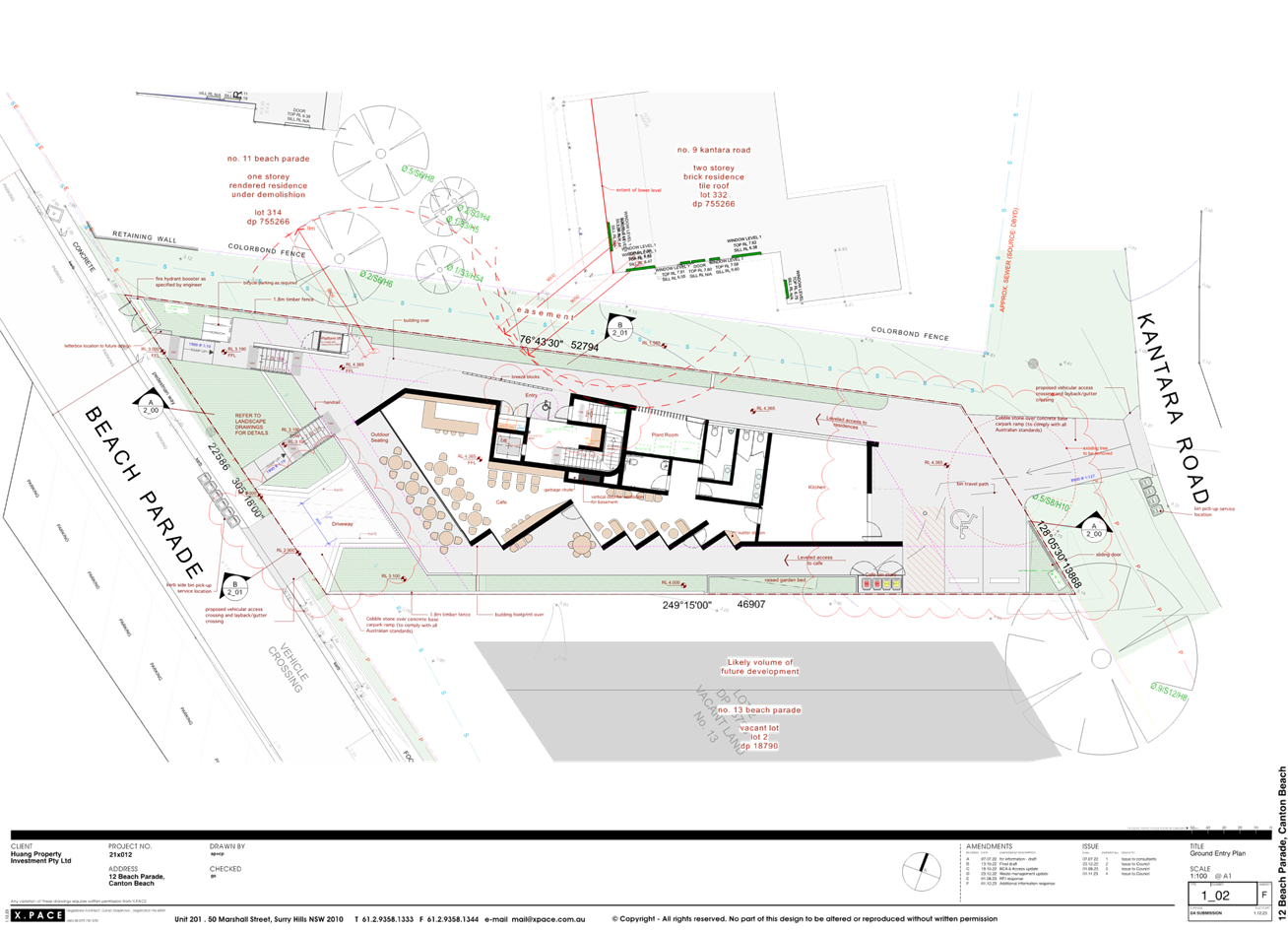
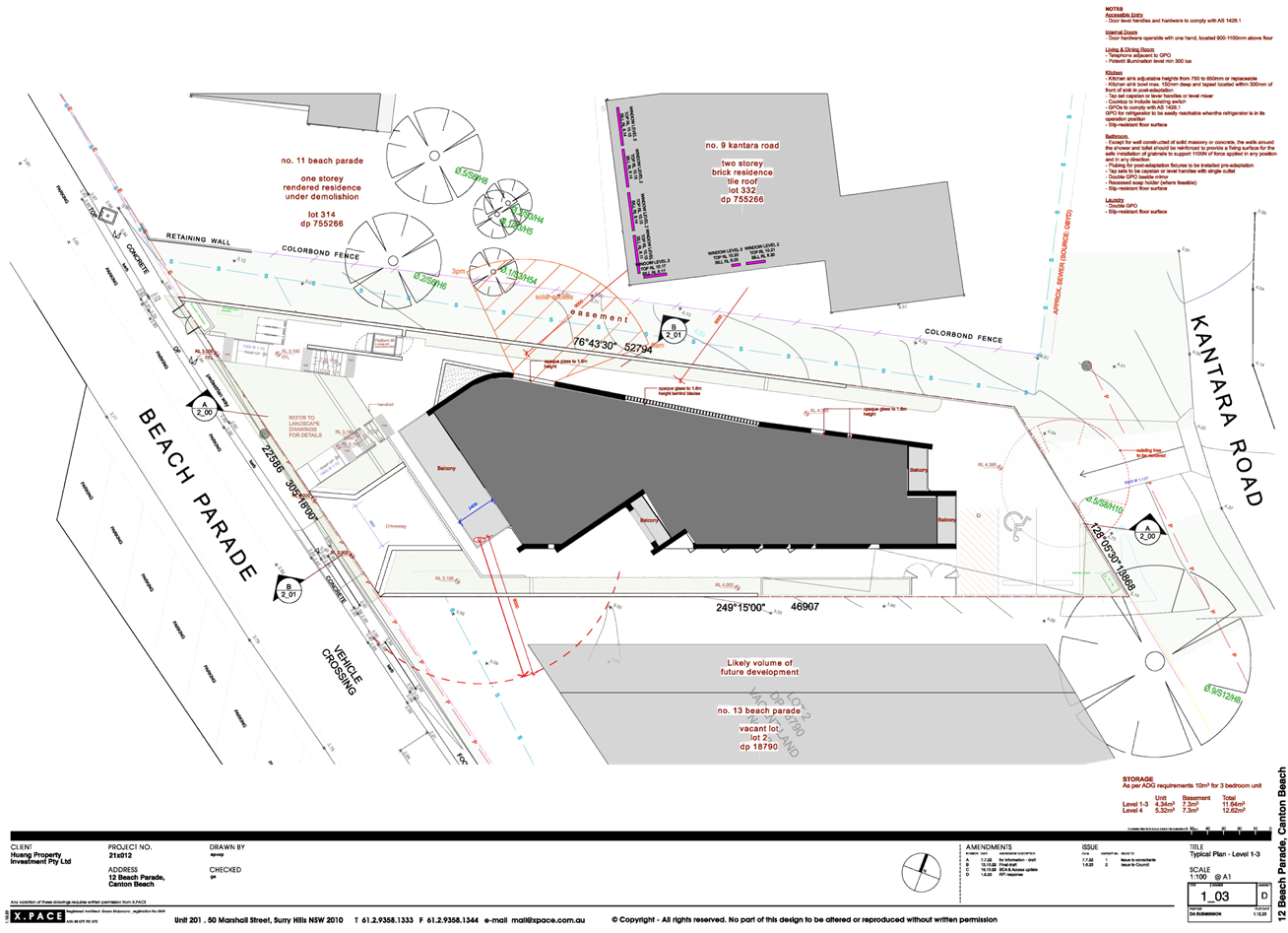
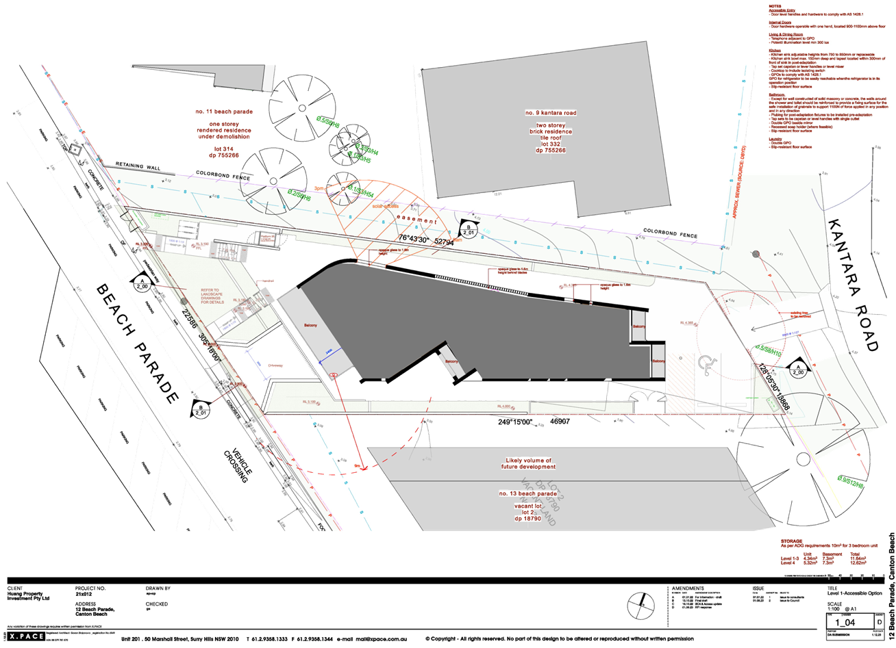
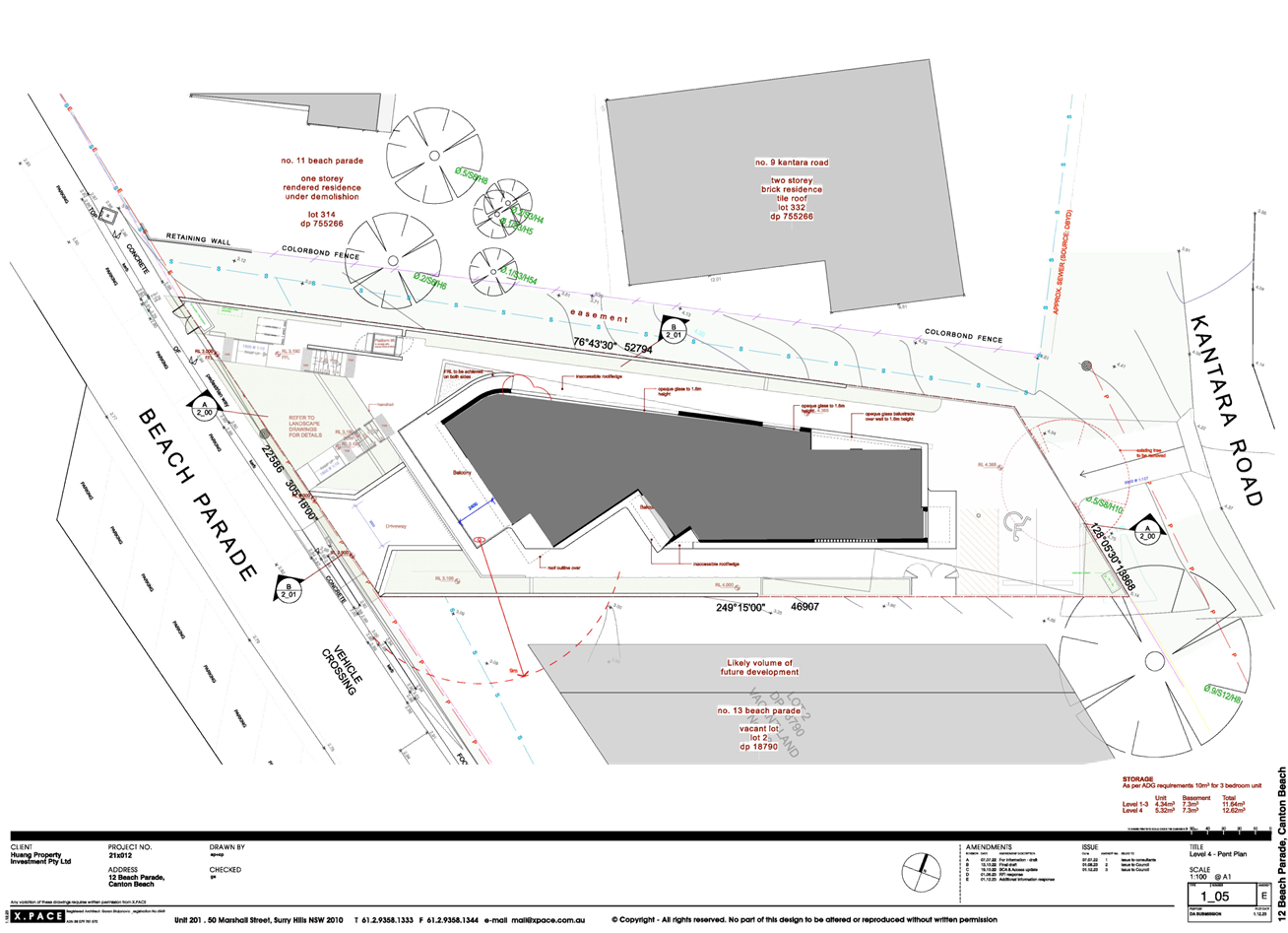
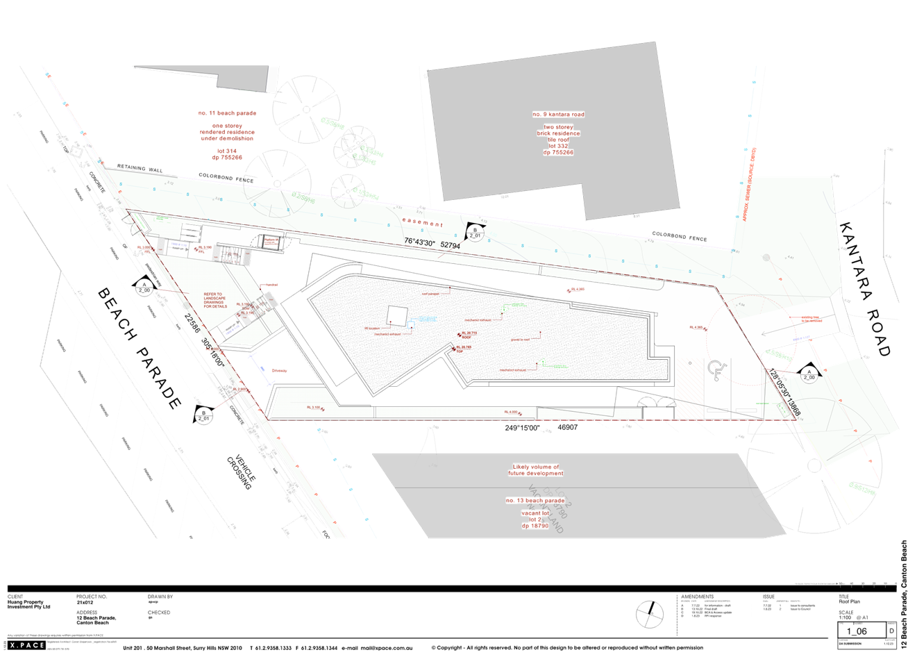
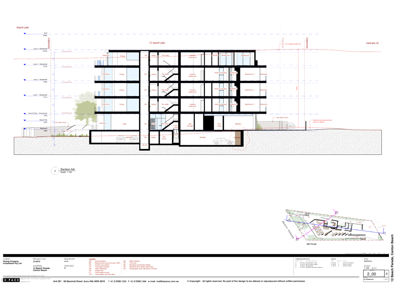
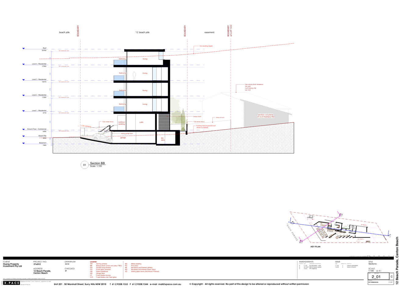
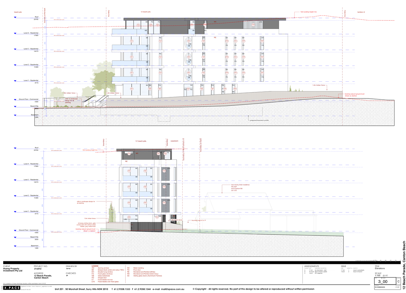
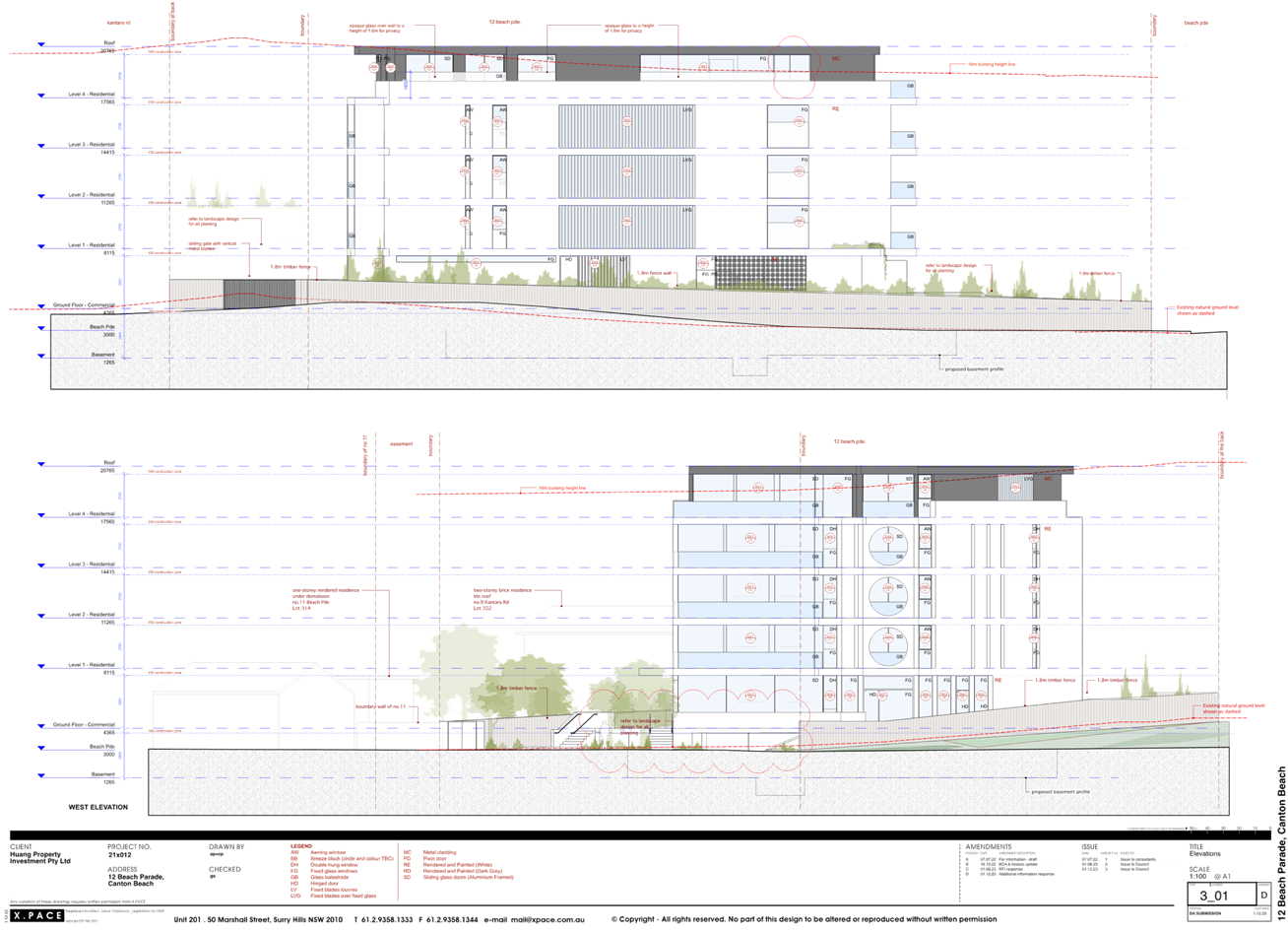
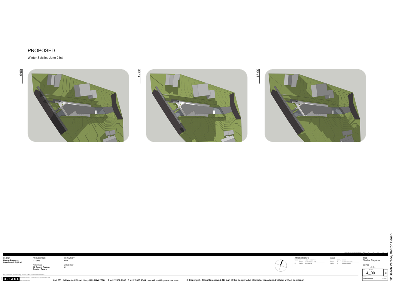
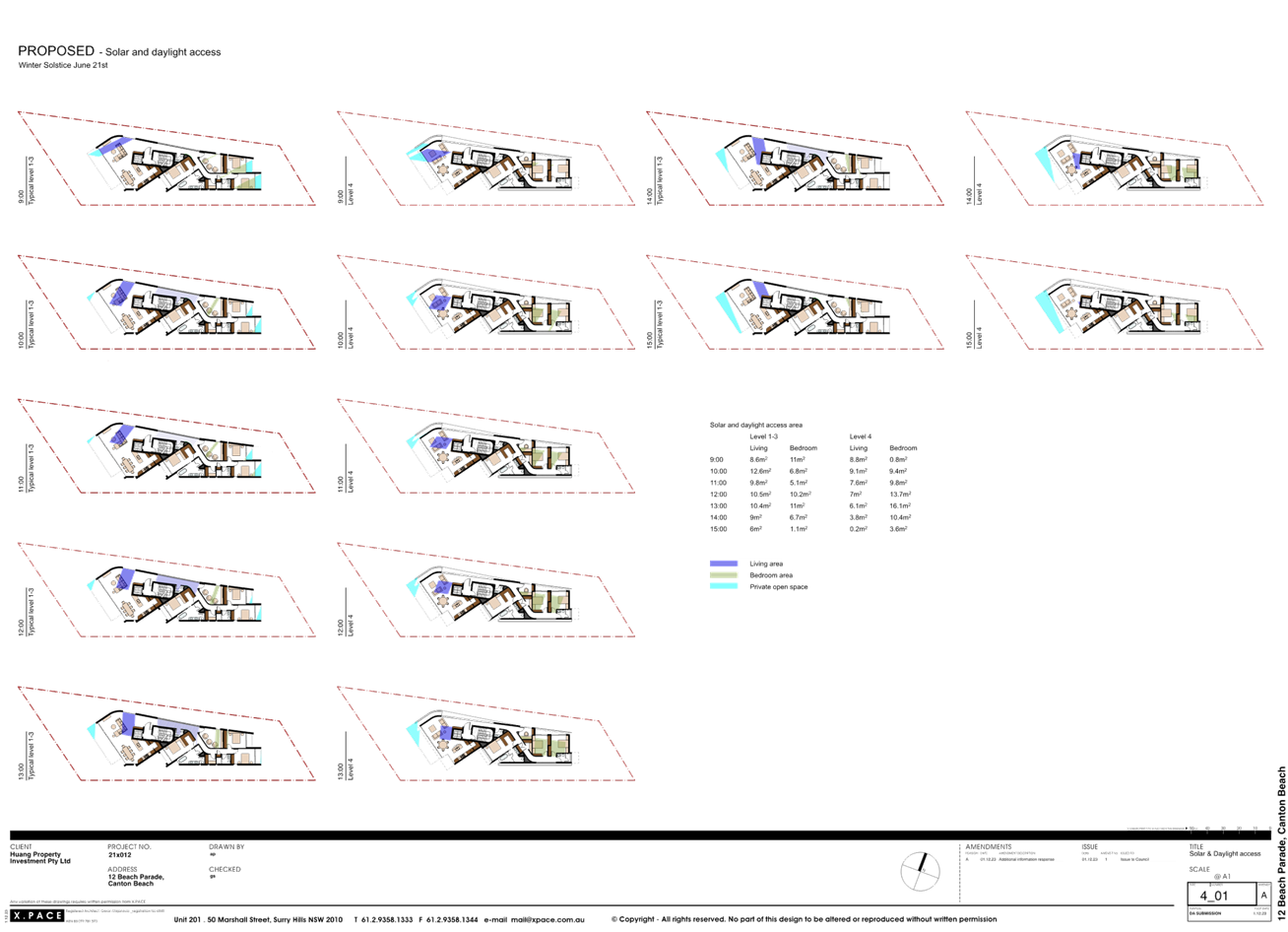
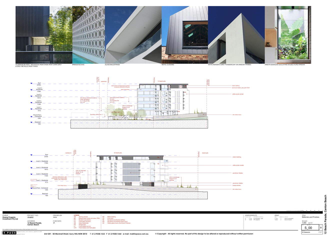
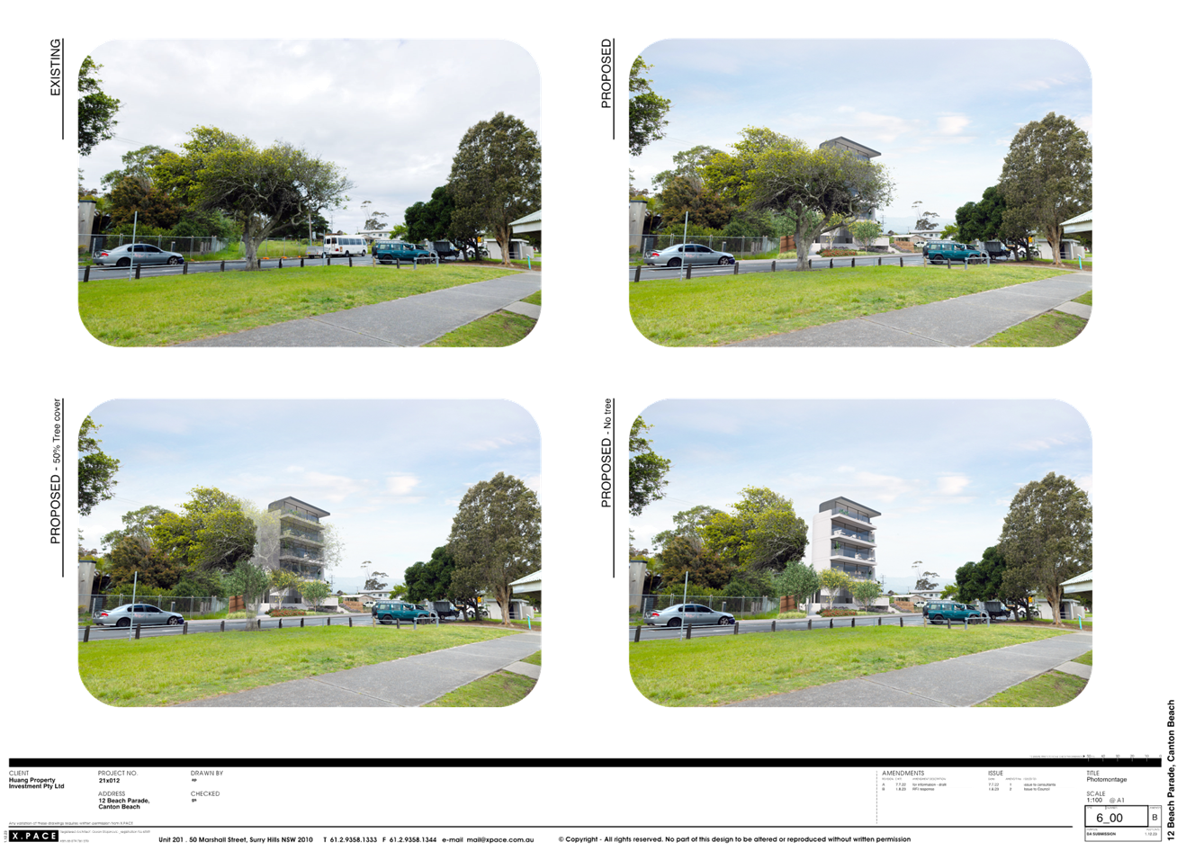
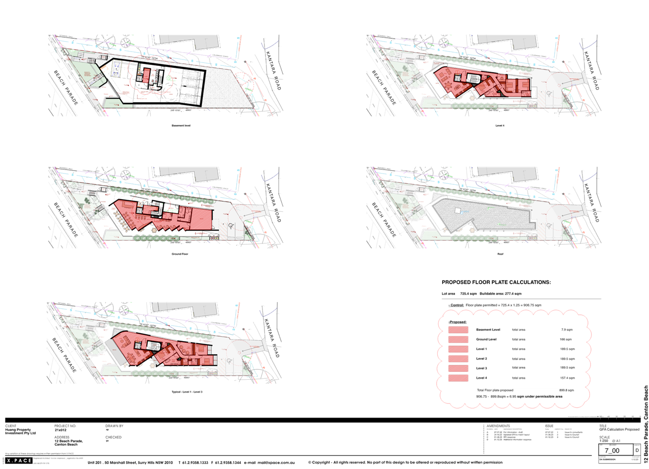
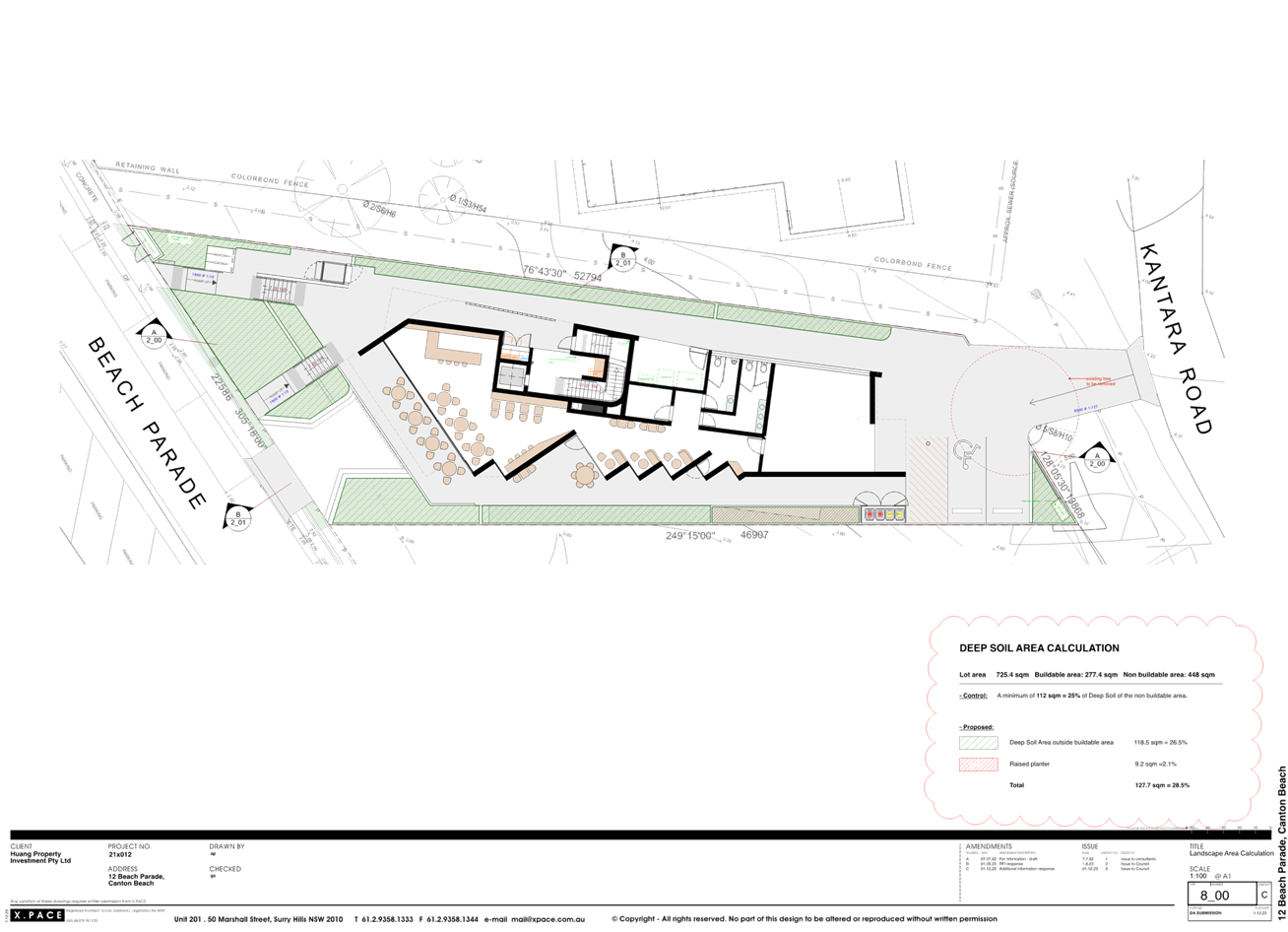
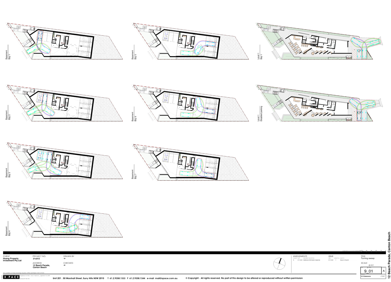
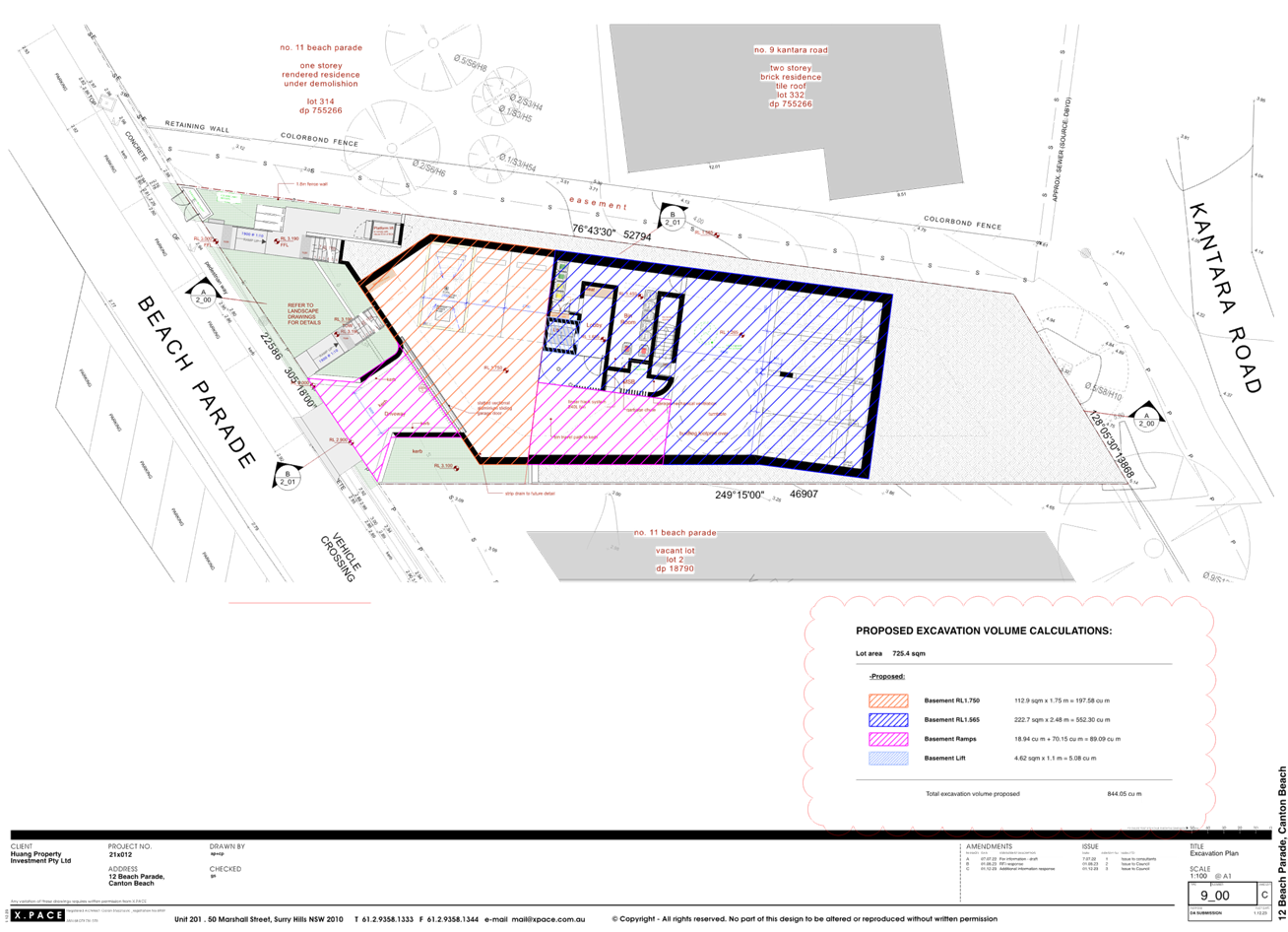
|
Item No: 3.2 |
|
|
Title: DA/2267/2023 - 262 Manns Road, West Gosford - Change of Use to Restricted Premises (Sex Shop) - internal alterations & signage |
|
|
Department: Environment and Planning |
|
|
3 October 2024 Local Planning Panel Meeting |
|
Reference: DA/2267/2023 - D16242940
Author: Dean Wooding, Development Planner, Employment and Urban Release
Section Manager: Emily Goodworth, Section Manager Employment and Urban Release
Unit Manager: Andrew Roach, Unit Manager. Development Assessment
|
Summary
An application has been received for Change of Use, Fitout and Signage for a Restricted Premises (Sex Shop). The application has been examined having regard to the matters for consideration detailed in section 4.15 of the Environmental Planning and Assessment Act 1979 and other statutory requirements with the issues requiring attention and consideration being addressed in the report.
The application is referred to the Local Planning Panel due to the proposal being for a Restricted Premises (Sex Shop), which is specifically identified as a ‘sensitive development’ in accordance with the Ministerial Directions for matters to be referred to the Local Planning Panel.
The application was placed on public exhibition from 15 December to 22 January 2024. The application was re-notified from 24 May to 7 June 2024 to properly characterize the change of use as being for a Restricted Premises (Sex Shop). No submissions have been received.
The application is recommended for approval, subject to conditions.
Applicant Mr J Hancock Owner Central Coast Brick Supplies Pty Ltd Application No DA/2267/2023 Description of Land Lot 2 DP 705906 262 Manns Road, West Gosford Proposed Development Change of Use, Fitout & Signage for Restricted Premises (Sex Shop) Site Area 2828.00 sqm Zoning E4 – General Industrial Existing Use Industrial Employment Generation Yes Estimated Value $10000
|
1 That the Local Planning Panel grant consent to DA/2267/2023 – 262 Manns Road, West Gosford subject to the conditions detailed in the schedule attached to the report and having regard to the matters for consideration detailed in Section 4.15 of the Environmental Planning and Assessment Act 1979.
2. That Council advises relevant external authorities of the Panel’s decision.
Key Issues
1. Parking
2. Signage
Precis:
|
Proposed Development |
Change of Use, Fitout & Signage for a Restricted Premises (Sex Shop) |
|
Permissibility and Zoning |
E4 – General Industrial |
|
Current Use |
Vacant |
|
Integrated Development |
No |
|
Submissions |
None |
Variations to Policies
|
CCDCP Chapter |
2.11 - Restricted Premises and Sex Services Premises |
|
Standard |
2.11.4.3 - Only one sign per premises is permitted |
|
LEP/DCP |
CCDCP 2022 |
|
Departure basis |
Two signs proposed |
The Site & Surrounds
The site is located on the south side of Manns Road near its junction with Merinee Road and is legally known as Lot 2 in DP 705906.
The Lot contains two buildings, located in the western and eastern part of the site. The development site has been identified as the eastern part of the lot containing the eastern building extending from Manns Road in the north to Dignity Crescent in the south. The site is accessed via a vehicular cross over direct from Manns Road.
The host building is a two-story red brick building with a flat roof, measuring 32m in length and 14m in width. The building has an awning projecting over the ground floor entrance and along the western side of the building. This building contains at least 2 tenancies, Central Coast Brick Supplies, at the rear of the premises, vacant offices formerly East Coast Roofing and Building Supplies (the subject premises). The subject tenancy will be in the northern part of the eastern building and will utilize the carparking area adjacent to Manns Road.
Behind the building, there is a large rear yard which contains open stored brick supplies (Central Coast Brick Supplies) and extends the full width of the development site and behind the western building.
The development site is bounded by several commercial, industrial and storage uses. To the west, the site forms the western part of Lot 2 in DP 705906 which contains a two-storey building occupied by “Central Coast Bricks and Heating”. Behind the building, there is a large rear yard which contains brick supplies (Central Coast Brick Supplies).
To the east of the site at 258 Manns Road, the premises is occupied by “Gas and Gear” a gas supplies company. To the north of the site on the opposite side of Manns Road at no. 2 Merinee Road, the site is occupied by an Ampol Service Station. To the south of the site on the opposite side of Dignity Crescent, at no 14, the site is occupied by a warehouse / industrial building occupied by “Price Plastics”.
Figure 1: Site context (Source: GeoView Image 24 June 2024)
Figure 2 – Photograph of the subject site frontage. Image 3 April 2024.
Figure 3 – Photograph of the subject site’s frontage from the adjacent tenancy. Image 3 April 2024.
Figure 4 – View of the ground floor interior. Image 3 April 2024.
Figure 5 – View of the first-floor interior. Image 3 April 2024.
The Proposed Development
The proposed development comprises the following:
· Change of use to Restricted Premises (Sex Shop)
Gross floor area =139.15m2
o Ground Floor Retail – 43.75m2
o Ground Floor Areas (Ancillary Space) – 25.38m2
o First Floor (Ancillary Storage) – 70.029m2
· Internal Fitout
Installation of shelving and internal partitions including the creation of a new internal lobby.
· Business Signage
o Fascia Sign Approximately 15m in width and 1m in height positioned above first floor windows (approx. 8m in height above GL) with black background and white lettering, reading “love + lust” “lingerie and adult shop” and “Order online loveandlust.com.au”.
o Door Signage approximately 800mm in width and 1m in height with black background and white lettering, reading “love + lust”, ” lingerie and adult shop”, ”Order online loveandlust.com.au”, and “Restricted Premises – persons under 18yrs of age not permitted. Members of the public are warned that some materials displayed here may cause offence”.
· Other works
o Frosted privacy film over shopfront windows.
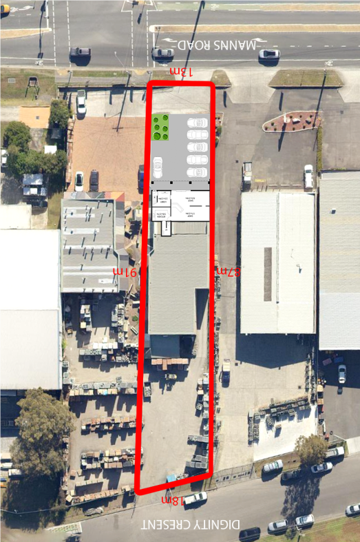
Figure 6 – Site Plan. This identifies the eastern part of the lot as the development
site. Source J Hancock. Accessed 24 June 2024.
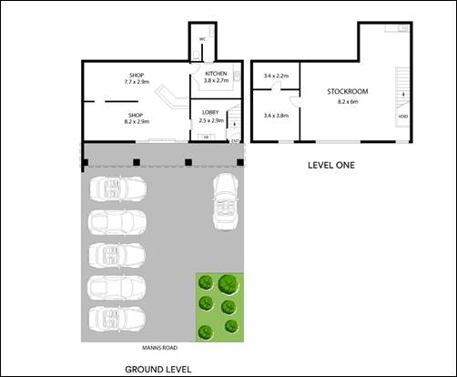
Figure 7 – Proposed Floor Plans. Note this is orientated south to north.
Source J Hancock. Accessed 24 June 2024.
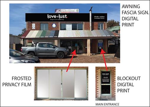
Figure 8 – Proposed Signage. Source J Hancock. Accessed 24 June 2024.
History
The following table represents previous applications for the site.
|
Application Number |
Description |
Status |
Decision |
Lodged |
|
DA/1544/1981 |
Factory Units |
Approved |
Approved |
14/11/1981 |
|
DA17647/1981 |
Ground Floor Office |
Approved |
Approved |
13/01/1982 |
|
DA18717/82 |
Ground Floor Office |
Approved |
Approved |
05/11/1981
|
|
DA/9786/1988 |
Display Area – Incorporating Pool |
Approved |
Approved |
26/06/1988 |
|
DA/58001/1989 |
Factory |
|
|
15/12/1989 |
|
DA/11613/1989 |
Outbuilding |
|
|
05/06/1989 |
|
DA61589/90 |
Multi Industrial Units |
Withdrawn |
Withdrawn |
25/03/1991 |
|
DA/7914/94 |
Seven Factory Bays |
Approved |
Approved |
03/03/1995 |
|
DA/20279/1995 |
Signs |
Approved |
Approved |
14/06/1995 |
|
DA/8081/1995 |
Proposed Advertisement Sign |
Approved |
Approved |
17/07/1995 |
ASSESSMENT:
Having regard for the matters for consideration detailed in Section 4.15 of the Environmental Planning and Assessment Act 1979 and other statutory requirements, Council’s policies and Section 10.7 Certificate details, the assessment has identified the following key issues, which are elaborated upon for Council’s information. Any tables relating to plans or policies are provided as an attachment.
State Environmental Planning Policy (Resilience and Hazards) 2021
Chapter 2 Coastal Management
The subject property falls within the mapped coastal management areas including: the ‘Coastal Environmental Area’ and ‘Coastal Use Area’ under Chapter 2. The proposal is consistent with the relevant provisions of Section 2.10 in respect of the Coastal Environment Area as it will not cause an adverse impact on the following:
• the integrity and resilience of the environment
• coastal environmental values and natural coastal processes
• water quality
• existing public open space and safe access to and along the foreshore
• aboriginal cultural heritage practices and places or
• the use of the surf zone
The proposed development will be carried out within an existing building and there are no external changes to the building that would likely impact on the coastal environment. Accordingly, having regard for the provisions of s.2.10(2), the Panel can be satisfied that the development is designed, sited, and will be managed to avoid any impacts listed above.
Further, the proposal is consistent with relevant provisions Section 2.11 in respect of the Coastal Use Area in that it is not likely to cause an adverse impact on:
• existing, safe access to and along the foreshore, beach, etc.
• overshadowing, wind funnelling and the loss of views from public places to foreshores
• the visual amenity and scenic qualities of the coast, including coastal headlands
• Aboriginal cultural heritage, practices, and places or
• cultural and built environment heritage.
The Panel can therefore be satisfied that the development is designed, sited, and will be managed to avoid any impacts listed above and the bulk, scale and size of the proposed development is appropriate (s.2.11(b) and(c)).
Chapter 4 Remediation of Land
Section 4.6 of Chapter 4 of the SEPP requires that a consent authority must not consent to the carrying out of any development on land unless it has considered whether the land is contaminated and if so whether it can and will be remediated such that it is suitable for the proposed use.
There is no evidence that the subject site is contaminated, and the land is not within an investigation area, and is not on land on which development for a purpose referred to in Table 1 to the contaminated land planning guidelines relates. However, the land immediately to the east, No. 258 Manns Road, is identified as being contaminated as a land use containing Gas works.
The proposed development is for a change of use of an existing premises. There are no external changes to the building, earthworks or similar that will disturb the existing ground level to the extent where a preliminary investigation would be warranted. Works proposed under this application involve internal fit-out works, and line marking and landscaping within the car parking area at the frontage of the site. If major earthworks had been proposed then as a matter of precaution, council would have requested a preliminary investigation given the land adjoining is identified as being contaminated.
The Panel can be satisfied the proposal does not involve a change of use on any land specified in subsection 4.6(4) and that given the nature of works and change of use proposed under this application, a preliminary investigation of the land was not warranted in this instance.
State Environmental Planning Policy (Industry and Employment) 2021
Chapter 3 Advertising and Signage
In accordance with SEPP (Industry and Employment) 2021 Chapter 3 Advertising and Signage, consent must not be granted for the display of signage unless the consent authority is satisfied:
a) that the signage is consistent with the objectives of this Chapter as set out in section 3.1(1)a), and
b) that the signage the subject of the application satisfies the assessment criteria specified in Schedule 5.
The aims of Section 3.1 (1)a) are:
a. To ensure that signage (including advertising):
i. Is compatible with the desired amenity and visual character of an area, and
ii. Provides effective communication in suitable locations, and
iii. Is of high-quality design and finish.
The proposed signage is defined as business identification signage and is compatible with the desired and visual amenity of this area. The site context for the signage is within an established commercial / industrial strip along a busy main (classified) road.
The proposed business identification signage is in suitable locations so as not to impact upon vehicular safety and provides a high-quality design and finish. There are no residential land uses near the site.
The proposed business identification signs have been assessed against the provisions of Schedule 5 – Assessment Criteria of the SEPP and the proposed signage has satisfactorily addressed the assessment criteria outlined in the table and the proposal is acceptable in terms of design, road safety and satisfies the relevant requirements of this Chapter of the SEPP.
|
Requirement |
Proposal |
Complies? |
||
|
1 Character of the area |
||||
|
Is the proposal compatible with the existing or desired future character of the area or locality in which it is proposed to be located? |
The proposed signs are located within an industrial zone and the signs are compatible with the area’s desired character |
Yes |
||
|
Is the proposal consistent with a particular theme for outdoor advertising in the area or locality? |
The proposal is consistent with outdoor advertising in the area. |
Yes |
||
2 Special areas |
||||
|
Does the proposal detract from the amenity or visual quality of any environmentally sensitive areas, heritage areas, natural or other conservation areas, open space areas, waterways, rural landscapes, or residential areas? |
The proposal does not detract from the amenity or visual quality of any environmentally sensitive areas, heritage areas, natural or other conservation areas, open space areas, waterways, rural landscapes, or residential areas. |
Yes |
||
|
3 Views and vistas |
||||
|
Does the proposal obscure or compromise important views? |
The proposal does not obscure or compromise important views. |
Yes |
||
|
Does the proposal dominate the skyline and reduce the quality of vistas? |
The proposal does not dominate the skyline and reduce the quality of vistas. |
Yes |
||
|
Does the proposal respect the viewing rights of other advertisers? |
The proposal does not compromise the viewing rights of other advertisers. |
Yes |
||
|
4 Streetscape, setting or landscape |
||||
|
Is the scale, proportion, and form of the proposal appropriate for the streetscape, setting or landscape? |
The proposal has an appropriate form within the streetscape. |
Yes |
||
|
Does the proposal contribute to the visual interest of the streetscape, setting or landscape? |
Given the nature of the proposed development, the proposed signs are more discreet and not required to contribute to the streetscape. |
Yes |
||
|
Does the proposal reduce clutter by rationalising and simplifying existing advertising? |
Some of the signs replaces existing signage. |
Yes |
||
|
Does the proposal screen unsightliness? |
The proposal does not screen unsightliness |
NA |
||
|
Does the proposal protrude above buildings, structures or tree canopies in the area or locality? |
The proposed signage does not project above the building. |
Yes |
||
|
Does the proposal require ongoing vegetation management? |
Not applicable |
NA |
||
|
5 Site and building |
||||
|
Is the proposal compatible with the scale, proportion and other characteristics of the site or building, or both, on which the proposed signage is to be located? |
The proposed signage is proportionate and sympathetic to the building. |
Yes |
||
|
Does the proposal respect important features of the site or building, or both? |
The building has no important features |
NA |
||
|
Does the proposal show innovation and imagination in its relationship to the site or building, or both? |
The signage is suitable for the site |
Yes |
||
|
6 Associated devices and logos with advertisements and advertising structures |
||||
|
Have any safety devices, platforms, lighting devices or logos been designed as an integral part of the signage or structure on which it is to be displayed? |
A logo is integral to the signage |
Yes |
||
|
7 Illumination |
||||
|
Would the illumination result in unacceptable glare? |
Not applicable |
NA |
||
|
Would illumination affect safety for pedestrians, vehicles, or aircraft? |
Not applicable |
NA |
||
|
Would illumination detract from the amenity of any residence or other form of accommodation? |
Not applicable |
NA |
||
|
Can the intensity of the illumination be adjusted, if necessary? |
Not applicable |
NA |
||
|
Is the illumination subject to a curfew? |
Not applicable |
NA |
||
|
8 Safety |
||||
|
Would the proposal reduce the safety for any public road? |
The proposal has no impact on road safety |
Yes |
||
|
Would the proposal reduce the safety for pedestrians or bicyclists? |
The proposal has no impact. |
Yes |
||
|
Would the proposal reduce the safety for pedestrians, particularly children, by obscuring sightlines from public areas? |
The proposal has no impact. |
Yes |
||
Central Coast Local Environmental Plan 2022
The Central Coast Local Environmental Plan 2022 (CCLEP 2022) came into effect 1 August 2022 and remains the applicable local environmental plan applying to the site.
Land Zoning
The subject site is zoned E4 (General Industrial) under the CCLEP 2022, as illustrated in Figure 9 below. The development is defined, as a ‘restricted premises’ under CCLEP2022, as follows:
restricted premises means premises that, due to their nature, restrict access to patrons or customers over 18 years of age, and includes sex shops and similar premises, but does not include a pub, hotel or motel accommodation, home occupation (sex services) or sex services premises.
The proposed use is permissible in the E4 zone.
![]()
![]()
![]()
![]()
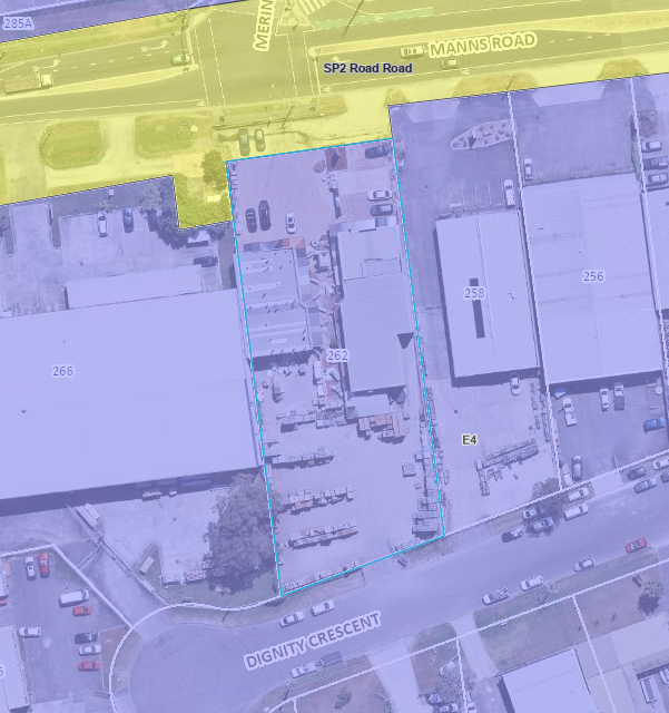
Figure 9: Zoning Map of subject site and surrounds E4 – General Industrial
Source GeoView sourced 15 August 2024
The objectives of the E4 – General Industrial zone are:
• To provide a range of industrial, warehouse, logistics and related land uses.
• To encourage employment opportunities.
Comment – The proposal will bring a vacant premises into viable economic use and results in employment generation.
• To enable limited non-industrial land uses that provide facilities and services to meet the needs of businesses and workers.
• To ensure that retail, commercial or service land uses in industrial areas are of an ancillary nature.
Comment – Although not defined as a retail use, the sex shop has a retail function in that it involves goods for sale. Although the proposed use is not ancillary to another use, given its relatively small size (approx.147.65sqm – 20.5%) in relation to the host building (approx. 719.92sqm) it is supported at this location.
• To support and protect industrial land for industrial uses.
Comment – The premises already has an existing lawful use as a shop.
The objectives of the SP2 –Infrastructure zone are:
• To provide for infrastructure and related uses.
• To prevent development that is not compatible with or that may detract from the provision of infrastructure.
• To recognise existing railway land, major roads, and utility installations and to enable their future development and expansion.
Comment – The proposal is for the continued use of the crossover / access road for all uses on the lot, as existing.
Flood Planning
The site is identified as flood planning and is located within the Narara Creek Catchment and Council’s records indicate that the site is affected by flooding and minimum floor level requirements.
In accordance with Clause 5.21(2), development consent must not be granted to development on land the consent authority considers to be within the flood planning area unless the consent authority is satisfied the development –
(a) Is compatible with the flood function and behaviour on the land, and
(b) Will not adversely affect flood behaviour in a way that results in detrimental increases in the potential flood affectation of other development or properties, and
(c) Will not adversely affect the safe occupation and efficient evacuation of people or exceed the capacity of existing evacuation routes for the surrounding area in the event of a flood, and
(d) Incorporates appropriate measures to manage risk to life in the event of a flood, and
(e) Will not adversely affect the environment or cause avoidable erosion, siltation, destruction of riparian vegetation or a reduction in the stability of riverbanks or watercourses.
The site for the proposed development is affected by flooding with the 1% AEP flood level RL 2.67m AHD. The respective Flood Planning Level is RL 3.17m AHD.
Councils Engineer has advised that the use is suitable if the materials, below the flood planning level, are able to withstand the effects of immersion. As the proposed works involve shelving and the installation of partitions, they are capable of being constructed to withstand these impacts. This requirement can form a condition of consent.
In this regard, the Panel can be satisfied that the proposed development, subject to conditions:
(a) is compatible with the flood function and behaviour on the land, and
(b) will not adversely affect flood behaviour in a way that results in detrimental increases in the potential flood affectation of other development or properties, and
(c) will not adversely affect the safe occupation and efficient evacuation of people or exceed the capacity of existing evacuation routes for the surrounding area in the event of a flood, and
(d) incorporates appropriate measures to manage risk to life in the event of a flood, and
(e) will not adversely affect the environment or cause avoidable erosion, siltation, destruction of riparian vegetation or a reduction in the stability of riverbanks or watercourses.
Acid Sulfate Soils
Clause 7.1 requires an assessment to be given to certain development on land being subject to actual or potential acid sulphate soils. The site is identified as part Class 2 on the Acid Sulphate Soils (ASS) Planning Map. An ASS management plan is not required in this instance as there are no works proposed more than 1m below the natural ground surface nor are any works proposed by which the water table is likely to be lowered more than 1m below natural ground surface (cl.7.1(2) & (3)).
The Panel can be satisfied that no further information is required in relation to clause 7.1 and development consent can be granted for the proposed works.
Essential Services
Clause 7.6 states that development consent must not be granted to a development application unless the consent authority is satisfied that the services that are essential for the development are available or that adequate arrangements have been made to make them available. The services include water supply, electricity supply, the disposal and management of sewage, stormwater drainage or on-site conservation and suitable vehicular access.
The Panel can be satisfied all required services are available for the proposed development.
Central Coast Development Control Plan 2022
Chapter 2.11 Restricted Premises and Sex Services Premises. The relevant sections of Chapter 2.11 relating to restricted premises have been addressed in the table below.
|
Requirement |
Proposal |
Complies? |
|
2.11.4 Planning Matter and Provisions |
||
|
2.11.4.1 Location |
||
|
Restricted premises must not be sited within view of or within a 100-metre radius of a church, hospital, school, community facility, residential property, or any place regularly frequented by children for recreation or cultural activities. |
The proposal is not located within 100m of church, hospital, school, community facility, residential property, or any place regularly frequented by children for recreation or cultural activities. |
Yes |
|
Restricted premises must not be sited within a radius of 200m of a licensed premises being a hotel, public bar nightclub or the like. |
The proposal is not located within 200m of a licensed premises being a hotel, public bar nightclub or the like. |
Yes |
|
Access to or exit from a restricted premises shall not be provided within 100 metres of the property boundary of any premises used as a dwelling |
There are no residential premises within 100m of the entrance/exit to the site. |
Yes |
|
2.11.4.2 Parking |
||
|
On site car parking shall be provided at the same rate as “business premises” being one (1) space per 2 working rooms |
Not relevant as they relate to sex services premises not a restricted premises. |
NA |
|
Parking areas, access corridors and entrances are to be well lit and signposted at all times, but not interfere with the amenity of the area. |
Not relevant as the requirement relates to sex services premises not a restricted premises. |
NA |
|
2.11.4.3 Signage |
||
|
Only one sign per premises is permitted |
The proposal is for one main sign visible from the public realm.
The proposed signage on the doorway results in two signs. However, this sign is important for wayfinding for customers once on the premises and a variation is considered acceptable. |
Variation supported |
|
Council must be satisfied that the content, illumination, size, and shape of the sign is not likely to interfere with the amenity of the locality |
The sign has no impact on amenity |
Yes |
|
The sign shall not display words or images, which are in the opinion of the consent authority sexually explicit, lewd or otherwise offensive. |
Complies |
Yes |
|
A clearly visible street number is to be displayed on the premises to avoid disturbance to surrounding premises arising out of confusion as to the location of the premises. |
The fascia sign provides adequate wayfinding from the street and a street number sign is not considered to be required. |
Yes |
|
2.11.4.4 Design of Premises |
||
|
Any new building or refurbishment of an existing building to function as a restricted premises is to be designed to be compatible with the built form of adjoining premises and integrated into the streetscape. |
The proposal is compatible with and integrated into the streetscape. |
Yes |
|
Street facades of restricted premises are to be articulated via changes of material, building form or setbacks that create a scale and proportion appropriate to the character of the local area. |
The proposal is compatible with the character of the surrounding area. |
Yes |
|
Plain blank walls devoid of architectural features are not permitted along the street. |
Not proposed |
Yes |
|
Front building facades must be designed in such a way that attention is not drawn to the premises, or the premises is not prominent in the streetscape. |
The front building façade will not draw attention to the premises. |
Yes |
|
Window openings should be retained as an architectural feature but be screened appropriately. Examples of appropriate screening include frosted glazing, reflective or frosted window laminates, blinds, or curtains. Butchers paper, newspaper, sheets, blankets, or other poor-quality treatments in window openings are not permitted.
|
Windows are suitably frosted |
Yes |
|
2.11.4.5 Safety and Security |
||
|
The pedestrian entrance to a building must be easily recognisable and provided at the front of the building. |
Pedestrian entrance is easily identifiable. |
Yes |
|
Opportunities to provide surveillance of vehicle routes, outdoor car parks and access to car parks must be maximised. This should be achieved by a building layout with windows overlooking these areas, provided there is no reduction in privacy or potential for offence or electronic surveillance where casual surveillance cannot be provided. |
Electronic surveillance is provided to all carparking areas. |
Yes |
|
2.11.4.5.2 Landscaping |
||
|
Landscaping must not conceal the building entrant from the street or obstruct sight lines between the building and the street. Any proposed plantings must not create entrapment spots or the concealment of intruders. |
The proposed landscaping is located in the northwestern section of the car park and will obstruct the entrance of the building from the street. |
|
Chapter 2.13 Transport and Parking
|
2.13.3.2 Car Parking Requirements |
||
|
dd Shops
1 space per 30m² GFA
pp. Industrial ii. Warehouse/bulk store/self-storage
1 space per 300m2
|
The premises has an area of 139.15m2.
The ground floor provides for a retail component of 43.75m2. The associated ancillary areas have an area of 25.38m2. Combined with the retail space, this results in an area of 69.13m2 = 3 spaces (rounded up).
The first floor has an area of 70.02m2 and will be used as ancillary storage for the use. It is considered reasonable to apply the controls for ‘warehouse’ to this part of the site. This generates 1 space (rounded up).
A total of 4 spaces is required for the proposed development.
As the proposal provides for 5 compliant spaces.
Notwithstanding, it is likely that as a specialty shop, retail footfall is likely to be less than a regular retail use.
|
Yes |
Under DA/17647/81, the subject unit was approved as an office with a first floor added under DA18717/82. This was approved with 8 off streetcar parking spaces and the car parking area extended across the entire frontage of the lot (see Figure 10).
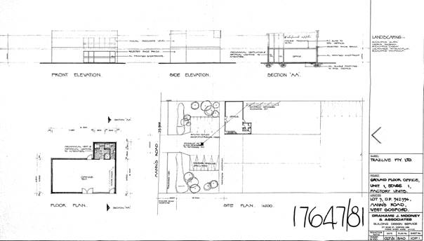
Figure 10: Approved Plans DA/17647/81. Source sourced 11 August 2024
Under DA/79146/94, the office was later absorbed into a larger development for ‘seven factory bays’ with the former office then forming part of Unit 1. This DA was approved with 18 car parking spaces, 6 spaces within the frontage and 12 spaces in the rear yard, together with a loading dock and extensive landscaping (see Figure 11 and 12).
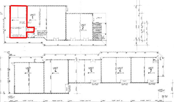
Figure 11: Approved Plans DA/79146/94 with the subject premises identified in red. Sourced 24 June 2024
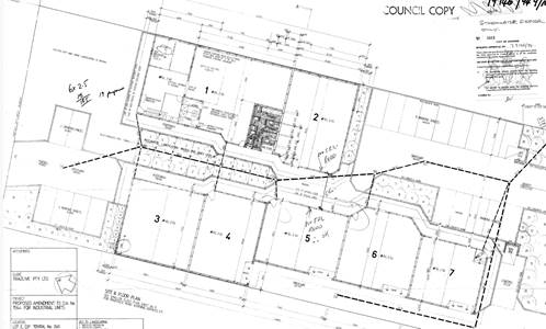
Figure 12: Approved Plans DA/79146/94. Sourced 24 June 2024
Former parking in front of Unit 1 is shown as removed under this plan and replaced with 2 spaces (see Figure 12).
However, aerial photographs from 2015 (see Figure 13) demonstrates the areas in front of the eastern and western buildings are devoted to carparking. In addition, Units 4 – 6 approved under DA/79146/94, were never constructed. This remains the situation today.
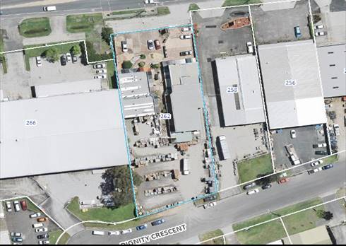
Figure 14: Aerial photograph 2015. Source AAM Pty Ltd. Sourced 25 June 2024
Within both buildings there are vacant tenancies, but the floor areas and last known uses of these tenancies are not known. However, as identified, the proposed use generates a maximum of 4 carparking spaces and is likely to generate less parking than a normal shop given it is a specialty shop and predominantly involves online retail sales. Five spaces have been provided.
In addition, the site is located within the same lot as the western building, which has an estimated 6 – 8 spaces within its front setback, and 1-3 cars are also parked within the TfNSW strip of land to the north. It is anticipated that carparking for the various tenancies could be utilised flexibly, which reduces the risk of displacing carparking to surrounding streets.
Councils Engineer supports the carparking scheme. However, they have advised that the use of the sixth space for car-parking (see Figure 7) would result in blocking other spaces. A condition of consent will ensure that the 5 row car parking spaces are provided.
Section 4.15(1) (iiia) any planning agreement
There are no planning agreements applicable to the subject site or proposed development.
Section 4.15(1)(a)(iv) any matters prescribed by the regulations.
• Environmental Planning and Assessment Regulations 2021 (Regs)
The Environmental Planning and Assessment Regulation 2021 applies to all development applications regarding such items as application type, compulsory contributions, notification of development applications and a range of many other details regarding development application requirements.
There are no specific matters under the Regulation that require further discussion.
Likely Impacts of the Development:
a) Built Environment
An assessment of the aspects of the proposed development on the built environment has been undertaken in terms of DCP compliance. The proposed restricted premises will be compatible with the character and amenity of the locality and streetscape and adjacent land uses. The proposal will achieve the objectives of Chapter 2.11.
To improve the appearance of the building, the existing redundant signage and north and west facing awning, which has been completed in multiple colours as part of a former use, will be conditioned to be removed and repainted.
b) Safety, security, and crime prevention
The proposal provides a Plan of Management that indicates that security measures, such as an internal lobby, and CCTV, being made available to the premises. These will form conditions of consent.
c) Social impacts
The proposal is in a suitable location that is a significant distance from any residential premises, licensed premises, other restricted premises and uses associated with children.
All other relevant issues regarding the likely impacts of the development have been discussed throughout this report. It is considered that the property is suitable for a restricted premises (sex shop).
Suitability of the Site for the Development
Based upon the site’s location, parking provision, permissibility within the zone, social impact and impact upon the built environment, the site is considered suitable.
Public Submissions
The application was advertised in accordance with CCDCP 2022, Chapter 1.2 Notification of Development Proposals, from 15 December to 22 January 2024 with no submissions received. The application was renotified from 24 May to 7 June 2024 to ensure the correct description of development was conveyed to the public. No submissions were received.
The Public Interest
Having regard to the above assessment it is considered that the proposal is in the public interest.
Other Relevant Considerations
Contributions
Contributions do not apply to the proposed development as the cost of works do not meet the threshold.
Political Donations
During assessment of the application there were no political donations declared by the applicant, applicant’s consultant, owner, objectors and/or residents.
Referrals
The following internal consultation was undertaken:
|
Internal Referral Body |
Comments |
|
Engineer |
Supported, subject to conditions |
|
Building Surveyor |
Supported. |
The following external consultations were undertaken:
|
External Referral Body |
Comments |
|
NSW Police |
No objections |
Conclusion:
The subject application has been assessed under the heads of consideration of section 4.15 of the Environmental Planning and Assessment Act 1979 and in accordance with all relevant instruments and policies. The site is considered suitable for the proposed development. Accordingly, the application is recommended for approval pursuant to section 4.16 of the Environmental Planning and Assessment Act 1979 for the following reasons:
1. The proposal is satisfactory having regard with the relevant environmental planning instruments, plans and policies.
2. Having regard for Sections 2.8, 2.11 and 2.12 of State Environmental Planning Policy (Resilience & Hazards) 2021, the Panel can be satisfied that the proposed development is designed, sited, and will be managed to avoid an adverse impact referred to in s.2.8(1) and s.2.11(1), and the development is not likely to cause increased risk of hazards on the subject site or other land.
3. The Panel can be satisfied that the land is suitable for the proposed development and does not include land referenced in section 4.6(4) of the State Environmental Planning Policy (Resilience and Hazards) 2021 nor does it involve a change of use of the land that warrants a preliminary site investigation. Accordingly, the development is satisfactory having regard for the provisions of section 4.6 of the same SEPP.
4. Having regard for the prerequisite conditions to the granting of consent under the Central Coast Local Environmental Plan 2022, the Panel can be satisfied that:
o Clause 5.21 – Flood Planning
The proposed development:
a) Is compatible with the flood function and behaviour on the land, and
b) Will not adversely affect flood behaviour in a way that results in detrimental increases in the potential flood affectation of other development or properties, and
c) Will not adversely affect the safe occupation and efficient evacuation of people or exceed the capacity of existing evacuation routes for the surrounding area in the event of a flood, and
d) Incorporates appropriate measures to manage risk to life in the event of a flood and
e) Will not adversely affect the environment or cause avoidable erosion, siltation, destruction of riparian vegetation or a reduction in the stability of riverbanks or watercourses.
environment in the event of a flood.
o Clause 7.1 -Acid Sulfate Soils
The proposed development will not involve any works more than 1m below the natural ground surface or by which the water table is likely to be lowered.
o Clause 7.6 – Essential services
All services essential for the proposed development remain available to the subject site.
5. The proposed development satisfies the provisions of State Environmental Planning Policy (Industry and Employment) 2021, Chapter 3 Advertising and Signage.
6. The proposal has been considered against the objectives of the E4 zone and has been found to be satisfactory.
7. The proposal is considered satisfactory in relation to Central Coast Development Control Plan 2022, Chapter 2.13 – Transport and Parking.
8. The proposal is considered satisfactory in relation to the relevant requirements of Development Control Plan 2022, Chapter 2.11 Restricted Premises and Sex Services Premises.
9. The proposal is considered satisfactory regarding the amenity of surrounding development.
10. The proposed development is considered suitable within the context of the site and surrounding development.
11. There are no significant issues or impacts or impacts identified with the proposal under section 4.15 of the Environmental Planning and Assessment Act 1979 and no submissions have been received.
|
1⇩ |
Appendix A Draft Conditions / Reasons |
|
D16302838 |
|
2⇩ |
Site Plan - 262 MANNS ROAD WEST GOSFORD 2250 - PAN-391406 - DA/2267/2023.pdf |
|
D15959878 |
|
3⇩ |
Signage Plan - 262 MANNS ROAD WEST GOSFORD 2250 - PAN-391406 - DA/2267/2023.pdf |
|
D15959879 |
|
4⇩ |
Shop Front Signage Plans - 262 MANNS ROAD WEST GOSFORD 2250 - PAN-391406 - DA/2267/2023.pdf |
|
D15959880 |
|
5⇩ |
Floor Plans - 262 MANNS ROAD WEST GOSFORD 2250 - PAN-391406 - DA/2267/2023.pdf |
|
D15959881 |
|
6⇩ |
PUBLIC - Statement of environmental effects - 262 MANNS ROAD WEST GOSFORD 2250 - PAN-391406 - DA/2267/2023.pdf |
|
D15959890 |
|
7⇩ |
PUBLIC - Operation Management Plan West Gosford - 262 MANNS ROAD WEST GOSFORD 2250 - PAN-391406 - DA/2267/2023 |
|
D15967444 |
|
3.2 |
DA/2267/2023 - 262 Manns Road, West Gosford - Change of Use to Restricted Premises (Sex Shop) - internal alterations & signage |
|
Attachment 1 |
Appendix A Draft Conditions / Reasons |
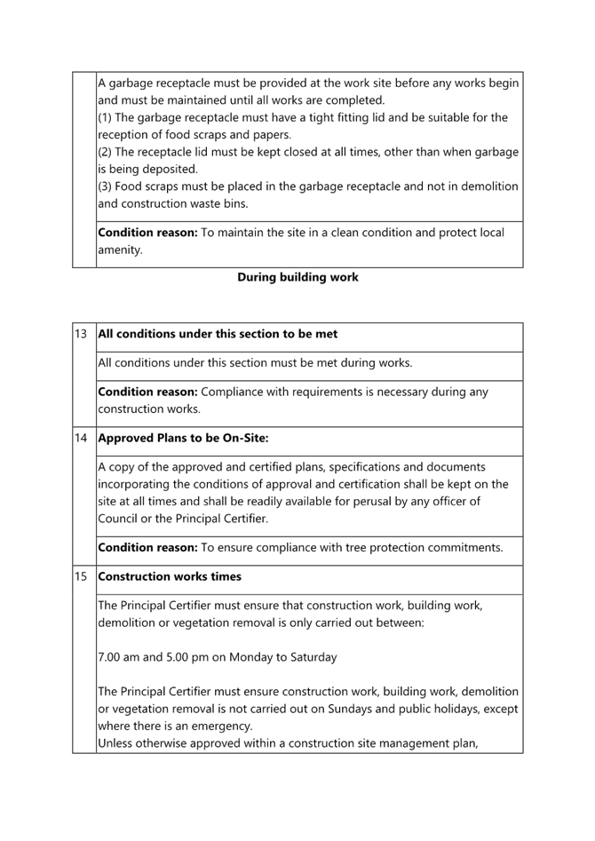
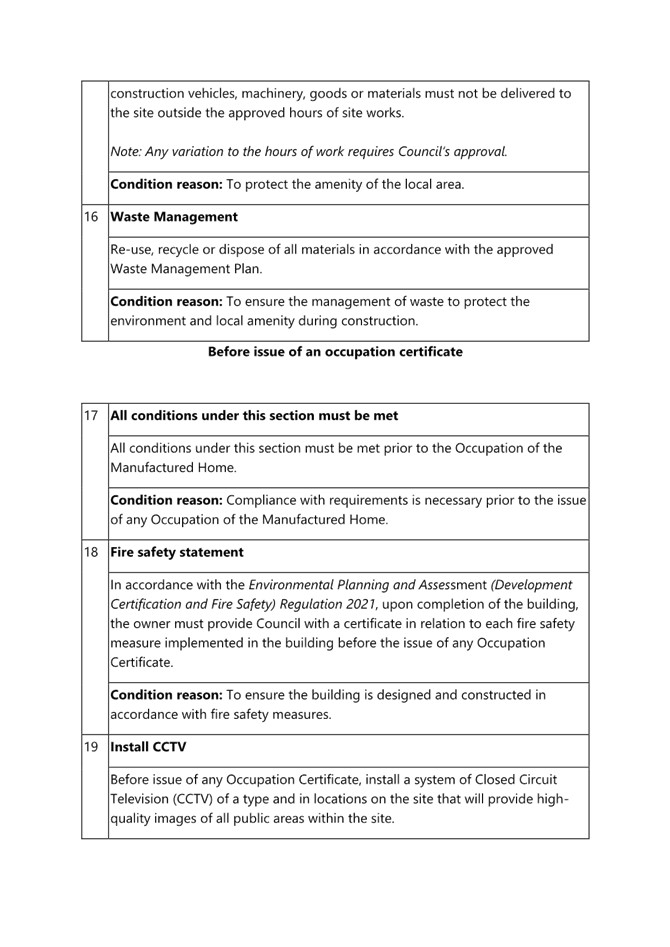
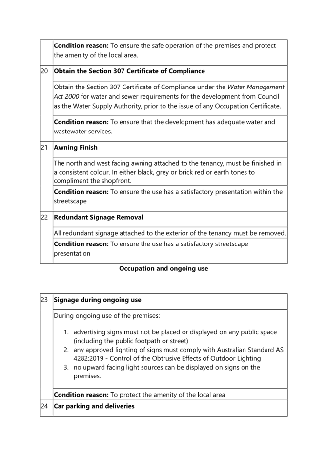
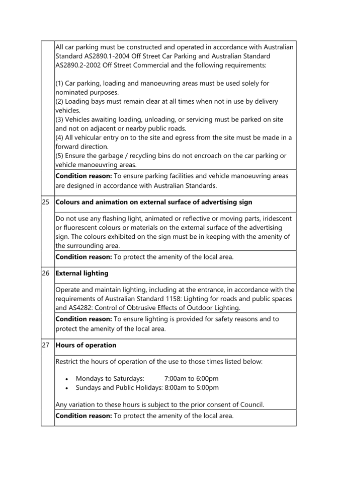
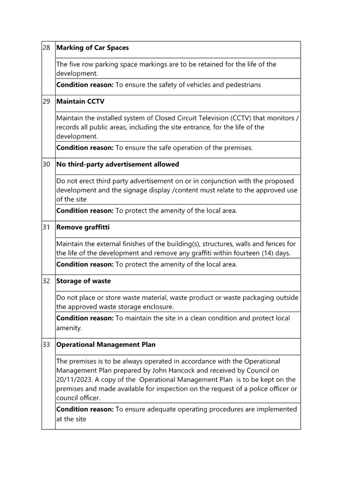
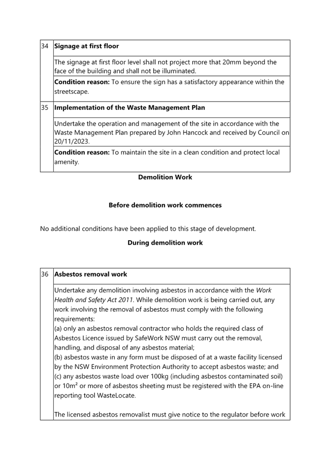

|
DA/2267/2023 - 262 Manns Road, West Gosford - Change of Use to Restricted Premises (Sex Shop) - internal alterations & signage |
|
|
Attachment 2 |
Site Plan - 262 MANNS ROAD WEST GOSFORD 2250 - PAN-391406 - DA/2267/2023.pdf |
|
3.2 |
DA/2267/2023 - 262 Manns Road, West Gosford - Change of Use to Restricted Premises (Sex Shop) - internal alterations & signage |
|
Attachment 3 |
Signage Plan - 262 MANNS ROAD WEST GOSFORD 2250 - PAN-391406 - DA/2267/2023.pdf |
|
3.2 |
DA/2267/2023 - 262 Manns Road, West Gosford - Change of Use to Restricted Premises (Sex Shop) - internal alterations & signage |
|
Attachment 4 |
Shop Front Signage Plans - 262 MANNS ROAD WEST GOSFORD 2250 - PAN-391406 - DA/2267/2023.pdf |
|
3.2 |
DA/2267/2023 - 262 Manns Road, West Gosford - Change of Use to Restricted Premises (Sex Shop) - internal alterations & signage |
|
Attachment 5 |
Floor Plans - 262 MANNS ROAD WEST GOSFORD 2250 - PAN-391406 - DA/2267/2023.pdf |
|
3.2 |
DA/2267/2023 - 262 Manns Road, West Gosford - Change of Use to Restricted Premises (Sex Shop) - internal alterations & signage |
|
Attachment 6 |
PUBLIC - Statement of environmental effects - 262 MANNS ROAD WEST GOSFORD 2250 - PAN-391406 - DA/2267/2023.pdf |