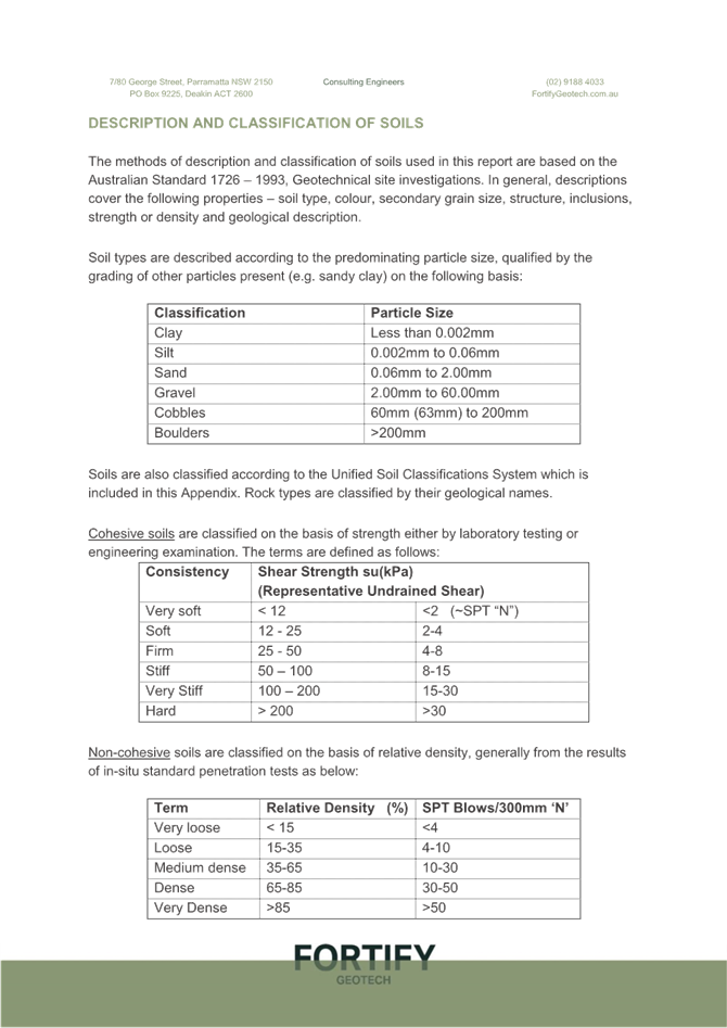
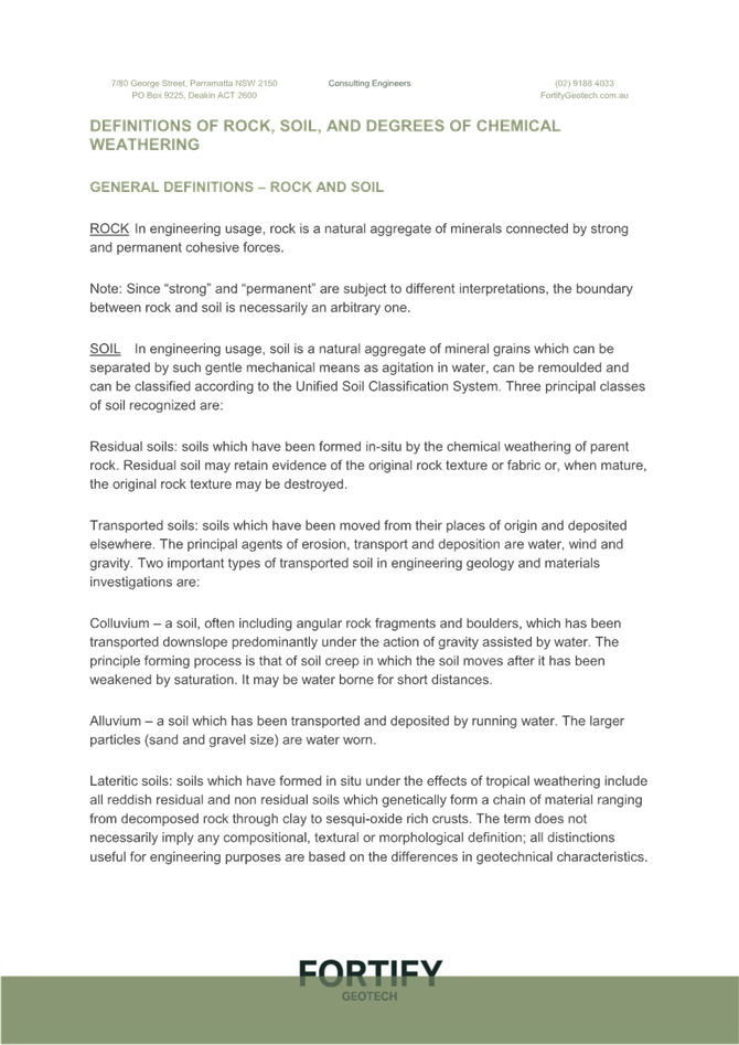
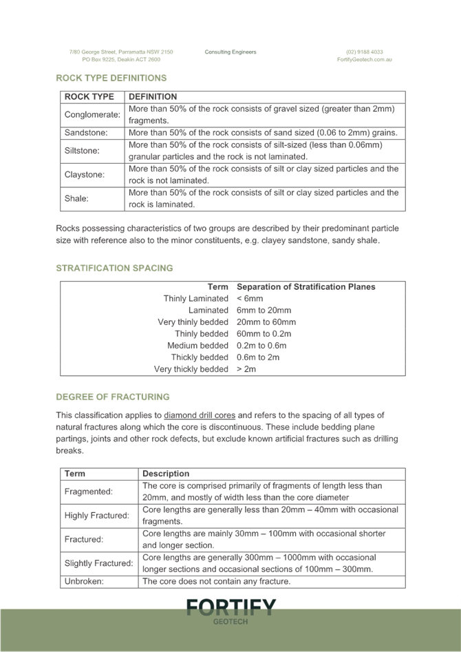
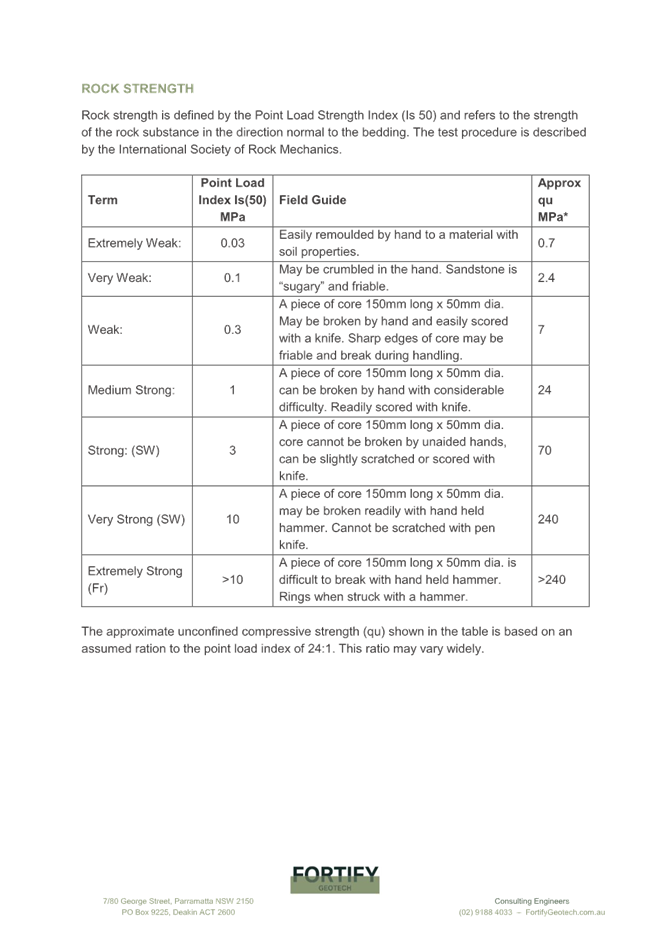
 |
Central Coast
Local Planning Panel Meeting
Business Paper
28 November 2024
 |
|
Central Coast
Local Planning Panel Meeting
Business Paper
28 November 2024
|
The Local Planning Panel Meeting
of Central Coast
will be held remotely - online,
Thursday 28 November 2024 at 2.00 pm,
for the transaction of the business listed below:
1 Procedural Items
1.1 Disclosures of Interest.............................................................................................................................. 3
2 Confirmation of Minutes of Previous Meetings
2.1 Confirmation of Minutes of Previous Meeting................................................................................. 4
3 Planning Reports
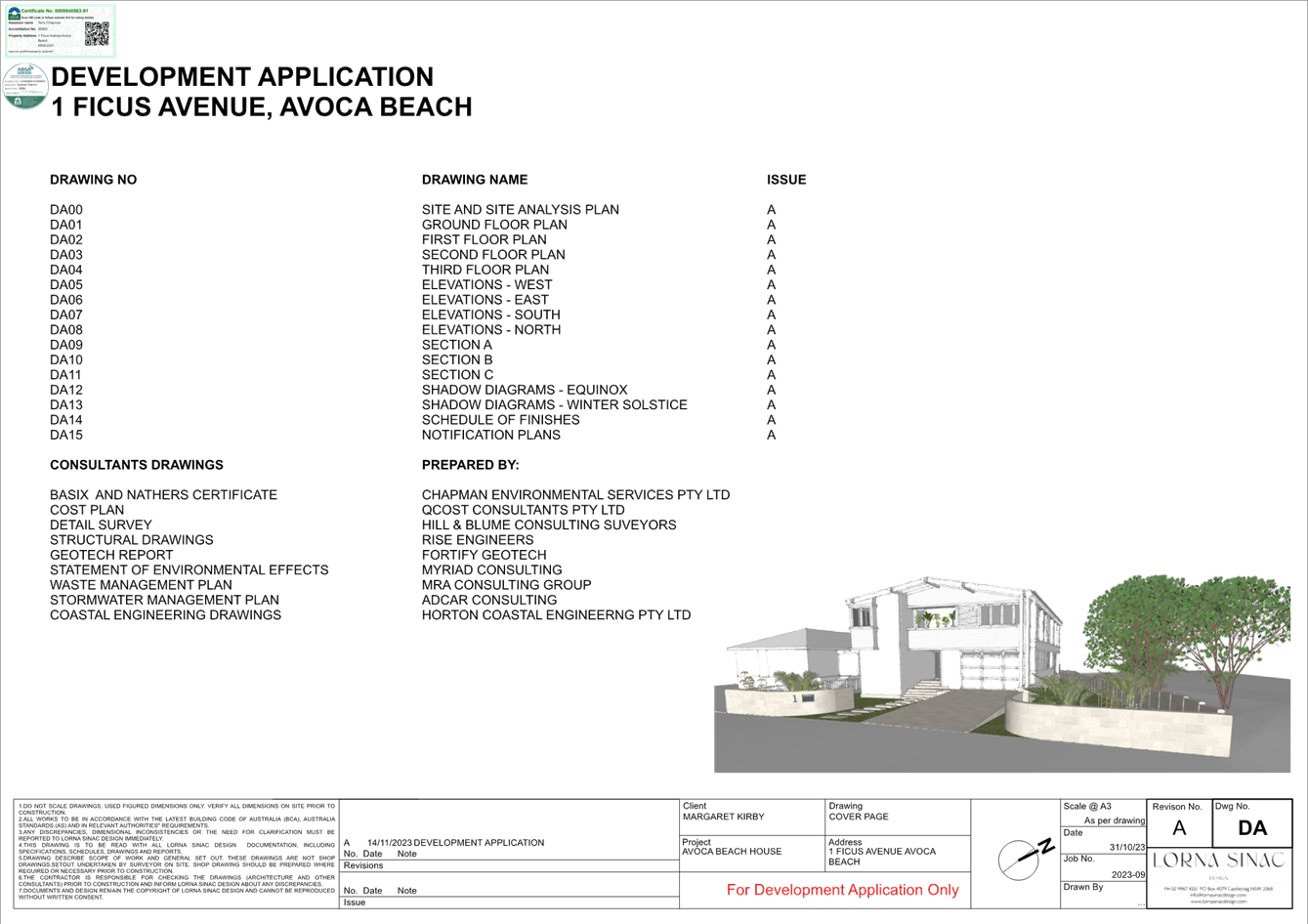
3.1 DA/2304/2023 - 1 Ficus Avenue Avoca Beach - Demolition of Existing Dwelling House and the erection of a two storey Dwelling House with roof terrace......................................................... 9
4 Reports
4.1 Operation of the Local Planning Panel in 2025........................................................................... 191
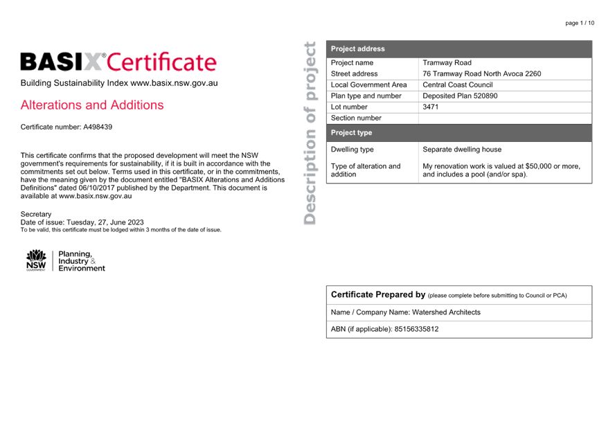
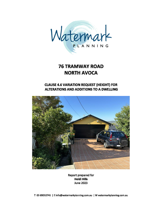
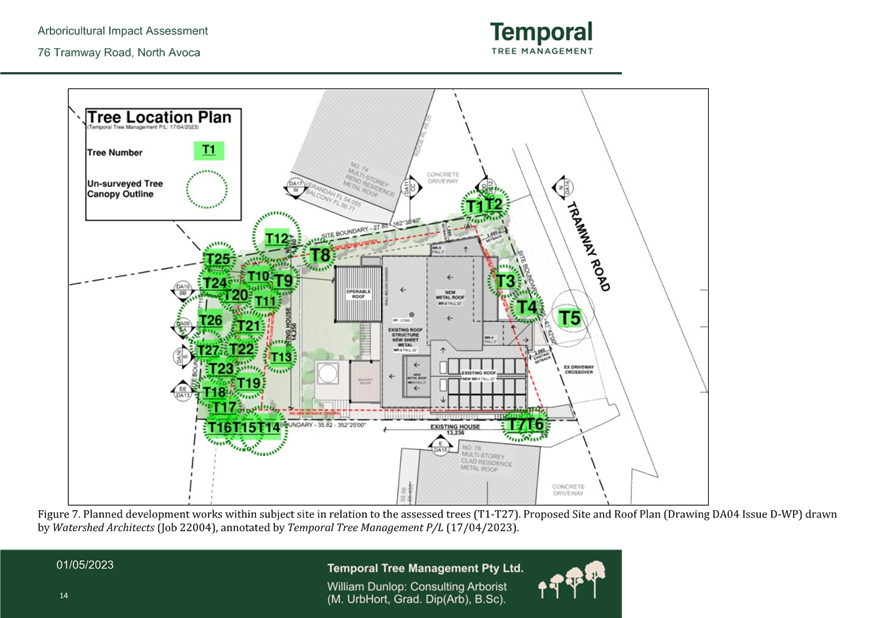
4.2 DA/1355/2023 - 76 Tramway Road, North Avoca - Alterations and additions to an existing residential dwelling............................................................................................................................... 194
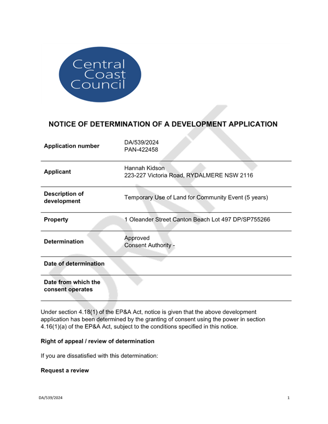
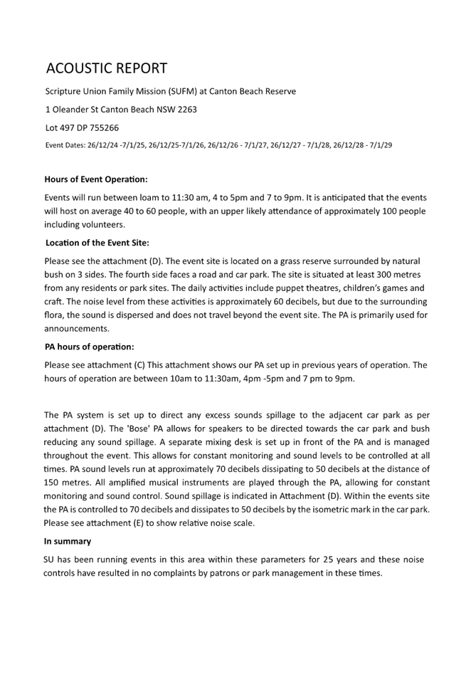
4.3 DA/539/2024 - 1CR Oleander Street, CANTON BEACH - Temporary Use of Land for Community Event (5 years)........................................................................................................................................ 411
5 Confidential Items
5.1 Land and Environment Court Proceedings Class 1 - Central Coast Council ats The Trustee for Vicary Family Trust Case 2024/00237002 - Appeal of Deemed Refusal of DA/2209/2023 - 75 Ocean View Drive Wamberal
The reason for dealing with the report confidentially is that it contains advice concerning litigation, or advice that would otherwise be privileged from production in legal proceedings on the ground of legal professional privilege.
Jason Perica
Chairperson
|
Item No: 1.1 |
|
|
Title: Disclosures of Interest |
|
|
Department: Governance |
|
|
28 November 2024 Local Planning Panel Meeting |
|
Reference: F2020/02502 - D14205789
|
The NSW Local Planning Panel Code of Conduct states that all panel members must sign a declaration of interest in relation to each matter on the agenda before or at the beginning of each meeting.
|
That Panel Members now confirm that they have signed a declaration of interest in relation to each matter on the agenda for this meeting and will take any management measures identified.
|
Item No: 2.1 |
|
|
Title: Confirmation of Minutes of Previous Meeting |
|
|
Department: Corporate Services |
|
|
28 November 2024 Local Planning Panel Meeting |
|
Reference: F2020/02502 - D16528443
Author: Lisa Martin, Civic Support Officer Civic Support
|
Summary
The
Minutes of the following Meeting of the Local Planning Panel, which have been
endorsed by the Chair of that meeting, are submitted for noting: · Local Planning Panel Meeting held on 14 November 2024
|
That the minutes of the previous Local Planning Panel Meeting held on 14 November 2024, which were endorsed by the Chair of that meeting, are submitted for noting.
|
1⇩ |
MINUTES - Local Planning Panel - 14 November 2024 |
|
D16516377 |
|
2.1 |
Confirmation of Minutes of Previous Meeting |
|
Attachment 1 |
MINUTES - Local Planning Panel - 14 November 2024 |
|
Item No: 3.1 |
|
|
|
|
|
Department: Environment and Planning |
|
|
28 November 2024 Local Planning Panel Meeting |
|
Reference: DA/2304/2023 - D16499955
Author: Stephen Goodworth, Senior Building Surveyor
Manager: Wayne Herd, Section Manager Building Assessment and Certification
Executive: Andrew Roach, Unit Manager. Development Assessment
Summary
An application has been received for New Dwelling House & Demolition of the existing Dwelling House and associated Structures. The application has been examined having regard to the matters for consideration detailed in section 4.15 of the Environmental Planning and Assessment Act 1979 and other statutory requirements with the issues requiring attention
and consideration being addressed in this report.
This development application is required to be reported to the Local Planning Panel due to the number of submissions, with 12 submissions by way of objection received at the conclusion of the notification period.
The application is recommended for refusal.
Applicant Lorna Sinac
Owner MAK 3 NSW Pty Ltd
Application No DA/2304/2023
Description of Land Lot 23 DP 20094. 1 Ficus Avenue, Avoca Beach
Proposed Development New Dwelling House & Demolition of Existing Dwelling House and ancillary structures
Site Area 1082.8sqm (by survey) and 1081sqm (by DP)
Zoning R2 Low Density Residential
Existing Use Dwelling House
Employment Generation No
Estimated Value $4,733,110
Conflict of Interest The staff responsible for the preparation of the report, recommendation or advice to any person with delegated authority to deal with the application have no pecuniary conflict of interest or non-pecuniary conflict of interest to disclose in respect of the application.
2 That Council advises those who made written submissions of the Panel’s decision.
Key Issues
1. Setback of proposed two storey dwelling from Avoca Lake and inadequate design response to edge of Lake (during periods of full or near full capacity) formed by grassed edge.
2. Proposed rear setbacks of dwelling following the pattern of rear setbacks of other dwellings along the southern foreshore of the lake.
3. Setback of proposed northern portion of dwelling from public reserve (eastern side boundary)
4. Fencing and planting proposed within Lake during periods of full or near full capacity.
Reasons for not supporting the proposed development
In summary, it is recommended that the proposed development be refused for the following reasons, which are elaborated upon throughout the remainder of the report for the information of the Local Planning Panel:
1. The proposal is not acceptable in relation to the matters for consideration under section 4.15 of Environmental Planning and Assessment Act 1979.
2. The proposed development does not satisfy the provisions of State Environmental Planning Policy (Resilience and Hazards) 2021 having regard to the surrounding Coastal Environment and Coastal Use Areas as required to be taken into account under clause 2.10 and 2.11.
3. The Local Planning Panel cannot be satisfied, that granting consent would be in the public interest as the proposal is inconsistent with the objectives of the SEPP (Resilience and Hazards) 2021 and inconsistent with the objectives of the R2 Low Density Residential zone.
4. The proposal is inconsistent with the following objectives of the R2 Low Density Residential zone:
• To encourage best practice in the design of low density residential development.
• To maintain and enhance the residential amenity and character of the surrounding area.
5. The setting and location of the proposed dwelling house in relation to the established rear building alignment is inconsistent with the objectives within CCDCP 2022 Chapter 2.17 – Character of Scenic Quality and the related document to this DCP being the Character and Scenic Quality Statements of Avoca1: Ocean Beachfront – Desired Character Requirements.
6. The development results in unnecessary and reasonable adverse impacts when viewed from the neighbour’s land, public spaces and amenity of the area as a result of inconsistency with the established rear building alignment.
7. The proposal is inconsistent with various objectives within Parts 2.1.4.1 and 2.17 of Central Coast Development Control Plan 2022.
8. Both the surrounding predominant form in the area and the desired future character of the area favours a two-storey presentation at consistent rear setbacks to other residential building along the Avoca Lake frontage. The proposal is antipathetic to this form on a visually prominent site from public spaces around the lake, while the proposal (changed or new) could readily achieve form compliance and desirable congruity.
Precis:
|
Proposed Development |
Demolition of existing Dwelling house and erection of a new two Storey Dwelling house incorporating a roof top terrace. |
|
Permissibility and Zoning |
R2 – Low Density Residential under the provisions of the Central Coast Local Environmental Plan 2022 (CCLEP 2022)
The proposed development is defined as a Dwelling house which is permissible with consent in the zone. |
|
Current Use |
Dwelling house |
|
Integrated Development |
No |
|
Submissions |
The development application was notified (in accordance with the provisions of the Central Coast Development Control Plan 2022) from 9 February 2024 to 23 February 2024.
Twelve (12) submissions were received. |
Variations to Instruments and Policies
State Environmental Planning Policy (Resilience and Hazards) 2021
|
Section |
2.11 (1) (a) (i) – Existing safe access to and along the foreshore for members of the public, including persons with a disability |
|
Planning Control |
Consent authority to consider whether the proposed development is likely to cause an adverse impact on certain matters |
|
Departure basis |
The proposed location of landscaping and the rabbit proof fence, whilst positioned on their land, will impact on historical safe access along the southern foreshore of the lake during periods at full, or near full, capacity. |
|
Section |
2.11 (1) (c) consent authority to take into account the surrounding coastal and built environment, and the bulk, scale and size of the proposed development |
|
Planning Control |
Development on land within the coastal use zone |
|
Departure basis |
The proposed development will be inconsistent to the established rear building alignment of other nearby residential buildings when taking into account the surrounding built environment. In other words, the proposed rear alignment of the development will be inconsistent, and hence out of character, to the setting and pattern of other residential buildings located along the Avoca Lake foreshore. Furthermore, the setting of the dwelling (design characteristics) does not respond to the shoreline of the lake during periods when full, or near full to capacity, delineated by the natural curvature of the grassed edged embankment of the lake. |
Central Coast Local Environmental Plan 2022
|
Clause |
2.3 – Zone Objectives and land use table |
|
Planning Control |
Objectives for Zone R2 Low Density Residential |
|
Departure basis |
The 2 of the 5 objectives for Zone R2 Low Density Residential, have determined not to be satisfied being: · To encourage best practice in the design of low density residential development · To maintain and enhance the residential amenity and character of the surrounding area.
The proposal is not considered to be consistent with zone objectives dot points 3 & 5 based on the rear setback of the proposed dwelling not compatible with the establish rear alignment setback of other residential buildings along the southern foreshore of Avoca Lake and thus be out of character and not conforming to the residential amenity within this locality.
|
|
Clause |
2.1.3.1 e - Waterfront setback (Eastern side boundary) |
|
Planning Control |
6m setback (from property boundary) for ground storey 10m setback (from property boundary) for any storey above the ground storey. |
|
Departure basis |
Elements of the eastern external walls and attached structures do not run parallel to the eastern side boundary and therefore setbacks vary from its closest point of 1.6m upto 4.8m. (at both levels). This represents a variation of upto 8.4m or 84%. |
|
Clause |
2.1.4.1 Views |
|
Planning Control |
Sited and designed to enable a sharing of views with surrounding private properties, particularly from habitable rooms |
|
Departure basis |
The proposal to position the building further north and beyond the rear establish building line does not align to the principles of view sharing. |
Central Coast Development Control Plan 2022 Chapter 2.17.1 - Character and Scenic Quality
|
Part |
2.17.1 -Matters for consideration |
|
Planning Control |
Development applications are to demonstrate their consistency or compatibility with Character and Scenic Quality Statements incorporated as related documents to this DCP. |
|
Departure basis |
The setting and location of the proposed dwelling house in relation to the established rear building alignment is inconsistent with the objectives within CCDCP 2022 Chapter 2.17 – Character of Scenic Quality and the related document to this DCP being the Character and Scenic Quality Statements of Avoca1: Ocean Beachfront – Desired Character Requirements.
|
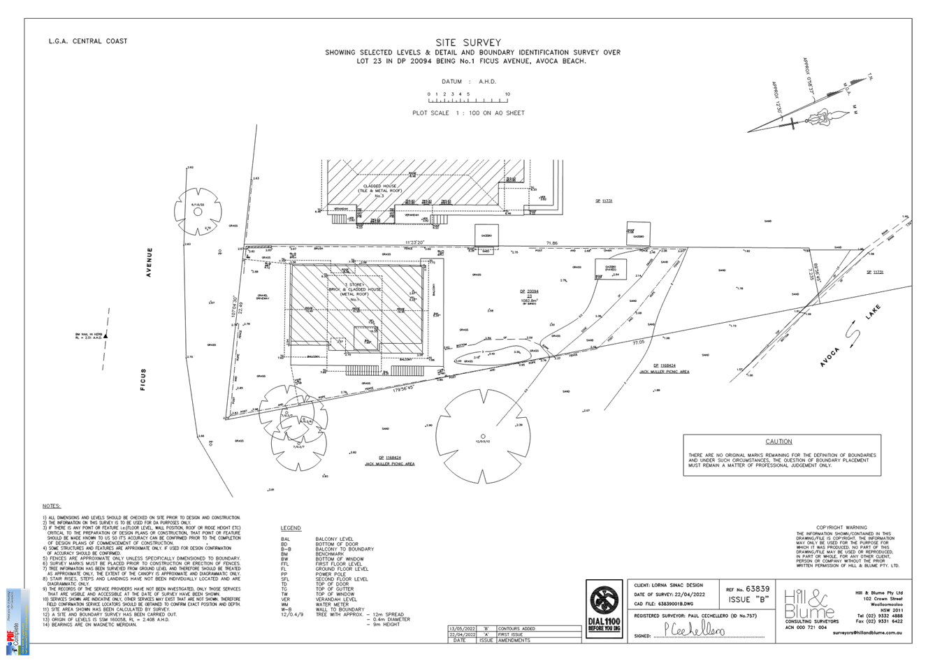
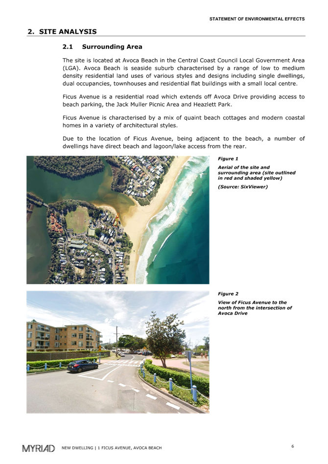
The Site
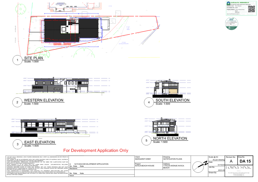
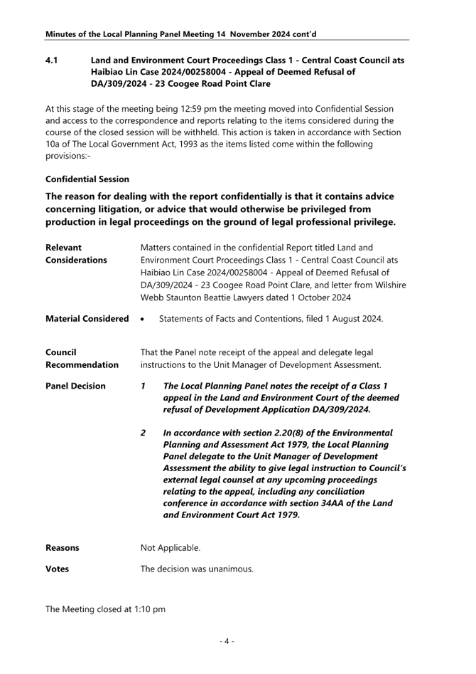
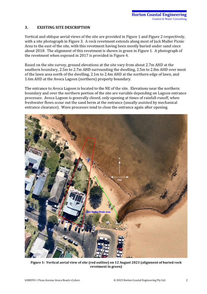
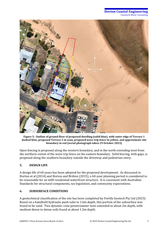
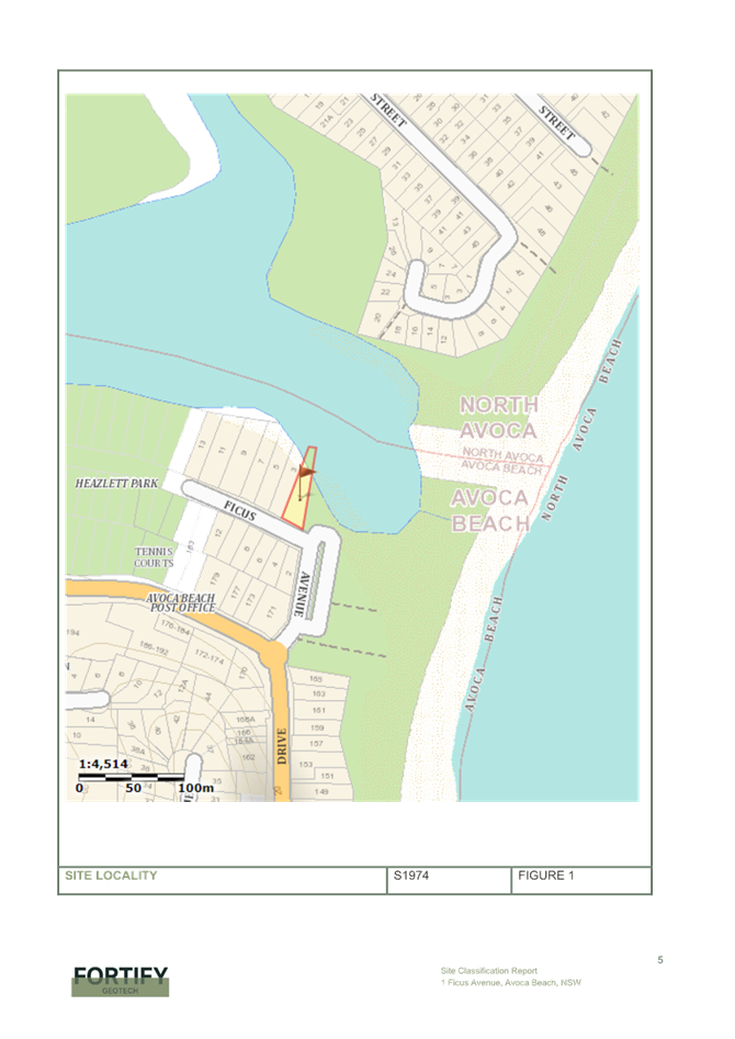
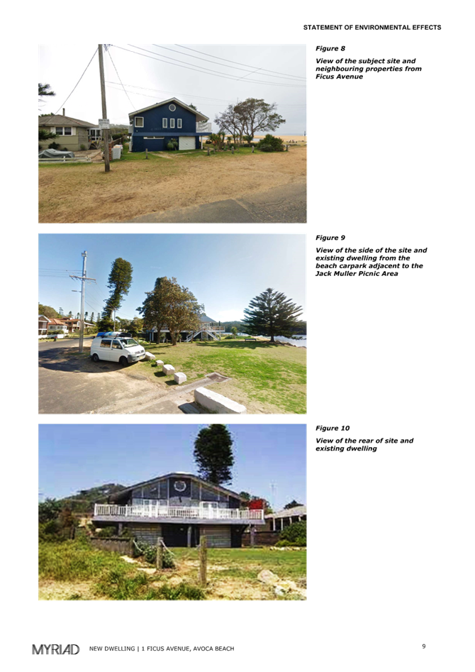
The site is a single lot legally identified as Lot 23 Deposited Plan No. 20094 (No 1 Ficus Avenue Avoca Beach). The site is 1081m2 in area (by DP) and generally rectangular in shape, narrowing towards the rear northern boundary, as illustrated in the aerial image of the land below.
The land is relatively level with ground surface levels (to AHD) of RL2.8m near the road frontage and RL2.5m near the northern grassed edge interfacing with Avoca Lake. The land is flood prone and subject to flood mitigation standards, including the requirement to have a minimum floor level for habitable spaces within the dwelling house of RL3.49m.
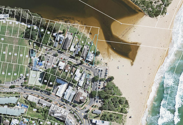
Figure 1 - Ariel Image of land and surrounds. – Source: GeoView 2020.
The waterbody known as Avoca Lake during periods at full, or close to full capacity flows across the rear portion of the land. It is estimated that approximately 250m2 of land area during these periods is submerged (i.e., forming part of the lake). The northern grass edge depicted within the aerial images of the land generally delineates the lake edge during these periods. The grassed edge also delineates the area of the land subject to Flood Precinct 4: High Hazard flooding.
Fences along the southern foreshore of the lake, where provided, are open (generally a rope and post arrangement) and are approx. aligned to the natural grassed edge of the lake during periods, when the lake is full. The local community based on a unique historic circumstance utilise and walk along the southern edge of the lake, across private land parcels, connecting the nearby open space (Heazlett Park) with the surf beach.
The land is not mapped or identified as being bushfire prone, however is mapped as Class 5 - Acid Sulfate Soils. The site does not contain any native vegetation or fauna habitat.
The land contains a dwelling house. The Statement of Environmental Effects submitted with this development application on page 8, describes the existing dwelling house to contain 6 bedrooms. An examination of the most recent development consent (BA41518/87) granted in April of 1987 references stamped approved architectural drawings for a 4-bedroom dwelling house. These drawings describe only spaces for car parking and a laundry room at ground level to withstand the effect of flooding. The additional two bedrooms of the described six bedroom dwelling are likely to be contained beneath the dwelling.
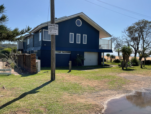
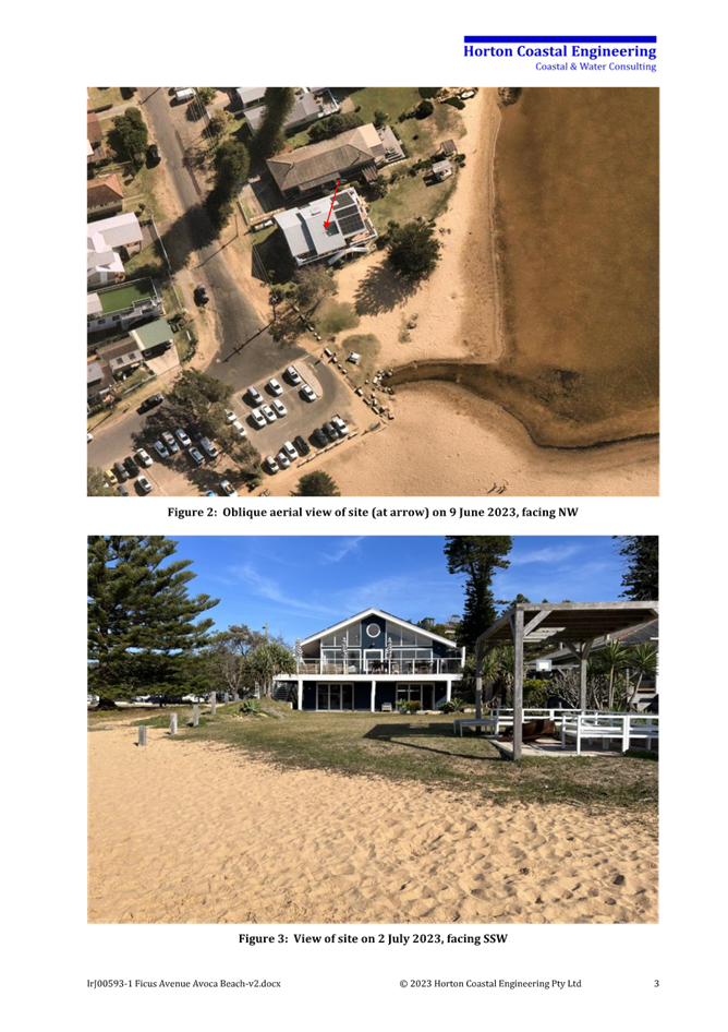
Figure 2 - Image taken of subject land from Ficus Ave. The existing blue in colour dwelling house is proposed to be demolished.
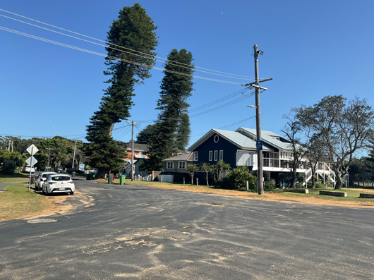
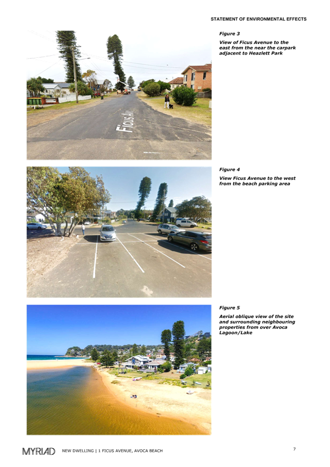
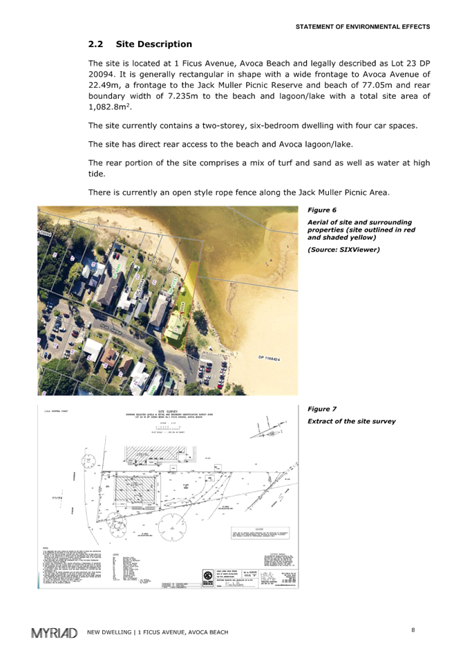
Figure 3 - Image taken SE of subject site near public carpark.
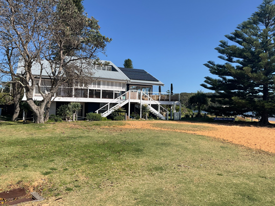
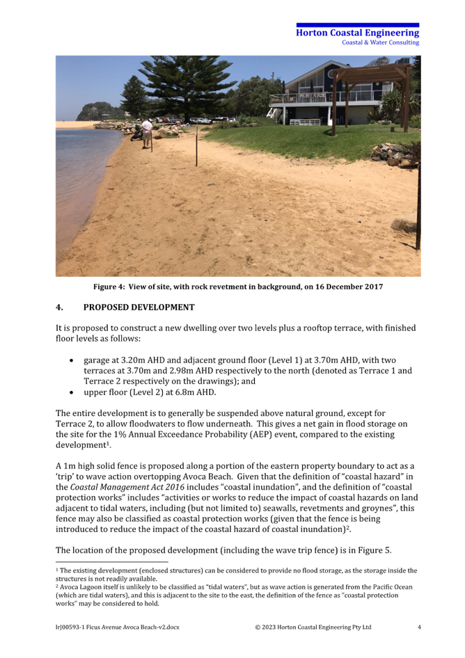
Figure 4 - image of subject site taken from Jack Muller Picnic Reserve
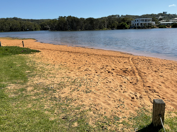
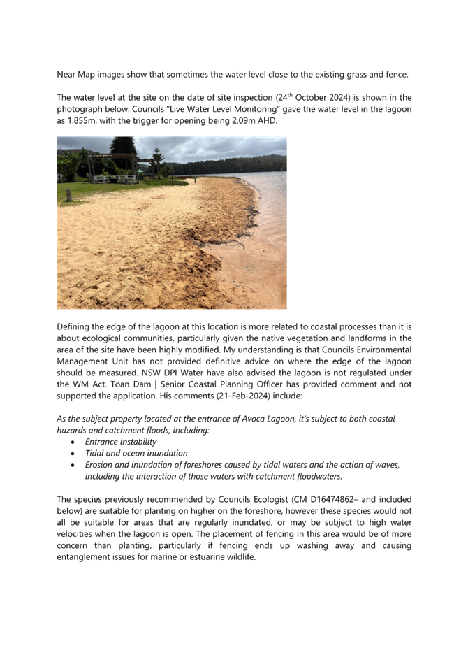
Figure 5 - Image taken (25/10/24) from northern portion of subject land viewing north. The lines marked in the sand do not represent the northern rear boundary of the site (it extends for a further 20ms) but rather illustrates the location of proposed landscaping and alignment of rabbit proof fence. Note: It also proposed to plant for a further 1.5ms to the north (lake side) of the north marked sand line.
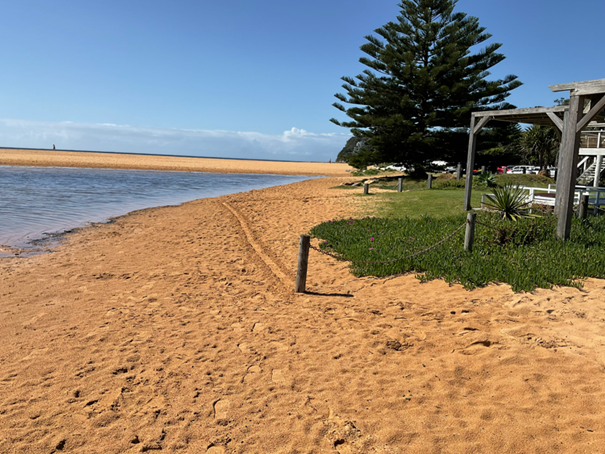
Figure 6 - Image taken (25/10/24) on adjacent western site viewing east towards the open surf beach. The lines marked in the sand represent the location of the rabbit proof fence. Landscaping is proposed to either side of the marked sand line. It is noted the land boundary extends from the post in the foreground on the same alignment as the chain /post fence for a further 16m (approx.) into the lake.
Surrounding Development
The adjoining land immediately to the west contains a building with 2 dwellings (originally 3) under a strata plan. The eastern adjoining land is Crown Land, under the control of Central Coast Council. A portion of the Crown Land forms Avoca Lake with the remainder a public reserve known as Jack Muller Picnic Area.
Within the vicinity of the subject land, developments compromise of dwelling houses and medium density residential unit developments.
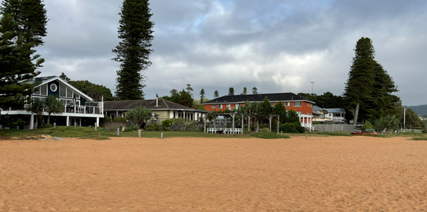
Figure 7 - Image taken (19/3/24) when water level in lake was lower than previous images. Photo taken from within bed of lake with subject site (blue clad dwelling with white trimmings) to left of photo.
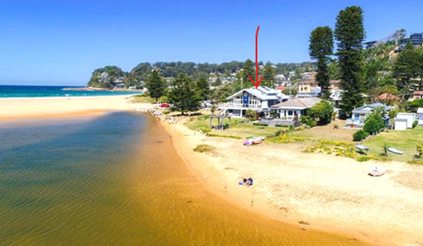
Figure 8 - Extract of image included within applicant’s SEE. The red arrow highlights the location of the subject site.
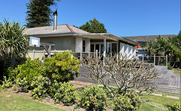
Figure 9 - image taken from northern portion of subject site viewing towards building (separated into2 dwellings) located on the western adjoining land.
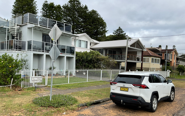
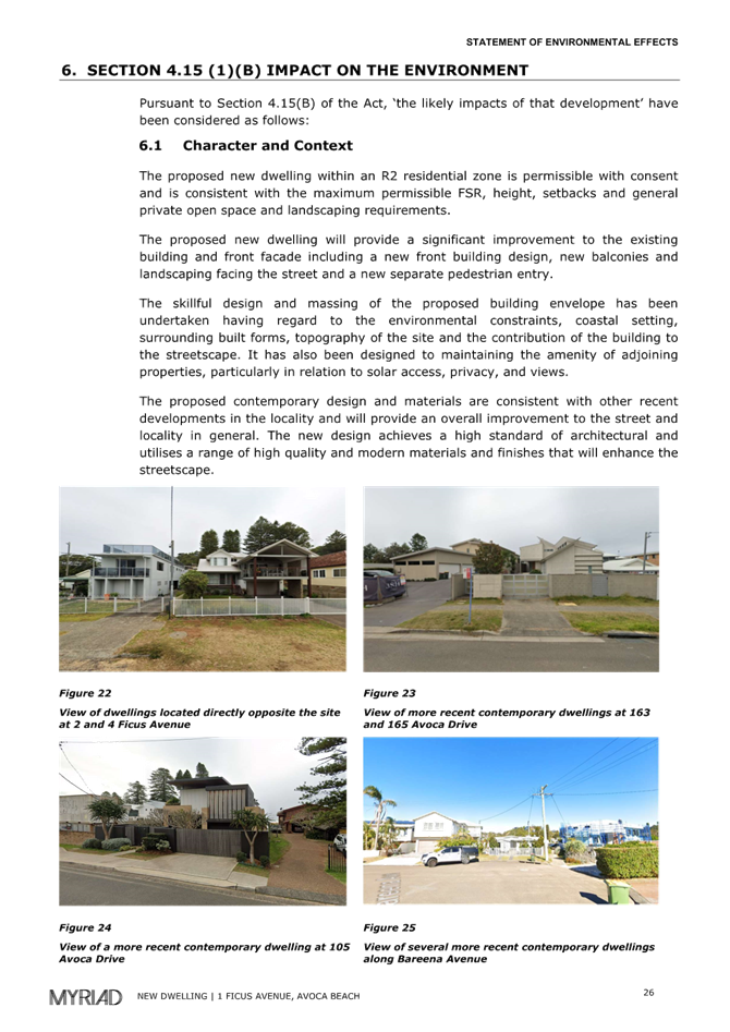
Figure 10 - image taken of developments directly opposite the subject site within Ficus Ave.
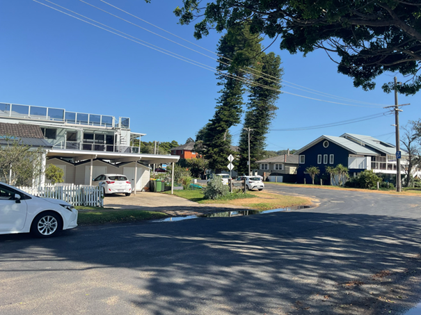
Figure 11 - Image taken to the south of the subject site illustrating heights and size of surrounding developments within the R1 land zone on the southern side of the Ficus Ave.
The Proposed Development
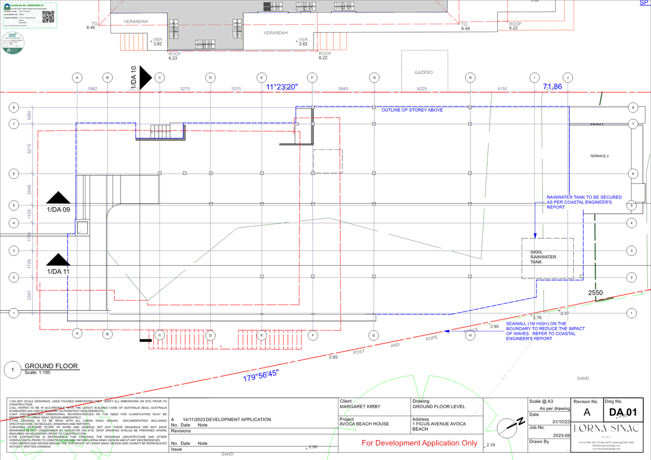
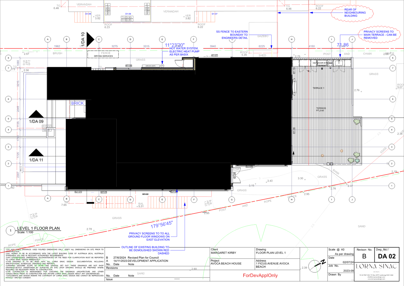
The development application seeks consent to demolish the existing dwelling and for the erection of a new two storey dwelling house. The ground floor level is proposed to be approximately 1m above the ground level at a floor level of 3.7mAHD to address flooding. The ground floor level contains living spaces, such as the kitchen, dining, TV, study and living rooms; as wells as service rooms including a store, laundry, WC, lift well and double garage. A large terrace, enclosed along its entire western side is proposed to the rear of the dwelling.
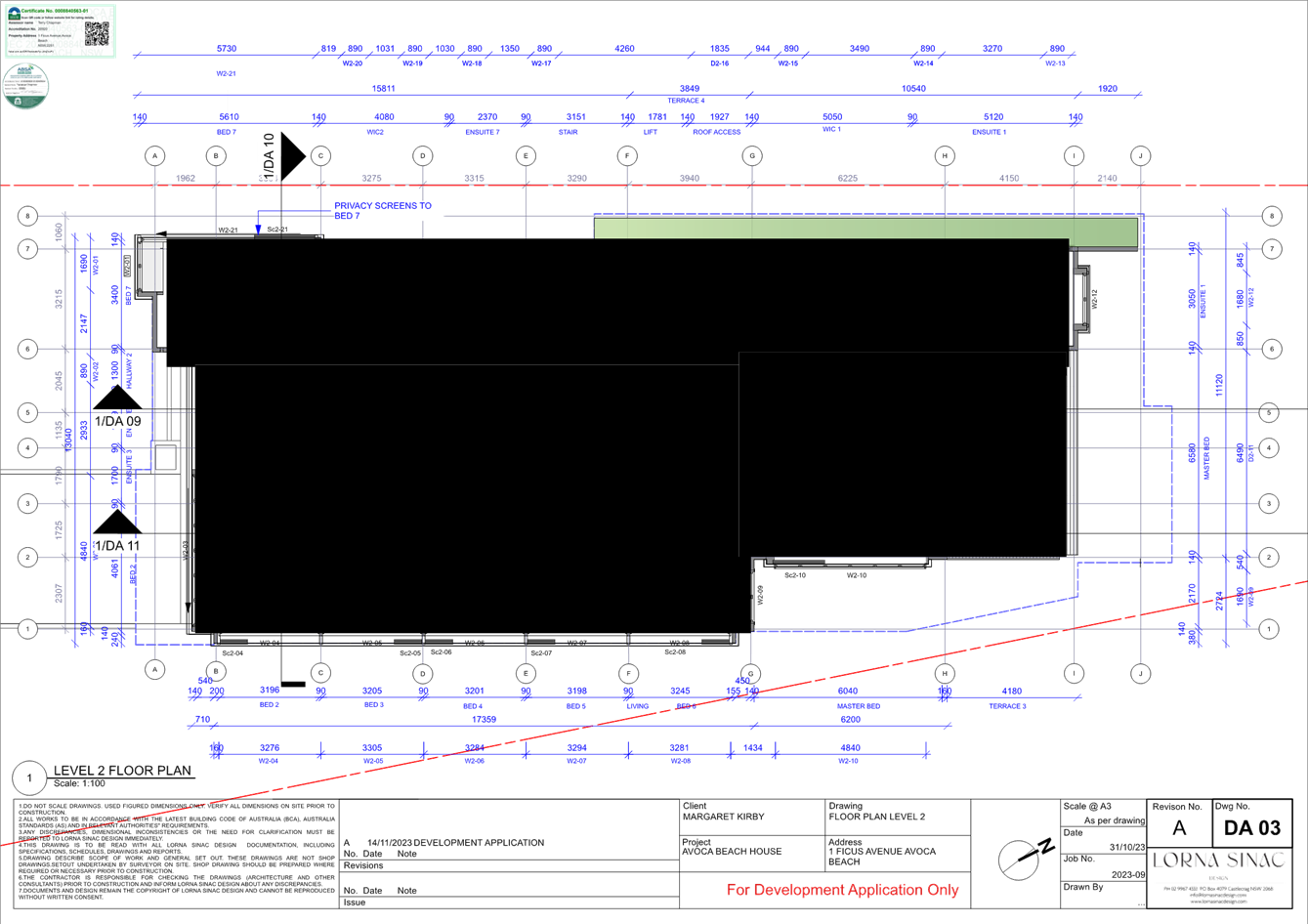
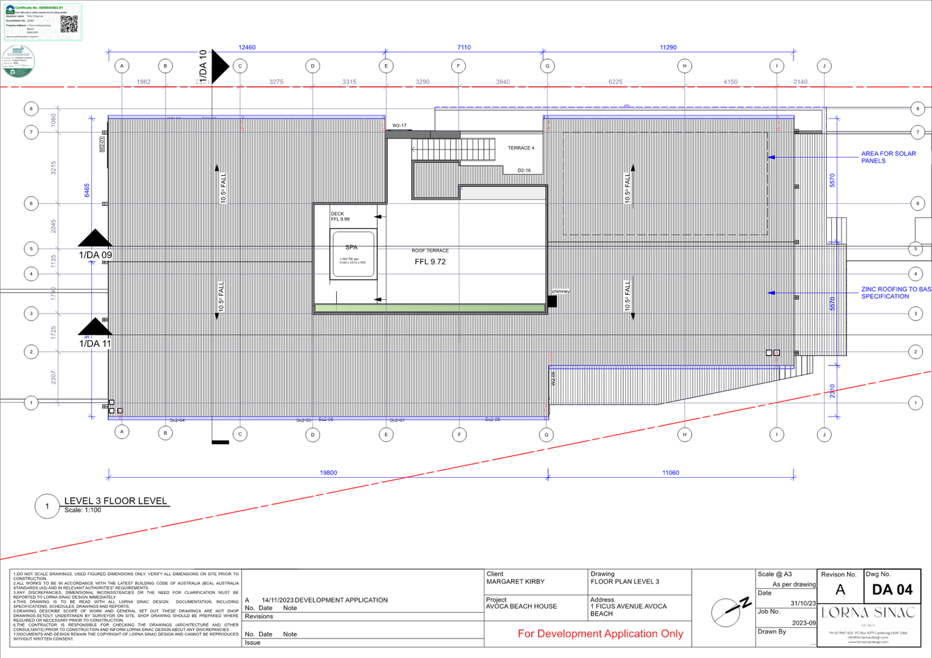
The first-floor level mainly contains the bedrooms, ensuites and Walk in Robes. There are 7 bedrooms proposed at this level, with each bedroom serviced by an ensuite. A large balcony is proposed for the master bedroom located at the rear of the dwelling. A smaller balcony is proposed along the western elevation. This balcony is a landing point for access to/from stairs leading to the roof terrace and roof spa.
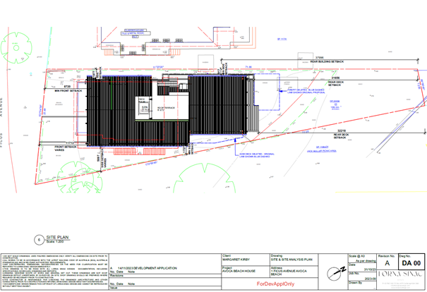
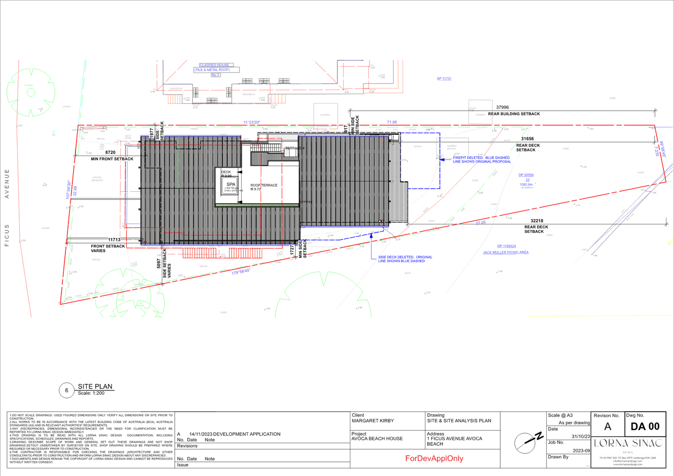
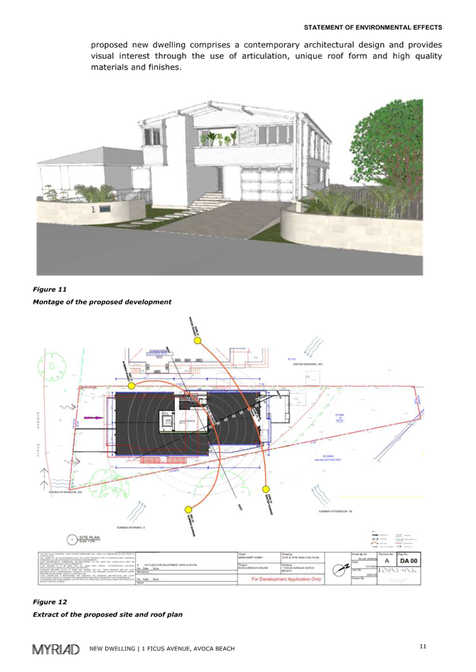
Figure 12 - extract of site plan
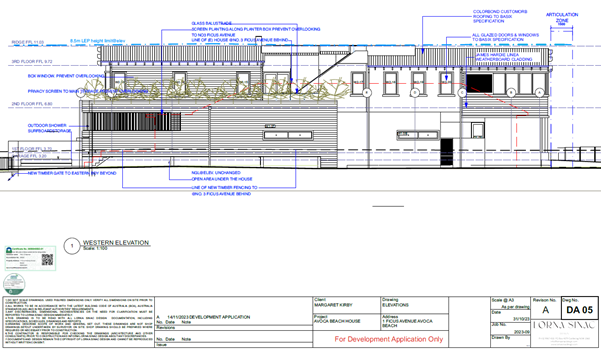
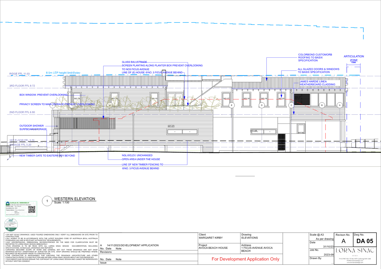
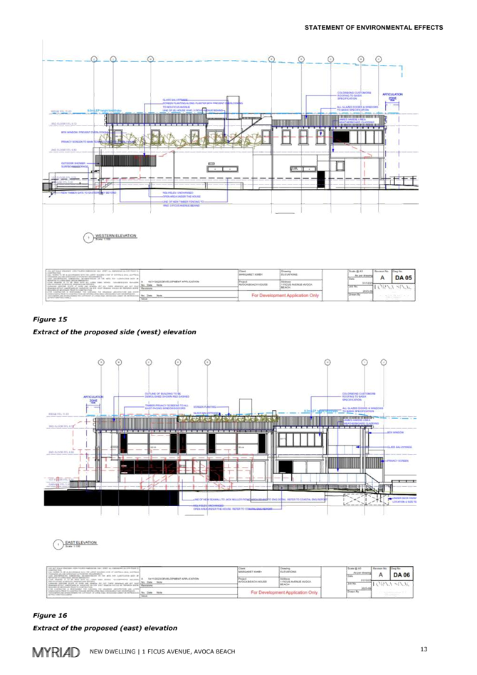
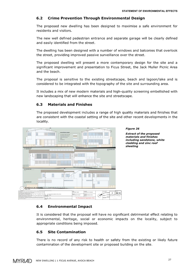
Figure 13 - extract of western side elevation
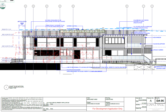
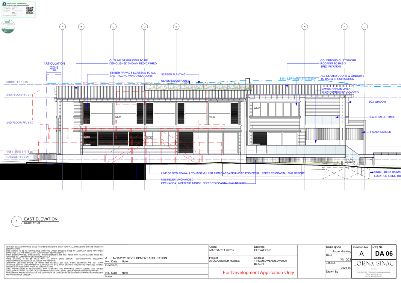
Figure 14 - Extract of eastern side elevation
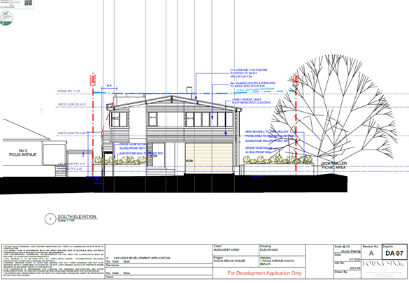
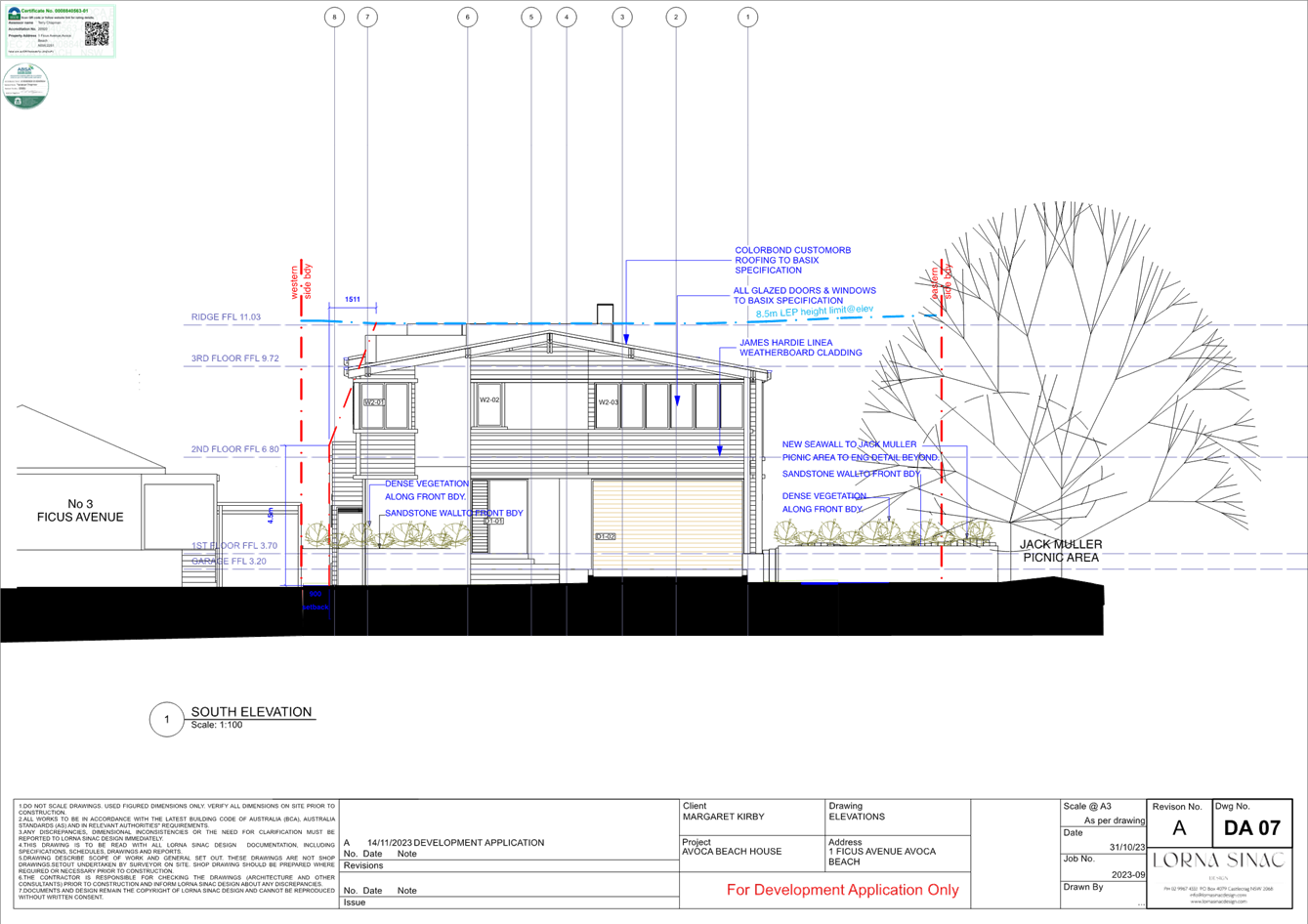
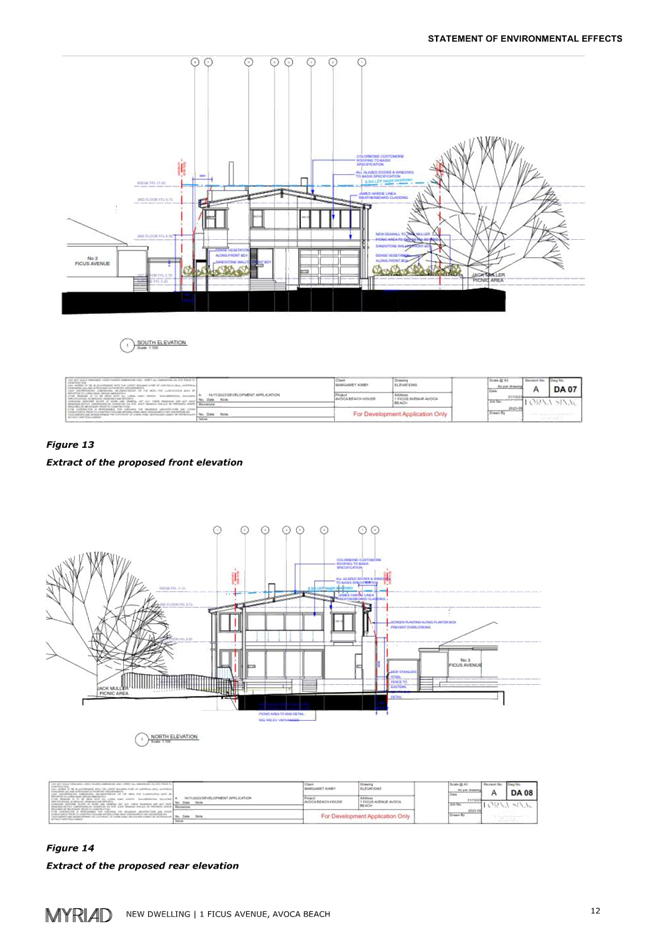
Figure 15 - Extract of southern street frontage elevation.
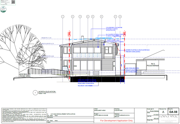
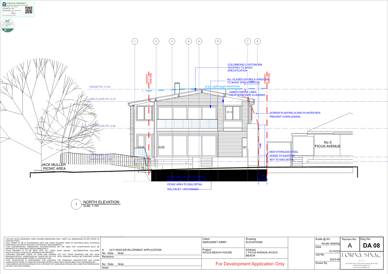
Figure 16 - Rear (Lake side) northern elevation
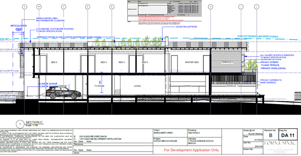
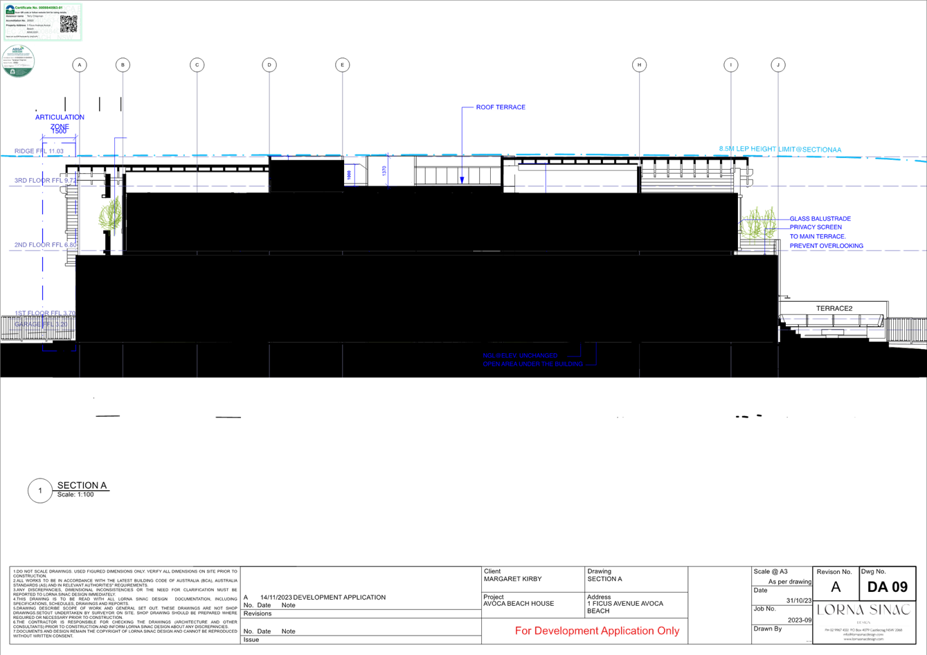
Figure 17 - Extract of section through proposed Dwelling House
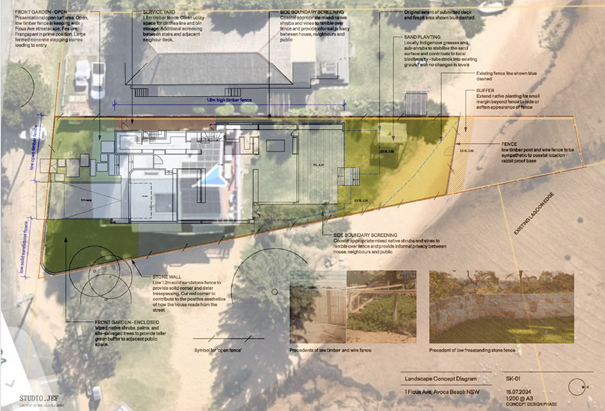
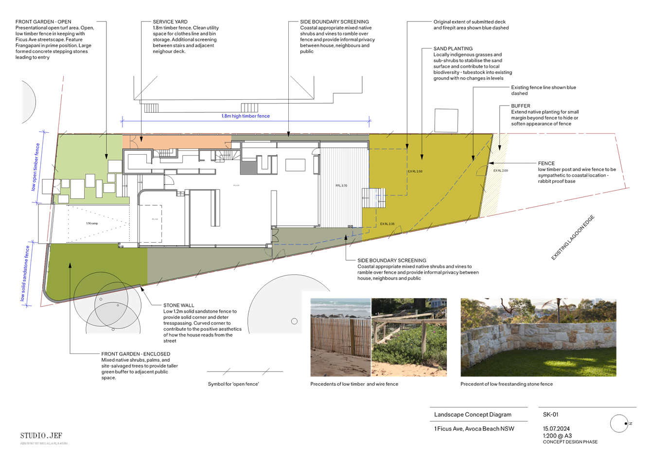
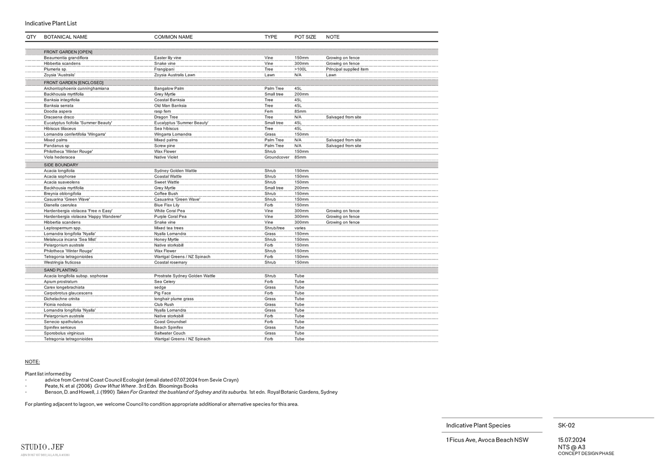
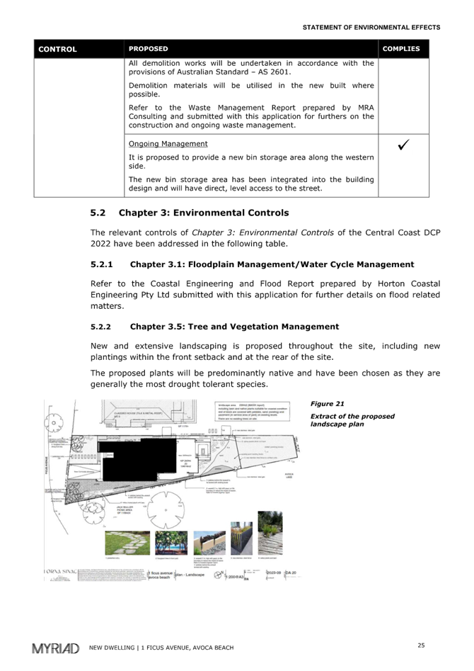
Figure 18 - Landscape design overlayed with aerial image of land dated 21/8/2024.
ASSESSMENT
Having regard for the matters for consideration detailed in Section 4.15 of the Environmental Planning and Assessment Act 1979 and other statutory requirements, Council’s policies and Section 10.7 Certificate details, the assessment has identified the following key issues, which are elaborated upon for Council’s information. Any tables relating to plans or policies are provided as an attachment.
Provisions of Relevant Instruments/Plans/Policies
Draft Environmental Planning Instruments
No draft Environmental Planning Instruments apply to this application.
State Environmental Planning Policies
State Environmental Planning Policy (Sustainable Buildings (2022)
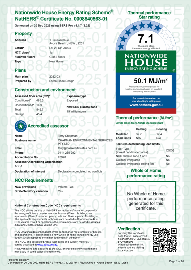
The State Environmental Planning Policy (Sustainable Buildings (2022) (Sustainable Buildings SEPP) commenced on 1 October 2023. The application was lodged after the commencement date and is supported by a BASIX Certificate demonstrating compliance with the requirements of the Sustainable Buildings SEPP.
State Environmental Planning Policy (Resilience and Hazards) 2021
Chapter 2 Coastal Management
The Resilience and Hazards SEPP applies to land within the coastal zone.
The site is located within the Coastal Use Area and the Coastal Environment Area and is therefore subject to the provisions of Clauses 2.10 and 2.11 of Chapter 2.
The northern shores of the lake are mapped as coastal wetlands. The subject site is located close to, but not within the outer boundary of the mapped “Coastal Wetlands -Buffer area”. Therefore, the provisions of Section 2.8, relating to land within proximity area for coastal wetlands does not apply.
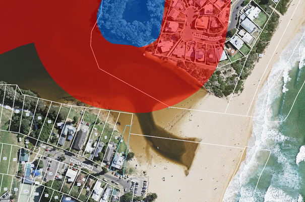
Figure 19 Aerial image of locality illustrating subject land close to the “Coastal Wetlands – Buffer” boundary marked in red shading. Note: blue shading is the mapped Coastal Wetlands area
The development proposal for a two storey dwelling house, with proposed landscape planting and a rabbit proof fence within the lake, is inconsistent with the relevant provisions of Clauses 2.10 in respect of the Coastal Environment Area as it will cause an adverse impact on the following matters for consideration.
Consideration of potential impact on Coastal Environment Area
|
Matters for consideration |
Compliance |
|
(a) the integrity and resilience of the biophysical, hydrological (surface and groundwater) and ecological environment, |
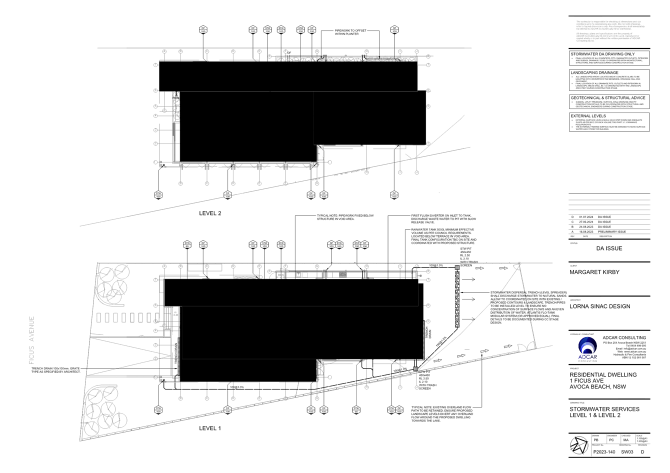
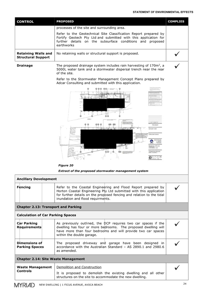
With the exception of the proposal to introduce landscape planting and a rabbit proof fence within the lake, the proposed two storey dwelling house is not likely to cause adverse impacts on the biophysical, hydrological, or ecological environment. Roof stormwaters are proposed to be directed to a 5,000-litre rainwater tank located under the rear terrace with overflow to an absorption trench positioned on the rear grassed area. |
|
(b) coastal environmental values and natural coastal processes, |
The proposal will not impact on the geological and geomorphological coastal processes. |
|
(c) the water quality of the marine estate (within the meaning of the Marine Estate Management Act 2014), in particular, the cumulative impacts of the proposed development on any of the sensitive coastal lakes identified in Schedule 1, |
With the exception of the proposal to introduce landscape planting and a rabbit proof fence within the lake, the proposal will not result in an adverse impact on the water quality of the marine estate and does not drain to a sensitive coastal lake contained in Schedule 1.
The proposal is to dispose of roof waters, from the water tank overflow to an inground absorption trench. |
|
(d) marine vegetation, native vegetation and fauna and their habitats, undeveloped headlands and rock platforms, |
The proposal will not result in an adverse impact on native vegetation or fauna, undeveloped headlands, and rock platforms. |
|
(e) existing public open space and safe access to and along the foreshore, beach, headland or rock platform for members of the public, including persons with a disability, |
The proposed dwelling house does not impact on access to public open space and safe access for members of the public including persons with a disability. The proposed location of landscaping and the rabbit proof fence, whilst positioned on their land, will impact on historical safe access along the southern shores of the lake during periods of full, or near full, capacity. |
|
(f) Aboriginal cultural heritage, practices and places, |
There are no identified aboriginal cultural heritage items within 50m of the site. |
|
(g) the use of the surf zone. |
The land is subject to coastal inundation however does not have a frontage to the surf zone. |
The development proposal is inconsistent with provisions in Clause 2.11, (Sub-Clauses 2.11 (1)(a)(i) &(1) (c)), in respect of the Coastal Use Area.
Consideration of potential impact on Coastal Use Area
|
Matters for consideration |
Compliance |
|
(1) Development consent must not be granted to development on land that is within the coastal use area unless the consent authority— |
N/A |
|
(a) has considered whether the proposed development is likely to cause an adverse impact on the following— |
N/A |
|
(i) existing, safe access to and along the foreshore, beach, headland or rock platform for members of the public, including persons with a disability, |
The proposed component of the development consisting of landscaping and rabbit proof fence will result in changes to the existing access along the foreshore. |
|
(ii) overshadowing, wind funnelling and the loss of views from public places to foreshores, |
The proposal will not cause an adverse impact on access, overshadowing, wind funnelling or view loss from public places to any foreshore. |
|
(iii) the visual amenity and scenic qualities of the coast, including coastal headlands, |
The proposal does not impact the visual amenity or scenic quality of the coast (when viewed well away from the subject land and near the breaking surf beach). |
|
(iv) Aboriginal cultural heritage, practices and places, |
There are no known objects, areas, or items of heritage significance on the land, and no potentially adverse impacts on cultural or environmental heritage have been identified. |
|
(v) cultural and built environment heritage, and |
There are no known objects, areas, or items of heritage significance on the land, and no potentially adverse impacts on cultural or environmental heritage have been identified. |
|
(b) is satisfied that— |
N/A |
|
(i) the development is designed, sited and will be managed to avoid an adverse impact referred to in paragraph (a), or |
There have been no adverse impacts identified in the consideration of clause 2.11(1), with the exception of the landscaping and fence to the northern area of the land, that would engage the further considerations under section 2.11(2) of the Resilience and Hazards SEPP.
|
|
(ii) if that impact cannot be reasonably avoided—the development is designed, sited and will be managed to minimise that impact, or |
N/A |
|
(iii) if that impact cannot be minimised—the development will be managed to mitigate that impact, and |
The impact can be minimised by excluding landscaping and fencing near and within the lake during periods at full or near full capacity. |
|
(c) has taken into account the surrounding coastal and built environment, and the bulk, scale and size of the proposed development. |
The proposed development will be inconsistent to the established rear building alignment of other nearby residential buildings when taking into account the surrounding built environment. In other words, the proposed rear alignment of the development will be inconsistent, and hence out of character, to the setting and pattern of other residential buildings located along the Avoca Lake foreshore. Furthermore, the setting of the dwelling (design characteristics) does not respond to shore of the lake during periods when full, or near full to capacity, delineated by the natural curvature of the grassed edged embankment of the lake. The natural curvature of the southern foreshore of the lake is identified and distinct in aerial imagery of this locality taken at various times since 1954. |
Chapter 4: Remediation of Land
The Resilience and Hazards SEPP applies to any land defined in section 4.3 (1)(a) or (b).
The current use of the site is for a dwelling house and there are no known previous uses that would lead to the site being contaminated or unsuitable for the proposed use.
It is therefore considered that the requirements of the SEPP in relation to remediation of land have been satisfied.
Central Coast Local Environmental Plan 2022 (CCLEP 2022)
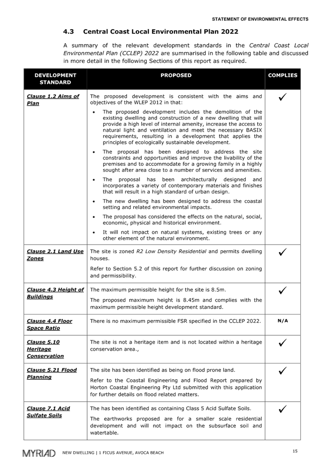
Zoning and Permissibility
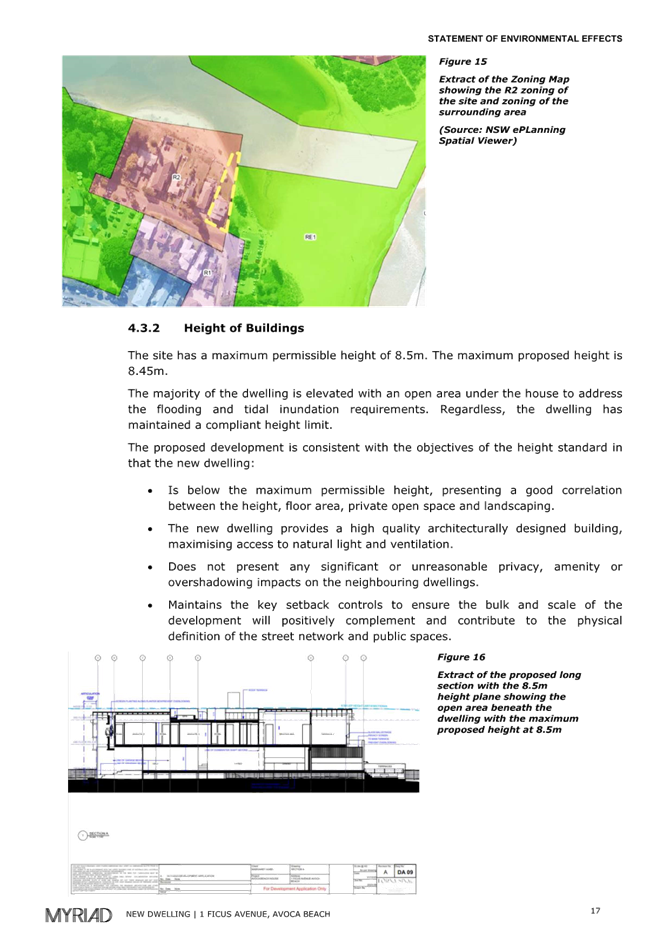
The site is zoned R2 – Low Density Residential. The development is defined as a Dwelling House and the proposed land use is a permissible use within the R2 zone.
As illustrated with the figure below, the small pocket of this R2 zone (consisting of only 7 properties and the adjoining public road) is bordered by W1 – Natural Waterways, RE1 – Public Recreation and directly to the south, R1 – General Residential.
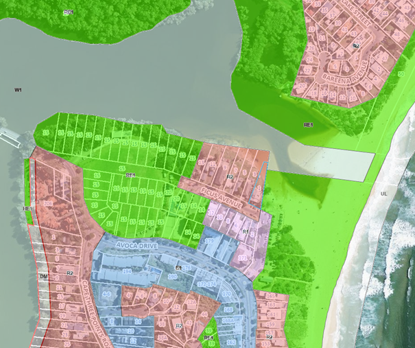
Figure 20 Aerial image of land and locality overlayed with CCLEP2022 land use zone map.
Clause 2.3 – Zone Objectives
Clause 2.3(2) requires the consent authority to have regard to the objectives of the zone when determining a development application.
The objectives of the zone are:
• To provide for the housing needs of the community within a low density residential environment.
• To enable other land uses that provide facilities or services to meet the day to day needs of residents.
• To encourage best practice in the design of low density residential development.
• To ensure that non-residential uses do not adversely affect residential amenity or place unreasonable demands on services.
• To maintain and enhance the residential amenity and character of the surrounding area.
The proposed size and position of the dwelling on the land is considered to be inconsistent with zone objectives
· To encourage best practice in the design of low density residential development.
· To maintain and enhance the residential amenity and character of the surrounding area.
for the following reasons:
· The rear setback of the proposed dwelling is not compatible with the establish rear alignment setback of other residential buildings along the southern foreshore of Avoca Lake and thus be out of character and not conforming to the residential amenity within this locality.
· The proposed location of landscaping and fence on the northern portion of the land and within the lake during periods of near full or full capacity is uncharacteristic to other features and landscaping of other properties along the southern shoreline of the Lake.
Clause 4.3 Height of Buildings
Clause 4.3(2) of CCLEP 2022 provides that the height of a building on any land will not exceed the maximum height shown for the land on the Height of Buildings Map. The maximum height shown on the relevant map is 8.5m. The Dictionary within CCLEP 2022 defines building height -as the vertical distance from ground level (existing) to the highest point of the building. The definition excludes communication devices, antennae, satellite dishes, mast, flagpoles, chimneys, flues and the like.
The proposed building height is measured at 8.45m and complies with this clause of the CCLEP2022.
Clause 4.4 Floor Space Ratio
Clause 4.4(2) Floor Space Ratio (FSR) of CCLEP 2022 provides the maximum floor space ratio for a building on any land is not to exceed the floor space ration shown for land on the Floor Space Ratio Map. The land is not included within this map and hence no floor space ratio applies to the proposed development under the CCLEP 2022.
Clause 5.21 Flood Planning
Council’s records indicate that the site is affected by flooding in the 1% AEP flood event including the following Flood Precincts as depicted in the mapping below.
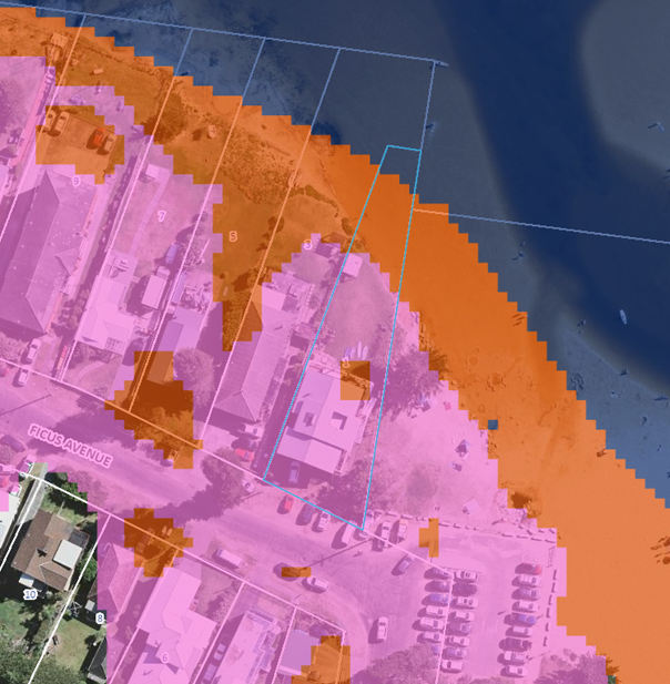
Figure 21 - Aerial image of land with flood precinct overlay.
In accordance with clause 5.21(2) development consent must not be granted to development on land the consent authority considers to be within the flood planning area unless the consent authority is satisfied the development:
(a) is compatible with the flood function and behaviour on the land, and
(b) will not adversely affect flood behaviour in a way that results in detrimental increases in the potential flood affectation of other development or properties, and
(c) will not adversely affect the safe occupation and efficient evacuation of people or exceed the capacity of existing evacuation routes for the surrounding area in the event of a flood, and
(d) incorporates appropriate measures to manage risk to life in the event of a flood, and
(e) will not adversely affect the environment or cause avoidable erosion, siltation, destruction of riparian vegetation or a reduction in the stability of river banks or watercourses.
In accordance with clause 5.21(3) in deciding whether to grant development consent on land to which this clause applies, the consent authority must consider the following matters—
(a) the impact of the development on projected changes to flood behaviour as a result of climate change,
(b) the intended design and scale of buildings resulting from the development,
(c) whether the development incorporates measures to minimise the risk to life and ensure the safe evacuation of people in the event of a flood,
(d) the potential to modify, relocate or remove buildings resulting from development if the surrounding area is impacted by flooding or coastal erosion.
The following comments are provided in relation to clause 5.21(2) land 5.21(3) as follows:
· Consideration has been given to the requirements of clause 5.21(3)(d) in relation to potential impact to the surrounding area that is impacted by flood affectation as follows:
o The site is affected by control flooding levels. (Coastal Lagoons Catchment Overland Flood Study, 2020).
o The 1% AEP is RL 2.99m AHD and the Flood Planning Level (minimum habitable floor level) is RL 3.49m AHD. (the proposed development has a MFL of 3.7mAHD.
o The subject property is defined as a Flood Control Lot, located within a Flooding Hydraulic Flood Storage Area, and within a High Hazard Area. The proposed dwelling being open underfloor bearers and joists type of structure helps to address this situation.
o The northern part of the property is also located within a High Hazard Flooding Area.
The proposal is consistent with the requirements and objectives of clause 5.21 in that:
· There is approximately 200mm deep flood affectation over the existing ground levels adjacent to the road in a 1% AEP flood event. The risk to life and property associated with the proposed development or the surrounding area is considered to be manageable.
· The proposal would be at an acceptable risk of coastal hazard, provided that the proposed structures are founded on suitable footing system, designed to support all the loads and structural actions and recommended conditions.
The Panel can be satisfied that the proposed development complies with the provisions of clause 5.21 Flood Planning.
Clause 5.22 Special flood considerations
This development application for a dwelling house, is not sensitive and hazardous development. Furthermore the proposed development in the event of a flood, is not considered to cause a particular risk to life or require the evacuation of people or other safety considerations, above what has been considered under the provisions of Clause 5.21.
Clause 7.1 Acid sulfate soils
This land has been identified as being affected by the Acid Sulfate Soils Map and the matters contained in clause 7.1 of CCLEP 2022 have been considered. The site contains Class 5 Acid Sulfate Soils (ASS) which are likely to occur where:
· Works within 500 metres of adjacent Class 1, 2, 3 or 4 land that is below 5 metres Australian Height Datum and by which the watertable is likely to be lowered below 1 metre Australian Height Datum on adjacent Class 1, 2, 3 or 4 land.
The land is mapped as Class 5, no known occurrence ASS and is located adjacent to Class 1 ASS (Avoca Lake). Extensive excavation of the land is not proposed. The geotechnical engineer, within their report is recommending the footing system of the dwelling to comprise of concrete beam strip footings near the land surface, supported on screw piles, which is not likely to lower the water table below 1 metre in the adjacent Class 1 land; therefore, an ASS Management Plan is not required.
The Panel can be satisfied that the proposed development complies with the provisions of clause 7.1 Acid Sulfate Soils.
Clause 7.6 Essential Services
Development consent must not be granted to development unless the consent authority is satisfied that all of the following services that are essential for the development are available or that adequate arrangements have been made to make them available when required—
(a) the supply of water,
(b) the supply of electricity,
(c) the disposal and management of sewage,
(d) stormwater drainage or on-site conservation,
(e) suitable vehicular access,
(f) the collection and management of waste.
The property was previously connected to electricity, reticulated water and sewer and serviced for waste collection and is therefore available to the proposed new dwelling house.
Water and Sewer is available to the land. A Section 307 certificate of compliance under the Water Management Act 2000 is required to be obtained prior to the occupation of the building.
Satisfactory details have been provided in the Waste Management Plan for waste management procedures associated with the construction, and ongoing operation of the proposed development.
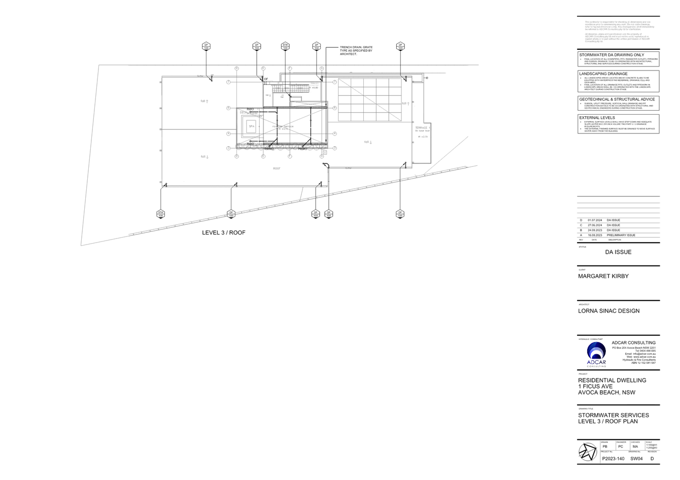
Satisfactory stormwater drainage can be obtained in accordance with the Stormwater Plans and there is adequate area for vehicle access.
The Panel can be satisfied that the proposed development complies with the provisions of clause 7.6 and that adequate essential servicing is available to the development having regard for water, sewer, electricity, stormwater drainage, waste collection and vehicular access.
Central Coast Development Control Plan 2022
The relevant controls of Central Coast Development Control Plan (CCDCP 2022) are considered below:
Chapter 2.1 Dwelling Houses, Secondary Dwellings and Ancillary Development
The proposal has been assessed in accordance with the relevant provisions of Chapter 2.1 Dwelling Houses, Secondary Dwellings and Ancillary Development.
|
Development Control |
Required |
Proposed |
Compliance with Control |
Compliance with Objective |
|
2.1.2.1 a & c Building Height |
a) max height – 8.5m c) max 2 storeys, however 3 storeys allowed in some circumstances |
Max 8.45m 2 storeys |
Yes |
Yes |
|
2.1.2.2 a (ii) Site Coverage |
Max 40% for allotment that has an area of 900m2 to 1500m2 (site area is 1081m2) |
28% |
Yes |
Yes |
|
2.1.2.3 Floor Space Ratio (FSR) |
No mapped FSR in CCLEP 2022 |
N/A |
N/A |
N/A |
|
2.1.3.1a Front Setbacks |
Average distance of the front setbacks to the nearest 2 dwelling houses having the same primary road boundary and located within 40m of the lot on which the dwelling house is erected, or if 2 dwelling houses are not located within 40m of the lot – 4.5m. iv. The minimum required setback for garage and carport structures and the like: A minimum 1m behind the front boundary setback. |
There are 2 dwellings located within 40m of the subject land (with the same primary road boundary) – required setback is calculated at 8.55m.
Propose front boundary setback is 8.7m.
Garage located >1m (1.96m) behind front boundary setback. |
Yes |
Yes |
|
2.1.3.1b (i) Rear Setbacks |
To a private allotment |
Notwithstanding the unique situation of the rear boundary of this allotment adjoining a private allotment, both being within the Lake, the required numerical setback by calculation is 6m.
The proposed development is 31.6m from its rear boundary. |
Yes |
Yes |
|
2.1.3.1c (i) Side Western Setback |
Any part of a dwelling with a height of up to 4.5m – 0.9m; and - for any part of the dwelling with a height of more than 4.5m – 0.9m + one quarter of the height of the building above 4.5m. |
Required setback of 1.55m based on a wall height of 7.12m.
Proposed setback at the first floor level 1.98m |
Yes
|
Yes |
|
Waterfront setback (Eastern side boundary) |
The entire eastern side boundary adjoins either a waterbody(natural) or land zoned public recreation adjoining the waterway (natural waterbody).
Required setbacks. · 6m setback for the ground storey and; · 10m for any storey above the ground storey. |
Elements of the eastern façade do not run parallel to the eastern side boundary and therefore the setbacks varies from its closest point of 1.6m to 4.8m. (at both levels). |
No |
No -refer to comments at the end of this table. |
|
2.1.4.1 Views |
a. Address NSW L&E Court planning principles relating to view sharing. b. Sited and designed to enable view sharing to adjoining / adjacent sites particularly from habitable rooms. c. Development steps down a sloping site. d. Design of the roof form provides for view sharing. |
The site adjoins a public reserve to the north and a public walkway beach access reserve to the south.
There are impacts on scenic coastal views from west adjacent building containing two dwellings
|
No |
No -refer to comments at the end of this table. |
|
2.1.4.2 Visual Privacy
|
Orientation of windows and terrace areas to not directly overlook private open space areas of adjoining allotments |
|
Yes |
Yes |
|
2.1.4.3 Private Open Space (POS)
|
24sqm for allotments with a width greater than 10m wide at the building line Min dimension 3m. |
Greater than 24sqm and 3m width achieved by the terrace area on the rear elevation directly accessible from living/dining area. |
Yes |
Yes |
|
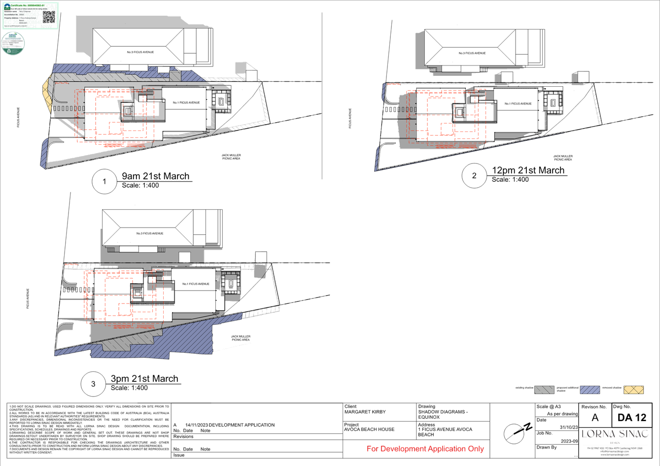
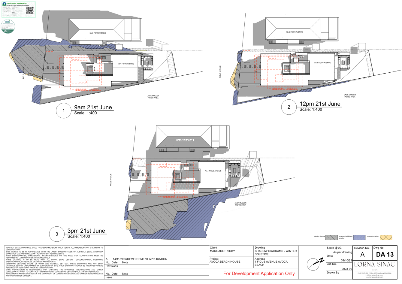
2.1.4.4 Sunlight Access |
Min 3 hrs/day sunlight mid-winter to 50% of principal private open space POS for new dwellings.
Minimum 3 hours/day sunlight mid-winter to 50% of principal POS on adjoining land |
Shadow diagrams indicate compliance is achieved to the POS of the subject dwelling. The POS is located at the northern lakefront.
The dwelling house south of the subject site is separated by the public walkway reserve and its east facing POS it not impacted by overshadowing. |
Yes |
Yes |
|
2.1.5 Car Parking and Access |
Provide minimum off street parking facilities – 2 spaces for a dwelling with 4 or more bedrooms. Ensure safe vehicular access to public road.
|
2 spaces provided within garage. The garage spaces being behind the primary road setback.
The garage/driveway is designed to enable vehicles to provide for safe vehicle entry and pedestrian access and minimise potential for pedestrian and vehicle conflict. |
Yes
|
Yes
|
|
2.1.6.1 Earthworks |
Cut/fill maximum 1m within 1m of boundaries, or 3m if more than 3m from boundary |
Earthworks for the proposal is considered satisfactory for the characteristics of the site, complies with the objectives and generally consistent with the controls.
Erosion and Sedimentation Control Plan provided and deemed satisfactory. |
Yes |
Yes |
|
2.1.6.3 Drainage |
All stormwater drainage collecting must be conveyed by a gravity fed or charged system to a public drainage system, or an inter-allotment drainage system, or an on-site disposal system |
Stormwater Management Plan provided – no stormwater runoff is directed onto neighbouring properties |
Yes |
Yes |
|
2.1.7.3 Swimming Pools |
i. be located behind the setback area from a primary road or in the rear yard unless it can be justified site constraints exist. ii. Comply with side and rear setbacks for the swimming pool water line and any associated deck. iii. Have associated pump housed in an enclosure that is sound proofed. |
The proposed swimming pool (spa on the roof terrace) complies with the requirements of clause 2.1.7.3. |
Yes |
Yes |
|
2.1.7.4 Fencing |
Fencing 1.2m – local road or 1.8m to a collector road.
Fences should not be constructed in areas where front fencing is not part of the overall streetscape. |
1.2m high fencing is proposed on the front boundary of the site.
|
Yes |
Yes |
Clause 2.1.3.1 e Waterfront setback (Eastern side boundary)
In most circumstances the provisions of the clause would relate to the setback from the rear boundary of a property, where there is greater opportunity for dwellings to achieve either a 6m or 10m rear setback without unreasonably limiting the design potential of a dwelling house. In the circumstance of this property with its entire eastern side boundary adjoining a public reserve and waterway, achieving a 10m side boundary setback with a property width of approx. 15m (centrally positioned) presents a significant design challenge.
The proposed dwelling incorporates variable setbacks associated with the stepping of the building from the eastern side boundary. These setback areas are proposed to be planted with a variety of coastal shrubs. The eastern wall of the dwelling is designed with a variety of high-quality architectural materials and large openings over the public reserve creating high levels of architectural interest.
Generally, the proposed setbacks from the eastern side boundary is reasonable, with the exception of the northern portion of the dwelling in close proximity to the interface with the edge of the lake. The proposed dwelling is considered to extend well beyond the established rear building alignment and unresponsive to the natural curvature of lake during periods of full or near full, delineated by the grassed edge of the lawn area. Not only should the dwelling have an increased rear setback, but also step at least half of the eastern portion of the dwelling to be sympathetic to the natural curvature of the lake. By stepping this rear portion of the dwelling from the rear boundary will also result in an increased side setback.
Clause 2.1.4.1 Views
The design of the proposed development is to have regard to existing views enjoyed by surrounding properties. Existing views should not be substantially affected where it is possible to design for the sharing of views. The primary view lines of adjacent properties should be maintained where possible. Notwithstanding this, an objective set out within this clause of the DCP is facilitation of view sharing should be encouraged whilst not restricting the reasonable development of the site.
Submissions in relation to impact on views has been received from occupants of the western adjoining property containing 2 dwellings, as a result of the position of the proposed rear portion of the dwelling.
For the purpose of this assessment, the planning principles established by the NSW Land and Environment Court have been utilised. In Tenacity Consulting v Warringah [2004] NSWLEC 140, the Court adopted a four-step assessment process for determining potential impacts on existing views and is detailed as follows:
Step 1: Determining the type of view to be affected.
The images below illustrate the current view from the rear deck of the western side adjoining dwelling to the rear of the building. Elements of the view, in an easterly direction, include the ocean, interface of lake with beach, breaking surf and the beach. The neighbour will be impacted by the elements of the proposed dwelling extending further north (towards the rear) of the established rear building alignment. The impact is illustrated by red hatching edited into the image representing the western wall of the proposed dwelling.
The current views of the other neighbours dwelling (located closer to the road) will not vary greatly, given the current location of the existing dwelling on the subject site.
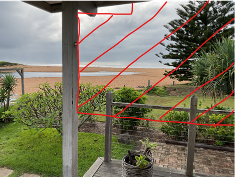
Figure 22 - Image taken from western neighbour rear deck (under the awning) adjacent to the rear wall of the neighbours dwelling. The red hatching illustrates the extent of view loss from this position on the deck and similar to within the living spaces of the dwelling.
Step 2: Determining the position of where views are obtained.
The images and captions above illustrate where the views are obtained from both a standing position.
Step 3: Assessing the extent of impact.
The third step is to assess the extent of the impact. This should be done for the whole of the property, not just for the view that is affected. The impact on views from living areas is more significant than from bedrooms or service areas. It is usually more useful to assess the view loss qualitatively as negligible, minor, moderate, severe or devastating.
The rear alignment of the ground floor rear deck extends a 500mm beyond the rear alignment of the western neighbours rear deck. The neighbours rear deck is generally open, whilst the western side of the proposed deck is to be enclosed for its entire length to act as a privacy screen. The enclosure of the western side deck will severely impact the neighbours view towards the beach and ocean.
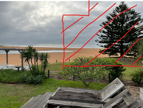
Figure 23 - Image taken from western neighbours rear open deck in a central location. The red hatching illustrates the extent of view loss.
Step 4: Assessing whether the extent of impact is reasonable.
The fourth step is to assess the reasonableness of the proposal that is causing the impact. A development that complies with all planning controls would be considered more reasonable than one that breaches them. Where an impact on views arises as a result of non-compliance with one or more planning controls, even a moderate impact may be considered unreasonable. With a complying proposal, the question should be asked whether a more skilful design could provide the applicant with the same development potential and amenity and reduce the impact on the views of neighbours. If the answer to that question is no, then the view impact of a complying development would probably be considered acceptable and the view sharing reasonable.
Views across side boundaries are more difficult to protect than views from front and rear boundaries, and the expectation to retain side views is often unrealistic and not achievable particularly where compliant design is proposed.
The impact on view loss is across the side boundaries of the land, however the proposed development, extending further beyond the established rear alignment and not incorporating design principles of being sympathetic to the setback from the curvature of the edge of the lake during periods when full, is achievable to protect or reduce the impact on view loss.
The applicant could therefore reasonably propose a more skilful design with increased rear setbacks, providing the applicant with the same development potential and amenity resulting in a reduction of the impact of the neighbours view.
The proposal significantly and unreasonable reduces the amenity enjoyed by the occupants of the western adjoining land.
Chapter 2.14 Site Waste Management
A Waste Management Plan has been submitted with the proposal. The proposal has demonstrated compliance with this chapter of the CCDCP 2022 and associated Waste Control Guidelines applying at the time the application was lodged. Appropriate conditions are included in the development consent.
Chapter 2.17 Character and Scenic Quality
The principle aim of this chapter of the DCP is to maintain the character and scenic quality of an area while considering the desired and likely future character of the area.
The site is located within South Coastal landscape unit comprising Avoca Beach and surrounding localities and is within in the Character and Scenic Quality Statements of Avoca1: Ocean Beachfront – Desired Character Requirements.
The desired character of developments within this precinct is to ensure developments do not dominate the informal scenic quality of prominent backdrops to ocean beaches and ensure new structures do not disrupt the development patterns that are evident upon surrounding properties.
The setting and location of the proposed dwelling house in relation to the established rear building alignment (development patterns) is inconsistent with the objectives within CCDCP 2022 Chapter 2.17 – Character of Scenic Quality and the related document to this DCP being the Character and Scenic Quality Statements of Avoca1: Ocean Beachfront – Desired Character Requirements.
Chapter 3.1 Floodplain Management/Water Cycle Management
Chapter 3.1 seeks to minimise the impact of development on the natural pre-development
water cycle. This will lead to more sustainable outcomes that will protect the environment.
The Stormwater Management Plan submitted with the application is considered satisfactory for this type of development.
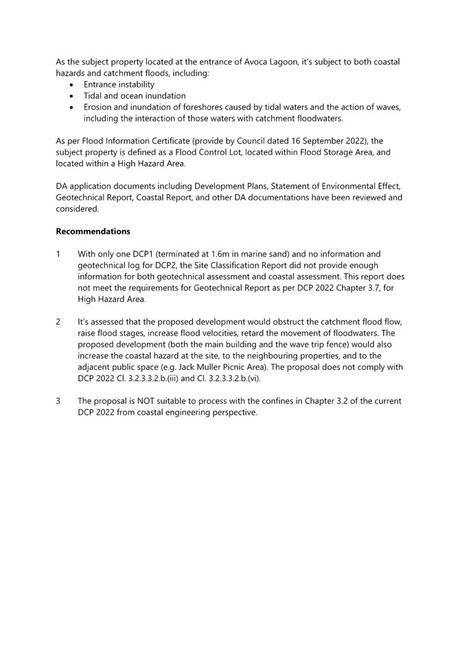
Chapter 3.2 Coastal Hazard Management
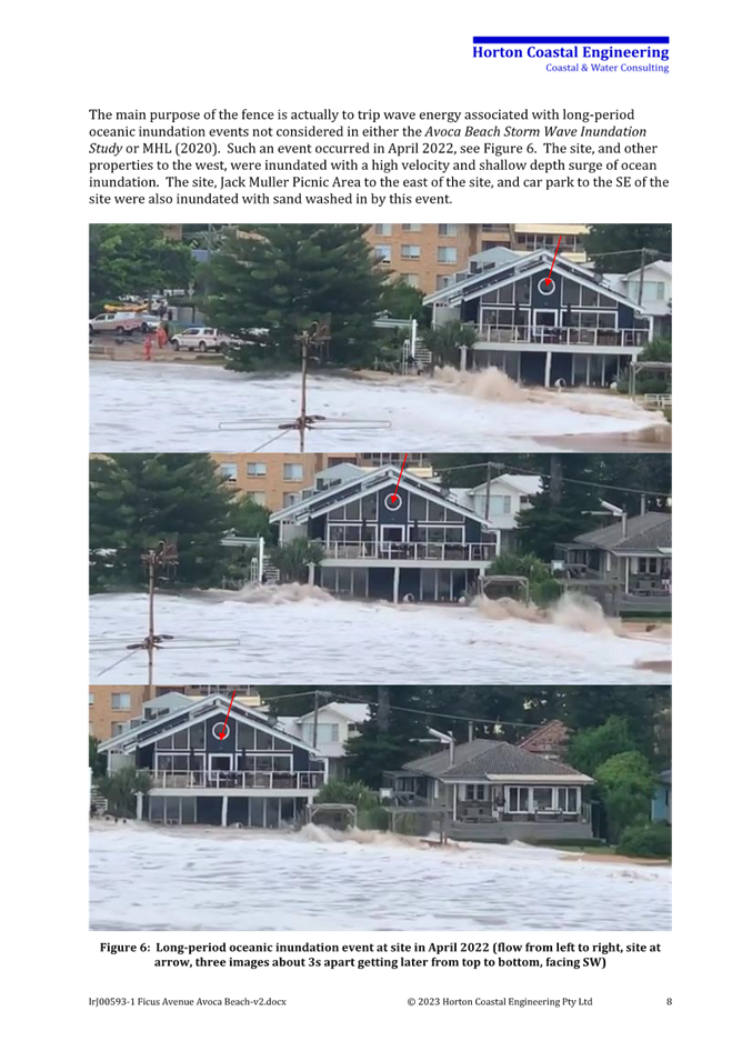
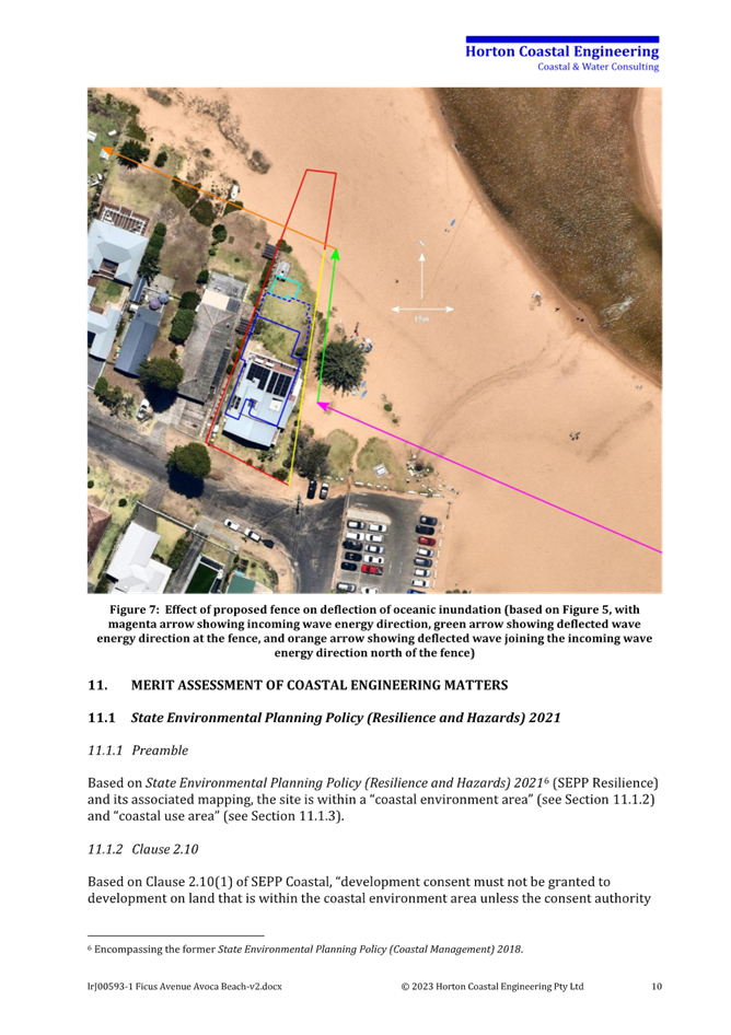
The application is supported by a coastal engineering report, as outlined within the report the site is not subject to typical erosion/recessions processes as occur at the adjacent open coast Avoca Beach, but rather take into account the effect of ocean waves overtopping the beach berm and flowing east towards the site.
The figure below, extracted from the coastal engineer report, illustrates an ocean inundation event that occurred in early April 2022.
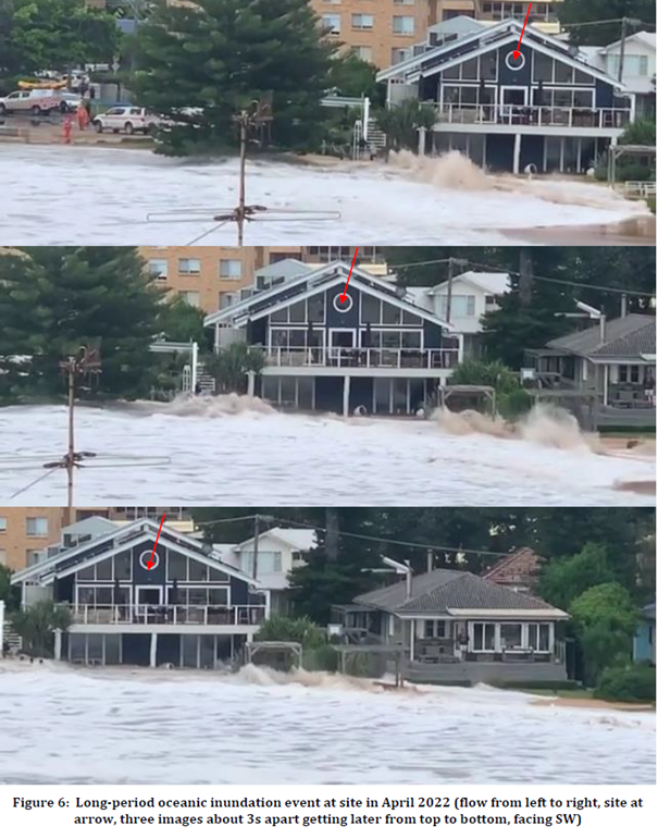
Figure 24 - extract from Coastal Engineers report dated 15/11/23.
This application originally included a ‘solid wave trip fence’ extending along the eastern boundary and to approximately 12m within the lake during periods of full capacity. This component of the development has been withdrawn and does not form part of the assessment of this development application.
With the removal of the solid wave trip fence from the application, the comments from Councils Senior Coastal Planning Officer in terms of chapter 3.2 – Coastal Hazard Management, centres around the positioning of the dwelling from the edge of the lake and its likely obstruction to flood flow and increase the coastal hazard of the site, neighbouring dwellings and the adjacent public space.
Further communication was made with Councils Senior Coastal Planning Officer, whereby an increased rear setback consistent with the setbacks of the western adjoining property would address this issue.
Chapter 3.7 Geotechnical Requirements for Development
Chapter 3.7 provides a management strategy for development in areas identified as having landslip potential and guidelines on the content of geotechnical reports.
The subject site is not mapped as being Immediate high, high nor medium within Councils Geocortex mapping system. The site, however is described of being a Low Hazard based on its distance from the lake and beach.
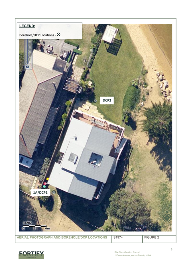
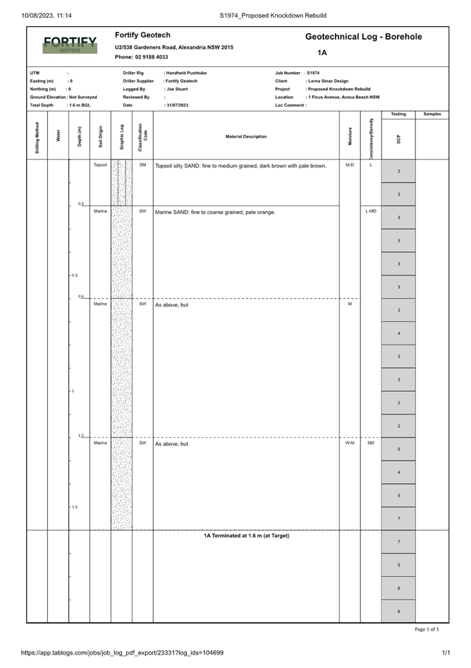
The application is supported by a geotechnical engineer’s report including the geological profile of the subsurface conditions at two locations on the site. The two locations are at the front (southern) side and rear (northern) side of the existing dwelling. The outcome of the geotechnical investigation includes recommendations that screw piers to be used due to the collapsible nature of the sandy soils.
Provisions of regulations
The Environmental Planning and Assessment Regulations 2021 applies to all development applications in regard to such items as application type, compulsory contributions, notification of development applications and a range of many other details regarding development application requirements. Assessment of this application has considered all relevant matters including the demolition of the building in accordance Australian Standard AS2601-2001: The Demolition of Structures.
Likely Impacts of the Development
Section 4.15 (1)(b) of the Environmental Planning and Assessment Act 1979 requires consideration of the likely impacts of the development including environmental impacts on both the natural and built environments, and social and economic impacts in the locality.
As outlined within this planning report the rear setback of the proposed dwelling house is inconsistent with the established rear setbacks of other dwellings adjoining the lake, nor does the design respond with the natural curvature of the lake delineated by the grassed edge of the lawn area.
Suitability of the site
In accordance with section 4.15(1)(c) in determining a development application the suitability of the site for the proposed development is to be considered. Having regard to the assessment above, it is considered a dwelling house is suitable for the site, however not in term of the proposed rear setbacks of the proposed dwelling house in relation to the established rear building alignment.
Public interest
Having regard to the above assessment it is considered that the proposed development is not in the public interest as the proposed development is inconsistent with the objectives of a number of stated chapters of the CCDCP2022, inconsistent with the provisions of State Environmental Planning Policy (Resilience and Hazards) 2021 and inconsistent with the objectives of the R2 Low Density Residential zone.
Access and traffic
The local road network is considered to have adequate capacity to cater for the proposed development and minimal increase in traffic generated by the proposal. More than adequate provision is provided for onsite car parking and vehicle movements.
Natural Environment
The proposal is satisfactory in relation to impacts on the natural environment as identified throughout this report for land subject to coastal hazards with the exception of the proposed fence and landscape works within the lake during periods of full or near full capacity.
Economic and Social Impacts
The proposal replaces a dwelling house. No unreasonable economic or social impacts will arise from the approval of the dwelling house.
Any Submission made in Accordance with this Act or Regulations
Section 4.15 (1)(d) of the Environmental Planning and Assessment Act 1979 requires consideration of any submissions received during notification of the proposal.
The proposed modification has been notified in accordance with the provisions of Central Coast Development Control Plan 2022. The application was notified for the period of 9 February 2024 to 23 February 2024.
Twelve submissions were received.
A summary of submission items with respect to the amended development proposal is as
follows:
• Concerns regarding view loss.
Comment: The impact on views and consideration of view sharing is elaborated under the heading of CCDCP2022 - 2.1.4.1 Views.
• Concerns regarding the impact of the development on flooding
Comment: The proposed development has been designed with habitable floor levels to be above the flood planning level. The proposed impact can be improved with a greater rear setback. The initial component of the proposed development involving a sold wave trip fence along the eastern side boundary has been removed from this application.
· Concerns regarding overshadowing and loss of sunlight and impact on sea breezes.
Comment: The proposed development will result in some overshadowing to the western adjoining dwelling particularly during the morning period. The western side boundary setbacks and height of the proposed dwelling complying with planning controls. Whilst there will be some impacts on the neighbours as a result of the proposed development in terms of overshadowing and obstruction of seas breezes, the impact is considered reasonable whilst residing in a coastal residential area.
· Concerns regarding the character of the area and impact on the streetscape and setbacks from boundaries.
Comment: Generally, the size and scale of the proposed dwelling is considered to be consistent with other more contemporary developments in the area. The setback of the proposed dwelling along the rear, associated with the established rear building alignment and design response to the natural curvature of the edge of the lake is considered to be out of character.
· Concerns on property values and public safety
Comment: The proposed solid wave trip fence has been removed from the proposed development. The impact on property values is not a matter of consideration under planning legislation.
· Concerns on reduction of privacy
Comment: The size and general layout of windows within the dwelling are consistent in design of other dwellings within a coastal residential setting. The proposed roof top terrace is centrally located and well away from the side boundaries. The stairway access along the western side of the dwelling is proposed to be screened with planting within a planter box adjacent to the stairs and landing area.
· Concerns on the impact on parking based on the number of bedrooms proposed.
Comment: The required provision for off street parking complies with Council development control plans. Furthermore, near to this site are two public carparking areas.
· Concerns on the impact on the fence location and its impact on public access.
Comment: The proposed solid wave trip fence has been removed from this application, however the revision to introduce a rabbit proof fence and landscaping within the lake during periods of full or near full capacity will have the same effect.
It is noted the land to the north of the grassed edge is not public land, however I am certain that members of the public would not recognise the land as part of the site, particularly given the natural features encountered along the edge of the lake.
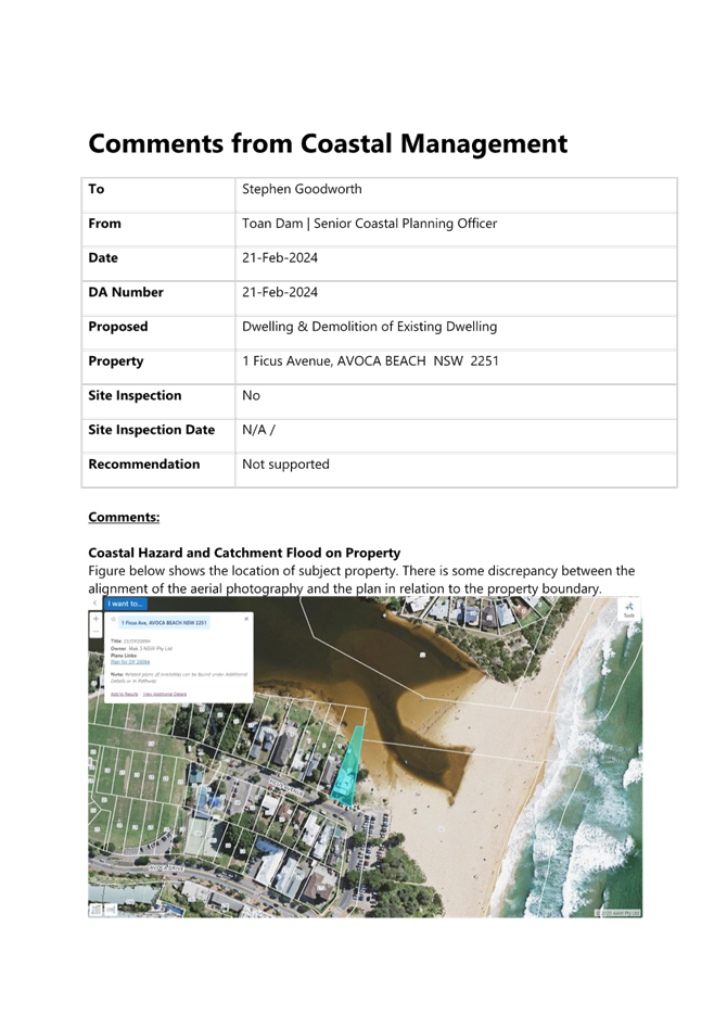
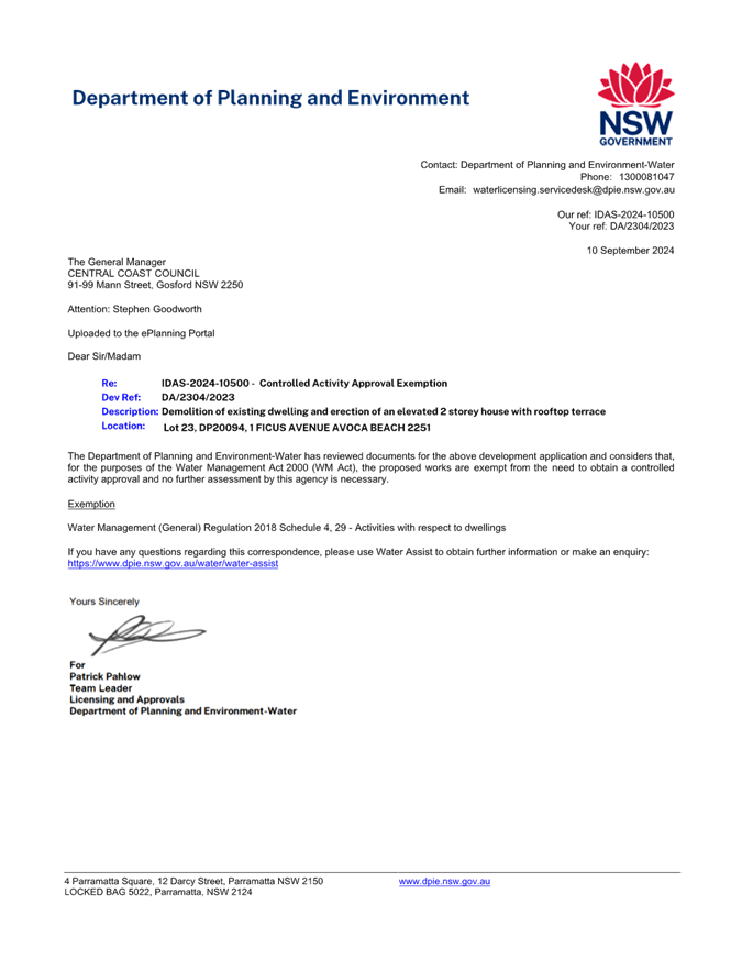
Submissions from Public Authorities
The application was referred to NSW Government Department of Planning and Environment – Water (NSW DPE-W). NSWDPE-W reviewed the development application for the erection of a two storey dwelling house and considered , for the purposes of the Water Management Act 2000, the proposed development is exempt from the need to obtain a controlled activity approval as included within Schedule 4, 29 – activities with respect to dwellings- of the Water Management (General) Regulation 2018.
Internal Consultation
|
Development Engineering (flooding) |
|
Supported subject to conditions. (flooding) |
|
|
Tree Assessment Officer |
Supported subject to conditions. |
||
|
Coastal Planning Officer |
|
Not supported, see commentary above |
|
|
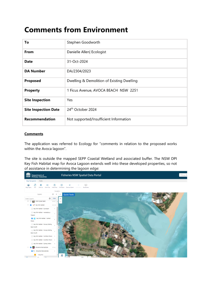
Ecologist comments |
|
Not supported |
|
Ecologist comments
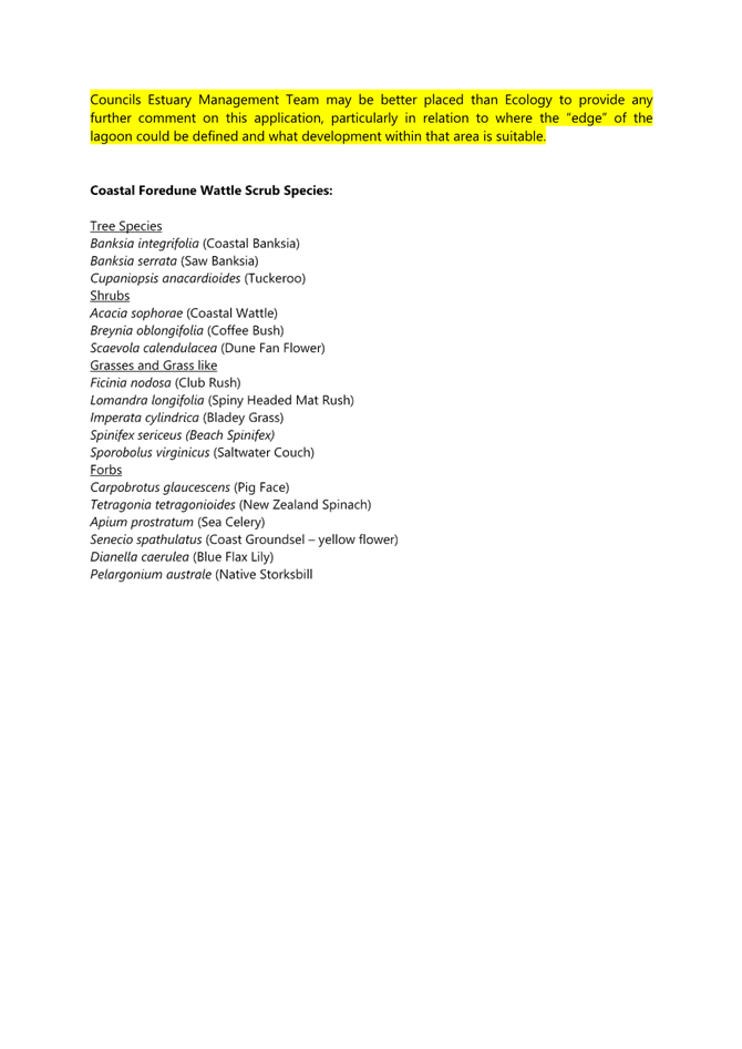
Planting of the site is not suitable for areas that are regularly inundated or subject to high water velocity when the lake is open. The placement of fencing in this area is more of concern than planting, particularly if fencing ends up washing away and causing entanglement issues for marine and estuarine wildlife.
Ecologically Sustainable Principles
The development has been assessed having regard to ecologically sustainable development principles and is consistent with the principles.
The development is considered to incorporate satisfactory stormwater, drainage and erosion control and the retention of vegetation where possible and is unlikely to have any significant adverse impacts on the environment and will not decrease environmental quality for future generations. The proposal does not result in the disturbance of any endangered flora or fauna habitats and is unlikely to significantly affect fluvial environments.
Climate Change
The potential impacts of climate change on the development proposed to be modified have been considered by Council as part of the assessment of the application.
This assessment has included consideration of such matters as potential rise in sea level; potential for more intense and/or frequent extreme weather conditions including storm events, bushfires, drought, flood and coastal erosion; as well as how the proposed development may cope, combat, withstand these potential impacts. The proposed development if proposed with a greater rear setback would be considered satisfactory in relation to climate change.
Political Donations
During assessment of the application there were no political donations were declared by the applicant, applicant’s consultant, owner, objectors and/or residents.
Other Matters for Consideration:
Development Contributions Plan
The land is subject to the Central Coast Section 7.12 Local Infrastructure Contribution Plan 2023 which was adopted by Council on 28 November 2023 and replaces the Central Coast Regional Section 7.12 Development Contribution Plan 2019.
There are no transitional arrangements in place, therefore any subject contributions will be applied to an application based on the contributions plan in force at the date of application determination.
Development that is not subject to a section 7.11 contribution under any other contributions plan adopted by the Council under the Environmental Planning & Assessment Act 1979, may be subject to levy of section 7.12 contributions unless is development that is exempt under Clause 1.5 of this Plan.
Development contributions are only levied where the proposal meets the cost of works thresholds and not subject to any exemption under this plan. The proposed cost of works is $4,733,111; however the development is for a dwelling house and is exempt under clause 1.5 of the plan, that is, no development contributions levy is applicable in this instance.
Water and Sewer
Water and Sewer services are available to the site. A Section 305 application will be required to obtain a Section 307 Certificate of compliance. The resulting Section 306 letter of requirements will contain Water Authority conditions if required.
Air Quality
Standard dust conditions can be applied during construction works.
Noise
Standard condition for construction times can be applied.
Conclusion
That Development Application No. DA/2304/2023 - 1 Ficus Avenue Avoca Beach - Demolition of Existing Dwelling House and the erection of a two storey Dwelling House with roof terrace. be REFUSED pursuant to section 4.16(1) of the EP&A Act for the following reasons:
2. The proposed development does not satisfy the provisions of State Environmental Planning Policy (Resilience and Hazards) 2021 having regard for Chapter 2 Coastal Management, section 2.10 – Development on land within the coastal environment area and section 2.11 – Development on land within the coastal use area.
3. The Local Planning Panel cannot be satisfied, that granting consent would be in the public interest as the proposal is inconsistent with the objectives of the SEPP (Resilience and Hazards) 2021 and inconsistent with the objectives of the R2 Low Density Residential zone.
4. The proposal is inconsistent with the following objectives of the R2 Low Density Residential zone:
• To encourage best practice in the design of low density residential development.
• To maintain and enhance the residential amenity and character of the surrounding area.
5. The setting and location of the proposed dwelling house in relation to the established rear building alignment is inconsistent with the objectives within CCDCP 2022 Chapter 2.17 – Character of Scenic Quality and the related document to this DCP being the Character and Scenic Quality Statements of Avoca1: Ocean Beachfront – Desired Character Requirements.
6. The development results in unnecessary and reasonable adverse impacts when viewed from the neighbour’s land, public spaces and amenity of the area as a result of inconsistency with the established rear building alignment.
7. The proposal is inconsistent with various objectives within Parts 2.1.4.1 and 2.17 of Central Coast Development Control Plan 2022.
8. Both the surrounding predominant form in the area and the desired future character of the area favours a two-storey presentation at consistent rear setbacks to other residential building along the Avoca Lake frontage. The proposal is antipathetic to this form on a visually prominent site from public spaces around the lake, while the proposal (changed or new) could readily achieve form compliance and desirable congruity.
Attachments
|
1 |
Architectural Plans |
Provided Under Separate Cover |
D16478547 |
|
2 |
Landscape plans |
|
D16310449 |
|
3 |
Coastal Engineering Assessment |
|
D15973727 |
|
4 |
Coastal Engineering Assessment in relation to the Water Management Act 2000 |
|
D16311206 |
|
5 |
Geotechnical Engineers Assessment |
|
D15973732 |
|
6 |
Statement of Environmental Effects |
|
D15973739 |
|
7 |
Survey plan |
|
D15973741 |
|
8 |
NatHERS certificate |
|
D16044051 |
|
9 |
Structural engineers report |
|
D16044065 |
|
10 |
Coastal Management Comments |
|
D16079509 |
|
11 |
Engineering Comments |
|
D16183230 |
|
12 |
Response from Dept of Planning & Environment-Water |
|
D16397180 |
|
13 |
Stormwater management plan |
|
D16310452 |
|
14 |
Environment referral comments |
|
D16491960 |
|
ARCHITECTURAL DETAILS FORMING THE ASSESSMENT - 1 FICUS Ave Avoca Beach PAN-393546 - DA23042023 |
Provided Under Separate Cover |
D16478547 |
|
|
2⇩ |
ARCHITECTURAL DETAILS FORMING THE ASSESSMENT - 1 FICUS Ave Avoca Beach PAN-393546 - DA23042023_Redacted |
|
D16525593 |
|
3⇩ |
Updated Landscape Plan - 1 FICUS AVENUE AVOCA BEACH - PAN-393546 - DA/2304/2023 |
|
D16310449 |
|
4⇩ |
Coastal Assessment Report - 1 FICUS AVENUE AVOCA BEACH 2251 - PAN-393546 - DA/2304/2023.pdf |
|
D15973727 |
|
5⇩ |
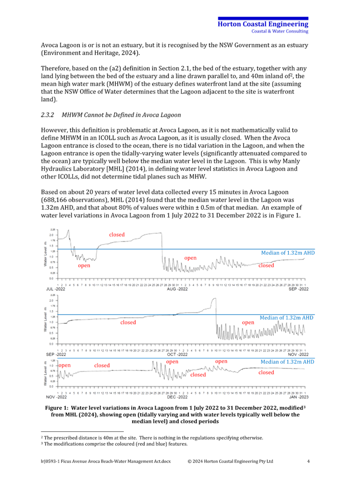
commentary (from applicants coastal engineer) as to whether the Avoca Lagoon is a waterfront land as defined by the Water Management Act 2000 - 1 FICUS AVENUE AVOCA BEACH - PAN-393546 - DA/2304/2023 |
|
D16311206 |
|
6⇩ |
PUBLIC - Geotechnical report - 1 FICUS AVENUE AVOCA BEACH 2251 - PAN-393546 - DA/2304/2023.pdf |
|
D15973732 |
|
Statement of environmental effects - 1 FICUS AVENUE AVOCA BEACH 2251 - PAN-393546 - DA/2304/2023.pdf |
Provided Under Separate Cover |
D15973739 |
|
|
8⇩ |
Survey plan - 1 FICUS AVENUE AVOCA BEACH 2251 - PAN-393546 - DA/2304/2023.pdf |
|
D15973741 |
|
9⇩ |
PUBLIC - NatHERS Certificate - 1 FICUS AVENUE AVOCA BEACH 2251 - PAN-393546 - DA/2304/2023 |
|
D16044051 |
|
10⇩ |
Structural Engineering Report - 1 FICUS AVENUE AVOCA BEACH 2251 - PAN-393546 - DA/2304/2023 |
|
D16044065 |
|
11⇩ |
Coastal Management Referral Comments - 1 Ficus Avenue, AVOCA BEACH NSW 2251 - DA/2304/2023 - Central Coast Council |
|
D16079509 |
|
12⇩ |
Engineering Referral Comments - 1 Ficus Avenue, AVOCA BEACH NSW 2251 - DA/2304/2023 - Central Coast Council |
|
D16183230 |
|
13⇩ |
NSW Department of Planning and Environment—Water Response_IDAS-2024-10500_A-86376 |
|
D16397180 |
|
14⇩ |
Updated Stormwater - 1 FICUS AVENUE AVOCA BEACH - PAN-393546 - DA/2304/2023 |
Provided Under Separate Cover |
D16310452 |
|
Environment Referral Comments - 1 Ficus Avenue, AVOCA BEACH NSW 2251 - DA/2304/2023 - Environment Referral Comments - Central Coast Council |
|
D16491960 |
|
3.1 |
DA/2304/2023 - 1 Ficus Avenue Avoca Beach - Demolition of Existing Dwelling House and the erection of a two storey Dwelling House with roof terrace. |
|
Attachment 2 |
ARCHITECTURAL DETAILS FORMING THE ASSESSMENT - 1 FICUS Ave Avoca Beach PAN-393546 - DA23042023_Redacted |

|
3.1 |
DA/2304/2023 - 1 Ficus Avenue Avoca Beach - Demolition of Existing Dwelling House and the erection of a two storey Dwelling House with roof terrace. |
|
Attachment 3 |
Updated Landscape Plan - 1 FICUS AVENUE AVOCA BEACH - PAN-393546 - DA/2304/2023 |
|
DA/2304/2023 - 1 Ficus Avenue Avoca Beach - Demolition of Existing Dwelling House and the erection of a two storey Dwelling House with roof terrace. |
|
|
Attachment 4 |
Coastal Assessment Report - 1 FICUS AVENUE AVOCA BEACH 2251 - PAN-393546 - DA/2304/2023.pdf |
|
DA/2304/2023 - 1 Ficus Avenue Avoca Beach - Demolition of Existing Dwelling House and the erection of a two storey Dwelling House with roof terrace. |
|
|
Attachment 5 |
commentary (from applicants coastal engineer) as to whether the Avoca Lagoon is a waterfront land as defined by the Water Management Act 2000 - 1 FICUS AVENUE AVOCA BEACH - PAN-393546 - DA/2304/2023 |

|
DA/2304/2023 - 1 Ficus Avenue Avoca Beach - Demolition of Existing Dwelling House and the erection of a two storey Dwelling House with roof terrace. |
|
|
Attachment 6 |
PUBLIC - Geotechnical report - 1 FICUS AVENUE AVOCA BEACH 2251 - PAN-393546 - DA/2304/2023.pdf |


|
3.1 |
DA/2304/2023 - 1 Ficus Avenue Avoca Beach - Demolition of Existing Dwelling House and the erection of a two storey Dwelling House with roof terrace. |
|
Attachment 8 |
Statement of environmental effects - 1 FICUS AVENUE AVOCA BEACH 2251 - PAN-393546 - DA 2304 2023_Redacted |


|
DA/2304/2023 - 1 Ficus Avenue Avoca Beach - Demolition of Existing Dwelling House and the erection of a two storey Dwelling House with roof terrace. |
|
|
Attachment 9 |
Survey plan - 1 FICUS AVENUE AVOCA BEACH 2251 - PAN-393546 - DA/2304/2023.pdf |
|
3.1 |
DA/2304/2023 - 1 Ficus Avenue Avoca Beach - Demolition of Existing Dwelling House and the erection of a two storey Dwelling House with roof terrace. |
|
Attachment 10 |
PUBLIC - NatHERS Certificate - 1 FICUS AVENUE AVOCA BEACH 2251 - PAN-393546 - DA/2304/2023 |
|
DA/2304/2023 - 1 Ficus Avenue Avoca Beach - Demolition of Existing Dwelling House and the erection of a two storey Dwelling House with roof terrace. |
|
|
Attachment 11 |
Structural Engineering Report - 1 FICUS AVENUE AVOCA BEACH 2251 - PAN-393546 - DA/2304/2023 |

|
DA/2304/2023 - 1 Ficus Avenue Avoca Beach - Demolition of Existing Dwelling House and the erection of a two storey Dwelling House with roof terrace. |
|
|
Attachment 12 |
Coastal Management Referral Comments - 1 Ficus Avenue, AVOCA BEACH NSW 2251 - DA/2304/2023 - Central Coast Council |

|
DA/2304/2023 - 1 Ficus Avenue Avoca Beach - Demolition of Existing Dwelling House and the erection of a two storey Dwelling House with roof terrace. |
|
|
Attachment 13 |
Engineering Referral Comments - 1 Ficus Avenue, AVOCA BEACH NSW 2251 - DA/2304/2023 - Central Coast Council |

|
DA/2304/2023 - 1 Ficus Avenue Avoca Beach - Demolition of Existing Dwelling House and the erection of a two storey Dwelling House with roof terrace. |
|
|
Attachment 14 |
NSW Department of Planning and Environment—Water Response_IDAS-2024-10500_A-86376 |
|
3.1 |
DA/2304/2023 - 1 Ficus Avenue Avoca Beach - Demolition of Existing Dwelling House and the erection of a two storey Dwelling House with roof terrace. |
|
Attachment 16 |
Updated Stormwater - 1 FICUS AVENUE AVOCA BEACH - PAN-393546 - DA 2304 2023 |
|
DA/2304/2023 - 1 Ficus Avenue Avoca Beach - Demolition of Existing Dwelling House and the erection of a two storey Dwelling House with roof terrace. |
|
|
Attachment 17 |
Environment Referral Comments - 1 Ficus Avenue, AVOCA BEACH NSW 2251 - DA/2304/2023 - Environment Referral Comments - Central Coast Council |
|
Item No: 4.1 |
|
|
Title: Operation of the Local Planning Panel in 2025 |
|
|
Department: Environment and Planning |
|
|
28 November 2024 Local Planning Panel Meeting |
|
Reference: F2020/02502 - D16487583
Author: Andrew Roach, Unit Manager. Development Assessment
Unit Manager: Andrew Roach, Unit Manager. Development Assessment
That the Central Coast Local Planning Panel note the information in the report and adopt the proposed schedule of meeting dates for 2024, noting that additional meetings can be called by the Chair as required, depending on workload and application volume.
Summary of 2024 Local Planning Panel Activity
During the 2024 calendar year, 13 meetings of the Local planning Panel were scheduled to accommodate the anticipated volume of applications required to be reported to the Panel. Additional meetings were called as required, and a total of 16 Local Planning Panel meetings have been held (January to end November, including the meeting of 28 November 2024).
The following details the outcomes of matters referred to the Panel thus far in 2024:
· 38 Development Applications considered and determined by the Panel from January 2024 until end November 2024.
· 2 Planning Proposals were considered by the Panel for advice (in the period from January to November).
At the time of writing of this this report there is a further meeting scheduled for 12 December 2024, which will bring the total meetings held in 2024 to 17. There are currently 5 Development Applications tentatively scheduled to be considered by the Panel at the remaining meeting on 12 December.
Meeting Format
Since the inception of the Central Coast Local Planning Panel in 2020, all Central Coast Local Planning Panel meetings (apart from one meeting in 2023) have been held remotely (online). Feedback from the Panel, Council staff and applicants and others who have attended the remote meetings, has been positive. Remote meetings have continued to provide greater flexibility, including the option for applicants and others to attend the meeting during business hours and at various location within and outside of the Local Government area, including having specialist consultants ‘call in’ to the meeting from across Australia.
During 2024, no meetings were held ‘in person’ at Central Coast Council Administration Centre at Wyong.
Whilst the legislative framework that permitted online meetings was initially a temporary measure implemented by NSW Government as a result of the COVID-19 pandemic, legislative amendments during 2022 mean that Panels can hold their meetings entirely online (something that was not permitted prior to legislative interventions that occurred during the pandemic). For clarity, Schedule 2 of the Environmental Planning and Assessment Act 1979 (Section 25(4)) states:
‘A planning body may carry out any of the planning body’s business at a meeting held wholly or partly by audio link, audio visual link or other electronic means, but only if a member who speaks on a matter before the meeting or the part of the meeting can be heard by the other members.’
The use of video-conference software (Zoom or similar) helps to facilitate compliance with legislative requirements including the requirement that meetings must be recorded and made publicly available (on the Council’s website or website of the Planning Panel) in accordance with Section 25(3) of Schedule 2 of the Act.
The Panel may choose to commence face-to-face meetings (in lieu of the current practice of utilising video conferencing). If such a change was to be made, meetings would need to be accommodated at Council’s Administration Centre in Wyong or another suitable location, noting that meetings will still need to be held in a location that provides for recording and live streaming.
Note that it remains open to the Chair to elect an ‘in person’ meeting at any time.
Meeting Schedule
Council staff have reviewed the schedule structure and propose the following:
· Generally, one meeting per month, commencing in February 2025 (noting previous practice not to have Panel meetings in January) with an additional meeting scheduled in June (end of financial year) and at the end of the calendar year (November or December) to allow for anticipated demand during those periods.
· Meetings to be held on a Thursday as per previous schedule arrangements, with Panel site inspections and remote site discussions (as required) on the Tuesday prior to the meeting (or as otherwise arranged in conjunction with the meeting Chair).
· Meetings online via videoconference, as has been current practice.
· The Chair to call ‘in person’ meetings in any particular circumstance that warrant them.
· Additional public meetings may be held where there is a need to avoid unreasonable delay in the determination of applications. These meetings would be held on a date mutually agreed by Council staff and the Panel Chair.
Council staff have reviewed the schedule structure and propose a draft meeting schedule for 2025 as follows:
|
Date |
Month |
|
20 |
February |
|
13 |
March |
|
10 |
April |
|
15 |
May |
|
5 |
June |
|
19 |
June |
|
17 |
July |
|
14 |
August |
|
18 |
September |
|
16 |
October |
|
6 |
November |
|
27 |
November |
|
11 |
December |
Panel Member Terms of Appointment
It is noted that no Panel member appointments are due to expire throughout 2025.
Nil.
|
Item No: 4.2 |
|
|
Title: DA/1355/2023 - 76 Tramway Road, North Avoca - Alterations and additions to an existing residential dwelling |
|
|
Department: Environment and Planning |
|
|
28 November 2024 Local Planning Panel Meeting |
|
Reference: DA/1355/2023 - D16499216
Author: Alexandra Allouche, Senior Development Planner Employment and Urban Release
Section Manager: Emily Goodworth, Section Manager Employment and Urban Release
Unit Manager: Andrew Roach, Unit Manager Development Assessment
|
Summary
The subject development application seeks consent for the alterations and addition to No. 76 Tramway Road, North Avoca, NSW, 2260. The application has been assessed having regard to the matters for consideration detailed in Section 4.15 of the Environmental Planning and Assessment Act 1979 and other statutory requirements.
The application is referred to the Local Planning Panel in accordance with the Ministerial Direction dated 6 March 2024 as: · The application seeks a variation greater than 10%, being 24.71%, to the maximum permissible height limit (8.5m) under Clause 4.3 of the Central Coast Local Environmental Plan 2922,
The application is recommended for approval, subject to conditions.
Applicant H K Hillis Owner H K Hillis and D J Koerber Application No DA/1355/2023 Description of Land Lot 3471 DP 520890 No. 76 Tramway Road, North Avoca Proposed Development Alterations and additions to an existing residential dwelling Site Area 550.00 m2 Zoning R2 – Low Density Residential Existing Use Residential Employment Generation No Estimated Value $980,000
|
1 That the Local Planning Panel grant consent to DA/1355/2023 for No. 76 Tramway Road, North Avoca, for the alterations and additions to the existing residential dwelling subject to the conditions detailed in the schedule attached to the report and having regard to the matters for consideration detailed in Section 4.15 of the Environmental Planning and Assessment Act 1979.
2 The Local Planning Panel
agrees that the applicant’s clause 4.6 written request demonstrates that
compliance with the height of building development standard is unnecessary in
the circumstances of the case, that compliance with the height standard would
be unreasonable in the circumstances of the case and that there are sufficient
environmental planning grounds to justify contravening that development
standard.
Further, the Local Planning Panel considers that the proposed development will
be in the public interest because it is consistent with the objectives of the
development standard and the objectives for development within the R2 –
Low Density Residential zone in which the development is proposed to be carried
out.
Key Issues
· Clause 4.3 – Building Height
· Clause 4.6 – Exceptions to Development Standards
· Stormwater and drainage, connection to easement
Precis:
|
Proposed Development |
Alterations and additions to the existing residential dwelling. |
|
Permissibility and Zoning |
R2 – Low Density Residential. The proposed development constitutes permissible development within the aforementioned zone. |
|
Relevant Legislation |
· Rural Fires Act 1997 · State Environmental Planning Policy (Building Sustainability Index: BASIX) 2004 · State Environmental Planning Policy (Resilience and Hazards) 2021 · Central Coast Local Environmental Plan 2022 |
|
Current Use |
Residential |
|
Integrated Development |
No |
|
Submissions |
Nil |
Variations to Policies
|
Clause |
Clause 4.3 – Height of Buildings |
|
Standard |
8.5m |
|
LEP/DCP |
Central Coast Local Environmental Plan, 2022 |
|
Departure basis |
2.1m variation, equating to 24.7% |
The Site
The site, located on the southern side of Tramway Road, is an irregular shaped lot with a primary frontage of 20.905m, total site area of 550sqm and formally identified as Lot 3471 in DP 520890. The site is currently occupied by a three-storey rendered dwelling house with a metal roof, sloping southward heavily vegetated towards The Arena.
There is an existing Council easement to drain water down the side boundary. Council has no drainage pipes in this easement. Council records indicate the site is not affected by 1% AEP flooding or minimum floor level requirements.
Figure 1. Aerial of subject site.
Surrounding development comprises of detached residential dwellings in all directions, Avoca beach directly south, Erina to the north-west and Terrigal town centre to the north.
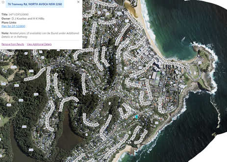
Figure 2. Location Plan
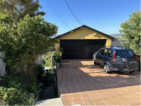
Figure 3. The subject site, No. 76 Tramway Road.
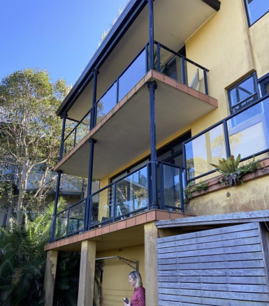
Figure 4. North western elevation of subject dwelling.
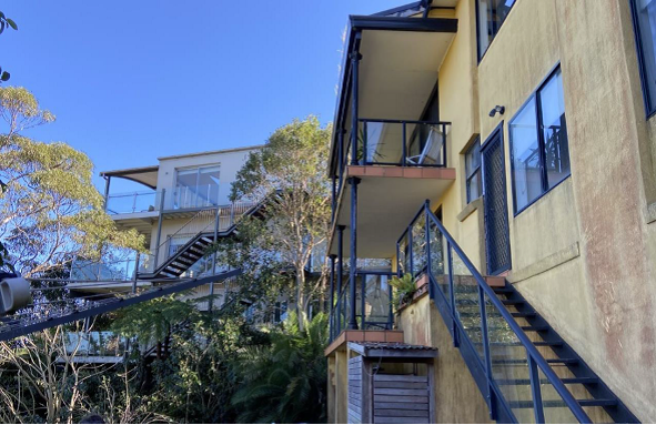
Figure 5. Rear of subject site and adjoining dwelling, looking west.
Figure 6. Eastern side boundary of subject dwelling with adjoining dwelling, looking north.
Figure 7. Front terrace and garage, looking east.
Figure 8. Subfloor area.
Figure 9. Views looking south.
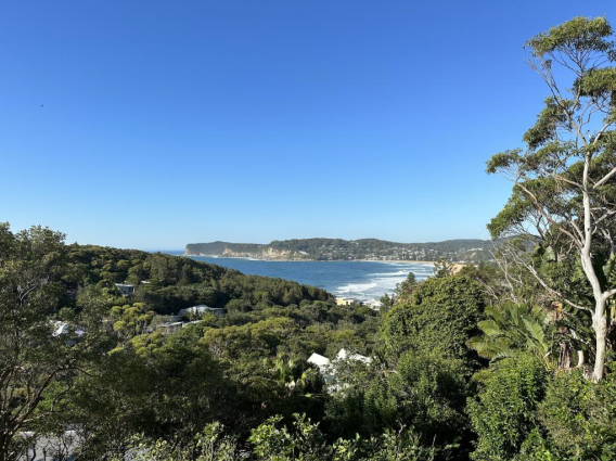
Figure 10. Views looking south.
The Proposed Development
The proposed development seeks consent for the alterations and additions to the existing dwelling to reconfigure the internal layout, creating a four bedroom plus study. Reference is made to the Architectural Plans, at Attachment 1. Specifically, the proposed development will comprise of the following:
|
Roof |
A new metal roof to the north-western portion of the roof. |
|
New metal roof sheeting to the remainder of the roof. |
|
|
A new operable roof to the rear deck. |
|
|
Lower Level |
Retain the existing under croft area. |
|
Installation of new rainwater tanks to the under croft, a new storage room, terrace, deck, and external staircase. Note: The Applicant advised via email on 7 November 2024 that they are no longer seeking consent for the spa component and this portion of the development is omitted. |
|
|
Level 1 |
Convert the existing living room to a pool room with bathroom and wet bar. |
|
Demolish the existing laundry and reconfigure the existing bedrooms, to create bedrooms 2 and 3. |
|
|
Demolish the existing staircase and construct a new staircase to access Level 2. |
|
|
Demolish the existing bathroom and construct a new bathroom, hallway linen, cupboard and study. |
|
|
Demolish the rear balcony and external staircase and construct new balconies. |
|
|
Installation of new windows and doors. |
|
|
Level 2 |
Infill the west facing window to the retained living room. |
|
Refurbish the existing kitchen and dining room. |
|
|
Extend the dwelling to the north and west to create a hallway, pantry/laundry and rumpus room. |
|
|
New decking to the retained front terrace. |
|
|
Demolish the existing staircase and construct a new staircase to access Level 1. |
|
|
Demolish the internal walls to the bedrooms and bathrooms and extend the dwelling to the north, to create 1 bedroom, bathroom, WIR, ensuite and rumpus room. |
|
|
Demolish the rear balcony and external staircase and construct new balconies. |
|
|
Garage floor |
Retain the existing double garage. |
|
Infill the stair void and extend south to create a study. |
|
|
A new porch, entry and skillion roof with highlight windows. |
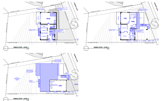
Figure 11. Proposed Demolition Plan.
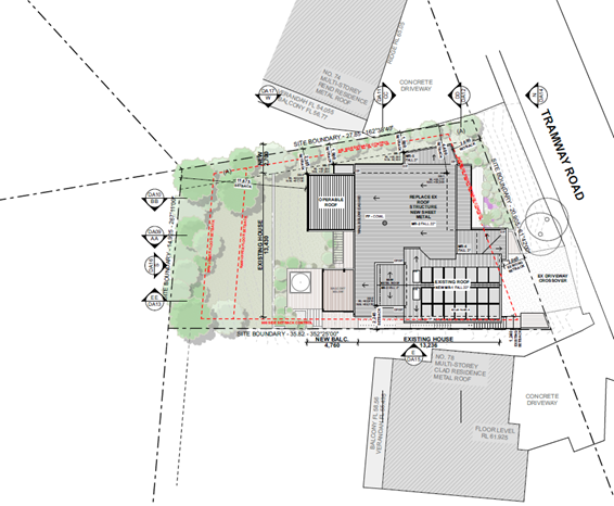
Figure 12. Proposed Site Plan.

Figure 13. Proposed Garage Floor Plan.
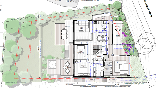
Figure 14. Proposed Level 2 Plan.
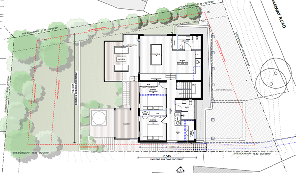
Figure 15. Proposed Level 1 Plan.
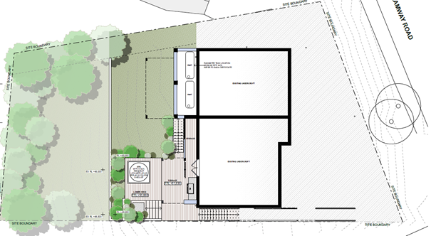
Figure 16. Proposed Terrace and Spa Plan.
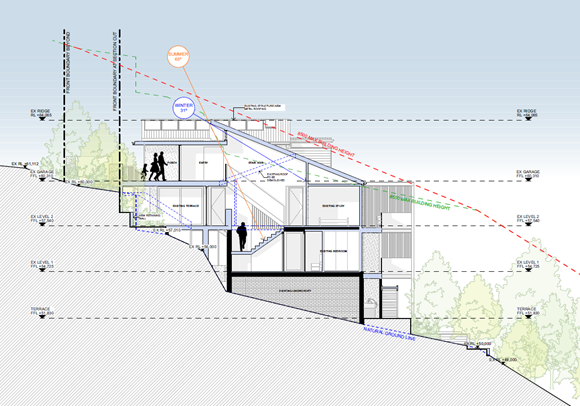
Figure 17. Proposed Section A-A.
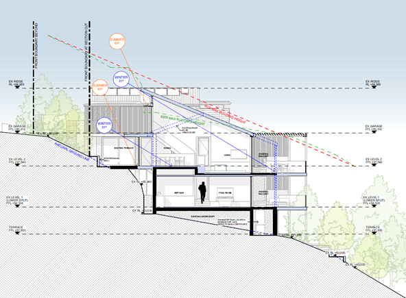
Figure 18. Proposed Section B-B.
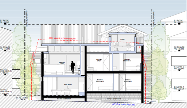
Figure 19. Proposed Section C-C.
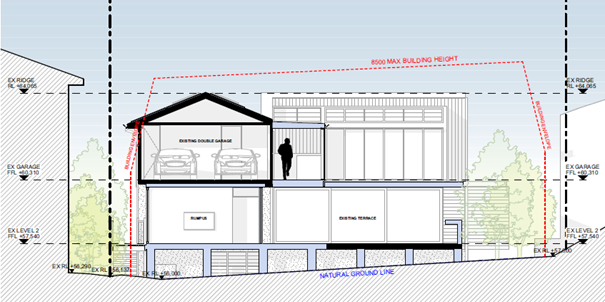
Figure 20. Proposed Section D-D.
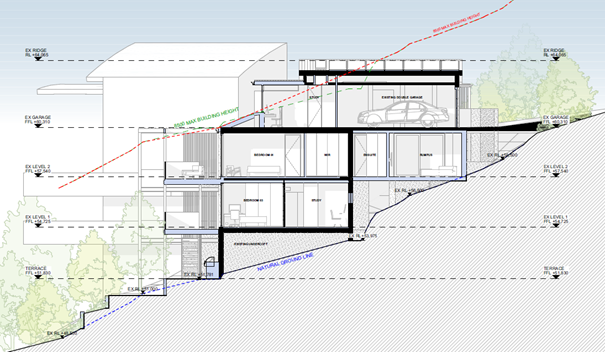
Figure 21. Proposed Section E-E.
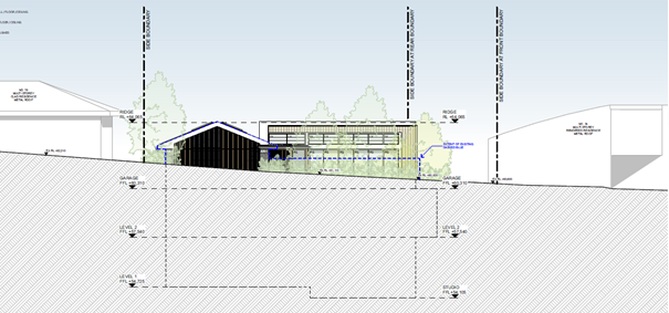
Figure 22. Northern Elevation.
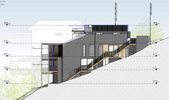
Figure 23. Eastern Elevation.
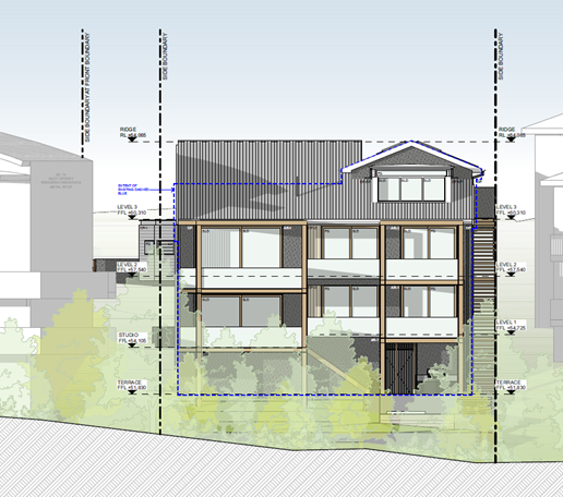
Figure 24. Southern Elevation.
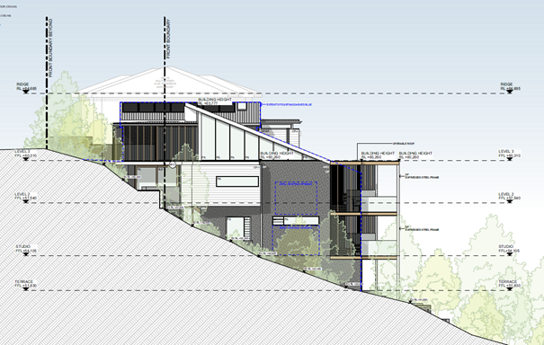
Figure 25. Western Elevation.
Summary
Having regard for the matters for consideration detailed in Section 4.15 of the Environmental Planning and Assessment Act 1979 and other statutory requirements, Council’s policies and Section 10.7 Certificate details, the assessment has identified the following key issues, which are elaborated upon for Council’s information.
Site History
The following applications have previously been considered in relation to the subject site:
· Building Information Certificate BC/3105/2001 refused on 14 March 2001.
· Plumbing and Drainage PD/44314/2007 completed on 1 February 2007.
Internal Consultation
Tree
The application was referred to Council’s Tree Assessment Officer who noted that several planted ornamentals located within the primary setback may require removal. These trees are relatively small and mostly a result of a lightly maintained yard.
Lopped Gum trees located within the road reserve will not be impacted by the works, and nor will existing trees located near the property boundary.
The application is supported, subject to recommended conditions.
Water Assessment
The application was referred to Council’s Technical Officer Water Assessment who advised that water and sewer is available to the land and sewer relining is not required. The applicant will be required to obtain a Section 307 Certificate of Compliance under the Water Management Act 2000.
The application is supported, subject to recommended conditions.
Infrastructure and Access Crossing Officer
The application was referred to Council’s Infrastructure and Access Crossing Officer who advised that as no works will be undertaken to the existing vehicle crossing on the road reserve, no referral is required.
The applicant confirmed this via email on 5 November 2024.
Development Engineer
The application and revised stormwater plans prepared by Cubo Consulting were referred to Council’s Development Assessment Engineer for review and comment. The development proposes to direct stormwater to an existing system in Lot 349, DP16963 via 10000L rainwater tanks. The connection is through an interallotment system burdening Lot 3472, DP520890.
DRAINS
calculations have been provided; however, it is unclear from the labelling the
location of the nodes in relation to the proposed system.
The proposed system is supported with owner consent (from Lot 3472, DP520890) and the development limits the total Post Development Discharge Rates to 25l/s during 1% AEP events.
The application is supported, subject to recommended conditions.
Ecologically Sustainable Principles
The proposal has been assessed having regard to ecologically sustainable development principles and is consistent with the principles.
The proposed development is considered to incorporate satisfactory stormwater, drainage and erosion control and the retention of vegetation where possible and is unlikely to have any significant adverse impacts on the environment and will not decrease environmental quality for future generations. The proposal does not result in the disturbance of any endangered flora or fauna habitats and is unlikely to significantly affect fluvial environments.
Climate Change
The potential impacts of climate change on the proposed development have been considered by Council as part of its assessment of the application.
This assessment has included consideration of such matters as potential rise in sea level; potential for more intense and/or frequent extreme weather conditions including storm events, bushfires, drought, flood and coastal erosion; as well as how the proposed development may cope / combat / withstand these potential impacts and is demonstrated to be acceptable in this instance.
Environmental Planning Instruments, Proposed Instrument, Development Control Plan, Planning Agreements and the Regulations
The relevant environmental planning instruments, proposed instruments, development control plans, planning agreements and the matters for consideration under the Regulation are considered below.
a) SECTION 4.15(1)(a)(i) – PROVISIONS OF ENVIRONMENTAL PLANNING INSTURMENTS
The following pieces of legislation are relevant to this application:
· Rural Fires Act 1997
· State Environmental Planning Policy (Building Sustainability Index: BASIX) 2004
· State Environmental Planning Policy (Resilience and Hazards) 2021
· Central Coast Local Environmental Plan 2022
Consideration of the relevant SEPPs is further outlined below.
Rural Fires Act 1997
The subject site is identified as bushfire prone land in accordance with the Central Coast Council Bush Fire Prone Land Map as shown below. The subject development is not a listed Special Fire Protection Purpose and is not classified as integrated development under Section 4.46 of the Environmental Planning and Assessment Act 1979 and therefore does not require a Bushfire Safety Authority under Section 100B of the Rural Fires Act 1997.
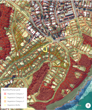
Figure 26. Bushfire Prone Land Map.
In accordance with the provisions of Section 4.14 of the Environmental Planning and Assessment Act 1979, consent cannot be granted unless the consent authority is satisfied the development conforms to the relevant specification and requirements of Planning for Bushfire Protection 2019 (PBP) (s.4.14(1)(a)) or alternatively, that certification stating the development conforms to the relevant specifications and requirements from an appropriately qualified person is provided to the consent authority (s.4.14(1)(b)).
Accordingly, the application is accompanied by a Bushfire Assessment Report, prepared by David Peterson dated 2 April 2023 (Attachment 2). The Report undertakes an assessment of the proposed development by a consultant accredited by the Fire Protection Association of Australia’s BPAD (Accreditation No. BPC-L3-18882) and acts as a certificate as described under Clause 4.14(1)(b) of the EP&A Act 1979.
Subject to the conclusions and recommendations contained therein, including that all external building works are to be designed and constructed to comply with BAL-12.5 of Australian Standard AS3959-2018 Construction of Buildings in Bushfire Prone Areas (AS3959), the Panel can be satisfied that the proposed development will comply with Planning for Bush Fire Protection 2019.
State Environmental Planning Policy (Building Sustainability Index: BASIX) 2004
The application is accompanied by BASIX Certificate No. A498439 and dated Tuesday 27 June 2023 (Attachment 3). The Certificate demonstrates that the proposed development satisfies the relevant thermal, energy and water requirements of the SEPP, subject to compliance with the commitments contained therein.
Subject to recommended conditions, the Panel can be satisfied that the provisions of the SEPP are satisfied in this instance.
State Environmental Planning Policy (Resilience and Hazards) 2021
Chapter 2: Coastal Management
The subject site is located within the coastal use area as shown in the figure below. Section 2.11 is to be taken into consideration with further assessment below.
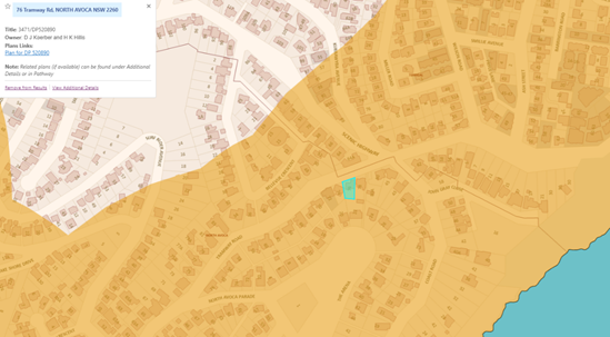
Figure 27. Coastal use affectation.
Clause 2.11 – Coastal Use Area
|
Matters for Consideration |
Compliance |
|
(1) Development consent must not be granted to development on land that is within the coastal use area unless the consent authority: |
|
|
(a) has considered whether the proposed development is likely to cause an adverse impact on the following: |
|
|
(i) existing, safe access to and along the foreshore, beach, headland or rock platform for members of the public, including persons with a disability, |
The site is not in proximity to public open space and does not impact existing safe access to and along the foreshore for members of the public |
|
(ii) overshadowing, wind funnelling and the loss of views from public places to foreshores, |
The proposal will not result in unreasonable overshadowing, wind funnelling or loss of views from any public places to foreshores. |
|
(iii) the visual amenity and scenic qualities of the coast, including coastal headlands, |
The proposal does not impact visual amenity or scenic qualities of the coastal area |
|
(iv) Aboriginal cultural heritage, practices and places, |
The proposal is not likely to cause an adverse impact on Aboriginal cultural heritage, practices and places. Standard conditions are imposed to stop works and report the findings to the AHO if any Aboriginal Engravings or Relics are unearthed. |
|
(v) cultural and built environment heritage, and |
The site is within a developed urban area and the proposed development is unlikely to adversely impact the cultural and built environment heritage |
|
(b) is satisfied that— |
|
|
(i) the development is designed, sited and will be managed to avoid an adverse impact referred to in paragraph (a), or |
The proposed development has been designed, sited to avoid any adverse impact referred to in paragraph (a). |
|
(ii) if that impact cannot be reasonably avoided—the development is designed, sited and will be managed to minimise that impact, or |
N/A |
|
(iii) if that impact cannot be minimised—the development will be managed to mitigate that impact, and |
N/A |
|
(c) has taken into account the surrounding coastal and built environment, and the bulk, scale and size of the proposed development. |
The proposed development has taken into account the surrounding coastal and built environment. The proposed bulk, scale and size of the development is demonstrated to be acceptable. |
Based on the above, the Panel can be satisfied that the requirements of Part 2 of the SEPP are satisfied in this instance.
Chapter 4: Remediation of Land
Clause 4.6 requires the approval authority to consider whether the land is contaminated and if the land is contaminated, it is satisfied that the land is suitable in its contaminated state (or will be made suitable after remediation) for the purpose for which the development is proposed to be carried out.
Further under clause 4.6(2), before determining an application for consent to carry out development that would involve a change of use of land, the approval authority must consider a report specifying the findings of a preliminary investigation of the land concerned, carried out in accordance with the contaminated land planning guidelines.
Having regard for the site historically being used for residential purposes, and the fact that the development does not result in a change of use to which the Contaminated Land Planning Guidelines refers to, it is considered that the site is and remains suitable for the proposed development.
The Panel can be satisfied that the requirements of Chapter 4 of the SEPP are satisfied in this instance.
Central Coast Local Environmental Plan 2022
The relevant local environmental plan applying to the site is the Central Coast Local Environmental Plan 2022 (CCLEP 2022). The aims of the CCLEP 2022 are to promote a high standard of urban design that responds appropriately to the existing or desired future character of areas.
Zoning and Permissibility (Part 2)
The site is zoned R2 – Low Density Residential pursuant to Clause 2.2 of the CCLEP 2022.
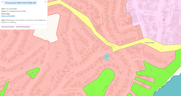
Figure 28. Land Use Map.
The objectives of the R2 – Low Density Residential zone are as follows:
• To provide for the housing needs of the community within a low-density residential environment.
• To enable other land uses that provide facilities or services to meet the day to day needs of residents.
• To encourage best practice in the design of low-density residential development.
• To ensure that non-residential uses do not adversely affect residential amenity or place unreasonable demands on services.
• To maintain and enhance the residential amenity and character of the surrounding area.
The proposed alterations and additions to the existing dwelling house are permitted with consent and considered to satisfy the objectives of the zone as it continues to provide for the housing needs of the North Avoca community within a low-density residential environment, whilst maintaining and enhancing the residential amenity and character of the area.
Clause 2.7 Demolition requires development consent
The proposed development seeks demolition of nominated structures as shown in the below figure. Subject to appropriate conditions, including compliance with AS2061, Council can be satisfied the provisions of this Clause have been met.

Figure 29. Proposed Demolition Plan.
Part 4 Principal Development Standards
The following table provides an assessment of the proposed development against other relevant clauses of the CCLEP 2022, including consideration of Principal Development Standards.
|
Development Standard |
Required |
Proposed |
Complies with numerical controls |
Variation |
Complies with objectives |
|
4.3 – Height of Buildings |
Maximum permitted building height is 8.5m. |
10.6m (skillion roof), 10.4m (study), 9.5m (rear balcony roof).
|
No – refer below. |
2.1m or 24.7% |
Yes – refer below. |
|
4.4 – Floor Space Ratio |
The site is not subject to a prescribed FSR. |
N/A |
N/A |
N/A |
N/A |
|
4.6 – Exceptions to development standards |
Development consent must not be granted to development that contravenes a development standard unless the consent authority is satisfied the applicant has demonstrated that compliance is unreasonable or unnecessary in the circumstances and there are sufficient environmental planning grounds to justify the contravention of the development standard. |
The application is accompanied by a written justification seeking to vary the numerical requirements of Clause 4.3 – Height of Buildings in accordance with the provisions of Clause 4.6. |
Further discussion below. |
Further discussion below. |
Further discussion below. |
|
5.10 – Heritage |
The objectives of Clause 5.10 of the CCLEP are as follows: · To conserve the environmental heritage of the Central Coast, · To conserve the heritage significance of heritage items and heritage conservation areas, including associated fabric, settings and views, · To conserve archaeological sites, To conserve Aboriginal objects and Aboriginal places of heritage significance. |
There are no heritage items within or adjoining the site. The site is not mapped as a heritage conservation area.
An AHIMS search does not identify the site as containing Aboriginal objects, or Aboriginal places of heritage significance. |
N/A |
N/A |
N/A |
|
7.1 – Acid Sulfate Soils |
Various |
The site is subject to Class 5 Acid Sulfate Soils. The site and proposed development are not within 500m of adjacent Class 1, 2, 3 or 4 Acid Sulfate Soils and therefore not required to be considered further. |
N/A |
N/A |
N/A |
|
7.6 Essential Services |
Essential services must be made available or adequate arrangements be made to make them available. |
The following essential services remain available to the site – the supply of water, electricity, disposal and management of sewage, stormwater drainage, suitable vehicular access and the collection and management of waste. |
Yes |
No |
Yes |
Clause 4.3 – Height of Buildings
The objectives of this Clause are as follows:
(a) To establish a maximum height of buildings to enable appropriate development density,
(b) To ensure that the height of buildings is compatible with the character of the locality.
Clause 4.3(2) permits a maximum building height of 8.5m for the subject site. The existing dwelling has a non-compliant building height of 10.8m and the proposed development seeks consent for an overall building height of 10.4m on the eastern elevation at its highest point, which exceeds the maximum permitted in accordance with this Clause.
The application is accompanied by a written Clause 4.6 justification seeking to
vary the numerical provisions of Clause 4.3(2) for the 2.1m or 24.7% height
exceedance (Attachment
4). This
is discussed further below.
Clause 4.6 – Exceptions to Development Standards
Clause 4.6 provides flexibility in applying development standards. The proposed development seeks consent for an overall building height of 10.6m to the skillion roof, 10.4m to the study and 9.5m to the rear balcony roof, which exceeds the maximum permitted under Clause 4.3(2) by 2.1m or 24.7% at the highest point.
On 15 September 2023, the NSW Government published a package of amendments that changed the operation of Clause 4.6 across standard instrument local environmental plans, including the Central Coast Local Environmental Plan 2022. The SEPP Amendment and amendment to the EPA Regulation included savings provisions and development applications made on or before 1 November 2023 are to be determined as if changes had not commenced.
From 1 November 2023, clause 4.6(3) -(5) and (7) of the Standard Instrument -Principal Local Environmental Plan were omitted. However, this application is subject to the provisions of clause 4.6 prior to amendments made from 1 November 2023.
To demonstrate that compliance with the development standard is unreasonable or unnecessary in the circumstances of the case, the Five (5) Part Test established in Winten v North Sydney Council and expanded by Justice Preston in Wehbe v Pittwater [2007] NSW LEC 827 is considered:
The five ways outlined in Wehbe include:
1. That the objectives of the standard are achieved notwithstanding non-compliance with the standard.
The objectives of the standard are:
(a) To establish a maximum height of buildings to enable appropriate development density.
Applicant comment
The proposed development is appropriate to the site and will not result in a building height, greater than the existing 10.8 metre maximum height of the dwelling. The new works propose a maximum height of 10.6 metres, when measured in accordance with the Merman Investments Pty Ltd v Woollahra Municipal Council [2021] NSWLEC 1582.
The existing building and the majority of the proposed works comply with the maximum height control, when considered against an interpolated height plane, as previously applied by the Bettar judgement.
(b) To ensure that the height of buildings is compatible with the character of the locality.
Applicant comment
As the proposed works sit below the existing maximum building height, the works remain compatible with the existing building height. The new works are largely located to the rear of the site and below the existing garage, ensuring the presentation of the dwelling to the street remains in keeping with the character of the street.
It is considered this objective is met, despite the numerical variation.
2. The underlying objective or purpose of the standard is not relevant to the development and therefore compliance is unnecessary.
Applicant comment
This exception to development standards request does not rely upon this reason.
3. The underlying object or purpose would be defeated or thwarted if compliance was required and therefore compliance is unreasonable.
Applicant comment
This exception to development standards request does not rely upon this reason.
4. The development standard has been virtually abandoned or destroyed by the Council’s own actions in granting consents departing from the standard and hence compliance with the standard is unnecessary and unreasonable.
Applicant comment
This exception to development standards request does not rely upon this reason.
5. The zoning of the particular land is unreasonable or inappropriate so that a development standard appropriate for that zoning is also unreasonable and unnecessary as it applies to the land and compliance with the standard would be unreasonable or unnecessary. This is, the particular parcel of land should not have been included in the particular zone.
Applicant comment
This exception to development standards request does not rely on this reason.
Further, this clause 4.6 variation request establishes that compliance with the development standard is unreasonable or unnecessary in the circumstances of the proposed development because the objectives of the standard are achieved and accordingly justifies the variation to the height of buildings control pursuant to the First Way outlined in Wehbe.
Thus it is considered that compliance with Clause 4.6(3)(a) is satisfied.
Clause 4.6(3)(b) – Are there sufficient environmental planning grounds to justify contravening the development standard?
The Applicant provides the following grounds/reasons for the proposed variation to the development standard:
1. Detail of variation:
a. The existing dwelling has a non-compliant maximum height of 10.8 metres and the new works propose a maximum height of 10.6 metres. The proposed variation is the result of the building height being measured in accordance with the recent Merman Judgement. The existing building and the majority of the proposed works comply with the maximum height when measured in accordance with the previously applied interpolated height set out in the Bettar judgement.
b. The proposed variation is largely the result of taking into account the existing excavated lower levels, which is acknowledged in the Merman judgement to distort the height of buildings development standard plane overlaid above the site, when compared to the topography of the hill. The judgement acknowledges that this distortion can be described as an environmental planning ground within the meaning of cl 4.6(3)(b) of LEP 2022.
c. The variation is for a limited area and the vast majority of the building complies with the height control. The apparent bulk through the variation is negligible and the resulting development remains consistent with the streetscape, satisfying Cl1.3(g).
2. Neighbour amenity:
a. Compliance with the height control would not result in a building which has a significantly lesser bulk as the new works are located at a lesser height than the existing maximum building height. A numerically complaint building height would have no material impact to neighbour, accordingly compliance with the development standard in this instance is unreasonable.
b. Solar access impacts as a result of the small height variation are negligible. The subject site and both adjoining properties do not currently achieve compliant solar access to private open space, which is located on south facing balconies to capture ocean views. The development is considered to have an appropriate impact, as it will not exacerbate the existing non-compliant solar access.
c. The proposed height variation has no impact on privacy for neighbours, accordingly, the variation is reasonable in the circumstances of the case.
3. Site constraints:
a. The variation to the height is largely the result of the revised building height measurement definitions set out in the Merman judgement. The minor variation allows for the orderly and economic use of the site and allows for an ecologically sustainable development satisfying Cl1.3(g) and (f).
4. Design and streetscape appeal:
a. Strict numerical compliance with the height control would not result in a better urban design outcome. The architectural character proposed will result in appealing alterations to this property. Compliance with the development standard based on this would be unreasonable.
b. The proposed development will not present with excessive bulk from the public domain with surrounding dwellings presenting with a consistent form and scale.
5. Consistent with zone objectives:
a. The extent of the variation is considered to be in the public interest as the proposal remains consistent with the objectives of the zone, ensuring that appropriate and reasonable housing is proposed. Compliance with the development standard based on this would be unreasonable.
6. Natural environment:
a. The inclusion of the small height variation has no impact on the natural environment. No landscape area is lost or impacted through the minor height variation satisfying Cl1.3(b). The natural environment is unaffected by the small departure to the development standard and it would be unreasonable for the development to be refused on this basis.
7. Environmentally sustainable development:
a. The proposal represents an environmentally sustainable design allowing for extension of the life on an existing dwelling satisfying Cl1.3(f). Compliance with the development standard based on this would be unreasonable.
8. Social and economic welfare:
a. The small variation to the height as detailed above will have no social impacts for the site or local area satisfying Cl1.3(b) and accordingly refusal of the development based on this reason would be unreasonable.
b. The small variation to the height as detailed above will have no economic impacts for the site or the local area satisfying Cl1.3(b) and accordingly refusal of the development based on this reason would be unreasonable.
9. Appropriate environmental planning outcome:
a. The development proposed is not an overdevelopment of the site and satisfies the objectives of the zone and the development standard.
b. The variation does not result in a roof form or height beyond that of the existing dwelling. The small variation will be compatible within the context in which it sits and is reasonable in the circumstances of the case satisfying Cl1.3(c). Compliance with the development standard based on this would be unreasonable.
c. Removal of the non-compliance would not substantially alter the perceived bulk and scale due to the minor nature, siting, and topography.
Council comment
The minor numerical non-compliance is acceptable in this instance as it will complement the existing development and not unreasonably contribute to building bulk, scale or height, or adverse impacts to the streetscape or surrounding residential properties. The non-compliant height components are below the existing building height of 10.8m.
The written request has suitably demonstrated the proposal will not result in adverse privacy, overshadowing or view impacts for surrounding properties with ample setbacks, and no direct overlooking into key living areas. Passive overlooking is experienced only due to the sloping nature of the site; however, this is not intensified from the proposed development. Notwithstanding this, the Applicant has implemented into the design the use of skylights, highlight windows and privacy screening to the balconies.
The written request has identified, and adequately justified, sufficient environmental planning grounds, and the reasons provided have demonstrated circumstances which relate to the specific contravention of the maximum permitted building height and how the objectives of the standard can be achieved even though it will not be a wholly compliant development (Al Maha Pty Ltd v Huajun Investments Pty Ltd [2018] NSWCA 245). Accordingly, the consent authority is satisfied as to those matters stated in clause 4(3) of CCLEP 2022 (RebelIMH Neutral Bay Pty Limited v North Sydney Council [2019] NSWCA 130).
Clause 4.6(4)(a) identifies matters of satisfaction for the consent authority to grant development. These are:
· That the written request has adequately addressed the above requirements of the written request contained at 4.6(3).
The Panel can be satisfied the written request has adequately addressed the provisions of cl.4.6(3).
· That the proposed development is in the public interest because it is consistent with the objectives of the particular standard and the objectives for development within the zone in which the development is proposed to be carried out, and
As identified in the above body of this report, the proposal is consistent with the stated objectives of the development standard as it ensures the development density and character is commensurate with the residential zone in which it exists, whilst minimising adverse environmental effects on the use or enjoyment of adjoining properties.
Having regard for the decision in Wehbe v Pittwater Council [2007] NSWLEC827 and repeated
in Initial Action Ltd v Woollahra Municipal Council [2008] NSWLEC118, it is considered the
objectives of the standard are achieved notwithstanding numerical non-compliance with the
standard. The Panel can be satisfied that the written requires to vary the maximum permitted building height is in the public interest because it is consistent with the objectives of the standard and the existing and desired future character of the residential zone in which it is located.
· The concurrence of the Planning Secretary has been obtained.
The application is reported to the Central Coast Local Planning Panel in accordance with Schedule 2 of the Local Planning Panels Direction – Development Applications and Applications to Modify Development Consents as the development contravenes a development standard by more than 10%.
· Any State or regional significant planning matters raised by contravening the standard.
There are no state or regional matters that arise because of the contravention of the standard.
· The public benefit of maintaining the standard.
In this instance, the variation would not contravene the public benefit if the standard were not maintained in this instance.
Clauses 4.6(6) and 4.6(8) provide circumstances under which the provisions of clause 4.6 cannot be utilised. These circumstances do not arise within this development application.
Having regard for the written request provided by the applicant and the above assessment,
the proposed development is considered to satisfy the requirements of clause 4.6, achieving a better outcome for and from the development within the circumstances.
Clause 7.1 – Acid Sulfate Soils
The site is mapped as Class 5 Acid Sulfate Soils and the proposed development does not involve excavation that impacts upon acid sulfate soils in any other class. The Panel, as the consent authority can be satisfied that the relevant considerations of this Clause have been satisfied and that no further consideration is required in this regard.
Clause 7.6 – Essential Services
The Panel can be satisfied that the proposed development has adequate essential servicing available to the development having regard for water, sewer, electricity,
stormwater drainage, waste collection and vehicular access. No further consideration is required in this regard.
b) SECTION 4.15(1)(a)(ii) – PROVISIONS OF ANY PROPOSED INSTRUMENTS
There are no draft instruments for consideration in this regard.
c) SECTION 4.15(1)(a)(iii) – PROVISION OF ANY DEVELOPMENT CONTROL PLAN
The following Development Control Plan is relevant to this application:
Central Coast Development Control Plan 2022 (CCDCP 2022)
The following Chapters of the CCDCP 2022 are relevant to this application:
- Chapter 1.2 – Notification of Development Proposals
- Chapter 2.1 – Dwelling Houses, Secondary Dwellings and Ancillary Development
- Chapter 2.13 – Transport and Parking
- Chapter 2.14 – Site Waste Management
- Chapter 3.5 - Tree and Vegetation Management
- Chapter 3.7 – Geotechnical Requirements
An assessment is provided below.
Chapter 1.2: Notification of Development Proposals
The application was notified in accordance with the requirements of Chapter 1.2 of the CCDCP 2022 from 14 to 28 July 2023. No submissions were received, and the Panel is advised that no further consideration of this Chapter is required in this regard.
Chapter 2.1 – Dwelling Houses, Secondary Dwellings and Ancillary Development
The following table provides an assessment of the proposed development against relevant sections of the Chapter 2.1.
Part 2.1.4.1 Views
In considering the impact to views because of the proposed development, the planning principles contained within Tenacity Consulting v Waringah [2004] are provided below:
· Assessment of views to be affected. Water views are valued more highly than land views. Iconic views (eg of the Opera House, the Harbour Bridge or North Head) are valued more highly than views without icons. Whole views are valued more highly than partial views, eg a water view in which the interface between land and water is visible is more valuable than one in which it is obscured.
No. 76 Tramway Road -subject site
Unencumbered views are currently obtained from a sitting and standing position from the living spaces as per the below image, over the subject site in a southerly direction, towards Avoca Beach.
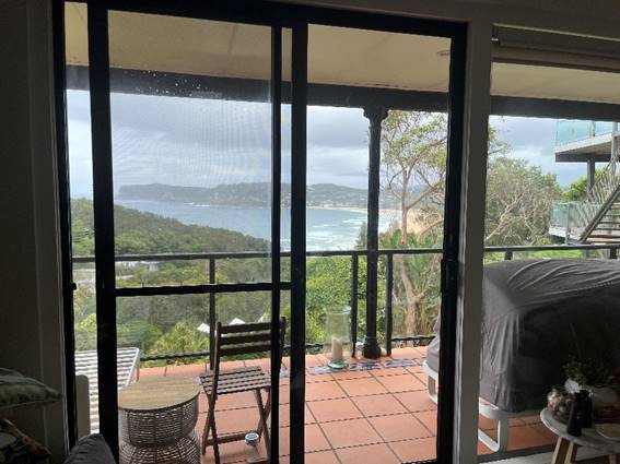
Figure 30. Existing views from loungeroom of subject site, looking south.
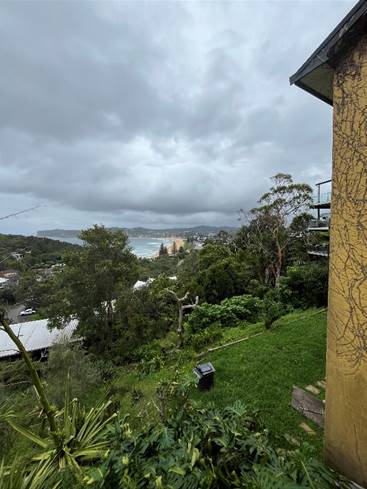
Figure 31. View from northern lot boundary of subject site, looking south.
No. 78 Tramway Road
Unencumbered views are enjoyed from the ground floor level in a sitting and standing position also over the site in a southerly direction from the rear outdoor deck as per Figure 31, the first floor level as per Figure 32, and presumed from the upper floor level however this was not accessible during the time of inspection.
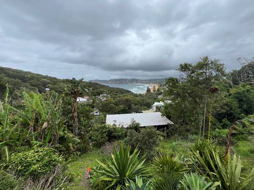
Figure 32. View from rear outdoor deck of No. 78 Tramway, looking south.
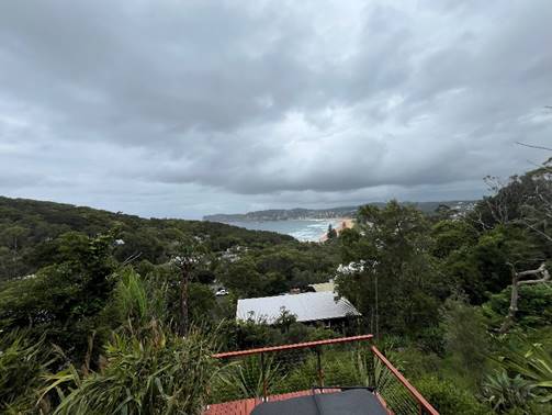
Figure 33. View from first floor level of No. 78 Tramway, looking south.
No. 74 Tramway Road
Unencumbered views are also obtained from No. 74 Tramway from all levels also in a sitting and standing position also over the site in a southerly direction towards Avoca Beach as per the below Figures.
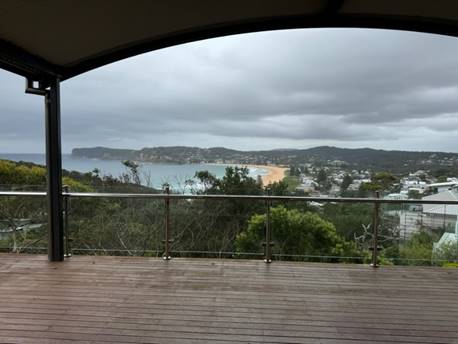
Figure 34. View from upper level of No. 74 Tramway, looking south.
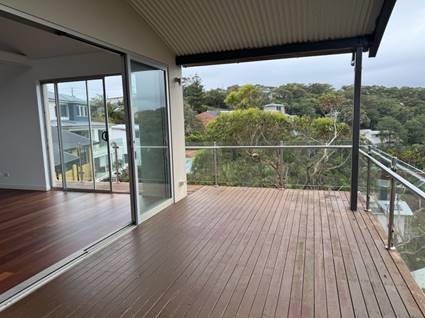
Figure 35. View from upper level of No. 74 Tramway, looking east (subject development barely visible in left portion of image)
· The extent of the impact. This should be done for the whole of the property, not just for the view that is affected. The impact on views from living areas is more significant than from bedrooms or service areas (though views from kitchens are highly valued because people spend so much time in them). The impact may be assessed quantitatively, but in many cases this can be meaningless. For example, it is unhelpful to say that the view loss is 20% if it includes one of the sails of the Opera House. It is usually more useful to assess the view loss qualitatively as negligible, minor, moderate, severe or devastating.
As demonstrated in the above images, views are currently enjoyed from the rear elevation of the subject site and those adjoining which comprise mainly of living areas and rear decks. As provided in the planning principle, views from the living areas are more significant than those from bedrooms or service areas. Both the subject site and adjoining developments enjoy an unencumbered view in a southerly direction towards Avoca Beach from all levels of respective dwellings, which remain unimpacted due to its steep topography and gradient and its orientation towards Avoca Beach in addition to the varying side setbacks of No. 74, 76 and 78 Tramway Road.
It is considered that the impact to existing and uninterrupted views of Avoca Beach will be minimised and maintained for all dwellings.
· The reasonableness of the proposal that is causing the impact. A development that complies with all planning controls would be considered more reasonable than one that breaches them. Where an impact on views arises as a result of non-compliance with one or more planning controls, even a moderate impact may be considered unreasonable. With a complying proposal, the question should be asked whether a more skilful design could provide the applicant with the same development potential and amenity and reduce the impact on the views of neighbours. If the answer to that question is no, then the view impact of a complying development would probably be considered acceptable and the view sharing reasonable.
The proposed development is generally compliant, except for a 2.1m building height exceedance, equating to a 24.7% variation to the maximum 8.5m permitted under Clause 4.3(2) of the Central Coast Local Environmental Plan 2022. In this instance, the building height variation does not result in view loss to existing and surrounding residential dwellings and can be attributed to the slope of the site. The proposed height of the development will be less than the height of the current dwelling house. Uninterrupted southerly views to Avoca Beach will be maintained for No. 74, 76 and 78 Tramway Road. It is also noted that the objectives of Part 3.1.4.1 of the CCDCP 2022 provides the following:
· To encourage view sharing as a means of ensuring equitable access to views from private property.
· To facilitate reasonable view sharing whilst not restricting the reasonable development from the site.
As previously discussed in the above body of this report, the proposed development is considered acceptable insofar as it ensures equitable access to views in a southerly direction towards Avoca Beach and ensures reasonable view sharing amongst residential dwellings whilst not restricting the reasonable development of the site.
Having regard to the above planning principles, the Panel can be satisfied that the potential impacts to all views from the redevelopment of No. 76 Tramway Road are minimised with existing views from surrounding residential dwellings maintained and enjoyed from respective levels in a sitting and standing position.
Chapter 2.13 – Transport and Parking
The proposed development remains compliant with the car parking requirements as required by Part 2.13.3.2 that dwellings with 4 or more bedrooms retain 2 spaces per dwelling.
This is maintained within the existing double garage accessed via Tramway Road.
The Panel is advised the requirements of Chapter 2.13 are satisfied in this instance.
Chapter 2.14 – Site Waste Management
The application is accompanied by a Waste Management Plan which details the site preparation/demolition, construction, and ongoing operation of the residential dwelling in accordance with the requirements of this Chapter.
Subject to recommended conditions, the Panel can be satisfied that the requirements of Chapter 2.14 have been met.
Chapter 3.5 - Tree and Vegetation Management
As detailed within the accompanied Arborist Report, an assessment of the trees within and adjacent to the subject site was undertaken by William Dunlop of Temporal Tree Management P/L on 13/04/2023 (Attachment 5). All trees inside and within five metres of the property boundaries of the subject site were assessed. As stipulated in Chapter 3.5.1 of the Central Coast DCP (2022), woody vegetation is prescribed as a ‘tree’ if it was measured to have a height of or greater than 3 metres, and 27 trees were identified and assessed according to Chapter 3.5.
Trees 1-7 are positioned on the northern side of the existing dwelling. Trees 1 and 2 are positioned adjacent to the north-western boundary while Trees 6 and 7 are positioned adjacent to the eastern boundary. The ownership of these trees is unclear. Trees 3 and 4 are positioned within the northern boundary of the subject site. Tree 5 is positioned within a steep embankment adjacent to the northern boundary that forms part of the Tramway Road reserve. Trees 8-27 are positioned on the southern side of the existing dwelling within a heavily vegetated and steep portion of land. Trees 12 and 25 are positioned adjacent to the south-western boundary and appear to be within the property of 74 Tramway Road. Trees 14-16 are positioned outside the south-eastern boundary and are within the property of 78 Tramway Road.
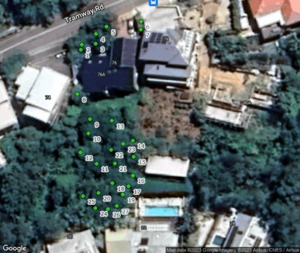
Figure 30. Location of 27 assessed trees as contained within the Arborist Report, prepared by William Dunlop.
The proposed development plans within the subject site involve alterations and additions to the existing three-storey dwelling. Demolition of internal walls and external steps and landscape structures will be required to facilitate the proposed development. The footprint of the proposed renovated dwelling will be extended on the southern side. The existing garage, vehicle crossing and driveway adjacent to the north-eastern boundary will be retained under the proposed design.
As advised by the consultant arborist, Tree 3 will be directly impacted by the proposed development due to the position of its stem within the footprint of the proposed outdoor entertaining area. Trees 1, 2 and 4-8 may be directly impact due to their close proximity to the proposed works areas. The remaining specimens (Trees 9-27) are more suitably distanced from the proposed development works and are unlikely to be directly impacted.
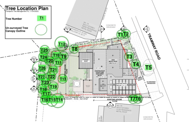
Figure 31. Proposed development in relation to assessed trees, as contained within the Arborist Report, prepared by William Dunlop.
The Report advises that the following trees are recommended for removal or retention in accordance with this Chapter:
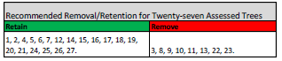
Council’s Tree Assessment Officer has considered the above and confirmed that determined the proposed development satisfactory with regards to Chapter 3.5.
Chapter 3.7 – Geotechnical Requirements
The application is accompanied by a Geotechnical Report for the proposed development undertaken by Douglas Partners Pty Ltd and dated April 2023 (Attachment 6). The Report undertakes an assessment of the subsurface soil and groundwater conditions at specified test locations and a slope stability assessment in accordance with the requirements of Chapter 3.7.
Based on local topographical information, the site slops approximately 60m AHD from the northern site boundary down to 44m AHD at the south-eastern corner of the site.
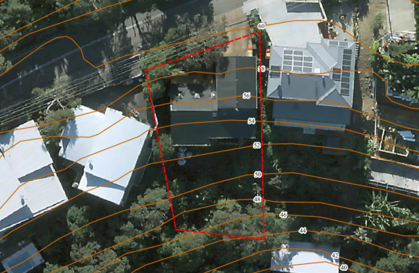
Figure 32. Subject site with elevational contours.
The Report provides a qualitative assessment of the likelihood of occurrence of a landslide, post construction, or mass ground movements and its consequence and risk to the property. The Report contains several recommendations to footings, excavation support including batter slopes, retaining walls and drainage.
Subject to the recommendations contained therein, which are imposed as recommended conditions of consent, the Panel can be satisfied the requirements of Chapter 3.7 have been met.
d) SECTION 4.15(1)(a)(iiia) – PLANNING AGREEMENTS UNDER SECTION 7.4 OF THE EP&A ACT
There are no planning agreements or draft planning agreements entered or proposed for the site. No further consideration is required in this regard.
e) SECTION 4.15(1)(a)(iv) – PROVISIONS OF REGULATIONS
Section 23 Persons who may make development applications
The Panel can be assured that correct owner’s consent has been made in accordance with Section 23 of the Regulations.
Section 61 Additional matters that consent authority must consider.
Section 61 of the Regulations, contains matters that must be taken into consideration by a consent authority in determining a development application, with the following matters relevant to the proposal:
· If demolition of a building is proposed, provisions of AS2601 apply.
The proposed development seeks to undertake partial demolition in accordance with the proposed demolition plan.
Subject to relevant conditions regarding waste management being imposed on any consent granted for the proposed development, the Panel can be satisfied Section 61 of the Regulations have been met.
f) SECTION 4.15(1)(b) – LIKELY IMPACTS OF DEVELOPMENT
The likely impacts of that development, including environmental impacts on both the natural and built environments, and social and economic impacts in the locality must be considered. In this regard, potential impacts related to the proposal have been considered in response to SEPPs, LEP and DCP controls outlined above and the Key Issues section below.
The consideration of impacts on the natural and built environments includes the following:
· Locality and streetscape
The proposal will not adversely impact on the character and amenity of the locality and streetscape. The scale, form, character, and density of the development is considered acceptable within the locality having regard for the low-density character of the area and the built form of surrounding dwellings.
The design and appearance of the development is of a high design that is of an architectural appearance which is satisfactory within the future character of the streetscape. The form and scale of the development is consistent with that envisaged for the site under the R2 zoning for low density development. The built form is well articulated and composed, includes a suitable materials palette including timber cladding of spotted gum, white finished linear weatherboard, and shale grey colourbond streel and has considered the relationship to surrounding properties and the opportunities presented by the location of the site.
· Context and setting
The site is located within a low-density residential area consisting of mainly single and two storey dwellings. As previously discussed in the report, the proposed development is in keeping with the character, built form and scale of surrounding development and as such is considered satisfactory regarding context and setting.
· Privacy, overlooking and boundary treatments
Nearby dwellings to the east, south and west are the most sensitive of potentially affected neighbouring properties that are most likely to be impacted by privacy and amenity. Overlooking has been minimised through the orientation of dwelling windows and balconies, towards the rear of the site, to avoid direct conflict. The incorporation of privacy screening and obscure glazing on both the eastern and western elevations will ensure that any potential privacy impacts are further minimised.
· Built environment.
A thorough assessment has been undertaken with regards to the physical, built environment under the Central Coast Local Environmental Plan and Development Control Plan with physical impacts considered to be reasonable within the context of the site.
· Natural environment
There will be no significant impact upon the natural environment because of the proposed development.
g) SECTION 4.15(1)(c) – SUITABILITY OF THE SITE
Having regard to the above, the site is considered suitably for the proposed form of development.
h) SECTION 4.15(1)(d) – PUBLIC SUBMISSIONS
The application was notified from 14 to 28 July 2023. No submissions were received, and the Panel is advised that no further consideration is required in this regard.
The Public Interest:
The proposed development is consistent with relevant planning provisions with no matters of concern that would indicate that the proposal is contrary to the public interest.
Other Matters for Consideration
Political Donations
There were no political donations declared by the applicant, applicant’s consultants, or property owner.
Contributions
Council’s Principal Strategic Planner Infrastructure advised on 11 November 2024 that alterations and additions to an existing dwelling house are excluded from Council’s Section 7.12 Contributions Plan.
No contributions are payable in this instance.
Conclusion
This development application has been considered in accordance with the requirements of the Environmental Planning and Assessment Act 1979 and the Regulations, as outlined in this report. The following is a summary of prerequisite conditions for the granting of development consent that have been considered in the assessment report and provided as part of the conclusion, for the benefit of the Panel:
· Having regard for Sections 2.11 of the State Environmental Planning Policy (Resilience & Hazards) 2021, the Panel can be satisfied that the proposed development is designed, sited, and will be managed to avoid an adverse impact referred to in s.2.11(1), and the development is not likely to cause increased risk of hazards on the subject site or other land.
· The Panel can be satisfied that the land is suitable for the proposed development as referenced in Section 4.6(4) of the State Environmental Planning Policy (Resilience and Hazards) 2021 nor does it involve a change of use of the land. Accordingly, the development is satisfactory having regard for the provisions of Section 4.6 of the same SEPP.
· The Panel can be satisfied that the proposed development is satisfactory with regards to the R2 – Low Density Residential zone and its objectives in accordance with the Central Coast Local Environmental Plan 2022.
· There are no significant issues or impacts identified with the proposal under Section 4.15 of the Environmental Planning and Assessment Act 1979.
· Having regard for the prerequisite conditions to the granting of consent under the Central Coast Local Environmental Plan 2022, the Panel can be satisfied that:
o Clause 7.6 – Essential Services
All services essential for the proposed development to be undertaken remain available to the site.
· Subject to the imposition of appropriate conditions, the proposed development is not expected to have any adverse environmental, social, or economic impact.
RECOMMENDATION
That Development Application No. DA/1355/2023 for the alterations and addition to No. 76 Tramway Road, North Avoca, NSW, 2260 be APPROVED pursuant to Section 4.16(1)(a) of the Environmental Planning and Assessment Act 1979 subject to the draft conditions attached to this report at Attachment 1.
|
Final Architectural Plans for No. 76 Tramway Road, as amended |
Provided Under Separate Cover |
D16510207 |
|
|
2⇩ |
Final Architectural Plans for No. 76 Tramway Road, as amended - REDACTED |
|
D16525804 |
|
3⇩ |
Bushfire Assessment Report |
|
D15751730 |
|
4⇩ |
BASIX Certificate |
|
D15751731 |
|
5⇩ |
Clause 4.6 Written Request to Vary a Development Standard |
|
D15751741 |
|
6⇩ |
Arboricultural Impact Assessment |
|
D15751736 |
|
7⇩ |
Geotechnical Report |
|
D15751723 |
|
4.2 |
DA/1355/2023 - 76 Tramway Road, North Avoca - Alterations and additions to an existing residential dwelling |
|
Attachment 2 |
Final Architectural Plans for No. 76 Tramway Road, as amended - REDACTED |
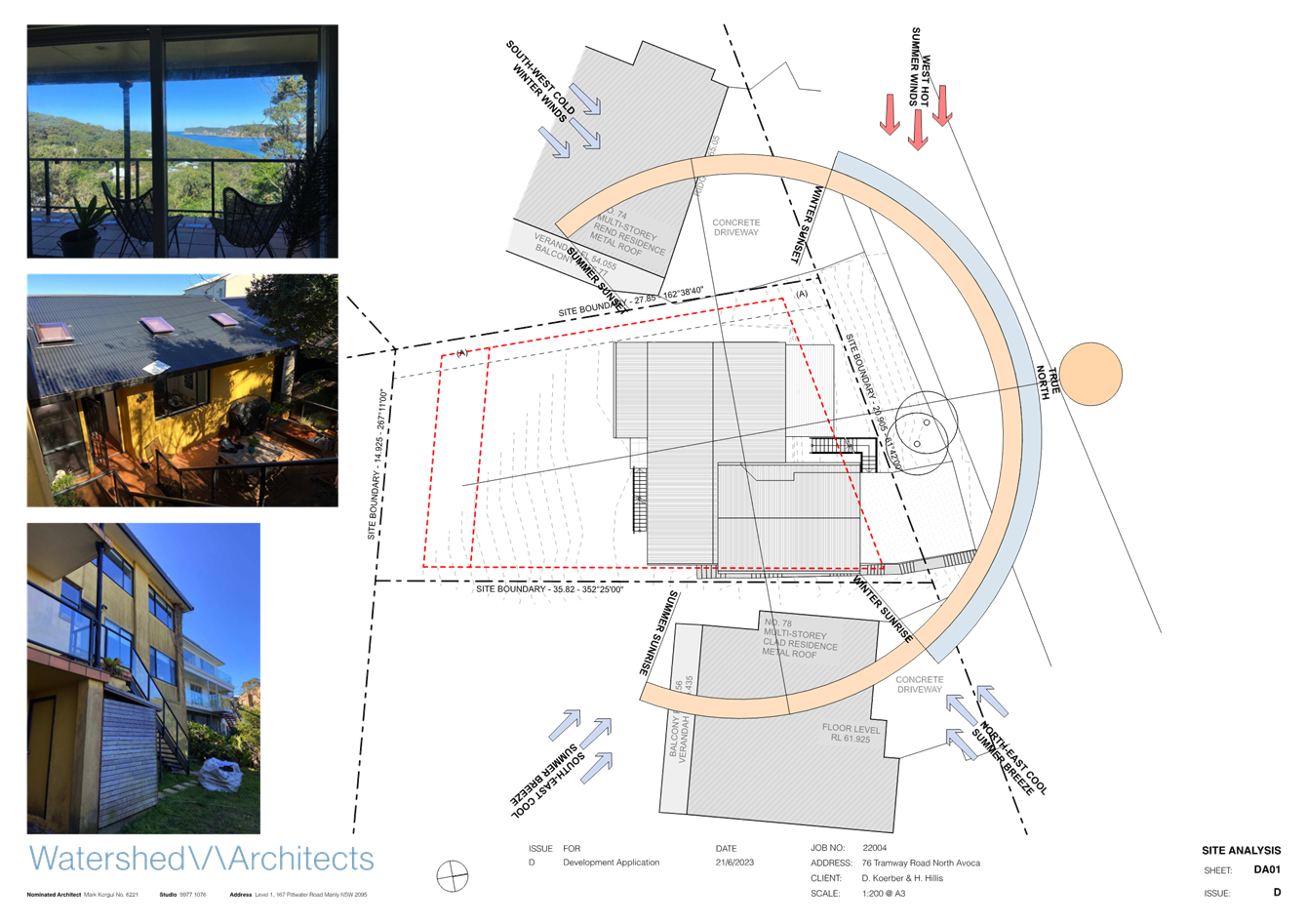
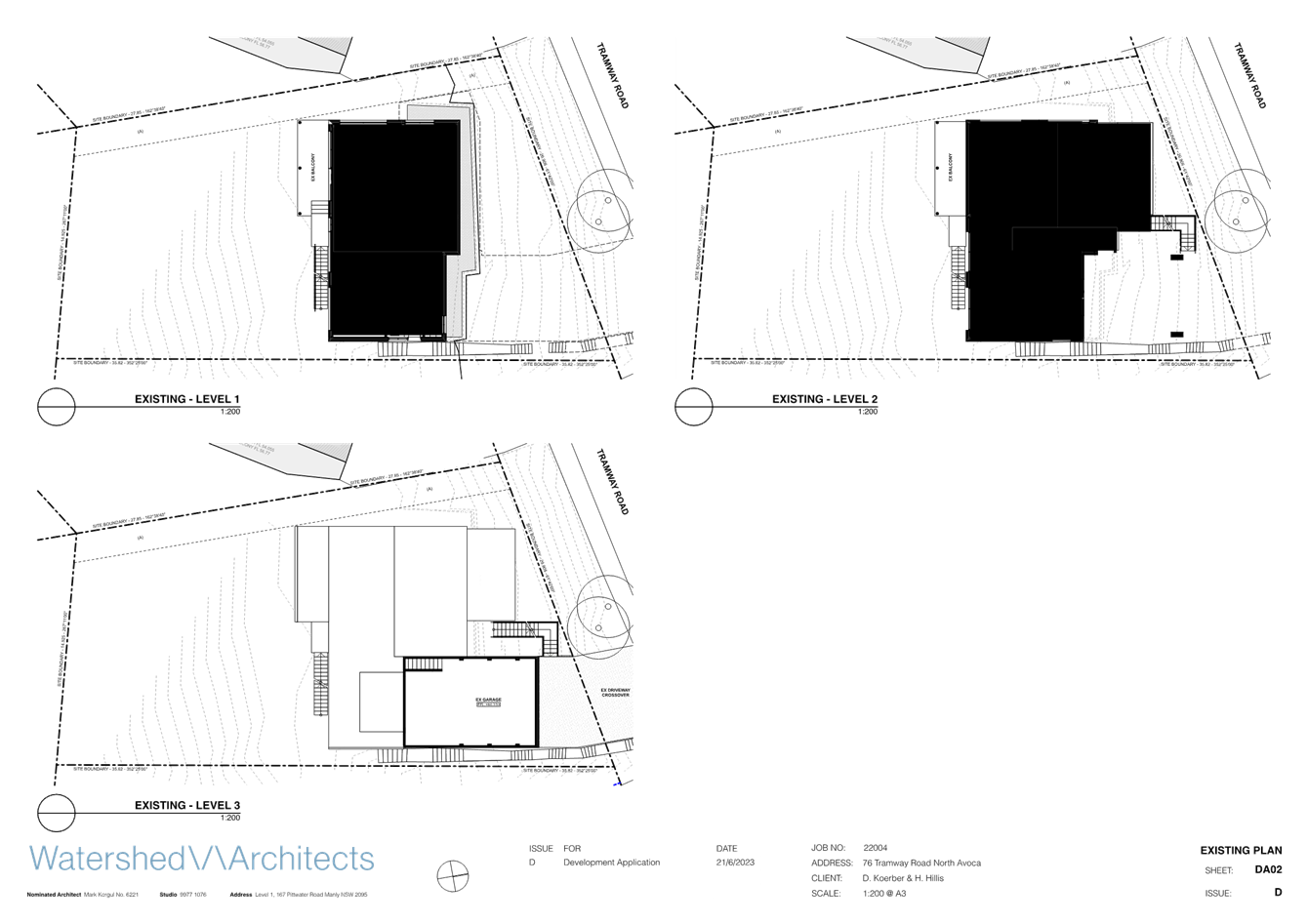
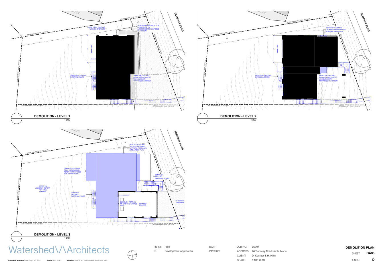
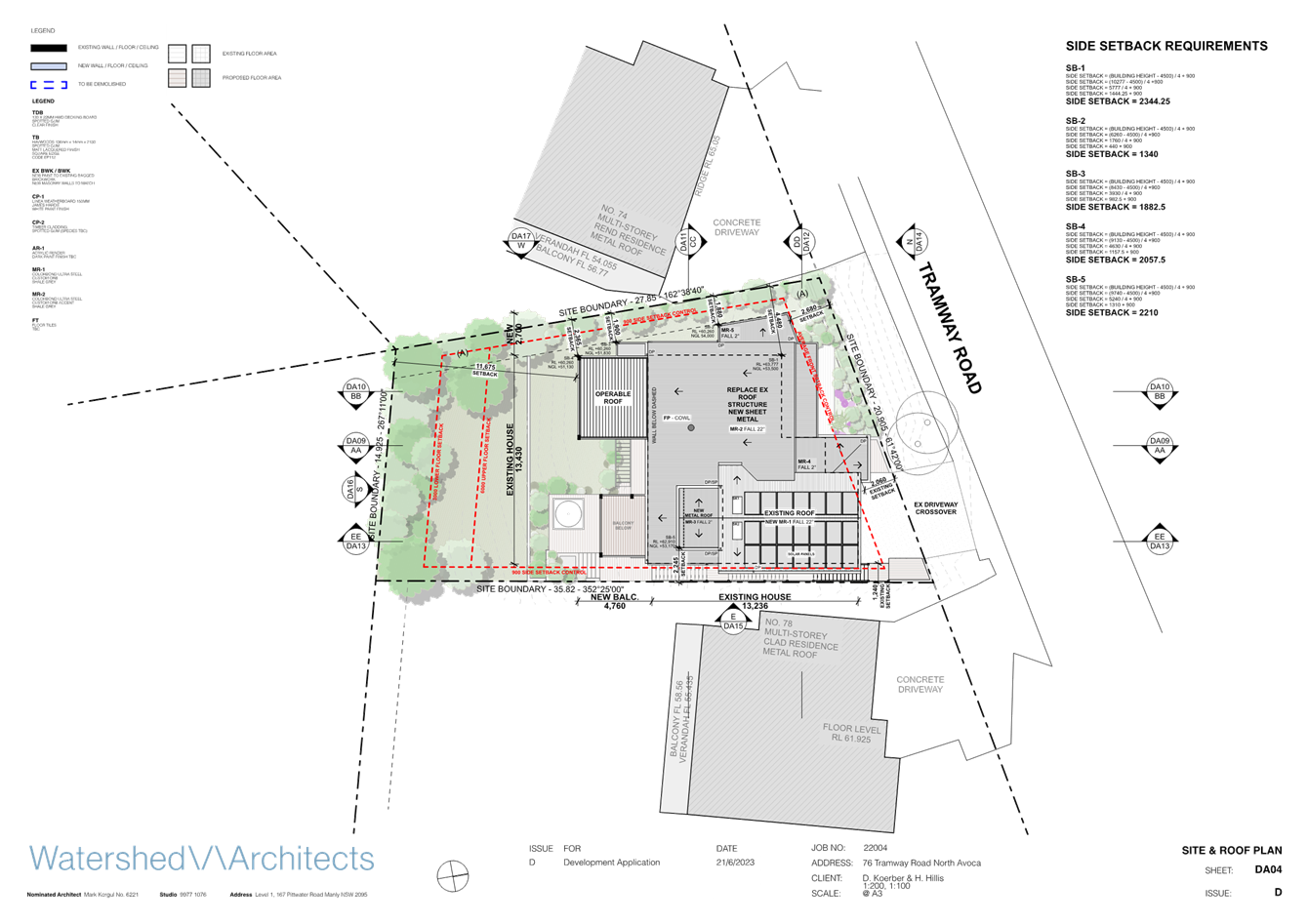
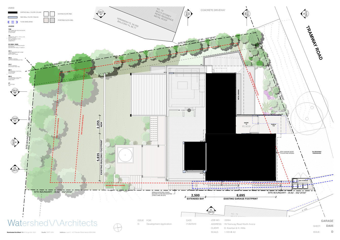
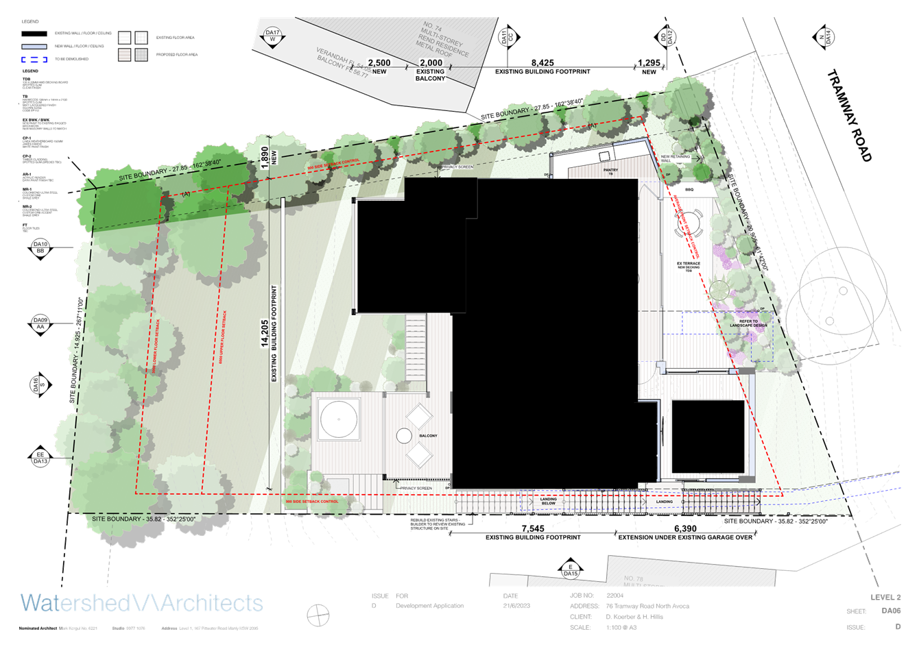
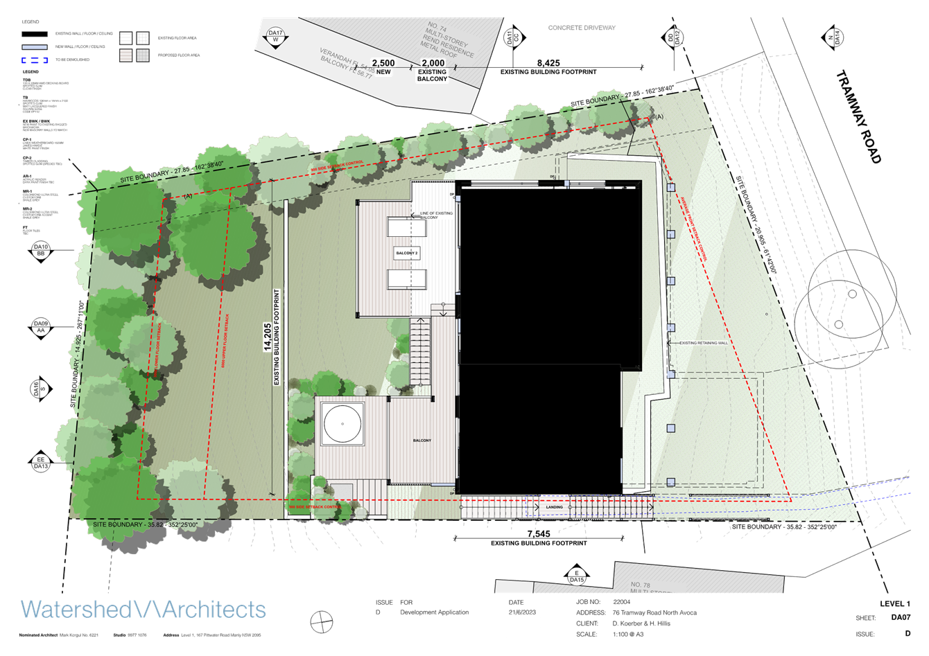
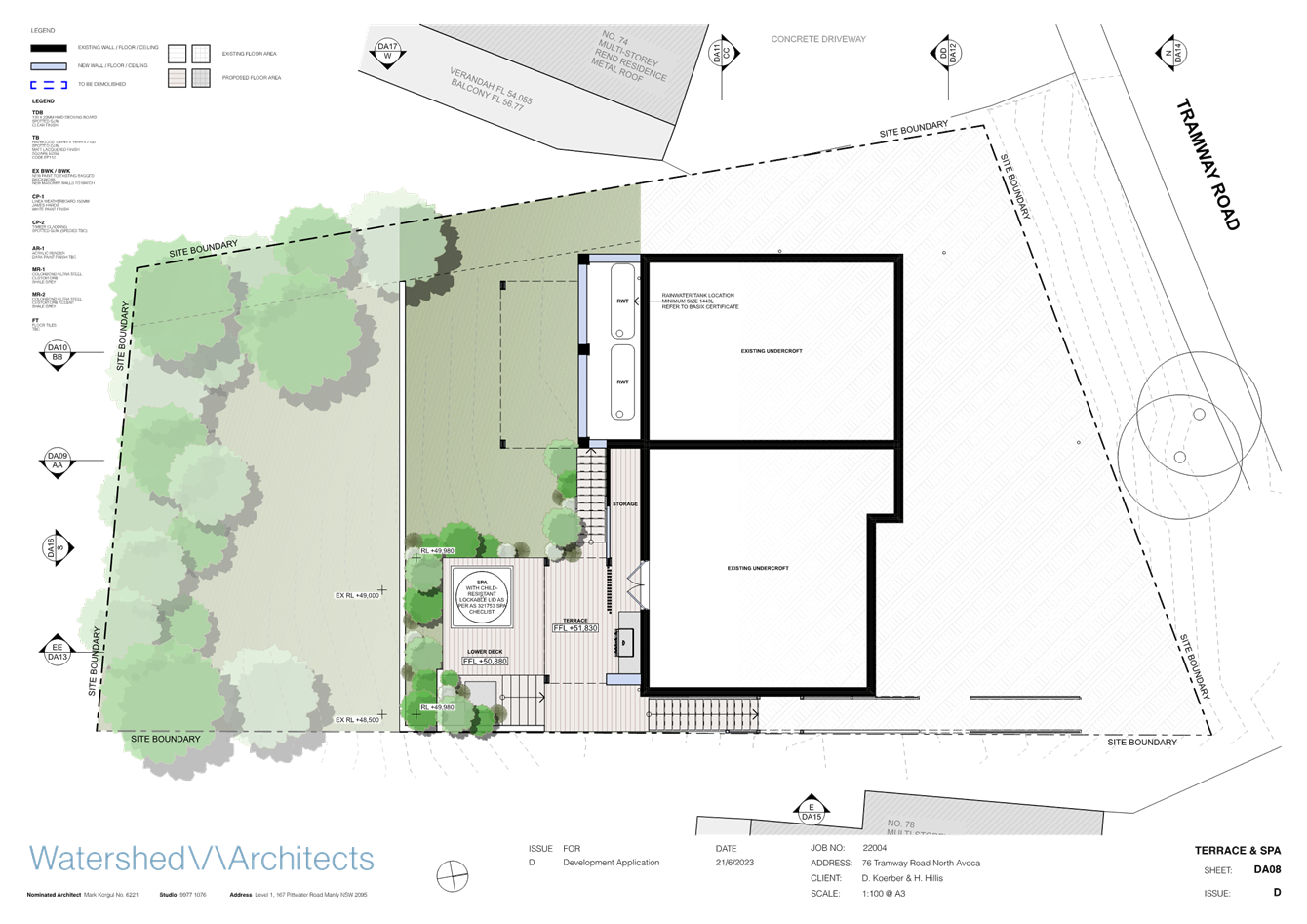
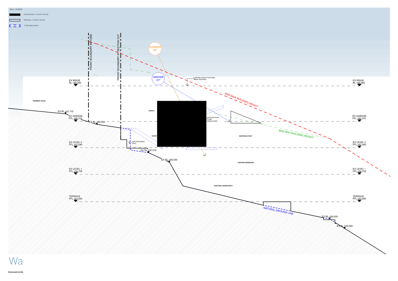
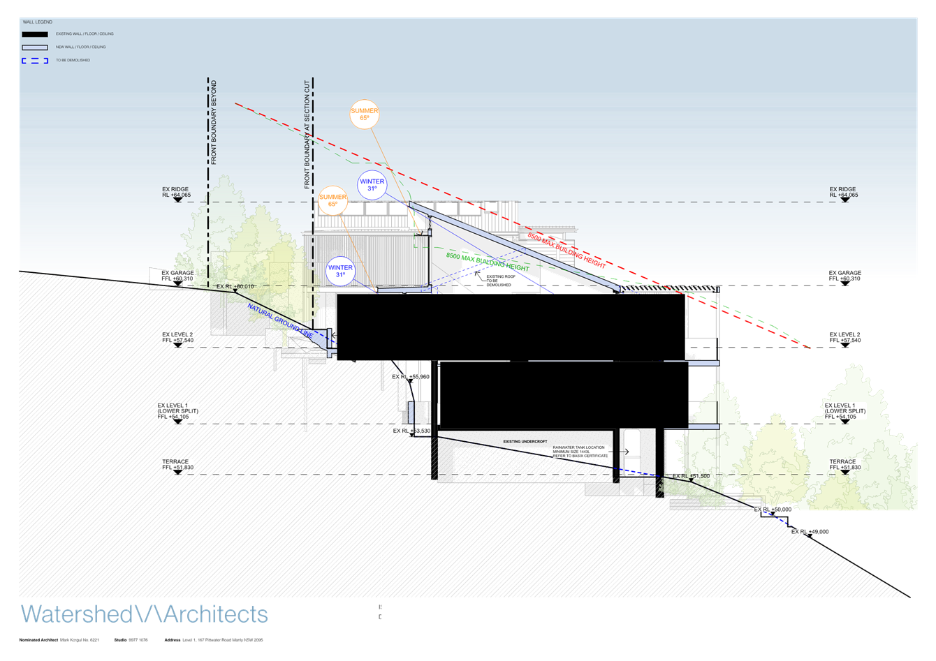

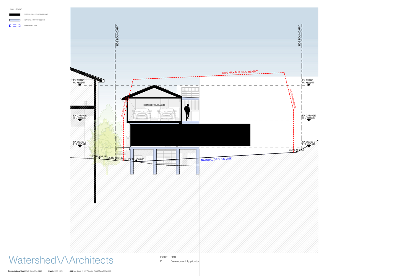
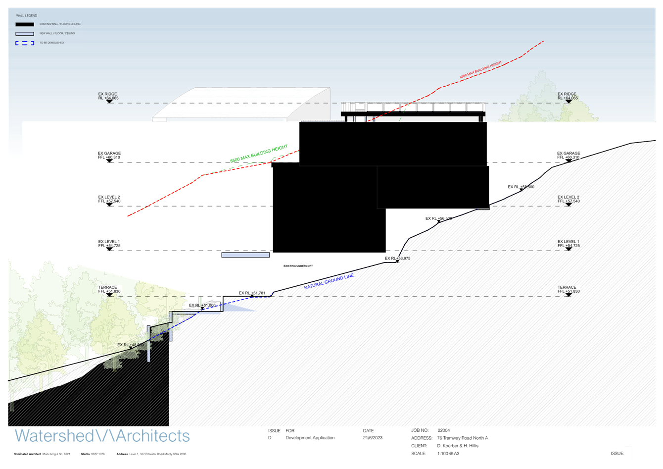
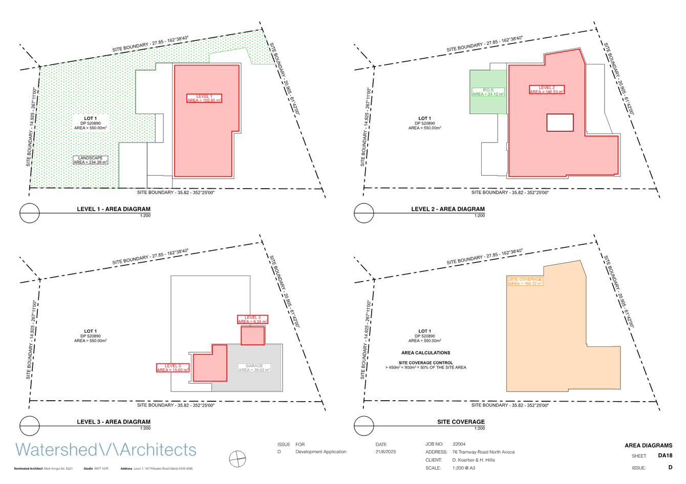
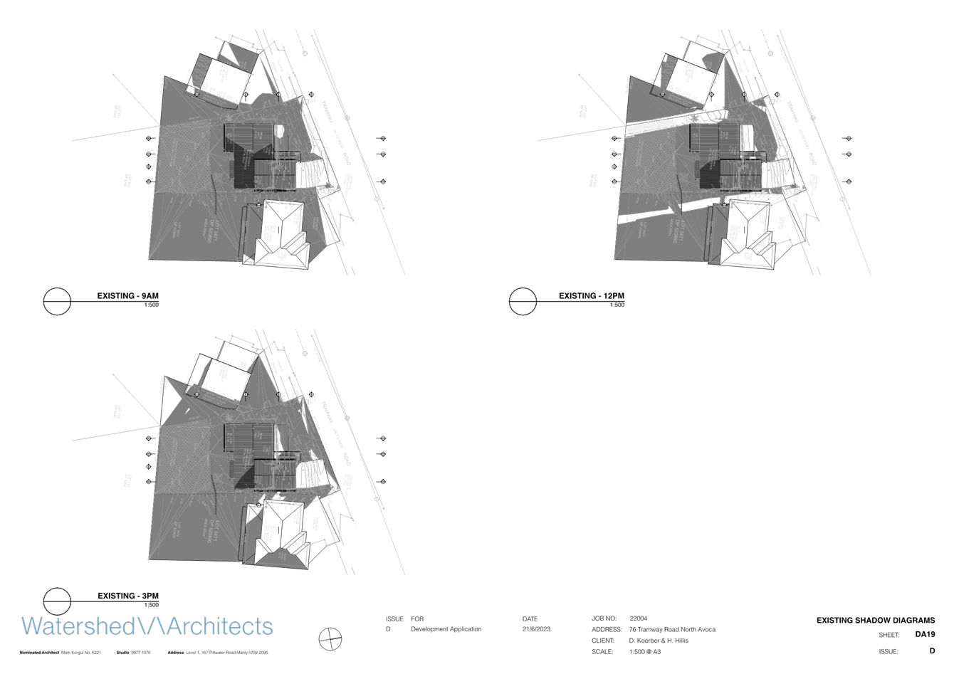
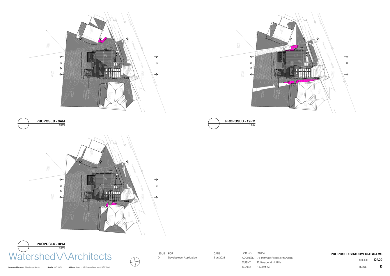
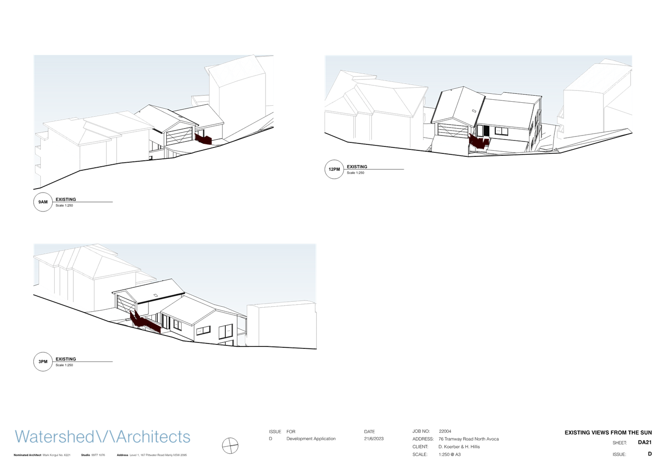
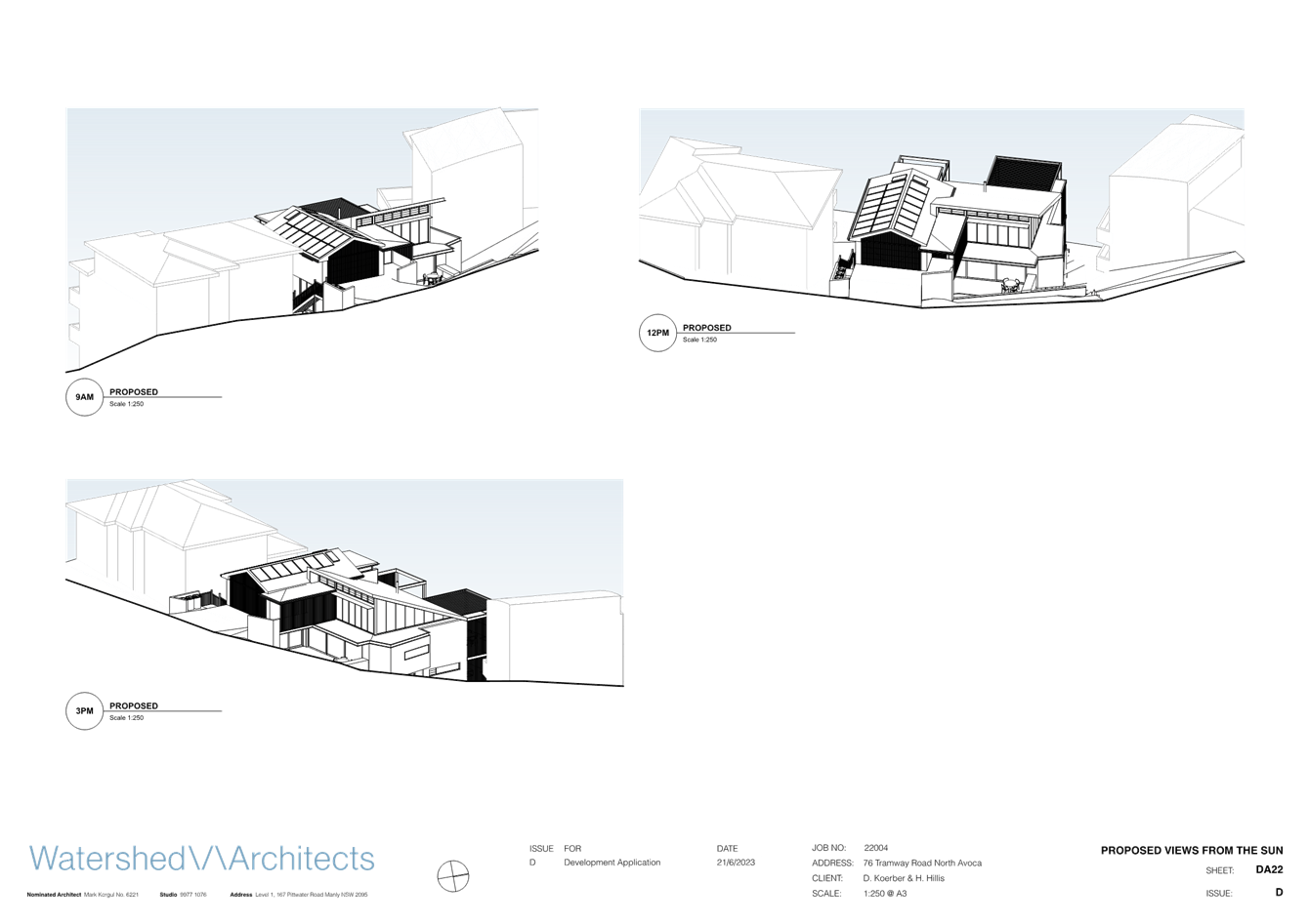
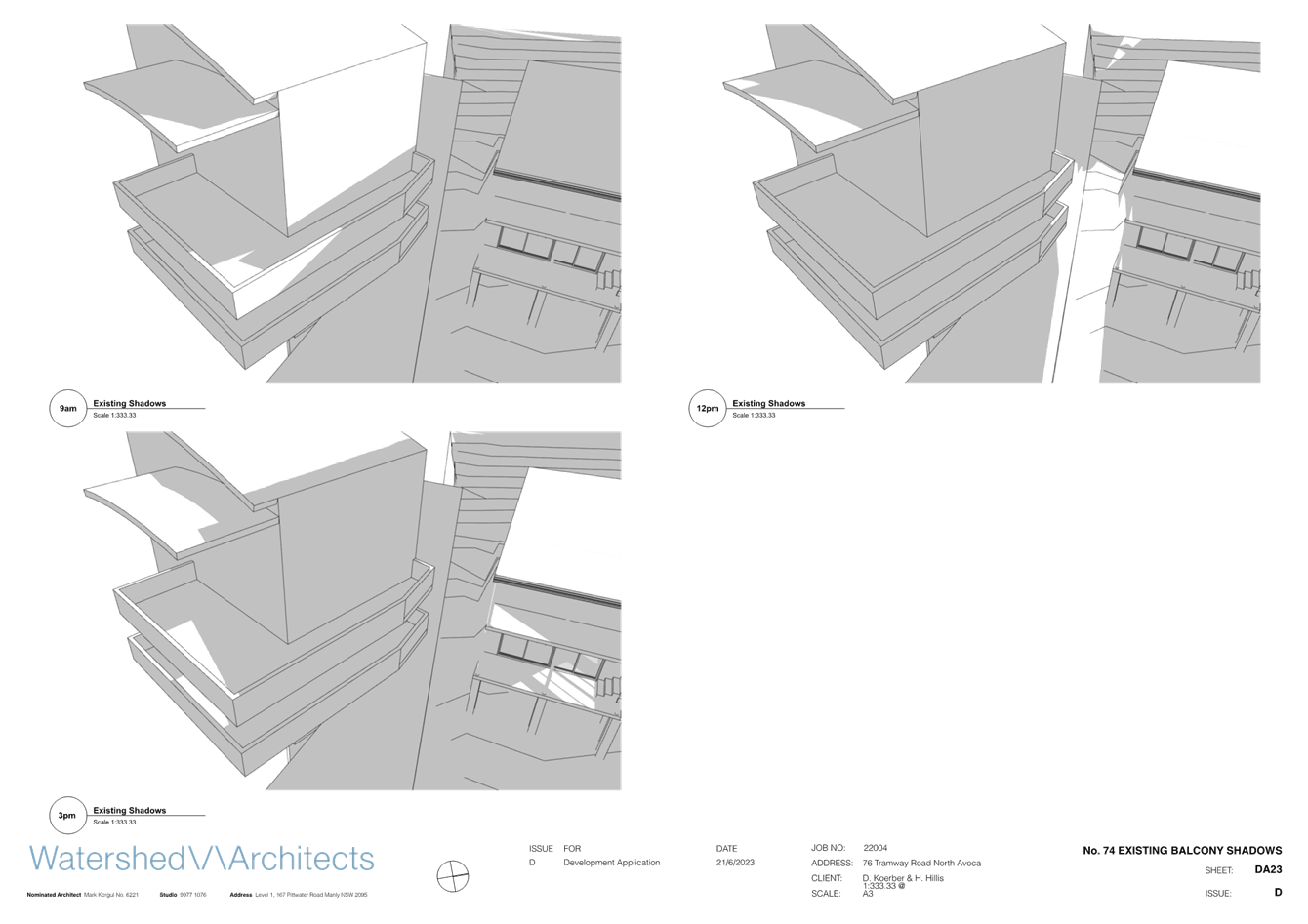
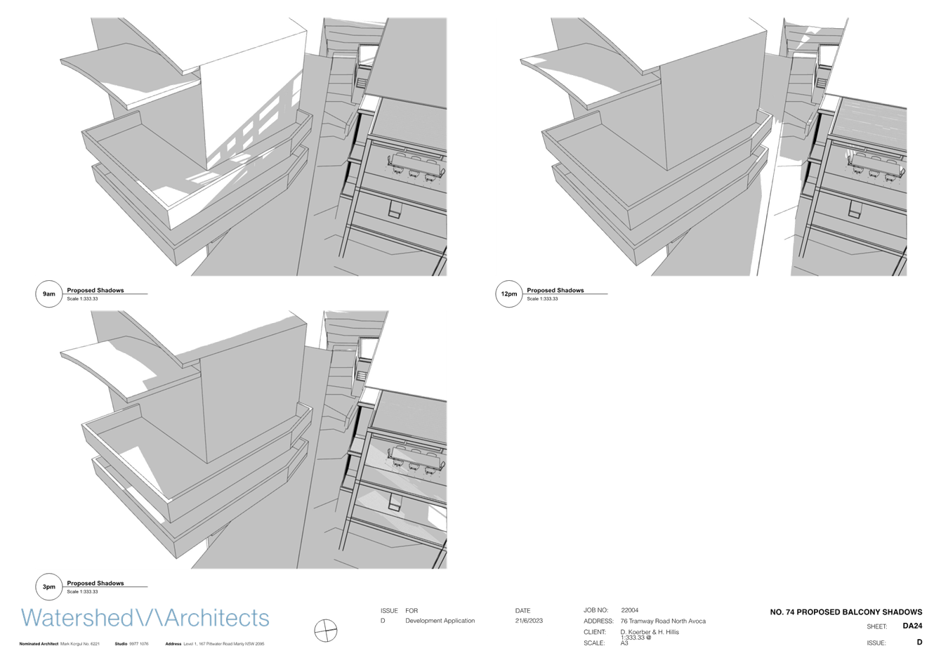
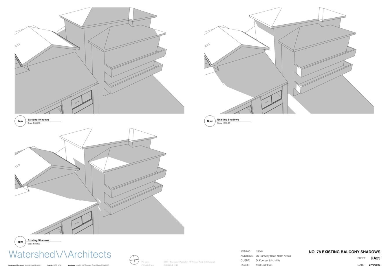
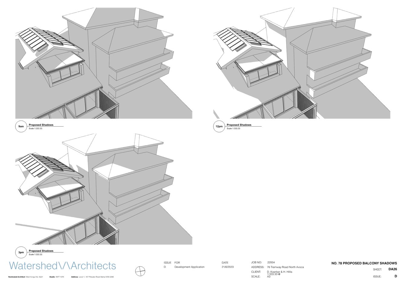
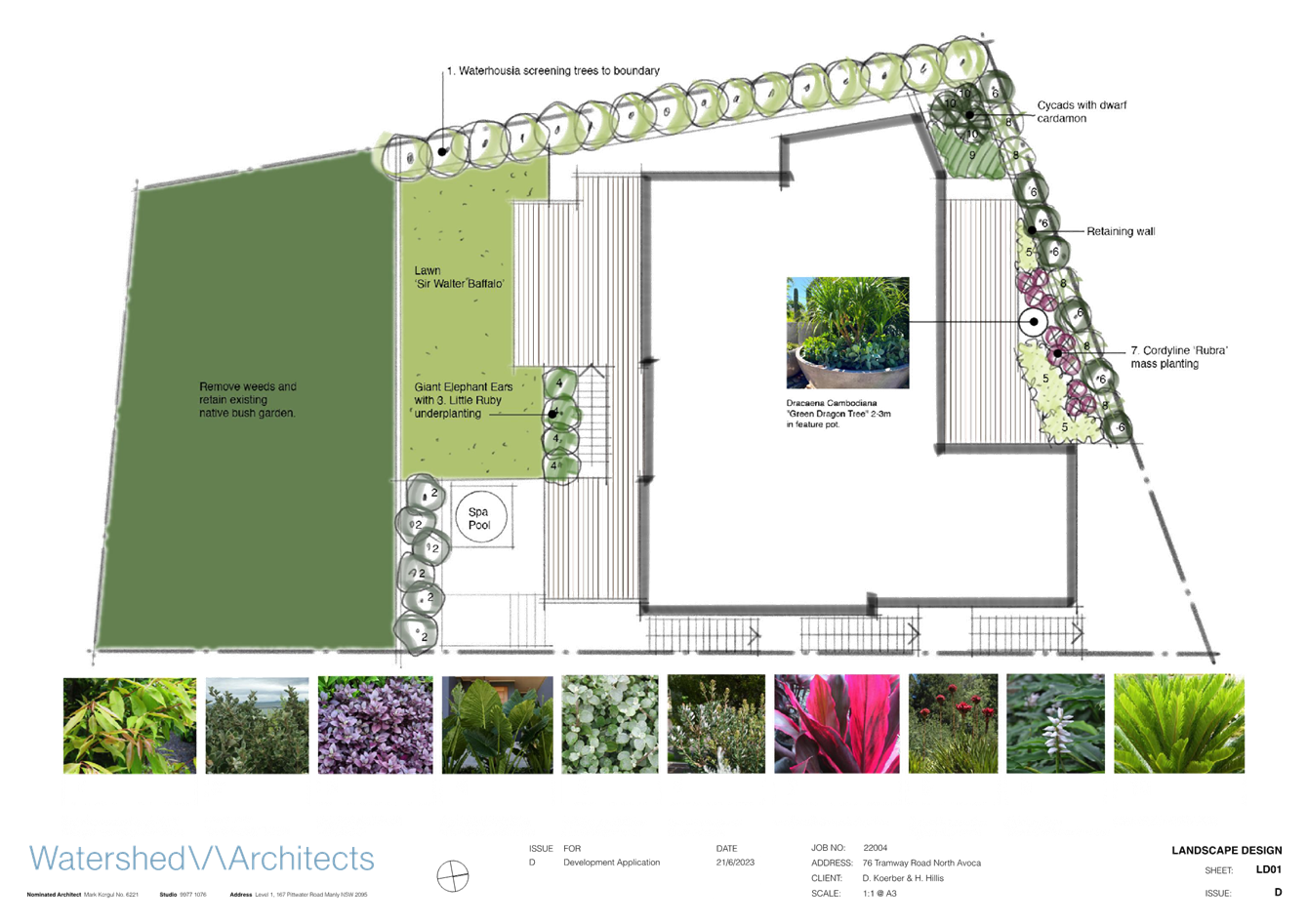
|
DA/1355/2023 - 76 Tramway Road, North Avoca - Alterations and additions to an existing residential dwelling |
|
|
Attachment 3 |
Bushfire Assessment Report |
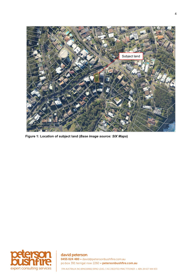
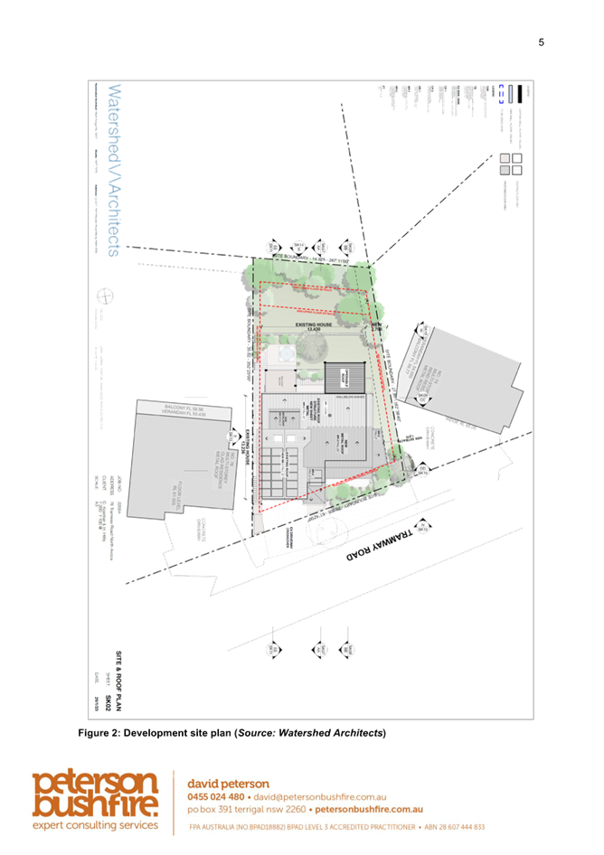
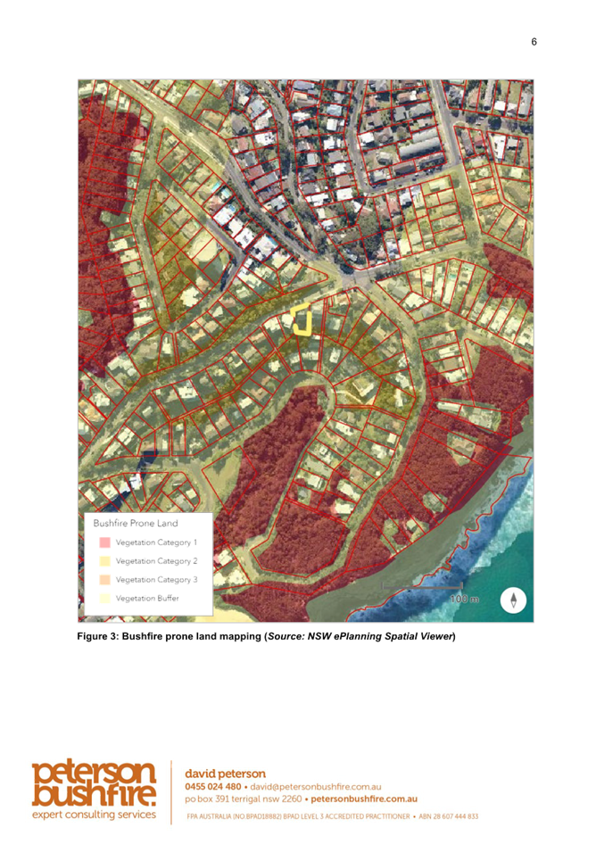
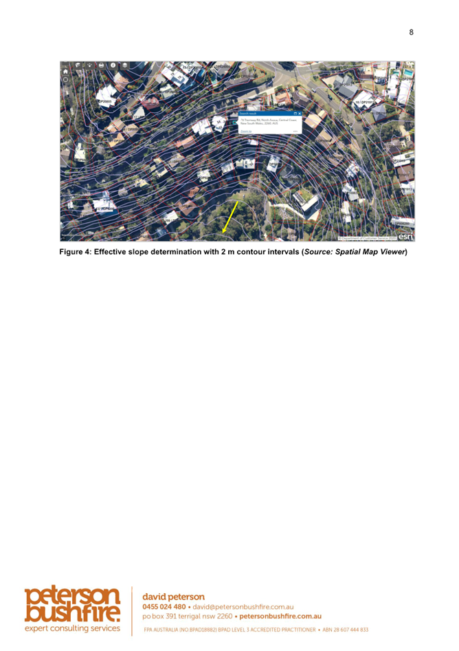


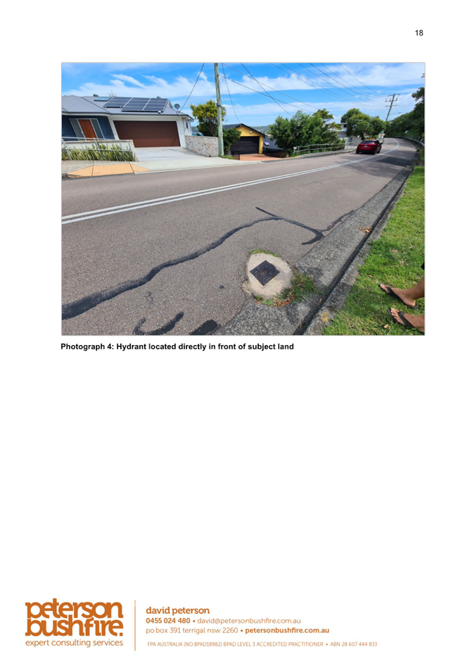

|
DA/1355/2023 - 76 Tramway Road, North Avoca - Alterations and additions to an existing residential dwelling |
|
|
Attachment 4 |
BASIX Certificate |
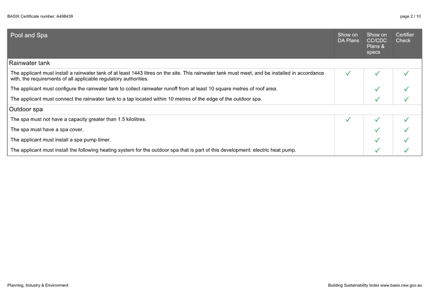
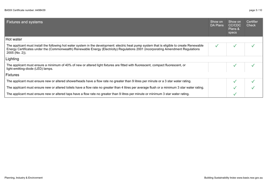
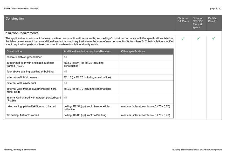
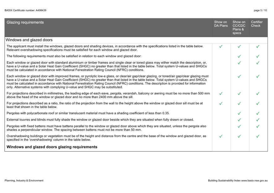
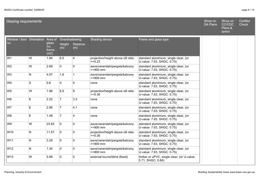
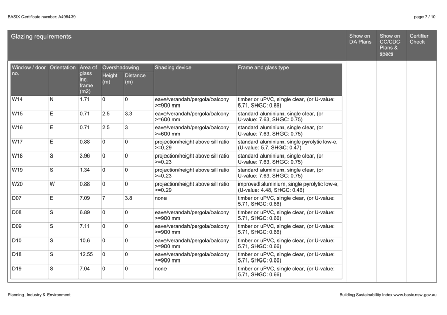
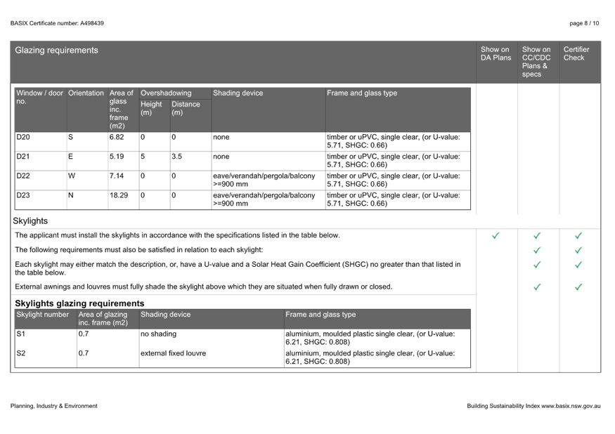

|
DA/1355/2023 - 76 Tramway Road, North Avoca - Alterations and additions to an existing residential dwelling |
|
|
Attachment 5 |
Clause 4.6 Written Request to Vary a Development Standard |
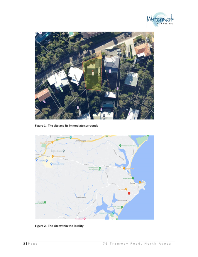
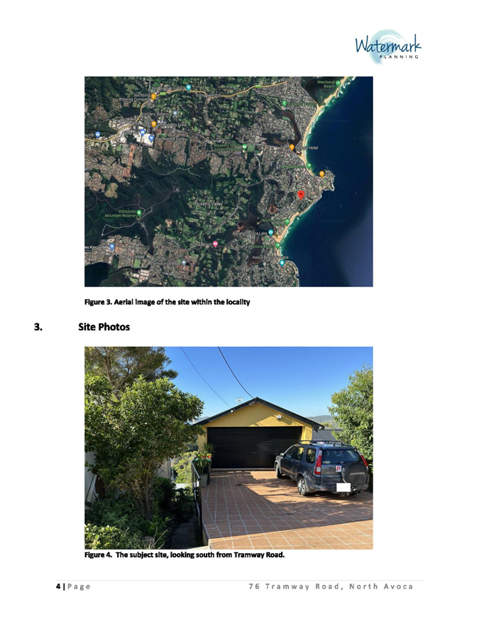
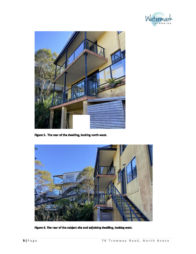
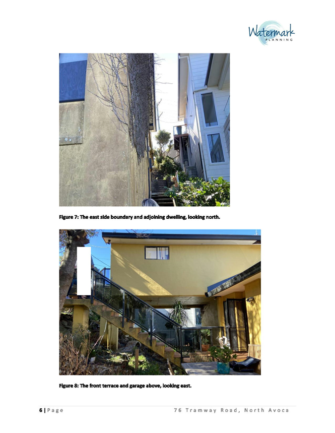
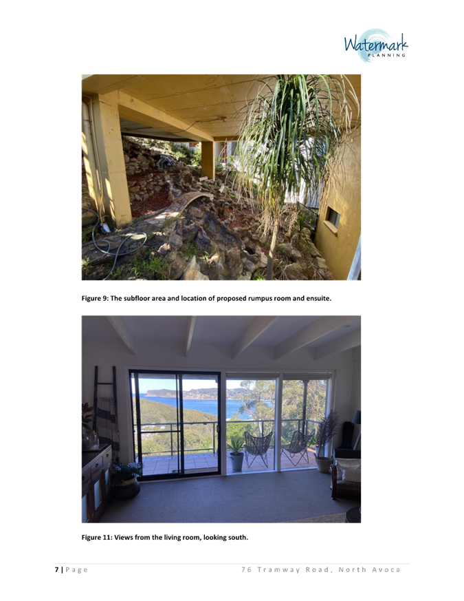
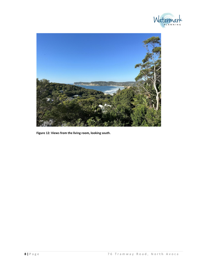
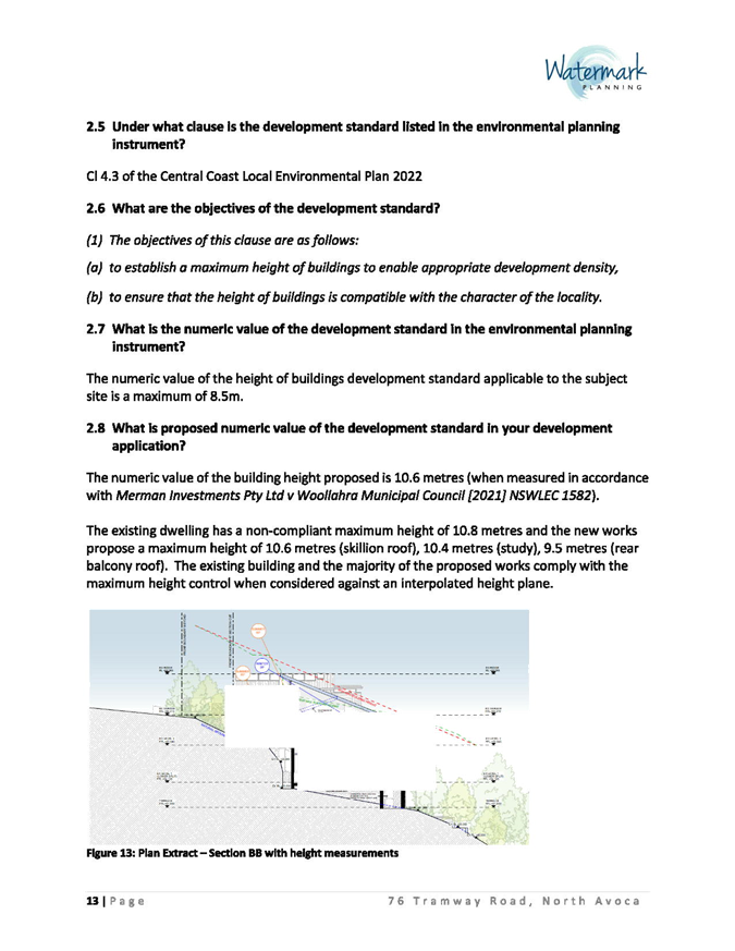

|
DA/1355/2023 - 76 Tramway Road, North Avoca - Alterations and additions to an existing residential dwelling |
|
|
Attachment 6 |
Arboricultural Impact Assessment |
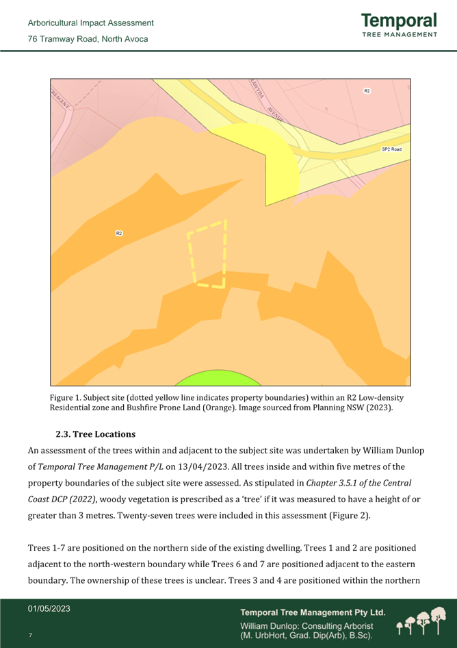
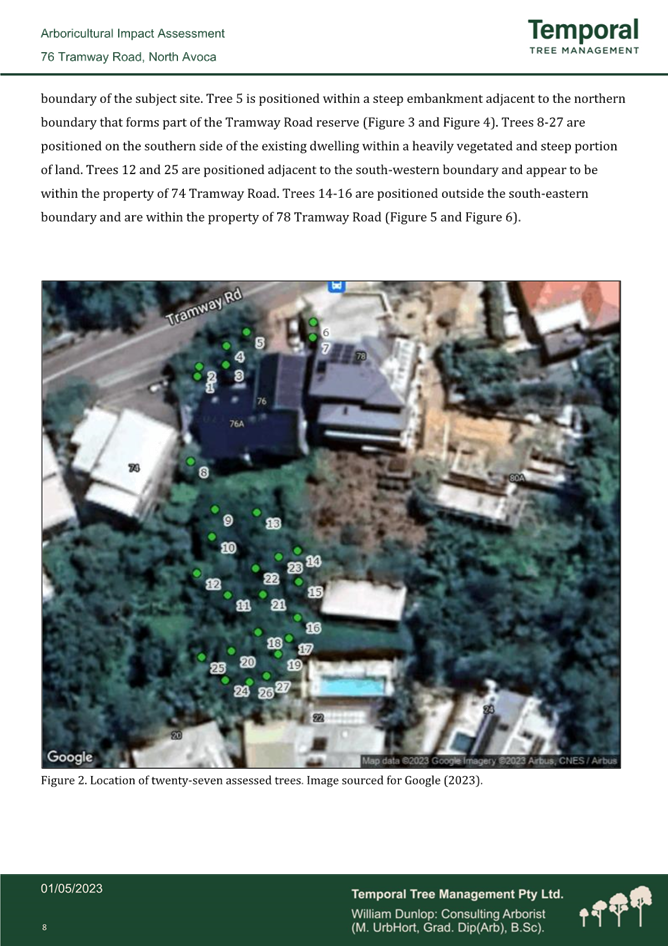
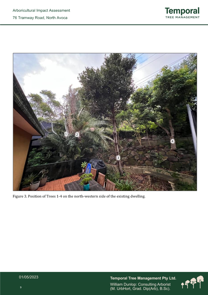
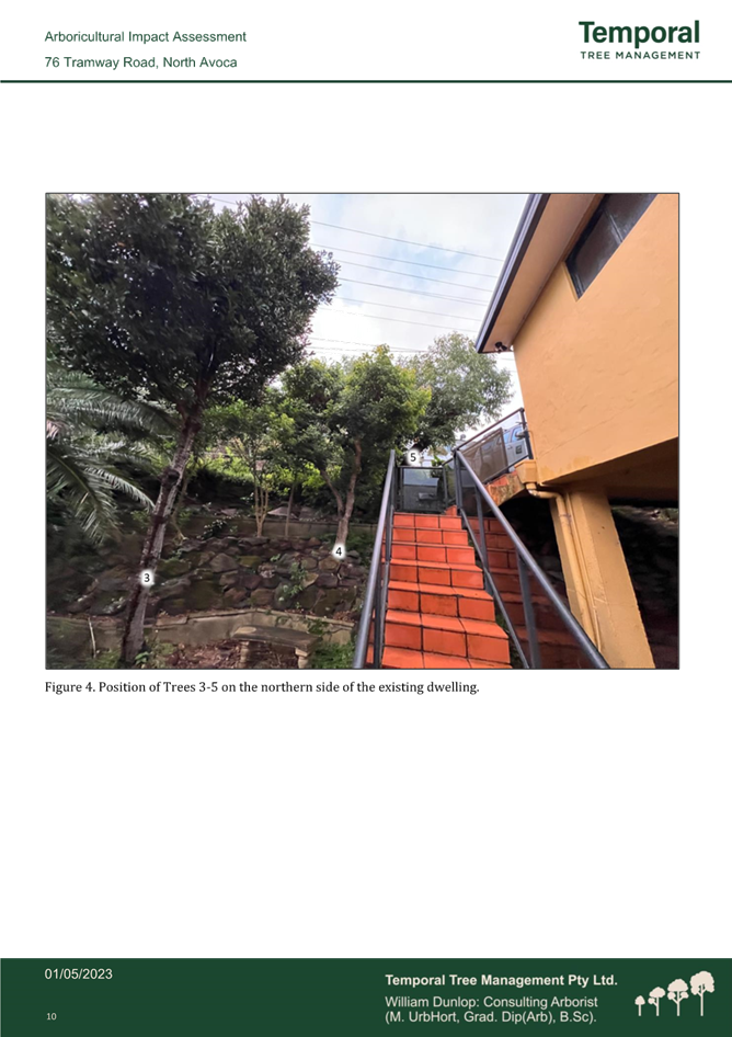
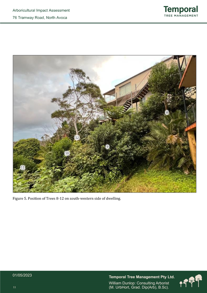
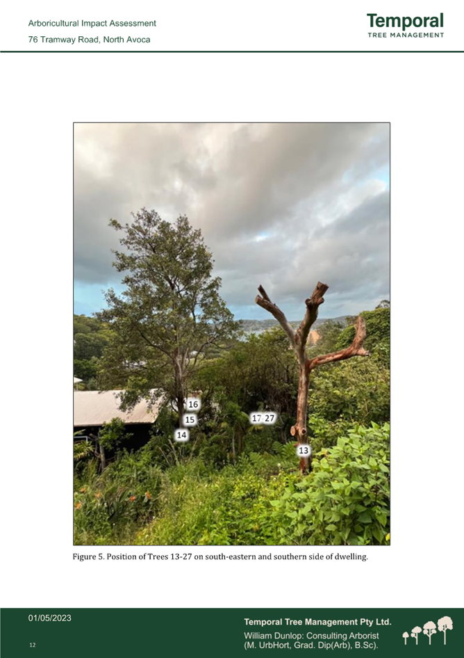
|
DA/1355/2023 - 76 Tramway Road, North Avoca - Alterations and additions to an existing residential dwelling |
|
|
Attachment 7 |
Geotechnical Report |
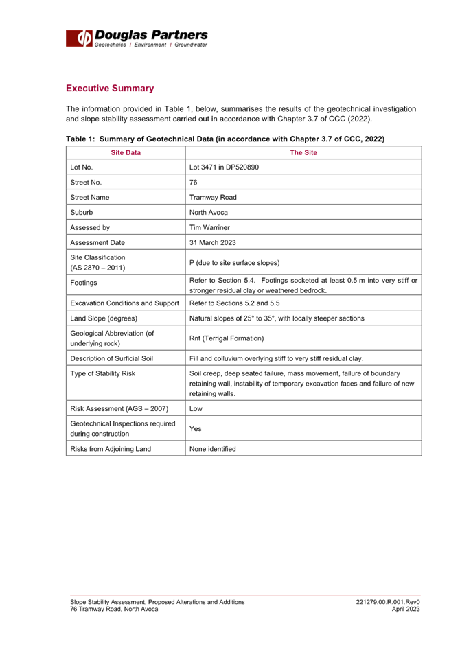
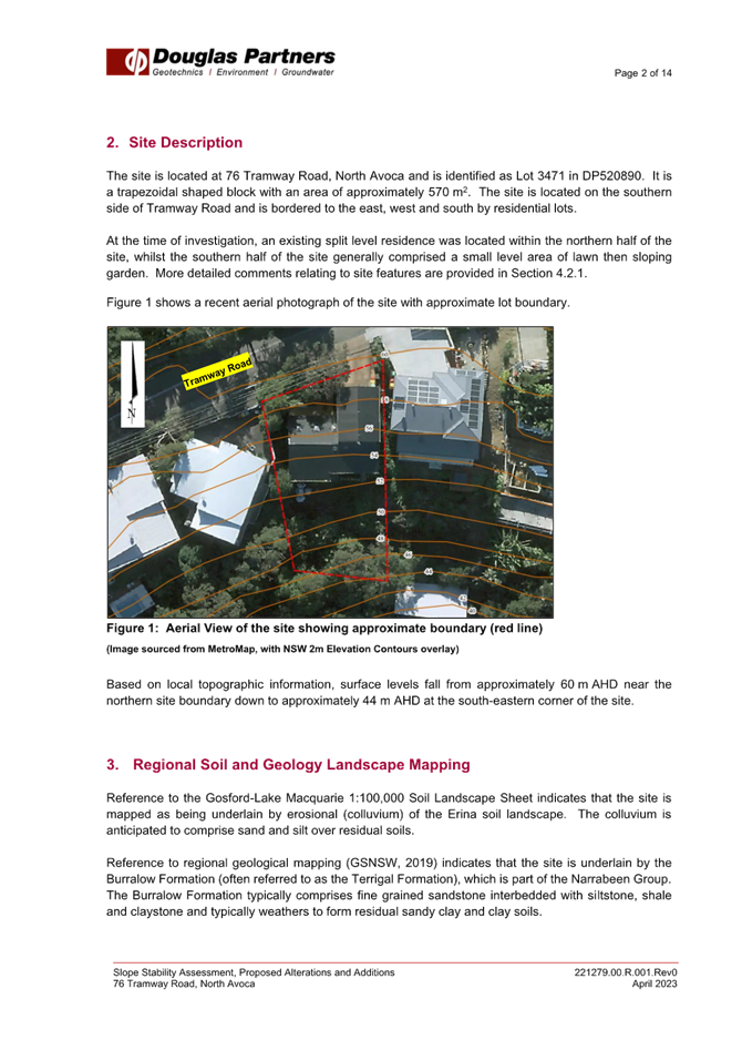
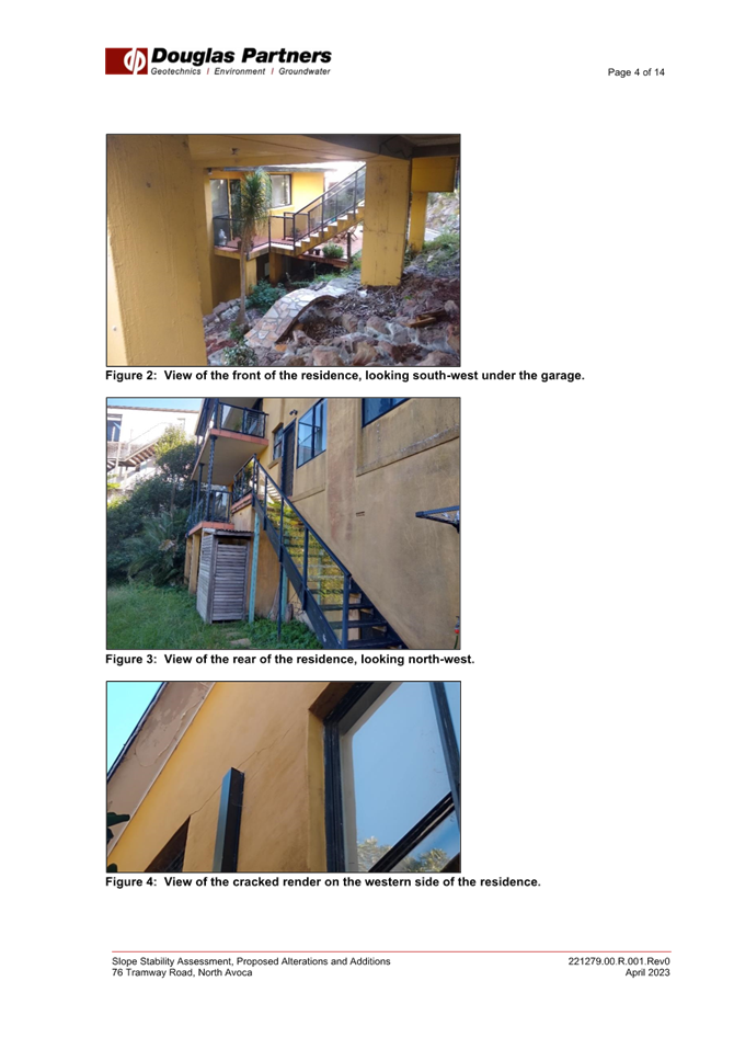
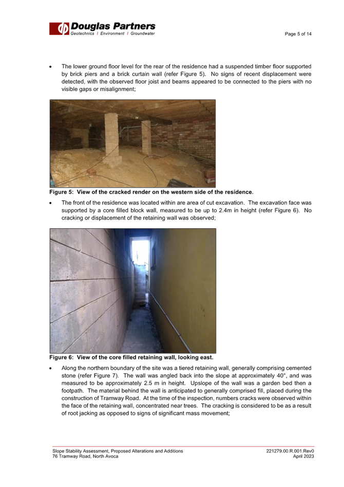
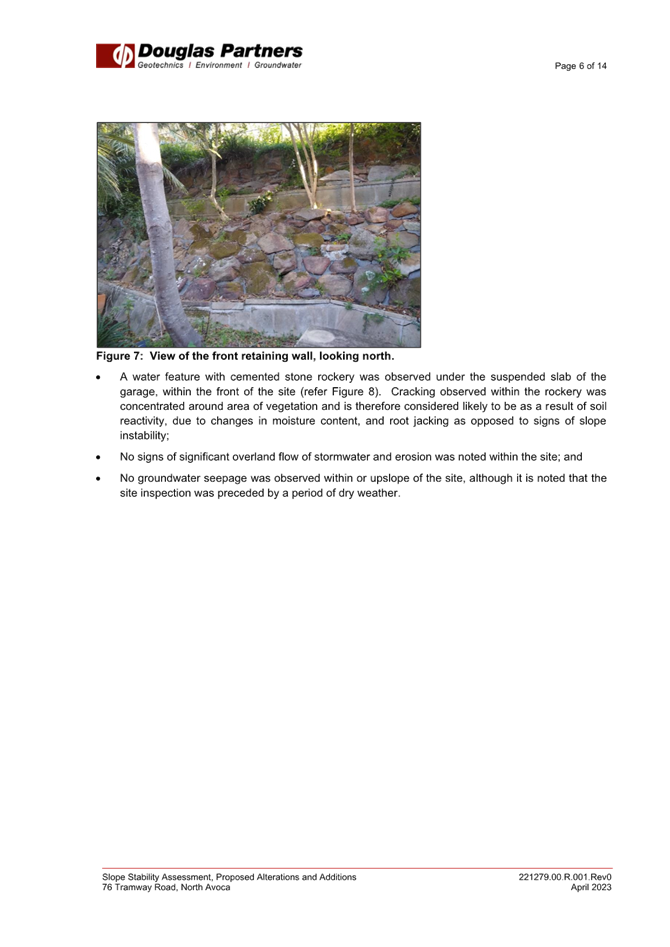
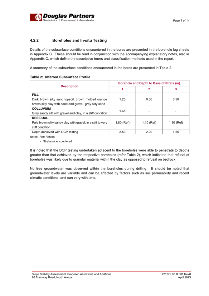
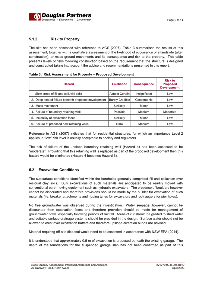
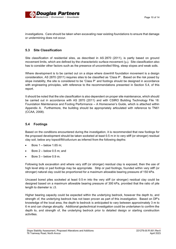
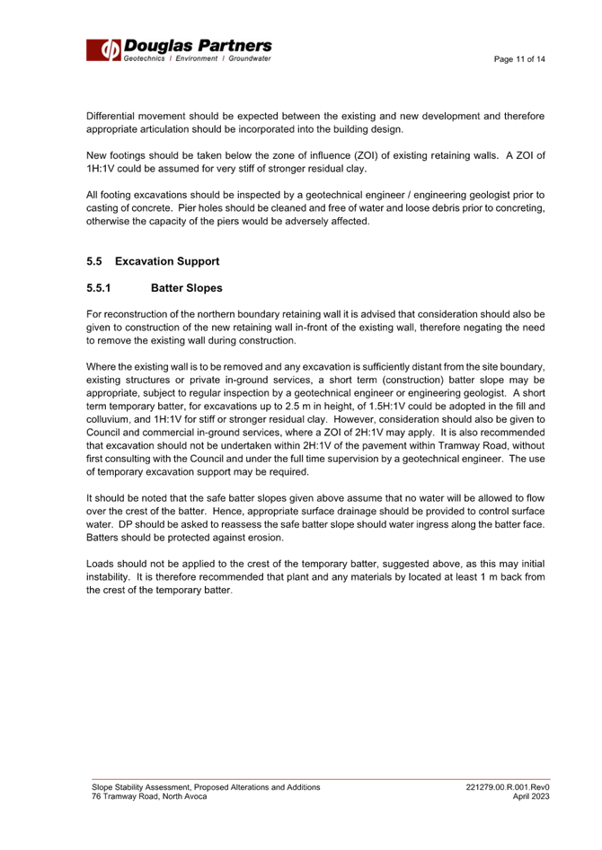
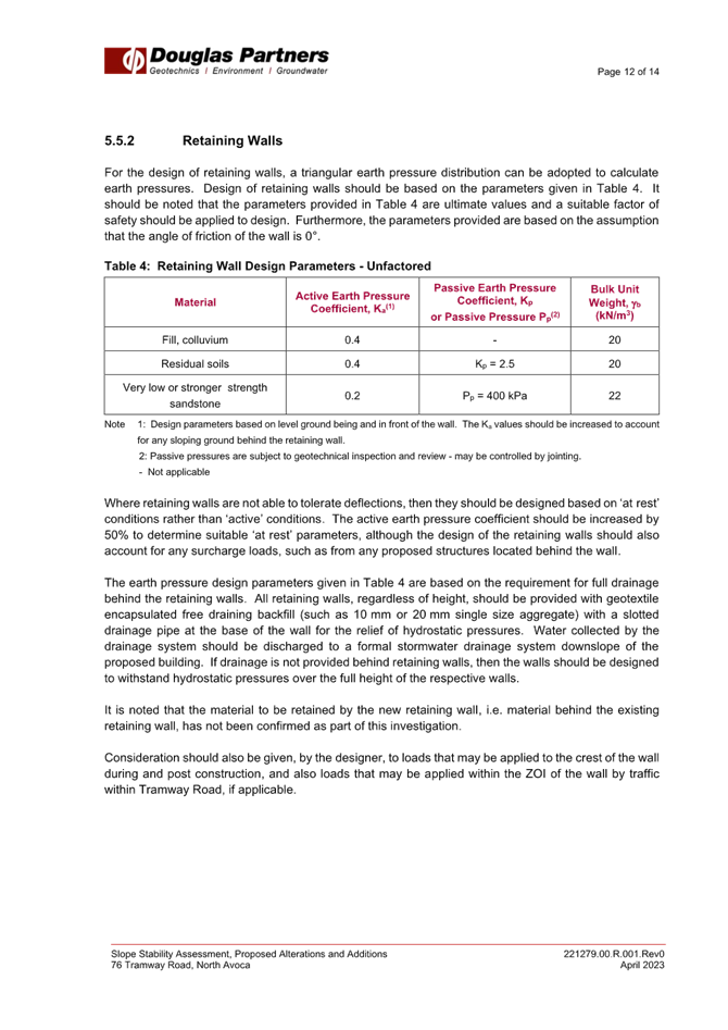

|
Item No: 4.3 |
|
|
Title: DA/539/2024 - 1CR Oleander Street, CANTON BEACH - Temporary Use of Land for Community Event (5 years) |
|
|
Department: Environment and Planning |
|
|
28 November 2024 Local Planning Panel Meeting |
|
Reference: DA/539/2024 - D16473547
Author: Emilia Ellis, Development Planner, Employment and Urban Release
Manager: Emily Goodworth, Section Manager Employment and Urban Release
Executive: Andrew Roach, Unit Manager. Development Assessment
|
Summary
An application has been received for the Temporary use of land for Community Events to be held on a Public Reserve. The application has been examined having regard to the matters for consideration detailed in section 4.15 of the Environmental Planning and Assessment Act 1979 and other statutory requirements with the issues requiring attention and consideration being addressed in the report.
This application is referred to the Central Coast Local Planning Panel in accordance with Schedule 2 of the Local Planning Panels Direction – Development Applications and Applications to Modify Development Consents, dated 6 March 2024 as the land is under the care and control of Council - Council is the designated Devolved Trust Manager of 1CR Oleander Street, Canton Beach.
The application was notified as required, and no submissions were received.
The application is recommended for approval.
Applicant Scripture Union NSW – Rydalmere Owner Crown Land – Central Coast Council Application No DA/539/2024 Description of Land Lot 3 DP 755266, 1CR Oleander Street, CANTON BEACH Proposed Development Temporary Use of Land for an annual Community Event over the next five years Site Area 46,550m2 Zoning RE1 Public Recreation and C2 Environmental Conservation Existing Use Public Reserve Employment Generation N/A Estimated Value N/A
|
1 That the Local Planning Panel grant consent to DA/539/2024 for the Temporary Use of Land for Community Events in Public Reserve at 1CR Oleander Street, Canton Beach, subject to the conditions detailed in the schedule attached to the report and having regard to the matters for consideration detailed in Section 4.15 of the Environmental Planning and Assessment Act 1979.
Precis:
|
Proposed Development |
Temporary use of Land for Community Events within the Public Reserve |
|
Permissibility and Zoning |
RE1 Public Recreation C2 Environmental Conservation Temporary Use of Land Clause 2.8 |
|
Relevant Legislation |
Environmental Planning and Assessment Act 1979 Environmental Planning and Assessment Regulation 2021 Local Government Act 1993 Crown Land Management Act 2016 Crown Land Management Regulations 2018 State Environmental Planning Policy (Resilience and Hazards) 2021 SEPP (Exempt and Complying Development Code) 2008 Central Coast Local Environmental Plan 2022 Central Coast Development Control Plan 2022 |
|
Current Use |
Public Reserve |
|
Integrated Development |
No |
|
Submissions |
Nil |
Variations to Policies
There are no variations to report.
The Site
The subject site is legally identified as Lot 497 DP 755266 and is part of the waterfront reserve known as the Canton Beach Reserve fronting Tuggerah Lake. The subject site is adjacent to the Canton Beach Holiday Park to the north and south-east. Access to the site is via Oleander Street and between the two caravan sites. The site is currently used as a recreation area and contains a public visitor parking area for the Caravan Park accessed directly from Oleander Street, and a separate access driveway for the caravan park to the south-east. The subject site is heavily vegetated to the southern portion of the site which contains an existing wetland area. The subject application is proposed to the northern end of the site which is sparsely vegetated with a portion of cleared land. The site is relatively flat with a minor slope towards the west. The subject application is seeking to occupy the cleared portion of land for event purposes.
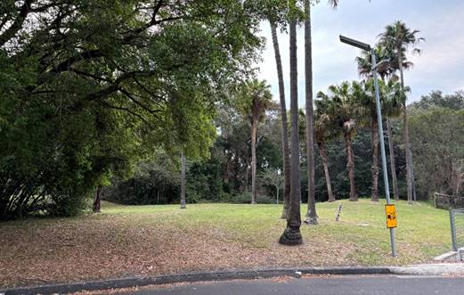
Figure 1: The site as viewed from the north-east entry point to the site from the existing carparking and access road traversing the site
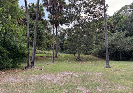
Figure 2: The site as viewed from the northern end of the clearing to the south, with the dense vegetation surrounding.
Surrounding Development
The site located at 1CR Oleander Street, Canton Beach, is part of the waterfront reserve. It is adjacent to Canton Beach Holiday Park to the north and west, and a low-density residential area to the northeast and 300 metres from Darren Kennedy Oval to the east. Further south-east of the site is Long Khanh Lakefront Retirement Village which adjoins the rear of the subject site.
It is noted the subject site, Canton Beach Holiday Park and the other surrounding lots are under the land ownership of Crown Lands with Central Coast Council as the appointed Crown Land Manager. However, the subject site is devolved to Council but still resides in the care of Central Coast Council, but Council is not the appointed Crown Land manager under the Crown Land Management Act 2016. This is discussed later in the report under the relevant legislation.
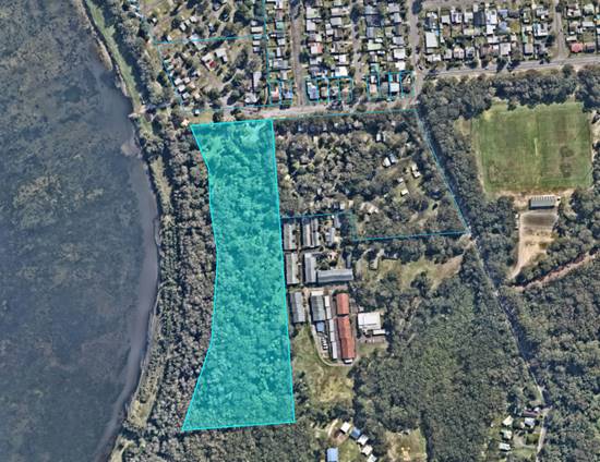
Figure 3: Aerial view of the subject site (in blue) and surrounds
The Proposed Development
The proposal is for a temporary pop-up scripture event to be held in the cleared area on the Northern end of the Public Reserve opposite the Canton Beach Caravan Park, at the western end of Oleander Street, Canton Beach. The event is proposed over a period of 13 days between Christmas and New Year to run for five consecutive years. The event is to be hosted by Scripture Union Family Mission (SUFM) which has held the event in this location for several decades and has a history of other events nearby in Budgewoi and Toowoon Bay over the same period.
The temporary event will hold recreation and entertainment activities on site for the local community. The activities will include scripture-based summer holiday programs for children and teenagers in addition to music and coffee for adults. Some of the daily activities include puppet theatres, children’s games, and crafts. The event activities will require the installation of eight temporary gazebos on site and the reserve will remain open to the public throughout the event.
All activities are proposed to be held daily within the following session times:
· 10:00am to 10:30am,
· 4:00am to 5:00pm,
· 7:00am to 9:00pm.
Waste is proposed to be collected on site by event organisers who will supply their own bins during the event and collected waste is to be stored in the adjacent Caravan Park’s skip bins for collection after each event. An agreement between the parties has been provided to Council in supporting documentation for the waste storage and collection.
No camping or accommodation is proposed on the site which differs from previous events in the past. It is presumed, based off previous events, most attendees will seek accommodation within the adjoining caravan park. Single day attendees can access the designated visitor parking area and walk to the reserve for the event. The designated parking area is established at the northern end of the subject site and is part of the Canton Beach Holiday Park which also includes the emergency assembly area for the park and event on site.
Self-contained Porta-loos, Portable toilets with hand washing facilities are provided for participants attending the event.
The activities are proposed to continue to take place annually over a period of five years with the event running for a total of 13 days each year. The following dates are proposed as part of this application:
· 26 December 2024 to 7 January 2025,
· 26 December 2025 to 7 January 2026,
· 26 December 2026 to 7 January 2027,
· 26 December 2027 to 7 January 2028,
· 26 December 2028 to 7 January 2029.
Below are plans of the proposal:
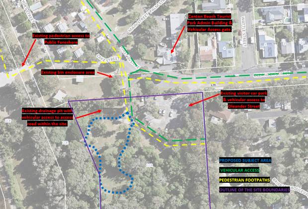
Figure 4: Aerial view of the proposal area and surrounding context
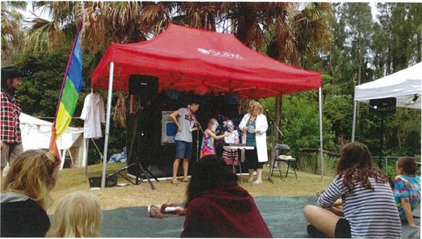
Figure 5: Image of gazebo set up from previous event
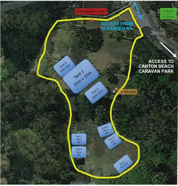
Figure 6: Proposed site plan for the event area on site
History
The SUFM activities have taken place successfully on the subject site for over 60 years with activities generally commencing over the Christmas and New Year period. Formal consent was first granted on the site in 2008 for three years, and subsequent approvals as detailed below show this has continued up until 2022 prior to the lodgment of this application. It is also noted the event has also operated from the Budgewoi Tourist Park and Swadling Park, Toowoon Bay, over the same dates in previous years.
· DA/1019/2017 – Application for temporary use of Public Reserve from 26 December to 7 January for 5 consecutive years ending in 2022 was approved on 12 October 2017.
· DA/801/2017 – Application for temporary use of Public Reserve was returned on 6 July 2017.
· DA/821/2011/B – Consent modified on 14 November 2013 which sought an extension of time on the consent for an additional 4 years ending in 2017.
· DA/821/2011/A – Consent modified on 27 September 2012 to change the hours of operation from 9:30am to 7:30pm each day of the event and cap the persons staying overnight to be a maximum of 15 persons.
· DA/821/2011 – Application for temporary use of Public Reserve from 26 December to 7 January for 3 consecutive years ending in 2014 was approved on 24 October 2011.
· DA/902/2008 – Application for temporary use of Public Reserve from 26 December to 7 January for 3 consecutive years ending in 2011 was approved on 28 October 2008.
Assessment:
Having regard for the matters for consideration detailed in Section 4.15 of the Environmental Planning and Assessment Act 1979 and other statutory requirements, Council’s policies and Section 10.7 Certificate details, the assessment has identified the following key issues, which are elaborated upon for Council’s information. Any tables relating to plans or policies are provided as an attachment.
Provisions of Relevant Instruments/Plans/Policies:
Relevant Legislation
Environmental Planning and Assessment Act 1979 (EP&A Act)
Section 9B Council-related development applications
The Conflict-of-Interest Regulation took effect on 3 April 2023. Clause 9B (2) of Schedule 1 to the EP&A Act defines council-related development applications as:
(2) In this clause–
Council-related development application means a development application, for which a council is the consent authority, that is–
(a) made by or on behalf of council, or
(b) for development on land, other than a public road within the meaning of the Local Government Act 1993–
(i) of which the council is an owner, a lessee or a licensee, or
(ii) otherwise vested in or under the control of the council.
Note– Land vested in or under the control of the council includes public land within the meaning of the LG Act.
Accordingly, the subject site is recognized as being vested in or under the control of the Council, as the appointed Devolved Trust Manager. As such, the application is referred to the Central Coast Local Planning Panel for determination. For the purposes of Section 22 of the EP& A Act, Clause 9B(1) of Schedule 1 requires that the minimum public exhibition period for a council-related development application is 28 days. The application has been notified for 28 days.
Local Government Act 1993 (LG Act)
![]() The subject site is
identified as a Public Reserve as defined under the LG Act, and is situated
amongst surrounding Crown Land owned sites within the vicinity. However, the
subject site is noted as being devolved land, while the surrounding sites are
under a Crown Land Manager (refer to figure 7 below for reference to the
specific sites).
The subject site is
identified as a Public Reserve as defined under the LG Act, and is situated
amongst surrounding Crown Land owned sites within the vicinity. However, the
subject site is noted as being devolved land, while the surrounding sites are
under a Crown Land Manager (refer to figure 7 below for reference to the
specific sites).
Figure 7: Aerial view of the Crown Land within the vicinity of the subject site (blue)
Devolved crown land are Crown reserves dedicated or reserved for public recreation or for a public cemetery that devolve to Council as the devolved trust manager if no other trustee is appointed under Section 48 of the LG Act. The subject site is identified as a reserve with the specific purpose of Public Recreation, and was devolved to Council to manage under Section 48 of the LG Act, which states:
(1) except as provided by section 2.22 of the Crown Land Management Act 2016, a council has the control of–
(a) public reserves that are not under the control of or vested in any other body or persons and are not held by a person under lease from the Crown, and
(b) public reserves that the Governor, by proclamation, places under the control of the council.
(2) If any doubt arises as to whether any land comes within operation of this section, or as to the boundaries of a public reserve, the Governor may, by proclamation determine the matter.
Whilst a site is managed under Section 48, and designated as devolved land, the devolved trust manager (i.e. Council) has a limited role as manager in comparison to the other sites where Council is recognized as the designated Crown Land Manager. Crown Land devolved under Section 48 of the LG Act do not require plans of management under the Crown Land Management Act 2016 and generally the manager takes a caretaker position of the land and does not hold any authority over the land.
In this instance, Council’s role is to maintain the site for general upkeep and is not able to issue any lease, tenure or license over the site. To permit this application Department of Planning, Housing, and Infrastructure – Crown Lands has issued consent for the application as the landowner.
Crown Land Management Act 2016 (CLM Act)
The Crown Land Management Act 2016 (CLM Act) allows councils to manage Crown land under the provisions of the Local Government Act 1993 (LG Act) for public land. Council currently manages many Crown land sites including two adjoining properties as seen in Figure 7 above, as the appointed crown land manager responsible for managing the affairs of a reserve trust.
Section 3.21 of the CLM Act requires the management of these lands to be in accordance with the LG Act. Where Council is identified as the crown land manager, they are authorised to classify and manage its dedicated and reserved Crown land as it if were public land. This requires the land to be designated as either community or operational land.
Once receiving this designation, a Plan of Management is required under Clause 3.23(2). However, as the subject site is devolved, the role of manager differs to that as if Council were the crown land manager and a Plan of Management is not required. Council is required to manage devolved reserves consistent with the reserve purpose and can undertake minor improvements, restoration work, maintenance or works for public safety. However, they are unable to grant any tenures over this land.
In this instance, Councils role on the site is to maintain the land and complete works where required for public safety. Where the land is devolved, the designated category is the purpose of land when it was gazetted and is to be managed as such under Section 48 of the LG Act solely as the CLM Act is not applicable in that instance.
Relevant Regulations
Crown Land Management Regulations 2018 (CLMR)
The Crown Land Management Regulations 2018 applies to all land crown land. The purpose of the land is to provide for consistent, efficient, fair, and transparent management of Crown Land for the benefit of the public.
The letter from the Department of Planning Housing and Infrastructure -Crown Land, submitted as part of the development application has granted consent for the lodgement of the development application.
There are no further requirements under the CLMR that require further discussion.
Environmental Planning and Assessment Regulations 2021 (Regs)
The Environmental Planning and Assessment Regulation 2021 applies to all development applications regarding items such as application type, compulsory contributions, notification of development applications and a range of many other details regarding development application requirements.
Section 23(1) required a development application to be accompanied by the written consent of the owner of the land to which a development application relates. The applicant has provided Crown Lands consent as the appropriate landowner for the parcel of land to which this application relates.
It is noted Council is the designated devolved trust manager of the site and under Section 66A of the Regulations requires that Council related development applications must not be determined by the consent authority unless:
a) The Council has adopted a Conflict-of-interest policy, and
b) The Council considers the policy in determining the application.
Central Coast Council’s Council Related Development Applications Conflict of Interest Protocol, Revision 1, was adopted by Council on 30 May 2023, in response to Section 66A of the Regulations.
The protocol aims to manage potential conflicts of interest and increase transparency at all stages of the development process for council-related development. In this instance, there is no specific management strategy as the application will be determined by the Central Coast Local Planning Panel.
The application was notified for a period of 28 days from 18 October 2024 to 15 November 2024 with no submissions received.
The relevant provisions of the Regulations have been satisfied and no further consideration is required in this regard.
State Environmental Planning Policies (SEPP)
State Environmental Planning Policy (Exempt and Complying Development) 2008
The proposed development includes the erection of several temporary structures including several tents of varying sizes. The proposed tents are to remain open and easily accessible without need for specified distances or separation. Consent is not being sought under this development application for these temporary structures as they can be erected under the provisions of exempt development subject to an approval being in place for the use of the land.
Notwithstanding the above, a condition of consent has been recommended to ensure the tents and temporary structures are removed in their entirety at the conclusion of the event.
State Environmental Planning Policy (Resilience and Hazards) 2021
Chapter 2 Coastal Management
The site is situated within the Coastal Environment Area and the Coastal Use Area under the SEPP (Resilience and Hazards) 2021 Chapter 2 Coastal Management.
In accordance with section 2.10 and 2.11 of the SEPP, the matters for consideration by the consent authority when it determines a development application to carry out development on land to which this Chapter of the SEPP applies. The proposed development has satisfactorily addressed the matters of consideration outlined in sections 2.10 and 2.11.
A summary of the matters for consideration pursuant to Sections 2.10 and 2.11 have been included below and there have been no matters identified that warrant the refusal of the proposed development.
Clause 2.10 – Coastal Environment Area
|
Matters for Consideration |
Compliance |
|
(1) Development consent must not be granted to development on land that is within the coastal environment area unless the consent authority has considered whether the proposed development is likely to cause an adverse impact on the following: |
|
|
(a) the integrity and resilience of the biophysical, hydrological (surface and groundwater) and ecological environment |
The proposal will not have any significant impact upon the biophysical, hydrological and ecological environment. |
|
(b) coastal environmental values and natural coastal processes |
The site is approximately 100m from the beach and is unlikely to have impact upon coastal environmental values and natural coastal processes. |
|
(c) the water quality of the marine estate (within the meaning of the Marine Estate Management Act 2014), in particular, the cumulative impacts of the proposed development on any of the sensitive coastal lakes identified in Schedule 1 |
The site is not located within a marine estate and the proposal will not result in an adverse impact on the water quality of the sensitive coastal lakes. |
|
(d) marine vegetation, native vegetation and fauna and their habitats, undeveloped headlands and rock platforms |
The proposal will not result in an adverse impact on the native vegetation or fauna, their habitats, or underdeveloped headlands and rock platforms due to the distance from the event site to the lake. |
|
(e) existing public open space and safe access to and along the foreshore, beach, headland or rock platform for members of the public, including persons with a disability |
The site is currently publicly available and will continue to have public and safe access during the temporary event. The surrounding reserves and access will remain unaffected by this proposal along the foreshore for members of the public not connected to the event. |
|
(f) Aboriginal cultural heritage, practices and places |
There are no identified aboriginal cultural heritage items on the site. With no physical works or permanent structures on the site, the proposal is unlikely to trigger impacts to the Aboriginal cultural heritage, practices and places in this instance. |
|
(g) use of the surf zone. |
There will be no impact on the use of the surf zone. |
|
(2) Development consent must not be granted to development on land to which this clause applies unless the consent is satisfied that: |
|
|
(a) the development is designed, sited and will be managed to avoid an adverse impact referred to in subclause (1) |
The proposed development has been designed, sited to avoid any adverse impact referred to in subclause (1). |
|
(b) if that impact cannot be reasonably avoided - the development is designed, sited and will be managed to minimise that impact |
N/A |
|
(c) if that impact cannot be minimised - the development will be managed to mitigate that impact |
N/A |
In accordance with s.2.10(2), the consent authority must be satisfied that –
(a) the development is designed, sited, and will be managed to avoid an adverse impact referred to in subsection (1), or
(b) if that impact cannot be reasonably avoided—the development is designed, sited and will be managed to minimise that impact, or
(c) if that impact cannot be minimised—the development will be managed to mitigate that impact.
The Panel can be satisfied the temporary use of the land for the proposed event will be managed to avoid any adverse impact on those matters referred to in subsection 2.10(1).
Further the development proposal is consistent with relevant provisions in section 2.11 in respect of the Coastal Use Area in that it is not likely to cause an adverse impact on the following matters for consideration.
Clause 2.11 – Coastal Use Area
|
Matters for Consideration |
Compliance |
|
(1) Development consent must not be granted to development on land that is within the coastal use area unless the consent authority: |
|
|
(a) Has considered whether the proposed development is likely to cause adverse impact on the following: |
|
|
(i) existing, safe access to and along the foreshore, beach, headland or rock platform for members of the public, including persons with a disability, |
The proposal does not impede public access to the foreshore as the proposal would allow the existing public footpath to still be available to the public whilst the event is occurring. The proposal is not directly located within the public foreshore area, and access to the site will continue to be available. |
|
(ii) overshadowing, wind funnelling and the loss of views from public places to foreshores, |
The proposal does not give rise to any significant overshadowing or view loss to public places. |
|
(iii) the visual amenity and scenic qualities of the coast, including coastal headlands, |
The proposal will maintain the visual amenity and scenic quality of the locality as no permanent structures are to be installed as part of this proposal. The operator will also be required to return the site to its existing state at the completion of the event. |
|
(iv) Aboriginal cultural heritage, practices and places, |
The site does not contain any Aboriginal cultural items on the surface and no excavation is proposed. |
|
(v) cultural and built environment heritage, and |
There is no cultural heritage on or in the vicinity of the site. There would therefore be no impacts on heritage. |
|
(b) Is satisfied that– |
|
|
(i) the development is designed, sited and will be managed to avoid an adverse impact referred to in paragraph (a), or |
The proposal does not is of a temporary nature and does not include any structures that are to be placed permanently at the site. |
|
(ii) if that impact cannot be reasonably avoided—the development is designed, sited and will be managed to minimise that impact, or |
N/A |
|
(iii) if that impact cannot be minimised—the development will be managed to mitigate that impact, and |
N/A |
|
(c) Has taken into account the surrounding coastal and built environment, and the bulk scale and size of the proposed development. |
The proposal does not is of a temporary nature and does not include any structures that are to be placed permanently at the site. |
(i) the development is designed, sited, and will be managed to avoid an adverse impact referred to in paragraph (a), or
(ii) if that impact cannot be reasonably avoided—the development is designed, sited and will be managed to minimise that impact, or
(iii) if that impact cannot be minimised—the development will be managed to mitigate that impact
The Panel can be satisfied the temporary use of the land for the proposed event will be managed to avoid any adverse impact on those matters referred to in subsection 2.11(1).
In addition, the provisions of s.2.11(1)(c) require the consent authority to take into account the surrounding coastal and built environment, and the bulk, scale and size of the proposed development. The scale and size of the proposed event will not adversely impact on the surrounding coastal and built environment as it is contained within the reserve and is of a temporary nature.
The relevant matters have been considered in the assessment of this application and the application is consistent with the stated aims, objectives, and relevant provisions in Chapter 2 of the SEPP.
Chapter 4 Remediation of Land
Section 4.6 (1) (a) of SEPP Resilience and Hazards (2021) Chapter 4 Remediation of Land requires the Consent Authority to consider whether land is contaminated. If the land is contaminated, the Consent Authority needs to be satisfied that the land is suitable in its contaminated state (or will be suitable, after remediation) for the purposes for which the development is proposed to be carried out.
In this regard, the proposed development is for the temporary use of land for a community event that will include the erection of temporary structures. The site has a history of being used for public recreation purposes, and no other purpose is known to have been carried out on this site.
The development does not involve a change of use of any of the land specified in subsection (4) therefore a preliminary investigation of the land is not required. As such, the Panel can be satisfied the proposed development is suitable regarding the provisions of s.4.6(1)(a) and (b).
Local Environmental Planning Policies (LEPs)
Central Coast Local Environmental Plan 2022 (CCLEP 2022)
· Permissibility
The subject site is zoned E2 Environmental Conservation and RE1 Public Recreation under the CCLEP 2022. The proposal is solely located within the RE1 zoning on the northern end of the site as shown in Figure 8 below. The proposed development is defined as a Temporary use of land for an Outdoor Event which is not a permissible use within the zone and therefore, is reliant on Clause 2.8 Temporary Use of Land of the CCLEP 2022 for permissibility which is discussed in further detail below.
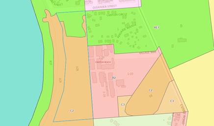
Figure 8: Aerial view of the land zoning across the site (in blue) and surrounds
· Clause 2.3 – Zone Objectives and Land Use Table
Subclause 2.3(2) of the CCLEP 2022 requires the consent authority to have regard to the objectives for development in a zone when determining the development application. The objective of the RE1 Public Recreation zone are as follows:
· To enable land to be used for public open space or recreational purposes.
· To provide a range of recreational settings and activities and compatible land uses.
· To protect and enhance the natural environment for recreational purposes.
· To identify areas suitable for development for recreation and cultural purposes.
· To provide space for integrated stormwater treatment devices for flow and water quality management.
The proposal is for a community event to be held annually which take advantage of the existing site and environment, complementing the land for recreational purposes. The proposed development will not prevent the site from being utilized by other recreational uses. The proposal is designed to be of minimal impact and cohesive with the surrounding natural environment. In this regard the proposed development is in keeping with the objectives of the relevant zone.
Relevant Clauses
The development application has been assessed against the following relevant clauses of the CCLEP 2022.
· Clause 2.8 – Temporary Use of Land
Clause 2.8 allows for the temporary use of land so long as the use does not compromise future development of the land or have a detrimental economic, social, amenity or environmental effects on the land. Further, this clause permits the temporary use of land for development despite the land zoning for a temporary use for a maximum of 28 days in any period of 12 months.
Per subclause (2), development consent is not able to be granted unless the consent authority is satisfied that–
(a) the temporary use will not prejudice the subsequent carrying out of development on the land in accordance with this Plan and any other applicable environmental planning instrument, and
(b) the temporary use will not adversely impact on any adjoining land or the amenity of the neighbourhood, and
(c) the temporary use and location of any structures related to the use will not adversely impact on environmental attributes or features of the land, or increase the risk of natural hazards that may affect the land, and
(d) at the end of the temporary use period the land will, as far as is practicable, be restored to the condition in which it was before the commencement of the use.
The development involves the use of the site for a period of 13 days between 26 December to 7 January annually for a period of five years ending in 2029, which is consistent with the requirements of the above clause.
The primary use of the land is a reserve with the intent of public recreation. The proposed event is not out of character with the purpose of the site and has been operating on the land for a number of years previous to this application. The proposal is considered to provide a benefit to the community through the provision of social events that will not prejudice the subsequent carrying out of development on the land under any other environmental planning instrument.
The proposed use is unlikely to have a detrimental impact upon the amount of public space available to the community and most of the site will remain available whilst an event is being held. Given the scale, type and frequency of the development proposed it is unlikely to impact upon the amenity of the adjoining land and local area.
The applicant estimates a maximum of 100 patrons (including staff and volunteers) to be present for the duration of the festivities based on previous years events. The use of the land is scattered with different activities and event times, which allow for peaks in attendance throughout the day. The event is to be held in the existing cleared areas of the site, with a speaker to amplify sound and music during these periods. The impact to the natural environment was reviewed by Council’s Ecologist and determined as insignificant for the immediate and long-term impacts of the surrounding ecology due to the small and brief nature of the event. The proposal is situated clear of existing trees and vegetation with no tree removal and minimal impact proposed. The event is located away from the dense portion of wetlands at the rear southern end of the site thus minimizing the impact on the dense habitats.
The proposal is set to meet the above criteria and a suitable plan of management is in place for the event to ensure compliance with the temporary use arrangements and restoration to the current condition at the conclusion of each event to the pre-existing condition. The land is capable of being restored to the condition before the commencement of use after each event. The Panel can be satisfied the proposed development is consistent with the requirements of clause ((a) –(d)) and development consent can be granted for the temporary use of land for the outdoor entertainment events.
· Clause 5.21 – Flood Planning
In accordance with Clause 5.21 of the CCLEP 2022, the consent authority must not grant consent to development on land identified as flood planning area unless the consent authority is satisfied that the development–
(a) is compatible with the flood function and behaviour on the land, and
(b) will not adversely affect flood behaviour in a way that results in detrimental increases in the potential flood affectation of other development or properties, and
(c) will not adversely affect the safe occupation and efficient evacuation of people or exceed the capacity of existing evacuation routes for the surrounding area in the event of a flood, and
(d) incorporates appropriate measures to manage risk to life in the event of a flood, and
(e) will not adversely affect the environment or cause avoidable erosion, siltation, destruction of riparian vegetation or a reduction in the stability of river banks or watercourses.
The subject site is identified as being affected by the flood planning area and maximum probable flood as the majority precinct across the subject site. However, it is noted parts of the site and surroundings are mapped as flood storage areas and these appear to align with the drainage line and direct road network connecting the Caravan Park. In this instance the development is for the temporary use of land for an event which runs for 13 days with no permanent structures proposed. The mapped flood area is only partially identified within the clearing used for the event.
It is considered the proposal is compatible with the flood function and behaviour on site. In the event of a flood, the organisers will either cancel the event, or if the event was being held, organisers and participants would have sufficient time to evacuate. A plan of management has been recommended as a condition of consent to address cancellation and suitable evacuation procedures in the event of a natural event. The risk to human life is considered low in this instance and suitable evacuation is available in the event of an emergency. The Panel can be satisfied that given the temporary nature of the land and the fact there is sufficient time for event participants to evacuate, the proposed use will not adversely affect flood function and behaviour, and there will be appropriate measures in place via a plan of management to manage risk to life in a flood event.
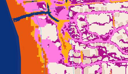
Figure 9: Aerial view of the mapped flooding precincts across the northern end of the site-Navy =floodway, Pink = Flood Planning Area, Purple =PMF (Source: Council Maps)
· Clause 7.1 – Acid Sulfate Soils
Clause 7.1 applies to development that has the potential to disturb, expose or drain acid sulfate soils. This land has been identified as containing Class 3 soils as identified on the Acid Sulphate Soils Map. However, the proposal includes no ground works in accordance with subclause (6), and there is no disturbance of soils less than 1 tonne and there are no works likely to lower the water table. In this instance the development is for the temporary use of land with no ground works proposed. The panel can be satisfied that an acid sulfate soils management plan was not required for the proposed temporary use of land.
· Clause 7.6 – Essential Services
Under the provisions of Clause 7.6 of CCLEP 2022, Council must ensure that the following services can be adequately provided before issuing a development consent. The proposal can provide the below services as per the following:
Access for Services (water, electricity, and sewage)
Water
The subject site does not have reticulated water and the proposal is not seeking water services to be connected for the event.
Electricity
A temporary power pole is proposed on the site to enable the use of power for the duration of the event. The pole is to be located within the northern end of the site and distanced from the existing vegetation. The pole will be removed, and power disconnected, at the completion of each event as per previous events.
Sewage
Temporary toilets are proposed to be provided on the site within the cleared area for the duration of the event per previous years. At the completion of the event the services are to be removed and ground rehabilitated to the pre-existing condition.
Stormwater drainage and on-site conservation
The proposal does not include any fixed or permanent structures on the site which would require collection into a suitable stormwater system. In lieu of this, the proposed structures are minimal and the runoff from these structures are not anticipated to increase the portable water on site.
Suitable vehicular access
The subject site currently contains the visitor parking area for the Canton Beach Tourist Park and the access driveway to the south-eastern portion of the Caravan Park. The proposed cleared area to be utilized does not have direct vehicular access and pedestrian access is required directly from the existing access driveway and footpath connecting the sites. The designated carpark is available for use directly north of the clearing for the temporary event. This carpark is easily accessible for pedestrian movement to and from the site, with many participants accommodated on-site within the adjoining camping sites of the Canton Beach Tourist Park.
Collection of waste
Event organisers have arranged for temporary waste bins to be stored around the site and collected three times each day. All collected waste will be stored under agreement with the adjoining Canton Beach Tourist Park’s on-site skip bins which will continue their usual schedule for pick up.
The panel can be satisfied that all necessary services can be provided for the site as per the above.
Local Environmental Planning Policies (LEPs)
Central Coast Development Control Plan 2022 (CCDCP 2022)
The following chapters of the CCDCP 2022 are relevant to this application:
· Chapter 1.2 Notification of Development Proposals
The application was notified in accordance with Chapter 1.2 of the Central Coast Development Control Plan from 10 May to 24 May (14 days) inclusive with no submissions received during this time. At the time of lodgment, it was presumed the site was solely owned by Crown Lands and Council was not the land manager in any capacity.
However, once Council was identified as Devolved Trust Manager, re-notification was required to ensure compliance with Central Coast Council’s Council Related Development Applications Conflict of Interest Protocol and the requirements of the Environmental Planning & Assessment Regulation which set out that applications on Council controlled land must be notified for a period not less than 28 days (the original notification being only for 14 days) . The application was subsequently re-notified for the required 28-days between 18 October 2024 and 15 November 2024 inclusive with no submissions received.
· Chapter 2.13 – Transport and Parking
Part 2.13.3.13 relates to Special Events or Regular Casual Uses and requires details to be provided for how parking demands will be met, and a traffic management plan may be required for any event that likely to have a significant impact on safe traffic movement and efficient parking.
In this instance, a traffic management plan is not considered warranted. The existing visitor car park is located approximately 20 metres from the event area and has capacity to hold approximately 49 vehicles.
The event is anticipated to generate an average of 40 – 60 participants with a majority of visitors attending multiple days staying within the adjoining Canton Beach Holiday Park. As such, these visitors staying on site will not utilize this carpark, but rather can park adjacent to their on-site accommodation.
The event is set up to run between the hours of 10:00 am and 9:30pm, each day. However, the key activities which generate the visitors and traffic are between the following times:
· 10:00am to 10:30am,
· 4:00am to 5:00pm,
· 7:00am to 9:00pm.
In between these sessions, the site is still open to visitors however this is mostly to be used by volunteers who are setting up the next session time. It is anticipated participants visiting the site will be coming and going in accordance with the available sessions and activities present.
It is estimated a maximum of 100 participants could be present on site at any time, this includes visitors, volunteers, and staff. It is noted the nature of the event is targeted to families and specifically children where the number of participants would be travelling in groups, therefore reducing the parking rate.
Public transport is available to the site with bus stops located in the adjoining street network, additional parking spaces can also be found in the adjoining Darren Kennedy Oval for additional parking, approximately 300 metres from the site.
The available parking is considered suitable to the desired use of the site and with minimal adverse impacts identified to surrounding properties.
· Chapter 2.14 – Site Waste Management
It is noted no public waste bins are available within the reserve. Event organisers are proposing to provide their own temporary bins on site for the duration of the event. Waste generation is anticipated to be domestic waste use consisting of paper, food scraps and the like.
A pre-existing arrangement has been provided with the adjacent Caravan Park’s manager to enable the event to use their large skip bins to hold the collected waste. At the completion of each event the reserve is to return the reserve to the same condition prior to the event taking place. A condition of consent is recommended to ensure this is complied with for the duration of the event.
Likely Impacts of the Development:
Built Environment
A thorough assessment of the aspects of the proposed development on the built environment has been undertaken in terms of DCP compliance.
As a result, the proposed development is considered satisfactory in terms of impacts on the built environment.
Access and Transport
As previously discussed, the existing transport arrangements for the site are
suitable to cater for the proposed events. There is also a possibility that
those attending the event would also be utilizing the Canton Beach Tourist Park
on the same days which would further reduce any parking demands on the site
during the events. Overall, there is sufficient parking on the site,
surrounding the site and alternative transport modes available, to cater for
patrons attending the proposed events.
Context and Setting
The site provides recreational activities for both residents and visitors to the area. The proposed development would allow the continued activation of the site for the community.
Natural Environment
· Biodiversity and Ecology
The subject site intersects with areas identified on the Biodiversity Vales Map, and significant habitat for the critically endangered Lathamus discolor (Swift Parrot). An analysis of the vegetation habitat present indicates that the site is constrained by the presence of two Plant Community Types (PCTs). The first being Melaleuca biconvexa - Swamp Mahogany - Cabbage Palm swamp forest of the Central Coast (PCT1723) and the second being Broad-leaved Paperbark - Swamp Oak - Saw Sedge swamp forest on coastal lowlands of the Central Coast and Lower North Coast (PCT1724).
Melaleuca biconvexa - Swamp Mahogany - Cabbage Palm swamp forest is associated with the Threatened Ecological Community Swamp Sclerophyll Forest on Coastal Floodplains of the New South Wales North Coast, Sydney Basin and Southeast Coast Bioregions. Aside from cleared patches, the site is majority identified as being in “Moderate-Good” condition and is mapped as Core Habitat for threatened species on Council’s Geospatial Information System.
An analysis of the BioNet Threatened Species records indicate that the site is known to support a variety of threatened flora and fauna species, including but not limited to Lathamus discolor (Swift Parrot), Syzygium paniculatum (Magenta Lilly Pilly), Pandion cristatu (Eastern Osprey), Glossopsitta pusilla (Little Lorikeet) and Crinia tinnula (Wallum Froglet).
The proposal has been reviewed and considered against the previous consents issued for the events on site. Previous applications outlined that the proposal was established with Ecologically Sustainable principles in mind with no requirement to remove any trees or vegetation. All activities, structures and tents will be established away from trees and habitat, minimising direct impacts to vegetation. The proposal does not result in the disturbance of any endangered flora or fauna habitats and is unlikely to significantly affect fluvial environments.
As no vegetation is proposed for removal, and the temporary nature of the event with a short duration and the activities are generally contained to the cleared portion of the site, impacts to significant biodiversity values are minimal. The proposed site plan provides adequate avoidance to habitat features and established vegetation, assuring Council’s Ecologist that immediate and long-term impacts to ecology will be insignificant. As such recommended conditions of consent proposed ensure compliance with the proposed event is upheld and continued throughout the entirety of the event period.
· Noise
The event is proposed with attendance between 40 to 60 people across the entire event however, a maximum of 100 people (including volunteers) can be anticipated at peak times. Generally, the daily activities are crafts, children’s games, and puppet theatres. The volume and amplification of sound is anticipated to fluctuate with the number of participants and each activity. An acoustic report has been provided with the application, which estimates these activities at approximately 60 decibels, which can be likened to a common conversation. As the activities are proposed at a small gathering scale, the type of activities is designed to be intimate and reduce the sound amplification away from the clearing. The existing vegetation assists in providing a noise buffer to stop the amplification of sound.
A PA system is to be used to make announcements for the event primarily but is also available for the use of amplifying musical instruments as required by attendance. The provided acoustic report acknowledges a separating mixing desk to be set up nearby the PA system to monitor the sound levels and always control these levels. The sound levels are projected to run at approximately, 70 decibels dissipating to 50 decibels at 150 metres.
It is considered the sound levels are minimal and have the ability to monitor and control these levels during the event. As such, it is recommended a condition of consent is adopted to ensure the PA system and all noise control measures are be operated as stated in the Acoustic Report.
· Bushfire and Flooding
The site is impacted by bushfire and flooding, however the cleared area the subject of this event location is minimally impacted by these natural events. It is generally considered the property is suitable for the proposal with a suitable plan of management in place to manage the site in the case of such emergency events.
All other issues regarding likely impacts of the development has been discussed throughout this report. Generally, the site is considered suitable for the proposal given approval is issued with suitable conditions of consent.
Suitability of the Site for the Development:
A review of Council’s Land Information mapping has identified bushfire and flooding as site constraints however, given the nature of the proposal, being for temporary use of land, these constraints can be appropriately managed through a suitable plan of management. The site is therefore suitable for development.
The proposed event is located within the curtilage of the subject site and adjoins the neighbouring Canton Beach Tourist Park. The proposed development is compatible with the existing development in the locality and would likely be utilised predominantly by residents and visitors for the holiday season.
As previously discussed within the report, the proposal is not likely to have any impacts on the amenity of the local residents as the location of the site is distanced from the local residential catchment. Additionally, the hours of operation are sporadic and align with the surrounding Caravan Park which would have activities and uses at this time and therefore, the proposal is not considered out of character to the surrounding land uses and development. The site is generally considered suitable for the proposed development.
Any Submission made in Accordance with this Act or Regulations
Submissions from the public
The application was notified in accordance with Chapter 1.2 from 10 May to 24 May inclusive with no submissions received during this time. At the time of lodgment, it was presumed the site was solely owned by Crown Lands and Council was not the land manager in any capacity. However, once Council was identified as Devolved Trust Manager, re-notification was required to ensure compliance with Central Coast Council’s Council Related Development Applications Conflict of Interest Protocol and the requirements of the Environmental Planning & Assessment Regulations which specify a minimum 28 day notification period for applications on land in the care and control of Council. The application was then re-notified for the required 28-days between 18 October 2024 and 15 November 2024 inclusive with no submissions received.
Submissions from Public Authorities
· Rural Fire Service (NSW RFS)
The application was referred to the Rural Fire Service (NSW RFS) in accordance with section 4.14 of the Environmental Planning and Assessment Act 1979 who requested a bushfire report to accompany the application for comment. Recommended conditions were provided by NSW RFS which related to the provision of a suitable Bush Fire Emergency Management and Evacuation Plan to be provided in accordance with Table 6.8d and Section 8.3.8 of Planning for Bush Fire Protection 2019. Further recommendations are provided for the applicant to provide a copy of the completed report to the Local Emergency Management Committee for its information prior to the first event.
Crown Lands
The application was referred to Crown Lands, however no comment has been provided to date however it is noted they have granted land owners consent to the application.
Internal Consultation
|
Environmental Health Officer |
Supported subject to conditions 3 and 14. |
|
Ecologist |
Supported subject to conditions 12, 13 and 19. |
|
Waste Officer |
Supported, with no comments provided. |
|
Recreation Passive Parks |
Notified, with no comments provided. |
External Consultation
|
NSW Rural Fire Service |
Supported, subject to condition 2. |
Ecologically Sustainable Principles:
The proposal has been assessed having regard to ecologically sustainable development principles and is considered to be consistent with the principles.
The proposed development is considered to incorporate satisfactory stormwater, drainage and erosion control and the retention of vegetation where possible and is unlikely to have any significant adverse impacts on the environment and will not decrease environmental quality for future generations. The proposal does not result in the disturbance of any endangered flora or fauna habitats and is unlikely to significantly affect fluvial environments.
Climate Change
The potential impacts of climate change on the proposed development have been considered by Council as part of the assessment of the application.
This assessment has included consideration of such matters as potential rise in sea level, potential for more intense and/or frequent extreme weather conditions including storm events, bushfires, drought, flood, and coastal erosion; as well as how the proposed development may cope, combat, withstand these potential impacts. In this particular case, the following matters are considered to warrant further discussion, as provided below:
Bushfire Protection: The site is identified as bushfire prone land and was referred to the NSW RFS for comment who recommended conditions relating to bushfire emergency and evacuation arrangements to be included with any consent granted.
Rising Sea Level: The site is identified as part flood affected. In a flood event it is considered group organisers and visitors would have sufficient time to evacuate and delay/cancel the event if flooding occurred. Part of the event planning is ensuring an appropriate plan of management is in place to address cancellation and evacuation in the event of a flood. The risk to human life associated with flooding can be alleviated through early intervention.
Planning Agreements
The proposed development is not subject to a Planning Agreement or Draft Planning Agreement.
The Public Interest (s4.15(1)(e)):
The proposed event is to be run for 13 days over five years commencing from 26 December 2024. While the date is within peak holiday times, the location and scale of the temporary event will not impede or restrict use of the waterfront reserve. The event provides social benefits and activation for the local community and encourages tourism. The proposal does not contravene the public interest.
Other Matters for Consideration
Contributions
Given the type of development proposed, Sections 7.11 and 7.12 Contributions are not applicable.
Conclusion:
The application has been assessed under the heads of consideration of Section 4.15 of the Environmental Planning and Assessment Act 1979 and all relevant instruments and policies. The potential constraints have been assessed and it is considered suitable against the nature and use of the site and surroundings.
The application is commended for approval pursuant to Section 4.16 of the Environmental Planning and Assessment Act 1979 for the following reasons:
1. The proposal is satisfactory having regard for the relevant environmental planning instruments, plans and policies.
2. There are no significant issues or impacts identified with the proposal under Section 4.15 of the Environmental Planning and Assessment Act 1979.
3. The proposal satisfies the provisions of Chapter 2 and 4 of SEPP (Resilience and Hazards) 2021.
4. The proposal is satisfactory with regard to Clauses 2.8, 5.21, 7.1 and 7.6 of the Central Coast Local Environmental Plan 2022.
5. The proposal will provide a social benefit to the community.
|
1⇩
|
Draft Notice Of Determination - DA/539/2024 - PAN-422458 - 1CR Oleander Street, CANTON BEACH |
|
D16496937 |
|
2⇩
|
PUBLIC - Site Map - PAN-422458 - 1 Oleander Cres Canton Beach - DA/539/2024 |
|
D16157555 |
|
3⇩
|
PUBLIC - Coastal Assessment Report - PAN-422458 - 1 Oleander Cres Canton Beach - DA/539/2024 |
|
D16157566 |
|
4⇩
|
PUBLIC - REVISED - Portal Doc - 1CR Oleander Street, CANTON BEACH NSW 2263 - DA/539/2024 - Acoustic report |
|
D16360807 |
|
5⇩
|
RFS Referral Comments_DA20240501001729-Original-1 - 04-09-2024 16_10_30 - Determination Letter_A-88208 |
|
D16391926 |
|
4.3 |
DA/539/2024 - 1CR Oleander Street, CANTON BEACH - Temporary Use of Land for Community Event (5 years) |
|
Attachment 1 |
Draft Notice Of Determination - DA/539/2024 - PAN-422458 - 1CR Oleander Street, CANTON BEACH |
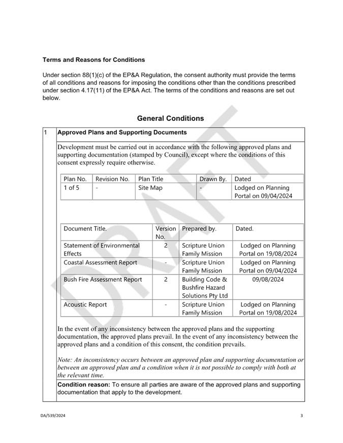
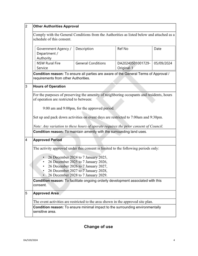
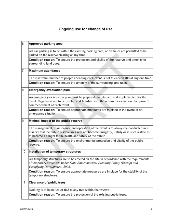
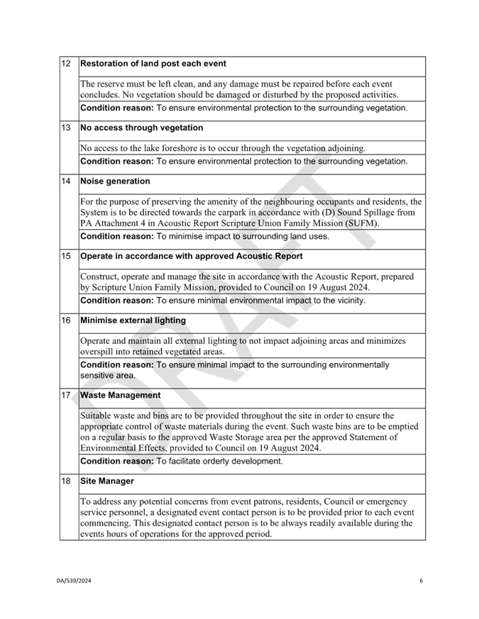
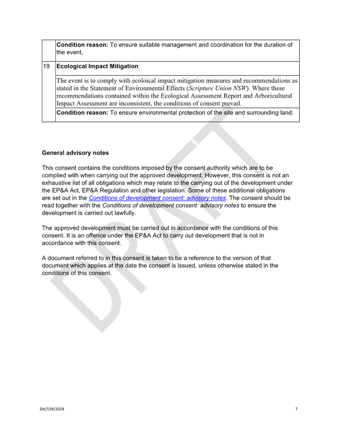
|
DA/539/2024 - 1CR Oleander Street, CANTON BEACH - Temporary Use of Land for Community Event (5 years) |
|
|
Attachment 2 |
PUBLIC - Site Map - PAN-422458 - 1 Oleander Cres Canton Beach - DA/539/2024 |

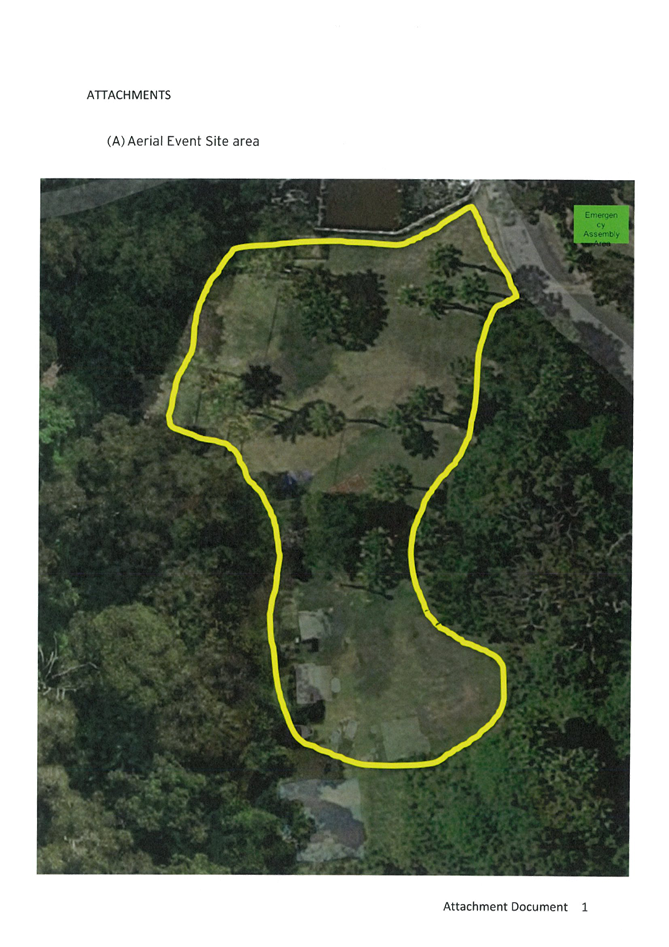
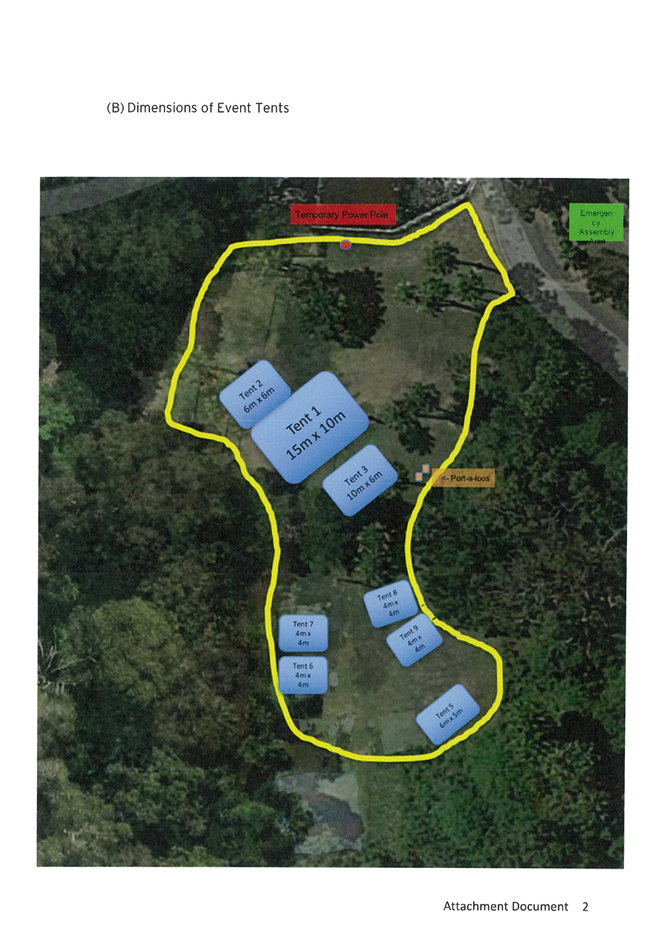
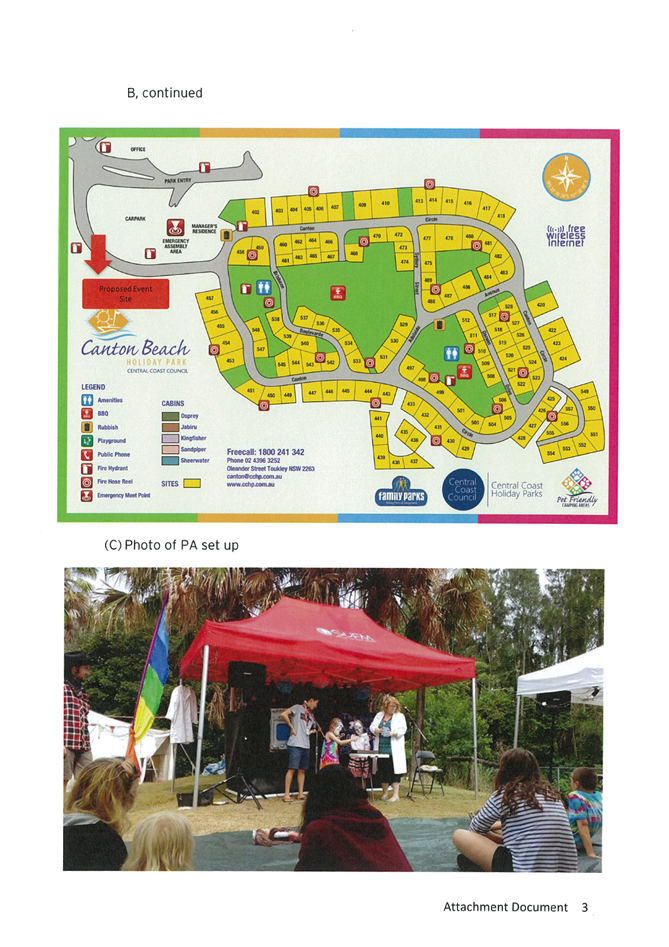
|
DA/539/2024 - 1CR Oleander Street, CANTON BEACH - Temporary Use of Land for Community Event (5 years) |
|
|
Attachment 3 |
PUBLIC - Coastal Assessment Report - PAN-422458 - 1 Oleander Cres Canton Beach - DA/539/2024 |
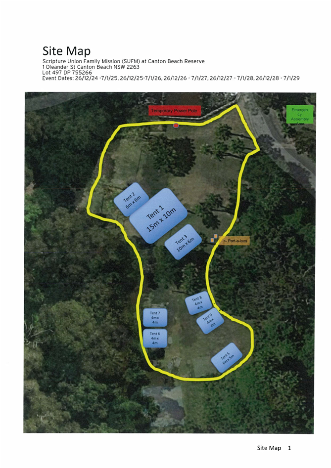
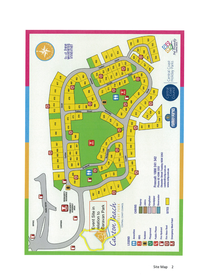

|
DA/539/2024 - 1CR Oleander Street, CANTON BEACH - Temporary Use of Land for Community Event (5 years) |
|
|
Attachment 4 |
PUBLIC - REVISED - Portal Doc - 1CR Oleander Street, CANTON BEACH NSW 2263 - DA/539/2024 - Acoustic report |