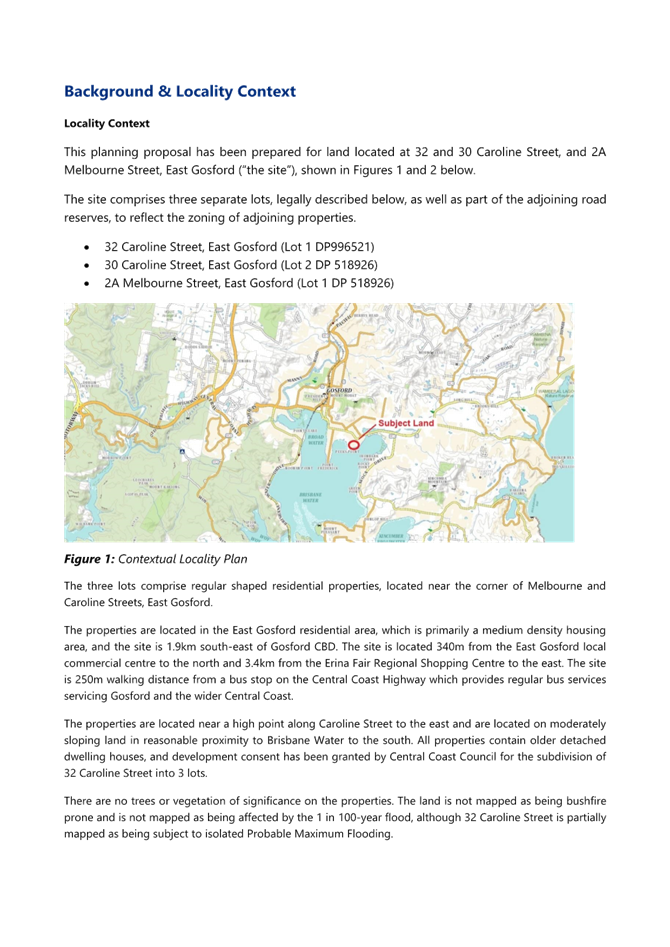
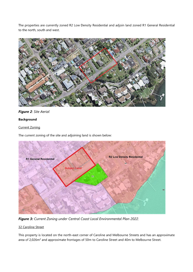
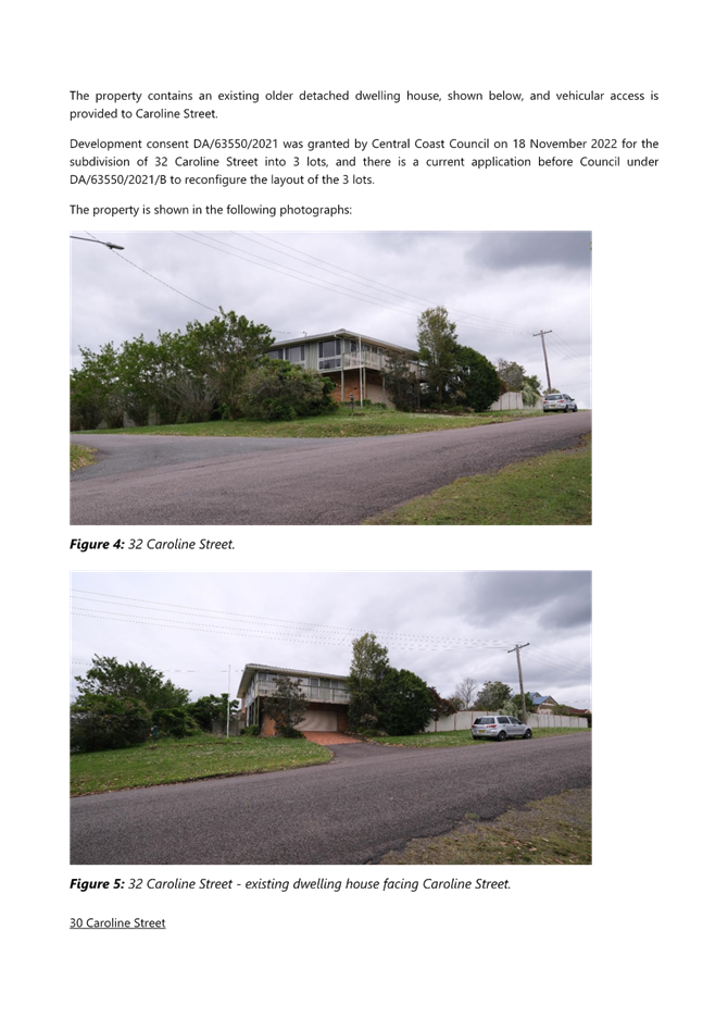
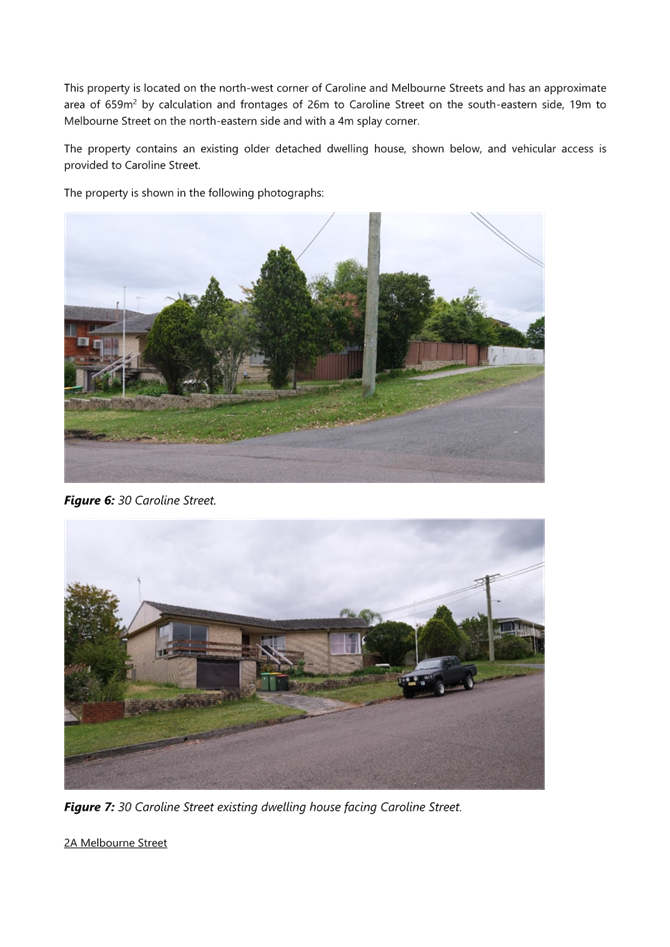
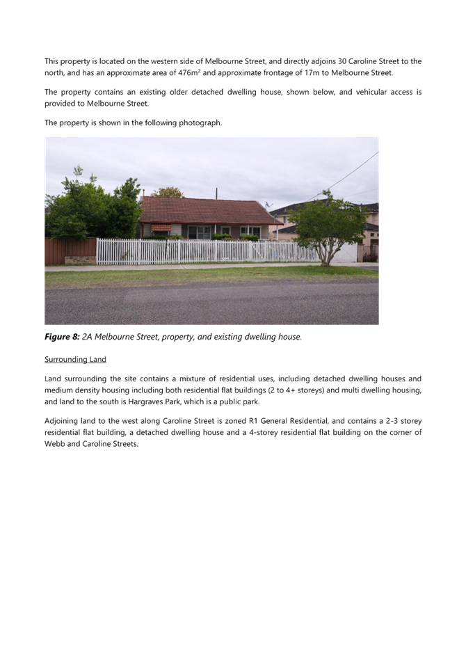
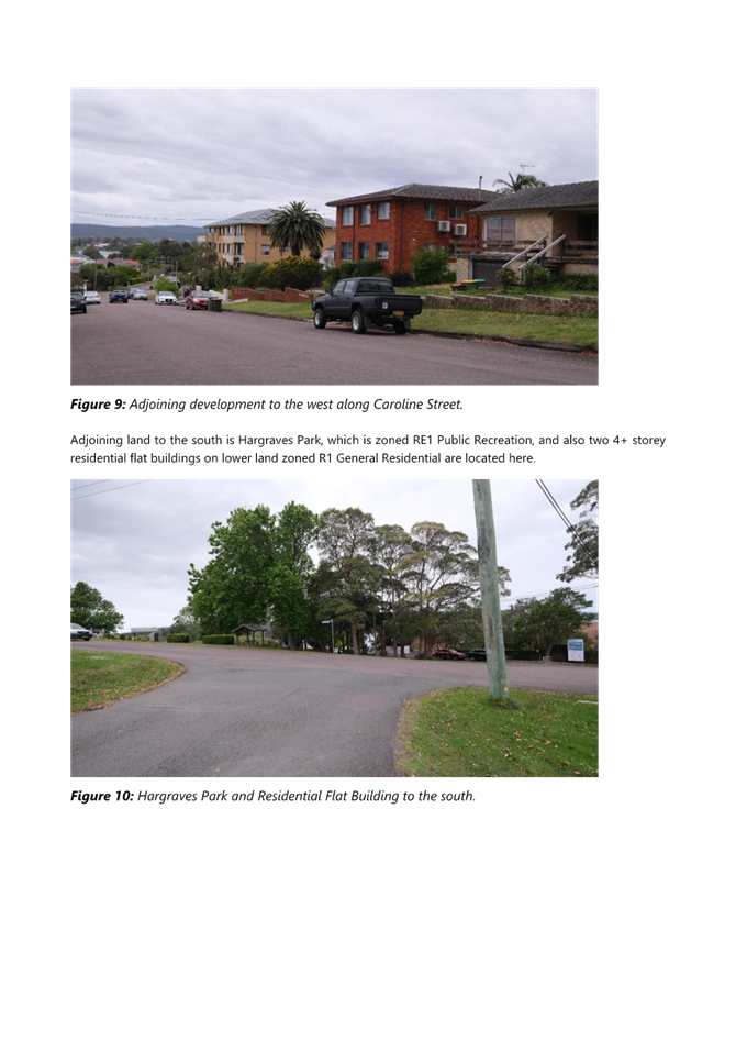
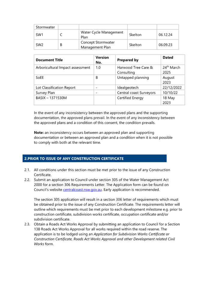
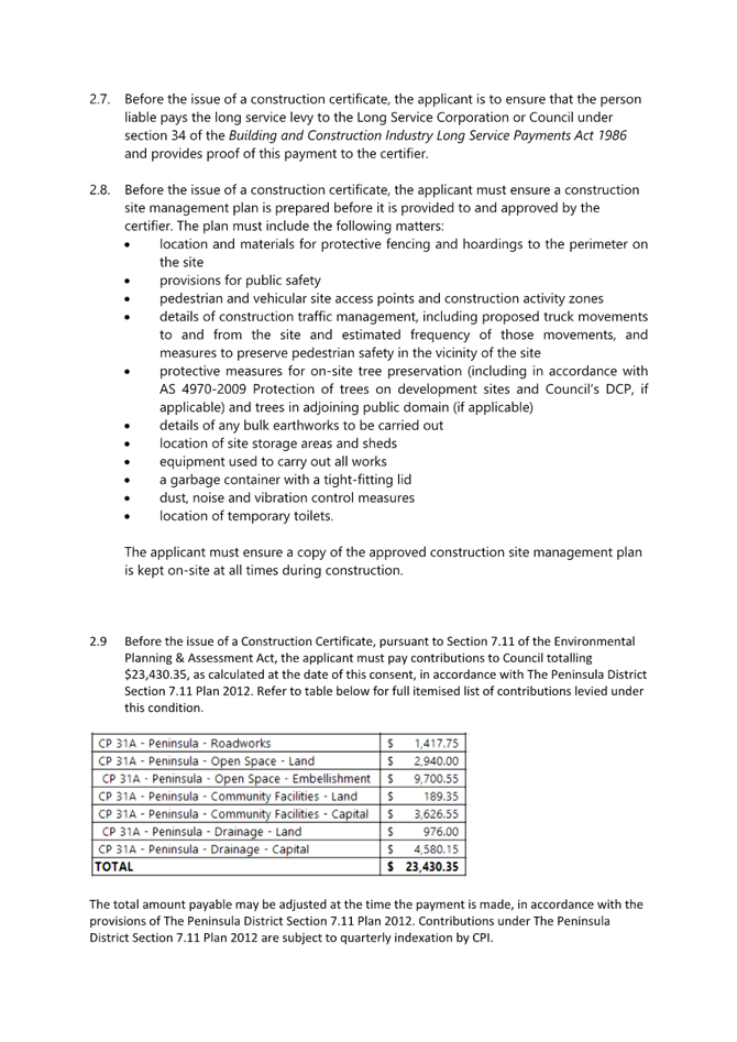
 |
Central Coast
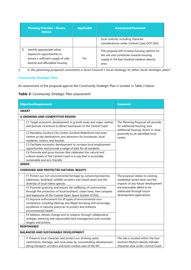
Local Planning Panel Meeting
Business Paper
10 April 2025
 |
|
Central Coast
Local Planning Panel Meeting
Business Paper
10 April 2025
|
The Local Planning Panel Meeting
of Central Coast
will be held remotely - online,
Thursday 10 April 2025 at 12.00 pm,
for the transaction of the business listed below:
1 Procedural Items
1.1 Disclosures of Interest.............................................................................................................................. 3
2 Confirmation of Minutes of Previous Meetings
2.1 Confirmation of Minutes of Previous Meeting................................................................................. 4
3 Planning Reports
3.1 DA/1627/2023 - 42 Hobart Avenue, Umina Beach - Dual Occupancy and two lot strata subdivision......................................................................................................................................................................... 9
3.2 DA/1703/2023 - 28 Bungary Road, Norah Head - Studio, Alterations & Additions....... 138
4 Reports
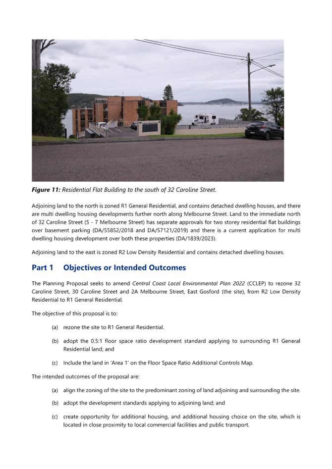
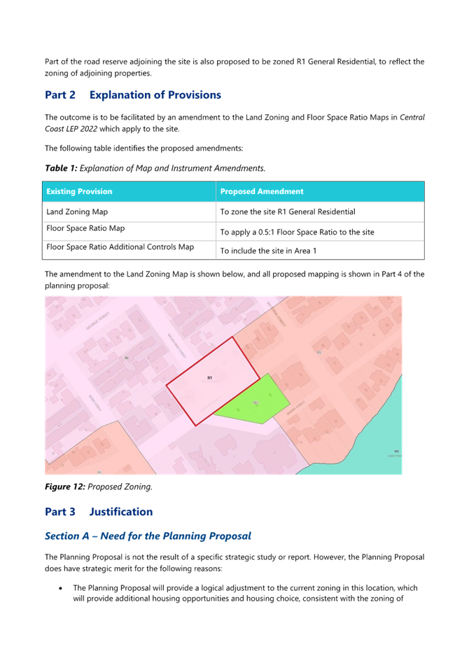
4.1 Request to amend Central Coast Local Environmental Plan to allow rezoning at 30 and 32 Caroline St and 2A Melbourne St, East Gosford........................................................................................... 219
Heather Warton
Chairperson
|
Item No: 1.1 |
|
|
Title: Disclosures of Interest |
|
|
Department: Governance |
|
|
10 April 2025 Local Planning Panel Meeting |
|
Reference: F2020/02502 - D14205789
|
The NSW Local Planning Panel Code of Conduct states that all panel members must sign a declaration of interest in relation to each matter on the agenda before or at the beginning of each meeting.
|
That Panel Members now confirm that they have signed a declaration of interest in relation to each matter on the agenda for this meeting and will take any management measures identified.
|
Item No: 2.1 |
|
|
Title: Confirmation of Minutes of Previous Meeting |
|
|
Department: Corporate Services |
|
|
10 April 2025 Local Planning Panel Meeting |
|
Reference: F2020/02502 - D16764746
|
Summary
The
Minutes of the following Meeting of the Local Planning Panel, which have been
endorsed by the Chair of that meeting, are submitted for noting: · Local Planning Panel Meeting held on 19 March 2025
|
That the minutes of the previous Local Planning Panel Meeting held on 19 March 2025, which were endorsed by the Chair of that meeting, are submitted for noting.
|
1⇩ |
MINUTES - Local Planning Panel - 19 March 2025 |
|
D16734551 |
|
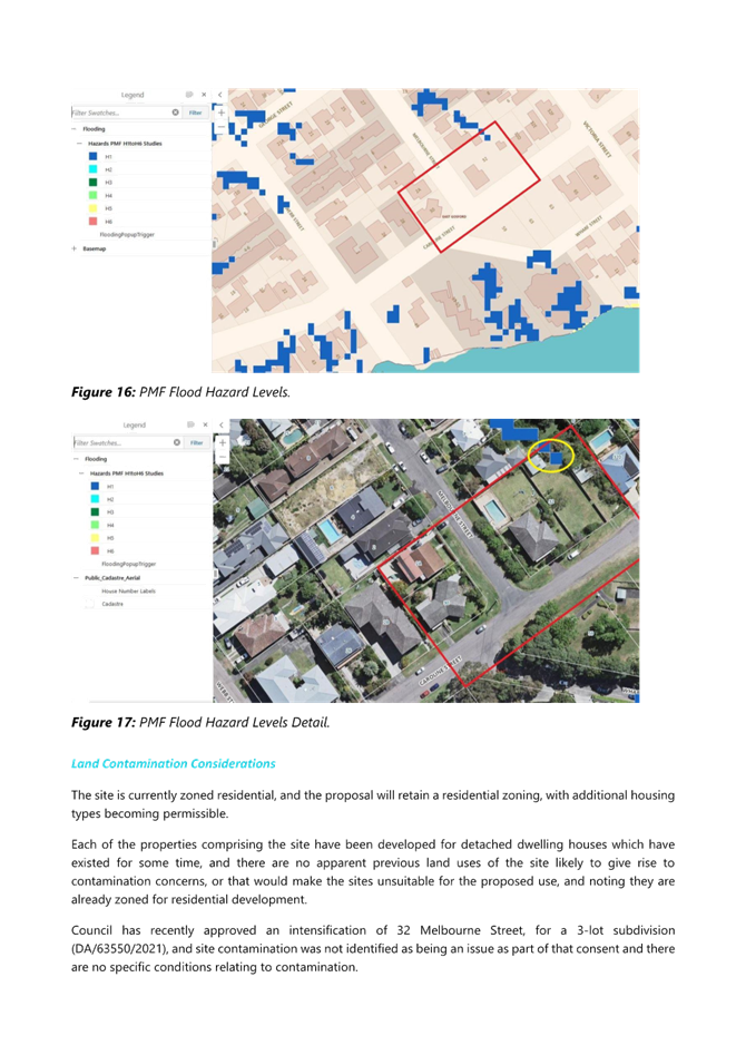
2.1 |
Confirmation of Minutes of Previous Meeting |
|
Attachment 1 |
MINUTES - Local Planning Panel - 19 March 2025 |
|
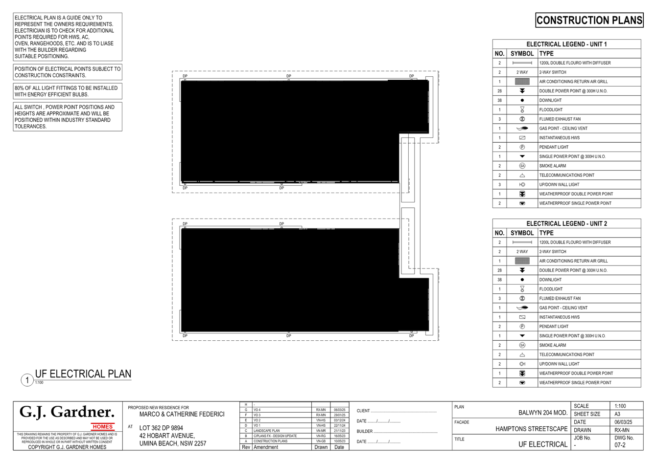
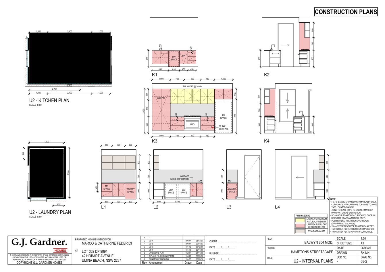
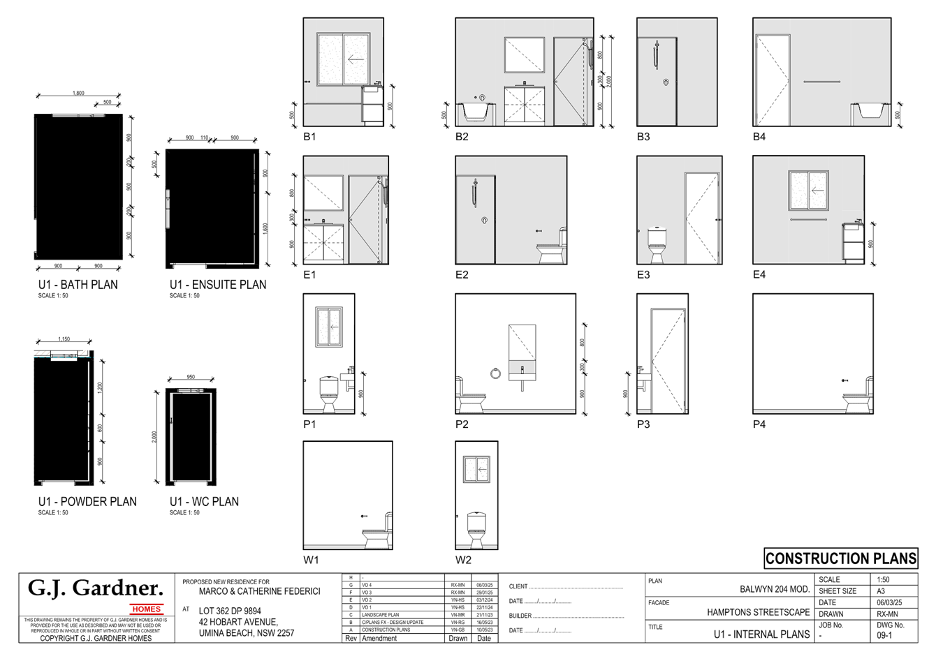
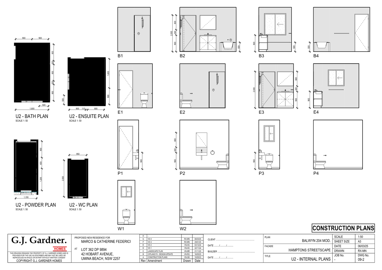
DA/1627/2023 - 42 Hobart Avenue, Umina Beach - Dual Occupancy and two lot strata subdivision |
|
|
Attachment 1 |
Draft conditions /Reasons - 42 Hobart Avenue UMINA BEACH NSW 2257- DA/1627/2023 |
|
Item No: 3.1 |
|
|
Title: DA/1627/2023 - 42 Hobart Avenue, Umina Beach - Dual Occupancy and two lot strata subdivision |
|
|
Department: Environment and Planning |
|
|
10 April 2025 Local Planning Panel Meeting |
|
Reference: DA/1627/2023 - D16690269
Author: Kate Alberry, Senior Development Planner
Unit Manager:: Andrew Roach, Unit Manager Development Assesments
|
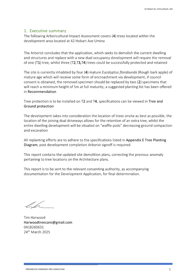
Summary
An application has been received for an attached dual occupancy and two lot strata subdivision. The application has been examined having regard to the matters for consideration detailed in section 4.15 of the Environmental Planning and Assessment Act and other statutory requirements with the issues requiring attention and consideration being addressed in the report.
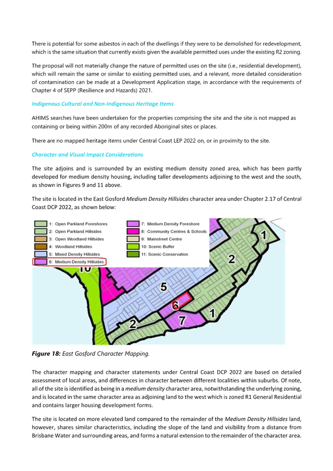
The development application is required to be reported to the Local Planning Panel for determination as a result of the number of submissions. 22 submissions were received during the notification period. The application is recommended for approval, subject to conditions.
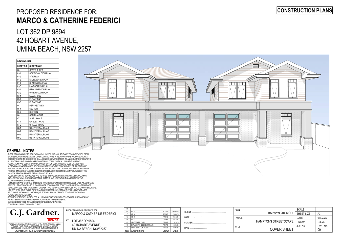
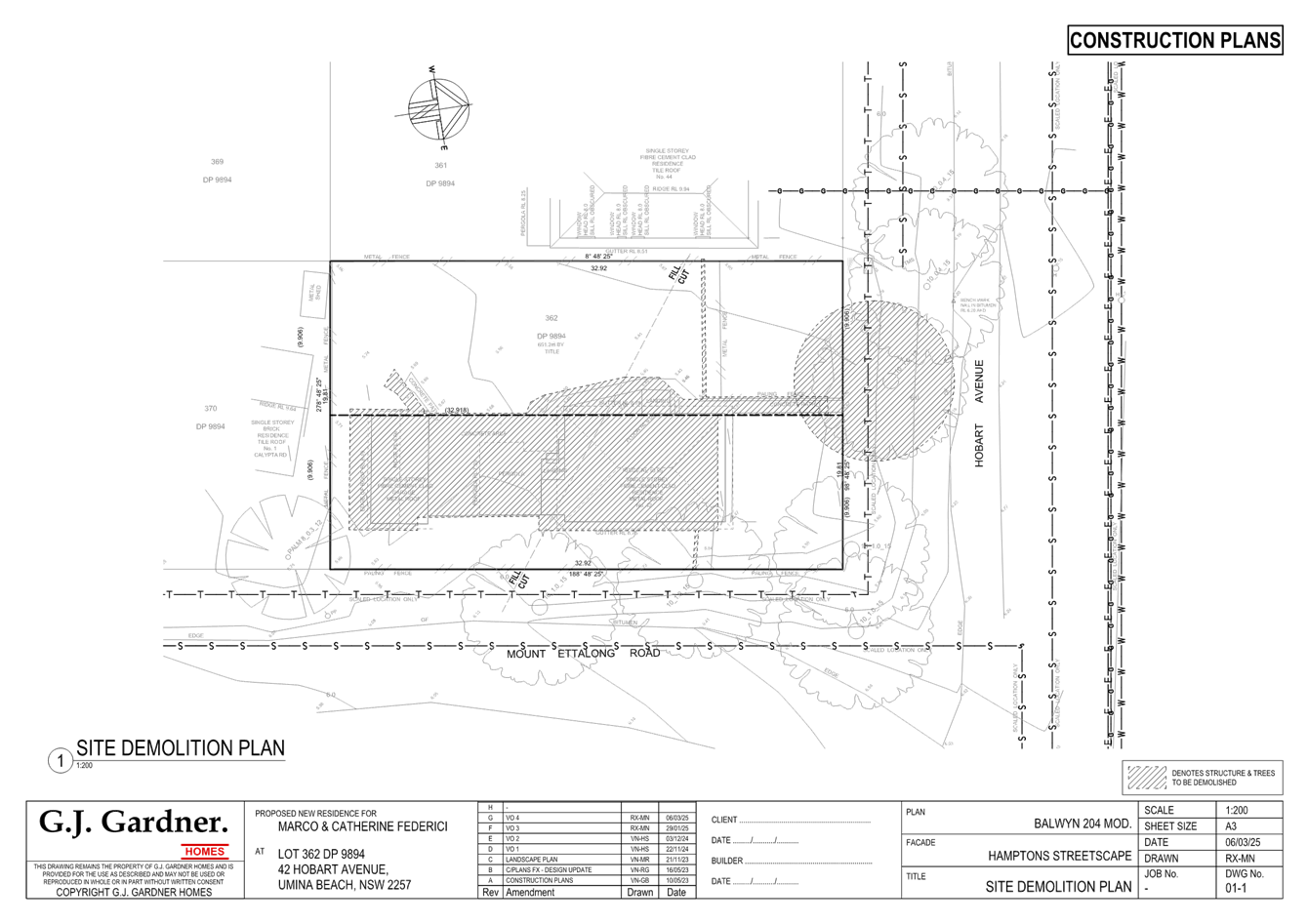
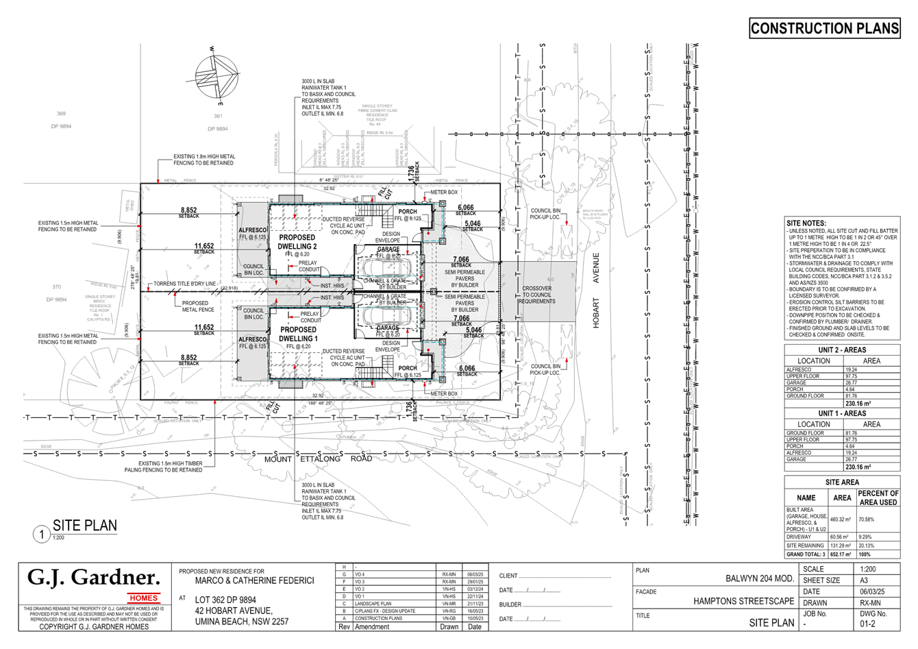
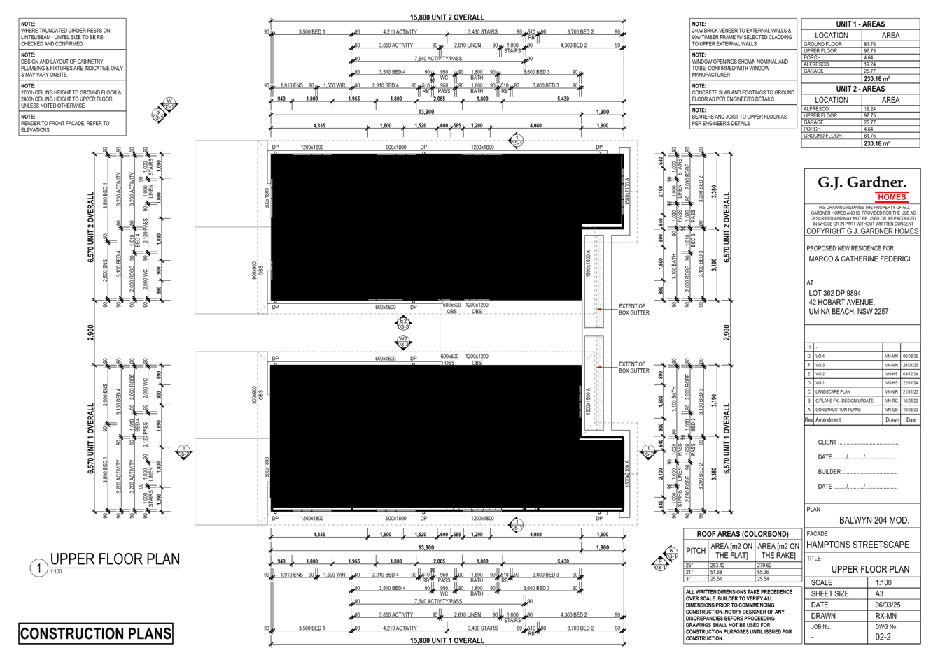
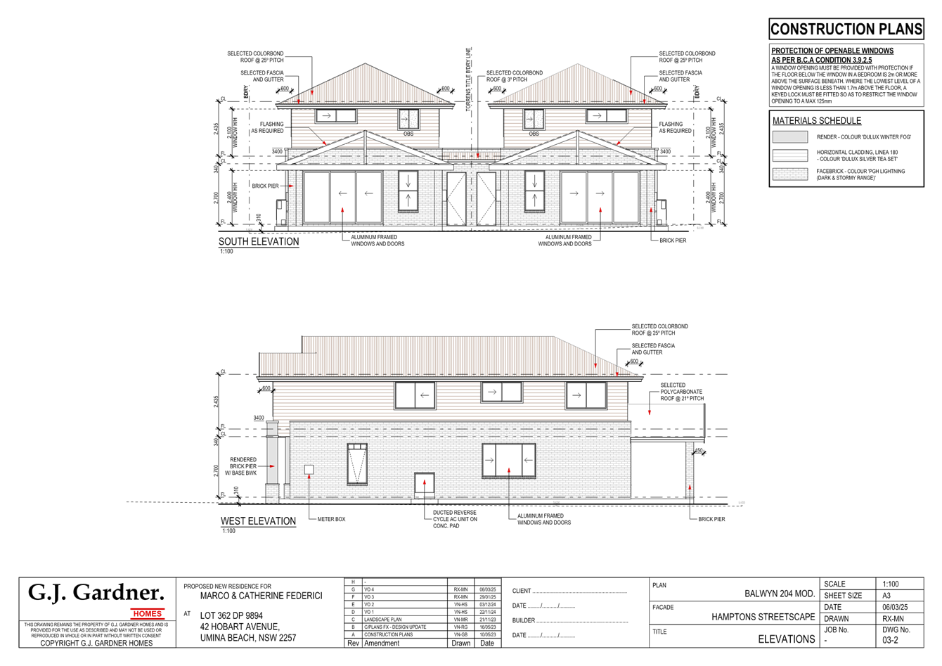
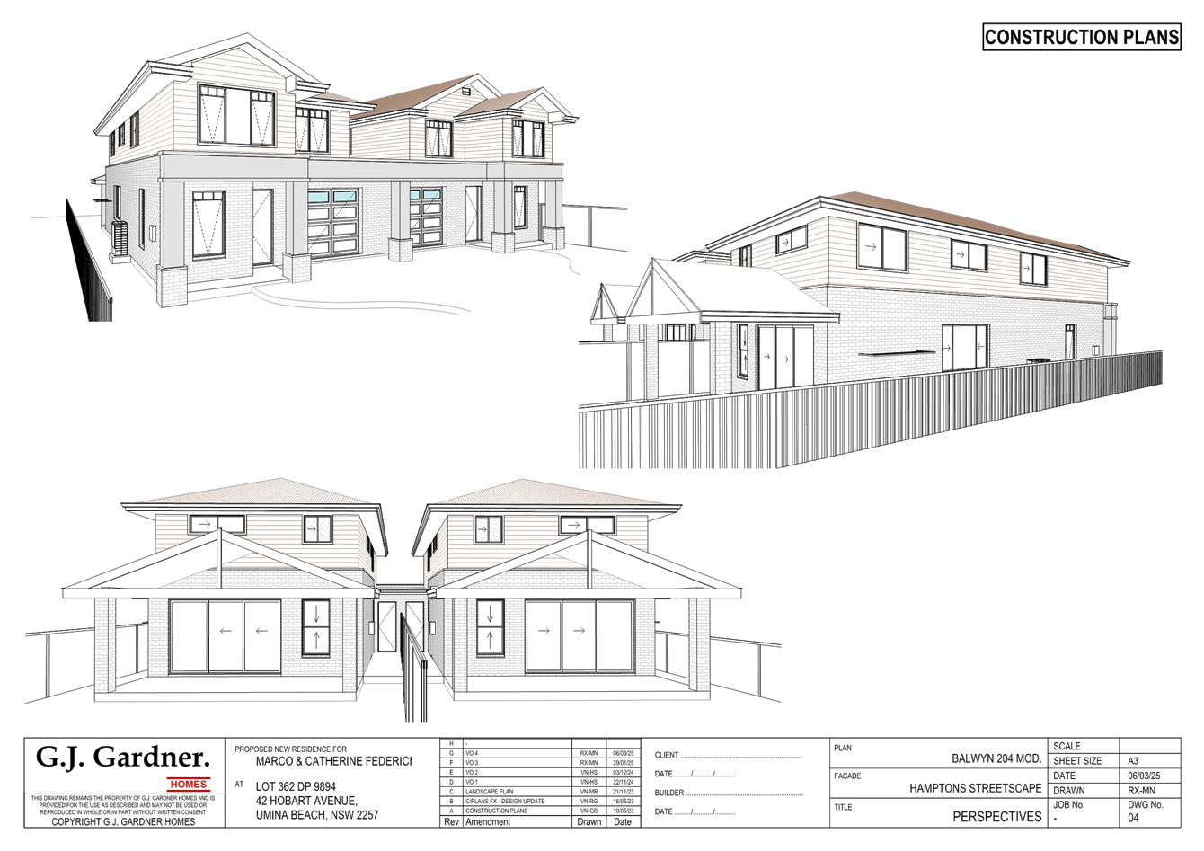
Applicant Untapped Planning Owner C & M Federici Application No DA/1627/2023 Description of Land 42 Hobart Avenue, Umina Beach Proposed Development Attached Dual Occupancy and two lot strata subdivision. Site Area 651.2m2 Zoning R2 Low Density Residential Existing Use dwelling house Employment Generation No Estimated Value $1,127,261.30
|
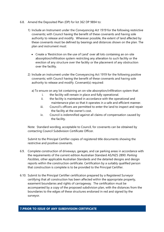
1 That the Local Planning Panel grant consent to DA/1627/2023 – 42 Hobart Avenue, Umina Beach – for the purpose of a dual occupancy development and strata subdivision subject to the conditions detailed in the schedule attached to the report and having regard to the matters for consideration detailed in Section 4.15 of the Environmental Planning and Assessment Act 1979.
2 That Council advise those who made written submissions of the Panel’s decision.
Key Issues
An application has been received for an attached dual occupancy with a 2 lot strata subdivision at 42 Hobart Avenue, Umina Beach.
The development application is required to be reported to the Local Planning Panel due to the development attracting twenty-two (22) submissions which is over the ten (10) submissions being able to be delegated to Council officers for determination.
The development proposes a 4% variation to Clause 2.2.4.2 Floor Space Ratio of the Central Coast Development Control Plan 2022 from the required 0.5:1 for a Dual Occupancy, to 0.54:1.
Furthermore, it requires a variation to clause 2.2.5(e) Building Setbacks of the CCDCP 2022, for a side setback of 1.736m to Mount Ettalong Road, this is a variation of 0.264m instead of the required 2m which represents a variation of 13.2%.
Precis:
|
Proposed Development |
Attached dual occupancy with two lot strata subdivision.
|
|
Permissibility and Zoning |
The subject site is zoned R2 Low Density Residential under the provisions of the Central Coast Local Environmental plan 2022 (CCLEP 2022).
The existing development is defined as a ‘dwelling house’ which is defined under the CCLEP 2022 as:
Dwelling house means a building containing only one dwelling.
The proposed development is defined as a ‘dual occupancy’ which is defined under the CCLEP 2022 as:
Dual occupancy (attached) means 2 dwellings on one lot of land that are attached to each other but does not include a secondary dwelling.
|
|
Current Use |
Dwelling house
|
|
Integrated Development |
No
|
|
Submissions |
The development application was notified (in accordance with the CCLEP 2022 from 3rd November 2023 to 17th November 2023.
Twenty-two (22) submissions were received, 18 within the time frame and 4 late submissions. All submission have been considered as part of this report.
|
Variations to Policies
|
Clause |
Clause 4.4 Floor Space Ratio of the CCDCP 2022
|
|
Standard |
0.5:1
|
|
DCP |
CCDCP 2022
|
|
Departure basis |
0.54:1
A variation of 27.62m2
The variation requested represents a 4% variation. |
|
Clause |
2.2.5(e) Building Setbacks of the CCDCP 2022
|
|
Standard |
e. Corner Allotments Side Street – Dual Occupancy
i. 2.0m, plus compliance with sight preservation lines
|
|
DCP |
CCDCP 2022
|
|
Departure basis |
The development has a side setback of 1.736m to Mount Ettalong Road, this is a variation of 0.264m instead of the required 2m.
Sight lines comply due to the road reserve and corner alignment.
This represents a variation of 13.2%.
|
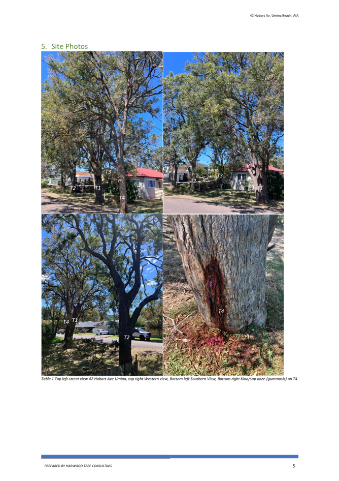
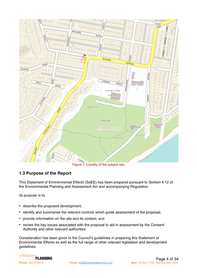
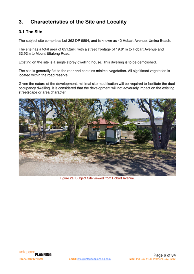
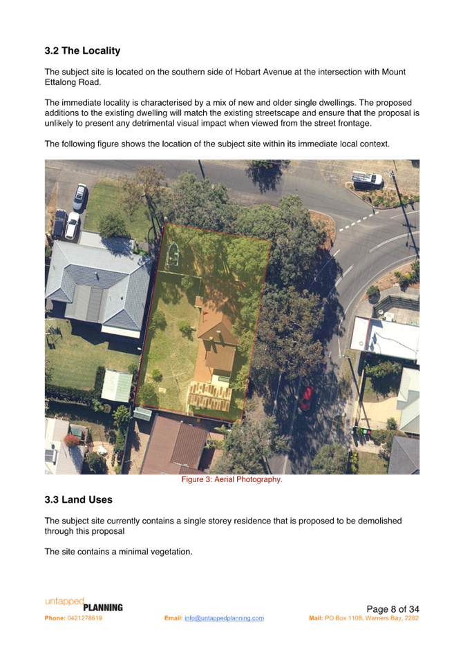
The Site
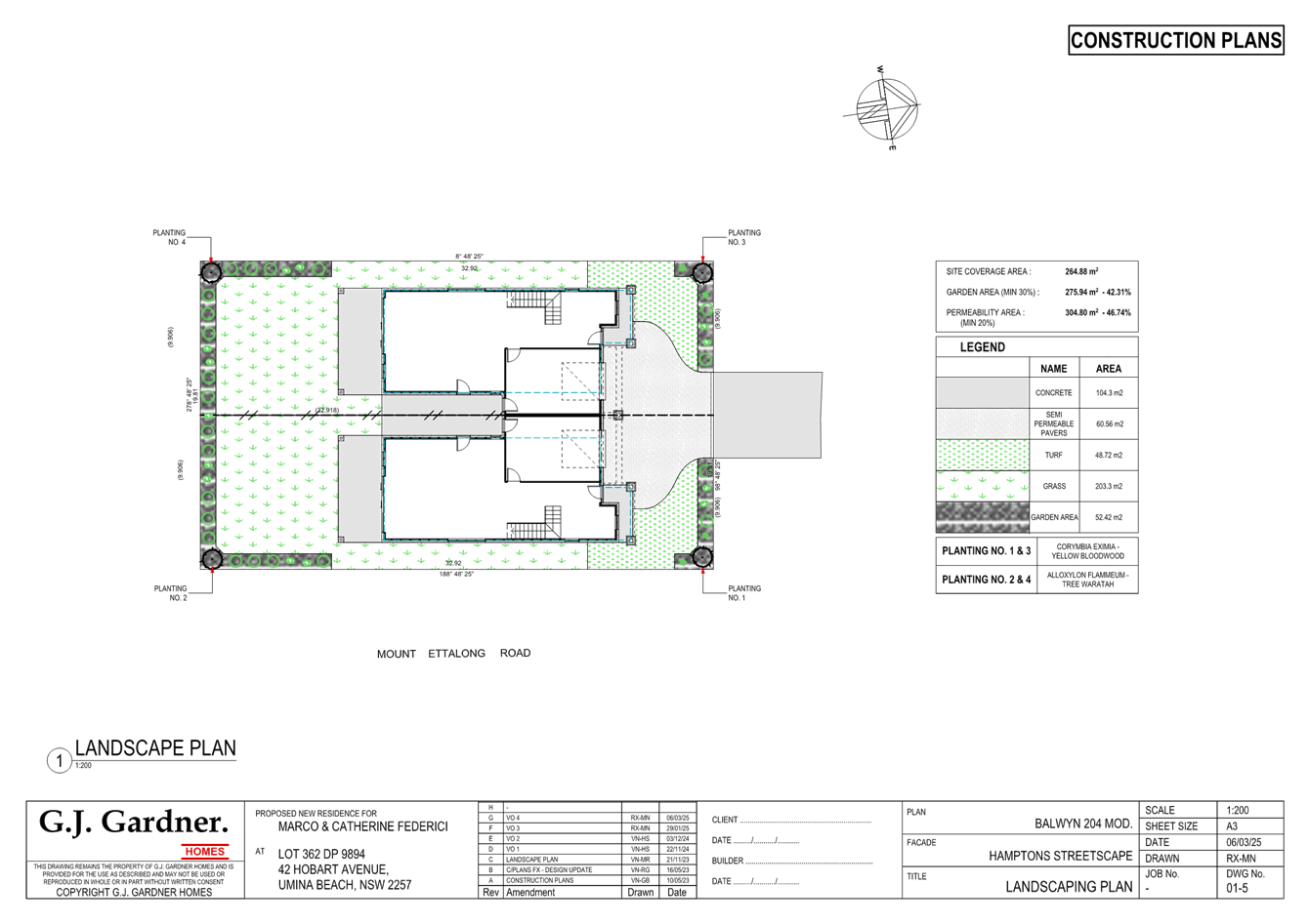
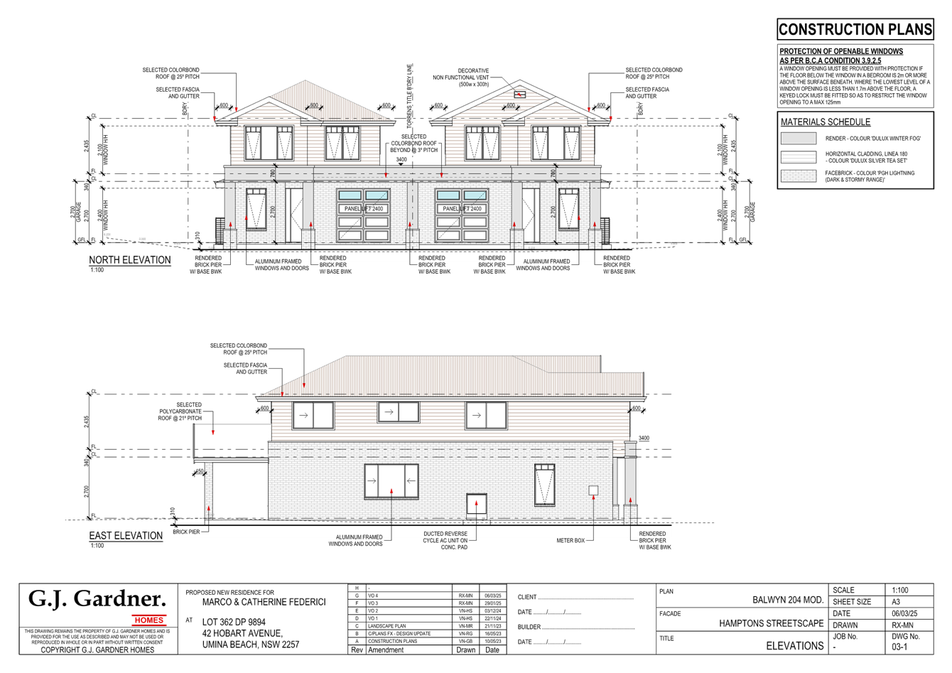
The site is legally described as Lot 362 DP9894 and is commonly known as 42 Hobart Avenue, Umina Beach. The site area is 651.2m2 by title with a street frontage to Hobart Avenue of 19.81m and side boundary of 32.92m to Mount Ettalong Road.
The site contains and existing residential dwelling. The area is surrounded by residential lots also zoned R2 Low Density residential which is predominantly single storey dwelling development. Development in this area is interspersed with newer style developments including dual occupancy development and 2 storey dwellings.
Adjacent and on the eastern side of Mount Ettalong Road is an area of R1 General Residential land.
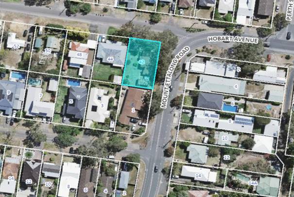
Figure 1 - Site Locality Plan
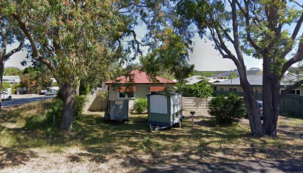
Figure 2 - Proposed Development Site viewed from Hobart Avenue
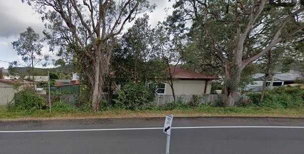
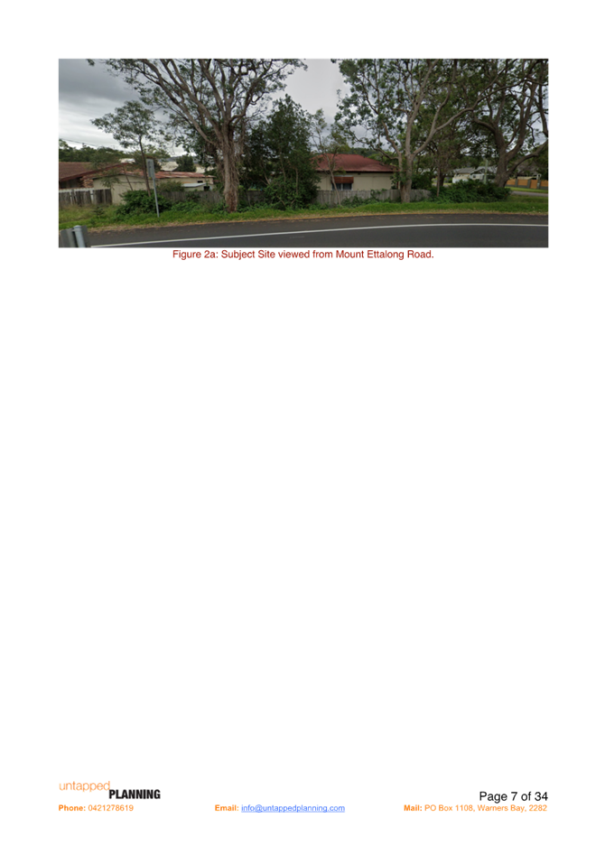
Figure 3 – Proposed Development site viewed from Mount Ettalong Road
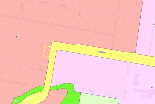
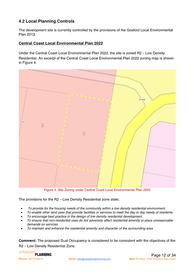
Figure 4 - Zone Pattern
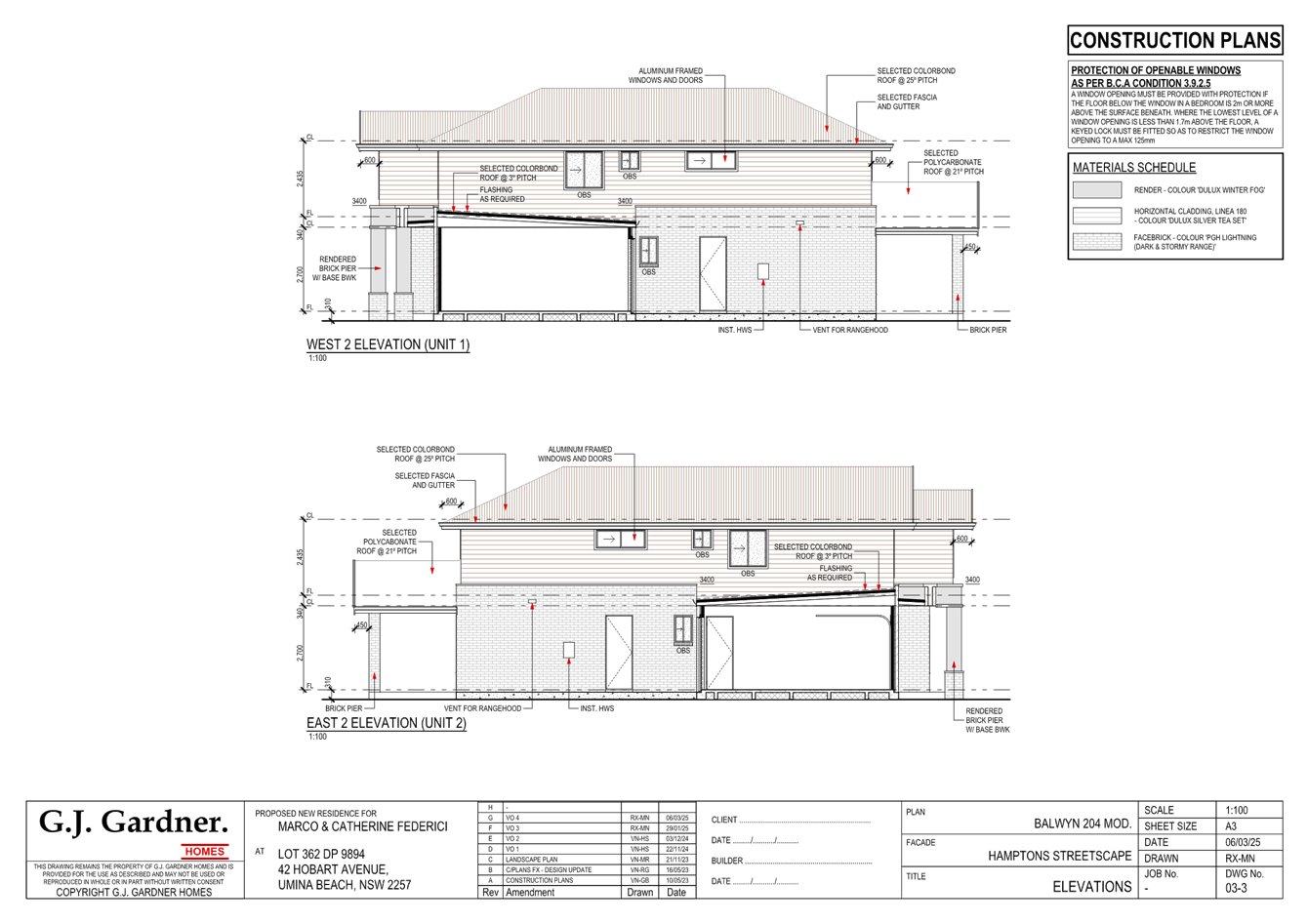
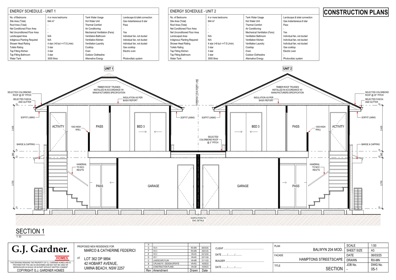
The Proposed Development
The proposed development seeks consent for the construction of a dual occupancy development and a 2 lot Torrens title subdivision.
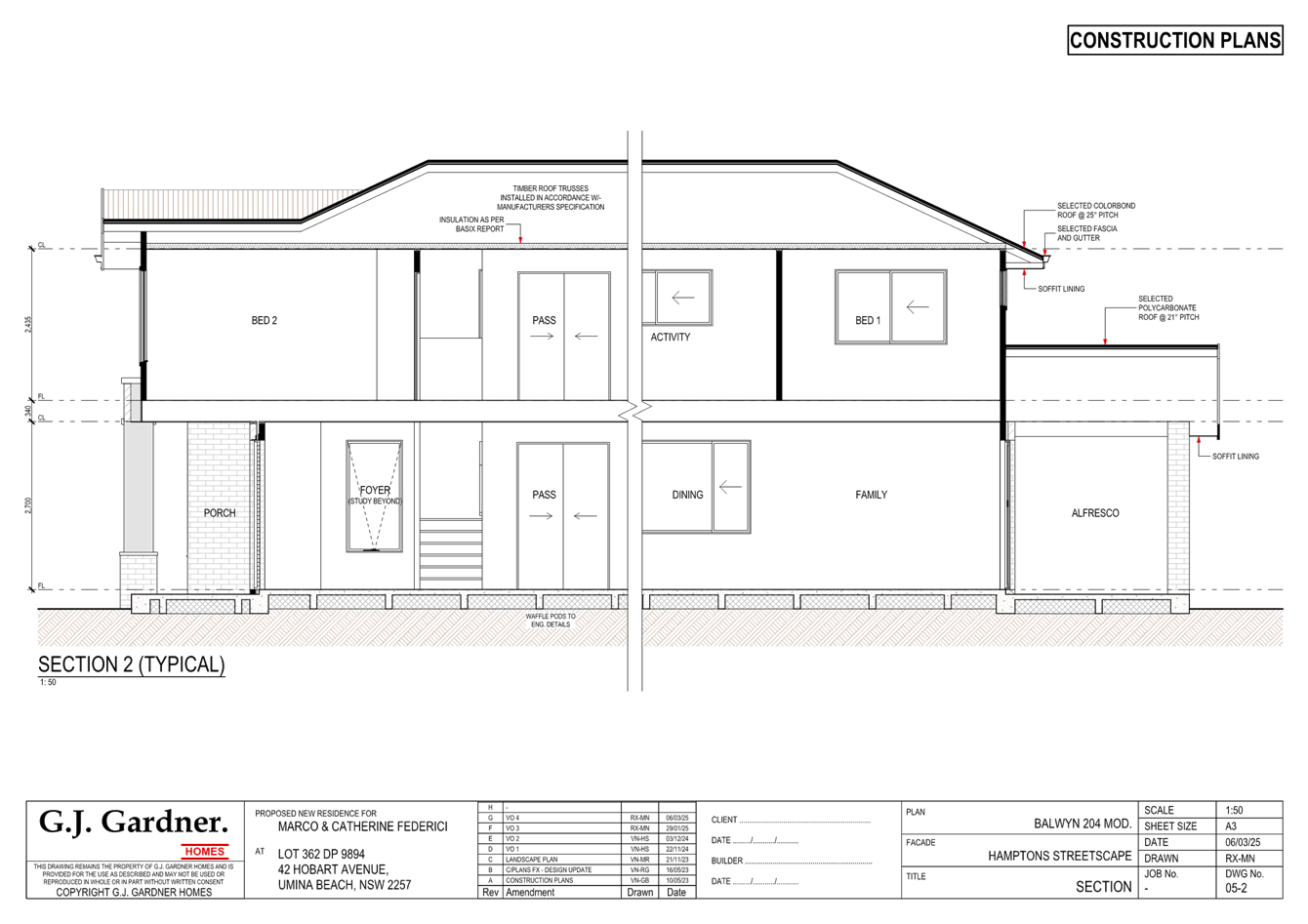
The dual occupancy relates specifically:
Ground floor
· Garage
· Study
· Dining/family/kitchen
· Laundry
· Bathroom
First floor
· 4 x bedrooms
· Activity room
· Toilet
History
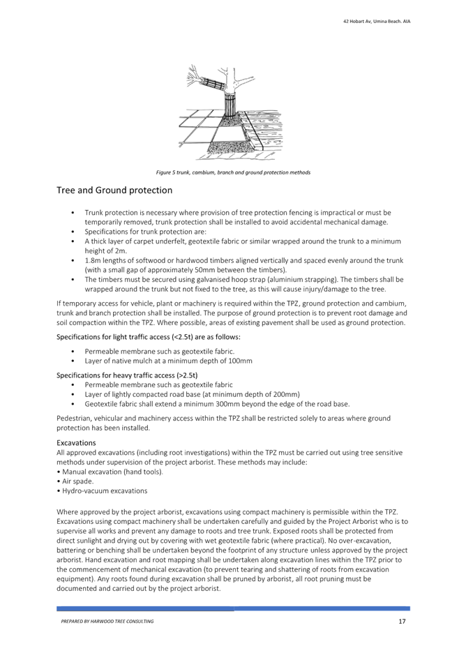
The dwelling and subdivision pattern existed prior to the 1970’s, it might be worth noting that the pattern of vegetation removal is not new in this area.
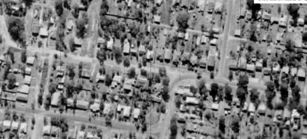
Figure 5 - Historical Imagery 1971 - Spatial Services
ASSESSMENT:
Having regard for the matters for consideration detailed in Section 4.15 of the Environmental Planning and Assessment Act 1979 and other statutory requirements, the assessment has identified the following key issues, which are elaborated upon for the consideration of the Local Planning Panel.
State Environmental Planning Policy (Building Sustainability Index) BASIX 2004
A compliant BASIX certificate achieving the NSW Government’s Energy Efficiency targets has been provided in support of the application. The proposal is consistent with the requirements of State Environmental Planning Policy (Building Sustainability Index: BASIX) 2004.
The Panel can be satisfied that the proposed development satisfies the relevant provisions of SEPP (BASIX) 2004, subject to recommended conditions.
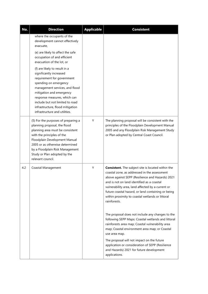
State Environmental Planning Policy (Resilience and Hazards) 2021
The relevant provisions of the SEPP are addressed as follows:
The aims of Chapter 2 are to be considered when determining an application within the Coastal Management Areas. The Coastal Management Areas are areas defined on maps issued by the NSW Department of Planning and Environment and the subject property falls within the ‘Coastal Environment Area’ and ‘Coastal Use Area’ identified on these maps.
In considering the impact of any development application, the consent authority must have regard to matters within clause 2.10 of the SEPP (for the coastal environment area) and clause 2.11 (for the coastal use area).
The relevant matters have been considered in the assessment of this application. The proposed development is not likely to cause undue impact on the biophysical, hydrological or ecological environment. The values of the natural coastal processes are not likely to be impacted, marine vegetation and fauna habitats will not be disturbed by the proposal and the proposal does not impact on known aboriginal cultural heritage, the surf zone, or existing public spaces. The proposed development will not result in adverse impact on rock shelves, overshadowing, loss of views from public places nor visual amenity.
The Panel can be satisfied that the relevant matters of clause 2.10 for development within the coastal environment and use area and clause 2.11 for development within the coastal use area have been considered in the assessment of this application. The application is considered consistent with the stated aims and objectives.
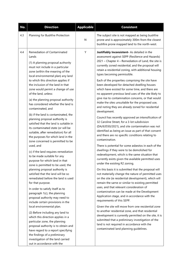
Chapter 4 Remediation of Land
Clause 4.6 of Chapter 4 requires that a consent authority must not consent to the carrying out of any development on land unless it has considered whether the land is contaminated. The current use of the site is residential purposes, and there are no known previous uses that would lead to the site being contaminated or unsuitable for the proposed use.
It is noted that a condition of consent has been imposed to deal with the presence of asbestos, if required, due to the age of the existing dwelling which is proposed to be demolished.
The Panel can be satisfied that the proposed development is acceptable with regard to Chapter 4 of the SEPP.
Central Coast Local Environmental Plan 2022 (CCLEP 2022)
The subject site is zoned R2 - Low Density Residential under the provisions of CCELP 2022. The proposed development is defined as an attached dual occupancy, which is defined under CCLEP 2022 as:
dual occupancy (attached) means 2 dwellings on one lot of land that are attached to each other but does not include a secondary dwelling.
Note— Dual occupancies (attached) are a type of dual occupancy—see the definition of that term in this Dictionary.
The development is permissible in the zone, with development consent.
Central Coast Local Environmental Plan 2022 (CCLEP2022) – Zone Objectives
The land is zoned R2 Low Density Residential under the provisions of the CCLEP 2022.
The objectives for the R2 zone are:
• To provide for the housing needs of the community within a low-density residential environment.
• To enable other land uses that provide facilities or services to meet the day to day needs of residents.
• To encourage best practice in the design of low-density residential development.
• To ensure that non-residential land uses do not adversely affect residential amenity or place demands on services.
• To maintain and enhance the residential amenity and character of the surrounding area.
Following a detailed assessment of the proposed development and it is considered that the proposal is consistent with the stated objectives of the zone, providing housing consistent with the character of the area and does not have adverse impacts on the locality.
Central Coast Local Environmental Plan 2022 – Principal Development Standards
The proposal has been assessed in accordance with the relevant development standards of CCLEP 2022:
|
Development Standard |
Required |
Proposed |
Compliance with Controls |
Variation % |
Compliance with Objectives |
|
Clause 4.1C Minimum lot sizes for dual occupancies |
550m2 |
651.2m2 |
Yes |
Nil |
Yes |
|
Clause 4.3 Height of Buildings |
8.5m |
7.6m |
Yes |
Nil |
Yes |
|
Clause 4.4 Floor Space Ratio |
Not Mapped |
|
|
|
|
|
Clause 7.1 Acid Sulfate Soils |
|
Class 4 No construction more than 2m below the natural ground surface |
Yes |
Nil |
Yes |
Clause 4.4 Floor Space Ratio
Clause 4.4(2) Floor Space Ratio (FSR) of CCLEP 2022 provides the maximum floor space ratio for a building on any land. There is no floor space ratio applying to the site under the CCLEP 2022.
Notwithstanding this, the proposed development has satisfactory density, bulk and scale which integrates with the streetscape and character of the area and is comparable to contemporary buildings in the area.
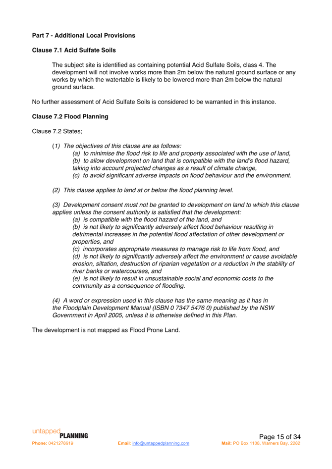
Clause 7.1 Acid sulfate soils
This land has been identified as being affected by the Acid Sulfate Soils Map and the matters contained in clause 7.1 of CCLEP 2022 have been considered. The site contains Class 4 Acid Sulfate Soils (ASS) which are likely to occur where:
· Works more than 2 metres below the natural ground surface.
· Works by which the watertable is likely to be lowered more than 2m below the natural ground surface.
A Geotechnical Assessment prepared by Ideal Geotech, dated 23 December 2022 was provided with the application. The purpose of the investigation was to provide an assessment of site classification, risk of overall instability and related geotechnical advice, consideration of relevant Council controls. It is noted that the presence of acid sulfate soils was not part of this report. The Statement of Environmental Effects states that no works are more than 2m below the natural ground surface and therefore, a condition of development consent relating to the discovery of acid Sulfate soils is included with the conditions of consent.
Clause 7.6 Essential Services
Development consent must not be granted to development unless the consent authority is satisfied that all of the following services that are essential for the development are available or that adequate arrangements have been made to make them available when required—
(a) the supply of water,
(b) the supply of electricity,
(c) the disposal and management of sewage,
(d) stormwater drainage or on-site conservation,
(e) suitable vehicular access,
(f) the collection and management of waste.
The property is currently connected to electricity, reticulated water and sewer and serviced for waste collection and is therefore available to the proposed new dwelling house.
Water and Sewer is available to the land. A Section 307 certificate of compliance under the Water Management Act 2000 is required to be obtained prior to the occupation of the building.
Satisfactory details have been provided in the Waste Management Plan for waste management procedures associated with the construction, and ongoing operation of the proposed development.
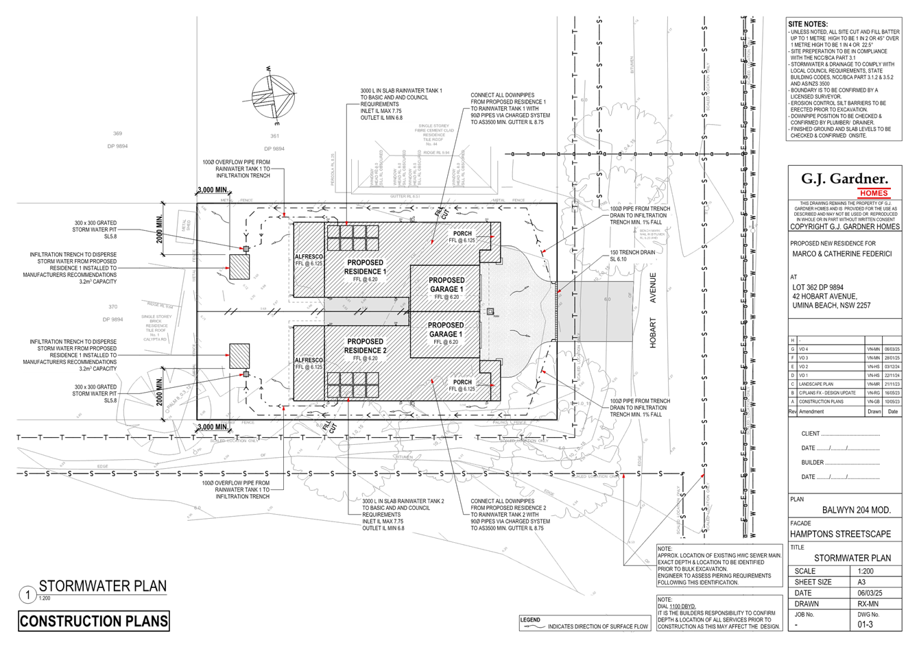
Satisfactory stormwater drainage can be obtained in accordance with the Stormwater Plans and there is adequate area for vehicle access from Hobart Avenue.
The Panel can be satisfied that the proposed development complies with the provisions of clause 7.6 and that adequate essential servicing is available to the development having regard for water, sewer, electricity, stormwater drainage, waste collection and vehicular access.
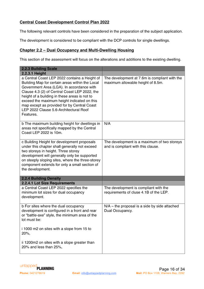
Central Coast Development Control Plan 2022
The relevant controls of CCDCP 2022 are considered below:
Chapter 2.1 – Dwelling Houses, Secondary Dwellings and Ancillary Development
|
Required |
Proposed |
Compliance with Controls |
Compliance with Objectives |
|
|
2.2.3.1 a Building Height |
8.5m. |
7.6m |
No Variation of 12.7% |
Yes |
|
2.2.3.1 c Building Height |
Building Height shall generally not exceed two storeys. |
2 storey |
Yes |
Yes |
|
Floor Space Ratio (FSR) |
FSR not mapped in LEP FSR Dual Occupancies – 0.5:1 (CCDCP) |
4% variation = 27.62m2 |
No 4% variation = 27.62m2 |
Yes |
|
2.2.4.3 Site Coverage |
25% of site area shall be ‘soft’ landscaping. |
Site coverage is 48% and is providing 30% soft landscaping. |
Yes |
Yes |
|
2.1.3.1 a (i) Front Setbacks |
Average distance of the 2 neighbouring properties |
6m |
Yes |
Yes |
|
2.2.5 a Front setback |
Road reserve < 12m |
Dwelling 1 – 6.066m Dwelling 2 – 6.066m |
Yes |
Yes |
|
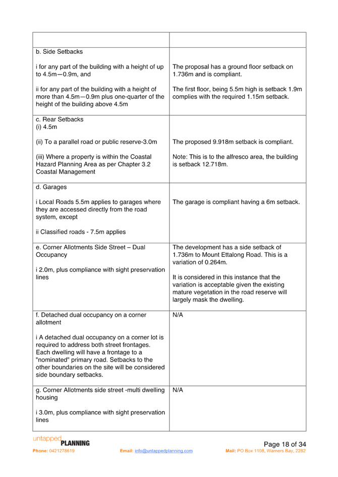
2.2.5 b Side Setbacks |
For any part of the building with a height of up to 4.5m—0.9m, and For any part of the building with a height of more than 4.5m—0.9m plus one-quarter of the height of the building above 4.5m.
Unbroken walls exceeding 10m in length and 3m in height |
Western side – ground floor - 1.736m
First floor - Eastern side 1.736m
7.6m-4.5m = 3/1m/4 = 0.775 +0.9m = 1.675m required first floor.
Both units have unbroken walls of 15.8m but the walls are only 2.4m in height and then articulation is provided |
Yes
|
Yes |
|
2.2.5 c Rear setbacks |
3m |
D1 – 11.652m D2 – 11.652m |
Yes |
Yes |
|
2.2.5.d Garages |
5.5m |
Garages: Dwelling 1 – 7.066m Dwelling 2 – 7.066m |
|
|
|
Corner allotments side street dual occupancy |
2m plus compliance with sight preservation |
1.736m side setback provided to Mount Ettalong Road. This is a variation of 0.264m or 13.2%. |
No
This is a variation of 0.264m or 13.2%. |
Yes |
|
2.2.6.1 Facades & Articulation |
10 m in length and 3m in height articulation
Garages door width is 12m or < or 6m or 60% of the width of the building. |
Both units have unbroken walls of 15.8m but the walls are only 2.4m in height and then articulation is provided.
Garages are within 7.5m of the frontage.
Garage doors are 4.1m in width and the width of the dwelling/s is 8.3m.
49% of the building width.
|
Yes |
Yes |
|
2.2.6.2 Roof Elements |
Respond to solar access |
No roof top gardens are proposed, and the roof elements respond to solar access.
|
|
|
|
Residential Address |
Identification for visitors and emergency services and passive surveillance |
Both dwellings face the street and offer surveillance. |
Yes |
Yes |
|
2.2.7.1 Views |
No view sharing |
|
Yes |
Yes |
|
2.2.7.2 Privacy
|
Direct overlooking of internal living area and private open space from surrounding dwellings must be minimised by building layout, location and design of windows and balconies, screening devices and landscaping. |
The proposal does not result in any direct overlooking of private open space or internal living areas. |
Yes |
Yes |
|
2.2.7.2.2 Acoustic Privacy |
Site layout should separate active recreational, parking, access and service equipment from bedroom areas. |
The dwelling design will not result in any adverse acoustic impacts. |
Yes |
Yes |
|
2.2.7.2 Private Open Space |
Minimum area of 45m2 with minimum dimensions of 4.5m. |
Open space at the rear of the dwellings is 79m2 / dwelling which is not including the alfresco area. |
Yes |
Yes |
|
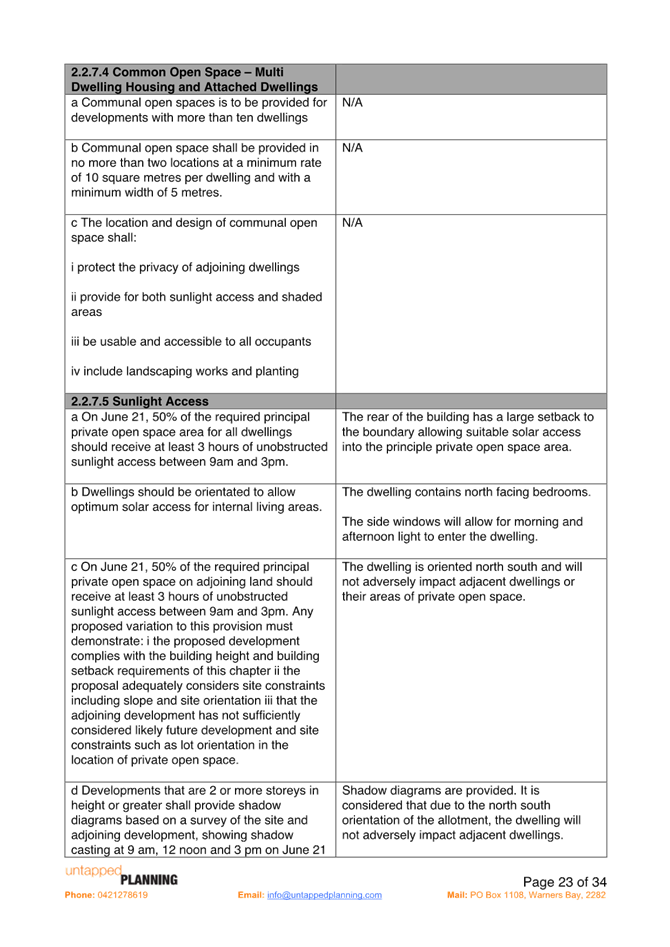
2.2.7.5 Sunlight Access |
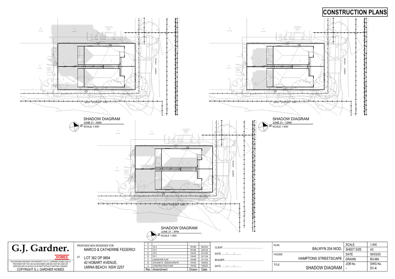
50% of POS for all dwellings should receive at least 3 hours unobstructed sunlight access between 9am and 3pm |
Complies |
Yes |
Yes |
|
|
50% of POS on adjoining land should receive at least 3 hours unobstructed sunlight access between 9am and 3pm |
Complies |
Yes |
Yes |
|
2.2.8 Car Parking |
Provide minimum off street parking facilities – 2 spaces for dwelling with 4 or more bedrooms.
Ensure safe vehicular access to public road. Driveway access does not detract from aesthetic qualities of the site. |
2 parking spaces have been provided. |
Yes |
Yes |
|
2.2.8.2 Access design |
Driveways to be in accordance with Australian standards |
Driveways are compliant |
Yes |
Yes |
|
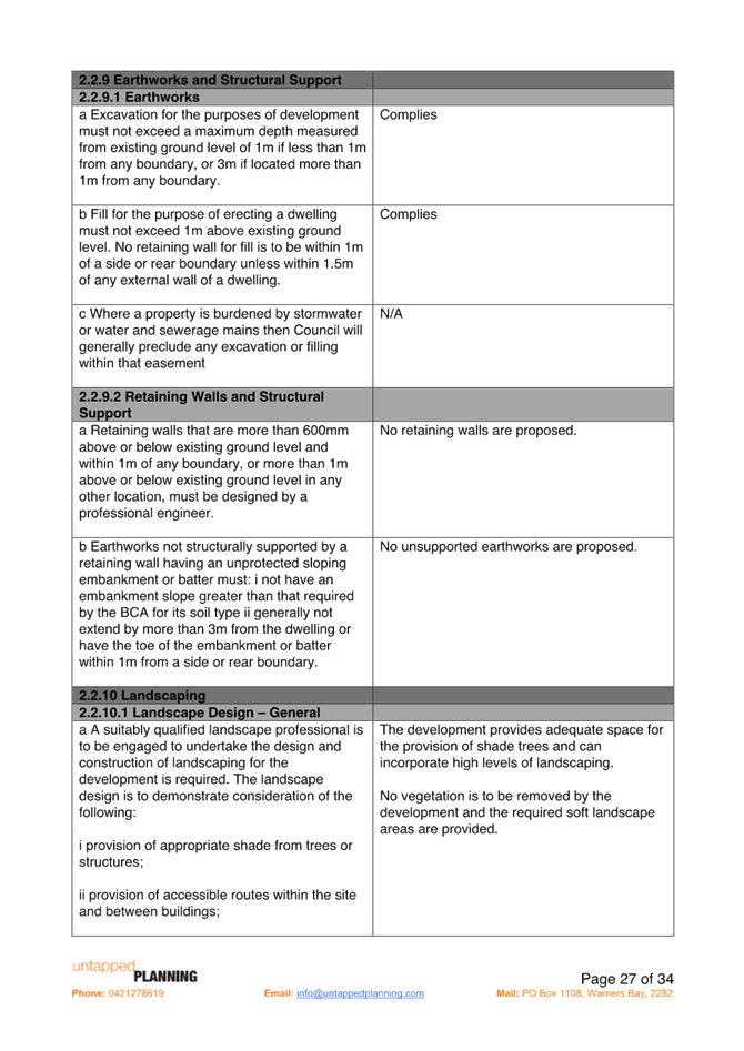
2.2.9 Earthworks |
Cut/fill maximum 1m within 1m of boundaries, or 3m if more than 3m from boundary |
complies |
Yes |
Yes |
|
2.2.10 Landscaping |
Landscape |
No vegetation is to be removed from the development site. The proposal provides adequate space for shade trees and high levels of landscaping. |
Yes |
Yes |
|
2.2.10.2 Street trees |
Provide 2 street tree planting |
The development requires the removal of 1 existing street tree from the verge. The street trees are a cluster of remnant vegetation. It is noted that this is the only cluster of remnant vegetation in the area. Council will require additional street tree plantings. |
Yes |
Yes |
|
2.2.10.3 Deep Soil |
A Minimum 50% of landscaping shall be a deep soil zone. |
All landscaping is a deep soil zone. |
Yes |
Yes |
|
2.2.10.4 Fencing |
Maximum height of 1.8m for side and rear fencing |
Existing fencing to remain. |
Yes |
Yes |
|
2.2.11.1 Servicing |
Site shall be services |
Site already contains a dwelling and servicing can be achieved. |
Yes |
Yes |
|
2.2.11.3 Stormwater |
A stormwater management plan is to be submitted. |
Stormwater plan accompanies the application. |
Yes |
Yes |
|
2.2.11.4 Garbage and waste |
Waste management |
Bins are located in the space allocated adjacent to the garage on the internal boundary. |
Yes |
Yes |
|
2.2.11.5 Dual Occupancy Subdivision |
Applications for the subdivision of dual occupancy development must include: · Proposed plan of subdivision · Details of easements · Details of the location of any existing easements or services on the site. |
A subdivision plan has been included in the application. |
Yes |
Yes |
Central Coast Development Control Plan 2022
The proposed development proposes a variation to the maximum permitted floor space ratio set out under clause 2.1.2.3 Floor Space Ratio and clause 2.2.5 e Corner allotments side street - dual occupancy of CCDCP 2022.
Clause 2.2.4.2 Floor Space Ratio
2.2.4.2 Floor Space Ratio
OBJECTIVES
▪ To have development sites and densities that are appropriate in the zone and compatible with the local context
▪ To ensure building bulk and site coverage provisions are compatible with neighbouring development
▪ To ensure the intensity of the use of the site is appropriate
REQUIREMENTS
a. Central Coast LEP 2022 contains a Floor Space Ratio map and the relevant considerations for certain areas within the Central Coast LGA.
b. The maximum floor space ratio for development proposals subject to this Chapter that relate to land not included in the Floor Space Ratio Map of Central Coast LEP 2022 is specified in Table 2 below:
|
Form of Housing |
Floor Space Ratio (where not specified in the central coast LEP 2022) |
|
Dual Occupancy and semi-detached dwellings (except in rural or environmental living zones) |
0.5:1 |
|
Multi-dwelling housing and attached dwellings |
0.6:1 |
Table 2 - Floor Space Ratio requirements
Clause 2.2.4.2 provides the maximum Floor Space Ratio (FSR) required for a dual occupancy in this area is 0.5:1.
The variation sought is a departure of 0.04:1 (0.54:1) which equates to a 4% variation required to this control. Numerically it represents 27.62m2. It is noted that FSR is not mapped under the CCLEP 2022 for this area.
Clause 2.2.5e corner allotments side street – dual occupancy
2.2.5 Building Setbacks
OBJECTIVES
▪ To ensure that setbacks are compatible with adjacent development and complements the character, streetscape and natural areas
▪ To ensure the visual focus of a development is the dwelling, not the garage
▪ To ensure views, privacy and solar access of adjacent properties are reasonably maintained
▪ To reasonably maintain view corridors to coastal foreshores and other desirable outlooks
▪ To maintain the scenic and environmental qualities of natural waterbodies and their foreshores and respond to site attributes such as topography
▪ To provide deep soil areas sufficient to provide new landscaping
▪ To provide appropriate articulation of facades and horizontal elements reduce the appearance of bulk and provides visual interest to the building and subsequent streetscape where they face a street frontage/s
Clause 2.2.5.e provides for the minimum side setback on corner allotments for a dual occupancy is 2m plus compliance with site preservation.
The variation sought is for the provision of 1.736m side setback to Mount Ettalong Road which is a departure of 0.264m, or 13.2%.
Comment:
The variations proposed will not result in any decrease in amenity to adjoining properties.
The minor variation of clause 2.2.5 e, for a total of 27.62m2 and to clause 2.1.2.3 FSR for 0.264m will not have a material impact any of the following in terms of amenity:
· Overshadowing
· Privacy
· Visual dominance
· Streetscape and Character
· Views
The cumulative impact of the proposed minor non-compliances of side setback and FSR has been considered.
The surrounding area is undergoing a transition whereby existing dwelling are progressively being preplaced with larger contemporary dwellings.
Chapter 2.14 Site Waste Management
A Waste Management Plan has been submitted with the proposal.
The proposal has demonstrated compliance with this chapter of the CCDCP 2022 and associated Waste Control Guidelines. Appropriate conditions are included in the development consent.
Chapter 2.17 Character and Scenic Quality
The site is located within the character area:
Peninsula – Landscape Units Covered: Woy Woy, Umina, Woy Woy Bays. This sit is within the Umina 1 area Ocean Beachfront – Existing, #6 Parkland Bungalows. The character statement provides the existing and desired character as follows:
Umina 6: Parkland Bungalows - Existing Character
A cluster of established low-density residential neighbourhoods on flat land, partly cleared of original vegetation but also planted with shady garden and street trees, supporting a variety of modestly-scaled houses in wooded garden settings that are significant features of the Peninsula’s traditional garden suburbs.
Across regular gridded subdivisions, narrow to medium frontage allotments face a local thoroughfare or access streets that are long and straight, generally with secondary frontages to rear lanes. Access streets are mostly narrow unkerbed pavements, flanked by broad grassed verges supporting copses of tall woodland remnants and planted shady trees that often also extend along rear lane frontages, providing scenically-distinctive streetscape features and contributing to a leafy, open woodland atmosphere. The local thoroughfare has a wider unkerbed pavement flanked by narrow grassed verges without trees.
Situated on medium-sized allotments, dwellings are predominantly traditional mid-Twentieth Century bungalows that are modestly-scaled single storey timber-framed buildings, clad in boards or sheets and capped by hipped roofs of tile or corrugated iron, with a scattering of newer brick or weatherboard houses of one or two storeys capped by pitched tile roofs.
Facing the street, buildings display consistent front and side setbacks, fronted by gardens that are generally small and relatively open containing scattered woodland remnants plus planted shady trees and shrubs set behind low fences. In general, back yards are deep with space for a variety of detached garages and sheds, surrounded by tall fences along rear lanes, and shaded by corridors of tall woodland remnants plus planted trees that rise above the rooftops contributing to a leafy woodland appearance.
Umina 6: Parkland Bungalows - Desired
Desired Character
These should remain leafy low-density residential hillsides, retaining the streetscape and scenic qualities of existing lush hillside gardens that surround each dwelling.
Minimise disturbance to natural slopes and existing trees that are visually-prominent features of any hillside or street frontage by appropriate siting of new structures, plus low-impact construction such as suspended floors and decks rather than extensive cut-and-fill. Complement the established tree canopy by planting additional trees and shrubs throughout each garden as well as along street verges. Facing the street, emphasise a leafy garden character by avoiding wide driveways and terraces, tall fences or multiple retaining walls.
Avoid the appearance of a continuous wall of development along any street or hillside. Locate new buildings behind front setbacks that are similar to their surrounding properties. Provide at least one wide side setback or step the shape of front and rear facades.
Minimise the scale and bulk of buildings by stepping floor-levels to follow natural slopes and by using irregular floorplans to create well-articulated forms. For example, divide floorspace into linked pavilions that are capped by individual roofs and separated by courtyards. Front or rear facades that are taller than neighbouring dwellings should be screened by balconies, verandahs, stepped forms or extra setbacks. Roofs should be gently-pitched to minimise the height of ridges, and flanked by wide eaves to disguise the scale of exterior walls.
Minimise the scale of prominent facades by using extensive windows and verandahs plus a variety of materials and finishes rather than expanses of plain masonry. All dwellings should display a traditional “street address” with verandahs or decks, and living rooms or front doors that are visible from the roadway. Avoid wide garages that would visually-dominate any front façade or block views from a dwelling to the street. Locate and screen all balconies or decks to maintain the existing levels of privacy and amenity that are enjoyed by neighbouring dwellings.
Comment: The proposed dual occupancy development design incorporates these desired character features. The proposed dwelling design is consistent with the desired character of the area.
The Likely Impacts of the Development
Built Environment
Given the position of the proposed dwelling on the allotment and comparison of bulk and scale with other dwellings, the proposal is suitable with regard to the context and setting of the subject site and is considered to be in keeping with the character of the area.
A thorough assessment of the proposed development’s impact on the built environment has been undertaken in terms of the CCLEP 2022 and CCDCP 2022 compliance. It is considered on balance that the potential impacts are considered reasonable.
Natural Environment
The proposal does not involve any site excavation. Accordingly, the proposal is considered satisfactory in relation to impacts on the natural environment. Additionally, no vegetation removal on the site is proposed and one tree on the verge is proposed to be removed to allow for driveway access to the site. The remaining vegetation on the verge will be retained and protected during the construction works.
Context and Setting
The proposal is located within the R2 Low Density Residential land under CCLEP 2022. The proposal provides an updated housing option within a residential zone and is consistent with the objectives of the R2 land use and the Peninsula Landscape Unit. In addition, the proposal is considered to be consistent with the desired character for future development within the Umina 6: Parkland Bungalows of CCDCP 2022.
Economic and Social Impacts
The proposal will provide minor economic benefit through the provision of temporary employment during demolition and construction. The application does not require any tree removal in the site to facilitate the development however there is the need to remove 1 street tree to facilitate the development. The private open space provided within the subject site will retain generous private open space and landscaping.
Any Submission made in Accordance with this Act or Regulations
The development application was notified in accordance with the CCDCP 2022 from 3 November 2023 to 17 November 2023 and twenty-two (22) submissions were received.
A summary of the submissions is detailed below:
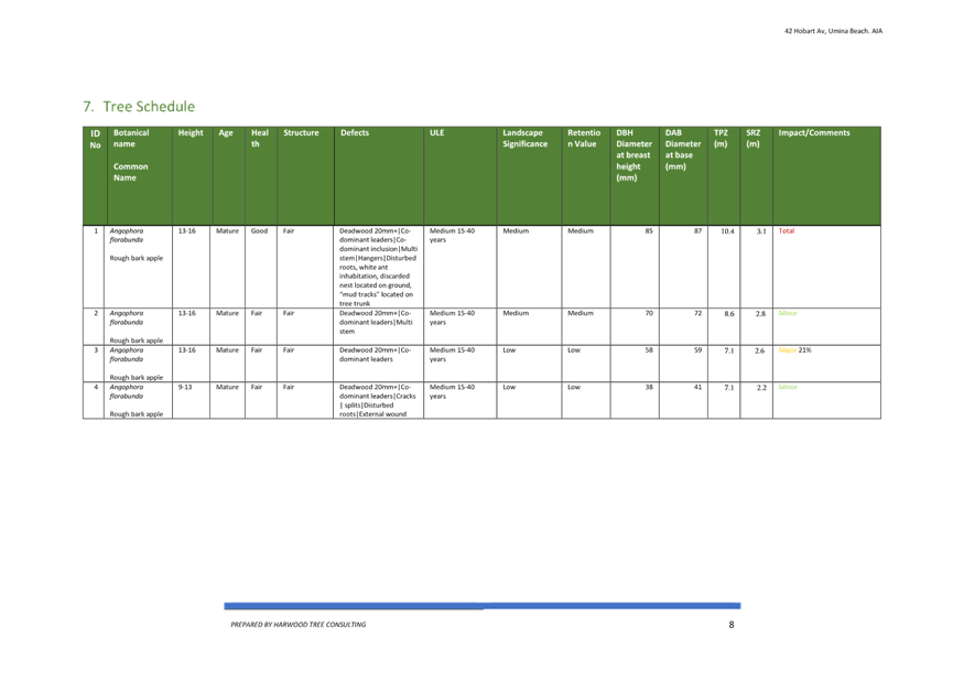
1. Removal of the tree on the verge/ The tree on the verge is an Angophora Floribunda needs to be kept
The Angophora floribunda or rough barked apple tree is a very common woodland and forest tree. It is a large tree reaching up to 30m tall and live for 40+ years (Angophora floribunda | Australian Plants Society).
The Arborist Report indicates ‘… opinion of the Arborist, the current development has been designed to take into consideration the location of the trees onsite, specifically the location of the garages which minimises disturbances to TPZ’s.’ Additionally, the Arborist states that ‘…T1 under the current plans will require removal and replacement at a 2:1 ratio to align with the Central Coast Council’s Greener Places Strategy’. This requirement will form part of the conditions of consent to be provided for the development. Additionally, a site arborist shall be appointed to supervise all tree protection procedures and the trees to be retained will be protected with truck protection during construction, this will form part of the conditions of development consent.
From historic photographs this strand of trees has been on this verge area since at least the 1970’s. The majority of vegetation in the area was removed prior to the 1970’s.
The arborist advises:
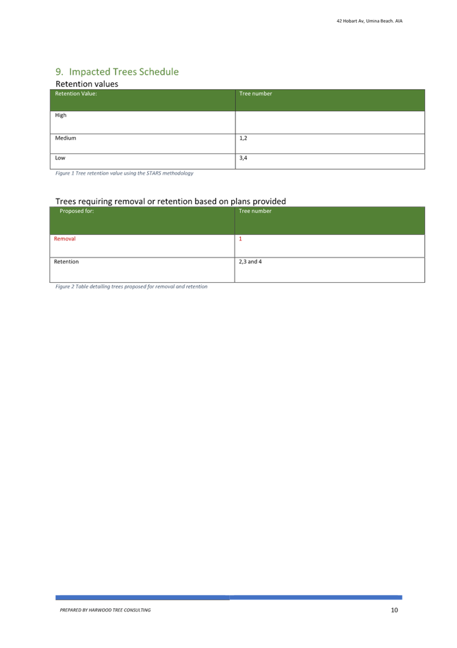
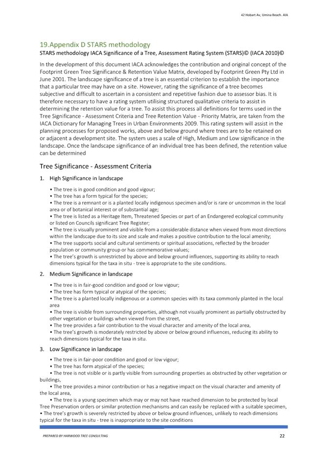
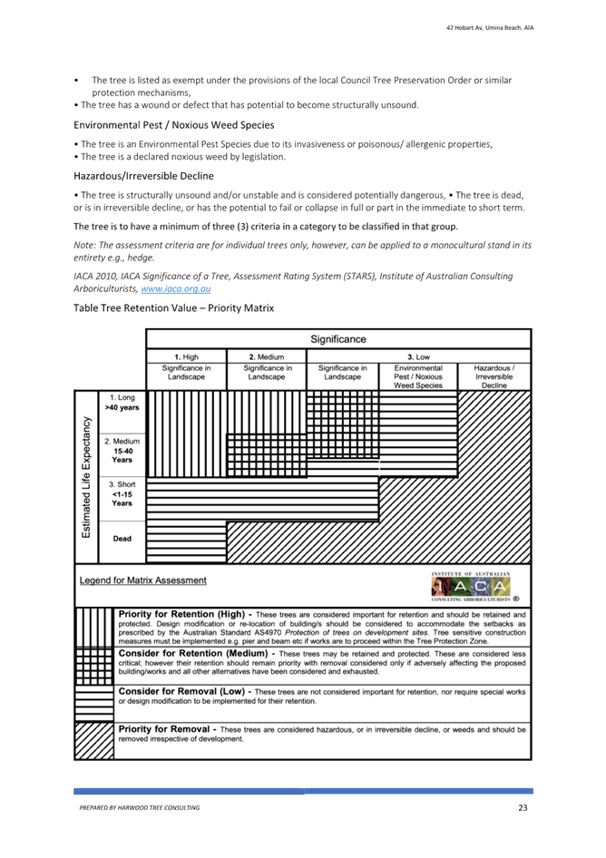
Under the current plans one (T1) tree will require removal, this specimen recorded a Medium retention value, under the STARS rating system located in Appendix D STARS methodology, trees classified as medium retention should be considered for retention, usually these specimens are considered less critical than the high retention specimens and could be removed if adversely affecting the build.
Therefore, it is considered that 1 tree on the verge being removed as part of the sites redevelopment is management and a reasonable impact
2. The application states no vegetation removal.
That is correct, there is no vegetation to be removed from the development site. The trees are on the Council verge and outside the site.
3. Heat island effect/ Peninsula is bare of trees/ Greener Places Strategy
According to the Department of Planning ‘urban heat islands’ are described as:
Urban heat islands develop in areas with hard, sealed surfaces and a lack of vegetation or ‘green infrastructure’ such as tree canopies, vegetated roofs and walls and waterways. This is because hard surfaces absorb, store and radiate heat, while green infrastructure reflects heat, provides shade and releases water into the atmosphere.
Urban heat islands are increasing the effects of climate change, making higher temperatures and extreme hot weather events more severe and difficult to manage, placing more people at risk of exposure. During a heatwave, for instance, temperatures in western Sydney, which has less green cover, are sometimes 10 °C higher than in eastern Sydney.
Planning how we use land plays an important role in reducing vulnerability to urban heat. It helps create places and communities that are more sustainable and resilient to a changing climate. We are delivering several planning initiatives to reduce urban heat.
The Central Coast Council Greener Places Strategy 2021-2031 (the Strategy)
The Strategy acknowledges the ability of urban greening to mitigate certain urban health effects and maintain livability in urban centers. Urban trees provide shade to buildings, and roads along with private and public open space which can assist in reducing the impact of the Urban Heat Island Effect. The Strategy identifies all of the positive attributes of trees and vegetation along with and acknowledges that 19 Central Coast suburbs have been identified for priority planting to mitigate urban heat island effects. The planting is to increase canopy cover by a further 5% over the next 30 years in these locations. The Greener Places Strategy is supported by its inclusion in the Central Coast Regional Plan 2041.
Umina Beach is identified as one of the areas where there is an impact from the Urban Heat Island Effect. It is reported that Umina Beach experiences significantly higher temperatures compared to surrounding rural areas due to the lack of vegetation and the abundance of hard surfaces like buildings and roads, which absorb and radiant heat making the area noticeable warmer in the summer months.
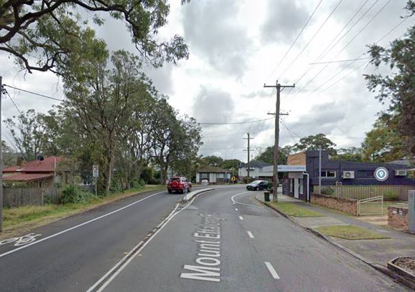
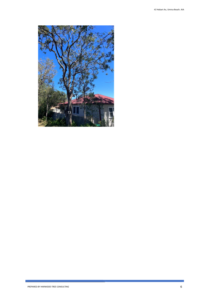
Figure 6 - Mount Ettalong Road - vegetation will remain
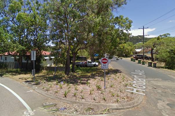
Figure 7 - The existing trees on the corner are being retained

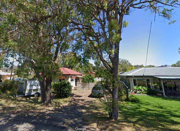
Figure 8 - frontage to Hobart Avenue - tree removal
![]()
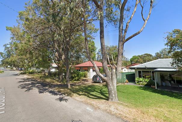
Figure 9 - Hobart Avenue street scape
Comment:
Several strategies of, The Greener Places Strategy, identify that remnant and existing vegetation should be retained. In this regard it is recommended that only 1 tree is recommended for removal. It is also recommended that no street trees be replanted as the verge area is already adequately vegetated with remnant vegetation. It is noted that the pattern of clearing in the area occurred prior to 1970. Additional trees are proposed to be planted in the rear private open space of each dwelling. Two feature trees are being proposed which are native to the Coast along with additional native shrubs and landscape plantings. This is considered adequate for this development.
4. Exceed the FSR requirements.
As discussed in the body of the report, the proposal is for a minor variation to the clause 2.1.2.3 of the CCDCP 2022 requirement to provide a 0.5:1 Floor Space Ratio (FSR) to provide a 0.54:1 FSR. The variation represents a departure of 27.62m2 or a 4% variation.
Comment:
This minor variation is recommended for support, and it is noted that the development is providing additional requirements above what is required by the CCDCP 2022:
5. No landscape plan provided.
A landscaping plan was provided in the material for notification.
6. Garages dominate the elevations.
The garages are compliant.
7. Large concrete driveway
A 5.5m driveway is the minimum requirements and appropriate to cater for a dual occupancy development and is considered appropriate. The vehicle access crossing are to comply with Council specification and the AS/NZ 2890.1:2004.
Semi permeable pavers are to be used in the driveways within the boundary of the property, which will allow a softening aspect to the development and aid water infiltration. The street has no kerb and guttering, and it is proposed to remain as such which also aids in water infiltration.
8. Parking/ no visitor parking
No visitor parking is required for this type of development.
9. Flood zone
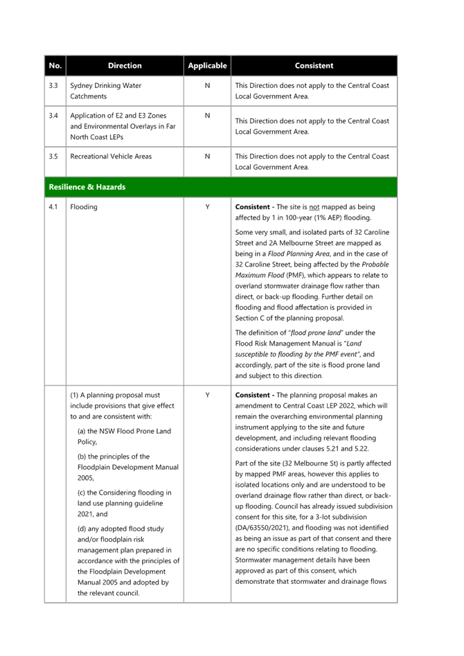
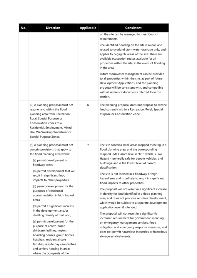
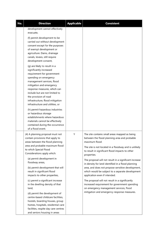
This site is not affected by Flood Controls 1% AEP+ freeboard. However, the site is affected by flooding in the Probable Maximum Flood (PMF) event with levels in the order of RL 5.89m - RL 5.90m AHD.
The architectural plans prepared by G J Garner (Rev F dated 29/01/24) indicate ground floor levels of RL 6.20m AHD and garage levels of RL 6.20m AHD which are above the PMF level. Safe evacuation of the development to the Hobart Street frontage would be feasible in a PMF event.
Internal Consultation
|
Traffic Engineer |
Supported without conditions. |
||
|
Development Engineer |
Supported subject to conditions. |
||
|
Tree Assessment Officer |
Supported subject to conditions. |
||
|
Waste Services |
Supported subject to conditions. |
||
|
Water and Sewer |
Supported subject to conditions. |
Trees Assessment Comments
A better Landscape Plan has been provided which nominates planting of two (2) advanced Coastal Cottonwoods in the rear yards. Combined with the established native trees to be retained on the road reserve, this will be sufficient.
Engineering Assessment Comments
A Flood Information Certificate issued by Council for the site indicates that the site is not affected by flooding or associated flood planning controls for events up to the 1%AEP event but is affected by flooding in the Probable Maximum Flood (PMF) event with levels in the order of RL 5.89m - RL 5.90m AHD. The architectural plans prepared by G J Garner (Rev F dated 29/01/24) indicate ground floor levels of RL 6.20m AHD and garage levels of RL 6.20m AHD which are above the PMF level. Safe evacuation of the development to the Hobart Street frontage would be feasible in a PMF event.
The Public Interest: (s79C(1)(e)):
Section 4.15 (1)(e) of the Environmental Planning and Assessment Act 1979 requires consideration as to whether to proposal is in the public interest.
The proposal will not have any adverse impact on the natural environment and will not unreasonably impact the amenity of neighbouring properties. The approval of the application is considered to be in the public interest.
Ecologically Sustainable Principles:
The proposal has been assessed having regard to ecologically sustainable development principles and is considered to be consistent with the principles.
The proposed development is considered to incorporate satisfactory stormwater, drainage and erosion control and the retention of vegetation where possible and is unlikely to have any significant adverse impacts on the environment and will not decrease environmental quality for future generations. The proposal does not result in the disturbance of any endangered flora or fauna habitats and is unlikely to significantly affect fluvial environments.
Climate Change
The potential impacts of climate change on the development proposed to be modified have been considered by Council as part of the assessment of the application.
This assessment has included consideration of such matters as potential rise in sea level; potential for more intense and/or frequent extreme weather conditions including storm events, bushfires, drought, flood and coastal erosion; as well as how the proposed development may cope, combat, withstand these potential impacts. The proposed development is considered satisfactory in relation to climate change.
Other Matters for Consideration:
Section 7.11 and 7.12 Contributions (formerly Sections 94 and 94A Contributions)
Water and Sewer Contributions.
Contributions are applicable to this development.
Political Donations
During assessment of the application there were no political donations declared by the Applicant, Applicant’s consultant, owner, objectors and/or residents.
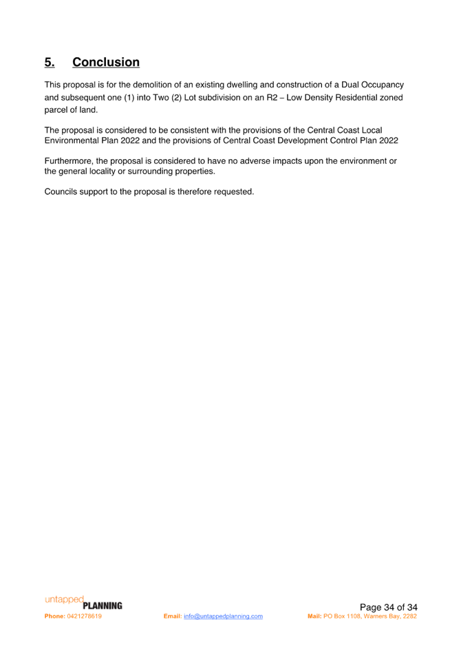
Conclusion:
The application has been assessed under the relevant heads of consideration specified under Section 4.15 of the Environmental Planning and Assessment Act 1979 and all relevant planning instruments and policies and found to be satisfactory. In particular:
· The proposed development is consistent with the zone objectives as set out under the Central Coast Local Environmental Plan 2022.
· The minor variations proposed to the provisions of the Central Coast Development Control Plan 2022 are relatively minor, and will not have a material impact in terms of amenity or impact on adjoining lands.
· The potential constraints of the site have been assessed and it is considered that the site is suitable for the proposed development, subject to the imposition of appropriate conditions of consent.
· The proposed development is not expected to have any adverse social or economic impact. It is considered that the proposed development will complement the locality and meet the desired future character of the area.
Accordingly, the application is recommended for approval, pursuant to Section 4.16 of the Environmental Planning and Assessment Act 1979.
|
1⇩ |
Draft conditions /Reasons - 42 Hobart Avenue UMINA BEACH NSW 2257- DA/1627/2023 |
|
D16746933 |
|
2⇩ |
PORTAL DOC - 42 Hobart Avenue, UMINA BEACH NSW 2256 - DA/1627/2023 - ARBORIST REPORT |
|
D16745085 |
|
3⇩ |
Portal Doc - 42 Hobart Avenue, UMINA BEACH NSW 2257 - DA/1627/2023 - Statement of environmental effects - SoEE - 42 Hobart Avenue Umina Beach Rev B.pdf - |
|
D16748131 |
|
4⇩ |
Portal Doc - 42 Hobart Avenue, UMINA BEACH NSW 2257 - DA 1627 2023 - Architectural Plans - Lot 362, 42 Hobart Avenue, Umina Beach.pdf - REDACTED |
|
D16759018 |

|
DA/1627/2023 - 42 Hobart Avenue, Umina Beach - Dual Occupancy and two lot strata subdivision |
|
|
Attachment 2 |
PORTAL DOC - 42 Hobart Avenue, UMINA BEACH NSW 2256 - DA/1627/2023 - ARBORIST REPORT |
|
DA/1627/2023 - 42 Hobart Avenue, Umina Beach - Dual Occupancy and two lot strata subdivision |
|
|
Attachment 3 |
Portal Doc - 42 Hobart Avenue, UMINA BEACH NSW 2257 - DA/1627/2023 - Statement of environmental effects - SoEE - 42 Hobart Avenue Umina Beach Rev B.pdf - |
|
DA/1627/2023 - 42 Hobart Avenue, Umina Beach - Dual Occupancy and two lot strata subdivision |
|
|
Attachment 4 |
Portal Doc - 42 Hobart Avenue, UMINA BEACH NSW 2257 - DA 1627 2023 - Architectural Plans - Lot 362, 42 Hobart Avenue, Umina Beach.pdf - REDACTED |
|
Item No: 3.2 |
|
|
Title: DA/1703/2023 - 28 Bungary Road, Norah Head - Studio, Alterations & Additions |
|
|
Department: Environment and Planning |
|
|
10 April 2025 Local Planning Panel Meeting |
|
Reference: DA/1703/2023 - D16754053
Author: Lachlan Anderson, Health and Building Surveyor
Section Manager: Wayne Herd, Section Manager Building Assessment and Certification
Unit Manager: Andrew Roach, Unit Manager Development Assessment
|
Summary
An application has been received for Studio, Alterations & Additions to Existing Dwelling. The application has been examined having regard to the matters for consideration detailed in section 4.15 of the Environmental Planning and Assessment Act and other statutory requirements with the issues requiring attention and consideration being addressed in the report.
The application is required to be
determined by the Local Planning Panel as a result of submissions. 20
submissions have been received, across 3 notification periods. The application is recommended for approval, subject to conditions.
Applicant Megan Etchells Owner Errol Mehmet Application No DA/1703/2023 Description of Land 28 Bungary Road, Norah Head - Lot 10 DP 19118 Proposed Development Studio, Alterations & Additions to Existing Dwelling Site Area 1266 sqm Zoning R2 Low Density Residential Existing Use Residential Employment Generation No Estimated Value $304,561.00 Conflict of Interest The staff responsible for the preparation of the report, recommendation, or advice to any person with delegated authority to deal with the application have no pecuniary conflict of interest or non-pecuniary conflict of interest to disclose in respect of the application.
|
1 That the Local Planning Panel grant consent to DA/1703/2023 at 28 Bungary Road, Norah Head for Studio, Alterations & Additions to Existing Dwelling subject to the conditions detailed in the schedule attached to the report and having regard to the matters for consideration detailed in Section 4.15 of the Environmental Planning and Assessment Act 1979.
2 That Council advise those who made written submissions of the Panel’s decision.
Key Issues
• The application is required to be reported to the Local Planning Panel for determination as in excess of twenty (20) submissions have been received in relation to the development proposal.
• The development proposes variations to the front boundary setbacks and height provisions as contained within Central Coast Development Control Plan 2022 (Chapter “Dwelling Houses, Secondary Dwellings and Ancillary Structures), to permit the development.
• Height of the Rear Addition and the impact upon water views of neighbouring residents.
Precis:
|
Proposed Development |
Construction of a Studio, Alterations & Additions to Existing Dwelling |
|
Permissibility and Zoning |
The subject site is zoned R2 – Low Density Residential under the provisions of the Central Coast Local Environmental Plan 2022 (CCLEP 2022)
The land contains an existing ‘dwelling house’ which is defined under the Central Coast LEP 2022 as;
‘dwelling house’ means – a building containing only one dwelling.
The proposed development is defined as a Dwelling house which is permissible with consent in the zone. |
|
Current Use |
Dwelling House |
|
Integrated Development |
No |
|
Submissions |
Twenty (20) submissions were received.
The development application was notified (in accordance with the provisions of the Central Coast Development Control Plan 2022 (CCDCP 2022)) on three separate occasions as follows:
• Originally proposed development - from 1 September 2023 until 15 September 2023.
During the first notification period, a total of Five (5) submissions were received in relation to the development proposal.
• Amended development proposal – from 23 April 2024 until 8 May 2024
During the second notification period, a total of Six (6) submissions were received in relation to the amended development proposal.
• Amended development proposal – from 31 October 2024 until 14 November 2024
During the second notification period, a total of Nine (9) submissions were received in relation to the amended development proposal.
|
Variations to Instruments and Policies
The development proposal seeks variations to Central Coast Development Control Plan 2022 (Chapter 2.1. Dwelling Houses, Secondary Dwellings and Ancillary Structures) as follows.
Front setback variation of First Floor Bedroom Addition
|
Clause |
3.1 Setbacks – Residential Lots |
|
Planning Control |
a. The average distance of the setbacks of the nearest 2 dwelling houses having the same primary road boundary and located within 40m of the lot on which the dwelling house is erected. If 2 dwelling houses are not located within 40m of the lot - 4.5m |
|
Departure basis |
The front setback of the Dwelling at 26 Bungary Road, Norah Head is 28.5m and the front setback of the Dwelling at 30 Bungary Road, Norah Head is 28.5m. Therefore, the front average setback of the two neighbouring dwellings is 28.5m. Accordingly the front boundary setback of the allotment is 28.5m. The first-floor bedroom addition setback is 25.931m which is a 2.569m difference from the required 28.5m. The difference of 2.569m is an 9% variation. |
Front setback variation of Studio
|
Clause |
3.1 Setbacks – Residential Lots |
|
Planning Control |
a. The average distance of the setbacks of the nearest 2 dwelling houses having the same primary road boundary and located within 40m of the lot on which the dwelling house is erected. If 2 dwelling houses are not located within 40m of the lot - 4.5m |
|
Departure basis |
The front setback of the Dwelling at 26 Bungary Road, Norah Head is 28.5m and the front setback of the Dwelling at 30 Bungary Road, Norah Head is 28.5m.
The front average setback of the two neighbouring dwellings is 28.5m. Accordingly the front boundary setback of the allotment is 28.5m. The Studio setback is 5.15m which is a 23.35m difference from the required 28.5m. The difference of 23.35m is an 82% variation.
(Note: The front setback of the garage at 26 Bungary Road, Norah Head is 6m (Approved under BA/3569/1995) and the front setback of the garage at 30 Bungary Road, Norah Head is 5.5m (Approved in 1971). These setbacks are of more relevance and will be discussed later in this report.) |
Height variation of Studio
|
Clause |
2.1.2.1 - Building Height |
|
Planning Control |
The maximum building height for outbuildings and detached ancillary development is: I. 4.8m on land zoned R1, R2, R3 or RU5 II. 7m on land zoned RU1, RU2, RU6, R5, C3, C4 or C2 (where permissible) |
|
Departure basis |
The maximum height of detached ancillary development is 4.8m. The studio has a maximum height of 8.004m. This is a 3.204m difference from the allowable 4.8m which a 67% variation. |
The Site
The site is a single large lot adjacent to an Environment Conservation Zone next to Cabbage Tree Bay legally identified as Lot 10 Deposited Plan No. 19118 (No. 28 Bungary Road, Norah Head). The site is 1266m2 in area (by DP) and generally rectangular in shape as illustrated in the aerial image of the land below.
The land is relatively level at the front then slopes very steeply at the rear down to Cabbage Tree Bay.
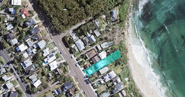
Figure 1: Aerial Image of land and surrounds – Source: GeoView 2020

Figure 2: Aerial Image of land and surrounds with Coastal Hazard Line – Source: GeoView 2020
The site is currently located on the north eastern side of Bungary Road, Norah Head with uninterrupted views of the ocean.
The land is not mapped as Acid Sulfate Soil prone land. Furthermore, the land is elevated and not identified as flood affected. The site does not contain any significant native vegetation or fauna habitat that requires removal as all works are located within the existing building footprint.
The land is mapped and identified as being Part Bushfire prone Land. A large parcel of land to the north west containing Dry Sclerophyll Forest is located approximately 95m northwest of the subject allotment as shown in Figure 1. Accordingly bush fire protection measures at BAL12.5 will be required as a condition of consent.
The rear part of the land is mapped and identified as being located within an area that is Coastal Hazard Prone Land due to sea level rise. The original proposal was for a Secondary Dwelling, Alterations and Additions. However, amended plans were submitted that:
· Removed 665mm of the rear deck extension located in the Low-Risk Coastal Hazard Area with the existing rear deck remaining as per its current size.
· Removed the Secondary Dwelling above existing garage as the second residence did not comply with current DCP 2022 Chapter 3.2 Coastal Hazard Management Cl. 3.2.2.2.1.g: Council will not approve new subdivisions, vulnerable development (including childcare centres, nursing homes and hospitals) or other development that intensifies land use seaward (or closer to the hazard) of the Low Risk Coastal Erosion Hazard Planning Line (yellow).
· Included a Class 1a Studio over the garage area of the allowable size of 50m2.
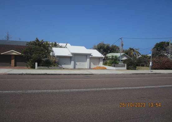
Figure 3 – Site Photo Street Elevation of the subject allotment
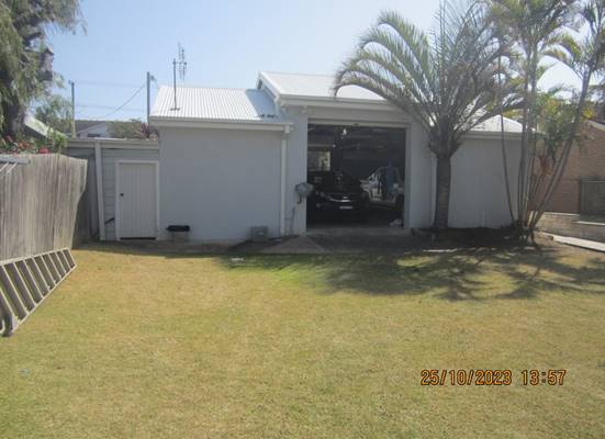
Figure 4 – Site Photo Rear Elevation of the Garage
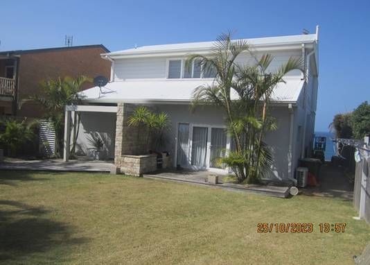
Figure 5 – Site Photo Front Elevation of the Existing Dwelling
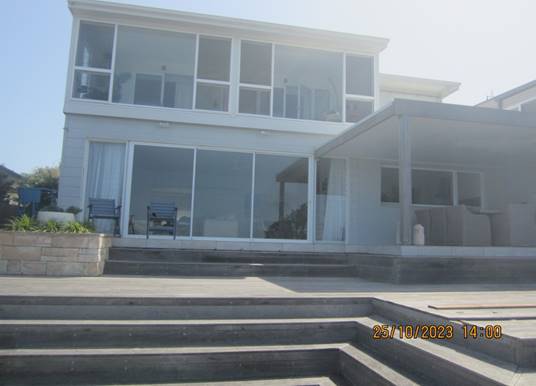
Figure 6 – Site Photo Rear Elevation of the Existing Dwelling
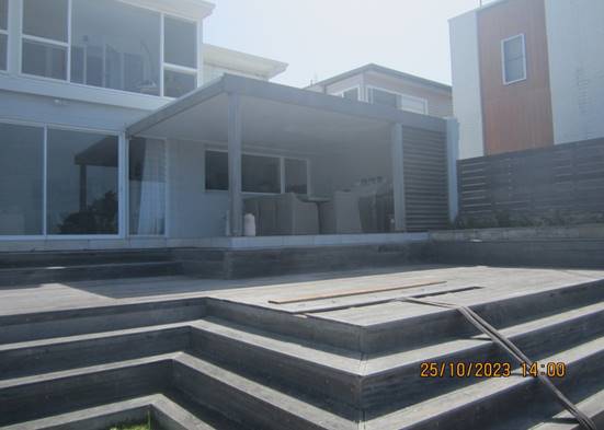
Figure 7 – Site Photo Rear Elevation of the Existing Dwelling
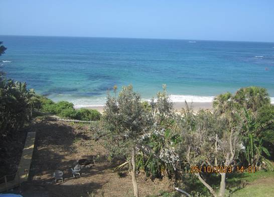
Figure 8 – Ocean Views from subject allotment
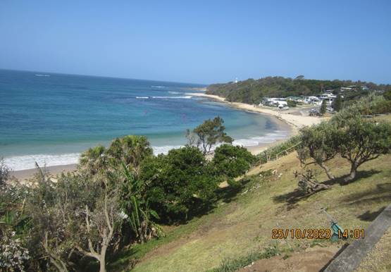
Figure 9 – Ocean Views from subject allotment
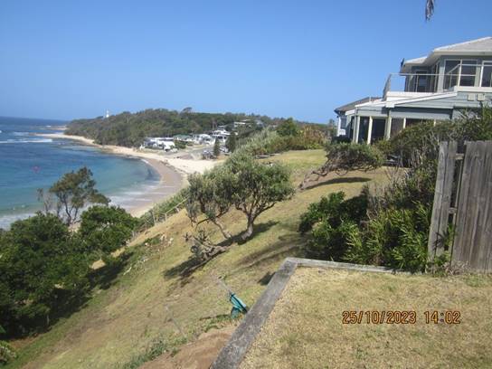
Figure 10 – Ocean Views from subject allotment
Surrounding Development
The subject site is surrounded by a mix of residential developments comprising single and two storey dwelling houses of timber and brick veneer construction. The mixed character of the area is a result of large two storey brick veneer residence replacing older clad dwellings.
The adjoining land immediately to the north west has been subdivided No. 26 and No. 26A Bungary Road, Norah Head. Each allotment contains a two-storey brick veneer dwelling. The views from No. 26 Bungary Road are the most impacted as discussed within this report.
The adjoining land immediately to the south east contains a single storey clad dwelling. The line of site from the subject allotment to No. 30 Bungary Road is significantly obstructed by foliage.
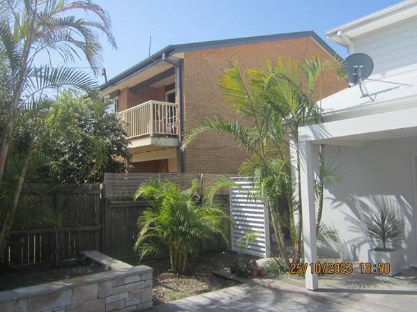
Figure 11 – Neighbouring Dwelling 26 Bungary Road, Norah Head
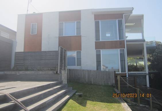
Figure 12 – Neighbouring Dwelling 26A Bungary Road, Norah Head
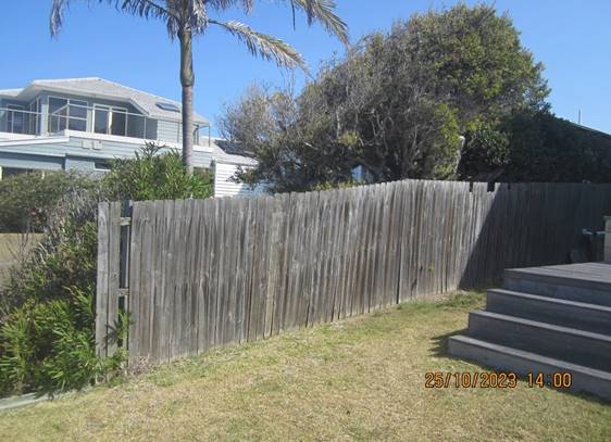
Figure 13 – Neighbouring Dwelling 30 Bungary Road, Norah Head
The Proposed Development
The development application seeks consent for the erection of a studio above the existing garage at the front of the allotment, a first-floor bedroom addition to the existing dwelling, erection of rear ground floor dining room and BBQ area as shown in Figures 14-17.
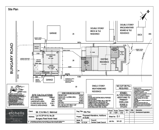
Figure 14 – Site Plan
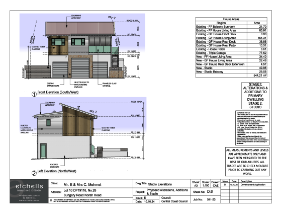
Figure 15 – Front and north western elevations of Garage/Studio
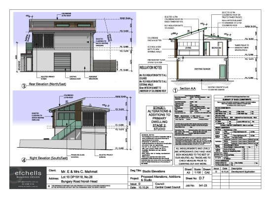
Figure 16 – Rear and south easterly elevations of Garage/Studio
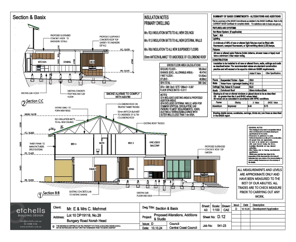
Figure 17 – Cross section of First Floor and Ground Floor Alterations and Additions
History
• BA/251/1959 Dwelling
• BA/2018/1970 Addition (BA/483/1972 for construction)
• BA/2433/1971 Garage
• BA/1799/1997 Additions
• DA/595/2014 Deck and Patio
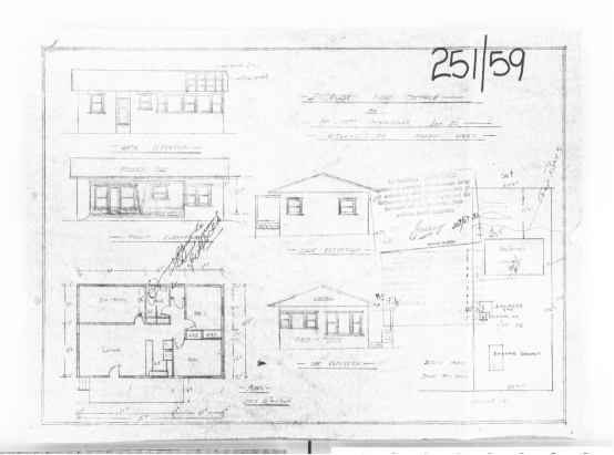
Figure 18 – BA/251/1959 Dwelling
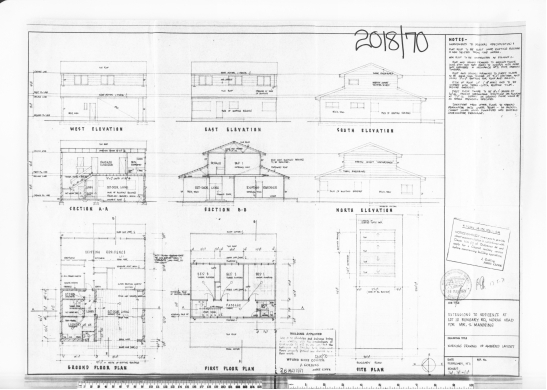
Figure 19 – BA/2018/1970 Addition
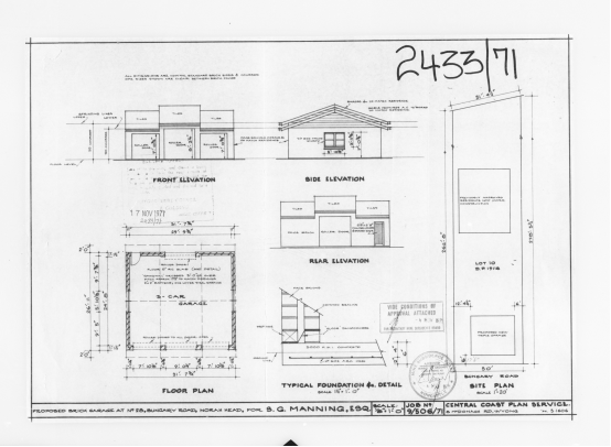
Figure 20 – BA/2433/1971 Garage
Figure 21 – BA/1799/1997 Additions
Figure 22 – DA/595/2014 Deck and Patio Ground Floor
Figure 23 – DA/595/2014 Deck and Patio First Floor
Application History
Development Application DA/1703/2023
· Application lodged for Dwelling Alterations, Additions and Secondary Dwelling. Plans by Etchells Building Design dated 22/08/2023 Version A. Plans notified from 1/09/2023 to 15/09/2023.
· Amended Plans by Etchells Building Design dated 5/10/2023 Version B. (North Point on plans adjusted)
· Amended Plans by Etchells Building Design dated 22/03/2024 Version C. (The Secondary Dwelling changed to a Studio on coastal hazards requirement as discussed in the report below. Front setback of staircase increased). Plans notified from 23/04/2024 to 08/05/2024.
Figure 24 – South Eastern Elevation of Dining Room and BBQ Area Plan Version C
· Amended Plans by Etchells Building Design dated 10/10/2024 Version C. (The height of the rear Dining Room Addition lowered by 600mm). Plans notified from 31/10/2024 to 14/11/2024.
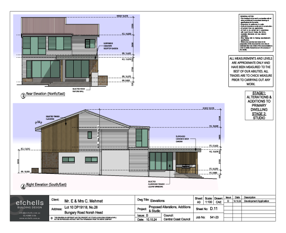
Figure 25 – South Eastern Elevation of Dining Room and BBQ Area Plan Version D
Assessment:
Having regard for the matters for consideration detailed in Section 4.15 of the Environmental Planning and Assessment Act 1979 and other statutory requirements, Council’s policies and Section 10.7 Certificate details, the assessment has identified the following key issues, which are elaborated upon for Council’s information. Any tables relating to plans or policies are provided as an attachment.
Environmental Planning and Assessment Regulation 2021 (Demolition)
With regard to demolition of works as part of a Development Application, clause 61 of the
Environmental Planning and Assessment Regulation 2021 provides additional matters that the
consent authority must consider:
(1) In determining a development application for the demolition of a building, the consent authority must consider the Australian Standard AS 2601—2001: The Demolition of Structures.
Comment: The works will be covered by the Australian Standard As 2601-2001 and is
conditioned for compliance as per draft condition 5.7 and 5.8.
A waste management plan has been submitted and accepted. Council is satisfied the
necessary demolition works required to facilitate dwelling alterations and additions and the plunge pool construction will occur in accordance with AS2601-2001.
State Environmental Planning Policy (Resilience and Hazards) 2021
The relevant provisions of the SEPP are addressed as follows:
Resilience and Hazards SEPP
Chapter 2: Coastal Management
The Resilience and Hazards SEPP applies to land within the coastal zone.
The site is located within the Coastal Use Area and the Coastal Environment Area and is therefore subject to the provisions of sections 2.10 and partially 2.11 of Chapter 2.
The development proposal is consistent with the relevant provisions of section 2.10 in respect of the Coastal Environment Area as it will not cause an adverse impact on the following matters for consideration.
Table 1 Consideration of potential impact on Coastal Environment Area
|
Matters for consideration |
Compliance |
|
(a) the integrity and resilience of the biophysical, hydrological (surface and groundwater) and ecological environment, |
The proposal is not likely to cause adverse impacts on the biophysical, hydrological, or ecological environment. |
|
(b) coastal environmental values and natural coastal processes, |
The proposal will not impact on the geological and geomorphological coastal processes. |
|
(c) the water quality of the marine estate (within the meaning of the Marine Estate Management Act 2014) the cumulative impacts of the proposed development on any of the sensitive coastal lakes identified in Schedule 1, |
The proposal will not result in an adverse impact on the water quality of the marine estate and does not drain to a sensitive lake contained in Schedule 1. |
|
(d) marine vegetation, native vegetation and fauna and their habitats, undeveloped headlands and rock platforms, |
The proposal will not result in an adverse impact on native vegetation or fauna, undeveloped headlands, and rock platforms. |
|
(e) existing public open space and safe access to and along the foreshore, beach, headland or rock platform for members of the public, including persons with a disability, |
The site will not impact on access to public spaces. |
|
(f) Aboriginal cultural heritage, practices, and places, |
There are no identified aboriginal cultural heritage items on the site including a clear AHIMS search. |
|
(g) the use of the surf zone. |
The development will not affect the use of the beach/surf zone. |
Further the development proposal is consistent with relevant provisions in section 2.11 in respect of the Coastal Use Area in that it is not likely to cause an adverse impact on the following matters for consideration.
Table 2 Consideration of potential impact on Coastal Use Area
|
Matters for consideration |
Compliance |
|
(1) Development consent must not be granted to development on land that is within the coastal use area unless the consent authority— |
N/A |
|
(a) has considered whether the proposed development is likely to cause an adverse impact on the following— |
N/A |
|
(i) existing, safe access to and along the foreshore, beach, headland or rock platform for members of the public, including persons with a disability, |
The site will not impact on access to public spaces. |
|
(ii) overshadowing, wind funnelling and the loss of views from public places to foreshores, |
The proposal will not cause an adverse impact on access, overshadowing, wind funnelling or view loss from public places to any foreshore. |
|
(iii) the visual amenity and scenic qualities of the coast, including coastal headlands, |
The proposal does not impact the visual amenity or scenic quality of the coast. |
|
(iv) Aboriginal cultural heritage, practices, and places, |
There are no known objects, areas, or items of heritage significance on the land, and no potentially adverse impacts on cultural or environmental heritage have been identified. |
|
(v) cultural and built environment heritage, and |
There are no known objects, areas, or items of heritage significance on the land, and no potentially adverse impacts on cultural or environmental heritage have been identified. AHIMS search / mapping is clear. |
|
(b) is satisfied that— |
|
|
(i) the development is designed, sited and will be managed to avoid an adverse impact referred to in paragraph (a), or |
There have been no adverse impacts identified in the consideration of section 2.11(1) that would engage the further considerations under section 2.11(2) of the Resilience and Hazards SEPP.
|
|
(ii) if that impact cannot be reasonably avoided—the development is designed, sited, and will be managed to minimise that impact, or |
N/A |
|
(iii) if that impact cannot be minimised—the development will be managed to mitigate that impact, and |
N/A |
|
(c) has considered the surrounding coastal and built environment, and the bulk, scale and size of the proposed development. |
The bulk and scale of the proposed development is considered satisfactory for its type and location. |
The development is not likely to have an adverse impact on the matters referred in sections 2.10 and 2.11.
The relevant matters have been considered in the assessment of this application and the application is considered to be consistent with the stated aims, objectives and relevant provisions.
Chapter 4: Remediation of Land
The Resilience and Hazards SEPP applies to any land defined in section 4.3 (1)(a) or (b).
Section 4.6 of Chapter 4 have been considered in the assessment of the development application requiring consent authorities to consider whether the land is contaminated, and if the land is contaminated, it is satisfied that the land is suitable in its contaminated state (or will be made suitable, after remediation) for the purpose for which the development is proposed to be carried out.
Council’s records indicate that the site has not been used for industrial or commercial land uses. As such, no further consideration is required in this regard.
It is therefore considered that the requirements of the SEPP in relation to remediation of land have been satisfied.
Central Coast Local Environmental Plan 2022 (CCLEP 2022) – Permissibility
The subject site is zoned R2 Low density Residential under the provisions of CCLEP 2022.
The proposed development is best defined as a ‘dwelling house’ which is defined under CCLEP 2022 as:
‘dwelling house’ means – a building containing only one dwelling.
The proposed development, inclusive of the proposed ancillary studio, is permissible in the zone, with development consent.
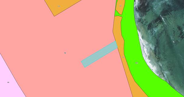
Figure 26 - Aerial Image of land and surrounds with Land Zoning – Source: GeoView 2020
Central Coast Local Environmental Plan 2022 (CCLEP 2022) - Objectives of Zone
The objectives of the R2 Low Density Residential General zone are:
• To provide for the housing needs of the community within a low-density residential environment.
• To enable other land uses that provide facilities or services to meet the day to day needs of residents.
• To encourage best practice in the design of low-density residential development.
• To ensure that non-residential uses do not adversely affect residential amenity or place unreasonable demands on services.
• To maintain and enhance the residential amenity and character of the surrounding area.
Following a detailed assessment of the development proposal it is considered that the
proposal is consistent with the stated objectives of the zone, providing housing consistent with the emerging character of the area, with the proposal not having adverse impacts on the
locality.
Central Coast Local Environmental Plan 2022 (CCLEP 2022) - Principal Development
Standards
It is to be noted that the site is mapped for both building height and Floor Space Ratio
under the provisions of Central Coast Local Environmental Plan 2022.
Building Height
The site is subject to a maximum 9.5 metre height limit with the existing dwelling on the site being below the mapped building height limit. Further, all proposed additions are located well below the mapped 9.5 metre building height limit.
Floor Space Ratio
The site is subject to a maximum Floor Space Ratio (FSR) of 0.5:1. In this regard, the proposal seeks a maximum FSR of 0.3:1. Accordingly, the proposal is compliant with the sites mapped FSR limit.
Central Coast Local Environmental Plan 2022 – Clause 7.6 Essential Services
Development consent must not be granted to development unless the consent authority is satisfied that all of the following services that are essential for the development are available,
or that adequate arrangements have been made to make them available when required:
a) the supply of water
b) the supply of electricity
c) the disposal and management of sewage
d) stormwater drainage or on-site conservation
e) suitable vehicular access
f) the collection and management of waste
The Panel can be satisfied that the proposed development complies with the provisions of
clause 7.6 and adequate servicing arrangements have been made for the proposed development.
Central Coast Development Control Plan 2022
Chapter 2.1 – Dwelling Houses, Secondary Dwellings and Ancillary Development
Principal Dwelling
|
Development Standard |
Description |
Required |
Proposed |
Compliance with Control |
Compliance with Objective |
|
2.1.2.1 |
Building Height |
Maximum 9.5 metres by virtue of LEP mapping |
8.392 metres (existing to be maintained) |
Yes |
Yes |
|
2.1.2.1(c) |
Building Height |
2 storeys/3 storey maximum where site is steeply sloping |
2 Storeys (existing to be maintained |
Yes |
Yes |
|
2.1.2.2 |
Site Coverage |
450m2 – 900m2 0.5:1 |
<0.5:1 |
Yes |
Yes |
|
2.1.2.3 |
Floor space ratio |
Maximum 0.5:1 |
<0.3:1 |
Yes |
Yes |
|
2.1.3.1 SETBACKS |
|||||
|
2.1.3.1(a) |
Front boundary setback (from the primary frontage) for primary and secondary dwellings |
The average distance of the setbacks of the nearest 2 dwelling houses having the same primary road boundary and located within 40m of the lot on which the dwelling house is erected, |
The first-floor bedroom addition setback is 25.931m which is a 2.569m difference from the required 28.5m. The difference of 2.569m is an 9% variation. |
No |
Yes, discussed in report |
|
2.1.3.1(b) |
Rear setback to an area zoned environmental conservation adjacent to a public recreation area that faces a water body |
3.0m |
>3.0m |
Yes |
Yes |
|
2.1.3.1(c) |
Side setback greater than 12.5m wide at the building line |
Minimum 0.9 metres up to 4.5 metres height |
Minimum 1500mm |
Yes
|
Yes |
|
2.1.4.4 RESIDENTIAL AMENITY |
|||||
|
2.1.4.1 |
Views |
The proposal is considered with the objectives of the clause and established view loss principles – refer to view loss analysis within the body of the report below. |
Yes |
Yes |
|
|
2.1.4.2 |
Visual privacy |
Minimal impact on privacy considering the location, size and setbacks of the proposed habitable spaces and windows from allotment boundaries. |
Yes |
Yes |
|
|
2.1.4.3 |
Private Open Space Areas |
Lots greater than 10m wide: 24m2 of open space |
>24m2 |
Yes |
Yes |
|
Minimum dimension of 3m. |
>3m |
Yes |
Yes |
||
|
the principal private open space area should be sited behind the front building line |
Behind the front building line |
Yes |
Yes |
||
|
should be generally level and may be in the form of a deck, terrace, or paved area. |
Generally, level/ 1:50 |
Yes |
Yes |
||
|
2.1.4.4 |
Sunlight Access |
Principal open space of dwelling to receive 3.0 hours of sunlight.
Principal Open space of adjoining dwellings to 3.0 hours of sunlight |
>3.0 hours
>3.0 hours |
Yes |
Yes |
|
2.1.5 |
Car Parking and Access |
Minimum 2.0 spaces for a dwelling containing 4 bedrooms
|
2 spaces |
Yes |
Yes |
|
2.1.6 EARTHWORKS, STRUCTURAL SUPPORT AND DRAINAGE |
|||||
|
2.1.6.1 |
Earthworks |
Excavation must not be greater than 1.0 metre depth where within 1.0 metre of the allotment boundary |
1.0 metre maximum |
Yes |
Yes |
|
2.1.6.2 |
Retaining Walls |
To be designed by a structural where engineer where in excess of 600mm in height |
No retaining walls required. |
Yes |
Yes |
|
2.1.6.3 |
Drainage |
To be directed to street system or an appropriate on side disposal system |
To be directed to the street via existing disposal system noting minimal additional roof area |
Yes |
Yes |
First Floor Studio
|
Development Standard |
Description |
Required |
Proposed |
Compliance with Control |
Compliance with Objective |
|
2.1.2.1(d) |
Building Height |
The maximum building height for outbuildings and detached ancillary development is: i 4.8m on land zoned R1, R2, R3 or RU5 ii 7m on land zoned RU1, RU2, RU6, R5, C3, C4 or C2 (where permissible) |
The studio has a maximum height of 8.004m. This is a 3.204m difference from the allowable 4.8m which a 67% variation. |
No |
Yes discussed in report |
|
2.1.2.1(c) |
Building Height |
2 storeys/3 storey maximum where site is steeply sloping |
2 Storeys (existing to be maintained |
Yes |
Yes |
|
2.1.2.2 |
Site Coverage |
450m2 – 900m2 0.5:1 |
<0.5:1 |
Yes |
Yes |
|
2.1.2.3 |
Floor space ratio |
Maximum 0.5:1 |
<0.3:1 |
Yes |
Yes |
|
2.1.3.1 SETBACKS |
|||||
|
2.1.3.1(a) |
Front boundary setback (from the primary frontage) for primary and secondary dwellings |
The average distance of the setbacks of the nearest 2 dwelling houses having the same primary road boundary and located within 40m of the lot on which the dwelling house is erected, |
The Studio setback is 5.15m which is a 23.35m variation from the required 28.5m. The variation is 82%.
|
No |
Yes discussed in report |
|
2.1.3.1(b) |
Rear setback to an area zoned environmental conservation adjacent to a public recreation area that faces a water body |
3.0m |
>3.0m |
Yes |
Yes |
|
2.1.3.1(c) |
Side setback greater than 12.5m wide at the building line |
Minimum 0.9 metres up to 4.5 metres height |
Minimum 930mm |
Yes
|
Yes |
|
2.1.4.4 RESIDENTIAL AMENITY |
|||||
|
2.1.4.1 |
Views |
The proposal is considered with the objectives of the clause and established view loss principles – refer to view sharing assessment within the body of the report below. |
Yes |
Yes |
|
|
2.1.4.2 |
Visual privacy |
Minimal impact on privacy considering the location, size and setbacks of the proposed habitable spaces and windows from allotment boundaries. |
Yes |
Yes |
|
|
2.1.4.3 |
Private Open Space Areas |
Lots greater than 10m wide: 24m2 of open space |
>24m2 |
Yes |
Yes |
|
Minimum dimension of 3m. |
>3m |
Yes |
Yes |
||
|
the principal private open space area should be sited behind the front building line |
Behind the front building line |
Yes |
Yes |
||
|
should be generally level and may be in the form of a deck, terrace or paved area. |
Generally level/ 1:50 |
Yes |
Yes |
||
|
2.1.4.4 |
Sunlight Access |
Principal open space of dwelling to receive 3.0 hours of sunlight
Principal Open space of adjoining dwellings to 3.0 hours of sunlight |
>3.0 hours
>3.0 hours |
Yes |
Yes |
|
2.1.5 |
Car Parking and Access |
Minimum 2.0 spaces for a dwelling containing 4 bedrooms |
2 spaces |
Yes |
Yes |
|
2.1.6 EARTHWORKS, STRUCTURAL SUPPORT AND DRAINAGE |
|||||
|
2.1.6.1 |
Earthworks |
Excavation must not be greater than 1.0 metre depth where within 1.0 metre of the allotment boundary |
1.0 metre maximum |
Yes |
Yes |
|
2.1.6.2 |
Retaining Walls |
To be designed by a structural where engineer where in excess of 600mm in height |
No retaining walls required. |
Yes |
Yes |
|
2.1.6.3 |
Drainage |
To be directed to street system or an appropriate on side disposal system |
To be directed to the street via existing disposal system noting minimal additional roof area |
Yes |
Yes |
Variations
The three variations to DCP Chapter 2.1 namely:
• Clause 2.1.3.1(a) Front Boundary setback variation of First Floor Bedroom Addition
• Clause 2.1.3.1(a) Front Boundary setback variation of Studio
• Clause 2.1.2.1(d) Building Height variation of Studio
Section 4.15(3A) of the Environmental Planning and Assessment Act 1979 requires in circumstances where provisions of a DCP set standards in respect of an aspect of the development, and the development does not comply with those standards, a consent authority is to be flexible in applying those provisions and allow reasonable alternative solutions that achieve the objects of those standards for dealing with that aspect of the development. Justification of the application clearly demonstrating that the non-compliance is supported and that a variation to the strict application of the controls is justified. The reasons include:
Each variation will be considered individually against the objectives of Central Coast Development Control Plan 2022 Chapter 2.1 – Dwelling Houses, Secondary Dwellings and Ancillary Development
In reviewing the proposal against each Objective, the following commentary is provided in
support of the development proposal:
DCP Chapter 2.1 Clause 2.1.3.1(a) Front Boundary setback for First Floor Bedroom Addition
Primary Road Setbacks
The front boundary setback of the dwelling at No. 26 Bungary Road, Norah Head is 28.5m and the front setback of the dwelling at No. 30 Bungary Road, Norah Head is 28.5m. The front setback average of the two neighboring dwellings is 28.5m. Accordingly the required front boundary setback for the proposed development is 28.5m. The first-floor bedroom addition setback is 25.931m which is a 2.569m. This equates to a variation of 9%.
The variation to the front setback proposed by the dwelling addition is compatible with the staggered setback pattern of the street resulting from a blend of old and new development. The front setback variation for the dwelling does not significantly impact upon the streetscape.
The proposed variation to the dwelling primary road setback is considered acceptable.
DCP Chapter 2.1 Clause 2.1.3.1(a) Front Boundary setback for Studio
Primary Road Setbacks
The studio is proposed to be constructed as a first-floor addition above the existing triple garage.
The existing garage on the site has a front setback of 5.5m and was approved under a building application in 1971. The current DCP controls related to primary road setbacks exclude existing ancillary structures when calculating setbacks.
The front boundary setback for the site is calculated as 28.5m. The proposed studio setback is 5.15m which is a 23.35m difference from the required 28.5m. The variation of 23.35m equates to 82%.
The proposed studio is assessed against the objectives of Development Control Plan 2022 Chapter 2.1 Section 2.1.3 Setbacks.
Ø Ensuring that setbacks are compatible with adjacent development and complements the character of the streetscape.
The front setback of the studio is compatible with the staggered setback pattern of the street resulting from a blend of old and new development. The front setback variation is reasonable and with a modern new appearance of the studio will have a new clean attractive appearance that elevates and improves upon the existing streetscape. The studio will be constructed over the existing garage.
Ø Ensuring the visual focus of a development is the dwelling, not the garage.
Locating the studio above the existing garage will take away the visual focus from the garage and give an emphasis on the detached ancillary buildings as a whole.
Ø Ensuring that the views, privacy and solar access of adjacent properties are maintained.
Water views of the ocean to the northeast will be impacted for the property at No. 57 Bungary Road. The issue of view sharing has been considered further in the report. The impact resulting from the proposed studio in respect of view sharing was assessed to be acceptable.
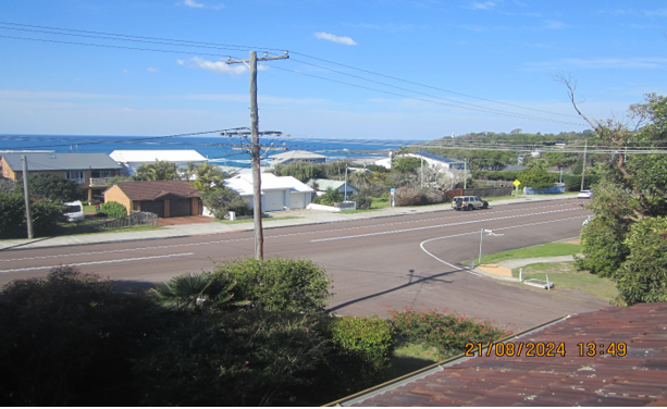
Figure 27 - Existing view from balcony of No. 57 Bungary Road
Shadow diagrams have been provided that demonstrate that on June 21, 50% of the required principal private open space area for all dwellings receives at least 3 hours of unobstructed sunlight access between 9am and 3pm. Also on June 21, 50% of the required principal private open space on adjoining land receives at least 3 hours of unobstructed sunlight access between 9am and 3pm.
Ø Ensuring that view corridors to coastal foreshores and other desirable outlooks are maintained.
The proposed studio will have a ridge height of 18.404m which is 0.026m higher than the dwelling addition at 18.378m. The front setback variation will result in partial loss of water views between the two storey dwellings at No. 28 and No. 32. The existing view corridor is shown in figure 27. The proposed studio will infill the gap between No. 28 and No. 32. The view is currently obscured in part by electrical wires and supporting pole. The resulting view impact as a result of the front setback variation is considered to be acceptable and reasonable.
Ø Maintaining the scenic and environmental qualities of natural waterbodies and their foreshores and respond to site attributes such as topography.
The studio addition is located over 80 metres from the foreshore and therefore not considered to have an impact upon the adjacent water body. The studio addition is setback further back further from the water body than existing development at No. 24A and 26A Bungary Road.
The studio addition is located on the roadside of the existing dwelling and therefore the appearance of the development from the ocean foreshore will be obstructed by the existing dwelling.
Ø Providing deep soil areas sufficient to conserve existing trees or accommodate new landscaping.
The studio addition is located over the existing garage and will not impact upon existing soil areas within the property.
Ø Providing appropriate articulation of facades and horizontal elements reduce the appearance of bulk and provides visual interest to the building and subsequent streetscape where they face a street frontage/s.
The front southwestern elevation of the first-floor studio addition has been provided with both articulation and visual elements that reduce the appearance of bulk and provides visual interest to the building and subsequent streetscape. The living area of the studio has been provided with a slight wall recess that breaks the horizontal appearance of the front wall. In concurrence with the wall recess is two different coloured timber cladding surfaces adjacent to each other. Both surfaces are natural in appearance yet the contrast in the colour and design schemes gives visual interest to the building. The balcony at the southeastern end of the studio is open in style with a glass balustrade which provides visual interest. The design of the studio is considered to have met the Objective.
The front setback variation for the First Floor Bedroom and Studio Addition are considered acceptable in the location and therefore supported in this instance.
DCP Chapter 2.1 Clause 2.1.2.1 - Building Height
Height variation of Studio 2.1.2.1(d)
The maximum height of detached ancillary development is 4.8m. The studio has a maximum height of 8.004m. This is a variation of 3.204m or 67% variation.
The dwelling meets the objectives of Development Control Plan 2022 Chapter 2.1 Section 2.1.2.1 Building Height by:
Ø Ensuring that buildings are compatible with the height, bulk and scale of the existing and desired future character of the locality.
The height of the first-floor studio addition is compatible with the height, bulk and scale of dwellings in the existing area which is a blend of old and new development.
There are several two storey dwellings within the area which have a similar height to the detached studio outbuilding including 26, 26A and 32 Bungary Road. As the area re develops and the older stock of housing is replaced it is very likely the building line will move forward substantially.
Ø Ensuring that the height of buildings protects the amenity of neighbouring properties in terms of visual bulk, access to sunlight, privacy, and views.
The studio above the existing garage will take away the visual focus from the garage and give an emphasis on the detached ancillary buildings as a whole.
Shadow diagrams have been provided that demonstrate that on June 21, 50% of the required principal private open space area for all dwellings receives at least 3 hours of unobstructed sunlight access between 9am and 3pm. Also on June 21, 50% of the required principal private open space on adjoining land receives at least 3 hours of unobstructed sunlight access between 9am and 3pm.
Privacy from the studio is addressed by directing view towards the street. Privacy screens have been utilized around the veranda and windows minimized on elevations facing adjacent neighbours properties.
Water views of the ocean to the northeast are obstructed by the development itself. A view impact assessment has concluded the impact on view sharing which result from the proposed studio are acceptable and reasonable.
Ø Ensuring that building height is compatible with the scenic qualities of hillside and ridgetop locations and respects the sites natural topography.
The site is not located on a hillside or within proximity of a ridgeline. The site displays a relatively level building footprint area.
The Studio Addition height variation are considered acceptable in the location and therefore supported in this instance.
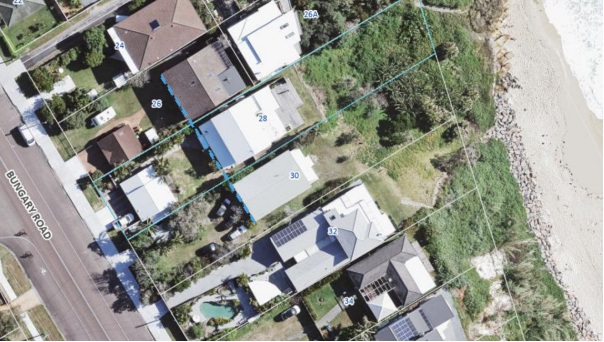
Figure 28: Detailing the average front boundary setback line showing that the setback is the average of the two neighbouring properties created by dwellings of older stock.
DCP Chapter 2.1 Clause 2.1.4.1 – Views
Clause 2.1.4.1 of requires the design of new buildings to have regard to existing views enjoyed by surrounding properties. Existing views should not be substantially affected where it is possible to design for the sharing of views. The primary view lines of adjacent properties
should be maintained where possible. Notwithstanding this, view sharing should be encouraged whilst not restricting the reasonable development of the site.
Various neighbours have lodged objections relating to potential view impact. The impact on view occurs from various locations in relation to the proposed development.
For the purpose of this assessment, the planning principles established by the Land and
Environment Court have been utilised. In Tenacity Consulting v Warringah [2004] NSWLEC
140, the Court adopted a four-step assessment process for determining potential impacts on
existing views and is detailed as follows:
Step 1: Determining the type of view to be affected.
The first step is to consider the type of view to be affected. Water views are valued more highly than land views. Whole views are valued more highly than partial views, e.g, a water
view in which the interface between land and water is visible is more valuable than one in
which it is obscured.
The proposed first floor Studio will result in view impacts for No. 57 Bungary Road.
No.57 Bungary Road
· Partial view impact of distant ocean and bombora views in a north/north easterly aspect.
![]()
![]()
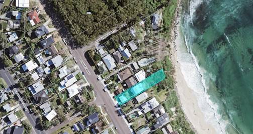
Figure 29: Detailing areas where view impact occurs from 57 Bungary Road
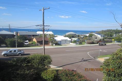
Figure 30: Detailing the existing view corridor of the ocean and bombora to the northeast from the first floor balcony (standing) of 57 Bungary Road
No.26 Bungary Road
· View impact for part of water/beach interface views in a north easterly aspect from the dining room (Standing) design plans D.
![]()
![]()
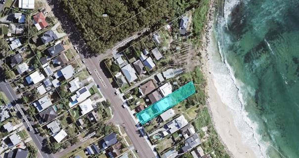
Figure 31: Detailing areas where view impact from 26 Bungary Road
![]()
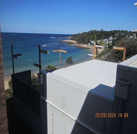
Figure 32: Detailing the existing view corridor to the north from the first floor dining area (standing) of 26 Bungary Road
Step 2: Determining the position of where views are obtained.
The second step is to consider from what part of the property the views are obtained. In
addition, whether the view is enjoyed from a standing or sitting position may also be relevant.
No. 57 Bungary Road
· The views in a north east direction are currently obtained from sitting and standing positions within the dwellings first floor dining area; and
· The views in a north east direction are currently obtained from standing position within the dwelling’s kitchen area; and
· The views in a north east direction are currently obtained from standing position from the dwellings first floor balcony; and
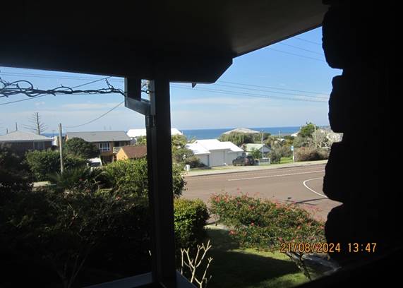
Figure 33: Detailing the existing view corridor of the ocean to the northeast from the first-floor kitchen area (standing) of 57 Bungary Road
No. 26 Bungary Road
· The views in a north eastern direction are currently obtained from sitting and standing positions within the dwellings first floor first floor dining area;
![]()
![]()
Figure 34: Detailing areas where view impact from 26 Bungary Road
Step 3: Assessing the extent of impact.
The third step is to assess the extent of the impact. This should be done for the whole of the
property, not just for the view that is affected. The impact on views from living areas is more significant than from bedrooms or service areas. It is usually more useful to assess the view loss qualitatively as negligible, minor, moderate, severe, or devastating.
The proposed studio will “in fill” the gap between dwellings at No. 28 and No. 32 as shown in figure 33. The view impacts to No. 57 Bungary Road, are considered to be minor when considering the extent of available whole views which are available.
In reviewing the view impacts to No. 26 Bungary Road, it is considered that the impact upon existing view corridors would be considered as being moderate. Particularly when considering the extent of available ocean views remaining. The applicant amended the design during assessment of the application which resulted in the rear roof being lowered. The resulting impact on view sharing is considered moderate due to the significance of the view. It is recognised that water/beach interface views are highly valued.
Step 4: Assessing whether the extent of impact is reasonable.
The fourth step is to assess the reasonableness of the proposal that is causing the impact. A
development that complies with all planning controls would be considered more reasonable than one that breaches them. Where an impact on views arises as a result of noncompliance
with one or more planning controls, even a moderate impact may be considered unreasonable.
With a complying proposal, the question should be asked whether a more skilful design could provide the applicant with the same development potential and amenity and reduce the impact on the views of neighbours. If the answer to that question is no, then the view
impact of a complying development would probably be considered acceptable and the view sharing reasonable.
While most of the view loss can be categorised as minor, Roseth S.C. argues that where an
impact on views arises as a result of non-compliance with one or more planning controls, even a moderate impact may be considered unreasonable.
Views across side boundaries are more difficult to protect than views from front and rear boundaries, and the expectation to retain side views is often unrealistic.
No.57 Bungary Road
As shown above (Figure 29), the objector's property is located west to north west of the subject site and view impacts from the Studio and First Floor addition occur to the east (across the side and front boundary).
In considering the view impacts it is noted that the proposed development has been designed with a detached ancillary Studio development with a height of 8.004m. Whilst this is acknowledged as being non-compliant with height controls the studio is only 0.026m higher than the dwelling addition. The studio is considered to be similar height to the first-floor dwelling addition. The studio has been designed to a height which is comparable to that of No. 28 and No. 32 dwelling height, as can be seen in figure 30 and 33. Removing the studio will provide a minor gain of filtered water views, however distant Ocean water views are maintained, as shown in figure 27 and 30.
The building design is considered to have addressed the principals of view sharing. Accordingly, the proposal is considered to have minor impact upon existing views, particularly when considering the overall views obtained from the impacted dwelling at No. 57 Bungary Road. As such, the proposal is considered consistent with established view loss principals and is therefore supported in this instance.
No. 26 Bungary Road
As shown above (Figure 32), the objector's property is located northwest of the subject allotment and principal view impacts occur to the rear in south east direction (across a side boundary).
In considering the view impacts it is noted that the proposed development has been designed with an attached rear Dining Room and BBQ area extension. Direct views of the ocean have been obstructed by 26A Bungary Road, so we are now assessing the impact upon the remaining views obtained across a side boundary from the first-floor dining area.
In considering the view impacts it is noted that the proposed development has been re-designed by the applicant to minimise the impact of the proposal on view sharing. The change from Design Plans C to Design Plan D the applicant has reduced the height of the of the Dining Room by 475mm which has been at a net gain of obtaining views of the Boat Ramp and rock pool, and improvements on water and beach/water interface views.
Lowering the initial design is considered to have addressed the principals of view sharing by providing a better design.
The proposal is considered to have moderate impact upon existing views, particularly when considering the overall quality of views. The proposal is considered consistent with established view loss principals and is therefore supported in this instance.
DCP Chapter 2.14 Waste Management
A Waste Management Plan has been submitted in support of the proposed development.
The proposal has demonstrated compliance with this chapter of the CCDCP 2022 and
associated Waste Control Guidelines. An appropriate condition is included in the development consent requiring compliance with the submitted waste management plan (condition 5.4).
DCP Chapter 2.17 – Character and Scenic Quality
The site is subject to character provisions of Chapter 2.17. In this regard, the development
proposal is considered consistent with the development pattern evident within the
Norah Head suburb. In this regard, there are numerous examples of similarly designed dwellings of a two-storey appearance along the Cabbage Tree Bay Public Reserve frontage.
Given the relative minor alterations and additions sought by the proposal, it is considered therefore that the proposed development will be consistent with character provisions of Chapter 2.17, with the proposal therefore considered appropriate in the location.
DCP Chapter 3.2 Coastal Hazard Management – Northern Area
The proposal has been assessed in accordance with the relevant provisions of CCDCP 2022 Chapter 3.2 Coastal Hazard Management - Northern Area (Former Wyong LGA).
The adopted Coastal Hazards Mapping (2011) as identified in Figure 21 below, indicate the following:
· Immediate Risk Coastal Hazard Planning Line - red line.
· High Risk Coastal Hazard Planning Line – amber line.
· Low Risk Coastal Hazard Planning Line – yellow line.
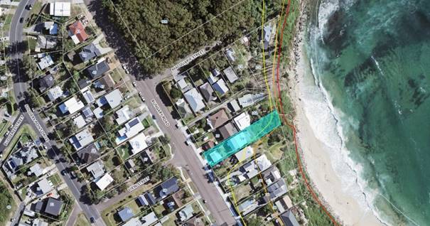
Figure 35: Detailing the Coastal Hazard lines impacting the site.
The proposed additions are located wholly landward of the adopted 2011 Immediate Coastal Hazard Area (landward of the yellow line).
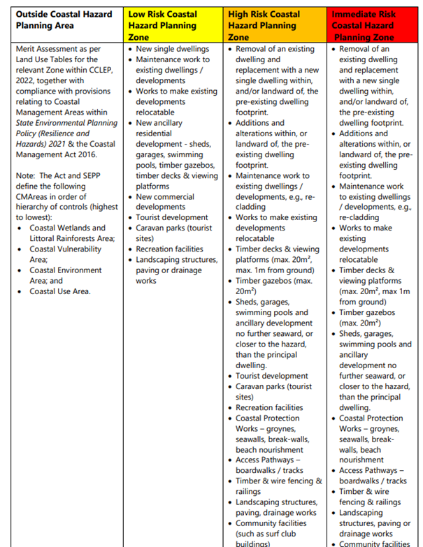
Figure36 : Detailing Table 1 of Chapter 3.2 indicating “non exhaustive” development types which may be considered forward of the immediate (red) coastal hazard line.
Council’s Coastal Planning Officer has supported the proposed development.
DCP Chapter 6.3 Erosion Sedimentation Control
The implementation of appropriate siltation controls will be conditioned within the issued development consent.
Likely Impacts of the Development:
Built Environment
A thorough assessment of the proposed development’s impact on the built environment has
been undertaken in terms of the CCLEP 2022 and CCDCP 2022 compliance. It is considered on balance that the potential impacts are considered reasonable.
Natural Environment
The proposal involves some very minor site excavation for Dwelling Additions and studio. Whilst there is some impact upon the natural environment it is considered reasonable given the sites General Residential zoning and the extent of the proposal in relation to adjoining development. Accordingly, the proposal is considered satisfactory in relation to impacts on the natural environment.
Context and Setting
The proposal is located within the R2 Low Density Residential zone under CCLEP 2022 and subject to character provisions of Chapter 2.17 of the CCDCP 2022. The proposal provides an improved dwelling outcome, noting the aged and nature of the existing site improvements, within the residential zone, with the proposal considered consistent with the objectives of the R2 land use. In addition, the proposal is considered consistent with the emerging character of the area.
Economic and Social Impacts
The proposal will provide minor economic benefit through the provision of temporary employment during demolition and construction works. Socially, the proposal does not give rise to any adverse environmental impacts in respect to overshadowing or view impacts within either the public or private domain.
Suitability of the Site for the Development:
Coastal Erosion Considerations
As indicated, the proposed additions are wholly located behind of the current adopted 2011 immediate coastal hazard line as indicated within the body of the report above. Assessment of the proposal against the relevant objectives of the Coastal Erosion Chapter indicates that the proposal is satisfactory in terms of the coastal erosion.
The Panel can therefore be satisfied that the development proposal is satisfactory in terms of
the sites coastal erosion constraint.
Submissions
As indicated, the development application was notified in accordance with the provisions of
Chapter 1.2 “Notification of Development Proposals” of Central Coast Development Control
Plan 2022 on three separate occasions as follows: -
Plans Issue A
Ø First round of notification - from 1 September 2023 until 15 September 2023.
During this period, a total of five (5) submissions were received.
As a result of concerns from the submissions, the applicant in response provided amended development plans.
Plans Issue B
Issue B included the following amendments:
· The north point on the plans was re-oriented
Plans Issue C
Before being re-advertised the application was referred internally to Council’s Coastal Planning Officer. Initial referral advice indicated that the proposal could not be supported from a coastal erosion perspective. Accordingly amended development plans were submitted that significantly altered the proposed development and included the following amendments:
· Secondary Dwelling change to a Studio
· Front setback of Studio staircase increased
· Ground floor front deck width increased
· Rear deck extension removed resulting in narrower BBQ Area
· Second storey addition of Dwelling slightly larger and therefore further forward
· Second round of notification - from 23 April 2024 until 8 May 2024.
During this period, a total of seven (7) submissions were received (6) submissions were unique.
Plans Issue D
As a result of concerns with the proposed development raised by the assessing officer, the
applicant in response provided amended development plans. These amended development
plans altered the proposed development and included the following amendments:
· The height of the rear Dining Room Addition lowered by 475mm
· Third round of notification - from 31 October 2024 until 14 November 2024.
During this period, a total of nine (9) submissions were received.
Throughout the advertising process a total of 20 submissions were received.
It should be noted that 6 of the submissions were received from N0. 26 Bungary Road. The property has recently been sold and the new owner lodged a submission but withdrew the submission on the 11 November 2024.
A summary of submission items with respect to the amended development proposal is as
follows:
Studio
· Concerns regarding the height of the Studio and location will cause view loss.
Comment: As indicated within the view impact assessment above, view sharing impacts for neighbouring properties, in particular No. 57 Bungary Road, are considered acceptable and in line with established view sharing principles. There is not a more suitable location on the site for the Studio that will maximise the amount of open space for recreation.
· Studio front setback is non-compliant.
Comment: The front setback to the road does not comply and the applicant has requested a variation. The Studio is located over the existing garage and the large setback of the building line is a result of the neighbouring properties being well setback from the street and taking advantage of the ocean/beach views at the rear boundary.
· Studio floor area is not compliant.
Comment: The Studio floor area is less than 50 square metres and complies.
· Studio shouldn’t be constructed in front of the Dwelling.
Comment: Council’s development controls allow for a detached studio to be located forward of the dwelling provided it is integrated with the design of the dwelling. The modern appearance and carefully selected building materials ensures that the Studio integrates with the dwelling on the site.
· The Studio is the visually dominant feature and is aesthetically displeasing.
Comment: At least one third of the Studio is open in style which reduces the bulk and scale. The external finishes are modern, appealing and will elevate the appearance of the streetscape.
· The bulk and scale to large.
Comment: At least one third of the Studio is open in style which reduces the bulk and scale. The location of the studio takes away the visual focus from the garage doors to the building as a whole which has points of visual interest on the front elevation.
· Privacy screen inadequate and should be a solid barrier.
Comment: The design of the privacy screen on the south eastern elevation of the Studio will adequately obstruct the line of site from the Studio balcony to the front yard of the adjoining property. Changing the design of the privacy screen to a solid barrier will likely increase the bulk of the Studio and reduce amenity to the studio itself.
· Stairs of Studio to close to the boundary.
Comment: The staircase along the south eastern elevation of the Studio has a side setback of 930mm making it compliant with setback controls. Use of the stairs will only create a passing glance in a north easterly direction towards the existing dwelling on subject allotment. It is very unlikely that occupants will stop on the staircase for social activities of an extended duration.
· The height of the building does not protect the amenity of neighbouring properties, in terms of visual bulk, access to sunlight, privacy, and views.
Comment: Bulk and scale, privacy and view loss have all been addressed. Shadow diagrams have been supplied that demonstrate that on June 21, 50% of the required principal private open space area for all dwellings receives at least 3 hours of unobstructed sunlight access between 9am and 3pm. Also on June 21, 50% of the required principal private open space on adjoining land receives at least 3 hours of unobstructed sunlight access between 9am and 3pm. The Studio is located forward of any habitable building on adjacent properties and therefore overshadowing doesn’t occur to any habitable building. The impact of the Studio upon the amenity of neighouring properties is considered to be acceptable.
· The setback of the stairs of the Secondary Dwelling is outside the articulation zone.
Comment: Amended plans have been received that has changed the Secondary Dwelling to a Studio. A detached ancillary building does not have an articulation zone. The staircase does protrude 1.535m in front of the studio but elevations show that it will be below boundary fence height and therefore low and unobtrusive.
· Garage doors beneath the Studio are non-compliant.
Comment: Plans indicate that the garage was approved under Building Application BA/2433/1971. The garage is not part of the Studio addition, and any non-compliances are not considered as part of this application.
Alterations and Additions to Dwelling
Additions to front of Dwelling
· The Dwelling addition has no consideration for view sharing being higher than the existing ridge line.
Comment: The addition of the first-floor bedroom requires the ridge line to be 919mm higher than the existing so that a reasonable roof slope and appearance can be achieved. The slope of the roof additions requires an increase in height to match and integrate with the existing roof. The increase in the ridge line height complies with the planning controls and is at least 1 metre lower. The proposed development is a similar height to the existing development within the area.
· The first floor Addition Dwelling meet Council specifications.
Comment: This is a broad unspecific statement that cannot be addressed.
· The first floor Dwelling Addition will cause overshadowing of the neighbouring.
Comment: Shadow diagrams have been provided that demonstrate that on June 21, 50% of the required principal private open space area for all dwellings receives at least 3 hours of unobstructed sunlight access between 9am and 3pm. Also on June 21, 50% of the required principal private open space on adjoining land receives at least 3 hours of unobstructed sunlight access between 9am and 3pm.
· The complainant seeks a guarantee that the ground floor deck at the front will not be enclosed.
Comment: Enclosure of the ground floor deck would require development consent. This application does not propose the deck to be enclosed.
Additions to rear of Dwelling
· The rear additions remove views of the Light House, Rock Pool, Boat Ramp.
Comment: A view sharing assessment has been completed for No. 26 Bungary Road. The assessment concluded view sharing to be acceptable and in line with established view sharing principles. Amended plans were submitted during the assessment process whereby the Dining Room roof was lowered by 475mm to ensure that the views of the rockpool and boat ramp are maintained.
· The rear additions/ roof top garden may collapse the rear yard in or adjacent to the Coastal Hazard Zone.
Comment: The application was referred to Council’s Coastal Planning Officer who has supported the application without conditions. The additions are located landward of the coastal hazard line. The foundations are required to be designed in accordance with the Building Code of Australia.
· BBQ extension and roof top garden cause overshadowing,
Comment: The shadow diagrams provided indicate that properties located to the north west will experience limited impact. The single storey height ensures that the shadows are unlikely to extend over the south eastern boundary.
· Separate shadow diagrams for the rear Additions are required.
Comment: The shadow diagrams provided show that properties located to the north west will experience limited impact.
· The roof garden improves privacy and appearance for the applicant at the neighbours expense of views.
Comment: The proposed roof top garden does not provide sufficient soil depth to support the growth of shrubs. Planting on roof top gardens is made up of low-lying succulents or similar plant species.
· Incremental View Creep is occurring with no concern for View Sharing.
Comment: The view sharing assessment has concluded the proposed development is acceptable and in line with established view loss principles.
· The height and setback of the rear addition does not protect the amenity of neighbouring properties, in terms of visual bulk, access to sunlight, privacy, and views.
Comment: Privacy, view loss and sunlight loss have all been assessed in the report. The bulk and scale of the rear additions is considered to be reasonable as side and rear setbacks are compliant. The impact of the Dining Room and BBQ Area upon the amenity of neighboring properties is acceptable as compliant side and rear setbacks have been achieved.
· The height poles required measurements on them to show height of concrete garden. They should be put up by an independent professional.
Comment: The height poles were checked onsite by Councils assessing officer. The height poles were found to be consistent with the proposed plans. There are two existing datum points on the site which were used to confirm the accuracy of the height poles.
· Water runoff seepage will cause subsidence.
Comment: The rear development increases roofed area on the site which reduces the volume of uncontrolled stormwater runoff. All water from the roofed areas of the development will be required to be disposed of in registered stormwater system which reduces water runoff seepage at the rear of the property.
General Concerns
· The development allows further additions.
Comment: Noted. The application assessment can only consider the proposed development.
· No consultation with neighbours has occurred before lodging the development application.
Comment: Whilst Council encourages community consultation and transparency, visiting neighbours is not a statutory requirement.
· The development will detract from the adjoining neighbouring properties.
Comment: The proposal is using modern materials with clean lines and a fresh appearance common to all development within the Central Coast Local Government Area.
· The rear First Floor Enclosure on the rear southeastern corner of the dwelling has not been approved and concerns have been raised hat viewing from the addition impacts upon the privacy of neighbouring residents.
Comment: The first-floor deck was approved under DA/595/2014. The deck has now been enclosed and roof placed over sometime after 2014. The view impacts from the enclosed deck have not changed because of the roof and windows.
· The development will devalue property in the area.
Comment: There is no evidence to support this.
· Vegetation in the rear yard of the subject property has been previously cleared.
Comment: No evidence has been submitted to support this statement. No vegetation has been removed during the assessment of the application. The plans have errors and misinformation. In particular:
Ø The north point in the plans is incorrect, with a 90° variation from true north. This has the effect of invalidating any provided shadow diagrams and indications of wind and solar access, incorrectly presenting elevations, and preventing an accurate assessment of impacts to surrounding properties.
Ø There is no comparison of existing development to what is being proposed, preventing an accurate assessment of the proposed changes and their impacts.
Ø Proposed elevations do not indicate existing ground levels, only finished floor levels. It is recommended that a survey be prepared and submitted and included with the exhibition material and included on elevations to ensure accuracy of drawings.
Ø The proposal incorporates a substantially different floor space ratio to what was presented for previous development applications for the same site, despite a limited change in development. It is suggested that clarification be made as to the extent of changes between this DA and existing development as well as inconsistencies between plans exhibited for the DA approved in 2014 and what was constructed.
Comment: The north point orientation has been corrected. The plans are adequately detailed and scaled to show the height of the Studio and Dwelling alterations and Additions. Shadow diagrams have been submitted showing the impacts of the proposal upon neighbouring properties. The plans have been completed in a professional manner with adequate detail.
· There is no mention of how the proposal impacts the surrounds.
Comment: A Statement of Environmental Effects has been submitted that does addresses the impacts of the proposal upon views, solar access, and the streetscape.
· No survey to understand the full impacts of the site, slope, and landscape. The actual height posts are not accurate. Height poles should be labelled with measurements to show the full extent of view loss.
Comment: The rear additions are being constructed at the existing deck level and therefore a Survey is not required. The height poles were checked by the Council Officer as part of the site inspection and assessment process.
· Dismissive resubmission & lack of detail on the amended plans. The changes aren’t big enough to address all the concerns.
Comment: Council conducted a merits assessment of the plans keeping in consideration all of the concerns raised in the submissions. The amended plans have addressed all requirements requested by Council officers during the assessment process.
· The process is causing undue stress.
Comment: Council is unable to address this issue.
· There will be additional impacts of Plan Issue D in that the design will allow for further additions.
Comment: Noted. The application assessment can only consider the proposed development.
· The development will cause overcrowding of the general area which will lead to traffic congestion and the like.
Comment: A Studio is permitted on the site. The area has been zoned with a Floor space Ratio of 0.5:1 and the development has a Floor space Ratio of 0.3:1 which shows that the allotment is not being over developed.
· The development allows for future air B & B opportunities.
Comment: The studio is not permitted to be used for separate occupation.
· The proposal is non-compliant with DCP – The development plans are non-compliant with the DCP as detailed below.
o Section 2.1.2.1 Building Height
o Section 2.1.3.1 Setbacks – Residential Lots
o Section 2.1.4 Residential Amenity, including section 2.1.4.1 Views
o Section 2.1.7 Ancillary Development
Comment: These matters have been addressed as part of the assessment process.
· The SOEE states there will be no impact on the Coastal Environment Area and there will be.
Comment: The SOEE makes this statement in the context that there will not be any direct physical impact upon the Public Foreshore Area which is correct. Non-physical impacts such as how the additions may impact upon the character of the area are addressed in other parts of the statement.
· The SOEE does not include a complete view loss analysis.
Comment: A view sharing assessment has been completed by Council Officers as part of the application assessment.
· Aboriginal Heritage Impact Assessment Report has not been supplied with the application.
Comment: Council has conducted its own checks and there does not appear to be any Aboriginal mittens within the general area of the development.
· The bombora and bluff area on the headland are iconic views of Aboriginal significance. Blocking these views is disrespecting past Aboriginal Heritage.
Comment: The Studio, Alterations and Additions to the existing Dwelling are a significant distance from these features. Therefore, the development will not cause actual physical damage to these natural features of importance, and they will remain in place for future generations.
Submissions from Public Authorities
The development proposal was not required to be referred to any external authority.
Internal Consultation
|
Coastal Engineering |
Supported without conditions |
Ecologically Sustainable Principles:
The proposal has been assessed having regard to ecologically sustainable development principles and is considered consistent with the principles.
The proposed development is considered to incorporate satisfactory stormwater, drainage and erosion control and does not impact upon significant existing vegetation mostly being inside the existing building envelope and is unlikely to have any significant adverse impacts on the environment and will not decrease environmental quality for future generations. The proposal does not result in the disturbance of any endangered flora or fauna habitats and is unlikely to significantly affect fluvial environments.
Climate Change
The potential impacts of climate change on the proposal have been considered by Council as
part of the assessment of the application.
The assessment has included consideration of such matters as potential rise in sea level,
potential for more intense and / or frequent extreme weather conditions including storm events, bushfires, drought, flood and coastal erosion; as well as how the proposed development may cope, combat and withstand any resultant impacts. The proposed
development is considered satisfactory in relation to climate change.
The Public Interest
The proposed development is seen to be in the public interest by providing assurance that the subject land can be developed in proportion to its site characteristics.
Conclusion
The development application has been assessed having regard for the matters for
consideration under Section 4.15 of the Environmental Planning and Assessment Act 1979 and
all relevant instruments, plans and policies. Following a thorough assessment of the relevant
planning controls and the key issues identified in this report it is considered that the
application can be supported because:
1. The Panel can be satisfied that the proposed development is considered satisfactory having regard to the matters for consideration provided in Section 4.15 of the Environmental Planning and Assessment Act 1979.
2. The application has been assessed against the requirements of clause 61 of the Environmental Planning and Assessment Regulation 2021 in respect of demolition.
3. The Panel can be satisfied that the provisions of State Environmental Planning Policy (Resilience and Hazards) 2021, Chapter 2 Coastal Management, sections 2.10, 2.11 and 2.15 have been considered and satisfied.
4. The Panel can be satisfied that the proposed development is consistent with the zone objectives as set out in the Central Coast Local Environmental Plan 2022.
5. The Panel can be satisfied that the relevant provisions of the environmental planning instruments, plans and policies that apply to the development have been considered in the assessment of the application.
6. Subject to the imposition of appropriate conditions, the proposed development is not expected to have any adverse environmental, social, or economic impact.
The application is therefore recommended for approval subject to the conditions included in Attachment 1.
|
1⇩ |
Draft conditions/reasons - 28 Bungary Road, NORAH HEAD NSW 2263 - DA/1703/2023 - Draft conditions/reasons - Central Coast Council |
|
D16754449 |
|
Portal Doc - 28 Bungary Road, NORAH HEAD - DA/1703/2023 - Architectural Plans - 28 Bungary Rd, Norah Head - DA Plans - Issue D |
Provided Under Separate Cover |
D16455722 |
|
|
3⇩ |
Portal Doc - 28 Bungary Road, NORAH HEAD - DA 1703 2023 - Architectural Plans - 28 Bungary Rd, Norah Head - DA Plans - Issue D - REDACTED |
|
D16759396 |
|
3.2 |
DA/1703/2023 - 28 Bungary Road, Norah Head - Studio, Alterations & Additions |
|
Attachment 1 |
Draft conditions/reasons - 28 Bungary Road, NORAH HEAD NSW 2263 - DA/1703/2023 - Draft conditions/reasons - Central Coast Council |
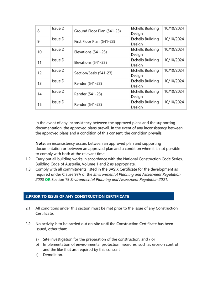

|
DA/1703/2023 - 28 Bungary Road, Norah Head - Studio, Alterations & Additions |
|
|
Attachment 3 |
Portal Doc - 28 Bungary Road, NORAH HEAD - DA 1703 2023 - Architectural Plans - 28 Bungary Rd, Norah Head - DA Plans - Issue D - REDACTED |

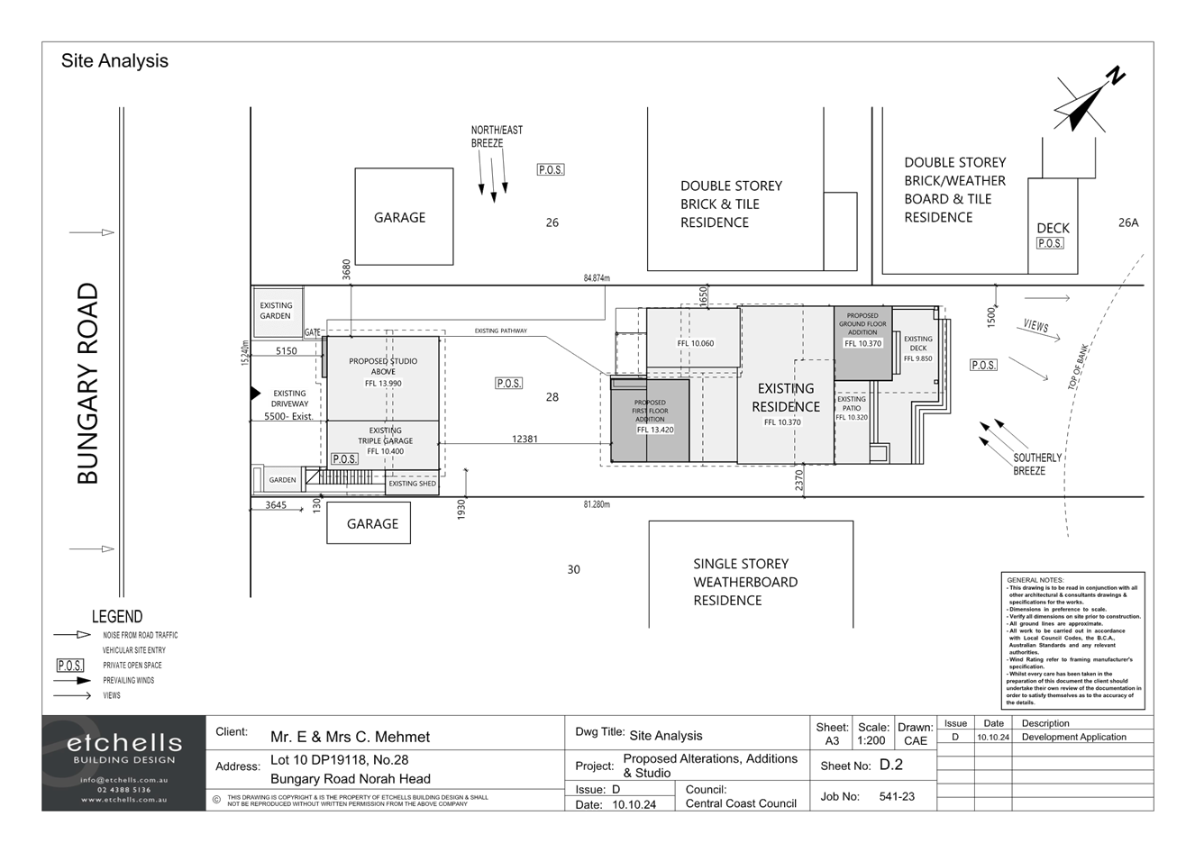
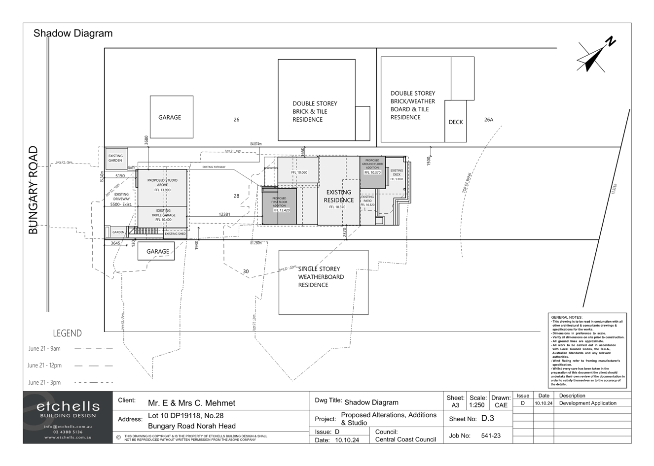
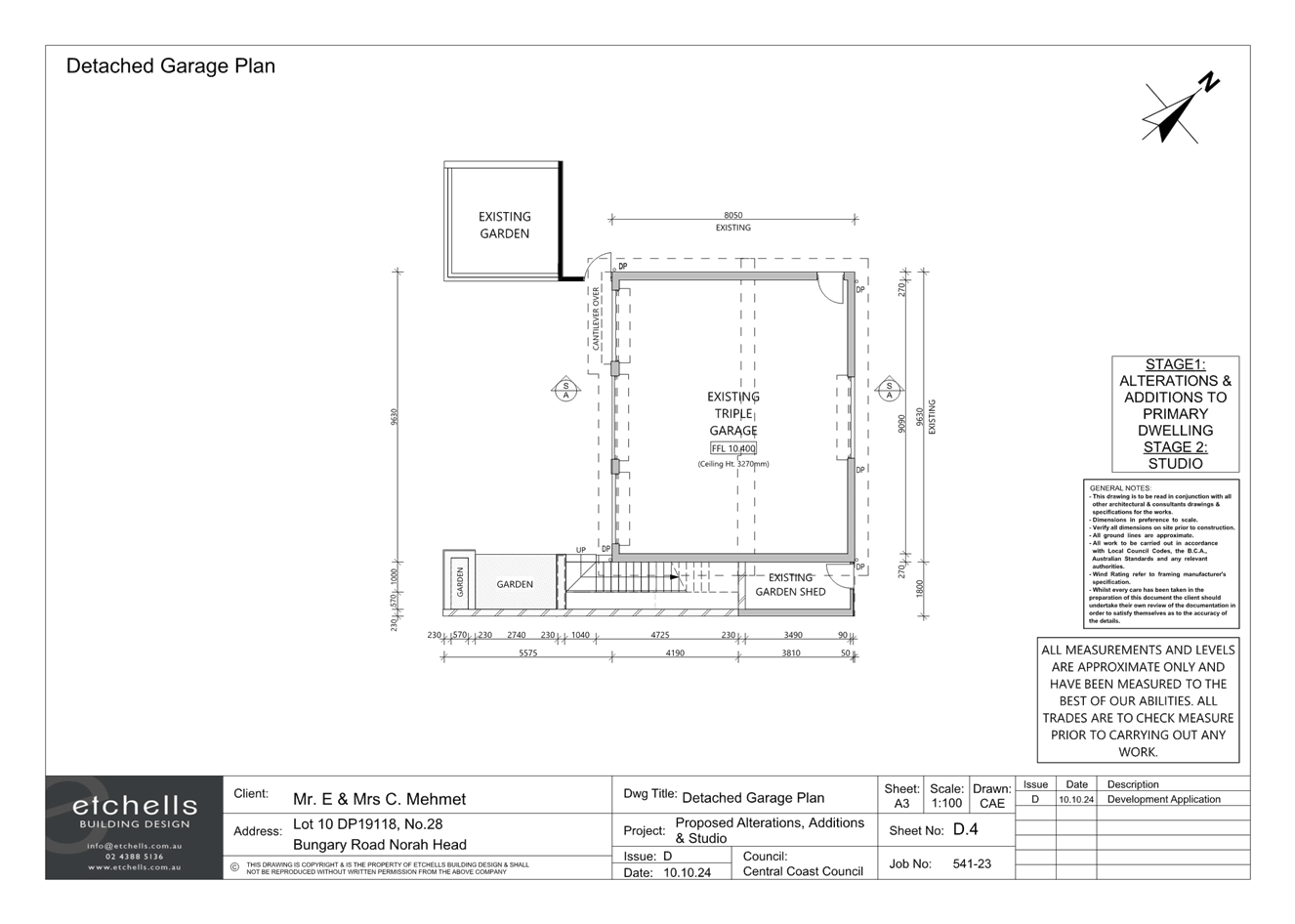
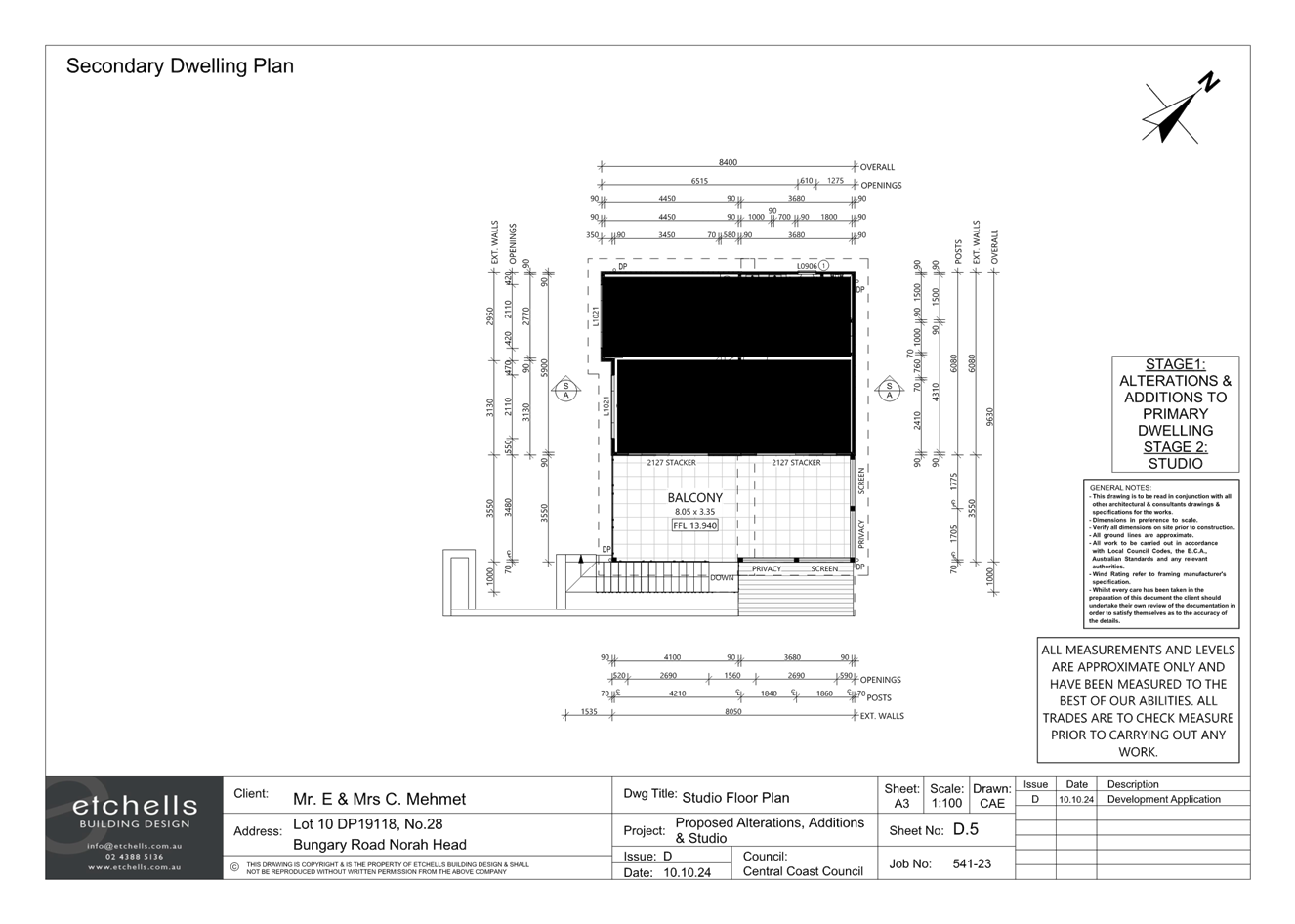
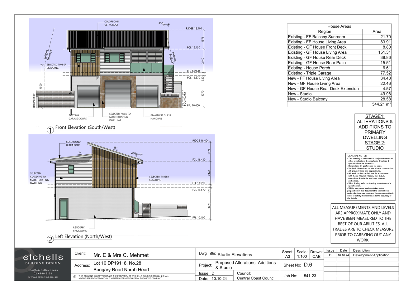
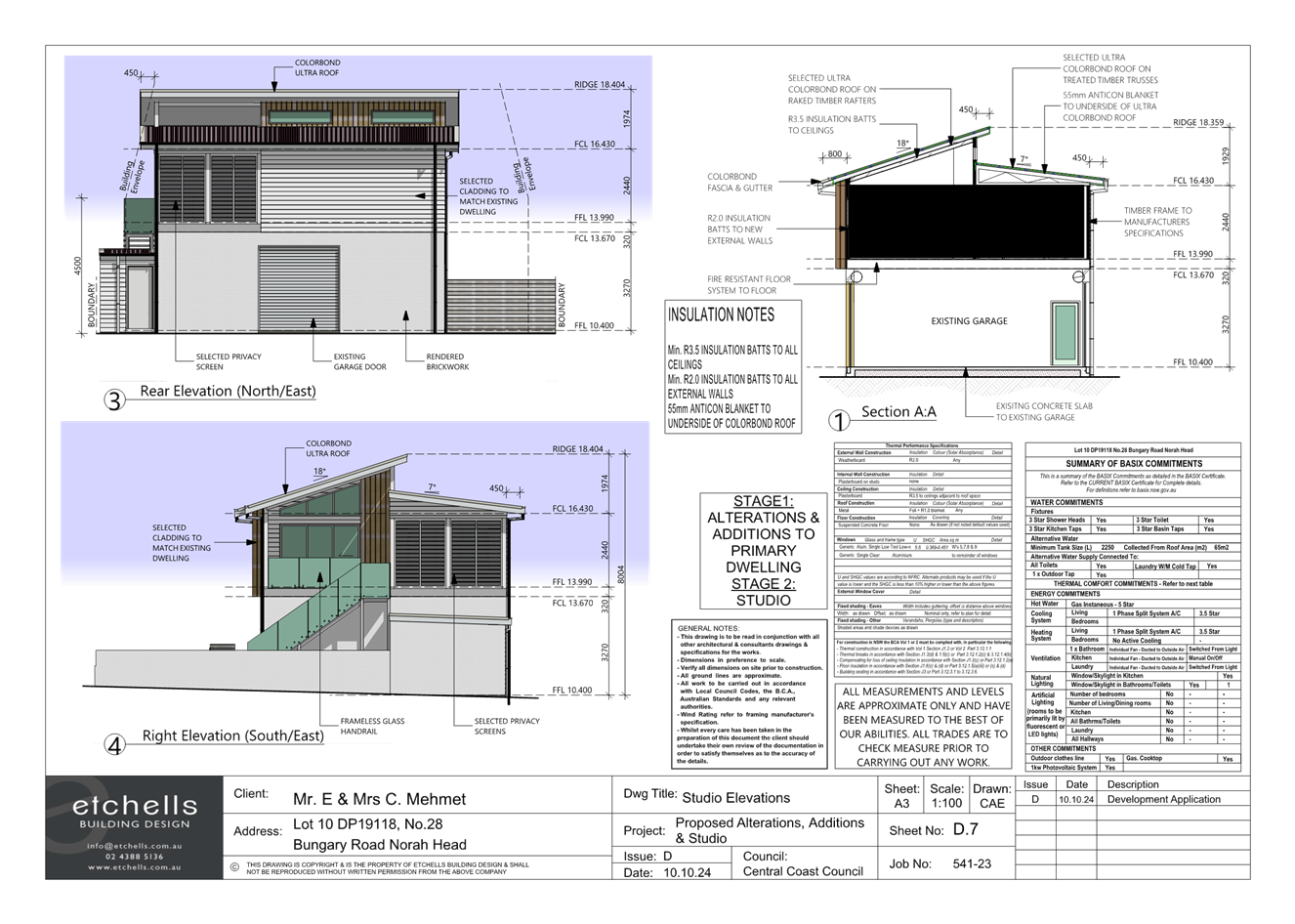
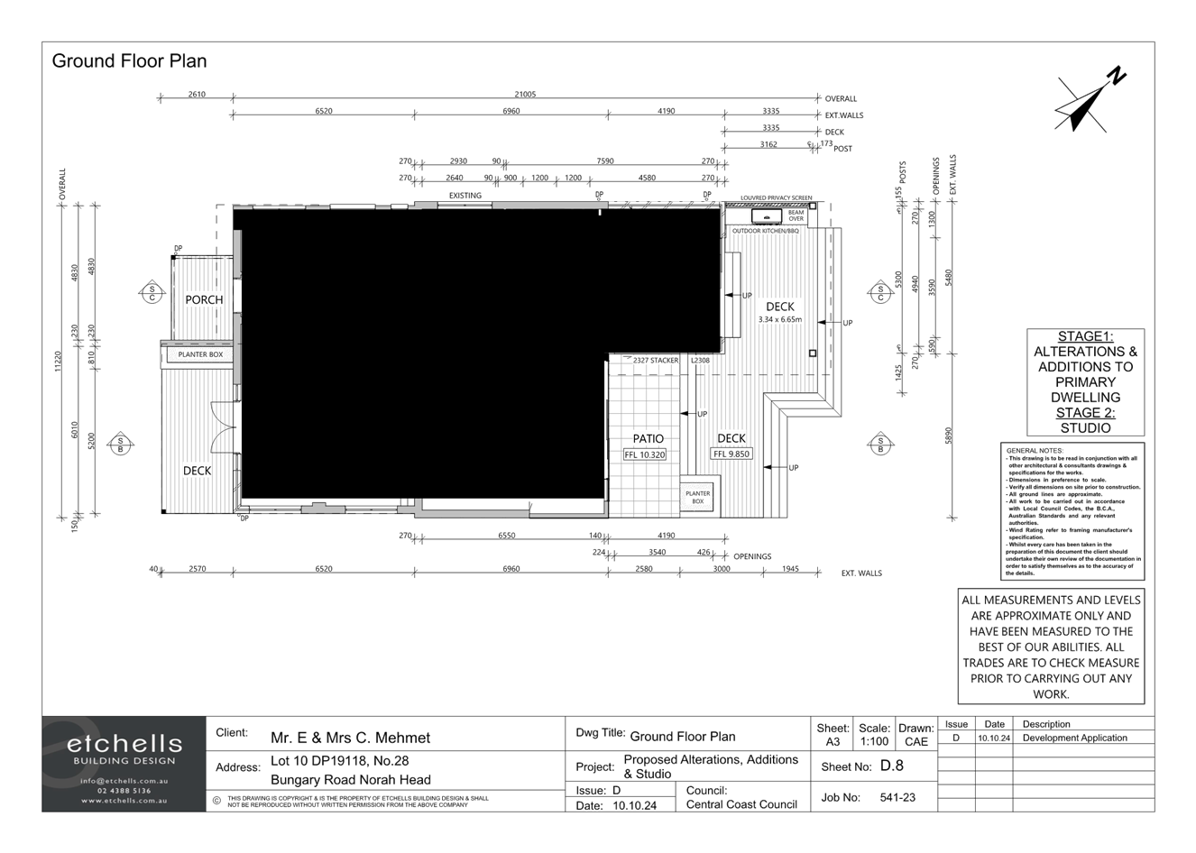
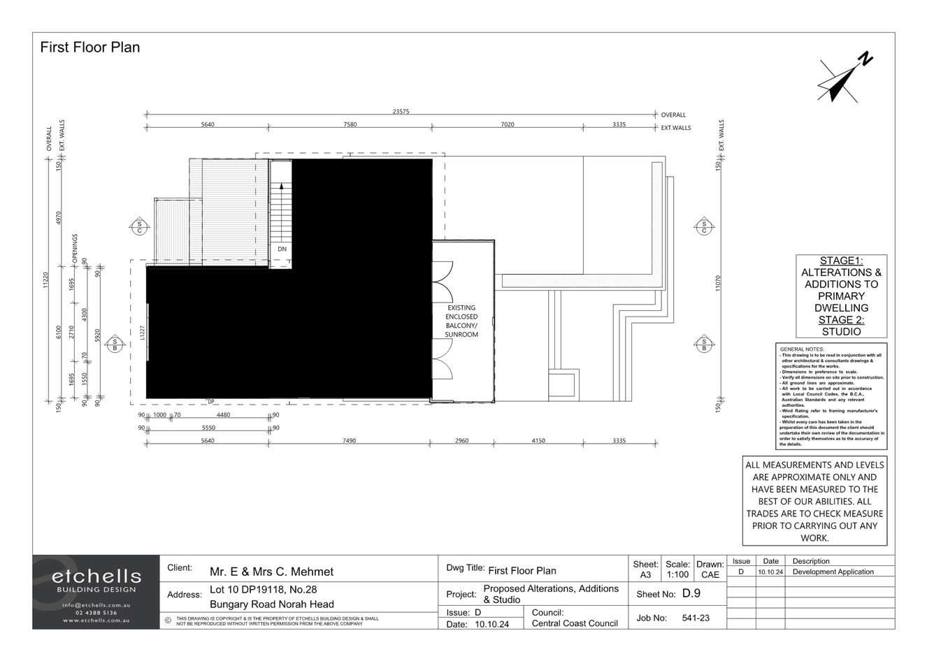
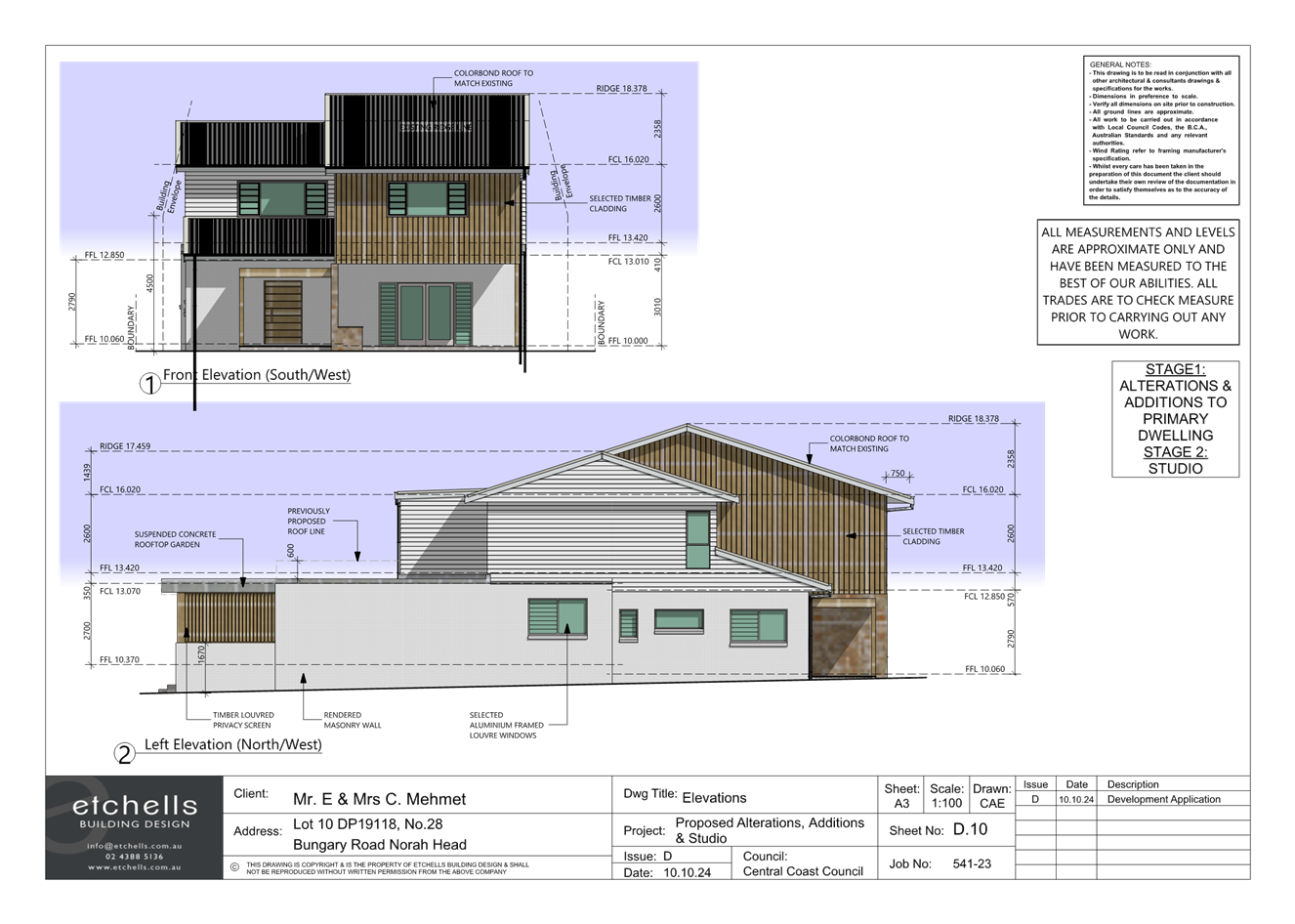
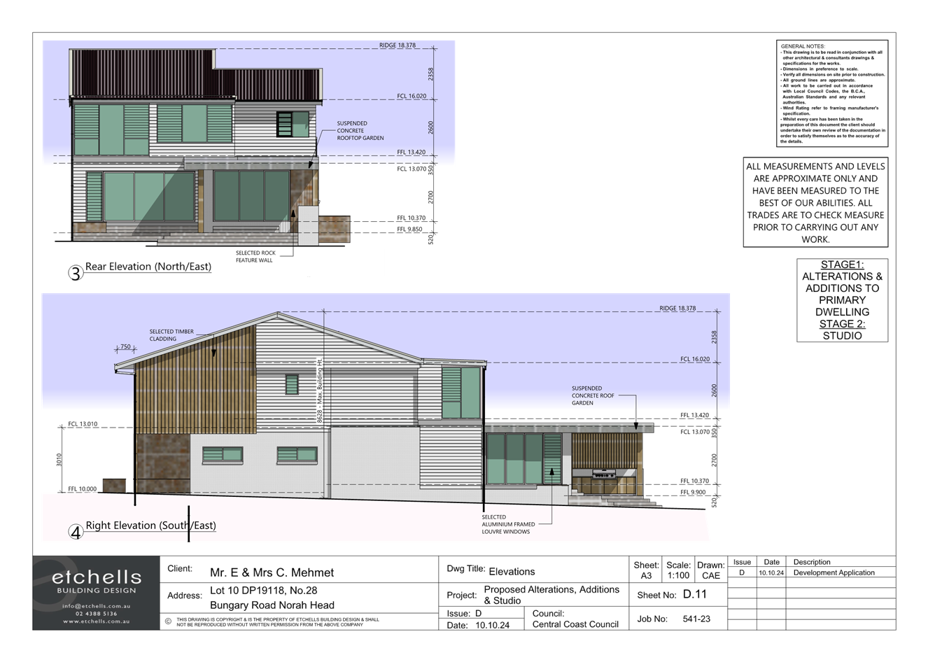
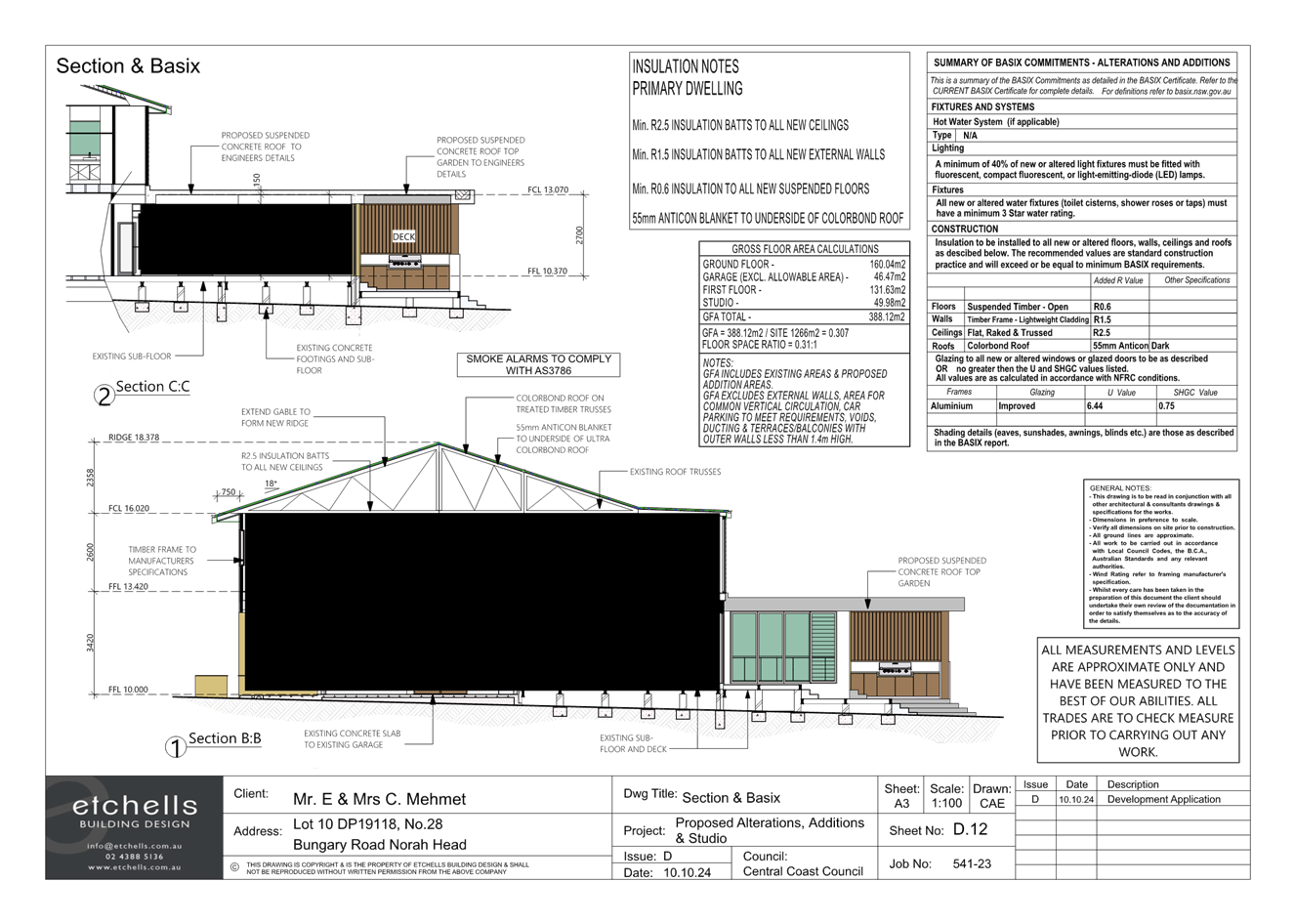
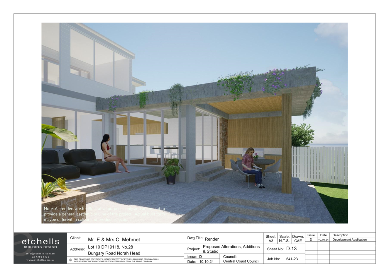
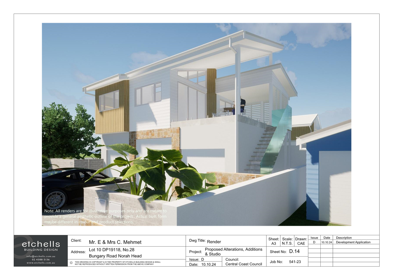
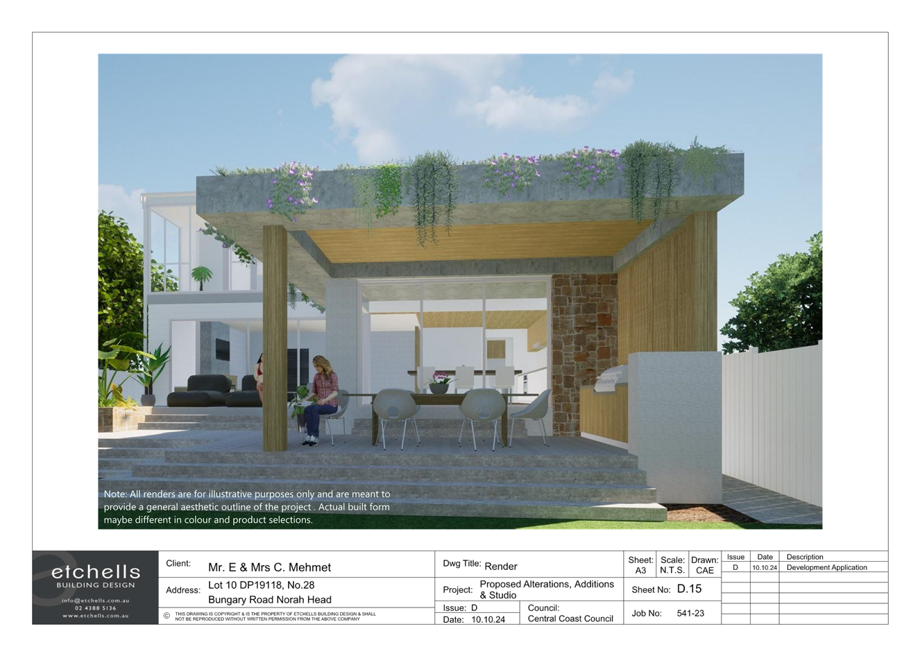
|
Item No: 4.1 |
|
|
Title: Request to amend Central Coast Local Environmental Plan to allow rezoning at 30 and 32 Caroline St and 2A Melbourne St, East Gosford |
|
|
Department: Environment and Planning |
|
|
10 April 2025 Local Planning Panel Meeting |
|
Reference: RZ/4/2024 - D16732699
Author: Chelle Leith, Senior Strategic Planner
Alexander Batten, Strategic Planner
Manager: Scott Duncan, Section Manager Local Planning and Policy
Executive: Jamie Loader, Director Environment and Planning
That the Local Planning Panel review the Planning Proposal and provide their advice in preparation for reporting this matter to Council.
Summary
This report relates to a request to prepare a Planning Proposal for 30 (Lot 2, DP518926) and 32 (Lot 1, DP996521) Caroline St and 2A (Lot 1, DP518926) Melbourne St, East Gosford which will be considered by Council. This request is referred to the Local Planning Panel (LPP) for advice prior to the reporting of the matter to Council’s Environment and Planning Standing Committee.
The request seeks to prepare a Planning Proposal to rezone Lot 1 DP 996521 – 32 Caroline Street, Lot 2 DP 518926 – 30 Caroline Street and Lot 1 DP 518926 – 2A Melbourne Street, East Gosford from R2 Low Density Residential to R1 General Residential. It is also proposed to amend Central Coast Local Environmental Plan 2022 (CCLEP) to apply the Floor Space Ratio of 0:5:1 and include the land in Area 1 on the Floor Space Ratio Additional Controls Map.
Please refer to Attachment 1 (Draft Planning Proposal) “Draft Planning Proposal for Caroline and Melbourne Street, East Gosford”, to review and comment on the Planning Proposal in satisfaction of Ministerial Direction s.9.1, so that the Local Planning Panel comments may be included as an attachment to the Council report on 27 May 2025.
If the Council decision is to forward the Planning Proposal for a Gateway Determination, then the Panel’s advice shall also be forwarded to the Minister.
|
1⇩ |
Finalised Planning Proposal for Caroline and Melbourne Streets East Gosford |
|
D16728229 |