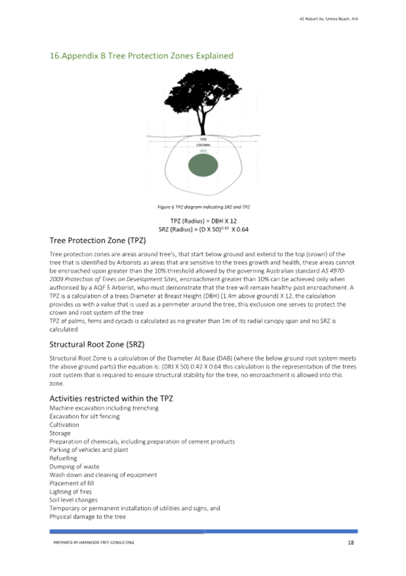
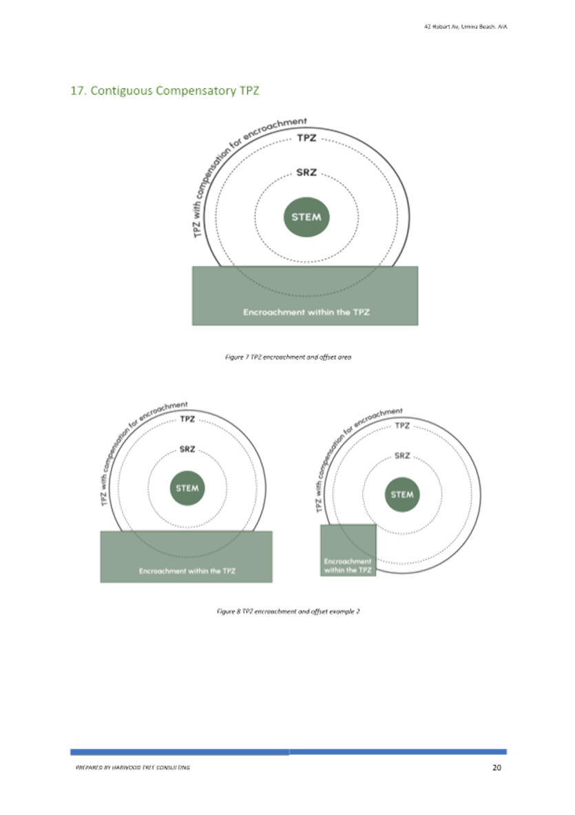
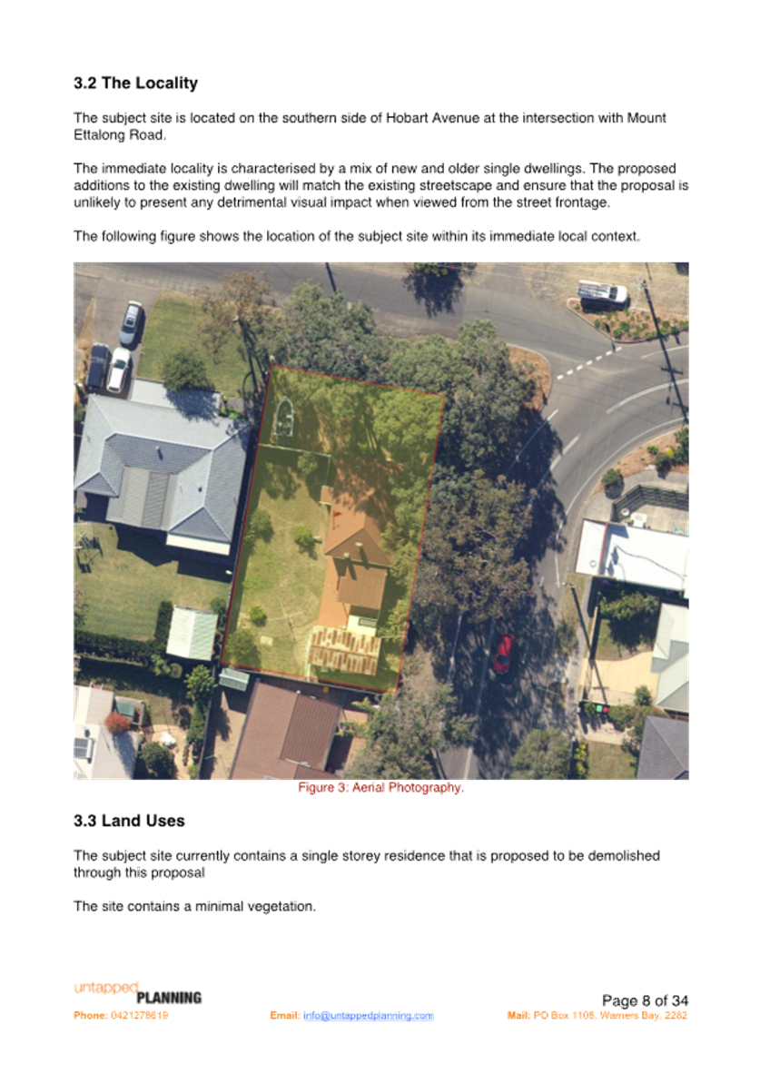
 |
Central Coast
Local Planning Panel Meeting
Business Paper
15 May 2025
 |
|
Central Coast
Local Planning Panel Meeting
Business Paper
15 May 2025
|
The Local Planning Panel Meeting
of Central Coast
will be held remotely - online,
Thursday 15 May 2025 at 12.00 pm,
for the transaction of the business listed below:
1 Procedural Items
1.1 Disclosures of Interest........................................................................................ 3
2 Confirmation of Minutes of Previous Meetings
2.1 Confirmation of Minutes of Previous Meeting............................................. 4
3 Planning Reports
3.1 DA/1627/2023 - 42 Hobart Avenue, Umina Beach - Dual Occupancy, two lot Torrens title subdivision and demolition....................................... 13
3.2 DA/1496/2024 - 203 Matcham Road, Matcham - 2 Lot Subdivision... 147
The Hon Terry Sheahan AO
Chairperson
|
Item No: 1.1 |
|
|
Title: Disclosures of Interest |
|
|
Department: Governance |
|
|
10 April 2025 Local Planning Panel Meeting |
|
Reference: F2020/02502 - D14205789
|
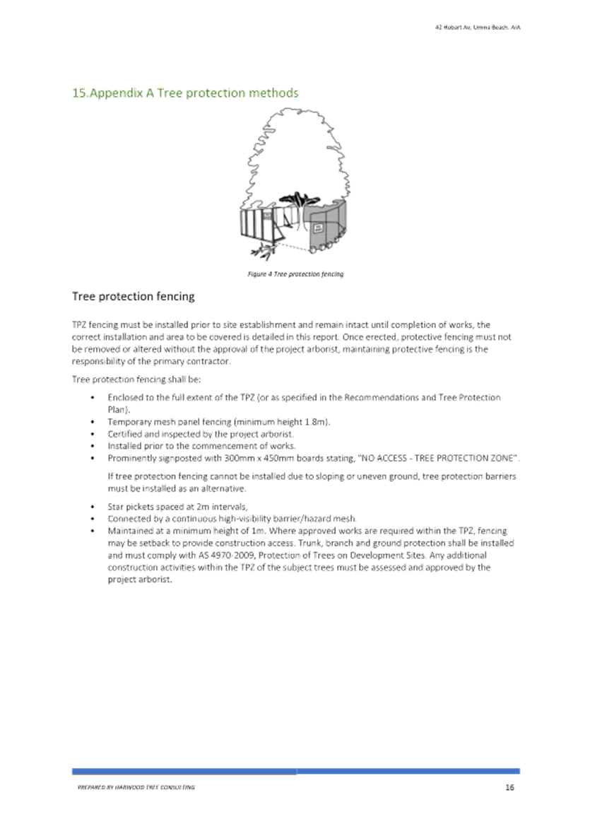
The NSW Local Planning Panel Code of Conduct states that all panel members must sign a declaration of interest in relation to each matter on the agenda before or at the beginning of each meeting.
|
That Panel Members now confirm that they have signed a declaration of interest in relation to each matter on the agenda for this meeting and will take any management measures identified.
|
Item No: 2.1 |
|
|
Title: Confirmation of Minutes of Previous Meeting |
|
|
Department: Corporate Services |
|
|
15 May 2025 Local Planning Panel Meeting |
|
Reference: F2020/02502 - D16783780
Author: Lisa Martin, Civic Support Officer Civic Support
|
Summary
The
Minutes of the following Meeting of the Local Planning Panel, which have been
endorsed by the Chair of that meeting, are submitted for noting: · Local Planning Panel Meeting held on 10 April 2025
|
That the minutes of the previous Local Planning Panel Meeting held on 10 March 2025, which were endorsed by the Chair of that meeting, are submitted for noting.
|
1⇩ |
MINUTES - Local Planning Panel - 10 April 2025 |
|
D16777908 |
|
2.1 |
Confirmation of Minutes of Previous Meeting |
|
Attachment 1 |
MINUTES - Local Planning Panel - 10 April 2025 |

|
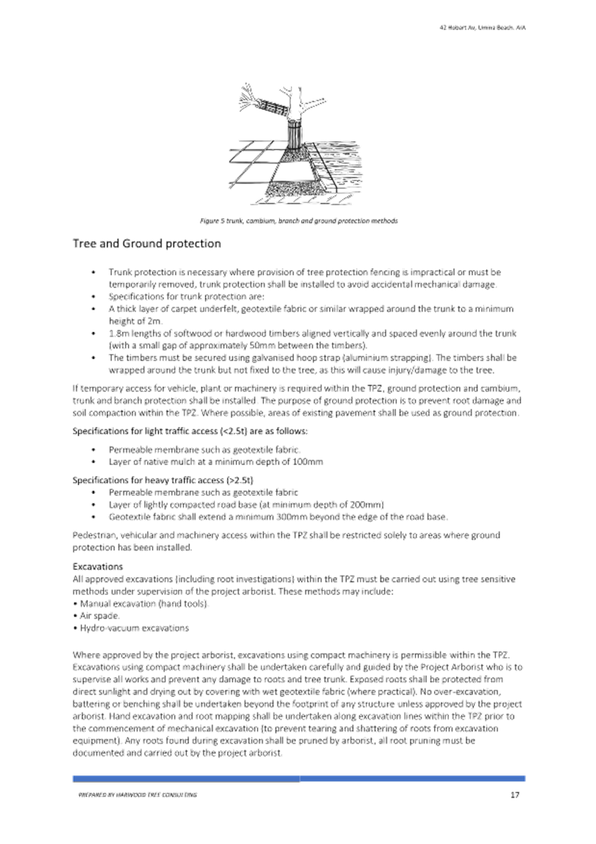
Item No: 3.1 |
|
|
Title: DA/1627/2023 - 42 Hobart Avenue, Umina Beach - Dual Occupancy, two lot Torrens title subdivision and demolition |
|
|
Department: Environment and Planning |
|
|
15 May 2025 Local Planning Panel Meeting |
|
Reference: DA/1627/2023 - D16690269
Author: Kate Alberry, Senior Development Planner
Section Manager: Ailsa Prendergast, Section Manager Residential Assessments
Unit Manager:: Andrew Roach, Unit Manager Development Assesments
|
Summary
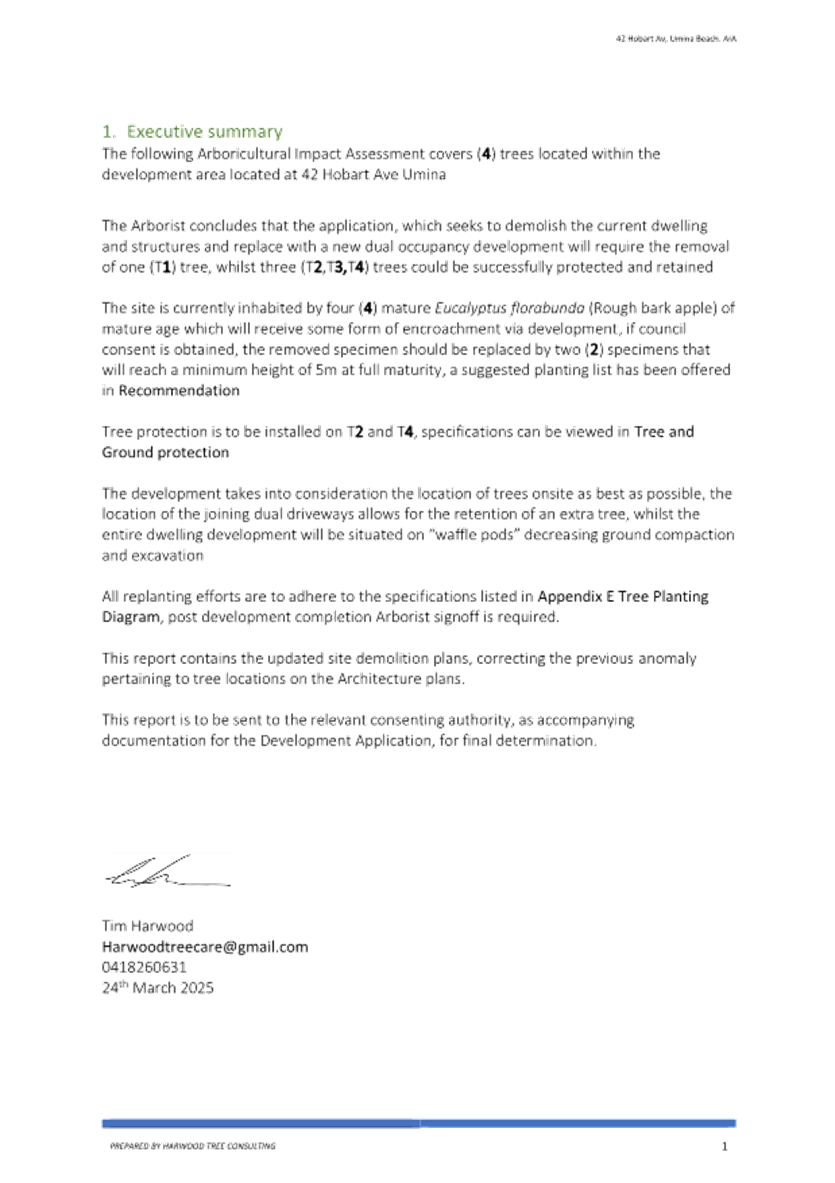
An application has been received for an attached dual occupancy, two lot torrens title subdivision and demolition. The application has been examined having regard to the matters for consideration detailed in section 4.15 of the Environmental Planning and Assessment Act 1979 and other statutory requirements with the issues requiring attention and consideration being addressed in the report.
The development application is required to be reported to the Local Planning Panel for determination as a result of the number of submissions. 22 submissions were received during the notification period.
The application is recommended for approval, subject to conditions.
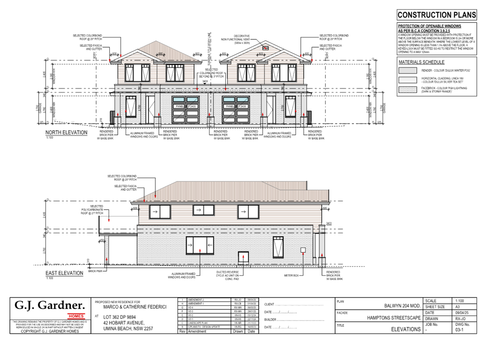
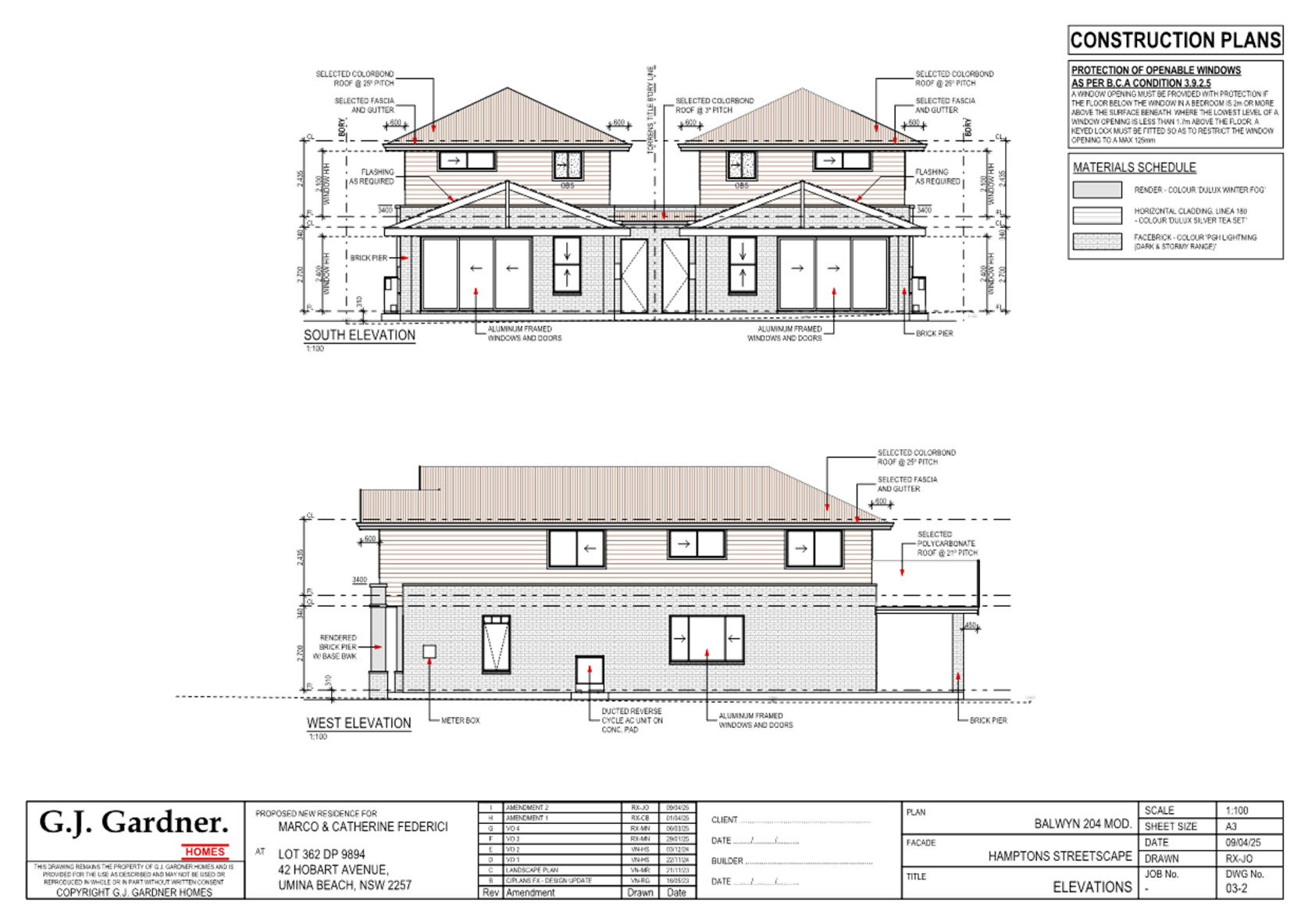
Applicant Untapped Planning Owner C & M Federici Application No DA/1627/2023 Description of Land 42 Hobart Avenue, Umina Beach Proposed Development Attached Dual Occupancy, two lot Torrens title subdivision and demolition. Site Area 651.2m2 Zoning R2 Low Density Residential Existing Use dwelling house Employment Generation No Estimated Value $1,127,261.30
|
Recommendation
1. That the Local Planning Panel grant consent to DA/1627/2023 – 42 Hobart Avenue, Umina Beach – for the purpose of a dual occupancy development, torrens title subdivision and demolition subject to the conditions detailed in the schedule attached to the report and having regard to the matters for consideration detailed in Section 4.15 of the Environmental Planning and Assessment Act 1979.
2. That Council advise those who made written submissions of the Panel’s decision.
· Matters raised in public submissions - the development application is required to be reported to the Local Planning Panel due to the development attracting twenty-two (22) submissions.
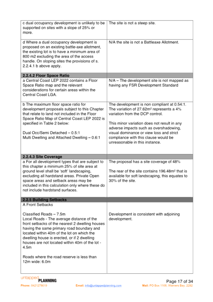
· The development proposes a 4% variation to Clause 2.2.4.2 Floor Space Ratio of the Central Coast Development Control Plan 2022 (CCDCP) from the required 0.5:1 for a Dual Occupancy, to 0.54:1.
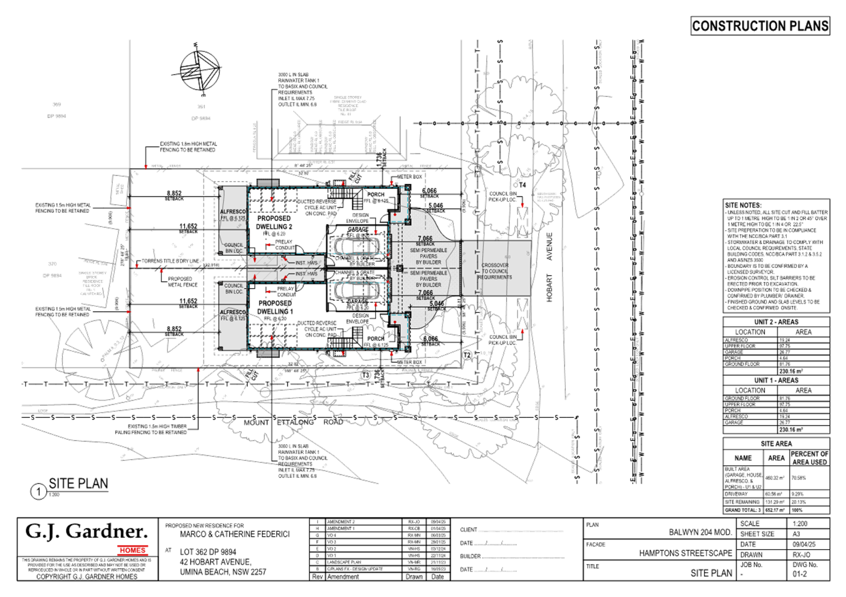
· The development requires a variation to clause 2.2.5(e) Building Setbacks of the CCDCP 2022, for a side setback of 1.736m to Mount Ettalong Road, this is a variation of 0.264m instead of the required 2m which represents a variation of 13.2%.
Precis:
|
Proposed Development |
Attached dual occupancy with two lot Torrens title subdivision.
|
|
Permissibility and Zoning |
The subject site is zoned R2 Low Density Residential under the provisions of the Central Coast Local Environmental plan 2022 (CCLEP 2022).
The existing development is defined as a ‘dwelling house’ which is defined under the CCLEP 2022 as:
Dwelling house means a building containing only one dwelling.
The proposed development is defined as a ‘dual occupancy’ which is defined under the CCLEP 2022 as:
Dual occupancy (attached) means 2 dwellings on one lot of land that are attached to each other but does not include a secondary dwelling.
|
|
Current Use |
Dwelling house
|
|
Integrated Development |
No
|
|
Submissions |
The development application was notified (in accordance with the CCLEP 2022 from 3rd November 2023 to 17th November 2023.
Twenty-two (22) submissions were received, 18 within the time frame and 4 late submissions. All submission have been considered as part of this report.
|
|
Clause |
Clause 4.4 Floor Space Ratio of the CCDCP 2022
|
|
Standard |
0.5:1
|
|
DCP |
CCDCP 2022
|
|
Departure basis |
0.54:1 (A variation of 27.62m2 or 4%)
|
|
Clause |
2.2.5(e) Building Setbacks of the CCDCP 2022
|
|
Standard |
e. Corner Allotments Side Street – Dual Occupancy i. 2.0m, plus compliance with sight preservation lines
|
|
DCP |
CCDCP 2022
|
|
Departure basis |
The development has a side setback of 1.736m to Mount Ettalong Road, this is a variation of 0.264m instead of the required 2m. Sight lines comply due to the road reserve and corner alignment. This represents a variation of 13.2%.
|
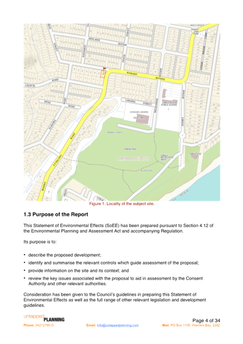
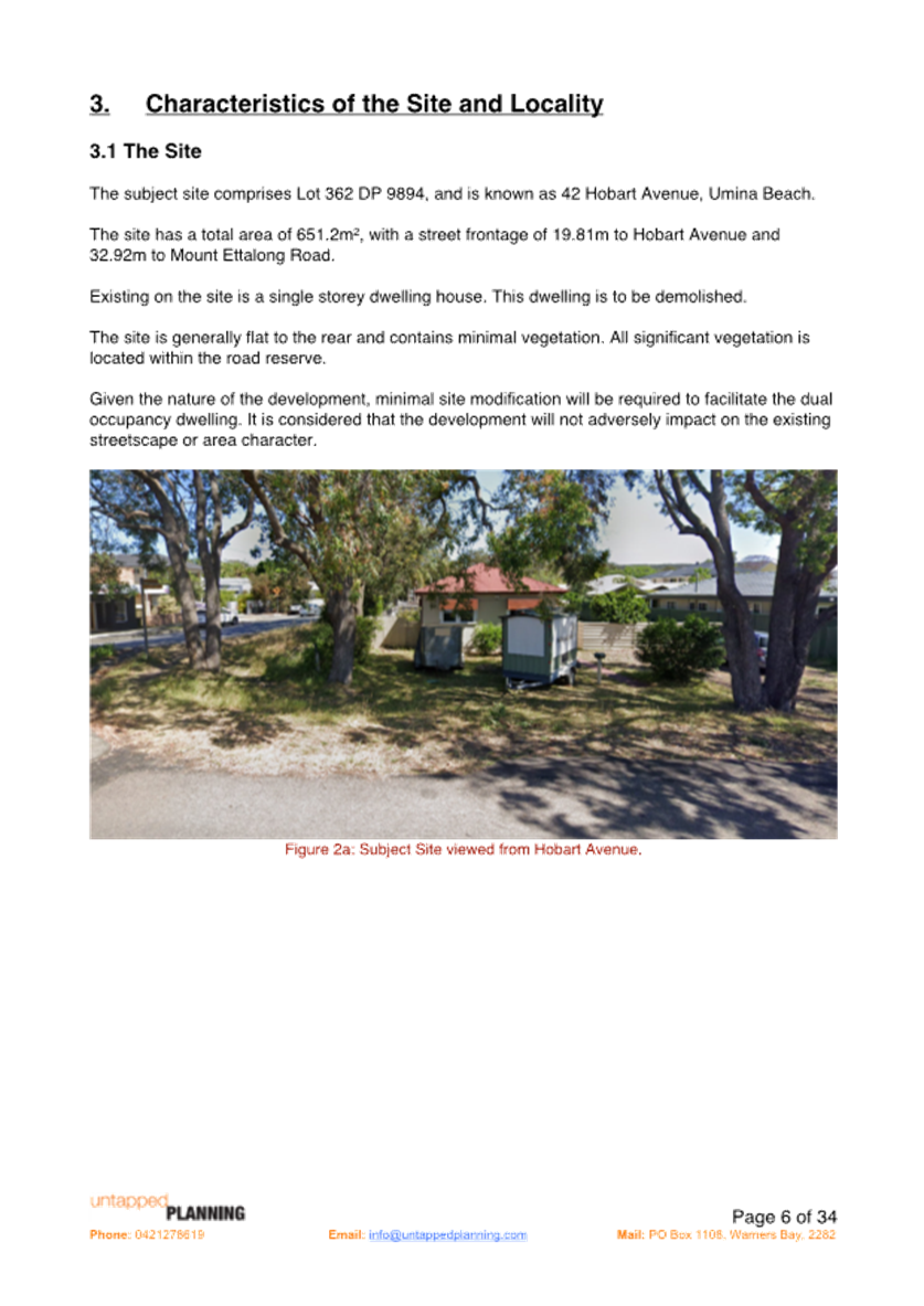
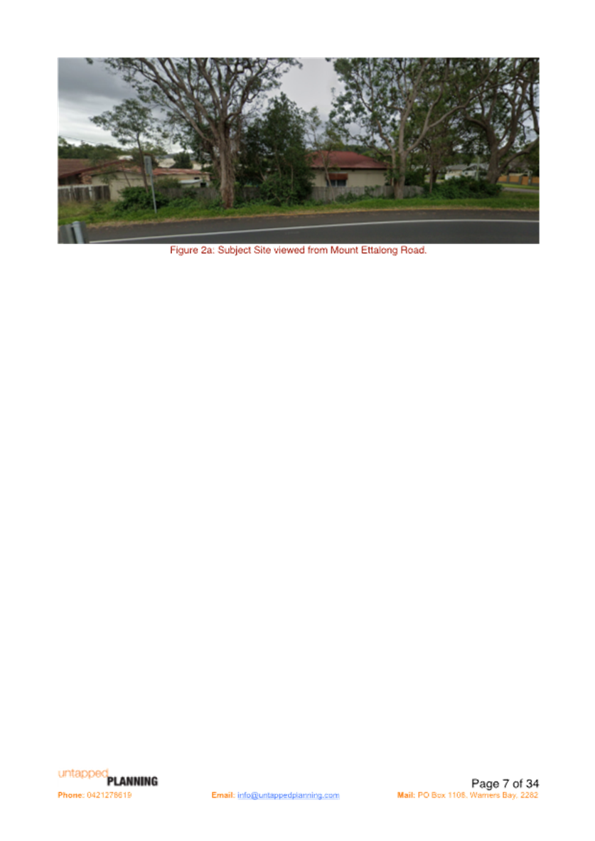
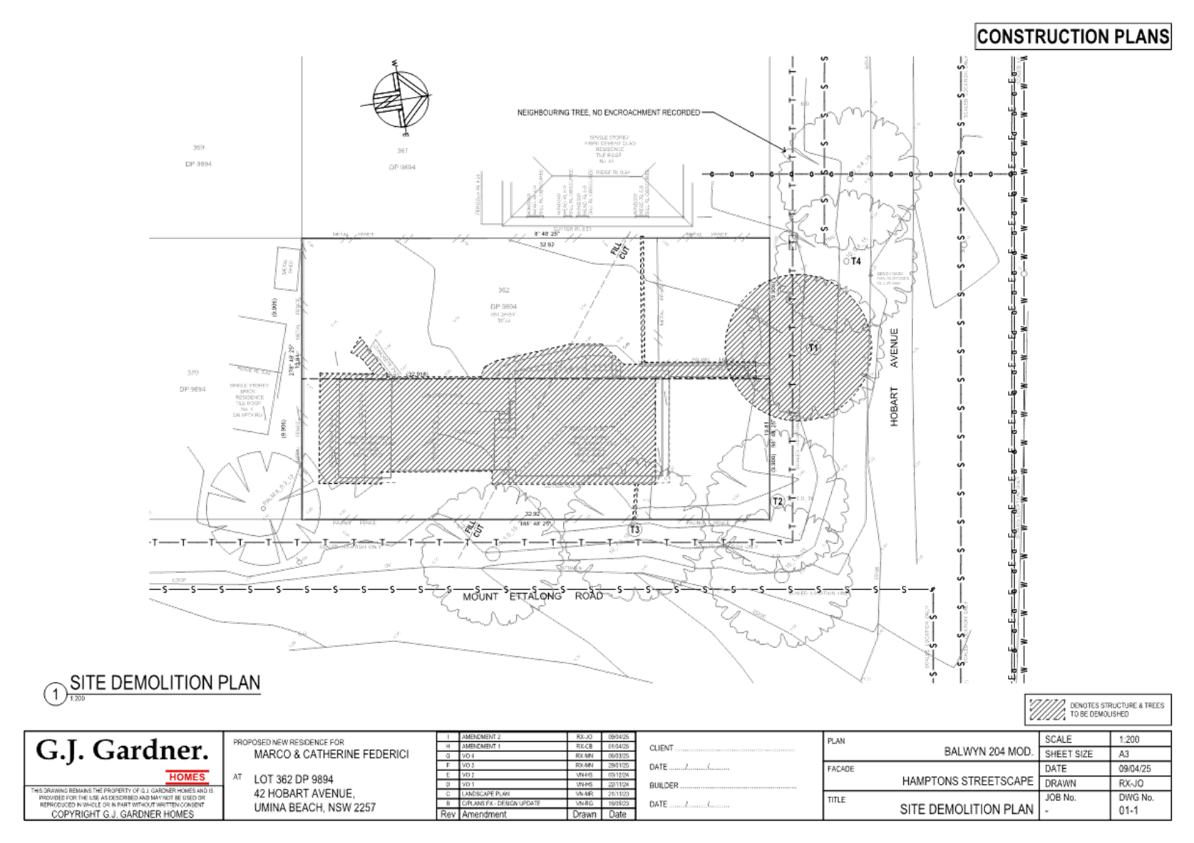
The site is legally described as Lot 362 DP9894 and is commonly known as 42 Hobart Avenue, Umina Beach. The site area is 651.2m2 by title with a street frontage to Hobart Avenue of 19.81m and side boundary of 32.92m to Mount Ettalong Road.
The site contains and existing residential dwelling. The area is surrounded by residential lots also zoned R2 Low Density residential which is predominantly single storey dwelling development. Development in this area is interspersed with newer style developments including dual occupancy development and 2 storey dwellings.
Adjacent and on the eastern side of Mount Ettalong Road is an area of R1 General Residential land.
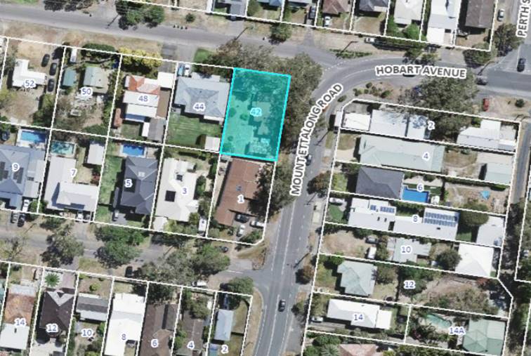
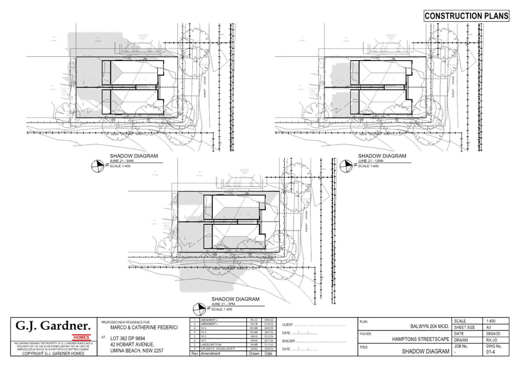
Figure 1 - Site Locality Plan
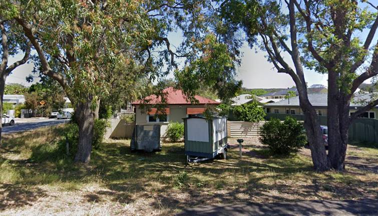
Figure 2 - Proposed Development Site viewed from Hobart Avenue
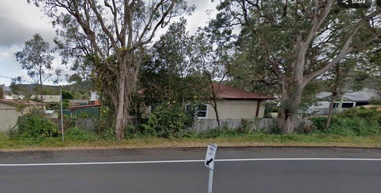
Figure 3 – Proposed Development site viewed from Mount Ettalong Road
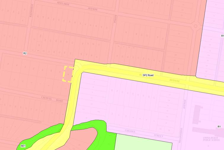
Figure 4 - Zone Pattern
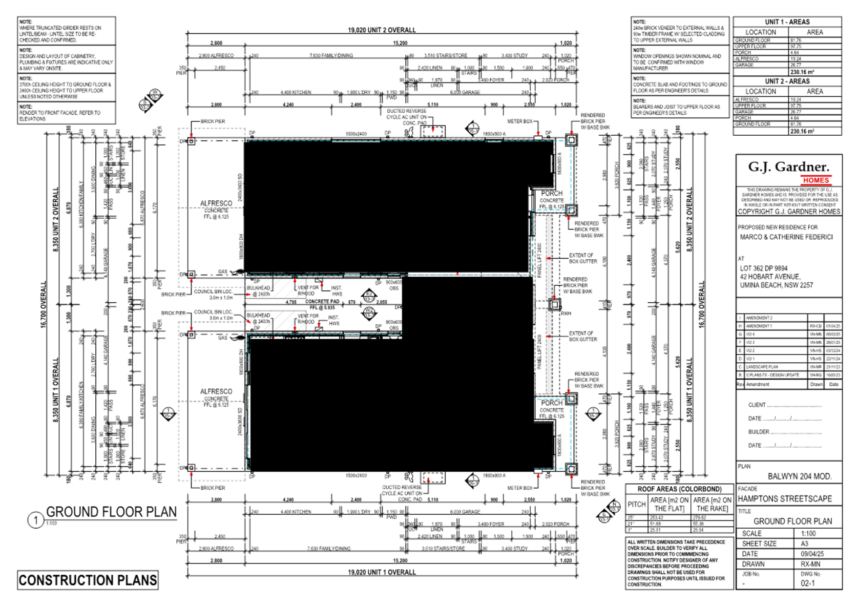
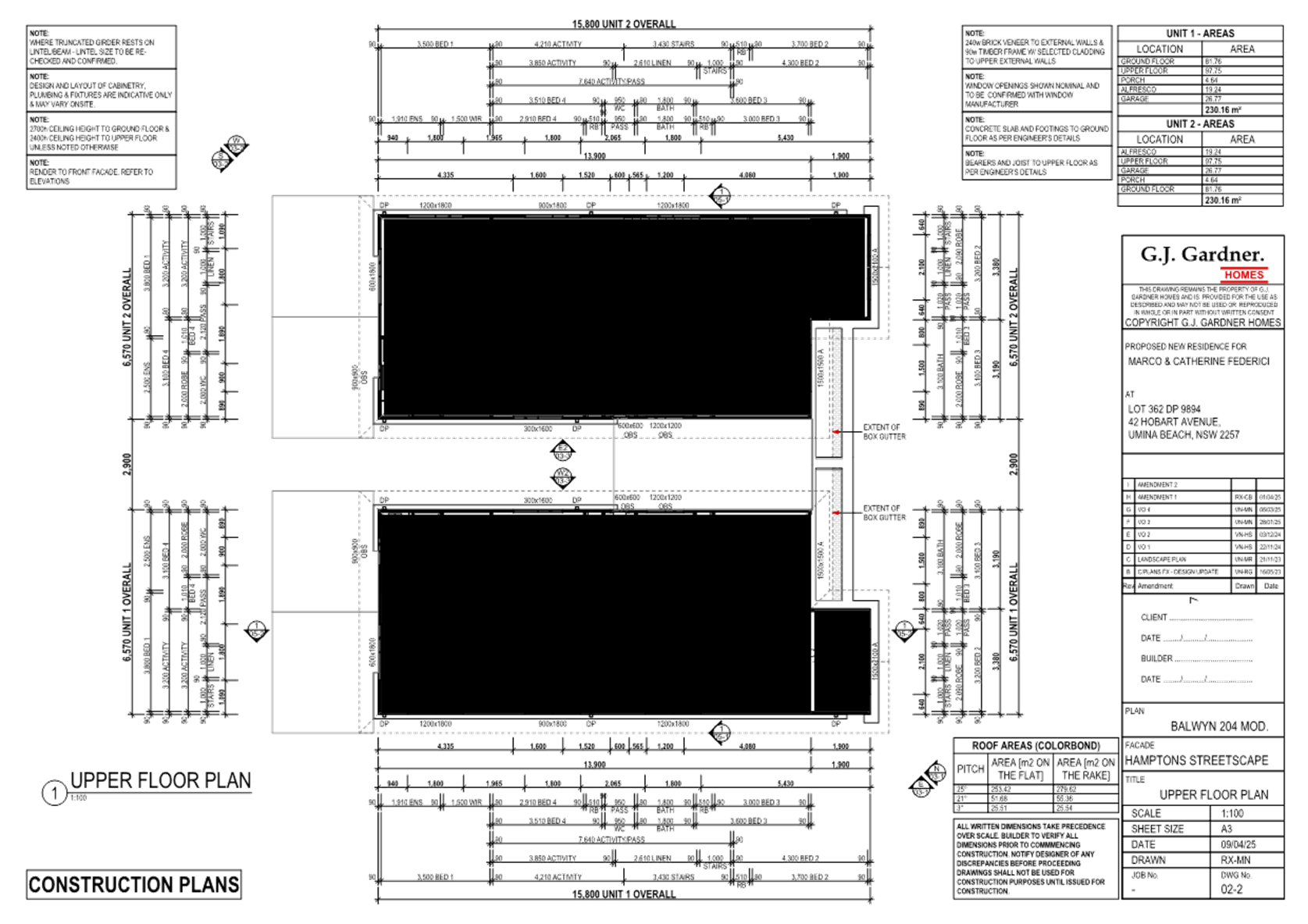
The Proposed Development
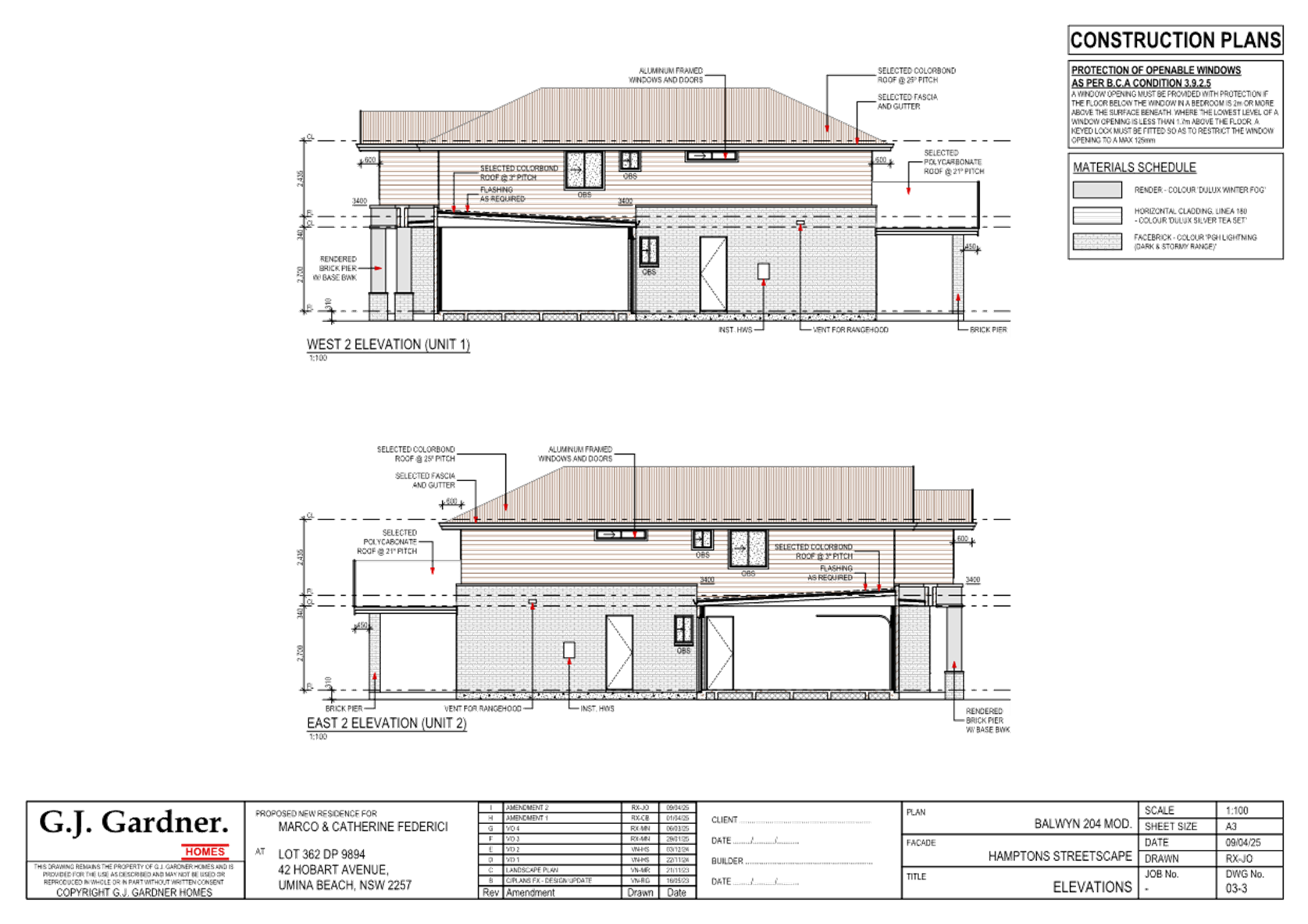
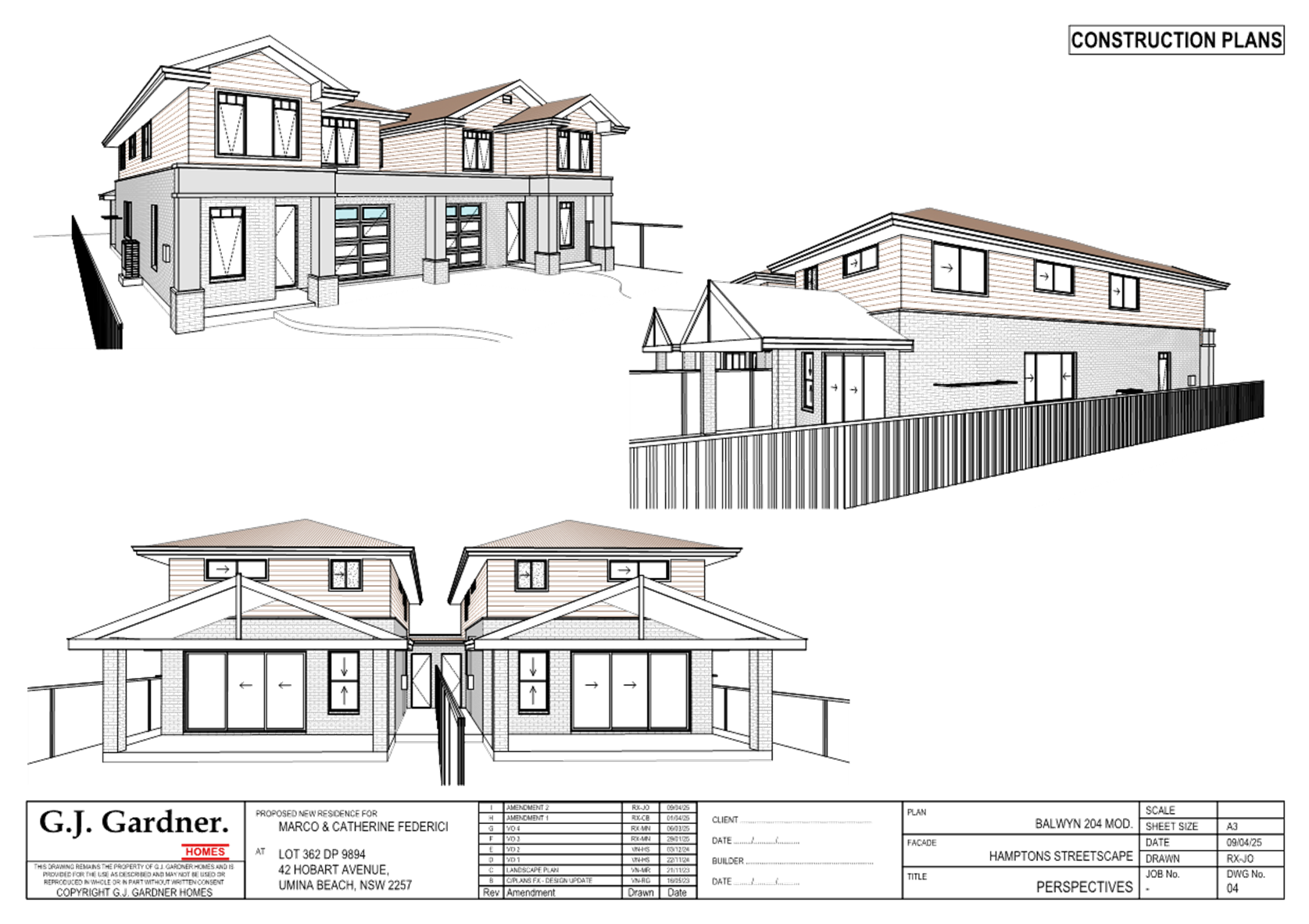
The proposed development seeks consent for the construction of a dual occupancy development and a 2 lot Torrens title subdivision.
The dual occupancy relates specifically:
Ground floor
· Garage
· Study
· Dining/family/kitchen
· Laundry
· Bathroom
First floor
· 4 x bedrooms
· Activity room
· Toilet
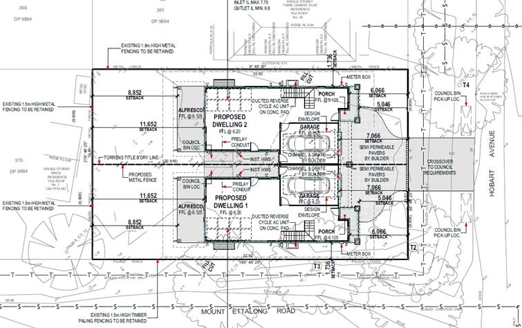
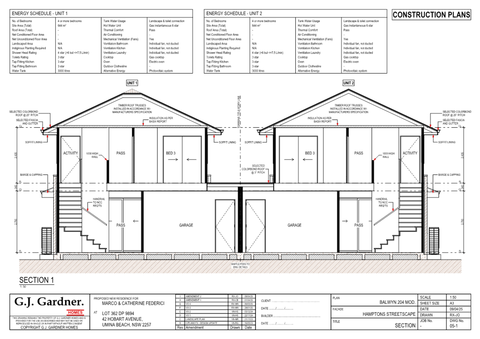
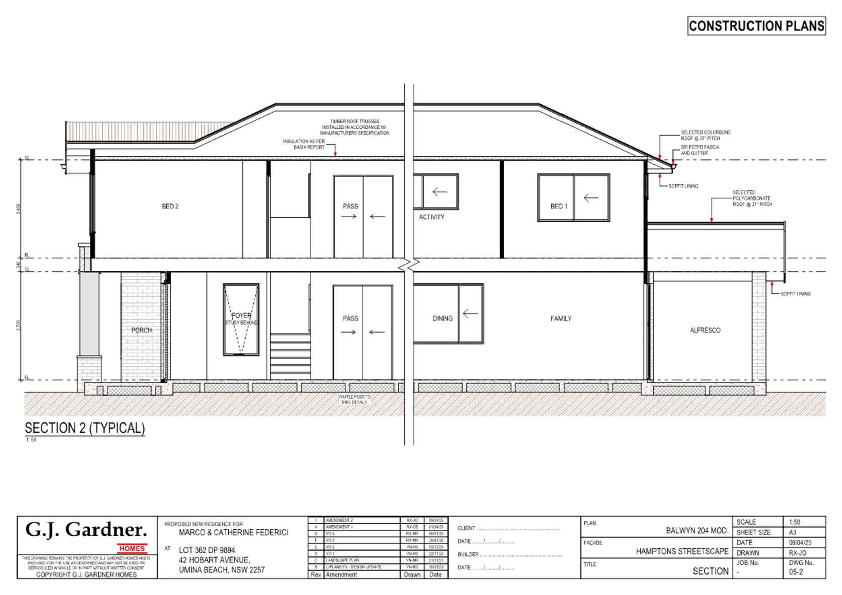
Figure 5 - Site plan
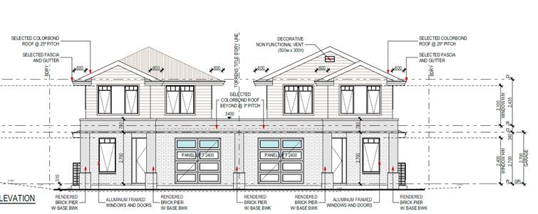
Figure 6 - front elevation
History
The dwelling and subdivision pattern existed prior to the 1970’s, it might be worth noting that the pattern of vegetation removal is not new in this area.
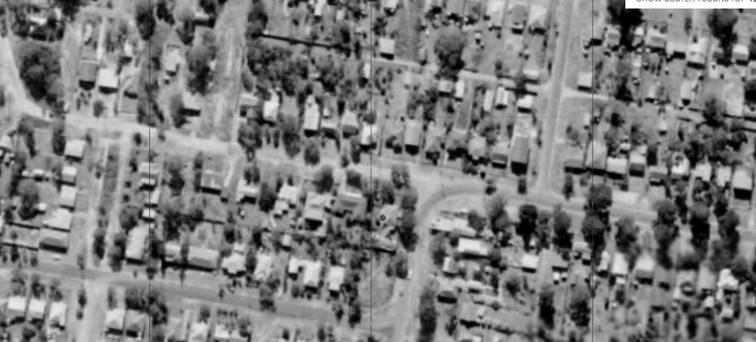
Figure 7 - Historical Imagery 1971 - Spatial Services
ASSESSMENT:
Having regard for the matters for consideration detailed in Section 4.15 of the Environmental Planning and Assessment Act 1979 and other statutory requirements, the assessment has identified the following key issues, which are elaborated upon for the consideration of the Local Planning Panel.
State Environmental Planning Policy (Building Sustainability Index) BASIX 2004
A compliant BASIX certificate achieving the NSW Government’s Energy Efficiency targets has been provided in support of the application. The proposal is consistent with the requirements of State Environmental Planning Policy (Building Sustainability Index: BASIX) 2004.
The Panel can be satisfied that the proposed development satisfies the relevant provisions of SEPP (BASIX) 2004, subject to recommended conditions.
State Environmental Planning Policy (Resilience and Hazards) 2021
The relevant provisions of the SEPP are addressed as follows:
The aims of Chapter 2 are to be considered when determining an application within the Coastal Management Areas. The Coastal Management Areas are areas defined on maps issued by the NSW Department of Planning and Environment and the subject property falls within the ‘Coastal Environment Area’ and ‘Coastal Use Area’ identified on these maps.
In considering the impact of any development application, the consent authority must have regard to matters within clause 2.10 of the SEPP (for the coastal environment area) and clause 2.11 (for the coastal use area).
The relevant matters have been considered in the assessment of this application. The proposed development is not likely to cause undue impact on the biophysical, hydrological or ecological environment. The values of the natural coastal processes are not likely to be impacted, marine vegetation and fauna habitats will not be disturbed by the proposal and the proposal does not impact on known aboriginal cultural heritage, the surf zone, or existing public spaces. The proposed development will not result in adverse impact on rock shelves, overshadowing, loss of views from public places nor visual amenity.
The Panel can be satisfied that the relevant matters of clause 2.10 for development within the coastal environment and use area and clause 2.11 for development within the Coastal Environment Area have been considered in the assessment of this application. The application is considered consistent with the stated aims and objectives.
Chapter 4 Remediation of Land
Clause 4.6 of Chapter 4 requires that a consent authority must not consent to the carrying out of any development on land unless it has considered whether the land is contaminated. The current use of the site is residential purposes, and there are no known previous uses that would lead to the site being contaminated or unsuitable for the proposed use.
It is noted that a condition of consent has been imposed to deal with the presence of asbestos, if required, due to the age of the existing dwelling which is proposed to be demolished.
The Panel can be satisfied that the proposed development is acceptable with regard to Chapter 4 of the SEPP.
Central Coast Local Environmental Plan 2022 (CCLEP 2022)
dual occupancy (attached) means 2 dwellings on one lot of land that are attached to each other but does not include a secondary dwelling.
Note—
Dual occupancies (attached) are a type of dual occupancy—see the definition of that term in this Dictionary.
The development is permissible in the zone, with development consent.
Central Coast Local Environmental Plan 2022 (CCLEP2022) – Zone Objectives
The land is zoned R2 Low Density Residential under the provisions of the CCLEP 2022.
The objectives for the R2 zone are:
• To provide for the housing needs of the community within a low-density residential environment.
• To enable other land uses that provide facilities or services to meet the day to day needs of residents.
• To encourage best practice in the design of low-density residential development.
• To ensure that non-residential land uses do not adversely affect residential amenity or place demands on services.
• To maintain and enhance the residential amenity and character of the surrounding area.
Following a detailed assessment of the proposed development and it is considered that the proposal is consistent with the stated objectives of the zone, providing housing consistent with the character of the area and does not have adverse impacts on the locality.
Central Coast Local Environmental Plan 2022 – Principal Development Standards
The proposal has been assessed in accordance with the relevant development standards of CCLEP 2022:
|
Development Standard |
Required |
Proposed |
Compliance with Controls |
Variation % |
Compliance with Objectives |
|
Clause 4.1C Minimum lot sizes for dual occupancies |
550m2 |
651.2m2 |
Yes |
Nil |
Yes |
|
Clause 4.3 Height of Buildings |
8.5m |
7.6m |
Yes |
Nil |
Yes |
|
Clause 4.4 Floor Space Ratio |
Not Mapped |
|
|
|
|
|
Clause 7.1 Acid Sulfate Soils |
|
Class 4 No construction more than 2m below the natural ground surface |
Yes |
Nil |
Yes |
Clause 4.4 Floor Space Ratio
Clause 4.4(2) Floor Space Ratio (FSR) of Central Coast Local Environmental Plan 2022 provides the maximum floor space ratio for a building on any land. There is no floor space ratio applying to the site under the Central Coast Local Environmental Plan 2022 (CCLEP 2022).
Notwithstanding this, the proposed development has satisfactory density, bulk and scale which integrates with the streetscape and character of the area and is comparable to contemporary buildings in the area.
Clause 7.1 Acid sulfate soils
This land has been identified as being affected by the Acid Sulfate Soils Map and the matters contained in clause 7.1 of CCLEP 2022 have been considered. The site contains Class 4 Acid Sulfate Soils (ASS) which are likely to occur where:
· Works more than 2 metres below the natural ground surface.
· Works by which the watertable is likely to be lowered more than 2m below the natural ground surface.
A Geotechnical Assessment prepared by Ideal Geotech, dated 23 December 2022 was provided with the application. The purpose of the investigation was to provide an assessment of site classification, risk of overall instability and related geotechnical advice, consideration of relevant Council controls. It is noted that the presence of acid sulfate soils was not identified as part of this report. The Statement of Environmental Effects states that no works are more than 2m below the natural ground surface and therefore, a condition of development consent relating to the discovery of acid sulfate soils is included with the conditions of consent.
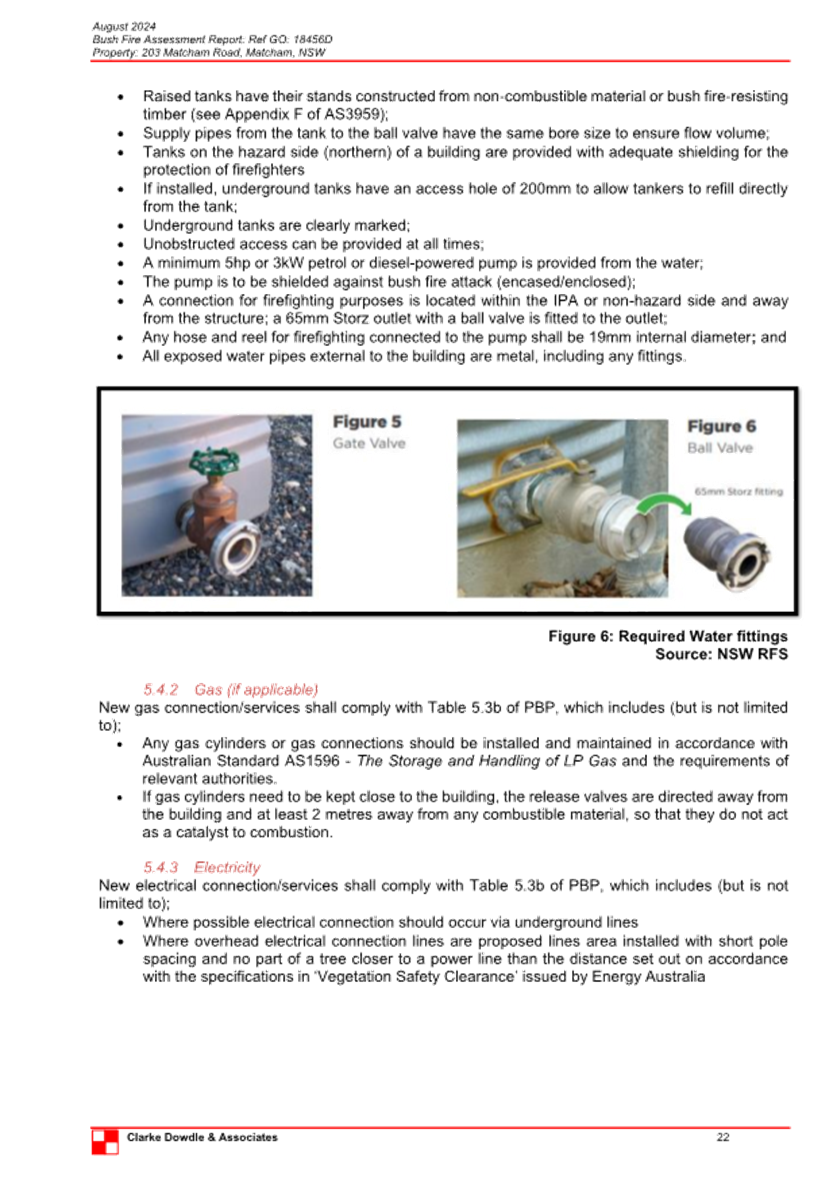
Clause 7.6 Essential Services
Development consent must not be granted to development unless the consent authority is satisfied that all of the following services that are essential for the development are available or that adequate arrangements have been made to make them available when required—
(a) the supply of water,
(b) the supply of electricity,
(c) the disposal and management of sewage,
(d) stormwater drainage or on-site conservation,
(e) suitable vehicular access,
(f) the collection and management of waste.
The property is currently connected to electricity, reticulated water and sewer and serviced for waste collection and is therefore available to the proposed new dwelling house.
Water and Sewer is available to the land. A Section 307 certificate of compliance under the Water Management Act 2000 is required to be obtained prior to the occupation of the building.
Satisfactory details have been provided in the Waste Management Plan for waste management procedures associated with the construction, and ongoing operation of the proposed development.
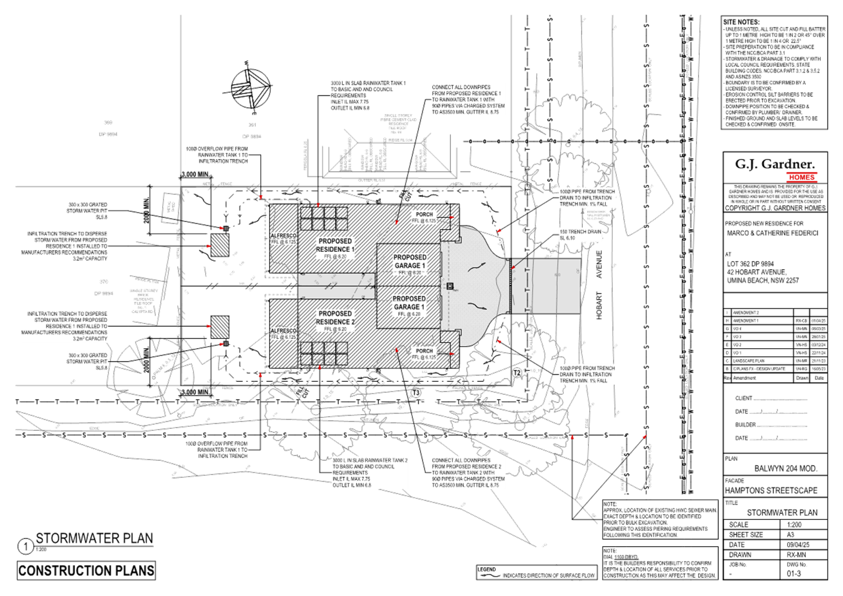
Satisfactory stormwater drainage can be obtained in accordance with the Stormwater Plans and there is adequate area for vehicle access from Hobart Avenue.
The Panel can be satisfied that the proposed development complies with the provisions of clause 7.6 and that adequate essential servicing is available to the development having regard for water, sewer, electricity, stormwater drainage, waste collection and vehicular access.
Central Coast Development Control Plan 2022 (CCDCP)
The relevant controls of CCDCP 2022 are considered below:
Chapter 2.2 – Dual Occupancy and Multi Dwelling Housing
|
Required |
Proposed |
Compliance with Controls |
Compliance with Objectives |
|
|
2.2.3.1 a Building Height |
8.5m. |
7.6m |
Yes |
Yes |
|
2.2.3.1 c Building Height |
Building Height shall generally not exceed two storeys. |
2 storey |
Yes |
Yes |
|
Floor Space Ratio (FSR) |
FSR not mapped in LEP FSR Dual Occupancies – 0.5:1 (CCDCP) |
4% variation = 27.62m2 |
No 4% variation = 27.62m2 |
Yes |
|
2.2.4.3 Site Coverage |
25% of site area shall be ‘soft’ landscaping. |
Site coverage is 48% and is providing 30% soft landscaping. |
Yes |
Yes |
|
2.1.3.1 a (i) Front Setbacks |
Average distance of the 2 neighbouring properties. This is a corner block therefore 2.25a is used. Hobart Avenue is not a classified Road. |
6.066m is provided to the wall at the front of the site. |
Yes |
Yes |
|
2.2.5 a Front setback |
Road reserve < 12m |
Dwelling 1 – 6.066m Dwelling 2 – 6.066m |
Yes |
Yes |
|
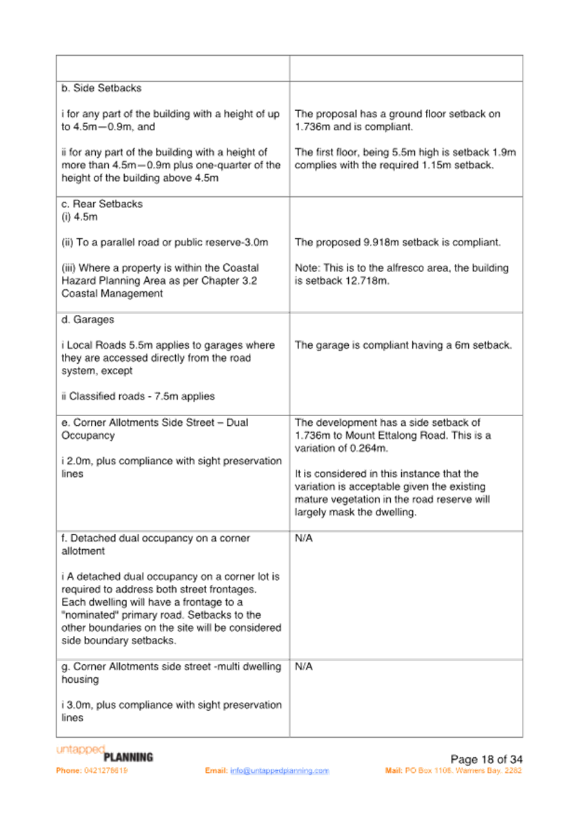
2.2.5 b Side Setbacks |
For any part of the building with a height of up to 4.5m—0.9m, and For any part of the building with a height of more than 4.5m—0.9m plus one-quarter of the height of the building above 4.5m.
Unbroken walls exceeding 10m in length and 3m in height |
Western side – ground floor - 1.736m
First floor - Eastern side 1.736m
7.6m-4.5m = 3/1m/4 = 0.775 +0.9m = 1.675m required first floor.
Both units have unbroken walls of 15.8m but the walls are only 2.7m in height and then articulation is provided |
Yes
|
Yes |
|
2.2.5 c Rear setbacks |
3m |
D1 – 11.652m D2 – 11.652m |
Yes |
Yes |
|
2.2.5.d Garages |
5.5m required setback to the garages. |
Garages: Dwelling 1 – 7.066m Dwelling 2 – 7.066m |
Yes |
Yes |
|
Corner allotments side street dual occupancy |
2m plus compliance with sight preservation toot he eastern side boundary to Mouth Ettalong Road. |
1.736m side setback provided to Mount Ettalong Road. This is a variation of 0.264m or 13.2%. Sight preservation is provided in the road reserve. Mount Ettalong Road is a classified Road. |
No
This is a variation of 0.264m or 13.2% to the eastern side boundary. The western side boundary is providing a 3.51% greater side setback than what is required. |
Yes |
|
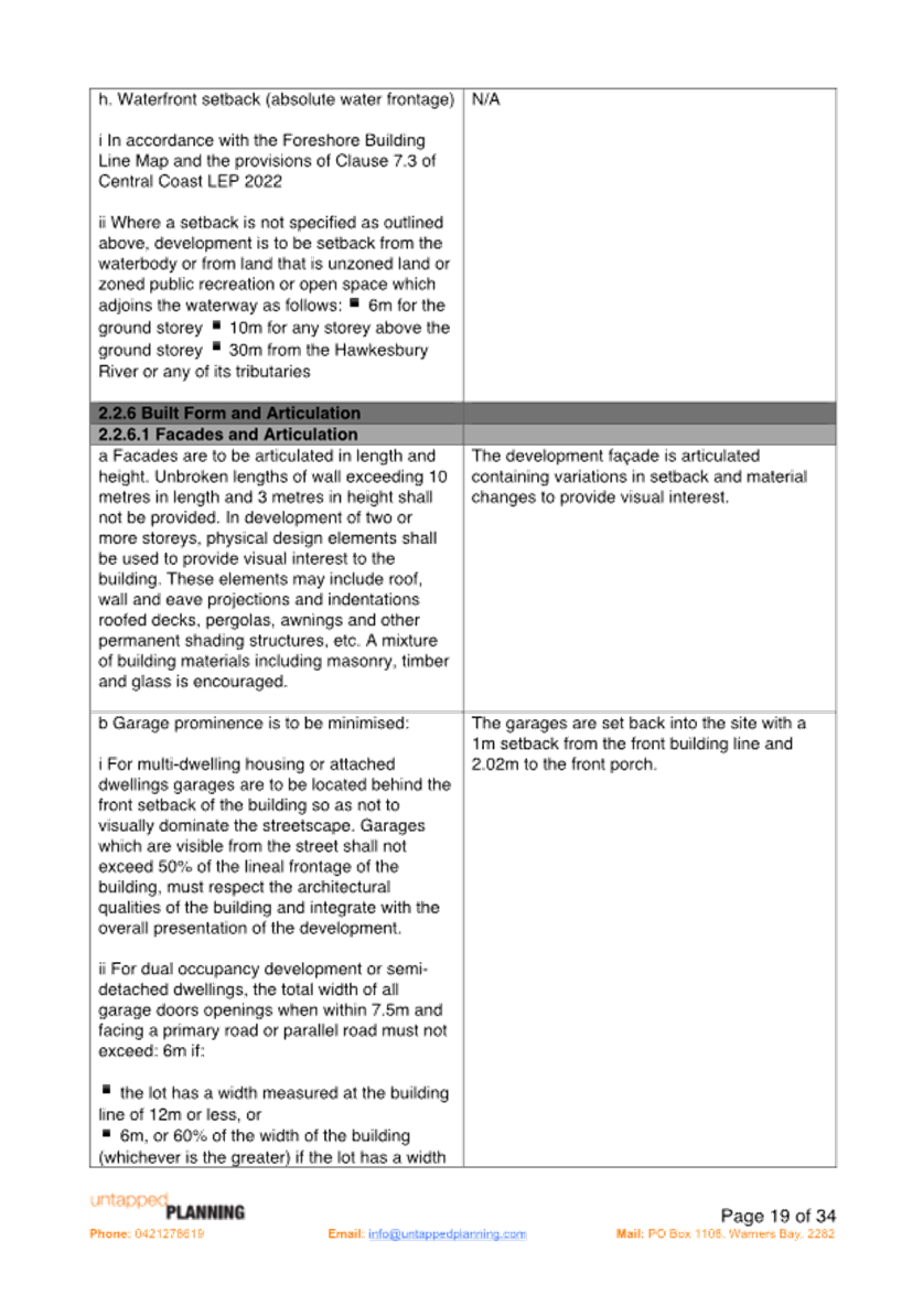
2.2.6.1 Facades & Articulation |
10 m in length and 3m in height articulation
Garages door width is 12m or < or 6m or 60% of the width of the building. |
Both units have unbroken walls of 15.8m but the walls are only 2.7m in height and then articulation is provided.
Garages are within 7.5m of the frontage.
Garage doors are 4.1m in width and the width of the dwelling/s is 8.3m.
49% of the building width.
|
Yes |
Yes |
|
2.2.6.2 Roof Elements |
Respond to solar access |
No roof top gardens are proposed, and the roof elements respond to solar access.
|
|
|
|
Residential Address |
Identification for visitors and emergency services and passive surveillance |
Both dwellings face the street and offer surveillance. |
Yes |
Yes |
|
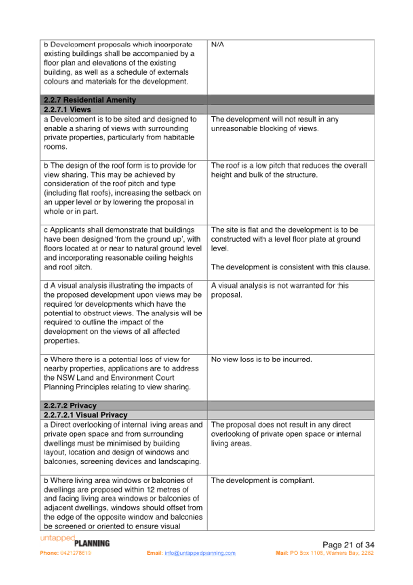
2.2.7.1 Views |
No view sharing |
|
Yes |
Yes |
|
2.2.7.2 Privacy
|
Direct overlooking of internal living area and private open space from surrounding dwellings must be minimised by building layout, location and design of windows and balconies, screening devices and landscaping. |
The proposal does not result in any direct overlooking of private open space or internal living areas.
Bedroom 4 on each dwelling has a window which faces the other bedroom 4 over the garage and as such this has an elevated sill high to prevent overlooking. |
Yes |
Yes |
|
2.2.7.2.2 Acoustic Privacy |
Site layout should separate active recreational, parking, access and service equipment from bedroom areas. |
The dwelling design will not result in any adverse acoustic impacts. |
Yes |
Yes |
|
2.2.7.2 Private Open Space |
Minimum area of 45m2 with minimum dimensions of 4.5m. |
Open space at the rear of the dwellings is 79m2 / dwelling which is not including the alfresco area. |
Yes |
Yes |
|
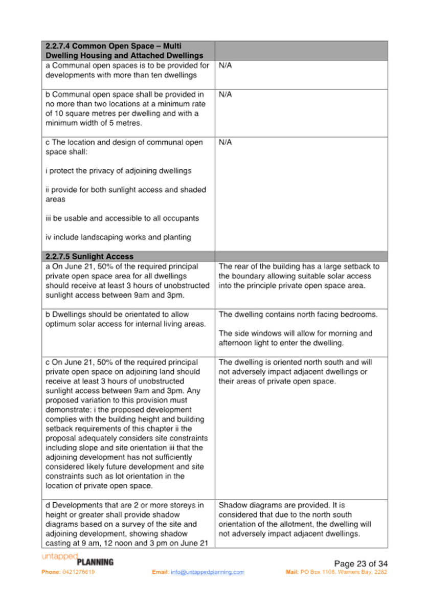
2.2.7.5 Sunlight Access |
50% of POS for all dwellings should receive at least 3 hours unobstructed sunlight access between 9am and 3pm |
Complies |
Yes |
Yes |
|
|
50% of POS on adjoining land should receive at least 3 hours unobstructed sunlight access between 9am and 3pm |
Complies |
Yes |
Yes |
|
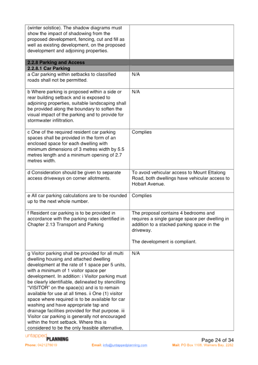
2.2.8 Car Parking |
Provide minimum off street parking facilities – 2 spaces for dwelling with 4 or more bedrooms.
Ensure safe vehicular access to public road. Driveway access does not detract from aesthetic qualities of the site. |
2 parking spaces have been provided. I garage and 1 stacked. |
Yes |
Yes |
|
2.2.8.2 Access design |
Driveways to be in accordance with Australian standards |
Driveways are compliant |
Yes |
Yes |
|
2.2.9 Earthworks |
Cut/fill maximum 1m within 1m of boundaries, or 3m if more than 3m from boundary |
Complies |
Yes |
Yes |
|
2.2.10 Landscaping |
Landscape |
No vegetation is to be removed from the development site. The proposal provides adequate space for shade trees and high levels of landscaping. |
Yes |
Yes |
|
2.2.10.2 Street trees |
Provide 2 street tree planting |
The development requires the removal of 1 existing street tree from the verge. The street trees are a cluster of remnant vegetation. It is noted that this is the only cluster of remnant vegetation in the immediate area. Council has recommended that no street planting occurs in the verge because of the amount of remnant vegetation. |
Yes |
Yes |
|
2.2.10.3 Deep Soil |
A Minimum 50% of landscaping shall be a deep soil zone. |
All landscaping provided is a deep soil zone. |
Yes |
Yes |
|
2.2.10.4 Fencing |
Maximum height of 1.8m for side and rear fencing |
Existing fencing to remain. |
Yes |
Yes |
|
2.2.11.1 Servicing |
Site shall be services |
Site already contains a dwelling and servicing can be achieved. |
Yes |
Yes |
|
2.2.11.3 Stormwater |
A stormwater management plan is to be submitted. |
Stormwater plan accompanies the application. |
Yes |
Yes |
|
2.2.11.4 Garbage and waste |
Waste management |
Bins are located in the space allocated adjacent to the garage on the internal boundary. |
Yes |
Yes |
|
2.2.11.5 Dual Occupancy Subdivision |
Applications for the subdivision of dual occupancy development must include: · Proposed plan of subdivision · Details of easements · Details of the location of any existing easements or services on the site. |
A Torrens Title subdivision plan has been included in the application. |
Yes |
Yes |
Central Coast Development Control Plan 2022 (CCDCP)
The proposed development proposes a variation to the maximum permitted floor space ratio set out under clause 2.1.2.3 Floor Space Ratio and clause 2.2.5 e Corner allotments side street - dual occupancy of CCDCP 2022.
Clause 2.2.4.2 Floor Space Ratio
2.2.4.2 Floor Space Ratio
OBJECTIVES
▪ To have development sites and densities that are appropriate in the zone and compatible with the local context
▪ To ensure building bulk and site coverage provisions are compatible with neighbouring development
▪ To ensure the intensity of the use of the site is appropriate
REQUIREMENTS
a. Central Coast LEP 2022 contains a Floor Space Ratio map and the relevant considerations for certain areas within the Central Coast LGA.
b. The maximum floor space ratio for development proposals subject to this Chapter that relate to land not included in the Floor Space Ratio Map of Central Coast LEP 2022 is specified in Table 2 below:
|
Form of Housing |
Floor Space Ratio (where not specified in the central coast LEP 2022) |
|
Dual Occupancy and semi-detached dwellings (except in rural or environmental living zones) |
0.5:1 |
|
Multi-dwelling housing and attached dwellings |
0.6:1 |
Table 2 - Floor Space Ratio requirements
Clause 2.2.4.2 provides the maximum Floor Space Ratio (FSR) required for a dual occupancy in this area is 0.5:1.
The variation sought is a departure of 0.04:1 (0.54:1) which equates to a 4% variation required to this control. Numerically it represents 27.62m2. It is noted that FSR is not mapped under the CCLEP 2022 for this area.
Clause 2.2.5e corner allotments side street – dual occupancy
2.2.5 Building Setbacks
OBJECTIVES
▪ To ensure that setbacks are compatible with adjacent development and complements the character, streetscape and natural areas
▪ To ensure the visual focus of a development is the dwelling, not the garage
▪ To ensure views, privacy and solar access of adjacent properties are reasonably maintained
▪ To reasonably maintain view corridors to coastal foreshores and other desirable outlooks
▪ To maintain the scenic and environmental qualities of natural waterbodies and their foreshores and respond to site attributes such as topography
▪ To provide deep soil areas sufficient to provide new landscaping
▪ To provide appropriate articulation of facades and horizontal elements reduce the appearance of bulk and provides visual interest to the building and subsequent streetscape where they face a street frontage/s
Clause 2.2.5.e provides for the minimum side setback on corner allotments for a dual occupancy is 2m plus compliance with site preservation.
The variation sought is for the provision of 1.736m side setback to Mount Ettalong Road which is a departure of 0.264m, or 13.2% for the required 2m. It is noted that the side setbacks provided are greater than what would normally be applied to a dual occupancy on a block that is not on a corner by 3.51%.
Comment:
The variations to the CCDCP 2022 will not result in any decrease in amenity to adjoining properties.
The minor variation to clause 2.2.5 e - Corner Allotments side street for dual occupancy development of the CCDCP, a total of 27.62m2 (to the eastern side boundary) less than the required 2m and a minor variation to clause 2.1.2.3 FSR of the CCDCP for the provision of a FSR of 0.54:1 instead of 05:1, will not have a material impact any of the following in terms of amenity:
· Overshadowing
· Privacy
· Visual dominance
· Streetscape and Character
· Views
The cumulative impact of the proposed minor non-compliances of side setback and FSR has been considered.
The surrounding area is undergoing a transition whereby older style existing dwelling are progressively being preplaced with larger contemporary dwellings. Chapter 2.14 Site Waste Management
A Waste Management Plan has been submitted with the proposal.
The proposal has demonstrated compliance with this chapter of the CCDCP 2022 and associated Waste Control Guidelines. Appropriate conditions are included in the development consent.
Chapter 2.17 Character and Scenic Quality
The site is located within the character area:
Peninsula – Landscape Units Covered: Woy Woy, Umina, Woy Woy Bays. This sit is within the Umina 1 area Ocean Beachfront – Existing, #6 Parkland Bungalows. The character statement provides the existing and desired character as follows:
Umina 6: Parkland Bungalows - Existing Character
A cluster of established low-density residential neighbourhoods on flat land, partly cleared of original vegetation but also planted with shady garden and street trees, supporting a variety of modestly-scaled houses in wooded garden settings that are significant features of the Peninsula’s traditional garden suburbs.
Across regular gridded subdivisions, narrow to medium frontage allotments face a local thoroughfare or access streets that are long and straight, generally with secondary frontages to rear lanes. Access streets are mostly narrow unkerbed pavements, flanked by broad grassed verges supporting copses of tall woodland remnants and planted shady trees that often also extend along rear lane frontages, providing scenically-distinctive streetscape features and contributing to a leafy, open woodland atmosphere. The local thoroughfare has a wider unkerbed pavement flanked by narrow grassed verges without trees.
Situated on medium-sized allotments, dwellings are predominantly traditional mid-Twentieth Century bungalows that are modestly-scaled single storey timber-framed buildings, clad in boards or sheets and capped by hipped roofs of tile or corrugated iron, with a scattering of newer brick or weatherboard houses of one or two storeys capped by pitched tile roofs.
Facing the street, buildings display consistent front and side setbacks, fronted by gardens that are generally small and relatively open containing scattered woodland remnants plus planted shady trees and shrubs set behind low fences. In general, back yards are deep with space for a variety of detached garages and sheds, surrounded by tall fences along rear lanes, and shaded by corridors of tall woodland remnants plus planted trees that rise above the rooftops contributing to a leafy woodland appearance.
Umina 6: Parkland Bungalows - Desired
Desired Character
These should remain leafy low-density residential hillsides, retaining the streetscape and scenic qualities of existing lush hillside gardens that surround each dwelling.
Minimise disturbance to natural slopes and existing trees that are visually-prominent features of any hillside or street frontage by appropriate siting of new structures, plus low-impact construction such as suspended floors and decks rather than extensive cut-and-fill. Complement the established tree canopy by planting additional trees and shrubs throughout each garden as well as along street verges. Facing the street, emphasise a leafy garden character by avoiding wide driveways and terraces, tall fences or multiple retaining walls.
Avoid the appearance of a continuous wall of development along any street or hillside. Locate new buildings behind front setbacks that are similar to their surrounding properties. Provide at least one wide side setback or step the shape of front and rear facades.
Minimise the scale and bulk of buildings by stepping floor-levels to follow natural slopes and by using irregular floorplans to create well-articulated forms. For example, divide floorspace into linked pavilions that are capped by individual roofs and separated by courtyards. Front or rear facades that are taller than neighbouring dwellings should be screened by balconies, verandahs, stepped forms or extra setbacks. Roofs should be gently pitched to minimise the height of ridges, and flanked by wide eaves to disguise the scale of exterior walls.
Minimise the scale of prominent facades by using extensive windows and verandahs plus a variety of materials and finishes rather than expanses of plain masonry. All dwellings should display a traditional “street address” with verandahs or decks, and living rooms or front doors that are visible from the roadway. Avoid wide garages that would visually-dominate any front façade or block views from a dwelling to the street. Locate and screen all balconies or decks to maintain the existing levels of privacy and amenity that are enjoyed by neighbouring dwellings.
Comment: The proposed dual occupancy development design incorporates these desired character features. The proposed dwelling design is consistent with the desired character of the area.
The Likely Impacts of the Development
Built Environment
Given the position of the proposed dwelling on the allotment and comparison of bulk and scale with other dwellings, the proposal is suitable with regard to the context and setting of the subject site and is considered to be in keeping with the character of the area.
A thorough assessment of the proposed development’s impact on the built environment has been undertaken in terms of the CCLEP 2022 and CCDCP 2022 compliance. It is considered on balance that the potential impacts are considered reasonable.
Natural Environment
The proposal does not involve any site excavation. Accordingly, the proposal is considered satisfactory in relation to impacts on the natural environment. Additionally, no vegetation removal on the site is proposed and one tree on the verge is proposed to be removed to allow for driveway access to the site. The remaining vegetation on the verge for both Hobart Avenue and Mount Ettalong Road will be retained and protected during the construction works.
Context and Setting
The proposal is located within the R2 Low Density Residential land under CCLEP 2022. The proposal provides an updated housing option within a residential zone and is consistent with the objectives of the R2 land use and the Peninsula Landscape Unit. In addition, the proposal is considered to be consistent with the desired character for future development within the Umina 6: Parkland Bungalows of CCDCP 2022.
Economic and Social Impacts
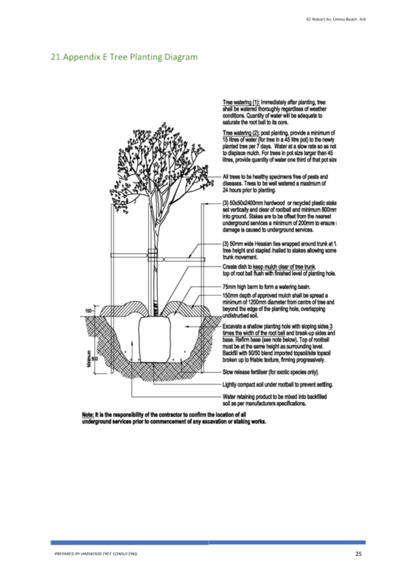
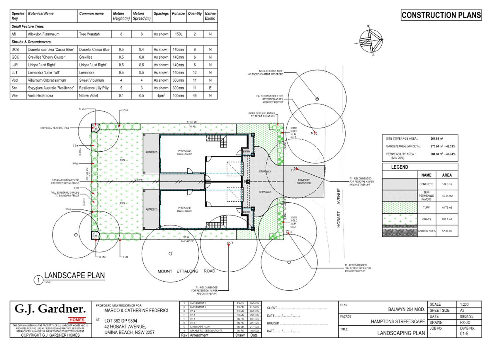
The proposal will provide minor economic benefit through the provision of temporary employment during demolition and construction. The application does not require any tree removal in the site to facilitate the development however there is the need to remove 1 street tree to facilitate the development. The private open space provided within the subject site is generous and it provides the replacement of 2 trees as well as landscaping.
Any Submission made in Accordance with this Act or Regulations
The development application was notified in accordance with the CCDCP 2022 from 3 November 2023 to 17 November 2023 and twenty-two (22) submissions were received. Of these submissions 18 were received within the timeframe however all submissions were included.
A summary of the submissions is detailed below:
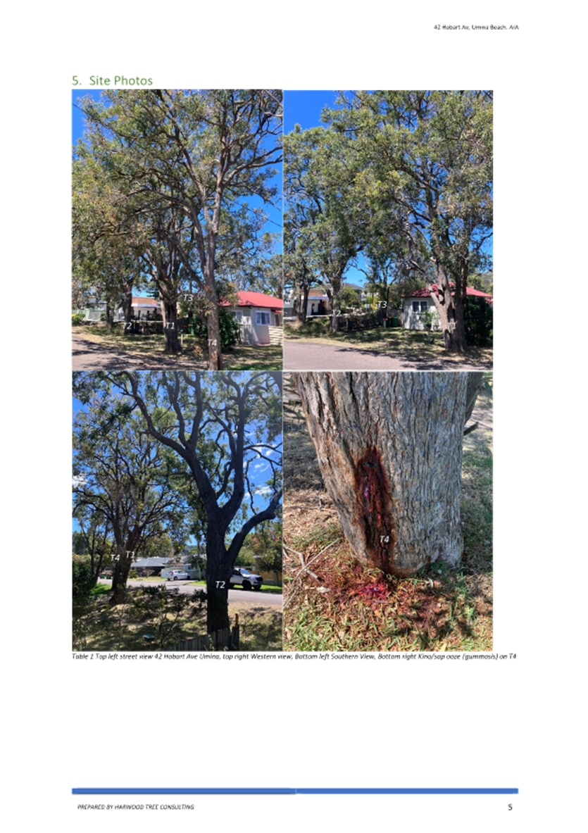
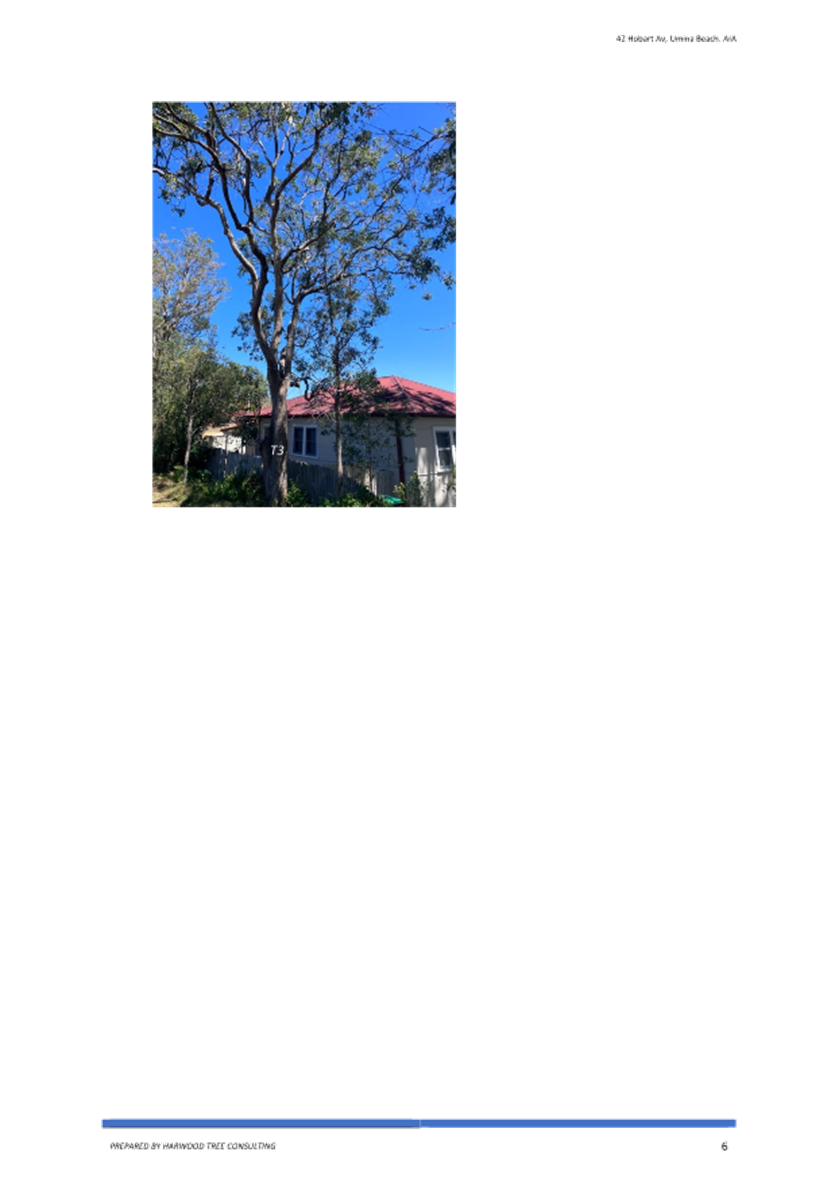
1. Removal of the tree on the verge/ The tree on the verge is an Angophora Floribunda needs to be kept
The Angophora floribunda or rough barked apple tree is a very common woodland and forest tree. It is a large tree reaching up to 30m tall and live for 40+ years (Angophora floribunda | Australian Plants Society).
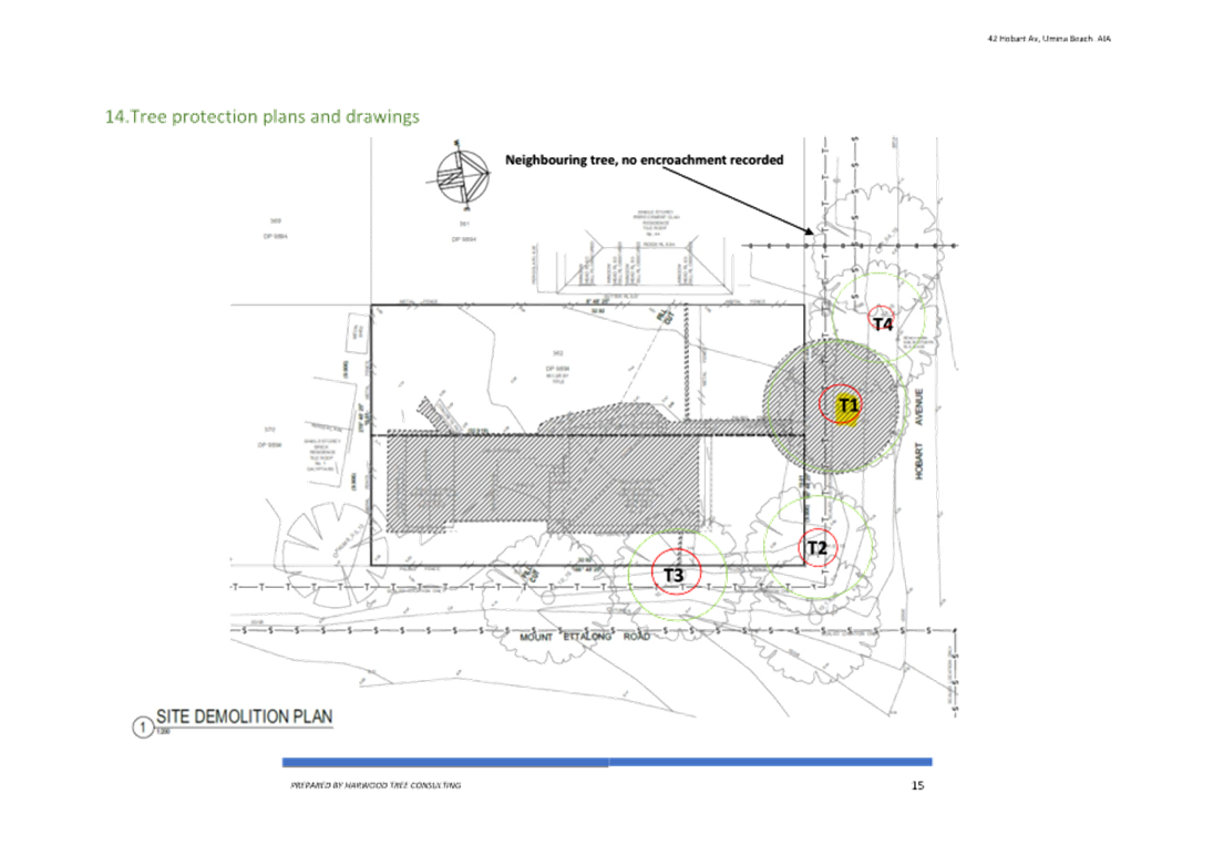
The Arborist Report indicates ‘… opinion of the Arborist, the current development has been designed to take into consideration the location of the trees onsite, specifically the location of the garages which minimises disturbances to TPZ’s.’ Additionally, the Arborist states that ‘…T1 under the current plans will require removal and replacement at a 2:1 ratio to align with the Central Coast Council’s Greener Places Strategy’. This requirement will form part of the conditions of consent to be provided for the development. Additionally, a site arborist shall be appointed to supervise all tree protection procedures and the trees to be retained will be protected with truck protection during construction, this will form part of the conditions of development consent.
From historic photographs this strand of trees has been on this verge area since at least the 1970’s. The majority of vegetation in the area was removed prior to the 1970’s.
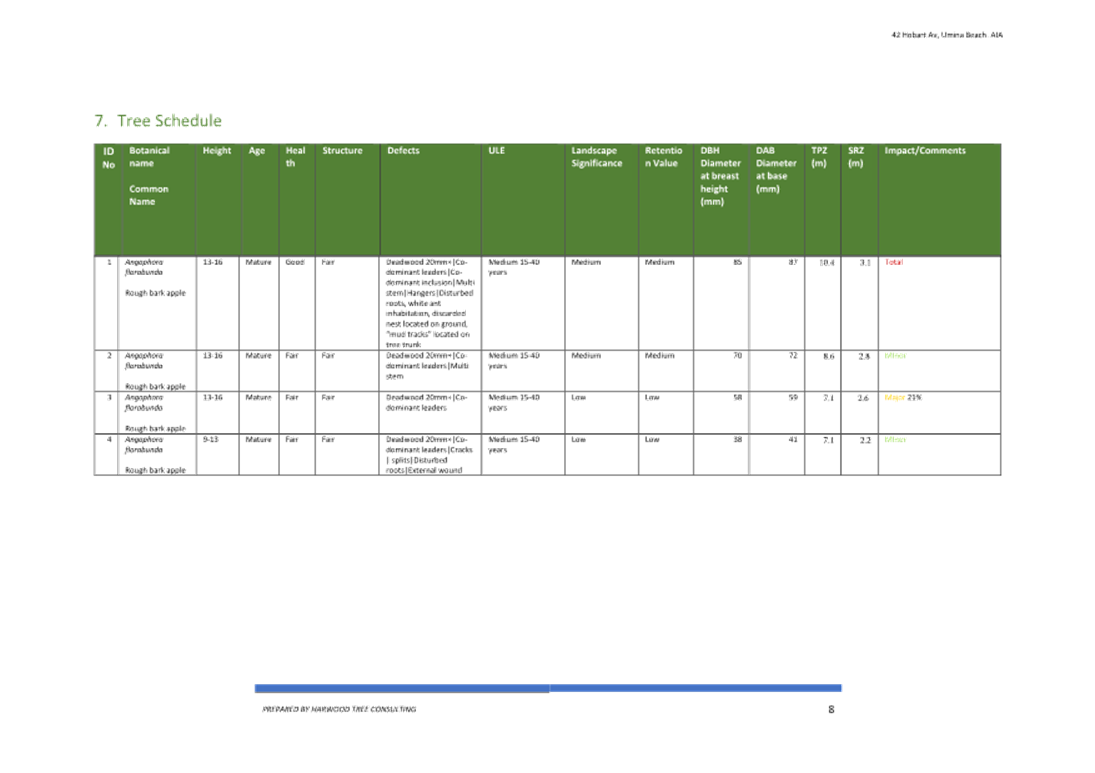
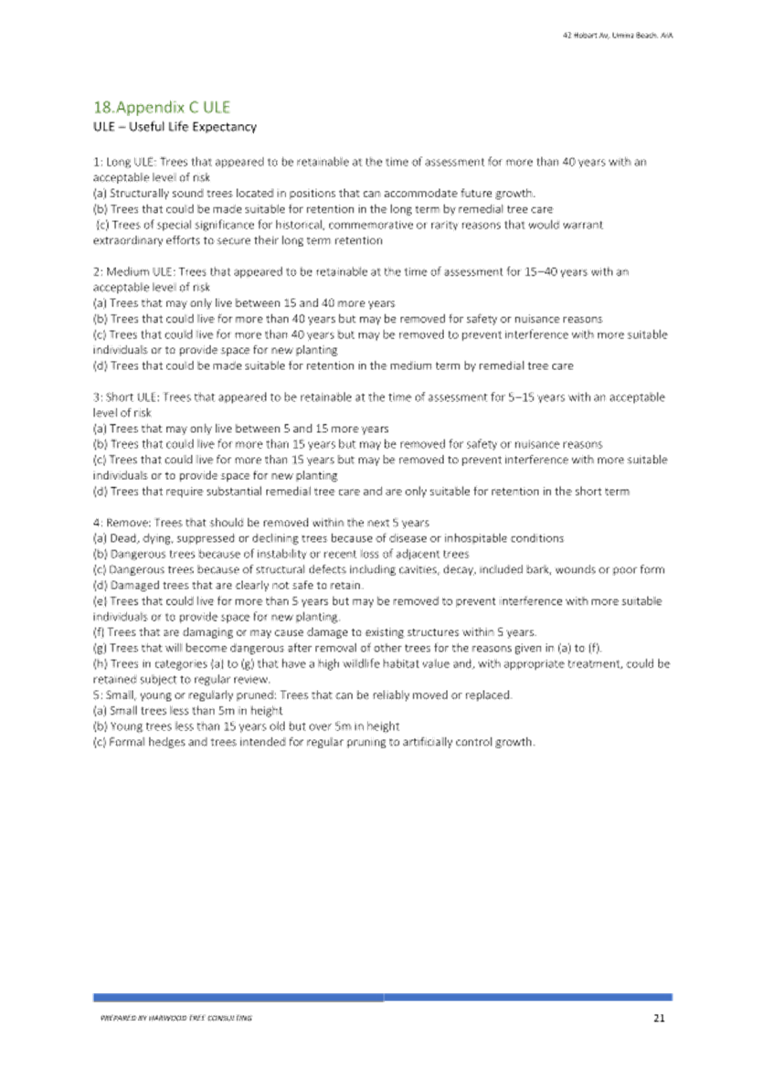
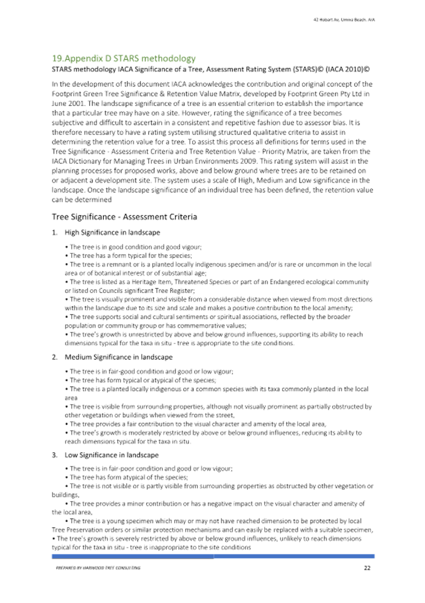
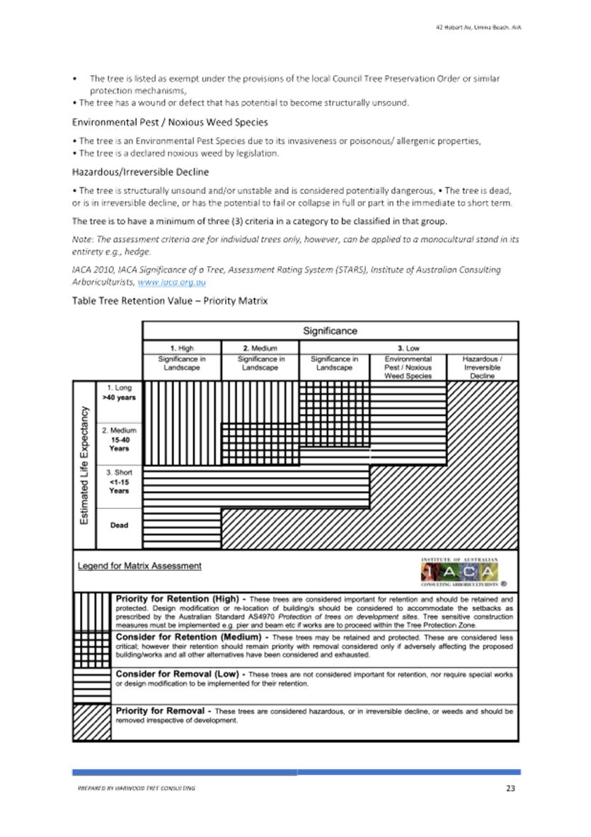
The arborist advises:
Under the current plans one (T1) tree will require removal, this specimen recorded a Medium retention value, under the STARS rating system located in Appendix D STARS methodology, trees classified as medium retention should be considered for retention, usually these specimens are considered less critical than the high retention specimens and could be removed if adversely affecting the build.
Therefore, it is considered that 1 tree on the verge being removed as part of the site’s redevelopment is a reasonable impact. It is noted that all other street trees both on Hobart Avenue and Mount Ettalong Road will be retained. Another building design would have required more trees to be removed.
2. The application states no vegetation removal.
That is correct, there is no vegetation to be removed from the development site. The trees are on the Council verge and outside the site.
3. Heat island effect/ Peninsula is bare of trees/ Greener Places Strategy
According to the Department of Planning ‘urban heat islands’ are described as:
Urban heat islands develop in areas with hard, sealed surfaces and a lack of vegetation or ‘green infrastructure’ such as tree canopies, vegetated roofs and walls and waterways. This is because hard surfaces absorb, store and radiate heat, while green infrastructure reflects heat, provides shade and releases water into the atmosphere.
Urban heat islands are increasing the effects of climate change, making higher temperatures and extreme hot weather events more severe and difficult to manage, placing more people at risk of exposure. During a heatwave, for instance, temperatures in western Sydney, which has less green cover, are sometimes 10 °C higher than in eastern Sydney.
Planning how we use land plays an important role in reducing vulnerability to urban heat. It helps create places and communities that are more sustainable and resilient to a changing climate. We are delivering several planning initiatives to reduce urban heat.
The Central Coast Council Greener Places Strategy 2021-2031 (the Strategy)
The Strategy acknowledges the ability of urban greening to mitigate certain urban health effects and maintain livability in urban centers. Urban trees provide shade to buildings, and roads along with private and public open space which can assist in reducing the impact of the Urban Heat Island Effect. The Strategy identifies all of the positive attributes of trees and vegetation along with and acknowledges that 19 Central Coast suburbs have been identified for priority planting to mitigate urban heat island effects. The planting is to increase canopy cover by a further 5% over the next 30 years in these locations. The Greener Places Strategy is supported by its inclusion in the Central Coast Regional Plan 2041.
Umina Beach is identified as one of the areas where there is an impact from the Urban Heat Island Effect. It is reported that Umina Beach experiences significantly higher temperatures compared to surrounding rural areas due to the lack of vegetation and the abundance of hard surfaces like buildings and roads, which absorb and radiant heat making the area noticeable warmer in the summer months.
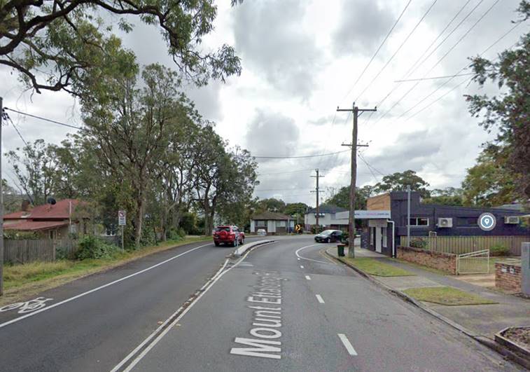
Figure 8 - Mount Ettalong Road - vegetation will remain
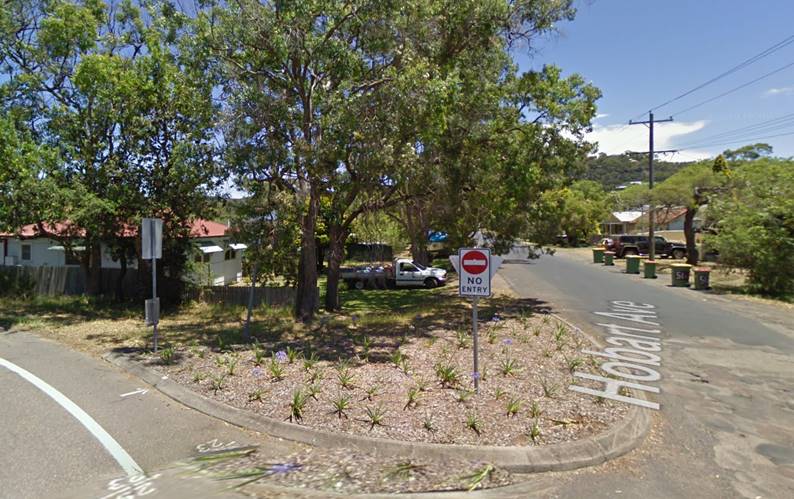
Figure 9 - The existing trees on the corner are being retained
![]()
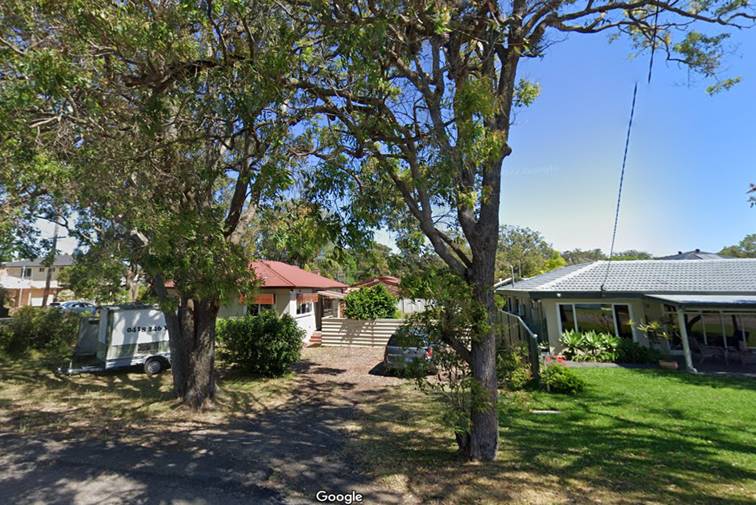
Figure 10 - frontage to Hobart Avenue - tree removal
![]()
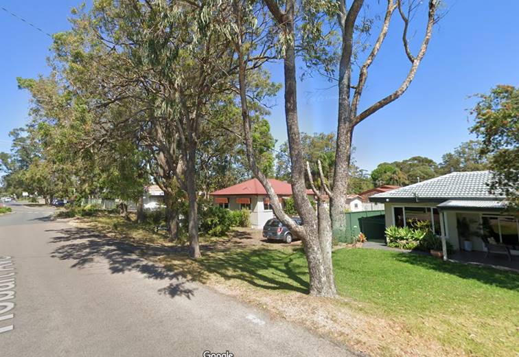
Figure 11 - Hobart Avenue street scape
Comment:
Several strategies of, The Greener Places Strategy, identify that remnant and existing vegetation should be retained. In this regard it is recommended that only 1 tree is recommended for removal. It is also recommended that no street trees be replanted as the verge area is already adequately vegetated with remnant vegetation. It is noted that the pattern of clearing in the area occurred prior to 1970. Additional trees are proposed to be planted in the rear private open space of each dwelling. Two feature trees are being proposed which are native to the Coast along with additional native shrubs and landscape plantings. This is considered adequate for this development.
4. Exceed the FSR requirements.
As discussed in the body of the report, the proposal is for a minor variation to the clause 2.1.2.3 of the CCDCP 2022 requirement to provide a 0.5:1 Floor Space Ratio (FSR) to provide a 0.54:1 FSR. The variation represents a departure of 27.62m2 or a 4% variation.
Comment:
This minor variation is recommended for support, and it is noted that the development is providing additional requirements above what is required by the CCDCP 2022:
5. No landscape plan provided.
A landscaping plan was provided in the material for notification.
6. Garages dominate the elevations.
The garages are compliant.
7. Large concrete driveway
A 5.5m driveway is the minimum requirements and appropriate to cater for a dual occupancy development and is considered appropriate. The vehicle access crossing are to comply with Council specification and the AS/NZ 2890.1:2004.
Advise from engineering:
The proposed double width of the vehicle access crossing is required for the following reasons:
- Narrowing the vehicular access crossing would result in potential conflicts with the vehicular swept turning paths between vehicle entering and exiting the site for one dwelling and the tandem car parking space for the other dwelling, which in effect could/would reduce effective parking on site to the garage spaces only, with the tandem spaces being unusable.
- The application proposes a Torrens title subdivision of the dual occupancy. Narrowing the vehicle access crossing would require right of accesses to be created over the driveways where turning paths for one dwelling/lot encroached into the neighbouring lot. This in effect could/would again reduce effective parking on site to the garage spaces only. Furthermore, right of accesses are not proposed with the subdivision of the development.
Additionally, semi permeable pavers are to be used in the driveways within the boundary of the property, which will allow a softening aspect to the development and aid water infiltration. The street has no kerb and guttering, and it is proposed to remain as such which also aids in water infiltration.
8. Parking/ no visitor parking
No visitor parking is required for this type of development.
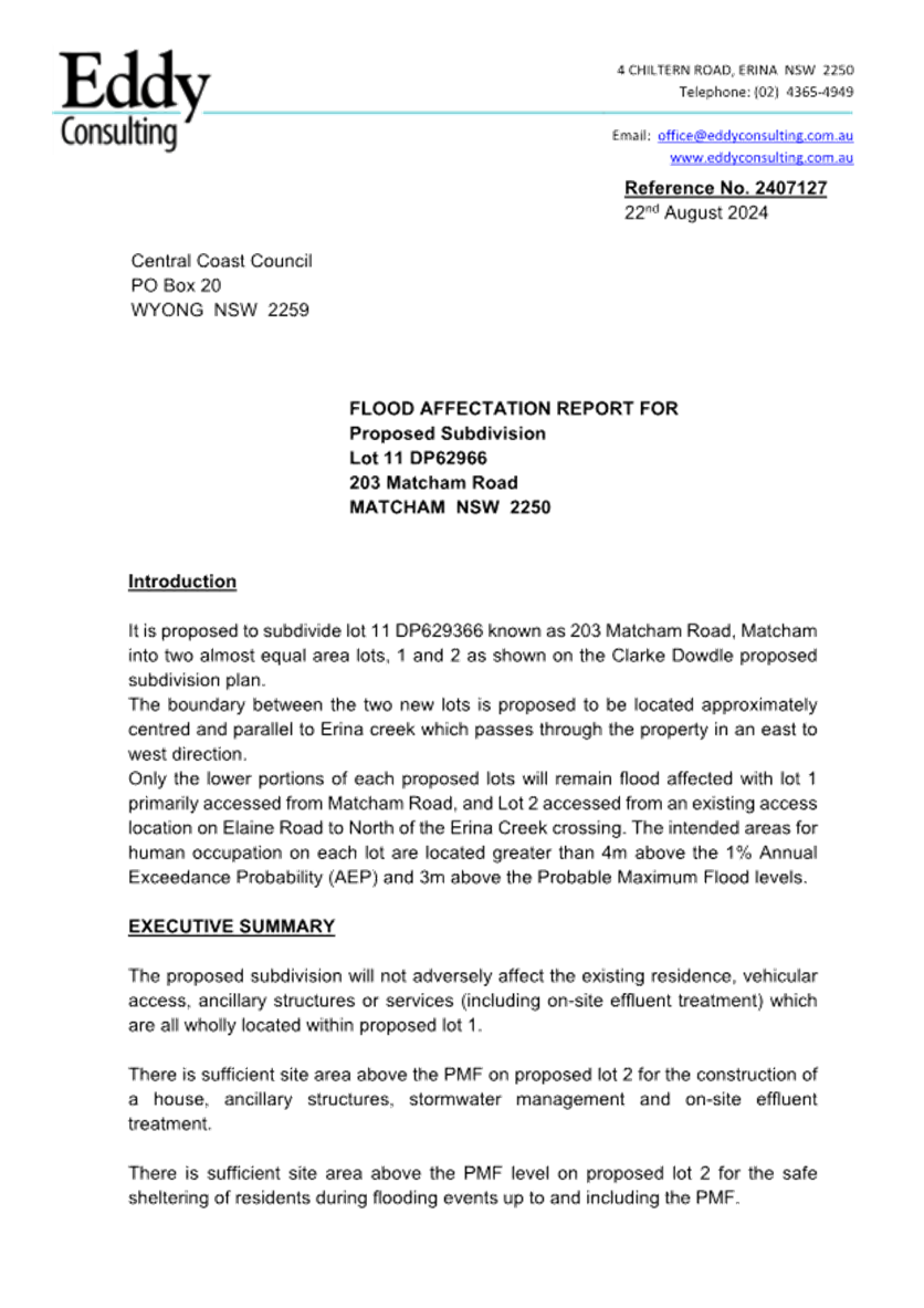
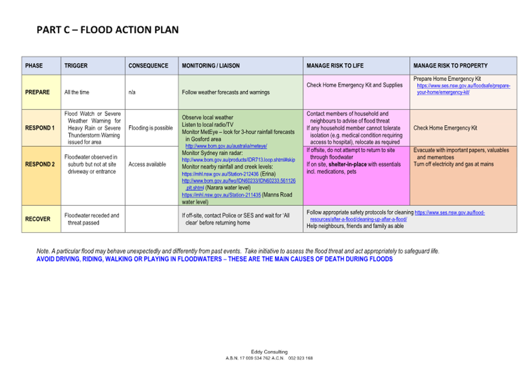
9. Flood zone
This site is not affected by Flood Controls 1% AEP+ freeboard. However, the site is affected by flooding in the Probable Maximum Flood (PMF) event with levels in the order of RL 5.89m - RL 5.90m AHD.
The architectural plans prepared by G J Garner (Rev F dated 29/01/24) indicate ground floor levels of RL 6.20m AHD and garage levels of RL 6.20m AHD which are above the PMF level. Safe evacuation of the development to the Hobart Street frontage would be feasible in a PMF event.
Internal Consultation
|
Traffic Engineer |
Supported without conditions. |
||
|
Development Engineer |
Supported subject to conditions. |
||
|
Tree Assessment Officer |
Supported subject to conditions. |
||
|
Waste Services |
Supported subject to conditions. |
||
|
Water and Sewer |
Supported subject to conditions. |
Trees Assessment Comments
A Landscape Plan has been provided which nominates planting of two (2) advanced Alloxylon Fammeum – Tree Waratah in the rear POS. Combined with the established native trees to be retained on the road reserve, this will be sufficient.
Engineering Assessment Comments
A Flood Information Certificate issued by Council for the site indicates that the site is not affected by flooding or associated flood planning controls for events up to the 1%AEP event but is affected by flooding in the Probable Maximum Flood (PMF) event with levels in the order of RL 5.89m - RL 5.90m AHD. The architectural plans prepared by G J Garner (Rev F dated 29/01/24) indicate ground floor levels of RL 6.20m AHD and garage levels of RL 6.20m AHD which are above the PMF level. Safe evacuation of the development to the Hobart Street frontage would be feasible in a PMF event.
The Public Interest: (s79C(1)(e)):
Section 4.15 (1)(e) of the Environmental Planning and Assessment Act 1979 requires consideration as to whether to proposal is in the public interest.
The proposal will not have any adverse impact on the natural environment and will not unreasonably impact the amenity of neighbouring properties. The approval of the application is considered to be in the public interest.
Ecologically Sustainable Principles:
The proposal has been assessed having regard to ecologically sustainable development principles and is considered to be consistent with the principles.
The proposed development is considered to incorporate satisfactory stormwater, drainage and erosion control and the retention of vegetation where possible and is unlikely to have any significant adverse impacts on the environment and will not decrease environmental quality for future generations. The proposal does not result in the disturbance of any endangered flora or fauna habitats and is unlikely to significantly affect fluvial environments.
Climate Change
The potential impacts of climate change on the development proposed to be modified have been considered by Council as part of the assessment of the application.
This assessment has included consideration of such matters as potential rise in sea level; potential for more intense and/or frequent extreme weather conditions including storm events, bushfires, drought, flood and coastal erosion; as well as how the proposed development may cope, combat, withstand these potential impacts. The proposed development is considered satisfactory in relation to climate change.
Other Matters for Consideration:
Section 7.11 and 7.12 Contributions (formerly Sections 94 and 94A Contributions)
Water and Sewer Contributions.
Contributions are applicable to this development.
Political Donations
During assessment of the application there were no political donations declared by the Applicant, Applicant’s consultant, owner, objectors and/or residents.
Conclusion:
The application has been assessed under the relevant heads of consideration specified under Section 4.15 of the Environmental Planning and Assessment Act 1979 and all relevant planning instruments and policies and found to be satisfactory. In particular:
· The proposed development is consistent with the zone objectives as set out under the Central Coast Local Environmental Plan 2022.
· The variations proposed to the provisions of the Central Coast Development Control Plan 2022 are relatively minor and will not have a material impact in terms of amenity or impact on adjoining lands.
· The potential constraints of the site have been assessed and it is considered that the site is suitable for the proposed development, subject to the imposition of appropriate conditions of consent.
· The proposed development is not expected to have any adverse social or economic impact. It is considered that the proposed development will complement the locality and meet the desired future character of the area.
Accordingly, the application is recommended for approval, pursuant to Section 4.16 of the Environmental Planning and Assessment Act 1979.
|
1⇩ |
Draft conditions /Reasons - 42 Hobart Avenue UMINA BEACH NSW 2257- DA/1627/2023 |
|
D16746933 |
|
2⇩ |
PORTAL DOC - 42 Hobart Avenue, UMINA BEACH NSW 2256 - DA/1627/2023 - ARBORIST REPORT |
|
D16745085 |
|
3⇩ |
Portal Doc - 42 Hobart Avenue, UMINA BEACH NSW 2257 - DA/1627/2023 - Statement of environmental effects - SoEE - 42 Hobart Avenue Umina Beach Rev B.pdf - |
|
D16778446 |
|
Portal Doc - 42 Hobart Avenue, UMINA BEACH NSW 2257 - DA 1627 2023 - Architectural Plans - Lot 362, 42 Hobart Avenue, Umina Beach.pdf - REDACTED |
Provided Under Separate Cover |
D16778431 |
|
3.1 |
DA/1627/2023 - 42 Hobart Avenue, Umina Beach - Dual Occupancy, two lot Torrens title subdivision and demolition |
|
Attachment 1 |
Draft conditions /Reasons - 42 Hobart Avenue UMINA BEACH NSW 2257- DA/1627/2023 |

|
DA/1627/2023 - 42 Hobart Avenue, Umina Beach - Dual Occupancy, two lot Torrens title subdivision and demolition |
|
|
Attachment 2 |
PORTAL DOC - 42 Hobart Avenue, UMINA BEACH NSW 2256 - DA/1627/2023 - ARBORIST REPORT |
|
DA/1627/2023 - 42 Hobart Avenue, Umina Beach - Dual Occupancy, two lot Torrens title subdivision and demolition |
|
|
Attachment 3 |
Portal Doc - 42 Hobart Avenue, UMINA BEACH NSW 2257 - DA/1627/2023 - Statement of environmental effects - SoEE - 42 Hobart Avenue Umina Beach Rev B.pdf - |


|
DA/1627/2023 - 42 Hobart Avenue, Umina Beach - Dual Occupancy, two lot Torrens title subdivision and demolition |
|
|
Attachment 5 |
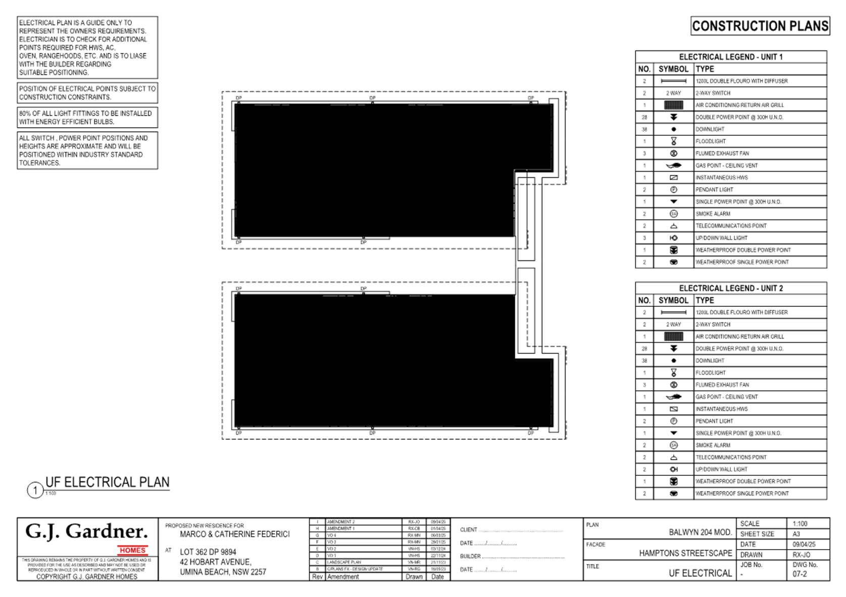
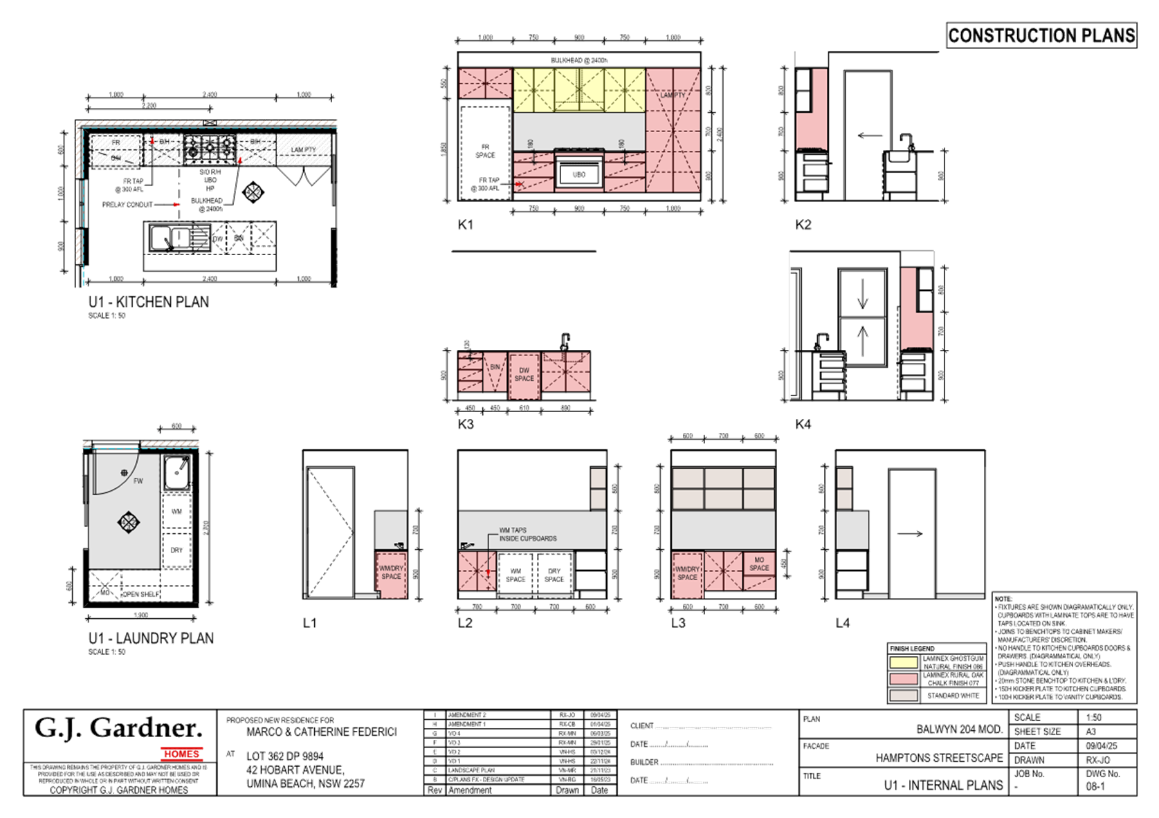
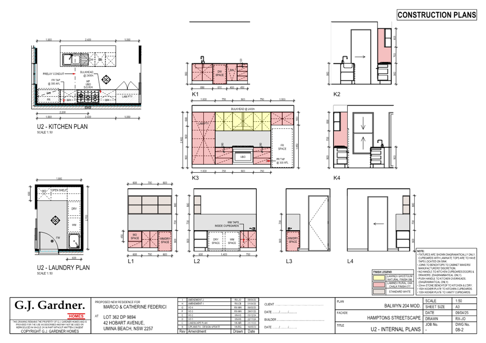
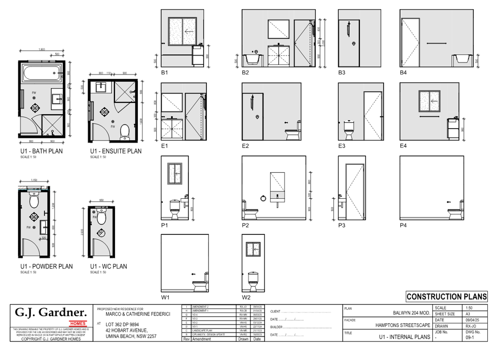
Portal Doc - 42 Hobart Avenue, UMINA BEACH NSW 2257 - DA 1627 2023 - Architectural Plans - Lot 362, 42 Hobart Avenue, Umina_Redacted |

|
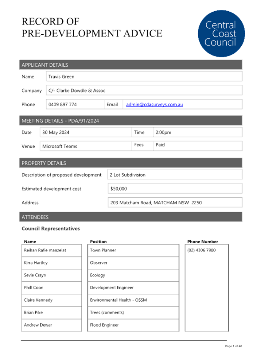
Item No: 3.2 |
|
|
Title: DA/1496/2024 - 203 Matcham Road, Matcham - 2 Lot Subdivision |
|
|
Department: Environment and Planning |
|
|
15 May 2025 Local Planning Panel Meeting |
|
Reference: DA/1496/2024 - D16765382
Author: Kirra Hartley, Senior Development Planner
Section Manager: Ailsa Prendergast, Section Manager Residential Assessments
Unit Manager: Andrew Roach, Unit Manager Development Assessment
|
Summary
An application has been received for 2 Lot Subdivision - (Nominated Integrated & Integrated) at 203 Matcham Road, Matcham. The application has been examined having regard to the matters for consideration detailed in section 4.15 of the Environmental Planning and Assessment Act 1979 and other statutory requirements with the issues requiring attention and consideration being addressed in the report.
The application is required to be referred to the Local Planning Panel for determination as the proposed development has a departed from the development standards by more than 10% under Subdivision 18 (4)(b) of Interim Development Order No. 122. Schedule 2 Point 3 of the Local Planning Panels Ministerial Direction (dated 6 March 2024) requires such applications to be referred to the Panel.
The development proposes the subdivision of one (1) lot into two (2) Torrens title lots which comprises a variation to the minimum lot size development standard of subdivision 18 (4)(b) of the Interim Development Order No. 122 (IDO) by 27.39% for lot 1 and 29.2% for lot 2.
The applicant was notified with one objection received.
The application is recommended for refusal.
Applicant T M Green Owner C P Green and T M Green Application No DA/1496/2024 Description of Land 203 Matcham Road, MATCHAM, NSW 2250 Proposed Development 2 Lot Subdivision - (Nominated Integrated & Integrated) Site Area 1.435 Hectares Zoning 7(C2) Scenic Protection Rural Existing Use Dwelling house Employment Generation Nil Estimated Value $70,000 Site Inspection 20 November 2024 |
A That the Central Coast Local Planning Panel as consent authority refuse the Development Application No. DA/1496/2024 for 2 lot Subdivision - (Nominated Integrated & Integrated) on Lot 11 DP 629366, 203 Matcham Road, Matcham subject to the reasons for refusal detailed in the schedule attached to the report and having regard to the matters for consideration detailed in Section 4.15 of the Environmental Planning and Assessment Act 1979 for the following reasons:
1: The proposed development is not considered in the public interest. There would be an increased risk to life as a result of this development. There will be no safe evacuation for the additional occupants during a flood which would result in:
o An increased exposure to the risk factors of sheltering in place
o An increased risk of people being isolated during medical emergencies
o An increased risk of people making dangerous decisions such as entering floodwater while access roads are inundated.
o An increased workload for emergency services who will need to rescue or resupply a greater number of people
o An increased risk to life compared to existing.
2: The proposed allotments are significantly less than the minimum lot size requirement of 1 hectare (Ha) for land zoned 7 (C2) Scenic Protection Rural as prescribed under Clause 18 within the IDO 122. Undersized subdivision of lots in this area is not consistent with current legislation or approval patterns and would set a precedence in the area for significantly undersized lots which is not consistent with the orderly development of the area.
3: The development is inconsistent with the objectives of the 7 (C2) Scenic Protection Rural zone. The environmental limitations over the site within the zone include Medium Landslip, Flooding, Biodiversity Values and Bushfire Prone Land which forces the building envelope for any future dwelling to be located close to the north and eastern boundaries prompting objection from a neighbouring property. This will adversely affect the aesthetic and scenic value of the land by clustering any future dwelling with the existing dwelling houses which will interfere unreasonably with the amenity of existing adjoining properties.
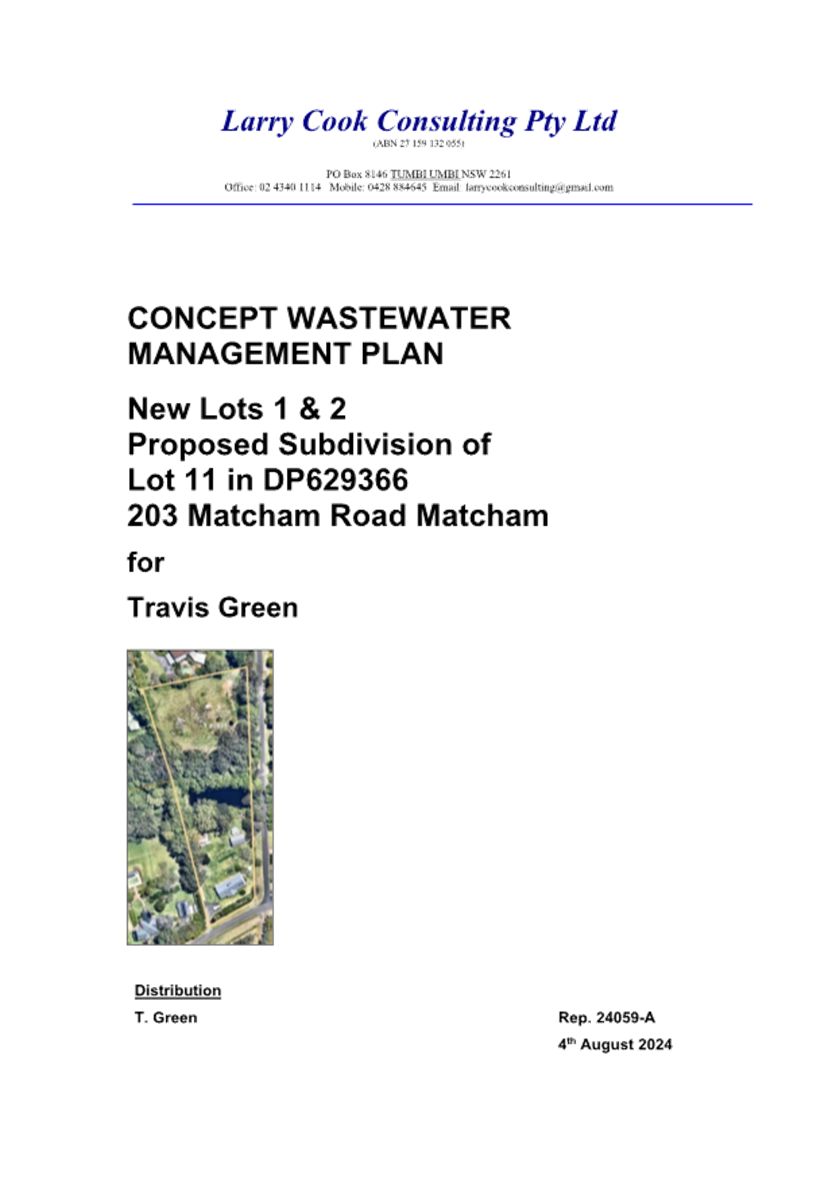
4: Insufficient information and documentation was provided with the development application. The applicant did not provide a Preliminary Engineering Plan and the Wastewater Management Report comprised insufficient information to support the DA application.
B That Council advises those who made written submissions of the Panel’s decision.
C That Council advise relevant external authorities of the Panel’s decision.
1. Flood safety concerns
2. Minimum lot size variation
3. Insufficient information provided.
4. Submission/s and matters raised therein.
5. The Development Application has not satisfactorily resolved the issues identified in the Pre-Development application meeting undertaken.
Precis:
|
Proposed Development |
2 Lot Subdivision
|
|
Permissibility and Zoning |
The subject site is zoned 7(c2) Conservation and Scenic Protection (Scenic Protection - Rural Small Holdings) under Interim Development Order No. 122. The proposed development is defined as a Torrens title subdivision which is permissible in the zone with consent of Council.
|
|
Current Use |
Dwelling house
|
|
Integrated Development |
Yes.
The Development Application (DA) was submitted to the NSW Rural Fire Service (NSW RFS) as ‘integrated development’ for the purposes of Section 100B (special fire protection purpose) of the Rural Fires Act 1997.
The Development Application (DA) was submitted to The Department of Planning and Environment-Water as Nominated Integrated.
|
|
Submissions |
One (1) submission received during the notification period.
|
Proposed Variations to Policies and Departure from Legislation
|
Clause |
Section 4.15(1)(b)(c) and (e)
|
|
Standard |
1. The likely impacts of that development, including environmental impacts on both the natural and built environments, and social and economic impacts in the locality. 2. The suitability of the site for the development 3. The public interest.
|
|
LEP/DCP/Act |
Environmental Planning and Assessment Act 1979 (the Act)
|
|
Departure basis |
|
|
Clause |
· 18(4)(b) |
|
Standard |
The minimum subdivision allotment size prescribed by clause 18(4)(b) of the Interim Development Order No 122. |
|
LEP/DCP |
|
|
Departure basis |
Lot 1: 27.39% variation Lot 2: 29.2% variation |
|
Clause |
Clause 5(3) |
|
Standard |
Consent must not be granted for development of land within the prescribed zone, unless the objectives of the zone have been taken into consideration in conjunction with the objectives of the Local Government Act 1993, pertaining to Ecologically Sustainable Development. |
|
LEP/DCP |
Interim Development Order No. 122 |
|
Departure basis |
Non numerical variation. Inconsistency with zone objectives. |
|
Clause |
Subdivision 18 (4)(b) |
|
Standard |
Subdivide land within Zone No. 7(c2) so as to create one or more allotments having an area of less than 2 hectares but not less than 1 hectare. |
|
LEP/DCP |
Interim Development Order No. 122 (IDO) |
|
Departure basis |
As above:
Lot 1: 27.39% variation Lot 2: 29.2% variation |
|
Clause |
Chapter 2.4, Clause 2.4.5 |
|
Standard |
Lot Size and Design. |
|
LEP/DCP |
Central Coast Development Control Plan 2022 |
|
Departure basis |
Not compliant pursuant to the IDO. |
The Site
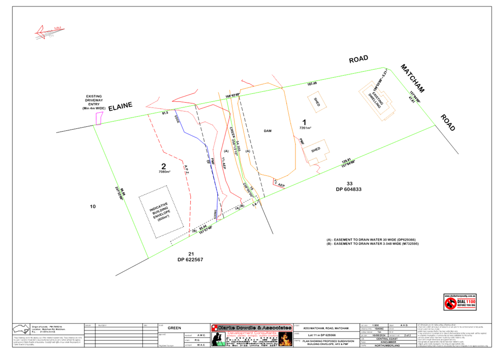
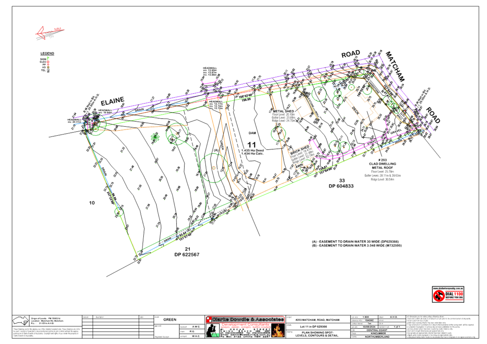
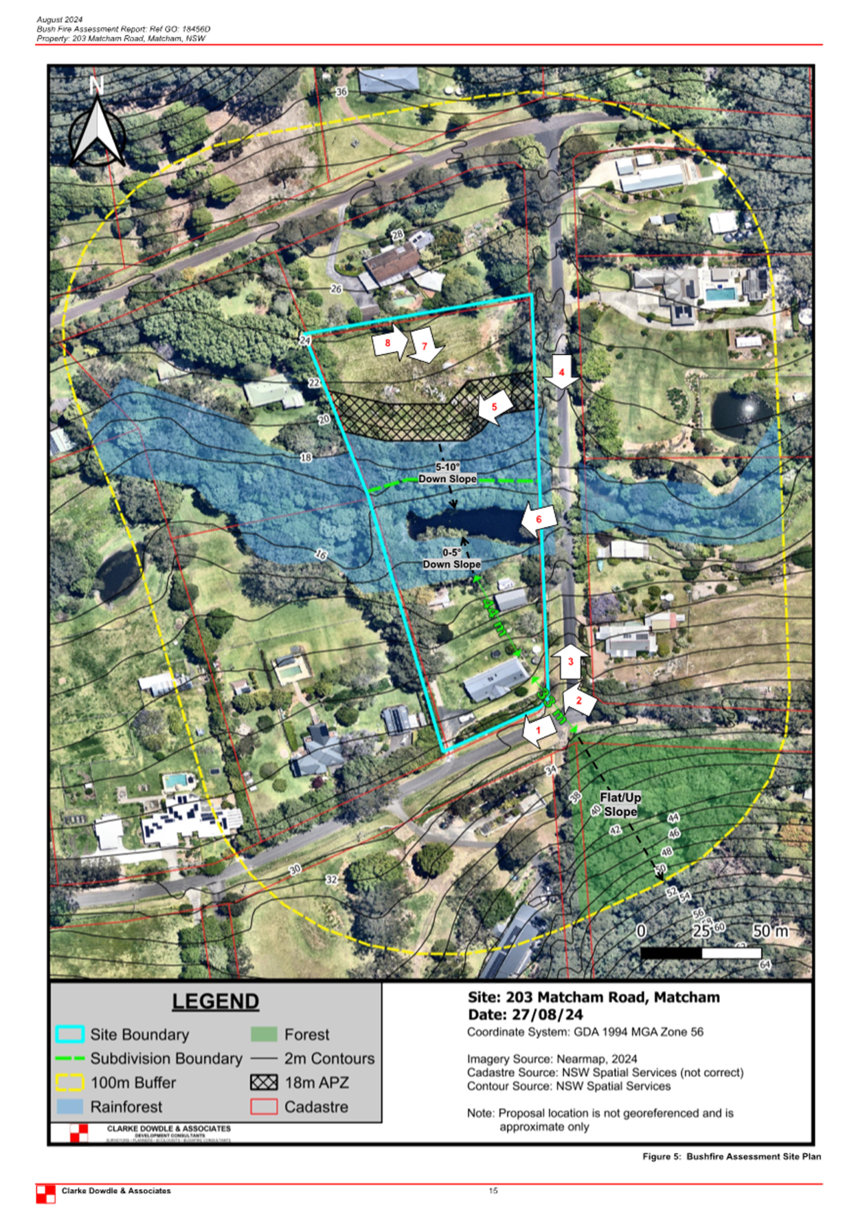
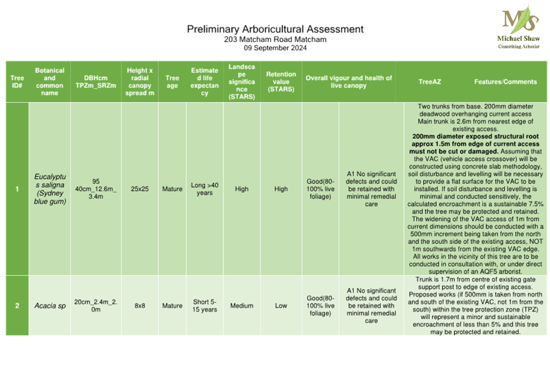
· Subject site is legally described as lot 11 DP 629366 at No. 203 Matcham Road, Matcham. The overall site area is 1.43 Hectares (Ha) and is currently occupied by a dwelling house and ancillary development (refer to Figure 1).
· The site is impacted with Biodiversity Values (refer to Figure 2).
· The site is identified as Bushfire Prone Land (refer to Figure 3).
· The site is identified as Medium Landslip (Refer to Figure 4).
· The site identified as Flood Prone Land Mapping indicating 1% AEP (Refer to Figure 5).
· The site is identified on the Flood Precincts Map as impacted by Floodway, Precinct 4: High Hazard, Precinct 3: Flood Storage, Precinct 2: Flood Planning and Precinct 1: Probable Maximum Flood (refer to Figure 6).
· The site has an Identified Watercourse (Erina Creek) and 40m buffer zone traversing the site (refer to Figure 7).
· The site is zoned 7(C2) Scenic Protection Rural IDO under Interim Development Order No 122 (refer to Figure 8). The site is proposed to be rezoned to C4 Environmental Living per the Central Coast Local Environmental Plan 2022.
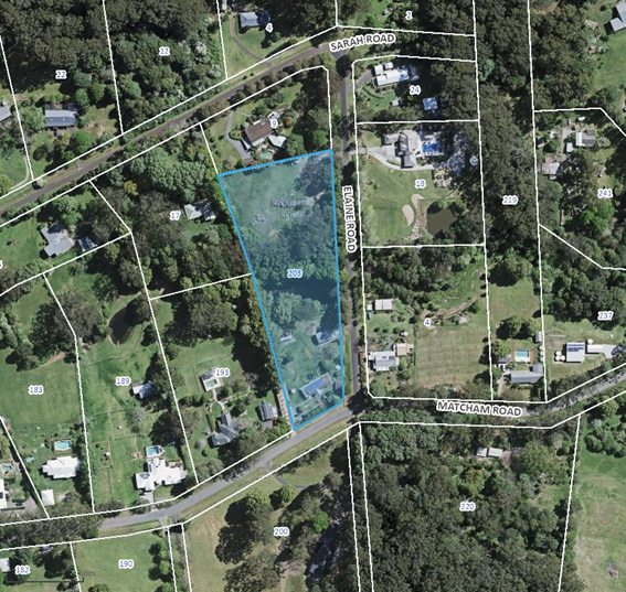
Figure 1: Aerial view of subject site
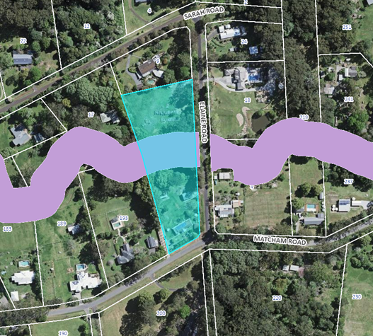
Figure 2: Biodiversity Values Map Extract
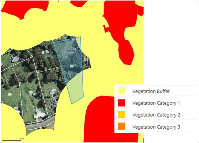
Figure 3: Bushfire Prone Land
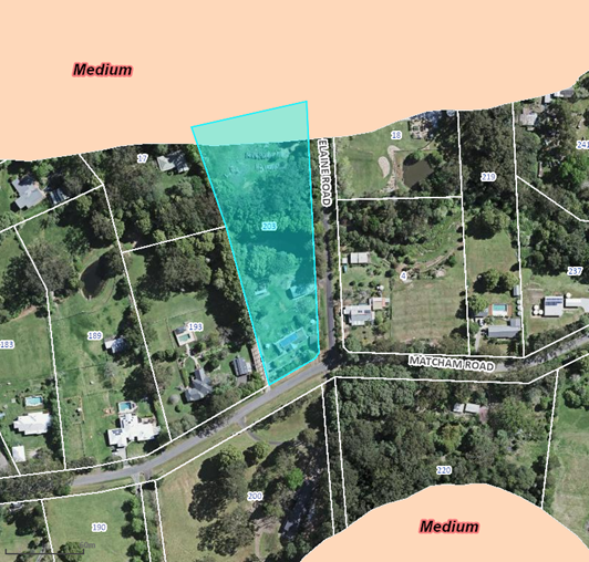
Figure 4: Medium Landslip Hazard
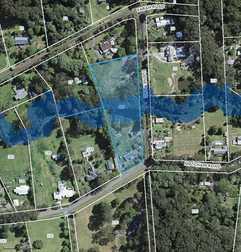
Figure 5: Flood Prone Land mapping indicating 1% AEP
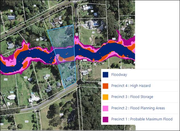
Figure 6: Flood Precincts
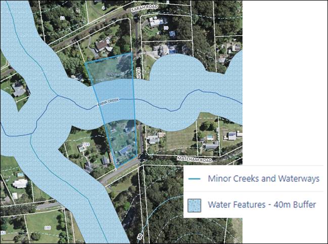
Figure 7: Identified Watercourse and 40m buffer zone traversing the site
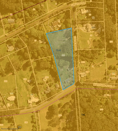
Figure 8: Zoning map, 7 (c2) Scenic Protection Rural per the Interim Development Order No. 122
Surrounding Development
Surrounding development adjoining the site and in the immediate area comprises dwelling houses on large rural lots. The land slopes towards the centre of the site where Erina Creek traverses the site and adjoining properties to the east and west (refer to Figures 7 and 12).
The Proposed Development
The proposal comprises the subdivision of one (1) lot into two (2) Torrens title lots (refer to Figure 9 Subdivision Plan), both lots being less than the minimum lot size requirement (1 Hectare) as per Council’s Interim Development Order No 122 (IDO) as follows:
Proposed Lot 1 (southern portion):
· 7261m2
· Existing dwelling and ancillary development to be retained on this site; and
· Access off Matcham Road to be retained.
Proposed Lot 2 (northern portion):
· 7080m2
· Vacant land with building parcel outline.
· New vehicle access crossing (VAC) proposed off Elaine Road.
The boundary between the two is to be approximately centred on and parallel to Erina creek which passes through the property in an east to west direction.
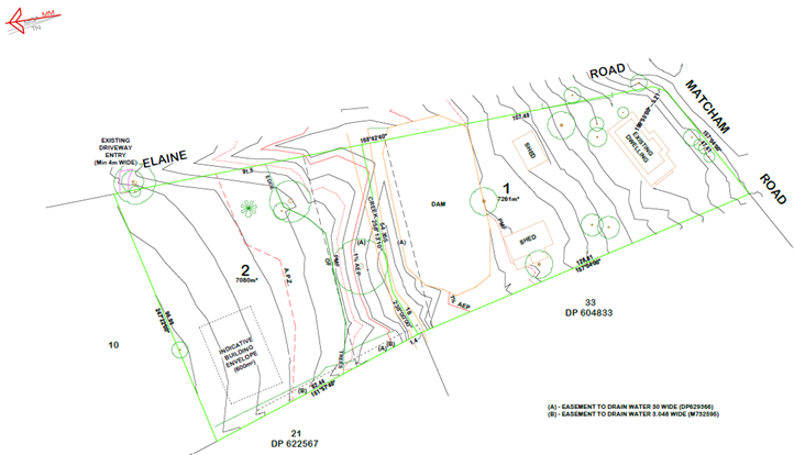
Figure 9: Proposed Plan of Subdivision
History
On 30 May 2024 the applicant and Council staff attended a Pre-Development Application meeting (Ref. PDA/91/2024) via Microsoft Teams whereby the proposed 2 lot Torrens title subdivision of the site (which is now being assessed within this report), was discussed.
The applicant was advised both during the Pre–Development Application (Pre-DA) meeting and within the Pre-DA meeting minutes provided that the proposed 2 lot subdivision would not be supported by Council for reasons outlined during the Pre-DA meeting, and calrified in writing within Pre-DA Meeting Minutes.
It is advised that the reasons outlined for position taken in the Pre-DA discussions (and set out in the Pre-DA Minutes) have not been resolved within the Development Application submitted.
Previous Applications
Council’s records show that the following applications were previously lodged on this site:
· DA/46470/2014 approved on 14 May 2015 for Dwelling Additions, Swimming Pool In-ground and Garage.
· DA/56026/2019 approved on 19 March 2019 for Dwelling Alterations, Additions & Swimming Pool Above Ground.
· DA/56026/2019A approved on 15 January 2020 for Section 4.55 Amendment - Remove pergola, add wrap-around veranda and stage development.
ASSESSMENT:
Having regard for the matters for consideration detailed in Section 4.15 of the Environmental Planning and Assessment Act 1979 and other statutory requirements, Council’s policies and Section 10.7 Certificate details, the assessment has identified the following key issues, which are elaborated upon for Council’s information.
Environmental Planning and Assessment Act 1979
· Delegation to the Local Planning Panel
In accordance with s.9.1 of the Environmental Planning & Assessment Act 1979 this development application (DA) is delegated to the Central Coast Local Planning Panel (LPP) for determination due to that the proposed variation to a development standard is greater than 10%.
· The development proposes the subdivision of one (1) lot into two (2) Torrens title lots which comprises a variation to the minimum lot size development standard of subdivision 18 (4)(b) of the Interim Development Order No. 122 (IDO) by 27.39% for lot 1 and 29.2% for lot 2.
Per the Ministerial Directions for the referral of development applications to the Local Planning Panels Direction – Development Applications and Applications to Modify Development Consents specified in Schedule 2, dated 6 March 2024, the development will be delegated to the Local Planning Panel (LPP) under Schedule 2, (3) Departure from development standards as ‘Development that contravenes a development standard imposed by an environmental planning instrument by more than 10% or non- numerical development standards.’
National Parks and Wildlife Act 1974
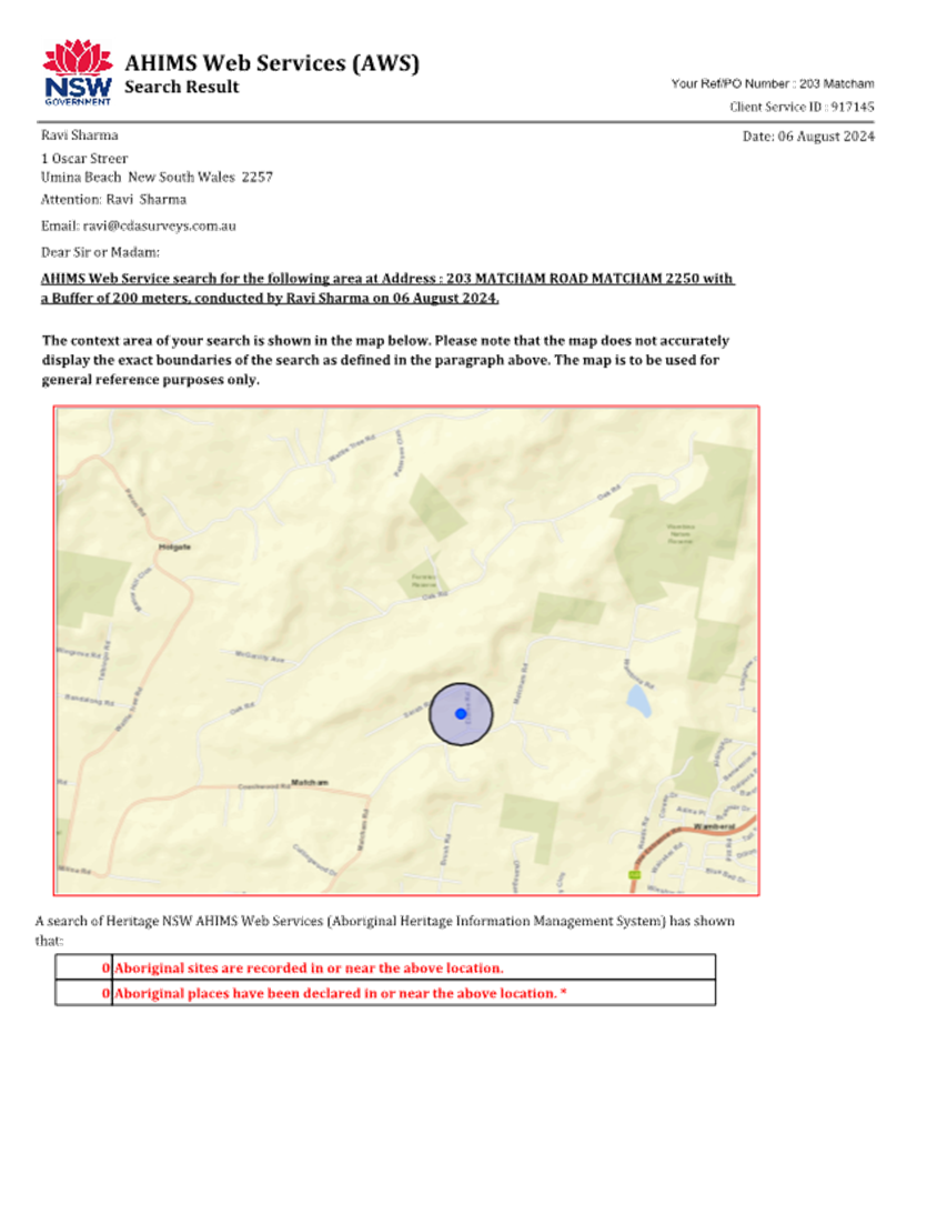
An AHIMS search was submitted with the DA indicating no items or places of Aboriginal heritage have been identified within 200m of the development area.
The relevant matters have been considered in the assessment of this application. The application is considered consistent with the stated aims and objectives.
The Development Application (DA) was submitted to the NSW Rural Fire Service (NSW RFS) as ‘integrated development’ for the purposes of Section 100B (special fire protection purpose) of the Rural Fires Act 1997. The RFS provided their concurrence and issued a bushfire certificate which would be conditioned as part of the consent if the proposal was to be supported.
The Development Application (DA) was submitted to The Department of Planning and Environment-Water which reviewed the proposal and responded with a determination that
for the purposes of the Water Management Act 2000 (WM Act), a controlled activity approval would not be required for the proposed works and no further assessment by that agency would be necessary.
State Environmental Planning Policy (Biodiversity and Conservation) 2021
The relevant matters have been considered in the assessment of this application. The application is considered consistent with the stated aims and objectives.
State Environmental Planning Policy (Resilience and Hazards) 2021
The use of the area of the land to be utilised for residential purposes is a paddock with no previous uses that would lead to the site being contaminated.
The relevant matters have been considered in the assessment of this application. The application is considered consistent with the stated aims and objectives.
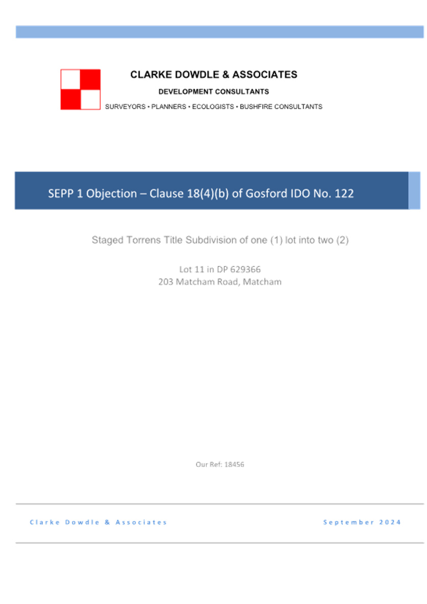
State Environmental Planning Policy No 1 Development Standards
Specifically:
· proposed lot 1 comprises a 27.39% variation; and
· proposed lot 2 comprises a 29.2% variation
to the minimum lot size development standards pursuant to the IDO 122.
Consequently, a written objection per Clause 6 Making of application of the State Environmental Planning Policy No 1—Development Standards (1980 EPI 10) was provided by the applicant which states that compliance with the development standard Clause 18 of the IDO 122 is unreasonable or unnecessary in the circumstances of the case. Although SEPP 1 is now repealed, it is applicable in this instance given that the land is still subject to interim Development Order No. 122, rather than the Central Coast LEP 2022.
Aims, objectives
The aims and objections of the SEPP are set out within Clause 3 the SEPP as follows:
‘This Policy provides flexibility in the application of planning controls operating by virtue of development standards in circumstances where strict compliance with those standards would, in any particular case, be unreasonable or unnecessary or tend to hinder the attainment of the objects specified in section 5 (a) (i) and (ii) of the [Environmental Planning & Assessment] Act.’
Although the Environmental Planning & Assessment Act has been amended and now has sections numbered differently, the aims and objectives mentioned above, before the repeal of SEPP 1, as follows:
(a) to encourage:
(i) the proper management, development and conservation of natural and artificial resources, including agricultural land, natural areas, forests, minerals, water, cities, towns and villages for the purpose of promoting the social and economic welfare of the community and a better environment,
(ii) the promotion and co-ordination of the orderly and economic use and development of land.
(similar objectives are now contained within Section 1.3 of the Act)
Clause 6 of the SEPP set out:
‘Where development could, but for any development standard, be carried out under the Act (either with or without the necessity for consent under the Act being obtained therefor) the person intending to carry out that development may make a development application in respect of that development, supported by a written objection that compliance with that development standard is unreasonable or unnecessary in the circumstances of the case, and specifying the grounds of that objection.’
Clause 7 of the SEPP states:
‘Where the consent authority is satisfied that the objection is well founded and is also of the opinion that granting of consent to that development application is consistent with the aims of this Policy as set out in clause 3, it may, with the concurrence of the Director, grant consent to that development application notwithstanding the development standard the subject of the objection referred to in clause 6.’
Applicants Written Justification
The applicant has provided a written justification for the variation (provided in full as an Attachment for the information of the Panel).
The applicants SEPP 1 submission concludes, as follows:
‘Strict compliance with the development standard is not achieved on this occasion in relation to one (1) of the two (2) lots in the subdivision, however, the departure from strict compliance with the standard will not impede the achievement of zone objectives and or the desired future character of the locality. Strict compliance with the development standard in the circumstances would hinder the attainment of the objectives of the Environmental Planning and Assessment Act, 1979.
Subsequently it is submitted to Council for the reasons set out in the objection that it would be both unreasonable and unnecessary for the prescriptive measures of the Gosford Interim Development Order No. 122 to be applied to this application. It is considered that the SEPP 1 Objection is well founded and outlines how the proposal meets the overarching objectives of the IDO (including clause 18(4)(b)) and would not result in the undermining or destroying the development standard or the planning objectives of the locality.’
Council Comment:
With respect to objective (i) within the SEPP:
(i) the proper management, development and conservation of natural and artificial resources, including agricultural land, natural areas, forests, minerals, water, cities, towns and villages for the purpose of promoting the social and economic welfare of the community and a better environment,
The justification provided by the applicant that the proposal will promote the social and economic welfare of the community is not agreed. As advised by Council’s Flood Engineer, the proposed subdivision fails to incorporate measures to minimise the risk to life and ensure the safe evacuation of people in the event of a flood which is also not compliant with Section 4.15 of the EP&A Act.
The development, therefore, has not considered the proper management or development of the site given the increased risk to human life. The development is not considered to promote a better environment or be a benefit to the community.
With respect to objective (ii) within the SEPP:
(ii) the promotion and co-ordination of the orderly and economic use and development of land,
The plans show any future building envelope is in close proximity to existing dwellings at Nos. 9 and 17 Sarah Road which is more consistent with the orderly development of general or high density residential zones as opposed to the 7 (C2) Scenic Protection Rural zone.
The objectives of the 7 (C2) Scenic Protection Rural zone are as follows:
(a) to provide a buffer or transition zone between conservation areas and urban areas; and
(b) to enable development for the purposes of rural-residential holdings to be carried out on land which is suitable for those purposes and which is unlikely:
(i) to adversely affect the aesthetic and scenic value of the land and its setting; or
(ii) to create a demand for the uneconomic provision of services; and
(c) to allow for non-residential uses where those uses are:
(i) compatible with rural-residential development and unlikely to create an unreasonable demand for public services or substantially reduce existing levels of service;
(ii) unlikely to adversely affect the aesthetic and scenic value of the land and its setting; and
(iii) unlikely to interfere unreasonably with the amenity of adjoining properties.
The environmental limitations over the site within the (C2) Scenic Protection Rural zone include Medium Landslip to the north, Flooding and Biodiversity Values to the south and Bushfire Prone Land to the east which forces the building envelope for any future dwelling to be located close to the north and eastern boundaries. This will adversely affect the aesthetic and scenic value of the land by clustering the any future dwelling with the existing dwelling houses which will interfere unreasonably with the amenity of existing adjoining properties.
To give further context, dwelling separation in the immediate area is approximately between 35m to over 140m to neighbouring dwellings. The proposed building envelope shown on the Subdivision Plan indicates approximately 7m setback to the northern boundary (which has an approximate zero boundary setback) and 8m to the western boundary (which has an approximate 12m boundary setback). As the existing neighboring dwellings have not been identified on the site plan, an exact distance is unclear. However, the proposed location is shown in Figure 10 below.
![]()
![]()
![]()
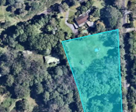
Figure 10: Proposed building envelope
In addition, flooding events over the site must be considered as an uneconomic provision of services with regards to the increased workload for emergency services who will need to rescue or resupply a greater number of people as raised by Council’s Flood Engineer.
It is not considered best Floodplain Management Practice to intensify development in a location which will be cut off by flood water. Due to the isolation of proposed lot 2 and the lack of an evacuation plan there will be an increased risk of local motorists leaving their premises for general purposes or in a medical emergency and entering into flood waters which happened in 2022 when a local motorist was killed in Matcham while attempting to cross a flooded road during a storm event.
It is advised that the proposed development is not considered to be consistent with the objectives specified in section 5 (a) (i) and (ii) of the Act or with the objectives of the 7 (C2) Scenic Protection Rural zone.
Making of applications
Where development could, but for any development standard, be carried out under the Act (either with or without the necessity for consent under the Act being obtained therefor) the person intending to carry out that development may make a development application in respect of that development, supported by a written objection that compliance with that development standard is unreasonable or unnecessary in the circumstances of the case, and specifying the grounds of that objection.
Council Comment:
The applicant provided a SEPP 1 written objection with the DA which has been reviewed and found to be unsatisfactory in this report under clause 3 - Aims, objectives. It is advised that the IDO 122 standards are not considered unreasonable or unnecessary in the circumstances of this case as outlined above in this document.
Where the consent authority is satisfied that the objection is well founded and is also of the opinion that granting of consent to that development application is consistent with the aims of this Policy as set out in clause 3 Aims, objectives, it may, with the concurrence of the Director, grant consent to that development application notwithstanding the development standard the subject of the objection referred to in clause 6.
Council reviewed the SEPP 1 written objection provided with the DA and is not satisfied the justifications for the proposed variations are well founded. The proposal is not considered consistent with the aims, objectives of this policy for the reasons outlined above and do not support the proposed variation to the IDO 122.
Concurrence
The matters which shall be taken into consideration in deciding whether concurrence should be granted are:
(a) whether non-compliance with the development standard raises any matter of significance for State or regional environmental planning, and
(b) the public benefit of maintaining the planning controls adopted by the environmental planning instrument.
Council Comment:
The public benefit of maintaining the minimum lot size planning controls adopted by the IDO 122 include minimising the risk to life as a result of this development and retaining the aesthetic and scenic value of the area as well as the amenity of the existing Adjoining properties.
Both Council’s Flood Engineers as well as the applicant’s Flood Engineers have identified there is no safe evacuation for the additional occupants during a flood event. By maintaining the minimum lot size planning controls adopted by the IDO 122 there will be:
· Reduced exposure to the risk factors of sheltering in place
· Reduced risk of people being isolated during medical emergencies
· Reduced risk of people making dangerous decisions such as entering floodwater while access roads are inundated.
· Reduced workload for emergency services who will need to rescue or resupply a greater number of people
· Reduced risk to life compared to existing.
In addition, the retention of the minimum lot size planning controls adopted by the IDO 122 will allow the retention of the aesthetic and scenic value of the 7(c2) Conservation and Scenic Protection land and its setting and will retain the amenity of the existing adjoining properties.
Interim Development Order No. 122
Permissibility
· The subject site is zoned 7(c2) Conservation and Scenic Protection (Scenic Protection - Rural Small Holdings) under Interim Development Order No. 122. The proposed development is defined as a Torrens title subdivision which is permissible in the zone with consent of Council.
Relevant Clauses
· Clause 5(3) of Interim Development Order No 122 stipulates that consent must not be granted for development of land within the prescribed zone, unless the objectives of the zone have been taken into consideration in conjunction with the objectives of the Local Government Act 1993, pertaining to Ecologically Sustainable Development.
The objectives for the 7(c2) Conservation and Scenic Protection (Scenic Protection - Rural Small Holdings) are:
Objectives 7(c2) Scenic Protection – Rural Small Holdings
(a) to provide a buffer or transition zone between conservation areas and urban areas; and
(b) to enable development for the purposes of rural-residential holdings to be carried out on land which is suitable for those purposes and which is unlikely:
(i) to adversely affect the aesthetic and scenic value of the land and its setting; or
(ii) to create a demand for the uneconomic provision of services; and
(c) to allow for non-residential uses where those uses are:
(i) compatible with rural-residential development and unlikely to create an unreasonable demand for public services or substantially reduce existing levels of service;
(ii) unlikely to adversely affect the aesthetic and scenic value of the land and its setting; and
(iii) unlikely to interfere unreasonably with the amenity of adjoining properties.
These environmental restrictions combined with the proposed lot size variation determines the building envelope for any future dwelling be located close to the north and eastern boundaries which clusters them close to existing neighbouring houses.
Close proximity to adjoining dwellings is more consistent with the orderly development of low, medium, or general density residential zones not the 7 (C2) Scenic Protection Rural zone which the site is located in.
The existing dwelling separation in the immediate area is approximately between 35m to over 140m to neighbouring dwellings. The proposed building envelope shown on the Subdivision Plan indicates approximately 7m setback to the northern boundary (which has an approximate zero boundary setback) and 8m to the western boundary (which has an approximate 12m boundary setback).
Any dwelling located on proposed lot 2 will adversely affect the aesthetic and scenic value of the land and will interfere unreasonably with the amenity of Nos 9 and 17 Sarah Road, Matcham.
In addition, flooding events over the site must be considered as an uneconomic provision of services with regards to the increased workload for emergency services who will need to rescue or resupply a greater number of people as raised by Council’s Flood Engineer above.
· The proposal has been assessed in accordance with the relevant development standards of IDO.
|
Development Control
|
Required |
Proposed |
Comment |
|
Subdivision 18 |
|
|
|
|
(4) A person may, with the consent of the Council: |
(b) subdivide land within Zone No. 7(c2) so as to create one or more allotments having an area of less than 2 hectares but not less than 1 hectare where: (i) (ii) the person agrees to contribute to the Council an amount of money to be used by the Council for the purchase for use as a public reserve of land within Zone No. 7(a) or for the improvement or embellishment of any public reserve owned by the Council which is within Zone No. 7(a) or which was formerly within Zone No. 7(a) under this Order. |
(i) Relevant per clause 18(4)(b)(ii). |
(4)(b) Not compliant. Lot 1: 27.39% variation Lot 2: 29.2% variation |
The subdivision is pursuant to Clause 18 (4)(b)(ii) within the IDO 122 which allows for smaller subdivision of land from 2ha into 1ha, where the land the owner agrees to:
Contribute to the Council an amount of money to be used by the Council for the purchase for use as a public reserve of land within Zone No. 7(a) or for the improvement or embellishment of any public reserve owned by the Council which is within Zone No. 7(a) or which was formerly within Zone No. 7(a) under this Order.
As the proposed allotments are significantly less than the minimum lot size (greater than 10% variation) as prescribed under this Clause, the applicant has submitted a written objection per Clause 6 Making of application of the State Environmental Planning Policy No 1 - Development Standards (1980 EPI 10) that compliance with the development standard Clause 18 (4)(b)(ii) of the IDO 122 is unreasonable or unnecessary in the circumstances of the case which has been discussed further under State Environmental Planning Policy No 1 Development Standards.
A table of the properties identified by the applicant to reflect the ‘existing subdivision pattern’ has been inserted below.
The table submitted by the applicant has omitted the approved date of subdivision for the properties which are less than 1Ha.
An objection received by Council in response to the development application highlights concerns the proposed variation to minimum lot sizes may set a precent. Council is in agreement with this concern raised by the objector as can be seen from the table of properties provided by the applicant, approvals for lot size variations were predominantly approved in the 1970’s and 1980’s.
|
Title |
Lot Size |
Created |
Subdivided
|
|
|
24 Elaine Rd, MATCHAM NSW 2250 |
91/DP629222 |
5061 m2 |
- |
25.08.1982 |
|
9 Sarah Rd, MATCHAM NSW 2250 |
10/DP629366 |
6098 m2 |
- |
04.11.1982 |
|
181 Matcham Rd, MATCHAM NSW 2250 |
7A/DP417785 |
7856 m2 |
02.06.1960 |
- |
|
169 Matcham Rd, MATCHAM NSW 2250 |
61/DP628420 |
5000 m2 |
- |
1.10.1982 |
|
159 Matcham Rd, MATCHAM NSW 2250 |
501/DP1170954 |
9754 m2 |
- |
28.09.2011 |
|
69 Sarah Rd, MATCHAM NSW 2250 |
502/DP1170954 |
1.188 ha |
- |
28.09.2011 |
|
157 Matcham Rd, MATCHAM NSW 2250 |
8/DP243571 |
3960 m2 |
- |
18.09.1972 |
Table 1: Existing subdivisions
The desktop assessment identified that the subdivision/creation of the existing parcels with an area of 1 hectare or less dates to 1982 and earlier.
It is noted that the most recent subdivision of lot 501 DP1170954 and lot 502 DP1170954, occurred in 2011 and the area of lot 502 DP1170954 complies with the minimum requirement whilst lot 501 DP1170954, with a total area of 9754 m², comprises a minor variation to Clause 18(4)(b)(ii) of IDO 122 (refer to Table 1).
With exception to the single subdivision of minor variation undertaken in 2011, there have been no subdivision approvals within the last 40+ years.
Undersized subdivision of lots in this area is not consistent with current legislation or approval patterns and would set a precedence in the area for significantly undersized lots which is not consistent with the orderly development of the area and is not supported by Council’s development planner given the significant non-compliance of both proposed allotments to the development standards of Clause 18(4)(b)(ii) of IDO 122 and flood safety concerns raised by Council’s Flood Engineer.
Central Coast Development Control Plan 2022
· Part 2: Development Provisions
|
Development Control
|
Comment |
|
|
2.4.2.1 Stormwater Management and Flooding
|
According to ECFRSMP 2015, access to the site is significantly affected by events as frequent as the 20% AEP Flood. The Flood Hazard for the site access for this event is H5, increasing to H6 for the PMF flood, which is unsafe for vehicles and people. The Proposed Subdivision is not supported by Floodplain Management. |
|
|
2.4.2.3 Cut, Fill and Earthworks |
Preliminary Engineering plans were not provided showing proposed cut/ fill required for development of the vehicular access to proposed Lot 2. |
|
|
2.4.2.4 Street Trees and Landscaping
|
The provisions of this control have been satisfied. |
|
|
2.4.2.6 Land Clearing, Vegetation Management and Threatened Species
|
The provisions of this control have been satisfied. |
|
|
2.4.2.8 Roads, paths and cycleways |
Preliminary Engineering plans were not provided showing proposed cut/ fill required for development of the vehicular access to proposed Lot 2. |
|
|
2.4.5.1 Lot Size and Design |
Not Compliant. Refer to IDO 122 minimum lot size controls above. |
|
|
2.4.5.2 Road Layout and Orientation |
Not applicable. |
|
|
2.4.5.3 Scenic Quality and Physical Constraints |
Subdivision plan has identified watercourses, drainage features and flood prone areas; slopes; bush fire and vegetation on the site. |
|
The relevant matters have been considered in the assessment of this application. The application is considered consistent with the stated aims and objectives.
· Part 3: Environmental Controls
3.1 Floodplain Management and Water Cycle Management
The proposed subdivision is identified on the Flood Precincts map impacted by Floodway, Precinct 4: High Hazard, Precinct 3: Flood Storage, Precinct 2: Flood Planning and Precinct 1: Probable Maximum Flood.
The proposed development was supported by a Flood Affectation Report compiled by Eddy Consulting (internal reference D16396716).
Onsite Flood Conditions
The site is partially affected by flooding according to the Erina Creek Floodplain Risk Management Study and Plan 2015 (ECFRSMP 2015). The proposed building footprint falls outside the PMF extent. The proposed building would not be affected by flooding.
Floodplain Development Controls apply to this site. The Proposed Subdivision is a development intensification. The proposed subdivision will be assessed against CC LEP 2022 cl 5.21 Flood Planning and Cl 5.22 Special flood considerations to determine whether it can be supported.
According to ECFRSMP 2015, access to the site is significantly affected by events as frequent as the 20% AEP Flood. The Flood Hazard for the site access for this event is H5, increasing to H6 for the PMF flood, which is unsafe for vehicles and people. The proposed dwelling location is situated on flood free land.
Access and Evacuation during Flood Events
Elaine Road provides access to and from the Site from Matcham Road. The road at this location is predicted to be cut by flooding according to the ECFRSMP 2015. The road crosses the main floodway of Erina Creek.
The data suggests that occupants of this site are expected to be frequently isolated and unable to leave their building as the access road will be inundated. There is no safe evacuation from this site during these relatively minor flood events. Floodplain Management does not consider it appropriate to increase the number of people subjected to the risk of isolation during a flood.
The Flood Depth on Elaine Road is 1.7m during the PMF, 0.8m in the 1% AEP event and 0.6m during the 20% AEP event (refer to Table 2).
Supporting flood report
The supporting flood report compiled by Eddy Consulting correctly identifies that access to and from the site would be lost during a PMF event, and argues that evacuation is unnecessary. It does not explain how the development would ‘enable the safe occupation and efficient evacuation of people in the event of a flood.’
The supporting flood report argues that it is Councils responsibility to upgrade Elaine and any other roads to a point where they are no longer flood affected. To some extent this is correct. However, it is not currently a Council priority and cannot be relied upon to overcome evacuation issues.
The report also states that no flood warning signs have been provided, and continues ‘The absence of safety warning signs indicates the modelled hazard levels are either incorrect, or Council accepts a “shelter in place” practical approach for the management of flood access for the Elaine Road crossing.’
This is not correct – the absence of warning signs does not indicate an absence of risk.
Conclusion and Recommendation
The Proposed Subdivision will result in more people on this site compared to currently. It is necessary to consider whether there would be an increased risk to life as a result of this development. There will be no safe evacuation for the additional occupants during a flood.
In our view, the Proposed Subdivision would result in:
o An increased exposure to the risk factors of sheltering in place
o An increased risk of people being isolated during medical emergencies
o An increased risk of people making dangerous decisions such as entering floodwater while access roads are inundated.
o An increased workload for the SES who will need to rescue or resupply a greater number of people
o An increased risk to life compared to existing.
It is not considered best Floodplain Management Practice to intensify development in a location which will be cut off by flood water. In our view the proposed Subdivision fails to comply with CC LEP 2022 cl.5.21(2)( c) which says that Development consent must not be granted to development on land the consent authority considers to be within the flood planning area unless the consent authority is satisfied the development will not adversely affect the safe occupation and efficient evacuation of people or exceed the capacity of existing evacuation routes for the surrounding area in the event of a flood.
The proposed Subdivision also fails to comply with CC LEP 2022 cl.5.21(3)( c) which requires the consent authority to consider whether the development incorporates measures to minimise the risk to life and ensure the safe evacuation of people in the event of a flood.
The CC LEP cl. 5.21 Flood Planning requires that a development should not result in an unacceptable increased risk to life compared to the current. In this case, there is a clear increase in risk as the road will be cut off during frequent flood events. An additional occupancy will result in an increase in the number of people isolated by floodwater. The historical data indicates that people may enter flood water during storm events. In 2022, a local motorist was killed in Matcham while attempting to cross a flooded road during a storm event.
The fact that this location will be cut off during relatively frequent flood events demonstrates that development intensification is not appropriate.
The Proposed Subdivision is not supported by Floodplain Management.
The site is not serviced by Council’s reticulated sewerage system and the development application was supported by a Wastewater Management Report compiled by Larry Cook Consulting Pty Ltd.
Following Council’s review of the Wastewater Management Report, Council’s Senior Environmental Health Officer advises insufficient information was provided to support the DA application.
A revised report will be required which addresses the following items relating to the existing lot (lot 1):
1. The location of the eastern garden bed is to be reviewed with reference to the survey plan. Should the eastern garden bed not be contained within the property and the necessary buffer distance between the drip irrigation line and the boundary be achievable, the design will need to be revised.
2. Buffer distances between the garden elements and existing structures and boundaries must be clearly identified to demonstrate compliance with AS1547:2012 On-site domestic wastewater management.
3.5 Tree and Vegetation Management
The provisions of this control have been satisfied.
Draft Environmental Planning Instruments
No draft Environmental Planning Instruments apply to this application.
Deferred Matters Lands Planning Proposal
The Deferred Matters Planning Proposal consists of approximately 3500 land parcels that remain subject to the historic Planning Instruments, Interim Development Order (IDO) 122 and the Gosford Planning Scheme Ordinance.
Public Exhibition will run from 11 October 2023 until 8 November 2023 has been reported to Council and the Planning Proposal is currently under final consideration with The Department of Planning, Housing and Infrastructure.
The completion of this Planning Proposal process will see all land within the LGA (excepting the Gosford City Centre) fall under CCLEP.
Details can be found on the YVOC Page including a link to the draft LEP mapping, the Planning Proposal and other relevant information.
The site is proposed to be re-zoned under the Deferred Matters Lands Planning Proposal to C4 Environmental Living per the CCLEP.
The minimum lot size of the site is proposed to be 20,000m2 (2 Hectares) per the CCLEP. As the site area is 1.435 Hectares, the existing lot size is 28.25% smaller than the minimum lot size requirements.
Any proposal for subdivision from one into two lots of the existing site following the implementation of the Deferred Matters Planning Proposal zone change would require a significant variation to the development standards per clause 4.1 of the CCLEP (64.13% variation) and would be referred to the Central Coast Local Planning Panel for determination.
Likely Impacts of the Development:
· Section 4.15
The suitability of the site for the
development and the public interest Section 4.15 of the Environmental
Planning and Assessment Act 1979 (EP&A Act) outlines specific
assessment criteria which must be addressed within the submissions of a
development application and the likely impacts of the development on the
surrounding built and natural environment,
and social and economic impacts in the locality. The likely impacts of the
development are addressed below:
Access and Evacuation during Flood Events
Elaine Road provides access to and from proposed lot 2 from Matcham Road. The road at this location is predicted to be cut by flooding according to the ECFRSMP 2015. The road crosses the main floodway of Erina Creek (refer to Figure 11 and Figure 12).
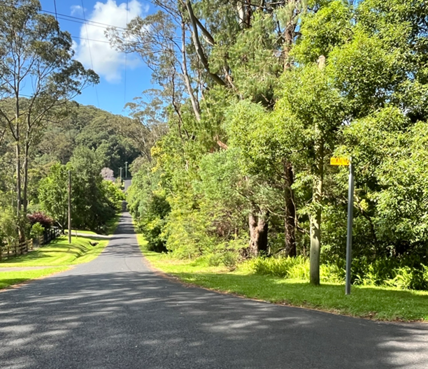
Figure 11: Slope down Elaine Road facing north towards proposed lot 2 access.
The data suggests that occupants of this site are expected to be frequently isolated and unable to leave their building as the access road will be inundated. There is no safe evacuation from this site during these relatively minor flood events. Floodplain Management does not consider it appropriate to increase the number of people subjected to the risk of isolation during a flood.
Context and Setting
The proposal is to subdivide lot 11 DP629366 known as 203 Matcham Road, Matcham into two almost equal area lots, 1 and 2. The boundary between the two is to be approximately centred on and parallel to Erina creek (refer to Figure 12) which passes through the property in an east to west direction.
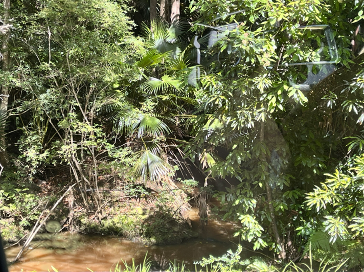
Figure 12: Erina Creek traversing the site viewed from Elaine Road 20 November 2024
during the site inspection.
Built Environment /Natural Environment
Only a portion of each proposed lot will remain flood affected with lot 1 primarily accessed from Matcham Road, and lot 2 from Elaine Road, north of the Erina Creek crossing. The intended building locations are approximately larger than 4 metres above the 1% Annual Exceedance Probability (AEP) and 3m above the Probable Maximum Flood levels.
The proposed development will result in further intensification of the land which will increase the existing flood burden within the immediate area and have a negative impact on the natural environment and create unnecessary risk to human life.
Suitability of the Site for the Development:
· Onsite Flood Conditions
The site is partially affected by flooding according to the Erina Creek Floodplain Risk Management Study and Plan 2015 (ECFRSMP 2015). The proposed building footprint falls outside the PMF extent. The proposed building would not be affected by flooding.
Floodplain Development Controls apply to this site. The proposed subdivision is a development intensification. The proposed subdivision has been assessed against the Central Coast Local Environmental Plan 2022 (CCLEP) clause 5.21 Flood Planning and Clause 5.22 Special flood considerations to determine whether it could be supported.
According to ECFRSMP 2015, access to the site is significantly affected by events as frequent as the 20% AEP Flood. The Flood Hazard for the site access for this event is H5, increasing to H6 for the PMF flood, which is unsafe for vehicles and people. The proposed dwelling location is situated on flood free land.
· Access and Evacuation during Flood Events
Elaine Road provides access to and from the site from Matcham Road (refer to Figure 11). The road at this location is predicted to be cut by flooding according to the ECFRSMP 2015. The road crosses the main floodway of Erina Creek (refer to Figure 12).
The data suggests that occupants of this site are expected to be frequently isolated and unable to leave their building as the access road will be inundated. There is no safe evacuation from this site during these relatively minor flood events. Floodplain Management does not consider it appropriate to increase the number of people subjected to the risk of isolation during a flood.
The Flood Depth on Elaine Road is 1.7m during the PMF, 0.8m in the 1% AEP event and 0.6m during the 20% AEP event (refer to Table 2 below).
|
|
Depth |
Velocity |
D*V |
|
PMF |
1.7 |
2.5 |
4.2 |
|
0.50% |
0.9 |
1.3 |
1.1 |
|
1% |
0.8 |
1.3 |
1.0 |
|
10% |
0.7 |
0.9 |
0.6 |
|
20% |
0.6 |
0.8 |
0.5 |
|
50% |
0.5 |
0.6 |
0.3 |
|
FPA |
1.7 |
2.5 |
1.0 |
Table 2: Flood depths and velocities on Elaine Road
· Supporting flood report
The supporting flood report correctly identifies that access to and from the site would be lost during a PMF event and argues that evacuation is unnecessary. It does not explain how the development would ‘enable the safe occupation and efficient evacuation of people in the event of a flood.’
The supporting flood report argues that it is Councils responsibility to upgrade Elaine and any other roads to a point where they are no longer flood affected. To some extent this is correct. However, it is not currently a Council priority and cannot be relied upon to overcome evacuation issues.
The report also states that no flood warning signs have been provided and continues ‘The absence of safety warning signs indicates the modelled hazard levels are either incorrect, or Council accepts a “shelter in place” practical approach for the management of flood access for the Elaine Road crossing.’
This is not correct – the absence of warning signs does not indicate an absence of risk.
· Recommendation
The proposed subdivision will result in more people on this site compared to currently. It is necessary to consider whether there would be an increased risk to life as a result of this development. There will be no safe evacuation for the additional occupants during a flood.
In our view, the proposed subdivision would result in:
o An increased exposure to the risk factors of sheltering in place
o An increased risk of people being isolated during medical emergencies
o An increased risk of people making dangerous decisions such as entering floodwater while access roads are inundated.
o An increased workload for the SES who will need to rescue or resupply a greater number of people
o An increased risk to life compared to existing.
It is not considered best Floodplain Management Practice to intensify development in a location which will be cut off by flood water. In our view the proposed Subdivision fails to comply with CCLEP clause 5.21(2)( c) which says that Development consent must not be granted to development on land the consent authority considers to be within the flood planning area unless the consent authority is satisfied the development will not adversely affect the safe occupation and efficient evacuation of people or exceed the capacity of existing evacuation routes for the surrounding area in the event of a flood.
The proposed subdivision also fails to comply with CCLEP clause 5.21(3)( c) which requires the consent authority to consider whether the development incorporates measures to minimise the risk to life and ensure the safe evacuation of people in the event of a flood.
The CCLEP clause 5.21 Flood Planning requires that a development should not result in an unacceptable increased risk to life compared to the current. In this case, there is a clear increase in risk as the road will be cut off during frequent flood events. An additional occupancy will result in an increase in the number of people isolated by floodwater. The historical data indicates that people may enter flood water during storm events. In 2022, a local motorist was killed in Matcham while attempting to cross a flooded road during a storm event.
The fact that this location will be cut off during relatively frequent flood events demonstrates that development intensification is not appropriate.
The applicant was advised during the Pre-DA meeting that the proposed subdivision and potential development of addition dwelling houses on the newly created Torrens lot was not considered suitable for the site due to significant flooding impacts on and around the site and the proposed subdivision is not supported by Floodplain Management.
The Public Interest
The applicant is advised the proposed development is found to be inconsistent with Section 4.15(1)(b)(c) & (e) of the Environmental Planning and Assessment Act 1979 and is not supported by Council.
Any Submission made in Accordance with this Act or Regulations
Section 4.15 (1)(d) of the Environmental Planning and Assessment Act 1979 requires consideration of any submissions received during notification of the proposal.
The proposal was formally advertised and notified in accordance with the CCDCP 2022 Chapter 1, Part 1.2 Notification of Development Proposals between 27 September 2024 and 6 28 October 2024.
One (1) public submission was received in relation to the application. Those issues associated with key issues have been addressed in the above report. The remaining issues pertaining to various concerns were addressed in the assessment of the application pursuant to the heads of consideration contained within section 4.15 of the Environmental Planning and Assessment Act 1979.
A summary of the submission is detailed below.
1. The site is below the minimum lot size for subdivision.
Comment
The proposed Torrens title subdivision is significantly less than the minimum lot size permitted per the IDO 122 being Lot 1: 27.39% variation and Lot 2: 29.2% variation and do not support the proposed Torrens title subdivision.
2. The development does not preserve the environmental amenity.
Comment
The proposed development has the capacity to negatively impact on the amenity of the area with specific regards to the immediate adjoining properties.
3. If the development is approved it may set a precedence in the area which allows lot sizes less than what is permitted under legislation.
Comment
The variation to the minimum lot size permitted is considered unsuitable in a rural zone and is not consistent with the orderly development of the area.
4. Concerns that this approval pathway requires financial gains given directly to Council to permit lot sizes less than the minimum lot size.
Comment
The development is permitted with consent from the delegate authority per the State Environmental Planning Policy No 1 Development Standards (SEPP 1) and the Interim Development Order No. 122.
Submissions from Public Authorities
Rural Fire Services
The RFS provided their concurrence and issued a bushfire certificate which would be conditioned as part of the consent if the proposal was to be supported.
The Department of Planning and Environment-Water
The Department of Planning and Environment-Water advised a controlled activity approval would not be required for the proposed works and no further assessment by that agency would be necessary.
Internal Consultation
|
Flood Engineer |
Not supported |
||
|
Engineer |
Insufficient Information |
||
|
Environmental Health OSSM |
Insufficient Information |
||
|
Tree |
Supported, subject to conditions |
||
|
Environmental Health |
Supported, subject to conditions |
||
|
Ecology |
|
Supported, subject to conditions |
|
External Consultation
|
NSW Rural Fire Service |
Supported, subject to conditions |
||
|
Department of Planning and Environment - Water |
|
Controlled Activity approval not required |
|
Political Donations
During assessment of the application there were no political donations were declared by the applicant, applicant’s consultant, owner, objectors and/or residents.
Ecologically Sustainable Principles:
The proposal has been assessed having regard to ecologically sustainable development principles and is considered to be consistent with the principles.
The proposed development is considered to incorporate satisfactory stormwater, drainage and erosion control and the retention of vegetation where possible and is unlikely to have any significant adverse impacts on the environment and will not decrease environmental quality for future generations. The proposal does not result in the disturbance of any endangered flora or fauna habitats and is unlikely to significantly affect fluvial environments.
Climate Change
The potential impacts of climate change on the proposed development have been considered by Council as part of the assessment of the application.
The supporting flood report compiled by Eddy Consulting correctly identifies that access to and from the site would be lost during a PMF event and argues that evacuation is unnecessary. It does not explain how the development would ‘enable the safe occupation and efficient evacuation of people in the event of a flood.’
The proposed development is not considered satisfactory in relation to climate change.
Other Matters for Consideration:
1. A Preliminary Engineering Plan was not provided with the DA showing how the vehicular access to proposed lot 2 would be undertaken.
2. The Wastewater Management Report comprised insufficient information to support the DA application and will require a revised report (refer to 3.3 On-Site Sewage Management of the CCDCP).
Development Contribution Plan
The site is not subject to the provisions of any section 7.11 or 7.12 development contribution plan.
Housing and Productivity Contribution (HPC)
· The HPC applies to the whole of the Central Coast Local Government area and to the following types of development:
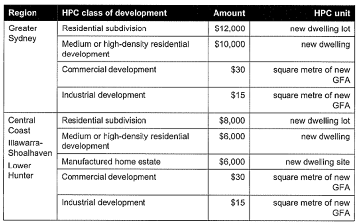
· The HPC came into effect on 1 October 2023 and will apply to development applications and complying development certificates across 43 council areas in the Greater Sydney, Illawarra-Shoalhaven, Lower Hunter and Central Coast regions. The Ministerial Order sets out how the contribution will operate.
· The HPC will be required to be paid prior to issue of a construction certificate/CDC/Subdivision Certificate, depending on the type of work consented to.
· The HPC for this site is $8000 for the new residential lot.
Planning Agreements
The proposed development is not subject to a planning agreement or draft planning agreement.
Conclusion:
This application has been assessed under the heads of consideration of section 4.15 of the Environmental Planning & Assessment Act 1979 and all relevant instruments and policies and found to be unsatisfactory.
The constraints of the site have been assessed and it is considered that the site is not suitable for the proposed development with specific concerns as reiterated throughout the report for flooding and increased risk of local motorists leaving their premises for general purposes or in a medical emergency and entering into flood waters which happened in 2022 when there was a fatal accident due to trying to travel through flood waters.
Based on the assessment outlined earlier in this report, it is considered that the application be refused pursuant to section 4.16(1)(b) of the Environmental Planning and Assessment Act 1979, for the reasons outlined in this report.
Delegations
The staff responsible for the preparation of the report, recommendation or advice to any person with delegated authority to deal with the application have no pecuniary conflict of interest or non-pecuniary conflict of interest to disclose in respect of the application.
The staff authorised to determine the application have no pecuniary conflict of interest or non-pecuniary conflict of interest to disclose in respect of the application.
Recommendation:
A That the Central Coast Local Planning Panel as consent authority refuse the Development Application No. DA/1496/2024 for 2 lot Subdivision - (Nominated Integrated & Integrated) on Lot 11 DP 629366, 203 Matcham Road, Matcham subject to the reasons for refusal detailed in the schedule attached to the report and having regard to the matters for consideration detailed in Section 4.15 of the Environmental Planning and Assessment Act 1979 for the following reasons:
1: The proposed development is not considered in the public interest. There would be an increased risk to life as a result of this development. There will be no safe evacuation for the additional occupants during a flood which would result in:
o An increased exposure to the risk factors of sheltering in place
o An increased risk of people being isolated during medical emergencies
o An increased risk of people making dangerous decisions such as entering floodwater while access roads are inundated.
o An increased workload for emergency services who will need to rescue or resupply a greater number of people
o An increased risk to life compared to existing.
2: The proposed allotments are significantly less than the minimum lot size requirement of 1 hectare (Ha) for land zoned 7 (C2) Scenic Protection Rural as prescribed under Clause 18 within the IDO 122. Undersized subdivision of lots in this area is not consistent with current legislation or approval patterns and would set a precedence in the area for significantly undersized lots which is not consistent with the orderly development of the area.
3: The development is inconsistent with the objectives of the 7 (C2) Scenic Protection Rural zone. The environmental limitations over the site within the zone include Medium Landslip, Flooding, Biodiversity Values and Bushfire Prone Land which forces the building envelope for any future dwelling to be located close to the north and eastern boundaries prompting objection from a neighbouring property. This will adversely affect the aesthetic and scenic value of the land by clustering any future dwelling with the existing dwelling houses which will interfere unreasonably with the amenity of existing adjoining properties.
4: Insufficient information and documentation was provided with the development application. The applicant did not provide a Preliminary Engineering Plan and the Wastewater Management Report comprised insufficient information to support the DA application.
B That Council advises those who made written submissions of the Panel’s decision.
C That Council advise relevant external authorities of the Panel’s decision.
|
1⇩
|
PUBLIC - Portal Doc - 203 Matcham Road, MATCHAM NSW 2250 - DA/1496/2024 - Plan of Subdivision |
|
D16396728 |
|
2⇩
|
PUBLIC - Portal Doc - 203 Matcham Road, MATCHAM NSW 2250 - DA/1496/2024 - Plan of Subdivision with APZ, PMF, Building Envelope |
|
D16396729 |
|
3⇩
|
PUBLIC - Portal Doc - 203 Matcham Road, MATCHAM NSW 2250 - DA/1496/2024 - Survey Plan |
|
D16396731 |
|
4⇩
|
PUBLIC - Portal Doc - 203 Matcham Road, MATCHAM NSW 2250 - DA/1496/2024 - Flood Report |
|
D16396716 |
|
5⇩
|
Portal Doc - 203 Matcham Road, MATCHAM NSW 2250 - DA/1496/2024 - SEPP 1 Objection |
|
D16396723 |
|
6⇩
|
Pre-development Application Record of Advice - 203 Matcham Road, MATCHAM NSW 2250 - PDA 91 2024 - T M Green |
|
D16596474 |
|
7⇩
|
PUBLIC - Portal Doc - 203 Matcham Road, MATCHAM NSW 2250 - DA/1496/2024 - Bushfire Report |
|
D16396714 |
|
8⇩
|
PUBLIC - Portal Doc - 203 Matcham Road, MATCHAM NSW 2250 - DA/1496/2024 - Arborists Report |
|
D16396713 |
|
9⇩
|
PUBLIC - Portal Doc - 203 Matcham Road, MATCHAM NSW 2250 - DA/1496/2024 - Wastewater Management Plan |
|
D16396733 |
|
10⇩
|
Portal Doc - 203 Matcham Road, MATCHAM NSW 2250 - DA/1496/2024 - AHIMS Web Search |
|
D16396724 |
|
11⇩
|
Portal Doc - 203 Matcham Road, MATCHAM NSW 2250 - DA/1496/2024 - Preliminary Engineering Drawings Acknowledgement Doc |
|
D16396726 |
|
3.2 |
DA/1496/2024 - 203 Matcham Road, Matcham - 2 Lot Subdivision |
|
Attachment 1 |
PUBLIC - Portal Doc - 203 Matcham Road, MATCHAM NSW 2250 - DA/1496/2024 - Plan of Subdivision |
|
3.2 |
DA/1496/2024 - 203 Matcham Road, Matcham - 2 Lot Subdivision |
|
Attachment 2 |
PUBLIC - Portal Doc - 203 Matcham Road, MATCHAM NSW 2250 - DA/1496/2024 - Plan of Subdivision with APZ, PMF, Building Envelope |
|
3.2 |
DA/1496/2024 - 203 Matcham Road, Matcham - 2 Lot Subdivision |
|
Attachment 3 |
PUBLIC - Portal Doc - 203 Matcham Road, MATCHAM NSW 2250 - DA/1496/2024 - Survey Plan |
|
3.2 |
DA/1496/2024 - 203 Matcham Road, Matcham - 2 Lot Subdivision |
|
Attachment 4 |
PUBLIC - Portal Doc - 203 Matcham Road, MATCHAM NSW 2250 - DA/1496/2024 - Flood Report |
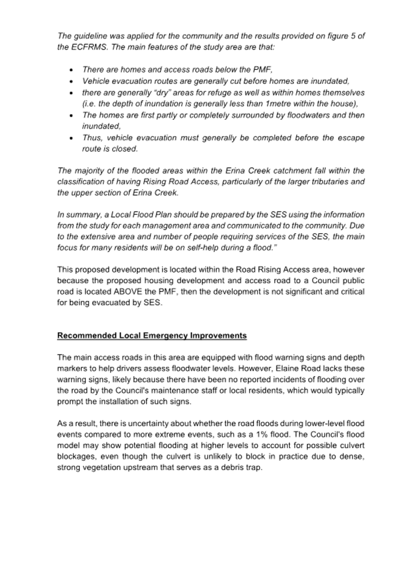
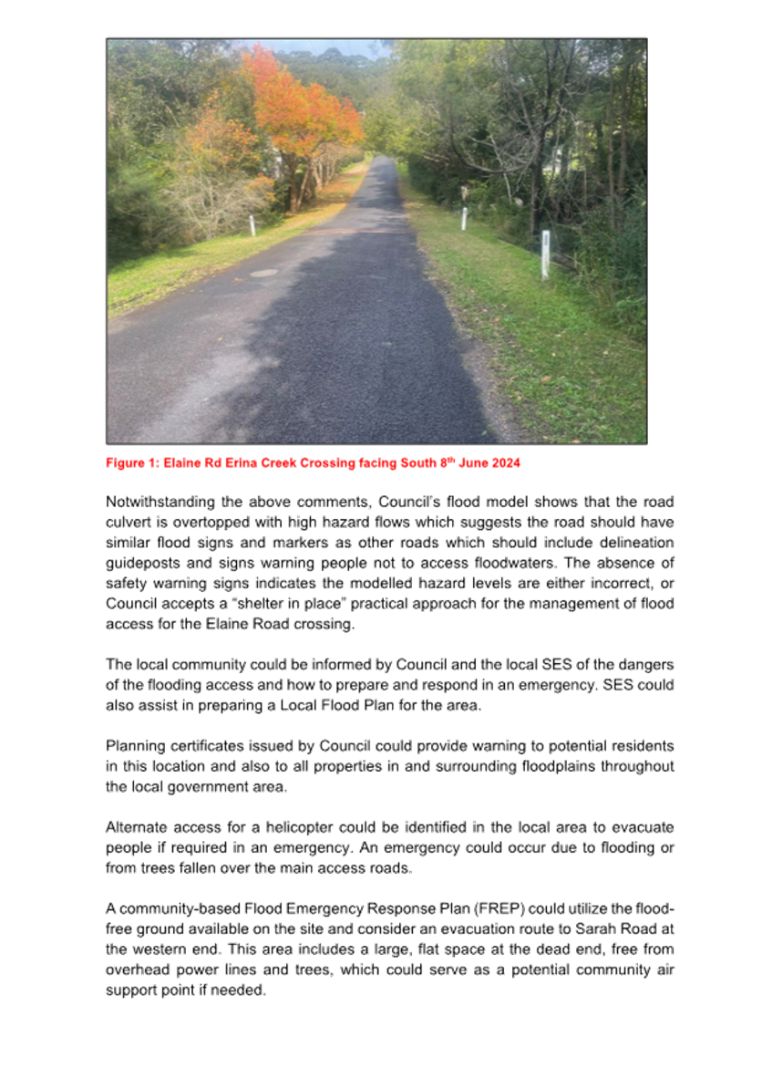
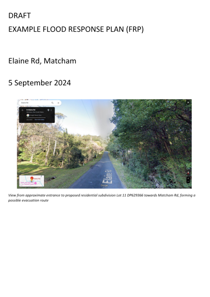
|
3.2 |
DA/1496/2024 - 203 Matcham Road, Matcham - 2 Lot Subdivision |
|
Attachment 5 |
Portal Doc - 203 Matcham Road, MATCHAM NSW 2250 - DA/1496/2024 - SEPP 1 Objection |
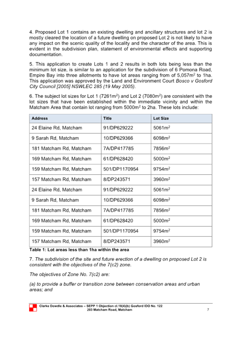
|
DA/1496/2024 - 203 Matcham Road, Matcham - 2 Lot Subdivision |
|
|
Attachment 6 |
Pre-development Application Record of Advice - 203 Matcham Road, MATCHAM NSW 2250 - PDA 91 2024 - T M Green |
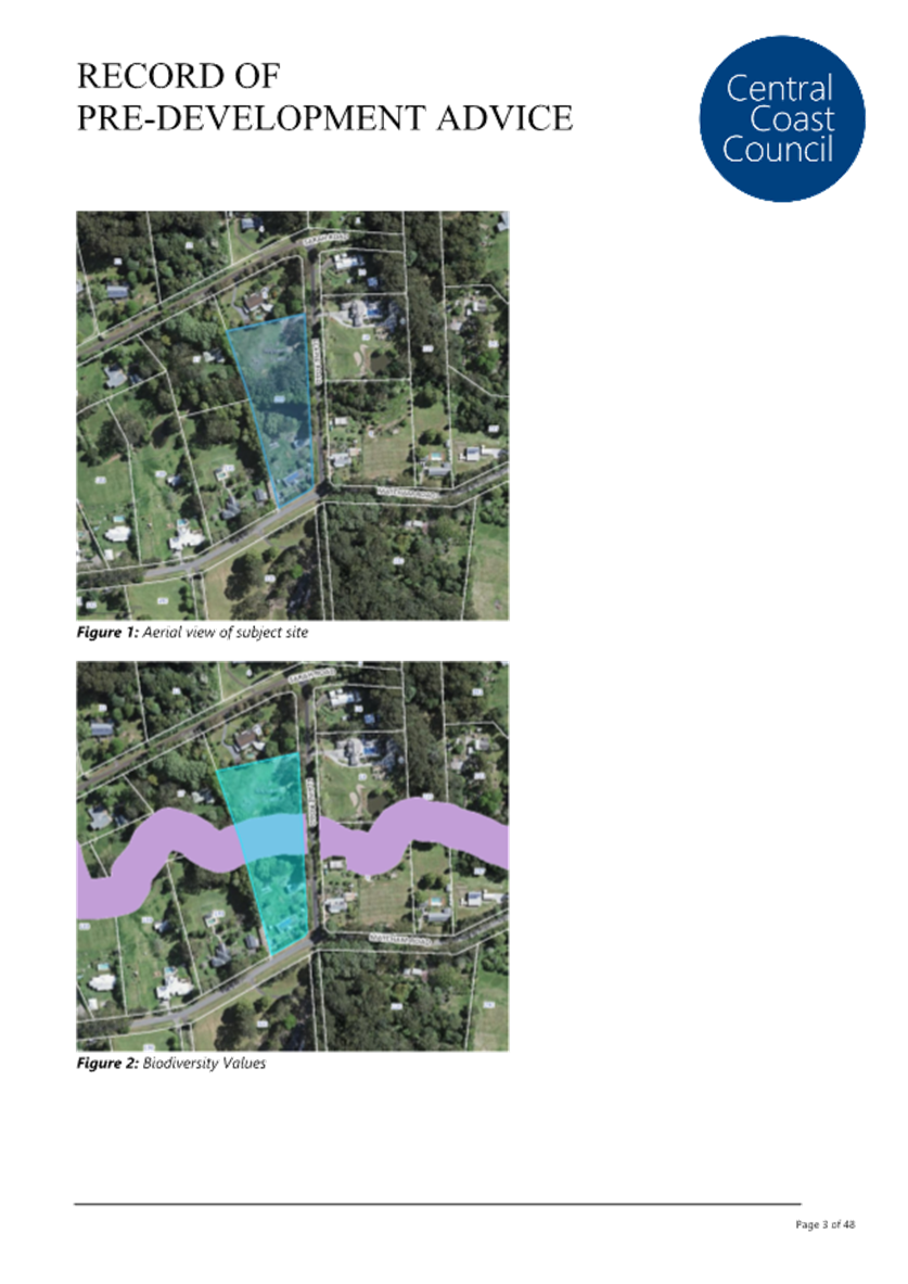
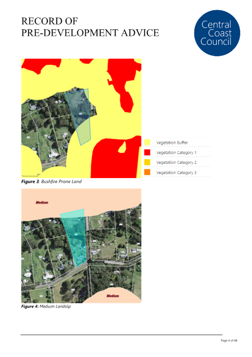
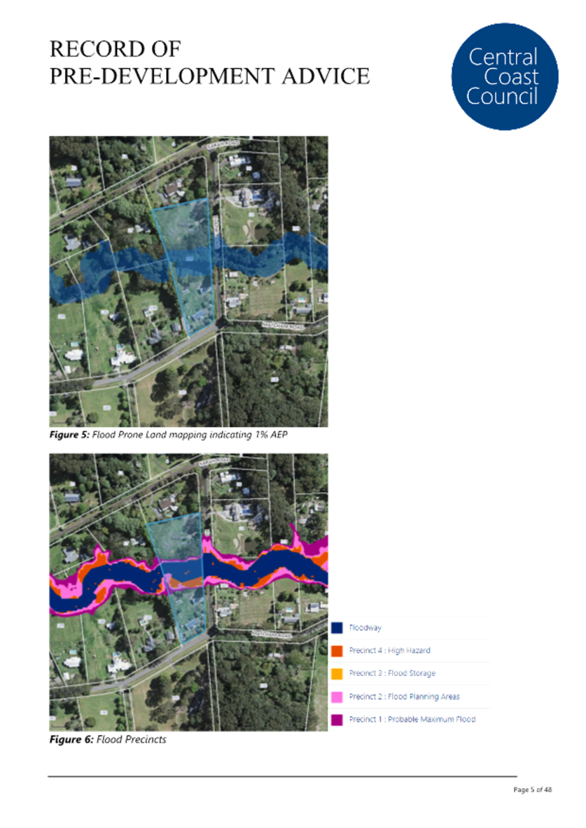
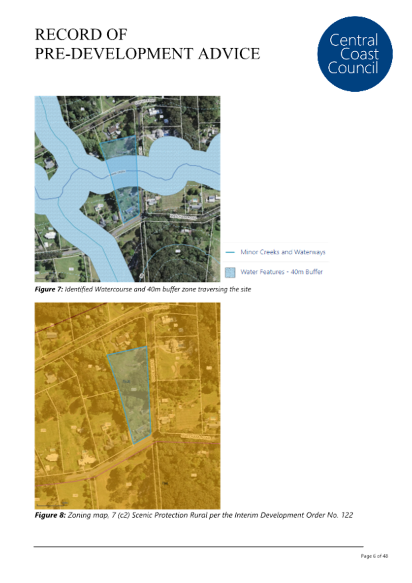
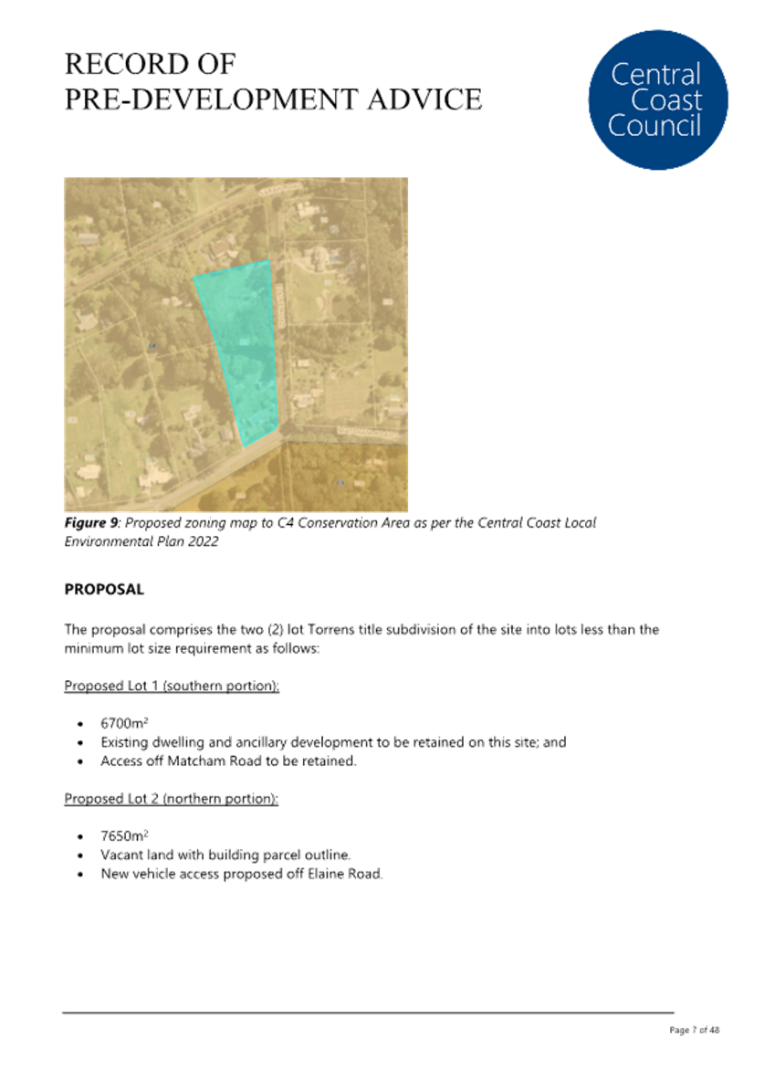
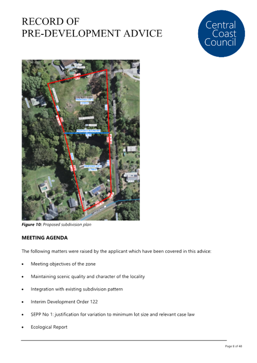
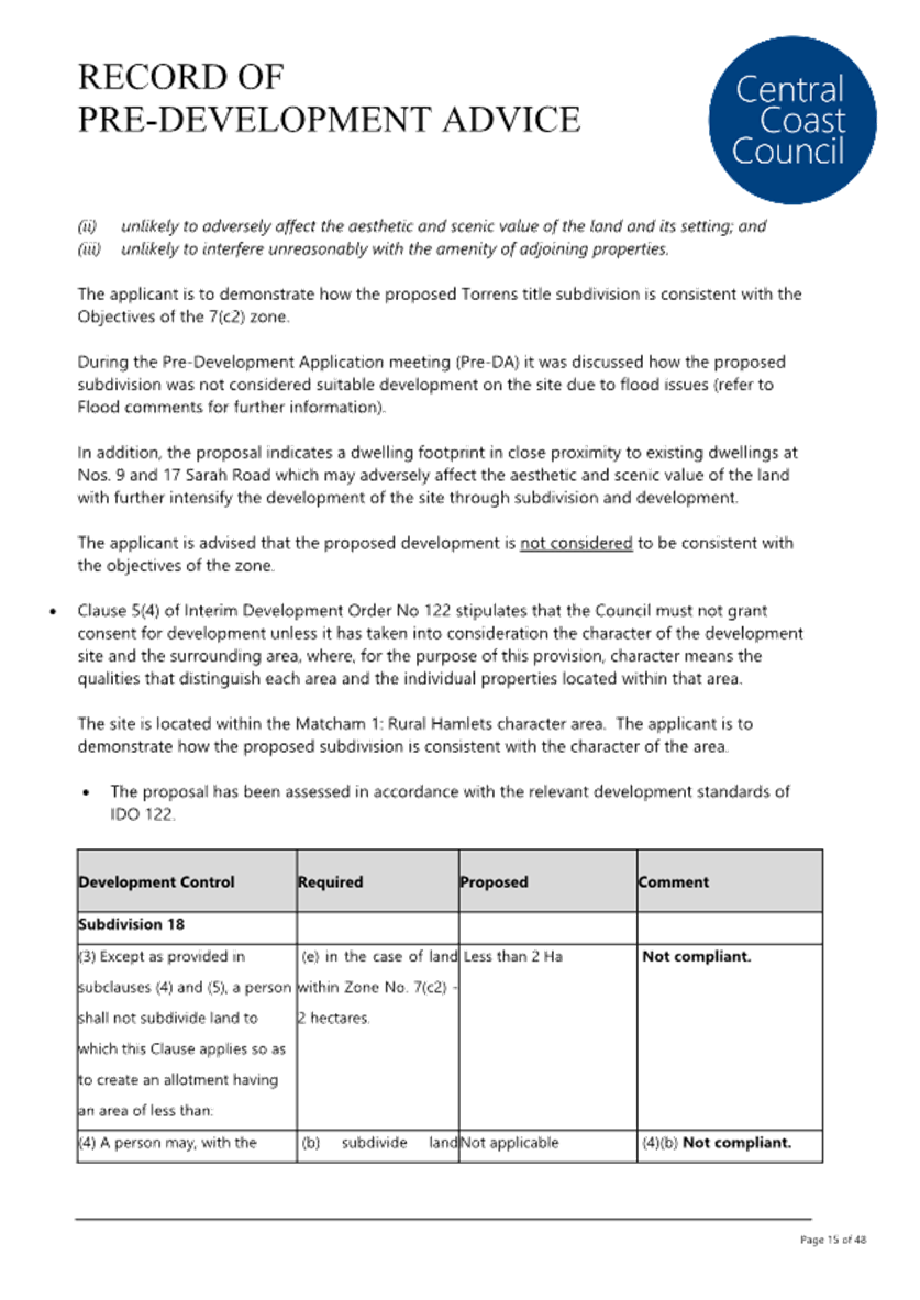
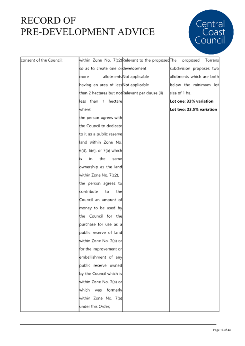
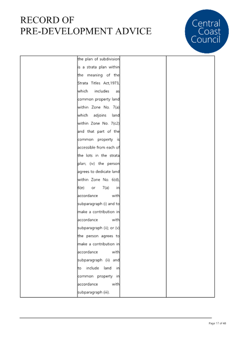
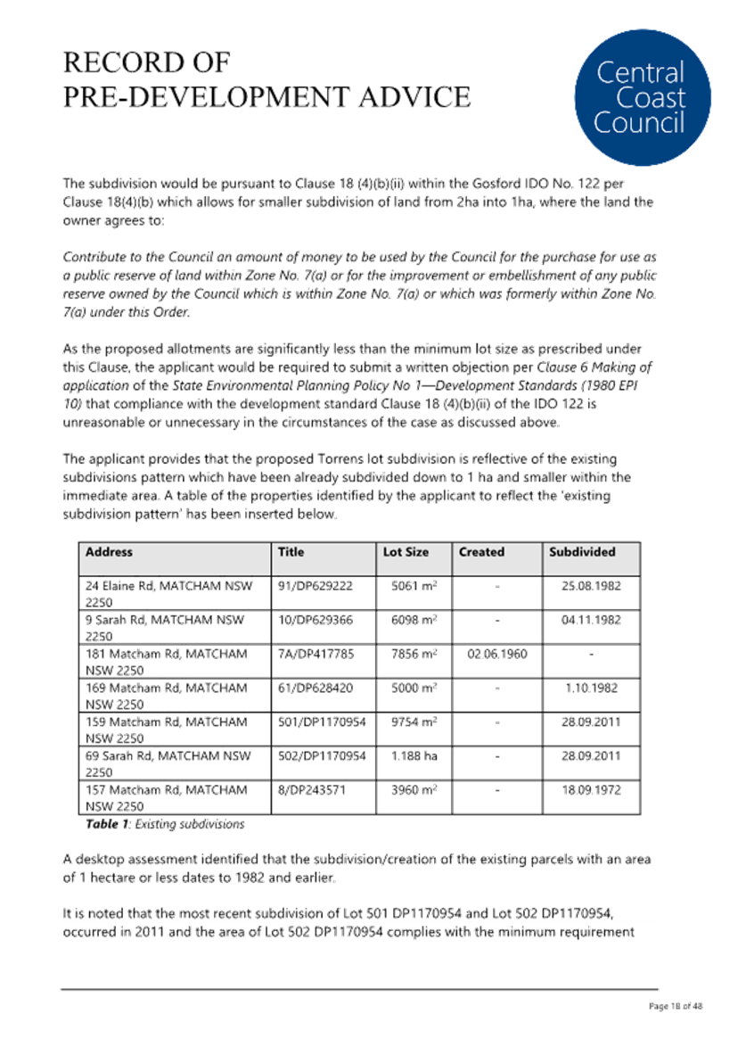
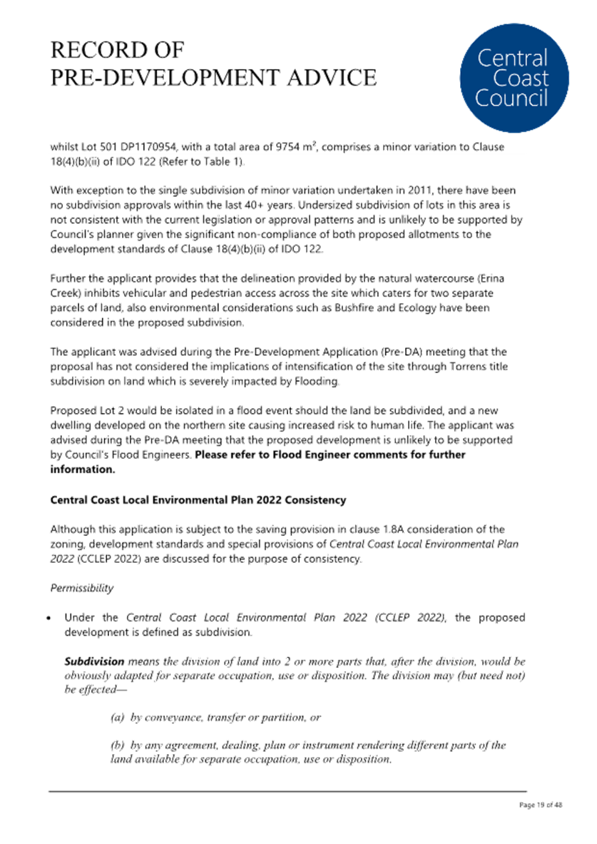
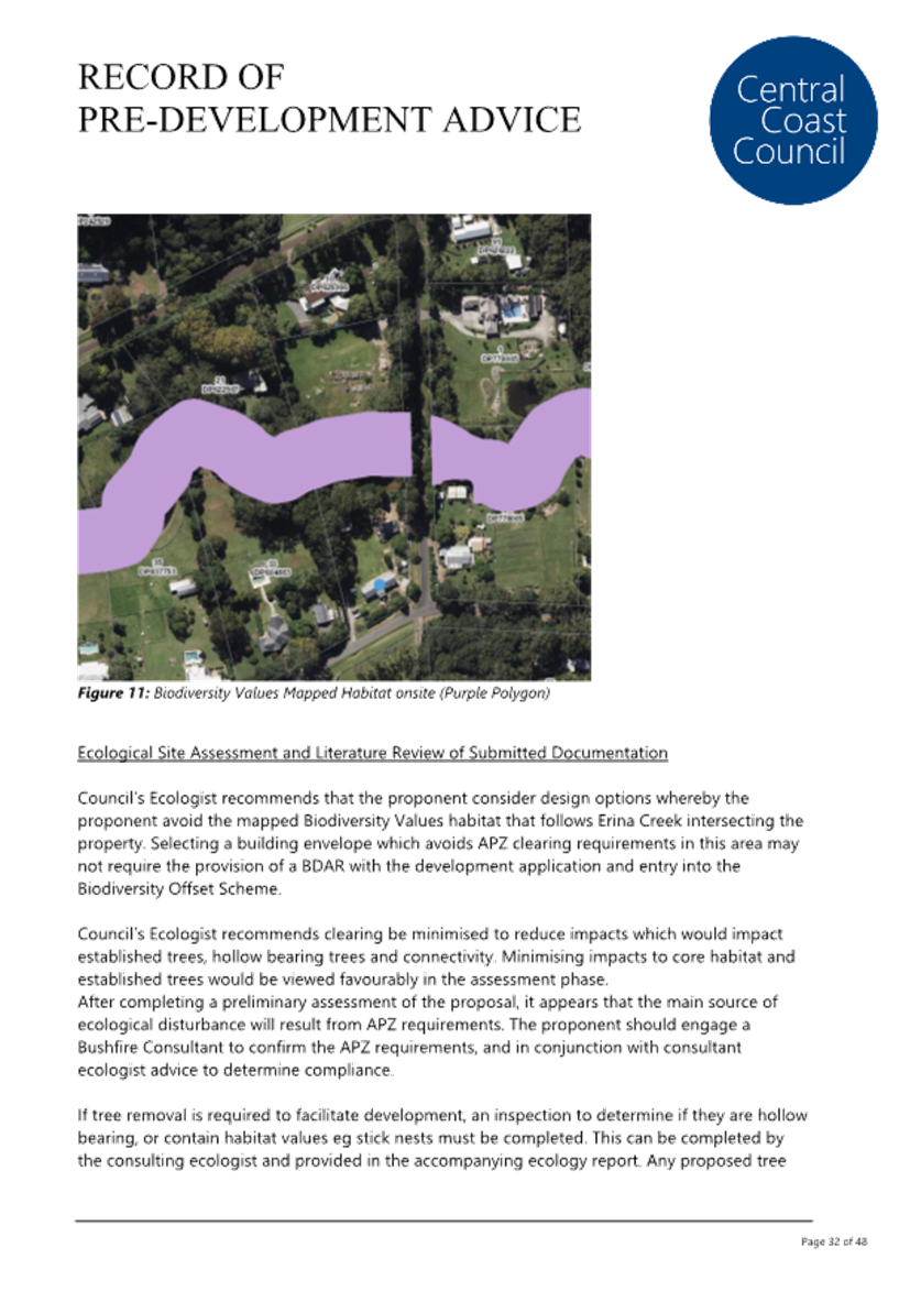
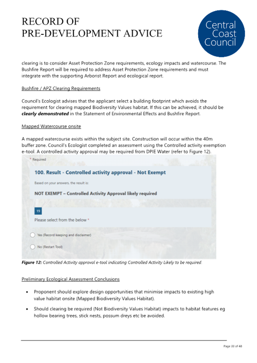

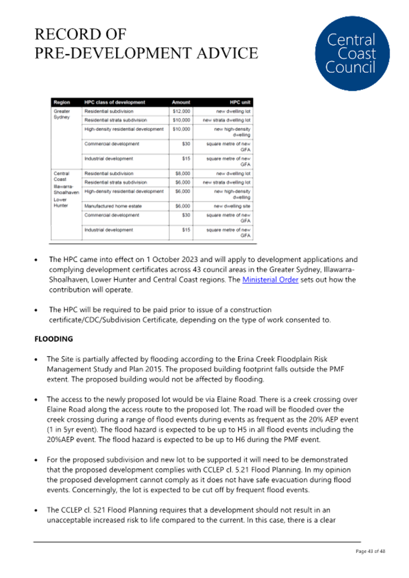

|
DA/1496/2024 - 203 Matcham Road, Matcham - 2 Lot Subdivision |
|
|
Attachment 7 |
PUBLIC - Portal Doc - 203 Matcham Road, MATCHAM NSW 2250 - DA/1496/2024 - Bushfire Report |
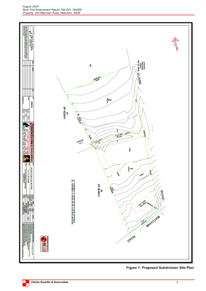
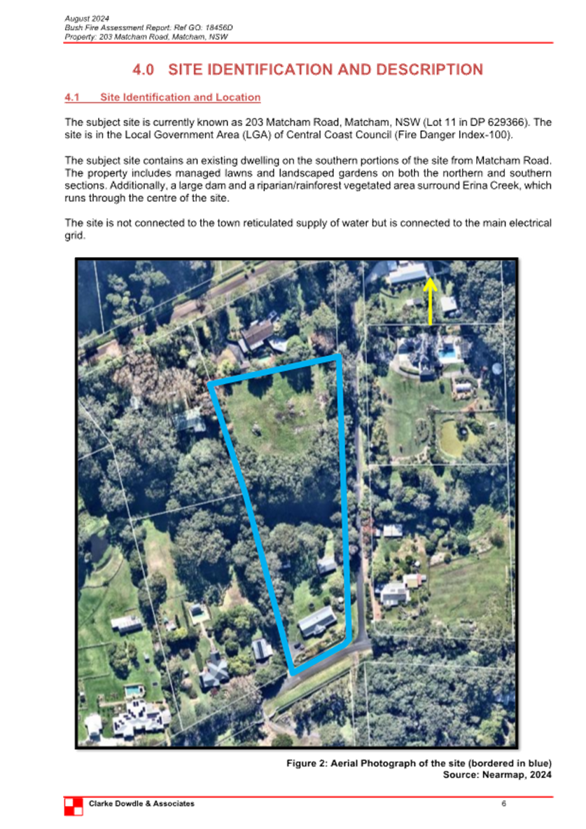
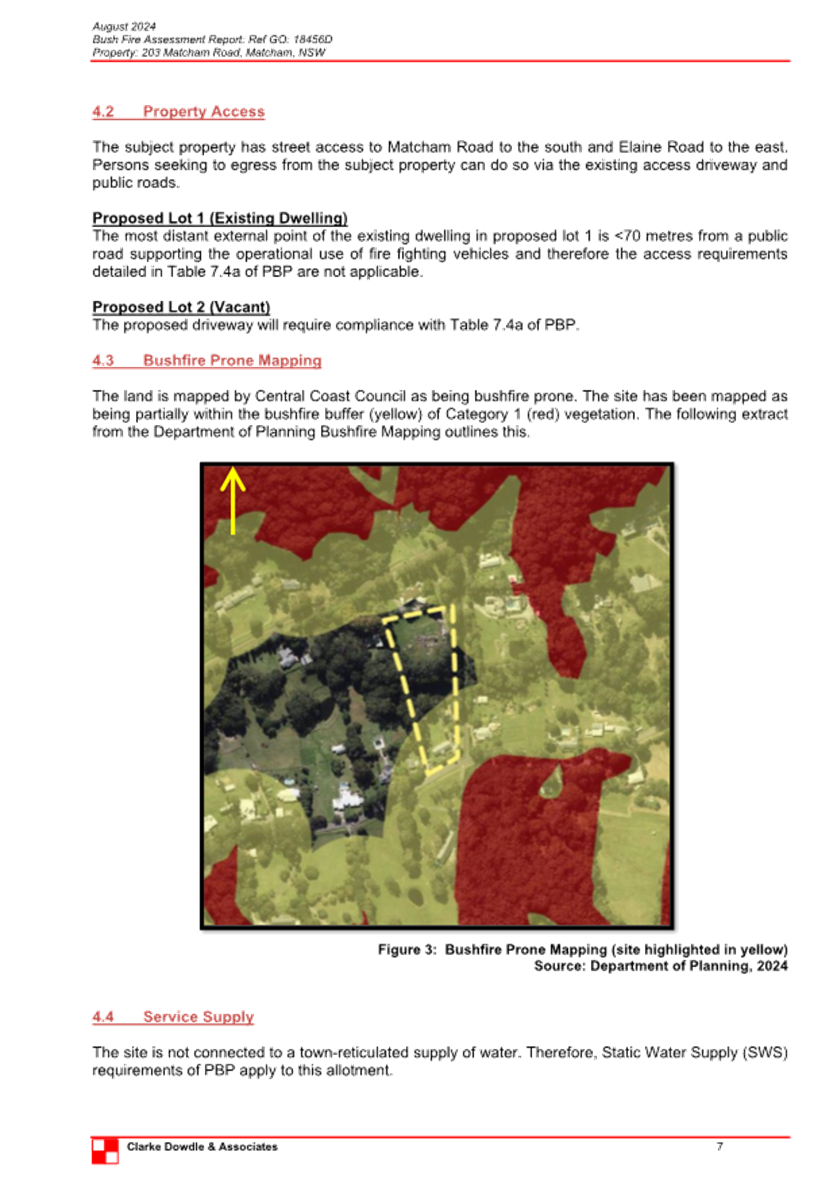
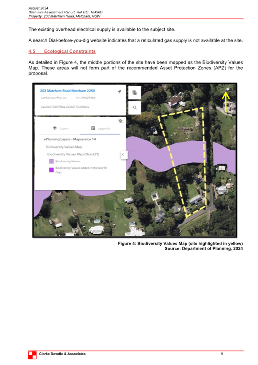
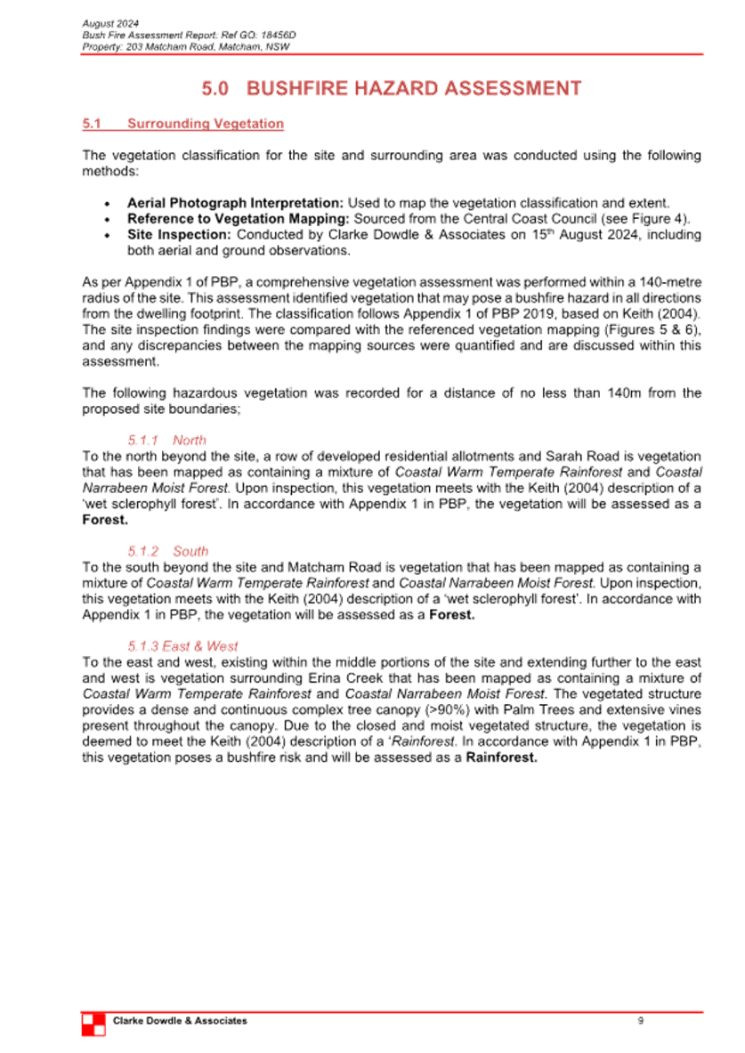
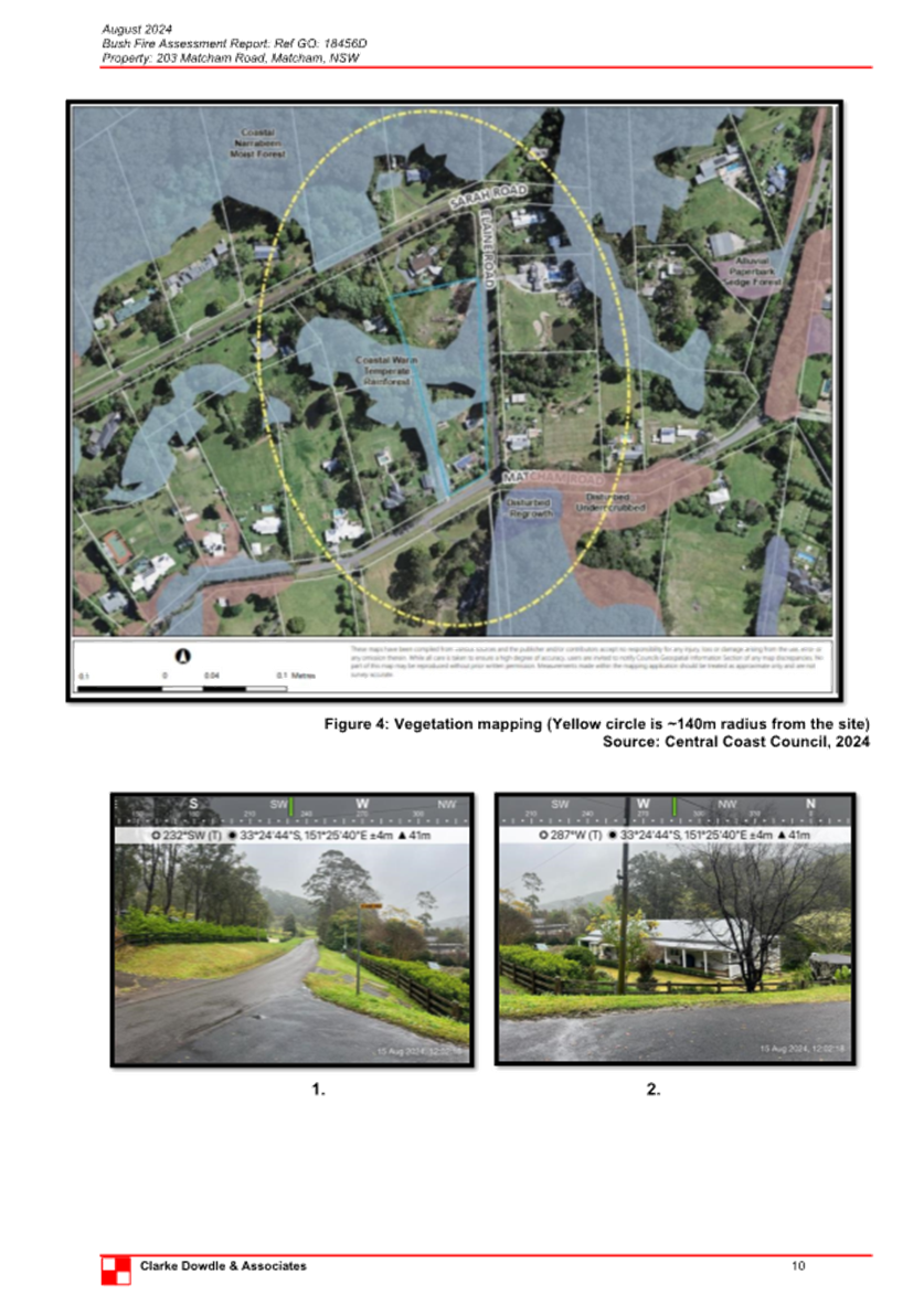
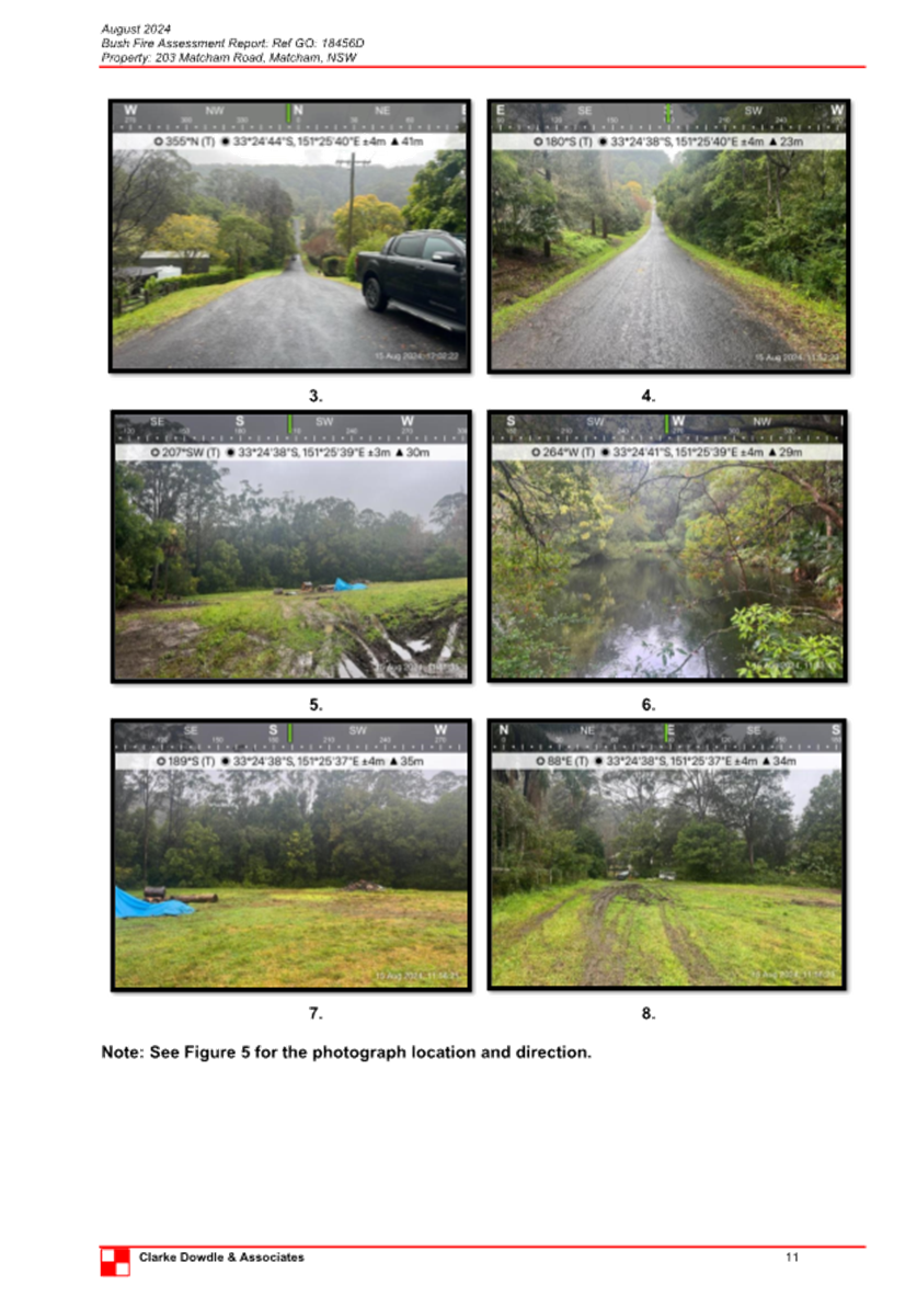
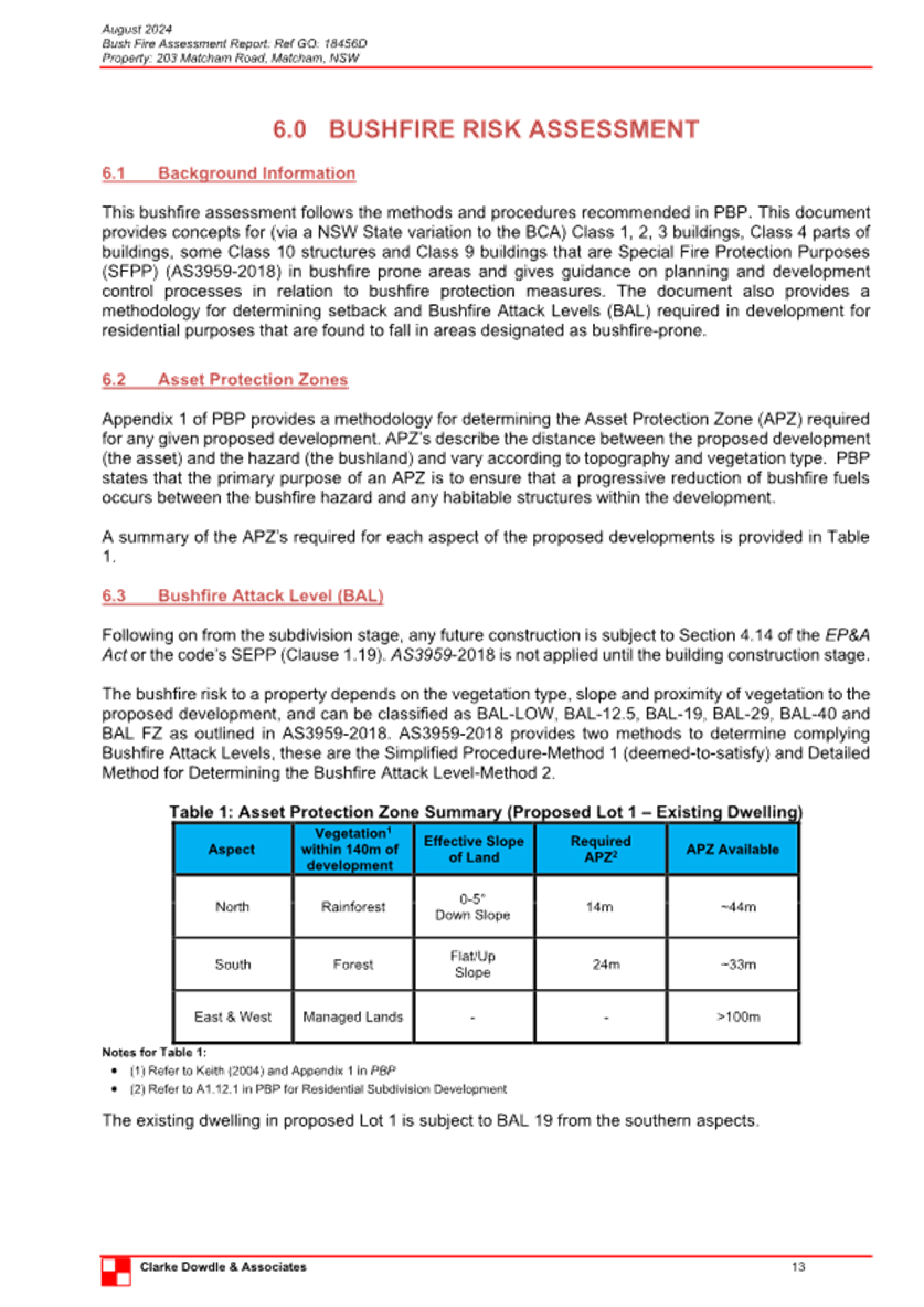
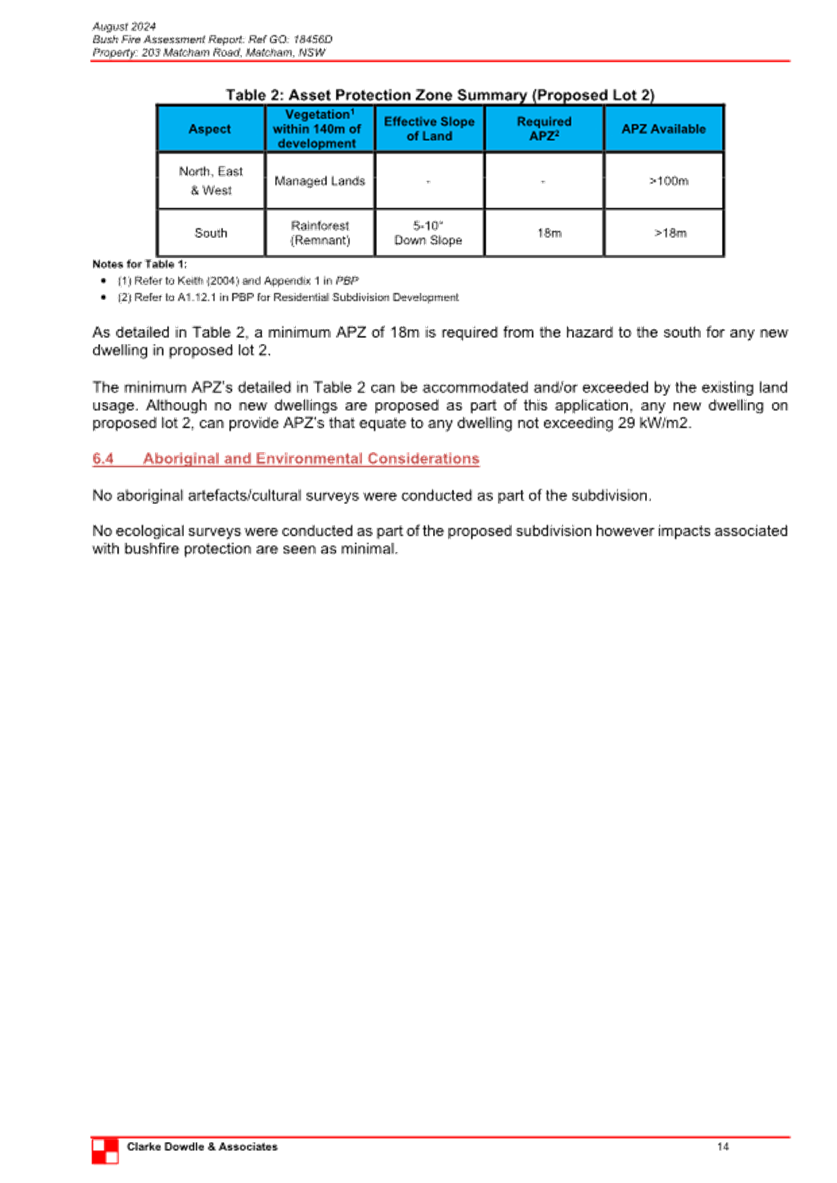
|
DA/1496/2024 - 203 Matcham Road, Matcham - 2 Lot Subdivision |
|
|
Attachment 8 |
PUBLIC - Portal Doc - 203 Matcham Road, MATCHAM NSW 2250 - DA/1496/2024 - Arborists Report |
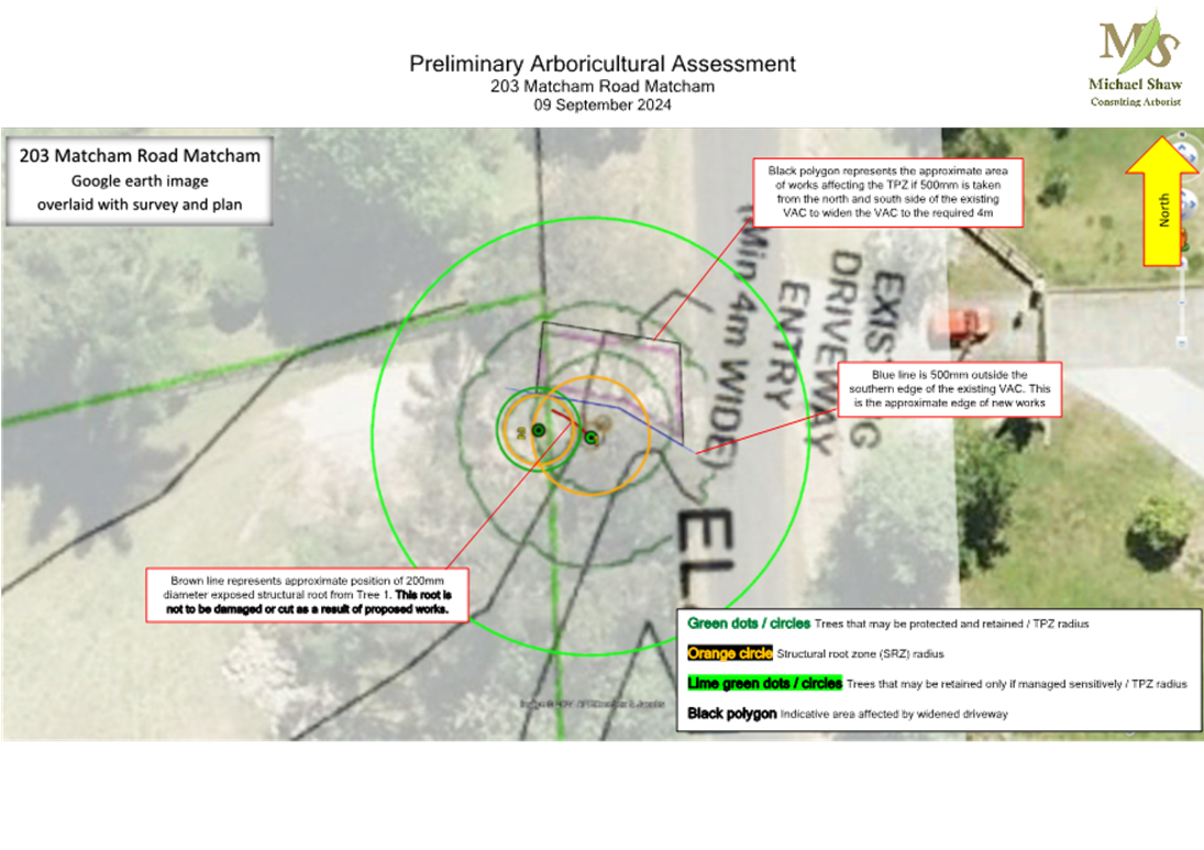
|
DA/1496/2024 - 203 Matcham Road, Matcham - 2 Lot Subdivision |
|
|
Attachment 9 |
PUBLIC - Portal Doc - 203 Matcham Road, MATCHAM NSW 2250 - DA/1496/2024 - Wastewater Management Plan |
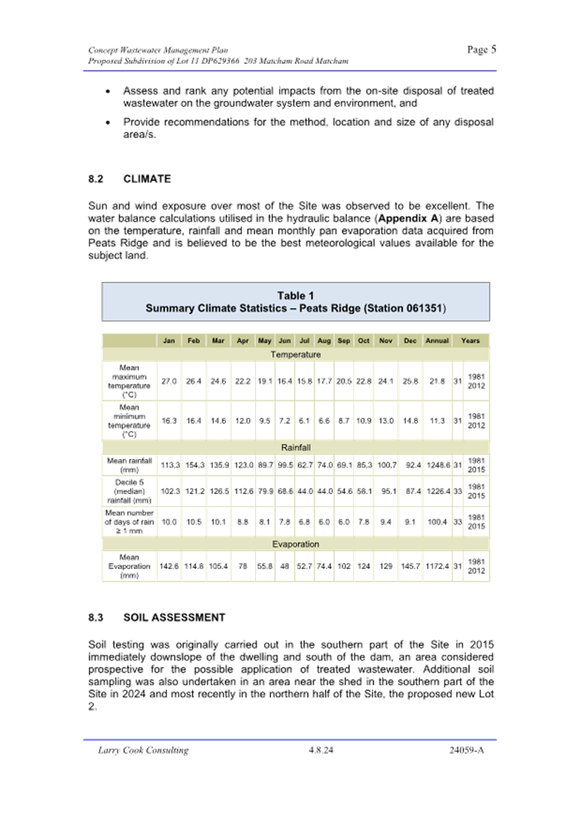
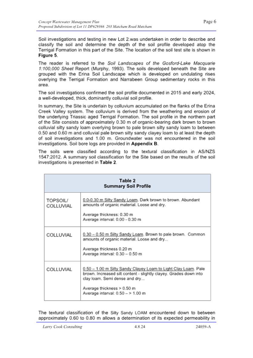
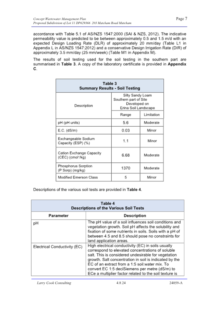
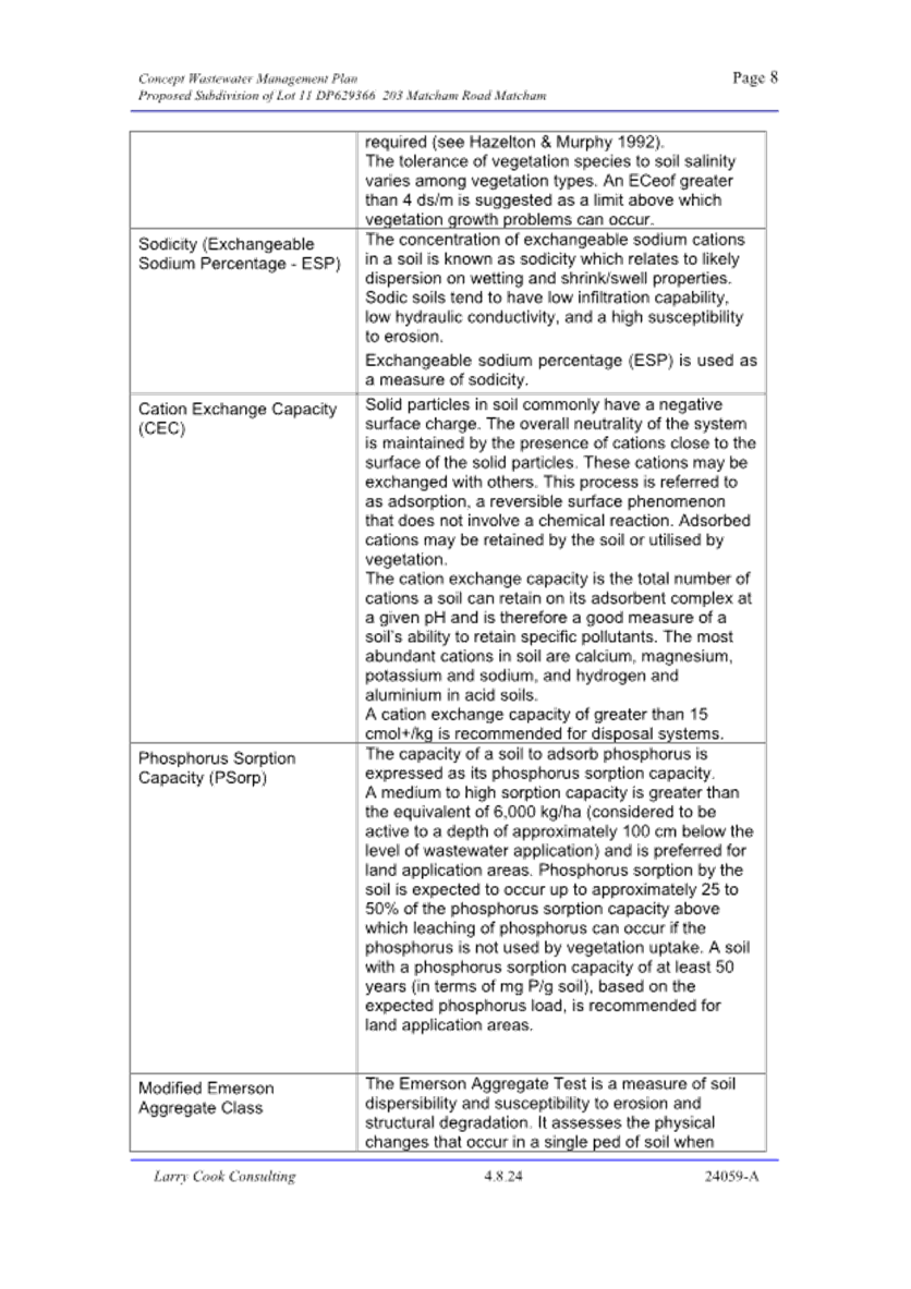
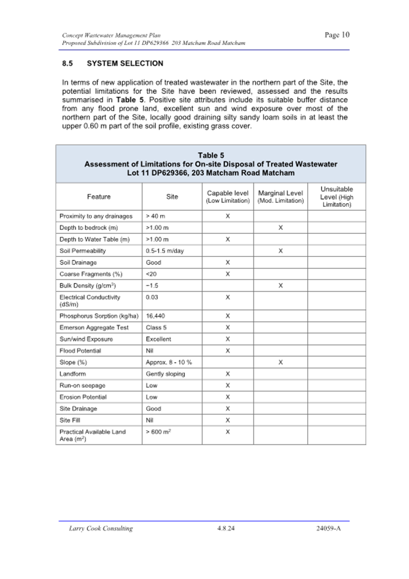
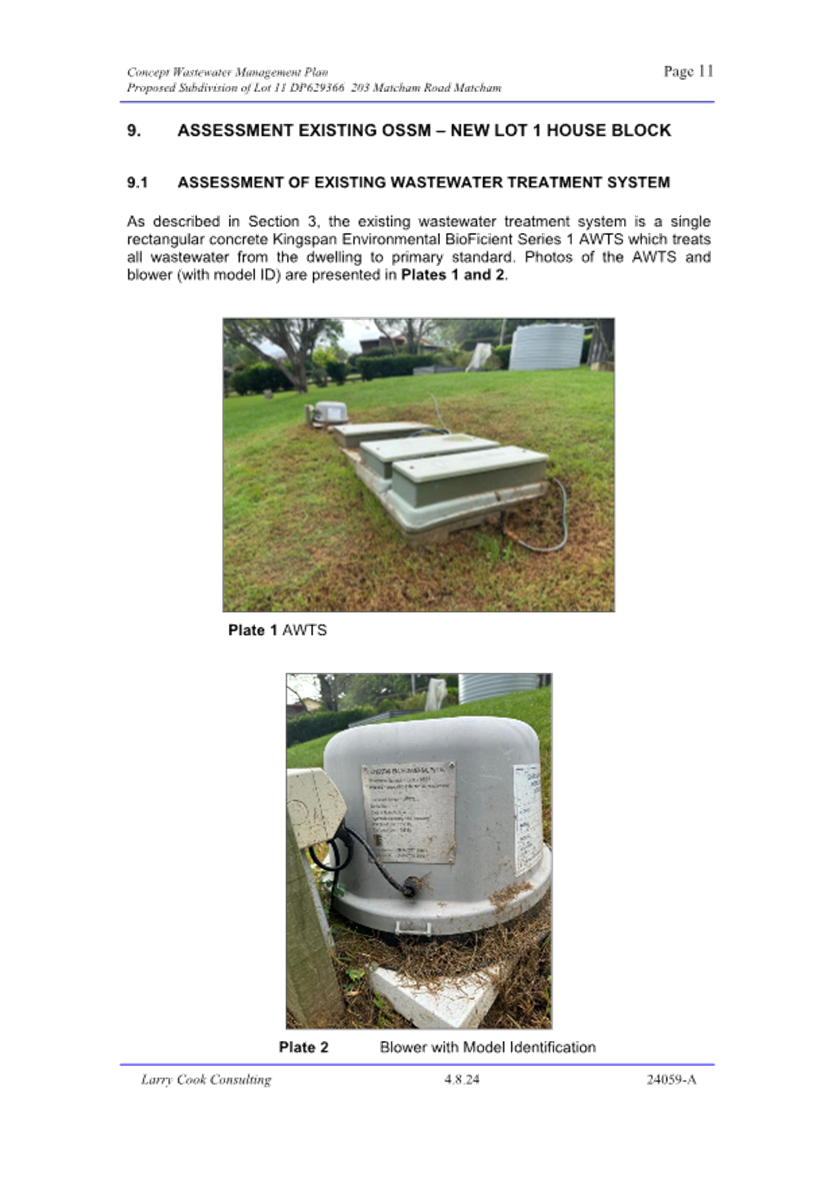
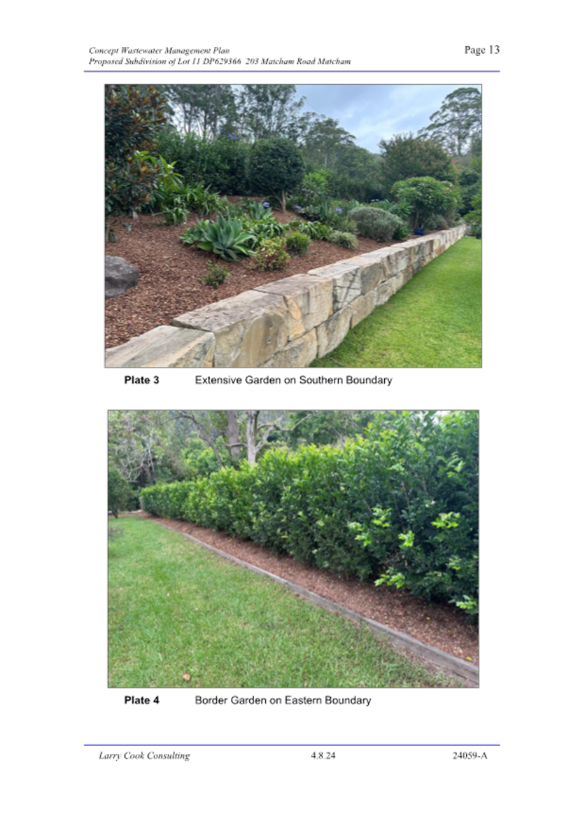
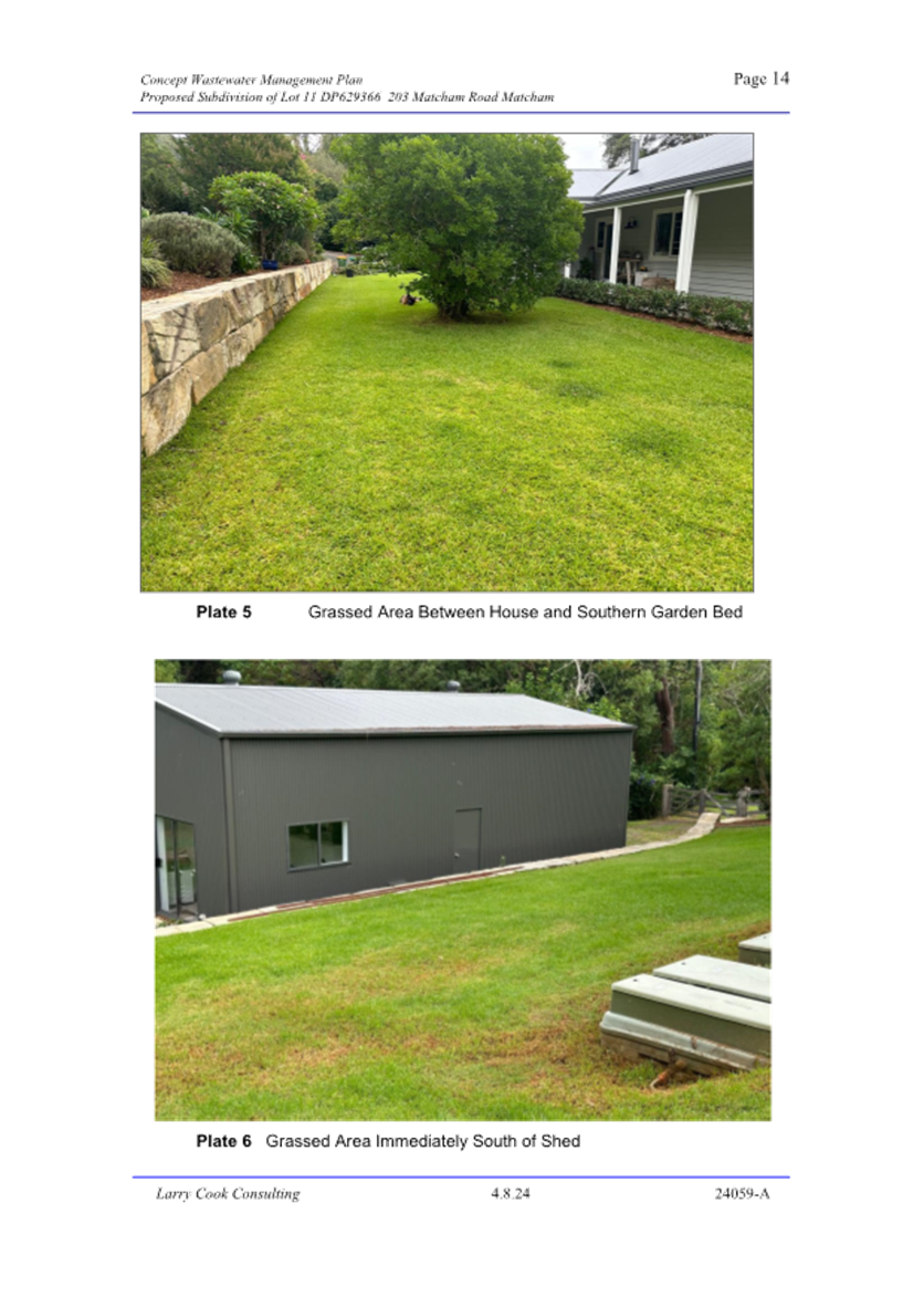
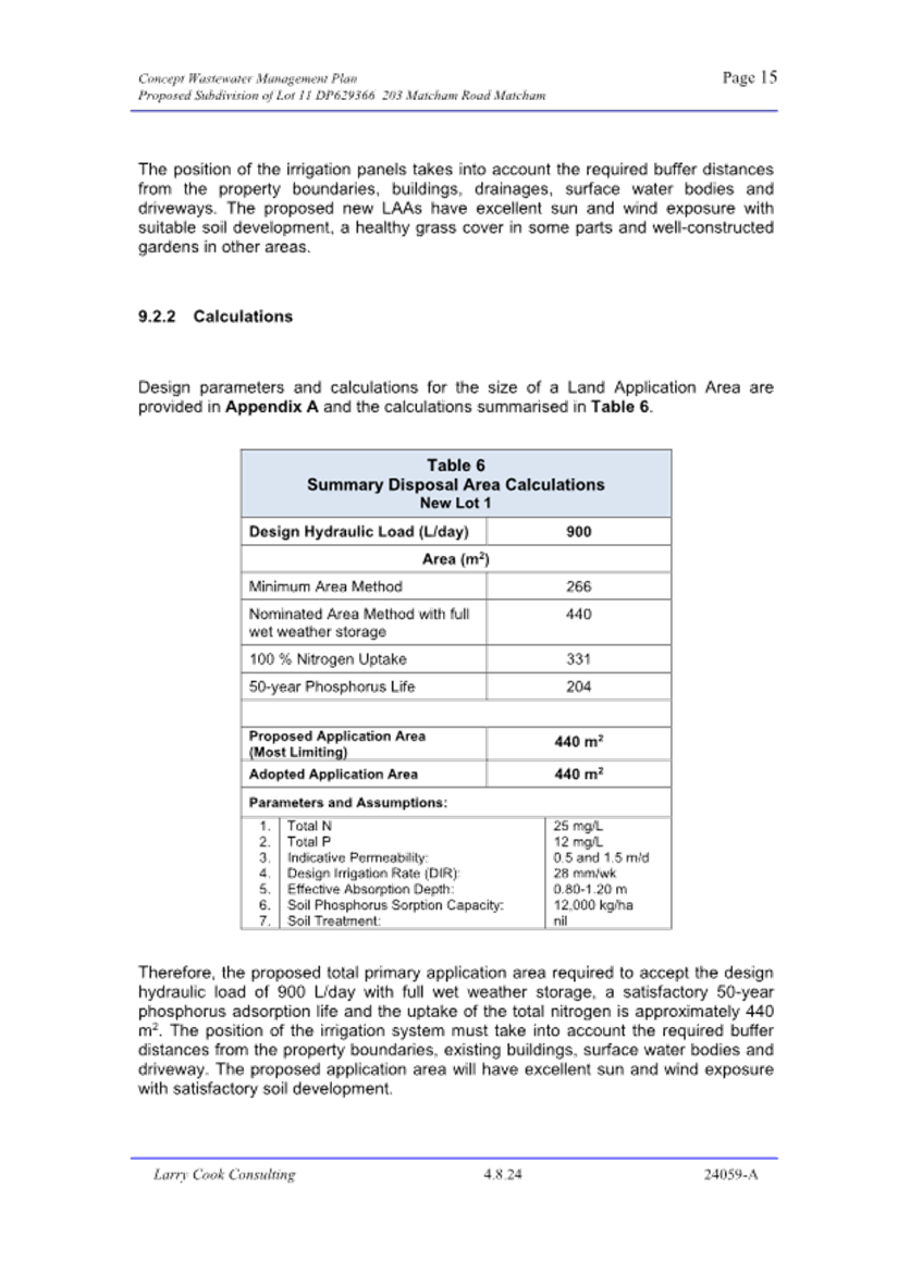
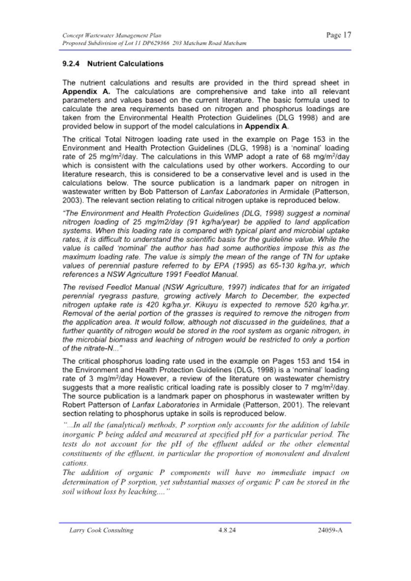
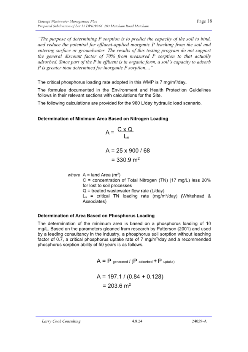
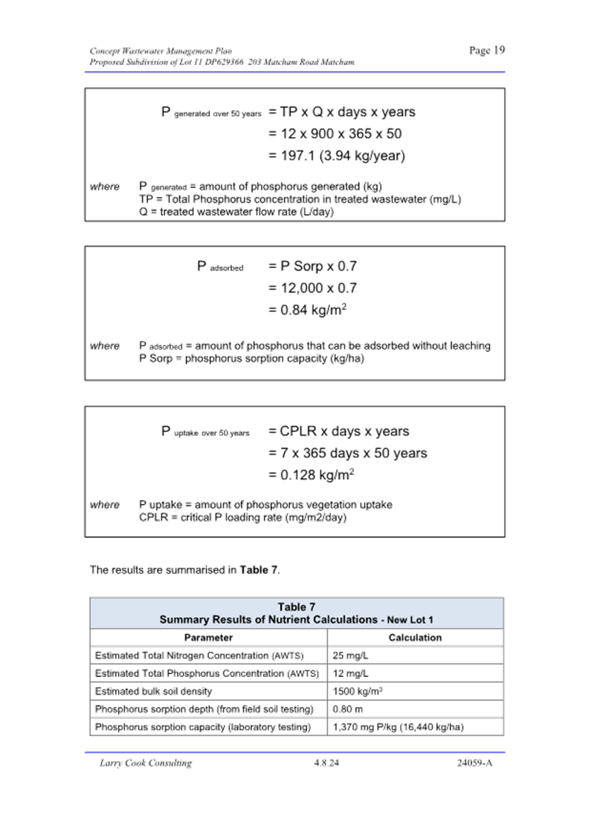
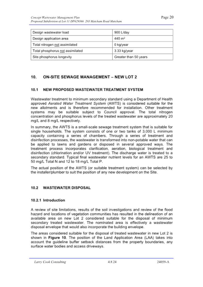
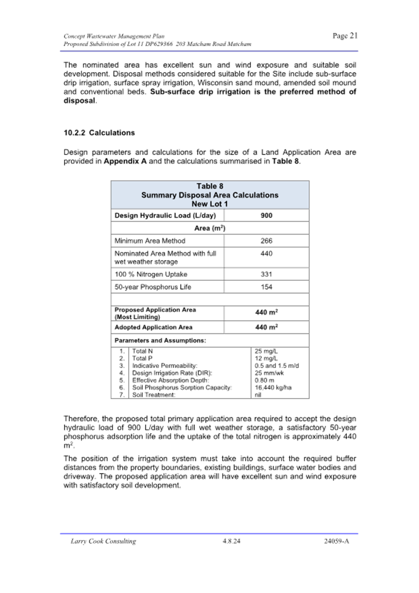
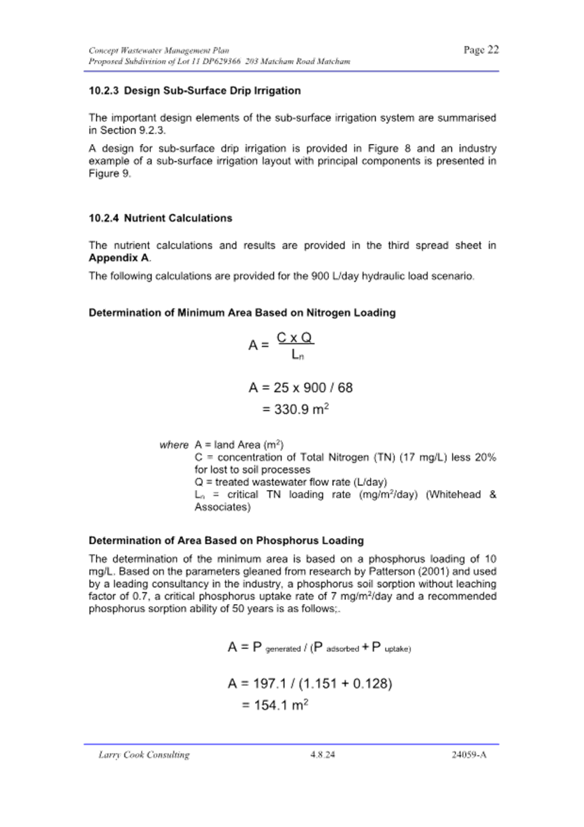
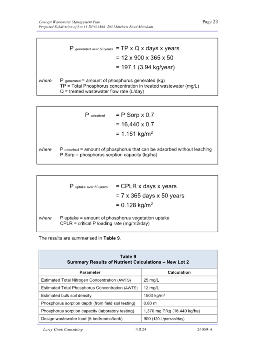
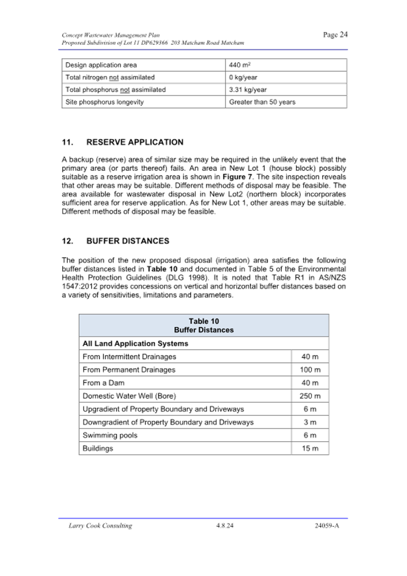

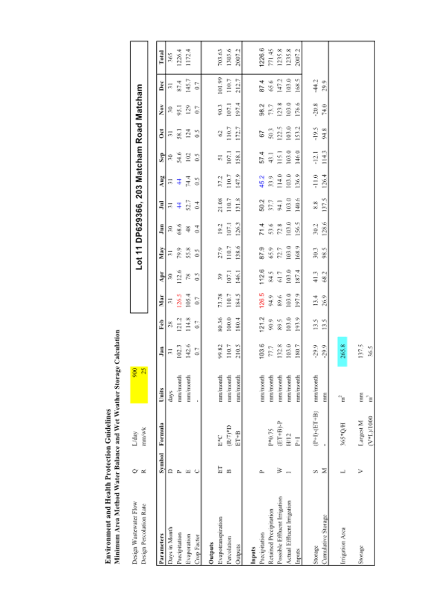
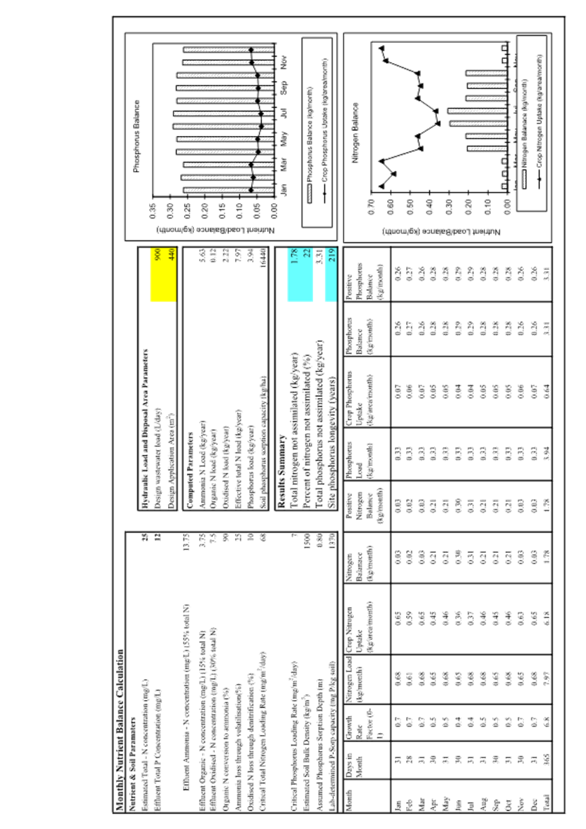
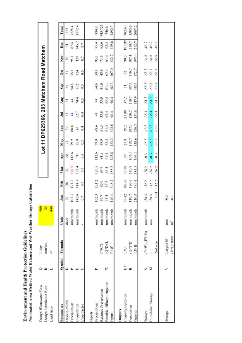
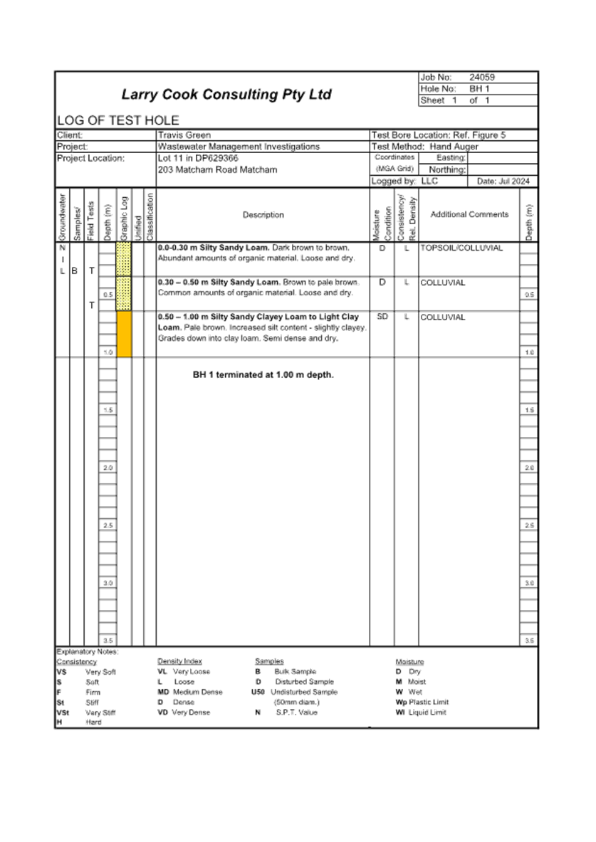
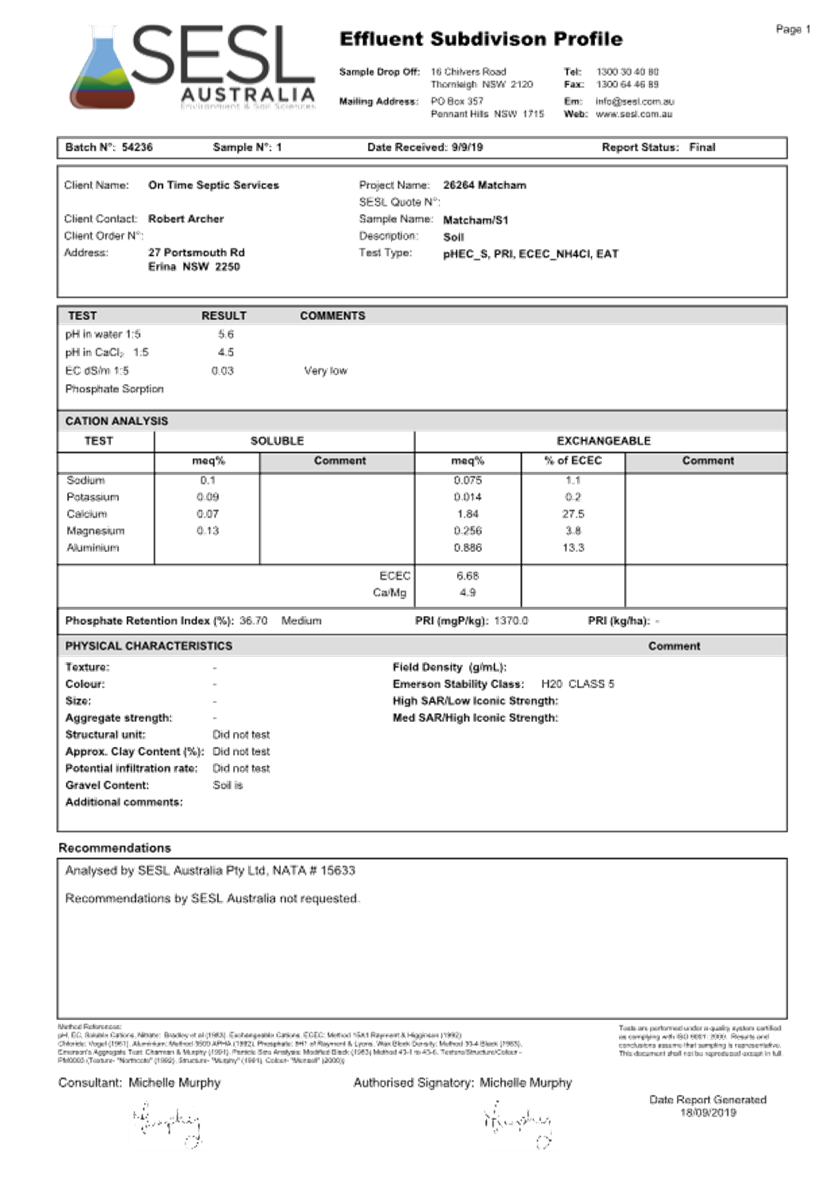
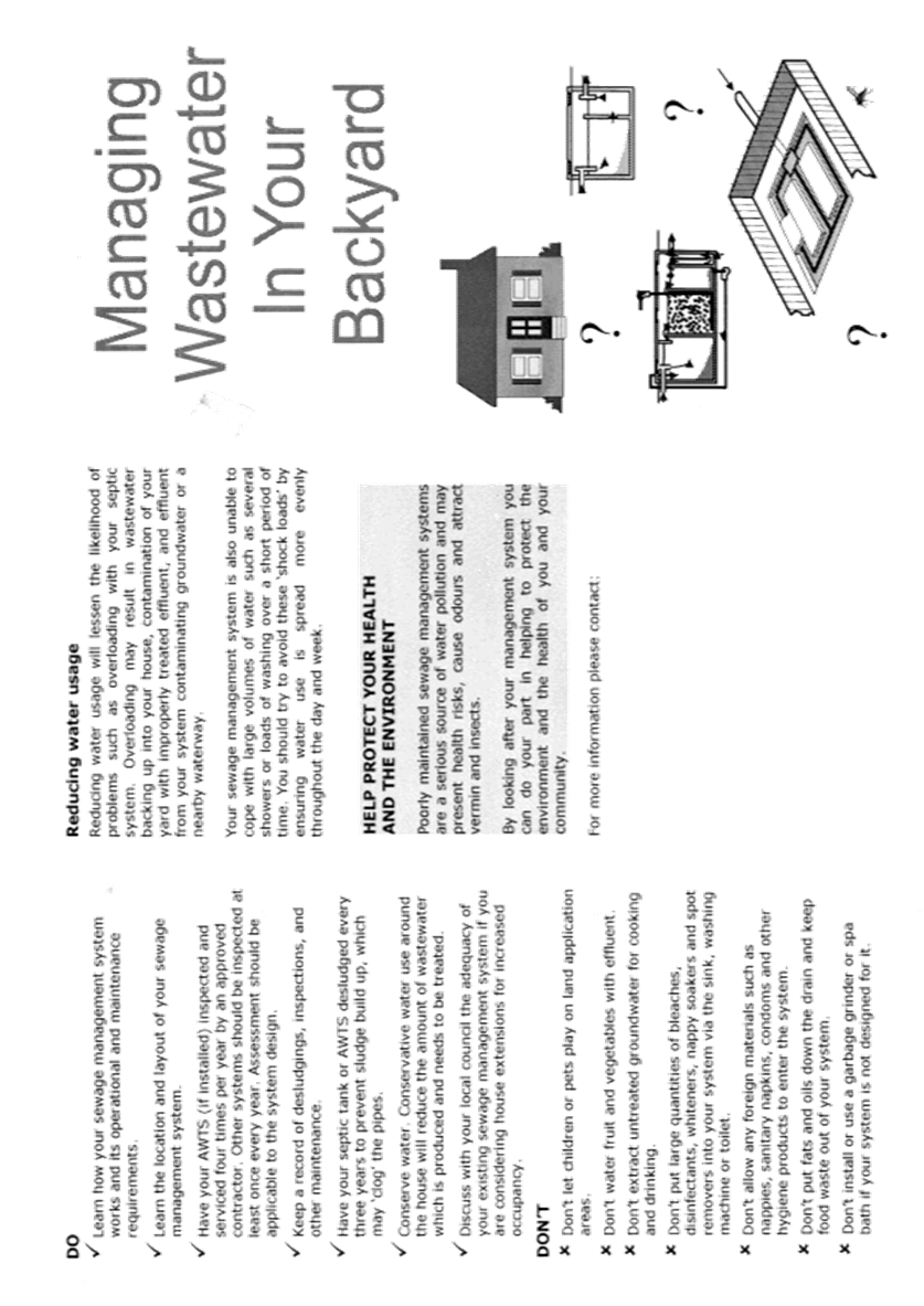
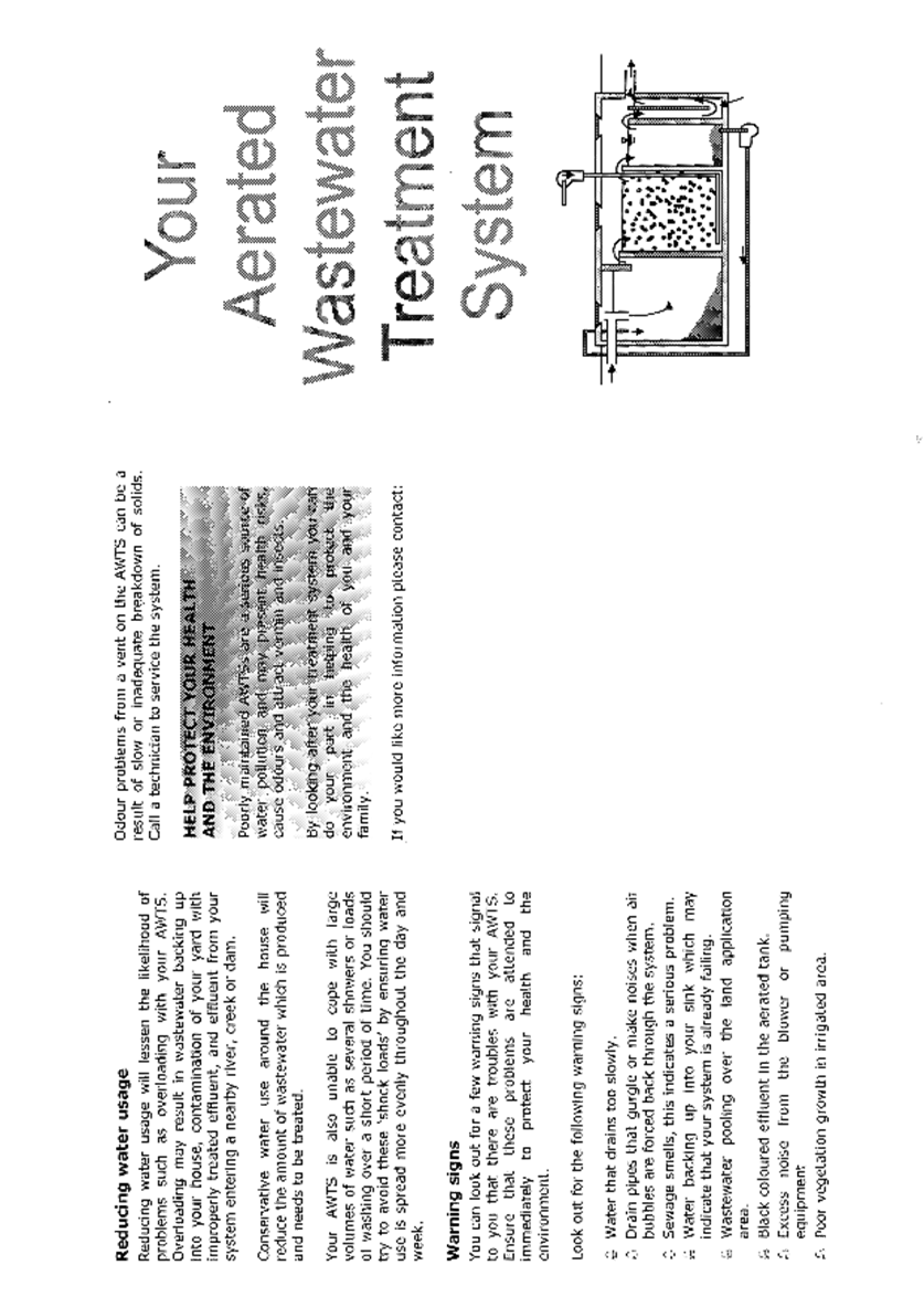
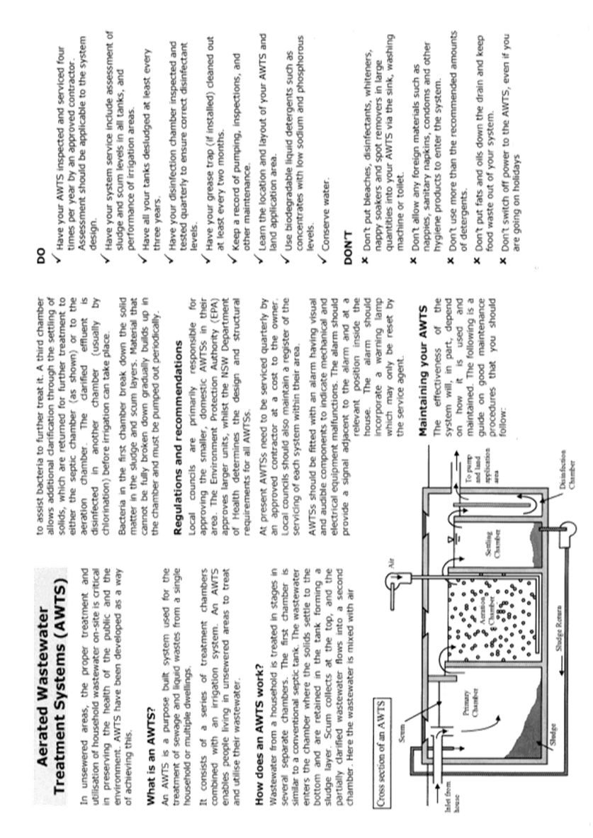
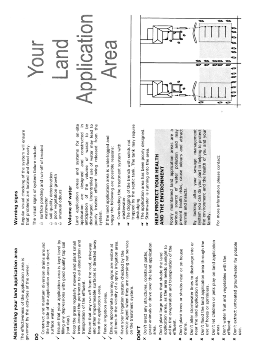
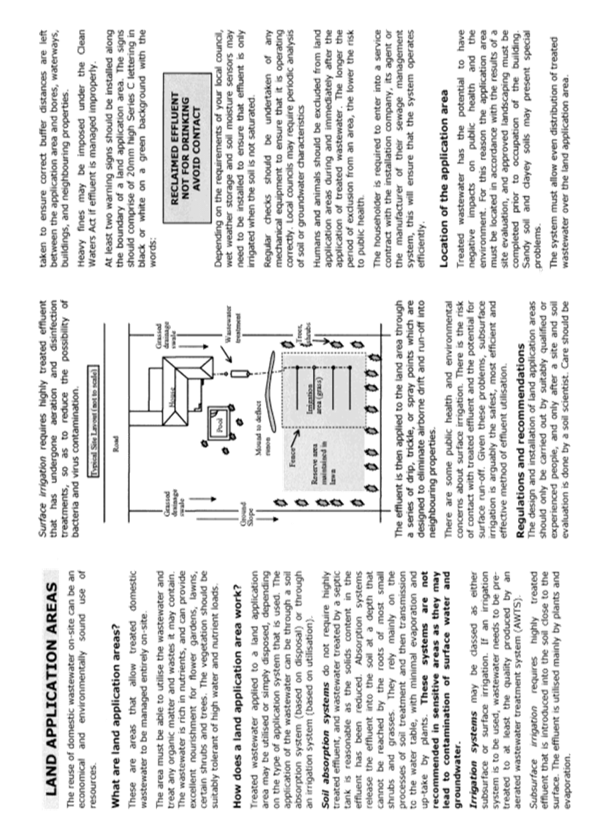

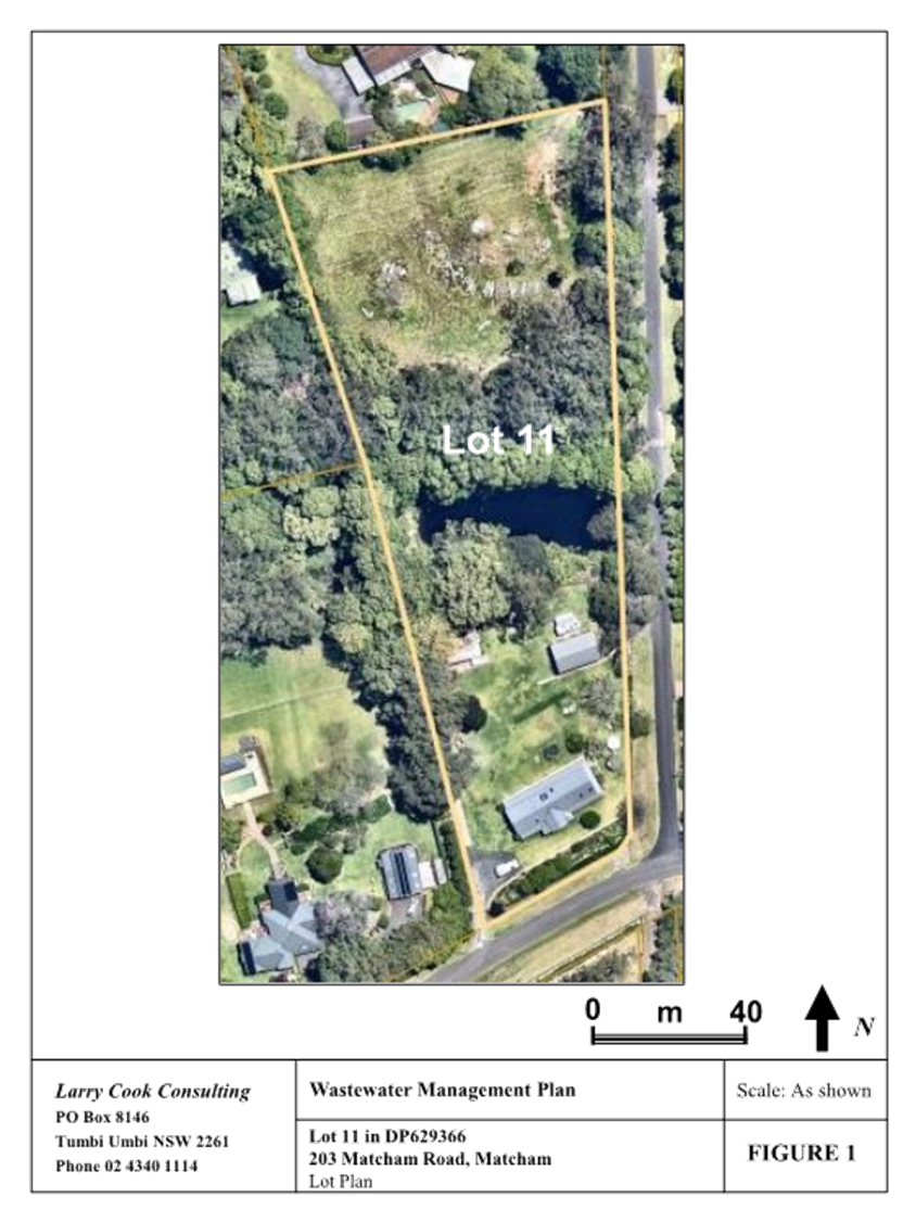
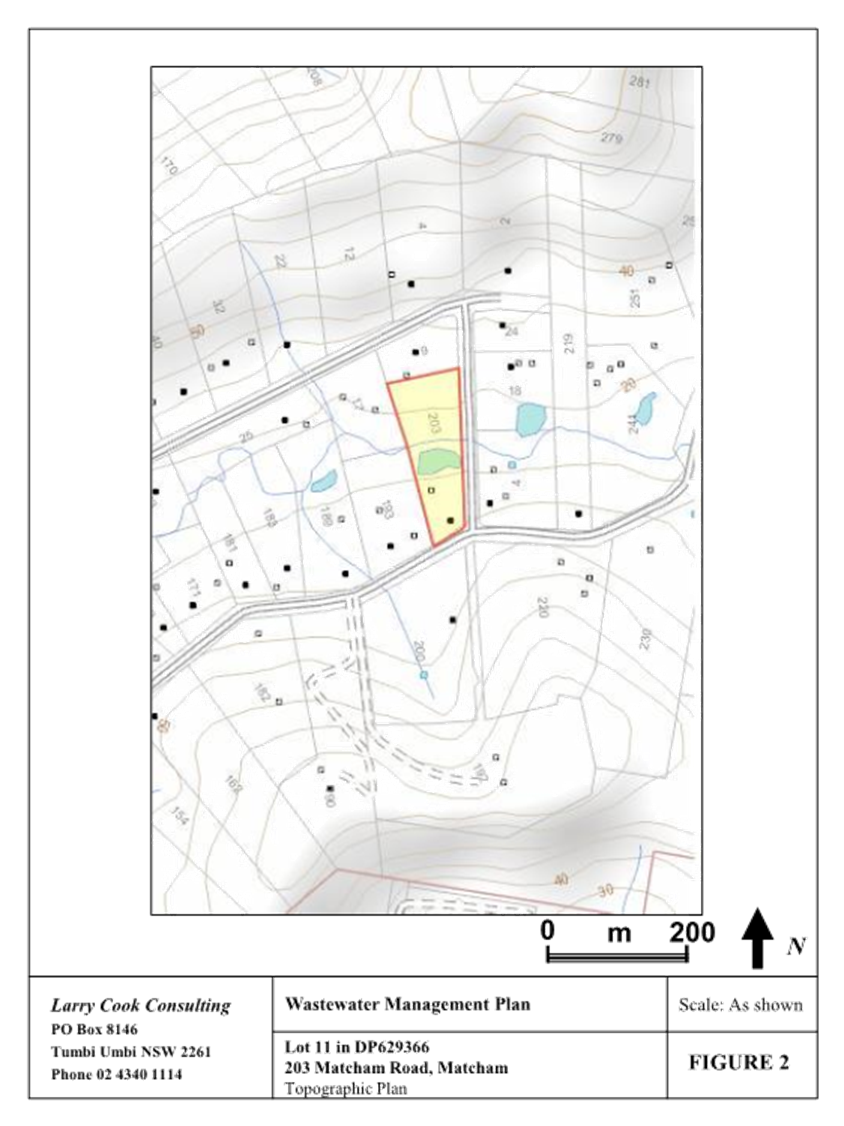
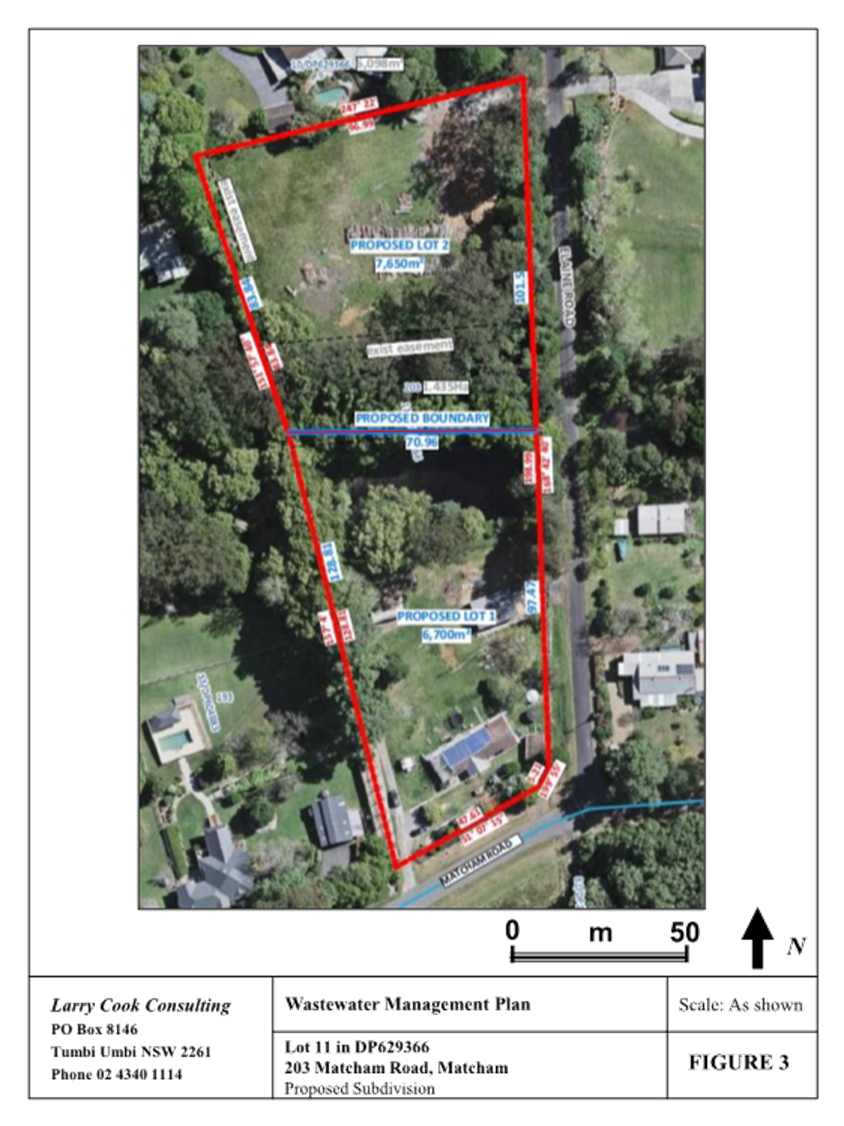
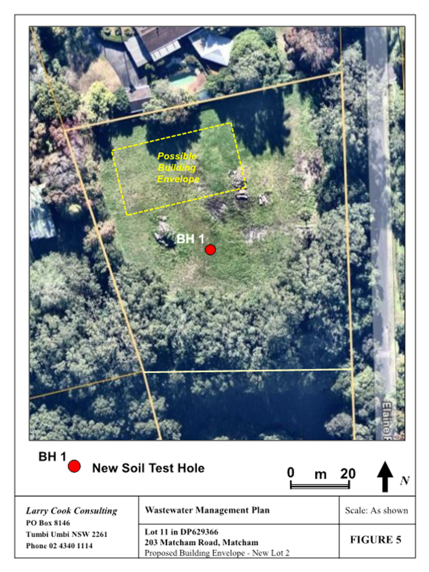
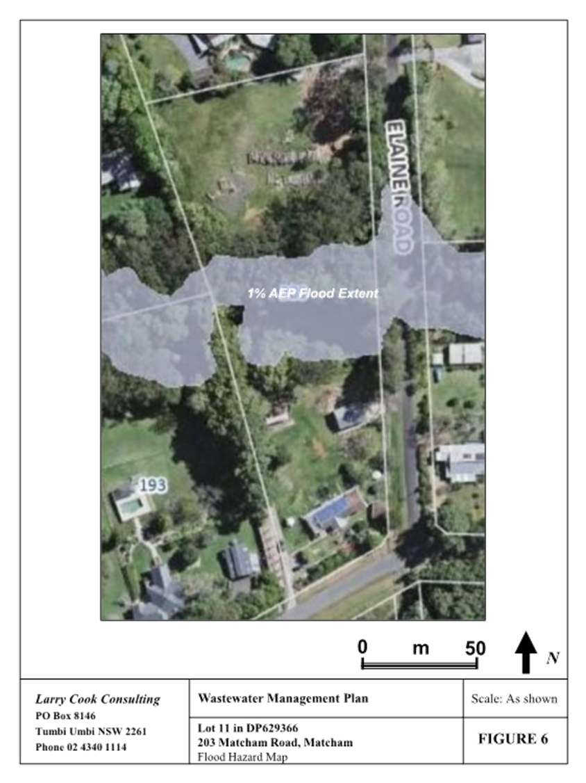
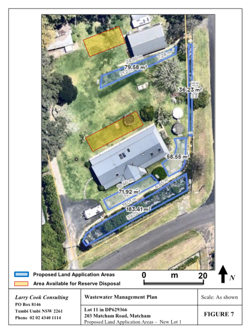
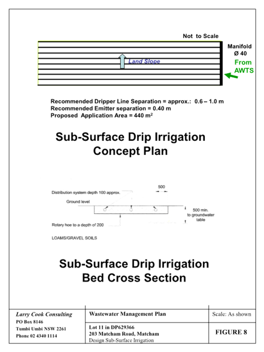
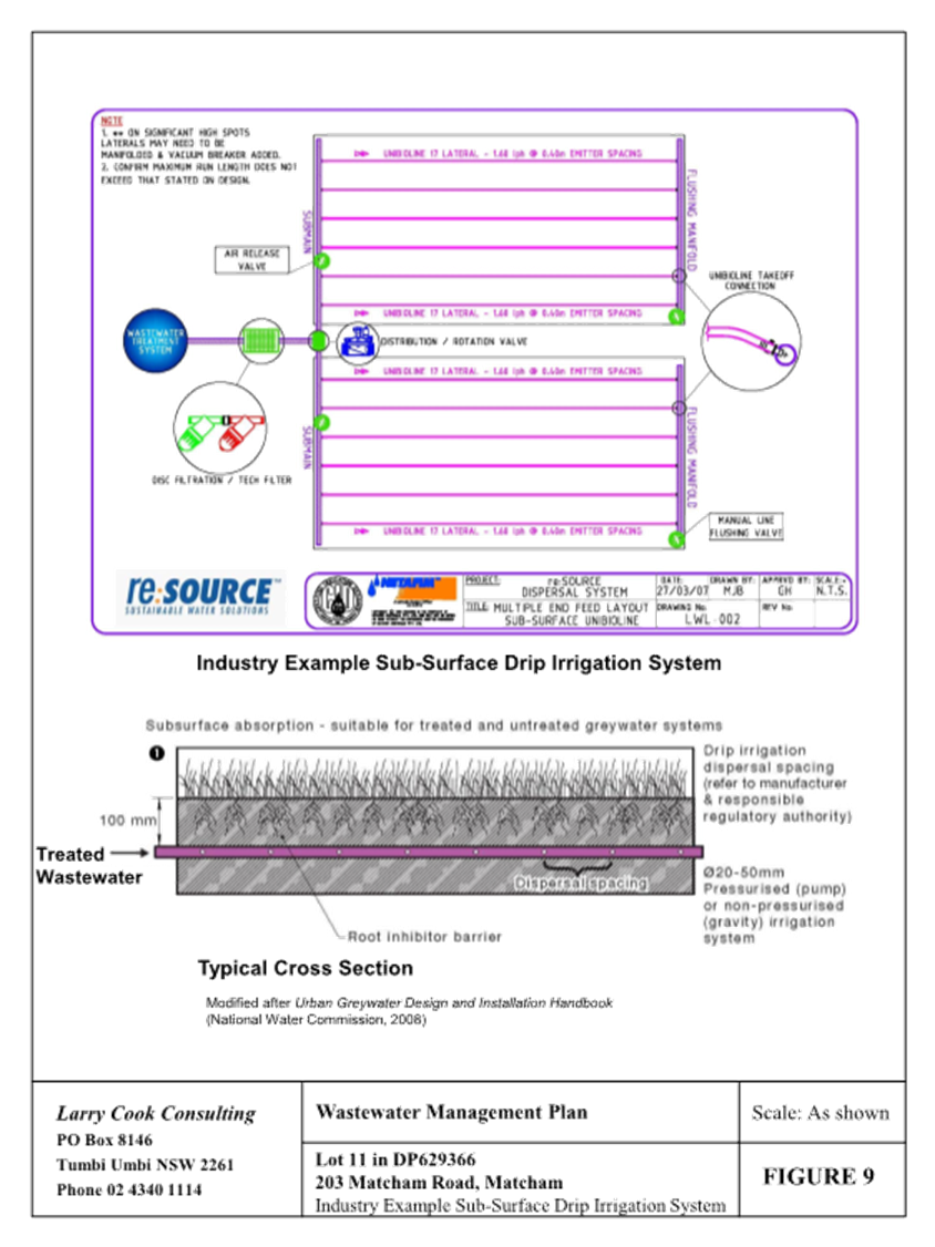
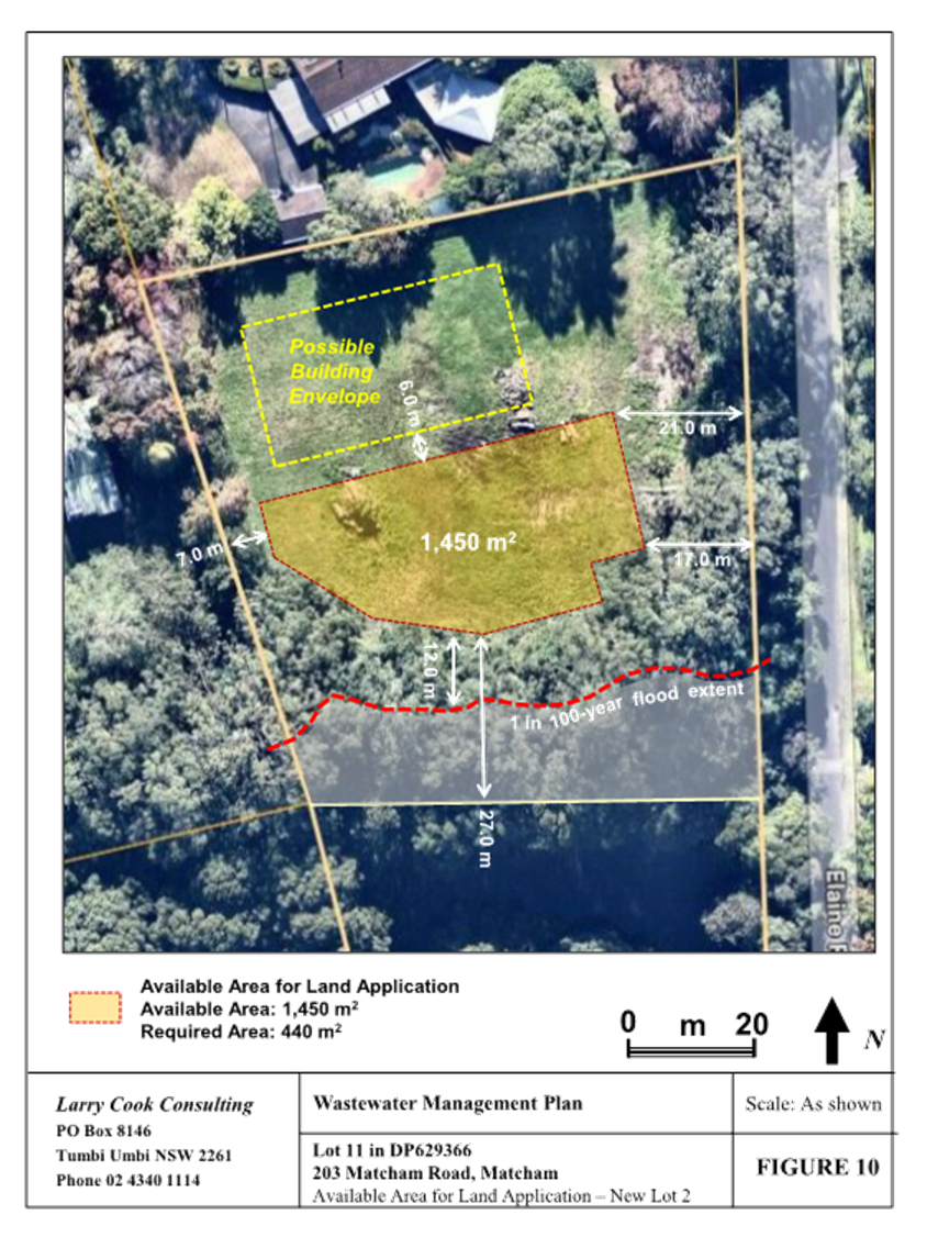
|
DA/1496/2024 - 203 Matcham Road, Matcham - 2 Lot Subdivision |
|
|
Attachment 10 |
Portal Doc - 203 Matcham Road, MATCHAM NSW 2250 - DA/1496/2024 - AHIMS Web Search |