 |
Central Coast
Local Planning Panel Meeting
Business Paper
05 June 2025
 |
|
Central Coast
Local Planning Panel Meeting
Business Paper
05 June 2025
|
The Local Planning Panel Meeting
of Central Coast
will be held remotely - online,
Thursday 5 June 2025 at 2.00 pm,
for the transaction of the business listed below:
1 Confirmation of Minutes of Previous Meetings
1.1 Confirmation of Minutes of Previous Meeting................................................................................. 4
2 Procedural Items
2.1 Disclosures of Interest.............................................................................................................................. 3
3 Planning Reports- Outside of Public Meeting
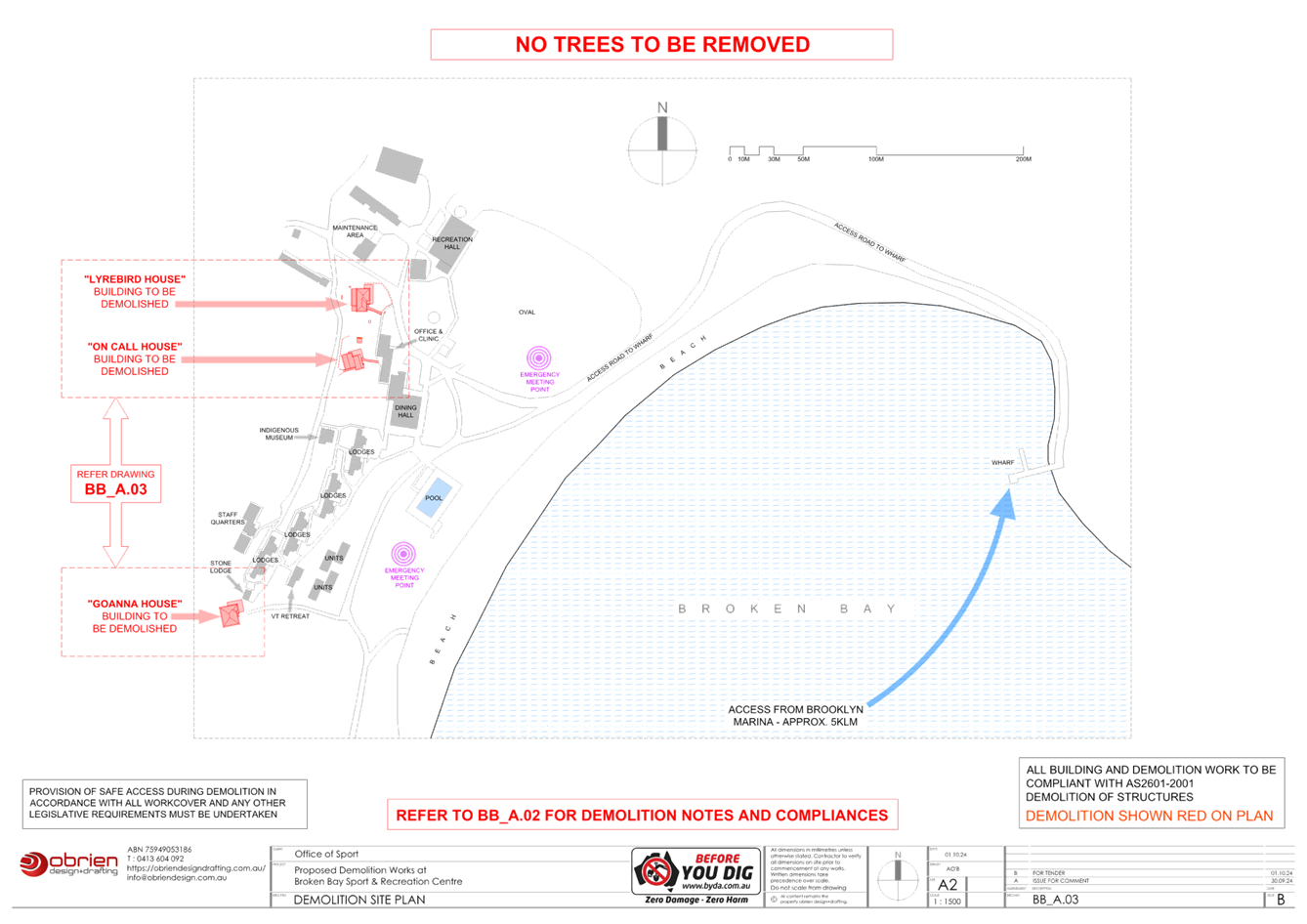
3.1 DA/2105/2024 - 500 Hawkesbury River, Patonga - Demolition of Inground Swimming Pool, Filtration Buildings and Three Accommodation Cottages......................................................... 11
3.2 DA/867/2024 - Burns Place Park, Burns Crescent, Gosford - Heritage Demolition and Restoration Works of Sandstone Wall, Archway and Landscaping, including tree removal................ 114
The Hon Terry Sheahan AO
Chairperson
|
Item No: 1.1 |
|
|
Title: Disclosures of Interest |
|
|
Department: Governance |
|
|
5 June 2025 Local Planning Panel Meeting |
|
Reference: F2020/02502 - D14205789
|
The NSW Local Planning Panel Code of Conduct states that all panel members must sign a declaration of interest in relation to each matter on the agenda before or at the beginning of each meeting.
|
That Panel Members now confirm that they have signed a declaration of interest in relation to each matter on the agenda for this meeting and will take any management measures identified.
|
Item No: 1.1 |
|
|
Title: Confirmation of Minutes of Previous Meeting |
|
|
Department: Corporate Services |
|
|
5 June 2025 Local Planning Panel Meeting |
|
Reference: F2020/02502 - D16853917
Author: Lisa Martin, Civic Support Officer Civic Support
|
Summary
The
Minutes of the following Meeting of the Local Planning Panel, which have been
endorsed by the Chair of that meeting, are submitted for noting: · Local Planning Panel Meeting held on 15 May 2025
|
That the minutes of the previous Local Planning Panel Meeting held on 15 May 2025, which were endorsed by the Chair of that meeting, are submitted for noting.
|
1⇩ |
MINUTES - Local Planning Panel - 15 May 2025 |
|
D16835510 |
|
1.1 |
Confirmation of Minutes of Previous Meeting |
|
Attachment 1 |
MINUTES - Local Planning Panel - 15 May 2025 |

|
Item No: 3.1 |
|
|
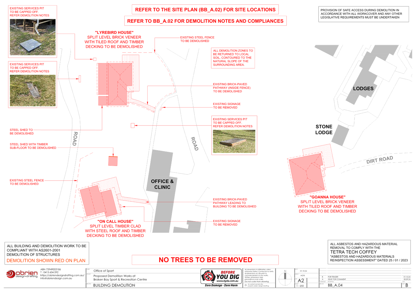
Title: DA/2105/2024 - 500 Hawkesbury River, Patonga - Demolition of Inground Swimming Pool, Filtration Buildings and Three Accommodation Cottages |
|
|
Department: Environment and Planning |
|
|
5 June 2025 Local Planning Panel Meeting |
|
Reference: DA/2105/2024 - D16662493
Author: Rebecca Samways, Development Planner Employment and Urban Release
Section Manager: Emily Goodworth, Section Manager Employment and Urban Release
Unit Manager: Andrew Roach, Unit Manager Development Assessment
|
Summary
An application has been received for the demolition of an inground pool, filtration buildings and three accommodation cottages on land at 500 Hawkesbury River, Patonga. The application has been examined having regard to the matters for consideration detailed in section 4.15 of the Environmental Planning and Assessment Act 1979 and other statutory requirements with the issues requiring attention and consideration being addressed in this report.
The application is required to be referred to the Local Planning Panel for determination as development involving the demolition of a heritage item is listed as ‘sensitive development’ in Schedule 2 (point 4(c)) of the Local Planning Panels Ministerial Direction (dated 6 March 2024).
The application is recommended for approval, subject to conditions.
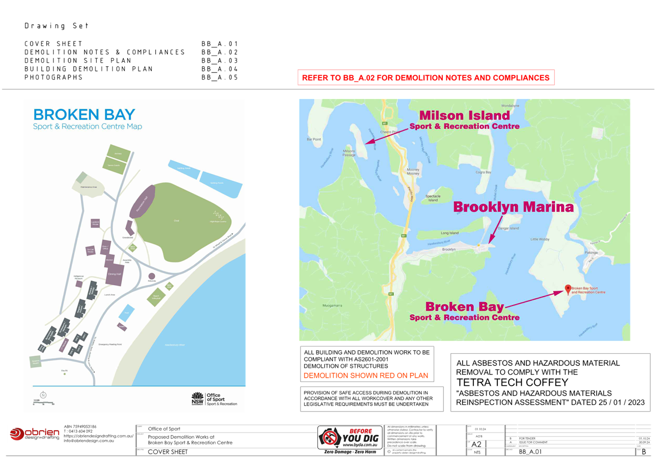
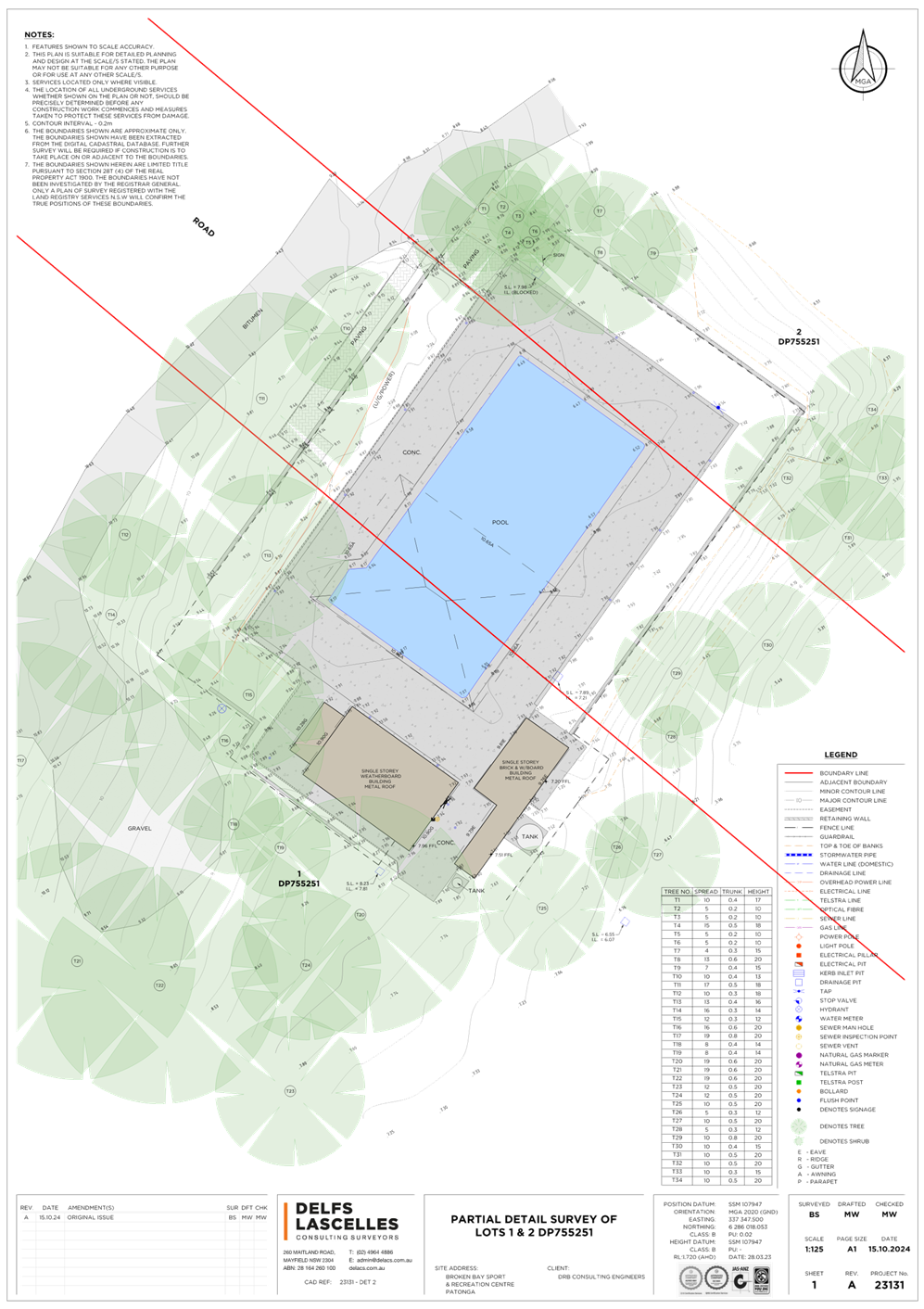
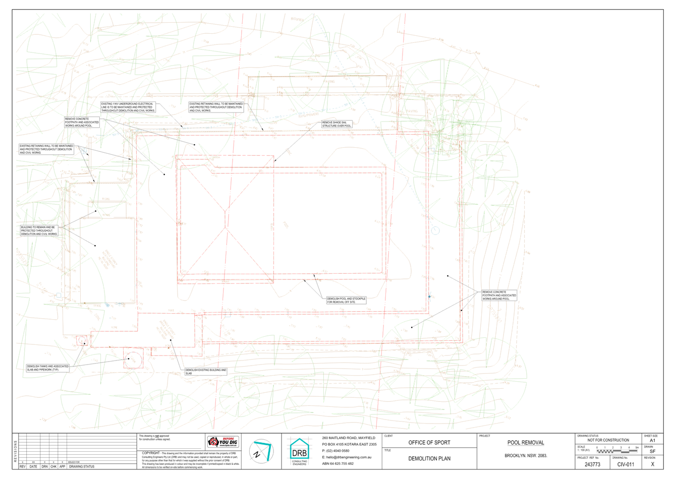
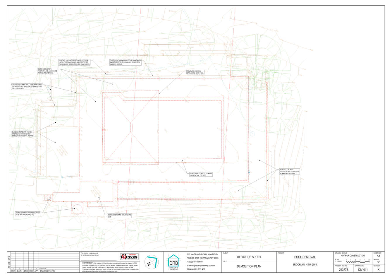
Applicant NSW Office of Sport Owner NSW Crown Lands Application No DA/2105/2024 Description of Land Lot 1 and Lot 2 in DP 755251 500 Hawkesbury River, Patonga Proposed Development Demolition of Inground Swimming Pool, Filtration Building and three Accommodation Cottages Site Area 377,415m2 Zoning RE1 Public Recreation Existing Use Broken Bay Sport and Recreation Centre Employment Generation No Estimated Value $660,000
|
Recommendation
1 That the Local Planning Panel grant consent to DA/2105/2024 – Lot 1 and Lot 2 in DP 755251, 500 Hawkesbury River, Patonga - Demolition of Inground Swimming Pool, Filtration Building and Accommodation Cottages subject to the conditions detailed in the schedule attached to the report and having regard to the matters for consideration detailed in Section 4.15 of the Environmental Planning and Assessment Act 1979.
2 That Council advises relevant external authorities of the Panel’s decision.
Key Issues
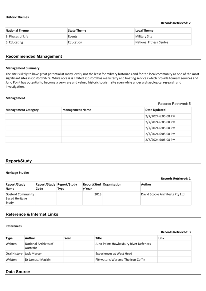
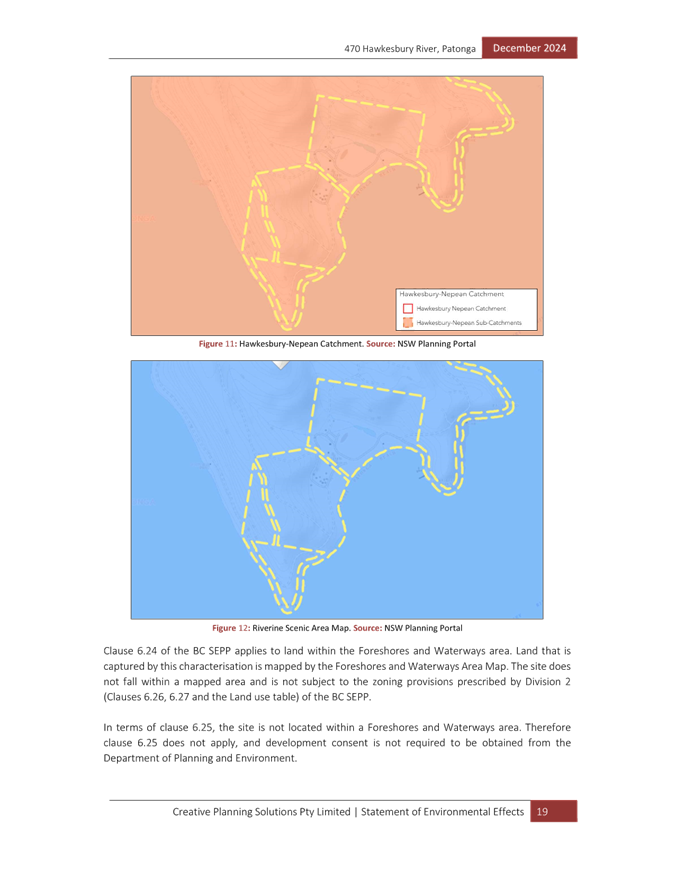
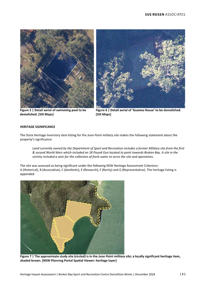
· The subject site is listed as ‘Juno Point military site’ (Item No. I210) of local significance in Schedule 5 of the Central Coast Local Environmental Plan 2022 (CCLEP 2022)
· The application was notified from 7 February 2025 to 7 March 2025 with no submissions received.
· The site is owned by NSW Crown Lands who have raised no objection to the proposed development.
Precis:
|
Proposed Development |
Demolition of Inground Swimming Pool, Filtration Building & and Accommodation Cottages |
|
Permissibility and Zoning |
The subject site is zoned RE1 Public Recreation. Demolition is permissible by virtue of CCLEP 2022, clause 2.7 (demolition requires development consent). |
|
Current Use |
Broken Bay Sport and Recreation Centre |
|
Integrated Development |
No |
|
Submissions |
No submissions received |
Variations to Policies
There are no variations to report.
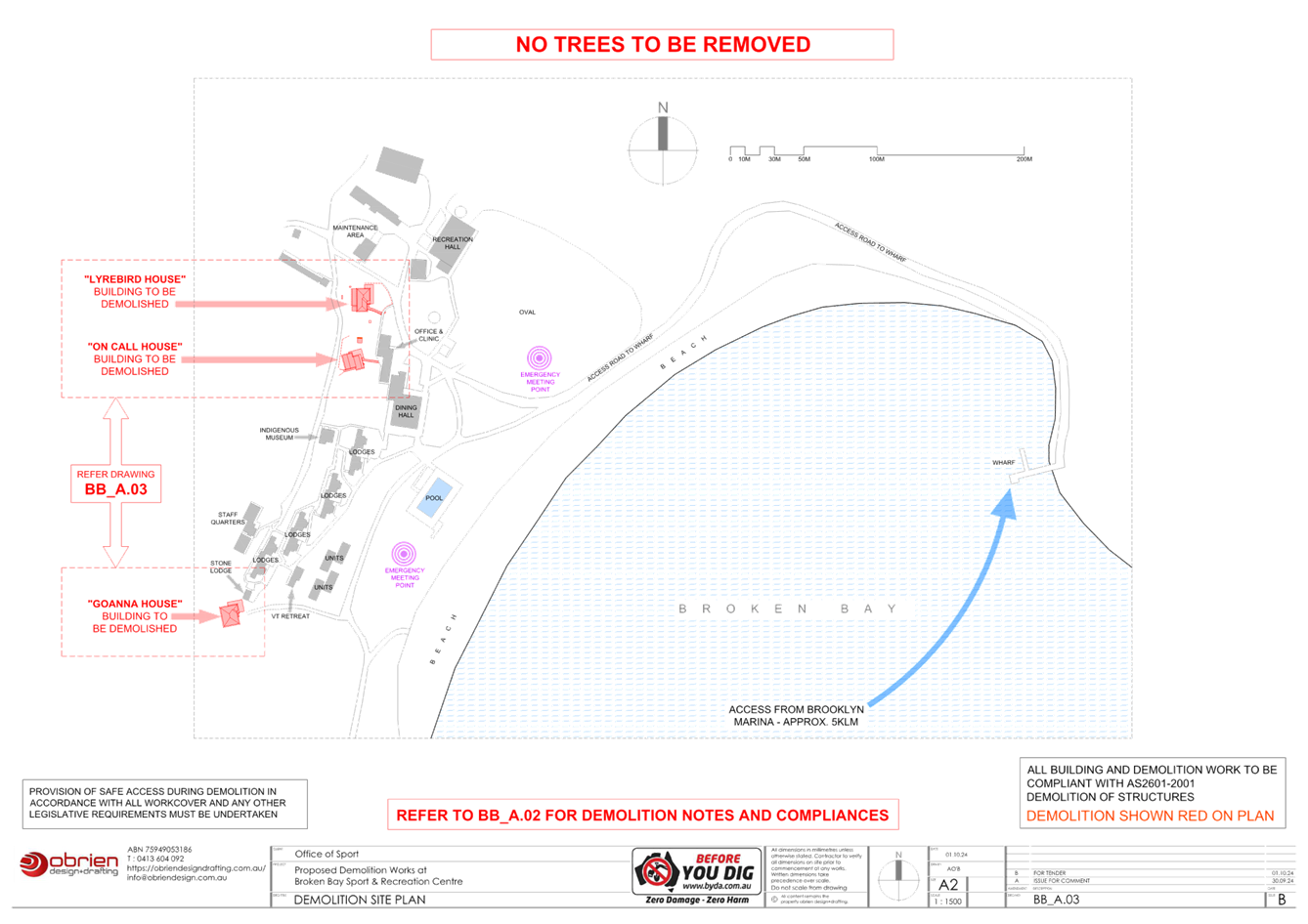
The Site
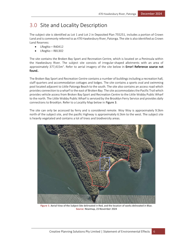
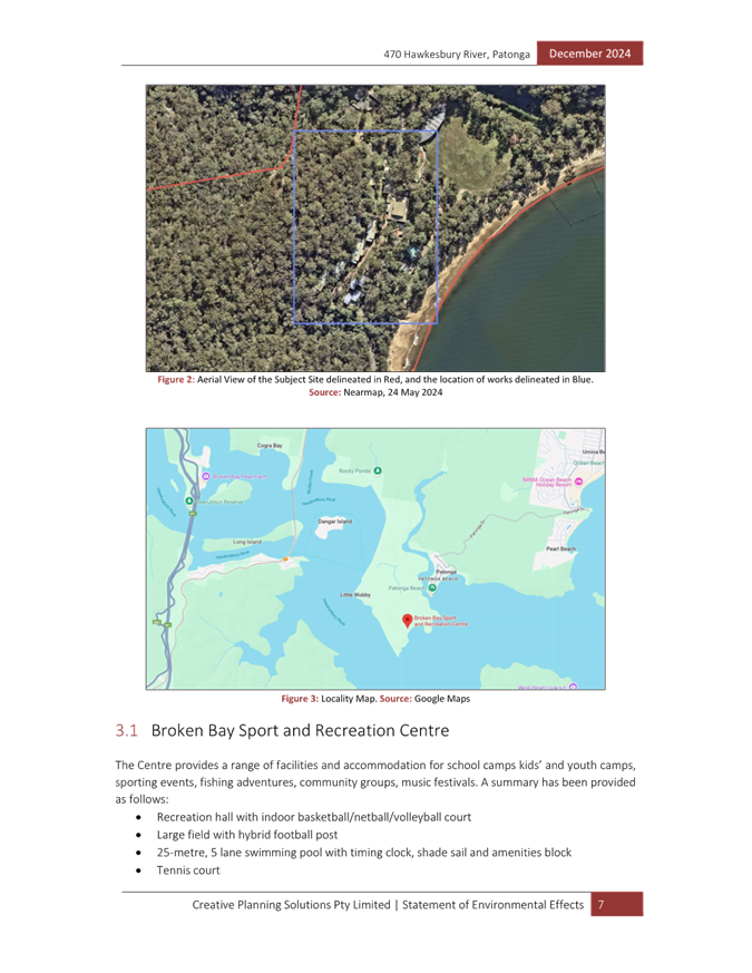
The site is legally described as Lot 1 and Lot 2 in DP 755251 and is commonly known as 500 Hawkesbury River, Patonga. The site is also identified as Crown Land Reserves R40412 and R81302.
The site contains the Broken Bay Sport and Recreation Centre, which is located on a Peninsula within the Hawkesbury River. The subject site consists of irregular-shaped allotments with an area of approximately 377,415m2.
The Broken Bay Sport and Recreation Centre contains a number of buildings including a recreation hall, staff quarters and accommodation cottages and lodges. The site contains a sports oval and swimming pool located adjacent to Little Patonga Beach to the south.
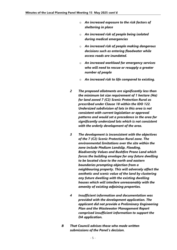
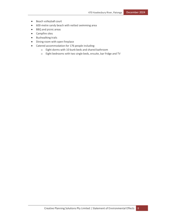
The site is only accessible by boat/ferry. The site contains an access road which provides connection to a private wharf to the east of Broken Bay. The site accommodates the Pacific Trail which provides vehicle access from Broken Bay Sport and Recreation Centre to the Little Wobby Public Wharf to the north.
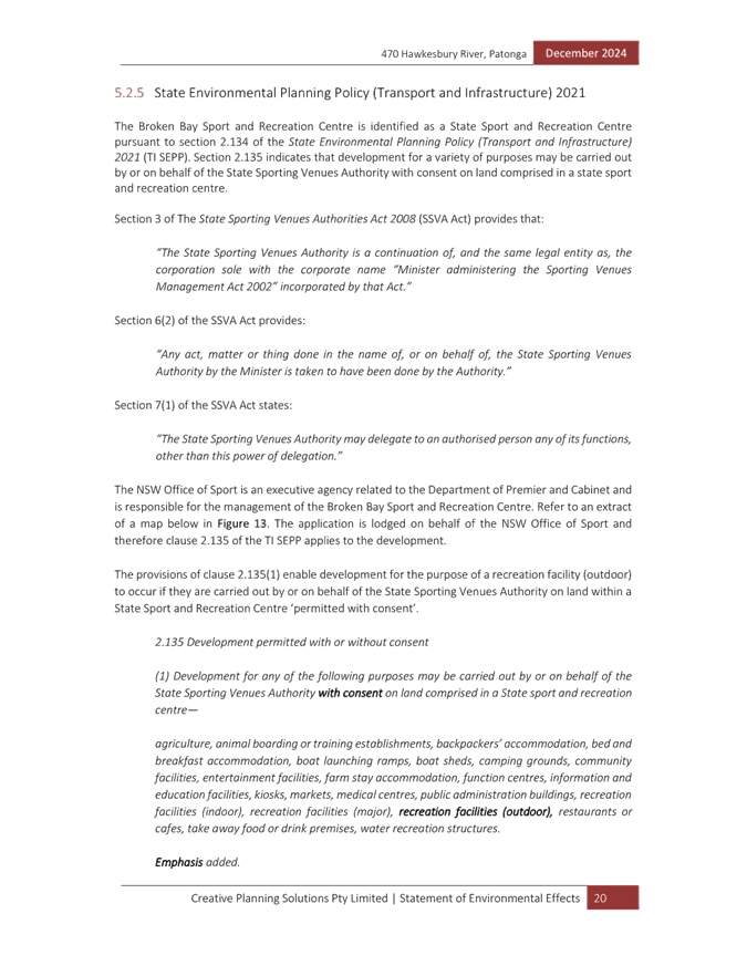
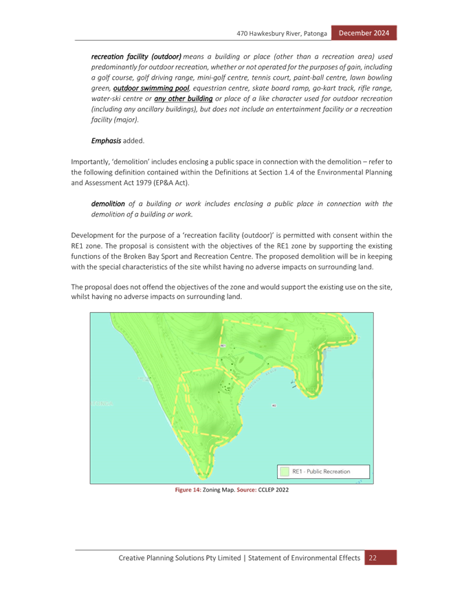
The site is zoned RE1 Public Recreation and is affected by class 1, 3 and 5 acid sulfate soils, is bushfire prone, is identified as coastal use and coastal management areas and is mapped on the biodiversity values map.
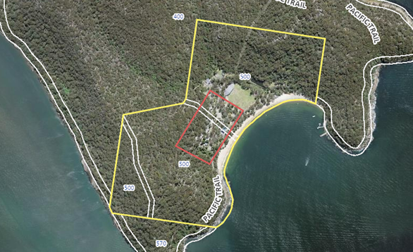
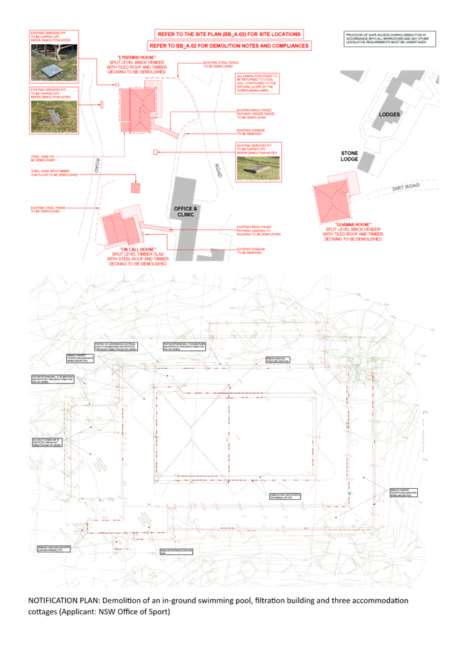
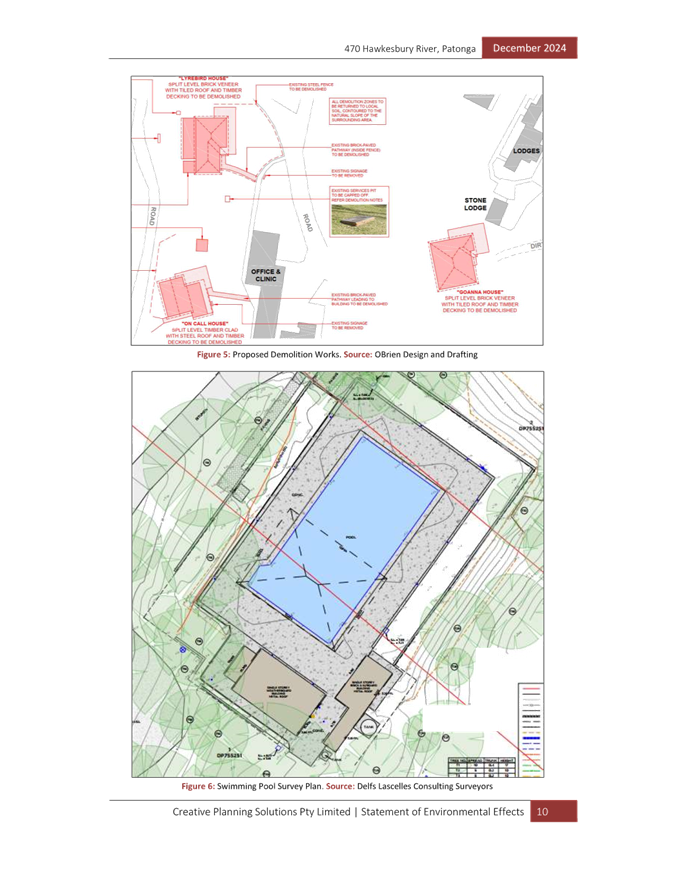
Figure 1 – Aerial photo of the site outlined in yellow; Structures proposed for demolition located within the area outlined in red.
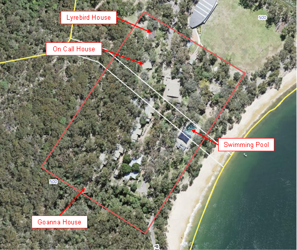
Figure 2 – Aerial photo of the area of proposed demolition works
 Figure 3 – Site as
viewed from Hawkesbury River
Figure 3 – Site as
viewed from Hawkesbury River
Figure 4 – Dinning Hall to be retained
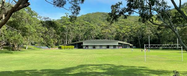
Figure 5 – Oval with Recreation Hall in the distance to be retained.
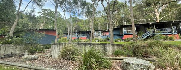
Figure 6 – Accommodation lodges to be retained.
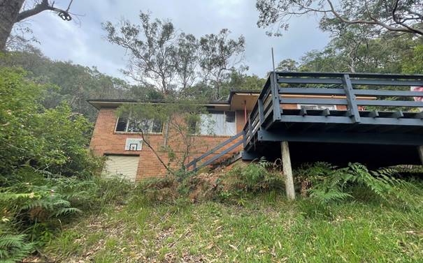
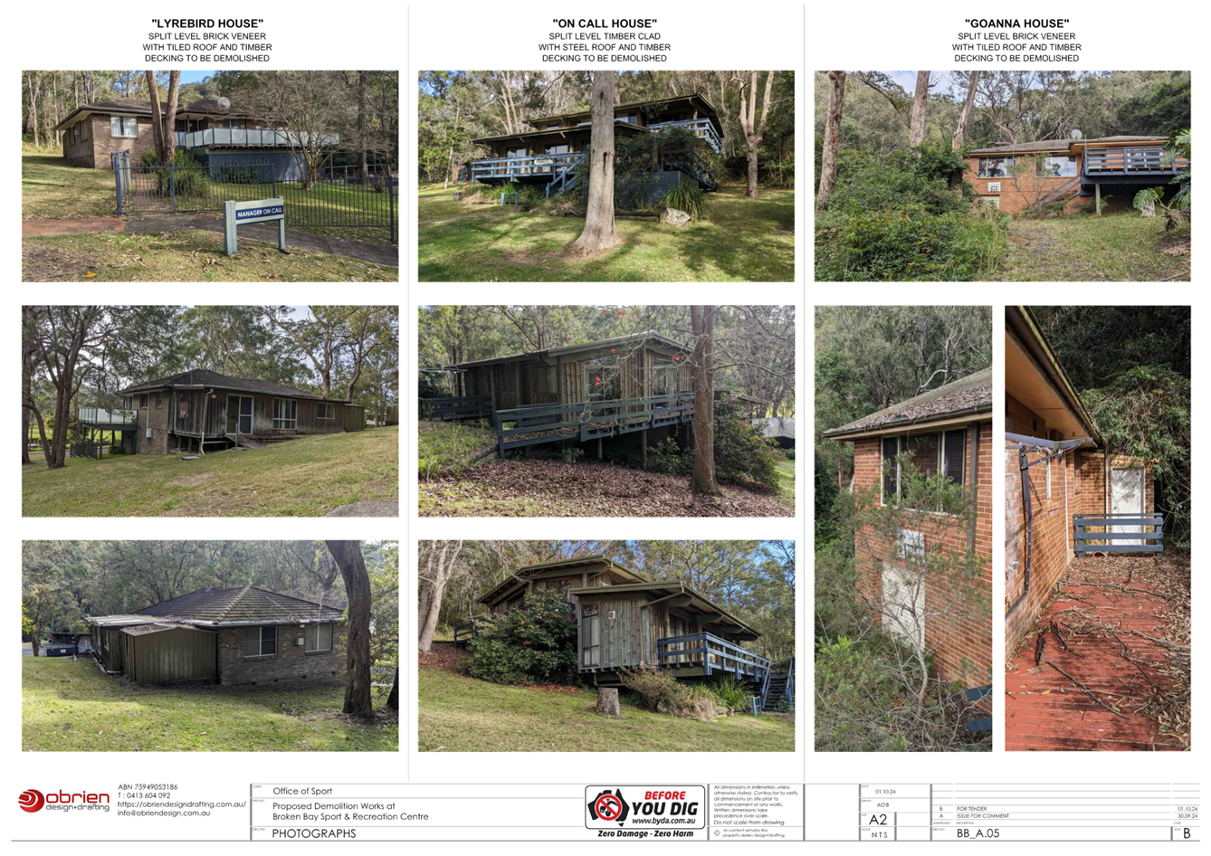
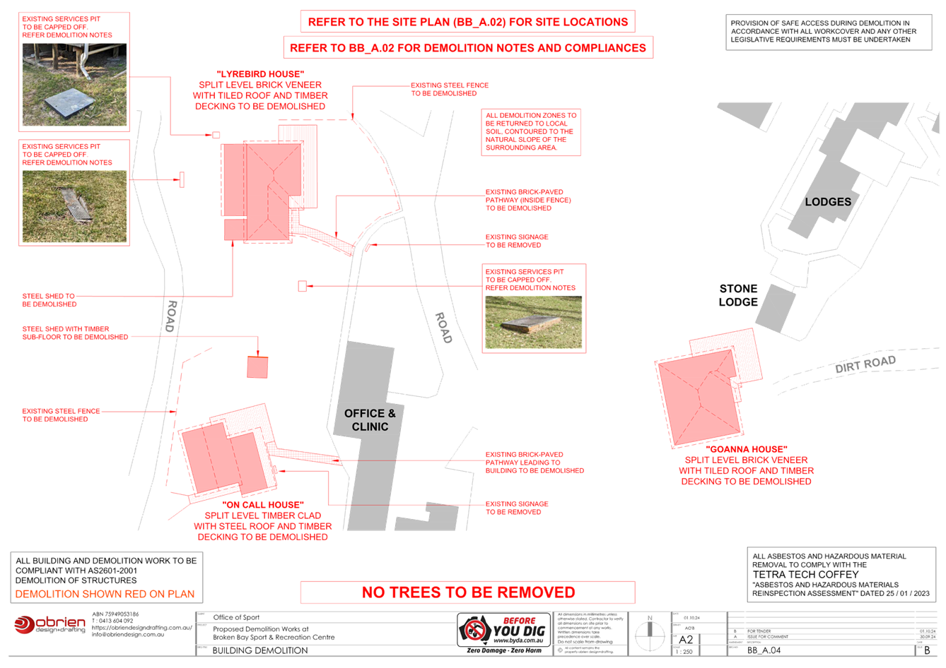
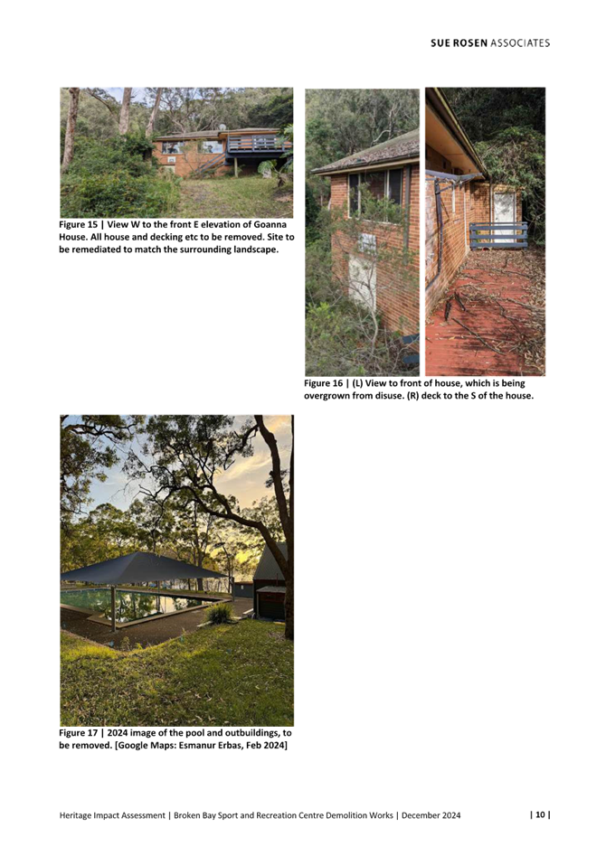
Figure 7 – Goanna House proposed to be demolished.
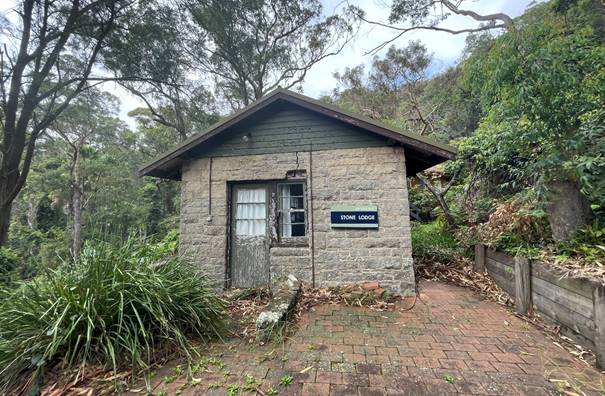
Figure 8 – Stone Lodge (to be retained) located adjacent to Goanna House (behind)
Figure 9 – Swimming proposed to be demolished.
 Figure 10 –
Amenities building adjacent to the pool to be retained; filtration building,
and water tanks proposed to be demolished.
Figure 10 –
Amenities building adjacent to the pool to be retained; filtration building,
and water tanks proposed to be demolished.
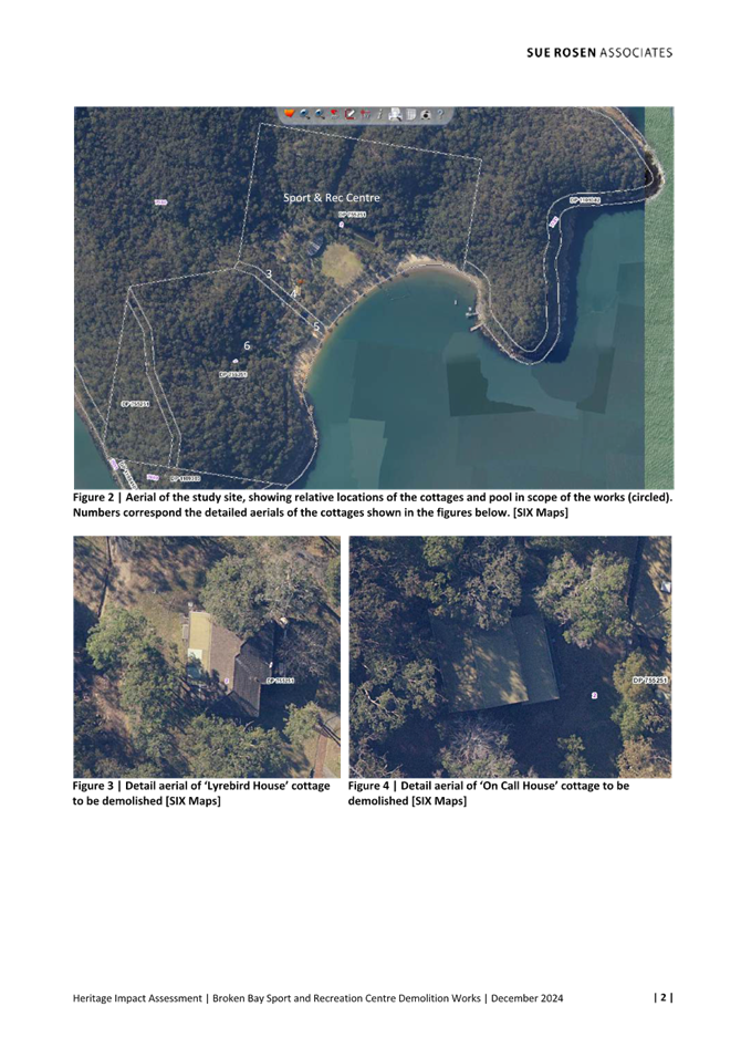
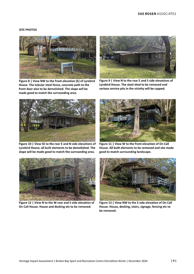
Figure 11 – Lyrebird House proposed to be demolished.
Figure 12 – On Call House proposed to be demolished.
Surrounding Development
The site adjoins bushland to the north, east and west and adjoins the Hawkesbury River to the south. Patonga is located approximately 750m to the north-east of the site which consists of residential development, small shops and cafes and a public wharf. Little Wobby is located approximately 1.5km north-west of the subject site which consists of residential development and a public wharf. Woy Woy is approximately 9.5km north-east of the site, and the Pacific Highway is approximately 6.5km to the west.
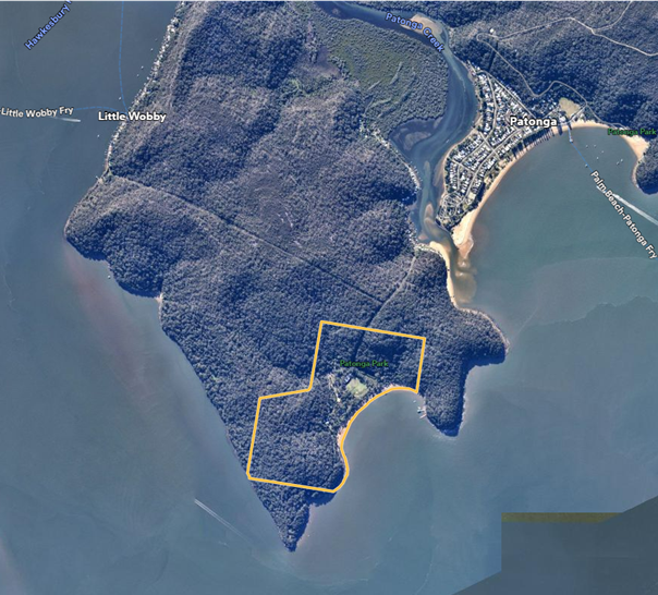
Figure 13 – Surrounding bushland and development at Patonga and Little Wobby
The Proposed Development
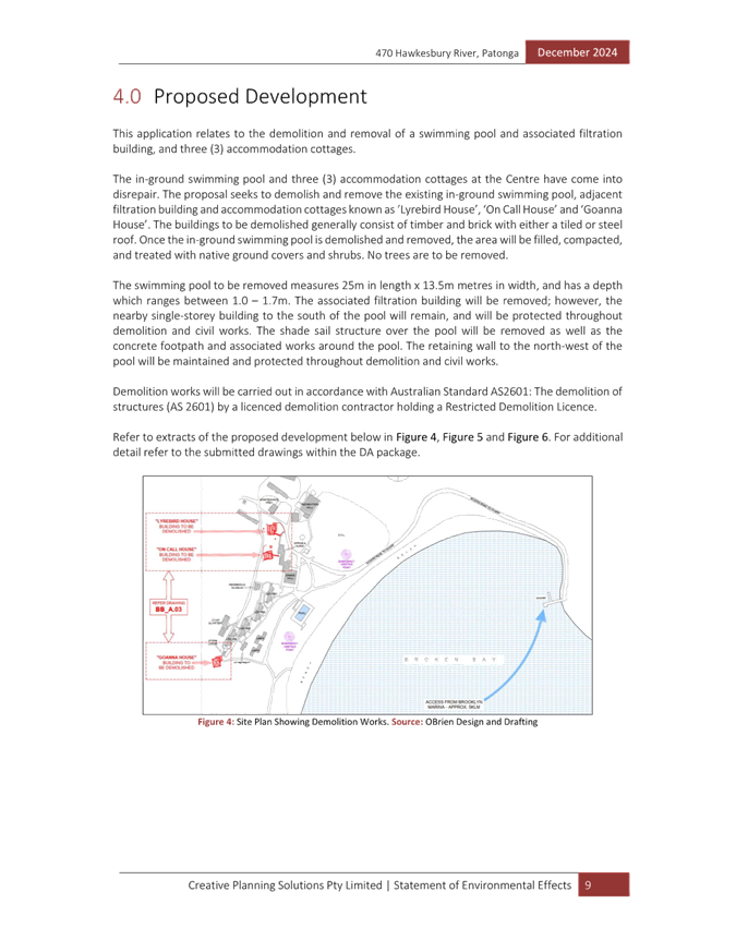
The development application seeks consent for the demolition of the swimming pool and three former accommodation cottages. Specifically, the proposal involves the following works:
· Demolition of the existing in-ground swimming pool, shade sail structure over the pool, concrete footpath around the pool and the associated filtration building. Once the swimming pool is demolished and removed the area will be filled and compacted and native ground covers and shrubs planted.
The nearby amenities building to the south of the pool and the retaining wall to the north-west of the pool will remain and be protected throughout the demolition works for the pool.
· Demolition of three accommodation cottages known as ‘Lyrebird House’, ‘On Call House’ and ‘Goanna House’. The cottages are not currently used, are dilapidated, and infested with white ants. At all cottage sites the land will be made good to match the surrounding topography and landscaping.
Demolition works will be carried out in accordance with Australian Standard AS2601: The demolition of structures by a licenced demolition contractor.
The proposal does not include the removal of any trees or vegetation.
NSW Office of Sport have advised they are intending on completing the demolition works in the July school holidays as they do not have any bookings during this time.
History
During the WWII period Juno Point Military Site was established on the site. After WWII, the site was passed to NSW Department of Education for the establishment of a ‘National Fitness Centre.’ Later the site was adopted by NSW Office of Sport for management and is now operated as Broken Bay Sport and Recreation Centre.
The following applications have been approved on the site since Broken Bay Sport and Recreation Centre has been operating on the site:
· DA/23714/2004 was approved on 13 May 2024 for a sea wall near the wharf.
· DA/22994/1998 was approved on 16 March 1998 for dwelling additions to Goanna House (subject to the proposed demolition).
· DA/22053/1996 was approved on 6 February 1997 for a canoe and boat storage shed near the oval.
· DA/9622/2000 was approved on 25 October 2000 for the construction of an amenities building adjacent to the swimming pool and alterations to the accommodation lodges.
· DA/39352/2010 was approved on 23 March 2011 for the demolition of a hall and storage building adjacent to the oval and construction of new recreation hall.
ASSESSMENT:
Having regard for the matters for consideration detailed in Section 4.15 of the Environmental Planning and Assessment Act 1979 and other statutory requirements, Council’s policies and Section 10.7 Certificate details, the assessment has identified the following key issues, which are elaborated upon for Council’s information. Any tables relating to plans or policies are provided as an attachment.
Provisions of Relevant Instruments/Plans/Policies:
Environmental Planning and Assessment Act 1979
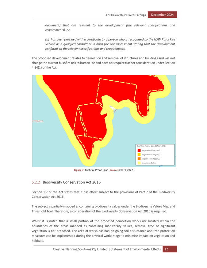
Section 4.14 – Consultation and development consent – certain bush fire prone land
The site is identified as bushfire prone land containing vegetation buffer and vegetation category 1. The proposed development comprises a development which is not a special fire protection purpose for the purposes of s100B Bush of the Rural Fires Act 1997, however, the provisions of s4.14 of the EP&A Act are relevant.
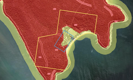
Figure 14 – Bushfire prone land on the site
The proposed development is required to comply with Planning for Bushfire Protection 2019 (PBP 2019). The aim and objectives of BPB 2019 are as follows:
The aim of PBP is to provide for the protection of human life and minimise impacts on property from the threat of bush fire, while having due regard to development potential, site characteristics and protection of the environment.
The objectives are to:
· afford buildings and their occupants protection from exposure to a bush fire;
· provide for a defendable space to be located around buildings;
· provide appropriate separation between a hazard and buildings which, in combination with other measures, prevent the likely fire spread to buildings;
· ensure that appropriate operational access and egress for emergency service personnel and occupants is available;
· provide for ongoing management and maintenance of BPMs; and
· ensure that utility services are adequate to meet the needs of firefighters
As the proposed development is for demolition only, the proposal will not increase the current bushfire exposure or risk to human life. The removal of the structures will provide additional space around the remaining structures on the site for defendable space and separation from the hazard. There are no proposed changes to the existing access arrangements, BPMs or utility services for firefighters needs.
Having regard for the proposal being for demolition only, the Panel can be satisfied the proposal is consistent with the aim and objectives of Planning for Bushfire Protection 2019 and section 4.14 of the EP&A Act.
Section 4.33 – Determination of Crown development applications
The NSW Office of Sport is a public authority and is therefore prescribed by the Section 294 of the EP&A Regulation 2021 to be the Crown for the purposes of Division 4.6 of Part 4 of the EP&A Act. As the Development Application has been made by the NSW Office of Sport, it is therefore a Crown Development Application.
Section 4.33(1) of the EP&A Act stipulates that a consent authority (other than the Minister) must not:
(a) refuse its consent to a Crown Development Application, except with the approval of the Minister, or
(b) impose a condition on its consent to a Crown Development Application, except with the approval of the applicant or the Minister.
The recommended conditions of consent provided in Attachment 1 have been reviewed by the applicant. The applicant provided recommended changes to some draft conditions which have been amended accordingly and now form the basis of the set which are before the Panel for consideration.
Environmental Planning and Assessment Regulation 2021 (EP& A Regulation 2021)
Section 23 – Persons who may make development applications
The subject site is owned by the NSW Crown Lands and is administered as a Reserve under the Crown Land Management Act 2016.
In accordance with section 23 (2) of the EP&A Regulation 2021, owner’s consent is not required for a development application made by a public authority if the applicant complies with subsections 23(3) and 23(4) which read as follows:
(3) The applicant must give notice of the application—
(a) to the owner of the land before the application is made, or
(b) by publishing, no later than 14 days after the application is made, a notice in a newspaper circulating in the area in which the development will be carried out.
(4) If the applicant gives notice under subsection (3)(b), the applicant must also, no later than 14 days after the application is made—
(a) if the applicant is a public authority—publish the notice on the public authority’s website, or
(b) for public notification development—arrange for the consent authority to publish the notice on the NSW planning portal.
On 20 December 2024, prior to the Development Application being lodged on 29 January 2025, the applicant issued a ‘notice of intent to lodge a development application’ to the Crown, under the provisions of subsection 3(a), therefore owners’ consent is not required.
Crown Land Management Act 2016
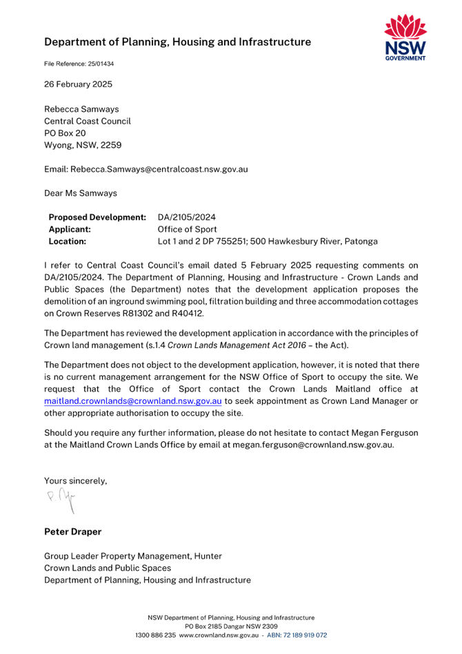
The site is identified as Crown Land which has been registered as Crown Land Reserves R40412 and R81302. There is currently no Plan of Management over the site. There is no requirement for a Plan of Management to be prepared by a non-council manager unless directed by the Minister, as per Division 3.6 of the Crown Land Management Act 2016. Given the proposed development is for demolition, there will be no works that will alter the current operation of the site or impact any future use of the site that requires further consideration by NSW Crown Lands.
The application was referred to NSW Crown Lands, who did not object to the development application, however noted that there is no current management arrangement for the NSW Office of Sport to occupy the site. The applicant has advised that they have since contacted NSW Crown Lands to request that NSW Office of Sport be appointed as Crown Land Manager or be provided another appropriate authorisation to occupy the site. It is noted that in accordance with Division 3.6, should NSW Office of Sport be appointed as Crown Land Manager, a Plan of Management would also not be required unless directed by the Minister.
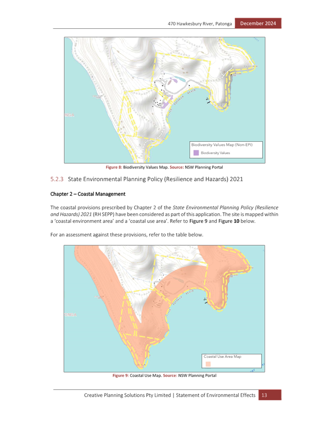
Biodiversity Conservation Act 2016
The site is partially mapped as containing biodiversity values. A small portion of the proposed demolition works for the swimming pool are located within the boundaries of the areas mapped as containing biodiversity values. Removal any trees or significant vegetation is not proposed. Tree protection conditions are recommended to ensure the protection of the trees surrounding the swimming pool during the demolition works.
Given no trees or native vegetation are proposed to be impacted, the proposed development is satisfactory with regard to the provisions of the Biodiversity Conservation Act 2016.
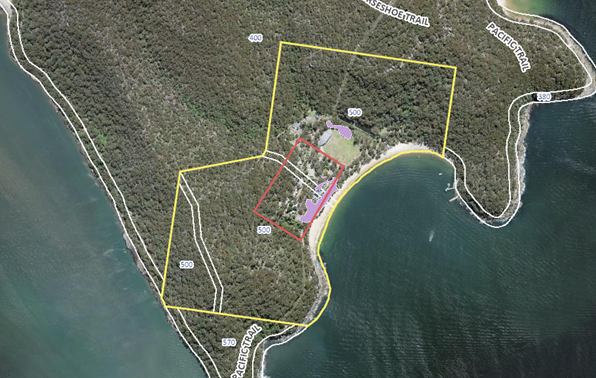
Figure 15 – Biodiversity values on the site
State Environmental Planning Policies (SEPP)
State Environmental Planning Policy (Resilience and Hazards) 2021
Chapter 2 Coastal Management
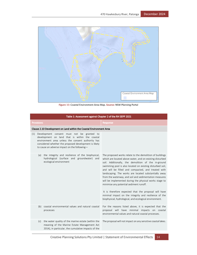
The provisions of State Environmental Planning Policy (Resilience and Hazards) 2021 require Council to consider the aims and objectives of the SEPP when determining an application within the Coastal Management Area. The Coastal Management Area is an area defined on maps issued by the NSW Department of Planning and Environment. The subject property falls within the ‘Coastal Environment Area’ and ‘Coastal Use Area’ identified on these maps.
In considering the impact of any development application, the consent authority must have regard to matters within sections 2.10 (for the coastal environment area) and 2.11 (for the coastal use area) of the SEPP.
The relevant matters have been considered in the assessment of this application. The proposed development is not likely to cause undue impact on the biophysical, hydrological, or ecological environment. The values of the natural coastal processes are not likely to be impacted, marine vegetation and fauna habitats will not be disturbed by the proposal and the proposal does not impact on known Aboriginal cultural heritage, the surf zone, or existing public spaces. The proposed development will not result in adverse impact on rock shelves, overshadowing, loss of views from public places nor visual amenity.
The impact in terms of cultural and built environment heritage (section 2.11(1)(v) of the SEPP) has been considered further in this report.
The Panel can be satisfied the proposal will not cause any adverse impact upon the coastal environment and the proposed demolition is consistent with the relevant requirements of Chapter 2.
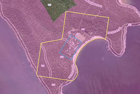
Figure 16 – Coastal management area on the site
Figure 17 – Coastal use area on the site
Chapter 4 Remediation of Land
Section 4.6(1)(a) of SEPP Resilience and Hazards (2021) in Chapter 4 Remediation of Land requires that the consent authority must not consent to the carrying out of any development on land unless it has considered whether the land is contaminated.
The site has been used for sport and recreation since approximately 1945. There is no history of contaminating land uses on the site where the proposed structures are proposed to be demolished.
Given the age of the buildings proposed to be demolished there is potential for asbestos to be present in the buildings. Conditions of consent have been recommended in relation to the safe removal of any asbestos from the site.
The Panel can be satisfied that the demolition will be undertaken by a suitably qualified and licensed contractor, the site is suitable in its current state, and a preliminary site investigation report is not required in this instance.
State Environmental Planning Policy (Biodiversity and Conservation) 2021
Chapter 4 Koala habitat protection 2021
Chapter 4 of SEPP (Biodiversity and Conservation) 2021 applies to Central Coast local government area. There is no approved koala plan of management that applies to the land. As the site is over 1 hectare the provisions of Section 4.9 apply to the site. Section 4.9(2) states the following:
Before a council may grant consent to a development application for consent to carry out development on the land, the council must assess whether the development is likely to have any impact on koalas or koala habitat.
The Panel can be satisfied that because no trees are proposed to be removed, the development is not likely to impact on koalas or koala habitat having regard for the provisions of Section 4.9(3) of the Biodiversity Conservation SEPP 2021.
Central Coast Local Environmental Plan 2022
Permissibility
The site is zoned RE1 Public Recreation under Central Coast Local Environmental Plan 2022 (CCLEP 2022). The proposed demolition is identified as a type of development under section 1.5 of the Environmental Planning and Assessment Act 1979. The Act provides the following definition:
demolition of a building or work includes enclosing a public place in connection with the demolition of a building or work.
Development consent is required for the demolition of the accommodation cottages and swimming pool as the extent of works are not considered to be exempt. Demolition is permissible in the zone pursuant to clause 2.7.
Figure 18 – Zoning map of the site and surrounding development
Clause 2.3 – Zone Objectives and Land Use Table
Subclause 2.3(2) of the CCLEP 2022 requires the consent authority to have regard to the objectives for development in a zone when determining a development application. The proposed demolition takes place wholly within the RE1 Public Recreation zone. The objectives of the RE1 Public Recreation zone are as follows:
· To enable land to be used for public open space or recreational purposes.
· To provide a range of recreational settings and activities and compatible land uses.
· To protect and enhance the natural environment for recreational purposes.
· To identify areas suitable for development for recreation and cultural purposes.
· To provide space for integrated stormwater treatment devices for flow and water quality management.
Given the current state of the dilapidated accommodation cottages and the lack of use of the swimming pool by Broken Bay Sport and Recreation Centre, it is considered that in the interest of public safety the structures should be removed. The removal of the structures will still allow for the land to be used for recreational purposes consistent with the objectives of the zone.
Clause 2.7 - Demolition requires development consent
The proposed demolition works are not identified as exempt development under the SEPP (Exempt and Complying development Codes 2008) or any relevant environmental planning instrument and therefore development consent is required. Development consent is sought for the proposed demolition works as part of this application which satisfies this clause.
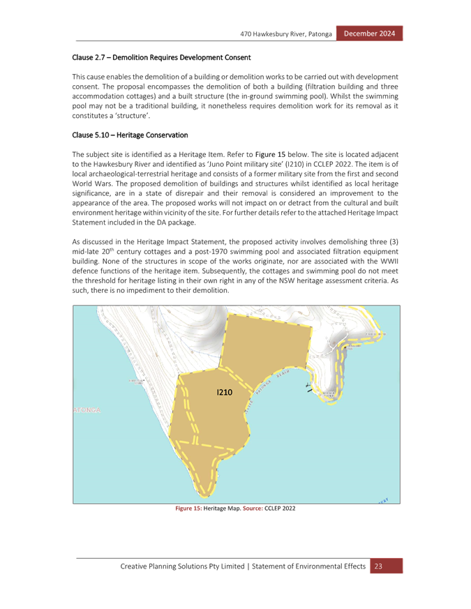
Clause 5.10 - Heritage conservation
The site is identified as an item of local heritage significance, listed as ‘Juno Point military site’ (Item No. I210) in Schedule 5 of the CCLEP 2022.
Clause 5.10 of CCLEP 2022 establishes the statutory framework for the protection and management of heritage items and heritage conservation areas and stipulates that development consent is required for the demolition or altering of a building that is a heritage item or is within a heritage conservation area.
The provisions of clause 5.10 require, amongst other things, requires consideration to be given to the impact of the proposed development on the heritage significance of the item or area concerned.
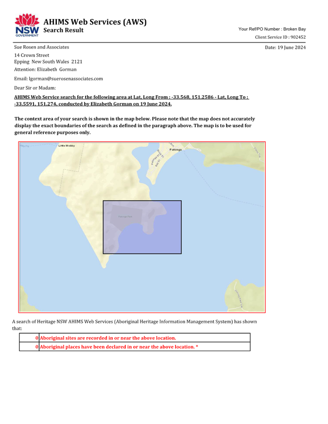
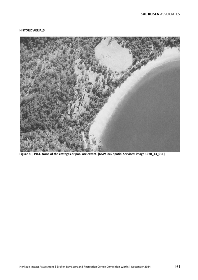
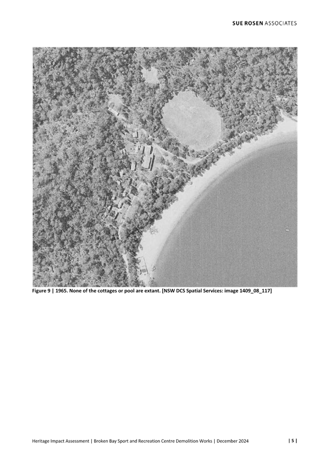
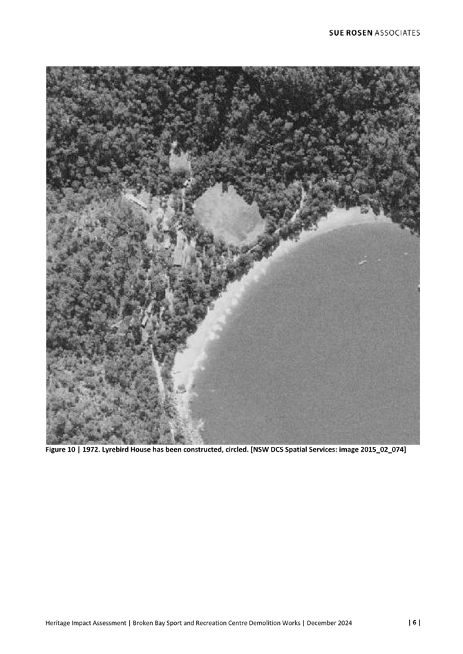
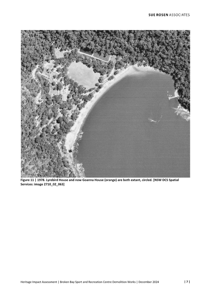
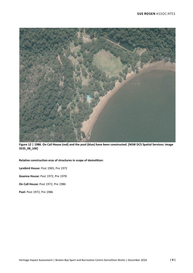
The Juno Point military site is principally heritage listed as an archaeological-terrestrial item of high significance, recognised as a rare and relatively intact example of a WWII defence site. The Heritage Impact Assessment, prepared by Sue Rosen Associates, dated 20 December 2024, identified the structures proposed to be removed were constructed around the following dates:
· Lyrebird House – Late 1960’s to early 1970’s
· On Calle House – Late 1970’s to early 1980’s
· Goanna House – Mid to late 1970’s
· Swimming Pool – Late 1970’s to early 1980’s
The structures subject to the proposed works are not original to the site’s wartime function and have no direct historical association with the defence operations. The proposed demolition works have been assessed and will not adversely impact the cultural or built heritage values of the site or its surrounding context. The cottages and swimming pool do not meet the threshold for heritage listing under the NSW heritage assessment criteria. As such, their removal does not pose a heritage concern or constraint.
Goanna Cottage is situated near Stone Lodge, a key heritage structure within the site. It is essential that all demolition and remediation works are undertaken with due care to prevent any impact on the structural integrity, material fabric, or heritage significance of Stone Lodge.
The Heritage Impact Assessment includes recommendations for the protection of significant built and landscape elements particularly with regard to Goanna House, briefing of contractors regarding the structures to be removed, and an unexpected archaeological finds protocol. Compliance with the recommendations of the Heritage Impact Assessment has been included in the recommended conditions of consent.
Figure 19 – Location of Stone Lodge near Goanna House
Figure 20 – Location of Stone Lodge near the verandah of Goanna House
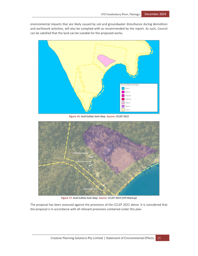
Clause 7.1 – Acid sulfate soils
The site is mapped as potentially containing class 1, 3 and 5 acid sulfate soils. All demolition works are within the area of the site are mapped as potentially containing class 5 acid sulfate soils. In accordance with clause 7.1, development consent is required for the following works within areas mapped as potentially containing class 5 acid sulfate soils.
Works within 500m of adjacent Class 1, 2, 3 or 4 land that is below 5m Australian Height Datum and by which the watertable is likely to be lowered below 1m Australian Height Datum on adjacent Class 1, 2, 3 or 4 land.
The structures proposed to be demolished are within 500m of the adjacent class 1 and 3 land. The demolition of the three accommodation cottages will not involve any significant excavation works which would lower the watertable on adjacent class 1 and 3 land below 1m AHD. The swimming pool is constructed with the base having an RL of approximately 6.5m AHD. Demolition of the pool is not likely to lower the watertable below 1m AHD on the adjacent class 1 or 3 land. Therefore, the proposed works are unlikely to impact acid sulfate soils and an Acid Sulfate Soils Management Plan (ASSMP) is not required.
Conservatively, an ASSMP has been provided. The ASSMP, dated 20 December 2024, prepared by EI Australia, was considered satisfactory in meeting the requirements of the Acid Sulfate Soil Manual (NSW ASSMAC, 1998). The ASSMP assessment, procedures and contingency plans are considered satisfactory. It is noted that no intrusive assessments nor a liming rate have been provided at this point. It is advised in the ASSMP that intrusive assessment commence prior to the works to categorise acid sulfate indicators. A condition is recommended to ensure all earthworks are carried out in accordance with the ASSMP.
The Panel can be satisfied the provisions of clause 7.1 of CCLEP have been adequately addressed.
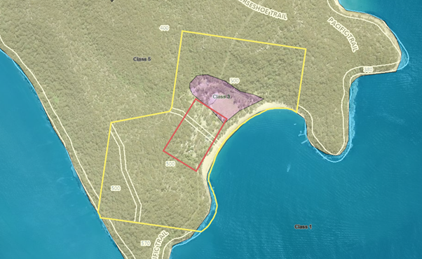
Figure 21 – Acid sulfate soils on the site
Clause 7.6 – Essential services
Development consent must not be granted to development unless the consent authority is satisfied that all the following services that are essential for the development are available or that adequate arrangements have been made to make them available when required—
(a) the supply of water,
(b) the supply of electricity,
(c) the disposal and management of sewage,
(d) stormwater drainage or on-site conservation,
(e) suitable vehicular access,
(f) the collection and management of waste
The application does not require the connection to essential services for the proposed demolition, however, it is noted that conditions have been applied to require the safe disconnection of essential services prior to demolition works occurring.
The Panel can be satisfied clause 7.6 has been considered and that there is no requirement for essential services in this instance.
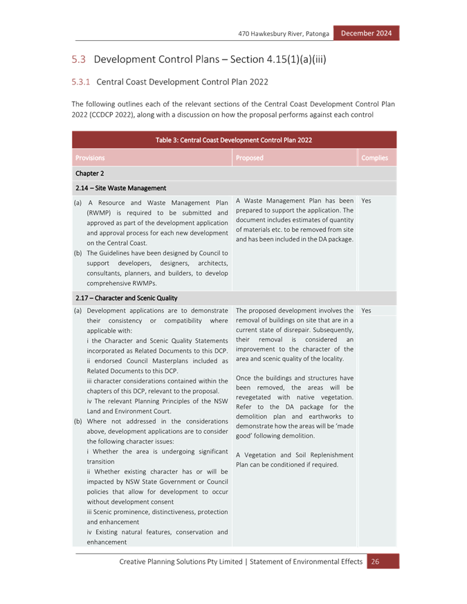
Central Coast Development Control Plan 2022
Chapter 2.14 – Site Waste Management
A Waste Management Plan has been submitted with the application demonstrating the amount of waste to be generated during the demolition phase.
The proposal has demonstrated compliance with this chapter of the CCDCP 2022 and associated Waste Control Guidelines. Appropriate conditions are included in the recommended conditions of consent.
Chapter 3.6 – Heritage Conservation
The proposed development has been assessed against the requirements of Clause 2.7 and 5.10 of CCLEP 2022 and is supported by a Heritage Impact Assessment. As previously discussed in the report, the proposed structures for demolition do not have heritage significance and will not impact on the heritage importance of the site. The requirements of Chapter 3.6 have been satisfied.
Permissibility
Likely Impacts of the Development:
The impacts associated with the demolition of the unused pool and dilapidated cottages are considered minimal. Demolition will be completed by a licensed contractor and will not impact on any other structures or vegetation remaining on the site.
Built Environment, Context and Setting
An assessment of the impacts of the proposed development on the built environment has been undertaken in terms of CCLEP 2022 and CCDCP 2022. Demolition is recommended because the structures are dilapidated and/or not in use and their removal will facilitate a safe environment for users of the site.
Natural Environment
No vegetation is proposed to be removed to facilitate the proposed demolition. The proposal is satisfactory in relation to impacts on the natural environment. There will be no significant impact upon the natural environment because of the proposal.
Economic and Social Impacts
Demolition of the structures will reduce costs to NSW Office of Sport to manage and maintain the structures and will allow for the continued use of the recreational facility for different user groups within the community.
Demolition of the cottages is considered to have a positive social impact as it will improve safety on the site. As the pool is not used and water activities are still available within the Hawkesbury River, there will be a negligible social impact from the removal of the pool.
Suitability of the Site for the Development
Given the condition of the cottages to be demolished and the current operations of the site which do not require the pool, it is considered that the proposed structures to be demolished will not impact on the suitability of the site and will allow the ongoing safe operation of the facility and its continued heritage conservation.
Any Submission made in Accordance with this Act or Regulations
The Public Interest: (s4.15(1)(e)):
The proposal is in the local and broader public interest as it will remove dilapidated and unused structures to improve the safety of the site whilst not impacting on the heritage structures on the site.
Submissions
The application was advertised in accordance with CCDCP 2022, Chapter 1.2 - Notification of Development Proposals for a period of 28 days between 7 February and 7 March 2025.
No submissions were received during the notification period.
Internal Consultation
|
Waste Officer |
Supported subject to conditioning compliance with the submitted Waste Management Plan. |
||
|
Environmental Health Officer |
Supported subject to conditions. |
||
|
Heritage Officer |
Supported subject to conditions. |
External Consultation
|
Crown Lands |
Supported. |
Ecologically Sustainable Principles:
The proposal has been assessed having regard to ecologically sustainable development principles and is considered to be consistent with the principles.
The proposed development is considered to incorporate satisfactory stormwater, drainage and erosion control and the retention of vegetation where possible and is unlikely to have any significant adverse impacts on the environment and will not decrease environmental quality for future generations. The proposal does not result in the disturbance of any endangered flora or fauna habitats and is unlikely to significantly affect fluvial environments.
Climate Change
The potential impacts of climate change on the proposed development have been considered by Council as part of the assessment of the application.
This assessment has included consideration of such matters as potential rise in sea level, potential for more intense and/or frequent extreme weather conditions including storm events, bushfires, drought, flood, and coastal erosion; as well as how the proposed development may cope, combat, withstand these potential impacts. Given the condition of the structures proposed to be demolished and that they are no longer used, demolition of the development is appropriate in relation to climate change.
Other Matters for Consideration:
Section 7.11 and 7.12 Contributions
There are no applicable contributions for the proposed development.
Local Planning Panel Directions
The application is required to be referred to the Local Planning Panel for determination because development involving the demolition of a heritage item is listed as ‘sensitive development’ in Schedule 2 (point 4(c)) of the Local Planning Panels Ministerial Direction (dated 6 March 2024). Whilst the buildings and swimming pool proposed to be demolished are not heritage listed items, they are located on land which is identified as a heritage item. Accordingly, the application has been referred to the Central Coast Local Planning Panel for determination.
Conclusion:
The development application has been considered in accordance with the requirements of the Environmental Planning and Assessment Act 1979 and the Regulations, as outlined in this report. The following is a summary of prerequisite conditions for the granting of development consent that have been considered in the assessment report and provided as part of the conclusion, for the benefit of the Panel:
1. The Panel can be satisfied that the land is suitable for the proposed development as required by Section 4.14 of the Environmental Planning and Assessment Act 1979, and the nature of the works will reduce the risk and hazards of bushfire.
2. The Panel can be satisfied that the conditions of consent have been agreed upon by the Crown prior to a determination, in accordance with Section 4.33 of the Environmental Planning and Assessment Act, 1979.
3. Having regard for Sections 2.10 and 2.11 of the State Environmental Planning Policy (Resilience & Hazards) 2021, the Panel can be satisfied that the demolition works will be managed to avoid an adverse impact referred to in Sections 2.10 and 2.11, and the development is not likely to cause increased risk of hazards on the subject site or other land.
4. The Panel can be satisfied that the land is suitable for the proposed development as referenced in Section 4.6(4) of the State Environmental Planning Policy (Resilience and Hazards) 2021 as it does not involve a change of use of the land and the land is not considered to be contaminate. Accordingly, the development is satisfactory having regard for the provisions of Section 4.6 of the same SEPP.
5. The Panel can be satisfied that the proposed development is satisfactory with regards to the RE1 Public Recreation zone and its objectives in accordance with the Central Coast Local Environmental Plan 2022.
6. There are no significant issues or impacts identified with the proposal under Section 4.15 of the Environmental Planning and Assessment Act 1979.
7. Having regard for the prerequisite conditions to the granting of consent under Central Coast Local Environmental Plan 2022, the Panel can be satisfied that:
a. Clause 5.10 – Heritage Conservation
i. The structures proposed to be removed are not of heritage significance.
ii. There will be no impact to the heritage significance of the Juno Point military site from the proposed demolition works.
b. Clause 7.1 – Acid Sulfate Soils
i. An Acid Sulfate Soils Management Plan is not required as the proposed demolition is not likely to lower the watertable below 1m AHD on the adjacent class 1 or 3 land.
ii. Conservatively, an Acid Sulfate Soils Management Plan prepared in accordance with the Acid Sulfate Soil Manual has been provided which is satisfactory.
c. Clause 7.6 – Essential Services
i. There will be no impact to existing essential services for the remaining structures on the site as a result of the proposed demolition.
Subject to the imposition of appropriate conditions, the proposed development is not expected to have any adverse environmental, social, or economic impact.
The application is recommended for approval pursuant to Section 4.16 of the Environmental Planning and Assessment Act 1979.
|
1⇩ |
Draft Conditions of Consent |
|
D16815953 |
|
2⇩ |
Applicant Approval of Draft Conditions |
|
D16842190 |
|
3⇩ |
Development Plans |
|
D16608263 |
|
4⇩ |
Statement of Environmental Effects |
|
D16587047 |
|
5⇩ |
Heritage Impact Assessment |
|
D16587030 |
|
6⇩ |
Crown Lands Referral Comments |
|
D16712014 |
|
3.1 |
DA/2105/2024 - 500 Hawkesbury River, Patonga - Demolition of Inground Swimming Pool, Filtration Buildings and Three Accommodation Cottages |
|
Attachment 1 |
Draft Conditions of Consent |

|
DA/2105/2024 - 500 Hawkesbury River, Patonga - Demolition of Inground Swimming Pool, Filtration Buildings and Three Accommodation Cottages |
|
|
Attachment 2 |
Applicant Approval of Draft Conditions |

|
DA/2105/2024 - 500 Hawkesbury River, Patonga - Demolition of Inground Swimming Pool, Filtration Buildings and Three Accommodation Cottages |
|
|
Attachment 3 |
Development Plans |

|
3.1 |
DA/2105/2024 - 500 Hawkesbury River, Patonga - Demolition of Inground Swimming Pool, Filtration Buildings and Three Accommodation Cottages |
|
Attachment 4 |
Statement of Environmental Effects |


|
DA/2105/2024 - 500 Hawkesbury River, Patonga - Demolition of Inground Swimming Pool, Filtration Buildings and Three Accommodation Cottages |
|
|
Attachment 5 |
Heritage Impact Assessment |

|
DA/2105/2024 - 500 Hawkesbury River, Patonga - Demolition of Inground Swimming Pool, Filtration Buildings and Three Accommodation Cottages |
|
|
Attachment 6 |
Crown Lands Referral Comments |
|
Item No: 3.2 |
|
|
Title: DA/867/2024 - Burns Place Park, Burns Crescent, Gosford - Heritage Demolition and Restoration Works of Sandstone Wall, Archway and Landscaping, including tree removal |
|
|
Department: Environment and Planning |
|
|
5 June 2025 Local Planning Panel Meeting |
|
Reference: DA/867/2024 - D16815848
Author: Emilia Ellis, Development Planner Employment and Urban Release
Section Manager: Emily Goodworth, Section Manager Employment and Urban Release
Unit Manager: Andrew Roach, Unit Manager Development Assessment
|
Summary
An application has been received for Heritage Restoration of Sandstone Walls, Archway and Landscaping, including tree removal at burns Place Park, Gosford. The application has been examined having regard to the matters for consideration detailed in section 4.15 of the Environmental Planning and Assessment Act 1979 and other statutory requirements with the issues requiring attention and consideration being addressed in this report.
The application is required to be referred to the Local Planning Panel for determination as works include the removal of trees and works to structures on a site wholly listed as a heritage item. Such works involve the dismantling and restoration of the sandstone walls, pillars, and garden bed wall on the site. The works meet the definition of ‘sensitive development’ in Schedule 2 (point 4(c)) of the Local Planning Panels Ministerial Directions (dated 6 March 2024) involving demolition of a heritage item.
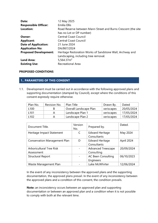
Applicant Central Coast Council Owner Central Coast Council Application No DA/867/2024 Description of Land Road Reserve between Mann Street and Burns Crescent (the site has no Lot of DP number) Proposed Development Heritage Restoration Works of Sandstone Wall, Archway and Landscaping, including tree removal. Site Area 5,564.37m2 Zoning B3 Commercial Core Existing Use Recreation Area Employment Generation No Estimated Value $400,000
|
1 That the Local Planning Panel grant consent to DA/867/2024 – Burns Crescent, Gosford – Heritage Restoration Works of Sandstone Walls, Archway and Landscaping, including tree removal subject to the conditions detailed in the schedule attached to the report and having regard to the matters for consideration detailed in Section 4.15 of the Environmental Planning and Assessment Act 1979.
Precis:
|
Proposed Development |
Heritage Restoration Works of Sandstone Wall, Archway & Landscaping, including tree removal.
|
|
Permissibility and Zoning |
B3 Commercial Core of SEPP (Precincts-Regional) 2021 Recreational Area is a permissible use in the B3 Commercial Core |
|
Relevant Legislation |
The following planning policies and control documents are relevant to the development and were considered as part of the assessment: · Environmental Planning and Assessment Act 1979 (EP&A Act) · Local Government Act (LG Act) · Roads Act 1993 (Roads Act) · Environmental Planning and Assessment Regulations 2021 (Regs) · State Environmental Planning Policy (Precincts – Regional) 2021 · State Environmental Planning Policy (Resilience and Hazards) 2021 Gosford City Centre Development Control Plan 2018 (GDCP 2018) |
|
Current Use |
Recreation Area |
|
Integrated Development |
No |
|
Submissions |
No |
Variations to Policies
There are no variations to any policies.
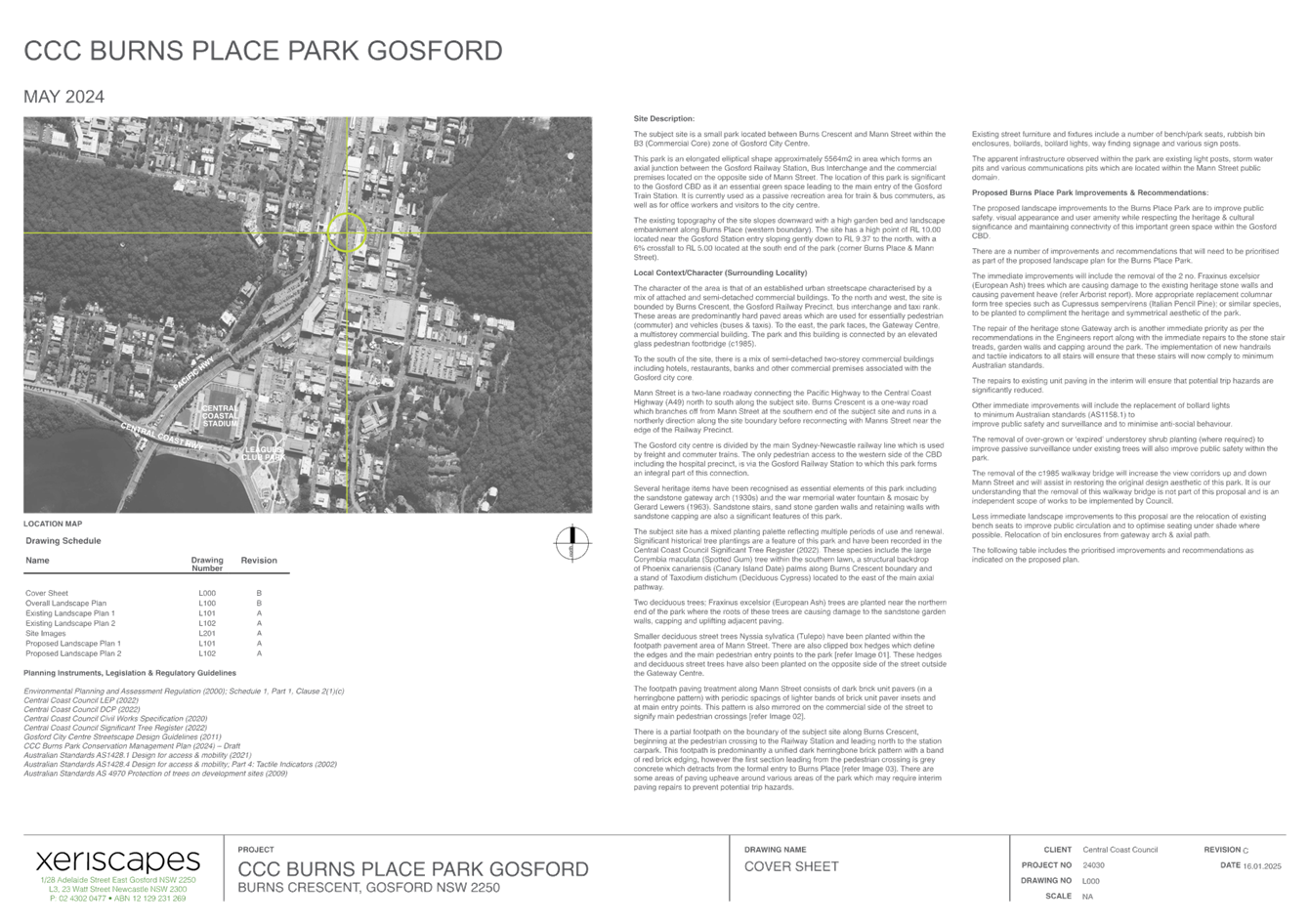
The Site
The site is described as Burns Place Park and is located between Burns Crescent and Mann Street, Gosford. The subject site does not have a Lot or DP number and is identified as a road reserve.
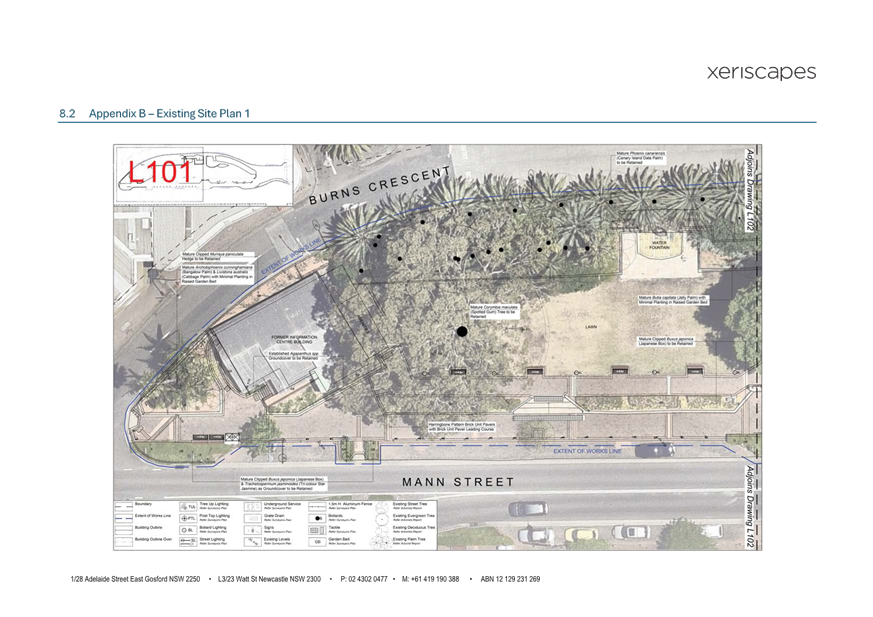
The site is irregular in shape and is located within the roadway owned and managed by Central Coast Council. The site does not occupy its own allotment or include separate legal boundaries. The park however is informally bounded by a pedestrian footpath, on-street parking, sandstone garden bed walls, and fencing on the north, east and southern sides, while the western side of Burns Crescent includes a vehicular drop off point for the adjacent Gosford Train Station, with trees hedging this boundary. The northern side of this boundary includes access stairs into the park, and a pedestrian walkway to the Bus and taxi stands adjacent to the Gosford Train Station. These informal boundaries are shown in Figure 1 below in the red outline and include an area of approximately 5,564.37m2.
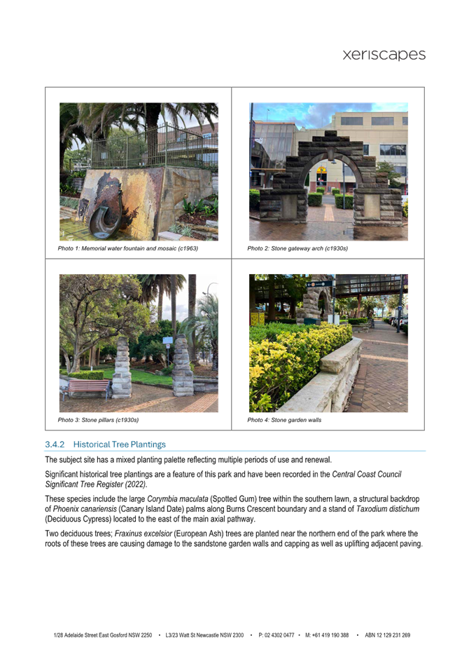
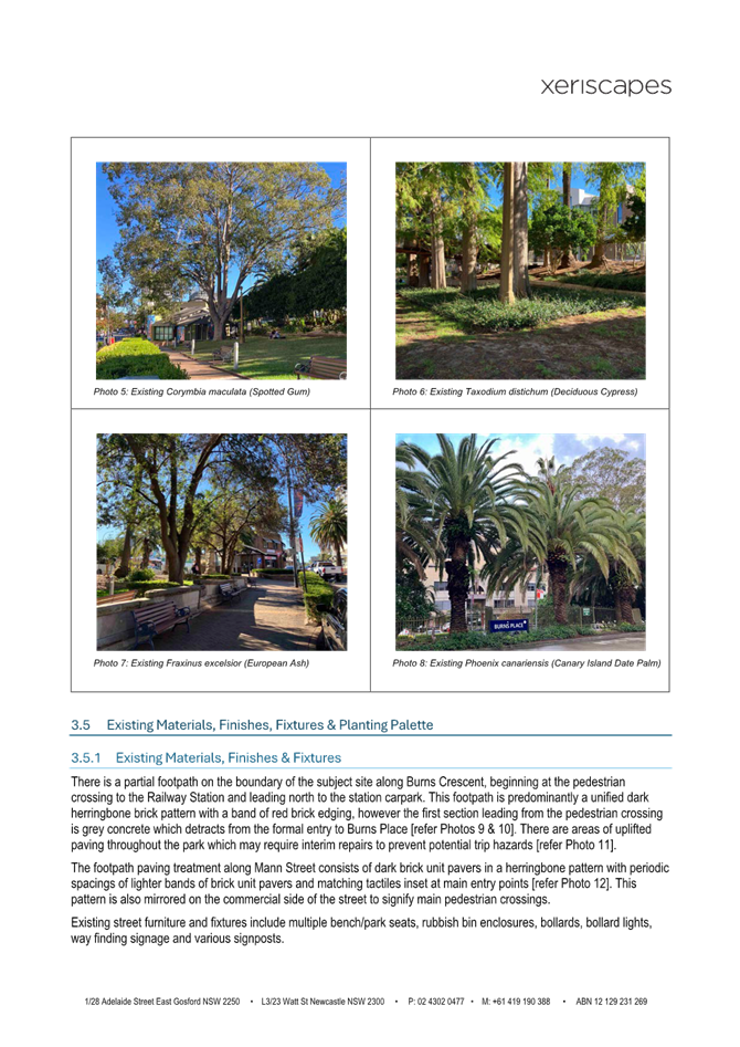
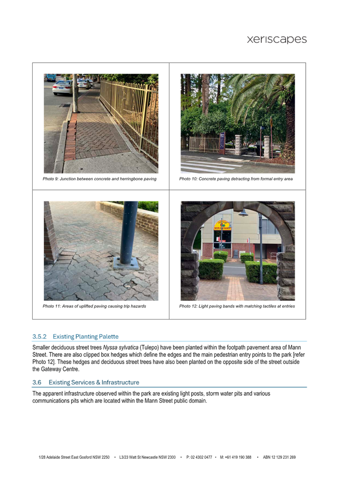
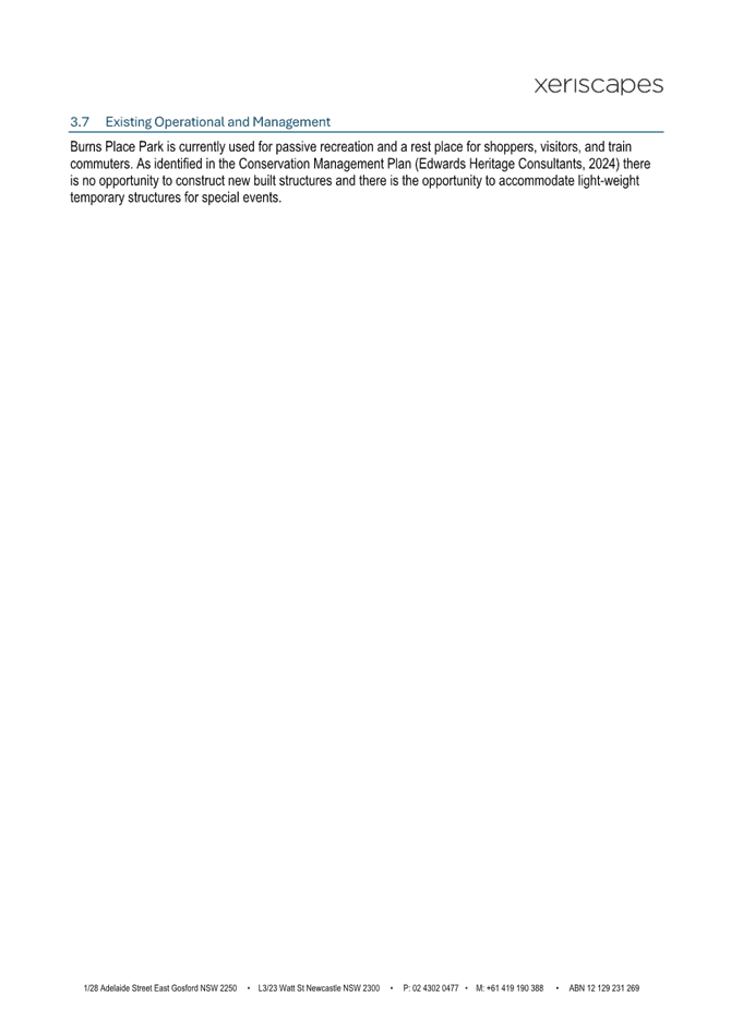
Situated in Burns Park Place are several built features and mature plantings which range in age and maturity to reflect the works, and modifications taken place in the park over time. Since its establishment, many original features and landscape layout have remained consistent with the original design. The original 1930s built features including the sandstone arch, garden bed wall, steps and formed concrete lamp posts in the centre of the park and stands of Taxodium distichum (Bald Cypress) trees in the centre of the park have been retained and upheld over time.
Several elements were later added to the park, including the War Memorial Fountain, dated 1963, with the pedestrian footbridge connecting the train station over the site to adjacent Gateway building opposite Mann Street and the tourist information centre with public toilets located in the southern corner of the site, undertaken in the 1980s. The landscape setting has largely been retained, although specifically the plantings and several smaller décor items have been added as later additions, but the park retains its original layout and charm of the original park design. Burns Place Park was funded by the community as a place of public open space in the 1930s and holds high social significance to the Gosford community.
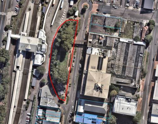
Figure 1: Aerial view of the subject site (red outline) and surroundings (Source: Council GIS Mapping)
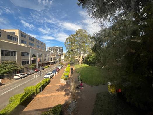
Figure 2: View of the existing park facing south from the pedestrian footbridge to the gateway centre (Source: Council Officer, dated 5/5/2025)
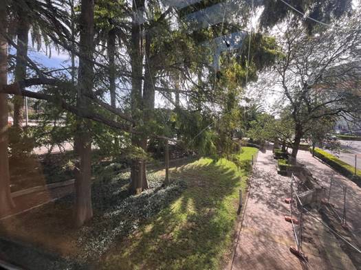
Figure 3: View of the existing park facing north from the pedestrian footbridge to the gateway centre (Source: Council Officer, dated 5/5/2025)
Surrounding Development
The site is situated within the heart of the Gosford Town Centre, specifically sited between Burns Crescent to the west and Mann Street to the east.
The site is located on the fringe of the adjoining railway precinct and is used as a gateway location for the city to the railway station. Directly west across Burns Crescent is the main entrance to Gosford Train Station, the Newcastle to Sydney Rail Line, and a transport interchange comprising pedestrian drop off point, bus and taxi stands. To the north, south and east of the site is are commercial and retail buildings which is the core of the Gosford town centre.
Directly opposite Burns Park Place is the ‘Gateway Centre’ which was built as a commercial premises in the 1980s and is earmarked as a ‘key site’ for future development and master planning in line with the provisions of Chapter 5 Gosford City Centre in SEPP (Precincts-Regional) 2021 and the Gosford City Centre Development Control Plan 2018.
![]()
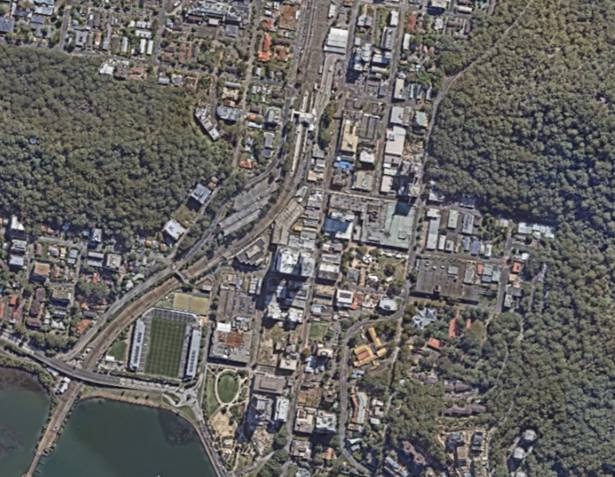
Figure 4: Aerial view of the subject site (red outline) to the surrounding Gosford City Centre (Source: Council GIS Mapping)
The Proposed Development
Development consent is being sought for works which will dismantle and restore the original sandstone elements, in addition to further works around the park to provide more appropriate for lighting, pedestrian safety and access. The application also includes the removal of several trees and shrubs around the site to improve sight lines and ensure structural damage to the heritage structures does not occur in the future. The new landscaping works will also allow for the appropriate ongoing maintenance of the park.
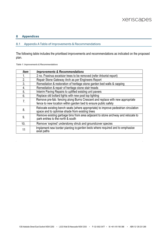
Specifically, the proposal includes:
· Remediation and restoration of the stone garden bed walls and capping from around the entire of the site (original heritage item). Works include:
o Dismantling and rebuilding the entire length of the garden wall with new and salvaged stone.
o the removal of the Buxus sempervirens shrubs currently providing a hedge border for the wall. The clipped border shrub is to be replaced with Buxus japonica at the completion of the remedial stone wall repair.
· Removal of two existing Fraxinus excelsior (European Ash) trees along the norther corner of Mann Street entrance. The invasive root system has resulted in substantial damage to the traditional sandstone garden bed walls and street pavement. The trees are to be replaced with two Cupressus sempervirens (Glauca).
· Dismantling and reconstruction of stone gateway arch and realignment of the base wall in the centre of the site (original heritage item) to engineers’ specifications. Works include:
o dismantling and rebuilding the spandrel, arch, and base wall with salvaged and new sandstone as required.
o coring out the steel rods as they are exposed during the works.
o reinstalling the stone plagues with new flexible sealant around the perimeters.
o reinstalling the strengthening rods using stainless steel.
· Remedial repair of the stone pillars at the northern entry of the park. Works include the dismantling and rebuilding of the wall using new and salvaged stone.
· Repair and/or uplifting and replacement of pedestrian paving along the footpath along Mann Street and within Burns Park.
· General maintenance to bin appearances and relocation of two bench seats for sufficient pedestrian clearance around the street trees on Mann Street.
· Remedial repair of stone stair treads and implementation of new handrails to comply with Australian Standards on the centre stairwell from the Burns Crescent entrance.
· Remediation and restoration of stone stair trends on the stairs on Mann Street leading up to Burns Place Park.
· Removal of the existing 12x white bollard lights around the park which are not in working condition and replace with new light poles with integrated LED internal lighting.
· Removal of existing mature 3-4m high Murraya paniculate shrubs located in the south-western garden bed with Burns Crescent Road to the rear. The shrubs are to be replaced with mass planting ground cover to mirror with the northern garden bed in the park. The mass underground cover will extend below the existing Date Palms along the perimeter of Burns Crescent.
· Removal of prefabricated existing fencing along burns crescent and replace with a new 1.2m high black powder coated fence to new location within garden bed to ensure public safety.
· Restoration works including the cleaning of walls surrounding the fountain, stairwell, and pavement on the site.
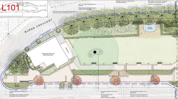
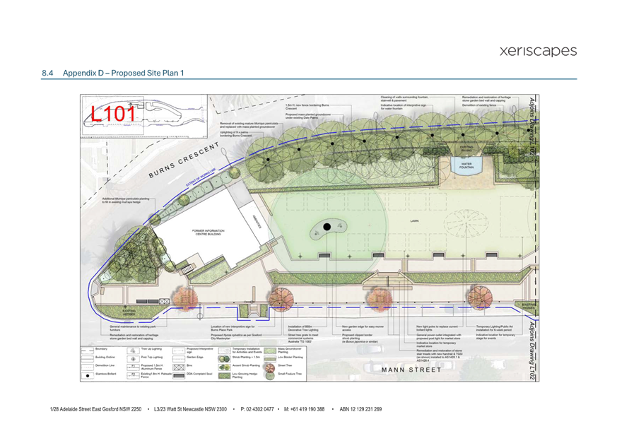
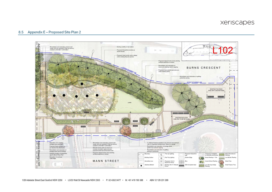
Figure 5: Proposed northern of site plan detailing proposed works (Source: xeriscapes, Landscape Plan, dated 16/1/2025)
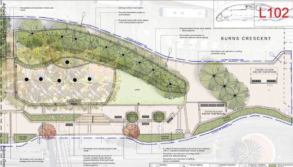
Figure 6: Proposed southern side of site plan detailing proposed works (Source: xeriscapes, Landscape Plan, dated 16/1/2025)
Background
Central Coast Council participated in the Safer Cities: Her Way pilot program as a collaboration between Transport for NSW and several Councils. The program identified opportunities to improve perceptions of safety in public places around transport precincts, including Burns Place Park. A report of the program outcomes was recommended to be noted by the Administrator, Rik Hart at the Council meeting held on 27 August 2024. The report also recommended the learnings and opportunities of the program be noted for inclusion in future Council plans and strategies. The outcomes specific to Burns Place Park included a future Development Application which would include paving pathways for safe pedestrian access, repairing retaining walls, and restoring the heritage archway. Minor enhancements also were proposed which included landscaping, improved lighting, and new fencing on site.
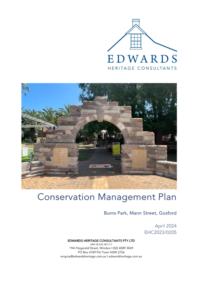
On the recommendation of Council’s Heritage Officer at the pre-development application meeting a Heritage Conservation Management Plan (CMP) was recommended to be undertaken. The CMP was to guide the long-term maintenance, management and decision making considering the park’s heritage significance. The provided Conservation Management Plan for the park was recommended to be adopted by Council at the Environment and Planning Committee meeting, held on 6 May 2025 which resolved to place the CMP on public exhibition for a minimum of 28 days, and a further report on the outcome of the community consultation would then be required. The public exhibition period has not started at the time of drafting this report.
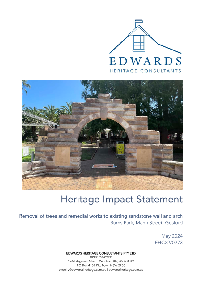
The proposed works under this application include the immediate restoration works to several key heritage features in the park that have started to decay or cause substantial damage which warrant immediate attention. These works include the damage in Figures 7 to 9 below for the restoration works to the sandstone garden bed wall, stair treads and the European Ash tree roots placing strain on the sandstone wall and adjacent ground pavement. These elements have been fenced off for public safety and remain like this until such time as the works can be approved in relation to the heritage listing of the site. The application has been supported with a Conservation Management Plan (CMP) and a Heritage Impact Statement (HIS).
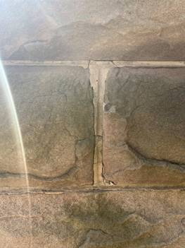
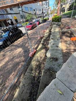
Figure 7: Examples of the damage (shifting, cracking, and breaking) to the existing sandstone pillars, and stair treads on Mann Street entrance (Source: Council Officer, dated 5/5/2025)
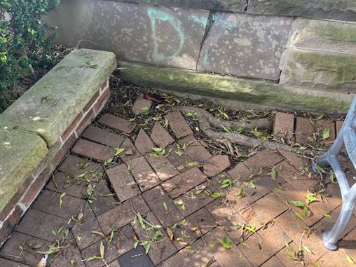
Figure 8: Example of the Fraxinus excelsior (European Ash) tree root damage and root strain on the sandstone garden bed and uplifting of the surrounding pedestrian pavement (Source: Council Officer, dated 5/5/2025)
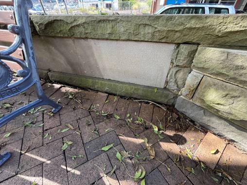
Figure 9: Example of the uplifting in the pedestrian pathway around and within Burns Place Park (Source: Council Officer, dated 5/5/2025)
History
The area now identified as Burns Place Park was previously known as Railway Square and was land described as overgrown and undesirable. As a result, a community lead and funded initiative gathered the funds to design and construct a new park at the site in 1935. In 1937 the local businesses contributed to the stone walls, archways, and garden layout while the then Gosford Municipal Council undertook a major tree planting scheme which provided the extensive planting of trees, shrubs, and flowers around the site. Over time, the park has undergone several changes including the removal of the original band rotunda and the original tourist information centre. In 1963, the War Memorial was constructed, and the footbridge to the gateway centre, and new commercial building with public toilets (to replace the original tourist information centre) were added in the 1980’s.
In 1997, the then Gosford City Council commissioned landscape architectural firm Andrews Neil to prepare a landscape master plan for Burns Place Park. The commissioned work included a design concept which outlined a series of landscaping and civil improvement works to the site. However, many of the recommendations required the removal or modification of several original elements. The community resisted the changes, and the concept plans were not adopted. Since then, the park has remained mostly unchanged with little known alterations recorded.
The site was heritage listed by the former Gosford City Council in 2004 after local heritage studies undertaken in the 1980s identified the site to have potential heritage significance. A subsequent heritage study in 2013 assessed and recommended its retention on the heritage list. It is currently listed under Schedule 9 – Chapter 5 of the State Environmental Planning Policy (Precincts – Regional) 2021, and is identified as ‘Burns Place Park, feature eucalypt and strands of mature trees’ (I27).
The applicant being Central Coast Council attended a pre-development application meeting (PDA/71/2023) on 22 May 2023 to discuss the proposed works.
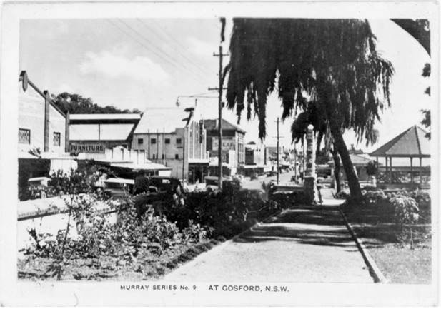
Figure 10: 1940s postcard showing the view of Burns Park facing south with the stone archway and Mann Street to the left (Source: Central Coast Library Service, adapted from Heritage Impact Statement, prepared by Edward Heritage Consultants, dated May 2024)
ASSESSMENT:
Having regard for the matters for consideration detailed in Section 4.15 of the Environmental Planning and Assessment Act 1979 and other statutory requirements. The assessment has identified the following key issues, which are elaborated upon for Council’s information. Any tables relating to plans or policies are provided as an attachment.
Provisions of Relevant Instruments/Plans/Policies:
Relevant Legislation
Environmental Planning & Assessment Act 1979 (EP&A Act)
Clause 9B Council related development applications
The Conflict-of-Interest Regulation took effect on 3 April 2023. Clause 9B (2) of Schedule 1 to the EP&A Act defines Council-related development applications as:
(2) In this clause–
Council-related development application means a development application, for which a council is the consent authority, that is–
(a) made by or on behalf of the council, or
(b) for development on land, other than a public road within the meaning of the Local Government Act 1993–
(i) of which the council is an owner, a lessee, or a licensee, or
(ii) otherwise vested in or under the control of the council.
Note–
Land vested in or under the control of council includes public land within the meaning of the Local Government Act 1993.
Accordingly, the development application has been made by the Council, in addition to the application being for land located within the Road which is owned and maintained by Council. In accordance with Schedule 1 Clause 9B of the EP&A Act, the application was publicly exhibited for the minimum period of 28 days between 12 July 2024 and 9 August 2024 (inclusive).
Local Government Act 1993 (LG Act)
The subject site is identified as a road reserve within the meaning of a road in the Roads Act 1993. As such, despite being known as Burns Place Park the site is not identified as ‘public land’ under the LG Act but rather a public road instead. Public land is described as follows:
public land means any land (including a public reserve) vested in or under the control of the council, but does not include–
(a) a public road, or
(b) land to which the Crown Land Management Act 2016 applies, or
(c) a common, or
(d) a regional park under the National Parks and Wildlife Act 1974.
As detailed under Part 2 Public Land of the LG Act, roads are exempt from being classified as either ‘community’ or ‘operational’ land. Therefore, there is no requirement for a plan of management to apply to the site. There is no further discussion warranted under the LG Act.
Roads Act 1993 (Roads Act)
The proposed site is identified as being a road reserve under the ownership and management of Council. Under the Roads Act, a road is defined as follows:
public road means–
(a) any road that is opened or dedicated as a public road, whether under this or any other Act or Law, and
(b) any road that is declared to be public road for the purposes of this Act.
road includes–
(a) the airspace above the surface of the road, and
(b) the soil beneath the surface of the road, and
(c) any bridge, tunnel, causeway, road-ferry, for or other work or structure forming part of the road.
There are no legal boundaries distinguishing the space between Mann Street and Burns Crescent, nor is the site identified as a registered parcel of land. As such Burns Place Park is within the road reserve of Mann Street and Burns Crescent.
Due to the nature of works, and the location being within a road, a section 138 Roads Act Approval is required for all works proposed under this application. Under the requirements of the section 138(1), a person must not–
(a) erect a structure or carry out a work in, on or over a public road, or
(b) dig up or disturb the surface of a public road, or
(c) remove or interfere with a structure, work, or tree on a public road, or
(d) pump water into a public road from any land adjoining the road, or
(e) connect a road (whether public or private) to a classified road,
otherwise than with the consent of the appropriate roads authority.
In this instance, the roads authority is Council, and conditions of consent have been imposed to ensure a section 138 Roads Act Approval is provided prior to any works commencing on site.
Relevant Regulations
Environmental Planning and Assessment Regulations 2021 (Regs)
The Environmental Planning and Assessment Regulations 2021 applies to all development applications regarding items such as application type, compulsory contributions, notification of development applications and a range of many other details regarding development application requirements.
Section 23(1) requires a development application to be accompanied with the written consent of the landowner to which the development application relates. The applicant, being Central Coast Council, has provided the relevant consent for the Road where the subject area is located. Under Section 66A of the Regulations Council related development applications must not be determined by the consent authority unless:
a) the Council has adopted a Conflict-of-interest policy, and
b) the Council considers the policy in determining the application.
Central Coast Council’s Council Related Development Applications Conflict of Interest Protocol, Revision 1, was adopted by Council on 30 May 2023, in response to Section 66A of the Regulations.
The protocol aims to manage potential conflicts of interest and increase transparency at all stages of the development process for Council-related development. In this instance, there is no specific management strategy required as the application will be determined by the Central Coast Council Local Planning Panel. Thus, removing any conflict of interest which may arise.
State Environmental Planning Policies (SEPPs)
State Environmental Planning Policy (Precincts Regional) 2021
Chapter 5 Gosford City Centre
The site is identified to be within the Land Application Area under Chapter 5 Gosford City Centre of SEPP (Precinct – Reginal) 2021. Under section 5.7 of SEPP, the Central Coast Local Environmental Plan 2022 which would apply to the site is repealed and ceases to apply. This chapter of the SEPP is therefore to be used in lieu of the CCLEP 2022. The relevant sections of the SEPP are discussed below in further detail.
Permissibility
The subject site is identified as a heritage item and is located within the B3 Commercial Core zone under SEPP (Precinct-Regional) 2021. The works proposed include demolition, maintenance, and restoration of a heritage item. The heritage item is identified as No. 27 under Schedule 9 Part 1 of SEPP (Precincts-Regional) 2021.
The following definitions are provided under SEPP (Precincts-Regional) 2021 and are relevant to the application:
demolish, in relation to a heritage item or an Aboriginal object, or a building, work, relic or tree within a heritage conservation area, means wholly or partly destroy, dismantle, or deface the heritage item, Aboriginal object, or building, work, relic or tree.
maintenance, in relation to a heritage item, Aboriginal object, or Aboriginal place of heritage significance, or a building, work, archaeological site, tree or place within a heritage conservation area, means ongoing protective care, but does not include the removal or disturbance of existing fabric, alterations (such as carrying out extensions or additions) or the introduction of new materials or technology.
heritage item means a building, work, place, relic, tree, object, or archaeological site the location and nature of which is described in Schedule 9.
The subject area being the Burns Place Park is best characterized as a recreation area, which is defined as follows:
recreation area means a place used for outdoor recreation that is normally open to the public, and includes–
(a) a children’s playground, or
(b) an area used for community sporting activities, or
(c) a public park, reserve or garden or the like,
and any ancillary buildings but does not include a recreation facility (indoor), recreation facility (major), or recreation facility (outdoor).
Burns Place Park is an existing public park which is permissible on the land.
Section 5.5 – Consent Authority
Under the provisions of this section, Council would be considered the consent authority as the cost of works are below $10 million. However, the site is listed as a heritage item and includes the works to a heritage item and the removal of several trees on the site which triggers the Local Planning Panel as the determining authority under the Local Planning Panels Ministerial Directions (dated 6 May 2024). Accordingly, the application is referred to the Central Coast Local Planning Panel for determination.
Section 5.13 – Zone Objectives and Land Use Table
Section 5.13 (2) requires the consent authority to have regard to the objectives for development in a zone when determining a development application. The objectives of the B3 Commercial Core zone are as follows:
· To provide a wide range of retail, business, office, entertainment, community, and other suitable land uses that serve the needs of the local and wider community.
· To encourage appropriate employment opportunities in accessible locations.
· To maximise public transport patronage and encourage walking and cycling.
· To strengthen the role of Gosford City Centre as the regional business, retail, and cultural centre of the Central Coast.
· To encourage a diverse and compatible range of activities, including commercial and retail development, cultural and entertainment facilities, tourist, leisure and recreation facilities and social, education and health services.
· To provide for residential uses if compatible with neighbouring uses and employment opportunities.
· To create opportunities to improve the public domain and pedestrian links throughout Gosford City Centre.
· To provide for the retention and creation of view corridors.
· To protect and enhance the scenic quality and character of Gosford City Centre.
Burns Place Park has been a staple of the Gosford City Centre since its inception in the 1930s. The park has maintained its open green space, is publicly accessible, and provides a communal area for events, meeting places, and natural shading in the commercial centre.
The restoration and maintenance works proposed around the park, will ensure the integrity of the heritage sandstone works for their ongoing use and protection. Further works including the removal of several trees and plantings, and fencing around the site, are an attempt to modernise the park and enhance safety and natural surveillance for users. The proposed modifications will provide an improvement to the public domain and pedestrian links in the centre, and provide further opportunities for view corridors, and scenic landscape quality in the heart of the city centre. The proposal does not contravene any of the zone objectives described above.
Section 5.36 – Heritage conservation
In accordance with the provisions of this chapter, development consent is required for demolishing or moving any of the following or altering the exterior of any of the following (including, in the case of a building, making changes to its detail, fabric, finish or appearance)–
(a) A heritage item,
(b) An aboriginal object,
(c) A building, work, relic, or tree within a heritage conservation area.
As previously discussed, the subject site is wholly identified as a Heritage Item of local significance under schedule 9 of the SEPP. This application is seeking consent to restore the original sandstone elements in the park, which will be done by way of dismantling the stone pillars and restoring each element’s structural integrity and subsequently rebuilding the structure. Further works include the removal and replacement of several trees and shrubs within the park as described in the proposal. These works change the details, finish, and appearance of the park, despite being minor works. Therefore, development consent is required in accordance with section 5.36(2).
Under subsection 4, prior to granting consent the consent authority must consider the effect of the proposed development on the heritage significance of the item or area concerned. The heritage listing provided on the NSW State Heritage Inventory (SHI No. 1620241) provides the following statement of significance:
‘Burns Place Park is the prime city centre formal park acting as a gateway between the commercial streetscape and the railway station. It is aesthetically significant as a public open space, and socially significant for its components donated/built by the community, such as the War Memorial Fountain. Full height mature trees (Taxodium distichum (Bald Cypress), especially in groups, are a valuable asset to the city.’
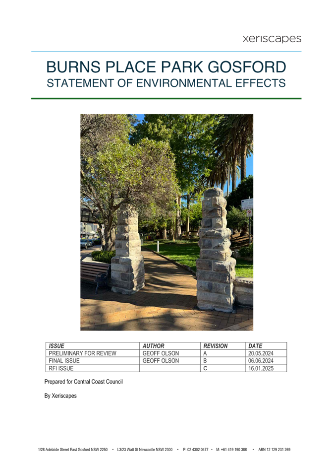
The listing is specific to an overview of the park, and not necessarily a single element within the park. The application includes a Conservation Management Plan (CMP), prepared by Edward Heritage Consultants, dated May 2024, which proposes to update the statement of significance provided in the State Heritage Inventory, to reflect the further analysis and research which has been provided in the Heritage Impact Statement, prepared by Edward Heritage Consultants, dated May 2024.
In this regard, the amended statement which forms part of the CMP, is currently before Council for consideration. For the purposes of this assessment the amended statement of significance has also been considered. The recommended amended statement of significance reads as follows:
‘Burns Park, Gosford is a small-scaled public park situated prominently in the heart of the Gosford town centre.
The park is historically significant at the local level and demonstrates the growth and development of the wider Gosford township. Having been informally left as open space since the coming of the railway in the late 1880s, it was through the conscious efforts and agitation of the community in the 1930s that the community raised funds of the establishment of ‘Burns Place’ (as it was then known). The park is of historical significance as it evidences the civic actions and community agitation for the beautification of the town centre, to provide both a sense of arrival for tourists arriving to Gosford by train and a sense of place-making for the community.
Burns Park sits prominently within the streetscape and while the surrounding context has progressively developed and changed, the boundaries, size and configuration of Burns Park has remained substantially unchanged. Despite this, Burns Park is described as an ‘evolved landscape’ and provides evidence of various layers and phases of changed, including most notably, the sandstone arch, garden wall and steps which are attributed to the formative phase of the development of Burns Park during the late 1930s Inter-War period, the cast concrete lamp post attributed to the 1940s period, the mature tree plantings with most attributed to the 1930s – 1960s period and the 1963 War Memorial Fountain designed by renowned mid-century sculptures Gerald and Margo Lewers.
Despite the loss of numerous early elements such as the 1930s bandstand rotunda and the introduction of numerous elements of lesser significance, the park is considered a good example of an evolved landscape, with the various later phases reinforcing the role and function as a public park.
Burns Park possesses landmark qualities due to its prominent positioning in the town centre and has aesthetic values and significance as an important and identifiable pocket or urban treed canopy and open space that is distinctive in the streetscape. It has social significance and holds varying degrees of esteem for the community, serving as an important area of public open space for the passive recreation, reference point and use and enjoyment of visitors, residents, workers, and the general community. Burns Park is also of social significance as an important element to the community’s sense of place.
Overall, Burns Park makes an important contribution to the historical narrative of Gosford, and has historical, social, and representative significance at the local level.’
The proposed works have taken into consideration the statement of significance described above and feature extensive remedial works to ensure the ongoing structural integrity and appearance of the original sandstone pillars, archway, and garden bed wall. The further works within the park will remove two established planted trees which are not original inclusions to the park and are causing increased stress and loading on the surrounding original sandstone elements which are individually identified of a higher level of significance in the setting.
The minor works proposed under this application including the replanting of shrubs and ground cover, cleaning measures, and replacement of lighting in the site, are measures to enhance the safety and security in the park for users. The proposed works are consistent with the statement of significance and will not jeopardize or dimmish the significance of the heritage item.
In accordance with subsections (5) and (6), the proposal has been supported by a Heritage Impact Statement and Conservation Management Plan, both prepared by Edward Consulting Engineers, dated May 2024. The reports provide detail in relation to the extent of works required for the site, with many requiring immediate action. Most notably are the sandstone elements in the park, which remain fenced off and inaccessible to the public because of safety concerns. Secondly the structural integrity of these sandstone elements (namely the stone gateway arch, pillars, and garden bed wall to the north-east corner of the park along Mann Street) are showing increasing signs of decay and damage which range from substantial failure to damage and require extensive remedial works.
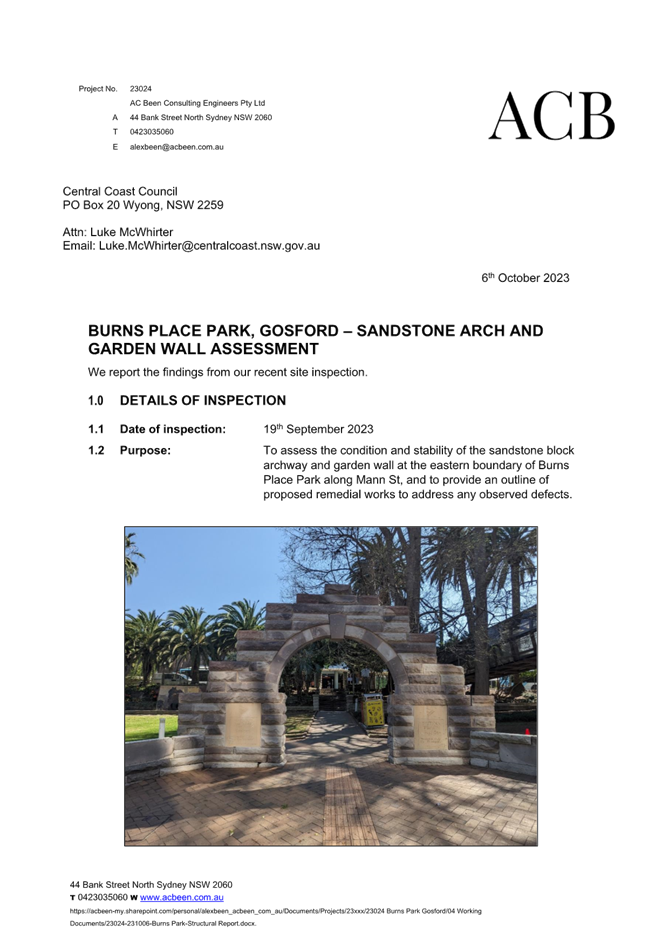
The proposal has been supported by the Burns Place Park, Gosford – Sandstone Arch and Garden Wall Assessment, prepared by AC Been Consulting Engineers, dated 6 October 2023. The structural report details the extent of damage and provides recommendations for remediation. There is visual evidence of previous localized repairs in the structures including the repointing of mortar joints, wholesale replacement of stone units and minor epoxy repairs.
The extent of works proposed may be considered radical when considering the dismantling of these structures partly down to the footings, however, previous attempts to provide the localized repairs have not survived the longevity of these structures which are starting to structurally decay and fail. The structural report notes the filling of the open mortal joints, and the like would have a limited lifespan in the archway and garden wall as the stone continues to move and shift. The embedded steel in the stone archways is showing signs of eroding and structurally failing which has started to see the archway drop.
The recommendation of the heritage consultant and structural engineer is for these stone original elements be reconstructed with like-for-like construction, whereby replacing stone will be limited to individual units classified as beyond a salvageable condition and the replacement units are to be as close to a match as possible to the existing stone. This will ensure the integrity of the structure, and ongoing use of the elements on the site.
Conditions of consent have been recommended to ensure a heritage induction is completed prior to any work commencing on site for items considered to be of exceptional, high, or moderate significance in the Heritage Conservation Management Plan and Heritage Impact Statement, and that all work undertaken is done so under the supervision of suitably qualified and experienced heritage stonemasons and engineers.
The proposal is seeking to restore several critical heritage elements which can be dated back to the park’s inception. Other works including the changing to the planting species, and shrubs will not impact on the heritage significance of the park. A recommended condition of consent has been included which requires confirmation of specific landscape species by council’s Heritage Officer prior to any planting.
Section 5.17 -Demolition requires development consent
Section 5.17 requires development consent for any demolition of a building or work. Accordingly, this application seeks consent for demolition works.
Section 5.39 – Acid sulfate soils
Section 5.39 applies to development that has the potential to disturb, expose, or drain acid sulfate soils. The site is mapped as being affected by class 5 acid sulfate soils. Class 5 acid sulfate soils are affected as follows:
Works within 500 metres of adjacent Class 1,2, 3 or 4 land that is below 5 metres Australian Height Datum (AHD) and by which the water table is likely to be lowered below 1 metre AHD on adjacent Class 1, 2, 3 or 4 land.
In this instance, the proposal does not include works which will lower the site levels below 5m AHD nor include works which will lower the water table by more than 1 metre. In this regard, the Panel can be satisfied that an acid sulfate soils management plan is not required for the proposed works and that consent can be granted.
Section 5.54 – Community infrastructure
Works on the subject area cannot proceed as development without consent as Burns Place Park is heritage listed. Accordingly, a development application has been lodged.
State Environmental Planning Policy (Resilience and Hazards) 2021
Chapter 4 Remediation of Land
Section 4.6 (1) (a) of SEPP Resilience and Hazards (2021) Chapter 4 Remediation of Land requires the Consent Authority to consider whether land is contaminated. If the land is contaminated, the Council needs to be satisfied that the land is suitable in its contaminated state (or will be suitable, after remediation) for the purposes for which the development is proposed to be carried out.
In this instance, the subject site can be dated back to its installation in the 1930s and has continued to operate as a recreational park prior to this under its former name’ Railway Square’ which can be dated back to when the Gosford Train Station was opened in 1888. It is for this reason, the Panel can be satisfied the park has remained relatively undisturbed and intact for a significant period, thus making any contamination unlikely.
Further the proposed application is not proposing radical works which will significantly change or alter the park from the original aesthetic or design. Excavation is minimal, only going to a depth of 300mm to facilitate the archway footings. The provided waste management plan does not list any hazardous materials and no hazardous materials are observed by the current historical imagery. It is considered unlikely there is contaminates present on the site which would require remediation.
In accordance with the provisions of this SEPP, the panel can be satisfied that the site is appropriate for the proposed works and no further assessment of contamination is necessary.
Relevant Local Environmental Plans (LEPs)
Central Coast Local Environmental Plan 2022 (CCLEP 2022)
The site is identified to be within the Land Application area under Chapter 5 Gosford City Centre of SEPP (Precincts – Regional) 2021 therefore Central Coast Local Environmental Plan 2022 does not apply.
Relevant Development Control Plans (DCPs)
Gosford City Centre Development Control Plan 2018 (GCCDCP 2018)
1.3 – Assessment and Determination Authority
As discussed under section 5.5 of SEPP (Precincts-Regional) 2021 earlier in this report, the consent authority would be Council. However due to the works being defined as demolition of a heritage item, the Local Planning Panel is the determining authority under the Local Planning Panels Ministerial Directions (dated 6 March 2024).
1.10 – Public notification of development applications
The subject site is owned and operated by Central Coast Council and is therefore considered a Council-related development application and not subject to this section. In accordance with Schedule 1 Clause 9B of the Environmental Planning and Assessment Act 1979, the application was publicly notified for a period of 28 days between 12 July 2024 and 9 August 2024 (inclusive). No submissions were received regarding the application.
3.2 Character areas – City North
The subject site is located within the character area being City North which includes many commercial premises and is an urbanized area without consistent open space and recreational assets. Burns Park Place is the only dedicated recreational area in the City North character area that meets the objectives of this chapter.
The objectives of the zone, include creating new pedestrian links across the rail corridor and the site has previously been identified and encouraged for its connection to the town centre, and as a transitional link from Gosford Station to the city centre. Further objectives seek to increase the public open space in the area and provide green relief to connect to the bushland in the surrounding outskirts of the town centre. The park is proposing to replace all the trees and green space proposed for removal and will continue to operate the park as a public open space area, which is compatible with the objectives of the city north character area.
4.1 Pedestrian network
The proposal includes the restoration to the pavement and sandstone walls and capping along the existing pedestrian footpath on Mann Street. The existing networks, and links around and through the site are to be retained, the application is however seeking to increase public safety through the restoration and replacement planting for increase sight lines around the site. The current proposal does not propose to change or radically alter the existing arrangement however is seeking to enhance the existing form and materiality, which aligns with the objectives of this section.
4.2 Public Open Space
The objectives of this chapter are to provide accessible and high-quality open spaces to enhance the users of the park. One of the key objectives is to retain and enhance the existing open spaces in the city centre. Burns Place Park is an existing recreational area which provides the convenience and quality open space in the centre of the city. The proposed works are designed to restore the original features of the heritage listing for ongoing use, and complete maintenance and restoration work to satisfy the needs of the public for future use and security within the park.
4.3 Solar access to key public spaces
The existing park will retain its current form and layout as required by the heritage listing. The park provides a great opportunity for natural solar relief with its extent of mature leafy trees which is one of only few green spaces in the immediate vicinity. The proposed works will not inhibit solar access to the public open space.
4.4 Views and Vistas
The proposed site is not located in such a position to block any significant views in the surrounding proximity including, waterways or ridgelines. The park provides visual relief in an urban environment. The proposed works have no impact to the street vista of Mann Street.
4.5 Footpath crossings and pedestrian overpasses and underpasses
The proposed development is not looking to alter any of the existing crossings, footpaths, or overpasses under this application. The application is seeking to restore the feature paving on the pedestrian walkway of Mann Street to ensure public safety to an appropriate standard.
7.5 Site facilities and Services
The objectives of the clause are to ensure site facilities are effectively integrated into the design of a development without adverse amenity impacts. Part of the proposed application is seeking to relocate two bench seats to provide sufficient clearance around the street trees on Mann Street and to enhance pedestrian mobility and moveability.
10.1 Heritage Items
The whole site is identified as a Heritage Item being a ‘place’ of local significance. This clause requires development of heritage items to have regard to the Statement of Significance and any conservation management plan, heritage impact statement or study required by the determining authority in response to the proposed development. These elements have been discussed under clause 5.36 of SEPP (Precincts-Regional) 2021 earlier in this report. The other heritage objectives of this chapter are discussed in further detail below.
Development principles and controls contained in this section
As per the requirements of this section, development which includes work on or within the curtilage of a listed heritage item should have regard to the heritage principles listed in the table below.
|
General principles |
Comment |
Complies |
|
1. Scale: The scale and bulk of any new building or work must be in scale with the original building and new development must not obstruct important views or vistas of the item. |
The proposed works will not alter the scale, nature of the park or an individual element within. The views or vistas from the park will remain unaffected. Some minor planting changes will seek to provide increased natural sightlines within the park but will not adversely alter overall views of vistas within. |
Yes |
|
2. Siting: If the existing street façade of the building is sympathetic to the character of the street, then alteration must be avoided. New work is best located to the rear or side of the building. |
The proposed works are seeking to keep the existing street façade and treatment at each entry point of the park with the sandstone elements. The works are seeking to provide restoration measures which will not compromise or negatively impact the existing siting or street treatment on any curtilage. |
Yes |
|
3. Architectural Form: The basic architectural form of any new work needs to respect what exists. Issued to consider are roof form, proportion, and location of windows and doors. |
The proposed works are seeking to retain and restore the architectural sandstone elements and the traditional landscape layout which has continued over the lifespan of the public area. The proposed removal of the large shrubs in the rear southern corner of the site will improve sightlines within the park, as well as provide consistency to the northern garden bed which has mature trees and only low-lying planting. |
Yes |
|
4. Architectural Detailing: It’s important to be aware of the particular era and architectural style of the building or buildings and make sure that any proposed changes are contextual to the period. |
Burns Place Park was built and established in the 1930s and 1940s. Over time further additions and changes have been added as discussed earlier in the report. As described in the Heritage Impact Assessment the site is considered an ’evolved landscape’ for this reason. As such there is no distinctive era or architectural style prevailing in this instance. The proposed works are not altering the layout of the park, but rather are seeking to restore the main elements of the park to ensure their ongoing structural integrity. The other minor changes in the planting are all low scale ground cover planting and are of minimal significance to the existing detailing within the park. |
Yes |
|
5. Materials and finishes: Existing materials should be reused where possible. New materials and detailing must be compatible with the original and consideration must be given to the colour, texture and type of materials and finishes. |
The proposal includes extensive remedial works to the sandstone elements in the park. These works will dismantle the existing sandstone units and reuse them where possible unless unsalvageable for re-use. Only then will new sandstone units be considered compatible for re-use. Under the recommendations of Council’s Heritage Officer conditions of consent are to be applied which ensures the existing stonework be prioritised. And new stone must be selected by an appointed Heritage Stonemason to complete the works. The New stone should be sourced from the same or similarly located quarry and be of similar appearance to the existing. The replacement stone will further need to be approved by the Heritage Officer prior to the use of the new stone in the works. These measures are to ensure the integrity of the material and finish in these elements which are recognised for their exception significance in the setting of the heritage listing. |
Yes |
|
6. Use: The best use for a building is usually the one for which it is built. Where this is not possible, a sympathetic use to the layout of the building and requiring minimal alterations will be compatible. |
The original use of the site is a recreation area to be used as a park adjacent to the railway station. The use of the park is consistent with the original use and is protected by the heritage listing. No works under this application are proposing to alter this use. |
Yes |
|
7. Origin fabric: Important to minimise alterations to the original fabric and where possible, rather than replace individual elements such as windows and doors. |
The proposal includes extensive remedial works to ensure the structural integrity of the sandstone elements. These works will look to dismantle and reuse the existing sandstone units and where entirely unsalvageable units are identified; new stone replacement units will be used. The original fabric of the park is to be retained in these elements of exceptional significance. Other elements in the park including minor planting and ground cover, replacement lighting and fencing are proposing to be altered, however these items are not of heritage significance and have evolved over time in the management of the park. The fabric and aesthetic materiality and nature of these elements will remain fundamentally consistent with the existing arrangement. |
Yes |
|
8. The aging process: The patina of age on a building adds much to its character and significance. A worn step for example demonstrates the many years of feet crossing a threshold. Such features add to the uniqueness and character of the place and must be retained wherever this does not present a public safety risk. |
The proposed works on the original sandstone elements have continuously been showing the signs of aging and have had minor repairs to date to rectify any defects. However, the proposed changes are showing substantial signs of failure with cracking and shifting in the forms, which has led to impacts on public safety and the intervention of extensive works is required to restore the elements for ongoing use. Other cosmetic works are to increase the security and safety of pedestrians in the park. |
Yes |
|
9. Curtilage: The treatment of the boundaries. There are three types of heritage curtilage: - Lot boundary - Reduced curtilage - Expanded curtilage |
The curtilage of the site in this case has an informal boundary surrounding the garden in the roadway. The site is not an individual lot and is surrounding by informal boundaries being the line of palm trees, vegetation and the sandstone garden bed walls and pedestrian footpath on Mann Street. The proposed works are seeking to restore the damage to the sandstone wall and no changes are proposed to the curtilage of the lot from this application. |
Yes |
For development that affects a heritage item, information addressing relevant issues must be included in a Statement of Heritage Impact submitted in a Statement of Heritage Impact submitted with the development application (DA). The SOHI must be prepared in accordance with the guidelines published by the NSW Office of Environment and Heritage.
As discussed under SEPP (Precincts-Regional) 2021, the application has
been lodged with a Heritage Impact Statement, prepared by Edwards Heritage
Consultations, dated May 2024. The report discusses the proposed works and
provides recommendations for works to be completed to restore the site for its
continued significance.
The report has been prepared with the support of a Conservation Management Plan (CMP) as previously discussed. The provided conservation plan provides guidelines to the actions for council in the day-to-day operations and long-term care of the park for conservation purposes. The conservation policies and recommendations in the CMP provide valuable guidance in formulating and understanding the significance of individual items and measures which can assist in facilitating the appropriate future management and conversation outcomes to ensure the longevity of Burns Place Park. Section 9.2 of the HIA has specifically highlighted relevant conservation policies and has provided an assessment against the relevant sections specific to the proposal.
To facilitate the conservation and protection of heritage items and heritage conservations areas and their settings
The proposal is predominately seeking to facilitate the ongoing conservation and protection of Burns Place Park (heritage item) through several restoration and maintenance measures. On the completion of the proposed works, the original sandstone elements of the park will be restored to their former stability and ensure their ongoing presence on the site. The other minor alterations to the park include changing the lighting, and planting on the site, which are not of high heritage significance but will preserver the garden layout of the site for aesthetic purposes.
To reinforce the special attributes and qualities of heritage items by ensuring that development has regard to the fabric and prevailing character of the item or special area e.g., scale, proportions, materials and finishes.
The most significant works proposed under this application relate to the restoration of the sandstone elements, and how these elements are structurally failing with significant damage observed. This application is partly seeking to dismantle and rebuild these elements to ensure their ongoing survival which is of considerable heritage significance. The original sandstone units are considered essential to the nature of the heritage elements, and their locations within Burns Place Park.
Council’s Heritage Officer has recommended specific conditions to ensure appropriate construction and treatment methods for the dismantling, storage, and location of these elements during the demolition and re-construction stages to maintain their level of significance. Any replacement sandstone units must be sourced, and hand selected to be consistent with the material, finishes, and type of sandstone per the original unit. These works and measures are considered critical to the value of the item, and its ongoing use on the site.
The further works for the planting of the ground cover, and replacement trees and hedges are not of high significance, and the proposed landscaping is seeking to keep suitable consistency to the previous planting and tree types currently observed on the site in recent years. Recommended conditions of consent ensure all plant location, species, and type are confirmed and discussed with council’s heritage officer prior to the planting of these items.
To conserve, maintain and enhance existing views and vistas to buildings and places of historic aesthetic significance.
Burns Place Park is in the heart of the Gosford city centre and the proposed works will seek to conserve the historic significance of the park.
Likely Impacts of the Development:
The likely impacts of the development, including environmental impacts on both the natural and built environment, social and economic impacts in the locality must be considered. In this regard, potential impacts related to the proposal have been considered in response to SEPPs and DCP controls.
The consideration of impacts on the natural and built environments includes the following:
Built Environment
Context and Setting
The proposed development relates to demolition works (dismantling of the sandstone elements and tree removal), remedial repair works to restore the elements to their original form for ongoing structural integrity and other minor works such as the removal of shrubs, relocation of bench seating, landscaping, lighting and pavement. The proposed works are in keeping with the existing and desired context and setting of the site.
Public Domain
The public domain is enhanced by the improvements proposed under this application to restore the pedestrian access and increase safety and security around and within the park. The accessibility and visibility of the park can be better maintained and restored by the works proposed under this application.
Traffic and Transport
The park has no formal street access as it is within the road reserve between Mann Street and Burns Crescent. As such, all access, and equipment for the works are to be brought onto the site via the street and pedestrian pathway. Conditions of consent have been imposed to ensure all works constructed under this application are undertaken in accordance with a Traffic Management Plan approved by Council.
Council’s road section was consulted on the application to ensure public safety will not be compromised by the proposal or the construction of works. Construction works will require collaboration with Council’s Road section and Heritage Officer to ensure all works carried out on site will be appropriately managed to ensure public safety is maintained.
Safety, Security and Crime Prevention
The principles of Crime and Prevention Through Environmental Design (CPTED) have been considered in the design of the proposed development. Burns Place Park has previously been identified as a place of perceived risk and security concern for pedestrians. As a result of the pilot program completed with Transport for NSW a key finding was to increase the perception of safety and security specifically on this site.
Opportunities to improve safety were identified and included increasing the natural lighting and surveillance of the park but the removal of the lower lying shrubs for visibility. Other opportunities include the replacement of lighting, cleaning of the sandstone elements within the park. These measures are included as targeted actions under this application for implementation. These works will change the appearance and refresh the presentation and appearance of the park and enable the park to be utilised on a regular basis.
Lighting
The proposal involves the removal of the existing 12x white bollard lights around the park which are not in working condition and their replacement with new light poles with integrated LED internal lighting. The lighting will be activated by a photometric sensor in each bollard and operate from dusk till dawn each day. All proposed lighting improvements are to be installed in accordance with Australian Standard: AS1158.1 lighting design for roads and outdoor public areas, to improve public safety and surveillance and minimize anti-social behaviour.
Natural Environment
Noise and Vibration
The subject site is located adjacent to a rail corridor which is listed as having mandatory requirements under State Environmental Planning Policy (SEPP) (Transport and Infrastructure) 2021, however the development does not include ‘residential accommodation, a place of public worship, a hospital, an educational establishment or centre-based child care facility’, and the nature of the works are such that the development is not subject to the provisions of Section 2.100 of SEPP (Transport and Infrastructure) (2021).
Trees and Vegetation
The site features multiple trees identified on Council’s Significant Tree Register. The trees identified include the Corymbia maculata Spotted Gum, Harpephyllum caffrum Kaffir Lime, Livistona Australia Cabbage Tree Palm, Melaleuca quinquenervia Broad-leaved Paperbark, Pheonic canariensis Date Palm, Taxodium distichum Deciduoud Cypres. These trees are located throughout the park in differing elements but are mostly located in the centre of the park in the lawn area, and along the western side of Burns Place Park fronting Burns Crescent.
As part of this application two mature Fraxinus excelsior (European Ash) trees are identified for removal. These trees are in the north-eastern corner of Burns Park Place on the Mann Street side frontage. The trees are located within two individual square brick and stone capped garden beds placed up against the existing original sandstone garden wall. These two trees are identified for their ongoing impact to the surrounding structures on the site and recommended for removal and with subsequent replacement planting within the garden.
An Arboricultural Tree Risk Assessment, prepared by Advanced Tree Consulting, dated 20/09/2023, was provided to support the proposed removal of these trees. The investigation into the trees found Tree 1 to be of visible decay in the trunk of the tree with signs of failure in the area of the canopy. Tree 2 is the larger of the two trees with the centre of the trunk located within 0.5m to the sandstone retaining wall. This tree has very long branches, overhanging the road, kerb side parking areas, and the footpath.
Despite the above conditions of the tree’s health, the reoccurring impact of the large roots of both trees, which extend into the grassed area on the western side of the paving, is the fact they are causing significant damage to the sandstone retaining walls, and pedestrian pavement surrounding (Figure 8). The consulting arborist advises that the large root plate of the trees are clearly visible above ground, and it would be impossible to rebuild the sandstone walls and restore the pedestrian pavement in its current location without future damage occurring to these features of the park.
Council’s tree officer has reviewed the proposal and confirmed the species of trees selected less than 30 years ago was a mistake for the above reasons. No objection is raised to the removal of the two European Ash trees to enable the walls to be rebuilt and maintained in perpetuity. Replacement planting will occur within the park to compensate for the loss of the mature trees. The current plans are proposing to replace the trees with mature Cupressus sempervurens Glauca or similar, which have a mature height of 15 metres and a width of 1m which is ideal in the current garden bed size and are not expect to impact on the rebuilt sandstone wall.
The proposal also involves the removal of the existing mature Murraya paniculata located in the southern garden bed. These shrubs are mature in height and size (approximately 3 metres) and located within the garden bed. These shrubs will be replaced by a mass planting of ground cover. This will enable increased natural lighting within the park and provide greater visibility in and around the park.
The northern garden bed currently has ground cover in lieu of plantings of this height and scale which is better suited to the pedestrian walkway and visibility it supports. The proposal is seeking to mirror the garden beds on both sides which retains the trees hedging this boundary and those which are listed on Council’s Significant Tree Register. None of the trees impacted by this proposal are listed on Councils register or are specifically listed or identified as having heritage significance in relation to the park.
The subject site does not contain any threatened species or habitat. The proposal is satisfactory and there will be no significant impact upon the natural environment because of the proposal.
Suitability of the Site for the Development:
Whether the proposal fits in the locality.
The application is supported by a Heritage Impact Statement and Conservation Management Plan which detail the significance of restoring the original features of the park for their ongoing significance. The proposal will enhance the park for community use.
Any Submission made in Accordance with this Act or Regulations
Submissions from the public
In accordance with Schedule 1, Clause 9B of the EP&A Act the development application was publicly notified for a period of 28 days between 12 July 2024 and 9 August 2024 (inclusive). No submissions were received regarding the application.
Submissions from Public Authorities
The application was not referred to any public authorities.
Internal Consultation
The application was referred to the following officers:
|
Supported, subject to conditions of consent. |
|
|
Standard Engineering |
Supported, subject to conditions of consent. |
|
Environmental Health Officer |
Supported, subject to conditions of consent. |
|
Heritage Officer |
Supported, subject to conditions of consent. |
|
Tree Assessment Officer |
Supported, subject to conditions of consent. |
|
Roads & Drainage Infrastructure Section Manager |
Supported, without conditions of consent. |
Ecologically Sustainable Principles:
The proposal has been assessed having regard to ecologically sustainable development principles and is consistent with the principles.
The proposed development is considered to incorporate satisfactory stormwater, drainage and erosion control and the retention of vegetation where possible and is unlikely to have any significant adverse impacts on the environment and will not decrease environmental quality for future generations. The proposal does not result in the disturbance of any endangered flora or fauna habitats and is unlikely to significantly affect fluvial environments.
Climate Change
The potential impacts of climate change on the proposed development have been considered by Council as part of the assessment of the application.
This assessment has included consideration of such matters as potential seas rise in sea level, potential for more intense and/or frequent extreme weather conditions including storm events, bushfires, draught, flood, and coastal erosion; as well as how the proposed development may cope, combat, withstand these potential impacts. The existing structures have the potential to be further impacted by extreme weather events should they remain existing in their current form. The proposed demolition, restoration and maintenance works are appropriate in relation to climate change.
The Public Interest: (s4.15(1)(e))
Burns Place Park is an example of a retained public open green space which provides an aesthetic streetscape and landmark to the Gosford City Centre. Burns Place Park has been a staple of Gosford since its inception with the installation of the trainline and retains a high level of local significance to the locality. The restoration and maintenance works proposed around the park will ensure the integrity of the heritage sandstone works for their ongoing use and protection. Further works including the removal of trees and plantings, and the replacement of fencing and lighting around the site, are improvements identified to modernise the park and enhance public safety and natural surveillance for pedestrians.
The proposed works will provide an improved public domain and the restoration works are in the public interest.
Other Matters for Consideration:
Section 7.11 and 7.12 Contributions
The current application is exempt from contributions under Section 7.12 contributions plan as detailed in section 1.5 of the plan. The works proposed are works undertaken by Council on behalf of Council as the landowner of the road and are considered an alteration and refurbishment of an existing development, where there is no enlargement, expansion, or intensification of the current use to warrant contributions to be levied.
Conclusion:
The development application has been considered in accordance with the requirements of the Environmental Planning and Assessment Act 1979 and the Regulations, as outlined in this report. The following is a summary of prerequisite conditions for the granting of development consent that have been considered in the assessment report and provided as part of the conditions, for the benefit of the Panel:
1. The Panel can be satisfied that the land is suitable for the proposed development with no significant issues or impacts identified with the proposal under Section 4.15 of the Environmental Planning and Assessment Act 1979.
2. The Panel can be satisfied that the land is suitable for the proposed development as referenced in Section 4.6(4) of the State Environmental Planning Policy (Resilience and Hazards) 2021 nor does it involve a change of use of the land. Accordingly, the development is satisfactory having regard for the provisions of Section 4.6 of the same SEPP.
3. The panel can be satisfied that the proposed development is satisfactory with regards to the B3 Commercial Core zone and its objectives in accordance with section 5.13 of SEPP (Precincts-Regional) 2021.
4. Having regard for the prerequisite conditions to the granting of consent under Chapter 5 Gosford City Centre of SEPP (Precincts-Regional) 2021, the Panel can be satisfied that Section 5.36 – Heritage conservation has been considered.
The proposed works have considered the effect on the heritage significance of the item and these works are supported by a Heritage assessment and CMP. The proposed works will enable the preservation of heritage significance of the park.
5. The proposed works are consistent with the relevant provisions of Gosford City Centre Development Control Plan 2018.
6. The proposed works will provide improvements to the public park and preserve its heritage significance which is in the public interest.
As such, it is recommended that Development Application No. DA/867/2024 for the various Heritage Restoration Works of Sandstone Wall, Archway and Landscaping work, including tree removal at Burns Place Park, Burns Crescent, Gosford be APPROVED subject to the draft conditions detailed in the schedule attached to the report in Attachment 1.
|
1⇩
|
Draft conditions reasons - Burns Place Park, Gosford - DA 867 2024 - Central Coast Council |
|
D16830270 |
|
2⇩
|
Landscape plans - Burns Place Park, Gosford - REV C - DA/867/2024 - Burns Crescent, GOSFORD NSW 2250.pdf |
|
D16624026 |
|
3⇩
|
Heritage Impact Statement - DA/867/2024 - Burns Place Park. Burns Cr, GOSFORD |
|
D16250672 |
|
4⇩
|
Conservation Management Plan - DA/867/2024 - Burns Place Park. Burns Cr, GOSFORD |
|
D16250673 |
|
5⇩
|
Structural Report - DA/867/2024 - Burns Place Park. Burns Cr, GOSFORD |
|
D16250676 |
|
6⇩
|
Statement of Environmental Effects - Burns Place Park Gosford - REV C |
|
D16624041 |
|
3.2 |
DA/867/2024 - Burns Place Park, Burns Crescent, Gosford - Heritage Demolition and Restoration Works of Sandstone Wall, Archway and Landscaping, including tree removal |
|
Attachment 1 |
Draft conditions reasons - Burns Place Park, Gosford - DA 867 2024 - Central Coast Council |

|
DA/867/2024 - Burns Place Park, Burns Crescent, Gosford - Heritage Demolition and Restoration Works of Sandstone Wall, Archway and Landscaping, including tree removal |
|
|
Attachment 2 |
Landscape plans - Burns Place Park, Gosford - REV C - DA/867/2024 - Burns Crescent, GOSFORD NSW 2250.pdf |
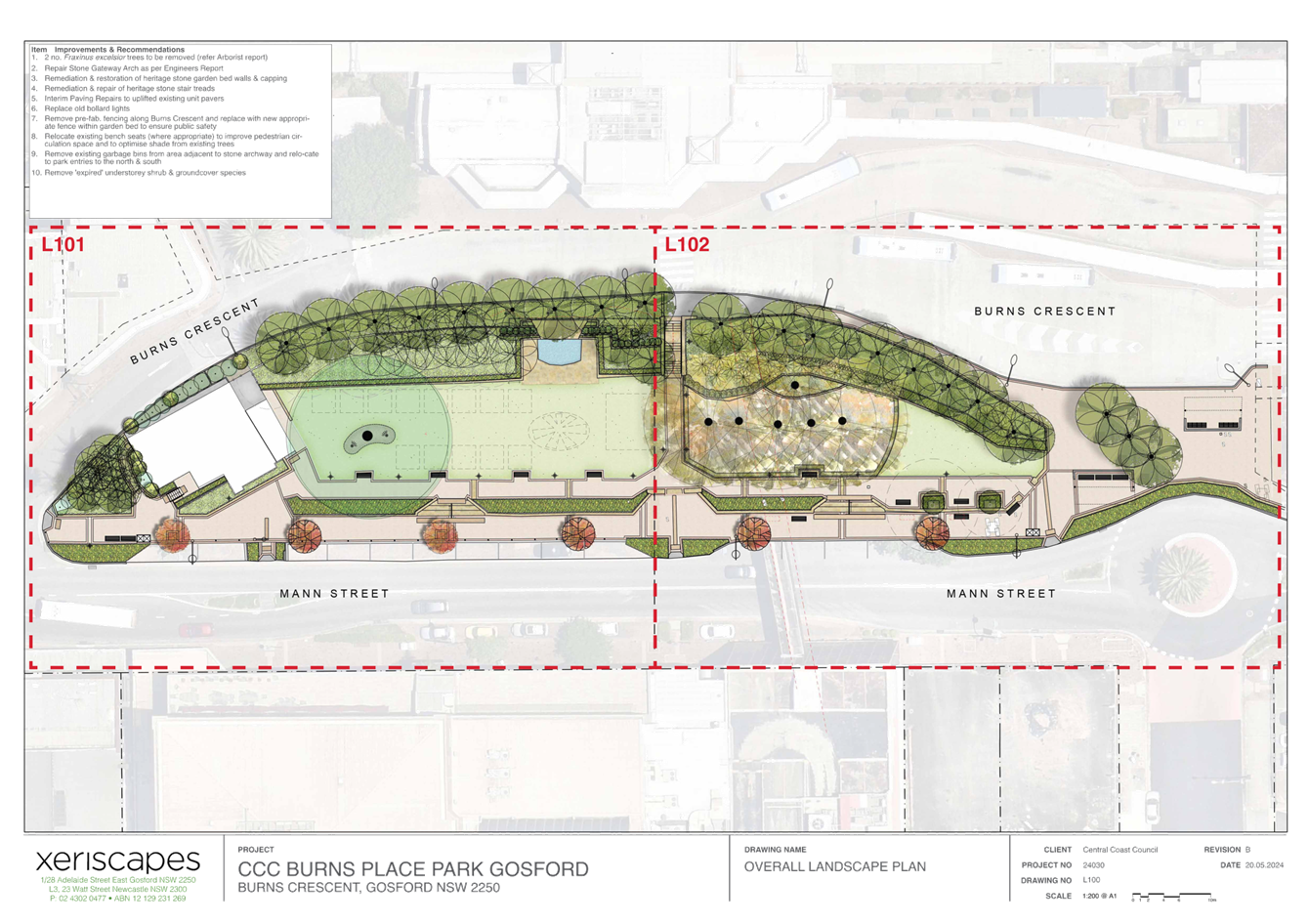
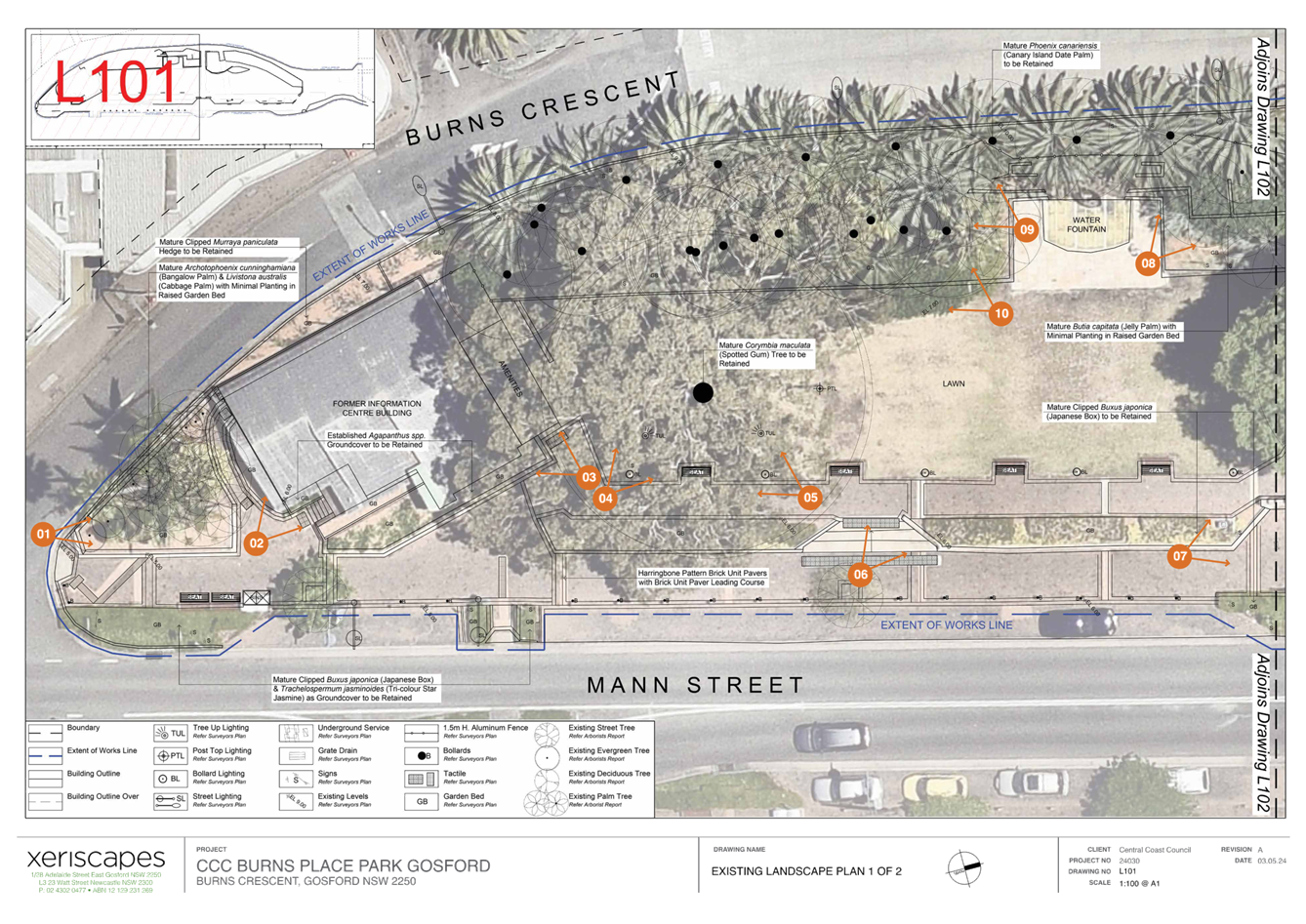
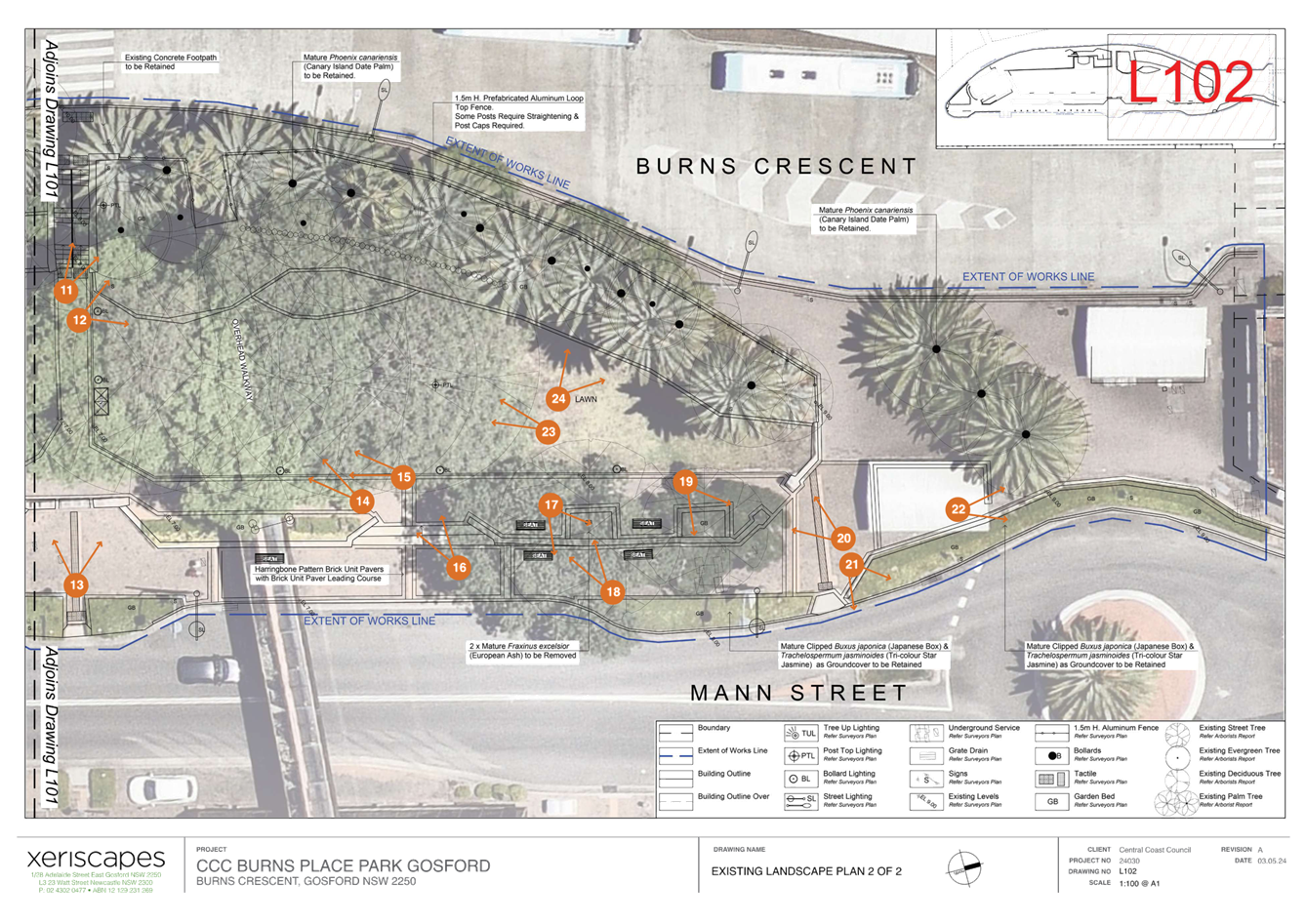
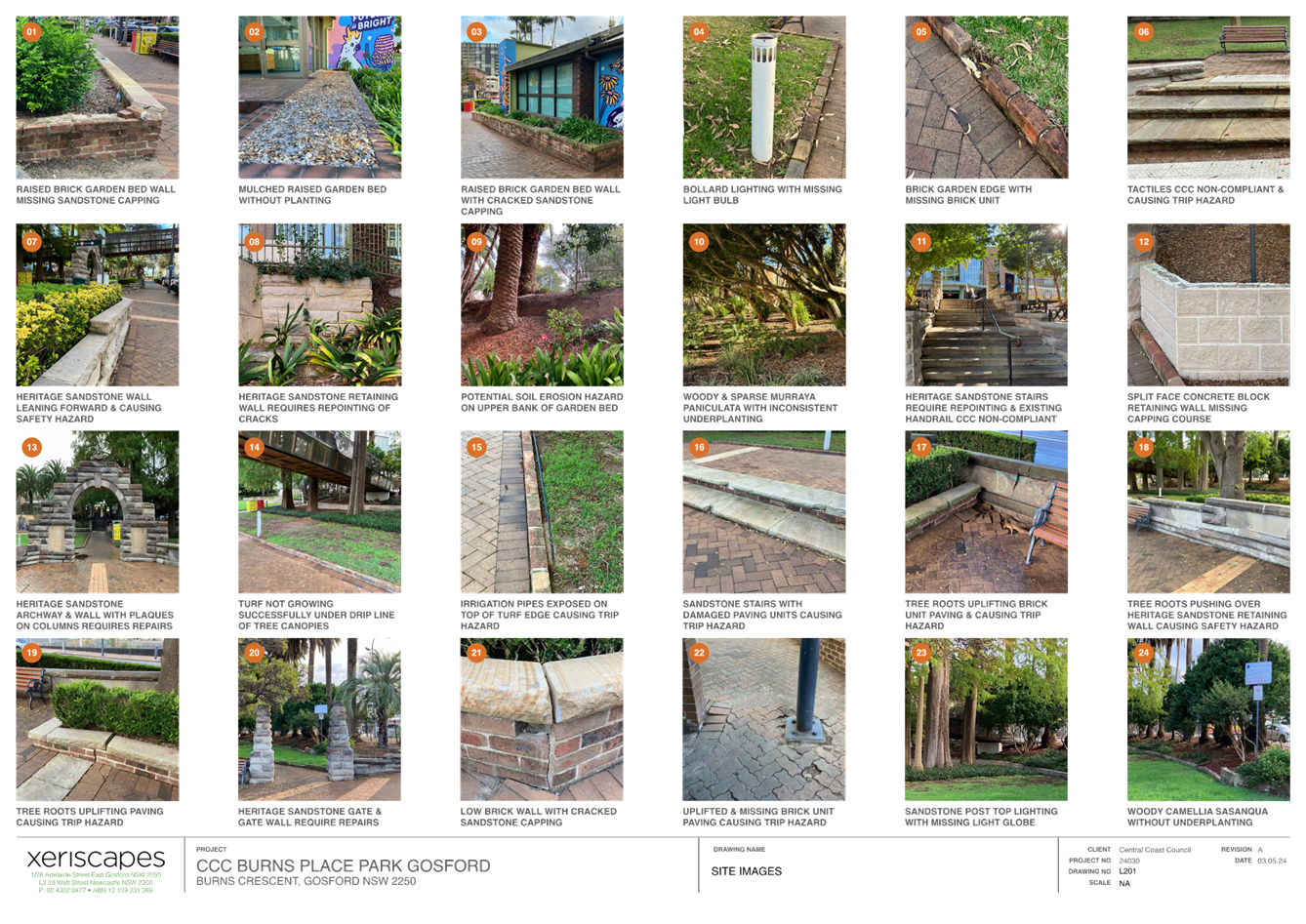
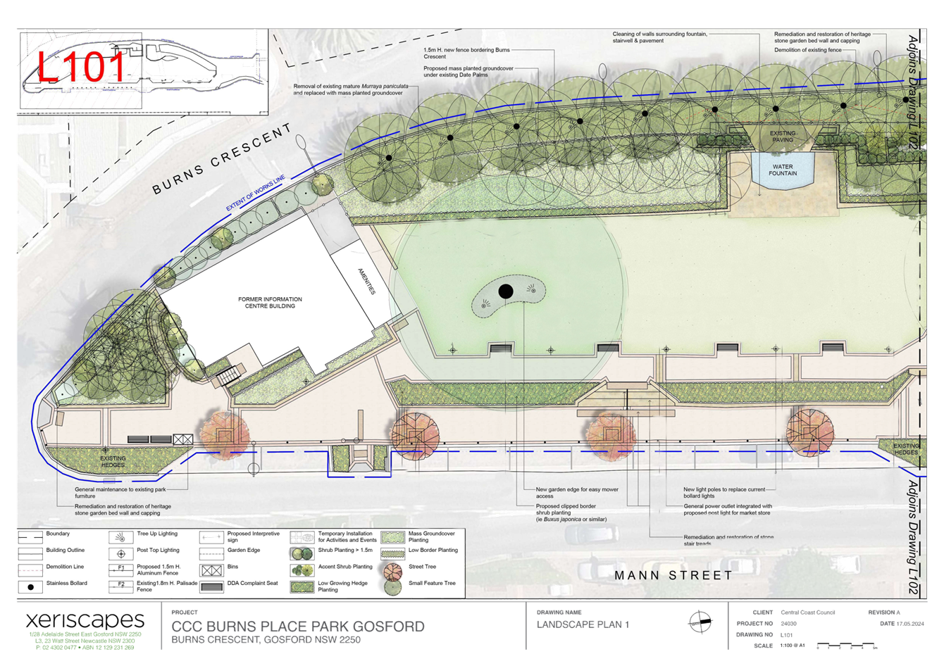
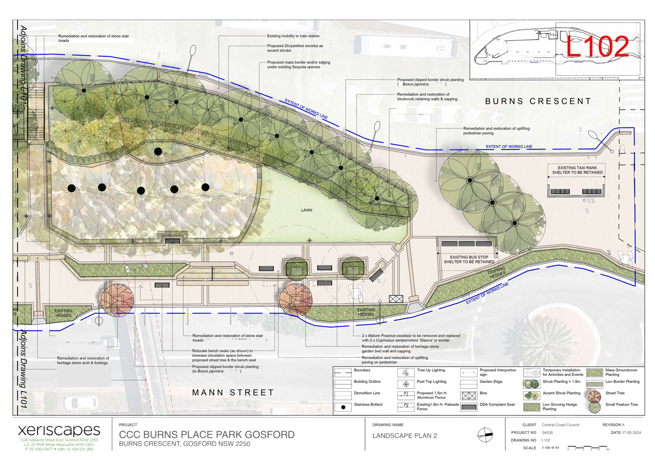
|
DA/867/2024 - Burns Place Park, Burns Crescent, Gosford - Heritage Demolition and Restoration Works of Sandstone Wall, Archway and Landscaping, including tree removal |
|
|
Attachment 3 |
Heritage Impact Statement - DA/867/2024 - Burns Place Park. Burns Cr, GOSFORD |


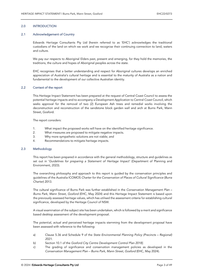
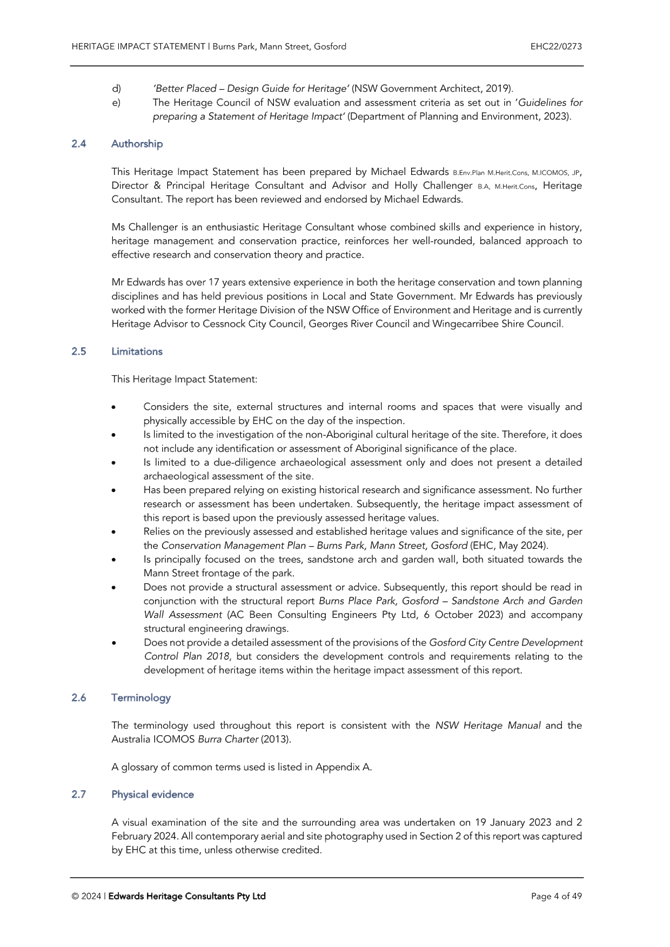


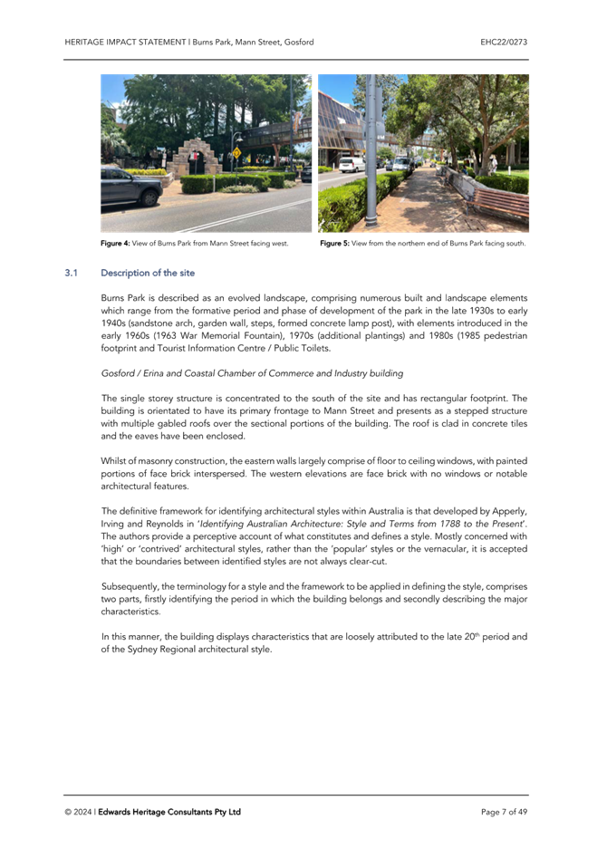
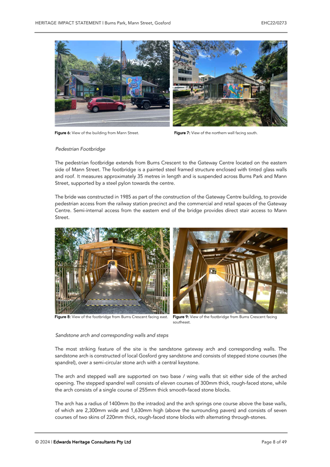
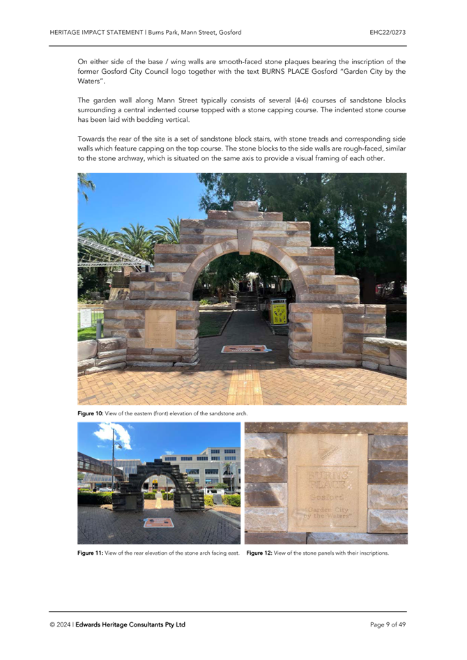
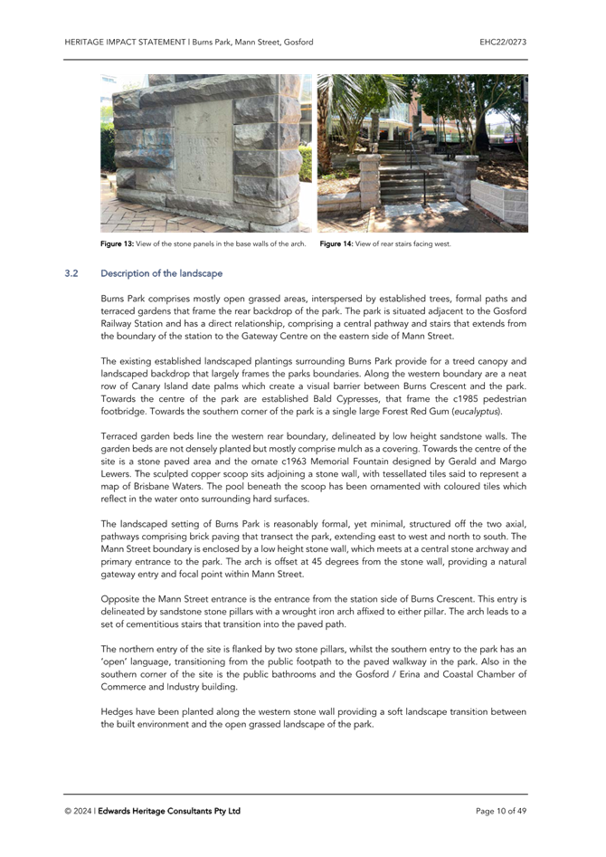

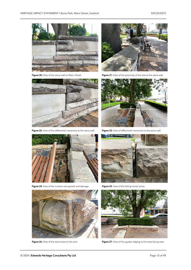
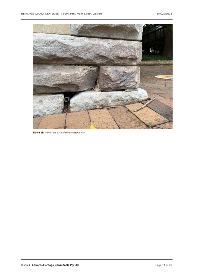
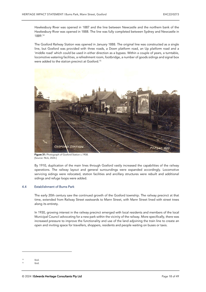
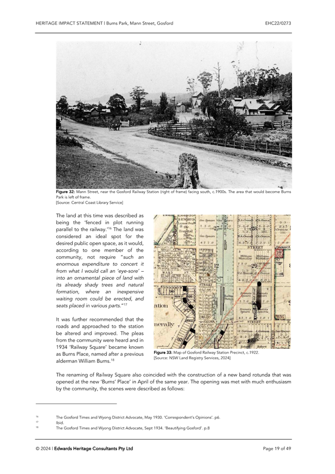

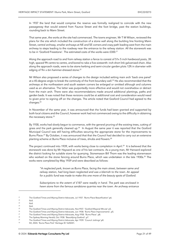
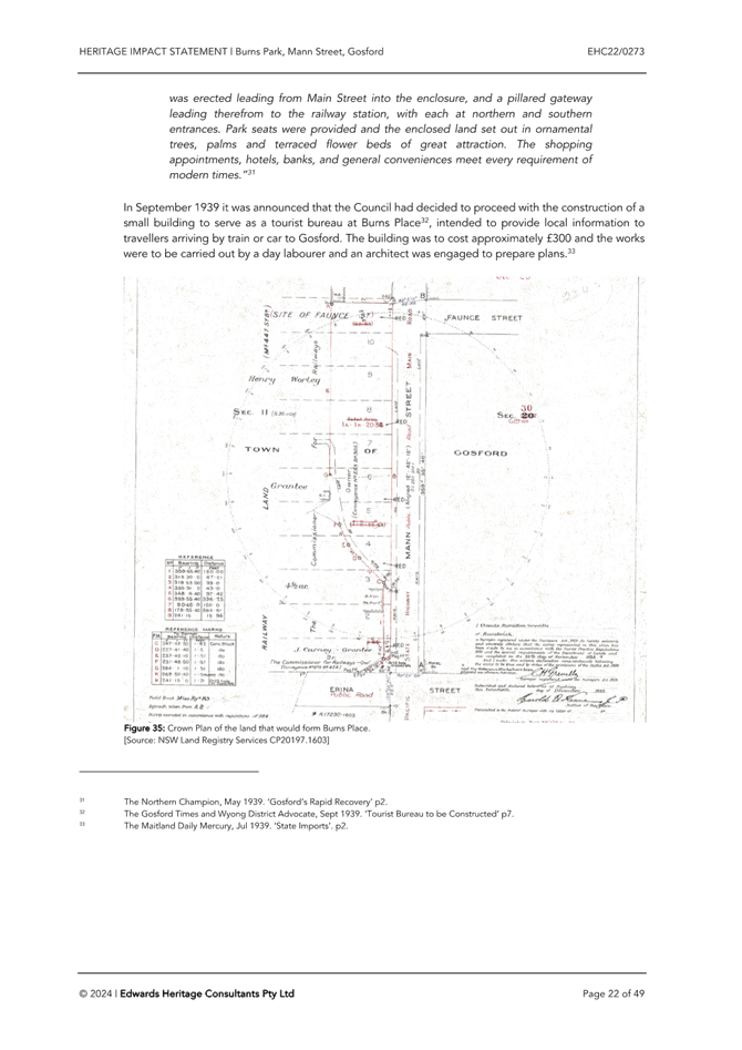

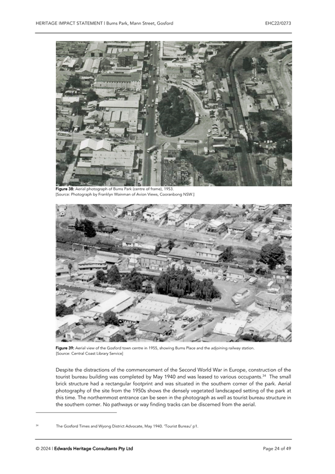


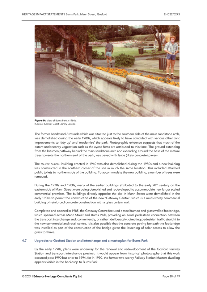
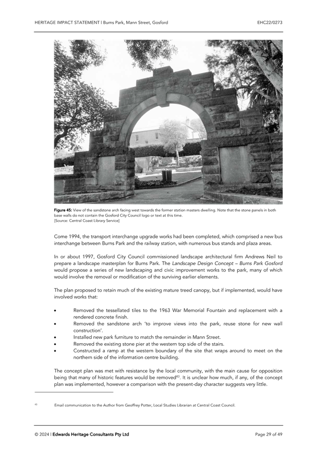
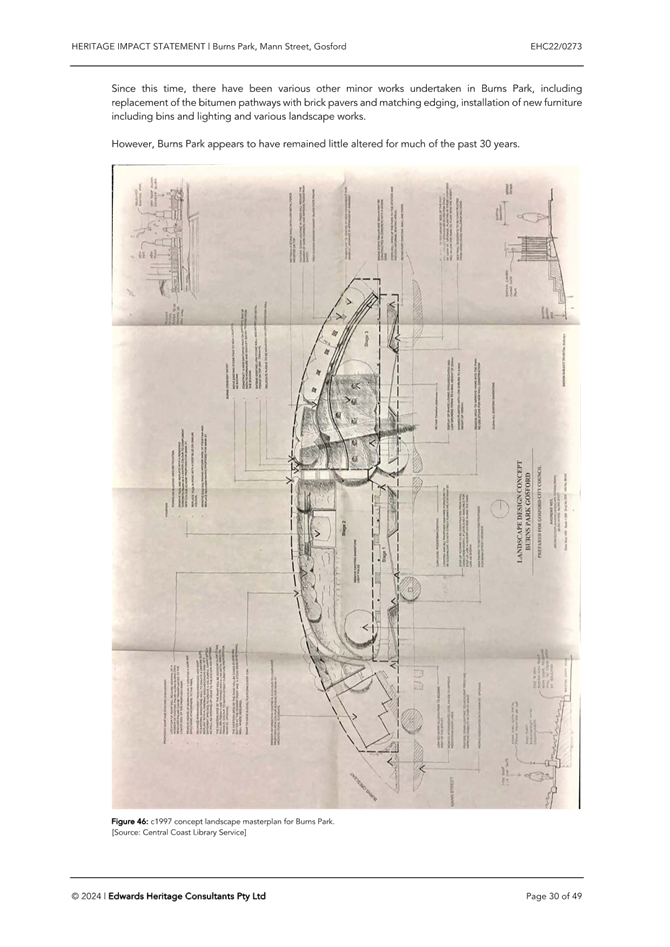
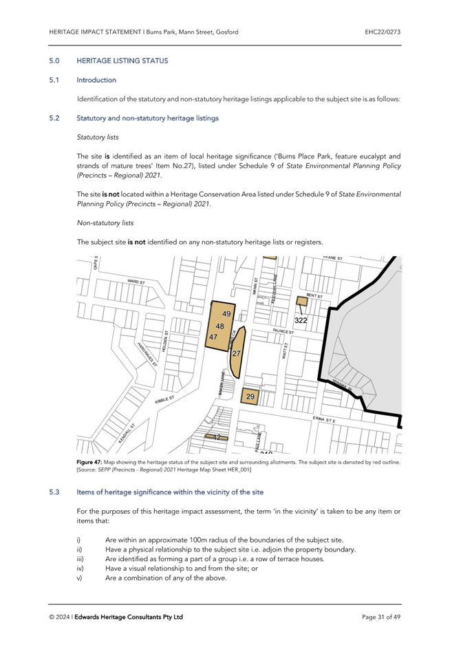
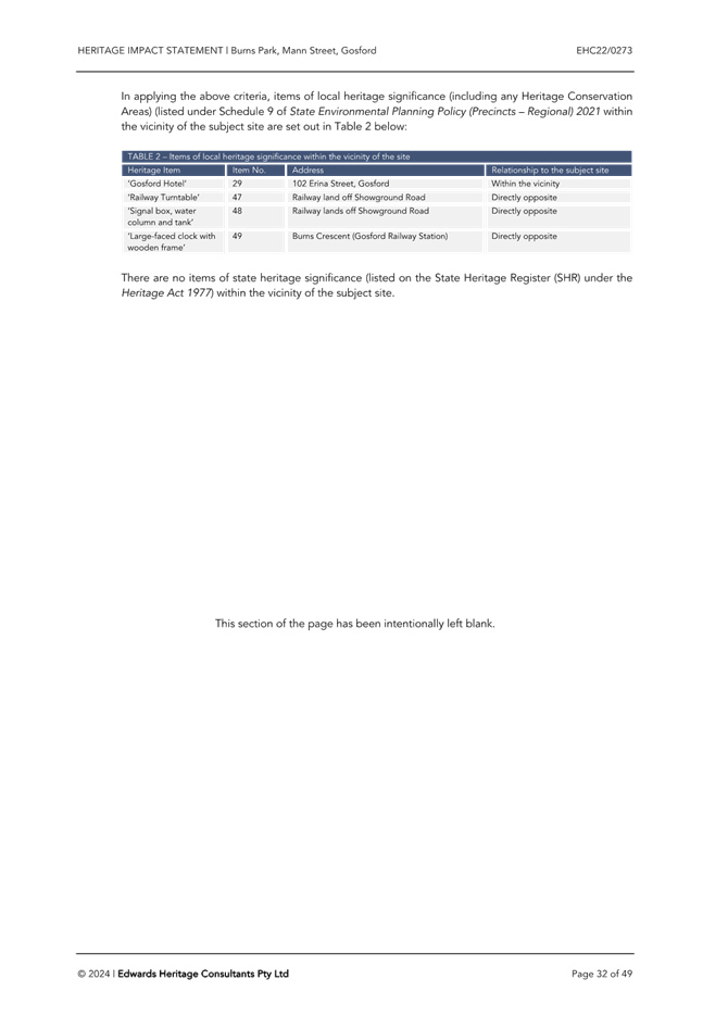

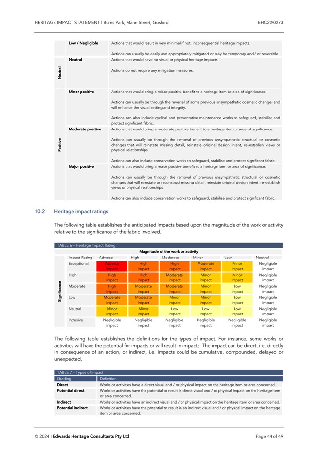

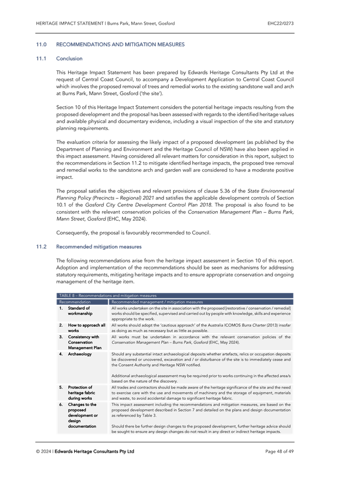


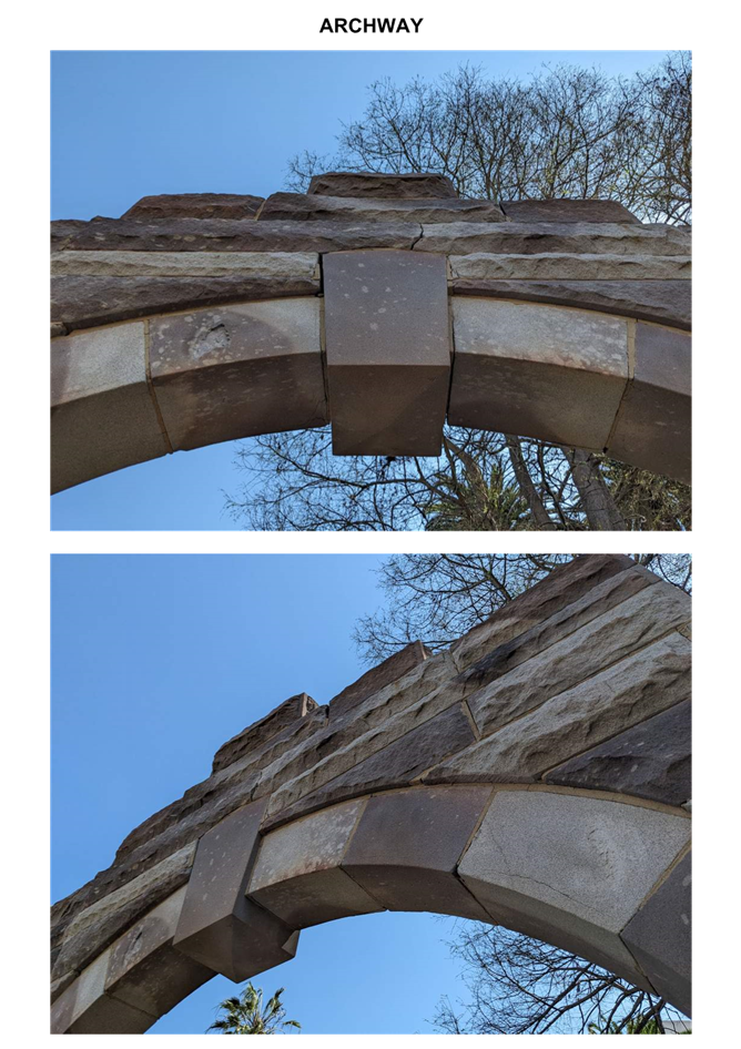


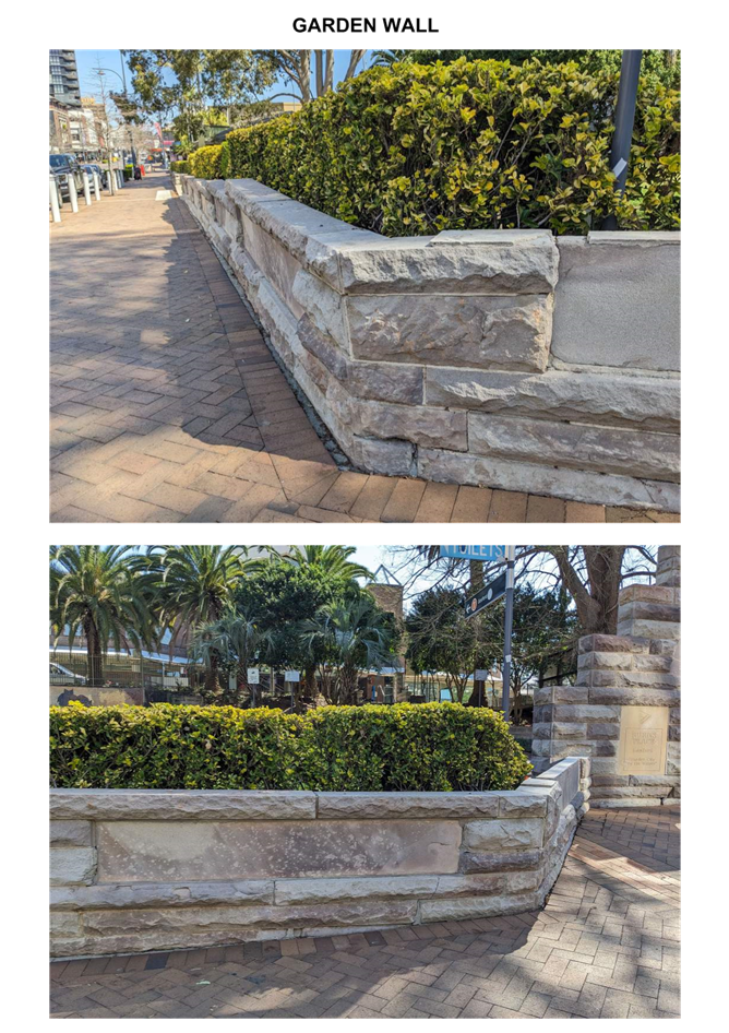


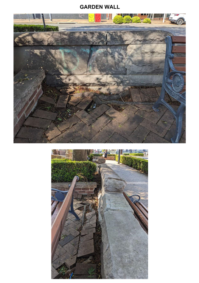

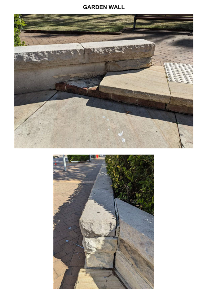
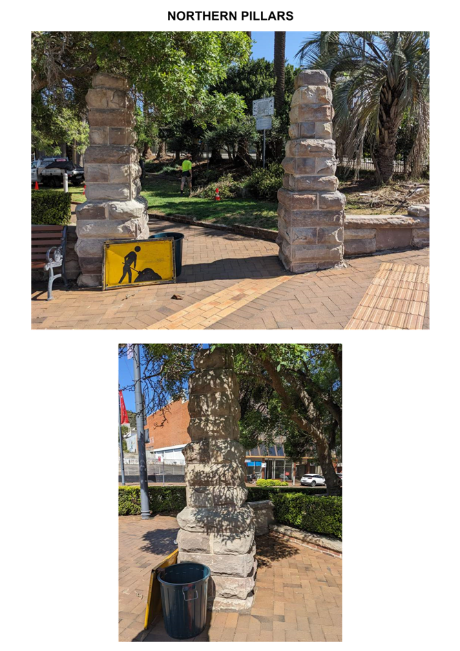
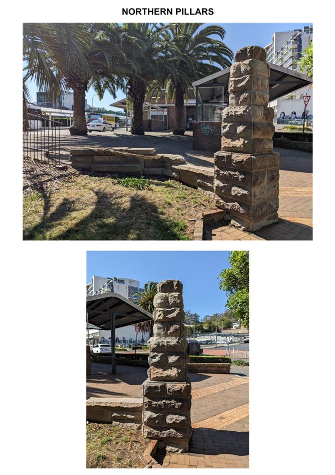
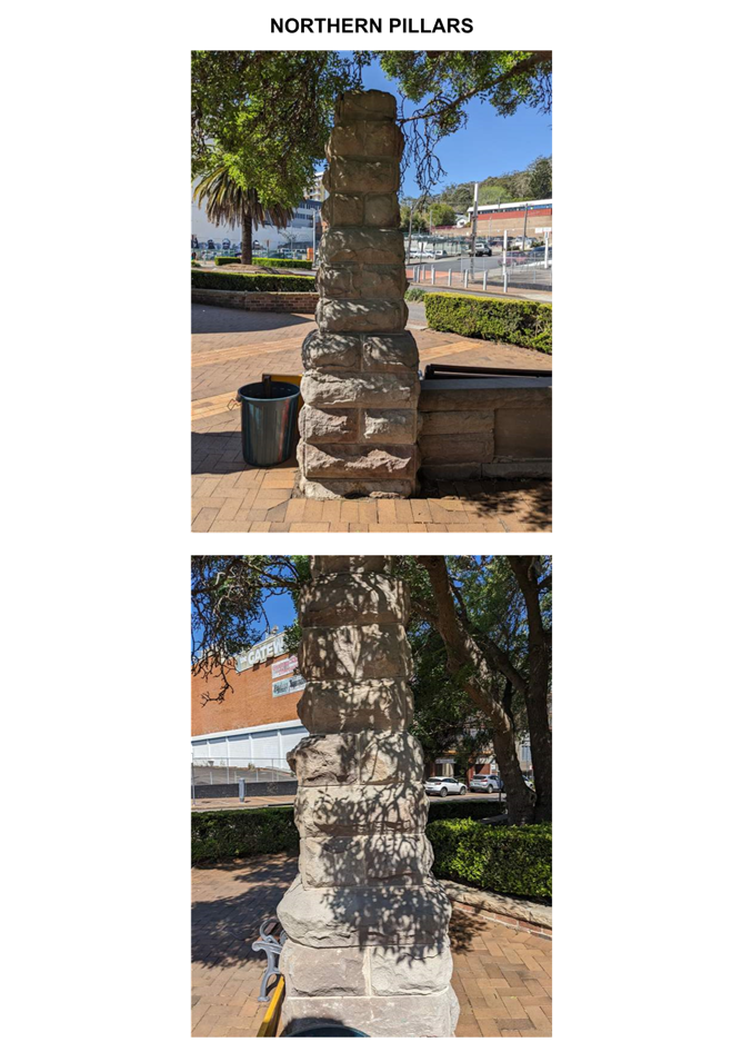
|
3.2 |
DA/867/2024 - Burns Place Park, Burns Crescent, Gosford - Heritage Demolition and Restoration Works of Sandstone Wall, Archway and Landscaping, including tree removal |
|
Attachment 4 |
Conservation Management Plan - DA/867/2024 - Burns Place Park. Burns Cr, GOSFORD |


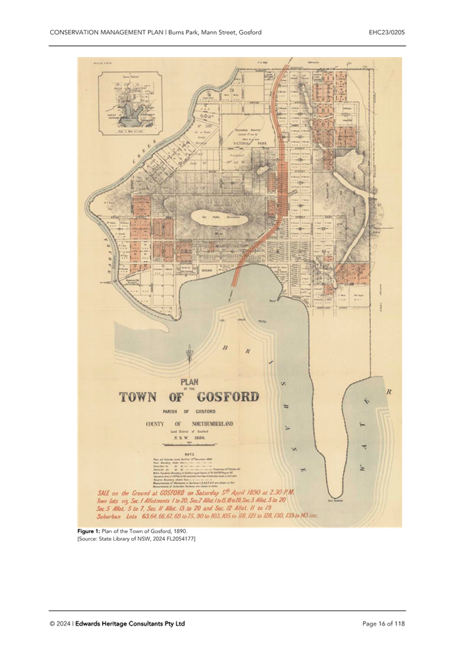
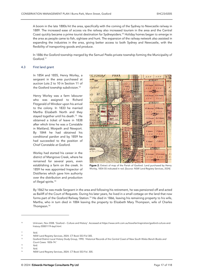
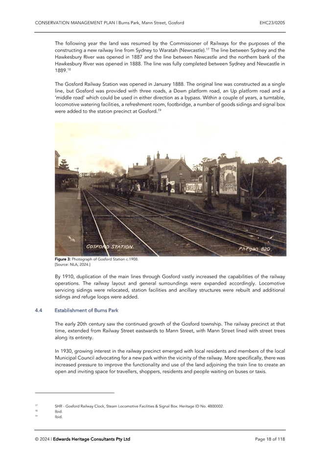
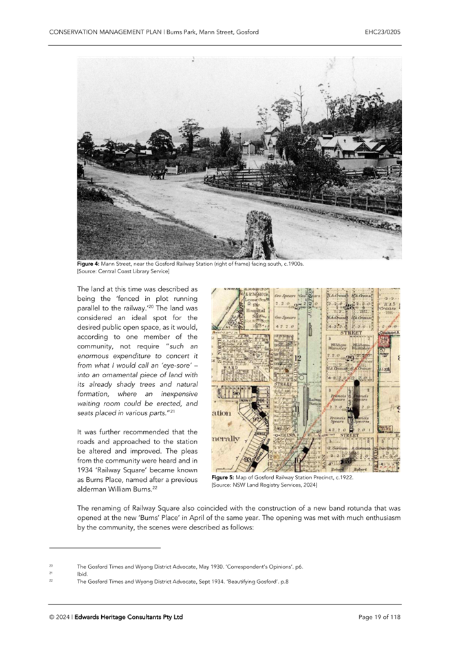
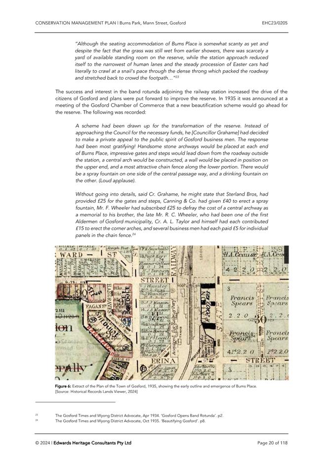
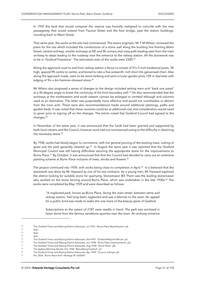
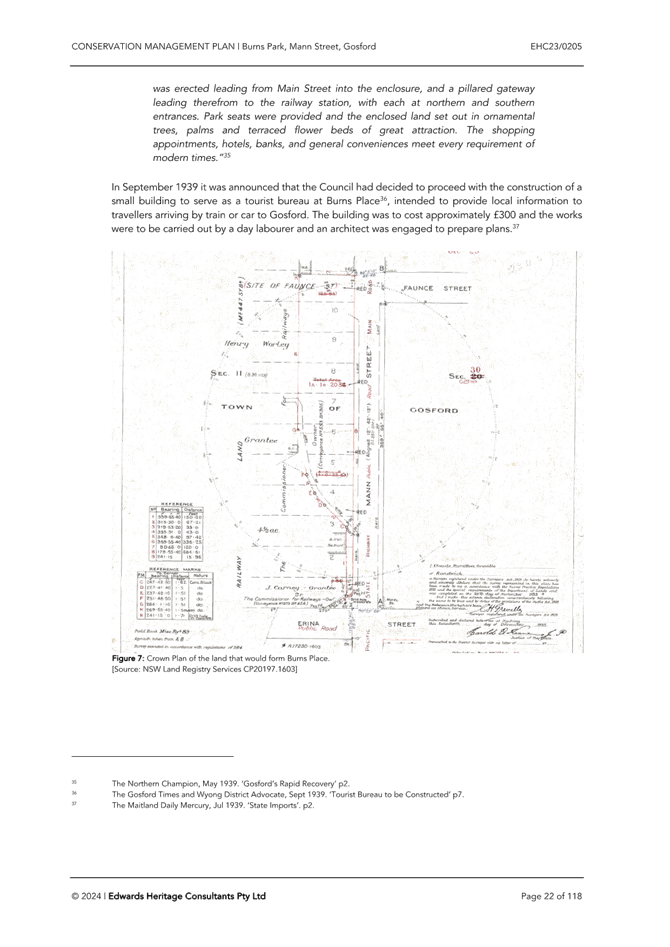
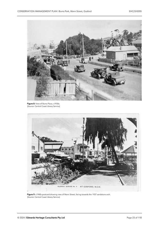
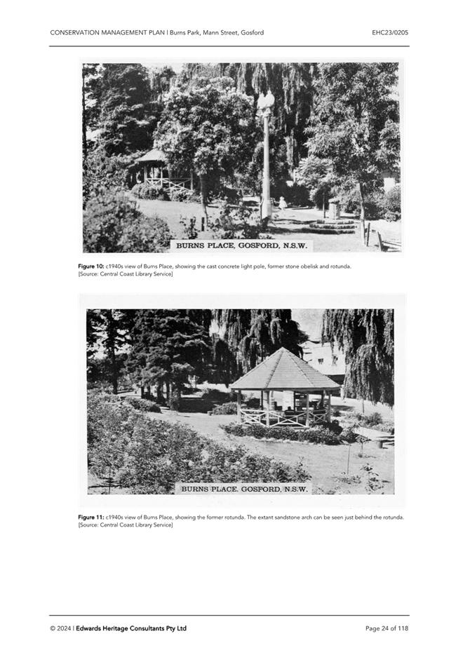
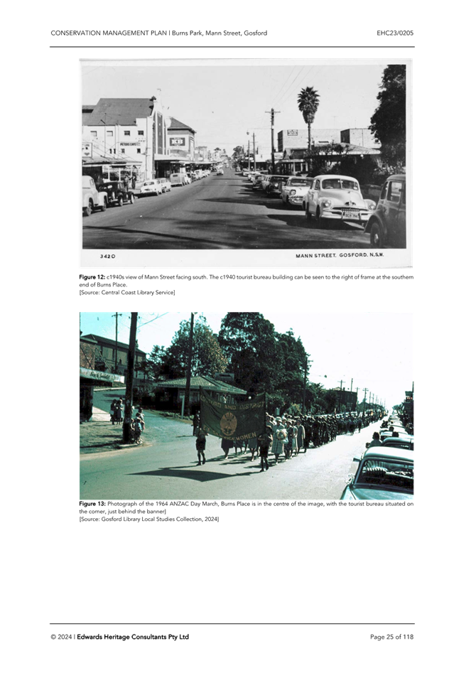

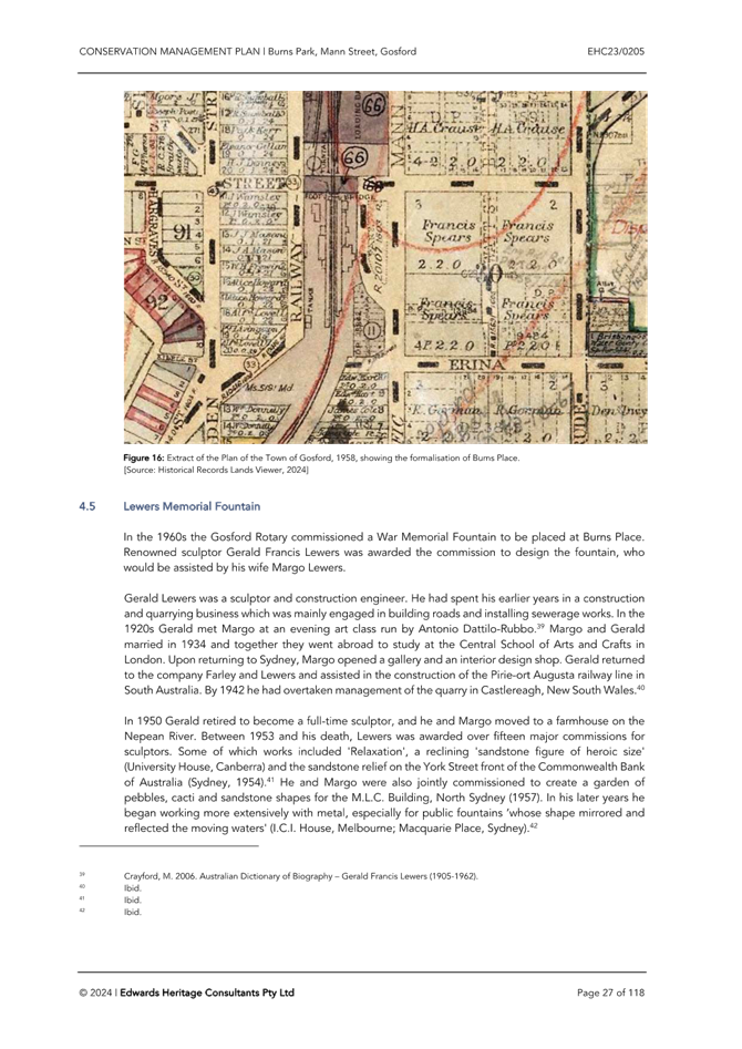
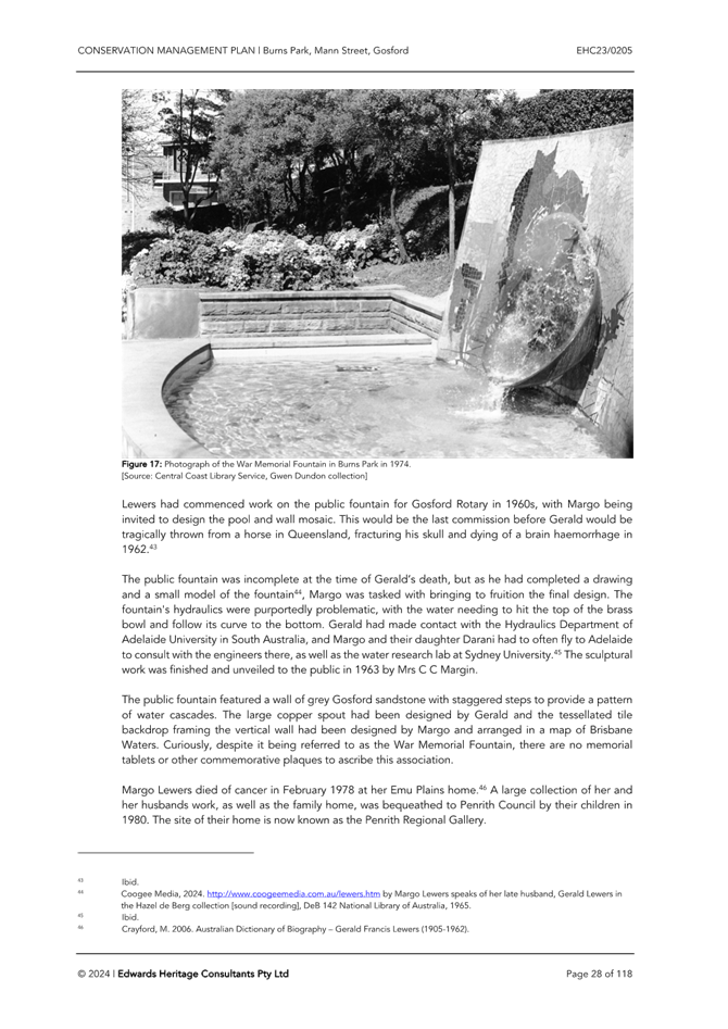
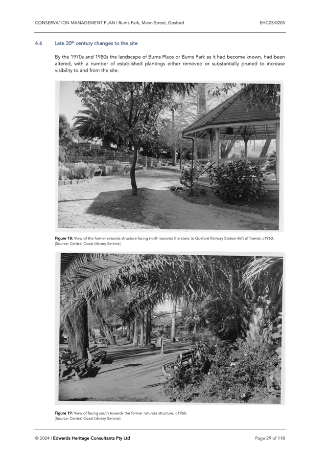
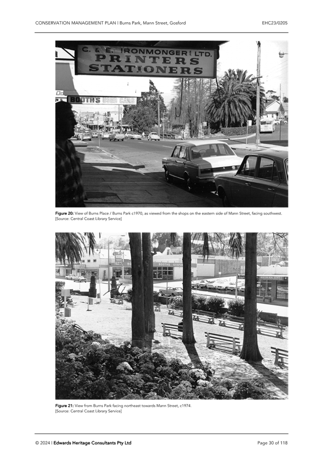
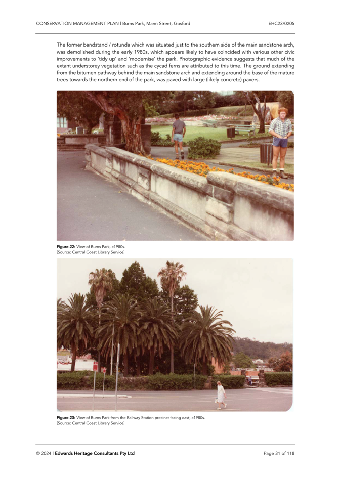
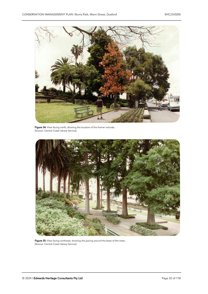
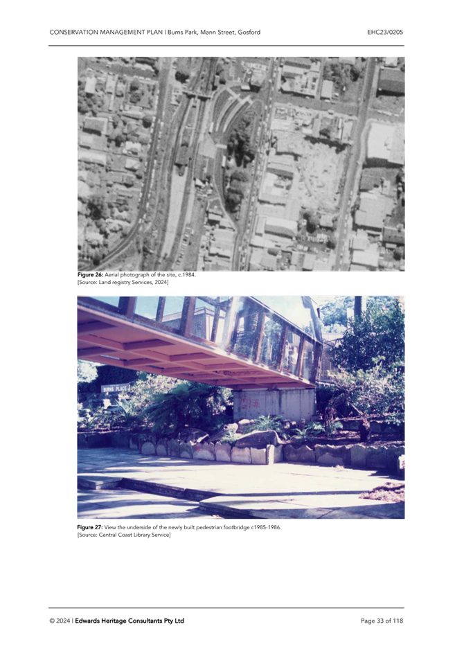
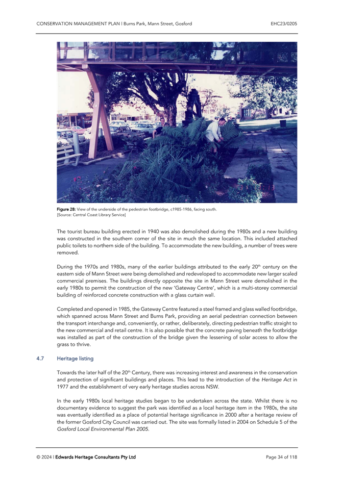
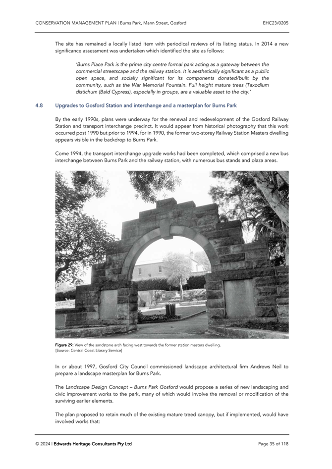
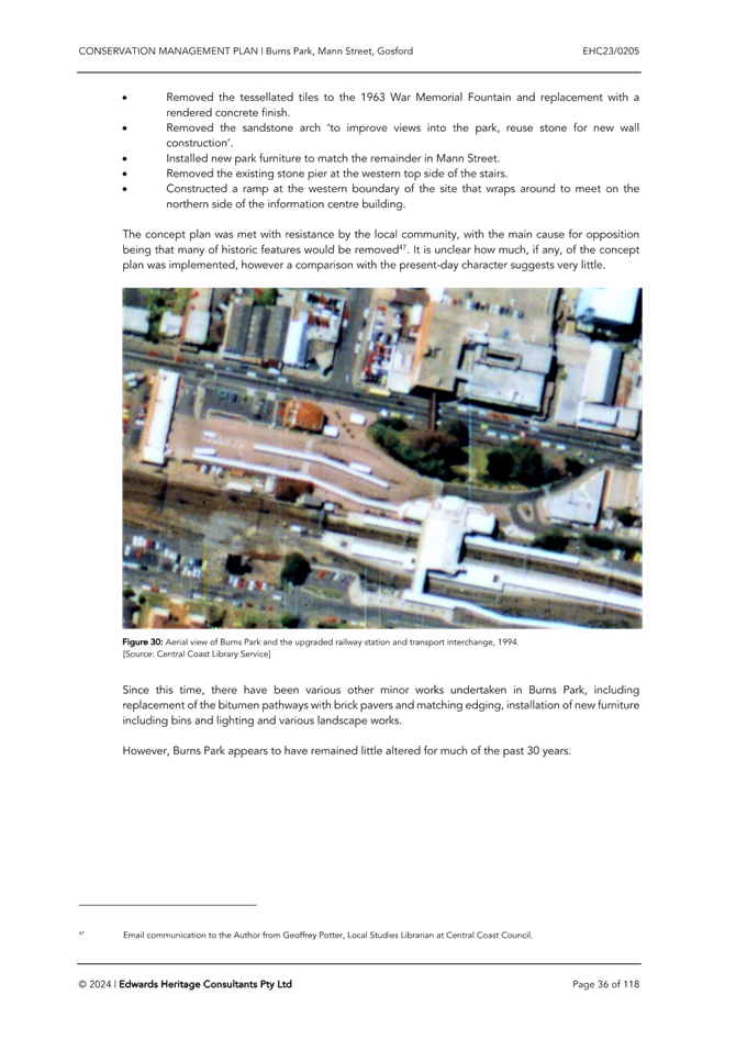
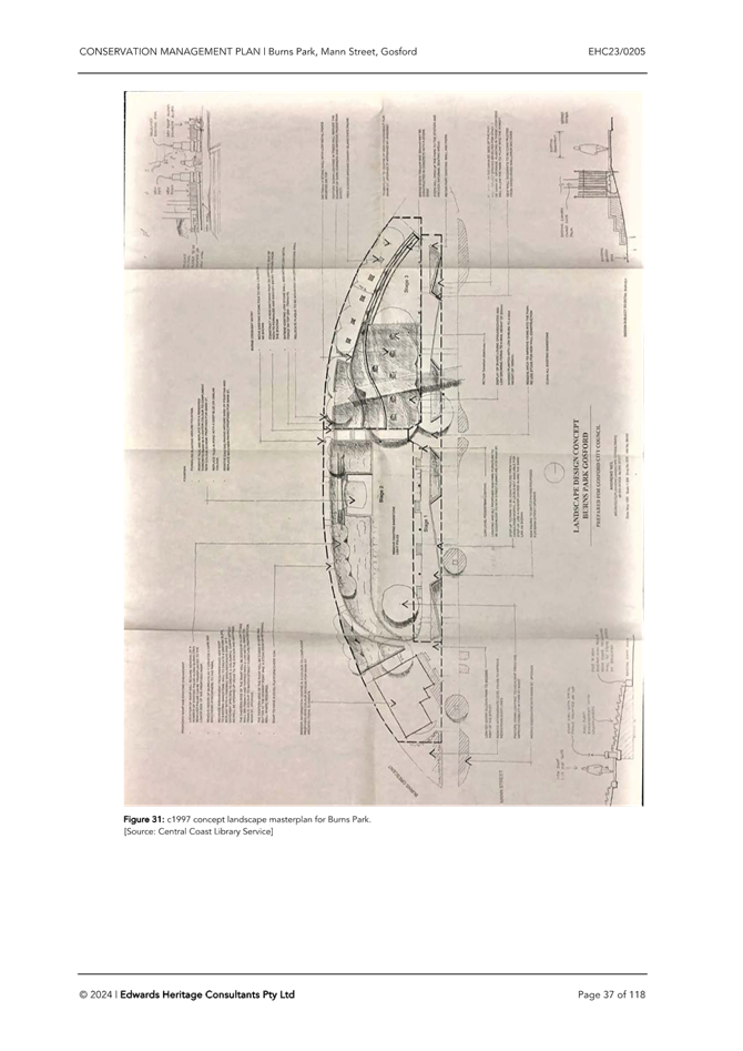
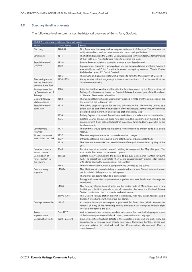
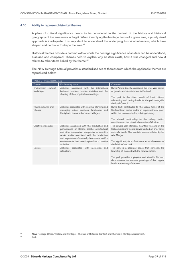

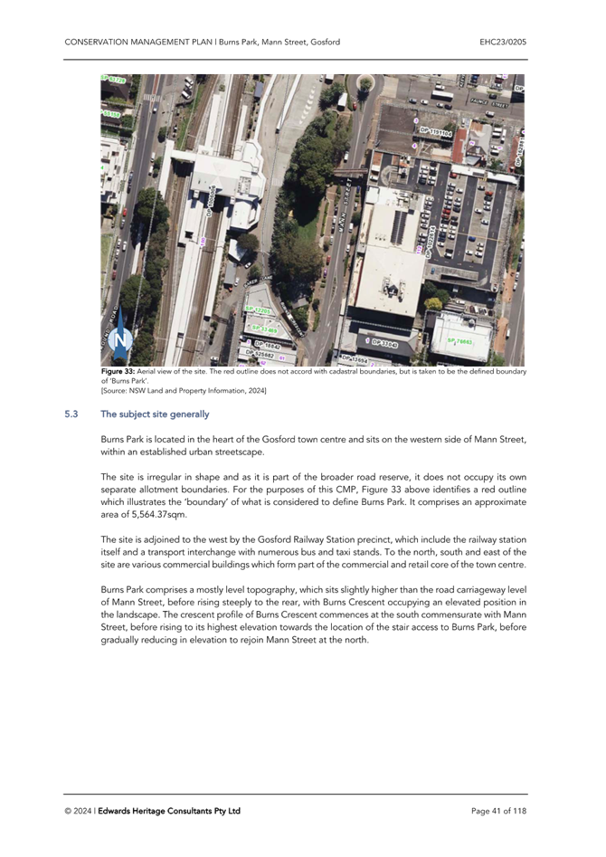
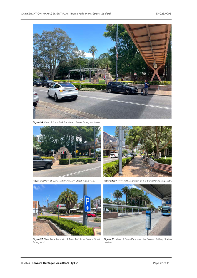
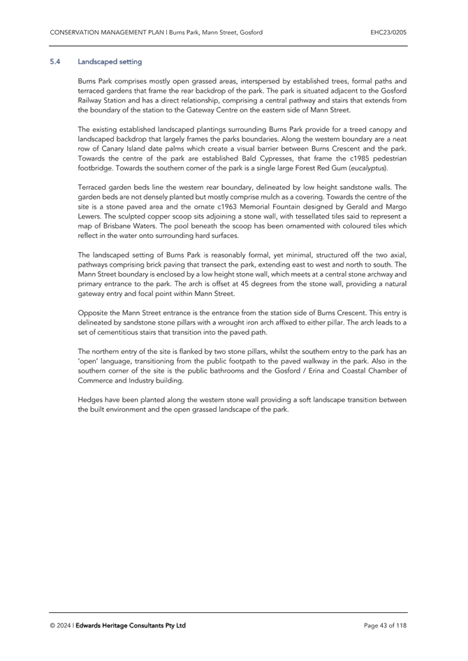
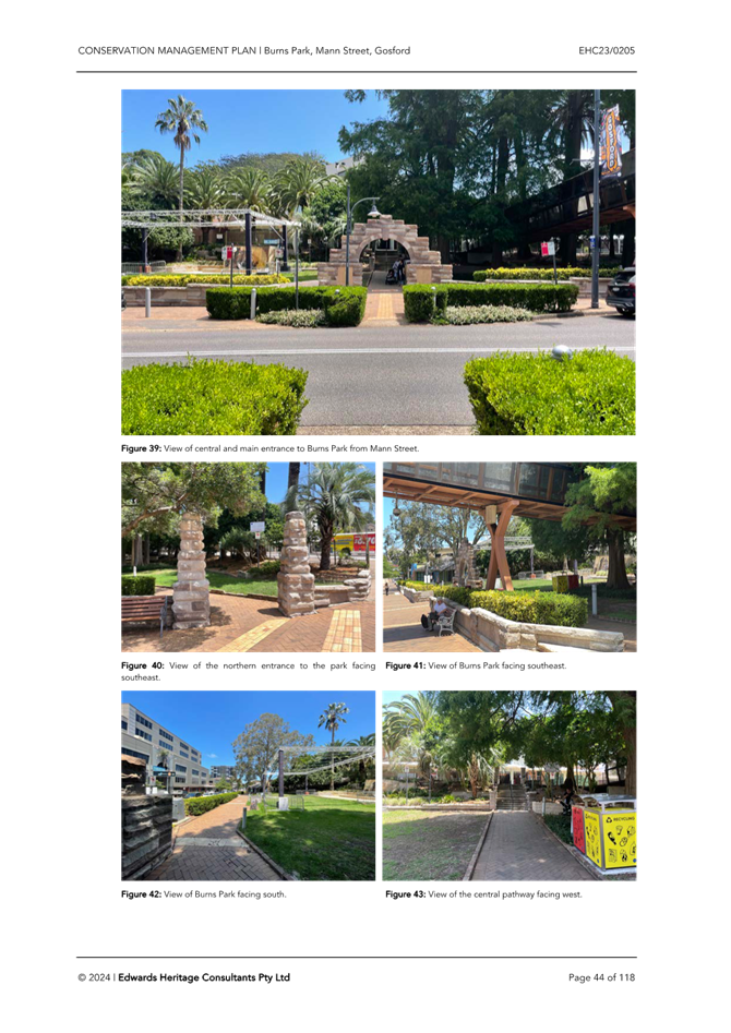
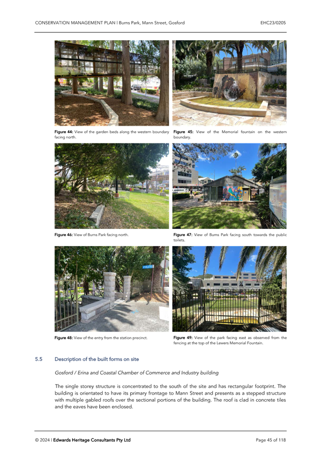
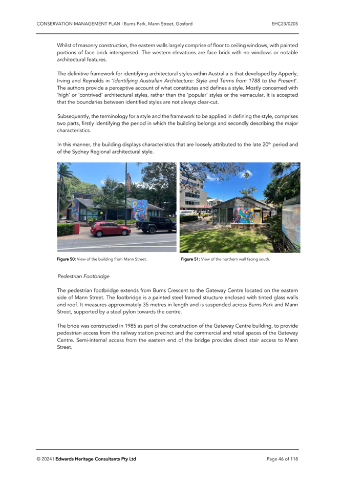
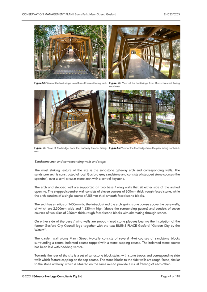
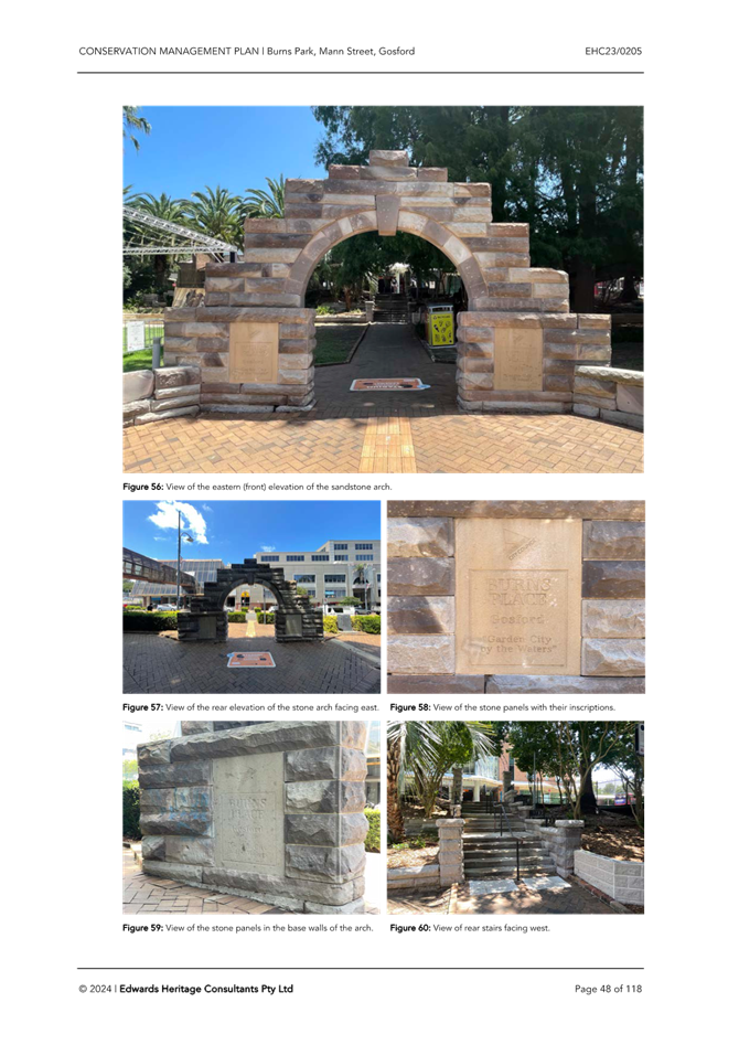
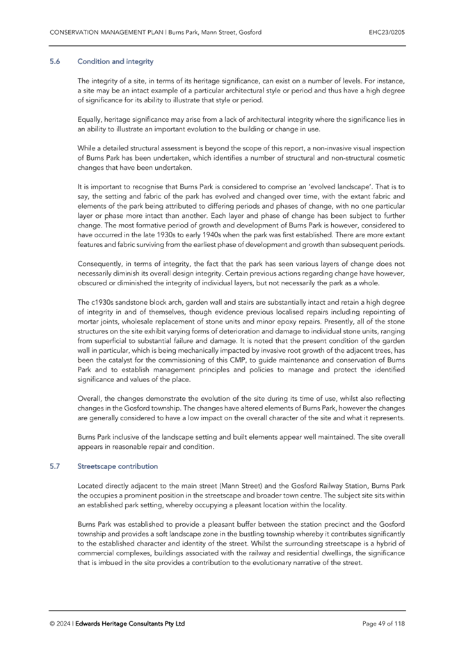
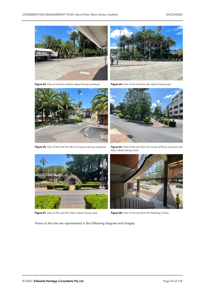
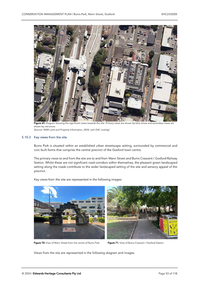
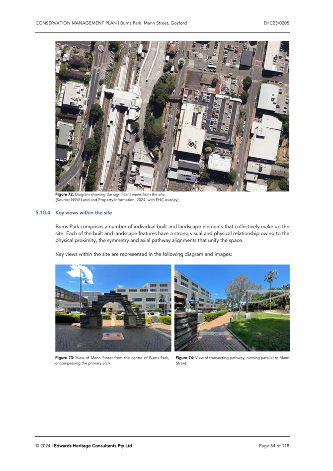
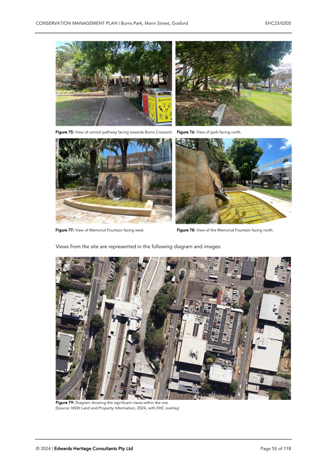
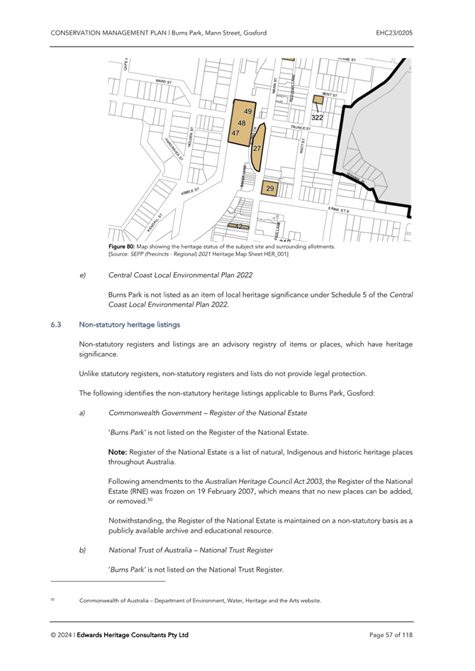

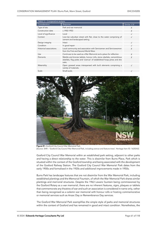
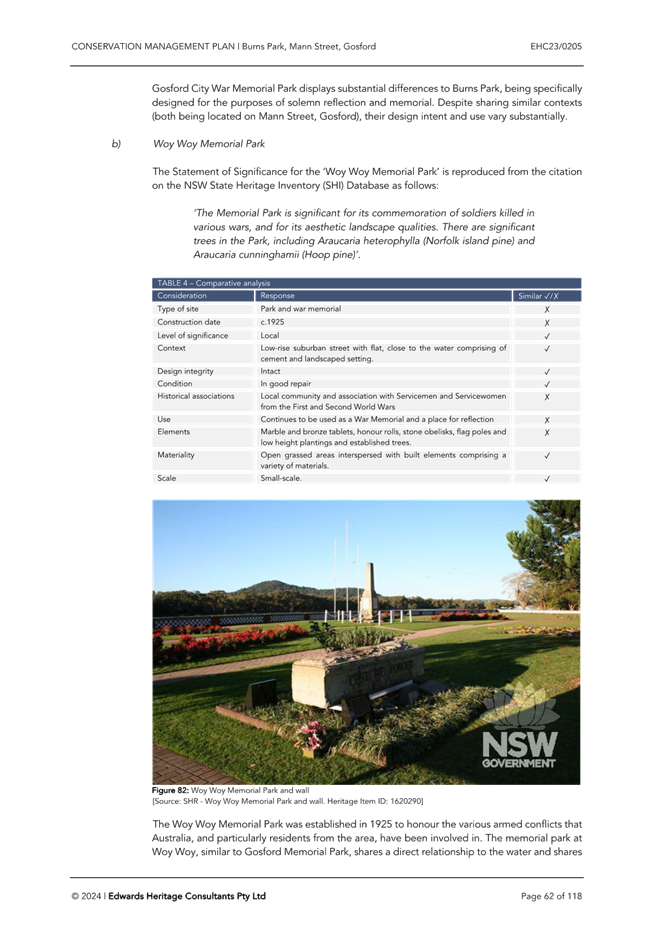
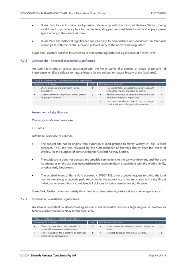
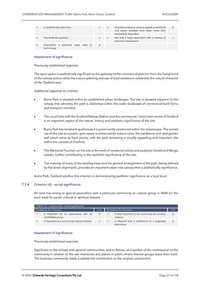
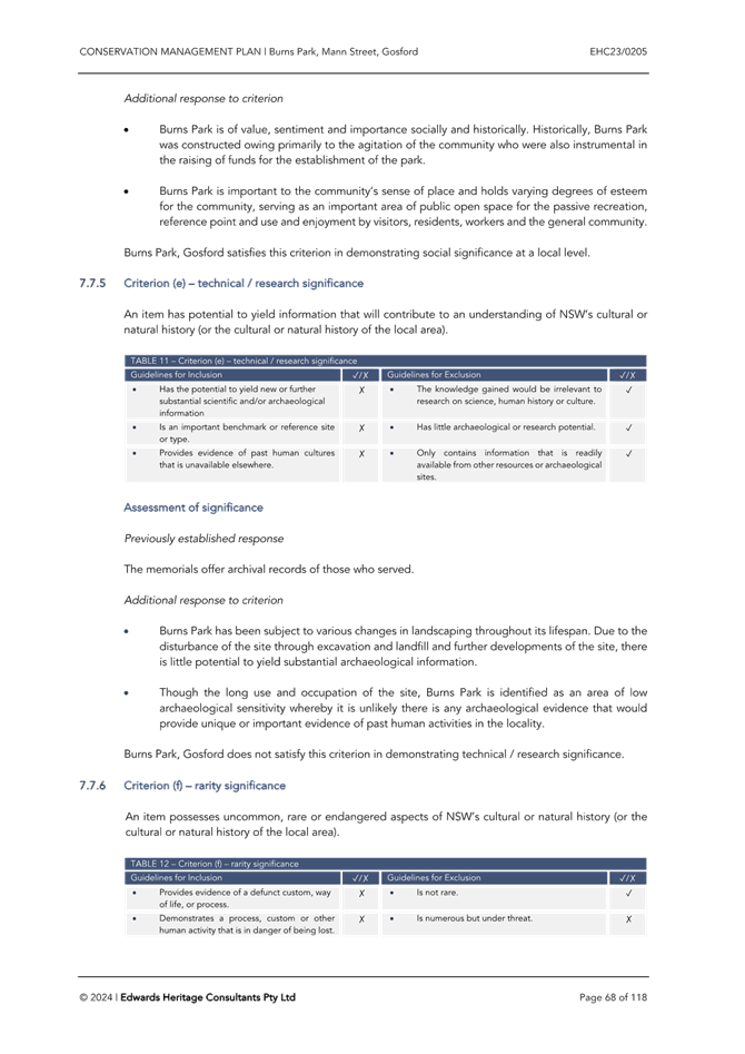
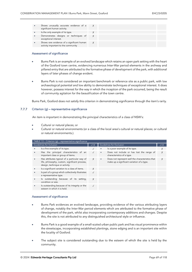
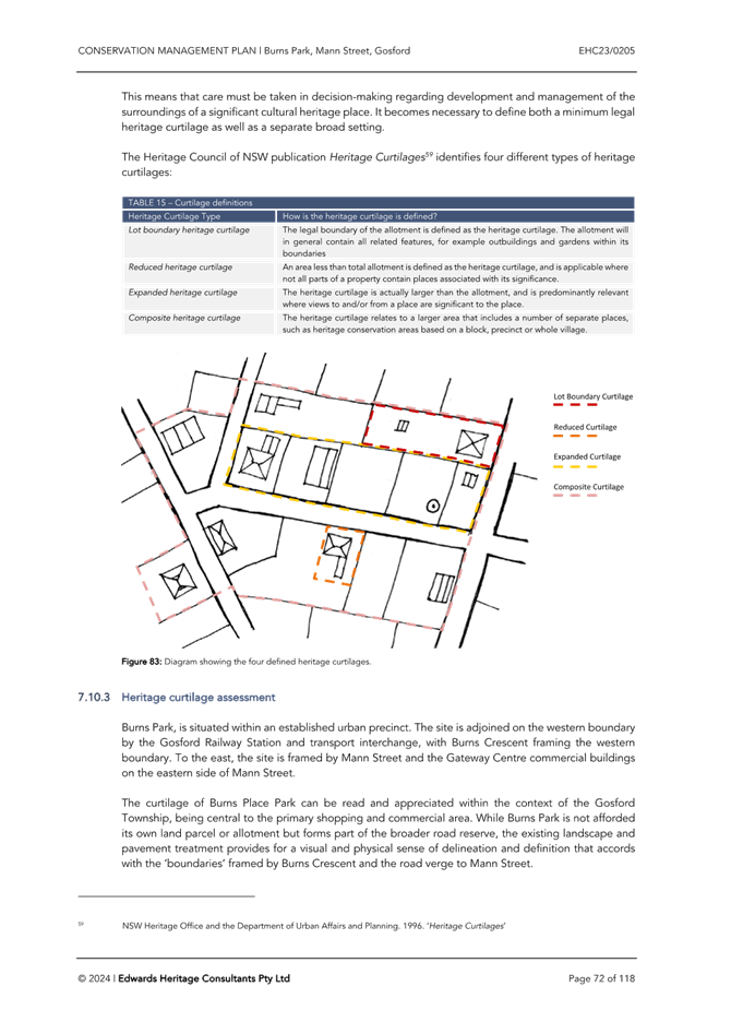
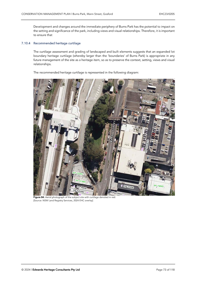
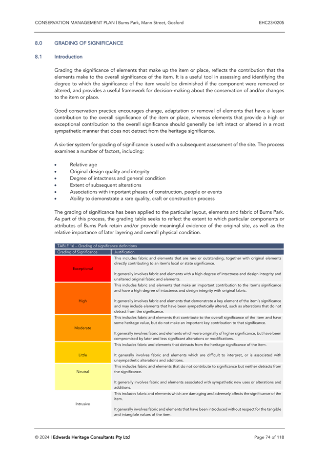
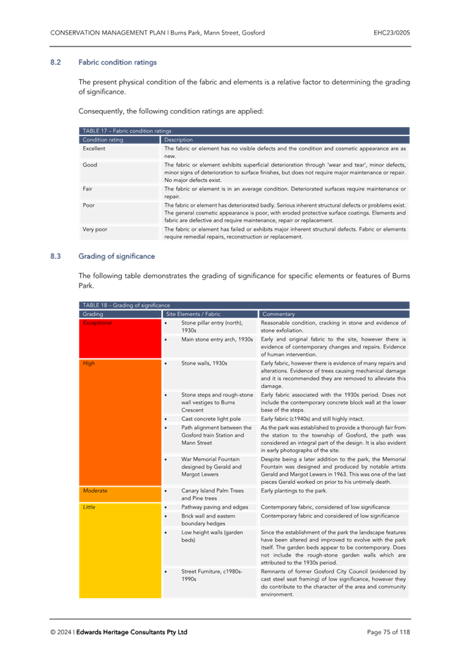
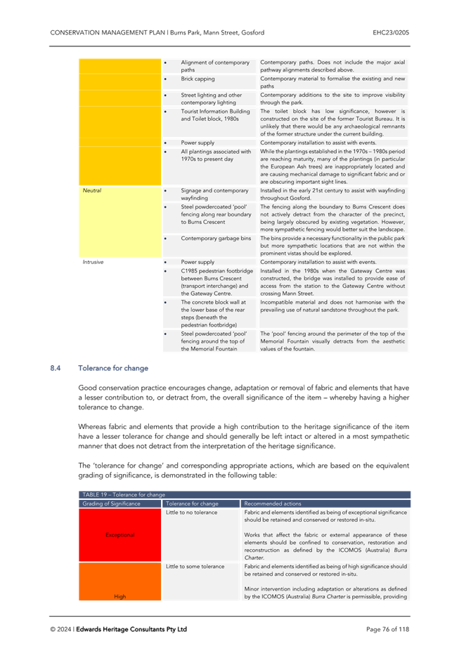
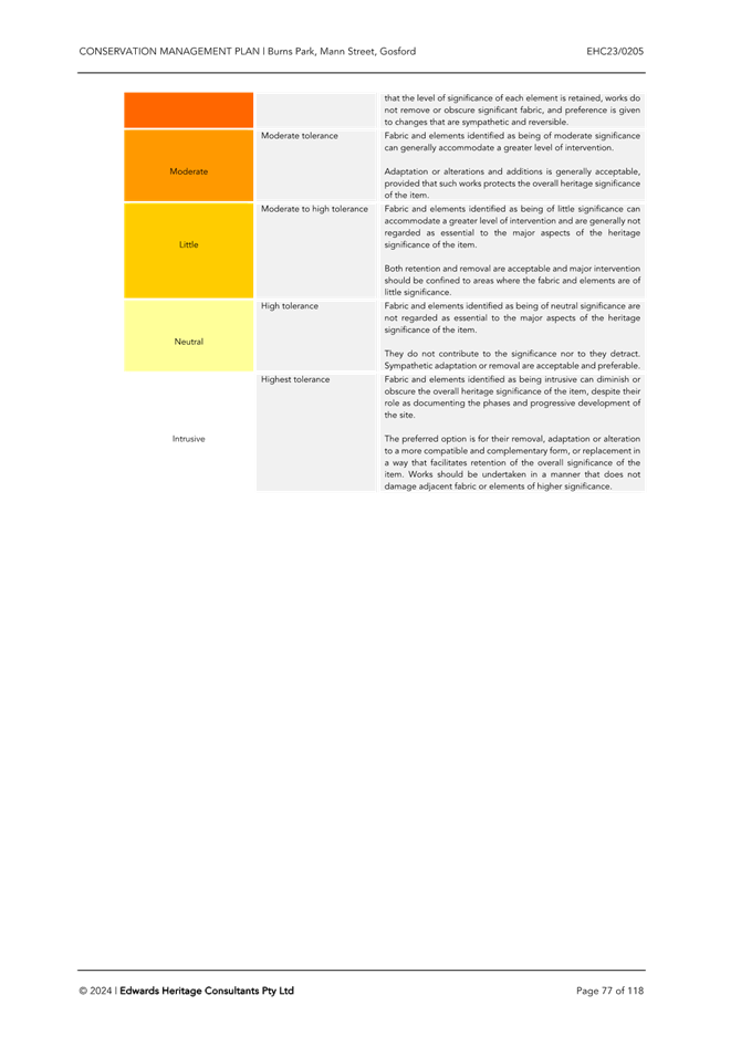
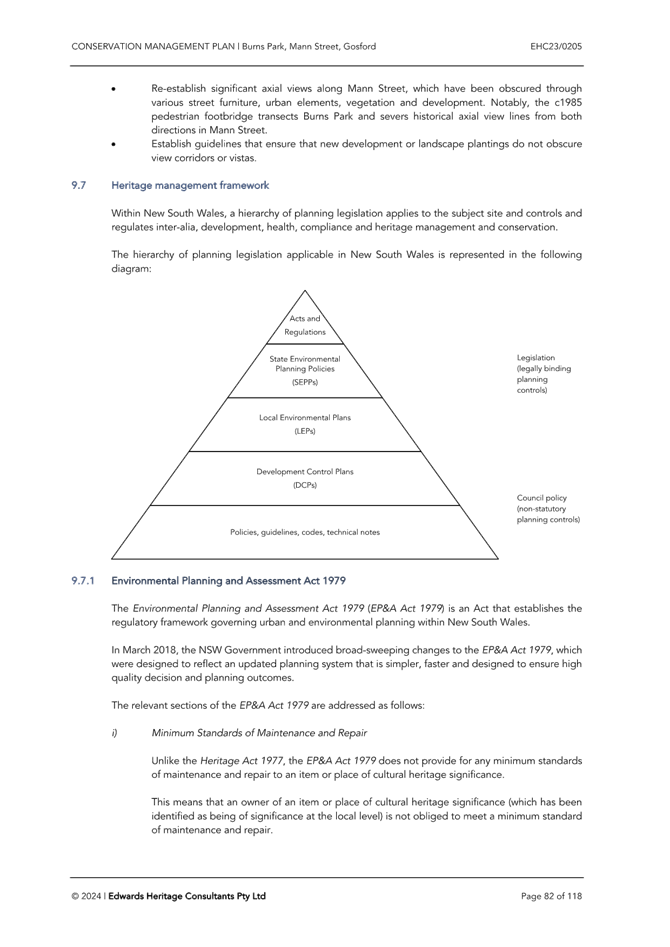


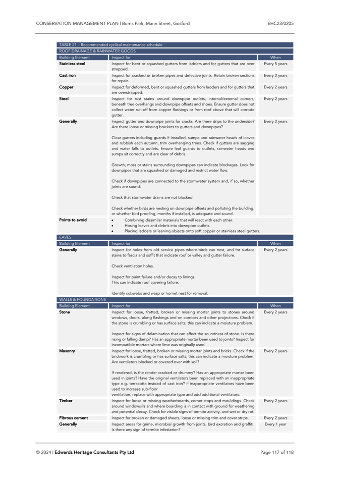


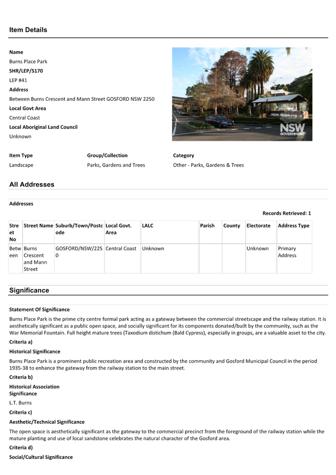


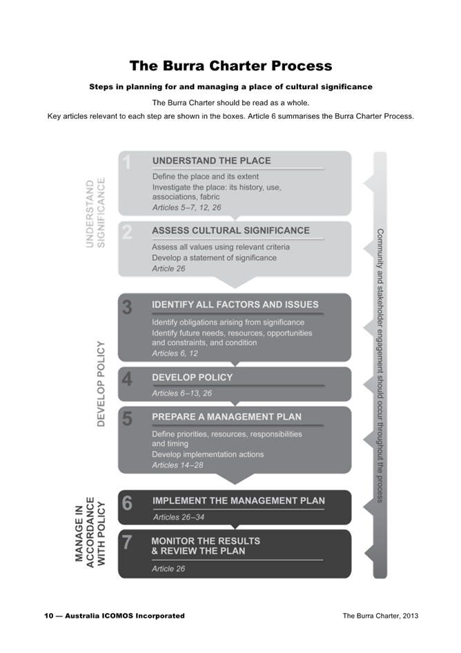
|
DA/867/2024 - Burns Place Park, Burns Crescent, Gosford - Heritage Demolition and Restoration Works of Sandstone Wall, Archway and Landscaping, including tree removal |
|
|
Attachment 5 |
Structural Report - DA/867/2024 - Burns Place Park. Burns Cr, GOSFORD |
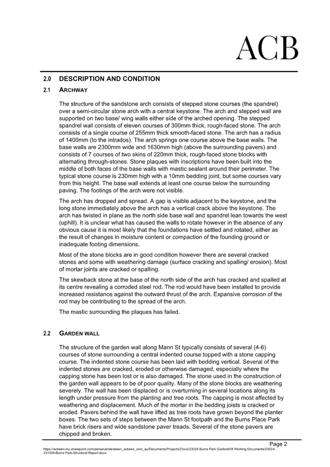
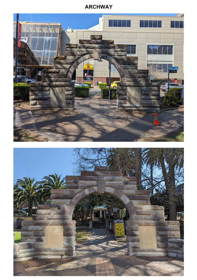

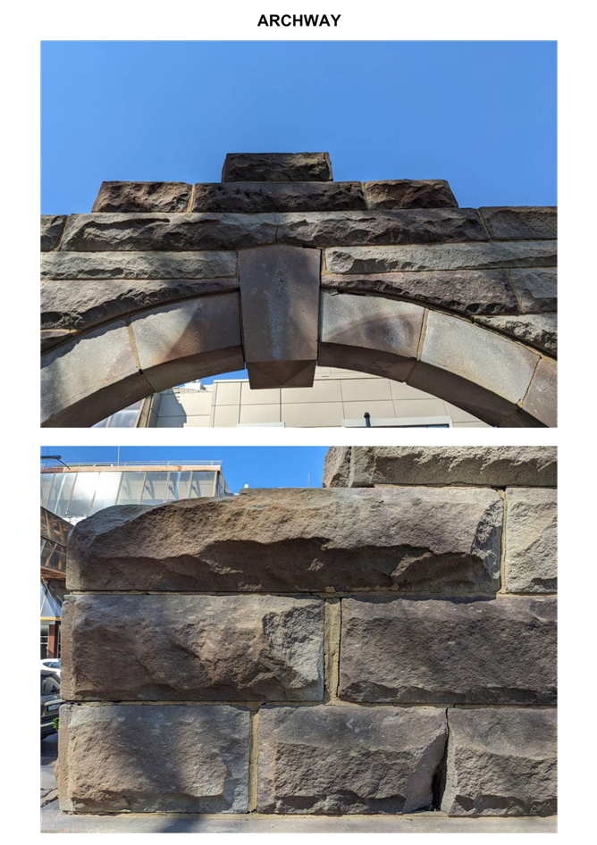
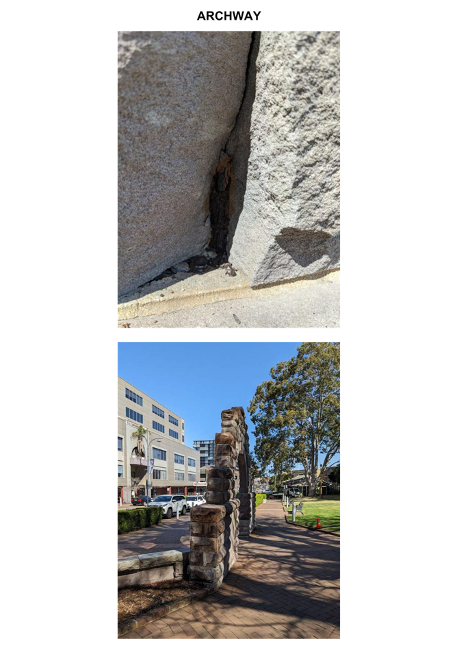
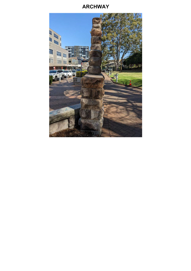

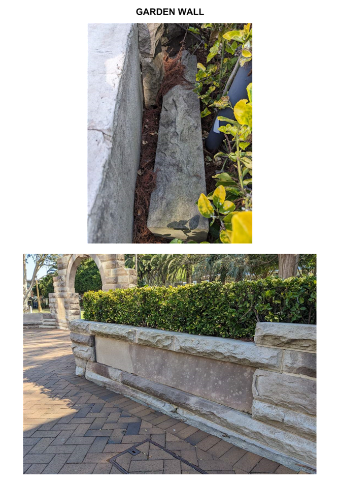
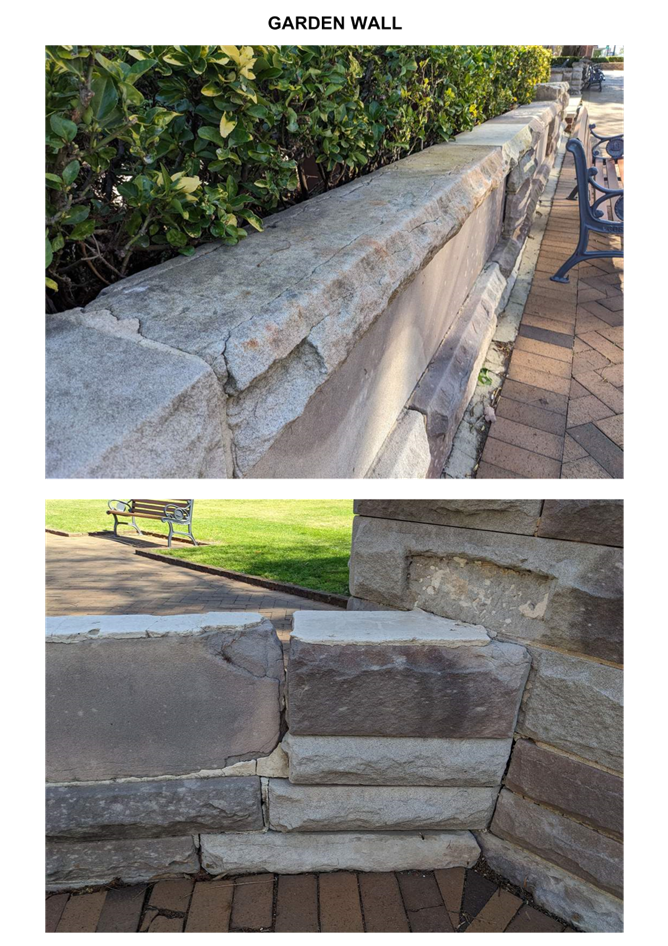
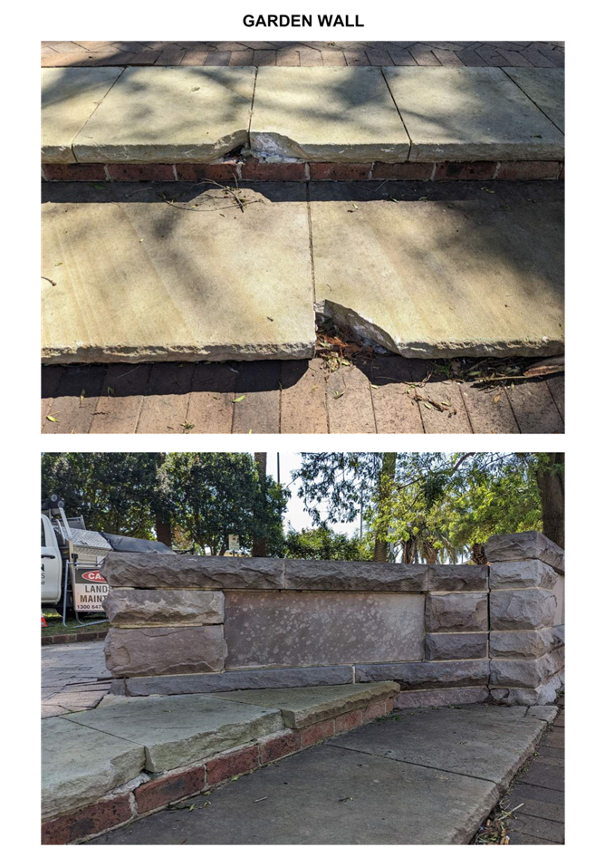
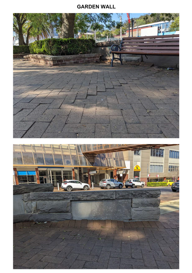

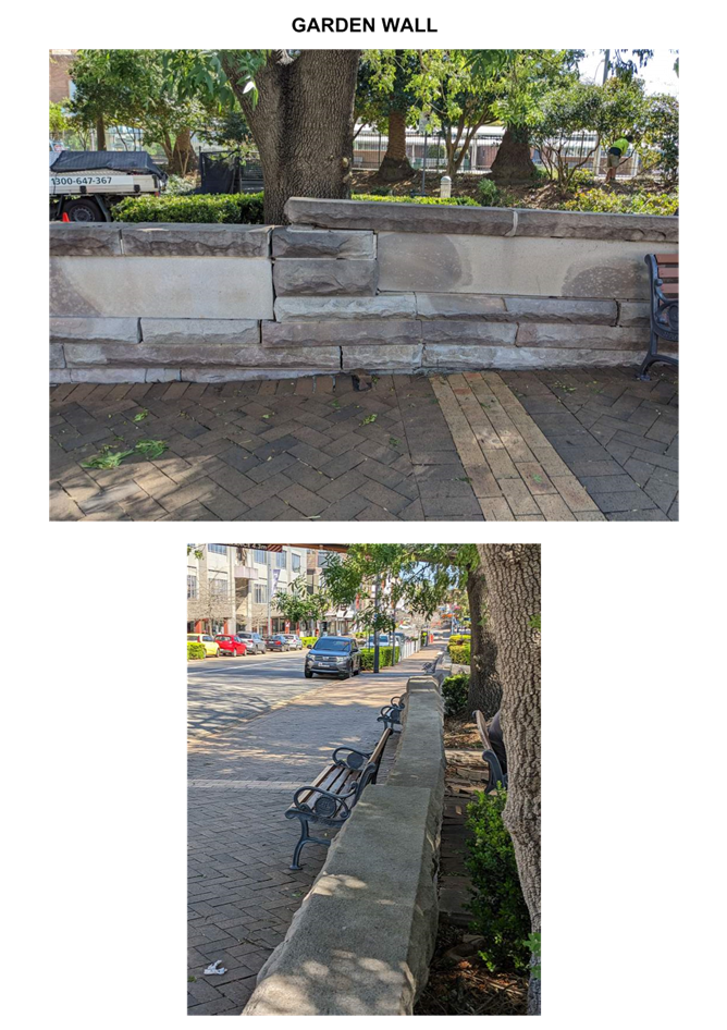
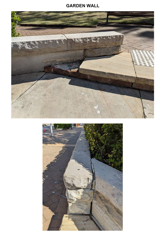


|
DA/867/2024 - Burns Place Park, Burns Crescent, Gosford - Heritage Demolition and Restoration Works of Sandstone Wall, Archway and Landscaping, including tree removal |
|
|
Attachment 6 |
Statement of Environmental Effects - Burns Place Park Gosford - REV C |