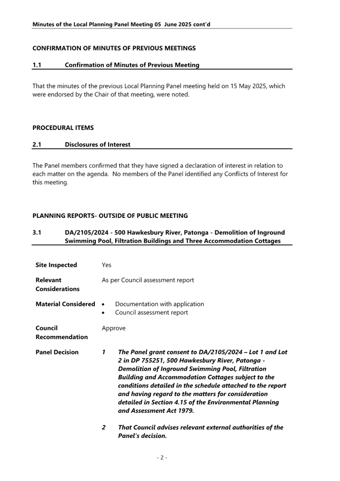
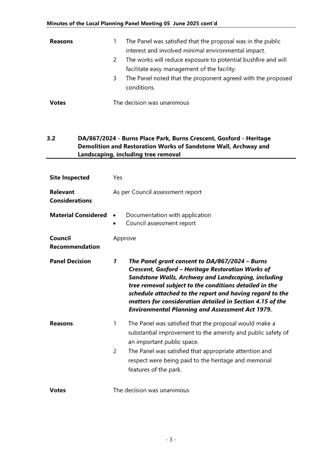
 |
Central Coast
Local Planning Panel Meeting
Business Paper
19 June 2025
 |
|
Central Coast
Local Planning Panel Meeting
Business Paper
19 June 2025
|
The Local Planning Panel Meeting
of Central Coast
will be held remotely - online,
Thursday 19 June 2025 at 2.00 pm,
for the transaction of the business listed below:
1 Confirmation of Minutes of Previous Meetings
1.1 Confirmation of Minutes of Previous Meeting................................................................................. 5
2 Procedural Items
2.1 Disclosures of Interest.............................................................................................................................. 4
3 Planning Reports- Outside of Public Meeting
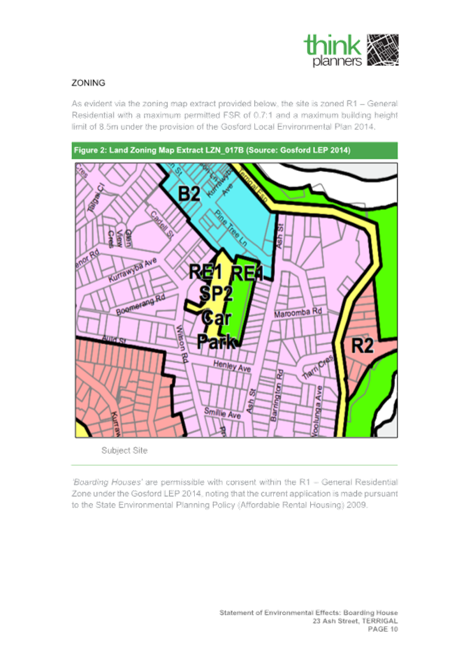
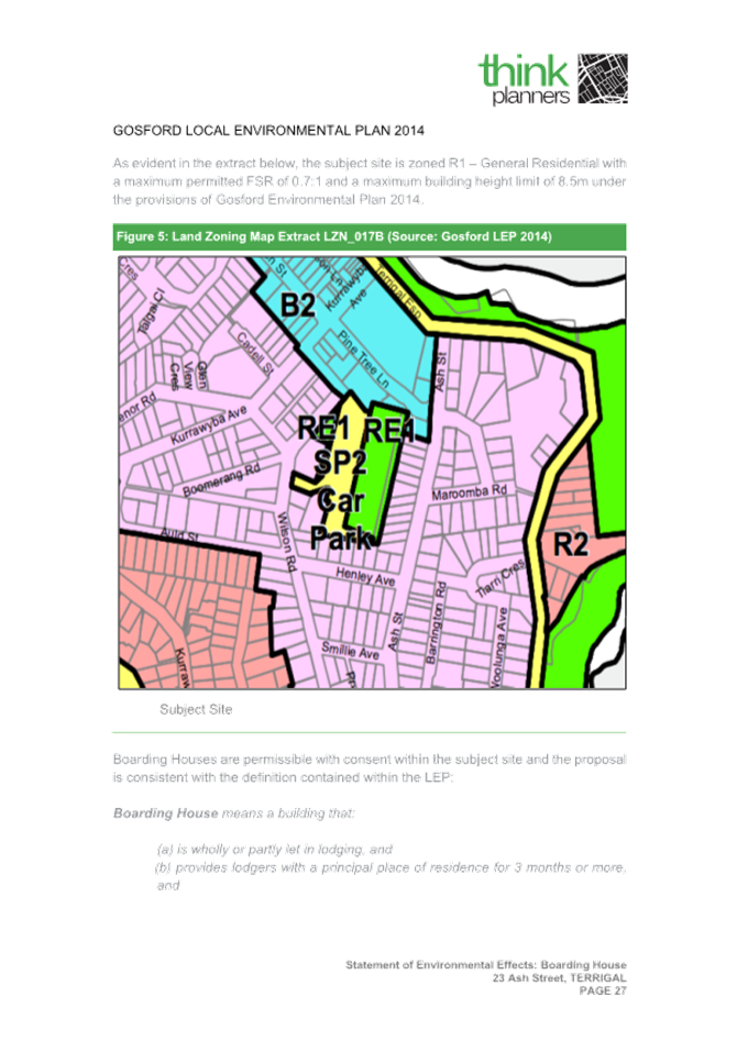
3.1 DA/690/2024 - Attached Dual Occupancy and Demolition - 15 North Avoca Parade, NORTH AVOCA........................................................................................................................................................... 9
4 Reports
4.1 Supplementary Report - DA/1809/2022 - 15-17 Coral Street, The Entrance - Construction of a 6 Storey Shop Top Housing development with Basement Level parking................................ 62
4.2 DA/1531/2024 - 12a The Scenic Road, Killcare Heights - Demolition of existing Dwelling and Proposed New Dwelling and associated works............................................................................. 96
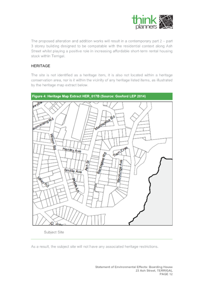
4.3 DA/63370/2021 - Boarding House - 23 Ash Street Terrigal.................................................... 142
5 Confidential Items
5.1 Land and Environment Court Proceedings Class 1 - Central Coast Council ats Optus Mobile Pty Ltd - Case 2025/86804 - DA/3623/2022 - 37 Wards Hill Road Killcare Heights
The reason for dealing with the report confidentially is that it contains information that would, if disclosed, prejudice the maintenance of law; AND contains advice concerning litigation, or advice that would otherwise be privileged from production in legal proceedings on the ground of legal professional privilege.
The Hon Terry Sheahan AO
Chairperson
|
Item No: 1.1 |
|
|
Title: Disclosures of Interest |
|
|
Department: Governance |
|
|
19 June 2025 Local Planning Panel Meeting |
|
Reference: F2020/02502 - D14205789
|
The NSW Local Planning Panel Code of Conduct states that all panel members must sign a declaration of interest in relation to each matter on the agenda before or at the beginning of each meeting.
|
That Panel Members now confirm that they have signed a declaration of interest in relation to each matter on the agenda for this meeting and will take any management measures identified.
|
Item No: 1.1 |
|
|
Title: Confirmation of Minutes of Previous Meeting |
|
|
Department: Corporate Services |
|
|
19 June 2025 Local Planning Panel Meeting |
|
Reference: F2020/02502 - D16889705
Author: Lisa Martin, Civic Support Officer Civic Support
|
Summary
The
Minutes of the following Meeting of the Local Planning Panel, which have been
endorsed by the Chair of that meeting, are submitted for noting: · Local Planning Panel Meeting held on 5 June 2025
|
That the minutes of the previous Local Planning Panel Meeting held on 5 June 2025, which were endorsed by the Chair of that meeting, are submitted for noting.
|
1⇩ |
MINUTES - Local Planning Panel - 5 June 2025 |
|
D16881791 |
|
1.1 |
Confirmation of Minutes of Previous Meeting |
|
Attachment 1 |
MINUTES - Local Planning Panel - 5 June 2025 |
|
Item No: 3.1 |
|
|
Title: DA/690/2024 - Attached Dual Occupancy and Demolition - 15 North Avoca Parade, NORTH AVOCA |
|
|
Department: Environment and Planning |
|
|
19 June 2025 Local Planning Panel Meeting |
|
Reference: DA/690/2024 - D16822854
Author: Katrina O'Malley, Development Planner Employment and Urban Release
Section Manager: Emily Goodworth, Section Manager Employment and Urban Release
Unit Manager: Andrew Roach, Unit Manager Development Assessment
|
Summary
An application has been received for an Attached Dual Occupancy, Demolition and Subdivision. The application has been examined having regard to the matters for consideration detailed in section 4.15 of the Environmental Planning and Assessment Act 1979 and other statutory requirements with the issues requiring attention and consideration being addressed in this report.
The application is referred to the Local Planning Panel for determination as the application proposes a variation to the minimum lot size standard for Dual Occupancies within Clause 4.1B of the Central Coast Local Environmental Plan 2022. The lot size requires a 88.4m2 (16%) variation. The application also proposes a number of other variations to design standards within the Central Coast Development Control Plan 2022, including floor space ratio and building setbacks.
The application is recommended for refusal.
Applicant Doug Sneddon Planning Pty Ltd Owner WJ Dover Application No DA/690/2024 Description of Land Lot 4 DP 203908 15 North Avoca Parade, NORTH AVOCA NSW 2250 Proposed Development Attached Dual Occupancy, Demolition, and subdivision. Site Area 461.6m2 Zoning R2 Low Density Residential Existing Use Dwelling Employment Generation N/A Estimated Value $840,905
|
Recommendation
1 That the Local Planning Panel refuse the application DA/690/2024 – 15 North Avoca Parade, NORTH AVOCA – Attached Dual Occupancy, Demolition and Subdivision subject to the reasons for refusal detailed in the schedule attached to the report and having regard to the matters for consideration detailed in Section 4.15 of the Environmental Planning and Assessment Act 1979.
2 That Council advises those who made written submissions of the Panel’s decision.
Key Issues
· The current application is for the demolition of existing structures and construction of an attached dual occupancy and two lot subdivision.
· The application received seven submissions during the notification period.
· The proposed development proposes a 16% variation to Clause 4.1B of the Central Coast Local Environmental Plan 2022.
· The proposed development proposes several variations to Central Coast Development Control Plan 2022, Chapter 2.2 – Dual Occupancy and Multi Dwelling Housing.
Precis:
|
Proposed Development |
Attached Dual Occupancy and Demolition
|
|
Permissibility and Zoning |
The use is best defined as a “Dual Occupancy (attached)” under the Central Coast Local Environmental Plan 2022 which is defined as:
dual occupancy means a dual occupancy (attached) or a dual occupancy (detached). Note— Dual occupancies are a type of residential accommodation—see the definition of that term in this Dictionary. dual occupancy (attached) means 2 dwellings on one lot of land that are attached to each other, but does not include a secondary dwelling. Note— Dual occupancies (attached) are a type of dual occupancy—see the definition of that term in this Dictionary.
The land has a zoning of R2 Low Density Residential and the development is permitted with development consent.
|
|
Current Use |
Dwelling house
|
|
Integrated Development |
No
|
|
Submissions |
Seven
|
Variations to Policies
|
Clause |
4.1B Minimum lot size for dual occupancies |
|
Standard |
Dual occupancies attached – 550m2 |
|
LEP/DCP |
CCLEP 2022 |
|
Departure basis |
Site = 461.6m2. 88.4m2 shortfall. 16% variation |
|
Clause |
2.2.4.1 Lot size requirements |
|
Standard |
Dual occupancies attached – 550m2 |
|
LEP/DCP |
CCDCP, Chapter 2.2 – Dual Occupancy & Multi Dwelling Housing |
|
Departure basis |
Site = 461.6m2. 88.4m2 shortfall. 16% variation |
|
Clause |
2.2.4.2 Floor Space Ratio |
|
Standard |
Maximum FSR = 0.5:1 |
|
LEP/DCP |
CCDCP, Chapter 2.2 – Dual Occupancy & Multi Dwelling Housing |
|
Departure basis |
Proposed = 0.59:1. 18% variation |
|
Clause |
2.2.5 Building Setbacks |
|
Standard |
For any part of the building with a height of more than 4.5m—0.9m plus one-quarter of the height of the building above 4.5m. 1.8m required. |
|
LEP/DCP |
CCDCP, Chapter 2.2 – Dual Occupancy & Multi Dwelling Housing |
|
Departure basis |
1.6m and 1.7m proposed. 11% and 6% variation. |
|
Clause |
2.2.5 Building Setbacks |
|
Standard |
Rear setback is to be a minimum of 4.5m |
|
LEP/DCP |
CCDCP, Chapter 2.2 – Dual Occupancy & Multi Dwelling Housing |
|
Departure basis |
Between 0.9m and 2.8m for terraces. 80% and 38% variation. 3.6m for first floor balcony to northern dwelling. 20% variation |
|
Clause |
2.2.7.2 Privacy |
|
Standard |
Direct overlooking of internal living areas and private open space and from surrounding dwellings to be minimised. |
|
LEP/DCP |
CCDCP, Chapter 2.2 – Dual Occupancy & Multi Dwelling Housing |
|
Departure basis |
Impacts to privacy. Non-numerical variation |
|
Clause |
2.2.7.2 Sunlight |
|
Standard |
Shadow diagrams are to be provided. |
|
LEP/DCP |
CCDCP, Chapter 2.2 – Dual Occupancy & Multi Dwelling Housing |
|
Departure basis |
Unsuitable shadow diagrams provided to demonstrate solar impacts. Non-numerical variation |
|
Clause |
2.2.8.1 Car Parking |
|
Standard |
One required resident space to be enclosed garage with minimum dimensions as follows: 3m wide 5.5m length 2.7m opening |
|
LEP/DCP |
CCDCP, Chapter 2.2 – Dual Occupancy & Multi Dwelling Housing |
|
Departure basis |
2.8m wide. 7% variation. 5.5m length 2.6m opening. 4% variation. |
The Site
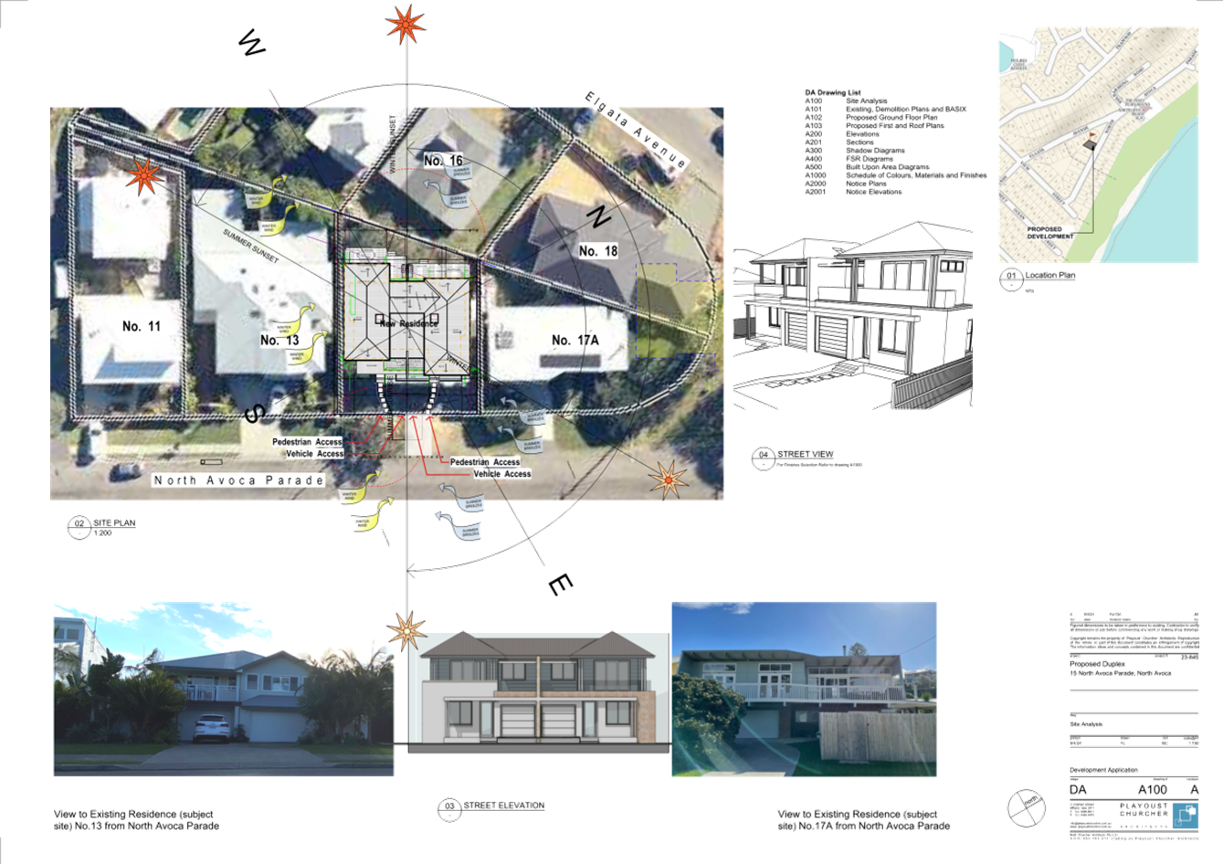
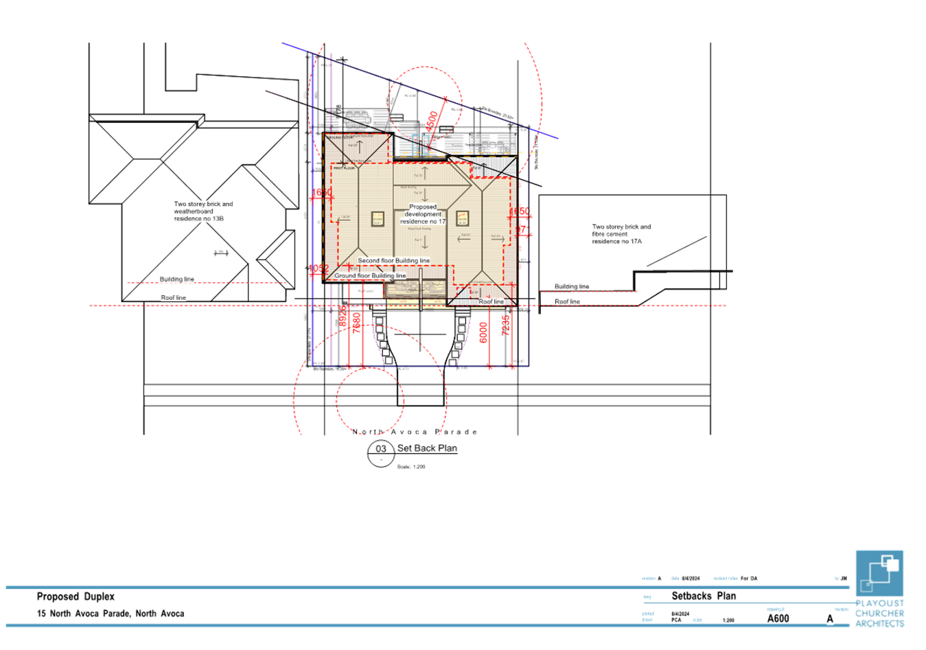
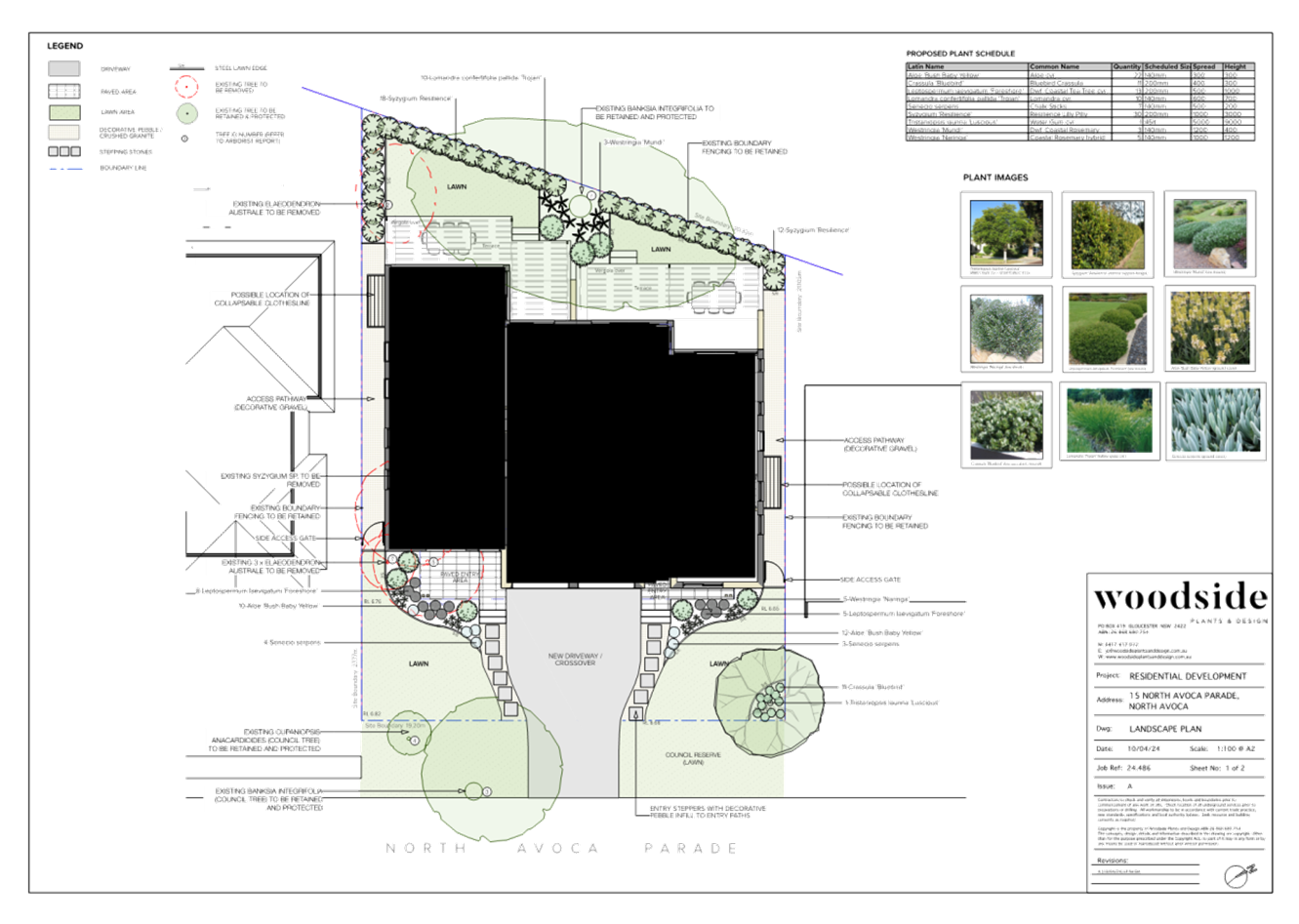
The site is located at 15 North Avoca Parade, North Avoca (Lot 4 DP 203908). The site has an area of 462m2. The site currently contains an existing two storey brick rendered dwelling with colorbond roof. The site is generally rectangular with an angled rear boundary and the site has an orientation of generally east to west.
The site is relatively level with a slight fall to the rear of the site. The site contains eight existing trees, which includes two existing street tree within the council road reserve. The trees on the site consist of a mixture of Coastal Banksia, Blush Boxwood, Tuckeroo and Lily Pilly.
The site is partially identified as flood prone land for a small portion of the rear yard at the boundary fence. The subject site is identified by Council as having a medium landslip risk.
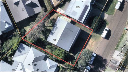
Figure 1. The site with existing dwelling and trees
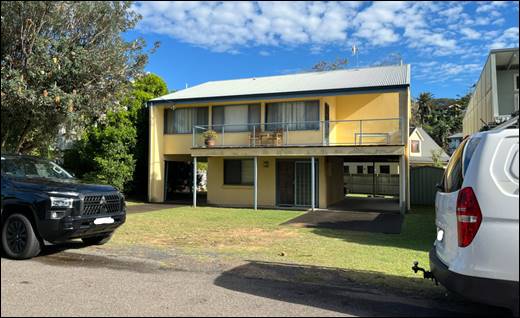
Figure 2. The site as view from North Avoca Parade (east)
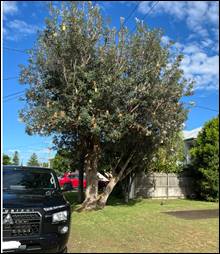
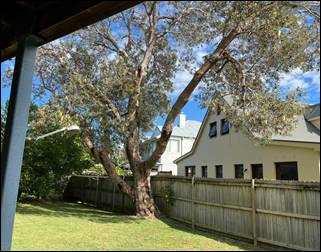
Figures 3 and 4. Trees to be retained at the front and rear of the site.
Surrounding Development
The subject site is located within an existing residential street with dwellings located on both sides. The dwelling to the north consists of a renovated two storey structure whilst to the south of the site is a two storey dual occupancy development. The local area predominantly comprises residential development, mostly consisting of single detached dwelling houses and a number of dual occupancy developments.
The existing residential development is a mixture of older style development, renovated structures and new constructions. A small reserve is located at the north end of the street whilst an additional reserve is located behind the dwellings at the southern end of the street. North Avoca Beach is located to the east of the site.
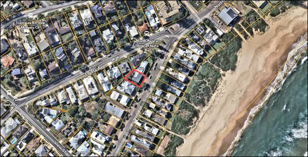
Figure 5. The site within the locality
The Proposed Development
The proposed development involves the construction of an attached dual occupancy development and the demolition of existing structures. The proposal will include the following works:
· Demolition of the existing dwelling house;
· Removal of five trees from the site;
· Erection of 2 x two storey attached three-bedroom dwelling;
· Construction of new vehicular access;
· Ancillary civil works.
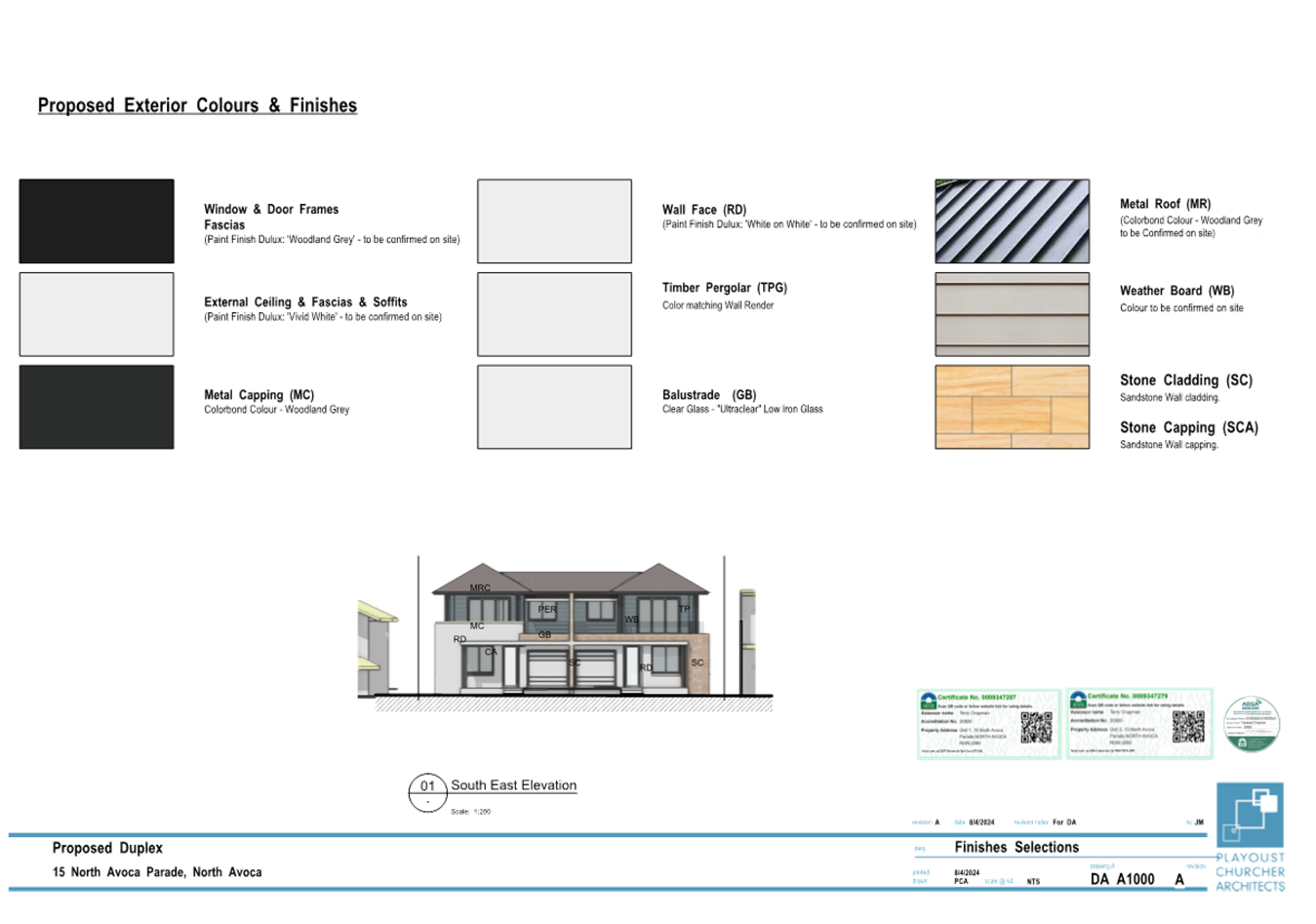
The proposed dwellings are to be constructed out of a mixture of stone cladding and weatherboard, with colorbond roofing. The proposal includes landscaping on the site incorporating the retention of three trees on the site and within the road reserve.
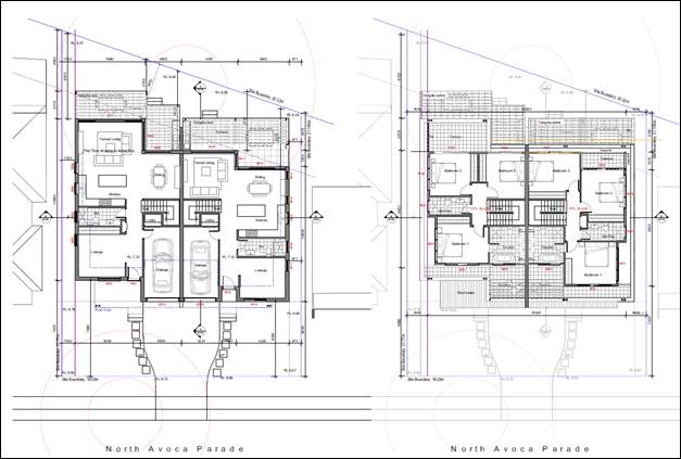
Figure 5. Proposed dual occupancy on the site.
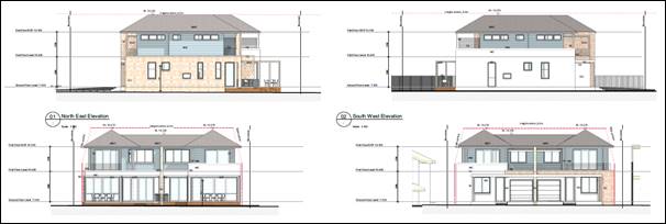
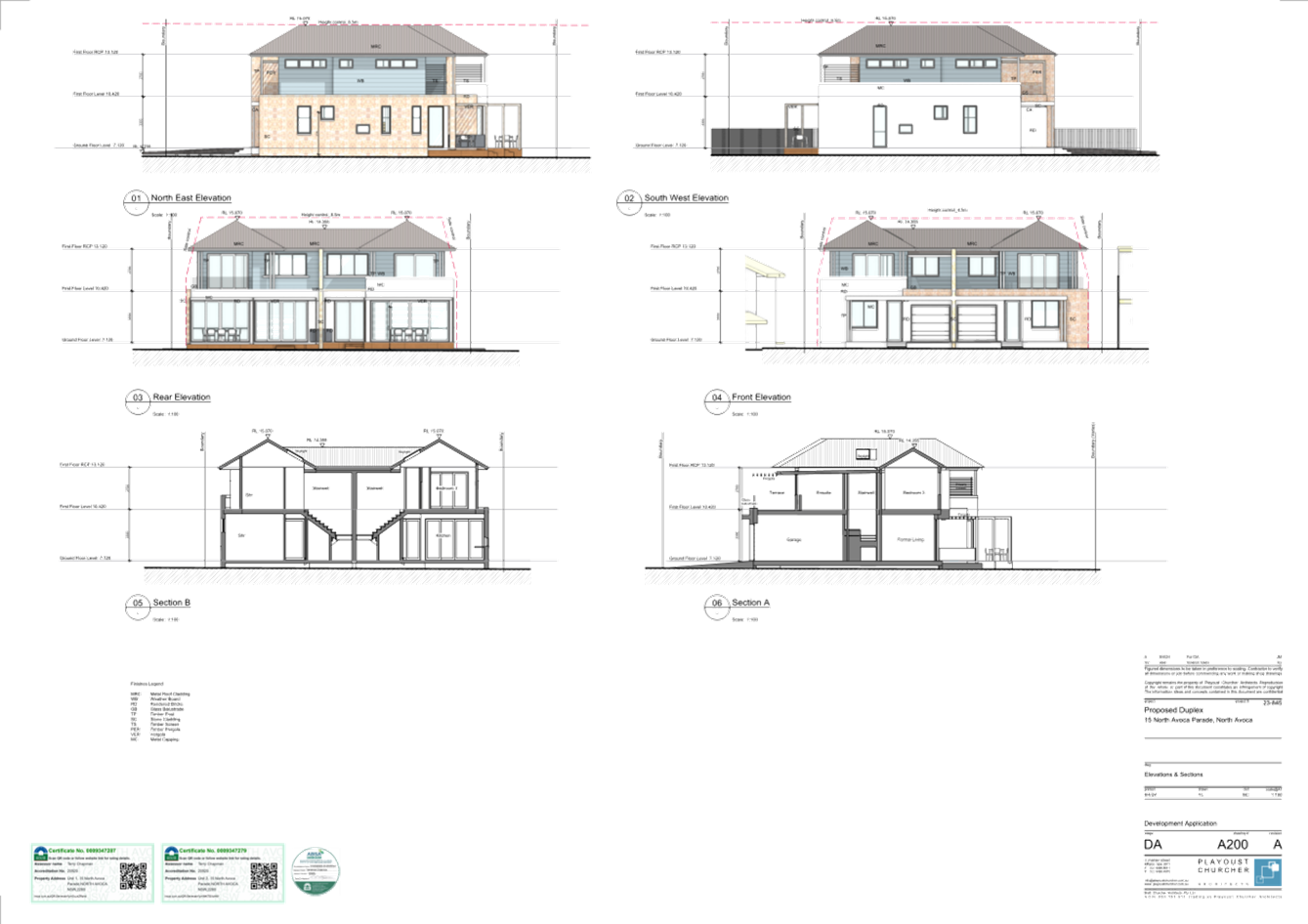
Figure 6. Proposed elevations of the proposal.
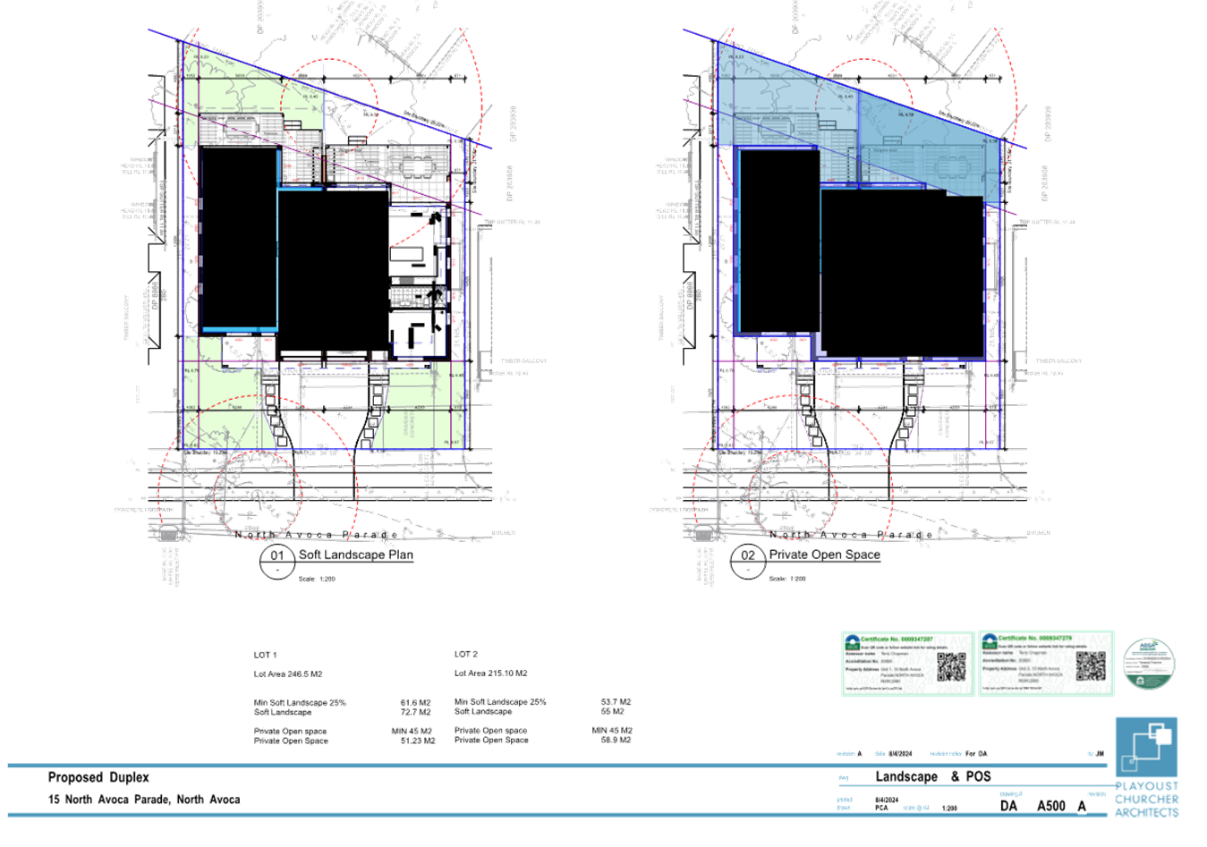
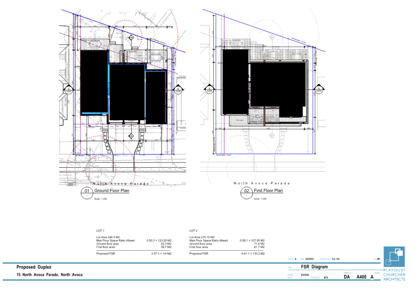
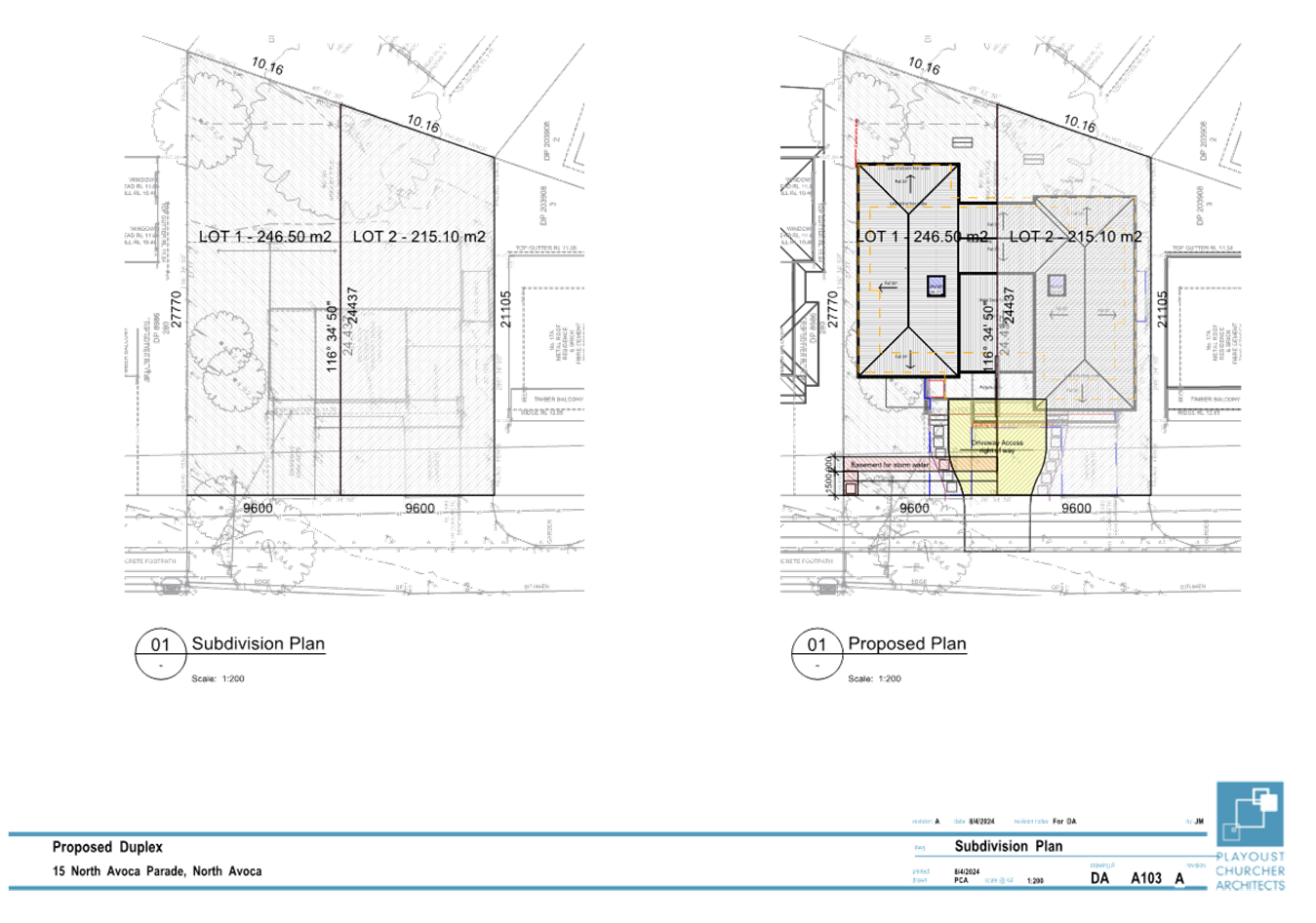
The proposed development also includes the two lot torrens title subdivision of the site. The proposed subdivision will result in each dwelling being located on its own lot with reciprocal rights of access over the driveway, and an easement for drainage over proposed Lot 1. The proposed lots would have an area of 246.50m2 (Lot 1) and 215.10m2 (Lot 2).
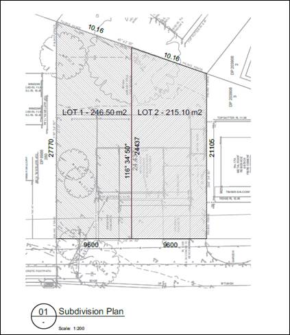
Figure 7. Proposed subdivision of the site.
History
A pre-lodgement application meeting was held in 2023 for the construction of a dual occupancy and proposed subdivision on the site. The applicant was advised at the time of the meeting that the proposal would require a 16% variation to the minimum lot size for dual occupancy development under clause 4.1B of the Central Coast Local Environmental Plan 2022.
The applicant was further advised that the variation was not likely to be supported by Council given the significant variation proposed. The plans submitted with the development application show little variation to what was discussed at the pre-lodgement meeting.
ASSESSMENT
Having regard for the matters for consideration detailed in Section 4.15 of the Environmental Planning and Assessment Act 1979 and other statutory requirements, Council’s policies and Section 10.7 Certificate details, the assessment has identified the following key issues, which are elaborated upon for Council’s information. Any tables relating to plans or policies are provided as an attachment.
Provisions of Relevant Instruments/Plans/Policies:
State Environmental Planning Policies (SEPP)
State Environmental Planning Policy (Resilience and Hazards) 2021
· Chapter 2 – Coastal Management
The site is currently located within a coastal environment area under the above SEPP. Prior to the granting of consent for any development on land identified as a coastal environment area the consent authority is required to consider certain matters and be satisfied of certain things in accordance with s.2.10.
The proposal will not have an adverse impact upon the coastal environment given the nature of the proposal to be undertaken on the site. The structures are non-invasive and there is not likely to be any impacts to any objects or items of cultural heritage significance.
A summary of the matters for consideration pursuant to ss.2.10(1) is included below and there have been no matters identified that would likely impact on the coastal environment.
|
Matters for consideration |
Compliance |
|
(a) the integrity and resilience of the biophysical, hydrological (surface and groundwater) and ecological environment, |
The proposal is not likely to cause adverse impacts on the biophysical, hydrological, or ecological environment. |
|
(b) coastal environmental values and natural coastal processes, |
The proposal will not impact on the geological and geomorphological coastal processes. |
|
(c) the water quality of the marine estate (within the meaning of the Marine Estate Management Act 2014), in particular, the cumulative impacts of the proposed development on any of the sensitive coastal lakes identified in Schedule 1, |
The proposal will not result in an adverse impact on the water quality of the marine estate and does not drain to a sensitive lake contained in Schedule 1. |
|
(d) marine vegetation, native vegetation and fauna and their habitats, undeveloped headlands and rock platforms, |
The proposal will not result in an adverse impact on native vegetation or fauna, undeveloped headlands, and rock platforms. |
|
(e) existing public open space and safe access to and along the foreshore, beach, headland or rock platform for members of the public, including persons with a disability, |
The site does not have frontage to any, beach, headland or waterways and is separated by Council zoned land C1 which is similar in appearance to an open reserve but is not impacted by this proposal for access. |
|
(f) Aboriginal cultural heritage, practices and places, |
There are no identified aboriginal cultural heritage items on the site including a clear AHIMS search. |
|
(g) the use of the surf zone. |
Not Applicable. No frontage to any beach/surf zone. |
With respect of the matters in ss2.10(2), the Panel can be satisfied the proposed development is not likely to adversely impact on the coastal environment area.
The site is also located within a coastal use area as identified by the SEPP. Prior to the granting of consent for any development on land identified as a coastal use area the consent authority is required to consider certain matters and be satisfied of certain things in accordance with s.2.11.
The proposal will not have an impact upon the coastal environment and is therefore consistent with the requirements of s.2.11.
|
Matters for consideration |
Compliance |
|
(1) Development consent must not be granted to development on land that is within the coastal use area unless the consent authority— |
|
|
(a) has considered whether the proposed development is likely to cause an adverse impact on the following— |
|
|
(i) existing, safe access to and along the foreshore, beach, headland or rock platform for members of the public, including persons with a disability, |
The site does not have frontage to any foreshore, beach or waterway and is not visible from any foreshore or beach. |
|
(ii) overshadowing, wind funnelling and the loss of views from public places to foreshores, |
The proposal will not cause an adverse impact on access, overshadowing, wind funnelling or view loss form public places to any foreshore. |
|
(iii) the visual amenity and scenic qualities of the coast, including coastal headlands, |
The proposal does not impact the visual amenity or scenic quality of the coast. |
|
(iv) Aboriginal cultural heritage, practices and places, |
There are no known objects, areas, or items of heritage significance on the land, and no potentially adverse impacts on cultural or environmental heritage have been identified. |
|
(v) cultural and built environment heritage, and |
There are no known objects, areas, or items of heritage significance on the land, and no potentially adverse impacts on cultural or environmental heritage have been identified. AHIMS search / mapping is clear |
|
(b) is satisfied that— |
|
|
(i) the development is designed, sited and will be managed to avoid an adverse impact referred to in paragraph (a), or |
There have been no adverse impacts identified in the consideration of section 2.11(1) that would engage the further considerations under section 2.11(2) of the Resilience and Hazards SEPP.
<Remove b(ii) and b(iii) if the requirements of (b)(i) are met.> |
|
(ii) if that impact cannot be reasonably avoided—the development is designed, sited and will be managed to minimise that impact, or |
N/A |
|
(iii) if that impact cannot be minimised—the development will be managed to mitigate that impact, and |
N/A |
|
(c) has taken into account the surrounding coastal and built environment, and the bulk, scale and size of the proposed development. |
The bulk and scale of the proposed development results in an over development of the site given the non-compliance with DCP requirements that demonstrate a building of this size cannot fit on this lot. |
Whilst the proposed development will not impact on public access to the beach or impact on the amenity and scenic qualities of the coast or aboriginal cultural heritage places, or other cultural and built environmental heritage, the bulk and scale of the proposed development is not appropriate having regard for the non-compliances with the DCP requirements and the lot size. Accordingly, the Panel cannot be satisfied the proposal satisfies the provisions of s.2.11(1)(c).
· Chapter 4 -Remediation of Land
In accordance with Section 4.6 of the Chapter, the consent authority must not consent to the carrying out of any development on land unless it has considered whether the land is contaminated, and, if the land is contaminated, is suitable in its contaminated state for the purposes of the development which is proposed.
In this regard, the proposed development is for the construction of a dual occupancy development on an existing residential lot. The site is not considered contaminated and is suitable for the proposed purpose.
The proposed development is therefore considered suitable having regard for the provisions of s.4.6(1)(a) and (b) and the Panel can be satisfied that no further information is required in relation to land contamination.
Central Coast Local Environmental Plan 2022 (CCLEP 2022)
· Permissibility
The site is currently zoned R2 Low Density Residential under the Central Coast Environmental Plan 2022. The proposed development is for an attached dual occupancy development which is defined as follows:
dual occupancy means a dual occupancy (attached) or a dual occupancy (detached).
Note—
Dual occupancies are a type of residential accommodation—see the definition of that term in this Dictionary.
dual occupancy (attached) means 2 dwellings on one lot of land that are attached to each other, but does not include a secondary dwelling.
Note—
Dual occupancies (attached) are a type of dual occupancy—see the definition of that term in this Dictionary.
The proposed development satisfies the above definition of an attached dual occupancy. Dual occupancy developments are permitted within the R2 zone with consent. The objectives of the R2 zone are as follows:
• To provide for the housing needs of the community within a low density residential environment.
• To enable other land uses that provide facilities or services to meet the day to day needs of residents.
• To encourage best practice in the design of low density residential development.
• To ensure that non-residential uses do not adversely affect residential amenity or place unreasonable demands on services.
• To maintain and enhance the residential amenity and character of the surrounding area.
The proposed development is generally consistent with the above objectives of the R2 zone; however the design of the development has the potential to create amenity issues for surrounding dwellings due to overlooking and privacy concerns, along with overshadowing impacts to the southern adjoining property. These potential impacts are discussed further within the report.
· Clause 4.1 minimum subdivision lot size
The application also proposes the subdivision of the completed development that will result in two lots with a size of 246.5m2 and 215.1m2. The CCLEP 2022 requires a minimum lot size of 550m2 for the site under clause 4.1. The minimum lot size is 461.6m2.
· Clause 4.1B Minimum lot sizes for dual occupancies
Dual occupancy development in an R2 zone can rely upon the provisions of clause 4.1B. Clause 4.1B(3) outlines the minimum lot size for dual occupancy development as follows:
“Development consent may be granted to development for the purpose of dual
occupancies if the size of each lot is equal to or greater than—
(a) in the case of an attached dual occupancy—550 square metres, or
(b) in the case of a detached dual occupancy—700 square metres.”
The site has an area of 461.6m2 and an attached dual occupancy development is proposed. The site area has a shortfall of 88.4m2 which is a 16% variation to the requirement.
A written request under clause 4.6 of the CCLEP 2022 to vary the development standard has been submitted by the applicant. The applicant’s submission does not demonstrate the development standard is unreasonable and unnecessary in this instance, nor have sufficient environmental planning grounds been provided to justify a contravention to the development standard.
· Clause 4.1C Exceptions to minimum lot sizes for dual occupancies
Clause 4.1C allows for a single development consent to be granted for development on land to which the clause applies if the development application is for both the erection of a dual occupancy and the subdivision of the land into 2 lots that are both smaller than the minimum size shown on the lot size map (clause 4.1C(3)). As such, the Panel can consider the subject development application, being for a proposed attached dual occupancy and the proposed subdivision of the development. However, the provisions of clause 4.1B, relating to the minimum lot size, still apply.
· Height of Buildings
Clause 4.3(2) state the height of a building on any land is not to exceed the maximum height shown for the land on the Height of Buildings Map. The site is identified as having a maximum building height of 8.5 metres. The proposal will have a maximum building height of 8.40m at the highest point and therefore complies with the maximum building height specified for the land.
· Exceptions to Development Standards
Clause 4.6 provides flexibility in applying certain development standards to development. The applicant has submitted a written request to vary the minimum lot size required for dual occupancy development under clause 4.1B. Having regard for the provisions of clause 4.6(3) the Applicant is seeking a variation to the 550m2 minimum lot size required for attached dual occupancies under clause 4.1B of CCLEP 2022. A copy of the written request is provided as Attachment 3 to this report.
The site has an area of 461.6m2 and this represents a variation of 88.4m2 or 16% to the development standard. The applicant has provided that the proposal is consistent with the requirements of 4.6(1) because the proposal:
· complies with the above objectives as the proposed development achieves the economic and efficient use of the land having regard to the proposed development’s compliance with the applicable built form; building envelope; boundary setbacks; site coverage; soft/deep soil landscaping; and private open space development guidelines of Central Coast DCP 2022; and
· achieves better planning outcomes by increasing housing supply to satisfy the community’s increasing demand for a variety of housing types in an established urban area that is well serviced with utility, community and social infrastructure.
Under Clause 4.6(3), development consent must not be granted to development that contravenes a development standard unless the consent authority is satisfied the applicant has demonstrated that: -
(a) compliance with the development standard is unreasonable or unnecessary in the circumstances, and
(b) there are sufficient environmental planning grounds to justify the contravention of the development standard.
In addition, Section 35B of the Environmental Planning and Assessment Regulation 2021 requires a development application for development that proposes a contravention to a development standard to be accompanied by a document setting out the grounds on which the applicant seeks to demonstrate the matters in paragraphs (a) and (b). A document setting out the applicant’s grounds has been submitted.
The applicant has provided the following arguments as to why compliance with the development standard is unreasonable or unnecessary in the circumstances:
· contravention of the 550m2 minimum lot size development standard applying to the subject land and the proposed development is reasonable having regard to the particular circumstances;
Comment
The applicant has failed to describe the “particular circumstances” as to why compliance with the development standard is unreasonable or unnecessary.
· as demonstrated in the accompanying Statement of Environmental Effects, the bulk and scale of the proposed development is compatible (and not out of scale) with existing dwelling houses and dual occupancy development located in the near vicinity;
Comment
The design of the development results in several non-compliances with Chapter 2.2 of Central Coast Development Control Plan (CCDCP) as discussed further in the report. These non-compliances relate to FSR, building setbacks, privacy, overshadowing and car parking requirements, the cumulative impact of which results in a building that is of a greater bulk and scale than envisaged under the controls and an over-development of the site.
· there are sufficient environmental planning grounds to justify contravening the development standard in this case. No town planning purpose is served by strictly applying the 550m2 minimum lot size development standard so as prevent approval of the proposed dual occupancy development; and
Comment
No specific environmental planning grounds have been provided.
· the proposed development is in the public interest because it is consistent with the objectives of the minimum lot size development standard for attached dual occupancy development ‘to achieve planned residential density in certain zones’ and the objectives for development within the R2 Low Density Residential zone
Comment
The applicant has not detailed how the contravention to the development standard achieves the planned residential density in the zone and what they believe that planned residential density to be. Whilst the objective of the clause is to achieve planned residential density in certain zones, including the R2 Low Density Residential zone, 550m2 is the minimum lot size that has been considered appropriate to cater for a dual occupancy development such that the lot can cater for two appropriately sized dwellings and if the development is subdivided, the resulting lots are adequately sized for the constructed development and are of an appropriate area to provide a consistent form of development in a low density residential zone that is appropriate and compatible within the local context.
The non-compliances of the built form with the provisions of the Dual Occupancy Chapter demonstrate the land is not of a suitable size to cater for two appropriately sized dwellings. If the dual occupancy and subdivision of the land is not supported, there are still other development options available to the landowner to pursue such as a dwelling house or dwelling house with a secondary dwelling. The subject site will not be sterilized.
Having regard for the provisions of clause 4.6(3)(a), it is considered the applicant has not demonstrated that compliance with the development standard is unreasonable or unnecessary in the circumstances, and the Panel cannot reach a state of satisfaction that the proposed variation is unreasonable or unnecessary (RebelMH Neutral Bay Pty Limited v North Sydney Council [2019] NSWCA 130).
The applicant has provided the following reasons for justification of the variation under 4.6(3)(b):
· The proposed development is consistent with the strategic directions of the Central Coast Regional Plan 2041, supporting the development of a compact urban form; the efficient use of zoned residential land and existing infrastructure services; and the provision of a diversity of housing types within the Central Coast;
Comment
The strategic planning of the Coast is more specifically reflected in the planning controls contained within Central Coast Local Environmental Plan, and clause 4.1B has been deliberately inserted into the LEP to control the minimum lot size for attached dual occupancy development to achieve an appropriate design outcome. Clause 4.6 should not be used to effect general planning changes as an alternative to strategic planning powers.
· the proposed development is in the public interest because it is intended to facilitate the economically viable redevelopment of the subject land in a manner consistent with strategic planning objectives for the locality;
Comment
There is no specific requirement to satisfy the consent authority the contravention is in the public interest. There is no evidence to support the claim that the redevelopment of the land for two dwellings will result in a more economically viable development than any other compliant redevelopment of the land, and therefore a contravention to the development standard is warranted. Moreover, the test is not whether the profit (or return) can reasonably be expected to be high enough to justify the development. It is whether the contravention is justified on environmental planning grounds (Initial Action Pty Ltd v Woollahra Municipal Council (2008) 236 LGERA 256; [2018] NSWLEC 118). The meeting of a private interest is not an environmental planning ground (Pritchard v Northern Beaches Council [2020] NSWLEC 1310).
· approval of the proposed development would not raise any matter of significance for State or regional planning;
Comment
This statement does not justify, or inform, the breach of the minimum lot size development standard (Pritchard at [70]).
· there is no public benefit to be derived, or planning purpose to be served, in requiring the proposed development to strictly comply with the 550m2 minimum lot size development standard;
Comment
This statement does not justify, or inform, the breach of the minimum lot size development standard (Pritchard at [70]).
· the proposed development complies with the applicable built form; building envelope; boundary setbacks; site coverage; soft/deep soil landscaping; and private open space development guidelines of Central Coast DCP 2022;
Comment
An assessment of the proposed development against CCDCP 2022 has identified several non-compliances in relation to the built form including FSR, building setbacks, privacy, and car parking dimensions.
· the bulk and scale of the proposed development does not result in a building which is visually prominent or have any adverse scenic/visual impacts or amenity (privacy/overshadowing) impacts on either the public domain or neighbouring properties, in comparison to a fully compliant development;
Comment
This ground promotes the development as a whole and does not address the breach to the minimum lot size for attached dual occupancy development (STM 123 No. 7 Pty Ltd v Waverley Council [2020] NSWLEC 1495).
· as demonstrated in the accompanying Statement of Environmental Effects, the bulk and scale of the proposed development is compatible (and not out of scale) with existing low density residential development in the locality;
Comment
This ground promotes the development as a whole and does not address the breach (STM 123 No. 7 Pty Ltd v Waverley Council [2020] NSWLEC 1495).
· the built form of the proposed development is of high quality architectural design and is appropriate to its function and urban context;
Comment
This ground promotes the development as a whole and does not address the breach (STM 123 No. 7 Pty Ltd v Waverley Council [2020] NSWLEC 1495).
· the proposed building’s massing does not reduce the opportunity for either the proposed development; neighbouring properties; or public areas to receive satisfactory exposure to sunlight. The accompanying shadow diagrams show that the proposed development does not have any significant adverse shadowing impacts on either the public domain, or neighbouring properties;
Comment
This ground promotes the development as a whole and does not address the breach (STM 123 No. 7 Pty Ltd v Waverley Council [2020] NSWLEC 1495). Notwithstanding, an assessment of the proposal has identified the building will overshadow the property to the south for most of the day and will create privacy issues because of overlooking from the development.
· Consistency with the objectives of the standard: The proposed development is consistent with the objectives of the minimum lot size development standard for attached dual occupancy development ‘to achieve planned residential density in certain zones’;
Comment
This statement does not justify, or inform, the breach of the minimum lot size development standard (Pritchard at [70]).
· Consistency with the objectives for development within the R2 Low Density Residential Zone: The objectives for development within the R2 Low Density Residential zone are provided in Clause 2.3 (2) of CCLEP 2022 (Zone Objectives and Land Use Table).
Comment
This statement does not justify, or inform, the breach of the minimum lot size development standard (Pritchard at [70]). Notwithstanding, an objective of the R2 zone is to “maintain and enhance the residential amenity and character of the surrounding area”. An assessment of the proposal has identified the built form will overshadow the property to the south for most of the day and will create privacy issues as a result of overlooking from the development, resulting in impacts to adjoining residential development. This is contrary to the objectives of the zone.
Having regard for the provisions of clause 4.6(3)(b), the applicant has not demonstrated there are sufficient environmental planning grounds to justify the contravention of the development standard. The grounds relied on by the applicant must be “environmental planning grounds” by their nature (Four2Five Pty Ltd v Ashfield Council [2015] NSWLEC 1009), and the applicant is required to show that environmental planning grounds exist “particular to the circumstances of the proposed development on the subject site” to justify contravening the development standard. The Panel, as the consent authority, cannot be satisfied the applicant has demonstrated that compliance with the development standard is unreasonable or unnecessary in the circumstances, and that there are sufficient environmental planning grounds to justify the contravention of the development standard.
As to “unreasonable and unnecessary”, the applicant has not advanced any reasonable argument having regard for the matters raised in Wehbe v Pittwater Council (2007) 156 LGERA 446; [2007] NSWLEC 827 at [42]-[51] (Wehbe) and repeated in Initial Action at [16]-[21]. With regard to “sufficient environmental planning grounds”, there is little focus on the aspect of the development that contravenes the standard and the grounds advanced in the objection fail to justify the contravention, rather, attempt to promote the benefits of carrying out the development as a whole (Initial Action [24]).
· Flood Planning
Clause 5.21 applies to the site as it is identified as flood planning land under Council’s maps. In accordance with clause 5.21(2) development consent must not be granted to development on land the consent authority considers to be within the flood planning area unless the consent authority is satisfied the development:
(a) is compatible with the flood function and behaviour on the land, and
(b) will not adversely affect flood behaviour in a way that results in detrimental increases in the potential flood affectation of other development or properties, and
(c) will not adversely affect the safe occupation and efficient evacuation of people or exceed the capacity of existing evacuation routes for the surrounding area in the event of a flood, and
(d) incorporates appropriate measures to manage risk to life in the event of a flood, and
(e) will not adversely affect the environment or cause avoidable erosion, siltation, destruction of riparian vegetation or a reduction in the stability of river banks or watercourses.
The consent authority must also consider the following in deciding whether to grant development consent in accordance with clause 5.21(3):
(a) the impact of the development on projected changes to flood behaviour as a result of climate change,
(b) the intended design and scale of buildings resulting from the development,
(c) whether the development incorporates measures to minimise the risk to life and ensure the safe evacuation of people in the event of a flood,
(d) the potential to modify, relocate or remove buildings resulting from development if the surrounding area is impacted by flooding or coastal erosion.
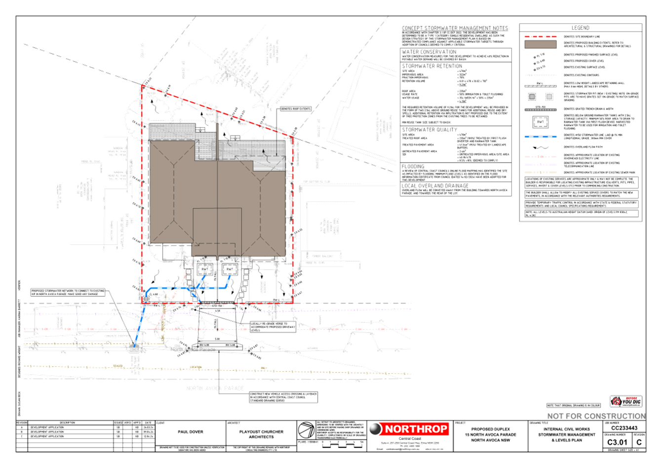
The site is identified as partially flood affected according to the Coastal Lagoons Overland Flood Study 2020. The Maximum 1% AEP flood level on site is 6.45m AHD and the maximum PMF is 6.85m AHD. The proposal includes a suitable minimum floor level of 7.12 AHD, and safe access and egress is available for future occupants. The proposal would not create additional flood impacts within the locality or any impacts to the local environment in regard to any riverbanks or watercourses within the locality.
The development if suitably designed can comply with the provisions of clause 5.21 having regard for the flood behaviour, and safe evacuation would be available to the site and in this regard risk to life could be adequately managed.
· Acid Sulfate Soils
The site is identified as containing potentially Class 4 acid sulfate soils. Any works more that 2m below the natural ground surface or works by which the watertable is likely to be lowered more than 2m below the natural ground surface requires the preparation of an acid sulfate soils management plan. The proposed development would not involve any works which would trigger the need for the preparation of an acid sulfate soils management plan given the proposal would require minimal excavation and disturbance of the ground soils. Accordingly, the Panel can be satisfied an acid sulfate soils management plan does not need to be prepared.
· Essential services
Under the provisions of Clause 7.6 of CCLEP 2022, the consent authority must be satisfied that services such as water, sewer, electricity, stormwater drainage and road access can be adequately provided or that adequate arrangements are in place for the provision of essential services. Essential services are available for the development and the Panel can be satisfied adequate arrangements are in place.
Central Coast Development Control Plan 2022
Chapter 2.2 – Dual Occupancy and Multi Dwelling Housing
The above Chapter sets out the requirements for dual occupancy developments. The proposed development has been assessed against the Chapter with a full assessment provided in Attachment 5. The assessment of the application against the controls has identified a number of variations proposed to the planning controls which are discussed below.
· Lot Size Requirements
The Chapter defers to the minimum lot size requirements for dual occupancies specified under CCLEP 2022. The CCLEP 2022 requires attached dual occupancies to be located on a lot with a minimum lot size of 550m2. The site has an area of 462m2 and as such proposes a variation of 16% to the development standard.
As previously discussed, it is considered the consent authority cannot be satisfied the applicant has adequately demonstrated compliance with the development standard is unreasonable or unnecessary and that there are sufficient environmental planning grounds to justify the contravention to the development standard.
· Floor Space Ratio
Dual occupancy developments are required to have a maximum Floor Space Ratio (FSR) of 0.5:1. The current application proposes a FSR of 0.59:1 which is a variation of 18%. The applicant has argued that the variation to the requirement is suitable as the proposal is consistent with the objectives of the Chapter relating to FSR which are as follows:
· To have development sites and densities that are appropriate in the zone and compatible with the local context.
· To ensure building bulk and site coverage provisions are compatible with neighbouring development.
· To ensure the intensity of the use of the site is appropriate.
Taking into consideration the above objectives it is not considered reasonable to support a variation to the FSR. The proposal is located within a low-density zone that permits dual occupancy development with consent; however the proposed development is not one which is considered to be compatible with the neighbouring development. The bulk and scale of the development results in privacy and overshadowing impacts to adjoining properties. The lot area and configuration are site constraints that have not been appropriately catered for in the design of the development. Moreover, there is nothing preventing a reduction in the building footprint and gross floor area to achieve compliance with the FSR controls.
· Building Setbacks (Side and Rear Setbacks)
Any part of the building that has a height of more than 4.5 metres, is to be setback 0.9m to the side boundary plus one-quarter of the height of the building above 4.5m. Given the proposal would have an overall height of 8.4m the development would be required to have a side setback of 1.875m. The proposal has a side setback of 0.9m at the ground floor and 1.65m at the first floor which would require a variation of 12% to the requirement. The applicant has stated the development complies with the side setback requirements therefore no justification has been provided for the non-compliance.
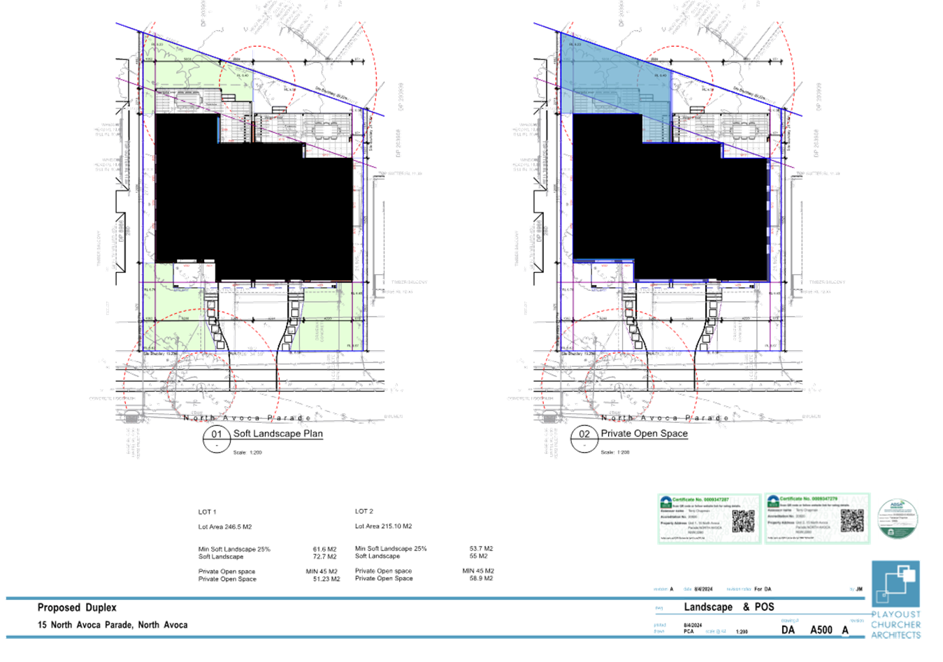
Developments are required to be setback a minimum of 4.5 metres from the rear boundary. The main dual occupancy structure is to be mostly setback in excess of 4.5 metres with setbacks between 4.7 and 6.7 metres. A portion of the first floor balcony for the northern dwelling however is only setback 3.6 metres from the rear boundary which requires a variation of 20% to the requirement.
The proposal also includes rear alfresco areas for both dwellings that are covered by a Vergola. The Vergola areas are located between 0.9 and 2.8 metres from the rear boundary. These structures result in a variation between 80% and 38% respectively. The applicant has not addressed the non-compliance of the outdoor terrace areas which form part of the overall built form.
The setback to the rear boundary is inconsistent with the building setback objectives in that the proposed setback would not ensure that the privacy of adjoining properties would be maintained. The Vergola areas appear to be between 300-400mm above the current ground level based on existing ground levels and the proposed finished floor levels. The existing boundary fencing is 1.8 metre high. Any occupants of the proposed development, sitting or standing on the outdoor terrace areas, have the potential to overlook the surrounding adjoining properties and their outdoor open space areas.
The potential height above ground level and the height of the fences would result in overlooking potential from the outdoor open space terrace areas. Although screen plantings are to be provided along the rear boundary these will take a number of years to be of a suitable height to provide screening to adjoining properties. The protrusion of the alfresco areas in the rear setback areas impact upon the ability of the rear open space areas to be utilised for future deep soil plantings and landscaping which are key objectives of the control.
There is nothing preventing a reduction in building footprint to achieve compliance with the side and rear setback controls. The non-compliance demonstrates the proposal is an over development of the site and results in amenity issues to neighbouring properties.
· Privacy
Developments are to ensure they do not create privacy issues by creating opportunities for overlooking to the internal living areas and private open spaces of adjoining properties. The proposed development includes the provision of multiple first floor balconies and raised rear alfresco areas. Balconies to be located to the front elevation on the first floor would be unlikely to create any privacy issues given they are located on the road and views would be focused to the beach behind dwellings on the opposite side of the road. There is also ample separation between these dwellings to not cause any amenity issues.
The proposal also includes the provision of two balconies at the rear of the site that are to be located on the first floor. The balconies are to be provided with either glass or metal capping balustrades. Given the location of the balconies and the balustrades proposed these areas could create potential privacy issues to both the internal and open space areas of adjoining properties. The proposed balcony for the southern dwelling meets the required rear setback however around half of the northern rear balcony is located within the rear setback area.
The tree to be retained at the rear of the site consists of sparse vegetation and as such would not provide a natural screen from the balcony and alfresco areas. New landscaping is proposed within the rear yard however the species proposed (Lilly Pilly) would take considerable time to mature and have some screening effect.
A timber screen is to be provided to the southern elevation of the Dwelling 1 rear balcony however there is still potential for the balcony to create privacy issues, both internal and external, to the property at the rear and the open space area of the property to the south. It is unclear if the rear balcony for Dwelling 2 is to have any screening as there is inconsistency with the plans as the floor plans show a glass balustrade, but the elevations appear to indicate a timber screen to the northern elevation. Given the reduced setback to the northern balcony it is unlikely that a timber screen would remove all overlooking issues should one be provided.
The adjoining dwellings contain a mixture of bedroom and living areas on the elevations that would be visible form the development site. Many of these areas have openings that face the site and would be subject to overlooking issues from the first floor balconies and potentially the ground floor terrace areas. The open space areas of the adjoining properties are also located within areas that would be subject to overlooking.
It is considered that the provision of the balconies on the first floor at the rear of the dwellings will create privacy issues both internally and external of the adjoining dwellings. The raised alfresco terraces also have the potential to create privacy areas given the potential height above ground level and the proximity to the rear boundaries.
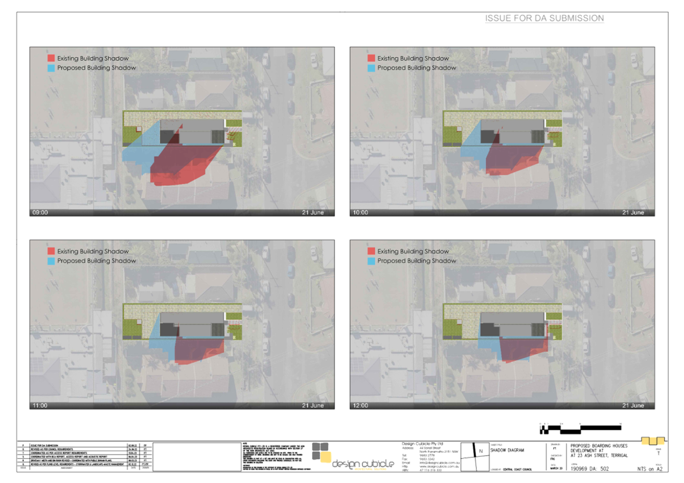
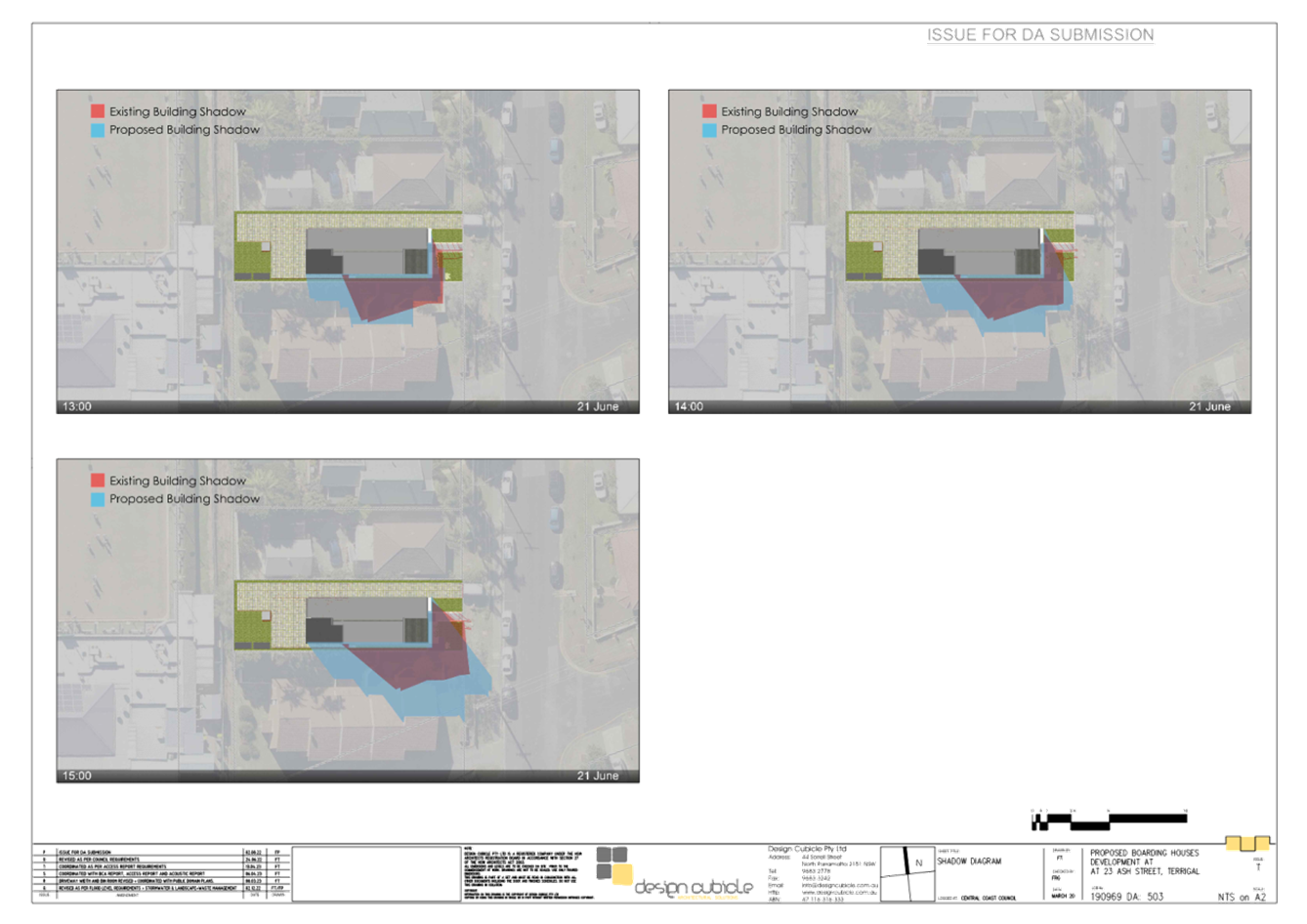
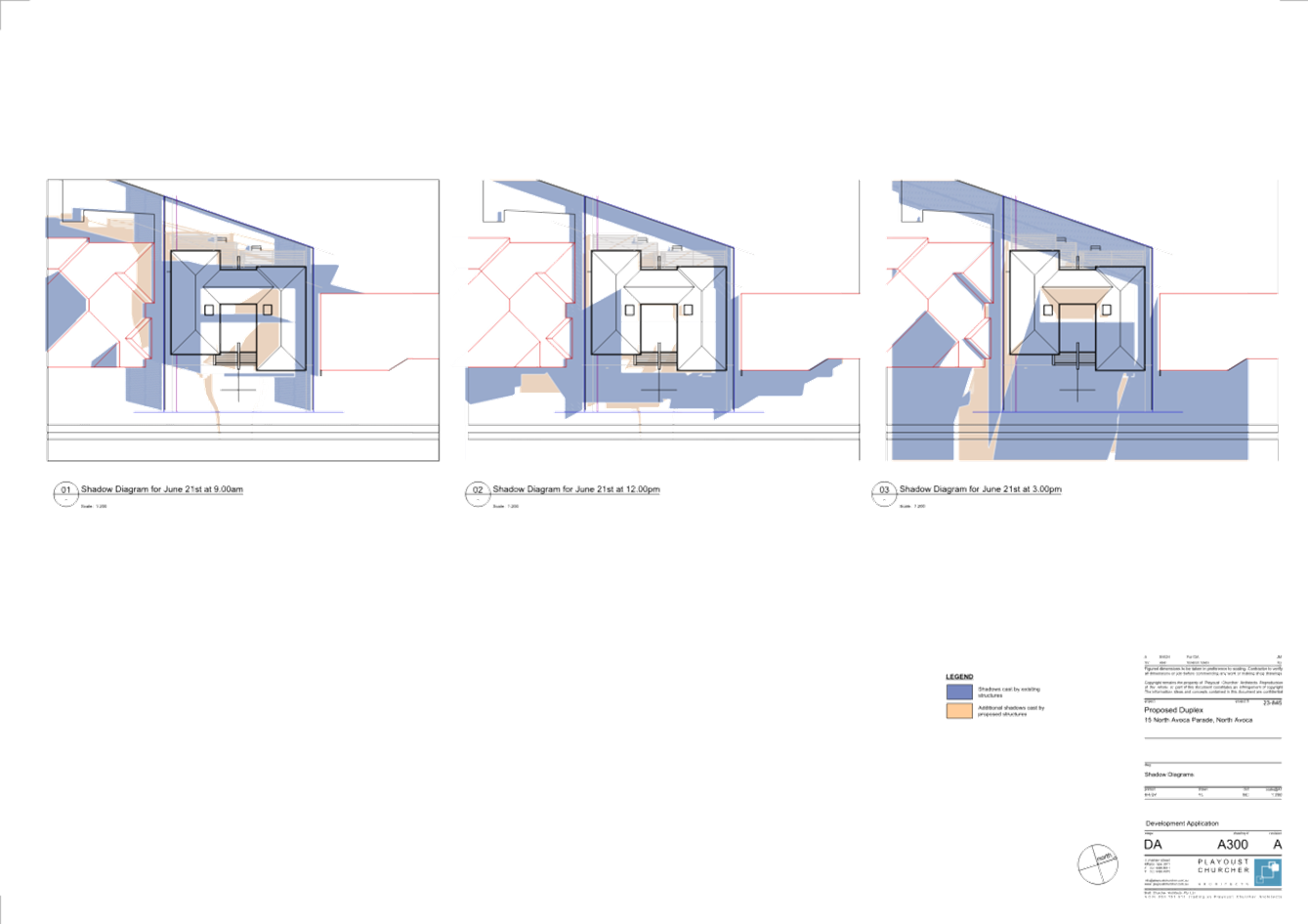
· Sunlight Access
Proposed developments are required to provide accurate shadow diagrams for two storey proposals so that potential impacts on solar access to the site and to adjoining properties can be determined. The shadow diagrams submitted do not appear to correctly indicate the extent of shadowing generated by the development, particularly the shadows generated at 9am.
An assessment of the shadow diagrams has found they do not correctly depict the shadows that would be generated by the proposal. It is likely that the proposed building would generate significant shadows over the rear of the site and adjoining property to the south however this has not been demonstrated by the images provided (shown below). The shadows from the dwellings to the north-west are also likely to cast shadows over the open space areas to the dwellings.
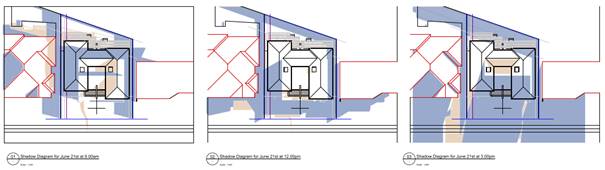
Figure 8. Shadow diagrams provided for the proposal (9am, 12 noon, 3pm).
It is considered the actual shadows that would be generated by the proposal would likely result in the open space areas for the both dwellings not receiving the required three hours of solar access between 9am and 3pm. The shadows cast from the development site would also carry across the property to the south which is likely to impact on the ability of this property to receive adequate solar access and would shadow those areas of the building located along their northern elevation.
Given the inaccuracy of the shadow diagrams, the consent authority is unable to determine the full extent of the overshadowing of the proposal within the development and to adjoining properties. Moreover, it is considered the overshadowing would be greater than that which has been depicted.
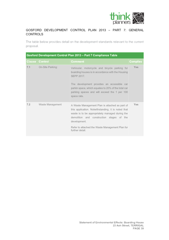
· Car parking
Each dwelling is required to provide a resident car space in the form of an enclosed parking space with minimum dimensions of 3.0m x 5.5m inside with a minimum opening of 2.7m. The proposed parking for the proposes a variation of 7% to the width and 4% to the opening. The applicant has not acknowledged the variation and as such has not provided any justification for the variation.
The proposed variation is not considered to be suitable in that the minimum garage standards are required to ensure that usable parking is to be provided for the site. Although a minor variation is proposed it is not supported as it would result in parking areas that may not be able to be suitable for the intended use and future occupants. This could lead to the spaces not been utilised and parking pushed on to the street.
Expanding the garages to meet the minimum dimensions could have flow on impacts in regard to the internal floor layouts or side setbacks. The proposed variation is therefore not considered suitable for the site and is not supported in its current form.
The variations proposed for the development under the above chapter are not considered reasonable and the applicant has failed to provide adequate justification for the variations or acknowledge variations to planning controls. It is considered the cumulative impact of the non-compliances results in an overdevelopment of the site and are not supported.
Chapter 2.17 – Character and Scenic Quality
The subject site is captured by the above chapter. The proposed development has included an assessment against the character statement for the Avoca / North Avoca area. The character statement for the area is for low-density residential that compliments the existing Bungalows within the area.
The proposed development is not considered to be in keeping with the smaller scale development of the older Bungalows however most of the newer development within the immediate locality are not of a scale that is in keeping with the Bungalow style. The proposed development is more in keeping with the newer larger scale housing developments however this type of development is not suitable for the site as the proposal fails to comply with a number of planning controls which results in an overdevelopment of the site.
Chapter 3.1 Floodplain Management and Water Cycle Management
The site is identified as partially flood affected according to the Coastal Lagoons Overland Flood Study 2020. The Maximum 1% AEP flood level on site is 6.45m AHD and the maximum PMF is 6.85m AHD. The proposal includes a suitable minimum floor level of 7.12 AHD, and safe access and egress is available for future occupants. The proposal would not create additional flood impacts within the locality or any impacts to the local environment in regard to any riverbanks or watercourses within the locality.
The proposal is considered acceptable having regard for the provisions of Part C of Chapter 3.1.
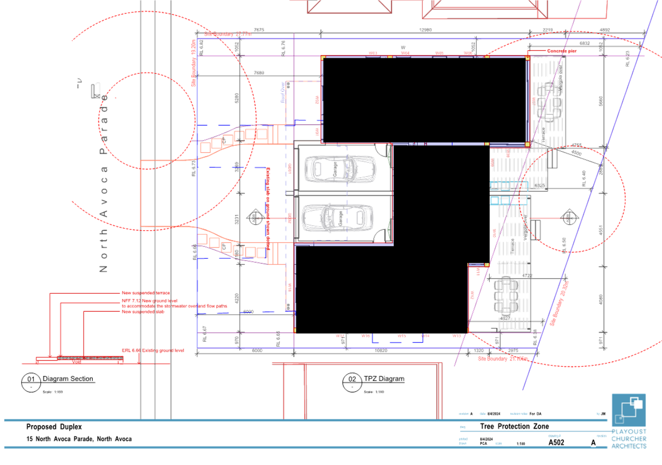
Chapter 3.5 – Tree and Vegetation Management
The site has six existing trees on the site and two within the road reserve. The application proposed the removal of five trees and the retention of the remaining three trees, with one on the site and the two within the road reserve. The application was accompanied by an arborist report that outlined the tree protection measures to be implemented on the site for the retained trees.
Although the information provided to address the tree removal and retention on the site appears to be satisfactory it has not addressed the impacts of engineering works that would be required for the proposal on the trees, particularly within the road reserve. There is the potential that future works within the road reserve, such as kerb and guttering and foot paving along with the provision of other services to be connected to the property for the proposal, could impact on the ability of the street trees to be retained. These impacts have not been considered within the arborist report and proposed plans.
Chapter 3.7 – Geotechnical Requirements for Development
The site has been identified as having a medium risk of landslip. Given the landslip risk to the site the proposal has been accompanied by a Geotechnical Investigation. The report has identified the site would be suitable for the development and has outlined construction methods for the site and identified the soil constraints of the site, the conclusion of which a development can still be built on the land.
Likely Impacts of the Development:
Built Environment
A thorough assessment of the aspects of the proposed development on the built environment has been undertaken in terms of CCLEP and DCP compliance and in terms of the submissions received. The proposal requires a number of variations in regard to the design of the development relating to floor space, setbacks, privacy and overshadowing impacts. The proposed development is considered an overdevelopment of the site given the number of non-compliances and will create undesirable impacts on adjoining properties.
Access and Transport
Access to the site is via North Avoca Parade which is an existing two-way sealed road. The existing verge is a flat grassed area that adjoins the site. There has limited kerb and guttering within the immediate locality however the adjoining properties to the south have kerb and guttering and foot paving provided to their frontages because of previous redevelopment.
Informal on street parking is available but given the narrow nature of the roadway it reduces the road to a single lane when vehicles are parked on both sides of the street. The proposal provides an enclosed garage for each dwelling however as previously discussed they do not meet the minimum dimensions required.
Given the design and length of the driveway there is no ability for vehicles to be parked in front of each garage without vehicle conflict within the driveway. This has the potential to create flow-on effects that would lead to additional vehicles parking on the road, creating further access and parking issues within close proximity to the beach.
Context and Setting
The proposed development is to be located within an existing residential area with most of the residential development consisting of single detached dwellings and a number of dual occupancy developments. The proposed new development is of a bulk and scale that is contrary to the dual occupancy planning controls and is not sympathetic to the amenity of neighbouring properties.
Natural Environment
The site has eight existing trees located on the site and within the road reserve. The proposal has identified the retention of three trees, one in the rear and two within the road reserve.
The retention of the trees within the road reserve are unlikely to be retained given the extent of roadworks that would be required if consent was granted. The proposal may also require the connection to additional services, such as drainage, that could impact on the trees. The arborist report has not considered the engineering implications of the retention of the trees that are located within the road reserve. The actual impacts of the development on the existing vegetation are therefore not able to be gauged at the present time.
Suitability of the Site for the Development:
Whether the proposal fits in the locality.
The proposed development will be in an area that is dominated by large scale dwelling houses and dual occupancy developments. The design of the development fails to comply with the dual occupancy planning controls relating to lot size, setbacks, FSR, privacy and overshadowing impacts, the cumulative impact of which results in an over-development of the site. Whilst the lot size cannot be rectified, the other controls have the potential to be achieved by a reduction in the building footprint.
The Public Interest: (s4.15C(1)(e)):
Any Submission made in Accordance with this Act or Regulations
The application was notified in accordance with DCP 2013 – Chapter 1.2 Notification of Development Proposals with seven submissions being received. The general issues raised in relation to the proposal are included below.
· The application has provided insufficient information to allow an assessment of the impacts of the proposal.
Comment: The application has submitted sufficient information for notification which is consistent with the information notified for other applications. No further details have been provided in relation to what information the submitter believes was missing from the exhibition.
· The proposed development is not suitable for the site given it does not meet the minimum lot size required under the CCLEP 2022.
Comment: Agreed. As discussed within the report there has been insufficient justification provided to support the proposed contravention to the minimum lot size.
· The proposal does not meet the lot size requirements and FSR requirements for the site and no suitable justification provided.
Comment: Agreed.
· There is no planned residential density for the locality and the site is within a low-density residential area and not a higher density area.
· Comment: The proposed development is for a dual occupancy development which is permissible within the R2 zone under the CCLEP. The site however is not of a suitable size for the dual occupancy as anticipated under the LEP and strategic planning for the Local Government Area. The overdevelopment of the site would create an undesirable precinct for the locality to encourage other non-compliant development.
Comment: The number of variations proposed is not considered suitable and support of the variations proposed could create an undesirable precedent for the quality of development within the locality
· The proposed floor levels do not appear to be consistent with the flood construction requirements for the site.
Comment: The site is flood prone land however the proposed minimum floor level is considered to be satisfactory and the proposal satisfies the requirements of Clause 5.21 of the CCLEP.
· First floor balconies would overlook adjoining property open space areas and internal areas.
Comment: The location and setback of the ground floor terrace areas and first-floor balconies has the potential to create overlooking issues to adjoining properties. The balconies have been provided with insufficient measures to manage the potential privacy impacts to adjoining properties. The non-compliance with building setbacks also contributes to this issue.
· The dividing wall in the rear open space area could impact on the retained tree at the rear of the site.
Comment: The proposed wall has been considered in the arborist report with construction requirements provided to ensure the tree can be retained and protected during construction.
· The non-compliant side setbacks have the potential to create overshadowing impacts to the south. The shadows generated would impact the southern property for the whole day.
Comment: Agreed. The shadow diagrams provided do not allow suitable assessment of the shadow impacts however t is likely that there would be significant shadow impacts to the property to the south.
· The proposal has the potential to create additional parking impacts within the locality which are already prevalent.
Comment: The proposed development has proposed parking in accordance with the requirements.
· The proposal could be utilised for short-term rental creating impacts in the locality from such a use.
Comment: Any future use of the site for short term rental accommodation would be required to operate in accordance with the relevant requirements.
Internal Consultation
|
Development Engineer |
Supported subject to conditions |
||
|
Tree Assessment Officer |
Supported subject to conditions. |
||
|
Flooding Engineer |
Supported subject to conditions. |
External Consultation
|
Ausgrid |
No objections. The application was referred to Ausgrid under Section 2.48 of SEPP (Transport and Infrastructure) 2021. Ausgrid advised that a decision was not required subject to appropriate construction techniques being undertaken for the proposal. |
Ecologically Sustainable Principles:
The proposal has been assessed having regard to ecologically sustainable development principles and if granted consent, has the appropriate BASIX certificates to ensure sustainable measures are incorporated into the design of the development and to incorporate satisfactory stormwater, drainage and erosion control and the retention of vegetation where possible and is unlikely to have any significant adverse impacts on the environment and will not decrease environmental quality for future generations. The proposal does not result in the disturbance of any endangered flora or fauna habitats and is unlikely to significantly affect fluvial environments.
Other Matters for Consideration:
Section 7.12 Contributions (formerly Sections 94 and 94A Contributions)
Given the value and type of works proposed, Section 7.12 contributions would apply.
Conclusion:
The proposal has been assessed using the heads of consideration under Section 4.15 of the Environmental Planning and Assessment Act 1979. The proposed development does not satisfactorily meet the requirements of the CCLEP 2022 or the CCDCP 2022, has unsatisfactory adverse impacts, is deemed unsuitable for the site, and is not in the public interest.
In accordance with clause 4.6, the applicant has not demonstrated the development standard is unreasonable or unnecessary in the circumstances, nor have they demonstrated there are sufficient environmental planning grounds to justify the contravention of the development standard.
It is considered the Panel, as the consent authority, cannot reach the appropriate state of satisfaction as required by clause 4.6. Accordingly, the proposal should be refused for the following reasons:
1. The bulk and scale of the proposed development results in an over development of the site given the non-compliance with DCP requirements that demonstrate a building of this size cannot fit on this lot. Accordingly, the Panel cannot be satisfied the proposal satisfies the provisions of s.2.11(1)(c) of State Environmental Planning Policy (Resilience and Hazards) 2021.
2. The proposal does not comply with the 550m2 minimum lot size development standard for attached dual occupancy development as required under Clause 4.1B of Central Coast Local Environmental Plan 2022.
3. The applicant’s Clause 4.6 written request to vary clause 4.1B of Central Coast Local Environmental Plan 2022, has not adequately demonstrated that compliance with the standard is unreasonable or unnecessary in the circumstances of the case.
4. The applicant’s Clause 4.6 written request to vary clause 4.1B of Central Coast Local Environmental Plan 2022, has not adequately demonstrated that there are sufficient environmental planning grounds to justify a contravention to the development standard.
5. The Panel, as the consent authority, cannot reach a level of satisfaction that the applicant has demonstrated compliance with the development standard is unreasonable or unnecessary in the circumstances, and that there are sufficient environmental planning grounds to justify a contravention of the development standard.
6. The proposal fails to comply with Clause 2.2.4.2 of Central Coast Development Control Plan 2022, as the proposal exceeds the maximum floor space ratio for dual occupancy development which contributes to the excessive bulk and scale of the development.
7. The proposal fails to comply with the building setback requirements in Clause 2.2.5 of Central Coast Development Control Plan 2022, which contributes to amenity issues to adjoining properties and additional bulk and scale of the built form.
8. The proposal fails to comply with Clause 2.2.7.2 of Central Coast Development Control Plan 2022, as the proposal creates amenity issues to adjoining properties by way of privacy and overlooking.
9. The proposal fails to comply with Clause 2.2.7.5 of Central Coast Development Control Plan 2022, as the shadow diagrams indicate unacceptable overshadowing within the property and to adjoining developments, and the deficiencies with the shadow diagrams may not be depicting the true extent of overshadowing that will be experienced both within the development and to adjoining properties.
10. The proposal fails to comply with Clause 2.2.8.1 of Central Coast Development Control Plan 2022, as the proposal does not meet the minimum dimensions required for enclosed garages.
11. The proposal is not in the public interest.
|
Architectural Plans - FULL SET - PAN-432812 - 15 North Avoca Parade, NORTH AVOCA - DA/690/2024 |
|
D16190989 |
|
|
Statement of Environmental Effects - PAN-432812 - 15 North Avoca Parade, NORTH AVOCA - DA/690/2024 |
|
D16211456 |
|
|
PUBLIC - Clause 4.6 Request - PAN-432812 - 15 North Avoca Parade, NORTH AVOCA - DA/690/2024 |
|
D16211460 |
|
|
PUBLIC - Arborist Report - PAN-432812 - 15 North Avoca Parade, NORTH AVOCA - DA/690/2024 |
|
D16190974 |
|
|
Assessment against CCDCP Chapter 2.2 - DA/690/2024 - 15 North Avoca Parade NORTH AVOCA |
|
D16845893 |
|
3.1 |
DA/690/2024 - Attached Dual Occupancy and Demolition - 15 North Avoca Parade, NORTH AVOCA |
|
Attachment 6 |
Architectural Plans - FULL SET - PAN-432812 - 15 North Avoca Parade, NORTH AVOCA - DA 690 2024 - REDACTED |

|
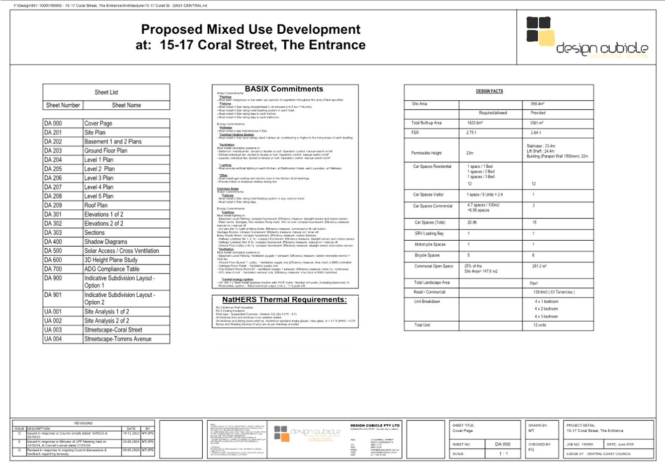
Item No: 4.1 |
|
|
Title: Supplementary Report - DA/1809/2022 - 15-17 Coral Street, The Entrance - Construction of a 6 Storey Shop Top Housing development with Basement Level parking |
|
|
Department: Environment and Planning |
|
|
19 June 2025 Local Planning Panel Meeting |
|
Reference: DA/1809/2022 - D16449479
Author: Jenny Tattam, Senior Development Planner.Employment and Urban Release
Section Manager: Emily Goodworth, Section Manager Employment and Urban Release
Unit Manager: Andrew Roach, Unit Manager Development Assessment
1 That the additional information be considered in the Panel’s determination of the application.
2 In the event that the Local Planning Panel are of the view that sufficient information has been submitted to address the particulars of the Panel Decision in the Minutes of the Local Planning Panel Meeting dated 14 March 2024, the Panel approve Development Application no. DA/1809/2022 at 15-17 Coral Street, The Entrance, subject to the conditions detailed in the schedule attached to this report.
3 That Council advise those Government Agencies who made written submissions of Council’s decision.
Summary
The subject development application seeks consent for the construction of a six storey shop top housing development and basement level car parking. The application has been examined having regard to matters for consideration detailed under Section 4.15 of the Environmental Planning and Assessment Act 1979 and other statutory requirements.
The Local Planning Panel considered the matter at its meeting of 14 March 2024 (Report included as Attachment 1). The matter was deferred at the meeting pending the submission of supplementary information regarding:
b. The opportunity for the Applicant to dedicate the existing rear Right of Way to Council as a public road, like other sites to the east.
c. Confirmation whether de-watering is required for the site and whether this would trigger the need for approval by WaterNSW.
d. Removal of the ground level corner planter retaining wall and planting, with paving to match the footpath treatment, to improve sightlines for pedestrians and motorists.
e. The willingness of the applicant to include EV charging points or stations in the basement parking spaces for units, to allow future charging of EV vehicles.
This Supplementary Report provides a response to the above listed items (a -e).
The application is recommended for approval subject to recommended conditions.
Precis
|
Application Number |
DA/1809/2022 |
|
Applicant |
Design Cubicle Pty Ltd |
|
Owner |
Mr M Rammal and Mr A A Nasrallah |
|
Property Lot and DP |
Lot 2 DP 25544, Pt Lot 1 DP 25544 |
|
Property Address |
15-17 Coral Street, The Entrance, NSW 2261 |
|
Proposal |
Consolidation of two (2) allotments and construction of a six (6) storey shop top housing development. |
|
Application Type |
Development Application – Local |
|
Site Area |
1,093m2 |
|
Zoning |
B2 – Local Centre |
|
Existing Use |
Vacant |
|
Employment Generating |
No |
|
Application Lodged |
6 September 2022 |
|
Estimated Value |
$6,00,496.00 |
|
Exhibition |
23 September to 19 October 2022 inclusive Renotified as Nominated Integrated Development under Water Management Act 2000 from 19 April to 20 May 2024. |
|
Submissions |
Nil |
|
Disclosure of Political Donations & Gifts |
No |
|
Site inspection |
14 December 2022 |
Background
The Panel considered a Planning Assessment Report on the matter at its meeting on 14 March 2024 and resolved as follows:
|
Panel Decision |
1. The Local Planning Panel defer determination of DA/1809/2022 – 15-17 Coral Street, The Entrance, for construction of a six (6) storey shop top housing development and basement level car parking, for subsequent determination of a Panel at a future meeting, comprising the same Panel members, as far as is practicable and as soon as practicable. This future meeting may be by electronic means. A further report is to be provided to that Panel that addresses the following matters: |
|
|
(a) Confirmation the written consent of all owners of land to which the development application relates has been provided with the DA. (b) The opportunity for the Applicant to dedicate the existing rear Right of Way to Council as a public road, like other sites to the east. (c) Confirmation whether de-watering of the site is needed, and whether this would trigger the need for approval by WaterNSW; (d) Removal of the ground level corner plater retaining wall and planting, with paving to match the footpath treatment, to improve sightlines for pedestrian and motorists. (e) The willingness of the applicant to include EV charging points or stations in the basement parking spaces for units, to allow future charging of EV vehicles |
|
Reasons |
While the Panel was conceptually supportive of granting approval, there was a key uncertainty regarding whether the written consent of all owners of land “to which the development application relates” has been provided, particularly related to the vehicular access to and from the site potentially over adjoining land. The Panel also noted that a number of developments to the east have or will dedicate a rear Right of Way (“RoW”) as a public road, to allow public access and future extension of Farrell Lane, which seems an appropriate outcome for this site.
In terms of the ground level corner treatment, the intersection is a busy one and this has resulted in appropriate setbacks and corner treatment to the north. The Panel therefore supports the removal of Palms closest to the intersection and new street planting. For the same reasons, the proposed ground level planter box and retaining wall should be removed, with matching paving, which may also allow use as seating or dining, as long as it does not interfere with the intention of this condition.
Other more minor matters warranted consideration and clarification, as outlined in the terms of the decision above. The Panel noted there were no written submissions received by Council regarding the proposal. |
Please find below a response to the matters raised by the Panel.
(a) Owners Consent
The subject site is located on the corner of Coral Street and Torrens Avenue intersection within The Entrance town centre. The site is burdened by a 3.6m wide right of carriageway (ROW) along the rear of the site (known as Farrell Lane) which is shared with the adjoining properties that also front Coral Street (refer to Figure 1 below). Informal two-way access is currently provided along the ROW.
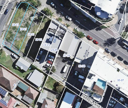
Figure 1: Aerial view showing properties that share the ROW (Farrell Lane)
The proposal includes vehicular access to the basement parking facilities provided via a new entry/exit driveway located at the eastern end of the ROW site frontage at the rear of the site.
Because the 3.6m wide ROW is not wide enough to allow two cars to pass, the original proposal requested restricting traffic flow in the ROW to one-way eastbound only, such that all turning movements into/out of the development would be restricted to left-in/left-out. This would require all development traffic to approach from Torrens Avenue and depart via Farrell Lane back to Victoria Avenue. Figure 2 below shows the surrounding street network.
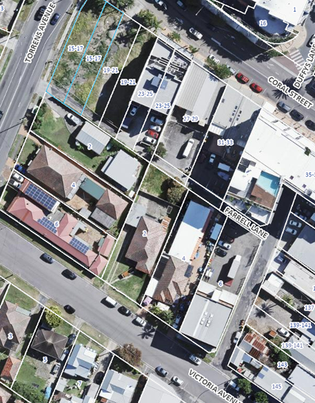
Figure 2: Existing street network around the site
In their reasons, the Panel noted they were uncertain as to whether the written consent of all owners of the ROW was required, to enable vehicular access to and from the site over adjoining land as proposed.
Further investigation of this issued revealed the difficulty in making the ROW one direction. Farrell Lane comprises eight lots (or part of) and each of those lots is burdened and/or benefitted by the existing easement, which does not limit the ROW to one way. A DA which proposes to make “Farrell Lane” would require a change to the terms of the easement with the consent of all those who benefit from the easement.
On 3 April 2025 the applicant amended the proposal such that vehicles would enter and exit the site from Torrens Avenue without the need to travel further along Farrell Lane. This removed the need to make the ROW one-way. As such, changes were required to the plans to provide widening to the laneway to enable two-way use on this section of the ROW.
On 9 May 2025 the applicant provided amended plans which now show the rear portion of the Ground Floor has been re-designed between the rear boundary and residential lobby, to incorporate a wider 6m start to the laneway to enable a car to sit and wait. This 6m segment of laneway then transitions back to the existing 3.6m width of the existing ROW within the boundaries of the subject site. The driveway design to the basement has not been altered in any way. A revised Landscape Plan was also provided to reflect the latest Ground Floor design.
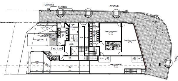
Figure 3: Original ground floor plan
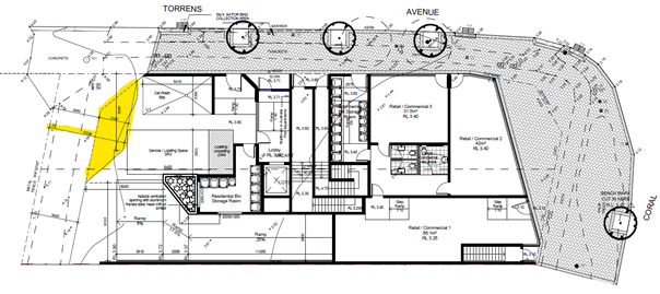
Figure 4: Amended ground floor plan
Swept path diagrams were provided by the applicant’s traffic engineer to illustrate vehicle manoeuvring within the laneway and development when multiple cars are entering or exiting the site at the same time. The revised plans included swept paths which have been reviewed by Council’s Senior Development Engineer and considered acceptable.
With the above amended proposal, the applicant has demonstrated that access to and from the development can be accommodated within their own site with no reliance on any parts of the ROW or adjoining properties. Therefore, because the development is not proposing to utilize any other land for the purposes of access, consent from beneficiaries of the ROW is not required.
The application is accompanied by the consent of the owners of the subject site, and this satisfies section 4.12 of the EPA Act and section 23 of the EPA Regulation 2021.
(b) Dedication of Right of Way
In the reasons for their decision on 14 March 2024 the Panel noted that a number of developments to the east have or will dedicate a rear Right of Way (ROW) as a public road, to allow public access and future extension of Farrell Lane, which seems an appropriate outcome for this site and adjoining developments.
The applicant has agreed to dedicate that portion of the ROW that is within their site, as part of the proposed development. Consent can be granted to a development application for subdivision which proposes the dedication of roads under section 9 of the Roads Act 1993 without the need for a planning agreement or section 7.11 condition. Section 9 of the Roads Act provides that:
9 Public road created by registration of plan
(1) A person may open a public road by causing a plan of subdivision or other
plan that bears a statement of intention to dedicate specified land as
a public road (including a temporary public road) to be registered in the
office of the Registrar-General.
(2) On registration of the plan, the land is dedicated as a public road.
Where land is dedicated as a public road, the council for the local government area in which the road is located becomes the owner of the road.
The applicant has proposed:
· dedication of the land matching the existing ROW (nominated as lot 2 on the plan below) as a public road under the provisions of Section 9 of the Roads Act 1993; and
· for the land indicated as (A) on the plan below, which constitutes the widened area required to facilitate two-way access, nominated this as an easement in gross for public right of way/right of carriageway to the benefit of Council.
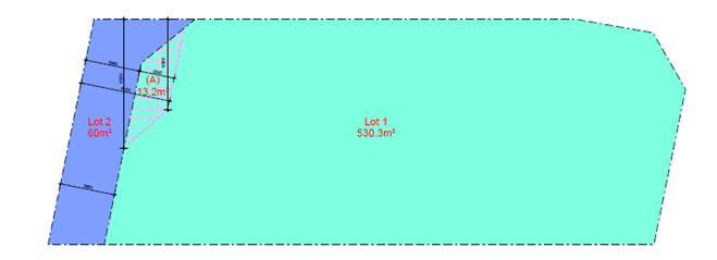
Figure 5: Indicative subdivision layout
If the entire ROW becomes dedicated as a public road in the future, then the widened entry section would be surplus to requirements. Council would have the ability to then extinguish the easement no longer required and the owners of the subject site would retain ownership of that portion of the land.
A recommended condition of consent requires dedication of the ROW and creation of an easement in gross prior to issue of an Occupation Certificate.
(c) Water NSW approval
Following the Panel meeting on 14 March 2024 the application was referred to Water NSW via the NSW Planning Portal.
On 18 September 2024 Water NSW issued General Terms of Approval (GTAs) for the development. The GTAs confirm that the applicant must obtain an approval for dewatering under the Water Management Act 2000 prior to commencement of any works.
The GTAs are incorporated into the recommended conditions of consent.
(d) Removal of ground level corner planter
The Panel requested that the proposed ground level planter box and retaining wall be removed and the area paved to match the footpath treatment to improve sightlines for pedestrian and motorists at the intersection.
Figure 3 below shows the original Ground Floor plan with planter box and retaining wall at the front of the development.
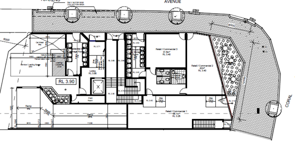
Figure 6: Original Ground Floor with planter box and retaining wall
The applicant amended the proposed plans by removing the ground level planter box and associated retaining walls at the intersection of Coral Street and Torrens Avenue to improve sightlines for pedestrians and motorists. In addition, this area has been revised to show paving which matches and ties in with the proposed footpath treatment surrounding it. Refer to Figure 4 below.
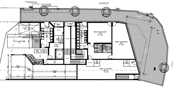
Figure 7: Revised Ground Floor plan showing removal of planter box and retaining walls
and replacement with paving
The proposed Landscape Plan was also updated to reflect the above changes.
(e) EV charging stations.
The Panel requested that the applicant consider the inclusion of EV charging points or stations in the basement parking spaces for units, to allow future charging of EV vehicles. The applicant has provided a response to this matter as follows:
In relation to the issue of allowing future charging of EV vehicles in the basement, we would like to point out this is covered in the latest National Construction Code (NCC), specifically NCC 2022 Volume 1, which governs the development. According to Clause J9D4 (1)(a), a carpark associated with a Class 2, 3, 5, 6, 7b, 8 or 9 building must be provided with electrical distribution boards dedicated to electric vehicle charging, in accordance with Table J9D4 in each storey of the carpark. In addition, Clause J9D4 (2)(e) states electrical distribution boards dedicated to serving electric vehicle charging in a carpark must be sized to support the future installation of a 7kW (32A) type 2 electric vehicle charger in 100% of the car parking spaces associated with a Class 2 building, & 10% of car parking spaces associated with a Class 5 or 6 building.
By way of further reference, Table J9D4 referenced earlier sets out that for 0-9 carpark spaces per storey for electric vehicles, no electrical distribution boards are required, as a minimum of 10 spaces per storey is required to necessitate the requirement of a dedicated electrical distribution board per storey for EV charging.
Based on all this information above referenced from NCC 2022, whilst EV charging points themselves are not yet required to be allocated in the design, the development does require provisions for the future installation of EV charges in the carparking spaces of 100% of the residential units (Class 2), & 10% of the commercial / retail tenancies (Class 5 or 6). As there are only 2x commercial / retail parking spaces, & the remainder are residential, essentially every space will be required to support future EV charging, & we would anticipate allocating it to both these commercial / retail spaces as well, so that all parking spaces in the development were covered. Furthermore, whilst there are only 8x parking spaces per basement level, thereby not triggering the requirement for separate electrical distribution boards per level for future EV charging, we have nevertheless shown 1x electrical distribution board per level for EV charging if required.
If the separate electrical distribution boards are not required, the main power distribution board in the development would have sufficient capacity to accommodate the future EV chargers required. Please refer to Revised Architectural Plans (Issue E) for further details, where notations relating to the Electrical Distribution Boards for electric vehicle charging (EVC) have been incorporated. As a result, no matter which way the electrical requirements are resolved in the Construction Certificate, both Council & the Panel can rest assured that future EV charging will be supported in the development as per the governing requirements of NCC 2022, which already comprehensively covers this topic.
Other
Contributions
Condition 2.13 which levied the payment of contributions is recommended to be updated from the original report to the Local Planning Panel on 14 March 2024. Since then, contribution rates have been indexed and accordingly, the condition relating to contributions has been updated in the revised conditions of consent and is now Condition 2.12. (Attachment 2).
Conclusion
This Supplementary Report has addressed the matters requested by the Panel in their deferral of the determination of DA/1809/2022 on 14 March 2024. The questions raised by the Panel have been addressed and no further issues or impacts have arisen.
It is therefore recommended that Development Application No. DA/1809/2022 for construction of a six storey shop top housing development with basement level carparking at 15-17 Coral Street, The Entrance be APPROVED pursuant to Section 4.16(1)(a) of the Environmental Planning and Assessment Act 1979 subject to the revised recommended draft conditions of consent attached to this report.
|
Report to LPP 14 March 2024 - DA/1809/2022 - 15-17 Coral Street, The Entrance |
Provided Under Separate Cover |
D16840356 |
|
|
Draft conditions/reasons - 15-17 Coral Street, THE ENTRANCE NSW 2261 - DA/1809/2022 - Central Coast Council |
Provided Under Separate Cover |
D16062040 |
|
|
3⇩ |
Final Revised Architectural Plan Set - DA 1809 2022 - 15-17 Coral Street, The Entrance - REDACTED |
|
D16888173 |
|
Final Revised Architectural Plan Set - DA/1809/2022 - 15-17 Coral Street, The Entrance |
Provided Under Separate Cover |
D16840175 |
|
|
Portal Doc - 15-17 Coral Street, THE ENTRANCE NSW 2261 - DA/1809/2022 - Landscape plan - Revised Landscape Plans - Revision D - 15-17 Coral Street, The Entrance.pdf - |
Provided Under Separate Cover |
D16828477 |
|
|
Water NSW General Terms of Approval - DA/1809/2022 - 15-17 Coral Street, The Entrance |
Provided Under Separate Cover |
D16828522 |
|
4.1 |
Supplementary Report - DA/1809/2022 - 15-17 Coral Street, The Entrance - Construction of a 6 Storey Shop Top Housing development with Basement Level parking |
|
Attachment 3 |
Final Revised Architectural Plan Set - DA 1809 2022 - 15-17 Coral Street, The Entrance - REDACTED |
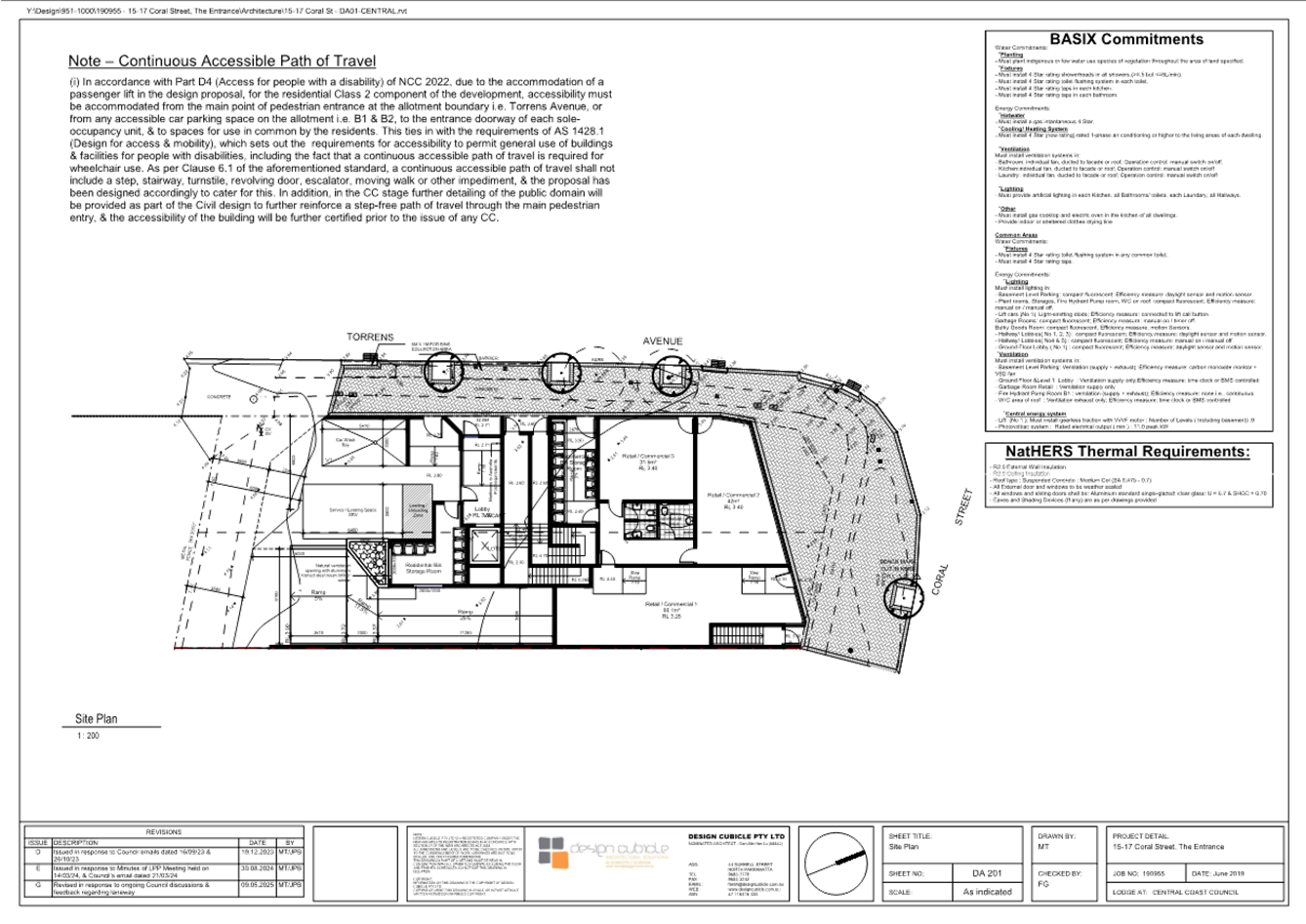
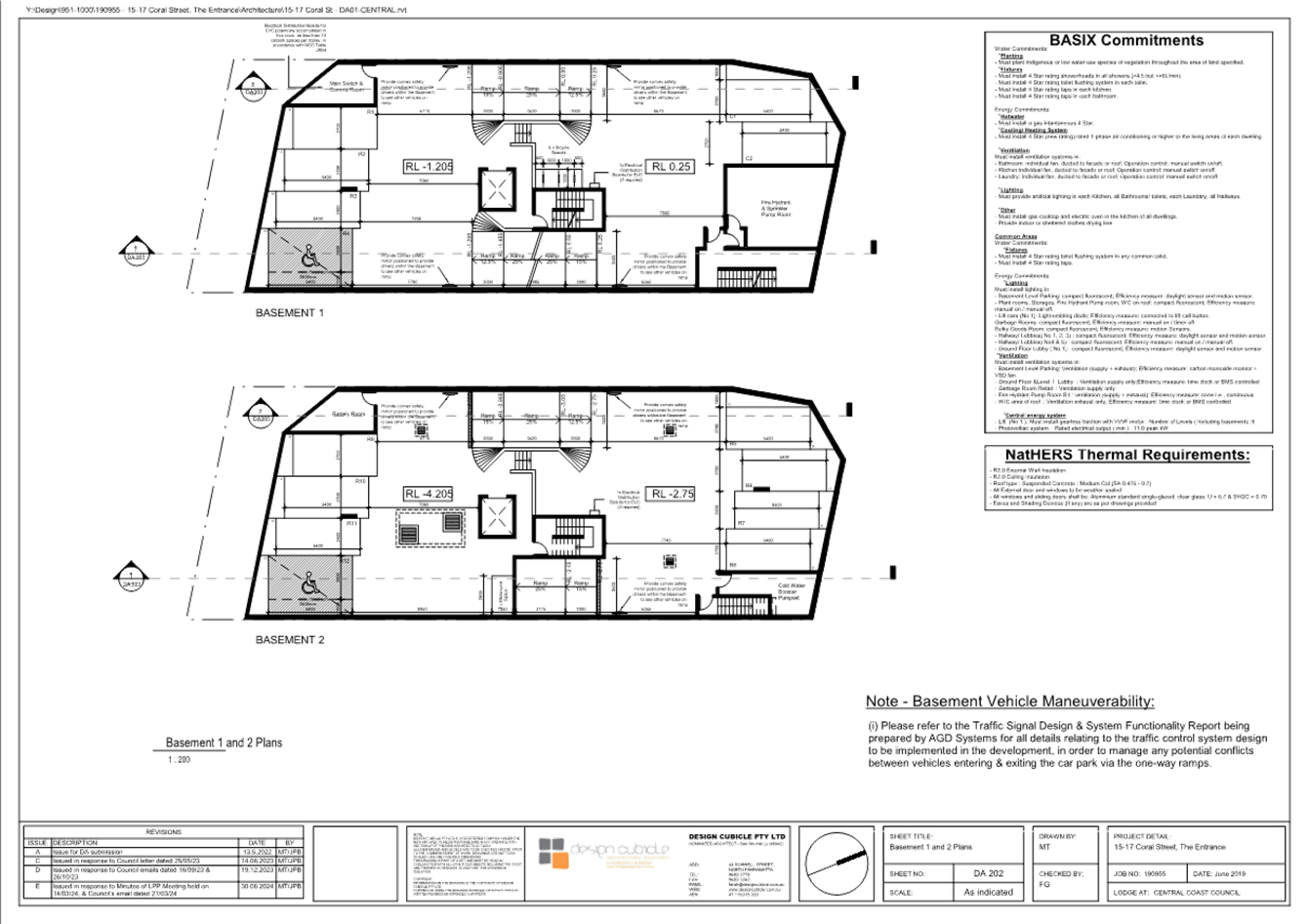
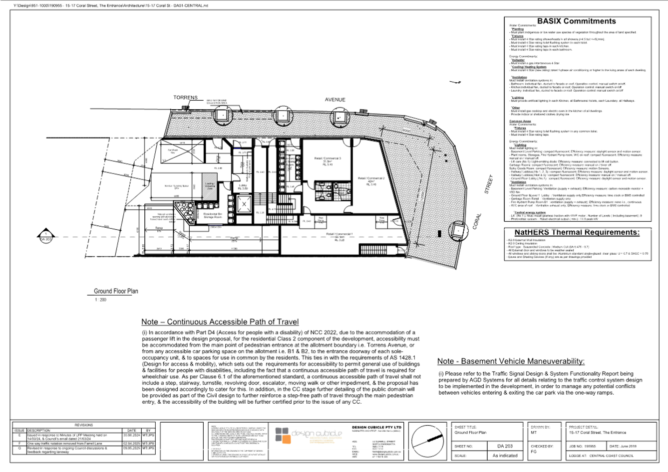
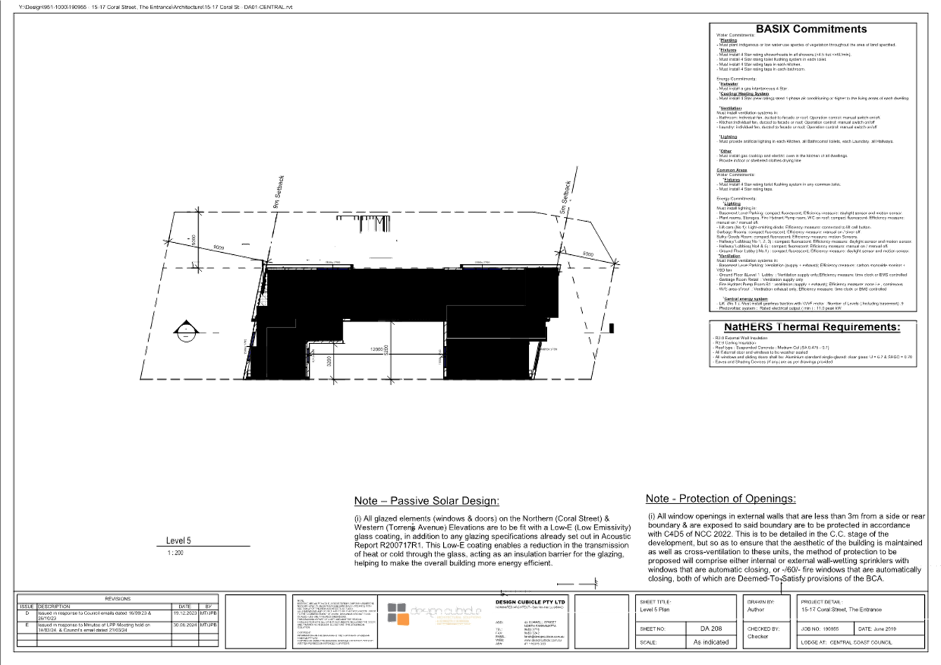
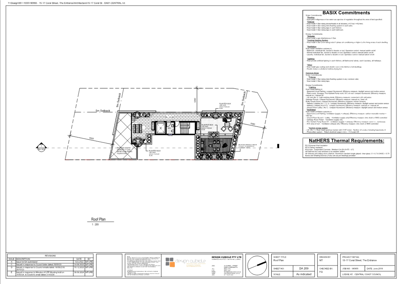
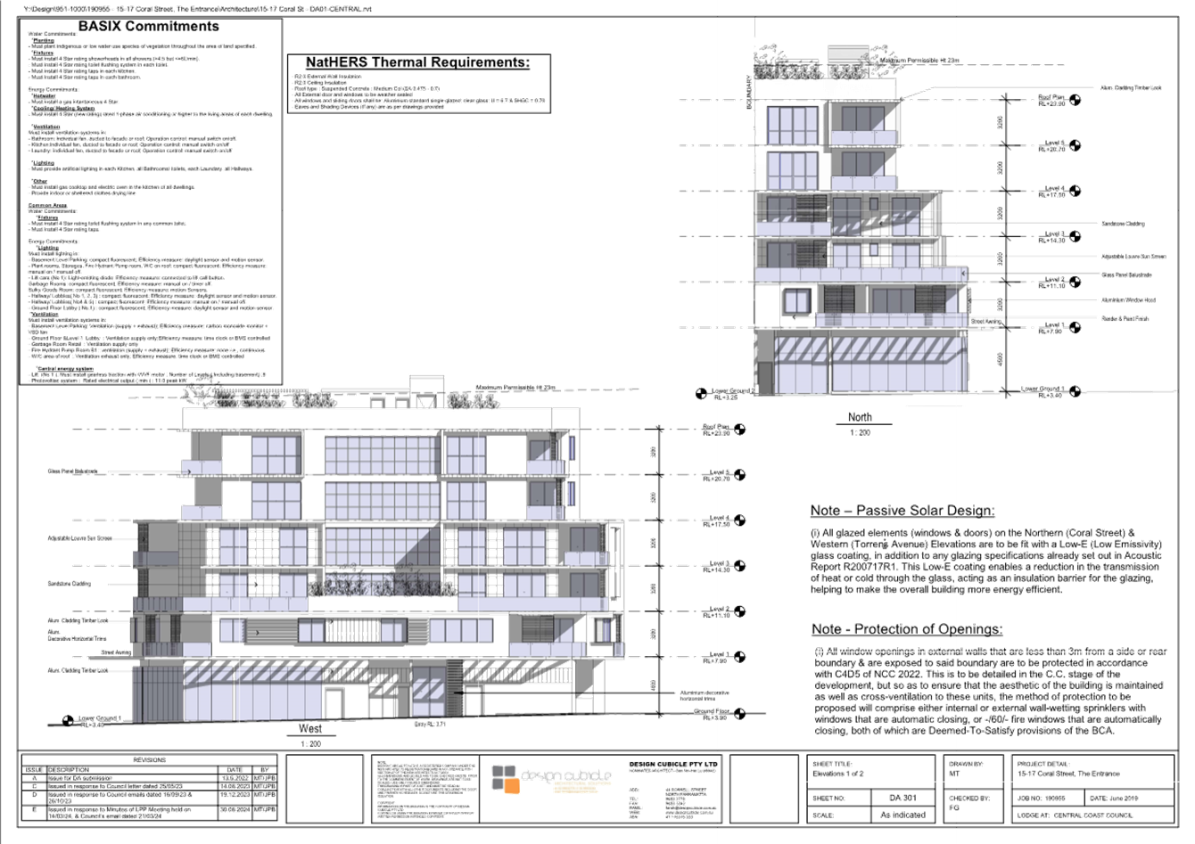
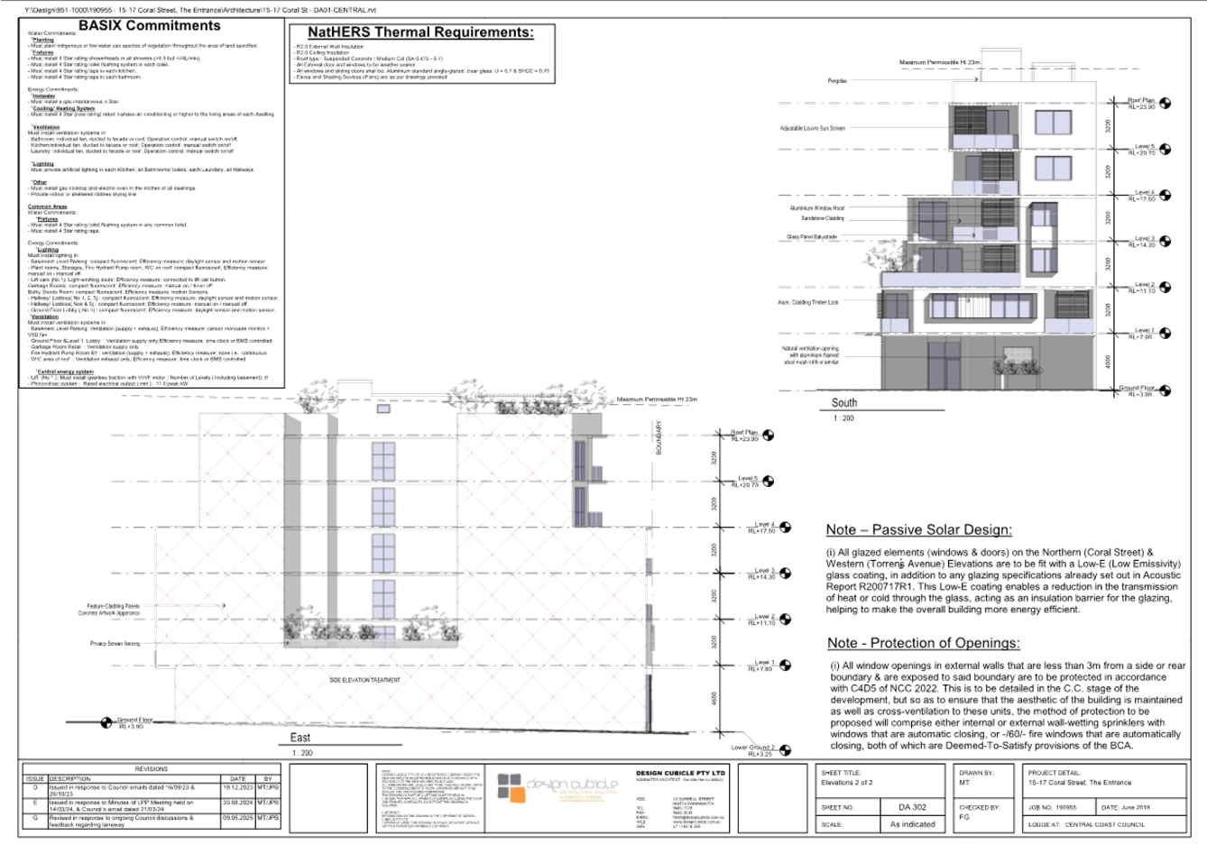
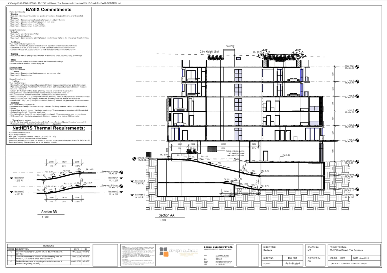
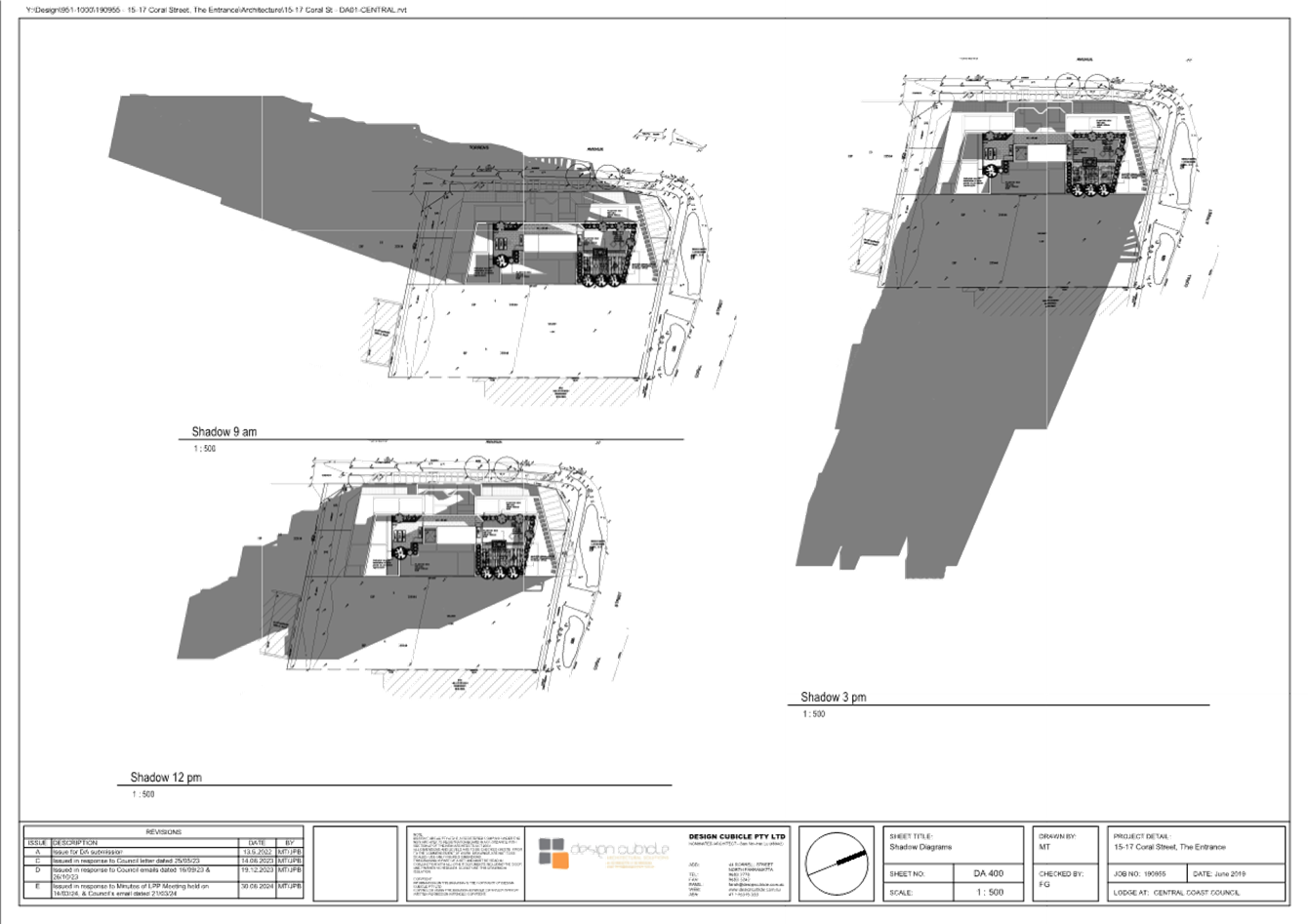
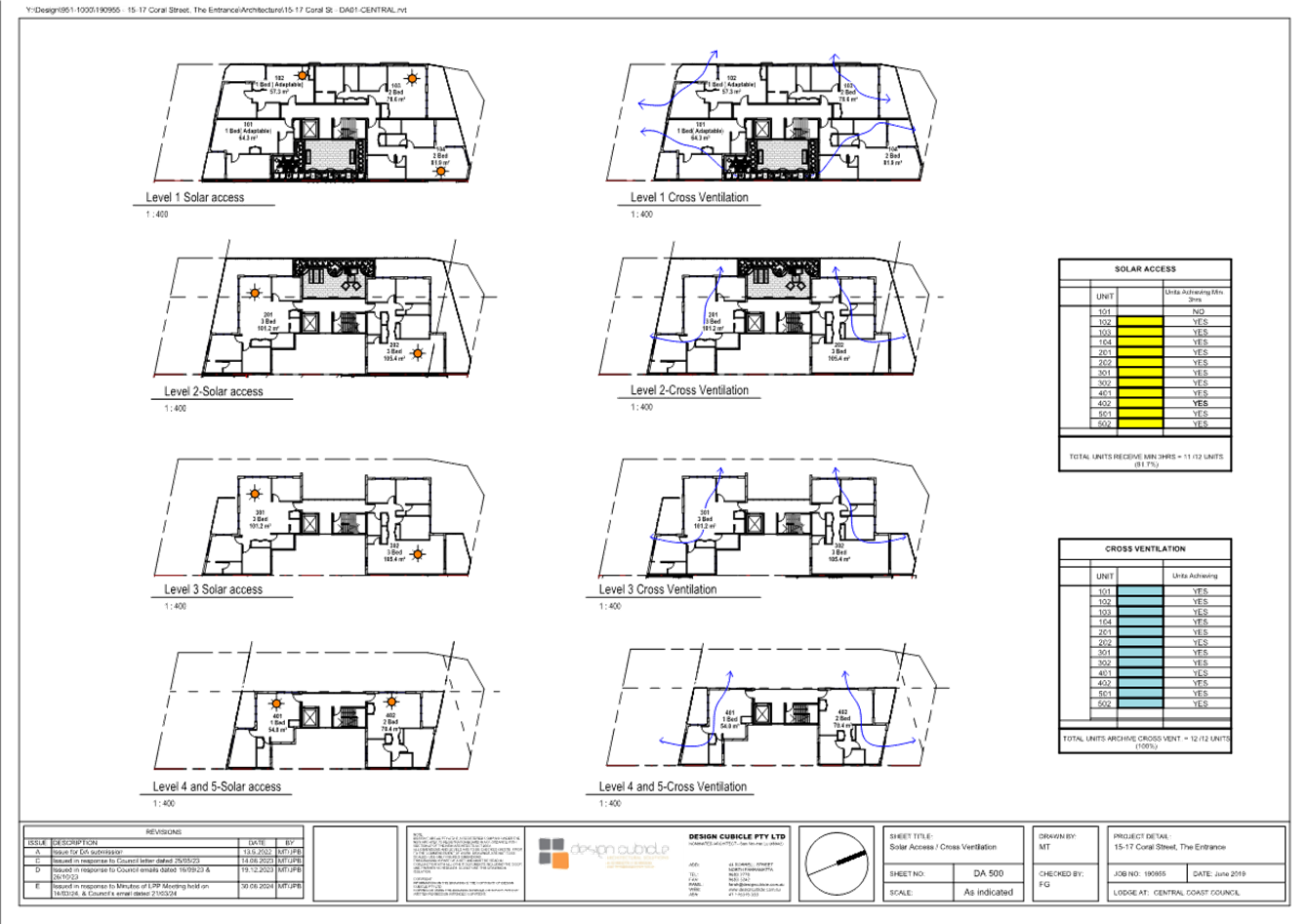
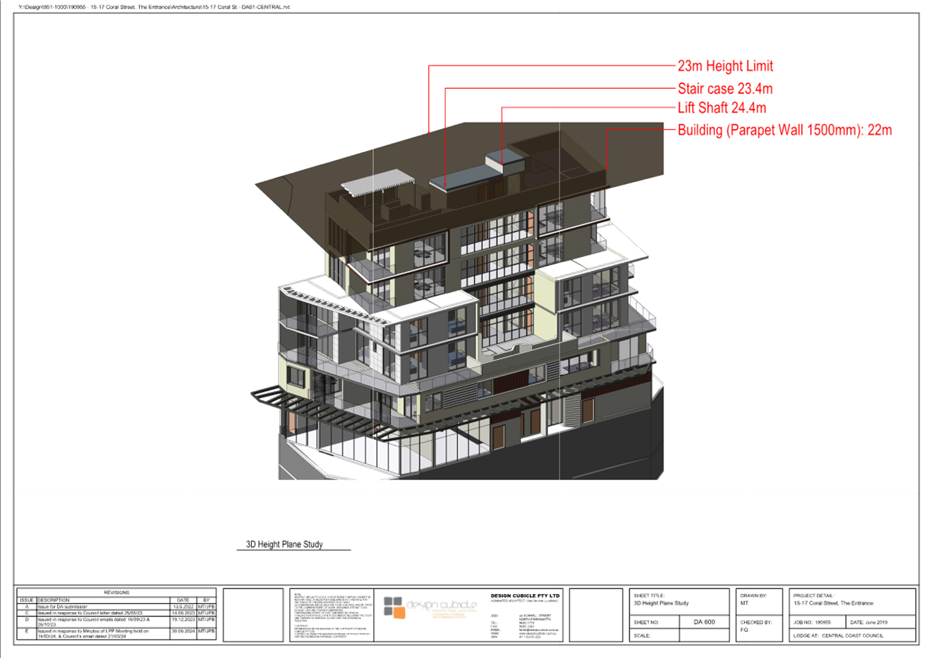
|
Item No: 4.2 |
|
|
Title: DA/1531/2024 - 12a The Scenic Road, Killcare Heights - Demolition of existing Dwelling and Proposed New Dwelling and associated works |
|
|
Department: Environment and Planning |
|
|
19 June 2025 Local Planning Panel Meeting |
|
Reference: DA/1531/2024 - D16850500
Author: Ileana Wilson, Development Planner
Section Manager: Ailsa Prendergast, Section Manager Residential Assessments
Unit Manager: Andrew Roach, Unit Manager Development Assessment
Summary
An application has been received for the demolition of an existing house and proposed new dwelling and associated works at 12A The Scenic Road, Killcare Heights. The application has been examined having regard to the matters for consideration detailed in section 4.15 of the Environmental Planning and Assessment Act 1979 and other statutory requirements with the issues requiring attention and consideration being addressed in this report.
The application proposes a variation to Clause 4.3(2) of the Central Coast Local Environmental Plan 2022 (Height of Building) and is therefore required to be determined by the Central Coast Local Planning Panel as per the Schedule 1 of the Ministerial Direction for the operation of Local Planning Panels (dated 6 March 2024).
Note that the current development application is the subject of a Class 1 – Appeal (deemed refusal), lodged with the Land & Environment Court of NSW lodged on 8 May 2025.
The application is recommended for approval, subject to conditions.
Applicant Guy Templeton
Owner Guy Templeton
Application No DA/1521/2024
Description of Land Lot 27 DP233604
12A The Scenic Road, Killcare Heights
Proposed Development Demolition of existing dwelling and proposed new dwelling and associated works.
Site Area 847m2
Zoning RE1 Public Recreation
Existing Use Dwelling house
Employment Generation No
Estimated Value $1,615,000
That:
1. The Panel agrees that the applicant’s clause 4.6 written request demonstrates that compliance with the Height of Building development standard is unnecessary in the circumstances of the case because of minimal environmental impact that would result from the noncompliance with the Height of Buildings standard, that compliance with the Height of Buildings standard would be unreasonable in the circumstances of the case because of the sloping site’s topography, and that there are sufficient environmental planning grounds to justify contravening that development standard.
Compliance with the Height of Buildings development standard would be unreasonable in the circumstances of this application and the variation does not have an unreasonable impact to the surrounding development.
Further, the Panel considers that the proposed development will be in the public interest because it is consistent with the objectives of the development standard and the objectives for development within the R2 Low Density Residential zone in which the development is proposed to be carried out.
2. That the Central Coast Local Planning Panel grants approval to the variation to the front setback for the dwelling. The variation is requested under clause 2.1.3.1a of the Central Coast Development Control Plan 2022.
3. That the Central Coast Local Planning Panel grants approval to the variation to the side setbacks for the dwelling. The variation is requested under clause 2.1.3.1c of the Central Coast Development Control Plan 2022.
4. That the Local Planning Panel grant consent to DA/1531/2024 at Lot 27 DP233604, 12a The Scenic Road, Killcare Heights for the Demolition of the existing dwelling and the construction of a new dwelling and the construction of an attached garage with a studio under, subject to the conditions detailed in the schedule attached to the report and having regard to the matters for consideration detailed in Section 4.15 of the Environmental Planning and Assessment Act 1979 and other relevant issues.
5. The Central Coast Local Planning Panel assume the concurrence of the Secretary of the Department of Planning to permit the non-compliance with the development standard under clause 4.6 of the Central Coast Environmental Plan 2022, in accordance with the provisions of clause 55 of the Environmental Planning and Assessment Regulation 2021.
Background
The current development application is the subject of a Class 1 – Appeal (deemed refusal), lodged with the Land & Environment Court of NSW lodged on 8 May 2025.
Key Issues
· Compliance with Central Coast Local Environmental Plan 2022 (CCLEP 2022).
o Variation greater than 10% to clause 4.3(2) Height of Building development standard.
· Compliance with the Central Coast Development Control Plan 2022
o Chapter 2.1 Dwelling Houses, Secondary Dwellings and Ancillary Structures – building height and setbacks.
· Bushfire risk – Bal FZ
· Land slip – High Risk
· Geotechnical assessment
· Ecology
· Arborist report
· Aboriginal heritage
Precis:
|
Proposed Development |
Demolition of existing dwelling and construction of a new dwelling, an attached garage with a studio under
|
|
Permissibility and Zoning |
Permissible with development consent R2 – Low density Residential
|
|
Current Use |
Dwelling |
|
Integrated Development |
Yes |
|
Submissions |
NIL |
Variations to Plans and Policies
Proposed variations to Central Coast Local Environmental Plan 2022
|
Clause |
4.3(2) – Height of Buildings |
|
Standard |
The height of a building on any land is not to exceed the maximum height shown for the land on the Height of Buildings Map of 8.5m. |
|
Departure basis |
The Clause 4.6 variation request submitted with the application indicates that the proposal has a maximum of 9.701m and therefore a variation of 1.2m or 14.11% is requested. |
Proposed variations to Central Coast Development Control Plan 2022
|
2.1.2.1(a) – Height of Buildings |
|
|
Standard |
Height of building is not to exceed the maximum building height on the Central Coast LEP 2022 Height of Building Map of 8.5m. |
|
Departure basis |
Maximum height of the roof line is 9.701 and therefore a variation of 1.2m or 14.11% is requested. |
|
Clause |
2.1.3.1 a Front setback (from the primary frontage to a local roadway on lots with a site area greater than 300m2)
|
|
Standard |
(iv) The minimum required setback for garage and carport structures and the like – A minimum of 1m behind the front boundary setback, noting that a min of 4.5m setback is required for the dwelling and therefore a min. of 5.5m setback is required for the garage |
|
Departure basis |
2.3m setback to garage and therefore a 3.2m variation or 157% is requested.
|
|
Clause |
2.1.3.1(c) Side Setbacks |
|
Standard |
(i) all lots greater than 12.5m wide at the building line: · 900mm setback for any part of the building with a height of up to 4.5m, · for any part of the building with a height of more than 4.5m—0.9m plus one quarter of the height of the building above 4.5m. |
|
Departure basis |
· Building height 9.701m · 9.7m-4.5m=5.2m/4=1.3m · 1.3+0.9 = 2.2m required on the First Floor, however, this is variable, due to the sloping nature of the site
North-eastern elevation – Kitchen and Pantry area · Proposed building height 6.9, 7.2m – 7.3m (varies) · Required: 1.5m (varies) · Proposed Setback 0.966, (varies) · Variation: 1.5-0.966 = 0.534m or 64%
South-western elevation · Proposed building height 8.5m to Bed 1 corner · Required: 1.9m (varies) · Proposed Setback 1.4m to Bed 1 corner · Variation: 1.9-1.4 = 0.5m or 26% |
The Site
The subject site is at 12a The Scenic Road, Killcare Heights and the property description is Lot 27 DP233604. The subject allotment is located on the southern side of The Scenic Road.
The site area is 847m2 and the subject land has a frontage of approximately 23m to the western boundary to The Scenic Road and extends some 56m to 69m to the narrow 9m rear eastern boundary.
Surface levels range from 60,0m AHD near the northwestern roadside corner to about 36.0 AHD near the rear south east site corner. The site is irregular in shape, with a curved frontage to the Scenic Road, falling from west to east by approximately 24m, a slope of approximately 41%
The subject site is located on the lower side of a north-easterly trending ridgeline, the apex of which follows the alignment of The Scenic Road. No defined drainage lines or watercourses
dissect the subject site. The terrain of the property is steep and rocky with dense ground cover and large trees occupying a large part of the eastern side of the subject site.
There is an existing dwelling on site, which is oriented west to east, towards expansive views over Putty Beach Reserve. The existing dwelling was likely constructed in the 1980’s. The existing dwelling is a 2-storey exposed brick home with Colorbond steel roof and a detached timber framed carport within the upslope western portion of the site. Access to the site is via an existing short vehicular driveway to the southern corner of the front boundary.
The western portion of the site appears to have been modified by mostly cut earthworks to form benching for the existing dwelling. There is an existing timber deck at the front of the dwelling, and a suspended deck at the rear of the dwelling.
Retaining walls and exposed sandstone rock are located to the northern side boundary, while the southern side of the dwelling adjoins sandstone steps and paved areas.
On the vegetated vacant southern side of the property, the ridge crest is occupied by numerous trees and large sandstone floaters.
Stairs have also been constructed to the rear of the house, providing access down the steep slope to the lower portions of the subject site, constructed with different landings to accommodate changes in direction around rock outcroppings and navigate the significant slope to the east away from the street boundary of the property.
The main services of power, water supply and telecommunications are available for connection to the subject site. A 600mm diameter Drainage Pipe is located to the western boundary and ends at the southern boundary of the subject site. Reticulated sewer is available to the site and the sewer is located to the eastern side of the site.
The site is identified as bushfire prone land.
Figure 1 - Site Locality Plan – subject site shaded light blue. - Image from Sixmaps
Figure 2 – Photo of existing carport, vehicular and pedestrian access to 12a The Scenic Road
Figure 3 – Photo of subject site, as seen from across the road, looking east.
Figure 4 – Photos of pedestrian access and existing dwelling, looking east on the southern side of the site.
Figure 5 – Photo of front of the existing dwelling and deck, looking north
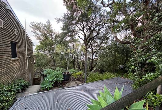
Figure 6 – Photo of the southern side of existing dwelling, looking east.
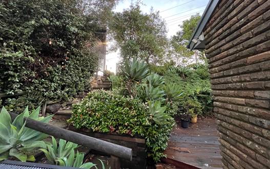
Figure 7 – Photo of the southern side of existing dwelling, looking west, towards The Scenic Road
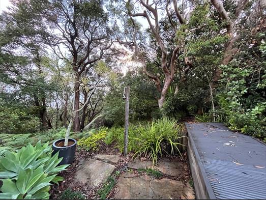
Figure 8 – Photo of the vegetated southern side of the site
Surrounding Development
The site is located within the Bouddi Peninsula, a steeply sloping ridgeline between Hardys Bay and the south Pacific Ocean.
The surrounding land generally contains single dwellings around The Scenic Road in a variety of architectural design and scale. On the Scenic Road to the north, dwellings are predominantly single dwelling houses. The majority of these are 2 storey developments, elevated above the natural ground, due to the land topography.
The land to the south of the subject site, forms part of the Putty Beach Reserve which is Crown land and is zoned C2 (Environmental Conservation).
There are few fresh water sources within the vicinity of the site. The closest fresh water source is an unnamed second order water course approximately 600 m north of the subject site, near Hardy’s Bay Parade.
The vegetation in and around the subject site has been subject to several phases of clearing associated with the development of The Scenic Road and existing houses.
The Proposed Development
The proposal is for demolition of the existing dwelling house and carport and the construction of a new dwelling house, an attached garage with a studio under the garage.
The studio is considered “attached” and has been assessed as part of the dwelling house.
The proposal comprises:
First Floor (main access level):
· Double garage
· Entry foyer, Lift, and Stairs
· Powder Room
· Covered Porch
· Kitchen, Walk-in Pantry, Dining & Sitting area.
· Lounge
· Bed 1 with Walk in robe and ensuite
· Covered terrace.
Ground floor (lower level)
· Studio and Storage area under the Garage
· Courtyard
· Covered area under the access Porch over.
· Breezeway (covered tiled area) between the studio and the Laundry.
· Laundry/bath
· Lift and entry
· Stair, Lift, linen storage under the Stair
· 3 bedrooms
· Family room
· Covered Terrace
The proposed dwelling will be generally located below the level of the road and will step down the site to follow the natural contour of the land. In relation to carparking provisions, a Double Garage is proposed to be located at the frontage of the subject site and is to be setback approximately 2.3m from the front property boundary.
The siting of proposed garage and associated driveway and vehicular manoeuvring area has been assessed by Council’s Development Engineer and found to be satisfactory in relation to the provision of safe vehicular egress, to and from The Scenic Road.
Council’s Development Engineer has also conditioned that the application be accompanied by detailed design drawings reports and other documentation prepared by a suitably experienced qualified professional in accordance with Council’s Civil Works Specifications, AS/NZS 2890. And other applicable Australian Standards and that. the design must be done and certified by a registered Structural or Civil Engineer as being in accordance with the Australian Standards.
In accordance with the Site plan, the proposal incorporates a 5000L Rainwater storage tank below floor level to the north of the site, with the overflow to be directed to an absorption trench to council requirements.
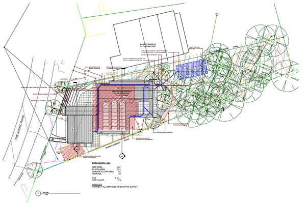
Figure 9 – Proposed Site plan
The locality comprises of residential dwellings of varying architectural design and scale. From an architectural point of view, the proposal provides for a development with a satisfactory design and external appearance and is considered to be generally consistent with the bulk and scale of similar residential structures in the immediate locality.
History
The site contained a dwelling which was on the site in 1980’s, as was the access road The Scenic Road. Approval for a single dwelling was granted by Gosford council in the 1980’s. NSW spatial services Historical imagery shows a single dwelling on the historical aerial photograph dated 1984. This looks to be of a similar size and location of the current dwelling.
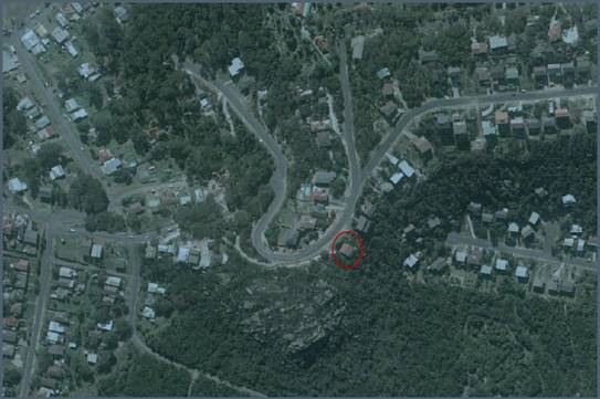
Figure 10 - historical aerial photograph, dated 1984 showing dwelling - Source: NSW Spatial Services Historical Imagery
In 2024 Development Applications Ref. DA/543/2024 and DA/687/2024 were lodged on this site for a similar development. These applications were returned on the 29th of April 2024 and respectively on 4th June 2024, due to lack of information.
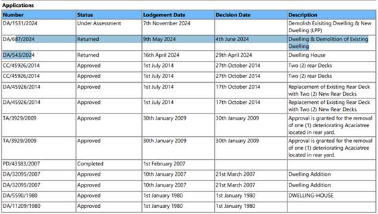
Figure 11 - Historical applications to council
ASSESSMENT:
Having regard for the matters for consideration detailed in Section 4.15 of the Environmental Planning and Assessment Act 1979 and other statutory requirements, the assessment has identified the following key issues, which are elaborated upon for the information of the Local Planning Panel.
Provisions of Relevant Instruments/Plans/Policies:
Environmental Planning and Assessment Regulation 2021 (Demolition)
With regard to demolition work as part of a Development Application, clause 61 of the Environmental Planning and Assessment Regulation 2021 provides additional matters that the consent authority must consider:
(1) In determining a development application for the demolition of a building, the consent authority must consider the Australian Standard AS 2601—2001: The Demolition of Structures.
Comment: The works will be covered by the Australian Standard As 2601-2001 and is conditioned for compliance as per draft conditions.
A waste management plan has been submitted and accepted. The Panel can be satisfied the necessary demolition works required to facilitate demolition and new dwelling will occur in accordance with AS2601-2001.
Environment Protection and Biodiversity Conservation Act 1999 and Biodiversity Conservation Act 2016
Council's Ecologist has assessed the ecological impact of the proposed development in accordance with section 4.15 of the Environmental Planning and Assessment Act 1979 (EP&A Act) and the Environment Protection and Biodiversity Conservation Act 1999 (EPBC Act). Impacts to biodiversity values have been assessed in accordance with the Biodiversity Conservation Act 2016 (BC Act) and the below comments were provided:
DA/1531/2024 is for demolition of the existing dwelling and construction of a new dwelling in the same general location. The rear of the site drops off steeply and is densely vegetated, mapped by the state government as comprising a health and Spotted Gum Dry Forest. The Lot to the south is owned by Council.
Bushfire: The dwelling is identified to be built to BAL-FZ with the APZ (inner protection area) comprising the area between the dwelling and Lot boundary to the west, north and south. Due to site constraints, only a 2m APZ is provided to the east (towards the hazard). RFS conditions for the APZ are consistent with those identified in the bushfire report.
Arborist Assessment: Out of the 16 trees assessed, six are identified to be removed which comprise four native species and two non-endemic/introduced species. Species proposed to be removed are small and likely previously planted, including a single Syzygium paniculatum in the road reserve. No trees are identified as being impacted in the adjoining Council land. The Arborist Report has considered the bushfire APZ and it been reviewed and is supported by Council’s Tree Assessment Officer.
Ecological Assessment: A terrestrial ecological study has not been completed, nor is one triggered in accordance with Council’s Flora and Fauna Guidelines 2019.
The development footprint generally comprises landscape areas around the existing dwelling. There is a large sandstone overhang that is outside of the development footprint. The overhang was inspected with no signs of microbat habitation. The stormwater overflow absorption trench area is infested with Lantana and Asparagus fern. Management of weeds in this area is important to limit their proliferation and spread, including into the adjoining Council reserve. A weed control program which applies to the entire Lot has been conditioned.
Biodiversity Offset Scheme (BOS) Threshold: Based on provided information, the proposal does not trigger any of the three triggers to the scheme.
1. Biodiversity Value map – no part of the subject site is included on the map.
2. Area clearing threshold – the threshold for native vegetation clearing, above which the BOS applies is 0.25 ha (minimum Lot size is <1ha). This threshold is not possible to exceed given the small size of the allotment.
3. Threatened species test of significance – based on the site inspection observations and the small amount of habitat proposed to be removed, it is unlikely any threatened species would be significantly impacted.
Council’s Ecologist and the Panel can be satisfied that the proposal does not trigger the Biodiversity Offsets Scheme under the Biodiversity Conservation Act 2016, and a Biodiversity Development Assessment Report (BDAR) is not required to be submitted with the application.
State Environmental Planning Policy Sustainable Buildings 2022
A compliant BASIX certificate achieving the NSW Government’s Energy Efficiency targets has been provided in support of the application. The proposal is consistent with the requirements of the State Environmental Planning Policy Sustainable Buildings 2022.
The Panel can be satisfied that the proposed development satisfies the relevant clauses of State Environmental Planning Policy Sustainable Buildings 2022, subject to recommended conditions.
State Environmental Planning Policy (Resilience and Hazards) 2021
The site has been identified as being part of the Coastal Environment and Coastal Use area and Chapter 2 – Coastal Management applies.
· Chapter 2 – Coastal Management
The aims of Chapter 2 are to be considered when determining an application within the Coastal Management Areas. The Coastal Management Areas are defined on maps issued by the NSW Department of Planning and Environment.
The site is located within the Coastal Environment Area and Coastal Use Area as identified on these maps and subject to the provisions of section 2.10 and section 2.11 of the SEPP.
The development is not likely to have an adverse impact on the matters referred to in section 2.10 and section 2.11. The development is not considered likely to cause increased risk of coastal hazards on the site or other land. A summary of considerations is included below.
Section 2.10 - Development on land within the coastal environment area
In accordance with section 2.10(1) development consent must not be granted in the coastal environment area unless the consent authority has considered whether the proposed development is likely to cause an adverse impact on the following:
|
Matters for consideration |
Compliance |
|
(a) the integrity and resilience of the biophysical, hydrological (surface and groundwater) and ecological environment, |
The proposal is not likely to cause adverse impacts on the biophysical, hydrological, or ecological environment. The proposal will be connected to reticulated sewer and stormwater will be managed on-site in accordance with the submitted stormwater plans with a 5kL rainwater tank overflowing into an absorption trench. Erosion and sediment controls will be in place during demolition and construction, and the proposal will not impact on the environment. |
|
(b) coastal environmental values and natural coastal processes, |
The proposal will not impact on the geological and geomorphological coastal processes. |
|
(c) the water quality of the marine estate (within the meaning of the Marine Estate Management Act 2014), in particular, the cumulative impacts of the proposed development on any of the sensitive coastal lakes identified in Schedule 1, |
The proposal will not result in an adverse impact on the water quality of the marine estate and does not drain to a sensitive lake contained in Schedule 1. The proposal will be connected to reticulated sewer and stormwater will be managed on-site in accordance with the submitted Site/Stormwater plan. Erosion and sediment controls will be in place during demolition and construction, to minimise impacts on water quality, and the proposal will not impact on any sensitive coastal lakes. |
|
(d) marine vegetation, native vegetation and fauna and their habitats, undeveloped headlands and rock platforms, |
The proposal will not result in an adverse impact on native vegetation or fauna, undeveloped headlands, and rock platforms. |
|
(e) existing public open space and safe access to and along the foreshore, beach, headland or rock platform for members of the public, including persons with a disability, |
The site does not have frontage to any, beach, headland or waterways and is separated by Council zoned land C2 which is similar in appearance to an open reserve but is not impacted by this proposal for access. |
|
(f) Aboriginal cultural heritage, practices and places, |
There are identified aboriginal cultural heritage items in the vicinity of the site but not within the subject site, and, an Aboriginal Assessment has been submitted with the application. The report’s findings considers that there is a low likelihood that the proposed works will result in harm to Aboriginal objects. No further Aboriginal heritage investigations are required. |
|
(g) the use of the surf zone. |
Not Applicable. No frontage to any beach/surf zone. |
There have been no adverse impacts identified in the consideration of Section 2.10(1) that would engage the further considerations under Section 2.10(2).
With respect of the matters in Section 2.10(2), the Panel can be satisfied the proposed development is not likely to adversely impact on the coastal environment area.
Section 2.11 - Development on land within the coastal use area
In accordance with section 2.11(1) development consent must not be granted in the coastal use area unless the consent authority has considered whether the proposed development is likely to cause an adverse impact on the following:
|
Matters for consideration |
Compliance |
|
(a) whether the proposed development is likely to cause an adverse impact on the following: i. existing, safe access to and along the foreshore, beach, headland or rock platform for members of the public, including persons with a disability, ii. overshadowing, wind funnelling and the loss of views from public places to foreshores, iii. the visual amenity and scenic qualities of the coast, including coastal headlands, iv. Aboriginal cultural heritage, practices and places, v. cultural and built environment heritage.
|
The proposal will not cause an adverse impact on overshadowing, access, wind funneling or view loss from public places to any foreshore. The dwelling house will be visible from the beach and coastal areas and will maintain an appropriate presentation that is consistent with other more recent development along the coastal headlands. There are identified aboriginal cultural heritage items in the vicinity of the site but not within the subject site, and, an Aboriginal Assessment has been submitted with the application. The report’s findings considers that there is a low likelihood that the proposed works will result in harm to Aboriginal objects. No further Aboriginal heritage investigations are required. |
|
(b) is satisfied that— i. the development is designed, sited, and will be managed to avoid an adverse impact referred to in paragraph (a), or ii. if that impact cannot be reasonably avoided—the development is designed, sited, and will be managed to minimise that impact, or iii. if that impact cannot be minimised—the development will be managed to mitigate that impact, |
If designed and constructed in accordance with the recommendations of the geotechnical engineering report, arborist report, Aboriginal assessment report and the DA conditions, the proposal will not result in adverse impacts referred to in clause 2.11(a), having regard to LEP and DCP requirements, the location and characteristics of the site and existing development on the site and surrounding properties.
There have been no adverse impacts identified in the consideration of section 2.11(1) that would engage the further considerations under section 2.11(2) of the Resilience and Hazards SEPP.
|
|
(c) has taken into account the surrounding coastal and built environment, and the bulk, scale and size of the proposed development. |
The proposal has taken into account the surrounding coastal and built environment and the bulk, scale and size of the development are sympathetic the surrounding environment. |
The proposed development will not impact on public access to the beach or impact on the amenity and scenic qualities of the coast or aboriginal cultural heritage places, or other cultural and built environmental heritage. The bulk and scale of the proposed development is considered appropriate having regard for the non-compliances with the LEP and DCP requirements. Accordingly, the Panel can be satisfied the proposal satisfies the provisions of s.2.11(1)(c).
Section 2.12 - Development in coastal zone generally - development not to increase risk of coastal hazards.
In accordance with section 2.12 development consent must not be granted to development on land within the coastal zone unless the consent authority is satisfied that the proposed development is not likely to cause increased risk of coastal hazards on that land or other land.
Comment:
The proposal is not located within the Coastal Hazard Area under CCDCP 2022 and the consent authority is satisfied that the proposed development is not likely to cause increased risk of coastal hazards on the land or other land. The proposed development is not expected to adversely affect coastal environmental values or natural coastal processes over its design life, as it is not at risk of damage from erosion/recession and inundation for an acceptably rare storm and over an acceptably long design life and it would be well landward and above typical coastal processes.
Section 2.13 - Development in coastal zone generally - coastal management programs to be considered.
In accordance with section 2.13 development consent must not be granted to development on land within the coastal zone unless the consent authority has taken into consideration the relevant provisions of any certified coastal management program that applies to the land.
Comment: The proposed site location is not identified as being part of the Coastal management program and no further consideration is required under Section 2.13.
· Chapter 4 -Remediation of Land
In accordance with Section 4.6 of the Chapter, the consent authority must not consent to the carrying out of any development on land unless it has considered whether the land is contaminated, and, if the land is contaminated, is suitable in its contaminated state for the purposes of the development which is proposed.
In this regard, a review of the land use history, aerial photographs and an inspection of the site has not revealed any evidence of potentially contaminating land uses being carried out on the site. The proposed development is for the construction of a single dwelling development on an existing residential lot. The site is not considered contaminated and is suitable for the proposed purpose.
The development and the land is not otherwise mentioned in Subsection 4.6(4) and accordingly the provisions of Subsection 4.6(2) are not engaged by the proposal and consent may be granted.
The proposed development is therefore considered suitable having regard for the provisions of s.4.6(1)(a) and (b).
The Panel can be satisfied that that proposed development complies with the provisions of Chapter 2 Coastal Management and Chapter 4 Remediation of Land of the State Environmental Planning Policy (Resilience and Hazards) 2021.
Bushfire Prone Land
The site is identified as "bushfire prone land" on Council's bushfire mapping.
In accordance with the provisions of Section 4.14 - Consultation and development consent – certain bushfire prone land, of the Environmental Planning and Assessment Act 1979,
“(1) Development consent cannot be granted for the carrying out of development for any purpose (other than a subdivision of land that could lawfully be used for residential or rural residential purposes or development for a special fire protection purpose) on bush fire prone land (being land for the time being recorded as bush fire prone land on a relevant map certified under section 10.3(2)) unless the consent authority:
(a) is satisfied that the development conforms to the specifications and requirements of the version (as prescribed by the regulations) of the document entitled Planning for Bush Fire Protection prepared by the NSW Rural Fire Service in co-operation with the Department (or, if another document is prescribed by the regulations for the purposes of this paragraph, that document) that are relevant to the development (the relevant specifications and requirements), or
(b) has been provided with a certificate by a person who is recognised by the NSW Rural Fire Service as a qualified consultant in bush fire risk assessment stating that the development conforms to the relevant specifications and requirements.
The proposal is accompanied by a Bushfire Protection Assessment Report prepared by Australian Bushfire Consulting Services Pty Ltd, being Report Reference Number 23-368, dated 4th October 2023, recommending that the proposal must comply with BAL-FZ.
The application was referred to the NSW Rural Fire Service (NSW RFS) under Section 4.14 of the Environmental Planning and Assessment Act 1979 (EP&A Act). As part of the General Terms of Approval letter by NSW RFS, dated 12 December 2024, NSW RFS provided recommended conditions for the following:
· “Asset Protection Zones - the property surrounding the building to be maintained as an Inner Protection Area in the north, south and west to the boundary and to the east for a distance of 2 meters.
· Landscaping is to comply with Appendix 4 of the Planning for Bushfire protection 2019.
· Construction Standards – new construction to comply with BAL FZ.
· property access roads must comply with the stated requirements of Table 7.4a of Planning for Bush Fire Protection 2019.
· Water and Utility Services - The provision of water, electricity and gas must comply with the stated requirements of Table 7.4a of Planning for Bush Fire Protection 2019.”
General Advice – Consent Authority to Note:
● The NSW RFS recognises that the site is constrained and that the proposed development falls within theFlame Zone. Flame Zone development is high risk development; consequently, in situations such as this, the NSW RFS seeks to improve the overall fire safety of the existing development. This requires greater emphasis on construction standards, landscaping, siting, and vegetation management practices to ensure improved levels of protection are afforded to the development, its occupants and fire fighters.
The NSW RFS has undertaken a merit-based assessment of the proposal and provides the above advice in accordance with Planning for Bush Fire Protection 2019.
● The property is located such that access/egress presents an ongoing bush fire risk. As such, a Bush Fire Survival Plan is to be prepared by the residents of the dwelling. Information to assist in the preparation of a Bush Fire Survival Plan can be found at www.rfs.nsw.gov.au.”
Council can be satisfied that the proposal is capable of compliance with Planning for Bushfire Protection 2019 and the General Terms and Conditions in the NSW RFS General Terms of Approval letter, dated 12 December 2024.
Indigenous Heritage
The site is identified as being in the vicinity of 3 aboriginal sites (located within 150m of the subject property), but none of these are located within the site’s boundaries.
The National Parks and Wildlife Act 1974 (NPW Act) provides that a person who exercises due diligence in determining that their actions will not harm Aboriginal objects has a defence against prosecution for the strict liability offence if they later unknowingly harm an object without an Aboriginal Heritage Impact Permit (AHIP).
The NPW Act defines an Aboriginal object as:
..any deposit, object or material evidence (not being a handicraft made for sale) relating to the Aboriginal habitation of the area that comprises New South Wales.
The National Parks and Wildlife Regulation 2019 (NPW Regulation) provides a framework for exercising due diligence, including the guidelines which this report adheres to: the Due Diligence Code of Practice for the Protection of Aboriginal Objects in NSW (DECCW 2010) (the Due Diligence Code).
The proposal is accompanied by an Aboriginal Heritage Due Diligence Assessment prepared by Umwelt (Australia) Pty Ltd, R01/31795 and dated October 2024.
The report’s conclusion considered that there is a low likelihood that the proposed works will result in harm to Aboriginal objects and recommends that no further investigations are required, along with proceeding with caution and some management measures.
Central Coast Local Environmental Plan 2022 (CCLEP 2022)
Zoning and Permissibility
The subject site is zoned R2 Low Density Residential under CCLEP 2022. The proposed development is defined as dwelling house which is permissible in the zone with consent of Council.
The CCLEP 2022 defines the following:
dwelling house means a building containing only one dwelling.
dwelling means a room or suite of rooms occupied or used or so constructed or adapted as to be capable of being occupied or used as a separate domicile.
In accordance with clause 2.3(2) the consent authority must have regard to the objectives for development in respect of land within the zone. The objectives of the R2 Low Density Residential zone are:
· To provide for the housing needs of the community within a low-density residential environment.
· To enable other land uses that provides facilities or services to meet the day to day needs of residents.
· To encourage best practice in the design of low-density residential development.
· To ensure that non-residential land uses do not adversely affect residential amenity or place demands on services.
· To maintain the enhance the residential amenity and character of the surrounding area.
The proposed development is generally consistent with the above objectives of the R2 zone.
The proposed development meets the objectives of the zone as follows:
· The proposal will provide a renewal of housing on the site, and the nature of the use is consistent with development in the surrounding area and considered compatible with the desired future character of the area.
· The design of the proposal responds to the ridgeline location of the site and is compatible with the scale and nature of more recent development on the Scenic Road in Killcare Heights. Properties along the Scenic Road comprise a variety of dwelling types including larger new dwellings and older cottages that are yet to be redeveloped.
· The proposal demonstrates architectural quality and uses different setbacks and design features to break up the massing of the dwelling house.
· The proposal does not unreasonably obstruct any significant views from private property or the public domain.
· The proposal maintains appropriate solar access to adjoining properties.
· The proposed development is ecologically, socially, and economically sustainable in the sensitive coastal location and will not give rise to any increased coastal hazards on adjacent land.
Following a detailed assessment of the proposed development and with the applicants written request to vary a development standard within CCLEP 2022, it is considered that the proposal is consistent with the stated objectives of the zone, providing housing consistent with the emerging character of the area and does not have adverse impacts on the locality.
Central Coast Local Environmental Plan 2022 (CCLEP 2022) - Principal Development Standards
The proposal has been assessed in accordance with the relevant development standards of CCLEP 2022.
|
Development Standard |
Required |
Proposed |
Compliance with Controls |
Variation % |
Compliance with Objectives |
|
Clause 4.3 Height of Buildings |
8.5m |
The proposal seeks a maximum height of 9.701m.
|
No |
14.11% |
Yes |
|
Clause 4.4 Floor Space Ratio |
Not mapped |
0.31:1 |
Yes |
- |
Yes |
Central Coast Local Environmental Plan 2022 Clause 4.3 - Height of buildings
The development proposes a variation to the maximum permitted height set out under clause 4.3 of CCLEP 2022 and is accompanied by a clause 4.6 written request to vary the development standard.
Clause 4.3(2) of CCLEP 2022 provides that the height of a building on any land will not exceed the maximum height shown for the land on the Height of Buildings Map. The maximum height shown on the relevant map is 8.5m. The CCLEP 2022 defines this as the height above existing ground level.
The proposed development seeks a variation to the height of the building of 1.201m or 14.11%.
The proposed area of non-compliance is located within the rear portion of the dwelling. The non-compliance does not result in any adverse amenity impacts to surrounding development.
A written request under clause 4.6 of CCLEP 2022 to vary the development standard has been submitted by the Applicant. The Applicant's submission demonstrates the proposed development is of a satisfactory height, bulk and scale and does not have adverse impact on adjoining development. The Applicant’s objection is considered to be well founded as the proposal is considered to achieve the objectives of the standard and the development is recommended for support.
The non-compliance shown in Figure 13 & Figure 14 does not discernibly impact on bulk and scale, streetscape character or adverse impact on views to surrounding properties.
Given the context and characteristics of the subject site, and the nature of the existing development, strict compliance with the maximum building height control is considered unreasonable and unnecessary in this instance.
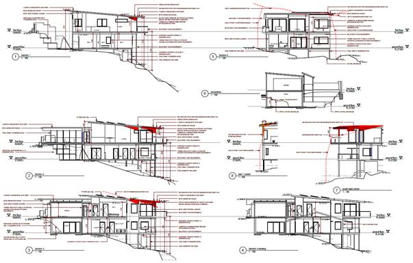
Figure 13 - Sections demonstrating extent of height noncompliance.
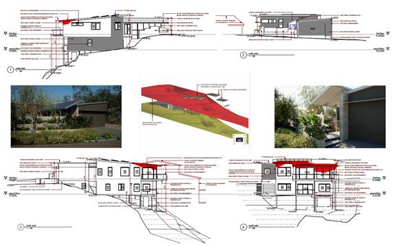
Figure 14 - Elevations demonstrating extent of height noncompliance.
Central Coast Local Environmental Plan 2022 Clause 4.6 - Exceptions to Development Standards for Height
A clause 4.6 Exceptions to Development Standards variation for the non-compliance associated with the maximum building height in Clause 4.3(2) of CCLEP 2022 was provided by the applicant (refer to Attachment 3). The Statement of Environmental Effects is provided as Attachment 11 to this report.
Clause 4.6 of CCLEP 2022 provides the ability to grant consent to a development application where the variation to a development standard can be adequately justified and where the objectives of clause 4.6 are satisfied, being:
(a) to provide an appropriate degree of flexibility in applying certain development standards to particular development,
(b) to achieve better outcomes for and from development by allowing flexibility in particular circumstances.
Clause 4.6(2) provides permissive power to grant development consent for a development that contravenes the development standard.
Clause 4.6 (3) of CCLEP 2022 requires consideration of the following:
Development consent must not be granted to development that contravenes a development standard unless the consent authority is satisfied the applicant has demonstrated that—
(a) compliance with the development standard is unreasonable or unnecessary in the circumstances, and
(b) there are sufficient environmental planning grounds to justify the contravention of the development standard.
In reviewing whether the proposed variation is unreasonable or unnecessary, and whether there are sufficient environmental planning grounds to justify contravening the variation, consideration of the objectives for maximum building height controls are relevant.
Clause 4.3(1) of CCLEP 2022 sets out two objectives pertaining to the building height development standard. The objectives and commentary in respect to compliance in relation to the proposed development:
a) to establish maximum height limits for buildings to enable appropriate development density
Comment: The proposed height of the building, whilst exceeding the numerical height limit, is consistent with numerous other dwellings within the vicinity within this steep coastal hillside locality.
b) to ensure that the height of buildings is compatible with the character of the locality
The height exceedance relates to roof projection located centrally within the dwelling. The building height is consistent in height with other dwellings within areas of the locality that display steeply sloping site topography.
Applicant’s Written Clause 4.6 Request
Clause 4.6 (3) of CCLEP 2022 also notes that “The Environmental Planning and Assessment Regulation 2021 requires a development application for development that proposes to contravene a development standard to be accompanied by a document setting out the grounds on which the applicant seeks to demonstrate the matters in paragraphs (a) and (b)”
A written request under clause 4.6 of CCLEP 2022 to vary the development standard has been submitted by the Applicant. The Applicant's submission demonstrates the proposed development is of a satisfactory height, bulk and scale and does not have adverse impact on adjoining development. The Applicant’s objection is considered to be well founded as the proposal is considered to achieve the objectives of the standard and the development is recommended for support.
The applicant’s submission is in accordance with the regulations and assessment considers it to have adequately addressed the provisions of clause 4.6(3)(a) and (b), as set out above.
The applicant’s full clause 4.6 document request is included in Attachment 3.
Zone Objectives
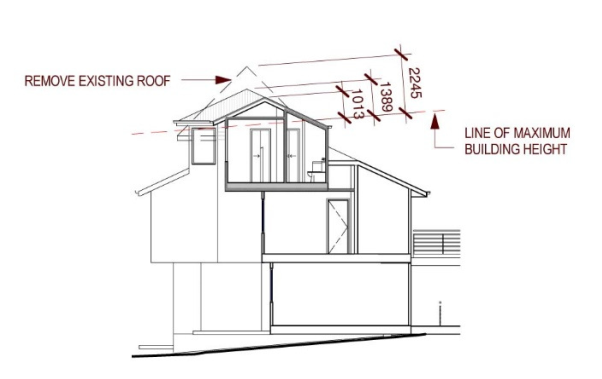
In reviewing the proposed variation, consideration of the Residential R2 Low Density Residential Zone objectives is also considered necessary.
The R2 Low Density Residential Zone objectives are as follows:
· To provide for the housing needs of the community within a low-density residential environment.
· To enable other land uses that provide facilities or services to meet the day to day needs of residents.
· To encourage best practice in the design of low-density residential development.
· To ensure that non-residential uses do not adversely affect residential amenity or place unreasonable demands on services.
· To maintain and enhance the residential amenity and character of the surrounding area.
In considering these zone objectives, the following points are considered relevant:
· Dwelling houses are permissible within the zone and satisfies the zone objective in terms of the provision of low-density residential development.
· The proposed dwelling design is considered in keeping with the existing and desired future character of the area.
· The design of the dwelling incorporates suitable architectural design elements and incorporates sustainable design features.
The proposal meets the relevant zone objectives and does not cause view loss or significant additional overshadowing impact to the adjoining properties. The proposal is consistent with the objectives of the development standard, as noted above and approval of the development is therefore considered in the public interest.
In accordance with clause 4.6 (3), The consent authority can be satisfied the applicant has demonstrated that,
a) compliance with the development standard is unreasonable or unnecessary in the circumstances, and
b) there are sufficient environmental planning grounds to justify the contravention of the development standard.
Having regard to the site factors, minimal impact on the character of the area and that of the residents, the applicants request to vary the building height development standard is considered reasonable and therefore supported in this instance.
Central Coast Local Environmental Plan 2022 – Clause 5.21 Flood Planning
The site is not subject to flood planning controls.
Central Coast Local Environmental Plan 2022 – Clause 5.23 – Public Bushland
Council is required to consider the likely effects of the development on the adjoining public reserve. The development does not encroach on the reserve. The site plans show a sediment control fence to be provided around the development footprint which will help prevent any runoff into the council reserve. A weed control program has been conditioned to mitigate potential spread and establishment of weeds from the development site to the Council reserve.
The potential environmental impacts associated with the proposal have been considered. Council’s Ecologist has no objection to the proposal subject to conditions being included within any consent granted.
Central Coast Local Environmental Plan 2022 – Clause 7.1 Acid Sulfate Soils
The site is identified as being Class 5 on the Acid sulfate soils map.
The proposed works are not located below 5m AHD.
The Panel can be satisfied that the proposed development complies with the requirements of Clause 7.1 of the CCLEP 2022. No further consideration is required under Clause 5.22 of the Central Coast Local Environmental Plan 2022 (CCLEP 2022).
Central Coast Local Environmental Plan 2022 – Clause 7.6 Essential Services
Development consent must not be granted to development unless the consent authority is satisfied that all of the following services that are essential for the development are available or that adequate arrangements have been made to make them available when required:
a) the supply of water
b) the supply of electricity
c) the disposal and management of sewage
d) stormwater drainage or on-site conservation
e) suitable vehicular access
f) the collection and management of waste
The Panel can be satisfied that the proposed development complies with the provisions of clause 7.6 and adequate servicing arrangements have been made for the proposed development.
Central Coast Development Control Plan 2022
Chapter 2.1 – Dwelling Houses, Secondary Dwellings and Ancillary Development
An assessment against the provisions of Chapter 2.1 of CCDCP 2022 is included in the table below:
|
Chapter 2.1 |
Requirement |
Proposed |
Compliance |
|
Clause 2.1.2.1(a) Building Height |
8.5m building height by virtue of LEP mapping |
9.701m |
No – see comments elsewhere in this report |
|
Clause 2.1.2.1(c) Building Height |
2 Storeys / 3 Storeys Steeply Sloping |
2 Storeys |
Yes |
|
Clause 2.1.2.2 Site Coverage |
Maximum 50% site coverage |
18% |
Yes |
|
Clause 2.1.2.3 Floor Space Ratio |
0.5:1 - where mapped (site is not mapped) |
0.31:1 |
Yes |
|
Clause 2.1.3.1a – Front Setback |
if 2 dwelling houses are not located within 40m of the lot - 4.5m
the minimum required setback for a garage – 1m behind the front setback (i.e. 5.5m) |
>6m
2.3m |
Yes
No – see comments elsewhere in this report
|
|
Clause 2.1.3.1b – Rear Setback |
To a public reserve: 3m |
>3m |
Yes
|
|
Clause 2.1.3.1c – Side Setback |
0.9m up to 4.5m in height and 0.9m plus one quarter of the building height located above 4.5m |
North-eastern elevation – Kitchen and Pantry area · Proposed building height 6.9, 7.2m – 7.3m (varies) · Required: 1.5m (varies) · Proposed Setback 0.966, (varies) · Variation: 1.5-0.966 = 0.534m or 64% South-western elevation – Bed 1 corner · Proposed building height 8.5m · Required: 1.9m (varies) · Proposed Setback 1.4m · Variation: 1.9-1.4 = 0.5m or 26%
|
No – see comments elsewhere in this report
|
|
Clause 2.1.3.3.1 Articulation Zones |
Elevations within 7.5m of and facing a primary road shall have no unbroken lengths of walls exceeding 10.0m |
Less than 10.0m |
Yes |
|
Clause 2.1.3.3.2 Garage Door Articulation |
Width of garage doors is not to exceed 60% of the width of the building |
Garage door width: 5.4m Width of building (including the garage) 15.6m 34% |
Yes |
|
Clause 2.1.4.1 |
To encourage view sharing between properties
|
No impact on views |
Yes
|
|
Clause 2.1.4.2 Visual Privacy |
To minimise direct overlooking between main living areas and areas of principle private open space within the site and adjoining sites |
Given site topography and distances to side and rear boundaries, the proposal is considered to meet the requirements of this clause. A condition has been added to the DA for privacy screening on the Northern elevation of the First floor terrace. |
Yes |
|
Clause 2.1.4.3 Private Open Space Areas |
Minimum 24.0m2
Minimum dimension 3.0m |
In excess of 24.0m2
In excess of 3.0m |
Yes
Yes |
|
Clause 2.1.4.4 Sunlight Access |
On 21 June 50% of required principal open space for all dwellings should receive 3 hours unobstructed sunlight access between 9am and 3pm.
On 21 June 50% of required principal open space on adjoining land should receive 3 hours unobstructed sunlight access between 9am and 3pm. |
In excess of 3.0 hours
In excess of 3.0 hours |
Yes
Yes |
|
Clause 2.1.5 – Car Parking and Access |
2 car spaces
|
2+ car spaces
|
Yes
|
|
Clause 2.1.6.1 Earthworks |
Maximum cut 1.0 metre if within 1.0m of side or rear boundary
Maximum 3.0m cut if in excess of 1.0m from side or rear boundary
Fill must not exceed 1.0m above existing ground surface level |
Less than 1.0m
Less than 3.0m
Less than 1.0m and contained within the building envelope |
Yes
Yes
Yes |
|
Clause 2.1.6.2 Retaining Walls and Structural Support |
Retaining walls in excess of 600mm height to be the subject of structural engineer’s design |
Retaining walls proposed subject to structural engineer’s design |
Yes – subject to condition of consent |
|
Clause 2.1.6.3 Drainage |
To on-site disposal system |
Stormwater to be collected to Rainwater tank and overflow to be drained to absorption trench |
Yes – subject to condition of consent |
DCP Chapter 2.1.2.1(a) Building Height
The applicant seeks a variation to the proposed maximum height of the dwelling. In this regard, the proposal seeks a maximum overall height of 9.701m. The variation proposed is 14.11%.
An assessment of the building height has been carried out under CCLEP 2022 and CCDCP 2022. The proposed building height variation is required for functionality, will be consistent with heights of other buildings in proximity to the allotment and throughout the Killcare Heights suburb. The proposal meets the relevant zone objectives and does not cause view loss impact or contribute to significant overshadowing to the adjoining properties.
It is considered the applicant’s request to vary the development standard would be consistent with the height and scale of other dwellings within the immediate area. In addition, the development would not impose any unreasonable level of detrimental impact on the amenity of residents in nearby dwellings.
DCP Chapter 2.1. 3.1a – Front Setback
The applicant seeks a variation to the proposed minimum setback for the garage.
The subject site is unique in terms of its geographical location, located on the bend of The Scenic Road with no immediate residential dwellings located to the south, and dwellings to the east at significant distance. The nearest dwellings located within 40m of the development site are the adjacent dwelling to the north, No. 14 The Scenic Road and the dwellings located across the road to the west.
The front setback control sets a requirement as follows:
i. ‘The average distance of the setbacks of the nearest 2 dwelling houses having the same primary road boundary and located within 40m of the lot on which the dwelling house is erected, or If 2 dwelling houses are not located within 40m of the lot - 4.5m’.
and
ii. “The minimum required setback for garage and carport structures and the like - A minimum of 1m behind the front boundary setback”
The nearest two dwellings are to the north and have setbacks of 0.0m to garage and 5.6m. The average of those dwellings is 2.8m. The dwelling has been proposed with garages located forward of the building line. The garage is sited 2.3m from the front boundary, whilst the primary façade of the residential dwelling is sited greater than 6.0m as measured from the front boundary. Accordingly, the proposal does not meet the numeric standard of the DCP.
The objectives of setback controls and a response to each are provided below:
|
Objective |
Response |
|
To ensure that setbacks are compatible with adjacent development and complements the character, streetscape, public reserve, or coastal foreshore |
The proposed front boundary setback(s) are compatible with that of the adjacent dwellings. Both No 14 and 14A The Scenic Road have garages located forward of the building with No. 14A The Scenic Road also including an in-ground swimming pool located in the front yard. The proposal is considered acceptable in this instance as the design complements the character and streetscape with no effect on Putty Beach Reserve and or coastal foreshore area. The topographical features of the site support an irregular 24.0m difference in level measured from the front boundary to the rear boundary and is not uncommon that based on the severe difference in level of the site, and in this case, the drop at the rear of the site, that the garages be located forward of the building with the access driveway crossover satisfying compliance with the Australian Standards for driveways and associated s138 Application. The residential dwelling has been designed to be as close to natural ground level as possible minimising the extent of excavation associated with potential rock cutting or rock breaking in order to reduce severe impacts to the surrounding environment. |
|
To ensure the visual focus of a development is the dwelling, not the garage |
The presentation to the streetscape is not indifferent to the adjacent dwellings. However, in addition with sensitive uses of colours, differentiating in contract between foreground and background, and the use of materials and finishes, the visual focus will be the primary residential dwelling. |
|
To protect the views, privacy and solar access of adjacent properties |
The subject site is predominantly orientated east-west, west being the front boundary and east being the rear boundary. To the common adjacent southern boundary is Putty Beach Reserve. The proposed development is considered to protect the views, privacy, and solar access to the adjacent properties. |
|
To maintain view corridors to coastal foreshores and other desirable outlooks |
The proposed development will not interrupt any view corridors to coastal foreshores and or desirable outlooks due to the undulating topography of the immediate surrounding locality. Existing view corridors to Putty Beach Reserve will remain. |
|
To maintain the scenic and environmental qualities of natural waterbodies and their foreshores and respond to site attributes such as topography |
The front setback to the garage will not impede on the scenic and or environmental qualities of any natural waterbodies and the foreshores. The proposed development is considered to favourably respond to the topography of the allotment. |
|
To provide deep soil areas sufficient to conserve existing trees or accommodate new landscaping |
The allotment has an overall site area of 847.0m2. It is proposed to construct a new two storey residential dwelling with a floor space ratio of 0.31:1 or 31%, therefore retaining the subsequent 69% for sufficient landscaping and conserving existing trees to accommodate any new landscaping. It must be noted that although the site is affected by Bushfire Prone Land, the rear of the site is heavily vegetated with trees, shrubs and ground covers. |
|
To provide appropriate articulation of facades and horizontal elements reduce the appearance of bulk and provides visual interest to the building and subsequent streetscape where they face a street frontage/s.
|
The proposed development will have the appearance of a two-storey dwelling when viewed from The Scenic Road, characteristic of other buildings along The Scenic Road. As such, to the casual observer in the public domain, the building will continue to appear at a compatible scale as the existing development and surrounding properties on The Scenic Road. With sensitive architectural merit, the proposed residential dwelling has articulated facades with horizontal elements, reducing the appearance of bulk and provides visual interest to the building and subsequent streetscape fronting The Scenic Road. It must also be noted that, the style of roof has been designed with a 10-degree flat skillion roof, compared to a traditional 22.5 - 35 degree pitched roof, limited cut and fill has been proposed, the dwelling has been designed with sensitivity to the natural surrounding environment, posing no privacy, visual or overshadowing impacts, the dwelling as presented to the streetscape is in complete compliance, reflects a design demonstrating an appropriate built form, allows for a seamless integration by adopting elements that are consistent to the locality to ensure a harmonious relationship between the new and existing dwellings, the extent of the variation will not have any significant material impacts. |
The proposed front setback variation is required for functionality, due to the sloping nature of the site. The proposal meets the relevant zone objectives.
The Panel can be satisfied that the proposed development complies with the objectives of Clause 2.1.3 a Setbacks of the CCDCP and agrees with the applicant’s request to vary the development standard.
DCP Chapter 2.1. 3.1c – Side Setback
The applicant seeks a variation to the proposed minimum side setback.
The side boundary setback control sets a requirement as follows:
“ c Side Boundary setback for primary and secondary dwellings and ancillary development (excluding outbuildings) –
i On all lots greater than 12.5m wide at the building line:
• for any part of the building with a height of up to 4.5m - 0.9m, and
• for any part of the building with a height of more than 4.5m - 0.9m plus one-quarter of the height of the building above 4.5m.
The residential dwelling proposes an overall height of 9.701m, to the uppermost portion of the building (RL 63.32), a variation of 1.2m (addressed in the submitted clause 4.6). In accordance with the control the required setback is to be 2.2m.
The building height varies across the site, as the site is sloping.
The minimum setback requirement for the higher parts of the building varies as well, due to the sloping nature of the site and the varying building height and setbacks.
The following are considered “worst case scenarios:
North-eastern elevation – Kitchen and Pantry area
· Proposed building height 6.9, 7.2m – 7.3m (varies)
· Required: 1.5m (varies)
· Proposed Setback 0.966, (varies)
· Variation: 1.5-0.966 = 0.534m or 64%
South-western elevation – Bed 1 corner
· Proposed building height 8.5m
· Required: 1.9m (varies)
· Proposed Setback 1.4m
· Variation: 1.9-1.4 = 0.5m or 26%
The objectives of setback controls and a response to each are provided below:
|
Objective |
Response |
|
To ensure that setbacks are compatible with adjacent development and complements the character, streetscape, public reserve, or coastal foreshore |
The residential dwelling proposes an overall height of 9.701m, requiring a setback of 2.2m. The residential dwelling has been designed with recessed northern side boundary setbacks varying from 0.996m, 0.998m and 2.738m respectively. The southern side boundary setbacks to the recessed southern façade vary from 1.381m and 1.768m, seeking a variation to the minimum setback of 2.2. The proposed side boundary setbacks are considered to be compatible with that of the adjacent dwelling to the north No 14 The Scenic Road. The proposal is considered acceptable in this instance as the design complements the character and streetscape with no effect on Putty Beach Reserve and or coastal foreshore area. |
|
To ensure the visual focus of a development is the dwelling, not the garage |
The presentation to the streetscape is not indifferent to the adjacent dwellings. However, in addition with sensitive uses of colours, differentiating in contract between foreground and background, and the use of materials and finishes, the visual focus will be the primary residential dwelling. |
|
To protect the views, privacy and solar access of adjacent properties |
The subject site is predominantly orientated east-west, west being the front boundary and east being the rear boundary. To the common adjacent southern boundary is Putty Beach Reserve. The proposed development is considered to protect the views, privacy and solar access to the adjacent properties. |
|
To maintain view corridors to coastal foreshores and other desirable outlooks |
The proposed development will not interrupt any view corridors to coastal foreshores and or desirable outlooks due to the undulating topography of the immediate surrounding locality. Existing view corridors to Putty Beach Reserve will remain. |
|
To maintain the scenic and environmental qualities of natural waterbodies and their foreshores and respond to site attributes such as topography
|
The side boundary setback(s) will not impede on the scenic and or environmental qualities of any natural waterbodies and the foreshores. The proposed development is considered to favourably respond to the topography of the allotment.
|
|
To provide deep soil areas sufficient to conserve existing trees or accommodate new landscaping
|
The allotment has an overall site area of 847.0m2. It is proposed to construct a new two storey residential dwelling with a floor space ratio of 0.31:1 or 31%, therefore retaining the subsequent 69% for sufficient landscaping and conserving existing trees to accommodate any new landscaping. It must be noted that although the site is affected by Bushfire Prone Land, the rear of the site is heavily vegetated with trees, shrubs and ground covers.
|
|
To provide appropriate articulation of facades and horizontal elements reduce the appearance of bulk and provides visual interest to the building and subsequent streetscape where they face a street frontage/s.
|
The proposed development will have the appearance of a two-storey dwelling when viewed from The Scenic Road, characteristic of other buildings along The Scenic Road. As such, to the casual observer in the public domain, the building will continue to appear at a compatible scale as the existing development and surrounding properties on The Scenic Road. With sensitive architectural merit, the proposed residential dwelling has articulated facades with horizontal elements, reducing the appearance of bulk and provides visual interest to the building and subsequent streetscape fronting The Scenic Road. The style of roof has been designed with a 10-degree flat skillion roof, compared to a traditional 22.5 - 35 degree pitched roof, limited cut and fill. The dwelling has been designed with sensitivity to the natural surrounding environment, posing no privacy, visual or overshadowing impacts. The dwelling reflects a design demonstrating an appropriate built form, allows for a seamless integration by adopting elements that are consistent to the locality to ensure a harmonious relationship. The extent of the variation will not have any significant material impacts. |
The proposed side setback variation is required for functionality, due to the sloping nature of the site. The proposal meets the relevant zone objectives.
The Panel can be satisfied that the proposed development complies with the objectives of Clause 2.1.3 c Setbacks of the CCDCP and agrees with the applicant’s request to vary the development standard.
DCP Chapter 2.14 Waste Management
A Waste Management Plan has been submitted in support of the proposed development.
The proposal has demonstrated compliance with this chapter of the CCDCP 2022 and associated Waste Control Guidelines. Appropriate conditions are included in the development consent.
DCP Chapter 2.17 – Character and Scenic Quality
The site is located within the Killcare Heights Land unit – Open parkland Ridge under the Geographic unit of Bouddi
Killcare Heights landscape unit consists of a coastal suburb perched on the steep mid slopes of Bouddi Peninsula above Killcare Beach and surrounded by the spectacular natural landscapes of Bouddi National Park. The development is haphazard partly on made road tracks, featuring suburban residences of various recent styles, forms, materials, mainly large, bulky, and visually prominent.
For the Half tide Rocks to Mourawaring point and Killcare Heights Landscape Units the main negative factor in the scenic quality is the present haphazard urban development in Killcare Heights. The Wagstaffe area has a distinctive foreshore character derived from the age, form and scale of the buildings and the relationship of these, their boat houses, and wharves to Brisbane Water. These aspects of the character should be encouraged to be preserved in any development in the area.
Visual sensitivity is high for all landscape units.
The Killcare Heights landscape unit is of regional scenic significance because of the area’s outstanding natural landscape.
The new development does not dominate the landscape setting and it is considered that improved standards of scenic-and-urban design quality are achieved by the dwelling.
The dwelling sits mostly below street level and does not visibly compromise the outstanding natural landscape of the area.
The design avoids disturbing natural slopes by use of low-impact construction such as suspended floors and retaining most of the existing site levels along the boundaries, with cut and fill being compliant with the relevant development controls. Parking is located next to the street.
Avoidance of the appearance of a continuous wall of development along any street or hillside is controlled by locating the dwelling at a consistent setback to the adjoining dwellings and providing stepping of the shape of the front and rear facades.
Minimisation of the scale and bulk of the building is achieved by stepping floor-levels to follow natural slopes and by using irregular floorplans to create well-articulated forms. The front and rear facades that are taller than neighbouring dwellings are screened by balconies, veranda’s, stepped forms and additional setbacks. The roof design is a gently pitched design and wide eaves, to minimise the height of ridges.
Minimisation of the scale of prominent facades has been achieved via the use of extensive windows and veranda’s plus a variety of materials and finishes rather than expanses of plain masonry. The dwelling displays a traditional “street address” of a one/two-storey design with veranda’s or decks and habitable rooms or front doors that are visible from the roadway. The location and screening of balconies or decks maintains the existing levels of privacy and amenity that are enjoyed by neighbouring dwellings. The suburb has many examples of similar scale and style buildings on steep sites.
DCP Chapter 3.7 Geotechnical Requirements for Development
The site has been identified as being a “High risk” on Council’s Geology Landslip map.
The proposal is accompanied by a Geotechnical report prepared by CKGeotech Pty Ltd (Reference number CKG 1132-1) dated July 2024.
The new dwelling will be double storey construction with suspended concrete floors and terraces extending slightly further east of the current building envelope. The western side of the new dwelling will require up to about 3m depth of retained excavation to contain a ground floor studio and tank storage with first floor garage above.
The site conditions are assessed to correspond with Identification Criteria corresponding to Category 3 High Hazard Area in accordance with Table M2 of Central Coast Development Control Plan 2022 Chapter 3.7 Geotechnical Requirements for Development. Section 3.7.1.2.2 (c) of the same guideline indicates that a Class 1 Geotechnical Report is required for Category 3 prior to site development and a ‘Post Development Report’ by a Geotechnical Engineer will be also required at the completion of development. This report complies with the requirements of a Class 1 Geotechnical Report.
The overall risk of slope instability has been described in the report as “moderate” and can be reduced to “low” by procedures recommended in the report at Section 4.3.
The Geotechnical Report has addressed the site’s ongoing stability. The provision of this report is considered to satisfactorily address the potential landslip site constraint.
The report provides geotechnical recommendations for earthworks, slabs and footings, as well as collection of surface water run-off and that a Dilapidation study of adjacent property be carried out by a Structural Engineer prior to commencement of earthworks. A condition has been added to the DA.
Figure 15: Site subject to high hazard landslip.
DCP Chapter 6.3 Erosion Sedimentation Control
Appropriate siltation control to proposed to be conditioned within the issued development consent.
The Likely Impacts of the Development
Built Environment
Given the position of the proposed dwelling and garage on the allotment and comparison of bulk and scale with other dwellings, the proposal is considered suitable with regard to the context and setting of the subject site and is considered to be in keeping with the character of the area.
A thorough assessment of the proposed development’s impact on the built environment has been undertaken in terms of the CCLEP 2022 and CCDCP 2022 compliance. It is considered on balance that the potential impacts are considered reasonable.
Natural Environment
The proposal involves some minor site excavation given the site’s sloping topography, noting that the site has been the subject of prior excavation and retaining wall construction. Additionally, some tree removal is required, however this has been assessed as being reasonable given the existing site conditions. Whilst there is some impact upon the natural environment, this is considered reasonable.
Context and Setting
The proposal is located within the R2 Low Density Residential land under CCLEP 2022 and the Killcare Heights Land unit – Open parkland Ridge character area within the Geographic unit of Bouddi under Chapter 2.17 of the CCDCP 2022. The proposal provides a new dwelling in a residential zone and is consistent with the objectives of the R2 land use. In addition, the proposal is considered consistent with the desired character for future development within the Killcare Heights Open parkland Ridge Character precinct of CCDCP 2022.
Economic and Social Impacts
The proposal will provide minor economic benefit through the provision of temporary employment during the demolition and construction period. Socially, the proposal does not give rise to any adverse environmental impacts in respect to overshadowing or view impacts within either the public or private domain. There is no public benefit in maintaining strict compliance with the development standard given that there are no unreasonable impacts that will result from the variation to the maximum height of building development standard.
The Suitability of the Site for the Development
The subject site is zoned R2 Low Density Residential under CCLEP 2022. The proposed development is defined as dwelling house which is permissible in the zone with consent of Council.
Following a detailed assessment of the proposed development and with the applicants written request to vary a development standard within CCLEP 2022, it is considered that the proposal is consistent with the stated objectives of the zone, providing housing consistent with the emerging character of the area and does not have adverse impacts on the locality.
Submissions
The development application was notified in accordance with the provisions of Chapter 1.2 “Notification of Development Proposals” of Central Coast Development Control Plan 2022 from 6 December 2024 to 13 January 2025.
No submissions were received.
Contributions
The site is not subject to the provisions of any section 7.11 Local infrastructure Contribution Plan 2024.
The site is not subject to the provisions of any section 7.12 Local infrastructure Contribution Plan 2024. As the proposed development is for a dwelling house that is subject to exemption under section 1.5 of the Plan. Therefore, no development contributions are applicable.
Planning Agreements
The proposal is not subject to a Planning Agreement or draft Planning Agreement.
Referrals
|
External Referral Body |
Comments |
|
Rural Fire Service |
Supported, subject to conditions |
|
Internal Referral Body |
Comments |
|
Development Engineer |
Supported, subject to conditions |
|
Environmental engineer |
Supported, subject to conditions |
|
Tree Officer |
Supported – subject to conditions |
Political Donations
During assessment of the application no political donations were declared by the applicant, applicant’s consultant, owner, objectors, or residents.
Ecologically Sustainable Principles:
The proposal has been assessed having regard to ecologically sustainable development principles and is considered consistent with the principles.
The proposed development is considered to incorporate satisfactory stormwater, drainage and erosion control and the retention of vegetation where possible and is unlikely to have any significant adverse impacts on the environment and will not decrease environmental quality for future generations. The proposal does not result in the disturbance of any endangered flora or fauna habitats and is unlikely to significantly affect fluvial environments.
Climate Change
The potential impacts of climate change on the proposal have been considered by Council as part of the assessment of the application.
The assessment has included consideration of such matters as potential rise in sea level; potential for more intense and / or frequent extreme weather conditions including storm events, bushfires, drought, flood, and coastal erosion; as well as how the proposed development may cope, combat and withstand any resultant impacts. The proposed development is considered satisfactory in relation to climate change.
The Public Interest
The proposed development is seen to be in the public interest by providing assurance that the subject land can be developed in proportion to its site characteristics.
Conclusion
The development application has been assessed having regard for the matters for consideration under Section 4.15 of the Environmental Planning and Assessment Act 1979 and all relevant instruments, plans and policies. Following a thorough assessment of the relevant planning controls and the key issues identified in this report it is considered that the application can be supported because:
1. The Panel can be satisfied the application has been assessed against the requirements of Section 4.14 of the Environmental Planning and Assessment Act 1979 in relation to bushfire prone land.
2. The Panel can be satisfied that the proposed development is considered satisfactory having regard to the matters for consideration provided in Section 4.15 of the Environmental Planning and Assessment Act 1979.
3. The application has been assessed against the requirements of clause 61 of the Environmental Planning and Assessment Regulation 2021 in respect of demolition.
4. The Panel can be satisfied that the provisions of State Environmental Planning Policy (Resilience and Hazards) 2021, Chapter 2 Coastal Management, sections 2.10, 2.11 and 2.15 have been considered and satisfied.
5. The Panel can be satisfied that the proposed development is consistent with the zone objectives as set out in the Central Coast Local Environmental Plan 2022.
6. The Panel can be satisfied the proposed development meets the objectives related to the building height development standard contained in Central Coast Local Environmental Plan 2022.
7. The Panel can be satisfied the requirements of clause 4.6 (3) of Central Coast Local Environmental Plan 2022 have been satisfied and that variation to the maximum building height provisions of the Central Coast Local Environmental Plan 2022 is warranted.
8. The Panel can be satisfied the applicant has demonstrated that,
- compliance with the development standard is unreasonable or unnecessary in the circumstances, and
- there are sufficient environmental planning grounds to justify the contravention of the development standard.
9. The Panel can be satisfied that the provisions of clause 7.6 Essential Services of Central Coast Local Environmental Plan 2022 have been considered and satisfied.
10. The Panel can be satisfied that the relevant provisions of the environmental planning instruments, plans and policies that apply to the development have been considered in the assessment of the application.
11. Subject to the imposition of appropriate conditions, the proposed development is not expected to have any adverse environmental, social, or economic impact.
As such, the application is recommended for approval in accordance with Section 4.16 of the Environmental Planning and Assessment Act, 1979, subject to recommended conditions detailed in the Attachment 1.
Delegations
The staff responsible for the preparation of the report, recommendation, or advice to any person with delegated authority to deal with the application have no pecuniary conflict of interest or non-pecuniary conflict of interest to disclose in respect of the application.
|
Draft conditions/reasons - 12A The Scenic Road, KILLCARE HEIGHTS NSW 2257 - DA/1531/2024 - Draft conditions/reasons - Central Coast Council |
Provided Under Separate Cover |
D16850340 |
|
|
Portal Doc - Architectural Plans - revised-4-6-25 - 12A The Scenic Road KILLCARE HEIGHTS - DA/1531/2024.pdf |
Provided Under Separate Cover |
D16883772 |
|
|
Portal Doc - Clause 4.6 - 12A The Scenic Road KILLCARE HEIGHTS - DA/1531/2024 |
Provided Under Separate Cover |
D16879580 |
|
|
SITE PHOTOS - 12a The Scenic Road, KILLCARE HEIGHTS - SITE INSPECTION 16/05/2025 - DA/1531/2024 |
Provided Under Separate Cover |
D16850766 |
|
|
Portal Doc - Aboriginal Heritage Due Diligence Assessment Report 12a The Scenic Road, KILLCARE HEIGHTS - DA/1531/2024 |
Provided Under Separate Cover |
D16815831 |
|
|
Portal Doc - NSW RFS Determination letter |
Provided Under Separate Cover |
D16735493 |
|
|
PUBLIC - Portal Doc - 12A The Scenic Road, KILLCARE HEIGHTS NSW 2257 - DA/1531/2024 - Bushfire Assessment Report |
Provided Under Separate Cover |
D16406677 |
|
|
Portal Doc - 12A The Scenic Road, KILLCARE HEIGHTS NSW 2257 - DA/1531/2024 - Driveway & Access Plan - 2406009 - Driveway.pdf - |
Provided Under Separate Cover |
D16406689 |
|
|
PUBLIC - Portal Doc - 12A The Scenic Road, KILLCARE HEIGHTS NSW 2257 - DA/1531/2024 - Arborists report |
Provided Under Separate Cover |
D16406656 |
|
|
PUBLIC - Portal Doc - 12A The Scenic Road, KILLCARE HEIGHTS NSW 2257 - DA/1531/2024 - BASIX certificate |
Provided Under Separate Cover |
D16406672 |
|
|
Portal Doc - 12A The Scenic Road, KILLCARE HEIGHTS NSW 2257 - DA/1531/2024 - Statement of environmental effects - TEMPLETON STATEMENT OF ENVIRONMENTAL EFFECTS REVISED 29-10-24.pdf - |
Provided Under Separate Cover |
D16492349 |
|
|
Portal Doc - Letter justifying setbacks - 12A The Scenic Road KILLCARE HEIGHTS - DA/1531/2024 |
Provided Under Separate Cover |
D16879584 |
|
|
PUBLIC - Portal Doc - 12A The Scenic Road, KILLCARE HEIGHTS NSW 2257 - DA/1531/2024 - Survey plan |
Provided Under Separate Cover |
D16406733 |
|
|
PUBLIC - Portal Doc - 12A The Scenic Road, KILLCARE HEIGHTS NSW 2257 - DA/1531/2024 - Geotechnical report |
Provided Under Separate Cover |
D16406698 |
|
Item No: 4.3 |
|
|
Title: DA/63370/2021 - Boarding House - 23 Ash Street Terrigal |
|
|
Department: Environment and Planning |
|
|
19 June 2025 Local Planning Panel Meeting |
|
Reference: DA/63370/2021 - D16830058
Author: Karen Hanratty, Principal Development Planner Residential Assessments
Section Manager: Ailsa Prendergast, Section Manager Residential Assessments
Unit Manager: Andrew Roach, Unit Manager Development Assessment
|
Summary
An application has been received for Boarding House. The application has been examined having regard to the matters for consideration detailed in section 4.15 of the Environmental Planning and Assessment Act 1979 and other statutory requirements with the issues requiring attention and consideration being addressed in this report.
The application is required to be reported to the Local Planning Panel for determination as greater than 10 unique submissions were received to the proposal. There have been two notification periods with 46 submissions received during the first notification period and 18 submissions received to the second notification period.
The proposal is recommended for refusal for the reasons identified within the report.
Applicant Design Cubicle Pty Ltd Owner A Sarkis Application No DA/63370/2021 Description of Land Lot 12 DP 7914, 23 Ash Street Terrigal NSW 2260 Proposed Development Boarding House Site Area 480.6 sqm Zoning R1 General Residential Existing Use Dwelling House Employment Generation No Estimated Value $1,000,256
|
Recommendation
1 That the Local Planning Panel refuse the application DA/63370/2021- Boarding House – on Lot 12 DP 7914, 23 Ash Street TERRIGAL NSW 2260 subject to the reasons for refusal detailed in the schedule attached to the report and having regard to the matters for consideration detailed in Section 4.15 of the Environmental Planning and Assessment Act 1979 for the following reasons:
1. Pursuant to Section 4.15(1)(a)(i) of the Environmental Planning and Assessment Act 1979, the proposed development is unsatisfactory with regard to the planning controls and objectives under Division 3 Boarding Houses of the State Environmental Planning Policy (Affordable Rental Housing) 2009 as the proposal:
a. Has failed to demonstrate that the development complies with Clause 29(d) in the location of the private open space for the managers residence.
b. Has failed to demonstrate that the development complies with Clause 29(e) in the provision of adequate off-street parking.
c. Has failed to demonstrate that the development complies with Clause 30A in that the development is not compatible with character of local area.
2. Pursuant to Section 4.15(1)(a)(i) of the Environmental Planning and Assessment Act 1979, the proposed development unsatisfactory with regard to the R1 General Residential zoning of the land under Gosford Local Environmental Plan 2014 as the proposal:
a. Has failed to demonstrate the proposal is compatible with the desired future character of the zone.
b. Has failed to demonstrate best practice in the design of multi dwelling housing and other similar types of development.
3. Pursuant to Section 4.15(1)(a)(iii) of the Environmental Planning and Assessment Act 1979, the proposed development is unsatisfactory with regard to the planning controls and objectives of the desired character area of Terrigal 6: Medium Density Hillsides, Chapter 2.1 of the Gosford Development Control Plan 2014 as the proposal:
a. Does not provide improved standards of amenity and urban design quality.
b. Does not provide a satisfactory level of articulation, a lightweight appearance is not provided, floor levels are not stepped to follow natural slopes.
c. Does not provide adequate landscaping along site boundaries to screen driveways and parking areas to provide a leafy garden setting.
d. Proposes fill to achieve compliant internal driveway and parking areas.
e. The design and layout do not reasonably respond to the site constraints and proposes a building of excessive bulk and scale resulting in adverse amenity impacts to the subject site and adjoining properties.
4. Pursuant to Section 4.15(1)(a)(iii) of the Environmental Planning and Assessment Act 1979, the proposed development is unsatisfactory with regard to the planning controls and objectives under Chapter 7.1 Car Parking of the Gosford Development Control Plan 2014, including the following as the proposal:
a. Has failed to provide suitable access grades and transitions compliant with Council’s Civil Works Specification and AS/NZS2890.1:2004 for the vehicle access crossing and internal driveway arrangements.
b. Has failed to provide suitable accessible path of travel related to pedestrian access grades and transitions within the road reserve from the back of the existing kerb & gutter to the property boundary and then within the property boundary to the entry to the development.
c. Has failed to provide for the required footway formation and associated transitions within the road reserve from the back of the existing kerb & gutter to the property boundary.
d. Has failed to provide a suitable path of travel for the transfer of bins from the bin storage area to the kerb side at an acceptable grade.
e. Has not suitably demonstrated the design is compatible with the objectives of clause 7.1.1.3 a balance has not been achieved between the needs of the proposed development and its use, and that of vehicular and pedestrian traffic.
5. Pursuant to Section 4.15(1)(a)(iii) of the Environmental Planning and Assessment Act 1979, the proposed development is unsatisfactory with regard to the planning controls and objectives under Chapter 7.2 Waste Management of the Gosford Development Control Plan 2014, as the proposal has not demonstrated sustainable waste management can be achieved including the following:
a. A Waste Management Plan for the demolition of any structure and the construction process has not been provided.
b. Insufficient information has been provided in the Occupancy Waste Management Plan to determine adequate provision has been made for ongoing waste management procedures.
6. Pursuant to Section 4.15(1)(b) of the Environmental Planning and Assessment Act 1979, the proposed development is considered to have unsatisfactory impacts to the natural environment as insufficient information has been provided to accommodate the development:
a. The standard construction drawings and notes do not meet the minimum requirements of the Landcom ’Blue Book’. All proposed erosion and sediment controls must meet the minimum requirements of the Blue Book. i.e., SD6-8 for sediment fence.
7. Pursuant to Section 4.15(1)(b) & (c) of the Environmental Planning and Assessment Act 1979, the proposed development is considered unsatisfactory with regard to site suitability as the design and layout does not reasonably respond to the site constraints and the site cannot suitably accommodate the proposed bulk and scale, resulting in adverse impacts to the subject site, adjoining sites and potential future residents of boarding house.
8. For the reasons stated above including not being compatible with the constraints of the site, and pursuant to Section 4.15(1)(e) of the Environmental Planning and Assessment Act 1979, it is considered that the proposed development is not in the public interest.
2 That Council advises those who made written submissions of the Panel’s decision.
3 That Council advises relevant external authorities of the Panel’s decision.
Key Issues
· Non-compliance with planning controls in Environmental Planning Policy (Affordable Rental Housing) 2009 (SEPP ARH).
· Non-compliance with R1 General Residential zoning of the land under Gosford Local Environmental Plan 2014.
· Not compatible with the desired character of the area.
· Vehicle, pedestrian, and waste collection access to the site.
· Issues raised in submissions.
Precis:
|
Proposed Development |
Boarding House |
|
Permissibility and Zoning |
The subject site is zoned R1 General Residential under Gosford Local Environmental Plan 2014 (GCLEP 2014). The proposed development is defined in the GLEP 2014 as ‘boarding house’ and is permissible in the zone with consent. Note: The application is made pursuant to the State Environmental Planning Policy (Affordable Rental Housing) 2009 |
|
Current Use |
Dwelling House |
|
Integrated Development |
No |
|
Submissions |
46 submissions – first notification period - 5 November 2021 to 3 December 2021 · 1 submission in support · 45 submissions of objection 18 submissions – second notification period - 24 March 2023 to 19 April 2023 |
Variation to Policies
|
Policy |
Clause / Description |
% Variance |
|
State Environmental Planning Policy (Affordable Rental Housing) 2009 |
Clause 29 Standards that cannot be used to refuse consent.
Clause 29(d) Private Open Space Required: Not located within front setback area Proposed: Managers residence private open space located with front setback
Clause 29(e) Parking Required: 6 spaces Proposed: 5 spaces |
Non-numerical
Shortfall of 1 car space |
|
Clause 30A Character of local area Not compatible with character of local area |
Non-numerical |
|
|
Gosford LEP 2014 |
Zone Objectives Not consistent with relevant objectives of R1 General Residential Zone |
Non-numerical |
|
Gosford DCP 2013
|
Chapter 2.1 Character Not compatible with character of local area |
Non-numerical |
|
Chapter 7.1 Car Parking Vehicle and pedestrian access to the site |
Non - numerical |
The Site
The site is legally described as Lot 12 DP 7914, otherwise known as 23 Ash Street Terrigal. Located on the western side of Ash Street, north of the intersection of Ash Street and Maroomba Road, the site is rectangular in shape and has an area of 480.6sqm.
A dwelling house and detached garage occupy the site with trees and landscaping along site boundaries.
Kerb and gutter and full road pavement occur across the site and neighbouring properties with a footpath located directly behind the kerb and gutter. Footway formation only for the section of footpath location Behind the footpath, the footway is grassed and grades steeply down to the site boundary at a grade of approximately 30%. Beyond the front site boundary, the topography of the site falls from the street to the rear of the property boundary, a fall of approximately 3.92m over a site depth of 39.625m, resulting in a gradient of 9.9%.
The site is not identified as "bushfire prone land" on Council's bushfire maps. The site contains Class 5 Acid Sulfate Soils and is subject to flooding in the 1 in 100-year flood event or the PMF.
The site context to its immediate surrounds is shown in Figure 1 and to adjoining properties in Figure 2.
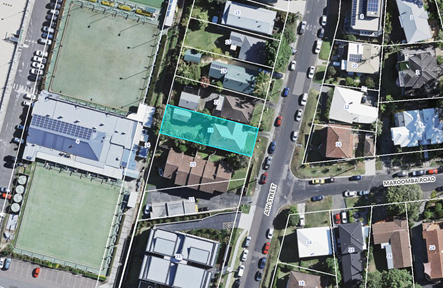
Figure 1 - Site context and immediate surrounds (Source: CCC Mapping)
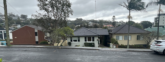
Figure 2 - Existing building on subject site (centre)
and adjoining properties viewed from Ash Street
Surrounding Development
The site is located within a medium-density residential area within walking distance to the Terrigal town centre and Terrigal Beach, refer Figure 3. Bus stops with services to Gosford and Erina are within 290m from the development site.
Surrounding development consists of:
· Single storey / part two storey dwelling house to the north.
· Multi dwelling housing development to the south.
· Variety of dwelling houses across Ash Street to the east.
· Terrigal Bowling Club to the west.
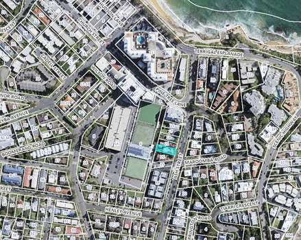
Figure 3 - Site and Locality context within Terrigal (Source: CCC Mapping)
The Proposed Development
The proposed development comprises construction and operation of a Boarding House and comprises:
· Demolition of part of the existing dwelling to undertake alterations and additions to facilitate a part 2 part-3 storey boarding house.
· Boarding House
o The boarding house will accommodate 10 rooms comprising 9 boarding rooms and 1 manager’s residence and provide housing for up to 11 lodgers.
§ Eight (8) rooms including the managers residence are designed as single rooms.
§ Two (2) rooms are designed as double rooms.
o Provision of a communal room on the ground floor and communal open space area at the rear of the site.
o Plan of Management for operation of the boarding house
· Parking
o 5 car parking spaces at ground level at the rear of the site / lower ground floor including an accessible car parking space.
o 2 x motorcycle and 2 x bicycle parking spaces within the lower ground floor.
o Vehicle access from Ash Street to rear of the site along northern side boundary.
· Waste
o Bulky waste store on lower ground floor and waste enclosure within site frontage.
The proposed site plan with landscaping is shown in Figure 4 and elevations in Figures 5 & 6.
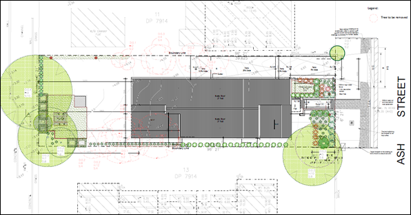
Figure 4 - Site Plan
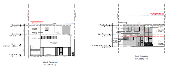
Figure 5 - West and East Elevations
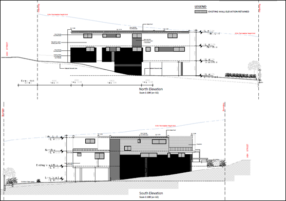
Figure 6 - North and South Elevations
Black shaded areas show the parts of the existing dwelling house to be retained
The proposed streetscape elevation is shown in Figure 7.
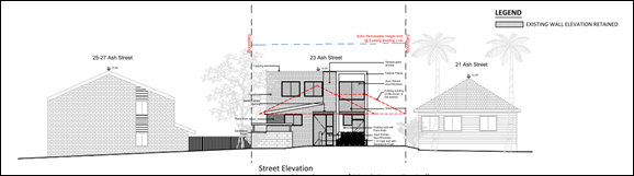
Figure 7 – Streetscape Elevation
ASSESSMENT:
Having regard for the matters for consideration detailed in section 4.15 of the EP&A Act, and other relevant statutory requirements, the following section provides an assessment against relevant provisions, and identifies the key issues of this application.
The Central Coast Local Environmental Plan 2022 (CCLEP 2022) was exhibited from 6 December 2018 to 28 February 2019 and adopted by Council on 14 December 2020. The CCLEP has been finalised, notified on 24 June 2022, and came into effect on 1 August 2022. This application is subject to saving provisions under clause 1.8A(1) of CCLEP 2022 and as such must be determined as if this plan had not commenced. The assessment and determination of this application has been made under Gosford Local Environmental Plan 2014.
Provisions of Relevant Instruments/Plans/Policies
Draft Environmental Planning Instruments
No draft Environmental Planning Instruments apply to this application.
State Environmental Planning Policies
State Environmental Planning Policy (Building Sustainability Index: BASIX) 2004
The application is supported by a BASIX certificate which confirms the proposal will meet the NSW government's requirements for sustainability, if built in accordance with the commitments in the certificate.
The proposal is considered to be consistent with the requirements of State Environmental Planning Policy (Building Sustainability Index: BASIX) 2004.
State Environmental Planning Policy (Sustainable Buildings (2022)
The State Environmental Planning Policy (Sustainable Buildings (2022) (Sustainable Buildings SEPP) commenced on 1 October 2023 and provides savings and transitional provisions in clause 4.2(1)(a) which states:
4.2 (1) This policy does not apply to the following—
(a) a development application submitted on the NSW planning portal but not finally determined before 1 October 2023,
The application was lodged prior to 1 October 2023. The applicant has submitted a valid BASIX Certificate.
State Environmental Planning Policy (Resilience and Hazards) 2021
State Environmental Planning Policy (Resilience and Hazards) 2021 commenced on 1 March 2022 incorporates and repeals the provisions of 3 SEPPs including State Environmental Planning Policy (Coastal Management) 2018 and State Environmental Planning Policy 55 – Remediation of Land.
No policy changes have been made and the SEPP consolidation does not change the legal effect of the existing SEPPs, with Section 30A of the Interpretation Act 1987 applying to the transferred provisions.
The relevant provisions of the SEPP are addressed as follows:
Chapter 2 Coastal Management
The aims of Chapter 2 are to be considered when determining an application within the Coastal Management Areas. The Coastal Management Areas are defined on maps issued by the NSW Department of Planning and Environment.
The site is located within the Coastal Environment Area and Coastal Use area as identified on these maps and subject to the provisions of Section 2.10 and Section 2.11 of the SEPP.
The development is not likely to have an adverse impact on the matters referred to in section 2.10 and section 2.11. The development is not considered likely to cause increased risk of coastal hazards on the site or other land. A summary of considerations is included below.
Section 2.10 - Development on land within the coastal environment area
In accordance with section 2.10(1) development consent must not be granted in the coastal environment area unless the consent authority has considered whether the proposed development is likely to cause an adverse impact on the following:
|
Matters for Consideration |
Compliance |
|
(a) the integrity and resilience of the biophysical, hydrological (surface and groundwater) and ecological environment |
The proposal is not likely to cause adverse impacts on the biophysical, hydrological, or ecological environment.
The proposal will be connected to reticulated sewer and stormwater will be managed on-site in accordance with the submitted stormwater plans. Erosion and sediment controls will be in place during demolition and construction, and the proposal will not impact on the environment. |
|
(b) coastal environmental values and natural coastal processes |
The proposal will not impact on the geological and geomorphological coastal processes. |
|
(c) the water quality of the marine estate (within the meaning of the Marine Estate Management Act 2014, in particular, the cumulative impacts of the proposed development on any of the sensitive coastal lakes identified in Schedule 1 |
The proposal will not result in an adverse impact on the water quality of the marine estate and does not drain to a sensitive lake contained in Schedule 1.
The proposal will be connected to reticulated sewer and stormwater will be managed on-site in accordance with the submitted stormwater plans. Erosion and sediment controls will be in place during demolition and construction, to minimise impacts on water quality, and the proposal will not impact on any sensitive coastal lakes. |
|
(d) marine vegetation, native vegetation and fauna and their habitats, undeveloped headlands, and rock platforms |
The proposal will not result in an adverse impact on native vegetation or fauna, undeveloped headlands, and rock platforms. |
|
(e) existing public open space and safe access to and along the foreshore, beach, headland, or rock platform for members of the public, including persons with a disability, |
The site does not have frontage to any foreshore, beach, headland, or waterway. |
|
(f) Aboriginal cultural heritage, practices, and places |
There are no identified aboriginal cultural heritage items on the site. |
|
(g) the use of the surf zone. |
Not applicable. No frontage to any beach/surf zone. |
There have been no adverse impacts identified in the consideration of Section 2.10(1) that would engage the further considerations under Section 2.10(2).
Section 2.11 - Development on land within the coastal use area
In accordance with section 2.11(1) development consent must not be granted in the coastal use area unless the consent authority has considered whether the proposed development is likely to cause an adverse impact on the following:
|
Matters for Consideration |
Compliance |
|
(a) whether the proposed development is likely to cause an adverse impact on the following: i. existing, safe access to and along the foreshore, beach, headland, or rock platform for members of the public, including persons with a disability, ii. overshadowing, wind funnelling and the loss of views from public places to foreshores, iii. the visual amenity and scenic qualities of the coast, including coastal headlands, iv. Aboriginal cultural heritage, practices, and places, v. cultural and built environment heritage. |
The site does not have frontage to any foreshore, beach, headland, or waterway.
The proposal will not cause an adverse impact on access, overshadowing, wind funneling or view loss from public places to any foreshore.
The proposal will not have adverse impact on the scenic qualities of the coast.
There are no known objects, areas, or items of heritage significance on the land, and no potentially adverse impacts on cultural or environmental heritage have been identified. |
|
(b) is satisfied that i. the development is designed, sited, and will be managed to avoid an adverse impact referred to in paragraph (a), or ii. if that impact cannot be reasonably avoided—the development is designed, sited, and will be managed to minimise that impact, or iii. if that impact cannot be minimised—the development will be managed to mitigate that impact, |
The proposal is appropriately designed and sited and will be management to avoid the adverse impacts referred to in clause 2.11(a) having regard to LEP and DCP requirements, the location and characteristics of the site and the approved development on the site and surrounding properties.
|
|
(c) has considered the surrounding coastal and built environment, and the bulk, scale, and size of the proposed development |
The bulk, scale and size of the proposed development is compatible with the scale and appearance of other multi-unit developments in the vicinity of the site in the coastal location. |
Section 2.12 - Development in coastal zone generally - development not to increase risk of coastal hazards.
In accordance with section 2.12 development consent must not be granted to development on land within the coastal zone unless the consent authority is satisfied that the proposed development is not likely to cause increased risk of coastal hazards on that land or other land.
The site does not have frontage to any foreshore, beach, headland, or waterway and will not cause increased risk of coastal hazards on other land.
Chapter 4 Remediation of Land
Clause 4.6 of Chapter 4 requires that a consent authority must not consent to the carrying out of any development on land unless it has considered whether the land is contaminated. and if the land is contaminated, it is satisfied that the land is suitable in its contaminated state (or will be suitable, after remediation) for the purpose for which the development is proposed to be carried out.
The current and historic land use is residential, and an existing dwelling and detached garage is currently present on the land. Due to the age of the structures hazardous materials including asbestos are expected within the structures. Plans indicate that part of the existing north and south facing walls are to be retained. Since the development proposes partial demolition of the existing dwelling the preparation of a hazardous material survey is recommended to ensure that any hazardous materials, such as asbestos, synthetic mineral fibers, and lead paint are removed and disposed of appropriately and not reused in the development.
It is recommended that the development be conditioned to provide A Hazardous Materials Survey for approval of Council’s Environmental Health and Protection Officer prior to issue of a construction certificate:
· Provide a Hazardous Materials Survey (‘HMS’) prepared by a suitable qualified occupational hygienist/assessor. The HMS must identify and list all hazardous materials within the existing dwelling, provide methods of safe removal and disposal, and confirm that all building materials proposed to be retained and reused in the boarding house are not hazardous materials and do not present a risk to human health and the environment.
The Environmental Site Assessment, 23 Ash Street, Terrigal NSW 2660, prepared by Compliance Health and Environmental Consulting, dated March 2023 has been reviewed. The Assessment considers contamination of soils from imported soils located at the rear of the property. The appropriate numbers of samples and sampling depths were taken, and the samples were analysed for all potential contaminants of concern. The appropriate human and ecological screening levels from NEPM were selected consisting of Residential A/ Recreational/Open space. Lab results indicated that all potential contaminants of concern were below the prescribed screening levels therefore the site is considered suitable for continued residential land use.
The development and the land are not otherwise mentioned in Section 4.6(4) and accordingly the provisions of Section 4.6(2) are not engaged by the proposal and consent may be granted. The proposal is considered consistent with the provisions of Chapter 4 of the SEPP.
The Panel can be satisfied that the proposed development complies with the provisions of Chapter 2 Coastal Management and Chapter 4 Remediation of Land of State Environmental Planning Policy (Resilience and Hazards) 2021.
State Environmental Planning Policy (Housing) 2021
State Environmental Planning Policy (Housing) 2021 (SEPP Housing) commenced on 26 November 2021.
Schedule 7A ‘Savings and transitional provisions’ of SEPP Housing states that the former provisions of the repealed instrument, being State Environmental Planning Policy (Affordable Rental Housing) 2009, continue to apply to a development application made, but not yet determined, on or before the commencement date. Given the application was lodged on 25 October 2021, the savings provisions apply.
SEPP Housing consolidates and updates the following housing related policies:
· State Environmental Planning Policy (Affordable Rental Housing) 2009 (SEPP ARH)
· State Environmental Planning Policy (Housing for Seniors and People with a Disability) 2004 (Seniors SEPP)
· State Environmental Planning Policy No 70 – Affordable Housing (Revised Schemes) (SEPP 70)
Clauses 23-27 of the SEPP Housing relate to Boarding Houses.
A key change of SEPP Housing is that Boarding Houses must now be used for affordable housing in perpetuity and delivered by Community Housing Providers.
Changes are also made to the standards which cannot be used to refuse consent, the following are relevant:
· A 30% GFA bonus is applicable (previously 0.5:1). On this site this equates to a bonus of 0.18:1 and a total allowed FSR of 0.78:1 instead of 1.1:1. The proposed FSR 0.57:1.
· A Minimum 30sqm of communal living space is required for boarding houses with six rooms or more with an additional 2sqm is required for each additional room. Under the SEPP ARH there is no size requirement for communal living rooms although private open space is required and is interpreted as communal living space. This proposal would require a 36sqm communal living room under the new Housing SEPP. The proposed communal living area totals 18sqm.
· Communal open space equivalent to 20% of the site area is required, which would equate to 96.12sqm. A 30sqm open space area is proposed.
The changes under the new SEPP Housing are significant and would not be able to be achieved with the proposed design approach. Given the savings provisions applicable the proposal has been assessed against the provisions of the SEPP ARH.
State Environmental Planning Policy (Affordable Rental Housing) 2009
The subject development has been designed under the provisions of State Environmental Planning Policy (Affordable Rental Housing) 2009 (SEPP ARH) and requires assessment under the controls of Division 3 Boarding Houses and Clause 26 stipulates that the provisions of the SEPP apply to land within an R1 zone.
Clause 29 and clause 30 of SEPP ARH are of relevance, as clause 29 details a set of standards that cannot be used to refuse consent by a consent authority, and clause 30 provides a set of standards for Boarding Houses.
The following table provides an assessment of the controls.
|
Clause/Provision |
Proposed |
Comply |
|
Clause 26 – Land to which this policy applies |
||
|
This Division applies to land within any of the following land use zones or within a land use zone that is equivalent to any of those zones. (a) Zone R1 General Residential |
The subject site is zoned R1 General Residential under Gosford Local Environmental Plan 2014 (GLEP 2014). Division 3 applies to the R1 General Residential zone.
|
Yes |
|
Clause 27 – Development to which Division applies |
||
|
27(2) – Within an Accessible Area |
Not applicable. Subject site is zoned R1 General Residential. |
N/A |
|
Clause 29 - Standards that cannot be used to refuse consent |
||
|
29(1) A consent authority must not refuse consent to development to which this Division applies on the grounds of density or scale if the density and scale of the buildings when expressed as a floor space ratio are not more than: (c) if the development is on land within a zone in which residential flat buildings are permitted and the land does not contain a heritage item that is identified in an environmental planning instrument or an interim heritage order or on the State Heritage Register—the existing maximum floor space ratio for any form of residential accommodation permitted on the land, plus— (i) 0.5:1, if the existing maximum floor space ratio is 2.5:1 or less, |
The maximum Floor Space Ratio (FSR) for the site as identified under Gosford Local Environmental Plan 2014 (GLEP 2014) is 0.7:1 Clause 4.4(2). Clause 4.4(2A)(e) applies in R1 zone reducing the FSR to 0.6:1. As per 29(1)(c)(i) the applicable FSR is 0.6:1 plus 0.5:1, resulting in an FSR of 1.1:1. The proposal provides for an FSR of 0.57:1, which is below the maximum allowable FSR. |
Yes
|
|
29(2) A consent authority must not refuse consent to development to which this Division applies on any of the following grounds: For clarification, if the development does not meet the standard the application can be refused based on non-compliance. If the development meets the standard, it cannot be refused for that reason. |
||
|
(a) Building height: if the building height of all proposed buildings is not more than the maximum building height permitted under another environmental planning instrument for any building on the land. |
The maximum height for the site as identified under Gosford Local Environmental Plan 2014 (GLEP 2014) is 8.5m.
The application proposes a maximum height of 8.5m which complies with the height limit requirement.
However, it is noted the proposal does not indicate a lift overrun (as shown in the Traffic Report).
The plans attached to the Traffic Report (dated September 2021) were not amended to reflect the plans lodged with the application which removed the lift overrun from the proposal as it is assumed this was for the purpose of compliance with the required building height. The inclusion of a lift overrun would breach the 8.5m height limit.
This is not satisfactory from a DA assessment perspective as it creates ambiguity in the design to which the proposal is being considered for the consent authority and the community. However, is not a reason for refusal in this instance. There is opportunity to comply with the BCA and a condition can be applied for no lift overrun should the application not be refused on other reasons. |
Yes |
|
(b) landscaped area: if the landscape treatment of the front setback area is compatible with the streetscape in which the building is located. |
The proposed landscaped treatment of the front setback is compatible with adjoining developments. |
Yes |
|
(c) Solar access: where the development provides for one or more communal living rooms, if at least one of those rooms receives a minimum of 3 hours direct sunlight between 9am and 3pm in mid-winter. |
The proposed communal room will receive a minimum of 3 hours direct sunlight between 9am and 3pm in mid - winter and therefore complies. |
Yes |
|
(d) Private open space: if at least the following private open space areas are provided (other than the front setback area): (i) one area of at least 20 square metres with a minimum dimension of 3 metres is provided for the use of the lodgers, (ii) If accommodation is provided on site for a boarding house manager – one area of at least 8 square metres with a minimum dimension of 2.5 metres is provided adjacent to that accommodation. |
Use of Lodgers The proposal provides 2 areas of communal open space: · 30sqm with a minimum dimension of 5.7m at the rear of the site. Managers residence The proposal provides approximately 8sqm with minimum dimension of 2.5m adjacent to the manager’s room. The POS is located within the front setback and is contrary to the controls. The proposal does not satisfy the open space requirements. The design of the proposal does not demonstrate best practice in the design of developments within the R1 medium density zoning and results in poor site planning and impacts on the level of amenity provided for the permanent onsite manager. |
Yes
No
|
|
(e) Parking if: (iia) in the case of development not carried out by or on behalf of a social housing provider—at least 0.5 parking spaces are provided for each boarding room, and (iii) In the case of any development – not more than 1 parking space is provided for each person employed in connection with the development and who is resident on site. |
(iia) Boarding rooms = 9 x 0.5 spaces = 4.5 spaces (iii) Managers residence – 1 space
Total spaces required - 5.5 spaces rounded up to 6 spaces.
The proposal provides 5 spaces at the rear of the site.
The proposal does not satisfy the numerical requirements associated with onsite car parking provisions in clause (iia) and (iii).
The application has included the managers residence as a boarding room. The manager’s residence is for permanent occupancy of a manager employed in connection with the development who is a resident on site and requires 1 car space (clause 29(e)(iii) SEPP ARH applies). It is also noted the SEPP ARH defines a boarding room as one capable of being occupied by one or more lodgers. The onsite manager is not considered a lodger. |
No |
|
(f) Accommodation size: if each boarding room has a gross floor area (excluding any area used for the purposes of private kitchen or bathroom facilities) of at least: (i) 12 square metres in the case of a boarding room intended to be used by a single lodger, or (ii) 16 square metres in any other case. |
Single Lodger Rooms x 7 - >12sqm Double Lodge Room x 2 - >16sqm
|
Yes |
|
29(3) A boarding house may have private kitchen or bathroom facilities in each boarding room but is not required to have those facilities in any boarding room. |
Each boarding room is provided with own private kitchenette and bathroom facilities. |
Yes |
|
Clause 30 - Standards for boarding houses |
||
|
30(1) A consent authority must not consent to development to which this division applies unless it is satisfied of each of the following: (a) If a boarding house has 5 or more boarding rooms, at least one communal living room will be provided. |
The proposal provides for an indoor communal area of approximately 18sqm on the ground floor. |
Yes |
|
(b) No boarding room will have a gross floor area (excluding any area used for the purpose of private kitchen or bathroom facilities) of more than 25sqm. |
No rooms exceed 25sqm excluding kitchen and bathroom facilities. |
Yes |
|
(c) No boarding room will be occupied by more than 2 adult lodgers.
|
No more than 2 adult lodgers are proposed. A condition of consent can be imposed to ensure compliance. |
Yes |
|
(d) Adequate bathroom and kitchen facilities will be available within the boarding house for the use of each lodger. |
All rooms are provided with bathroom kitchen and laundry facilities. |
Yes |
|
(e) If the boarding house has the capacity to accommodate 20 or more lodgers, a boarding room or on-site dwelling will be provided for a boarding house manager. |
The boarding has the capacity to accommodate up to 11 lodgers and as such a boarding house manager is not required. However, the current proposal is to provide a manager’s residence (Room 02). |
Yes |
|
(f) Repealed. |
Not applicable |
N/A |
|
(g) If a boarding house is on land zoned primarily for commercial purposes, no part of the ground floor of the boarding house that fronts a street will be used for residential purposes unless another environmental planning instrument permits such a use. |
The proposed subject site is not located within a commercial zone - not applicable. |
N/A |
|
(h) at least one parking space will be provided for a bicycle, and one will be provided for a motorcycle, for every 5 boarding rooms. |
There are 2 motorcycle and 2 bicycle parking spaces provided on the lower ground level. |
Yes |
|
Clause 30A - Character of local area |
||
|
A consent authority must not consent to development to which this Division applies unless it has taken into consideration whether the design of the development is compatible with the character of the local area. |
The proposal is not compatible with the character of the local area. Refer comments below. |
No
|
Clause 30A-Character of Local Area
Clause 30A states:
A consent authority must not consent to development to which this Division applies unless it has taken into consideration whether the design of the development is compatible with the character of the local area.
In determining whether the design of the development is compatible with the character of the local area, consideration was given to the planning principle in Project Venture Development Pty Ltd v Pittwater Council [2005] NSWLEC 191. Compatibility is seen to be a measure of the ability to exist together in harmony. It is not a test of sameness. To establish compatibility with the character of the local area, the following questions should be asked.
1. Are the proposal’s physical impacts on surrounding development acceptable? The physical impacts include constraints on the development potential of surrounding sites.
2. Is the proposal’s appearance in harmony with the buildings around it and the character of the street?
For a development to be visually compatible with its context, it should contain, or at least respond to, the essential elements that make up the character of the surrounding urban environment. The most important contribution to urban character is the relationship of built form to surrounding space, a relationship that is created by building height, setbacks and landscaping and are discussed as follows:
Building Height
The proposed development complies with the building height development standard in the GLEP 2014 having a height of 8.5m and has the appearance of a 2-storey dwelling when viewed from the street and a 3-storey residential flat building development when viewed from the other aspects of the building.
The revised Statement of Environmental Effects (SEE May 2023) states: Ash Street can be characterised by a wide range of housing types including high density housing, medium density and 1-2 storey low density dwellings of mixed ages and architectural styles.
In response, the high-density portion of Ash Street occurs within that part of Ash Street located within the Terrigal Town Centre where building heights are permitted up to RL 18.5m AHD (10 Pine Tree Lane - corner of Ash Street) and RL 20.8m AHD (24 Terrigal Esplanade – corner of Ash Street). These properties are zoned B2 Local Centre under the GLEP 2014. Otherwise, all other developments within Ash Street zoned R1 General Residential have an 8.5m maximum height limit generally of 1-2 storey developments under the planning controls of GLEP 2014 and where existing multi-unit developments occur, considered medium density developments located within consolidated allotments (33 Ash Street and 20-22 Maroomba Road).
A lift is proposed within the building and generally a lift overrun is required however is not identified on the architectural plans. It is noted the plans attached to the Traffic Report (dated September 2021) included a lift overrun and do not reflect the plans lodged with the application which removed the lift overrun from the proposal and it is assumed this was for the purpose of compliance with the required building height. The inclusion of a lift overrun would breach the 8.5m height limit.
The BCA Report (dated 19 April 2023) submitted with the amended proposal (Rev T plans) indicates compliance with the BCA can be achieved by the lift shaft taken up to a point higher than the building’s roof structure or alternatively is to be enclosed at the top with construction complying with Specification C1.1 of the BCA. Full documentation is to be provided with the Construction Certificate application.
The inconsistency with submitted documents is not satisfactory from an assessment perspective as the consent authority cannot be satisfied the proposal is of a satisfactory design and complies with the development controls. The possibility that the lift overrun as shown in the Traffic Report is constructed post DA approval being located to the southern side boundary would cause additional overshadowing and streetscape impacts.
Notwithstanding, the proposal has been considered compliant with the building height development standard and a condition would be required for no lift overrun should the application not be refused on other reasons.
Setbacks
The design of the development proposes to retain existing side setbacks by retaining part of the existing dwelling walls on the ground level. This appears to be the basis for compatibility with character of the areas. The SEE states: With the proposed works to be contained within the existing building footprint, there where be no change to the building envelope in-terms of its overall building footprint and setback (front and side boundaries). This will ensure that the siting of the building footprint will continue to be compatible with the development pattern in the locality.
The site is constrained by its allotment size, slope, and orientation. The design of the development has not appropriately considered the site constraints. The retaining of the existing setbacks results in adverse design and amenity issues.
The proposal is not compatible with the desired character of the area for the following reasons:
· Building bulk is located adjacent to the southern boundary and will cause additional overshadowing impacts to adjoining townhouses and their private open spaces. Design amendments have reduced some overshadowing impacts however the design of the proposal has not attempted to mitigate these impacts.
· The proposal has a large area of driveway and on ground parking (noting the application proposes a shortfall of 1 car space under the SEPP ARH) and provides inadequate landscaping along the north side boundary to accommodate a compliant driveway access in accordance with AS2890.
· The retaining of the existing dwelling height of the ground floor at a height lower than the front property boundary and significantly lower than road reserve creates inadequate vehicle, pedestrian, and waste bin access transitioning from the site to the street.
· Fill is required over the site to reduce driveway grades and comply with flooding impacts.
· The proposal provides poor amenity to the Managers residence with the location of its required private open space within the front setback and is contrary to the development standards of the SEPP ARH.
Landscaping
The proposal provides a consistent front setback to adjoining development and proposes landscaping within this setback as required by the SEPP ARH.
However as stated above, landscaping originally proposed along the northern side boundary has been removed to provide a compliant driveway in accordance with AS2890.
Landscaping is proposed at the rear of the site however overall, the proposal does not provide adequate landscaping along all site boundaries to reduce the visual bulk and mass of the building.
In summary, the design of the development has been considered and the proposal is not compatible with the character of the local area.
· The physical impacts of the development are not acceptable for the reasons stated above. The proposal is likely to result in constrained development potential of adjoining properties. The design of the development has adverse impacts on amenity to adjoining development as it does not minimise the extent of overshadowing to adjoining development to the south, locates waste enclosure and private open space of the managers residence within the front setback. The proposal does not provide the required onsite car parking the likely impacts affecting the already congested on street parking.
· The proposal’s appearance does not result in harmony with the buildings around it. The setbacks and separation distance create adverse amenity, visual and privacy impacts on adjoining properties.
The proposed development is unsatisfactory with regard to the planning controls and objectives under Division 3 Boarding Houses of the State Environmental Planning Policy (Affordable Rental Housing) 2009 as the proposal:
a. Has failed to demonstrate that the development complies with Clause 29(d) in the location of the private open space for the managers residence.
b. Has failed to demonstrate that the development complies with Clause 29(e) in the provision of adequate off-street parking.
c. Has failed to demonstrate that the development complies with Clause 30A in that the development is not compatible with character of local area.
Reason for Refusal 1
Gosford Local Environmental Plan 2014 (GLEP 2014) - Zoning and Permissibility
Permissibility
The subject site is zoned R1 General Residential under GLEP 2014. The zoning map is provided at Figure 8 below.
The proposed development is defined as boarding house.
The use is defined under the GLEP 2014 as:
boarding house means a building or place—
(a) that provides residents with a principal place of residence for at least 3 months, and
(b) that contains shared facilities, such as a communal living room, bathroom, kitchen, or laundry, and
(c) that contains rooms, some, or all of which may have private kitchen and bathroom facilities, and
(d) used to provide affordable housing, and
(e) if not carried out by or on behalf of the Land and Housing Corporation—managed by a registered community housing provider,
but does not include backpackers’ accommodation, co-living housing, a group home, hotel or motel accommodation, seniors housing or a serviced apartment.
Development for the purposes of a ‘Boarding House ‘is permissible in the R1 General Residential zone with development consent.
Zone Objectives and Land Use Table
The objectives of the R1 General Residential zone are:
· To provide for the housing needs of the community.
· To provide for a variety of housing types and densities.
· To enable other land uses that provide facilities or services to meet the day to day needs of residents.
· To ensure that development is compatible with the desired future character of the zone.
· To promote best practice in the design of multi dwelling housing and other similar types of development.
· To ensure that non-residential uses do not adversely affect residential amenity or place demands on services beyond the level reasonably required for multi dwelling housing or other similar types of development.
![]()
![]()
![]()
Figure 8 – Zoning Map Gosford Local Environmental Plan 2014 – (Source: CCC Mapping)
In this instance, it is considered that the proposal is inconsistent with the following objectives of the zone:
a. The proposal has failed to demonstrate the proposal is compatible with the desired future character of the zone.
o The proposal’s appearance does not result in harmony with the buildings around it.
o The setbacks and separation distance are inadequate and create adverse amenity, visual and privacy impacts on adjoining residential properties.
b. The proposal has failed to demonstrate best practice in the design of multi dwelling housing and other similar types of development.
o The design of the development has not appropriately considered the site constraints and is overdevelopment of the site, evident by non-compliance with SEPP ARH controls and the resultant overshadowing impacts on adjoining development, inadequate landscaping, inadequate onsite car parking.
o The proposal has not demonstrated suitable access grades and transitions for vehicles and pedestrians from the site to the street can be achieved.
Reason for Refusal 2
Gosford Local Environmental Plan 2014 - 2.7 Demolition requires development consent
Consent is sought for the partial demolition of the existing building to carry out alteration / additions to facilitate the development of a boarding house.
Gosford Local Environmental Plan 2014 - 4.3 Height of Buildings
Clause 4.3(2) of GLEP 2014 provides that the height of a building on any land will not exceed the maximum height shown for the land on the Height of Buildings Map. The maximum height shown on the relevant map is 8.5m. The GLEP 2014 defines this as the height above existing ground level.
The development proposes a maximum height of 8.5m to existing ground level and complies with the development standard.
Gosford Local Environmental Plan 2014 – 4.4 Floor Space Ratio
Clause 4.4(2) Floor Space Ratio (FSR) of GLEP 2014 provides the maximum floor space ratio for a building on any land. The site is identified on the GLEP 2014 FSR map as being 0.7:1.
The proposal is subject to exceptions to FSR under clause 4.4(2A)(e).
Despite subclause (2), the maximum floor space ratio for a building on land in Zone R1 General Residential for which the maximum floor space ratio on the Floor Space Ratio Map is 0.7:1 or 0.85:1 is to be—
(e) if the building is used for any other purpose (excluding a dwelling house)—0.6:1 or 0.75:1, respectively.
Therefore, the maximum FSR applicable a boarding house under GLEP 2014 is 0.6:1. The proposed development has an FSR of 0.57:1 and complies with the development standard.
Gosford Environmental Plan 2014 – 5.21 Flood Planning
Flooding advice was provided at a pre-DA meeting dated 16 December 2020 that indicated:
“The site is identified as being affected by Terrigal Bowling Club & CBD Flood Study. The 1% AEP flood level is RL 3.3m AHD, MFL is RL 3.8m AHD.
The existing ground floor level of RL 7.09 AHD and proposed lower ground floor level of RL 4.39m AHD are satisfactory.”
However, since the time of the pre-DA meeting held in December 2020, the “Terrigal Bowling Club & CBD Flood Study” and associated flood and flood planning control levels has been superseded by the Council’s Coastal Lagoons Overland Flood Study. In this regard, the Council’s Coastal Lagoons Overland Flood Study for the associated Terrigal catchment is the most recent flood study incorporating this site, which indicates that the site is now affected by flooding and flood planning controls as follows: The 1%AEP flood level is RL 4.08m AHD with a H3 hazard category within the lower western end of the site; The associated Flood Planning Level (FPL) is RL 4.58m AHD; The PMF level is RL 6.03m AHD.
The plans originally submitted with the application at lodgement indicated the area of the lower ground floor room (U.1) was being excavated below natural levels to propose a floor level of RL 4.39m AHD which was 0.19m below the current flood planning level. Therefore, the proposal for room U.1 with a habitable area that did not comply with the current FPL was not supported. The applicant was advised that any proposal for habitable areas must achieve a minimum floor level equivalent to the flood planning Level (RL 4.58m AHD). Subsequent revised architectural plans (Rev T, Q & R) now indicate a floor level of RL 4.75m AHD which satisfies the flood planning level requirement.
Furthermore, in relation to extreme events greater than the 1%AEP, it is noted that the occupant of room U.1 could become trapped with inundation levels in the PMF (for example) being 1.28m deep which would be deemed to be an unacceptable risk to life. (It is also unlikely that the lift would work in an extreme event like the PMF to permit evacuation of this area.) The applicant was advised that any proposal for a habitable floor area under the PMF level (RL 6.03m AHD) was to have a safe path of evacuation. A Flood Evacuation Strategy prepared by SGC Consulting Engineers (File Ref: 20210077-R02_Flood Evacuation [A].docx Issue A dated 3 March 2023) was submitted which indicates the following:
Occupants within U1 (and the rest of the lower ground) are able to evacuate any dangers that the PMF would pose. All affected people can escape via the driveway ramp and then re-enter the site through the main pedestrian entry where they are able to wait in the communal room which has an RL of 7.39 AHD. This has a 1.36m additional to the PMF level and provides shelter until such a time it is deemed safe to return to the lower ground.
With due consideration of this statement and the revised Architectural plans (Rev R) it was noted that an occupant in Unit U.1 could be trapped in the PMF event from potential depths of flow and hydrostatic pressure from flood waters on the external door to the lift area outside the unit. The latest architectural plans (Rev T) have now provided a safe evacuation route via an internal stairwell within the building from room U.1 to the level above.
The proposal is considered consistent with the requirements and objectives of clause 5.21 in
that:
· The flood affectation has no risk to life and property associated with the proposed development.
· The proposed development is compatible with the flood function and behaviour on the land.
· The proposed development does not have adverse cumulative impacts on flood behaviour and the environment.
· The proposed development enables safe occupation and efficient evacuation of people in the event of a flood.
The proposal has been reviewed by Council’s Senior Development Engineer in relation to flooding and is considered satisfactory in respect to clause 5.21 of GLEP 2014.
The Panel can be satisfied that the matters contained in clause 5.21 Flood Planning have been adequately considered and the proposed development complies with the provisions and objectives of clause 5.21 of GLEP 2014.
Gosford Environmental Plan 2014 – 7.1 Acid Sulfate Soils
This land has been identified as being affected by the Acid Sulfate Soils Map and the matters contained in clause 7.1 of GLEP 2014 have been considered. The site contains Class 5 Acid Sulfate Soils. In this instance, the proposal works are not considered to impact on Acid Sulfate Soils.
The Panel can be satisfied that the proposed development complies with the provisions of clause 7.1 Acid Sulfate Soils.
Central Coast Local Environmental Plan 2022 Consistency
The Central Coast Local Environmental Plan 2022 (CCLEP 2022) was exhibited from 6 December 2018 to 28 February 2019 and adopted by Council on 14 December 2020. The CCLEP 2022 has been finalised, notified on 24 June 2022, and came into effect on 1 August 2022.
This application was lodged on 25 October 2021 and is subject to saving provisions under clause 1.8A(1) of CCLEP 2022 and as such must be determined as if this plan had not commenced. The assessment and determination of this application has been made under Gosford Local Environmental Plan 2014 (GLEP 2014).
Notwithstanding, the development standards and special provisions of CCLEP 2022 are discussed for the purpose of consistency.
· The subject site is zoned R1 General Residential. A boarding house is permissible in the zone with consent. The proposal is not consistent with the zone objectives for R1 zoned land.
· Clause 4.3(2) stipulates the maximum height for the land on the Height of Buildings Map which is 8.5m. The development proposes a height of 8.5m to existing ground level and complies with the development standard.
· Clause 4.4(2) stipulates the maximum Floor Space Ratio (FSR) for the land on the Floor Space Ratio Map which is 0:5.1. The proposal is not subject to exceptions to FSR under clause 4.4A(4). The development proposes an FSR of 0.57:1 and does not comply with the development standard.
· Clause 5.21 – Flood Planning - the land is subject to flood related controls. The proposal complies – refer to discussion under clause 5.21 Flood Planning of GLEP 2014.
· Clause 7.1 Acid Sulfate Soils - This land has been identified as being affected by the Acid Sulfate Soils Map and the matters contained in clause 7.1 have been considered. The site contains Class 5 Acid Sulfate Soils. In this instance, the proposal works are not considered to impact on Acid Sulfate Soils.
· Clause 7.6 Essential Services – the site is connected to electricity, reticulated water and sewer and currently serviced for waste collection. Adequate stormwater drainage can be achieved. The proposal has not demonstrated satisfactory waste storage area is provided or is capable of providing suitable transitions for vehicular access and waste bin access from the site to the street.
Gosford Development Control Plan 2013 (GDCP 2013)
The relevant controls of Gosford Development Control Plan 2013 are considered below:
Chapter 2.1 Character
The site is located within the character area: Terrigal 6: Medium Density Hillsides of GDCP 2013.
The character statement provides for the desired character as follows:
These areas should remain medium-density residential hillsides where improved standards of amenity and urban design quality are achieved by new multi-unit developments that are surrounded by leafy hillside gardens, providing distinctive backdrops to Gosford City’s town centres, main roads, or the railway.
Maintain the existing informal scenic qualities of hillside properties and road verges by site planning those conserves visually prominent trees, particularly near hill crests, close to ridgelines or along street frontages and verges. Surround new developments with leafy gardens that retain natural slopes along all boundaries, providing space for new shady trees and shrubs, and avoiding the appearance of long or continuous buildings. On the steeper properties, use low-impact construction such as framed structures with suspended floors and decks that are elevated above basement parking, rather than extensive cut-and-fill that requires tall retaining walls or steep driveways. Plant a combination of trees and shrubs that are mostly indigenous along all property boundaries and through courtyards and use hedges or front fences that are low or see-through rather than tall and opaque.
Minimise the scale of new buildings and retain a proportion of the panoramic views that are available from any neighbouring property by using strongly articulated forms, including floor-levels that are stepped to follow natural slopes plus facades that vary in shape and height. For example, divide floorspace into individual dwelling pavilions with a varied form or orientation, separated by verandahs and landscaped courtyards. Any facades that are taller or longer than buildings on neighbouring properties should be screened by a combination of extra setbacks and balconies or verandahs. Roofs should be gently pitched to minimise the height of ridges, and flanked by wide eaves that disguise the scale and bulk of exterior walls. Parking is preferable in basements or open carports, rather than in wide garages that would accentuate building bulk, dominate visible facades or require steep driveways.
A “light-weight appearance” is preferable for all visible facades to minimise their scale and bulk, incorporating walls of windows that are shaded by framed balconies or verandahs plus exterior sunscreens, some painted finishes and sheet or board cladding rather than extensive plain masonry. Where dwellings face a street or common access-way, provide a traditional “street address” with visible verandahs, living rooms and front doors.
Screen any driveways, terraces, courtyards, and balconies to protect the privacy and amenity of neighbouring dwellings.
Comment:
The design of the development was amended during assessment to reduce visual bulk and improve solar access impacts to the adjoining multi dwelling housing development to the south by the reduction in height of the rear (west) extension. The retention of two existing trees in the southwest corner of the site is an improvement. The communal open space remains surrounded by parking areas but has been improved by the retention of existing trees and further landscaping.
The SEE indicates that the proposal retains part of the external walls of the existing dwelling to demonstrate the existing building envelope in terms of its overall setbacks is to be retained and therefore addresses the unique characteristics of the site, is sympathetic to the diverse built form character along Ash Street and consider residential amenity to surrounding properties.
It is considered the retaining of the existing building as stated is detrimental to the proposal and results in poor site planning. The improvements in the revised design are minimal. The proposed design locates building mass to the southern boundary creating overshadowing impacts. The driveway is located against the northern boundary, without landscaping buffer and adjacent the northern residential dwelling creating privacy and amenity impacts to that dwelling. It is considered the proposal is not compatible with the desired character of the area for the reasons identified under the SEPP ARH clause 30A character assessment.
The SEE states: it is noted that the area is undergoing a change in character as the DCP states that the original character of modest holiday cottages is changing rapidly, and the semi-regular layout of allotments now supports a dense mix of apartment and townhouse developments.
There has been minimal change in mix of development types within the immediate area of the subject site due to size, topography, and orientation of allotments in Ash Street unless development comprises more than one allotment. The lot size of the subject site at 480.6sqm restricts development for dual occupancy and multi dwelling housing developments as defined under the previous and current development controls.
In this instance, intensification of the site as proposed does not comply with the desired character of the area as described in the character statement in that the proposal:
· Does not provide improved standards of amenity and urban design quality.
· Does not provide a satisfactory level of articulation, a lightweight appearance is not provided, floor levels are not stepped to follow natural slopes.
· Does not provide adequate landscaping along site boundaries to screen driveways and parking areas to provide a leafy garden setting.
· Proposes fill to achieve compliant internal driveway and parking areas.
· The design and layout do not reasonably respond to the site constraints and proposes a building of excessive bulk and scale resulting in adverse amenity impacts to the subject site and adjoining properties.
Reason for Refusal 3
Chapter 2.2 Scenic Quality
The site is located within in the Terrigal Land Unit within the North Coastal Geographic Unit.
The principle aim of the Scenic Quality chapter is to provide guidelines for the interpretation and management of the scenic quality of the area in accordance with the development objectives of the landscape unit.
The landscape character is described as follows:
The Terrigal Landscape Unit is strongly enclosed because of landform characteristics and contains the most urban of the coastal settlements of Gosford centred on the beach, Terrigal Haven and The Skillion and surrounding the lagoon. As a result of the landform and vegetation characteristics, the landscape and development are codominant. The Terrigal area comprises significant coastal landscape features including the beach to Wamberal Lagoon and foreshore areas and The Skillion. The primary urban and commercial areas concentrate on the seaside of the lagoon while the area to the west is more suburban and surrounded by rural residential hinterland. The rural residential hinterland occupies higher ground in the unit and provides a natural backdrop to the unit and a contrast to highly urbanised sections of the unit.
The Terrigal Unit is of regional scenic value where the maintenance of scenic character requires careful attention to siting and scale of urban elements so as not to overpower the natural elements of the lagoon, beach and surrounding natural backdrop.
The Applicant states:
The sloping topography and associated flood affectation at the rear of the subject site represent development constraints for the proposed development, however they also benefit the development in that the major portions of the buildings will be contained within the slope of the site towards the west and away from the eastern scenic portions of the area. In addition, the proposed works will incorporate a stepped building platform that will address the sloping topography of the site and will comply with the maximum permitted building height to ensure that it will not incongruously protrude when viewed from the rear.
Furthermore, the proposal will present a building form to Ash Street that will be consistent with the existing scale and pattern of development within the area. In this regard, the proposal will not create any adverse impacts on the existing scenic quality of the area and as such will be respectful to the existing scenic setting and will align with the intentions of this section of the DCP.
Comment:
The proposal does not provide a stepped building platform that appropriately addresses site constraints. Retaining the walls of the existing dwelling, thus maintaining existing building setbacks which sets the floor levels of the building has created design issues and amenity impacts as stated throughout this report.
The proposed development is of a bulk and scale that results in amenity impacts for future residents and adjoining properties. In addition, the proposal has not demonstrated suitable access grades and transitions for vehicle, pedestrian, and waste servicing from the site to the street can be achieved.
Notwithstanding this, the proposal provides a compliant building height and does not impact on the scenic quality of the area.
Chapter 3.1 Dwelling Houses, Secondary Dwellings and Ancillary Development
The Statement of Environmental Effects for this proposal has provided a compliance table under Chapter 3.1 Dwelling Houses, Secondary Dwellings and Ancillary Development. Consideration of the proposed boarding house under this Chapter and comparing a boarding house to a single dwelling house is not appropriate.
The proposal is an intensification of the use of the site to that of a single dwelling house. The form of the development could more appropriately be considered a residential flat building to which Chapter 3.3 Multi Dwelling Housing & Residential Flat Buildings applies. Under Chapter 3.3 more onerous development controls apply to the form of such development to that of a dwelling house for number of storeys, height of exterior walls, side setbacks, landscaping, and deep soil requirements.
The GDCP 2013 does not contain specific controls for boarding houses.
Notwithstanding this, a comprehensive assessment has been undertaken in relation to relevant chapters of the GDCP 2013, which including assessment under SEPP ARH identify the likely impacts of the development and suitability of the site for the proposal.
Chapter 6.7 Water Cycle Management
The site grades from the Ash Street (eastern frontage) to the rear of the site (western frontage) with a fall of approximately 4m.
Following a request from Council, the applicant submitted a ‘Water Cycle Management Report’ prepared by SGC Consulting Engineers (Ref 20210077-R01_WCMP [A].docx Issue A dated 03.03.23. This Water Cycle Management Report addresses the requirements of Chapter 6.7 of Council’s Gosford DCP2013 as follows:
· On-Site Detention: A ‘DRAINS’ model was utilised to determine the on-site detention requirements for the proposed development. The results and proposed on-site detention system has been designed to limit post development flows back to less than or equal to predevelopment flows for all storms up to and including the 1%AEP recurrence interval. In this regard, an on-site detention system with a total volume of 18.5m3 is proposed, for which 6,000 litres (6m3) is obtained from a 50% volume credit associated with the proposed 13,500 litre (13.5m3) rainwater tank and 12.5m3 proposed in the combined OSD & Stormfilter tank.
· Water Quality: The ‘MUSIC’ model was utilised to analyse the performance of a treatment train approach utilising the rainwater tank and the stormwater filter chamber within the OSD tank, and Ocean guard baskets in drainage pits. The results indicate that the pollution reduction targets indicated in the DCP are achieved through the proposed water quality measures.
· Water Retention: In accordance with Chapter 6.7 of the Gosford DCP2013, a total of 11.6m3 is required for reuse within the development. An underground tank with a volume of 13.5m3 is proposed which satisfies the minimum volumetric requirement.
· Overland flows: The development has been designed to enable overland flows to be diverted around the building.
· Flooding: The floor level for Room U.1 has been amended to comply with the minimum floor level requirements related to flooding constraints on the site.
· An Operation & Maintenance Plan has been included in the report.
· Stormwater plans have been included in the report to detail the proposed water cycle management measures.
Revised ‘Stormwater Concept Design’ plans prepared by SGC Consulting Engineers (Ref 20210077 Sheets 1-6 (i.e., Drawing No’s SW100, SW200, SW201, SW300, SW400, & SW500 respectively), all Rev B dated 03.03.23) were submitted from which the outstanding stormwater related matters appear to have been satisfied.
Connection to the open drain within Council land (Terrigal Bowling Club site) will require an approval under S68 of the Local Government Act.
The proposal has been reviewed by Council’s Senior Development Engineer in relation to management of stormwater and is considered satisfactory in respect to Chapter 6.7 of GDCP 2013.
Chapter 7.1 Car Parking
Car Parking
Chapter 7.1 does not provide car parking rates for boarding houses. Consideration of the proposed parking rates has been undertaken under the Boarding House provisions of SEPP ARH. The proposal does not comply the parking rates of the SEPP ARH.
Traffic, Roads and Access
Council’s Senior Development Engineer has considered the proposal in relation to roads, access and traffic. The following comments are provided.
Existing Infrastructure within Ash Street, there is/are:
- Existing kerb & gutter and full width road pavement across the frontage of the site and neighbouring properties.
- An existing two strip concrete vehicle access crossing infilled at the footpath location. The associated layback is cracked.
- Concrete footpath across the site frontage and neighbouring properties. The footpath is located directly behind the kerb & gutter.
- Footway formation only for the section of footpath location. Behind the footpath, the footway is grassed and grades steeply down to the boundary at a grade of approximately 30%.
- Services in the footway including water (plus hydrant), and Telstra & NBN, etc,.
Road works
Road pavement works are not required for this development.
Access
Vehicular access
The site is presently accessed by a twin concrete strip vehicle access crossing between the existing footpath and the boundary, and an existing concrete driveway within the northern side boundary of the site, from the boundary to a garage located at the rear of the site. The alignment of the existing vehicular access is proposed to be retained, however, changes in final driveway levels are proposed.
The access driveway proposed will provide access to 5 car parking spaces (including 1 accessible space). A manoeuvring space area is also proposed to facilitate vehicles entering and existing the site in a forward direction. The access and parking areas will need to comply with AS2890.1:2004 and AS2890.6:2009. It is recommended that the development be conditioned to require signage in the manoeuvring area to indicate: “Manoeuvring Area. No Parking Permitted.”.
In relation the proposed driveway:
- Width: Although the vehicular access is indicated as a “ramp” (which would require a clear width of 3.6m wall to fence), it is considered to be a driveway for the purposes of access under AS/NZS 2890.1:2004 as it does not provide access to a basement carpark and is a low scale residential development. In this regard, in accordance with AS/NZS 2890.1:2004, the driveway would require a clear unobstructed width of 3m. The latest architectural plans (Rev T) and revised landscape plan now indicate that the driveway width has been increased to approximately 3m which has been achieved through the removal of landscaping along the driveway that was indicated on previous revisions of the plans.
- Access grades: The access grades for the proposed vehicle access crossing and driveway were requested to be amended to comply with the “Profile for Low Level Access with Footpath” indicated on Drawing No SD0508 Sheet 4 of 4 of Volume 3 of Council’s Civil Works Specification. Although the plan indicates a note to provide a vehicle crossing compliant with the Standard Drawing in Council’s Specification, the driveway levels within the site have not been amended to correlate to levels at the boundary that would match to those levels resulting to the adoption of Council’s Standard access profile, nor do the architectural plans indicate driveway details incorporating the Standard access crossing profile. Furthermore, the applicant has not provided longitudinal access profiles previously requested that would be compliant with Drawing No SD0508 Sheet 4 of 4 of Volume 3 of Council’s Civil Works Specification along each of the outside edges of the driveway and along the centreline, indicating existing and proposed levels to Australian Height Datum from the layback to the western end of the proposed driveway / car spaces.
Revised architectural plans were requested to be submitted to comply with the revised vehicular access requirements. These requirements were previously requested of the applicant, however, they have not been addressed in the latest revised Architectural plans (Rev T), the revised landscape plan, nor the revised stormwater plans to date.
Pedestrian Access
The development proposes to provide accessible paths of travel within the property from the front door to the property boundary, however, the development has not considered the constraint of the existing footway grades in the road reserve between the back of the footpath to the property boundary which are in the order of a 30% grade. Advice was provided at the pre-DA that the footway is to be formed at 2% from the kerb line to the property boundary across the full frontage of the site, however, it is noted that the formation of such would be problematic for tie-in works particularly at the northern and southern ends of the site frontage. Footway formation must be provided to provide acceptable pedestrian access grades from the road reserve to the development. In this regard the following is to be adopted as a minimum standard in this instance: The first 2.5m of the footway behind the kerb line is to be formed at 2% graded towards the kerb line, after which the maximum grade of the footpath connection to the property boundary is to be 1:14 (7.142%) graded towards the property boundary. From this raised resultant boundary level, transitions are to then occur within the property boundary to provide compliant accessible access grades to the front door. These requirements were previously requested of the applicant; however, they have not been addressed in any revised Architectural plans namely the Revisions T, Q &/or R plans), the revised landscape plan, nor the revised stormwater plans to date.
Footway formation
It is noted that recent developments (e.g., No 33 Ash Street) have required the footway to be formed at 2% from the back of kerb up to the boundary across the full frontage of the site where possible. (This was as also reflected in advice in the pre-DA for the subject site.)
The footway is to be formed as follows as a minimum requirement:
- For the pedestrian pathway connection in the footway, refer to requirement in ‘Pedestrian Access’ above. This footway formation is to extend a minimum of 1.5m either side of the outer edges of the pathway connection to the development.
- North of the pedestrian pathway connection formation in the footway, the footway grades behind the abovementioned 2.5m wide 2% formation is to transition from the 7.14% pedestrian link grade (towards the boundary) to the 10% grade associated with the vehicle access crossing adjacent to the vehicle access crossing.
- South of the pedestrian pathway connection formation, the footway grades behind the abovementioned 2.5m wide 2% formation is to transition from the 7.14% pedestrian link grade (towards the boundary) to the 10% grade (towards the boundary) at a point 3m within the alignment of the southern boundary of the lot, after which the footway it is to transition to natural levels near the southern alignment to prevent stormwater being trapped at the southern interface and avoid retaining walls in the road reserve.
The applicant was requested to submit revised plans that reflected these requirements. However, the revised plans submitted namely the Revisions T, Q & R of the Architectural plans, the revised landscape plan, nor the revised stormwater plans have addressed these requirements to date.
‘Public Domain Concept Design’ plans prepared by SGC Consulting Engineers (Ref 20210077, Sheets 1-5 Rev A dated 03.03.23) submitted for the application have not addressed the requested vehicle access and footway formation requirements previously requested by Council, nor the required transitions from the required works within the road reserve to connect the resulting levels at the boundary from such works in the road reserve to the proposed levels within the site.
Waste
The path of travel for the transfer of bins from the bin storage area to the kerb side is to provide an acceptable grade. It is recommended that this area link to the accessible pedestrian path within the site.
This requirement was previously requested of the applicant, however, it has not been addressed in the revised Architectural plans (Rev T, Q &/or R), the revised landscape plan, nor the revised stormwater plans to date.
Sight distance lines to pedestrians
As per advice in the pre-DA meeting, the development is to provide clear sight distance splays as per Fig 3.3 of AS 2890.1:2004. The development is to be amended to comply with this requirement.
This matter has not been addressed in the revised Architectural plans (Rev T, Q & R), the revised landscape plan, nor the revised stormwater plans to date.
Summary
In view of the above, the application is not supported for the following reasons:
1. The proposal has failed to provide suitable access grades and transitions compliant with Council’s Civil Works Specification and AS/NZS2890.1:2004 for the vehicle access crossing and internal driveway arrangements.
2. The proposal has failed to provide suitable accessible path of travel related to pedestrian access grades and transitions within the road reserve from the back of the existing kerb & gutter to the property boundary and then within the property boundary to the entry to the development.
4. The proposal has failed to provide a suitable path of travel for the transfer of bins from the bin storage area to the kerb side at an acceptable grade.
In this regard, the proposed development has not suitably demonstrated the design is compatible with the objectives of clause 7.1.1.3, a balance has not been achieved between the needs of the proposed development and its use, and that of vehicular and pedestrian traffic.
Reason for Refusal 4
Traffic
A “Traffic & Parking Assessment Report” prepared by Varga (Ref 21142 dated 28 September 2021) was submitted with the application at lodgement. This report indicates the following in relation to the proposed development:
- The proposed 5 car parking spaces (off street) satisfies the required parking rate for a boarding house based on 0.5 car spaces per room. (10 rooms proposed.)
- Two motorcycle and two bicycle spaces are also proposed in accordance with SEPP (Affordable Rental Housing) 2009.
- Vehicular access to the parking facilities is to be provided via a new entry/exit driveway located at the northern end of the Ash Street site frontage, which then extends along the northern setback of the site to the rear parking area.
- The proposed boarding house would generate a total of 3 peak hour trips, which is a net increase of 1 peak hour trip above than the existing use on the site (single dwelling).
- The additional traffic generation of the proposed development on the surrounding road network would be minimal.
The Report states:
- The geometric design layout of the proposed car parking facilities has been designed to comply with the relevant requirements specified in the Standards Australia publication Parking Facilities Part 1 - Off-Street Car Parking AS2890.1:2004 in respect of parking bay dimensions, ramp grades and aisle width, having regard to the adaptive re-use of the site.
- Specific reference is made to Table 3.1 & Table 3.2 in AS2890.1 which indicates that for a Class 1A development with less than 25 parking spaces, accessed from a local road, a Category 1 driveway is required which is between 3.0m (i.e. a single lane) and 5.5m wide (i.e. two-way).
- Reference is also made to AS2890.1 Clause 3.2.2, which states that as a guide, 30 or more movements in a peak hour (in and out combined) would usually require the provision for two vehicles to pass on the driveway – i.e. a minimum width of 5.5m.
- The proposed development is expected to generate just 3 peak hour vehicle trips (less at other times), which is significantly less than the 30 vehicles per hour threshold for two-lane ramps. The likelihood therefore of two cars entering and exiting the site at the same moment in time is statistically insignificant.
- The proposed development provides a single lane entry/exit driveway to service the 5 parking spaces and is therefore considered acceptable.
- Whilst it is noted that the aisle width in front of the front setback accessible space is not strictly compliant with AS2890.1:2004 numerical requirements, nor is the width of the ramp down to the rear parking area, due consideration needs to be given to the adaptive re-use of the site. Furthermore, swept turn paths of all parking spaces using a large B85 design vehicle confirm that the parking spaces are able to be accessed successfully. Importantly, all vehicles will be able to enter and exit the site whilst travelling in a forward direction at all times.
- The proposed parking arrangements satisfy the relevant requirements specified in both the SEPP (Affordable Rental Housing) 2009 [NSW] and the Australian Standards.
- It is therefore reasonable to conclude that the proposed development will not have any unacceptable parking implications.
From review of the car parking manoeuvrability indicated in the “Traffic & Parking Assessment Report” prepared by Varga (Ref 21142), it is noted that:
- car spaces C1 (accessible space) will require 2 manoeuvres to reverse into this space, with three manoeuvres to then exit the site in a forward direction.
- car spaces C2 will require 3 manoeuvres enter this space in a forward direction with two manoeuvres to then exit the site in a forward direction.
- car spaces C3, C4, & C5 will require 4 manoeuvres via the manoeuvring space to reverse into these spaces, with a single manoeuvre to then exit the site in a forward direction.
These manoeuvres are deemed acceptable with due consideration to the site constraints arising from the width of the lot being only 12.19m.
The application was referred to Council’s Traffic & Transport Engineer who raised no traffic objections to the proposal.
Chapter 7.2 Waste Management
Council’s Waste Management Assessment Officer has reviewed the amended plans (Rev T) and reports including the Operational Waste Management Plan by Elephants Foot Ref: SO1048 dated 7/09/2021 Rev B.
Insufficient information has been provided in relation to waste management.
Site Prep / Demolition / Construction:
· No Waste Management Plan has been provided for the demolition of any structure and the construction process.
Occupancy:
· Clarification on number of bins required by the proposed development. WMP states that 3 waste MGB’s and 2 recycling MGB’s will be required – the Operational Management plan states that there will be 5 of each.
· Site plans found in the WMP are different to the Architectural plan’s revision T, the WMP needs to be updated to reflect the new bin storage room.
· Consideration for future mandated food and organics (FOGO) collection to be included in waste generation report and proposed bin storage room size.
· Travel path from each unit to proposed Bin Storage area.
· Clarification on who has access to the bin storage area, will each resident be responsible for taking their own waste out to the storage area?
· Access to the proposed bin storage area – will it be locked? How will each user gain access? Also noted on plans the storage area is behind an automated roller door, what is the backup plan for a power failure and residents / building manager can't get access to the remove the bins?
· Travel path for proposed bin collection point and included gradients.
· Bulk waste storage room to be fully dimensioned.
· Collection point for Bulk waste to be clearly marked on site plans.
· Travel path for bulk waste from storage area to collection point, needs to be free from obstruction. Noting the proposed bulk waste storage room, clearance height under the proposed staircase should be considered for any travel path as well as the gradient of any driveways or walkways.
In this regard, as the proposal has not demonstrated sustainable waste management can be achieved.
Reason for Refusal 5
Other Matters for Consideration
General BCA Overview
Council’s interpretation of the classification of buildings and structures in accordance with Part A3 of the BCA is Class 3.
It is considered that there is an obvious design feature (internal stair) that would not prohibit the issue of a Development Consent from a BCA compliance perspective, however, needs to be addressed at CC stage.
Noise
The Noise Assessment, Proposed Boarding House Development, 23 Ash Street Terrigal, Revision 0, dated 30 March 2023 has been reviewed. The development is not close to a classified ‘busy road’ therefore an assessment of road noise impacts on the development is not required. Notwithstanding this the consultant has completed a road traffic noise assessment and provided recommendations for the building’s acoustic treatments for glazing, roof/ceiling and external walls.
Unattended noise monitoring was completed to determine the existing acoustic environment at the rear and front of the property. Appropriate residential and commercial sensitive receivers were selected. Noise modelling was completed for a total of 10 adults using the communal outdoor areas only, as well noise impacts from the onsite carpark. Due to an exceedance of the project specific noise criteria from the use of the onsite carpark at one (1) receiver, noise mitigation measures, acoustic fences, are required. Conditions can be applied.
A review of the mechanical plant and equipment will be required prior to CC to ensure that the project specific noise criteria can be met.
Plan of Management
The Plan of Management, New Generation Boarding House 23 Ash Street, Terrigal, dated 4 May 2023, prepared by Think Planners Pty Ltd has been reviewed. The boarding house will be managed by an appointed onsite manager who will be reasonably available 24/7 and will be responsible for building maintenance, pest control, keeping a resident register, waste collection, conflict resolution and incident reporting. Signage will be placed of the Managers contacts details on the building which will be visible to the public. A weekly cleaner will be appointed to clean common areas. A fire evacuation plan will be prepared for the building and CCTV will be placed in communal areas. Emergency contacts and procedures will also be prepared and displayed at the premises. House rules have been prepared for the property.
Soils and Construction
Excavations to at least 2 metres below the existing surface level are required into the subfloor space beneath the existing structure.
The total area of soil disturbance is expected to be greater than 250sqm, therefore formal erosion and sediment control plans are required. The submitted Erosion and Sediment Control Plan and Details, Revision A, prepared by SGC, dated 26.09.2021 is not supported in its current form for the following reasons:
· The standard construction drawings and notes do not meet the minimum requirements of the Landcom ’Blue Book’. All proposed erosion and sediment controls must meet the minimum requirements of the Blue Book. i.e., SD6-8 for sediment fence.
Reason for Refusal 6
Social Impact
A Social Impact Assessment (SIA) prepared by Planning Direction Pty Ltd dated 16 September 2021 and Plan of Management (revised) prepared by Think Planners Pty Ltd dated 4 May 2023 have been provided with the proposal.
The SIA concludes:
· The design of the development provides good amenity housing that is respectful of its neighbours.
· The proposal promotes State and Local planning housing objectives. The new generation boarding house provides significant social benefits including contribution to rental affordability, assisting in reducing rental stress and assisting in providing diversity in housing.
· The Plan of Management and House Rules contain appropriate provisions to negate the potential for significant adverse social impacts. Compliance with the provisions of these documents should be addressed by appropriately framed conditions of development consent.
· The proposed development represents precisely the type of housing encouraged by the SEPP 2009 and for which there is a demonstrated demand within the Central Coast local government area.
Comment
The application was referred to NSW Police for comment. On 16 November 2021 NSW Police comments were received. NSW police raised concern that proposed development will introduce new (potential) victims, crime opportunities and offenders to the development site and its surroundings; it being highly probable, that reported crime will increase in the future. This concern also reinforced the community concern raised in submissions.
Of particular concern raised by NSW Police was there is no provision for an onsite manager rather a manager who can be contacted during hours of 9am-5pm. NSW Police strongly recommended that for Boarding Houses with such strict house rules, that an onsite manager is utilised. Although the site is projected at key and low-income workers, front line workers, older persons and young workers and students, a boarding house style complex is generally sought after by specialist housing groups as outlined in the development application, 3.2 Target Market.
Consequently, the application was amended including a revised Plan of Management stating a site manager will reside on the premises and be contactable 24/7 and manage the day-to-day operations of the premises as set out in this Plan of Management. The manager will not be a tenant of the building, rather an independent manager employed by the Property Management Company. This Manager will perform duties now, which will not fall on a head tenant which was originally stated. Also, property management company will be responsible for tenants residing at the premises.
In addition to the above, comments received from NSW Police on 28 March 2023 following submission of revised plans, indicate that the proposal had been amended to a satisfactory level and that:
· NSW Police stated that to avoid conflict parking spaces will be allocated to individual rooms as part of occupancy agreements. Any other vehicles are only permitted to park in lawful locations. 5 Parking Spaces are provided. Parking is still deemed an issue. The small amount of parking spaces supplied could still potentially cause conflict with residents.
· Access to the CCTV will be through the building manager. CCTV will be installed in common areas, car parking areas and common lounge rooms. This will be a 24/7 Video Surveillance system.
· Residents will be issued with 1 set of access keys to common areas and their own individual room. They are not to be duplicated or given to any visitors to the site.
It is noted that despite the amendments made to the proposal, significant additional community concern continues to be raised in submissions in relation to potential social impacts.
The boarding house is purpose-built and appears to provide reasonable amenity to residents. There is limited outside private space, but each studio has a private balcony, kitchenette, bathroom and laundry facilities.
The Plan of Management is comprehensive. There is an onsite Manager supported by an external Managing Agent. There appear to be appropriate house rules, complaints mechanisms, support for tenants, emergency arrangements, maintenance and cleaning arrangements etc.
Development Contributions
The subject site is located within section 7.11 development contribution plan CP 47A Terrigal. The section 7.11 plan does not apply to boarding house developments; the plan does not include a rate to determine the contribution or a methodology for applying the plan (such as 1 person per bedroom x the per person rate).
Development that is not subject to a section 7.11 contribution under any other contributions plan adopted by the Council under the Environmental Planning & Assessment Act 1979, may be subject to levy of section 7.12 contributions.
The land is subject to Central Coast Section 7.12 Local Infrastructure Contribution Plan 2024 (the Plan). There are no transitional arrangements in place, therefore any subject contributions will be applied to an application based on the contributions plan in force at the date of application determination. The contribution that would apply being calculated at a levy rate of 1% on the cost of development more than $200,000 to be paid prior to the issue of any Construction Certificate.
Notwithstanding, given the recommendation for refusal no contributions are applicable.
Likely Impacts of the Development
Section 4.15 (1)(b) of the Environmental Planning and Assessment Act 1979 requires consideration of the likely impacts of the development including environmental impacts on both the natural and built environments, and social and economic impacts in the locality.
In this regard, potential impacts related to the proposal have been considered in response to SEPPs, LEP and DCP controls outlined above and summarised below:
Built Environment, Context and Setting
The subject site is zoned R1 General Residential under GLEP 2014 and adjoins residential developments comprising single dwellings and multi dwelling housing.
A thorough assessment of the impacts of the proposed development on the built environment has been undertaken in terms of SEPP ARH, GLEP 2014 and GDCP 2013 compliance. The proposal is not consistent with the provisions for a boarding house in the SEPP ARH. The proposal is likely to have unreasonable impacts on the character and amenity of the area in terms of bulk and scale, overshadowing, privacy, car parking and landscaping. The proposed built form is not acceptable in the context of the site.
Access and traffic
The local road network is considered to have adequate capacity to cater for the proposed development and minimal increase in traffic generated by the proposal.
However, the proposal does not provide suitable access grades or compliant with Council’s Civil Works Specification and AS/NZS2890.1:2004 for the vehicle access crossing and internal driveway arrangements. The proposal does not provide suitable accessible path of travel related to pedestrian access grades and transitions within the road reserve from the back of the existing kerb & gutter to the property boundary and then within the property boundary to the entry to the development and does not provide a suitable path of travel for the transfer of bins from the bin storage area to the kerb side at an acceptable grade.
Natural Environment
The proposal is satisfactory in relation to impacts on the natural environment as identified throughout this report. There will be no significant impact upon the natural environment as a result of the proposed modifications.
Economic and Social Impacts
The development will contribute to the supply of housing needs in the locality and is satisfactory from an economic perspective. Compliance with the Plan of Management for the boarding house is considered to avoid adverse social impacts.
Suitability of the Site for the Development
Section 4.15 (1)(c) of the Environmental Planning and Assessment Act 1979 requires consideration whether the site is suitable for the proposed development.
The site is zoned is zoned R1 General Residential under GLEP 2014. Boarding houses are permissible in the zone.
However, the proposed development is considered unsatisfactory with regard to site suitability as the design and layout does not reasonably respond to the site constraints and the site cannot suitably accommodate the proposed bulk and scale, resulting in adverse impacts to the subject site, adjoining sites and potential future residents of boarding house.
For the reasons stated above including not being compatible with the constraints of the site it is considered that the proposed development is not in the public interest and the application is recommended for refusal.
Reason for refusal 7 & 8
Any Submission made in Accordance with this Act or Regulations
Section 4.15 (1)(d) of the Environmental Planning and Assessment Act 1979 requires consideration of any submissions received during notification of the proposal.
The proposed modification has been notified in accordance with the provisions of Gosford Development Control Plan 2013.
The application was notified for the period 5 November 2021 to 3 December 2021. Prior to the closing date for submissions Council Development Planner facilitated a meeting with the neighbours and NSW Police. Forty-six (46) submissions were received to this notification of which 1 submission was in support of the proposal.
The application was renotified for the period 24 March 2023 to 19 April 2023 following submission of amended plans and reports. The amended proposal included design changes, a Plan of Management and provision for an on-site manager. Eighteen (18) submissions were received.
The issues raised in public submissions are summarised as follows:
|
Summary of Submission |
Response |
|
Building Height |
The proposal complies with the building height development standard in GLEP 2014 as indicated on the amended architectural plans notified on 24/03/2025.
The plans attached to the Traffic Report (dated September 2021) were not amended to reflect the plans lodged with the application which removed the lift overrun from the proposal as it is assumed this was for the purpose of compliance with the required building height. The inclusion of a lift overrun would breach the 8.5m height limit.
The revised BCA Audit Report (dated 19/04/2023) states DTS compliance can be achieved by either the lift shaft taken up to a point higher than the building’s roof structure or alternatively is to be enclosed at the top with construction complying with Specification C1.1 of the BCA. Full documentation is to be provided with the Construction Certificate application.
This is not satisfactory from a DA assessment perspective as it creates ambiguity in the design to which the proposal is being considered for the consent authority and the community. However, is not a reason for refusal in this instance. There is opportunity to comply with the BCA and a condition can be applied for no lift overrun should the application not be refused on other reasons.
The inconsistency with the documentation submitted with the application is noted. |
|
Minimum Lot size -clause 4.1B of GLEP.
|
There is not minimum lot size applicable to the proposed development under GLEP 2014 or SEPP ARH.
Clause 4.1B of the GLEP 2014 apply to dual occupancy, multi dwelling and residential flat building developments and does not apply to the proposed boarding house development. |
|
– lack of onsite resident and visitor parking in an already congested street. – site is not large enough to accommodate for these car spaces nor manoeuvring in and out of the premises. – site is not large enough to accommodate for these car spaces nor manoeuvring in and out of the premises.
|
Boarding house developments are provided with concessions for car parking rates based on whether the proposal is on behalf of a social housing provider or not. In this instance, the proposal will be privately owned and operated, and clause 29(e)(iia) of SEPP ARH applies and a rate of 0.5 parking spaces are required.
The revised Statement of Environmental Effects dated May 2023 (SEE) / Social Impact Assessment dated 16/09/2021 (SIA) indicates the proposal complies with these provisions.
The assessment of the application indicates the proposal does not comply with the parking requirements. The application has included the managers residence as a boarding room. The manager’s residence is for permanent occupancy of a manager employed in connection with the development who is a resident on site and requires 1 car space (refer clause 29(e)(iii) SEPP ARH applies). It is also noted the SEPP ARH defines a boarding room as one capable of being occupied by one or more lodgers. The onsite manager is not considered a lodger.
Clause 29 provides standards that cannot be used to refuse consent. However, if the development does not meet the standard the application can be refused based on non-compliance. If the development met the standard, it cannot be refused for that reason.
The proposal is recommended for refusal based on non-compliance with clause 29(e) (iia) & (iii).
Manoeuvring of vehicles within the site has been assessed by Council’s Senior Development Planner and detailed elsewhere in this report.
Traffic impacts on the local road network has been assessment by Council’s Traffic Engineer. The proposal is considered to have minimal additional impact. |
|
Inappropriate location of New Generation Boarding House Development / Adverse Social Impact on the community |
Submissions raise concern regarding the use of the ARH SEPP policy for the provision of affordable housing being used for a privately owned and operated Boarding House on the subject site within the ‘Terrigal Bowl’ where the area attracts high returns from up-market rental accommodation.
It is noted the amended SEE states the proposal complies with the aims of the SEPP ARH: The proposal is for a form of affordable housing directly sought in the SEPP. The proposal will result in the addition of affordable short-term rental housing in the area that is close to public transport, educational establishments and Terrigal Town Centre and as such is consistent with the aims of the policy.
It is noted that there are contradictions within the submitted documentation on projected status of occupants. The proposal is a permitted form of development under the SEPP ARH and is subject to savings provisions for a privately owned and operated Boarding House and as such can add to the supply of affordable rental accommodation within area of high property prices and can offer lower rents, compared to traditional apartments being accessible to a wider range of tenants.
It should also be noted that the SEPP Housing which replaces the SEPP ARH made policy changes to the operation of boarding house and only permits boarding houses run by community housing providers.
The proposal has not been amended for consideration as any other form of housing within the SEPP Housing. As stated, the SEPP Housing is not applicable to the proposal. However, the amendments to the Plan of Management in relation to the potential residential group is noted.
Notwithstanding this the proposal does not comply with the development standards in Division 3 of the SEPP ARH and the proposal is recommended for refusal as it does not meet the minimum standards required. Refer to discussion elsewhere in this report. |
|
Lack of Design Compatibility with the Character of the Area / Overdevelopment of the site |
The design of the development has not appropriately considered the site constraints and is not compatible with the character of the area. The proposal is overdevelopment of the site, evident by non-compliance with SEPP ARH controls resulting in adverse amenity impacts for future residents and adjoining development. The proposal is recommended for refusal. |
|
Inadequacy of The Plan of Management |
The amended proposal notified on 24/03/2023 makes provision for a permanent onsite manager. The Plan of Management has been amended to address the operation of the boarding house under a permanent onsite manager. The amended documentation has been reviewed by NSW Police and considered satisfactory. |
|
Construction Issues and Fire Safety |
The proposal seeks to demolish part and retain part of the existing dwelling house. The inconsistency with the documentation submitted with the application is noted.
Geotechnical report indicates Category 3 "Moderate" cracking to the South. Eastern corner: the southern wall appears to be retained and can assume existing footings to also be retained. Structural engineering details and certification would be required for the existing building to demonstrate structural adequacy.
Construction and fire safety issues raised in submissions can otherwise be addressed by conditions of consent for implementation at Construction Certificate stage should the application not be recommended for refusal on other development matters. |
|
Setbacks
|
The submissions state: - Retaining existing setbacks gives rise to further unacceptable environmental impacts such as privacy, acoustic and overshadowing due to the intensification of the use of the small site.
The proposal does not provide improved standards of amenity and urban design quality. The retaining of the existing setbacks and parts of the existing dwelling house is considered detrimental to the proposal as addressed under clause 30A of SEPP ARH and Chapter 2.1 Character of GDCP 2013 and the proposal is recommended for refusal. |
|
The driveway and ramp do not comply with AS 2890 |
Council’s Senior Development Engineer has reviewed the proposal. Despite numerous requests for information in relation to vehicle and pedestrian access and transition from the road reserve to the property the requested information has not been provided. The application is not supported on engineering grounds and refusal is recommended. Refer detailed discussion under Chapter 7.1 Car Parking in this report.
In addition, whilst the driveway width has been amended this is at the cost of removal of landscaping along the driveway portion of the proposal and raises further concern regarding compliance with zoning objectives and compatibility with existing and desired character. |
|
Runoff and Flooding Potential: |
The submission states: - the proposed development has a high percentage area of hard surfaces the driveway and 5 parking spaces. As these are located downslope toward the drain, there is a high potential for flood generating runoff in extreme rainfall events.
The proposal’s impact on flooding and drainage has been reviewed by Council’s Senior Development Engineer and generally considered satisfactory. Refer to detailed response under Clause 5.21 of GLEP 2014 and Chapter 6.7 Water Cycle Management of GDCP 2013. |
|
Waste storage issues from location of waste storage area at site frontage adjacent townhouse development to the south of the site |
Insufficient information has been provided to consider amenity impacts from waste storage and waste collection. The waste storage area is proposed to be covered. The consent authority cannot be satisfied the proposal complies with Council’s waste guidelines and is a reason for refusal of the application. |
|
Excessive Overshadowing of courtyards of five townhouses south of the site (some all day), including courtyards used for outside recreation, clotheslines and BBQ areas. |
The design of the proposal was amended to reduce the extent of overshadowing impacts to the adjoining southern property. The amended proposal was re-notified on 24/03/2023.
Notwithstanding this Townhouses 2, 3 & 4 will be impacted by the proposal. As such, the amenity impacts from the intensification of the site is not considered acceptable. |
|
Loss of Privacy to townhouse development to the south of the site from overlooking into courtyards of adjoining townhouses |
The proposal provides highlight windows on the southern elevation. No balconies are proposed. The proposal will not cause overlooking impacts to the adjoining southern property. |
|
Noise concerns from use of premises and carparking area. |
A Noise Assessment (Rodney Stevens Acoustics dated 30/03/2023) was submitted with the revised proposal to address potential noise impacts raised by Council. A noise impact assessment was not submitted with the proposal on lodgement. Due to an exceedance of the project specific noise criteria from the use of the onsite carpark at one (1) receiver, noise mitigation measures, acoustic fences, are required. Conditions can be applied. A review of the mechanical plant and equipment will be required prior to CC to ensure that the project specific noise criteria can be met. |
|
Safety
|
The submissions state: - strong concerns about the likely rise in anti-social behaviour, due to the target market this development may attract. - no onsite manager to monitor anti-social behaviour and Plan of Management. - The development application is not supported by a Crime Prevention Report. - Concerns for children playing / walking in the street.
The development application is not supported by a Crime Prevention Report. The application was referred to NSW Police for comment who assessed the crime risk of the proposal and made recommendations to mitigate crime and anti-social behaviour. Refer discussion under Other Matters for Consideration, Social Impact in this report. |
|
Depreciation of house value in Ash Street Terrigal . |
Submissions note that all issues mentioned in submissions contribute to the depreciation of the value of homes in Ash Street. Concern of residents is noted however this is not a planning matter. |
|
Submissions response to amended plans and documents |
Eighteen (18) submissions were received to the amended proposal. Submissions note amended design of the proposal including additional reports however indicate the revised design does not address concerns previously raised during the first notification period. |
Submissions from Public Authorities
NSW Police
The application was referred to NSW Police for comment. On 16 November 2021 NSW Police comments were received.
NSW Police stated that the result of this Safer by Design Crime Risk Evaluation for this development has identified an overall crime risk rating as moderate on a sliding scale of low, moderate, significant, high crime risk. The proposed development will introduce new (potential) victims, crime opportunities and offenders to the development site and its surroundings. It is highly probable, therefore, that reported crime will increase in the future.
The matters raised by NSW Police were requested to be addressed by
The applicant was requested to make amendments to address the matters raised by NSW Police. The amended application was referred to NSW Police for comment. On 28 March 2023 NSW Police provided comment on how the proposal addressed the key areas of concern previously raised which is addressed under Other Matters for Consideration – Social Impact.
Internal Consultation
The application has been referred to and reviewed by the following internal officers. Comments generally provided throughout the report and in the table below.
|
Internal Referral Body |
Comments |
|
Development Engineer |
Not supported - vehicle and pedestrian access |
|
Traffic Engineer |
Supported, without conditions |
|
Architect |
Supported, without conditions – some improvements have been made to the design of the proposal |
|
Environmental Health |
Insufficient Information |
|
Waste Services |
Insufficient Information |
|
Tree Officer |
Supported, subject to conditions – comments provided: · The proposal is supported by an Arborist Report and nominates removal of most existing trees from within the property. · Trees to be removed are located within or close to proposed building footprints, consisting of planted ornamentals such as Palm and Murraya. · Trees on adjoining properties near works are not expected to be adversely affected providing reasonable care is taken as detailed in the arborist report. |
|
Water and Sewer |
Supported, subject to conditions – comments provided: · Water and sewer are available to the land. · Council sewer main and recycle water main are located within the backyard of the land. The design plan appears the proposed structures will be located within the zone of influence of these mains. · Therefore, the developer shall provide engineering plans compliant with Councils Building Over and Adjacent to Water & Sewer Main Guidelines. · A Section 307 certificate is required, and Section 307 contributions shall apply for the boarding house. |
Ecologically Sustainable Principles
The proposal has been assessed having regard to ecologically sustainable development principles and is consistent with the principles.
The development proposed is considered to incorporate satisfactory stormwater, drainage and erosion control and the retention of vegetation where possible and is unlikely to have any significant adverse impacts on the environment and will not decrease environmental quality for future generations. The proposal does not result in the disturbance of any endangered flora or fauna habitats and is unlikely to significantly affect fluvial environments.
Climate Change
The potential impacts of climate change on the development proposed to be modified have been considered by Council as part of the assessment of the application.
This assessment has included consideration of such matters as potential rise in sea level; potential for more intense and/or frequent extreme weather conditions including storm events, bushfires, drought, flood and coastal erosion; as well as how the proposed development may cope, combat, withstand these potential impacts. The proposed development is considered satisfactory in relation to climate change.
The Public Interest
The proposed development is considered unsatisfactory about site suitability as the design and layout does not reasonably respond to the site constraints and the site cannot suitably accommodate the proposed bulk and scale, resulting in adverse impacts to the subject site, adjoining sites and potential future residents of boarding house.
For the reasons stated above including not being compatible with the constraints of the site it is considered that the proposed development is not in the public interest and the application is recommended for refusal.
Political Donations
During assessment of the application there were no political donations were declared by the applicant, applicant’s consultant, owner, objectors and/or residents.
Conclusion
This application has been assessed under the heads of consideration of Sections 4.15 of the Environmental Planning and Assessment Act 1979 and all relevant instruments and policies. Following a thorough assessment of the relevant planning controls and the key issues identified in this report the proposal is recommended for refusal for the following reasons:
· The Panel cannot be satisfied that the objectives and provisions of the State Environmental Planning Policy (Affordable Rental Housing) 2009 have been satisfied as the proposal:
o Has failed to demonstrate that the development complies with Clause 29(d) in the location of the private open space for the managers residence.
o Has failed to demonstrate that the development complies with Clause 29(e) in the provision of adequate off-street parking.
o Has failed to demonstrate that the development complies with Clause 30A in that the development is not compatible with character of local area.
· The Panel cannot be satisfied the objectives of the R1 General Residential zone have been met. The proposal is inconsistent with the following objectives of the zone:
o The proposal is not compatible with the desired future character of the zone. The proposal’s appearance does not result in harmony with the buildings around it. The setbacks and separation distance are inadequate and create adverse amenity, visual and privacy impacts on adjoining properties.
o The proposal has not demonstrated best practice in the design of multi dwelling housing and other similar types of development is achieved. The design of the development has not appropriately considered the site constraints and is overdevelopment of the site, evident by non-compliance with SEPP ARH controls and the resultant overshadowing impacts on adjoining development, inadequate landscaping, inadequate onsite car parking. The proposal has not demonstrated suitable access grades and transitions for vehicles and pedestrians from the site to the street can be achieved.
· The Panel cannot be satisfied the likely impacts of the development have been mitigated.
o The proposal is likely to have unreasonable impacts on the character and amenity of the area in terms of bulk and scale, overshadowing, privacy, car parking and landscaping. The proposed built form is not acceptable in the context of the site.
· The Panel cannot be satisfied the site is suitable for the proposed development given that:
o The proposal is an overdevelopment of the site by virtue of the dimensions of the site and the form and design of the proposed single building.
o The size of the site, retaining part of the existing building, inadequate side setbacks unreasonably exacerbate overshadowing of adjoining sites.
· The Panel cannot be satisfied the proposed development is in the public interest.
o The proposal will have undesirable impacts upon the local community, as evidenced by the adverse social impact and additional matters raised in the large number of submissions received during the exhibition periods.
|
Architectural Plans Issue T - 23 Ash Street, Terrigal - DA/63370/2021 |
Provided Under Separate Cover |
D15787157 |
|
|
Revised Architectural Plans Issue R - 23 Ash Street, Terrigal - DA/63370/2021 |
Provided Under Separate Cover |
D15593590 |
|
|
Revised Landscape Plans - 23 Ash Street, Terrigal - DA/63370/2021 |
Provided Under Separate Cover |
D15593588 |
|
|
Revised Plan of Management - 23 Ash Street Terrigal - DA/63370/2021 |
Provided Under Separate Cover |
D15779763 |
|
|
PUBLIC Social Impact Statement 23 Ash Street TERRIGAL DA/63370/2021 |
Provided Under Separate Cover |
D14876436 |
|
|
Revised Flood Evacuation Strategy - 23 Ash Street, Terrigal - DA/63370/2021 |
Provided Under Separate Cover |
D15593580 |
|
|
Revised Public Domain Plans - 23 Ash Street, Terrigal - DA/63370/2021 |
Provided Under Separate Cover |
D15593577 |
|
|
Revised Stormwater Plans - 23 Ash Street, Terrigal - DA/63370/2021 |
Provided Under Separate Cover |
D15593576 |
|
|
Revised Water Cycle Management Plan - 23 Ash Street, Terrigal - DA/63370/2021 |
Provided Under Separate Cover |
D15593575 |
|
|
PUBLIC Revised Survey Plan - 23 Ash Street, Terrigal - DA/63370/2021 |
Provided Under Separate Cover |
D15593573 |
|
|
Revised Access Report - 23 Ash Street,Terrigal - DA/63370/2021 |
Provided Under Separate Cover |
D15787156 |
|
|
Acoustic Report - 23 Ash Street, Terrigal - DA/63370/2021 |
Provided Under Separate Cover |
D15787155 |
|
|
Revised BCA Assessment Report (Rev.1), 23 Ash Street, Terrigal - DA/63370/2021 |
Provided Under Separate Cover |
D15787153 |
|
|
Preliminary Site Assessment - 23 Ash Street, Terrigal - DA/63370/2021 |
Provided Under Separate Cover |
D15787151 |
|
|
Traffic Report 23 Ash Street TERRIGAL DA/63370/2021 |
Provided Under Separate Cover |
D14876448 |
|
|
Waste Management Report 23 Ash Street TERRIGAL DA/63370/2021 |
Provided Under Separate Cover |
D14876450 |
|
|
Schedule of External Finishes 23 Ash Street TERRIGAL DA/63370/2021 |
Provided Under Separate Cover |
D14876445 |
|
|
PUBLIC Geotechnical Report 23 Ash Street TERRIGAL DA/63370/2021 |
Provided Under Separate Cover |
D14876429 |
|
|
PUBLIC Erosion & Sediment Control Plan 23 Ash Street TERRIGAL DA/63370/2021 |
Provided Under Separate Cover |
D14876427 |
|
|
PUBLIC BASIX Certificate 23 Ash Street TERRIGAL DA/63370/2021 |
Provided Under Separate Cover |
D14876425 |
|
|
PUBLIC Arborist Report 23 Ash Street TERRIGAL DA/63370/2021 |
Provided Under Separate Cover |
D14876424 |
|
|
22⇩ |
Revised Statement of Environmental Effects - 23 Ash Street Terrigal - DA/63370/2021 |
|
D15779760 |
|
23⇩ |
Redacted Architectural Plan Issue T - 23 Ash Street Terrigal - DA-63370-2021 |
|
D16890520 |
|
4.3 |
DA/63370/2021 - Boarding House - 23 Ash Street Terrigal |
|
Attachment 22 |
Revised Statement of Environmental Effects - 23 Ash Street Terrigal - DA/63370/2021 |